Embed Size (px)
Citation preview
Real-time Image-based 6-DOF Localization in Large-Scale Environments
Hyon LimSeoul National University, Korea
Sudipta N. Sinha Michael F. Cohen Matthew UyttendaeleMicrosoft Research, Redmond, USA
{sudipsin, mcohen, mattu}@microsoft.com
Abstract
We present a real-time approach for image-based local-ization within large scenes that have been reconstructedoffline using structure from motion (Sfm). From monocu-lar video, our method continuously computes a precise 6-DOF camera pose, by efficiently tracking natural featuresand matching them to 3D points in the Sfm point cloud.Our main contribution lies in efficiently interleaving a fastkeypoint tracker that uses inexpensive binary feature de-scriptors with a new approach for direct 2D-to-3D match-ing. The 2D-to-3D matching avoids the need for onlineextraction of scale-invariant features. Instead, offline weconstruct an indexed database containing multiple DAISYdescriptors per 3D point extracted at multiple scales. Thekey to the efficiency of our method lies in invoking DAISYdescriptor extraction and matching sparingly during local-ization, and in distributing this computation over a windowof successive frames. This enables the algorithm to run inreal-time, without fluctuations in the latency over long du-rations. We evaluate the method in large indoor and out-door scenes. Our algorithm runs at over 30 Hz on a laptopand at 12 Hz on a low-power, mobile computer suitable foronboard computation on a quadrotor micro aerial vehicle.
1. IntroductionThe problem of computing the position and orientation
of a camera with respect to a geometric representation ofthe scene, which is referred to as image-based localiza-tion, has received a lot of attention in the computer vi-sion community. It has important applications in loca-tion recognition [23, 26, 13, 18], autonomous robot naviga-tion [24, 20, 1] and augmented reality [15, 10, 33]. Broadlyspeaking, there are two approaches to image-based local-ization. The first addresses the problem of simultaneouslocalization and mapping (SLAM), where the camera is lo-calized within an unknown scene. In contrast, approachesin the second category use the knowledge of a prior mapor 3D scene model. Several recent methods fall in the
Figure 1: Our method can precisely localize a camera in real-timewithin a scene reconstructed offline using Sfm. The flight path ofa quadrotor micro aerial vehicle (MAV) within a 8m × 5m room(reconstruction has 76K points), and 3D points that were matchedto 2D features in the current frame (LOWER-LEFT), are shown.
second category [13, 10, 18, 25], and this renewed inter-est has been sparked by progress in structure from motion(Sfm) [29, 14], which makes it possible to easily reconstructlarge scenes in great detail.
Despite the scalability of recent approaches [13, 18, 25],real-time image-based localization in large environmentsremains a challenging problem. As the scene gets larger,recognizing unique identifiable landmarks becomes morechallenging. In [13, 18, 25], this difficulty is overcome byusing sophisticated image features such as SIFT [19], butthese are too expensive to compute in real-time. On theother hand, some visual SLAM [15, 7, 36] systems are real-time, but their performance degrades in larger scenes, wheremap maintenance becomes progressively expensive. Thesetechniques are also fragile if the camera moves too quickly,which makes them less attractive for persistently computinga precise camera pose over longer durations.
Recently, image-based localization has gained impor-tance for autonomous aerial navigation, especially in GPS-
1
denied areas [1]. It is particularly attractive for micro-aerialvehicles (MAV), such as the PIXHAWK quadrotors [20],which have limited payload but are capable of full-fledgedonboard vision processing. However, previous approaches[13, 18, 10, 25] are not fast enough for such platforms.
In this paper, we propose a new approach for continu-ously localizing a camera within large environments, whichhave already been reconstructed using Sfm. Our algorithmis real-time and runs over long periods with low fluctuationsin the frame-rate. At its core lies a fast keypoint tracker.Keypoints (Harris corners) from one frame are tracked inthe following frame by matching to candidate keypointswithin a local search neighborhood [30] in the next frame.Inexpensive to compute, binary feature descriptors (BRIEF)[6] are used to find the best frame-to-frame match. Thisfast tracker is interleaved with a new, efficient approach tofind corresponding 3D points in the Sfm reconstruction tothe tracked keypoints. These 2D-3D correspondences thenrobustly determine the camera pose for each frame. For de-termining these correspondences, we match features usingmore expensive DAISY descriptors [31, 37], and a kd-treeindex over the descriptors. This approach is related to re-cent work on direct 2D-to-3D matching [25]. However, incontrast to their work which focuses on localizing singleimages, we address the problem of continuous localizationfrom video over long durations and propose several modifi-cations to exploit spatio-temporal coherence.
We are able to achieve real-time performance by avoid-ing the need for scale-invariant keypoints at runtime. Thisis a key distinction from prior approaches [13, 10, 18, 25],which rely on the scale-invariance of SIFT [19]. However,matching features across different scales is important for re-liable 2D-to-3D matching and we address this requirementby computing redundant descriptors during offline process-ing, i.e. multiple descriptors for each 3D point in our recon-struction, extracted at different scales from multiple images.By storing corresponding camera indices along with thedescriptors, we can efficiently perform place recognition,which we use to prune false 2D-3D matches prior to geo-metric verification during camera pose estimation. Other in-direct methods first perform keyframe recognition [10, 13]using global image descriptors [7] or with local image fea-tures and a hierarchical bag-of-visual-words model [21].However, they incur the overhead of storing images or fea-tures in memory and having to geometrically verify the pair-wise feature matches during online processing.
Our feature matcher can also be used for localizing asingle image from scratch. This is vital for localizing thecamera in the first frame or for quick relocalization whenthe camera is lost. However, at other times when tracking issuccessful, we adopt a much more efficient guided matchingapproach for 2D-to-3D matching, similar to strategies usedin SLAM [9, 15]. Unlike traditional robust feature match-
ing [19, 28], where ambiguous matches are usually prunedusing a ratio-test [19, 13, 25], we recover multiple (one-to-many) 2D-3D match hypotheses for each tracked keypoint,and prune outliers later, during robust pose estimation. Weoptimize guided matching further, by distributing the com-putation in batches over a window of successive frames.By avoiding too many descriptor computations and kd-treequeries all at once, large fluctuations in the per-frame pro-cessing time are prevented. With lower per-frame latency,keypoints with known 3D point correspondences are typi-cally tracked over longer sequences. This higher efficiencyin tracking amortizes the cost of the relatively more expen-sive feature matching step, by requiring the matcher to beinvoked less frequently over longer periods of time.
1.1. Related Work
A number of existing works in image-based localizationhave adopted an image-based retrieval approach to the prob-lem, and used it for urban scene navigation [23] and city-scale location recognition [26]. However, these approachesoften recover an approximate location estimate or may noteven compute a complete 6-DOF pose. Existing work onmarkerless augmented reality [8, 16] addresses real-time3D camera tracking but typically only with respect to spe-cific objects, that often requires a CAD model of the object.
Approaches for 3D camera tracking using visual land-mark recognition [28] based on SIFT features [19], wasproposed for global localization and used for robot navi-gation [27]. However, the need for repeated pairwise imagematching in these approaches makes them too slow for real-time systems. Efficient keypoint recognition with random-ized trees [17] and random ferns [22] have enabled real-timecamera tracking, but their significant memory requirementshave limited their use beyond relatively small scenes.
SIFT features [19] are also used in recent work [13, 18,25] on location recognition, where Sfm is used to estimate3D coordinates for the landmarks. The approaches scalewell and some variants use the GPU [13]. However, thesemethods address the single-image localization problem, andare not fast enough for real-time localization from video.
Recently, a method for continuous localization was pro-posed for scenes reconstructed using Sfm [10]. It useskeyframe recognition repeatedly on video frames to indi-rectly recover 2D-3D matches. SIFT feature extraction isalso the bottleneck in their method, which runs at 6 fps ona single thread and at 20 fps using parallel threads on fourcores. Although our approach is related, it differs in the fol-lowing ways – we explicitly track keypoints using binarydescriptors [6], to amortize the cost of feature matchingover time, which is performed only as needed. Instead ofkeyframe-based matching, we use 2D-to-3D matching in-terleaved with tracking. This allows us to exploit spatio-temporal coherence and lowers the per-frame latency.
Real-time localization approaches for augmented realityon mobile devices have also been recently proposed [2, 33,7]. However, these approaches derive their speedup fromtracking relatively fewer features, making them less suitablefor continuous 6-DOF localization in larger scenes or overlonger durations. An efficient approach for tracking scale-invariant features in video was proposed in [30], but it wasused for object recognition, not real-time localization.
Visual SLAM systems have recently been used for real-time augmented reality [9], by utilizing parallel threads fortracking and mapping (PTAM) [15], using multiple localmaps [7] and performing fast relocalization using randomferns [36]. However, these approaches are susceptible tothe problem of drift and error accumulation in the pose es-timate, and existing solutions for fast relocalization do notscale to larger scenes. Visual SLAM (PTAM) [15] was re-cently used onboard a micro aerial vehicle for vision-basedposition control i.e. hovering at a pre-specified location [1],and autonomous navigation was demonstrated for sceneswith salient visual features [20, 4]. However, these ap-proaches focus more on the challenges of autonomous flightcontrol, and so far have demonstrated vision-based localiza-tion either in small areas or within controlled scenes.
2. Key elements of the proposed approachWe now discuss our scene representation and the
building blocks of the new 2D-to-3D matching approach.The offline and online stages of our algorithm are describedin Sections 2.3 and 3 respectively. Real-time localizationrequires efficient 2D-to-3D matching in two specific sce-narios. First, for initializing localization or relocalization,the camera pose must be efficiently computed from a singleimage from scratch [25, 18, 13, 10]. We call this globalmatching, which is challenging because the completemap must be searched. However, for intermediate videoframes, a pose estimate computed from tracked featureswith known 3D point matches is used to significantly speedup the search for the keypoints with unknown correspon-dences; we call this guided matching.
Scene representation. Our representation consists of a3D scene reconstruction in a global coordinate system,which is computed using Sfm [29] on an input sequence.This consists of the calibrated images, a 3D point cloudand a set of 2D-3D matches, that encode the viewsfrom which a particular 3D point was triangulated fromduring Sfm. The calibrated images are used to build adatabase of feature descriptors for the 3D points, anda kd-tree index is constructed over the descriptors tosupport efficient approximate nearest neighbor (ANN)queries during feature matching. We extract keypointsusing the Harris corner detector at multiple scales andcompute DAISY descriptors [31], in particular T2-8a-2r6s
descriptors [37] for each keypoint1. Descriptors in thedatabase are labeled with their image indices, and themapping between descriptors and corresponding 3D pointsis saved in a lookup table. This makes retrieving 3Dpoints corresponding to the descriptors in the databasevery efficient. We further optimize the point retrievalby grouping cameras into overlapping clusters and usethem for place recognition, as described later in this section.
Multi-scale features. To avoid extracting scale invariantkeypoints (e.g. DoG [19]) during online computation, of-fline we store in a database multiple descriptors for each3D point from keypoints detected across a range of scales.First, multi-scale Gaussian image pyramids are computedand Harris corners are extracted in all levels of the pyra-mids. At each keypoint, its orientation is computed by find-ing a peak in the gradient orientation histogram [19], and arotation invariant T2-8a-2r6s-32d DAISY descriptor [37] iscomputed from a resampled patch.
The 3D points in the map are then projected into the im-ages they were triangulated from during Sfm. For each key-point in a particular pyramid level of an image, the closestpoint amongst all 2D projections of the 3D points corre-sponding to that image is computed. If the closest point iswithin a threshold of τ pixels 2 (we set τ=2.0), that keypointand its descriptor is assigned to the corresponding 3D point.This computation is performed for each image pyramid togenerate all the descriptors for the 3D points in the map.
Having multiple descriptors, as described above, has anassociated overhead in storage. However, the redundancyin this representation allows keypoints extracted at a fixedscale during online localization to be matched to a set ofdescriptors in the database, as long as one of the descriptorsin this set was extracted at a similar scale. Using multipledescriptors per 3D point is advantageous for ANN queriesduring feature matching for reasons pointed out in [5],where using multiple descriptors boosted the accuracy of asimple nearest neighbor classifier for image classification.
Place recognition. In large scenes, global matching be-comes more difficult due to greater ambiguity in feature de-scriptors. A query descriptor in an image could match de-scriptors for several different 3D points, which are similarin appearance. To address this, we perform coarse locationrecognition to filter as many incorrect 2D-3D matches aspossible before the geometric verification step. As a result,fewer RANSAC [11] hypotheses will be required during ro-bust pose estimation, making that step more efficient.
For place recognition, we cluster nearby cameras duringthe offline stage into location classes, which are identifiedby solving an overlapping view clustering problem [12],
1using PCA to reduce the dimension to 32.2the distance is computed in the appropriate pyramid level.
where cameras with many Sfm points in common aregrouped into the same cluster. We use an approach similarto the one proposed in [12], for clustering Internet imagecollections, which iterates between finding a disjoint parti-tion of the cameras by analyzing the match graph from Sfm,and growing the clusters locally by including cameras fromneighboring clusters to improve the coverage of 3D points[12, 18]. When localizing an image, the most likely locationclass is selected using a simple voting scheme over the set ofmatching descriptors returned by the ANN query on the im-age descriptors. Matched descriptors that correspond to 3Dpoints that do not belong to the selected location cluster areremoved. This approach is non-parametric in comparisonto some approaches that cluster features in pose space [19],to achieve a similar goal. The global and guided matchingare next described in more detail.
2.1. Global matching
Given 2D keypoints in an image and their correspondingDAISY descriptors denoted as Q = {qi}, we seek to re-trieve a set of 3D point correspondences for them. For eachdescriptor qi, we perform a k-ANN query based on prioritysearch using a kd-tree [3, 19], which retrieves approximatenearest neighbors Di = {dij} sorted by increasing distance{sij}, j = 1 . . . k, from qi. For each neighbor dij , wheresij < σsi0, the corresponding 3D point Xij is retrieved,and every cluster that Xij belongs to, receives a vote equalto its strength si0/sij 3. We find the highest score s̃ amongstthe clusters, and select the clusters that have a score of atleast βs̃. The set of images in the selected clusters is de-noted as S. We set parameters k = 50, σ = 2.0 and β = 0.8.
The set of retrieved descriptorsDi is filtered by retainingdescriptors corresponding to the selected database imagesin S. Next, for each query qi, we compute a set of retrieved3D points, where a matching strength for each 3D point isobtained by summing the strengths of its corresponding de-scriptors dij , which were computed earlier. Finally, twoset of matches are constructed. The first set contains thebest 3D point match for each keypoint, where the best twomatches based on matching strength, passed a ratio test witha threshold of 0.75 [19]. The second set contains one-to-many 3D point matches; for each keypoint all the matcheswith ratios greater than 0.75 were included. The two set ofmatches are used for pose estimation. The first set is usedfor generating RANSAC hypotheses whereas the second setis used in the verification step.
2.2. Guided matching
During guided matching, other than the usual set of key-points and query descriptors, we are also given an additionalset of keypoints with known 3D point correspondences.
3Each 3D point could belong to multiple overlapping clusters.
This knowledge will be exploited to efficiently retrieve 2D-3D matches for the query set. Unlike global matching,where a voting scheme was used to narrow down the searchto a few images, here, the scope is computed by inspectingthe known 2D-3D correspondences. Concretely, we countthe number of 3D points (from the known matches) visiblein each image and then select the top 30 database imageswhere some 3D points were visible. The k-ANN search forthe query descriptors is now constrained to retrieve descrip-tors that belong to one of the selected images.
Although this check could have been enforced after thenearest neighbor search step, significant speedup is obtainedby avoiding unnecessary distance computations during thebacktracking stage of the kd-tree search. Thus, by check-ing the descriptor’s image label, the ones that are out-of-scope can be rejected early. We take the descriptors re-turned by the nearest neighbor query and obtain 3D pointmatches from them using the steps described in Section 2.1.The final matches are obtained after geometric verificationis performed on the one-to-many 2D-3D matches using thecamera pose estimate computed from the known matches.
2.3. Offline Preprocessing
The offline steps of our algorithm are now summarized.- The input images are processed using Sfm.
- The cameras are grouped into overlapping clusters.
- Keypoints are extracted in Gaussian image pyramids andmultiple DAISY descriptors are computed 4.
- A kd-tree is built for all the descriptors with image labels,and appropriate lookup tables are constructed.
During online localization, we currently assume that thefeauture database and map will fit into main memory. How-ever, an out-of-core approach should be possible for largerscenes, where the map is partitioned into overlapping sub-maps, kd-trees are built for each of them and only a fewrelevant sub-maps need to be memory at any time.
3. Real-time LocalizationIn this section, we introduce our approach for 2D key-
point tracking in video. We then discuss how guided match-ing is interleaved with tracking and finally describe pose es-timation and filtering in brief. Algorithm 1 summarizes theonline algorithm for localizing frame f , given the map M ,and a track table T , which is updated every frame. The tableT stores the features tracks, feature descriptors, multiple 3Dpoint match hypotheses and other attributes.
3.1. Keypoint Tracking
To track features in video, we extract Harris corners inthe original frame as described earlier. Next, for a µ × µ
4Our pyramid has two octaves and four sub-octaves.
pixel, square patch around each keypoint, a 256-bit BRIEFdescriptor [6] is computed. The keypoints tracked in theprior frame are compared to all the keypoint candidates inthe current frame, within a ρ× ρ search window around itsrespective positions in the prior frame. BRIEF descriptorsare compared using Hamming distance 5, and the best can-didate is accepted as a match, when the ratio between thebest and second-best match is less than ψ. We set param-eters µ=32, ρ=48 and ψ=0.8. In Algorithm 1, TRACK-2D
performs keypoint tracking. When the feature count dropsbelow κ1(= 25), new candidates are added (ADD-GOOD-FEATURES) in regions where there are no tracked keypoints.
BRIEF descriptors lack rotational and scale invariance,but can be computed very fast. Using BRIEF, our methodcan track many more features than KLT [32], for a givencomputational budget. Keypoint extraction is the main bot-tleneck in our tracker. We have tried using FAST corners,but found Harris corners to be more repeatable. We do notprune the detected Harris corners using a non maximal sup-pression step, but instead, select all keypoint candidates thathave a cornerness value greater than an adaptive threshold.The contrast-sensitive threshold is set to γr̃ where r̃ is themaximum cornerness of keypoint candidates in the previousframe and γ = 0.001. We do not perform any geometric ver-ification during tracking, but let the subsequent RANSAC-based pose estimation step handle outliers.
3.2. Distributing matching computation
When many new keypoints are added in ADD-GOOD-FEATURES, computing their DAISY descriptors and query-ing the kd-tree immediately will increase the latency inthose frames. However, these matches are not needed rightaway. Therefore, we distribute this computation over sev-eral successive frames, performing guided matching onlyon a small batch of keypoints at a time (usually 100–150), until all pending keypoints have been processed (i.e.MATCHES-PENDING returns false). Our lazy evaluation strat-egy also reduces the overall number of descriptors/queriescomputed. This is because the tracker usually drops manyfeatures right after new keypoints are inserted into the tracktable and by delaying the matching computation, we avoidwasting computation on keypoints that do not get tracked. Averified 2D-3D match is saved in the track table and reusedas long as the keypoint is accurately tracked. When fewerthan κ2 (= 10) 2D-3D matches are available to the tracker,it relocalizes by calling GLOBAL-MATCHING.
3.3. Pose Estimation and Filtering
Given 2D-3D matches, the 6-DOF pose is robustly com-puted. First, RANSAC is used with three-point pose esti-
5computed with bitwise XOR followed bit-counting using the parallelbit-count algorithm [http://graphics.stanford.edu/ seander/bithacks.html].
Algorithm 1 P ← LOCALIZE-FRAME (f , T , M )KALMAN-FILTER-PREDICT ( )P ← ∅K ← EXTRACT-KEYPOINTS (f )η ← TRACK-2D (f , K, T )if η < κ1 then
ADD-GOOD-FEATURES (f , K, T )end ifC1 ← FETCH-2D-3D-MATCHES-FROM-TABLE ( T )if |C1| > κ2 thenP ← ESTIMATE-POSE ( C1 )if MATCHES-PENDING ( T ) then
GUIDED-MATCHING (f , T , P , M )end if
elseGLOBAL-MATCHING (f , T , M )
end ifC2 ← FETCH-2D-3D-MATCHES-FROM-TABLE ( T )if |C2| > κ2 ∧ C1 6= C2 thenP ← ESTIMATE-POSE ( C2 )
end ifKALMAN-FILTER-UPDATE ( P )return P
Name size (m.) Cams. Pts. D L Mem.
LAB 8 × 5 2111 76,560 1,019,253 450 124 MB
HALL 30 × 12 2749 88,248 1,377,785 253 111 MB
OUTDOOR1 from [10] 1448 120,313 1,241,045 188 117 MB
OUTDOOR2 from [10] 1011 26,484 1,282,227 126 107 MB
Table 1: DATASETS: The scene size, the #cameras (Cams.) andthe #3D points (Pts.) in the offline 3D reconstruction, the #DAISYdescriptors (D) in the database, the #camera clusters (L) and thein-memory footprint (Mem.) of each dataset is listed.
mation [11] to find the set of inliers, after which the poseparameters are refined using non-linear least squares opti-mization. If less than 10 inliers are found, the estimate isrejected. Finally, the pose is filtered with a discrete Kalmanfilter that take position and orientation as input and esti-mates velocity. It assumes a constant velocity, constant an-gular velocity motion model similar to [9]. Currently, thisis implemented as two independent filters for position andorientation6, similar to the implementation in [20], whichexplains why this choice is suitable for a quadrotor MAV.
4. ExperimentsWe have tested our method on ten sequences from four
different scenes. This is summarized in Tables 1 and 2.The eight LAB and HALL sequences were captured from aPtGrey Firefly-MV camera at 30 fps. Two of them wereacquired with the camera mounted on our quadrotor MAV,while it was flown manually. OUTDOOR 1–2 are webcam
6We provide details in the supplementary material [35].
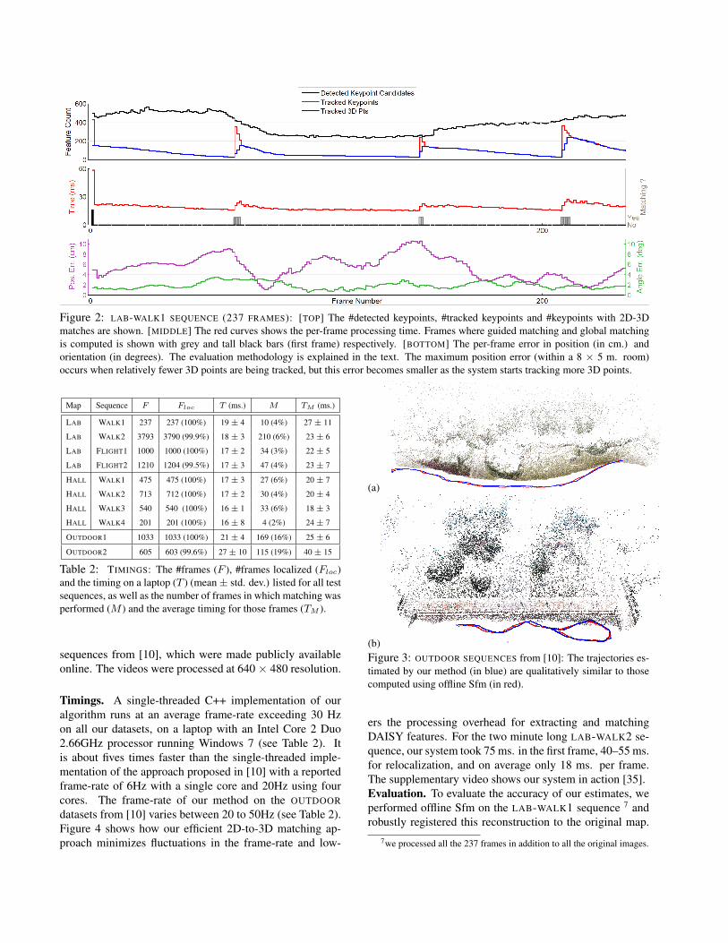
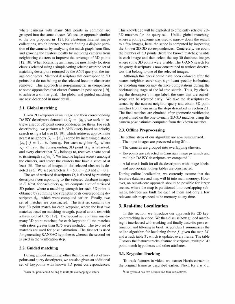
Figure 2: LAB-WALK1 SEQUENCE (237 FRAMES): [TOP] The #detected keypoints, #tracked keypoints and #keypoints with 2D-3Dmatches are shown. [MIDDLE] The red curves shows the per-frame processing time. Frames where guided matching and global matchingis computed is shown with grey and tall black bars (first frame) respectively. [BOTTOM] The per-frame error in position (in cm.) andorientation (in degrees). The evaluation methodology is explained in the text. The maximum position error (within a 8 × 5 m. room)occurs when relatively fewer 3D points are being tracked, but this error becomes smaller as the system starts tracking more 3D points.
Map Sequence F Floc T (ms.) M TM (ms.)
LAB WALK1 237 237 (100%) 19 ± 4 10 (4%) 27 ± 11
LAB WALK2 3793 3790 (99.9%) 18 ± 3 210 (6%) 23 ± 6
LAB FLIGHT1 1000 1000 (100%) 17 ± 2 34 (3%) 22 ± 5
LAB FLIGHT2 1210 1204 (99.5%) 17 ± 3 47 (4%) 23 ± 7
HALL WALK1 475 475 (100%) 17 ± 3 27 (6%) 20 ± 7
HALL WALK2 713 712 (100%) 17 ± 2 30 (4%) 20 ± 4
HALL WALK3 540 540 (100%) 16 ± 1 33 (6%) 18 ± 3
HALL WALK4 201 201 (100%) 16 ± 8 4 (2%) 24 ± 7
OUTDOOR1 1033 1033 (100%) 21 ± 4 169 (16%) 25 ± 6
OUTDOOR2 605 603 (99.6%) 27 ± 10 115 (19%) 40 ± 15
Table 2: TIMINGS: The #frames (F ), #frames localized (Floc)and the timing on a laptop (T ) (mean± std. dev.) listed for all testsequences, as well as the number of frames in which matching wasperformed (M ) and the average timing for those frames (TM ).
sequences from [10], which were made publicly availableonline. The videos were processed at 640× 480 resolution.
Timings. A single-threaded C++ implementation of ouralgorithm runs at an average frame-rate exceeding 30 Hzon all our datasets, on a laptop with an Intel Core 2 Duo2.66GHz processor running Windows 7 (see Table 2). Itis about fives times faster than the single-threaded imple-mentation of the approach proposed in [10] with a reportedframe-rate of 6Hz with a single core and 20Hz using fourcores. The frame-rate of our method on the OUTDOORdatasets from [10] varies between 20 to 50Hz (see Table 2).Figure 4 shows how our efficient 2D-to-3D matching ap-proach minimizes fluctuations in the frame-rate and low-
(a)
(b)Figure 3: OUTDOOR SEQUENCES from [10]: The trajectories es-timated by our method (in blue) are qualitatively similar to thosecomputed using offline Sfm (in red).
ers the processing overhead for extracting and matchingDAISY features. For the two minute long LAB-WALK2 se-quence, our system took 75 ms. in the first frame, 40–55 ms.for relocalization, and on average only 18 ms. per frame.The supplementary video shows our system in action [35].Evaluation. To evaluate the accuracy of our estimates, weperformed offline Sfm on the LAB-WALK1 sequence 7 androbustly registered this reconstruction to the original map.
7we processed all the 237 frames in addition to all the original images.
The true scale of the map was computed using known dis-tances between scene landmarks. The camera position andorientation estimates from our method were compared tothese pose estimates 8. Figure 2 shows the error in posealignment for the LAB-WALK1 sequence (along with otherrelevant statistics). The average position and orientation er-ror for this sequence was 5.1 cm. and 1.7 degrees respec-tively. The size of the LAB scene was 8m × 5m.
The accuracy of our method can also be qualitativelyjudged from Figure 3, which shows the camera trajectoriesfrom our method and from offline Sfm on the OUTDOORsequences. The two trajectories are well aligned. This con-firms the accuracy of the position estimates, even though aquantitative evaluation was not possible due to the unknownmap scale. The mean camera orientation error for the twosequences was 1.4 and 1.6 degrees respectively. Accord-ing to [10], the visual SLAM system (PTAM) [15], failed onboth these sequences due to fast camera motion, even whenit was configured to run at slower than real-time (5 fps).
We also tested our method on the larger HALL scenewhich contains a narrow corridor, doorways and sometextureless walls. The relatively fewer salient visual fea-tures makes 2D-to-3D matching more challenging in thisscene. All frames from the four sequences were accuratelylocalized using our approach at frame-rates exceeding 30Hz (see Table 2). Figure 5 shows the recovered trajectories.
MAV Experiments. To evaluate the feasibility of ourapproach running onboard a MAV, we designed our ownquadrotor vehicle mounted with the Firefly camera and aFitPC2i computer [34] running Windows 7. The FitPC,which has an Intel Atom Z550 2GHz CPU, 2GB RAM anda 64GB SSD drive, weighs less than 500gms. (incl. battery)and consumes only 10W at full load 9. Our algorithm runsat about 12Hz on the FitPC. It was tested on the two flightsequences from the LAB dataset. All the frames processedfrom the FLIGHT1 sequence and 98.5% of those processedfrom the FLIGHT2 sequence were successfully localized 10.The frame-rate in our case is comparable to the 5-10 Hz on-board visual SLAM system [15] used for vision-based posi-tion control [1]. These experiments show that if combinedwith an inertial measurement unit (IMU), our method couldbe used for autonomous aerial navigation in areas larger andmore complex than what has been tackled before [1, 4, 20].
5. Conclusions and Future WorkIn this paper, we have proposed a new approach for real-
time video-based localization in scenes reconstructed of-fline using Sfm. Our algorithm efficiently combines key-
8orientation error was measured with the angle metric, where error be-tween rotations R1 and R2 is the angle of the rotation R1R2
T .9Some advanced MAVs have faster onboard computers [20].
10When the processing exceeded 33 ms., we skipped the next frame.
point tracking in video with direct 2D feature to 3D pointmatching, without requiring scale-invariant image features.It exploits spatio-temporal coherence, invoking expensivefeature matching computations sparingly and distributes thecomputation over time. Our implementation can process640 × 480 video faster than video-rate on a laptop. Pre-liminary tests demonstrate that it is practical for onboardcomputation on a micro aerial vehicle and could be practi-cal for autonomous navigation. Our approach can fail whenthe camera faces a part of the scene poorly represented inthe map. Using visual SLAM to dynamically extend themap in real-time to address this limitation is an interestingavenue for future work.
References[1] M. Achtelik, M. Achtelik, S. Weiss, and R. Siegwart. Onboard IMU
and monocular vision based control for MAVs in unknown in- andoutdoor environments. In ICRA, 2011.
[2] C. Arth, D. Wagner, M. Klopschitz, A. Irschara, and D. Schmalstieg.Wide area localization on mobile phones. In ISMAR, pages 73–82,2009.
[3] S. Arya and D. M. Mount. Approximate nearest neighbor queries infixed dimensions. In SODA, pages 271–280, 1993.
[4] M. Blosch, S. Weiss, D. Scaramuzza, and R. Siegwart. Vision basedMAV navigation in unknown and unstructured environments. InICRA, 2010.
[5] O. Boiman, E. Shechtman, and M. Irani. In defense of nearest-neighbor based image classification. In CVPR, 2008.
[6] M. Calonder, V. Lepetit, C. Strecha, and P. Fua. BRIEF: BinaryRobust Independent Elementary Features. In ECCV (4)’10, pages778–792, 2010.
[7] R. O. Castle, G. Klein, and D. W. Murray. Wide-area augmented re-ality using camera tracking and mapping in multiple regions. CVIU,115(6):854 – 867, 2011.
[8] A. Comport, E. Marchand, M. Pressigout, and F. Chaumette. Realtime markerless tracking for augmented reality: The virtual visualservoing framework. TVCG, 12, 2006.
[9] A. J. Davison, I. D. Reid, N. D. Molton, and O. Stasse. MonoSLAM:Real-time single camera SLAM. PAMI, 26(6):1052–1067, 2007.
[10] Z. Dong, G. F. Zhang, J. Y. Jia, and H. J. Bao. Keyframe-based Real-time Camera Tracking. In ICCV, 2009.
[11] M. A. Fischler and R. C. Bolles. Random sample consensus: Aparadigm for model fitting with applications to image analysis andautomated cartography. Commun. ACM, 1981.
[12] Y. Furukawa, B. Curless, S. M. Seitz, and R. Szeliski. Towardsinternet-scale multi-view stereo. In CVPR, 2010.
[13] A. Irschara, C. Zach, J.-M. Frahm, and H. Bischof. From structure-from-motion point clouds to fast location recognition. In CVPR,pages 2599–2606, 2009.
[14] Y. Jeong, D. Nister, D. Steedly, R. Szeliski, and I.-S. Kweon. Pushingthe envelope of modern methods for bundle adjustment. In CVPR,pages 1474–1481, 2010.
[15] G. Klein and D. Murray. Parallel Tracking and Mapping for SmallAR Workspaces. In ISMAR, November 2007.
[16] R. Koch, K. Koeser, B. Streckel, and J. F. Evers-Senne. Marker-less image-based 3d tracking for real-time augmented reality appli-cations. In WIAMIS, 2005.
[17] V. Lepetit and P. Fua. Keypoint recognition using randomized trees.PAMI, 28:2006, 2006.
[18] Y. Li, N. Snavely, and D. P. Huttenlocher. Location recognition usingprioritized feature matching. In ECCV, 2010.
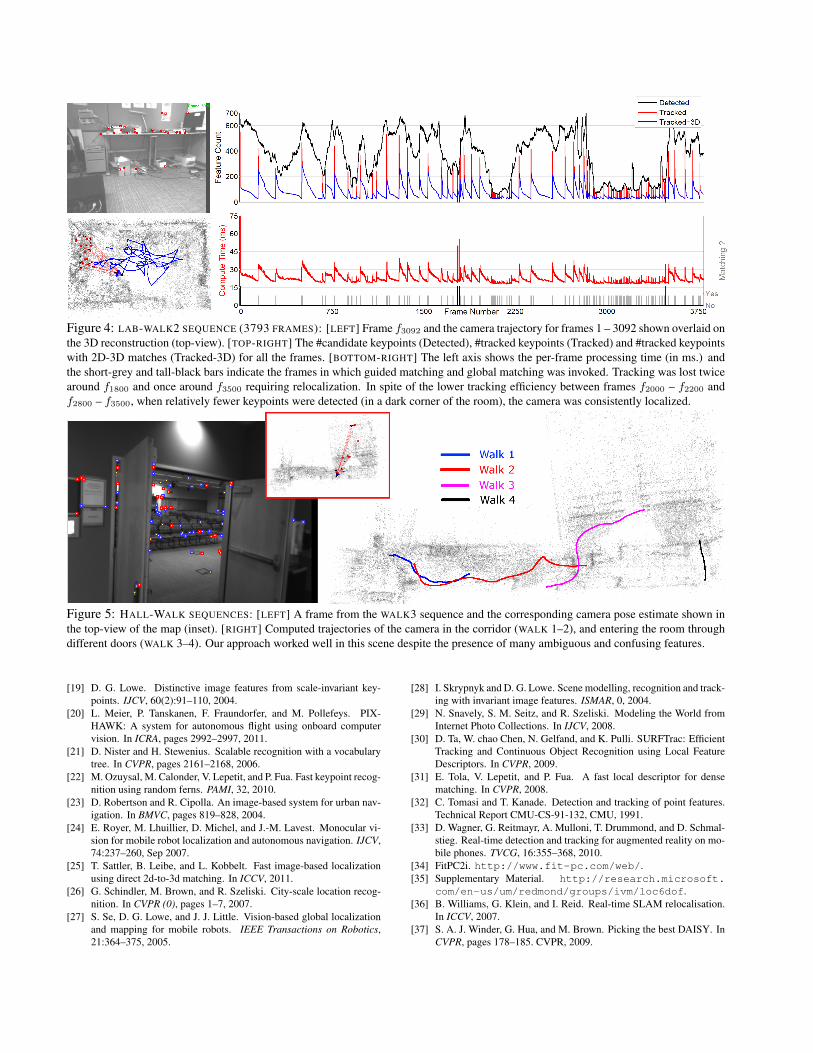
Figure 4: LAB-WALK2 SEQUENCE (3793 FRAMES): [LEFT] Frame f3092 and the camera trajectory for frames 1 – 3092 shown overlaid onthe 3D reconstruction (top-view). [TOP-RIGHT] The #candidate keypoints (Detected), #tracked keypoints (Tracked) and #tracked keypointswith 2D-3D matches (Tracked-3D) for all the frames. [BOTTOM-RIGHT] The left axis shows the per-frame processing time (in ms.) andthe short-grey and tall-black bars indicate the frames in which guided matching and global matching was invoked. Tracking was lost twicearound f1800 and once around f3500 requiring relocalization. In spite of the lower tracking efficiency between frames f2000 – f2200 andf2800 – f3500, when relatively fewer keypoints were detected (in a dark corner of the room), the camera was consistently localized.
Figure 5: HALL-WALK SEQUENCES: [LEFT] A frame from the WALK3 sequence and the corresponding camera pose estimate shown inthe top-view of the map (inset). [RIGHT] Computed trajectories of the camera in the corridor (WALK 1–2), and entering the room throughdifferent doors (WALK 3–4). Our approach worked well in this scene despite the presence of many ambiguous and confusing features.
[19] D. G. Lowe. Distinctive image features from scale-invariant key-points. IJCV, 60(2):91–110, 2004.
[20] L. Meier, P. Tanskanen, F. Fraundorfer, and M. Pollefeys. PIX-HAWK: A system for autonomous flight using onboard computervision. In ICRA, pages 2992–2997, 2011.
[21] D. Nister and H. Stewenius. Scalable recognition with a vocabularytree. In CVPR, pages 2161–2168, 2006.
[22] M. Ozuysal, M. Calonder, V. Lepetit, and P. Fua. Fast keypoint recog-nition using random ferns. PAMI, 32, 2010.
[23] D. Robertson and R. Cipolla. An image-based system for urban nav-igation. In BMVC, pages 819–828, 2004.
[24] E. Royer, M. Lhuillier, D. Michel, and J.-M. Lavest. Monocular vi-sion for mobile robot localization and autonomous navigation. IJCV,74:237–260, Sep 2007.
[25] T. Sattler, B. Leibe, and L. Kobbelt. Fast image-based localizationusing direct 2d-to-3d matching. In ICCV, 2011.
[26] G. Schindler, M. Brown, and R. Szeliski. City-scale location recog-nition. In CVPR (0), pages 1–7, 2007.
[27] S. Se, D. G. Lowe, and J. J. Little. Vision-based global localizationand mapping for mobile robots. IEEE Transactions on Robotics,21:364–375, 2005.
[28] I. Skrypnyk and D. G. Lowe. Scene modelling, recognition and track-ing with invariant image features. ISMAR, 0, 2004.
[29] N. Snavely, S. M. Seitz, and R. Szeliski. Modeling the World fromInternet Photo Collections. In IJCV, 2008.
[30] D. Ta, W. chao Chen, N. Gelfand, and K. Pulli. SURFTrac: EfficientTracking and Continuous Object Recognition using Local FeatureDescriptors. In CVPR, 2009.
[31] E. Tola, V. Lepetit, and P. Fua. A fast local descriptor for densematching. In CVPR, 2008.
[32] C. Tomasi and T. Kanade. Detection and tracking of point features.Technical Report CMU-CS-91-132, CMU, 1991.
[33] D. Wagner, G. Reitmayr, A. Mulloni, T. Drummond, and D. Schmal-stieg. Real-time detection and tracking for augmented reality on mo-bile phones. TVCG, 16:355–368, 2010.
[34] FitPC2i. http://www.fit-pc.com/web/.[35] Supplementary Material. http://research.microsoft.
com/en-us/um/redmond/groups/ivm/loc6dof.[36] B. Williams, G. Klein, and I. Reid. Real-time SLAM relocalisation.
In ICCV, 2007.[37] S. A. J. Winder, G. Hua, and M. Brown. Picking the best DAISY. In
CVPR, pages 178–185. CVPR, 2009.


![Learning-based Localization · 2020. 3. 31. · PoseNet Discussion 29 [1]“PoseNet: A Convolutional Network for Real-Time 6-DoF amera Localization”, Kendall et al., ICCV 2015 [2]“Image-ased](https://img.pdfslide.us/doc/110x75/5fe27065795ba708c86d9b5b/learning-based-localization-2020-3-31-posenet-discussion-29-1aoeposenet.jpg)