Embed Size (px)
Citation preview
Real-time Collage in Landscape Architecture
Jörg REKITTKE and Philip PAAR
1 Introduction
Digital landscape visualisations have primarily been used to present, explain and market landscape scenarios, rather than being used as a working model and to provide a meaningful contribution towards improving final results (ORLAND 1992, LANGE 1999, PAAR 2006). In landscape architecture, computer graphics are particularly applied in two ways: 1) as CAD programs for the production of the draft, and implementation plans and 2) for the preparation of perspectives, which are to give a motivating and stimulating view on proposed future reality. Real-time visualisation technologies are rarely used, a fact that does not surprise having the current international competition practice in mind. The common submission in idea and realisation competitions – main source in acquisition of large public construction projects – is formed by plans, perspectives, cross sections etc. as hardcopies. The files of the hardcopies are additionally submitted as copy on data media or online. However, these digital work pieces are only used for publication and archiving. The decision of the jury is exclusively based on the „hung up“ plans and drawings, the explanatory notes, and possibly a submitted mock-up. This paper points out, how new methods of real-time visualisation can be linked with traditional analogue and digital methods of collage techniques and which future potentials can be derived from it.
2 Analogue Archetypes
Landscape architectural and architectural collages are usually constructed like paintings: the view is fixed; an image already exists in the designers’ mind or emerges in the design process. The artist paints over and pastes over, using the whole range of available materials and tools.
Perspective drawings and illustrations as well as before-and-after views in open space planning can look back on a long tradition. Humphrey Repton (1752-1817) pioneered the use of montage techniques in landscape architecture. In his famous ‘Red Books’ he presented his designs and ideas to the clients by dint of beautiful red leather-bound watercolour picture books. He painted the as-is state of his projects on a moveable cover. By turning that cover back and forth, like the partial page of a book, the client could compare the subjacent planned scenario in an innovative and emotive way. Consequently, Repton combined conventional media like books and sketches with interactivity – and met with both professional and economic success. REPTON (1803) denoted his pictures as slides. This historical form of a New Media can retrospectively be considered as the first interactive, even though analogue technique of landscape visualisation.
Caspar David Friedrich (1774-1840) can be regarded as the godfather of landscape collage although the term didn’t exist at his times. Friedrich constructed and composed his
Real-time Collage in Landscape Architecture 89
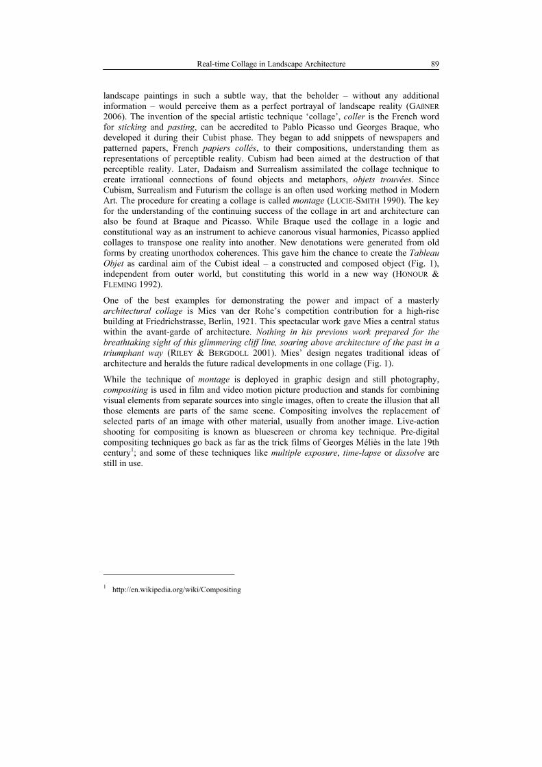
landscape paintings in such a subtle way, that the beholder – without any additional information – would perceive them as a perfect portrayal of landscape reality (GAßNER 2006). The invention of the special artistic technique ‘collage’, coller is the French word for sticking and pasting, can be accredited to Pablo Picasso und Georges Braque, who developed it during their Cubist phase. They began to add snippets of newspapers and patterned papers, French papiers collés, to their compositions, understanding them as representations of perceptible reality. Cubism had been aimed at the destruction of that perceptible reality. Later, Dadaism and Surrealism assimilated the collage technique to create irrational connections of found objects and metaphors, objets trouvées. Since Cubism, Surrealism and Futurism the collage is an often used working method in Modern Art. The procedure for creating a collage is called montage (LUCIE-SMITH 1990). The key for the understanding of the continuing success of the collage in art and architecture can also be found at Braque and Picasso. While Braque used the collage in a logic and constitutional way as an instrument to achieve canorous visual harmonies, Picasso applied collages to transpose one reality into another. New denotations were generated from old forms by creating unorthodox coherences. This gave him the chance to create the Tableau Objet as cardinal aim of the Cubist ideal – a constructed and composed object (Fig. 1), independent from outer world, but constituting this world in a new way (HONOUR & FLEMING 1992).
One of the best examples for demonstrating the power and impact of a masterly architectural collage is Mies van der Rohe’s competition contribution for a high-rise building at Friedrichstrasse, Berlin, 1921. This spectacular work gave Mies a central status within the avant-garde of architecture. Nothing in his previous work prepared for the breathtaking sight of this glimmering cliff line, soaring above architecture of the past in a triumphant way (RILEY & BERGDOLL 2001). Mies’ design negates traditional ideas of architecture and heralds the future radical developments in one collage (Fig. 1).
While the technique of montage is deployed in graphic design and still photography, compositing is used in film and video motion picture production and stands for combining visual elements from separate sources into single images, often to create the illusion that all those elements are parts of the same scene. Compositing involves the replacement of selected parts of an image with other material, usually from another image. Live-action shooting for compositing is known as bluescreen or chroma key technique. Pre-digital compositing techniques go back as far as the trick films of Georges Méliès in the late 19th century1; and some of these techniques like multiple exposure, time-lapse or dissolve are still in use.
1 http://en.wikipedia.org/wiki/Compositing
J. Rekittke and P. Paar 90
Fig. 1: Left: Pablo Picasso „Harlequin“ (1915). Oil on Canvas. The Museum of Modern
Art, New York, Lillie P. Bliss Bequest. Picture credits: Honour & Fleming, 1992. Right: Ludwig Mies van der Rohe „Wabe“ (1921). High-rise building at Friedrichstraße, Berlin. Competition contribution, photomontage. Bauhaus Archiv, Berlin.
3 Case Study: Competition ‘Gleisdreieck Berlin’
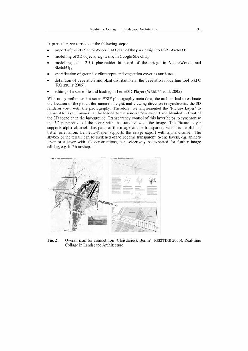
In 2006, the Senate Department of Urban Development issued a landscape architecture competition for ‘Gleisdreieck Berlin’ calling for a park concept for a former railways site in the centre of the city. The authors were part of a design team that participated at the first (idea generation) stage of the two-tiered competition. The team used different digital tools and techniques to produce the plans and illustrations: tools that are common in landscape design competition practice like CAD (Nemetschek VectorWorks, Google SketchUp), and image editing (Adobe Photoshop), tools that are hardly used in landscape design like GIS (ESRI ArcMAP) and rather unusual tools like (real-time) landscape visualisation systems (Lenné3D system). Techniques included CAD drafting, 3D sketching, GIS editing, vegetation modelling, 3D rendering, compositing, and collage. It was obligatory to create an illustrating perspective, which should be based on a default photography that came with the competition instructions. Our goal was to transfer our site context model from CAD into a 3D real-time model, which should serve as a digital content creation tool to generate montage layers for the obligatory perspective.
Real-time Collage in Landscape Architecture 91
In particular, we carried out the following steps: • import of the 2D VectorWorks CAD plan of the park design to ESRI ArcMAP, • modelling of 3D objects, e.g. walls, in Google SketchUp, • modelling of a 2.5D placeholder billboard of the bridge in VectorWorks, and
SketchUp, • specification of ground surface types and vegetation cover as attributes, • definition of vegetation and plant distribution in the vegetation modelling tool oikPC
(RÖHRICHT 2005), • editing of a scene file and loading in Lenné3D-Player (WERNER et al. 2005).
With no georeference but some EXIF photography meta-data, the authors had to estimate the location of the photo, the camera’s height, and viewing direction to synchronise the 3D renderer view with the photography. Therefore, we implemented the ‘Picture Layer’ to Lenné3D-Player. Images can be loaded to the renderer’s viewport and blended in front of the 3D scene or in the background. Transparency control of this layer helps to synchronise the 3D perspective of the scene with the static view of the image. The Picture Layer supports alpha channel, thus parts of the image can be transparent, which is helpful for better orientation. Lenné3D-Player supports the image export with alpha channel. The skybox or the terrain can be switched off to become transparent. Scene layers, e.g. an herb layer or a layer with 3D constructions, can selectively be exported for further image editing, e.g. in Photoshop.
Fig. 2: Overall plan for competition ‘Gleisdreieck Berlin’ (REKITTKE 2006). Real-time
Collage in Landscape Architecture.
J. Rekittke and P. Paar 92
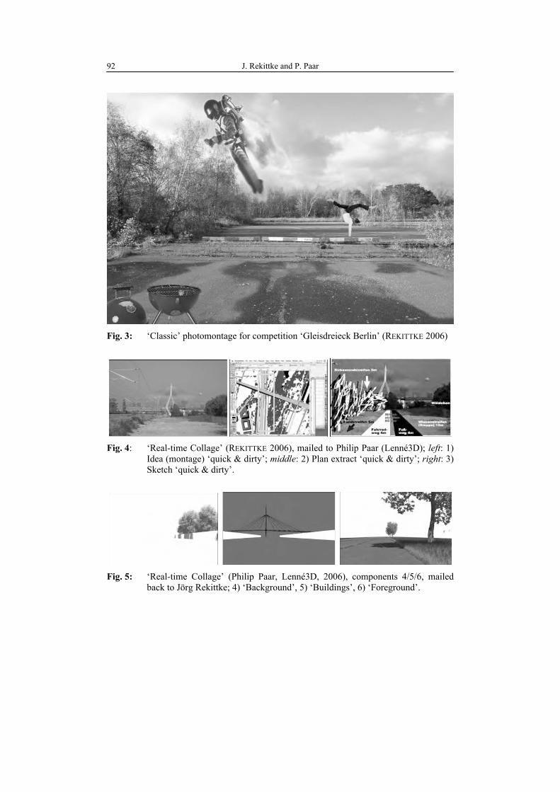
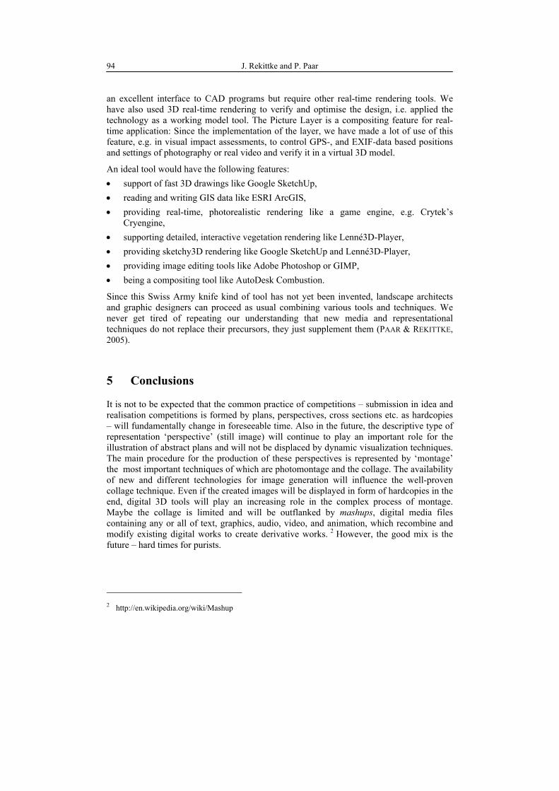
Fig. 3: ‘Classic’ photomontage for competition ‘Gleisdreieck Berlin’ (REKITTKE 2006)
Fig. 4: ‘Real-time Collage’ (REKITTKE 2006), mailed to Philip Paar (Lenné3D); left: 1)
Idea (montage) ‘quick & dirty’; middle: 2) Plan extract ‘quick & dirty’; right: 3) Sketch ‘quick & dirty’.
Fig. 5: ‘Real-time Collage’ (Philip Paar, Lenné3D, 2006), components 4/5/6, mailed
back to Jörg Rekittke; 4) ‘Background’, 5) ‘Buildings’, 6) ‘Foreground’.
Real-time Collage in Landscape Architecture 93
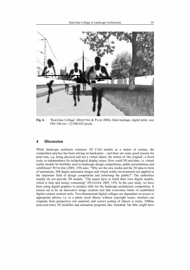
Fig. 6: ‘Real-time Collage’ (REKITTKE & PAAR 2006), final montage, digital print, size
196×140 cm = 22.046.922 pixels.
4 Discussion
While landscape architects construct 3D CAD models as a matter of routine, the competition practice has been relying on hardcopies – and there are some good reasons for print outs, e.g. being physical and not a virtual object, the notion of ‘the original’, a fixed scale, or independence for technological display issues. How could 3D real-time, i.e. virtual reality models be fruitfully used in landscape design competitions, public presentations and exhibitions? PETSCHEK (2005, 159) asks: “Why are the new media and the 3D data in form of animations, 360 degree panorama images and virtual reality environments not applied in the important field of design competition and informing the public?” The authorities usually do not provide 3D models. “The teams have to build their own digital models, which is time and money consuming” (PETSCHEK 2005, 159). In the case study, we have been using digital graphics to produce stills for the landscape architecture competition. It turned out to be an innovative image creation tool that overcomes limits of established digital content creation tools. Two-dimensional digital collages are dependent on access to appropriate photos, i.e. to a photo stock library without copyright issues, artefacts can originate from perspective raw material, and correct scaling of objects is tricky. Offline (non-real-time) 3D modeller and animation programs like Autodesk 3ds Max might have
J. Rekittke and P. Paar 94
an excellent interface to CAD programs but require other real-time rendering tools. We have also used 3D real-time rendering to verify and optimise the design, i.e. applied the technology as a working model tool. The Picture Layer is a compositing feature for real-time application: Since the implementation of the layer, we have made a lot of use of this feature, e.g. in visual impact assessments, to control GPS-, and EXIF-data based positions and settings of photography or real video and verify it in a virtual 3D model.
An ideal tool would have the following features: • support of fast 3D drawings like Google SketchUp, • reading and writing GIS data like ESRI ArcGIS, • providing real-time, photorealistic rendering like a game engine, e.g. Crytek’s
Cryengine, • supporting detailed, interactive vegetation rendering like Lenné3D-Player, • providing sketchy3D rendering like Google SketchUp and Lenné3D-Player, • providing image editing tools like Adobe Photoshop or GIMP, • being a compositing tool like AutoDesk Combustion.
Since this Swiss Army knife kind of tool has not yet been invented, landscape architects and graphic designers can proceed as usual combining various tools and techniques. We never get tired of repeating our understanding that new media and representational techniques do not replace their precursors, they just supplement them (PAAR & REKITTKE, 2005).
5 Conclusions
It is not to be expected that the common practice of competitions – submission in idea and realisation competitions is formed by plans, perspectives, cross sections etc. as hardcopies – will fundamentally change in foreseeable time. Also in the future, the descriptive type of representation ‘perspective’ (still image) will continue to play an important role for the illustration of abstract plans and will not be displaced by dynamic visualization techniques. The main procedure for the production of these perspectives is represented by ‘montage’ the most important techniques of which are photomontage and the collage. The availability of new and different technologies for image generation will influence the well-proven collage technique. Even if the created images will be displayed in form of hardcopies in the end, digital 3D tools will play an increasing role in the complex process of montage. Maybe the collage is limited and will be outflanked by mashups, digital media files containing any or all of text, graphics, audio, video, and animation, which recombine and modify existing digital works to create derivative works. 2
However, the good mix is the
future – hard times for purists.
2 http://en.wikipedia.org/wiki/Mashup
Real-time Collage in Landscape Architecture 95
References
Gaßner, H. (2006), Komposition. – In: Gaßner, V. (Ed.), Caspar David Friedrich – Die Erfindung der Romantik. – Hirmer Verlag, München: 271-289.
Honour, H. & Fleming, J. (1992), Weltgeschichte der Kunst. – Prestel, München.
Lucie-Smith, E. (1990), DuMont’s Lexikon der Bildenden Kunst. – DuMont, Köln.
Neumann, D. (2001), Hochhaus an der Friedrichstraße, Wabe, Projekt, Berlin-Mitte, 1921. – In: Riley, T. & Bergdoll, B. (Hrsg.), Mies in Berlin. Ludwig Mies van der Rohe. Die Berliner Jahre 1907-1938. – Prestel, München/London/New York: 180-183.
Orland, B. (1992), Data visualization techniques in environmental management: a con-solidated research agenda. – In: Landscape and Urban Planning, 21: 241-244.
Paar, P. (2006), Landscape visualizations: Applications and requirements of 3D visualization software for environmental planning. – In: Computers, Environment and Urban Systems, 30: 815-839.
Paar, P., & J. Rekittke (2005), Lenné3D -Walk-through Visualization of Planned Landscapes. – In: Bishop, I. D. & Lange, E. (Eds.), Visualization in landscape and environmental planning. – Spon Press, London: 152-162
Petschek, P. (2003), Planning of Public Space -The Application of New Media and 3D Visuallizations: The Zürich-Leutschenbach Case Study. – In: Buhmann, E. & S. Ervin (Eds.), Proc. at Anhalt University of Applied Sciences. – Wichmann, Heidelberg: 158-162.
Rekittke, J. & Paar, P. (2005), Enlightenment Approaches for Digital Absolutism – Diplomatic Steping-Stones Between the Real and the Envisioned. – In: Buhmann, E., Paar, P., Bishop, I. D. & Lange, E. (Eds.), Trends in Real-time Visualization and Participation. Proc. at Anhalt University of Applied Sciences. – Wichmann, Heidelberg: 210-224.
Repton, H. (1803), Observations on the theory and practice of landscape gardening: including some remarks on Grecian and Gothic architecture. – Taylor, London; Phaidon, Oxfort (facs.)
Röhricht, W. (2005), oik – nulla vita sine dispensatio. Vegetation Modelling for Landscape Planning. – In: Buhmann, E., Paar, P. Bishop, I. D. & Lange, E. (Eds.), Trends in Real-time Visualization and Participation. Proc. at Anhalt University of Applied Sciences. – Wichmann, Heidelberg: 256-262.
Werner, A., Deussen, O., Döllner, J., Hege, H.-C., Paar, P. & Rekittke, J. (2005), Lenné3D – Walking through Landscape Plans. – In: Buhmann, E., Paar, P. Bishop, I.-D. & Lange, E. (Eds.), Trends in Real-time Vsualization and Participation. Proc. at Anhalt University of Applied Sciences. – Wichmann, Heidelberg: 48-59.