Embed Size (px)
Citation preview
Real-Time & Big Data GIS: Leveraging the spatiotemporal big data store
Suzanne FossProduct Manager, Esri
Ricardo TrujilloReal-Time & Big Data GIS Developer, Esri
@rtrujill007
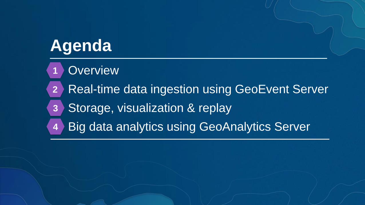
Agenda
Overview
Real-time data ingestion using GeoEvent Server
Storage, visualization & replay
Big data analytics using GeoAnalytics Server
1
2
3
4

1 Overview
DesktopWeb Device
live & historic
aggregates & features
map & feature service
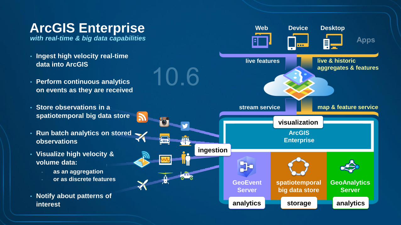
• Ingest high velocity real-time
data into ArcGIS
• Perform continuous analytics
on events as they are received
• Store observations in a
spatiotemporal big data store
• Run batch analytics on stored
observations
• Visualize high velocity &
volume data:
- as an aggregation
- or as discrete features
• Notify about patterns of
interest
stream service
live features
ArcGIS
Enterprise
GeoEvent
Server
ingestion
analytics
ArcGIS Enterprisewith real-time & big data capabilities
GeoAnalytics
Server
spatiotemporal
big data store
storage analytics
visualization
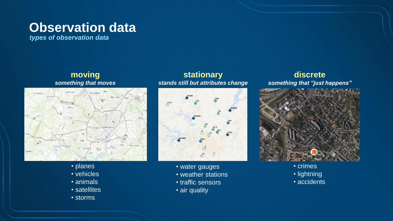
movingsomething that moves
• planes
• vehicles
• animals
• satellites
• storms
stationarystands still but attributes change
• water gauges
• weather stations
• traffic sensors
• air quality
discretesomething that “just happens”
• crimes
• lightning
• accidents
Observation datatypes of observation data
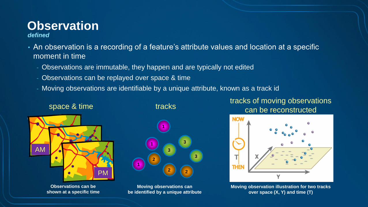
• An observation is a recording of a feature’s attribute values and location at a specific
moment in time
- Observations are immutable, they happen and are typically not edited
- Observations can be replayed over space & time
- Moving observations are identifiable by a unique attribute, known as a track id
space & time
AM
Observations can be
shown at a specific time
PM
Moving observations can
be identified by a unique attribute
tracks
1
1
1
2
22
3
3
3
tracks of moving observations
can be reconstructed
Moving observation illustration for two tracks
over space (X, Y) and time (T)
T
Observationdefined
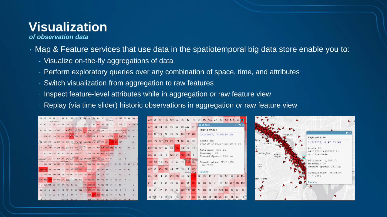
Visualizationof observation data
• Map & Feature services that use data in the spatiotemporal big data store enable you to:
- Visualize on-the-fly aggregations of data
- Perform exploratory queries over any combination of space, time, and attributes
- Switch visualization from aggregation to raw features
- Inspect feature-level attributes while in aggregation or raw feature view
- Replay (via time slider) historic observations in aggregation or raw feature view

Visualizingobservation dataMap & feature services using data
from the spatiotemporal big data store
Demo
2 Real-Time data ingestionusing GeoEvent Server
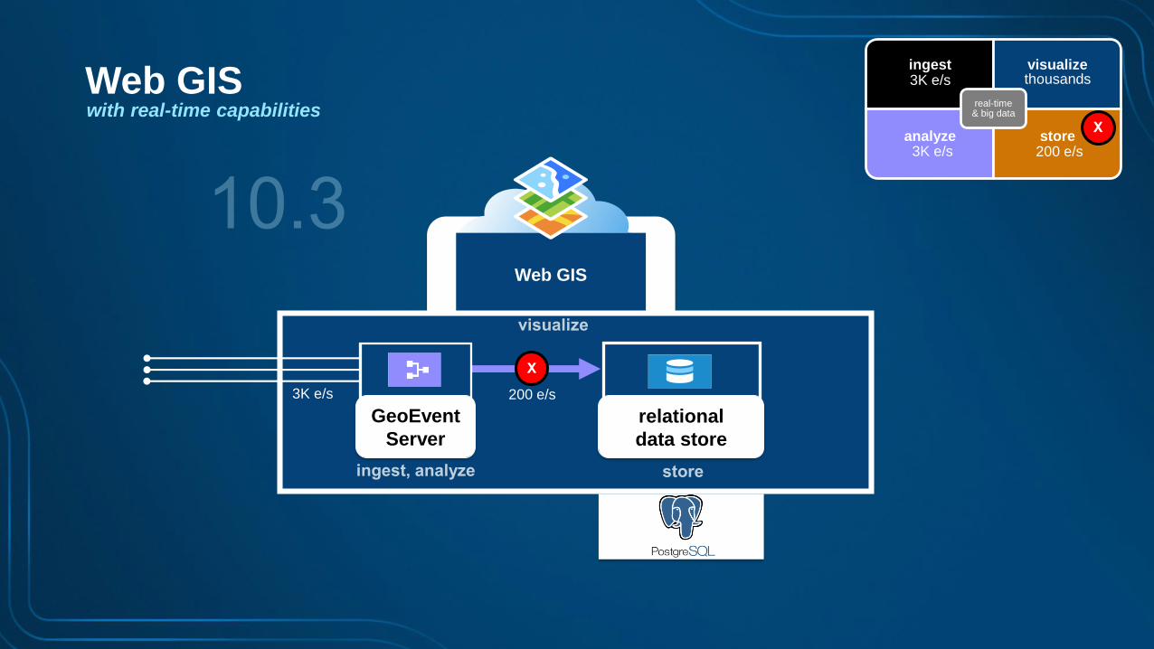
Web GIS
ingest visualize
analyze store
real-time & big data
thousands3K e/s
3K e/s 200 e/s
X
X
200 e/s3K e/s
Web GISwith real-time capabilities
GeoEvent
Server
relational
data store
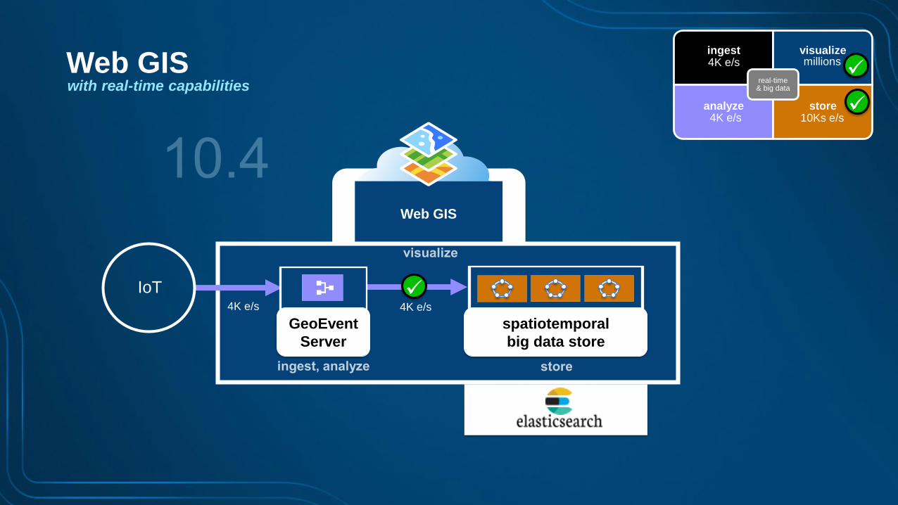
Web GIS
IoT
ingest visualize
analyze store
real-time & big data
millions4K e/s
4K e/s 10Ks e/s
4K e/s 4K e/s
Web GISwith real-time capabilities
GeoEvent
Server
spatiotemporal
big data store

ArcGIS
Enterprise
IoT
ingest visualize
analyze store
real-time & big data
millions4K e/s
4K e/s 10Ks e/s
4K e/s 4K e/s
ArcGIS Enterprisewith real-time capabilities
GeoEvent
Server
spatiotemporal
big data store
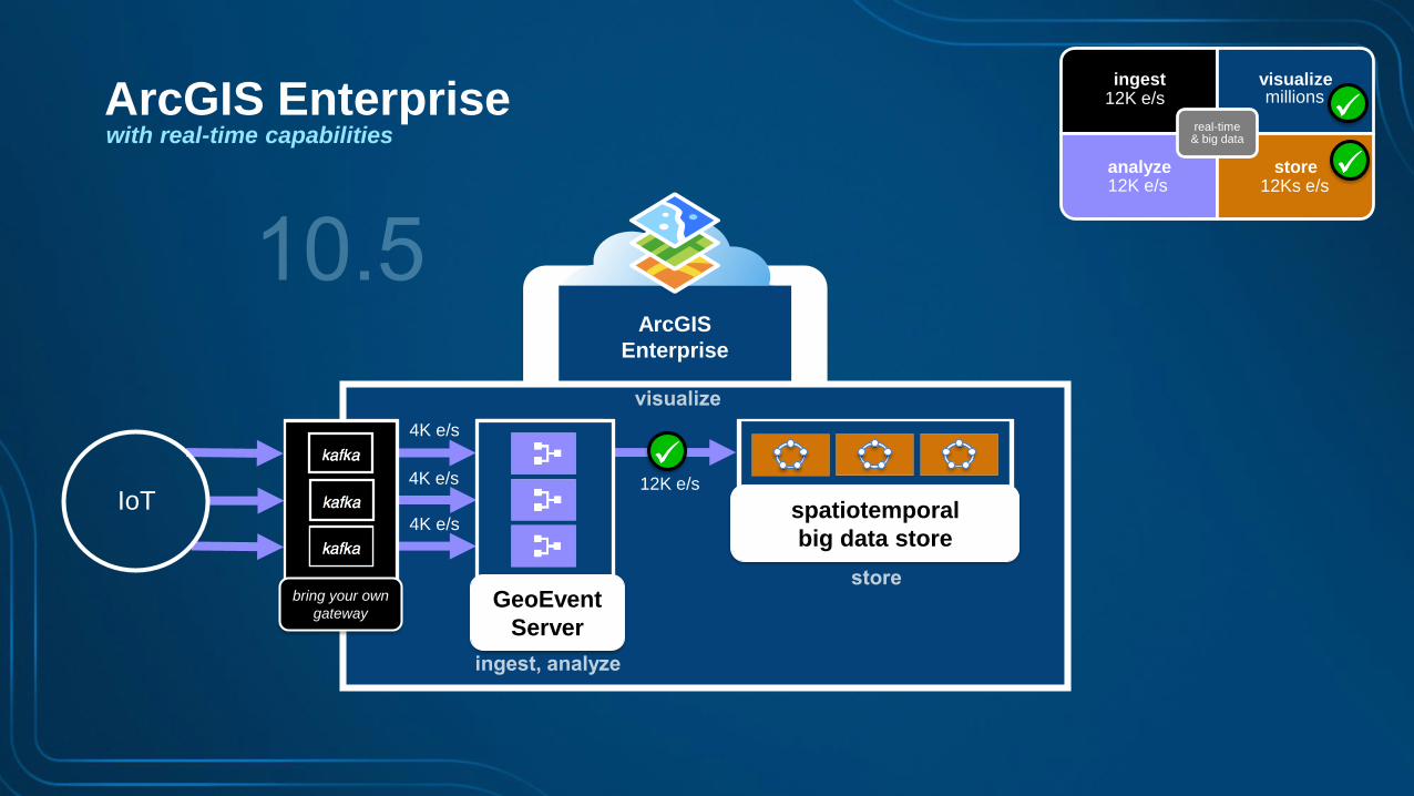
ArcGIS
Enterprise
ingest visualize
analyze store
real-time & big data
millions12K e/s
12K e/s 12Ks e/s
bring your own
gateway
IoT
4K e/s
4K e/s
4K e/s
12K e/s
ArcGIS Enterprisewith real-time capabilities
spatiotemporal
big data store
GeoEvent
Server
ArcGIS
Enterprise
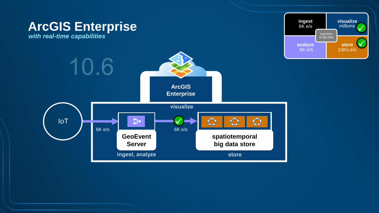
IoT
ingest visualize
analyze store
real-time & big data
millions6K e/s
6K e/s 10Ks e/s
6K e/s 6K e/s
ArcGIS Enterprisewith real-time capabilities
spatiotemporal
big data store
GeoEvent
Server
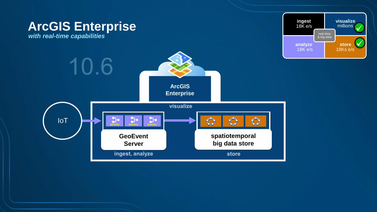
ArcGIS
Enterprise
IoTgatewaygateway gateway
ArcGIS Enterprisewith real-time capabilities
spatiotemporal
big data storeGeoEvent
Server
ingest visualize
analyze store
real-time & big data
millions18K e/s
18K e/s 18Ks e/s
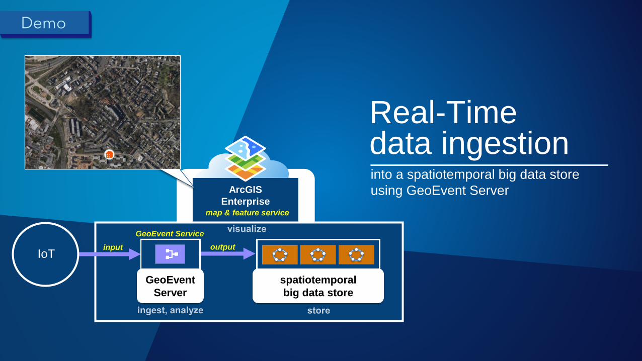
into a spatiotemporal big data store
using GeoEvent ServerArcGIS
Enterprisemap & feature service
input output
GeoEvent Service
IoT
spatiotemporal
big data store
Real-Timedata ingestion
Demo
GeoEvent
Server
3 Storage, visualization& replay
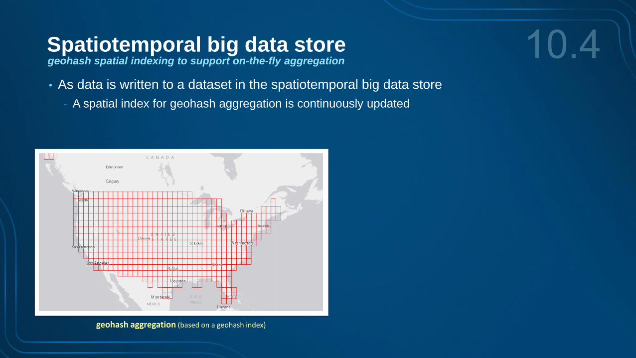
• As data is written to a dataset in the spatiotemporal big data store
- A spatial index for geohash aggregation is continuously updated
geohash aggregation (based on a geohash index)
Spatiotemporal big data storegeohash spatial indexing to support on-the-fly aggregation
geohash aggregation (based on a geohash index)
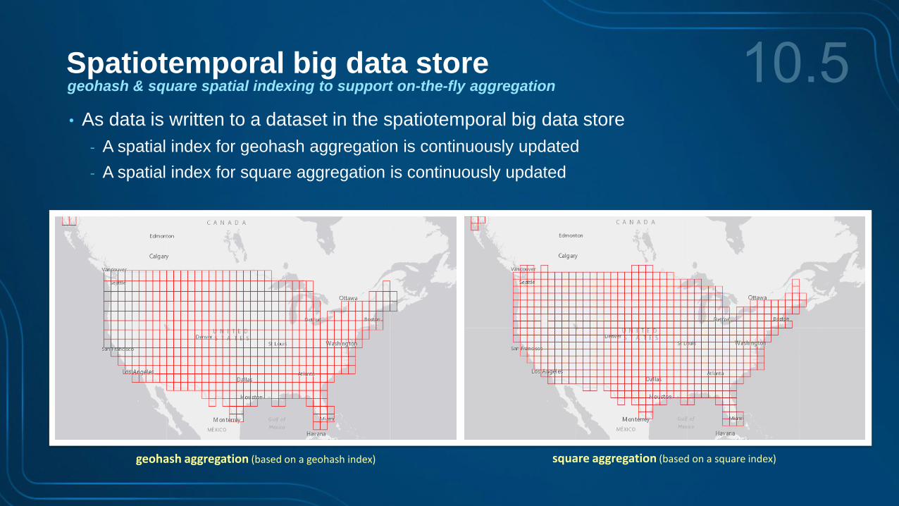
Spatiotemporal big data storegeohash & square spatial indexing to support on-the-fly aggregation
• As data is written to a dataset in the spatiotemporal big data store
- A spatial index for geohash aggregation is continuously updated
- A spatial index for square aggregation is continuously updated
square aggregation (based on a square index)

flat triangle aggregation (based on a flat triangle index)pointy triangle aggregation (based on a pointy triangle index)
Spatiotemporal big data storetriangle spatial indexing to support on-the-fly aggregation
• As data is written to a dataset in the spatiotemporal big data store
- A spatial index for ‘pointy triangle’ aggregation is continuously updated
- A spatial index for ‘flat triangle’ aggregation is continuously updated
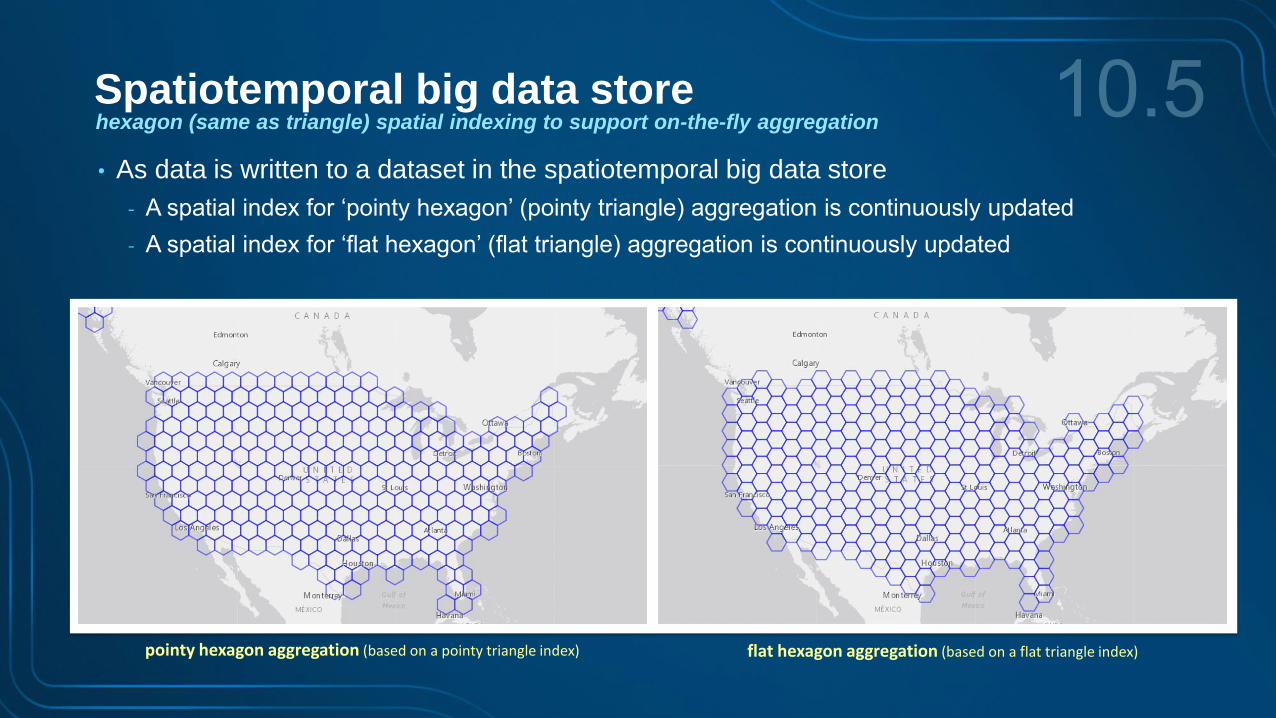
flat hexagon aggregation (based on a flat triangle index)pointy hexagon aggregation (based on a pointy triangle index)
• As data is written to a dataset in the spatiotemporal big data store
- A spatial index for ‘pointy hexagon’ (pointy triangle) aggregation is continuously updated
- A spatial index for ‘flat hexagon’ (flat triangle) aggregation is continuously updated
Spatiotemporal big data storehexagon (same as triangle) spatial indexing to support on-the-fly aggregation

geohash
square
trianglepointy
triangleflat
hexagonflat
hexagonpointy
• As data is written to a dataset in the spatiotemporal big data store
- Up to four types of spatial indices are supported: geohash, square, pointy & flat hexagon/triangle
- This is in addition to a temporal index on the time field
- And an inverted index on each of the attribute fields
Spatiotemporal big data storespatial indexing to support on-the-fly aggregation
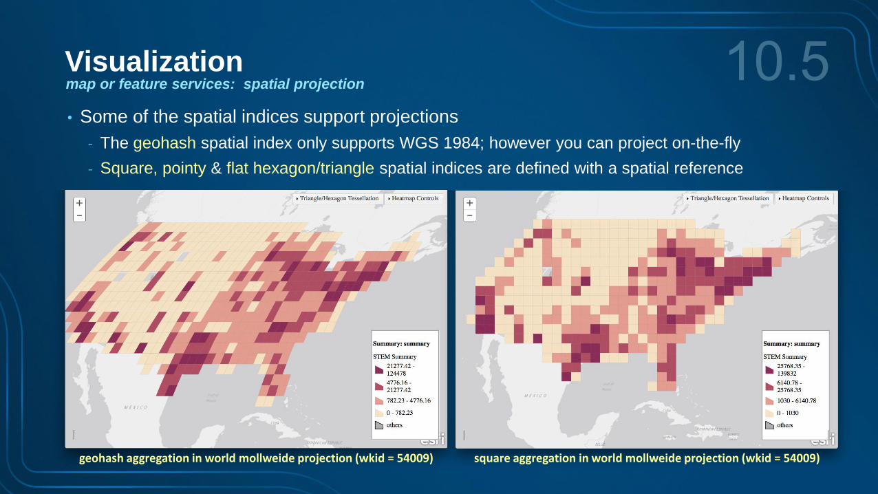
geohash aggregation in world mollweide projection (wkid = 54009) square aggregation in world mollweide projection (wkid = 54009)
Visualizationmap or feature services: spatial projection
• Some of the spatial indices support projections
- The geohash spatial index only supports WGS 1984; however you can project on-the-fly
- Square, pointy & flat hexagon/triangle spatial indices are defined with a spatial reference
geohash aggregation response geohash aggregation response
map servicefeature service
lodType=geohash&lod=2
feature servicelodType=geohash&lod=2&returnGeometry=false
geohash aggregation response
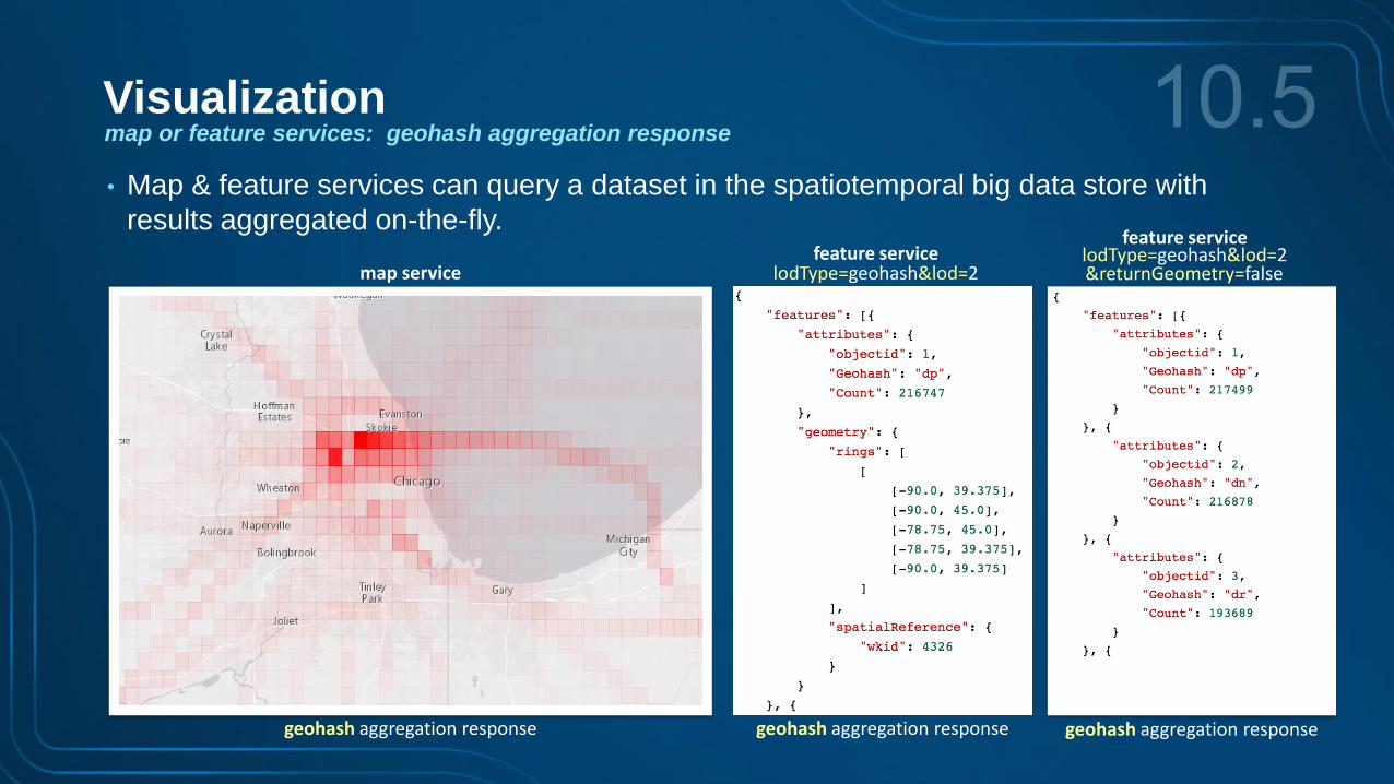
Visualizationmap or feature services: geohash aggregation response
• Map & feature services can query a dataset in the spatiotemporal big data store with
results aggregated on-the-fly.
map servicefeature service
lodType=square&lod=2
square aggregation response square aggregation response
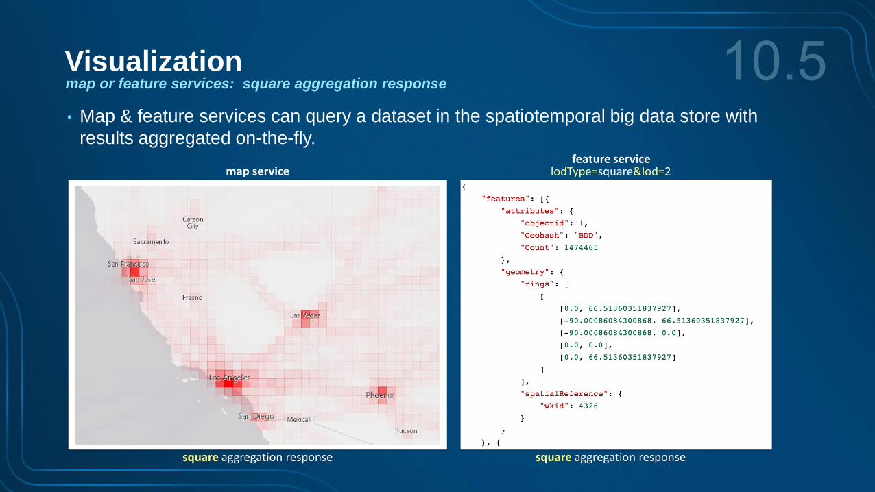
Visualizationmap or feature services: square aggregation response
• Map & feature services can query a dataset in the spatiotemporal big data store with
results aggregated on-the-fly.
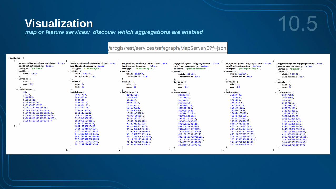
Visualizationmap or feature services: discover which aggregations are enabled
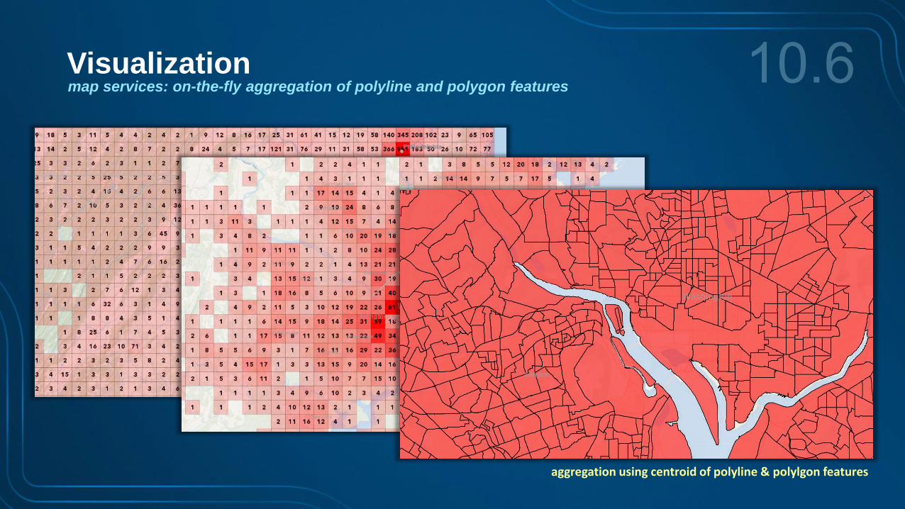
Visualizationmap services: on-the-fly aggregation of polyline and polygon features
aggregation using centroid of polyline & polylgon features

Storageexpanded spatiotemporal big data store capabilities
• Enhanced data retention control:
- Allows users to define both a maximum feature age and create exemptions for features based on
a WHERE clause.
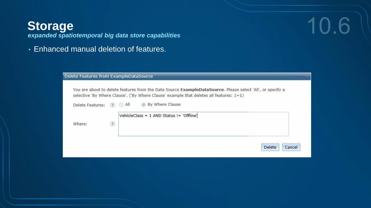
Storageexpanded spatiotemporal big data store capabilities
• Enhanced manual deletion of features.
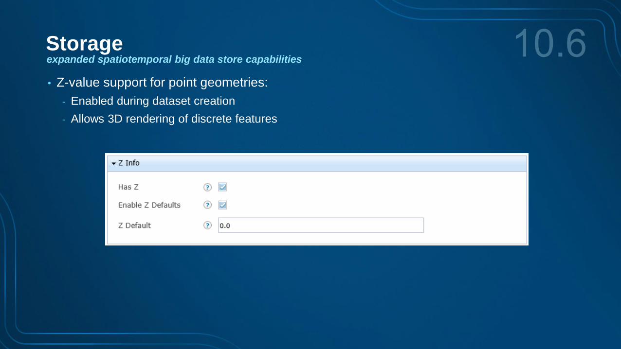
Storageexpanded spatiotemporal big data store capabilities
• Z-value support for point geometries:
- Enabled during dataset creation
- Allows 3D rendering of discrete features
geohash, square & hexagon
aggregation
Storage, visualization & replay
Demo
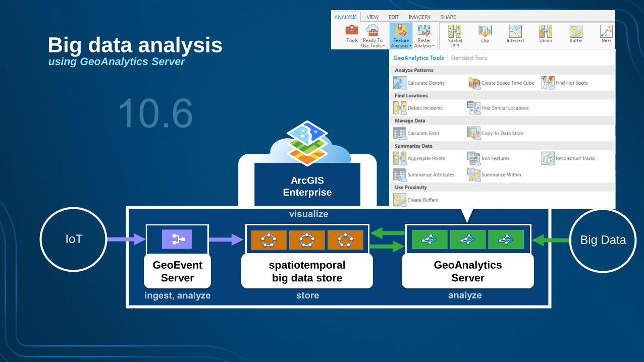
4 Big data analysisusing GeoAnalytics Server
ArcGIS
Enterprise
Big DataIoT
Big data analysisusing GeoAnalytics Server
spatiotemporal
big data store
GeoEvent
Server
GeoAnalytics
Server
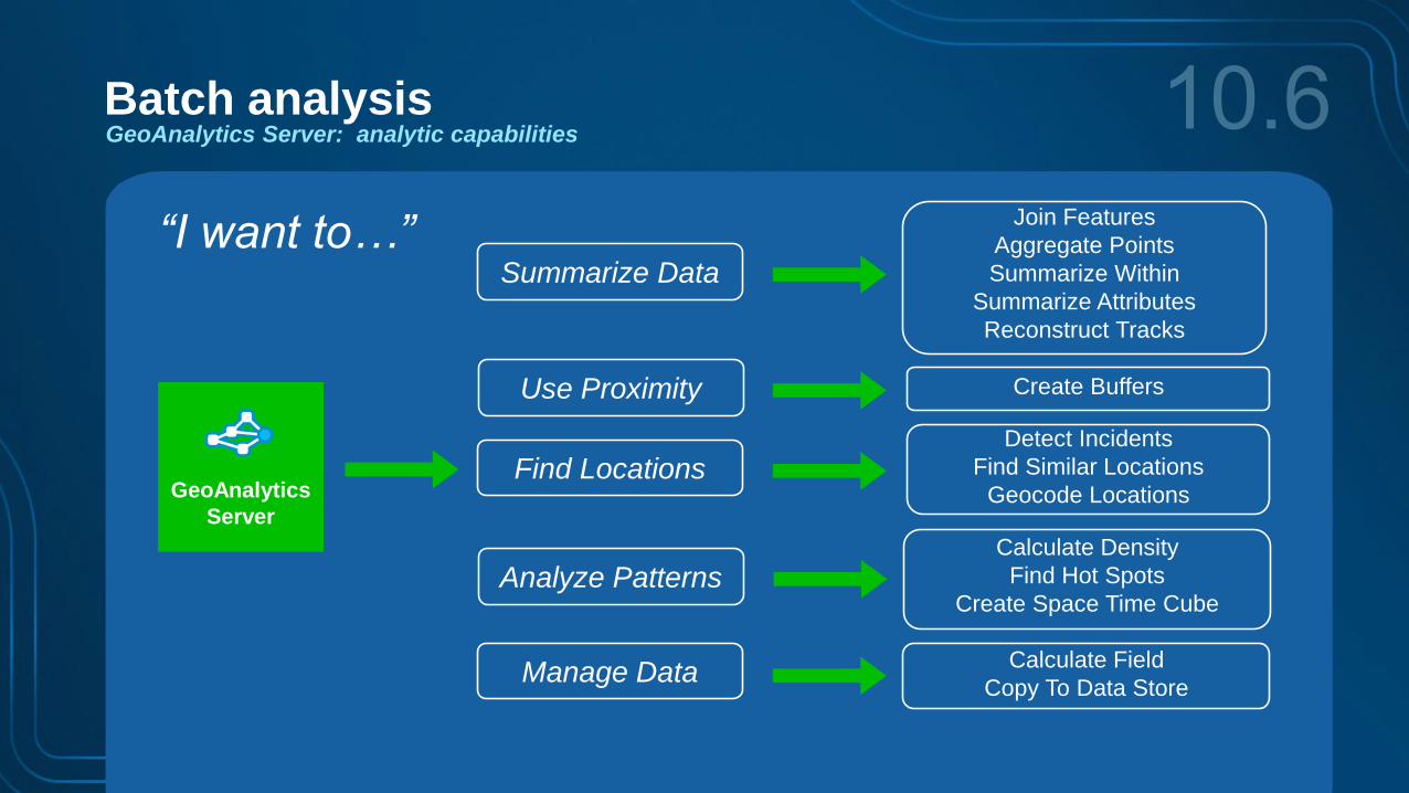
GeoAnalytics Server: analytic capabilities
Batch analysis
Analyze Patterns
Use Proximity
Summarize Data
Calculate Density
Find Hot Spots
Create Space Time Cube
Join Features
Aggregate Points
Summarize Within
Summarize Attributes
Reconstruct Tracks
Detect Incidents
Find Similar Locations
Geocode Locations
Create Buffers
Find Locations
“I want to…”
Manage DataCalculate Field
Copy To Data Store
GeoAnalytics
Server
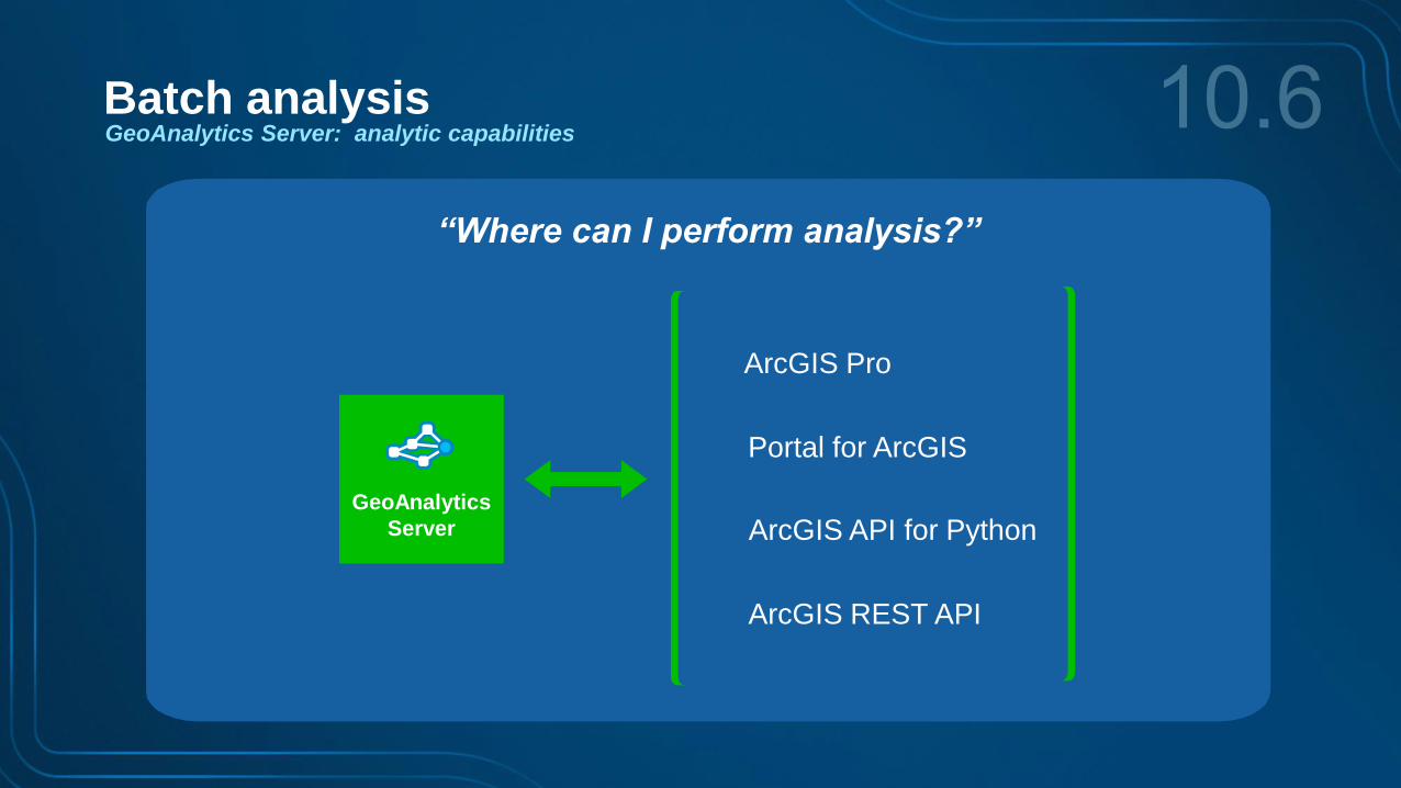
“Where can I perform analysis?”
Portal for ArcGIS
ArcGIS API for Python
ArcGIS REST API
ArcGIS Pro
GeoAnalytics
Server
GeoAnalytics Server: analytic capabilities
Batch analysis
use your Web GIS layers through Pro, Portal,Python notebooks or the REST API
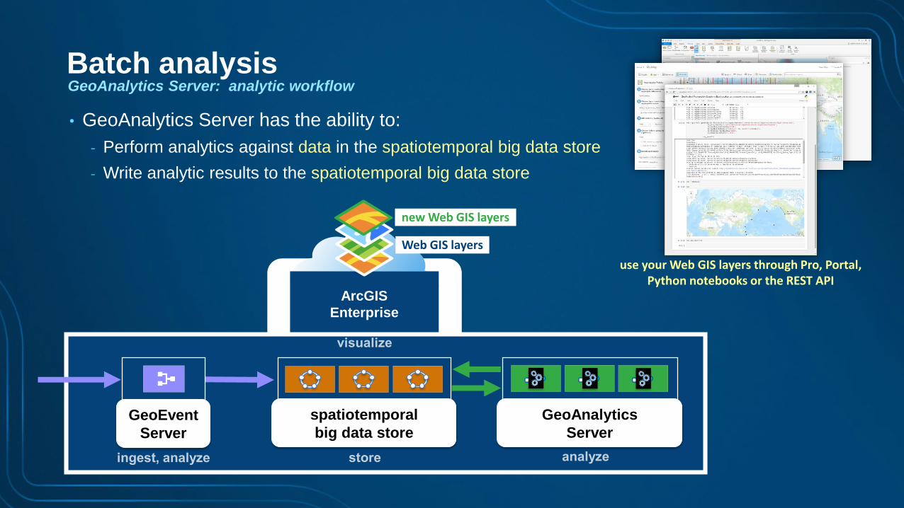
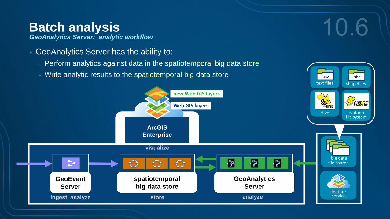
GeoAnalytics Server: analytic workflow
Batch analysis
• GeoAnalytics Server has the ability to:
- Perform analytics against data in the spatiotemporal big data store
- Write analytic results to the spatiotemporal big data store
ArcGIS
Enterprise
Web GIS layers
new Web GIS layers
spatiotemporal
big data store
GeoAnalytics
Server
GeoEvent
Server
ArcGIS
Enterprise
Web GIS layers
new Web GIS layers
spatiotemporal
big data store
GeoAnalytics
Server
GeoEvent
Server
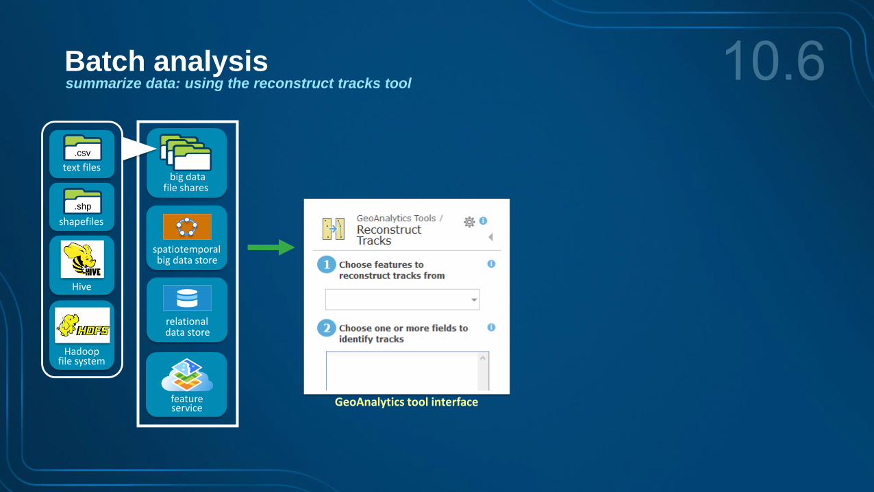
big datafile shares
featureservice
.shp
shapefiles
.csv
text files
Hadoopfile system
Hive
GeoAnalytics Server: analytic workflow
Batch analysis
• GeoAnalytics Server has the ability to:
- Perform analytics against data in the spatiotemporal big data store
- Write analytic results to the spatiotemporal big data store
summarize data
Batch analysis
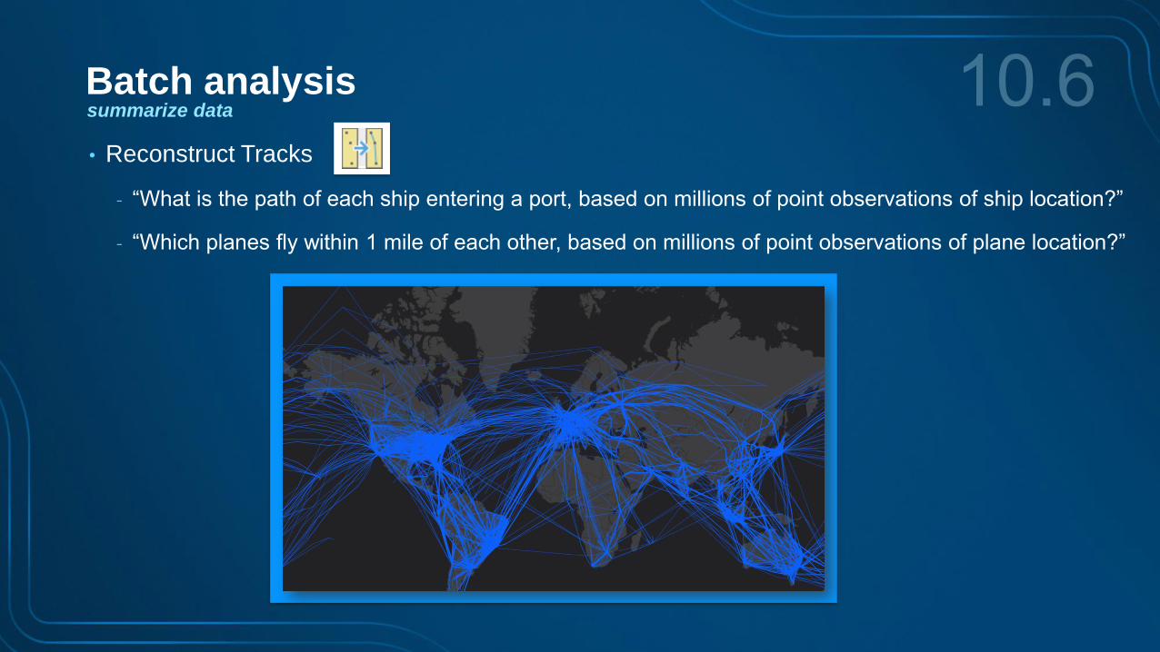
• Reconstruct Tracks
- “What is the path of each ship entering a port, based on millions of point observations of ship location?”
- “Which planes fly within 1 mile of each other, based on millions of point observations of plane location?”
summarize data
Batch analysis
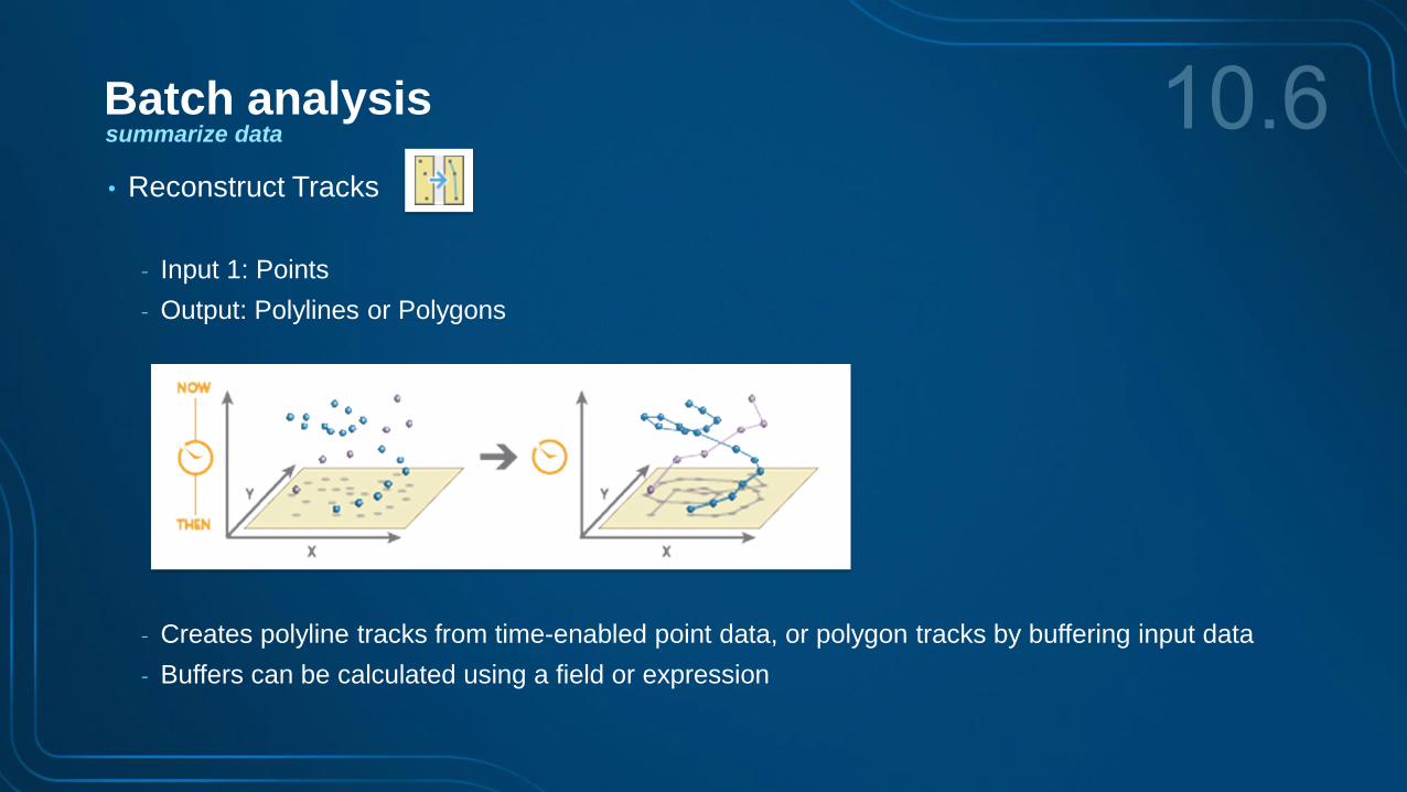
• Reconstruct Tracks
- Input 1: Points
- Output: Polylines or Polygons
- Creates polyline tracks from time-enabled point data, or polygon tracks by buffering input data
- Buffers can be calculated using a field or expression
big datafile shares
.shp
shapefiles
.csv
text files
Hadoopfile system
Hive
featureservice
relationaldata store
spatiotemporalbig data store
summarize data: using the reconstruct tracks tool
Batch analysis
GeoAnalytics tool interface

output features
input features
summarize data: using the reconstruct tracks tool
Batch analysis
GeoAnalytics tool interface
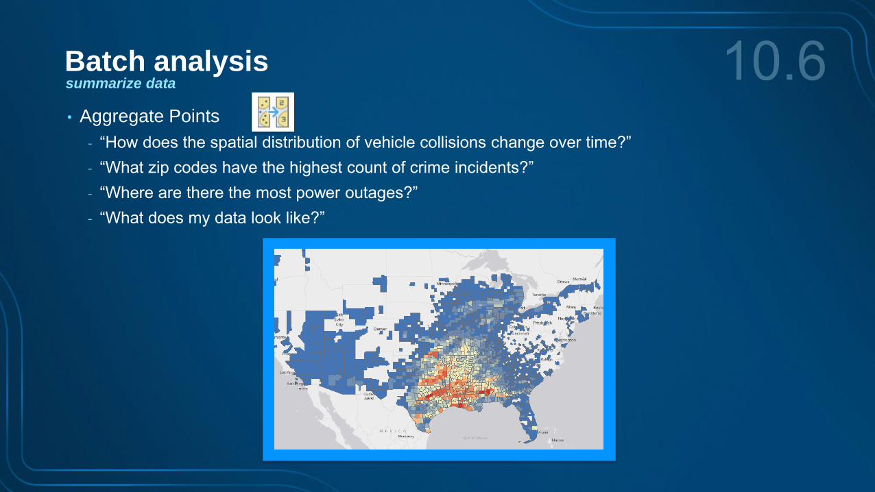
• Aggregate Points
- “How does the spatial distribution of vehicle collisions change over time?”
- “What zip codes have the highest count of crime incidents?”
- “Where are there the most power outages?”
- “What does my data look like?”
summarize data
Batch analysis
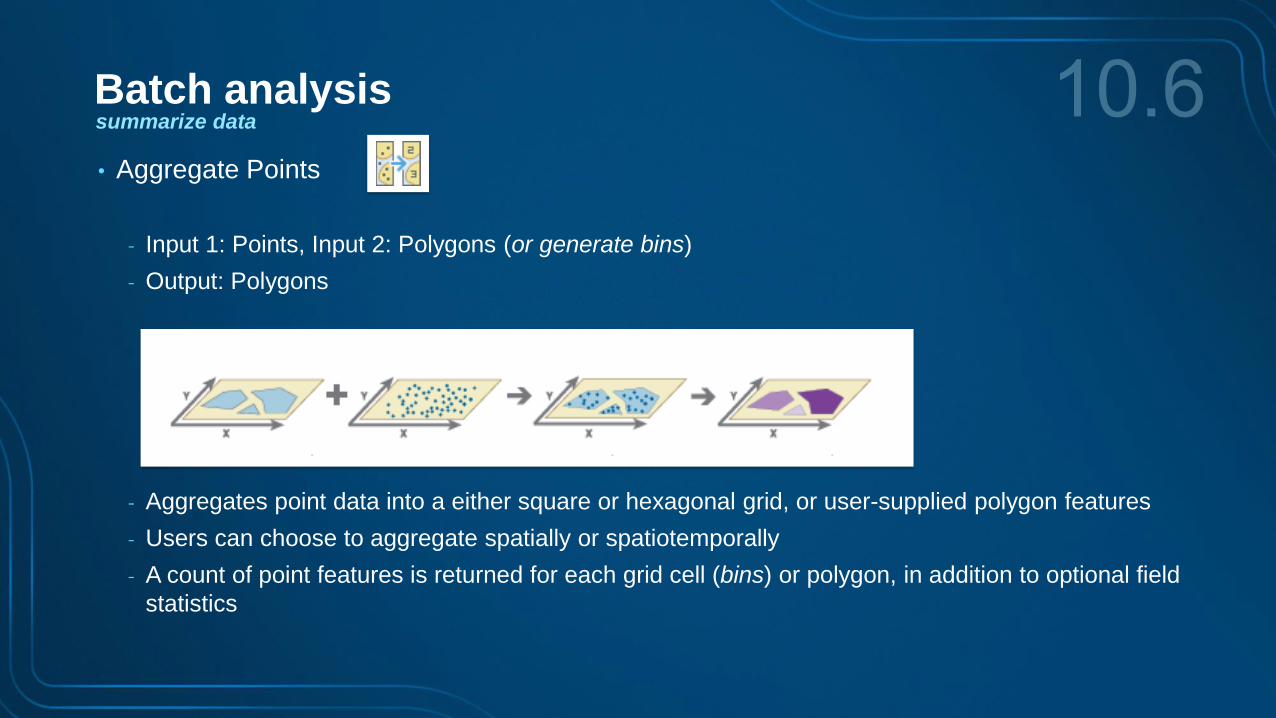
• Aggregate Points
- Input 1: Points, Input 2: Polygons (or generate bins)
- Output: Polygons
- Aggregates point data into a either square or hexagonal grid, or user-supplied polygon features
- Users can choose to aggregate spatially or spatiotemporally
- A count of point features is returned for each grid cell (bins) or polygon, in addition to optional field
statistics
summarize data
Batch analysis
• Aggregate Points
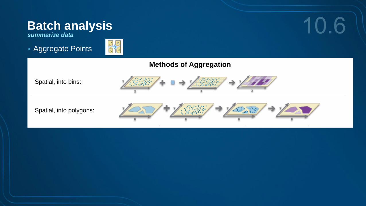
Methods of Aggregation
Spatial, into polygons:
Spatial, into bins:
summarize data
Batch analysis

Methods of Aggregation
Spatial, into polygons:
Spatial, into bins:
Spatiotemporal, into bins:
Spatiotemporal, into polygons:
summarize data
Batch analysis
• Aggregate Points

output features
input features
GeoAnalytics tool interface
summarize data: using the aggregate points tool
Batch analysis
spatiotemporal big data store
Summary
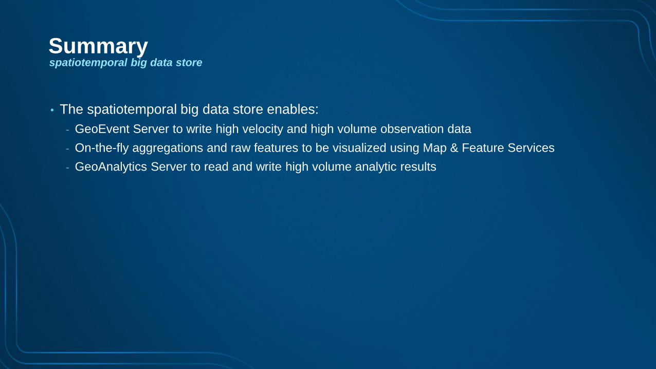
• The spatiotemporal big data store enables:
- GeoEvent Server to write high velocity and high volume observation data
- On-the-fly aggregations and raw features to be visualized using Map & Feature Services
- GeoAnalytics Server to read and write high volume analytic results
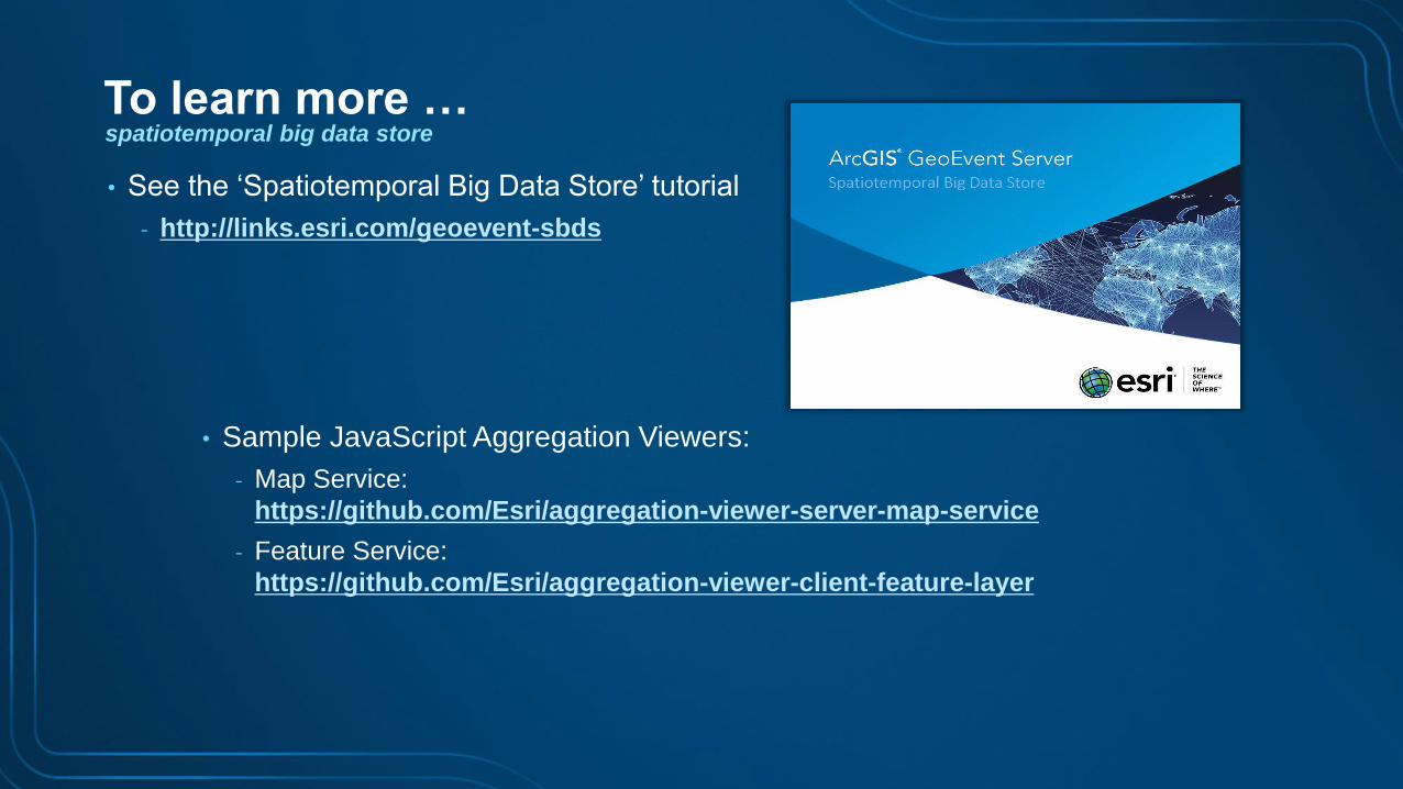
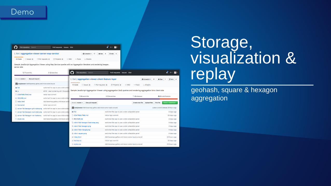
• Sample JavaScript Aggregation Viewers:
- Map Service:
https://github.com/Esri/aggregation-viewer-server-map-service
- Feature Service:
https://github.com/Esri/aggregation-viewer-client-feature-layer
• See the ‘Spatiotemporal Big Data Store’ tutorial
- http://links.esri.com/geoevent-sbds
spatiotemporal big data store
To learn more …

Please Attend Our Other Sessions!
• Developing Real-Time Web Apps with the ArcGIS API Thu, 9:00-9:30 am, Demo Theater 1: Oasis 1-2
for JavaScript
• Real-Time GIS: Road Ahead Thu, 4:00-5:00 pm, Pasadena/Sierra/Ventura
• GeoEvent Server: Creating Connectors and Fri, 8:30-9:30 am, Mesquite B
Processors Using the GeoEvent SDK
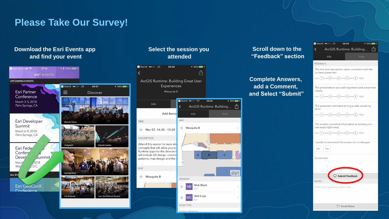
Please Take Our Survey!
Download the Esri Events app
and find your event
Select the session you
attended
Scroll down to the
“Feedback” section
Complete Answers,
add a Comment,
and Select “Submit”
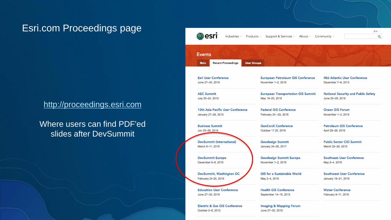
Esri.com Proceedings page
http://proceedings.esri.com
Where users can find PDF'ed
slides after DevSummit

Questions / Feedback?
Suzanne FossProduct Manager, Esri
Ricardo TrujilloReal-Time & Big Data GIS Developer, Esri
@rtrujill007