Embed Size (px)
Citation preview
Reading DiscussionReading Discussion
http://www.ngdc.noaa.gov/mgg/global/relief/ETOPO5/IMAGES/GIF/http://www.ngdc.noaa.gov/mgg/global/relief/ETOPO5/IMAGES/GIF/GLOBE.GIFGLOBE.GIF
Computer LanguageComputer Language
► Computers understand strings of zeros Computers understand strings of zeros and ones, making it difficult to and ones, making it difficult to comprehend how maps and other comprehend how maps and other geographical images are able to be geographical images are able to be represented in digital form.represented in digital form.
► It is important to understand that It is important to understand that digital representation of geography is digital representation of geography is not equal to geography itself, and not equal to geography itself, and always involves a certain degree of always involves a certain degree of approximation or estimation.approximation or estimation.
► Without getting too detailed, what kind Without getting too detailed, what kind of techniques or methods could be of techniques or methods could be used to process geographical used to process geographical information in a beneficial way?information in a beneficial way?
Methods created for processing Methods created for processing geographical informationgeographical information
► Since the mid-1970’sSince the mid-1970’s Techniques to input geographical information, converting the Techniques to input geographical information, converting the
information to digital forminformation to digital form Techniques for storing such information in compact format on Techniques for storing such information in compact format on
computer disks, compact disks, and other digital storage mediacomputer disks, compact disks, and other digital storage media Methods for automated analysis of geographical data, to search Methods for automated analysis of geographical data, to search
for patterns, combine different kinds of data, make for patterns, combine different kinds of data, make measurements, find optimum sites or routes , and a host of other measurements, find optimum sites or routes , and a host of other taskstasks
Methods to predict the outcome of various scenarios, such as the Methods to predict the outcome of various scenarios, such as the effects of climate change on vegetationeffects of climate change on vegetation
Techniques for display of data in the form of maps, images, and Techniques for display of data in the form of maps, images, and other kinds of displaysother kinds of displays
Capabilities for output of results in the form of numbers and Capabilities for output of results in the form of numbers and tablestables
Geographical Information Geographical Information SystemsSystems
► Also known as GISsAlso known as GISs► Encompasses wide range of geographical Encompasses wide range of geographical
data; includes GIS data, GIS decisions, data; includes GIS data, GIS decisions, and GIS systemsand GIS systems
► Complex systems that can take months or Complex systems that can take months or years to set upyears to set up
►How do they work?How do they work?
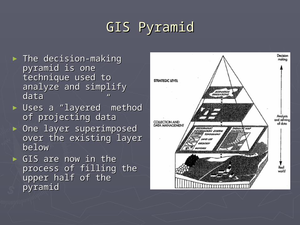
GIS PyramidGIS Pyramid
► The decision-making The decision-making pyramid is one technique pyramid is one technique used to analyze and used to analyze and simplify datasimplify data
► Uses a “layered” method Uses a “layered” method of projecting dataof projecting data
► One layer superimposed One layer superimposed over the existing layer over the existing layer belowbelow
► GIS are now in the GIS are now in the process of filling the process of filling the upper half of the pyramidupper half of the pyramid
GIS ChainGIS Chain
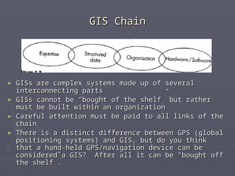
► GISs are complex systems made up of several GISs are complex systems made up of several interconnecting partsinterconnecting parts
► GISs cannot be “bought of the shelf” but rather must GISs cannot be “bought of the shelf” but rather must be built within an organizationbe built within an organization
► Careful attention must be paid to all links of the chainCareful attention must be paid to all links of the chain► There is a distinct difference between GPS (global There is a distinct difference between GPS (global
positioning systems) and GIS, but do you think that a positioning systems) and GIS, but do you think that a hand-held GPS/navigation device can be considered a hand-held GPS/navigation device can be considered a GIS? After all it can be “bought off the shelf”.GIS? After all it can be “bought off the shelf”.
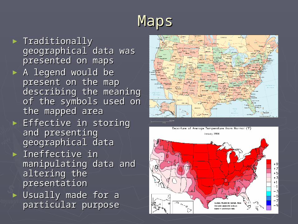
MapMapss
► Traditionally Traditionally geographical data was geographical data was presented on mapspresented on maps
► A legend would be A legend would be present on the map present on the map describing the meaning describing the meaning of the symbols used on of the symbols used on the mapped areathe mapped area
► Effective in storing and Effective in storing and presenting geographical presenting geographical datadata
► Ineffective in Ineffective in manipulating data and manipulating data and altering the presentationaltering the presentation
► Usually made for a Usually made for a particular purposeparticular purpose
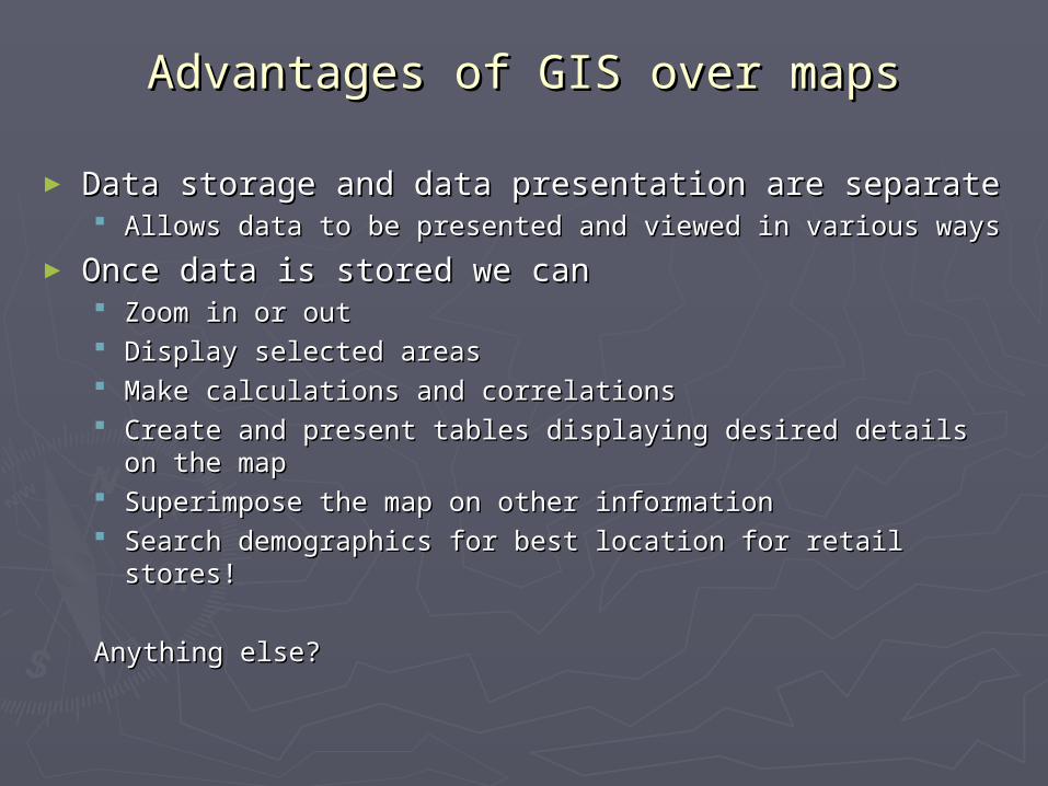
Advantages of GIS over mapsAdvantages of GIS over maps
► Data storage and data presentation are separateData storage and data presentation are separate Allows data to be presented and viewed in various waysAllows data to be presented and viewed in various ways
► Once data is stored we canOnce data is stored we can Zoom in or outZoom in or out Display selected areasDisplay selected areas Make calculations and correlationsMake calculations and correlations Create and present tables displaying desired details on the Create and present tables displaying desired details on the
mapmap Superimpose the map on other informationSuperimpose the map on other information Search demographics for best location for retail stores! Search demographics for best location for retail stores!
Anything else?Anything else?
Components Components
► There are many definitions of There are many definitions of geographical geographical information system, information system, for now consider a GIS for now consider a GIS to be any computer-based capability for the to be any computer-based capability for the manipulation of geographical datamanipulation of geographical data
► Includes hardware, software, special devices Includes hardware, software, special devices used to input maps and create map used to input maps and create map products, and communication systems products, and communication systems needed to link various elementsneeded to link various elements
Hardware and software functions Hardware and software functions include:include: Acquisition and verificationAcquisition and verification CompilationCompilation Storage Storage Updating and changingUpdating and changing Management and exchangeManagement and exchange ManipulationManipulation Retrieval and presentationRetrieval and presentation Analysis and combinationAnalysis and combination Now do you consider a GPS device a GIS?Now do you consider a GPS device a GIS?
GeoreferencingGeoreferencing
► All data in a GIS are georeferenced to a All data in a GIS are georeferenced to a specific location on the surface of the Earth specific location on the surface of the Earth through a coordinate systemthrough a coordinate system
► Common coordinate system is that of Common coordinate system is that of longitude and latitude, however many other longitude and latitude, however many other systems existsystems exist
►GIS must be capable of transforming GIS must be capable of transforming georeferences from one system to anothergeoreferences from one system to another
► Can a GPS fulfill this criteria? Can a GPS fulfill this criteria?
More about GISMore about GIS
►Has the ability to attach a variety of Has the ability to attach a variety of qualities and characteristics to geographical qualities and characteristics to geographical areasareas
►Qualities can be physical parameters (ie. Qualities can be physical parameters (ie. Elevation and temperature), vegetation, Elevation and temperature), vegetation, ownership of land, zoning, etc.ownership of land, zoning, etc.
►Qualities may be attached to points, but Qualities may be attached to points, but often are assigned to more complex often are assigned to more complex features such as lines or areas features such as lines or areas
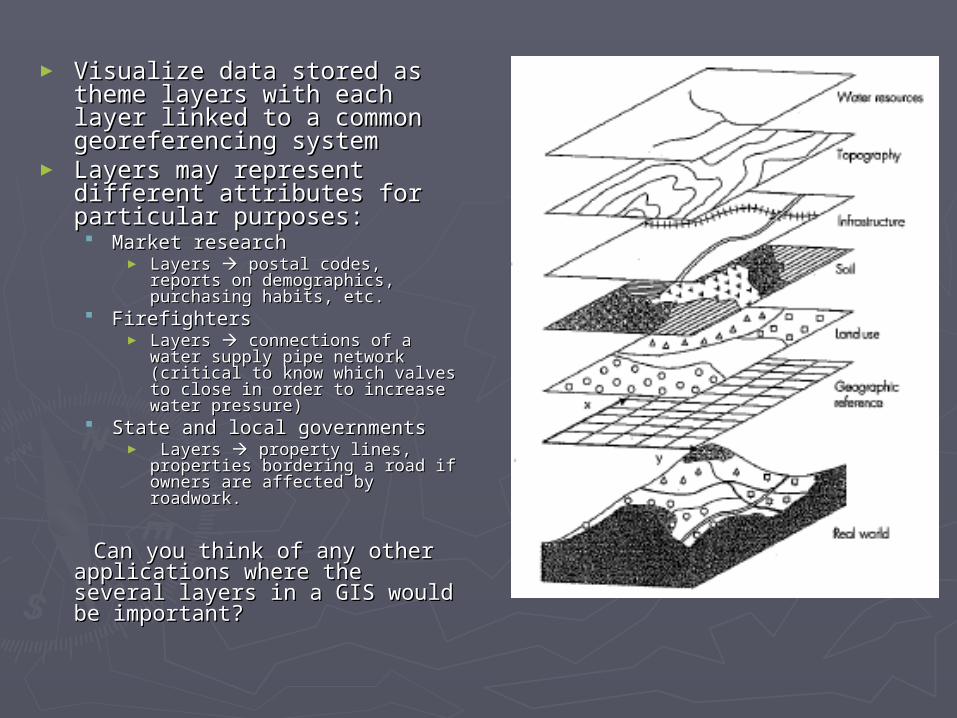
► Visualize data stored as Visualize data stored as theme layers with each layer theme layers with each layer linked to a common linked to a common georeferencing systemgeoreferencing system
► Layers may represent Layers may represent different attributes for different attributes for particular purposes:particular purposes: Market researchMarket research
► Layers Layers postal codes, reports postal codes, reports on demographics, purchasing on demographics, purchasing habits, etc.habits, etc.
FirefightersFirefighters► Layers Layers connections of a water connections of a water
supply pipe network (critical to supply pipe network (critical to know which valves to close in know which valves to close in order to increase water pressure)order to increase water pressure)
State and local governmentsState and local governments► Layers Layers property lines, property lines,
properties bordering a road if properties bordering a road if owners are affected by roadwork. owners are affected by roadwork.
Can you think of any other Can you think of any other applications where the several applications where the several layers in a GIS would be layers in a GIS would be important?important?
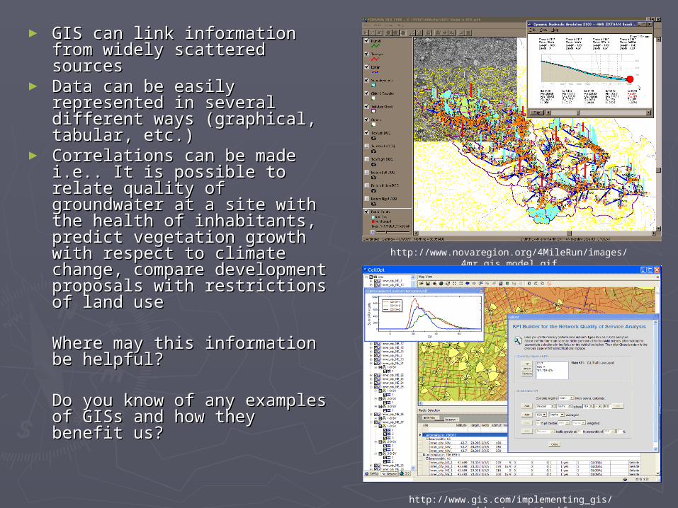
► GIS can link information from GIS can link information from widely scattered sourceswidely scattered sources
► Data can be easily Data can be easily represented in several represented in several different ways (graphical, different ways (graphical, tabular, etc.)tabular, etc.)
► Correlations can be made Correlations can be made i.e.. It is possible to relate i.e.. It is possible to relate quality of groundwater at a quality of groundwater at a site with the health of site with the health of inhabitants, predict inhabitants, predict vegetation growth with vegetation growth with respect to climate change, respect to climate change, compare development compare development proposals with restrictions of proposals with restrictions of land useland use
Where may this information Where may this information be helpful? be helpful?
Do you know of any Do you know of any examples of GISs and how examples of GISs and how they benefit us?they benefit us?
http://www.novaregion.org/4MileRun/images/4mr_gis_model.gif
http://www.gis.com/implementing_gis/graphics/comopt1.gif
Data IntegrationData Integration
► GISs have the capability of obtaining data from a GISs have the capability of obtaining data from a variety of sources, including but not only maps, variety of sources, including but not only maps, images from satellites, videofilm taken from images from satellites, videofilm taken from aircraft, statistical data, photographs, data from aircraft, statistical data, photographs, data from computer-assisted design (CAD) systems and computer-assisted design (CAD) systems and several other mediaseveral other media
► As GISs advance their definition changes, and As GISs advance their definition changes, and becomes more challenging to convey; for now we becomes more challenging to convey; for now we can consider GIS to be can consider GIS to be in the process of becoming in the process of becoming a typical data integration machinea typical data integration machine
► Storage capacity of these systems is minuet in Storage capacity of these systems is minuet in comparison with the complexity of the entire Earthcomparison with the complexity of the entire Earth

Storage Storage
► 100,000 words can be digitally stored in 100,000 words can be digitally stored in approximately 1 million bytes (1byte=8bits)approximately 1 million bytes (1byte=8bits)
► Information from a topographic map may Information from a topographic map may take 100 megabytes (1megabyte = just take 100 megabytes (1megabyte = just over 1million bytes) to digitally captureover 1million bytes) to digitally capture
►One scene from a satellite can take over One scene from a satellite can take over 300 megabytes, the equivalent space 300 megabytes, the equivalent space needed to store 300 booksneeded to store 300 books
What is the relevance of this? What does it What is the relevance of this? What does it mean?mean?
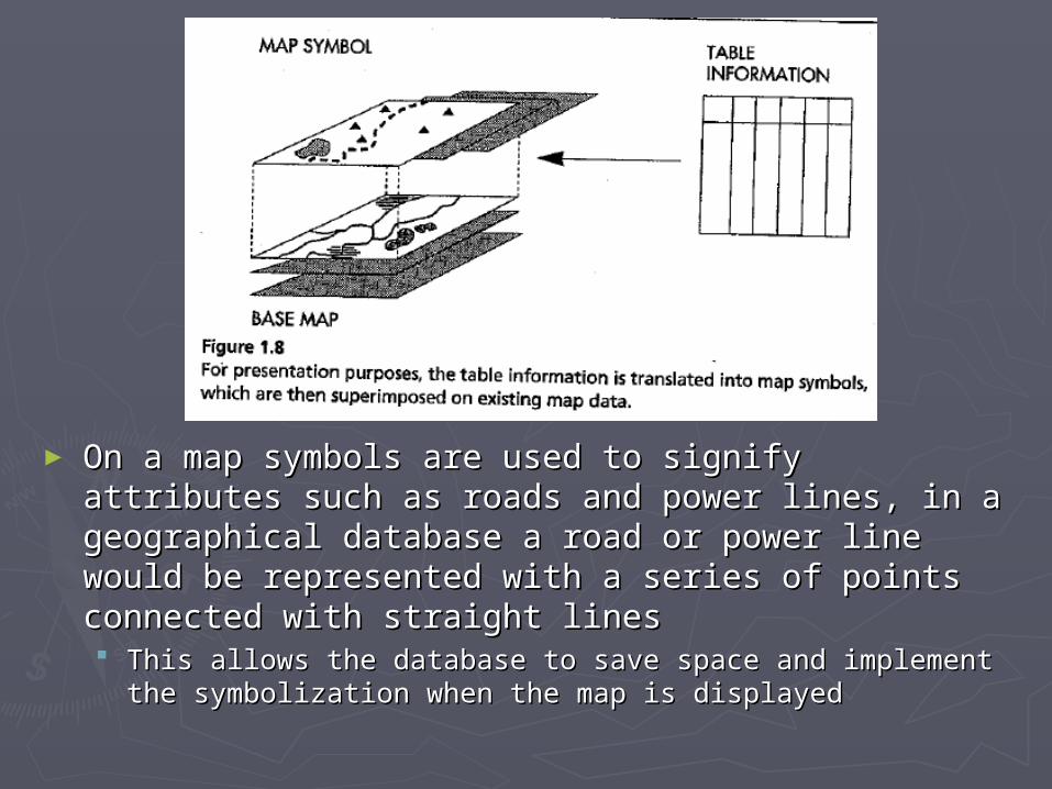
► On a map symbols are used to signify attributes On a map symbols are used to signify attributes such as roads and power lines, in a geographical such as roads and power lines, in a geographical database a road or power line would be database a road or power line would be represented with a series of points connected with represented with a series of points connected with straight linesstraight lines This allows the database to save space and implement the This allows the database to save space and implement the
symbolization when the map is displayed symbolization when the map is displayed
►Databases are vital in GISs because they Databases are vital in GISs because they allow the storing of geographical data in a allow the storing of geographical data in a structured mannerstructured manner
►Some GISs are imposing more Some GISs are imposing more structure by implementing database structure by implementing database management systems (DBMS) to store management systems (DBMS) to store part or all of the data in a largely part or all of the data in a largely independent subsystem under the GISindependent subsystem under the GIS
How does a DBMS help a GIS?How does a DBMS help a GIS?
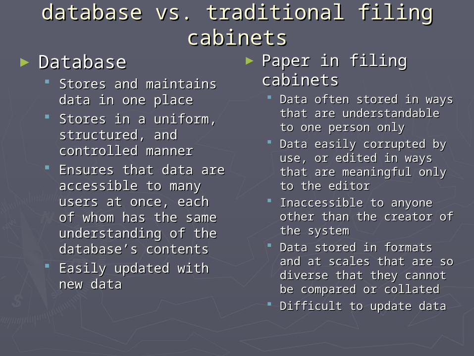
database vs. traditional filing cabinetsdatabase vs. traditional filing cabinets
►DatabaseDatabase Stores and maintains Stores and maintains
data in one placedata in one place Stores in a uniform, Stores in a uniform,
structured, and structured, and controlled mannercontrolled manner
Ensures that data are Ensures that data are accessible to many users accessible to many users at once, each of whom at once, each of whom has the same has the same understanding of the understanding of the database’s contentsdatabase’s contents
Easily updated with new Easily updated with new datadata
► Paper in filing Paper in filing cabinetscabinets Data often stored in ways Data often stored in ways
that are understandable that are understandable to one person onlyto one person only
Data easily corrupted by Data easily corrupted by use, or edited in ways use, or edited in ways that are meaningful only that are meaningful only to the editorto the editor
Inaccessible to anyone Inaccessible to anyone other than the creator of other than the creator of the systemthe system
Data stored in formats Data stored in formats and at scales that are so and at scales that are so diverse that they cannot diverse that they cannot be compared or collatedbe compared or collated
Difficult to update dataDifficult to update data
GIS diversityGIS diversity
► The diversity of GIS has caused various definitions, The diversity of GIS has caused various definitions, typically users contrive working definitions suited to typically users contrive working definitions suited to their own specific usestheir own specific uses
► Views of GIS includeViews of GIS include A data processing system designed for map production or A data processing system designed for map production or
visualizationvisualization A data analysis system for examining conflicts over plans A data analysis system for examining conflicts over plans
or optimizing the design of transport systemsor optimizing the design of transport systems An information system for responding to queries about An information system for responding to queries about
land ownership or soil typeland ownership or soil type A management system to support the operations of a A management system to support the operations of a
utility company, helping it to maintain its distribution utility company, helping it to maintain its distribution network of pipes or cables network of pipes or cables
A planning system to aid the design of road systems, A planning system to aid the design of road systems, excavations, or forest harvest operationsexcavations, or forest harvest operations
An electronic navigation system for use in land or sea An electronic navigation system for use in land or sea transporttransport
Definition ?Definition ?
► Can we come up with one definition?Can we come up with one definition?►GIS is now accepted internationally as GIS is now accepted internationally as an an
umbrella term for all digital systems umbrella term for all digital systems designed to process geographical data.designed to process geographical data.
Disciplines, applications, types of data Disciplines, applications, types of data and end users encompassed by GISand end users encompassed by GIS
► DisciplinesDisciplines: : computer sciences, cartography, computer sciences, cartography, photogrammetry, surveying, remote sensing, photogrammetry, surveying, remote sensing, geography, hydrography, statistics, information geography, hydrography, statistics, information sciences, planningsciences, planning
► ApplicationsApplications:: operation and maintenance of operation and maintenance of networks and other facilities, management of networks and other facilities, management of natural resources, real estate management, road natural resources, real estate management, road planning, map productionplanning, map production
► DataData:: digital maps, digital imaging of scanned digital maps, digital imaging of scanned maps and photos, satellite data, ground truth data, maps and photos, satellite data, ground truth data, video images, tabular data, text datavideo images, tabular data, text data
► UsersUsers:: water supply and sewage engineers, water supply and sewage engineers, planners, biologists and cartographers, surveyors planners, biologists and cartographers, surveyors
► CAD CAD computer assisted design. Image computer assisted design. Image processing system designed to perform a processing system designed to perform a wide range of operations on images.wide range of operations on images.
► As images become a more important part of As images become a more important part of GIS the distinction between image GIS the distinction between image processing and GIS is becoming increasingly processing and GIS is becoming increasingly blurredblurred
► Key terms for distinction:Key terms for distinction: GIS GIS analysis analysis
process process
CAD CAD extraction extraction design design
► ““Forest fires ravaging southern California, foot-Forest fires ravaging southern California, foot-and-mouth disease devastating the British and-mouth disease devastating the British livestock industry, the recent outbreak of livestock industry, the recent outbreak of severe acute respiratory syndrome (SARS)—all severe acute respiratory syndrome (SARS)—all of these disasters have at least one thing in of these disasters have at least one thing in common: the role played by geospatial common: the role played by geospatial analysts, mining satellite images for information analysts, mining satellite images for information to help authorities make crucial decisions.”to help authorities make crucial decisions.”
It is for reasons like this that geotechnology is one of It is for reasons like this that geotechnology is one of the three most important emerging and evolving the three most important emerging and evolving fields, along with nanotechnology and biotechnology. fields, along with nanotechnology and biotechnology.
Questions/comments?Questions/comments?