Embed Size (px)
Citation preview

LEARNER OUTCOMES (cont.)• Learn vocabulary related to the representa-
tion of key features of the earth on a map or globe.
ACTIVITIES• View and discuss two TV411 video
segments.
• Read two In Print articles related to the video.
• Review eight vocabulary words or terms.
READING AND MATH
(2 hours)
Lesson at a GlanceSUMMARYIt's old news to say that today's world is a global village. But do we know our neighbors?Apparently not. According to recent surveys,Americans generally score poorly on geographytests.
The GED contains a social studies section thatassumes the test-taker is, at the very least,capable of reading a world map. This lessoncapitalizes on the map-reading strategieslearned in Part 1 and helps learners navigate aglobe or world map with greater ease.
GOALS• To have a basic familiarity with a globe and/or
world map
• To understand the use of the points of the compass
• To understand longitude and latitude
LEARNER OUTCOMESStudents will...• Identify the seven continents and four
major oceans.
• Learn about the significance and locations of the equator and lines of longitude and latitude.
• Learn the difference between neighborhood, state, country, continent, and globe.
• Understand global measurement and distances between continents.
MATERIALSVIDEO:Sports Smarts: Reading a World Map Episode 25: Length: 4:15, Start Time: 19:25
Math Play: Longitude/LatitudeEpisode 25: Length: 0:23, Start Time: 24:15(immediately following Sports Smarts)
PRINT:A Global SocietyIssue 25, pp. 4–5
Meet the Harlem GlobetrottersIssue 25, p. 11
LARGE WORLD MAPINDIVIDUAL GLOBES OR MAPS OF THE WORLDATLAS
“You name it, we’ve been there.”
Maps, Part 2:Reading the Globe;
Understanding Longitude and Latitude
SU
PP
LE
ME
NTA
L
1
TE
AC
HE
R’S
GU
IDE
Reading the Globe;
READING AND MATH
Step by Step1. INTRODUCING THE CONTENT - VIDEO 1Pre-Viewing Activities
DiscussAsk the native-born Americans in the class where their families originated. Ask those born elsewhere where they come from.
Prompt students to talk about their homeland or their family's homeland (its continent, capital city, language or languages, system of government, etc.). Ask them to locate these places on a world map or in an atlas.
While it's fun to hear about the histories of people in the class, there's also a practical side to the exercise. The GED contains a social studies section; and the more students can learn about the geography of our planet, the better.
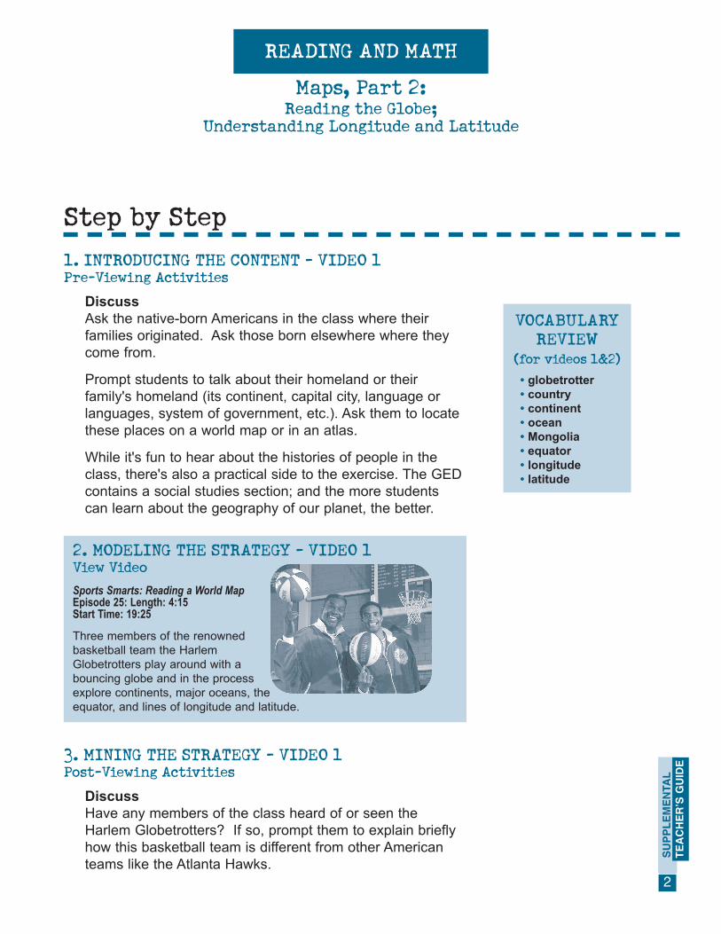
2. MODELING THE STRATEGY - VIDEO 1View VideoSports Smarts: Reading a World MapEpisode 25: Length: 4:15 Start Time: 19:25
Three members of the renownedbasketball team the HarlemGlobetrotters play around with abouncing globe and in the processexplore continents, major oceans, theequator, and lines of longitude and latitude.
VOCABULARYREVIEW
(for videos 1&2)• globetrotter • country • continent• ocean • Mongolia • equator • longitude• latitude
Understanding Longitude and Latitude
Maps, Part 2:
SU
PP
LE
ME
NTA
L
2
TE
AC
HE
R’S
GU
IDE
3. MINING THE STRATEGY - VIDEO 1Post-Viewing Activities
DiscussHave any members of the class heard of or seen the Harlem Globetrotters? If so, prompt them to explain briefly how this basketball team is different from other American teams like the Atlanta Hawks.
Step by Step (cont.)
Discuss (cont.)[Rather than play competitively, the Globetrotters are performers; they travel the world demonstrating their extraordinary basketball skills.]
What did students learn from the video?Possible answers:• there are seven continents• there are four major oceans• one of the Globetrotters is from Mongolia, a country
"sandwiched" between Russia and China• the equator is an imaginary line that divides the globe
in half• 70% of the planet Earth is water
4. EXTENDING AND PRACTICING THE STRATEGYVIDEO 1Workbook ActivityWorking in small groups, students read and complete AGlobal Society (In Print Issue 25, pp. 4–5). The activity reinforces what's taught in the video segment and includes a final section that requires use of a world map or globe to complete.
Have students compare their answers as a whole group.
5. INTRODUCING THE CONTENT - VIDEO 2Pre-Viewing Activities
DiscussAsk students to explain the concept of longitude and latitude that was introduced in the In Print activity. Explain that the next short TV411 segment presents the concept in visual ways.
Reading the Globe;
READING AND MATH
Understanding Longitude and Latitude
Maps, Part 2:
SU
PP
LE
ME
NTA
L
3
TE
AC
HE
R’S
GU
IDE

Step by Step (cont.)
Reading the Globe;
READING AND MATH
Understanding Longitude and Latitude
6. MODELING THE STRATEGY - VIDEO 2View VideoSports Smarts: Reading a World MapEpisode 25: Length: 0:23 Start Time: 24:15(immediately following Sports Smarts)
7. MINING THE STRATEGY - VIDEO 2Post-Viewing Activities
Discuss• Which are the lines of latitude? Which direction do
they run? [Lines that run from east to west, or side to side, are lines of latitude.]
• Which are the lines of longitude? Which direction do they run? [Lines that run from north to south, or up and down, are lines of longitude.]
• What is the purpose of crisscrossing the map with these lines? [When the lines intersect, they pinpoint a specific location on the earth.]
• What is the equator? [The line of latitude that divides the earth into halves: North and South.]
• Does anyone in the class come from Ecuador, a coun-try that lies right on the equator?
Maps, Part 2:
SU
PP
LE
ME
NTA
L
4
TE
AC
HE
R’S
GU
IDE

Understanding Longitude and Latitude
Step by Step (cont.)
8. EXTENDING AND PRACTICING THE STRATEGYVIDEO 2The following activity can be a competition or simply a collaborative project for the class.
Divide learners into at least four groups (pairs or more). Distribute globes or atlases and assign each group six different letters of the alphabet (excluding W and X, and noting that only one country begins with the letter O). Instruct the groups to write down one country per letter and to locate it on the map or globe. Then switch lists among the groups. Can the next group come up with six more countries for each letter?
You may wish to extend this lesson with an activity that prompts students to pinpoint the coordinates of latitude and longitude for each country.
9. PORTFOLIOStudents save their work in their portfolio. If class time runs out, they can pick up where they left off next time you meet.
Distribute copies of Meet the Harlem Globetrotters (In Print Issue 25, p. 11) for learners to read at home. If you wish, give the writing assignment as homework.
For a Web lesson on map reading, go to www.tv411.org, click on Reading and then on Reading Maps.
Encourage students to search the Internet for Web sites (such as the National Geographic site), which have information about, and pictures of, remote places. SU
PP
LE
ME
NTA
L
5
TE
AC
HE
R’S
GU
IDE
Reading the Globe;
READING AND MATH
10. HOMEWORK
11. WEB CONNECTION
Maps, Part 2: