Embed Size (px)
Citation preview
Saint-H
enriSaint-Henri Revitalization & Integration Strategy
Prepared for:
PHIL BUBIS - 5561736MARCOS CERETTI - 5531799ANWAR MOHAMED - 5482968WENYUAN ZHANG - 5600642
FINAL REPORT - April 21th, 2008
URBS 433 - ADVANCED URBAN LABORATORY - (2008) - PROF. PIERRE GAUTHIER DEPARTMENT OF GEOGRAPHY, PLANNING AND ENVIRONMENT - CONCORDIA UNIVERSITYMONTREAL - QUEBEC - CANADA

Saint-H
enriTable of ContentsAcknowledgements
Mission Statement
1 I Overview
1.1 Introduction
1.2 History
1.3 Current Trends
1.4 Administration
1.5 Community Groups
1.6 Socio-Economics Demographics Economics Gentrification
2 I Aims & Objectives
3 I Design Principles
4 I Proposal
4.1 Site 1 - Railroad Case Study
4.2 Site 2 - Lachine Canal Along the Canal
4.3 Parking Location
4.4 Tramway
4.5 Bus
4.6 Costs & Benefits
Conclusion
Bibliography
1
2
3
3
4
4
5
5
6
11
15
20
21
23
8
9
11
24
25
22

Saint-H
enri
This project is the culmination of the trials and tribulations for third-year Arts and Science students studying in the Urban Planning program at Concor-dia University. This work was part of an advanced urban laboratory project consisting of analyzing and understanding specific key elements that provide the contemporary makeup of Saint-Henri. This analysis, expresses the collaborative efforts of all students enrolled in the laboratory under the supervi-sion and professional expertise of Professor Pierre Gauthier Ph.D. in Urban Planning. It is with great pleasure that we invite you to review our final analyses of Saint-Henri.
In no specific order, we would like to thank Professor Pierre Gauthier, Professor Craig Townsend, Professor Pierre Barrieau, our classmates, individuals from community groups, and all guest lecturers who have aided in our overall understanding of the area as a whole.
Acknowledgements
1

Saint-H
enriMission Statement
The aim of our project is to enhance the overall quality of life in Saint-Henri for all inhabitants. This will be done by promoting a pedestrian friendly envi-ronment, encouraging and improving the use of Notre-Dame as a local high street, better integrating different sub-sectors of St-Henri, and by revitalizing the existing public infrastructure.
2
Saint-H
enri1.1 IntroductionTo the visual senses, Saint-Henri materializes in a similar regard to other working class neighborhoods within the Sud-Ouest of Montreal afflicted by an era of deindustrialization. Benefiting from proximity to the CBD of Montreal, Saint-Henri is an important area due to its geographic context. Saint-Henri is alienated from its surroundings by internal barriers as well as on the periphery. These boundaries are Avenue Atwater to the East, Autoroute 15 to the West, Autoroute 20 to the North, the Lachine Canal to the south, and the CN railroad cutting directly through the centre of the area. These boundaries act as psychological and physical barriers which have caused the creation of displaced pockets of activity within the area.
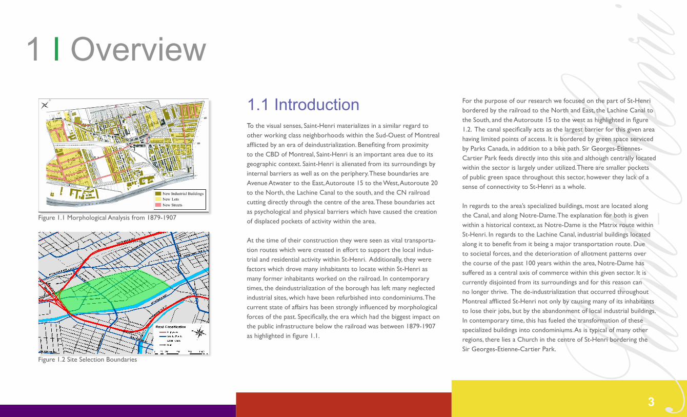
At the time of their construction they were seen as vital transporta-tion routes which were created in effort to support the local indus-trial and residential activity within St-Henri. Additionally, they were factors which drove many inhabitants to locate within St-Henri as many former inhabitants worked on the railroad. In contemporary times, the deindustrialization of the borough has left many neglected industrial sites, which have been refurbished into condominiums. The current state of affairs has been strongly influenced by morphological forces of the past. Specifically, the era which had the biggest impact on the public infrastructure below the railroad was between 1879-1907 as highlighted in figure 1.1.
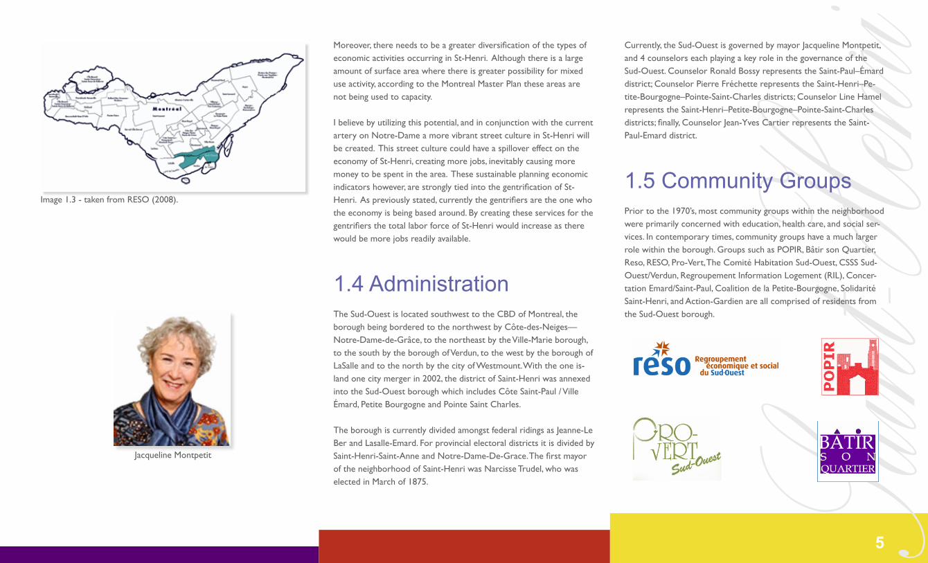
For the purpose of our research we focused on the part of St-Henri bordered by the railroad to the North and East, the Lachine Canal to the South, and the Autoroute 15 to the west as highlighted in figure 1.2. The canal specifically acts as the largest barrier for this given area having limited points of access. It is bordered by green space serviced by Parks Canada, in addition to a bike path. Sir Georges-Etiennes-Cartier Park feeds directly into this site and although centrally located within the sector is largely under utilized. There are smaller pockets of public green space throughout this sector, however they lack of a sense of connectivity to St-Henri as a whole.
In regards to the area’s specialized buildings, most are located along the Canal, and along Notre-Dame. The explanation for both is given within a historical context, as Notre-Dame is the Matrix route within St-Henri. In regards to the Lachine Canal, industrial buildings located along it to benefit from it being a major transportation route. Due to societal forces, and the deterioration of allotment patterns over the course of the past 100 years within the area, Notre-Dame has suffered as a central axis of commerce within this given sector. It is currently disjointed from its surroundings and for this reason can no longer thrive. The de-industrialization that occurred throughout Montreal afflicted St-Henri not only by causing many of its inhabitants to lose their jobs, but by the abandonment of local industrial buildings. In contemporary time, this has fueled the transformation of these specialized buildings into condominiums. As is typical of many other regions, there lies a Church in the centre of St-Henri bordering the Sir Georges-Etienne-Cartier Park.
1 I Overview
Figure 1.1 Morphological Analysis from 1879-1907
Figure 1.2 Site Selection Boundaries
3
Saint-H
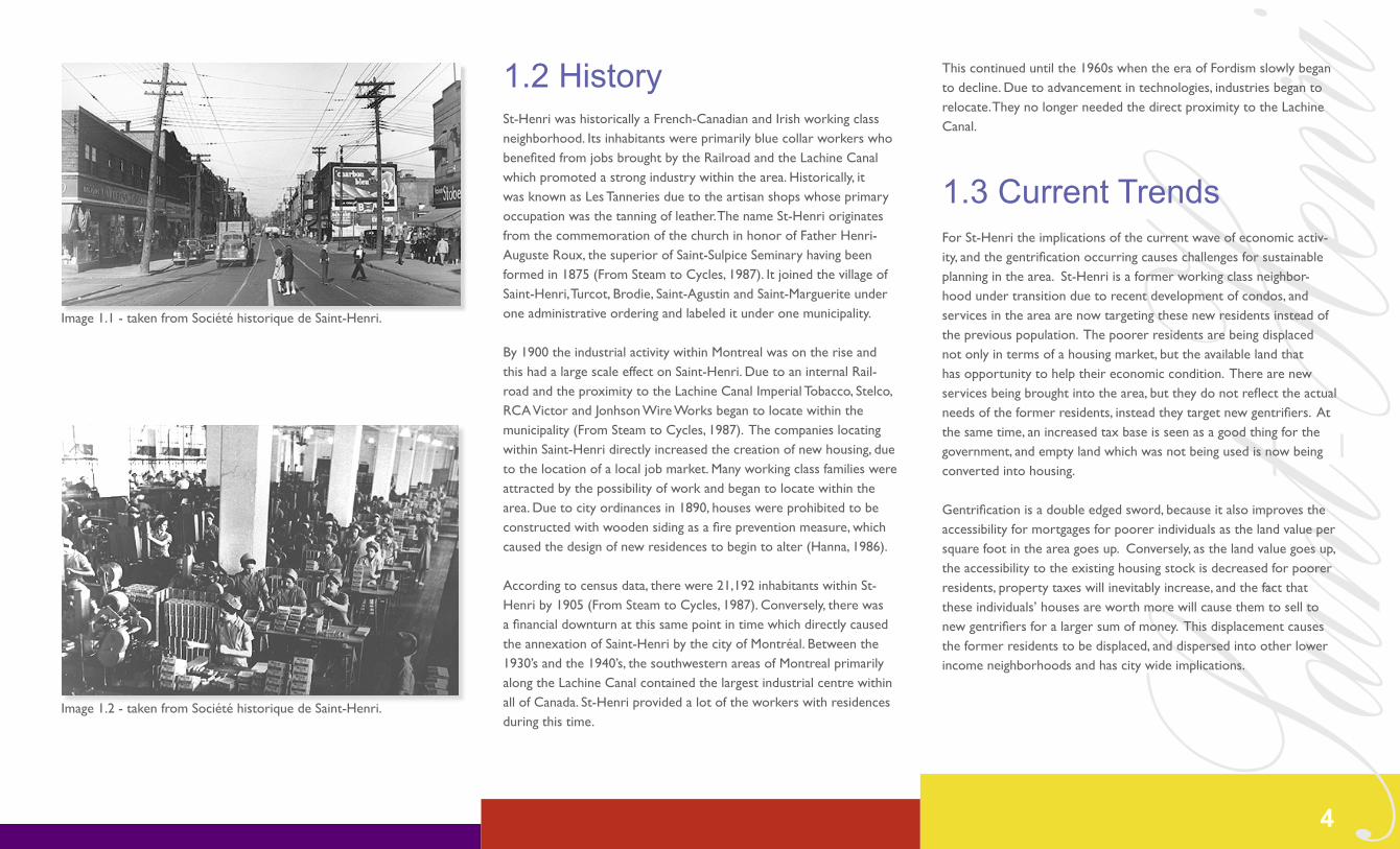
enri1.2 HistorySt-Henri was historically a French-Canadian and Irish working class neighborhood. Its inhabitants were primarily blue collar workers who benefited from jobs brought by the Railroad and the Lachine Canal which promoted a strong industry within the area. Historically, it was known as Les Tanneries due to the artisan shops whose primary occupation was the tanning of leather. The name St-Henri originates from the commemoration of the church in honor of Father Henri-Auguste Roux, the superior of Saint-Sulpice Seminary having been formed in 1875 (From Steam to Cycles, 1987). It joined the village of Saint-Henri, Turcot, Brodie, Saint-Agustin and Saint-Marguerite under one administrative ordering and labeled it under one municipality.
By 1900 the industrial activity within Montreal was on the rise and this had a large scale effect on Saint-Henri. Due to an internal Rail-road and the proximity to the Lachine Canal Imperial Tobacco, Stelco, RCA Victor and Jonhson Wire Works began to locate within the municipality (From Steam to Cycles, 1987). The companies locating within Saint-Henri directly increased the creation of new housing, due to the location of a local job market. Many working class families were attracted by the possibility of work and began to locate within the area. Due to city ordinances in 1890, houses were prohibited to be constructed with wooden siding as a fire prevention measure, which caused the design of new residences to begin to alter (Hanna, 1986).
According to census data, there were 21,192 inhabitants within St-Henri by 1905 (From Steam to Cycles, 1987). Conversely, there was a financial downturn at this same point in time which directly caused the annexation of Saint-Henri by the city of Montréal. Between the 1930’s and the 1940’s, the southwestern areas of Montreal primarily along the Lachine Canal contained the largest industrial centre within all of Canada. St-Henri provided a lot of the workers with residences during this time.
This continued until the 1960s when the era of Fordism slowly began to decline. Due to advancement in technologies, industries began to relocate. They no longer needed the direct proximity to the Lachine Canal.
1.3 Current TrendsFor St-Henri the implications of the current wave of economic activ-ity, and the gentrification occurring causes challenges for sustainable planning in the area. St-Henri is a former working class neighbor-hood under transition due to recent development of condos, and services in the area are now targeting these new residents instead of the previous population. The poorer residents are being displaced not only in terms of a housing market, but the available land that has opportunity to help their economic condition. There are new services being brought into the area, but they do not reflect the actual needs of the former residents, instead they target new gentrifiers. At the same time, an increased tax base is seen as a good thing for the government, and empty land which was not being used is now being converted into housing.
Gentrification is a double edged sword, because it also improves the accessibility for mortgages for poorer individuals as the land value per square foot in the area goes up. Conversely, as the land value goes up, the accessibility to the existing housing stock is decreased for poorer residents, property taxes will inevitably increase, and the fact that these individuals’ houses are worth more will cause them to sell to new gentrifiers for a larger sum of money. This displacement causes the former residents to be displaced, and dispersed into other lower income neighborhoods and has city wide implications.
Image 1.1 - taken from Société historique de Saint-Henri.
Image 1.2 - taken from Société historique de Saint-Henri.
4
Saint-H
enriMoreover, there needs to be a greater diversification of the types of economic activities occurring in St-Henri. Although there is a large amount of surface area where there is greater possibility for mixed use activity, according to the Montreal Master Plan these areas are not being used to capacity.
I believe by utilizing this potential, and in conjunction with the current artery on Notre-Dame a more vibrant street culture in St-Henri will be created. This street culture could have a spillover effect on the economy of St-Henri, creating more jobs, inevitably causing more money to be spent in the area. These sustainable planning economic indicators however, are strongly tied into the gentrification of St-Henri. As previously stated, currently the gentrifiers are the one who the economy is being based around. By creating these services for the gentrifiers the total labor force of St-Henri would increase as there would be more jobs readily available.
1.4 AdministrationThe Sud-Ouest is located southwest to the CBD of Montreal, the borough being bordered to the northwest by Côte-des-Neiges—Notre-Dame-de-Grâce, to the northeast by the Ville-Marie borough, to the south by the borough of Verdun, to the west by the borough of LaSalle and to the north by the city of Westmount. With the one is-land one city merger in 2002, the district of Saint-Henri was annexed into the Sud-Ouest borough which includes Côte Saint-Paul / Ville Émard, Petite Bourgogne and Pointe Saint Charles.
The borough is currently divided amongst federal ridings as Jeanne-Le Ber and Lasalle-Emard. For provincial electoral districts it is divided by Saint-Henri-Saint-Anne and Notre-Dame-De-Grace. The first mayor of the neighborhood of Saint-Henri was Narcisse Trudel, who was elected in March of 1875.
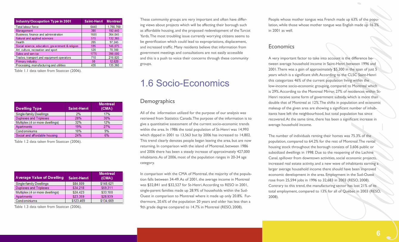
Currently, the Sud-Ouest is governed by mayor Jacqueline Montpetit, and 4 counselors each playing a key role in the governance of the Sud-Ouest. Counselor Ronald Bossy represents the Saint-Paul–Émard district; Counselor Pierre Fréchette represents the Saint-Henri–Pe-tite-Bourgogne–Pointe-Saint-Charles districts; Counselor Line Hamel represents the Saint-Henri–Petite-Bourgogne–Pointe-Saint-Charles districts; finally, Counselor Jean-Yves Cartier represents the Saint-Paul-Emard district.
1.5 Community GroupsPrior to the 1970’s, most community groups within the neighborhood were primarily concerned with education, health care, and social ser-vices. In contemporary times, community groups have a much larger role within the borough. Groups such as POPIR, Bâtir son Quartier, Reso, RESO, Pro-Vert, The Comité Habitation Sud-Ouest, CSSS Sud-Ouest/Verdun, Regroupement Information Logement (RIL), Concer-tation Emard/Saint-Paul, Coalition de la Petite-Bourgogne, Solidarité Saint-Henri, and Action-Gardien are all comprised of residents from the Sud-Ouest borough.
Image 1.3 - taken from RESO (2008).
Jacqueline Montpetit
5
Saint-H
enriThese community groups are very important and often have differ-ing views about projects which will be affecting their borough such as affordable housing, and the proposed redevelopment of the Turcot Yards. The most troubling issue currently worrying citizens seems to be gentrification which could lead to expropriations, displacement, and increased traffic. Many residents believe that information from government meetings and consultations are not easily accessible and this is a push to voice their concerns through these community groups.
1.6 Socio-Economics
Demographics
All of the information utilized for the purpose of our analysis was retrieved from Statistics Canada. The purpose of the information is to give a quantitative assessment of the current socio-economic trends within the area. In 1986 the total population of St-Henri was 14,993 which dipped in 2001 to 13,563 but by 2006 has increased to 14,802. This trend clearly denotes people began leaving the area, but are now returning. In comparison with the island of Montreal, between 1986 and 2006 there has been a steady increase of approximately 427,000 inhabitants. As of 2006, most of the population ranges in 20-34 age category.
In comparison with the CMA of Montreal, the majority of the popula-tion falls between 34-49. As of 2001, the average income in Montreal was $32,841 and $32,527 for St-Henri. According to RESO in 2001, single-parent families made up 28.9% of households within the Sud-Ouest in comparison to Montreal where it made up only 20.8%. Fur-thermore, 20.6% of the population 20 years and older has less than a 9th grade degree compared to 14.7% in Montreal (RESO, 2008).
Table 1.1 data taken from Stastcan (2006).
Table 1.2 data taken from Stastcan (2006).
People whose mother tongue was French made up 63% of the popu-lation, while those whose mother tongue was English made up 16.2% in 2001 as well.
Economics
A very important factor to take into account is the difference be-tween average household income in Saint-Henri between 1996 and 2001. There was a gain of approximately $5,300 in the span of just 5 years which is a significant shift. According to the CLSC Saint-Henri this categorizes 46% of the current population living within the low-income socio-economic grouping, compared to Montreal which is 29%. According to the Montreal Mirror, 27% of residences within St-Henri receive some form of government subsidy, which is more than double that of Montreal at 12%. The shifts in population and economic makeup of the given area are showing a significant number of inhab-itants have left the neighbourhood, but total population has since recovered. At the same time, there has been a significant increase in average household income.
The number of individuals renting their homes was 75.3% of the population, compared to 64.2% for the rest of Montreal. The rental housing stock throughout the borough consists of 3,606 public or subsidized dwellings in 1998. Due to the reopening of the Lachine Canal, spillover from downtown activities, social economic projects, increased real estate activity, and a new wave of inhabitants earning a larger average household income there should have been improved economic development in the area. Employment in the Sud-Ouest rose from 25,594 jobs in 1996 to 32,683 in 2003 (RESO, 2008). Contrary to this trend, the manufacturing sector has lost 21% of its total employment, compared to 13% for all of Québec in 2003 (RESO, 2008).
Table 1.3 data taken from Stastcan (2006).
6

Saint-H
enriGentrification
The highlighted socio-economic information in conjunction can be utilized to state that the neighbourhood is experiencing the effects associated with gentrification. Since 1996 the process has began to occur more rapidly.
It is hard to state the number of inhabitants whom are displaced by gentrification as there are no statistical figures in Stats Canada attrib-uted to this phenomenon. When looking at dwelling type however, the total make up of condominiums within Saint-Henri was 10% of the total residential dwellings (Statistics Canada, 2006).
As can be seen by the average value of dwellings within Saint-Henri, it is clear that the value of condominiums is a lot higher than that of any other housing stock. In Hélène Bélanger’s article Public Spaces in Gentrifying Neighbourhoods: Conflicting Meanings? she spoke about the contributing factors which are influencing the gentrification the Sud-Ouest is specifically experiencing. “Despite the fact that the area witnessed major social and physical changes, the arrival of wealthier residents did not put pressure into the local housing market at first. However, new commercial activities began to take on empty commer-cial spaces. With the combination of (1) transformations of their living environment, (2) the new popularity of the area and (3) the shortage of affordable housing, initial residents begin to fear being pushed away from their historical working class neighbourhood by the gentrifica-tion process” (Bélanger, 2007)
Image 1.4 - taken by Wenyuan Zhang
Image 1.5 - taken by Wenyuan Zhang
“We are taking one step forward and two steps back as gentrification in
some neighborhoods and continued deterioration in others leads to the
removal of vitally needed lower-cost rental housing.”
Nicolas Retsinas
7
Saint-H
enri2 I Aims & Objectives
8
Saint-H
enri3 I Design Principles
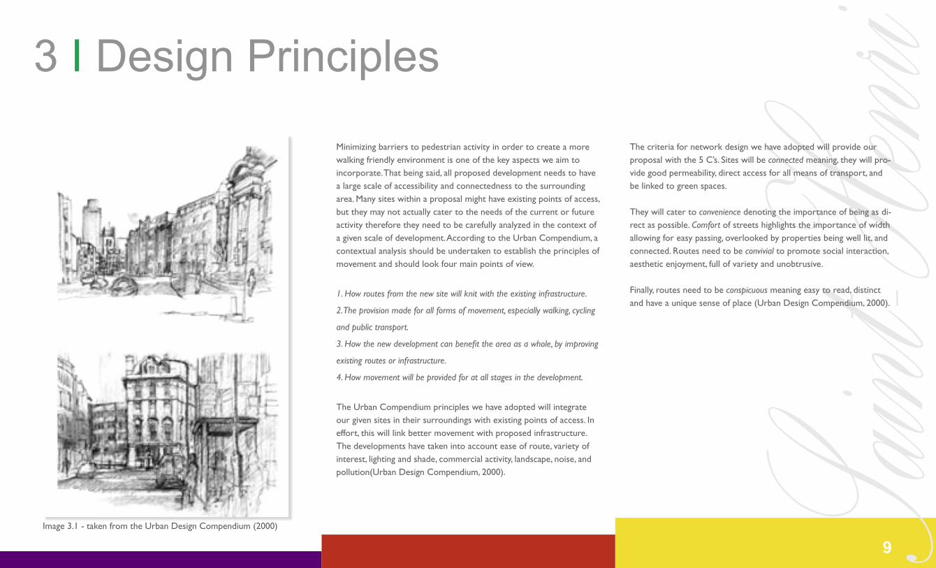
The criteria for network design we have adopted will provide our proposal with the 5 C’s. Sites will be connected meaning, they will pro-vide good permeability, direct access for all means of transport, and be linked to green spaces.
They will cater to convenience denoting the importance of being as di-rect as possible. Comfort of streets highlights the importance of width allowing for easy passing, overlooked by properties being well lit, and connected. Routes need to be convivial to promote social interaction, aesthetic enjoyment, full of variety and unobtrusive.
Finally, routes need to be conspicuous meaning easy to read, distinct and have a unique sense of place (Urban Design Compendium, 2000).
Minimizing barriers to pedestrian activity in order to create a more walking friendly environment is one of the key aspects we aim to incorporate. That being said, all proposed development needs to have a large scale of accessibility and connectedness to the surrounding area. Many sites within a proposal might have existing points of access, but they may not actually cater to the needs of the current or future activity therefore they need to be carefully analyzed in the context of a given scale of development. According to the Urban Compendium, a contextual analysis should be undertaken to establish the principles of movement and should look four main points of view.
1. How routes from the new site will knit with the existing infrastructure.
2. The provision made for all forms of movement, especially walking, cycling
and public transport.
3. How the new development can benefit the area as a whole, by improving
existing routes or infrastructure.
4. How movement will be provided for at all stages in the development.
The Urban Compendium principles we have adopted will integrate our given sites in their surroundings with existing points of access. In effort, this will link better movement with proposed infrastructure. The developments have taken into account ease of route, variety of interest, lighting and shade, commercial activity, landscape, noise, and pollution(Urban Design Compendium, 2000).
Image 3.1 - taken from the Urban Design Compendium (2000)
9
Saint-H
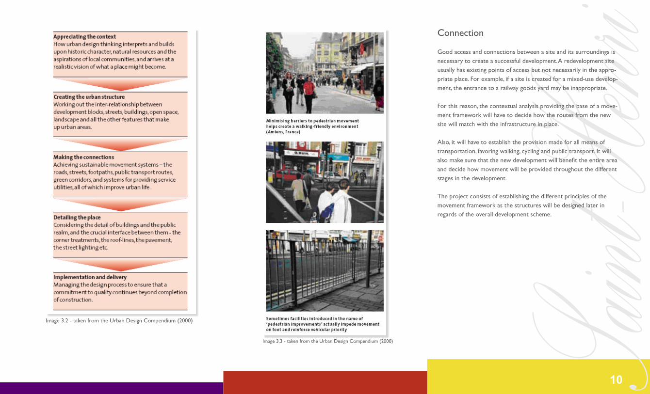
enriConnection
Good access and connections between a site and its surroundings is necessary to create a successful development. A redevelopment site usually has existing points of access but not necessarily in the appro-priate place. For example, if a site is created for a mixed-use develop-ment, the entrance to a railway goods yard may be inappropriate.
For this reason, the contextual analysis providing the base of a move-ment framework will have to decide how the routes from the new site will match with the infrastructure in place.
Also, it will have to establish the provision made for all means of transportation, favoring walking, cycling and public transport. It will also make sure that the new development will benefit the entire area and decide how movement will be provided throughout the different stages in the development.
The project consists of establishing the different principles of the movement framework as the structures will be designed later in regards of the overall development scheme.
10
Image 3.2 - taken from the Urban Design Compendium (2000)
Image 3.3 - taken from the Urban Design Compendium (2000)

Saint-H
enri4 I Proposal
Image 4.1 - taken by Wenyuan Zhang
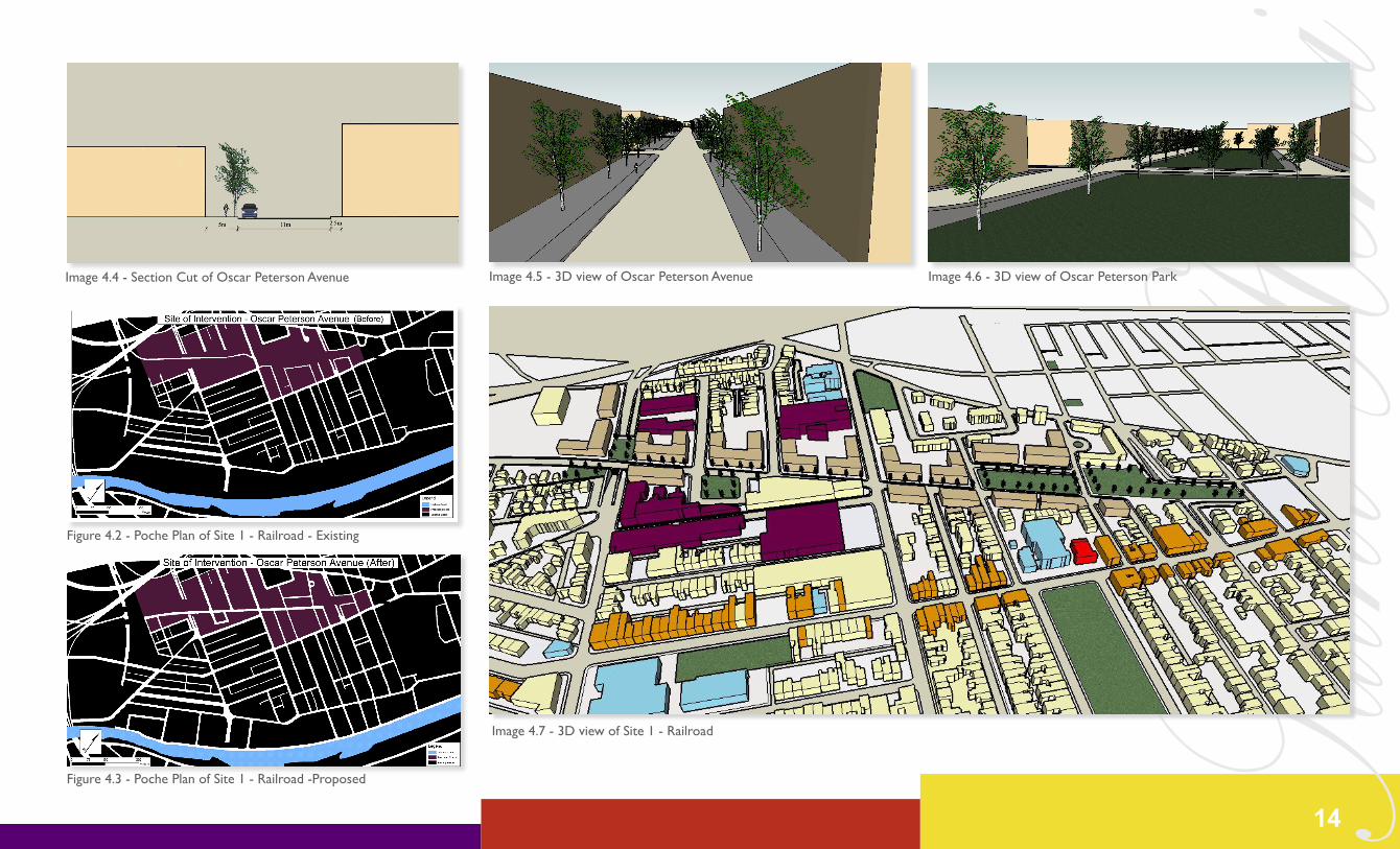
4.1 Site 1 - RailroadThe railroad in Saint-Henri was constructed in the first quarter of the 19th century. The impact of its creation on the current spatial net-work is an informal subdivision into the creation of sectors. In 1871, creations between the rail tracks were added in effort to create more circulation and movement through Saint-Henri. The land was convert-ed farmland into residential and industrial tracts of land excepting the actual location of the railroad itself. It encompasses an area between Rue Notre-Dame and Rue Saint-Jacques spanning throughout the western part of the neighborhood at ~117000m².
As af orementioned, this is one of the largest physical and psychologi-cal barriers within the whole area as a whole. It makes it hard to walk North to South along any street, and the creation of two underpasses was taken in effort to encourage automobile connectedness. Unfortu-nately, considering its current context this has made it detrimental to the economic viability of Rue Notre-Dame and in effort has currently led to 35 mixed use storefronts to be unoccupied. The recent wave of gentrification has led to many of these unoccupied units being rehabilitated, but the new activity does not cater to the needs of the existing inhabitants.
Table 4.1 Opportunities and Constraints for Site 1
11
Figure 4.1 - Poche Plan of Site 1 - Railroad - Existing

Saint-H
enriCase Study
In effort to find a case study of new housing being fully integrated into an existing city on a new street, the example of The Piggeries within Frome, England will be utilized. Frome is a historic market town within Somerset County, England. Traditionally, it had a strong industri-al history stemming from wool and cloth manufacturing. The plan itself was undertaken by the District council in combination with private developers The Guinness Trust and Knightstone Housing Association.
The site area for their proposal was 12,500m², proposing a built den-sity of 57 units per 10,000m² (net). The project itself consisted of 71 total social housing units, a mix of family housing, and flats set within a former conservation area within the centre of the city.
The importance of the project in terms of design was that the scheme is not discerbible from the architectural form and exist-ing built environment. The street adopted a spatial setup which fits seamlessly into the existing urban environment through architectural quality, detail and urban design.
The building height within the area varied from 2 to 4 storey’s across the site, but the importance is that it respected the surrounding built form. They used boundary treatments such as stone sidewalks, and a treed Avenue to contribute to an overall a sense of enclosure. The buildings were all outward-looking with minimal setbacks, which in effort created active street frontage.
A very important aspect which can be crossed over to our proposal is that they maintained pedestrian access across the site to aid the nearby area through peripheral streets, adding to the vitality and vi-ability of the local town centre.
This is different from the North American context, but it can be translated to aid and reinforce nodal commercial activity along Notre-Dame. The scheme accommodates the car throughout the street, however minimizing its overall impact, the street is not meant as a thoroughfare, but primarily as access to local residents.
Finally, the use of sustainable solutions was at the core of the design initiatives and links were established with the community early in the design process. This was done so that all parties could benefit from the final product.
Image 4.3 - taken from Urban Design Compendium (2000)
12
Image 4.2 - taken from Urban Design Compendium (2000)

Saint-H
enri13
Saint-H
enri
Image 4.4 - Section Cut of Oscar Peterson Avenue Image 4.5 - 3D view of Oscar Peterson Avenue Image 4.6 - 3D view of Oscar Peterson Park
Figure 4.3 - Poche Plan of Site 1 - Railroad -Proposed
Figure 4.2 - Poche Plan of Site 1 - Railroad - Existing
14
Image 4.7 - 3D view of Site 1 - Railroad

Saint-H
enri
Image 4.8 - taken by Wenyuan Zhang
4.2 Site 2 - Lachine CanalThis site of intervention is located along the Lachine canal, it is bor-dered by Highway 15 on the West side, Rue Saint-Ambroise on the north side, and the railroad tracks on the East side. The site occupies an area of approximately 225 000m². The Lachine Canal specifically passes through the southwestern part of the island of Montreal. It runs from the Old Port of Montreal to Lac Saint-Louis for a distance of 14.5 km.
More than just a route that bypasses the Lachine rapids; its history is over 150 years old and takes many different directions. It was cre-ated due to the interconnectedness of urbanization, industrialization and shipping. The Lachine Canal is a meaningful symbol of Montreal’s historic development into industrialization. The reason why Montreal became the foundation for the Canadian manufacturing industry is be-cause the canal was the port of entry that linked the Atlantic Ocean to the core of the country.
Table 4.2 - Opportunities and Constraints for Site 2
Figure 4.4 - Poche Plan of Site 2 - Lachine Canal - Existing
15
Saint-H
enriSome factors which favored its creation are it’s location near the local port, its hydraulic power potential; it has the closeness of markets, as well as the availability of inexpensive labor. All of these factors in combination favored diversified manufacturing industries to locate along its bank. These aspects ultimately led to the urbanization and industrialization for the South-West part of Montreal.
The canal has been under the administration of Parks Canada since 1978. Currently, it is considered a national historic site. It demon-strates the industrial history of both Montreal and Canada’s devel-opment. It is also used as a multi-purpose path that allows million of users to enjoy its landscape annually. For years, public investment has been put into the canal accounting for more than $100M dollars by diverse levels of government, private business, as well as com-munity organization in order to revitalize and restore the significant site. Since 2002 the canal reopened to pleasure boating and has also noticed a gentrified wave of new private condominium development along its bank.
Residential redevelopment along the Lachine canal in the Sud-Ouest borough is nothing new; it has been occurring at a fast pace in the past couple of years. These new residential projects noticed an increase in part due to the demand and popularity of the site. Ad-ditionally, such redevelopment schemes along the canal have been proven successful in terms of bringing more people to the borough, and bringing in new money. Needless to say, these residential develop-ments have catered to a different socio-economic class in Saint-Henri than those who traditionally lived there. While the local popula-tion continues to raise concerns on their imminent need for more adequate housing, the different social groups depict the negativity of the current wave of gentrification that is occuring next to the Lachine Canal.
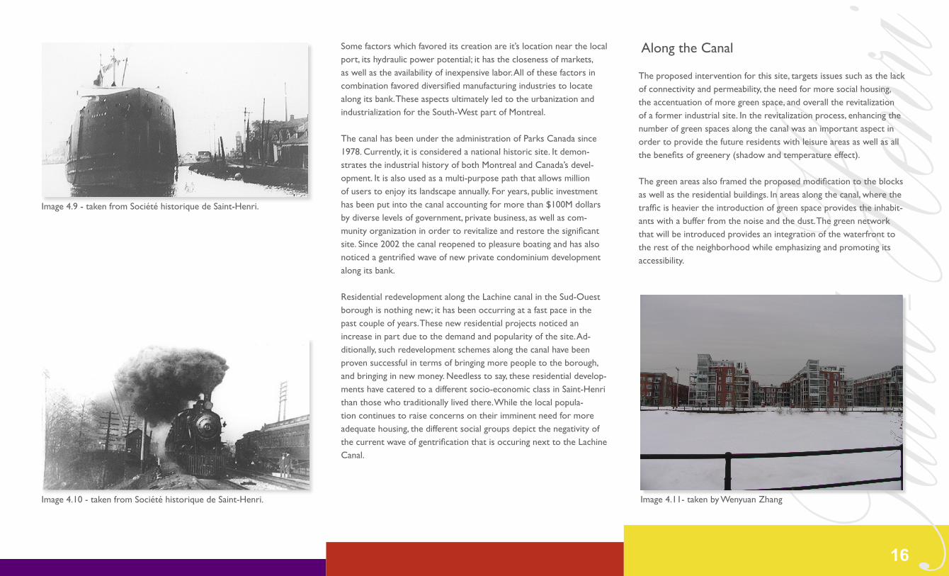
Along the Canal
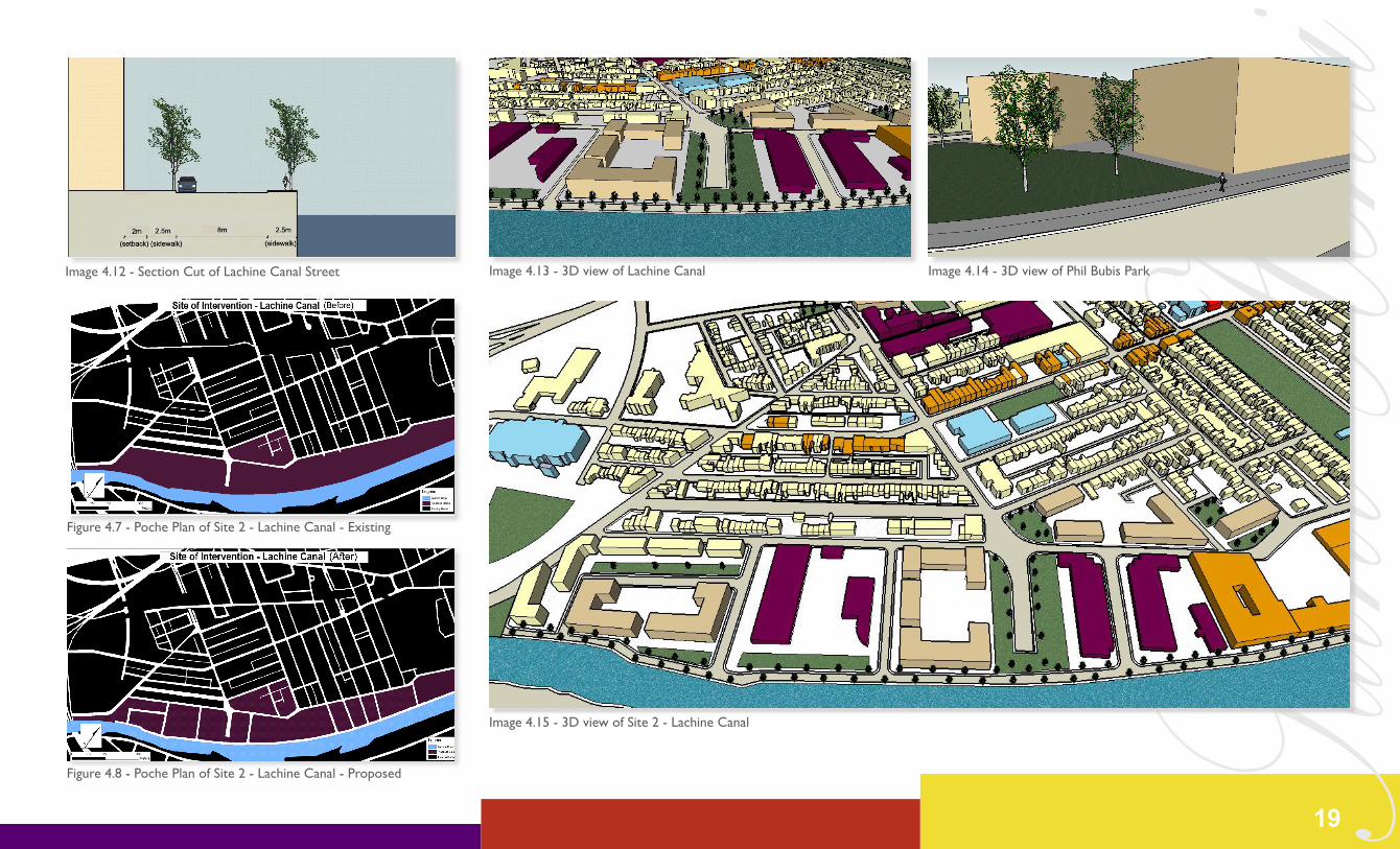
The proposed intervention for this site, targets issues such as the lack of connectivity and permeability, the need for more social housing, the accentuation of more green space, and overall the revitalization of a former industrial site. In the revitalization process, enhancing the number of green spaces along the canal was an important aspect in order to provide the future residents with leisure areas as well as all the benefits of greenery (shadow and temperature effect).
The green areas also framed the proposed modification to the blocks as well as the residential buildings. In areas along the canal, where the traffic is heavier the introduction of green space provides the inhabit-ants with a buffer from the noise and the dust. The green network that will be introduced provides an integration of the waterfront to the rest of the neighborhood while emphasizing and promoting its accessibility.
Image 4.9 - taken from Société historique de Saint-Henri.
Image 4.11- taken by Wenyuan ZhangImage 4.10 - taken from Société historique de Saint-Henri.
16

Saint-H
enriAs depicted in the poche plan, the current situation is drastic in regards of the connectivity and accessibility to the Lachine canal. Besides Chemin de la Côte-Saint-Paul and Rue Saint-Rémi (that becomes a tunnel to lead into Pointe-Saint-Charles) there are no con-necting streets to the water front. Along with our proposed residen-tial buildings, we will also introduce new connecting street to divide the existing large land parcels into smaller ones in order to promote the accessibility of the waterfront as well as the better permeability and circulation of the sector.
Although currently serviced by a bike path and a green trail, our pro-posal entails that we provide the waterfront of the Lachine canal with a one way street (heading west) that would end with a cul-de-sac just before Chemin de la Côte-Saint-Paul.
These measures are introduced in order to provide the future residents as well as others who want a way in their buildings and the waterfront with automobile, bicycle as well as pedestrian access. The idea is not to segregate any modes of transportation, and by having a one-way street with a dead end it reduces the induce traffic that could have resulted to reach other part of the neighborhood.
The width of the street would be of 8m to allow access to all and one parking lane on the north side of the street for people commuting to the Lachine Canal by car. Although cars are a less sustainable mode of transportation, it would be important to have car access in order to promote the waterfront to other residents of the island of Montreal as well as tourists. The sidewalk of the south side of the street and next to the canal would be 2.5m wide as well as the other sidewalk. A setback of 2m would be provided on the side where residential build-ings are located.
As for the actual building proposals for this site, it encompasses a mixture of privately developed ones and social housing building. Since over 100 million dollars (mainly public money) has been invested in the revitalization of the Lachine Canal, it is a righteous cause to suggest the implementation of social housing along the canal. Such a particular site should not be preserved for private developers whose aims are to provide gentrified condos.
Hence the fact that some industrial buildings are abandoned and would be replaced by residential housing, this provides the neighbor-hood with a great incentive to introduce the new housing plans. Out of the total of 9 proposed residential buildings, 4 of them will be filled with social housing. We believe that a mixture of low-income and higher income families along the canal would reduce the negative effects of gentrification and also create cohesions between the actual residents of Saint-Henri and the new comers.
The buildings’ shapes and heights would suit the desired and reason-able density, the surrounding configuration in terms of the lots and the existing buildings. Parking for the proposed residential building will be provided in an underground manner. The proposals aim was to implement these new residential buildings and also make sure that the current urban form is respected. Close-by factories could also remain or be redeveloped in order to provide jobs to the Saint-Henri inhabit-ants in need. Overall all these measures are put in place in response to an important need for social housing for low-income family, in order to redeveloped and revitalize the site along Lachine Canal, and overall to ensure more sustainability.
Note: Along the proposed street there was an old silo building of historic and industrial heritage value. Due to its dilapidated condition we have proposed the removal of the building in its current built form on the basis that it is beyond repair.
Figure 4.5 - Poche Plan of Site 2 - Lachine Canal - Existing
Figure 4.6 - Poche Plan of Site 2 - Lachine Canal - Proposed
17
Saint-H
enri18
Saint-H
enri
Image 4.12 - Section Cut of Lachine Canal Street Image 4.13 - 3D view of Lachine Canal Image 4.14 - 3D view of Phil Bubis Park
Figure 4.8 - Poche Plan of Site 2 - Lachine Canal - Proposed
Figure 4.7 - Poche Plan of Site 2 - Lachine Canal - Existing
19
Image 4.15 - 3D view of Site 2 - Lachine Canal
Saint-H
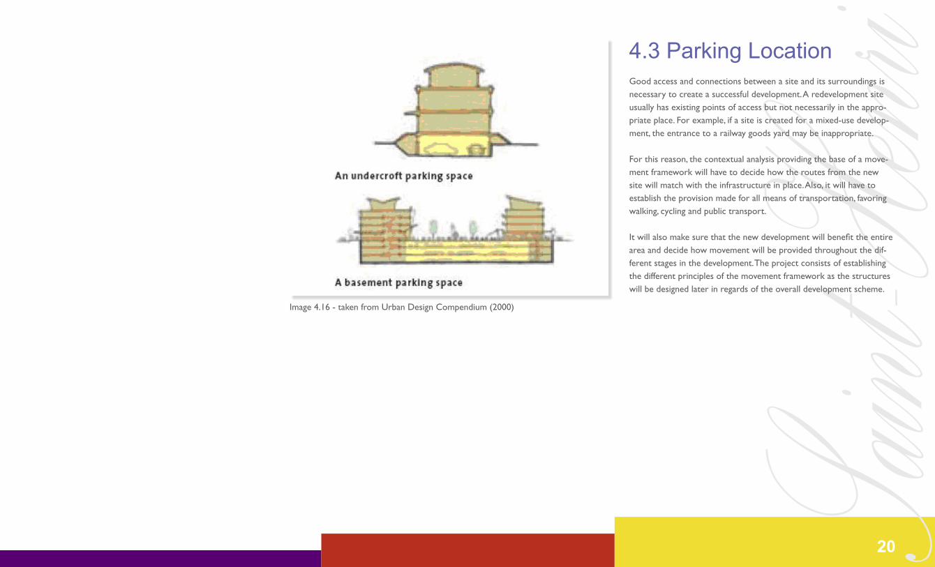
enri4.3 Parking LocationGood access and connections between a site and its surroundings is necessary to create a successful development. A redevelopment site usually has existing points of access but not necessarily in the appro-priate place. For example, if a site is created for a mixed-use develop-ment, the entrance to a railway goods yard may be inappropriate.
For this reason, the contextual analysis providing the base of a move-ment framework will have to decide how the routes from the new site will match with the infrastructure in place. Also, it will have to establish the provision made for all means of transportation, favoring walking, cycling and public transport.
It will also make sure that the new development will benefit the entire area and decide how movement will be provided throughout the dif-ferent stages in the development. The project consists of establishing the different principles of the movement framework as the structures will be designed later in regards of the overall development scheme.
Image 4.16 - taken from Urban Design Compendium (2000)
20

Saint-H
enri4.4 TramwayIn April 2007, Mr. Claude Dauphin, mayor of the Lachine borough publicly announced that he wishes that his territory be serviced by a tramway in order to be connected with the surrounding boroughs as well as to be linked to the downtown area of Montreal. In La Presse, April 12th 2007:
« Les arrondissements de Lachine, LaSalle et du Sud-Ouest ont signifié à l’administration montréalaise leur souhait de voir se réaliser, dès que possible, une ligne de tramway le long du canal de Lachine où l’emprise utilisée jadis par des voies ferrées du CN et du CP pourrait connaître une seconde vie. »
The introduction of the tramway in Saint-Henri would cater to the requirements of sustainable development, such as promoting us-age of public transit. This would also enhance the transit oriented development scheme the city of Montreal wishes to adapt providing better accessibility to other boroughs and neighboring cities. A study performed by PABECO Inc. has concluded that it would be more viable to implement a tram-train system to provide the borough with a newer, faster, and cheaper mode of transportation. Such a system would be a welcome addition to the transportation network in Saint-Henri.
The tram-train could circulate along Notre-Dame Street (to service the majority of the current 14,802 inhabitants in 2006 as well as a possible addition of 1,434 inhabitants as per our residential proposals) and then reach Avenue Atwater. From Avenue Atwater the tram-train could either go directly north to reach the Central Business District along Boulevard de Maisonneuve (as per the proposition in the 2007 Montreal Transport Plan).
The tram-train would also go south on Avenue Atwater to service the Pointe-Saint-Charles neighborhood and continue its way up to the CN train Station by using the already existing railways. Port of Mon-treal CEO Patrice Pelletier recently presented a project that would create a container terminal in Contrecoeur, thus reducing the amount of freight train that would need to use the CN and CP railways in Montreal (Gibbens, 2008).
Consequently this would provide the railways in Saint-Henri and Pointe-Saint-Charles with a higher capacity for public transportation and would not come in conflict with the already existing modes of transportation using them (i.e.: CN transportation trains, commuter train).
Figure 4.9 Existing Lightrail infrastructure
Figure 4.10 Proposed Tram Line
Figure 4.11 Proposed Tram Line
21
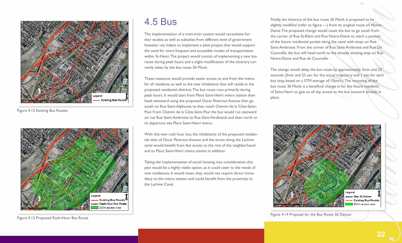
Saint-H
enri4.5 BusThe implementation of a tram-train system would necessitate fur-ther studies as well as subsidies from different level of government however; we indent to implement a pilot project that would support the need for more frequent and accessible modes of transportation within St-Henri. The project would consist of implementing a new bus route during peak hours and a slight modification of the itinerary cur-rently taken by the bus route 36 Monk.
These measures would provide easier access to and from the metro for all residents, as well as the new inhabitants that will reside in the proposed residential districts. The bus route runs primarily during peak hours. It would start from Place Saint-Henri metro station then head westward using the proposed Oscar Peterson Avenue then go south on Rue Saint-Alphonse to then reach Chemin de la Côte-Saint-Paul. From Chemin de la Côte-Saint-Paul the bus would run eastward on rue Rue Saint-Ambroise to Rue Saint-Ferdinand; and then north to its departure site Place Saint-Henri metro.
With this new rush hour bus, the inhabitants of the proposed residen-tial sites of Oscar Peterson Avenue and the street along the Lachine canal would benefit from fast access to the rest of the neighborhood and to Place Saint-Henri metro station in addition.
Taking the implementation of social housing into consideration, this plan would be a highly viable option, as it could cater to the needs of new residences. It would mean, they would not require direct imme-diacy to the metro station, and could benefit from the proximity to the Lachine Canal.
Finally, the itinerary of the bus route 36 Monk is proposed to be slightly modified (refer to figure ---) from its original route on Notre-Dame. The proposed change would cause the bus to go south from the corner of Rue St-Rémi and Rue Notre-Dame to reach a portion of the future residential pocket along the canal with stops on Rue Saint-Ambroise. From the corner of Rue Saint-Ambroise and Rue De Courcelle, the bus will head north to the already existing stop on Rue Notre-Dame and Rue de Courcelle.
The change would delay the bus route by approximately 5min and 23 seconds (3min and 23 sec. for the actual trajectory and 1 min for each bus stop, based on a STM average of 15km/h). The rerouting of the bus route 36 Monk is a beneficial change in for the future residents of Saint-Henri to gain an all day access to the bus network already in place.
Figure 4.12 Existing Bus Routes
Figure 4.13 Proposed Rush-Hour Bus RouteFigure 4.14 Proposal for the Bus Route 36 Detour
22
Saint-H
enri4.6 Costs & Benefits
Table 4.4 *1200 sq. Feet = a 4 or 5 ½ = 4 people/apartment
Table 4.3 *1200 sq. Feet = a 4 or 5 ½ = 4 people/apartment
Site 1 - Railroad
Site 2 - Lachine Canal
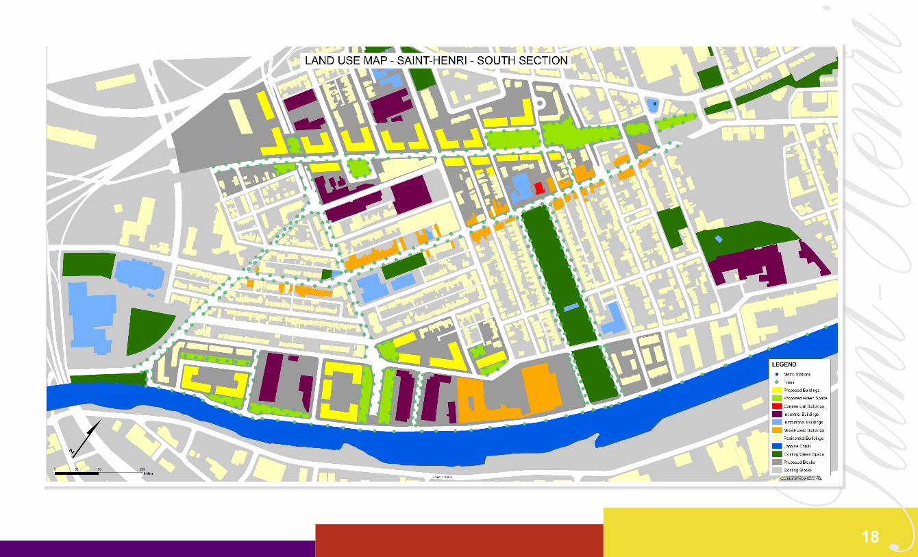
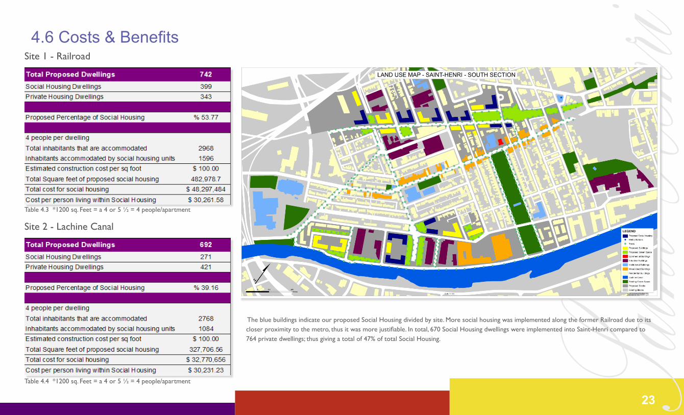
The blue buildings indicate our proposed Social Housing divided by site. More social housing was implemented along the former Railroad due to its closer proximity to the metro, thus it was more justifiable. In total, 670 Social Housing dwellings were implemented into Saint-Henri compared to 764 private dwellings; thus giving a total of 47% of total Social Housing.
23
Saint-H
enriConclusion
24
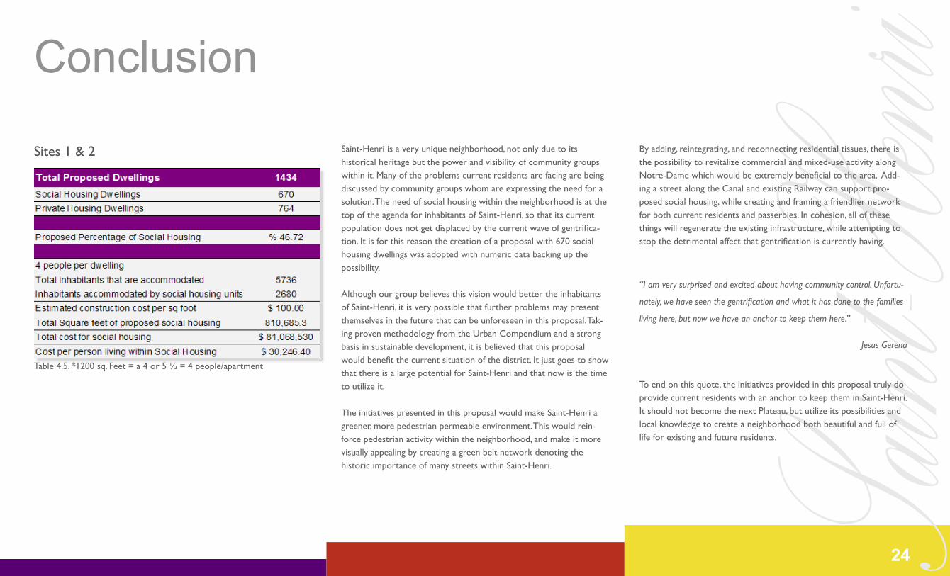
Table 4.5. *1200 sq. Feet = a 4 or 5 ½ = 4 people/apartment
Sites 1 & 2 Saint-Henri is a very unique neighborhood, not only due to its historical heritage but the power and visibility of community groups within it. Many of the problems current residents are facing are being discussed by community groups whom are expressing the need for a solution. The need of social housing within the neighborhood is at the top of the agenda for inhabitants of Saint-Henri, so that its current population does not get displaced by the current wave of gentrifica-tion. It is for this reason the creation of a proposal with 670 social housing dwellings was adopted with numeric data backing up the possibility.
Although our group believes this vision would better the inhabitants of Saint-Henri, it is very possible that further problems may present themselves in the future that can be unforeseen in this proposal. Tak-ing proven methodology from the Urban Compendium and a strong basis in sustainable development, it is believed that this proposal would benefit the current situation of the district. It just goes to show that there is a large potential for Saint-Henri and that now is the time to utilize it.
The initiatives presented in this proposal would make Saint-Henri a greener, more pedestrian permeable environment. This would rein-force pedestrian activity within the neighborhood, and make it more visually appealing by creating a green belt network denoting the historic importance of many streets within Saint-Henri.
By adding, reintegrating, and reconnecting residential tissues, there is the possibility to revitalize commercial and mixed-use activity along Notre-Dame which would be extremely beneficial to the area. Add-ing a street along the Canal and existing Railway can support pro-posed social housing, while creating and framing a friendlier network for both current residents and passerbies. In cohesion, all of these things will regenerate the existing infrastructure, while attempting to stop the detrimental affect that gentrification is currently having.
“I am very surprised and excited about having community control. Unfortu-
nately, we have seen the gentrification and what it has done to the families
living here, but now we have an anchor to keep them here.”
Jesus Gerena
To end on this quote, the initiatives provided in this proposal truly do provide current residents with an anchor to keep them in Saint-Henri. It should not become the next Plateau, but utilize its possibilities and local knowledge to create a neighborhood both beautiful and full of life for existing and future residents.
Saint-H
enriBibliography
25
Bélanger, Hélène. 2007. Public Spaces in Gentrifying Neighbourhoods: Conflicting Meanings?. Rotterdam: ENHR 2007 International Conference ‘Sustainable Urban Areas’.
From Steam to Cycles: The Lachine Canal Historical Guide. Montreal: Association Les Mil Lieues, 1987.
Hanna, David. 1986. Montreal: A City Built by Small Builders, 1867-1880. PhD. Thesis. Montreal: McGill University.
Regroupement Economique et Social du Sud-Ouest. 2008. Retrieved on April 15, 2008 from http://www.resomtl.com/en/default.aspx?sortcode=2.18.20.
Société Historique de Saint-Henri. 2005. Saint-Henri: Vivre en Ville 1890-1960. Retrieved on April 15, 2008 from http://epe.lac bac.gc.ca/100/205/301/ic/cdc/sthenri/index1.htm
Statistics Canada. 2006. St-Henri Comparison to Montreal CMA. Retrieved on April 15, 2008 from http://www.statcan.ca/english/information/12-591-XIEQ/12-591-XIEQ2006001.htm.
Urban Design Compendium. 2000. Chapter 2: Appreciating the Context. London: English Partnerships.
Urban Design Compendium. 2000. Chapter 3: Creating the Urban Structure. London: English Partnerships.
Urban Design Compendium. 2000. Chapter 4: Making the Connection. London: English Partnerships.


![[Henri Pirenne, Hans Van Werveke] Henri Pirenne,..(Bookos.org)](https://img.pdfslide.us/doc/110x75/55cf9bd5550346d033a78cad/henri-pirenne-hans-van-werveke-henri-pirennebookosorg.jpg)