Embed Size (px)
Citation preview
225 Labrador Drive, Unit 1, Waterloo, Ontario, N2K 4M8 Tel: (519) 725-2227 Web: www.nrsi.on.ca Email: [email protected]
January 5, 2018 Project 2025 Daniel Hrycyna HRYCYNA LAW GROUP 200-1081 Bloor Street West Toronto, Ontario M6H 1M5 Dear: Mr. Hrycyna,
RE: Woodland Assessment at Scott Street, Grand Valley
On behalf of Natural Resource Solutions Inc. (NRSI), I am pleased to provide the following summary
of the tree and woodland assessment undertaken by NRSI Certified Arborists at the 20 Scott Street
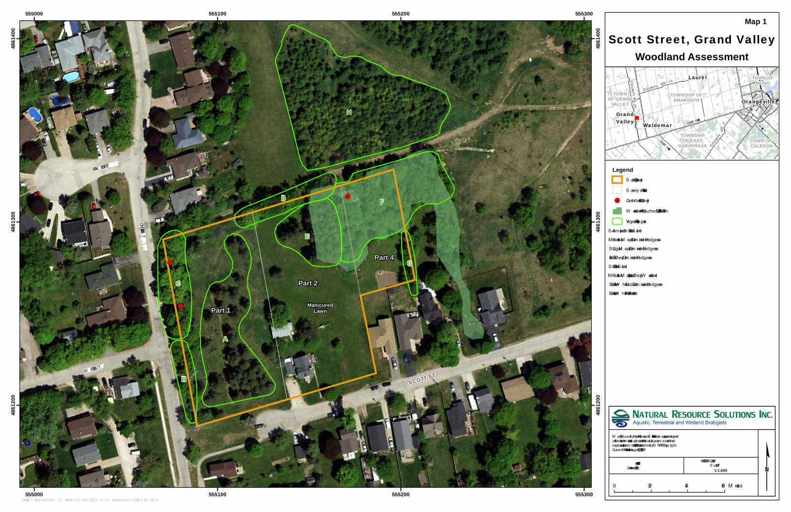
property in Grand Valley, Ontario (Map 1). The property area assessed by NRSI is comprised of
Part 1, Part 2 and Part 4 in a Plan of Survey (PLAN 7R-5603) prepared by P.J. Williams, O.L.S.
(December 21, 2006) and is herein referred to as the ―subject property‖. The subject property slopes
from the west to east, and is comprised of conifer stands with naturalizing meadow beneath,
maintained lawns, isolated landscape and hedgerow trees, a small woodland feature, with one
residence and associated out-buildings. It is near to the Grand River but outside the floodplain and
the area regulated by the Grand River Conservation Authority (GRCA). A small wooded area is
located in the northeast corner of the subject property that is identified on Schedule B-1, Natural
Heritage of Grand Valley‘s Official Plan (2006) as ‗wooded area <=4 ha‘. The inclusion of this
feature in Schedule B-1 means it is a Significant Woodland as per the criterion in section 4.2.1.5(c)
of the Official Plan (2006).
During a Pre-Consultation Meeting with the Town of Grand Valley, the Town requested that an
assessment of the on-site wooded feature be undertaken to inform the proposed development
submission for the property. A description of NRSI‘s assessment of the subject property and
findings are provided below.
Field Surveys
NRSI Certified Arborists visited the subject property on November 22, 2017 and January 3, 2018 to
document existing conditions. These site visits consisted of observing vegetation communities and
individual trees on site, noting species composition and relative density, noting any vascular plant
Species at Risk (SAR) observed, and searching for potential wildlife habitat features, including trees

Woodland Assessment at Scott Street, Grand Valley 2
with candidate bat maternity roost sites. Any trees that warrant consideration for retention during
preparation of the proposed Site Plan (i.e. large, mature trees in good condition, candidate bat cavity
roosting trees, etc.) were noted.
Results
Observations showed that many of the trees on the subject property are hedgerow or remnant
plantation trees, without a great diversity of species (Map 1). Some mature specimens exhibited
potential for use by wildlife, particularly SAR bat species known to roost in suitable tree cavities. No
vascular plant SAR was observed during the site visits, though seasonality certainly limited the
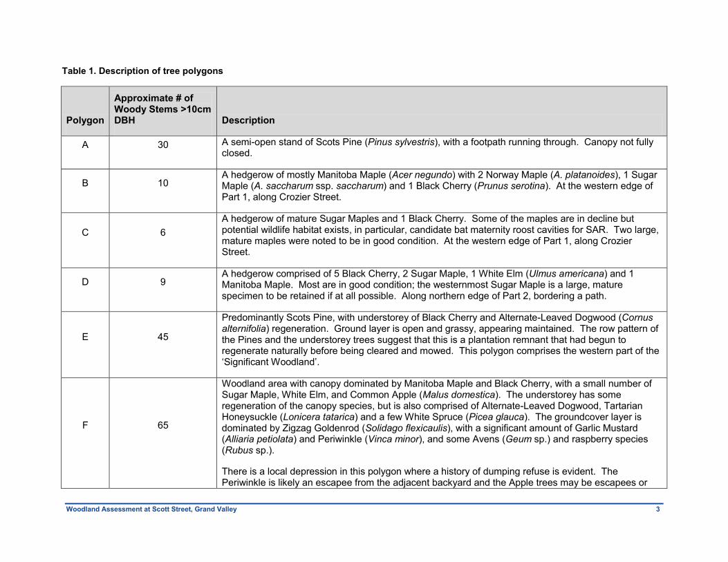
ability to identify herbaceous plants. Table 1 describes in more detail each tree polygon, as labeled
on Map 1. Photographs of these areas are shown in Appendix I.
Woodland Assessment at Scott Street, Grand Valley 3
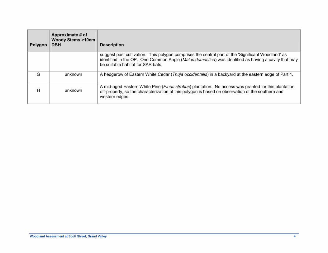
Table 1. Description of tree polygons
Polygon
Approximate # of Woody Stems >10cm DBH Description
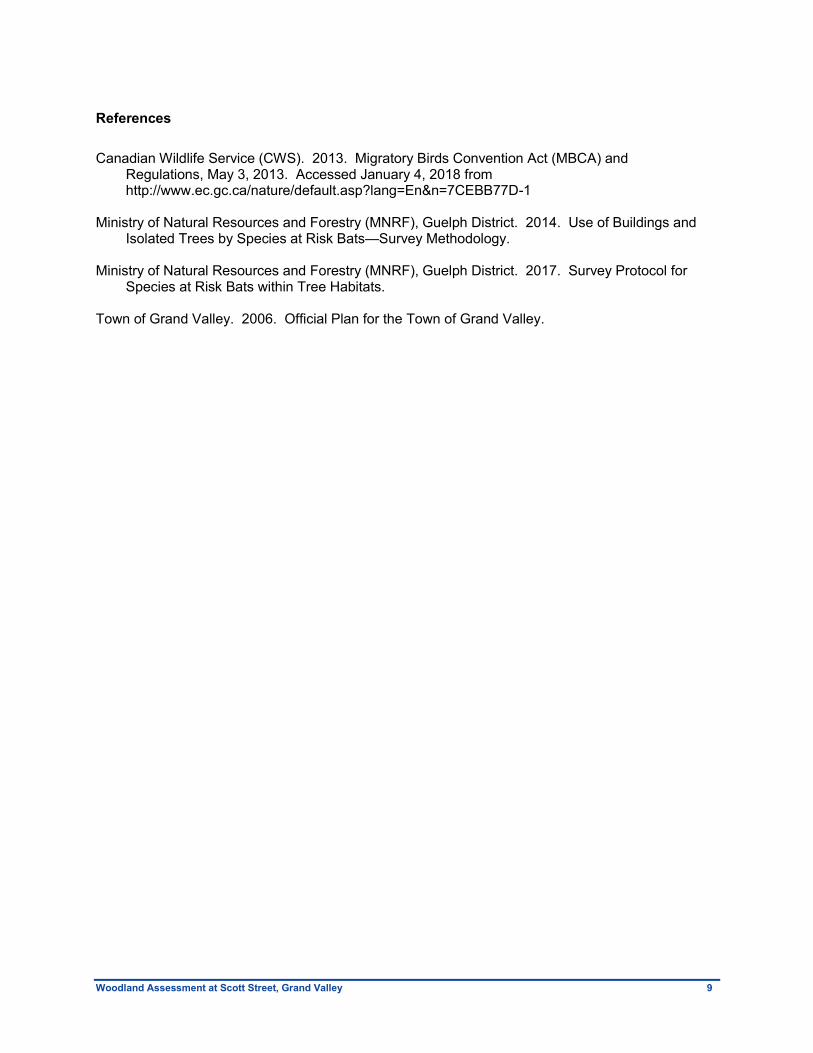
A 30 A semi-open stand of Scots Pine (Pinus sylvestris), with a footpath running through. Canopy not fully closed.
B 10 A hedgerow of mostly Manitoba Maple (Acer negundo) with 2 Norway Maple (A. platanoides), 1 Sugar Maple (A. saccharum ssp. saccharum) and 1 Black Cherry (Prunus serotina). At the western edge of Part 1, along Crozier Street.
C 6
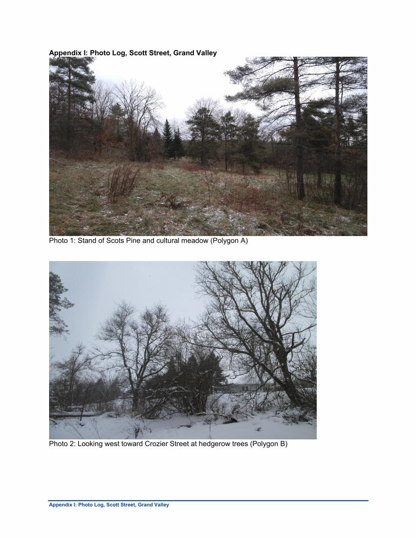
A hedgerow of mature Sugar Maples and 1 Black Cherry. Some of the maples are in decline but potential wildlife habitat exists, in particular, candidate bat maternity roost cavities for SAR. Two large, mature maples were noted to be in good condition. At the western edge of Part 1, along Crozier Street.
D 9 A hedgerow comprised of 5 Black Cherry, 2 Sugar Maple, 1 White Elm (Ulmus americana) and 1 Manitoba Maple. Most are in good condition; the westernmost Sugar Maple is a large, mature specimen to be retained if at all possible. Along northern edge of Part 2, bordering a path.
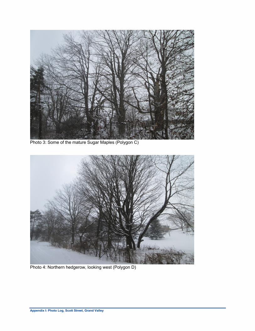
E 45
Predominantly Scots Pine, with understorey of Black Cherry and Alternate-Leaved Dogwood (Cornus alternifolia) regeneration. Ground layer is open and grassy, appearing maintained. The row pattern of the Pines and the understorey trees suggest that this is a plantation remnant that had begun to regenerate naturally before being cleared and mowed. This polygon comprises the western part of the ‗Significant Woodland‘.
F 65
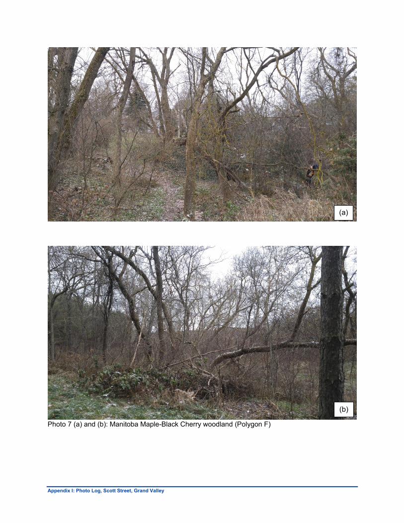
Woodland area with canopy dominated by Manitoba Maple and Black Cherry, with a small number of Sugar Maple, White Elm, and Common Apple (Malus domestica). The understorey has some regeneration of the canopy species, but is also comprised of Alternate-Leaved Dogwood, Tartarian Honeysuckle (Lonicera tatarica) and a few White Spruce (Picea glauca). The groundcover layer is dominated by Zigzag Goldenrod (Solidago flexicaulis), with a significant amount of Garlic Mustard (Alliaria petiolata) and Periwinkle (Vinca minor), and some Avens (Geum sp.) and raspberry species (Rubus sp.).
There is a local depression in this polygon where a history of dumping refuse is evident. The Periwinkle is likely an escapee from the adjacent backyard and the Apple trees may be escapees or
Woodland Assessment at Scott Street, Grand Valley 4
Polygon
Approximate # of Woody Stems >10cm DBH Description
suggest past cultivation. This polygon comprises the central part of the ‗Significant Woodland‘ as identified in the OP. One Common Apple (Malus domestica) was identified as having a cavity that may be suitable habitat for SAR bats.
G unknown A hedgerow of Eastern White Cedar (Thuja occidentalis) in a backyard at the eastern edge of Part 4.
H unknown A mid-aged Eastern White Pine (Pinus strobus) plantation. No access was granted for this plantation off-property, so the characterization of this polygon is based on observation of the southern and western edges.
Woodland Assessment at Scott Street, Grand Valley 5
Discussion
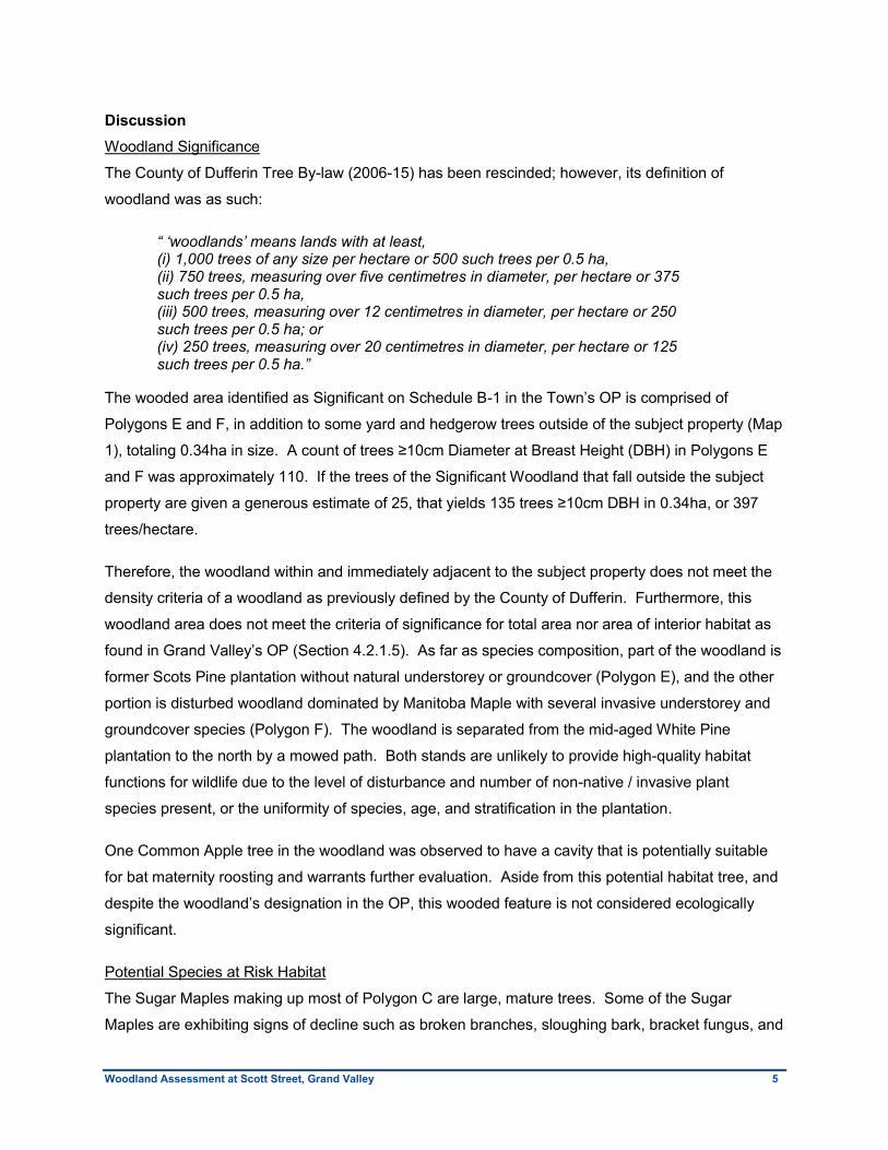
Woodland Significance
The County of Dufferin Tree By-law (2006-15) has been rescinded; however, its definition of
woodland was as such:
“ „woodlands‟ means lands with at least, (i) 1,000 trees of any size per hectare or 500 such trees per 0.5 ha, (ii) 750 trees, measuring over five centimetres in diameter, per hectare or 375 such trees per 0.5 ha, (iii) 500 trees, measuring over 12 centimetres in diameter, per hectare or 250 such trees per 0.5 ha; or (iv) 250 trees, measuring over 20 centimetres in diameter, per hectare or 125 such trees per 0.5 ha.”
The wooded area identified as Significant on Schedule B-1 in the Town‘s OP is comprised of
Polygons E and F, in addition to some yard and hedgerow trees outside of the subject property (Map
1), totaling 0.34ha in size. A count of trees ≥10cm Diameter at Breast Height (DBH) in Polygons E
and F was approximately 110. If the trees of the Significant Woodland that fall outside the subject
property are given a generous estimate of 25, that yields 135 trees ≥10cm DBH in 0.34ha, or 397
trees/hectare.
Therefore, the woodland within and immediately adjacent to the subject property does not meet the
density criteria of a woodland as previously defined by the County of Dufferin. Furthermore, this
woodland area does not meet the criteria of significance for total area nor area of interior habitat as
found in Grand Valley‘s OP (Section 4.2.1.5). As far as species composition, part of the woodland is
former Scots Pine plantation without natural understorey or groundcover (Polygon E), and the other
portion is disturbed woodland dominated by Manitoba Maple with several invasive understorey and
groundcover species (Polygon F). The woodland is separated from the mid-aged White Pine
plantation to the north by a mowed path. Both stands are unlikely to provide high-quality habitat
functions for wildlife due to the level of disturbance and number of non-native / invasive plant
species present, or the uniformity of species, age, and stratification in the plantation.
One Common Apple tree in the woodland was observed to have a cavity that is potentially suitable
for bat maternity roosting and warrants further evaluation. Aside from this potential habitat tree, and
despite the woodland‘s designation in the OP, this wooded feature is not considered ecologically
significant.
Potential Species at Risk Habitat
The Sugar Maples making up most of Polygon C are large, mature trees. Some of the Sugar
Maples are exhibiting signs of decline such as broken branches, sloughing bark, bracket fungus, and
Woodland Assessment at Scott Street, Grand Valley 6
wounds revealing some rot, while 2 of the trees appear in good condition. This row of trees serves
as a screen from Crozier Street, and the northern-most Sugar Maple may be a boundary tree on or
near the property line.
A bat cavity assessment within the subject property found that 2 of these Sugar Maples contain
cavities that may be suitable as roosting sites for SAR bats that are known from the area (i.e. Little
Brown Myotis (Myotis lucifugus), Northern Myotis (Myotis septentrionalis), and Tri-coloured Bat
(Perimyotis subflavus)). If these Sugar Maples and the Common Apple mentioned from Polygon F
are proposed for removal to accommodate the Site Plan, the Ministry of Natural Resources and
Forestry (MNRF) may require focused acoustic surveys in June to determine presence/absence of
SAR bats at these habitat features. Based on the MNRF guidelines (2014), it may be requested that
acoustic monitoring be conducted at the Common Apple tree in the woodland for at least 10 nights
with suitable weather conditions in June. For the isolated Maple trees, 2 nights of audio/video
recordings may be required by the MNRF to observe potential cavity use by SAR bats (MNRF 2017).
It is recommended that the trees in Polygon C be considered for retention and that surveys during
the bat maternity roosting period (June) be conducted. If candidate cavity trees are proposed for
removal, NRSI can discuss these with the MNRF to define the scope of monitoring. Furthermore,
slope should be measured on the subject property, especially where it is steepest in the western
portion near Polygons B and C, because Section 4.2.1.5.1 of the OP specifies that existing tree
cover and vegetation on slopes greater than 25% (1:4) should be maintained as a stabilizing force.
Tree Protection and Other Constraints
The trees in Polygon D are all well-established, native species that are in good condition. The
western-most Sugar Maple is an especially nice specimen. Trees within this Polygon are
recommended for retention and could function as a natural screen and landscape feature in the rear
of lots 13-15 in the proposed Site Plan. For any trees retained in Polygons C and D, proactive
pruning by qualified personnel (Arborist) is recommended to decrease the likelihood of failure of
declining scaffold branches. This work must be completed after any surveys that may be required
by the MNRF for the candidate bat cavities. When site works begin, retained trees and their root
zones should be protected by appropriate tree protection measures such as tree hoarding or
protection fencing. It is recommended that the tree protection measures be installed at a minimum
distance of 1m from the dripline of retained trees, where ‗dripline‘ is defined as that line on the
ground surface directly below the outermost extent of a tree‘s branches. Restricted activities within
the tree protection zone include, but are not limited to, grading or any soil disturbance, traffic or
parking of any machinery, refuelling of machines, and storage of construction materials or fill. It is
Woodland Assessment at Scott Street, Grand Valley 7
recommended that a Certified Arborist observe and approve tree protection measures prior to works
beginning on site.
According to the Canadian Wildlife Service (CWS), the peak breeding period for migratory birds that
nest in treed habitat in southern Ontario is between May 1 and August 31 (CWS 2013). During this
period they recommend that no clearing of vegetation within simple and/or complex habitats occur.
The Migratory Birds Convention Act protects migratory birds, their eggs and nests from being
harmed or destroyed at any time of the year. However, nest searches, as a means of mitigation
during the core breeding period, may be undertaken in ―simple‖ habitats such as hedgerows,
isolated trees, or constructed features (e.g. bridges, barns, etc.) where the potential to observe all
active nests is relatively high. It is therefore recommended that tree and vegetation removal occur
outside the peak breeding bird period, where possible.
Conclusion
NRSI Biologists and Certified Arborists conducted a site walk and bat cavity assessment survey to
observe the woodlands and vegetation communities on the subject property at the west end of Scott
Street, Grand Valley. An assessment of the species composition and density of the wooded area
identified as Significant Woodland in Schedule B-1 of the Town‘s Official Plan concluded that the
woodland is a disturbed site with non-native / invasive vegetation species in the understorey and
groundcover layer. A history of refuse being dumped in the feature was also documented and some
of the Manitoba Maples that dominate the canopy were noted to be in relatively poor condition, with
a number of fallen trees and failed limbs present.
The wooded area within Polygons E and F does not provide a high-quality intact community and is
not considered ecologically significant, though acoustic surveys in June may be required to conclude
that SAR bats are not utilizing this feature. A hedgerow of 6 Sugar Maple along the west side of the
subject property, and a hedgerow of 9 mature trees along the north side are recommended for
retention based on the species and quality of specimens, or their potential for provision of wildlife
habitat features to Species at Risk. Acoustic surveys targeting SAR bats that may use cavities in
some of the Sugar Maples of Polygon C may also be required in June.
Tree protection measures should be implemented to protect retained trees from site works
associated with the proposed development, as described above. Other vegetation polygons or
individual landscape trees identified on site are not considered significant. Any approved tree
removals should take place outside of peak bird breeding season between approximately May 1 –
August 31.

Woodland Assessment at Scott Street, Grand Valley 8
I trust that the above information is sufficient to satisfy the Town of Grand Valley‘s request for a
preliminary assessment of the woodland feature on the subject property. Should you have any
questions or comments, please do not hesitate to contact the undersigned.
Sincerely, Natural Resource Solutions Inc.
Joseph Lance, B.E.S. Certified Arborist, Terrestrial and Wetland Biologist
Woodland Assessment at Scott Street, Grand Valley 9
References
Canadian Wildlife Service (CWS). 2013. Migratory Birds Convention Act (MBCA) and
Regulations, May 3, 2013. Accessed January 4, 2018 from http://www.ec.gc.ca/nature/default.asp?lang=En&n=7CEBB77D-1
Ministry of Natural Resources and Forestry (MNRF), Guelph District. 2014. Use of Buildings and
Isolated Trees by Species at Risk Bats—Survey Methodology. Ministry of Natural Resources and Forestry (MNRF), Guelph District. 2017. Survey Protocol for
Species at Risk Bats within Tree Habitats. Town of Grand Valley. 2006. Official Plan for the Town of Grand Valley.

Natural Resource Solutions Inc. Woodland Assessment at Scott Street, Grand Valley
APPENDIX I
Photo Log
Appendix I: Photo Log, Scott Street, Grand Valley
Appendix I: Photo Log, Scott Street, Grand Valley
Photo 1: Stand of Scots Pine and cultural meadow (Polygon A)
Photo 2: Looking west toward Crozier Street at hedgerow trees (Polygon B)
Appendix I: Photo Log, Scott Street, Grand Valley
Photo 3: Some of the mature Sugar Maples (Polygon C)
Photo 4: Northern hedgerow, looking west (Polygon D)
Appendix I: Photo Log, Scott Street, Grand Valley
Photo 5: Stand of Scots Pine (Polygon E)
Photo 6: Eastern White Pine plantation, at southwest corner (Polygon H)
Appendix I: Photo Log, Scott Street, Grand Valley
Photo 7 (a) and (b): Manitoba Maple-Black Cherry woodland (Polygon F)
(a)
(b)

Natural Resource Solutions Inc. Woodland Assessment at Scott Street, Grand Valley
MAPS
!.
!.
!.
H
ManicuredLawn
Part 4
Part 2
Part 1
CROZIER S T
BAK ER CRT
W EBB ST
S COT TS TB
C
A
D
E
F
G
555000
555000
555100
555100
555200
555200
555300
555300
4861
200
4861
200
4861
300
4861
300
4861
400
4861
400
Scott Street, Grand Valley
LegendS ubject PropertyS urvey ed Lot Parts
!. Candidate Bat CavityW oodland <=4ha, S chedule B-1 of Official PlanVegetation Poly gons
A - S em i-open S cots Pine S tandB - M anitoba M aple Dom inated HedgerowC - S ugar M aple Dom inated HedgerowD - Black Cherry Dom inated HedgerowE - S cots Pine S tandF - M anitoba M aple - Black Cherry W oodlandG - Eastern W hite Cedar Dom inated HedgerowH - Eastern W hite Pine Plantation
Woodland Assessment
Map 1
M ap Produced by Natural Resource S olutions Inc. T his m ap is proprietary and confidential and m ust not be duplicated or distributed by any m eans withoutexpress written perm ission of NRS I. Data provided by M NRF© Copy right: Queen’s Printer Ontario. Im agery : ES RI (2015).
¢0 20 40 60M etres
Path: X :\2025_S cottS treetGrandValley _W oodlandS tudy \NRS I_2025_M ap1_W oodlandAssessm ent_2018_01_05_K EF.m xd
Project:2025Date: January 5, 2018
NAD83 - UT M Zone 17S ize: 11x17"
1:1,000
Orangeville
Laurel
WaldemarGrandValley
COUNT Y
RD25
COUNTY RD 10
COUNTY RD 10
9
COUNT Y
RD3
C LINE
COUNT Y RD 24
TOWNSHIP OFAMARANTH
TOWNOF GRAND
VALLEY
TOWN OFCALEDON
TOWN OFMONO
TOWNSHIPOF EAST
GARAFRAXA
M AIN S T


![CUSTOMER SATISFACTION HOW TO ENCOURAGE MORE …...[CUSTOMER SATISFACTION] GRAPHIC: WOODLAND, O’BRIEN & SCOTT Meet and exceed expectations by understanding needs. TRAINING CUSTOMERS](https://img.pdfslide.us/doc/110x75/5eb4642b969d502a832ebdf4/customer-satisfaction-how-to-encourage-more-customer-satisfaction-graphic.jpg)