Embed Size (px)
Citation preview

22nd February 2016.
Chief Executive Officer Mareeba Shire Council PO Box 154 MAREEBA QLD 4880
Attention: Carl Ewin – Planning Officer. Our Ref: 14-004
Dear Carl,
RE: OPERATIONAL WORKS APPLICATION FOR A DEVELOPMENT PERMIT TO ALLOW FOR THE CONSTRUCTION OF A DAM OVER LAND LOCATED AT 112 BARNWELL ROAD, KURANDA (REAL PROPERTY DESCRIPTION: LOT 22 N15727).
We refer to the above-described development proposal and advise that Urban Sync Pty Ltd has been engaged by Reever & Ocean Pty Ltd (the “Applicant”) to prepare and lodge an Operational Works Application with Mareeba Shire Council (the ‘Council’) to permit the construction of a small Dam over land located at 112 Barnwell Road, Kuranda.
In support of the application, please find enclosed the following to assist with your assessment:
Councils application fee to the amount of $1,234.00 (one thousand, two hundred and thirty-four dollars and zero cents only), consistent with Councils’ 2015/16 Schedule of Fees and Charges, being 1.5% of estimated construction cost;
IDAS Form 1 and 6 as Attachment 1; A detailed set of Project Engineering Plans outlining the proposed location and layout, including a typical
section, of the Dam over the prescribed land as Attachment 2; A Construction Work Estimate to confirm calculation of application fees as Attachment 3; and An assessment of the applicable codes under the current planning scheme for Mareeba Shire Council
(2007) as Attachment 4.
The Applicant seeks to obtain the necessary approvals from the Council to assist in the progression of earth works over the south-eastern corner of the land to support the establishing a small Dam. These works will cover an area of approximately 12,810m2; and will include a volume of earthworks (cut to fill) equal to approximately 7,625m3. The proposed works have taken into consideration of the constraints and values present over the land to ensure all potential impacts are appropriately managed or mitigated. An assessment of the relevant codes has highlighted that the proposed development possesses little-to-no conflict with the natural values of the area, include the continued functioning of the identified waterway that traverses the property, to the protection of the existing character and amenity of the general locality.
The proposed works are subject to Impact Assessment as per the Table of assessment (Table 22) provided under the Myola Zone Code (Part 4, Division 21), which requires all Operation Work that includes excavation or filling of more than 50m3. Assessment of the relevant codes made assessable under the scheme has emphasised the proposals ability to fulfil the obligations and intentions of each code, with little-to-no conflict experienced. It is recognised that a small divergence is encountered with the height parameters specified under the Excavation & Filling Code (Part 6, Division 17); however, evidence is provided to demonstrate compliance with the associated Specific Outcomes to ensure the visual amenity of the area is not compromised. Under this framework it is also recognised that a majority of the desirable development solutions are not applicable, or express the ability to manage key planning considerations and outcomes through the imposition of reasonable and just development conditions.

We submit this application, along with the associated technical supporting information, for Councils assessment and approval. Should you required any further information or desire to arrange a time to discuss this application, please do not hesitate to contact our office on the information provided below.
Yours faithfully,
Stuart Ricketts. Director – Senior Planner. E [email protected] | P (07) 4051 6946 | M 0418 985 935

ATTACHMENT 1: IDAS FORMS 1 & 6,
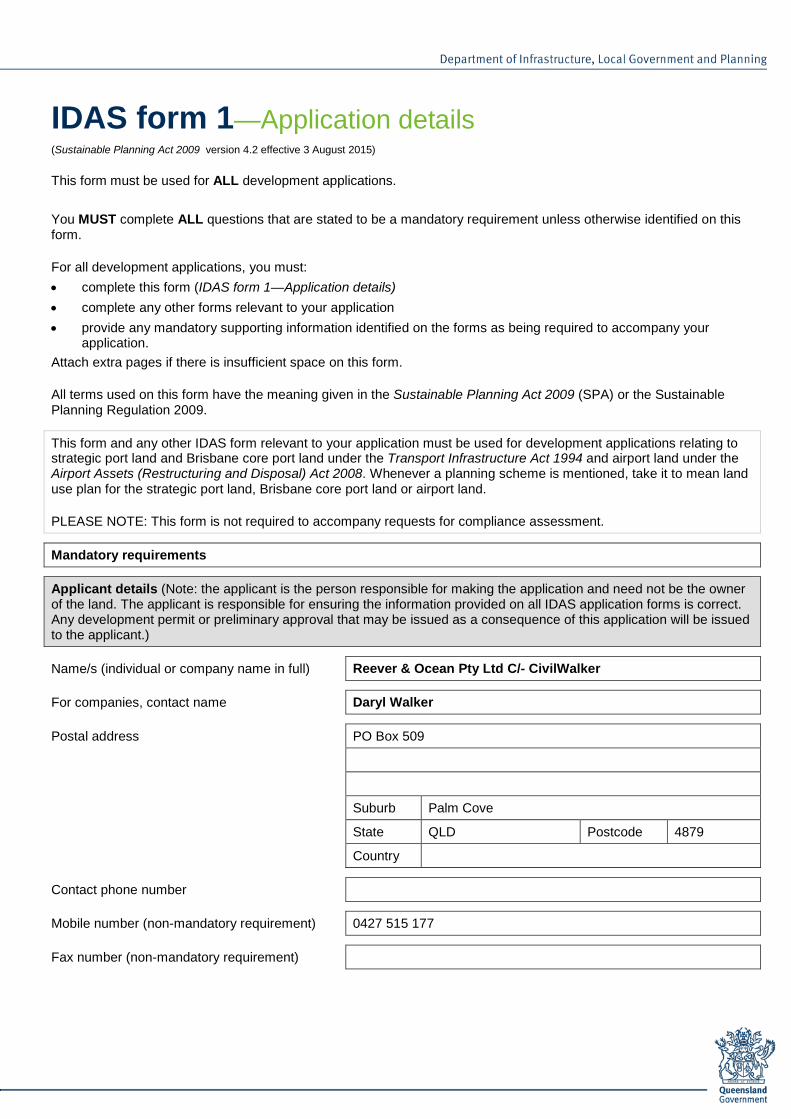
IDAS form 1—Application details (Sustainable Planning Act 2009 version 4.2 effective 3 August 2015)
This form must be used for ALL development applications. You MUST complete ALL questions that are stated to be a mandatory requirement unless otherwise identified on this form.
For all development applications, you must: • complete this form (IDAS form 1—Application details) • complete any other forms relevant to your application • provide any mandatory supporting information identified on the forms as being required to accompany your
application. Attach extra pages if there is insufficient space on this form.
All terms used on this form have the meaning given in the Sustainable Planning Act 2009 (SPA) or the Sustainable Planning Regulation 2009.
This form and any other IDAS form relevant to your application must be used for development applications relating to strategic port land and Brisbane core port land under the Transport Infrastructure Act 1994 and airport land under the Airport Assets (Restructuring and Disposal) Act 2008. Whenever a planning scheme is mentioned, take it to mean land use plan for the strategic port land, Brisbane core port land or airport land.
PLEASE NOTE: This form is not required to accompany requests for compliance assessment.
Mandatory requirements
Applicant details (Note: the applicant is the person responsible for making the application and need not be the owner of the land. The applicant is responsible for ensuring the information provided on all IDAS application forms is correct. Any development permit or preliminary approval that may be issued as a consequence of this application will be issued to the applicant.)
Name/s (individual or company name in full) Reever & Ocean Pty Ltd C/- CivilWalker
For companies, contact name Daryl Walker
Postal address PO Box 509
Suburb Palm Cove
State QLD Postcode 4879
Country
Contact phone number
Mobile number (non-mandatory requirement) 0427 515 177
Fax number (non-mandatory requirement)

IDAS form 1—Application details Version 4.2—3 August 2015
Email address (non-mandatory requirement) daryl
@civilwalker.com.au
Applicant’s reference number (non-mandatory requirement)
122-02
1. What is the nature of the development proposed and what type of approval is being sought?
Table A—Aspect 1 of the application (If there are additional aspects to the application please list in Table B—Aspect 2.)
a) What is the nature of the development? (Please only tick one box.)
Material change of use
Reconfiguring a lot Building work Operational work
b) What is the approval type? (Please only tick one box.)
Preliminary approval under s241 of SPA
Preliminary approval under s241 and s242 of SPA
Development permit
c) Provide a brief description of the proposal, including use definition and number of buildings or structures where applicable (e.g. six unit apartment building defined as a multi-unit dwelling, 30 lot residential subdivision etc.)
Construction of a dam.
d) What is the level of assessment? (Please only tick one box.)
Impact assessment
Code assessment
Table B—Aspect 2 of the application (If there are additional aspects to the application please list in Table C—Additional aspects of the application.)
a) What is the nature of development? (Please only tick one box.)
Material change of use
Reconfiguring a lot Building work Operational work
b) What is the approval type? (Please only tick one box.)
Preliminary approval under s241 of SPA
Preliminary approval under s241 and s242 of SPA
Development permit
c) Provide a brief description of the proposal, including use definition and number of buildings or structures where applicable (e.g. six unit apartment building defined as a multi-unit dwelling, 30 lot residential subdivision etc.)
d) What is the level of assessment?
Impact assessment
Code assessment
Table C—Additional aspects of the application (If there are additional aspects to the application please list in a separate table on an extra page and attach to this form.)
Refer attached schedule
Not required

IDAS form 1—Application details Version 4.2—3 August 2015
2. Location of the premises (Complete Table D and/or Table E as applicable. Identify each lot in a separate row.)
Table D—Street address and lot on plan for the premises or street address and lot on plan for the land adjoining or adjacent to the premises (Note: this table is to be used for applications involving taking or interfering with water.) (Attach a separate schedule if there is insufficient space in this table.)
Street address and lot on plan (All lots must be listed.) Street address and lot on plan for the land adjoining or adjacent to the premises (Appropriate for
development in water but adjoining or adjacent to land, e.g. jetty, pontoon. All lots must be listed.)
Street address Lot on plan description
Local government area (e.g. Logan, Cairns)
Lot Unit no.
Street no.
Street name and official suburb/ locality name
Post-code
Lot no. Plan type and plan no.
i) 112 Barnwell Road, Kuranda 4881 22 N157227 Mareeba Shire
ii)
iii)
Planning scheme details (If the premises involves multiple zones, clearly identify the relevant zone/s for each lot in a separate row in the below table. Non-mandatory) Lot Applicable zone / precinct Applicable local plan / precinct Applicable overlay/s
i) Myola Myola Precinct A Significant Vegetation (Category A) Natural & Cultural Heritage Features (Ridgelines)
ii)
iii)
Table E—Premises coordinates (Appropriate for development in remote areas, over part of a lot or in water not adjoining or adjacent to land e.g. channel dredging in Moreton Bay.) (Attach a separate schedule if there is insufficient space in this table.)
Coordinates (Note: place each set of coordinates in a separate row)
Zone reference
Datum Local government area (if applicable)
Easting Northing Latitude Longitude
GDA94 WGS84 other
3. Total area of the premises on which the development is proposed (indicate square metres)
37.26ha
4. Current use/s of the premises (e.g. vacant land, house, apartment building, cane farm etc.)
Rural/farm (including house).

IDAS form 1—Application details Version 4.2—3 August 2015
5. Are there any current approvals (e.g. a preliminary approval) associated with this application? (Non-mandatory requirement)
No Yes—provide details below
List of approval reference/s Date approved (dd/mm/yy) Date approval lapses (dd/mm/yy)
6. Is owner’s consent required for this application? (Refer to notes at the end of this form for more information.)
No
Yes—complete either Table F, Table G or Table H as applicable
Table F
Name of owner/s of the land Reever & Ocean Pty Ltd
I/We, the above-mentioned owner/s of the land, consent to the making of this application.
Signature of owner/s of the land Mr Ken Lee (Director)
Date
Table G
Name of owner/s of the land
The owner’s written consent is attached or will be provided separately to the assessment manager.
Table H
Name of owner/s of the land
By making this application, I, the applicant, declare that the owner has given written consent to the making of the application.
7. Identify if any of the following apply to the premises (Tick applicable box/es.)
Adjacent to a water body, watercourse or aquifer (e.g. creek, river, lake, canal)—complete Table I
On strategic port land under the Transport Infrastructure Act 1994—complete Table J
In a tidal water area—complete Table K
On Brisbane core port land under the Transport Infrastructure Act 1994 (No table requires completion.)
On airport land under the Airport Assets (Restructuring and Disposal) Act 2008 (no table requires completion)
Listed on either the Contaminated Land Register (CLR) or the Environmental Management Register (EMR) under the Environmental Protection Act 1994 (no table requires completion)
Table I
Name of water body, watercourse or aquifer
Owen Creek

IDAS form 1—Application details Version 4.2—3 August 2015
Table J
Lot on plan description for strategic port land Port authority for the lot
Table K
Name of local government for the tidal area (if applicable) Port authority for the tidal area (if applicable)
8. Are there any existing easements on the premises? (e.g. for vehicular access, electricity, overland flow, water etc)
No Yes—ensure the type, location and dimension of each easement is included in the plans submitted
9. Does the proposal include new building work or operational work on the premises? (Including any services)
No Yes—ensure the nature, location and dimension of proposed works are included in plans submitted
10. Is the payment of a portable long service leave levy applicable to this application? (Refer to notes at the end of this form for more information.)
No—go to question 12 Yes
11. Has the portable long service leave levy been paid? (Refer to notes at the end of this form for more information.)
No
Yes—complete Table L and submit with this application the yellow local government/private certifier’s copy of the receipted QLeave form
Table L
Amount paid Date paid (dd/mm/yy)
QLeave project number (6 digit number starting with A, B, E, L or P)
12. Has the local government agreed to apply a superseded planning scheme to this application under section 96 of the Sustainable Planning Act 2009?
No
Yes—please provide details below
Name of local government Date of written notice given by local government (dd/mm/yy)
Reference number of written notice given by local government (if applicable)

IDAS form 1—Application details Version 4.2—3 August 2015
13. List below all of the forms and supporting information that accompany this application (Include all IDAS forms, checklists, mandatory supporting information etc. that will be submitted as part of this application)
Description of attachment or title of attachment Method of lodgement to assessment manager
Development Plans Email
Local Government Code Assessment Email
14. Applicant’s declaration
By making this application, I declare that all information in this application is true and correct (Note: it is unlawful to provide false or misleading information)
Notes for completing this form • Section 261 of the Sustainable Planning Act 2009 prescribes when an application is a properly-made application.
Note, the assessment manager has discretion to accept an application as properly made despite any non-compliance with the requirement to provide mandatory supporting information under section 260(1)(c) of the Sustainable Planning Act 2009
Applicant details • Where the applicant is not a natural person, ensure the applicant entity is a real legal entity. Question 1 • Schedule 3 of the Sustainable Planning Regulation 2009 identifies assessable development and the type of
assessment. Where schedule 3 identifies assessable development as “various aspects of development” the applicant must identify each aspect of the development on Tables A, B and C respectively and as required.
Question 6 • Section 263 of the Sustainable Planning Act 2009 sets out when the consent of the owner of the land is required for
an application. Section 260(1)(e) of the Sustainable Planning Act 2009 provides that if the owner’s consent is required under section 263, then an application must contain, or be accompanied by, the written consent of the owner, or include a declaration by the applicant that the owner has given written consent to the making of the application. If a development application relates to a state resource, the application is not required to be supported by evidence of an allocation or entitlement to a state resource. However, where the state is the owner of the subject land, the written consent of the state, as landowner, may be required. Allocation or entitlement to the state resource is a separate process and will need to be obtained before development commences.
Question 7 • If the premises is listed on either the Contaminated Land Register (CLR) or the Environmental
Management Register (EMR) under the Environmental Protection Act 1994 it may be necessary to seek compliance assessment. Schedule 18 of the Sustainable Planning Regulation 2009 identifies where compliance assessment is required.
Question 11 • The Building and Construction Industry (Portable Long Service Leave) Act 1991 prescribes when the portable long
service leave levy is payable. • The portable long service leave levy amount and other prescribed percentages and rates for calculating the levy
are prescribed in the Building and Construction Industry (Portable Long Service Leave) Regulation 2002.

IDAS form 1—Application details Version 4.2—3 August 2015
Question 12 • The portable long service leave levy need not be paid when the application is made, but the Building and
Construction Industry (Portable Long Service Leave) Act 1991 requires the levy to be paid before a development permit is issued.
• Building and construction industry notification and payment forms are available from any Queensland post office or agency, on request from QLeave, or can be completed on the QLeave website at www.qleave.qld.gov.au. For further information contact QLeave on 1800 803 481 or visit www.qleave.qld.gov.au.
Privacy—The information collected in this form will be used by the Department of Infrastructure, Local Government and Planning (DILGP), assessment manager, referral agency and/or building certifier in accordance with the processing and assessment of your application. Your personal details should not be disclosed for a purpose outside of the IDAS process or the provisions about public access to planning and development information in the Sustainable Planning Act 2009, except where required by legislation (including the Right to Information Act 2009) or as required by Parliament. This information may be stored in relevant databases. The information collected will be retained as required by the Public Records Act 2002. OFFICE USE ONLY
Date received Reference numbers NOTIFICATION OF ENGAGEMENT OF A PRIVATE CERTIFIER
To Council. I have been engaged as the private certifier for the building work referred to in this application
Date of engagement Name BSA Certification license number
Building classification/s
QLEAVE NOTIFICATION AND PAYMENT (For completion by assessment manager or private certifier if applicable.)
Description of the work QLeave project number
Amount paid ($) Date paid
Date receipted form sighted by assessment manager
Name of officer who sighted the form
The Sustainable Planning Act 2009 is administered by the Department of Infrastructure, Local Government and Planning. This form and all other required application materials should be sent to your assessment manager and any referral agency.

IDAS form 6—Building or operational work assessable against a planning scheme (Sustainable Planning Act 2009 version 3.1 effective 3 August 2015)
This form must be used for development applications for building work or operational work assessable against a planning scheme.
You MUST complete ALL questions that are stated to be a mandatory requirement unless otherwise identified on this form.
For all development applications, you must: • complete IDAS form 1—Application details • complete any other forms relevant to your application • provide any mandatory supporting information identified on the forms as being required to accompany your
application. Attach extra pages if there is insufficient space on this form.
All terms used on this form have the meaning given in the Sustainable Planning Act 2009 (SPA) or the Sustainable Planning Regulation 2009.
This form must be used for building work or operational work relating on strategic port land and Brisbane core port land under the Transport Infrastructure Act 1994 and airport land under the Airport Assets (Restructuring and Disposal) Act 2008 that requires assessment against the land use plan for that land. Whenever a planning scheme is mentioned, take it to mean land use plan for the strategic port land, Brisbane core port land or airport land.
Mandatory requirements
1. What is the nature of the work that requires assessment against a planning scheme? (Tick all applicable boxes.)
Building work—complete Table A Operational work—complete Table B
Table A
a) What is the nature of the building work (e.g. building, repairing, altering, underpinning, moving or demolishing a building)?
b) Are there any current approvals associated with this application? (e.g. material change of use.)
No Yes— provide details below
List of approval reference/s Date approved (dd/mm/yy) Date approval lapses (dd/mm/yy)

IDAS form 6—Building or operational work assessable against a planning scheme
Version 3.1—3 August 2015
Table B
a) What is the nature of the operational work? (Tick all applicable boxes.)
Road works Stormwater Water infrastructure
Drainage works Earthworks Sewerage infrastructure
Landscaping Signage Clearing vegetation under the planning scheme
Other—provide details
b) Is the operational work necessary to facilitate the creation of new lots? (E.g. subdivision.)
No Yes—specify the number of lots being created
c) Are there any current approvals associated with this application? (E.g. material change of use.) No Yes—provide details below
List of approval reference/s Date approved (dd/mm/yy) Date approval lapses (dd/mm/yy)
2. What is the dollar value of the proposed building work? (Inc GST, materials and labour.)
$N/A
3. What is the dollar value of the proposed operational work? (Inc GST, materials and labour.)
$82,222.25
Mandatory supporting information
4. Confirm that the following mandatory supporting information accompanies this application
Mandatory supporting information Confirmation of lodgement
Method of lodgement
All applications involving building work or operational work
A site plan drawn to an appropriate scale (1:100, 1:200 or 1:500 are recommended scales) which shows the following: • the location and site area of the land to which the application relates
(relevant land) • the north point • the boundaries of the relevant land • the allotment layout showing existing lots, any proposed lots (including the
dimensions of those lots), existing or proposed road reserves, building envelopes and existing or proposed open space (note: numbering is required for all lots)
• any existing or proposed easements on the relevant land and their function
• any access limitation strips • all existing and proposed roads and access points on the relevant land.
Confirmed Email

IDAS form 6—Building or operational work assessable against a planning scheme
Version 3.1—3 August 2015
A statement about how the proposed development addresses the local government’s planning schemes and any other planning documents relevant to the application.
Confirmed Email
A statement addressing the relevant part(s) of the State Development Assessment Provisions (SDAP).
Confirmed Not applicable
Applications for building work (including extensions and demolition that is assessable development)
Floor plans drawn to an appropriate scale (1:50, 1:100 or 1:200 are recommended scales) which show the following: • the north point • the intended use of each area on the floor plan (for commercial, industrial
or mixed use developments only) • the room layout (for residential development only) with all rooms clearly
labelled • the existing and the proposed built form (for extensions only) • the gross floor area of each proposed floor area.
Confirmed Not applicable
Elevations drawn to an appropriate scale (1:100, 1:200 or 1:500 are recommended scales) which show plans of all building elevations and facades, clearly labelled to identify orientation (e.g. north elevation).
Confirmed Not applicable
Plans showing the size, location, proposed site cover, proposed maximum number of storeys, and proposed maximum height above natural ground level of the proposed new building work.
Confirmed Not applicable
Plans showing the extent of any demolition that is assessable development. Confirmed Not applicable
Applications for operational work involving earthworks (filling and excavating)
Drawings showing: • existing and proposed contours • areas to be cut and filled • the location and level of any permanent survey marks or reference
stations used as datum for the works • the location of any proposed retaining walls on the relevant land and their
height • the defined flood level (if applicable) • the fill level (if applicable).
Confirmed Not applicable
Applications for operational work involving roadworks
Drawings showing: • existing and proposed contours • the centreline or construction line showing chainages, bearings, offsets if
the construction line is not the centreline of the road and all intersection points
• information for each curve including tangent point chainages and offsets, curve radii, arc length, tangent length, superelevation (if applicable) and curve widening (if applicable)
• kerb lines including kerb radii (where not parallel to centreline) and tangent point changes (where not parallel to centreline)
• edge of pavement where kerb is not constructed • position and extent of channelisation • location and details of all traffic signs, guideposts, guardrail and other
street furniture • pavement markings including details on raised pavement markers
Confirmed Not applicable

IDAS form 6—Building or operational work assessable against a planning scheme
Version 3.1—3 August 2015
• catchpit, manhole and pipeline locations • drainage details (if applicable) • cross road drainage culverts (if applicable) • concrete footpaths and cycle paths • location and details for access points, ramps and invert crossings • changes in surfacing material.
Applications for operational work involving stormwater drainage
Drawings showing: • existing and proposed contours • drainage locations, diameters and class of pipe, open drains and
easements • manhole location, chainage and offset or coordinates and inlet and outlet
invert levels • inlet pit locations, chainage and offset or coordinates and invert and kerb
levels.
Confirmed Not applicable
Applications for operational work involving water reticulation
Drawings showing: • kerb lines or edge of pavement where kerb is not constructed • location and levels of other utility services where affected by water
reticulation works • pipe diameter, type of pipe and pipe alignment • water main alignments • water supply pump station details (if applicable) • minor reservoir details (if applicable) • conduits • location of valves and fire hydrants • location of house connections (if applicable) • location of bench marks and reference pegs.
Confirmed Not applicable
Applications for operational work involving sewerage reticulation
Drawings showing: • location of all existing and proposed services • location of all existing and proposed sewer lines and manhole locations • location of all house connection branches • kerb lines or edge of pavement where kerb is not constructed • chainages • design sewer invert levels • design top of manhole levels • type of manhole and manhole cover • pipe diameter, type of pipe and pipe alignment • location of house connections (if applicable) • sewer pump station details (if applicable).
Confirmed Not applicable
Applications for operational work involving street lighting
Drawings showing: • location of all light poles and service conduits • location of all other cross road conduits • type of wattage and lighting • any traffic calming devices • additional plans for roundabouts and major roads (if applicable) • details of any variations to normal alignment
Confirmed Not applicable

IDAS form 6—Building or operational work assessable against a planning scheme
Version 3.1—3 August 2015
• details of lighting levels.
Applications for operational work involving public utility services
Drawings showing: • any existing light poles and power poles • any existing underground services • details of proposed services • alteration to existing services.
Confirmed Not applicable
Applications for operational work involving landscaping works
Drawings showing: • the location of proposed plant species • a plant schedule indicating common and botanical names, pot sizes and
numbers of plants • planting bed preparation details including topsoil depth, subgrade
preparation, mulch type and depth, type of turf, pebble, paving and garden edge
• the location and type of any existing trees to be retained • construction details of planter boxes, retaining walls and fences • the proposed maintenance period • irrigation system details.
Confirmed Not applicable
Privacy—Please refer to your assessment manager, referral agency and/or building certifier for further details on the use of information recorded in this form. OFFICE USE ONLY
Date received Reference numbers The Sustainable Planning Act 2009 is administered by the Department of Infrastructure, Local Government and Planning. This form and all other required application materials should be sent to your assessment manager and any referral agency.

ATTACHMENT 2: PROJECT PLANS
- CivilWalker

18N15722763.01 ha
17N15722757.71 ha
95N15745234.05 ha
19N15745239.60 ha
131
2RP70398448.31 ha
1RP70398416.19 ha
20N15742370.62 ha
22N15722737.26 ha
BOYLE
S
RO
AD
RO
AD
RD
KE
NN
ED
Y
BARNWELL
ROAD
MYOLABarron
River
HWY
OAK FOREST ROAD
NTS
PROPOSED DAM AT MYOLA
LOCALITY PLAN AND DRAWING INDEX
A122-002-C01
EWK DJW
EWK DJW
REEVER & OCEAN
PTY LTDCivilWalker
Engineering and Project Management
DAM SITE
REEVER & OCEAN PTY LTDPROPOSED DAM AT LOT 22 on N157227
PROJECT No: 122-002

A1
A3
400 20 60 80 100 1201:2000
1:4000
PROPOSED DAM AT MYOLA
SITE PLAN
A122-002-C02
EWK DJW
EWK DJW
REEVER & OCEAN
PTY LTDCivilWalker
Engineering and Project Management
22N157227
BA
RN
WE
LL
RO
AD

A1
A3
20 1 3 4 5 61:100
1:200
PROPOSED DAM AT MYOLA
LAYOUT PLAN AND DAM TYPICAL SECTION
A122-002-C03
EWK DJW
EWK DJW
REEVER & OCEAN
PTY LTDCivilWalker
Engineering and Project Management
A1
A3
100 20 301:500
1:1000
5

ATTACHMENT 3: CONSTRUCTION WORK ESTIMATE
- CivilWalker

Item Description Quantity Unit Rate Amount
1 Site Mobilisation 1 Lump Sum 2,500.00$
2 Clearing and grubbing 0.2 ha 9,000.00$ 1,800.00$
3 Strip and stockpile topsoil (nominal 75mm thick) 12810 m² 0.50$ 6,405.00$
4 Earthworks ‐ cut to fill 7625 m³ 5.50$ 41,937.50$
5 Respread topsoil from stockpile (nominal 75mm thick) 12810 m² 0.50$ 6,405.00$
6 Grassing
(a) Turf to downstream batter 1025 m² 8.00$ 8,200.00$
(b) Seeding to other exposed surfaces below water line 2500 m² 1.00$ 2,500.00$
7 Erosion and Sediment Control 1 Lump Sum 5,000.00$
Sub‐Total 74,747.50$
GST 7,474.75$
Total 82,222.25$
Reever & Ocean Pty LtdMyola Farm Dam
Estimate of Construction Cost

ATTACHMENT 4: PLANNING SCHEME CODE ASSESSMENT
Mareeba Shire Council (Planning Scheme 2007).

Part 4, Division 21: Myola Zone Code
1
ASSESSMENT CATEGORIES
The Assessment categories are identified in the Myola Zone in column 2 of Tables 21 & 22 as follows:
a) Table 21 – making a Material Change of Use for a defined use, listed in column 1; or b) Table 22 – other development listed in column 1, including:
i) Carrying out building work not associated with a Material Change of Use; ii) Excavation or filling of land; iii) Reconfiguring a Lot; iv) Carrying out Operational Work associated with Reconfiguring a Lot.
ELEMENTS OF THIS CODE
FOR SELF ASSESSABLE AND CODE ASSESSABLE DEVELOPMENT
SPECIFIC OUTCOMES ACCEPTABLE / PROBABLE SOLUTIONS COMPLIES COMMENT
RESIDENTIAL DENSITY
S1 – Development is consistent in scale with existing buildings and structures in the vicinity and does not detrimentally impact upon road transport infrastructure and adjoining uses.
PS1.1 – Any building or structure does not exceed 7.5 metres and two storeys in height; and
COMPLIES
This application does not seek to erect any structures over the prescribed land. However, this application does seek to obtain a Development Permit to construct a small dam. The attached design plans illustrate that the proposed crest will be finished to approximately 8.0m above the current finished ground level. This proposal is considered to be consistent with the intent of the Specific Outcome as the proposed dam is a rural use and as such, is in keeping with the scale of the existing rural/rural-residential surroundings. Moreover, it will not place a detrimental impact on the character or visual amenity of the general locality due to the location of the dam over the prescribed land which is screened from view of all surrounding properties by the presence of healthy, mature vegetation

Part 4, Division 21: Myola Zone Code
2
PS1.2 – Any building or structure is located at least:
i) 50 metres from the centre line of the existing Kennedy Highway, Peninsula Developmental Road, Mareeba-Dimbulah Road or other State controlled road (Main Road Marked Route) as identified on Map R1, and
ii) 6 metres from any other road; and iii) 10 metres from any common boundary of
allotments; and
COMPLIES
As above.
PS1.3 – Outbuildings used for purposes ancillary to the use of a dwelling house do not exceed 4 metres in height at the apex of the roof.
N/A This application does not seek to erect any outbuildings over the prescribed land.
S2 – Design and layout seeks to achieve harmony between the man made and the natural features of the landscape.
PS2.1 – Buildings are located:
(a) on land with a slope of 15% or less or (b) designed and located to be a height less than 7.5
metres, and
N/A There are no new buildings proposed.
FOR CODE ASSESSABLE DEVELOPMENT ONLY N/A As per PS1.1 Above.
PS2.2 – Buildings and other structures are not visually intrusive:
i) Where located on ridgelines as identified on Natural Features Overlay Map N1; and
ii) When viewed from major tourist routes as identified on Maps SP1 and SP2.

Part 4, Division 21: Myola Zone Code
3
FOR CODE ASSESSABLE DEVELOPMENT ONLY
PERFORMANCE CRITERIA ACCEPTABLE MEASURES COMPLIES COMMENT
BUILT FORM
S3 – Buildings are protected from adverse flooding and does not interfere with the passage or storage of stormwater.
PS3.1 – Buildings are designed and located as not to be within an subject to flooding, unless:
i) the floor level of all habitable rooms is at least 300mm clear of the Q100 flood level; and
ii) the building is elevated and the area below the building is not enclosed or otherwise does not impede the passage of stormwater.
N/A There are no new buildings proposed.
S4 - Development of premises on land contiguous with a State Controlled road or Rail corridor is designed to mitigate noise impacts from road and railway activities.
PS4.1 – No probable solution prescribed. Note Refer Planning Scheme Policy-3 Information Local Government May Request, (8) Noise Mitigation.
N/A The subject site is not fronting or in close proximity to a State Controlled Road or Rail corridor.
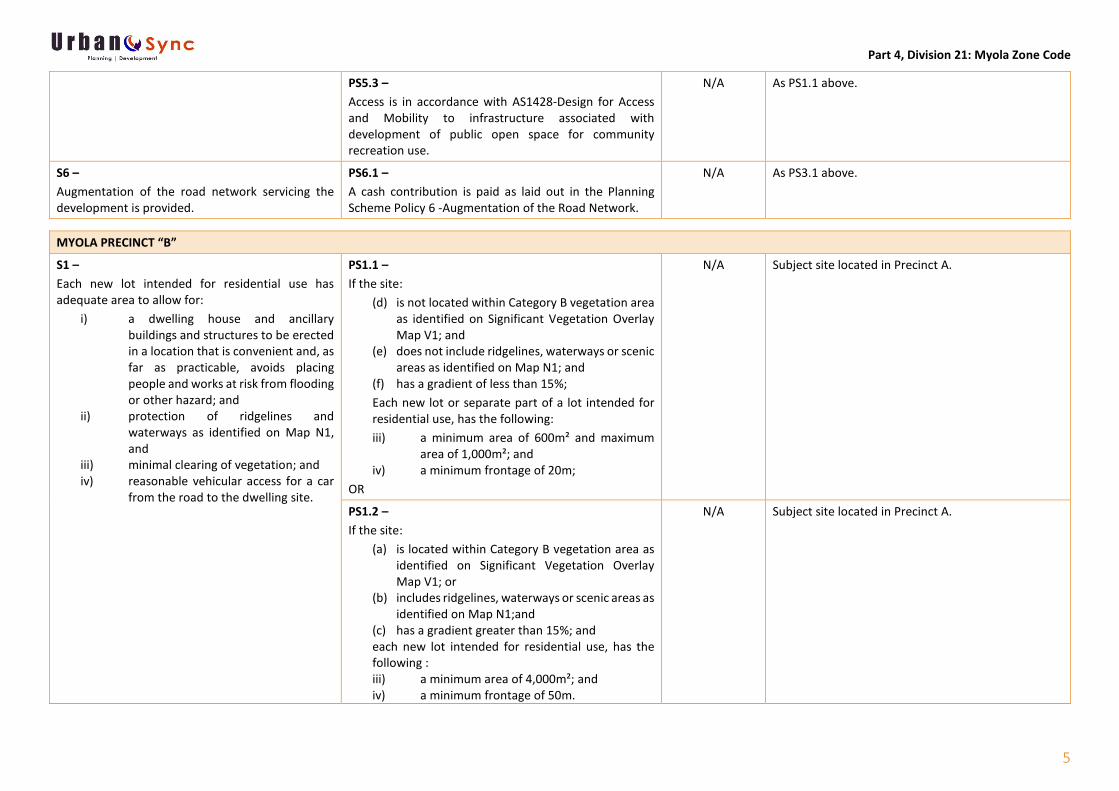
MYOLA PRECINCT “A”
S1 – Each new lot intended for residential use has adequate area to allow for:
i) a dwelling house and ancillary buildings and structures to be erected in a location that is convenient and, as far as practicable, avoids placing people and works at risk from flooding or other hazard; and
ii) protection of ridgelines and waterways as identified on Map N1, and
iii) minimal clearing of vegetation; and
PS1.1 – If the site:
(a) is not located within Category B vegetation area as identified on Significant Vegetation Overlay Map V1; and
(b) does not include ridgelines, waterways or scenic areas as identified on Map N1; and
(c) has a gradient of less than 15%; each new lot or separate part of a lot intended for residential use, has the following: i) a minimum area of 600m² and maximum area of
1,000m²; and ii) a minimum frontage of 20m;
OR
N/A Site is existing and is not proposed to be reconfigured under this application.

Part 4, Division 21: Myola Zone Code
4
iv) reasonable vehicular access for a car from the road to the dwelling site.
PS1.2 – If the site:
(a) is located within Category B vegetation area as identified on Significant Vegetation Overlay Map V1; or
(b) includes ridgelines, waterways or scenic areas as identified on Map N1;and
(c) has a gradient greater than 15%; and each new lot intended for residential use, has the following : i) a minimum area of 4,000m²; and ii) a minimum frontage of 50m.
N/A As PS1.1 above.
S2 – Each new lot is capable of being connected to the following:
i) reticulated water supply; ii) reticulated sewerage infrastructure; iii) urban drainage system; iv) underground power supply and
telecommunications.
PS2.1 – No acceptable solution prescribed.
N/A As PS1.1 above.
S3 – New roads are to an urban standard.
PS3.1 – New roads are designed and constructed in accordance with the Planning Scheme Policy 4-Development Manual.
N/A This application does not seek to construct any new roads.
S4 – New lots are designed to ensure vegetation is retained and wild life corridors (wildlife corridors are identified as Category B on Map V1) are maintained and not obstructed.
PS4.1 – Subdivision layout design retains vegetation and community of trees to facilitate free and uninterrupted movements of wildlife.
N/A As PS1.1 above.
S5 – Accessible and convenient public open space is provided for the recreation and wellbeing of the community.
PS5.1 – Land for parks and recreation is provided in accordance with Planning Scheme Policy 5 -Open Space Contribution OR
N/A As PS1.1 above.
PS5.2 – A cash contribution is paid as laid out in the Planning Scheme Policy 5 - Open Space Contribution.
N/A As PS1.1 above.
Part 4, Division 21: Myola Zone Code
5
PS5.3 – Access is in accordance with AS1428-Design for Access and Mobility to infrastructure associated with development of public open space for community recreation use.
N/A As PS1.1 above.
S6 – Augmentation of the road network servicing the development is provided.
PS6.1 – A cash contribution is paid as laid out in the Planning Scheme Policy 6 -Augmentation of the Road Network.
N/A As PS3.1 above.
MYOLA PRECINCT “B”
S1 – Each new lot intended for residential use has adequate area to allow for:
i) a dwelling house and ancillary buildings and structures to be erected in a location that is convenient and, as far as practicable, avoids placing people and works at risk from flooding or other hazard; and
ii) protection of ridgelines and waterways as identified on Map N1, and
iii) minimal clearing of vegetation; and iv) reasonable vehicular access for a car
from the road to the dwelling site.
PS1.1 – If the site:
(d) is not located within Category B vegetation area as identified on Significant Vegetation Overlay Map V1; and
(e) does not include ridgelines, waterways or scenic areas as identified on Map N1; and
(f) has a gradient of less than 15%; Each new lot or separate part of a lot intended for residential use, has the following: iii) a minimum area of 600m² and maximum
area of 1,000m²; and iv) a minimum frontage of 20m;
OR
N/A Subject site located in Precinct A.
PS1.2 – If the site:
(a) is located within Category B vegetation area as identified on Significant Vegetation Overlay Map V1; or
(b) includes ridgelines, waterways or scenic areas as identified on Map N1;and
(c) has a gradient greater than 15%; and each new lot intended for residential use, has the following : iii) a minimum area of 4,000m²; and iv) a minimum frontage of 50m.
N/A Subject site located in Precinct A.

Part 4, Division 21: Myola Zone Code
6
S2 – Each new lot is capable of being connected to the following:
i) reticulated water supply; ii) reticulated sewerage infrastructure; iii) urban drainage system; iv) underground power supply and
telecommunications.
PS2.1 – No acceptable solution prescribed.
N/A Subject site located in Precinct A.
S3 – Each new lot is capable of being accessed, via a road crossing of Barron River directly linking Precinct A and Precinct B, with a flood immunity of greater than Q10.
PS3.1 – No acceptable solution prescribed.
N/A Subject site located in Precinct A.
S4 – New roads are constructed to an urban standard.
PS4.1 – New roads are designed and constructed in accordance with the Planning Scheme Policy 4-Development Manual.
N/A Subject site located in Precinct A.
S5 – New lots are designed to ensure vegetation is retained and wild life corridors (wildlife corridors are identified as Category B on Map V1) are maintained and not obstructed.
PS5.1 – Subdivision layout design retains vegetation and community of trees to facilitate free and uninterrupted movements of wildlife.
N/A Subject site located in Precinct A.
S6 – Accessible and convenient public open
PS6.1 – Land for parks and recreation is provided in accordance with Planning Scheme Policy 5 -Open Space Contribution or
N/A Subject site located in Precinct A.
PS6.2 – A cash contribution is paid as laid out in the Planning Scheme Policy 5 - Open Space Contribution
N/A Subject site located in Precinct A.
PS6.2 – Access is in accordance with AS1428-Design for Access and Mobility to infrastructure associated with development of public open space for community recreation use.
N/A Subject site located in Precinct A.

Part 4, Division 21: Myola Zone Code
7
S7 – Augmentation of the road network servicing the development is provided.
PS7.1 – A cash contribution is paid as laid out in the Planning Scheme Policy 6 -Augmentation of the Road Network
N/A Subject site located in Precinct A.
MYOLA PRECINCT “C”
S1 – Each new lot intended for residential use has adequate area to allow for:
i) a dwelling house and ancillary buildings and structures to be erected in a location that is convenient and, as far as practicable, avoids placing people and works at risk from flooding or other hazard; and
ii) protection of ridgelines and waterways as identified on Map N1, and
iii) minimal clearing of vegetation; and iv) reasonable vehicular access for a car
from the road to the dwelling site.
PS1.1 – If the site:
(a) is not located within Category B vegetation area as identified on Significant Vegetation Overlay Map V1; and
(b) does not include ridgelines, waterways or scenic areas as identified on Map N1; and
(c) has a gradient of less than 15%; Each new lot or separate part of a lot intended for residential use, has the following: v) a minimum area of 4,000m² to 2 hectares
with an average of 8,000m²; and vi) a minimum frontage of 50m;
OR
N/A Subject site located in Precinct A.
PS1.2 – If the site:
(a) is located within Category B vegetation area as identified on Significant Vegetation Overlay Map V1; or
(b) includes ridgelines, waterways or scenic areas as identified on Map N1;and
(c) has a gradient greater than 15%; and each new lot intended for residential use, has the following : v) a minimum area of 4,000m² to 2 hectares
with an average of 8,000m2; and vi) a minimum frontage of 50m.
N/A Subject site located in Precinct A.

Part 4, Division 21: Myola Zone Code
8
S2 – Each new lot is capable of being connected to the following:
a) a suitable potable water supply; and b) a suitable sewerage disposal; an d c) an appropriate urban drainage system;
and d) underground power supply; and
telecommunications.
PS2.1 – Lots are connected to reticulated water and sewerage to the standards as stated in Planning Scheme Policy 4 - Development Manual (sections D6 and D7) in towns where these services are available; OR
N/A Subject site located in Precinct A.
PS2.2 – i) Lots are provided with a water supply in
accordance with Planning Scheme Policy 1 Water Supply (Outside Reticulated Water Supply Areas); and
ii) Onsite sewage disposal facilities are provided in accordance with the Plumbing and Drainage Act 2002.
N/A Subject site located in Precinct A.
PS2.3 – Lots are provided with underground electricity and telephone supplies.
N/A Subject site located in Precinct A.
PS2.4 – Stormwater drainage systems are provided in accordance with the Planning Scheme Policy 4 - Development Manual S4.
N/A Subject site located in Precinct A.
S3 – New roads are constructed to an urban
PS3.1 – New roads are designed and constructed in accordance with the Planning Scheme Policy 4-Development Manual.
N/A Subject site located in Precinct A.
S4 – New lots are designed to ensure vegetation is retained and wild life corridors (wildlife corridors are identified as Category B on Map V1) are maintained and not obstructed.
PS4.1 – Subdivision layout design retains vegetation and community of trees to facilitate free and uninterrupted movements of wildlife.
N/A Subject site located in Precinct A.
S5 – Accessible and convenient public open space is provided for the recreation and wellbeing of the community.
PS5.1 – Land for parks and recreation is provided in accordance with Planning Scheme Policy 5 -Open Space Contribution or
N/A Subject site located in Precinct A.
Part 4, Division 21: Myola Zone Code
9
PS5.2 – A cash contribution is paid as laid out in the Planning Scheme Policy 5 - Open Space Contribution
N/A Subject site located in Precinct A.
PS5.3 – Access is in accordance with AS1428-Design for Access and Mobility to infrastructure associated with development of public open space for community recreation use.
N/A Subject site located in Precinct A.
S6 – Augmentation of the road network servicing the development is provided
PS6.1 – A cash contribution is paid as laid out in the Planning Scheme Policy 6 -Augmentation of the Road Network
N/A Subject site located in Precinct A.
MYOLA PRECINCT “D”
S1 – A choice of residential allotments are provided on steeper and heavily vegetated land and provided with most conventional urban services such as underground power, sealed roads, urban drainage but not connected to reticulated water and sewerage.
PS1.1 – i) The minimum lot size is 2 hectares, with an
average area of 4 hectares; and ii) The minimum frontage is eighty (80)
metres.
N/A Subject site located in Precinct A.
S2 – New roads are constructed to an urban standard.
PS2.1 – New roads are designed and constructed in accordance with the Planning Scheme Policy 4-Development Manual.
N/A Subject site located in Precinct A.
S3 – Waterways within the precinct are retained in their natural state to protect scenic and environmental values.
PS3.1 – Riparian buffers may be considered as Open Space contribution where appropriate and is retained or restored to a natural condition and included in the Conservation zone.
N/A Subject site located in Precinct A.
S4 – New lots are designed to ensure vegetation is retained and wild life corridors (wildlife corridors are identified as Category B on Map V1) are maintained and not obstructed.
PS4.1 – Subdivision layout design retains vegetation and community of trees to facilitate free and uninterrupted movements of wildlife.
N/A Subject site located in Precinct A.

Part 4, Division 21: Myola Zone Code
10
S5 – Each new lot is capable of being connected to the following:
a) a suitable potable water supply; and b) a suitable sewerage disposal system; and c) an appropriate urban drainage system;
and d) underground power supply; and
telecommunications.
PS5.1 – i) Lots are provided with a water supply in
accordance with Planning Scheme Policy 1 - Water Supply (Outside Reticulated Water Supply Areas); and
ii) Onsite sewage disposal facilities are provided in accordance with the Plumbing and Drainage Act 2002; and
N/A Subject site located in Precinct A.
PS5.2 – Lots are provided with underground electricity and telephone supplies; and
N/A Subject site located in Precinct A.
PS5.3 – Stormwater drainage systems are provided in accordance with the Planning Scheme Policy 4 - Development Manual S4.
N/A Subject site located in Precinct A.
S6 – Accessible and convenient public open space is provided for the recreation and wellbeing of the community.
PS6.1 – Land for parks and recreation is provided in accordance with Planning Scheme Policy 5 -Open Space Contribution or
N/A Subject site located in Precinct A.
PS6.2 – A cash contribution is paid as laid out in the Planning Scheme Policy 5 - Open Space Contribution
N/A Subject site located in Precinct A.
PS6.3 – Access is in accordance with AS1428-Design for Access and Mobility to infrastructure associated with development of public open space for community recreation use.
N/A Subject site located in Precinct A.
S7 – Augmentation of the road network servicing the development is provided
PS7.1 – A cash contribution is paid as laid out in the Planning Scheme Policy 6 -Augmentation of the Road Network
N/A Subject site located in Precinct A.

Part 4, Division 21: Myola Zone Code
11
MYOLA PRECINCT “E”
S1 – The area is retained in its existing state to protect scenic and environmental values.
PS1.1 – No further reconfiguration is permitted
N/A Subject site located in Precinct A.
Part 5, Division 2 – Natural and Cultural Heritage Features Overlay Code
1
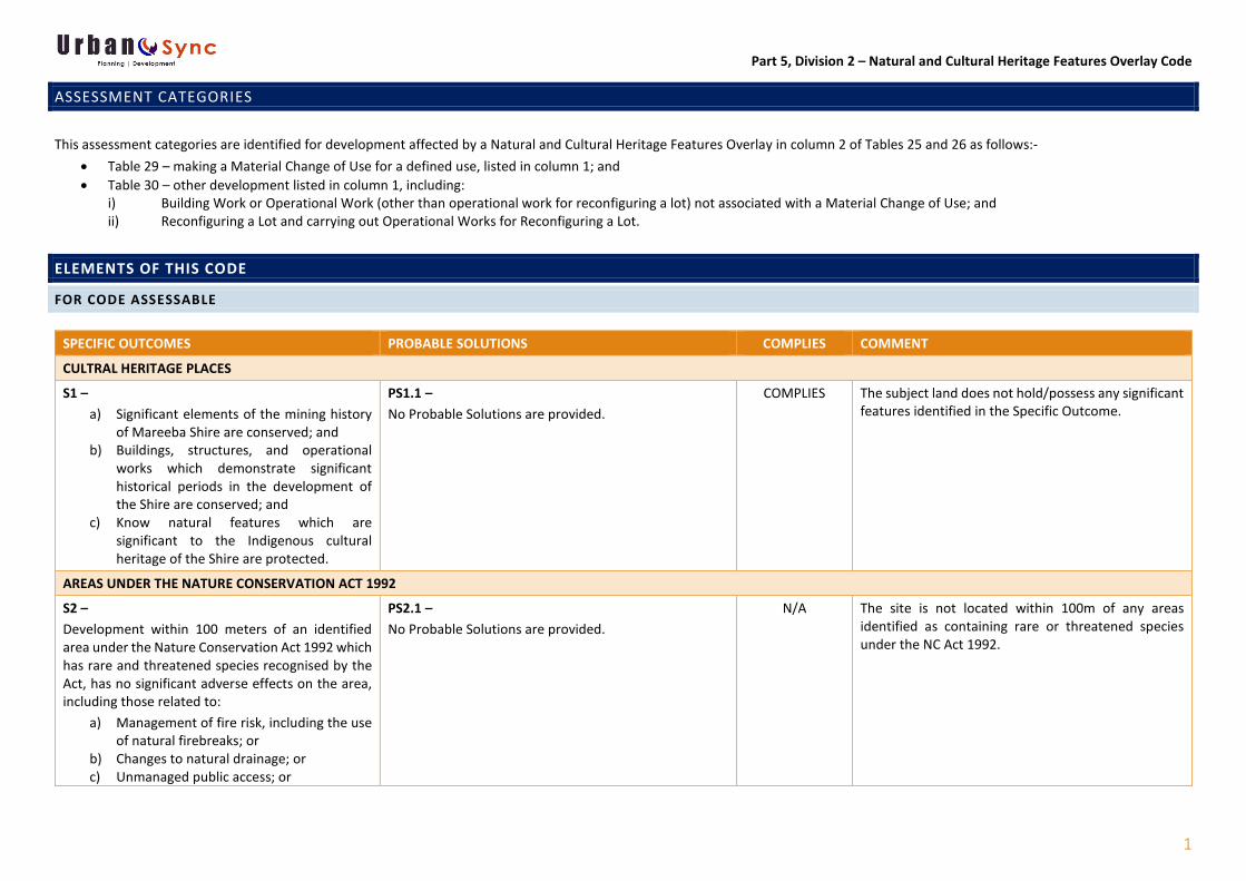
ASSESSMENT CATEGORIES
This assessment categories are identified for development affected by a Natural and Cultural Heritage Features Overlay in column 2 of Tables 25 and 26 as follows:-
• Table 29 – making a Material Change of Use for a defined use, listed in column 1; and • Table 30 – other development listed in column 1, including:
i) Building Work or Operational Work (other than operational work for reconfiguring a lot) not associated with a Material Change of Use; and ii) Reconfiguring a Lot and carrying out Operational Works for Reconfiguring a Lot.
ELEMENTS OF THIS CODE
FOR CODE ASSESSABLE
SPECIFIC OUTCOMES PROBABLE SOLUTIONS COMPLIES COMMENT
CULTRAL HERITAGE PLACES
S1 – a) Significant elements of the mining history
of Mareeba Shire are conserved; and b) Buildings, structures, and operational
works which demonstrate significant historical periods in the development of the Shire are conserved; and
c) Know natural features which are significant to the Indigenous cultural heritage of the Shire are protected.
PS1.1 – No Probable Solutions are provided.
COMPLIES The subject land does not hold/possess any significant features identified in the Specific Outcome.
AREAS UNDER THE NATURE CONSERVATION ACT 1992
S2 – Development within 100 meters of an identified area under the Nature Conservation Act 1992 which has rare and threatened species recognised by the Act, has no significant adverse effects on the area, including those related to:
a) Management of fire risk, including the use of natural firebreaks; or
b) Changes to natural drainage; or c) Unmanaged public access; or
PS2.1 – No Probable Solutions are provided.
N/A The site is not located within 100m of any areas identified as containing rare or threatened species under the NC Act 1992.

Part 5, Division 2 – Natural and Cultural Heritage Features Overlay Code
2
d) Effluent disposal; or e) Changes to natural activities of animals
with respect to the location and effects of uses, fencing, lighting, and the like.
WETLANDS AND WATERWAYS
S3 – a) There are no significant adverse effects on
identified wetlands and identified waterways in terms of: i) Habitat; or ii) Water quality; iii) Landscape.
b) For intensive agriculture, a buffer is maintained for the high bank of a waterway having regard to: i) Water quality; and ii) Fauna habitat corridor; and iii) The retention of undisturbed
vegetation; or iv) Revegetation of appropriate
areas with local endemic species.
PS3.1 – No Probable Solutions are provided.
COMPLIES The development proposed is located in excess of 100m from the adjacent watercourse (Owen Creek) that traverses through the property. The developments presence and function over the land has been taken into consideration to ensure that this proposal will not place an adverse impact on the natural drainage, Owen Creek, or other functions of the land. There are no identified wetlands on the site.
CONSERVATION OF BUILDINGS AND PLACES OF LOCAL HERITAGE SIGNIFICANCE
S4 – i) Original in situ building fabric are
preserved and restored; and ii) Material which is damaged or altered
from its original state are repaired and replaced with contemporary materials consistent with existing built fabric; and
iii) The curtilage and setting of the building are protected from development which conflicts with the character or scale of the existing building.
PS4.1 – No Probable Solutions are provided.
N/A The prescribed land does not comprise any buildings or places of local heritage significance.

Part 5, Division 2 – Natural and Cultural Heritage Features Overlay Code
3
RESPECT FOR FROM AND APPEARNACE OF NATURAL HERITAGE FEATURES AND CULTURAL HERITAGE FEATURES
S5 – Development affecting Natural Heritage Features and Cultural Heritage Features does not adversely impact upon buildings and structures of historic significance.
PS5.1 – No Probable Solutions are provided.
COMPLIES As PS4.1 above.
RETENTION OF NAUTRAL HERITAGE FEATURES AND CULTURAL HERITAGE FEATURES
S6 – Buildings or structures within a Natural Heritage Feature or Cultural Heritage Feature are retailed in an undamaged state or are enhanced through conservation of building and fabric of structures.
PS6.1 – No Probable Solutions are provided.
COMPLIES As PS4.1 above.
MINERAL RESOURCES ARE PROTECTED
S7 – Mineral resources are protected from conflicting land uses which may constrain the current or future utilisation of such resources.
PS7.1 – No Probable Solutions are provided.
COMPLIES No mineral resources have been identified as being contained on the land.

Part 5, Division 5 – Significant Vegetation Overlay Code
1
ASSESSMENT CATEGORIES
This assessment categories are identified for development affected by Significant Vegetation Overlay in column 2 of Tables 29 and 30 as follows:
a) Table 29 – making a Material Change of Use for a defined use, listed in column 1; and b) Table 30 – other development listed in column 1, including:
i) Carrying out building work not associated with a Material Change of Use; and ii) Carrying out operational work not associated with a Material Change of Use.
ELEMENTS OF THIS CODE
ASSESSMENT CRITERIA
SPECIFIC OUTCOMES ACCEPTABLE / PROBABLE SOLUTIONS COMPLIES COMMENT
S1 – Waterways and adjacent habitat are protected by:
i) Maintaining bank stability by protecting against erosion and slumping; and
ii) Maintaining water quality by filtering sediments, nutrients and other pollutants; and
iii) Maintaining aquatic habitat; and iv) Maintaining wildlife habitat.
PS1.1 – In areas identified as Category A or B on Planning Scheme Maps V1 and V2, vegetation is retained along each side of a waterway, within at least:
i) 50 metres of each high bank of a waterway in the Rural (lots with areas of two (2) hectares and above), Open Space and Conservation zone; and
ii) 25 metres of each high bank of a waterway in the Rural Residential (lots with areas of two (2) hectares and above only) and Myola zone; and
iii) 10 metres of each high bank of a waterway in the Rural Residential (lots with areas below two (2) hectares) and Rural (lots with areas below two (2) hectares) zone.
N/A The proposed dam will not require the clearing of any vegetation, nor will it be located within 25m of Owen Creek.
PS1.2 – Vegetation is retained on land with a slope greater than 15%.
N/A As PS1.1 above.

Part 5, Division 5 – Significant Vegetation Overlay Code
2
S2 – Vegetation is retained outside the immediate area required for development to protect remnant endangered regional ecosystems and wildlife corridors (Wildlife Corridors are shown as Category B on Maps V1 and V2).
PS2.1 – In areas identified as Category B on Maps V1 and V2,
i) For dwelling houses only: an area of no more than 600m² which includes the dwelling house, areas for infrastructure provision, driveways and effluent disposal/irrigation areas is cleared and fenced; and
ii) For all developments: All vegetation outside the area required for the approved development is retained.
N/A Prescribed land identified as being subject to Category A on Overlay Map V1.

Part 6, Division 17 – Excavation and Filling Code
1
ELEMENTS OF THIS CODE
FOR CODE ASSESSABLE SELF ASSESSABLE
SPECIFIC OUTCOMES ACCEPTABLE / PROBABLE SOLUTIONS COMPLIES COMMENT
VISUAL AMENITY
S1 – Filling and excavation are undertaken to ensure that the visual amenity of the adjoining lots are the area is not compromised
AS1.1 – Filling and excavation is not greater than two (2) meters in height or depth.
COMPLIES Does not Comply with Acceptable /Probably Solution, although does comply with the Specific Outcome. The excavation and filling associated with the construction of the proposed dam will result in the construction of a dam crest that will sit approximately 8.0 meters above the existing finished ground level. This proposal is considered to be consistent with the intent of the Specific Outcome as the proposed dam is a rural use and as such, is in keeping with the scale of the existing rural/rural-residential surroundings. Moreover, it will not place a detrimental impact on the character or visual amenity of the general locality due to the location of the dam over the prescribed land which is screened from view of all surrounding properties by the presence of healthy, mature vegetation The proposal demonstrates a high level of compliance with the Specific Outcomes as the Dam will not be visually obtrusive and therefore pose no threat to compromising the amenity of the general locality. It has been identified that this section of the property is screed from other surrounding rural residential allotments through the presence of thick vegetation.
PEST MANAGEMENT
S2 – Filling and excavation does not result in the spread of declared plants
AS2.1 – No declared plants are spread during any filling or excavation activities.
COMPLIES The Dam is able to be constructed through reworking of the site – i.e. the areas excavated will generate enough material for the areas that are required to be filled (this can be conditioned/there are no declared plants on site).

Part 6, Division 17 – Excavation and Filling Code
2
CODE ASSESSABLE ONLY
PERFORMANCE CRITERIA ACCEPTABLE MEASURES COMPLIES COMMENT
BUILT FORM
S3 – Filling and excavation on land is carried out in a way that does not impact adversely on the stability of the land.
AS3.1 – Material is compacted in layers no exceeding 200 millimetres to the requirements of AS1289; and
ABLE TO COMPLY
Council can condition compliance with the Performance Criteria.
AS3.2 – No filling or excavation is carried out within 1.5 meters of the side boundary; and
COMPLIES Excavation and filling works are approximately 60-65meters away from the eastern boundary.
AS3.3 – Where the level of filling or excavation at the rear or sides of the proposed lot differs from the level of adjoining lots by more than 100 millimetres either:
a) A retaining wall entirely within the development side is provided with at least a 50mm parapet above the allotment fill to ensure water is deflected from the adjoining land; or
b) A batter with a slop not exceeding 1 in 5 is provided with the end of the batter at least 1.5 meters form the side boundary.
N/A As AS3.2 above.
FLOODING AND DRAINAGE
S4 – Filling or excavation does not result in a change to the run off characteristics of a site that will have a detrimental effect upon the site and/or surrounding land or road reserves.
AS4.1 – Filling and excavation does not result in the ponding of water on the site or surrounding land or road reserves; and
ABLE TO COMPLY
Onsite works will be appropriately managed to ensure works will not result in any ponding of water in or around the site, or downstream. Council is also able to condition compliance with this requirement.
AS4.2 – Filling and excavation does not result in any increase in the flow of water across a site or any surrounding land or road reserves; and
ABLE TO COMPLY
Onsite works will be appropriately managed to ensure works will not result in a worsening of the existing overland flow paths. Council is also able to condition compliance with this requirement.

Part 6, Division 17 – Excavation and Filling Code
3
AS4.3 – Filling and excavation does not result in an increase in the volume of water or concentration of water in a watercourse and overland flow paths; and
ABLE TO COMPLY
Onsite works will be appropriately managed to ensure there will be no nett increase of water in any surrounding watercourses or transported through any overland flow paths. Council is also able to condition compliance with this requirement.
AS4.4 – Filling and excavation complies with Planning Scheme Policy 4 – Development Manual.
ABLE TO COMPLY
Nil comment. Council can condition compliance with the Performance Criteria.
ENVIRONMENT
S5 – Filling and excavation does not result in a reduction of the water quality of receiving waters.
AS5.1 – Filling and excavation does not occur within fifty (50) meters of waterways or wetlands as identified on the Planning Scheme Maps.
COMPLIES The proposed dam will be located in excess of 50m from Owen Creek which is identified on Overlay Map N1.
S6 – Excavation does not result in the disturbance of contaminated soils and filling is identified as suitable for the specific purpose.
AS6.1 – No contaminated material or unstable soil suitable for construction purposes is used for fil.
YES As AS2.1 above. This can be conditioned…..