Embed Size (px)
Citation preview
Resource Condition Report for a Significant Western Australian Wetland
Airfield Swamp (Nguyarri)
2009
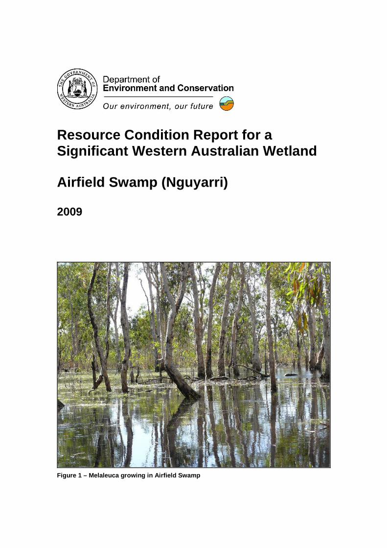
Figure 1 – Melaleuca growing in Airfield Swamp
This report was prepared by:
Glen Daniel, Environmental Officer, Department of Environment and Conservation, Locked Bag 104 Bentley Delivery Centre 6983
Stephen Kern, Botanist, Department of Environment and Conservation, Locked Bag 104 Bentley Delivery Centre 6983
Adrian Pinder, Senior Research Scientist, Department of Environment and Conservation, PO Box 51, Wanneroo 6946
Anna Nowicki, Technical Officer, Department of Environment and Conservation, PO Box 51, Wanneroo 6946
Invertebrate sorting and identification was undertaken by:
Nadine Guthrie, Research Scientist, Department of Environment and Conservation, PO Box 51, Wanneroo 6946
Ross Gordon, Technical Officer, Department of Environment and Conservation, PO Box 51, Wanneroo 6946
Prepared for:
Inland Aquatic Integrity Resource Condition Monitoring Project, Strategic Reserve Fund, Department of Environment and Conservation
Version 3 (August 2009)
Suggested Citation:
DEC (2009) Resource Condition Report for Significant Western Australian Wetland: Airfield Swamp. Prepared for the Inland Aquatic Integrity Resource Condition Monitoring (IAI RCM) Project, Department of Environment and Conservation. Perth, Australia.
Contents
1. Introduction.........................................................................................................................1
1.1. Site Code ...............................................................................................................1
1.2. Purpose of Resource Condition Report...................................................................1
1.3. Relevant International Agreements and Legislation.................................................1
2. Overview of Airfield Swamp ................................................................................................4
2.1. Location and Cadastral Information ........................................................................4
2.2. IBRA Region ..........................................................................................................4
2.3. Climate...................................................................................................................5
2.4. Wetland Type .........................................................................................................6
2.5. Values of Airfield Swamp........................................................................................6
3. Critical Components and Processes of the Ecology of Airfield Swamp.................................8
3.1. Geology and Soils ..................................................................................................8
3.2. Hydrology...............................................................................................................8
3.3. Water Quality .........................................................................................................9
3.4. Vegetation..............................................................................................................9
3.5. Aquatic Invertebrates............................................................................................12
3.6. Fish......................................................................................................................13
3.7. Birds.....................................................................................................................13
3.8. Terrestrial Vertebrates..........................................................................................13
4. Interactions between Ecological Components at Airfield Swamp .......................................14
5. Threats to the Ecology of Airfield Swamp ..........................................................................19
6. Knowledge Gaps and Recommendations for Future Monitoring.........................................23
References................................................................................................................................24
Appendix – Invertebrate Data ....................................................................................................25
1
1. Introduction This Resource Condition Report (RCR) was prepared by the Inland Aquatic Integrity Resource Condition Monitoring (IAI RCM) project. It describes the ecological character and condition of Airfield Swamp (Nguyarri in local dialect), a permanent freshwater lake on the Mitchell Plateau. Airfield Swamp is the largest of several lakes perched between 300 and 350 m above sea level on the Mitchell Plateau. It is of high significance to local Aboriginal people, who consider such water bodies to be the resting place of Wunggurr or creation spirits (Handley 1996). It is also a site of high biological diversity and is an important refuge for fauna during the dry season.
1.1. Site Code Inland Aquatic Integrity Resource Condition Monitoring Project: RCM011
Transect code: RCM011-R1
RCM011-A1
RCM011-A2
Register of the National Estate Place ‘Registered’ ID: 17248 (Mitchell - Lawley Rivers Region, Mitchell River Rd, Kalumburu, WA, Australia)
1.2. Purpose of Resource Condition Report The objective of this RCR is to summarise all ecological information relevant to Airfield Swamp and describe the drivers of, and threats to, the system. By doing so, the report provides a current ‘snapshot’ of ecological character against which future measures of condition can be assessed. This will allow the effectiveness of management planning and actions to be gauged.
1.3. Relevant International Agreements and Legislat ion The following is a summary of relevant international agreements and legislation that are relevant to the management of Airfield Swamp.
International Agreements
Migratory bird bilateral agreements and conventions
Australia is party to a number of bilateral agreements, initiatives and conventions for the conservation of migratory birds that may apply at Airfield Swamp. The bilateral agreements are:
JAMBA - The Agreement between the Government of Australia and the Government of Japan for the Protection of Migratory Birds in Danger of Extinction and their Environment, 1974;
CAMBA - The Agreement between the Government of Australia and the Government of the People’s Republic of China for the Protection of Migratory Birds and their Environment, 1986;
ROKAMBA - The Agreement between the Government of Australia and the Republic of Korea for the Protection of Migratory Birds and their Environment, 2006; and
The Bonn Convention on Migratory Species (CMS) - The Bonn Convention adopts a framework in which countries with jurisdiction over any part of the range of a particular species co-operate to prevent migratory species becoming endangered. For Australian purposes, many of the species are migratory birds.
National legislation
The Environment Protection and Biodiversity Conservation Act 1999 (EPBC Act)
The EPBC Act is the Australian Government's central piece of environmental legislation. It provides a legal framework to protect and manage nationally and internationally important flora, fauna, ecological communities and heritage places. These are defined in the Act as matters of
2
national environmental significance. There are seven matters of national environmental significance to which the EPBC Act applies. Two of these are relevant to Airfield Swamp:
• nationally threatened species; and
• migratory species listed under international treaties JAMBA, CAMBA and CMS.
Western Australian legislation
Wildlife Conservation Act 1950
This Act provides for the protection of wildlife. All fauna (animals native to Australia) in Western Australia are protected under section 14 and all flora (plants native to Western Australia) are protected under section 23 of the Wildlife Conservation Act 1950. The Act establishes licensing frameworks for the taking and possession of protected fauna, and establishes offences and penalties for interactions with fauna.
Aboriginal Heritage Act 1972
The purpose of this Act is to protect Aboriginal remains, relics and sites from undue interference, and to recognise the legitimate pursuit of Aboriginal customs and traditions. Under the Act, It is an offence for a person to excavate, destroy, damage or alter any Aboriginal site. The Act applies to all objects which are of sacred, ritual or ceremonial significance to persons of Aboriginal descent, or which are or were used for any purpose connected with the traditional cultural life of the Aboriginal people and the places where such objects are found. It also protects any sacred, ritual or ceremonial site, which is of importance and special significance to persons of Aboriginal descent. Finally, the Act states that, where a representative body of persons of Aboriginal descent who usually live subject to Aboriginal customary law, has an interest in a place, that place shall be available to that body for purposes sanctioned by the Aboriginal tradition relevant to that place.
Aboriginal Affairs Planning Authority Act 1972 (AAPA Act)
The AAPA Act repealed earlier Indigenous welfare legislation. It governs most Indigenous land related matters and vests reserves in the Aboriginal Affairs Planning Authority, which promotes the well being and economic advancement of Indigenous Australians. A visitor should always seek and gain permission to enter an Aboriginal community, and in the case of Aboriginal Reserve land, must do so by obtaining an entry permit. Under the AAPA Act, transit permits are required for any person visiting or passing through an Aboriginal reserve, unless he/she is:
• a person of Aboriginal descent; • a member of either House of Parliament of the State or of the Commonwealth; • a person exercising a function under the AAPA Act 1972 or otherwise acting in
pursuance of a duty imposed by law; or • a person authorised under the regulations of the AAPA Act 1972.
3
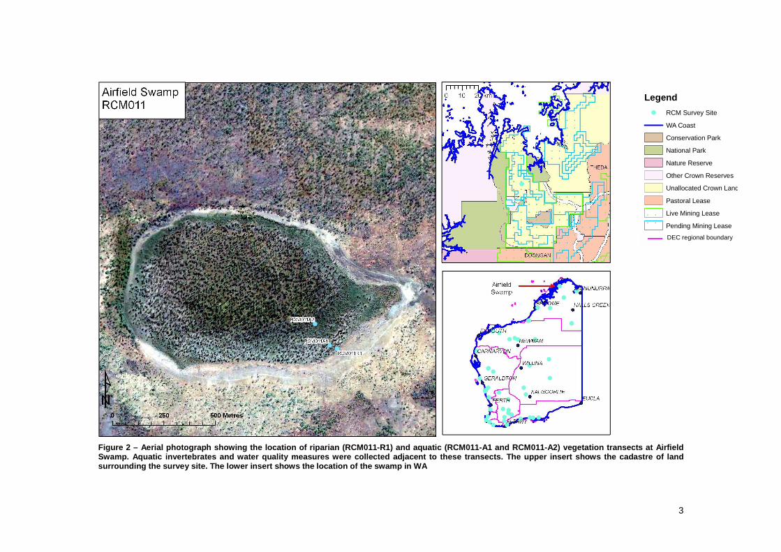
Figure 2 – Aerial photograph showing the location o f riparian (RCM011-R1) and aquatic (RCM011-A1 and R CM011-A2) vegetation transects at Airfield Swamp. Aquatic invertebrates and water quality meas ures were collected adjacent to these transects. Th e upper insert shows the cadastre of land surrounding the survey site. The lower insert shows the location of the swamp in WA
Legend
! RCM Survey Site
WA Coast
Conservation Park
National Park
Nature Reserve
Other Crown Reserves
Unallocated Crown Land
Pastoral Lease
! ! Live Mining Lease! !
Pending Mining Lease
DEC regional boundary
4
2. Overview of Airfield Swamp
2.1. Location and Cadastral Information Airfield Swamp lies on the Mitchell Plateau, approximately 340 km west-northwest of Kununurra. The nearest community is Kandiwal, approximately 5 km to the south. Kandiwal is home to about 30 Wunambal-Gaambera people who are the traditional custodians of the area (Wunambal Gaambera Aboriginal Corporation 2001).
Tenure of the Mitchell Plateau has an unusual and complicated history. Areas of the plateau were granted as pastoral leases as early as 1882. These were later abandoned and the entire plateau returned to unallocated crown land (UCL). In 1972, 184,000 ha of the plateau (including Airfield Swamp) was declared a temporary reserve for bauxite mining under the provisions of the Alumina Refinery (Mitchell Plateau) Bauxite Agreement Act 1971. This gave occupancy rights to a joint venture of mining companies until 2001. A condition of the occupancy required the joint venturers to appoint the Department of Conservation and Land Management (now Department of Environment and Conservation, DEC) as the land manager for the Temporary Reserve. Upon expiration of the temporary reserve’s occupancy period, the area reverted to UCL, but mining leases are still active over much of the plateau.
Further controversy ensued with the declaration of two National Parks and two Conservation Parks in 2000. Mitchell River National Park, Lawley River National Park, Camp Creek Conservation Park and Laterite Conservation Park occupy a combined area of 146,000 ha of the Mitchell Plateau. Their creation without adequate consultation angered local Aboriginal people who have challenged the legality of the tenure change under racial discrimination and native title legislation. Negotiations continue to institute joint management of the plateau between DEC and the traditional owners, with the existence of live mining tenements further complicating the issue.
Access to Airfield Swamp should not occur without the permission of the Wunambal-Gaambera people. The wetland is reached by following the Port Warrender road to the Mitchell Plateau Airfield. The swamp lies approximately 400 metres northwest of the northern end of the north-south airstrip. Local Aboriginal people request that visitors do not enter the water body.
2.2. IBRA Region Airfield Swamp lies within the Mitchell subregion (NK1) of the North Kimberley Interim Biogeographic Regionalisation of Australia (IBRA) region. The Mitchell subregion is a dissected plateau featuring a combination of basalt, laterite and sandstone substrates. It receives the highest rainfall in north-western Australia and is the only locality in the Kimberley where a lateritic landscape receives high rainfall. These unique characteristics give rise to very diverse suites of fauna and flora. For instance, the flora contains both Gondwanan and Australasian elements (Handley 1996).
The characteristic vegetation of the subregion is Savannah woodland over high Sorghum grasses and hummock grasses that occur on shallow sandy soils, and red and yellow earths. Closed forests of Melaleuca and Pandanus occur along drainage lines with numerous small patches of monsoon rainforest scattered though out the district. The Mitchell Plateau is well known for the presence of Livistona palms which are found as an understorey in eucalypt forest on the laterite plateau and its scree slopes. There are no other substantial areas in WA where palms are such a dominant feature of the vegetation. Furthermore, this subregion has provided the only records for the State of the family Podostomaceae, the genus Fissistigma and at least twenty-one other species (Handley 1996).
The Mitchell and Lawley Rivers area has the largest number of mammal species collected from any area of similar size in Western Australia. Forty-five species have been recorded to date, with open forests on the lateritic plateau surfaces providing the richest and most diverse small mammal fauna. The Mitchell and Lawley Rivers area also has a very diverse avifauna with a total of 219 bird species recorded, including twenty-seven species of birds listed in the 1992 schedule
5
to the Japan Australia Migratory Birds Agreement (JAMBA), eleven of which are also listed in the schedule to the China Australia Migratory Birds Agreement (CAMBA). Six species of bird are known from the subregion which are considered threatened or near threatened (Handley 1996).
In addition to these natural features, a range of archaeological sites, including middens, artefact scatters, grinding grooves, modified trees, quarries, paintings and burial sites occur in the Mitchell subregion. It is also a popular tourist destination with sites of particular aesthetic interest such as the Mitchell Falls (Punamii-Unpuu), Surveyors Pool (Aunauyu) and the seascapes of Port Warrender (Handley 1996).
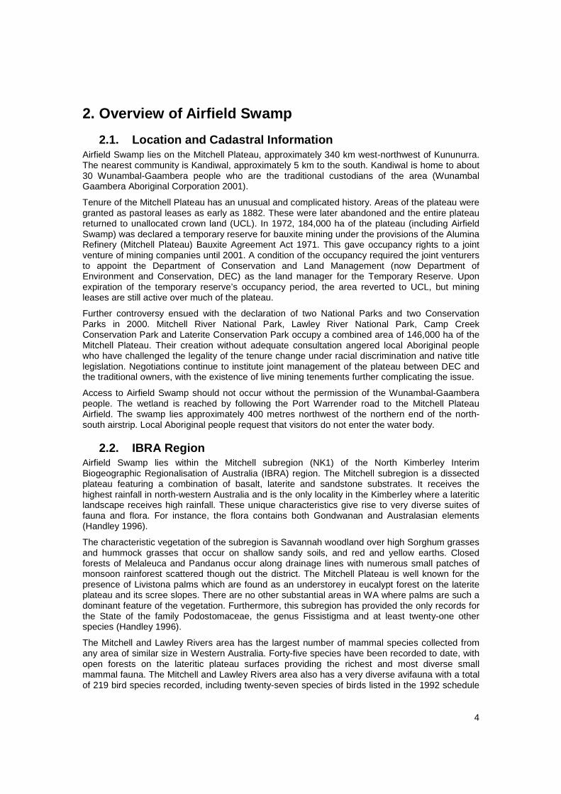
2.3. Climate The Bureau of Meteorology operated a weather station on the Mitchell Plateau between 1968 and 1986. That station was less than three kilometres from Airfield Swamp. The data presented here and in Figure 3 are from the Mitchell Plateau meteorological station. Since the closure of that station, the nearest available climatic data are from Doongan (85 km southeast) or Kalaumburu (105 km northeast). Those sites experience a similar temperature range to the Mitchell Plateau, but receive significantly less rainfall.
The Mitchell Plateau experiences a monsoonal climate. It receives a mean annual rainfall of 1,550 mm with almost 90% of that falling between November and March (Figure 3). Rainfall during the wet season is very reliable; the lowest recorded annual total was 1,093 mm. The passage of tropical cyclones can result in additional deluge and as much as 257 mm has been recorded in a single day. Annual evaporation was never recorded at the Mitchell Plateau or any of the surrounding sites. Mean maxima and minima temperatures are 36.0ºC/23.0ºC in November/December and 29.6ºC/9.7ºC in July/August.
0
5
10
15
20
25
30
35
40
Jan Feb Mar Apr May Jun Jul Aug Sep Oct Nov Dec
0
50
100
150
200
250
300
350
400
M ean Rain
M ean M ax T
M ean M in T
Figure 3 – Climatic averages for Mitchell Plateau, as recorded between 1968 and 1986
Airfield Swamp was surveyed by the IAI RCM project on the 19th of May 2008. In the nine months preceding the survey, Kalumburu received 1,304 mm of rain. The majority of this (721 mm) fell in February, with almost no rainfall recorded after the end of March. Historical records suggest that Mitchell Plateau receives around 30% more rainfall than Kalumburu, but that the timing of rainfall is similar.
Tem
pera
ture
(ºC
)
Rainfall (m
m)
6
2.4. Wetland Type Airfield Swamp is a ‘freshwater swamp forest; seasonally flooded forest, wooded swamp on inorganic soils’ (type B14 in the Directory of Important Wetlands in Australia). It has an area of 80 ha and a maximum depth in the wet season of around 0.5 m.
2.5. Values of Airfield Swamp Values are the internal principles that guide the behaviour of an individual or group. Value systems determine the importance people place on the natural environment and how they view their place within it. Divergent values may result in people pursuing different objectives in relation to nature conservation, having different reasons for desiring a commonly agreed outcome, or favouring different mechanisms to achieve it. Because of this, it is important to be explicit about the values that are driving conservation activities at a wetland.
The Conceptual Framework for Managing Natural Biodiversity in the Western Australian Wheatbelt (Wallace 2003) identified eight reasons that humans value natural biodiversity:
a. Consumptive use
Consumptive use is gaining benefit from products derived from the natural environment, without these products going through a market place, for example, the collection and personal use of firewood or ‘bushtucker’. Airfield Swamp (Nguyarri) has traditionally been an important resource to the Wunambal-Gaambera people and remains so today. This is illustrated by the following quote from Wilfred Goonack that appeared in the Ngauwudu Management Plan (Wunambal Gaambera Aboriginal Corporation 2001):
At Nguyarri there was a hunter for emu called Pundulngurr… my grandfather come here and waited for gunduli (agile wallaby), jebarra (emu), barnarr (bush turkey) to come for water. This swamp is living water. Wunggurr [creator snake], he bin come here. Animals, possum, everything come to this water. Hunting ground, sugarbag, cutting palms, getting roots.
A chief concern of the local people, discussed in that plan, is the continuation of traditional knowledge and practices in the area.
b. Productive use
Productive use values are derived from market transactions involving products derived from the natural environment. The same firewood that is collected for personal use may be exchanged for money or another commodity. No productive use is currently made of Airfield Swamp, although mining tenements are held over the area.
c. Opportunities for future use
Not all uses of the natural environment may be apparent at present. The potential for future benefit from the natural environment is maximised by maintaining the greatest possible biodiversity. Every lost taxa or ecosystem represents lost opportunities. Airfield Swamp may support endemic or rare taxa. Such unique features would increase the potential for future opportunities to present.
d. Ecosystem services
There are many naturally occurring phenomena that bring enormous benefit to mankind. For instance, plants generate oxygen, insects pollinate food crops and wetlands mitigate floods by regulating water flows. The term ‘ecosystem services’, is used as a broad umbrella to cover the myriad of benefits delivered, directly or indirectly, to humankind by healthy ecosystems. Airfield Swamp, in itself, would make a relatively small contribution to ecosystem services. That said, the greater area of the Mitchell and Lawley Rivers, which includes Airfield Swamp is very diverse and provides significant ecosystem services.
7
e. Amenity
Amenity describes features of the natural environment that make life more pleasant for people. For instance, pleasant views and shade or wind shelter from a stand of trees. It is difficult to quantify the amenity value of a remote site such as Airfield Swamp, but it is very likely to be valued by the local community and tourists for the amenity it provides.
f. Scientific and educational uses
Parts of the natural environment that remain relatively unmodified by human activity represent great educational opportunities. Such sites allow us to learn about the changes that have occurred to the natural world. They are also ‘control’ sites that allow us to benchmark other, altered habitats. Airfield Swamp is a relatively unmodified freshwater wetland that may present opportunities for advancing the science of wetland ecology.
g. Recreation
Many recreational activities rely on the natural environment (bird watching, canoeing, wildflower tourism, etc.) or are greatly enhanced by it (hiking, cycling, horse riding, photography, etc.). Recreation may deliver economic benefit derived from tourism and also delivers spiritual and physical health benefits to the recreator. Airfield Swamp is a popular location for bird watching and plans for low-impact tourism have been considered.
h. Spiritual/philosophical values
People’s spiritual and philosophical reasons for valuing the natural environment are numerous and diverse. One commonly cited is the ‘sense of place’ that people derive from elements of their environment. This is evident in many Aboriginal and rural Australians, who strongly identify themselves with their natural environment. Many people also believe that nature has inherent value or a right to exist that is independent of any benefit delivered to humans. A sense of spiritual well-being may be derived from the knowledge of healthy environments even if the individual has no contact with them. Airfield Swamp is of cultural significance to the local Aboriginal people, as seen in the previous quote from Wilfred Goonack. The swamp is known to be an important law ground (Wunambal Gaambera Aboriginal Corporation 2001).
The intent of nature conservation is usually to maintain the ecosystem service values, opportunity values, and scientific and educational values at a given site. Doing so is likely to have positive effects on the amenity values, recreational values and spiritual/philosophical values to which the site’s natural environment contributes. Consumptive and productive uses of the natural environment are not usually considered, as these are often incompatible with nature conservation. That said, Airfield Swamp has been described as an important source of resources for local Aboriginal people and may be esteemed by them for its consumptive values. These conflicting value sets should be considered when attempting to implement conservation management at the site.
8
3. Critical Components and Processes of the Ecology of Airfield Swamp
The primary objective of the Airfield Swamp Resource Condition Report (RCR) is to identify, describe and quantify the drivers of the wetland’s ecosystem. These are the components and processes that determine the site’s ecological character and are the variables that should be addressed in any ongoing monitoring.
Climate and geomorphology are the most important drivers of wetland ecosystems. Between them, these factors determine the position of a wetland in the landscape and the type and hydrological regime of that wetland. In turn, a wetland’s position, type and hydrology exert a strong influence on its biota and biochemical properties and processes.
A summary of Airfield Swamp’s critical ecosystem components is presented in Table 1, followed by a detailed description of the results of the Inland Aquatic Integrity Resource Condition Monitoring (IAI RCM) 2008 survey as well as additional information derived from previous studies of the site.
Table 1 – Summary of critical ecosystem components at Airfield Swamp
Component Summary description
Geomorphology Sumpland situated within a basaltic area surrounded by red loamy earths, red sandy earths and shallow gravels
Hydrology Perched paperbark swamp on Mitchell Plateau; maximum depth of 0.5 m
Water Quality Extremely fresh (24 µmS/cm), neutral pH, low nutrients and chlorophyll
Vegetation Dominated by sedgeland, grassland and Melaleuca woodland
Invertebrates Moderately high diversity of macroinvertebrates with a good range of taxonomic groups represented
Fish No fish recorded at the site. An unidentified species of fish was observed during the IAI RCM survey
Waterbirds 4 unidentified ducks, 2 Pacific Black Ducks and 1 Little Egret sighted during the IAI RCM survey
Terrestrial Vertebrates
No fauna observed at Airfield Swamp during the IAI RCM survey, but 10 species of mammal, 8 species of reptile and species of frog have previously been recorded at the site
3.1. Geology and Soils The Kimberley Plateau is a broad landform unit that stretches from Cambridge Gulf to Walcott Inlet and south almost to Halls Creek. In the west of that unit, basalt, dolerite and granophyre occur. Areas of basalt, in particular, can be extensive and are often associated with the development of lateritic duricrust. Airfield Swamp lies within a basaltic area and is surrounded by the red loamy earths, red sandy earths and shallow gravels usually associated with basalt uplands in the region.
The sediment of Airfield Swamp is a mixture of sand (56%), silt and clay (35%), and gravel (9%), with a few scattered rocks.
3.2. Hydrology Airfield Swamp is the largest (80 ha) of several swamps located on the Mitchell Plateau. Airfield Swamp is a perched paperbark forest wetland. The swamp reached a depth of 0.5 m in the wet season.

9
RCM
RCM0011
May 2008
pH 6.05 to 7.19Alkalinity (mg/L) 5
TDS (g/L) 0.01Turbidity (NTU) 1.3
Colour (TCU) 41Total nitrogen (ug/L) 500
Total phosphorus (ug/L) 10Total soluble nitrogen (ug/L) 500
Total soluble phosphorus (ug/L) 5Chlorophyll (ug/L) 2
Na (mg/L) 3.6Mg (mg/L) 0.6Ca (mg/L) 0.5
K (mg/L) 0.1Cl (mg/L) 3
SO4 (mg/L) 0.4HCO3 (mg/L) 6
CO3 (mg/L) 0.5
The wetland is associated with the Mitchell River, which flows northwards, draining part of the Kimberley Plateau into Admiralty Gulf via Walmsley Bay. It is actively eroding its bed through King Leopold Sandstone, giving rise to gorges and waterfalls, especially along the margins of the basaltic Mitchell Plateau. Part of the upper catchment of the Mitchell River is disturbed, whilst the lower catchment is relatively undisturbed. There is no documented study of the hydrology of Airfield Swamp itself. The swamp’s surface water is possibly fed by sheet flow.
3.3. Water Quality Airfield Swamp has very good water quality (Table 2). Notably, this wetland has an extremely low salinity (0.01 g/L measured in both laboratory and field, conductivity 24 µS/cm). This is lower than any other sample recorded by the DEC Science Division wetland group. Nutrient concentrations and chlorophyll are also low.
Table 2 – Water quality parameters at Airfield Swam p, as measured by the IAI RCM survey in 2008
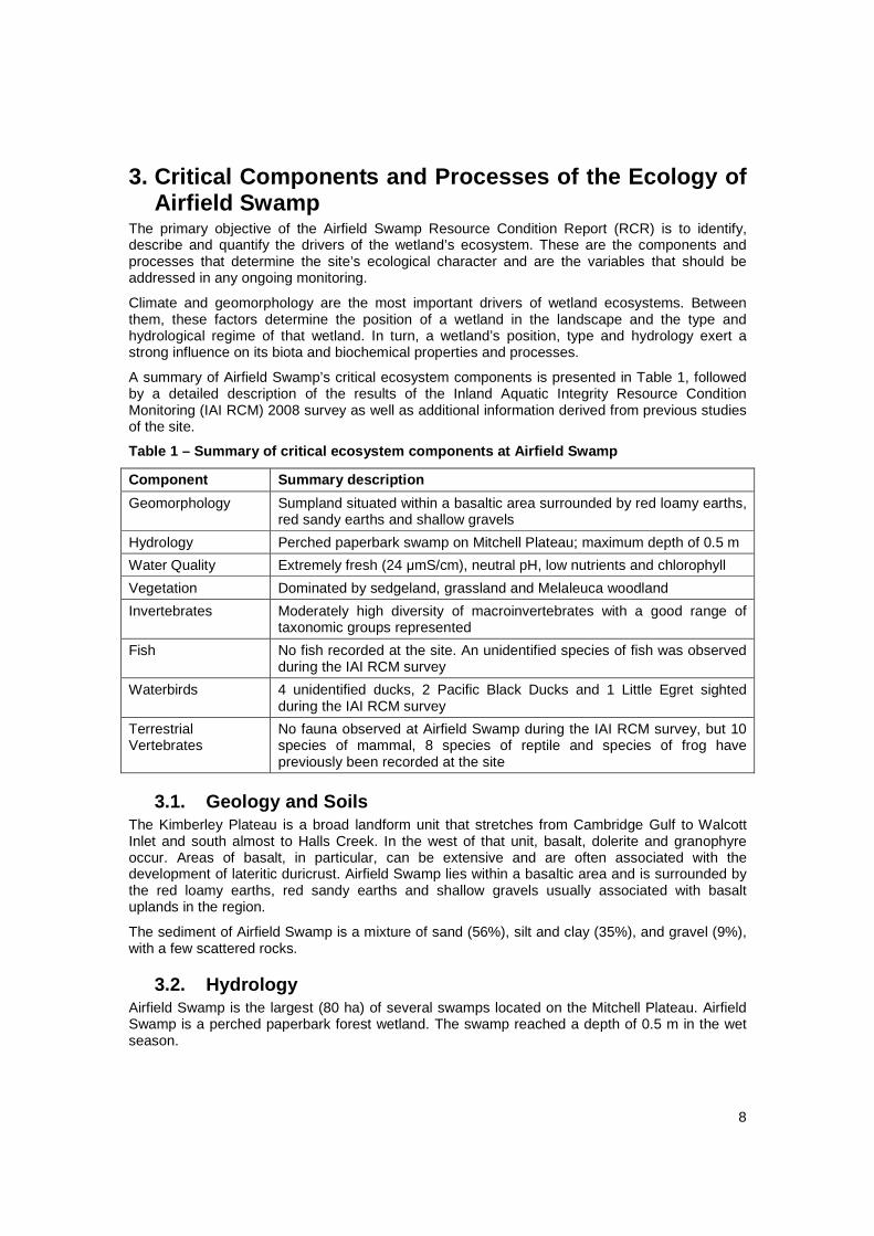
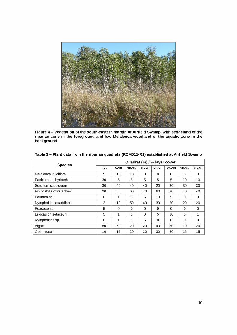
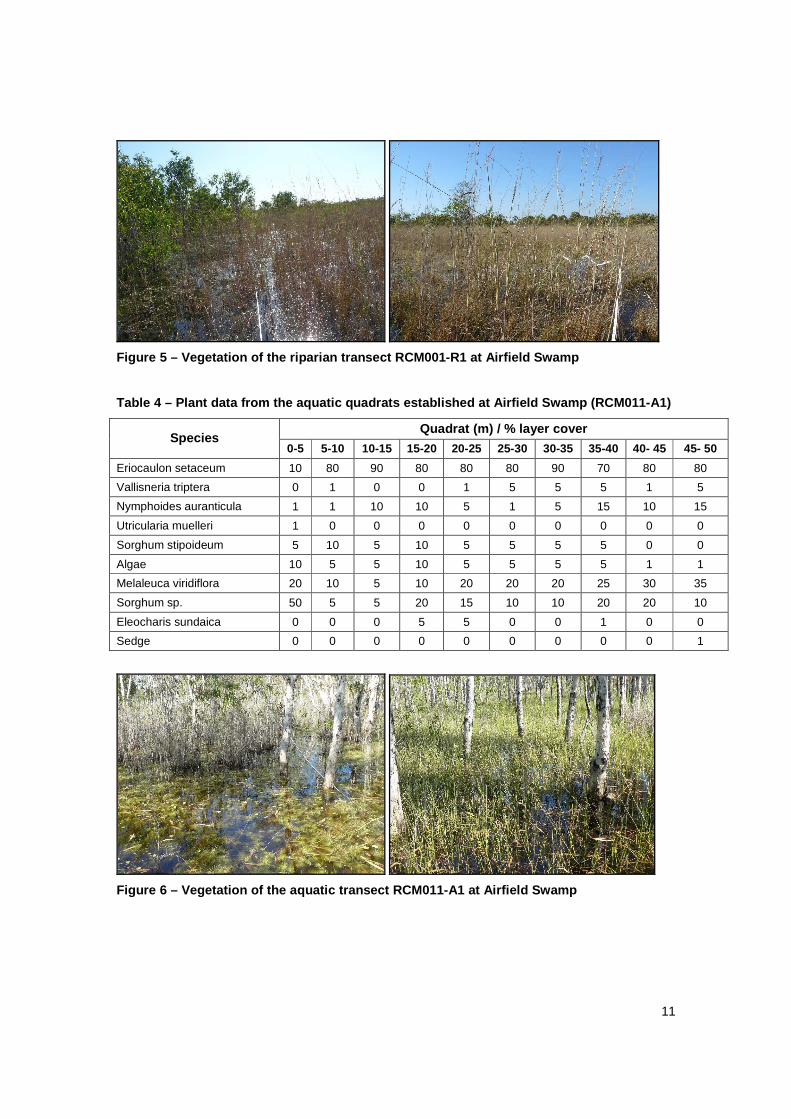
3.4. Vegetation Airfield Swamp is dominated by sedgeland and Melaleuca woodland (Figure 4). Three vegetation transects were established at the swamp. The first of these (RCM011-R1) was within the grasses, rushes and sedges that surround the permanent standing water beneath scattered low Melaleuca viridiflora (Figure 5 and Table 3). The two aquatic transects (RCM001-A1 and RCM011-A2) were within the low M. viridiflora woodland that covers the water body (Table 4, 6 and Figure 6, 8). The second of the two (RCM011-A2) is further from shore amid denser vegetation.
10
Figure 4 – Vegetation of the south-eastern margin o f Airfield Swamp, with sedgeland of the riparian zone in the foreground and low Melaleuca woodland of the aquatic zone in the background
Table 3 – Plant data from the riparian quadrats (RC M011-R1) established at Airfield Swamp
Quadrat (m) / % layer cover Species
0-5 5-10 10-15 15-20 20-25 25-30 30-35 35-40
Melaleuca viridiflora 5 10 10 0 0 0 0 0
Panicum trachyrhachis 30 5 5 5 5 5 10 10
Sorghum stipoideum 30 40 40 40 20 30 30 30
Fimbristylis oxystachya 20 60 60 70 60 30 40 40
Baumea sp. 0 1 0 5 10 5 0 0
Nymphoides quadriloba 2 10 50 40 30 20 20 20
Poaceae sp. 5 0 0 0 0 0 0 0
Eriocaulon setaceum 5 1 1 0 5 10 5 1
Nymphoides sp. 0 1 0 5 0 0 0 0
Algae 80 60 20 20 40 30 10 20
Open water 10 15 20 20 30 30 15 15
11
Figure 5 – Vegetation of the riparian transect RCM0 01-R1 at Airfield Swamp
Table 4 – Plant data from the aquatic quadrats esta blished at Airfield Swamp (RCM011-A1)
Quadrat (m) / % layer cover Species
0-5 5-10 10-15 15-20 20-25 25-30 30-35 35-40 40- 45 45- 50
Eriocaulon setaceum 10 80 90 80 80 80 90 70 80 80
Vallisneria triptera 0 1 0 0 1 5 5 5 1 5
Nymphoides auranticula 1 1 10 10 5 1 5 15 10 15
Utricularia muelleri 1 0 0 0 0 0 0 0 0 0
Sorghum stipoideum 5 10 5 10 5 5 5 5 0 0
Algae 10 5 5 10 5 5 5 5 1 1
Melaleuca viridiflora 20 10 5 10 20 20 20 25 30 35
Sorghum sp. 50 5 5 20 15 10 10 20 20 10
Eleocharis sundaica 0 0 0 5 5 0 0 1 0 0
Sedge 0 0 0 0 0 0 0 0 0 1
Figure 6 – Vegetation of the aquatic transect RCM01 1-A1 at Airfield Swamp
12
Table 5 – Plant data from the aquatic quadrats esta blished at Airfield Swamp (RCM011-A1)
Quadrat (m) / % layer cover Species
0-5 5-10 10-15 15-20 20-25 25-30 30-35 35-40 40- 45 45- 50
Sorghum sp. 10 10 0 0 0 0 0 0 0 0
Eleocharis sundaica 60 50 50 60 40 70 80 90 90 90
Pogostemon stellatus 1 0 0 1 1 0 0 0 5 5
Unidentified (K4aQA2MC02) 1 5 5 5 5 5 5 5 5 5
Melaleuca viridiflora 50 40 50 30 30 20 40 10 10 20
Nymphoides auranticula 5 5 1 1 0 1 0 0 0 0
Unidentified (K4aQA2MC05) 0 0 5 1 0 0 0 5 0 0
Eriocaulon setaceum 0 0 1 5 0 0 0 0 0 0
Figure 7 – Vegetation of the aquatic transect RCM01 1-A2 at Airfield Swamp
3.5. Aquatic Invertebrates Airfield Swamp has a moderately high diversity of macroinvertebrates with a good range of taxonomic groups represented (Table 6). Several taxa were recorded that don’t seem to fit known described species and may be new. However, for the present, taxonomic impediments and lack of survey data for the Kimberley region prevent much further discussion of these. Of particular note are the limnocharid water mites, both of which are probably new species and one of which is probably the first record of the genus Neolimnochares from Western Australia. Neolimnochares is otherwise known only from the Northern Territory (N. kakadu Harvey 1990). Another water mite, Mamersa corndorl, may not have been recorded in the State before. It is otherwise known from the Northern Territory and Queensland.
A full list of invertebrates identified at Airfield Swamp during the IAI RCM survey is available in Table 10 (Appendix).
Table 6 – Aquatic invertebrate diversity at Airfiel d Swamp
Diversity measure Abundance
Macroinvertebrate species richness 55
Macroinvertebrate family richness 27
13
3.6. Fish Fourteen species of freshwater fish have previously been recorded in the rivers, creeks and wetlands of the Mitchell/Lawley Rivers region (Handley 1996). Some fish were sighted at Airfield Swamp within the macrophyte habitat during the IAI RCM survey. These were not identified in keeping with the rapid assessment methodology employed by the survey.
3.7. Birds Waterbirds sighted during the IAI RCM survey in May 2008 included four unidentified ducks, two Pacific Black Ducks (Anas superciliosa) and one Little Egret (Egretta garzetta).
Previous surveys of the Mitchell Plateau have recorded twenty-seven species of birds listed in the 1992 schedule to the Japan Australia Migratory Birds Agreement (JAMBA), eleven of which are also listed in the schedule to the China Australia Migratory Birds Agreement (CAMBA). Six species of threatened or near-threatened bird, including the Gouldian Finch (Erythrura gouldiae), occur in the area. The Mitchell/Lawley Rivers region also has a very diverse avifauna, with a total of 219 species recorded (Handley 1996). It is unclear how many of these species are directly associated with Airfield Swamp.
3.8. Terrestrial Vertebrates The combination of geomorphology and climate in the Mitchell and Lawley Rivers region has resulted in a unique combination of vegetation containing both Gondwanan and Australasian elements. This, in turn, has given rise to a distinctive array of fauna and the highest number of mammals collected from any area of similar size in Western Australia. Forty-five species of mammals have been recorded in the Mitchell and Lawley Rivers region. However, it is expected that as many as fifty species out of the sixty-four species of mammals reported from the Kimberley, including all of the major elements of the Kimberley mammal fauna, may occur in the region (Handley 1996).
The Mitchell and Lawley Rivers region provides habitat for a number of rare and uncommon mammals including the Golden-backed Tree Rat (Mesembriomys macrurus; vulnerable), the Black-footed Tree Rat (Mesembriomys gouldii; rare in WA), the Scaly-tailed Possum (Wyulda squamicaudata; near threatened) and Monjon (Petrogale burbidgei; near threatened). Areas of eucalypt forest with a Livistona palm and cycad understorey provide habitat for a newly discovered species of dunnart and a gecko of the genus Oedura. The Mitchell and Lawley Rivers region is the only known locality where the three remaining species of extant tree rat species occur in close proximity. Mangroves are also an important habitat for mammals, particularly for bats and the Northern Brushtail Possum (Trichosurus arnhemensis) (Handley 1996).
A total of eighty-six species of reptiles and amphibians, rich in the taxa of the sub-humid zone of the north-west Kimberley, are found at the Mitchell and Lawley Rivers region. Nine of these species, which were found in the King Leopold Sandstone around the plateau, are restricted to the north-west of the Kimberley region (Handley 1996).
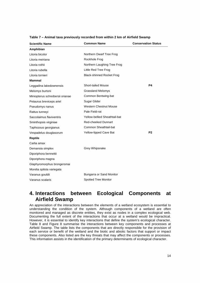
A number of fauna taxa have previously been recorded at Airfield Swamp, although none were observed during the IAI RCM survey. Taxa recorded within 2 km of the survey location are presented in Table 7.
14
Table 7 – Animal taxa previously recorded from with in 2 km of Airfield Swamp
Scientific Name Common Name Conservation Status
Amphibian
Litoria bicolor Northern Dwarf Tree Frog
Litoria meiriana Rockhole Frog
Litoria rothii Northern Laughing Tree Frog
Litoria rubella Little Red Tree Frog
Litoria tornieri Black-shinned Rocket Frog
Mammal
Leggadina lakedownensis Short-tailed Mouse P4
Melomys burtoni Grassland Melomys
Miniopterus schreibersii orianae Common Bentwing-bat
Petaurus breviceps ariel Sugar Glider
Pseudomys nanus Western Chestnut Mouse
Rattus tunneyi Pale Field-rat
Saccolaimus flaviventris Yellow-bellied Sheathtail-bat
Sminthopsis virginiae Red-cheeked Dunnart
Taphozous georgianus Common Sheathtail-bat
Vespadelus douglasorum Yellow-lipped Cave Bat P2
Reptile
Carlia amax
Demansia simplex Grey Whipsnake
Diporiphora bennettii
Diporiphora magna
Glaphyromorphus brongersmai
Morelia spilota variegata
Varanus gouldii Bungarra or Sand Monitor
Varanus scalaris Spotted Tree Monitor
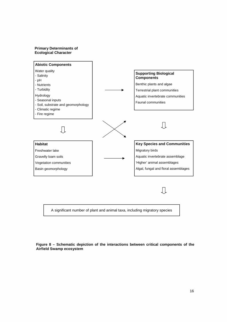
4. Interactions between Ecological Components at Airfield Swamp
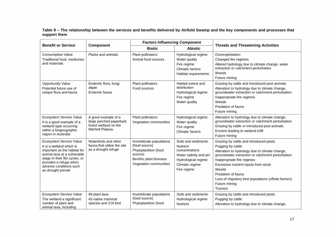
An appreciation of the interactions between the elements of a wetland ecosystem is essential to understanding the condition of the system. Although components of a wetland are often monitored and managed as discrete entities, they exist as nodes in a complex ecological web. Documenting the full extent of the interactions that occur at a wetland would be impractical. However, it is essential to identify key interactions that define the system’s ecological character. Table 8 and Figure 8 summarise the interactions between key components and processes at Airfield Swamp. The table lists the components that are directly responsible for the provision of each service or benefit of the wetland and the biotic and abiotic factors that support or impact these components. Also listed are the key threats that may affect the components or processes. This information assists in the identification of the primary determinants of ecological character.
15
Hale and Butcher (2007) justified the equivalence of Ramsar nomination criteria and primary determinants of ecological character. This justification may also be extended to consideration as a regionally significant wetland. Accordingly, the primary determinants of ecological character at Airfield Swamp are the characteristics that allow it to support a significant number of plant and animal taxa, including migratory species.
Therefore, the primary determinants of the ecological character of Airfield Swamp are the habitat requirements of the biota that inhabit it. Habitat is a broad term that encompasses all of the elements of the environment that allow individuals of a taxon to successfully complete their life cycle. It includes elements such as food sources, shelter requirements and breeding environments, as well as the correct climatic and hydrological conditions. Habitat is species-specific and can only be specified in the context of individual taxa. There is no evidence, documented, anecdotal nor observable, of any recent change to the integrity of Airfield Swamp. Therefore, it is reasonable to assume that its current status represents ideal habitat for the suite of biota that it supports. As such, the benchmark against which any changes to the swamp should be assessed is its current condition, as determined by the IAI RCM survey.
To date, there have been ninety-nine different plant taxa recorded at Airfield Swamp. Site-specific data are not available for fauna, but the Mitchell Plateau is known to support forty-three native mammal species and 219 bird species. Of these birds, twenty-seven species are included in the Japan-Australia Migratory Bird Agreement (JAMBA) and eleven in the China-Australia Migratory Bird Agreement (CAMBA). The nearby ‘Crusher’ rainforest patch is known to support nineteen species of land snail, the second highest count recorded in any such patch in Australia. It is not known how many of these animal taxa may depend on the resources of Airfield Swamp for some, or all, of their life cycle. Fifty-five species of aquatic macroinvertebrate were identified at Airfield Swamp during the 2008 IAI RCM survey. As microinvertebrates were not sampled, in keeping with the rapid assessment methodology employed by the survey, it is reasonable to assume that total aquatic invertebrate species richness is much higher than this figure.
16
A significant number of plant and animal taxa, including migratory species
Habitat
Freshwater lake
Gravelly loam soils
Vegetation communities
Basin geomorphology
Abiotic Components
Water quality - Salinity - pH - Nutrients - Turbidity
Hydrology - Seasonal inputs - Soil, substrate and geomorphology - Climatic regime - Fire regime
Supporting Biological Components
Benthic plants and algae
Terrestrial plant communities
Aquatic invertebrate communities
Faunal communities
Key Species and Communities
Migratory birds
Aquatic invertebrate assemblage
‘Higher’ animal assemblages
Algal, fungal and floral assemblages
Primary Determinants of Ecological Character
Figure 8 – Schematic depiction of the interactions between criti cal components of the Airfield Swamp ecosystem
17
Table 8 – The relationship between the services and benefits delivered by Airfield Swamp and the key c omponents and processes that support them
Factors Influencing Component Benefit or Service Component
Biotic Abiotic Threats and Threatening Activities
Consumptive Value Traditional food, medicines and materials
Plants and animals Plant pollinators Animal food sources
Hydrological regime Water quality Fire regime Climatic factors Habitat requirements
Overexploitation Changed fire regimes Altered hydrology due to climate change, water extraction or catchment perturbation Weeds Future mining
Opportunity Value Potential future use of unique flora and fauna
Endemic flora, fungi, algae Endemic fauna
Plant pollinators Food sources
Habitat extent and distribution Hydrological regime Fire regime Water quality
Grazing by cattle and introduced pest animals Alteration to hydrology due to climate change, groundwater extraction or catchment perturbation Inappropriate fire regimes Weeds Predation of fauna Future mining
Ecosystem Service Value It is a good example of a wetland type occurring within a biogeographic region in Australia
A good example of a large perched paperbark forest wetland on the Mitchell Plateau
Plant pollinators Vegetation communities
Hydrological regime Water quality Fire regime Climatic factors
Alteration to hydrology due to climate change, groundwater extraction or catchment perturbation Grazing by cattle or introduced pest animals Erosion leading to wetland infill Future mining
Ecosystem Service Value It is a wetland which is important as the habitat for animal taxa at a vulnerable stage in their life cycles, or provides a refuge when adverse conditions such as drought prevail
Waterbirds and other fauna that utilise the site as a drought refuge
Invertebrate populations (food source) Phytoplankton (food source) Benthic plant biomass Vegetation communities
Soils and sediments Nutrient concentrations Water salinity and pH Hydrological regime Climatic regime Fire regime
Grazing by cattle and introduced pests Pugging by cattle Alteration to hydrology due to climate change, groundwater extraction or catchment perturbation Inappropriate fire regimes Excessive nutrient inputs from stock Weeds Predation of fauna Loss of migratory bird populations (offsite factors) Future mining Tourism
Ecosystem Service Value The wetland a significant number of plant and animal taxa, including
99 plant taxa 43 native mammal species and 219 bird
Invertebrate populations (food source) Phytoplankton (food
Soils and sediments Hydrological regime Nutrient
Grazing by cattle and introduced pests Pugging by cattle Alteration to hydrology due to climate change,
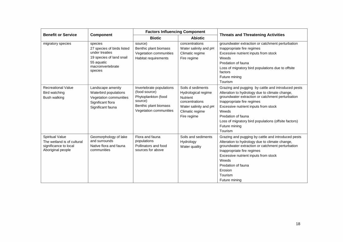
18
Factors Influencing Component Benefit or Service Component
Biotic Abiotic Threats and Threatening Activities
migratory species species 27 species of birds listed under treaties 19 species of land snail 55 aquatic macroinvertebrate species
source) Benthic plant biomass Vegetation communities Habitat requirements
concentrations Water salinity and pH Climatic regime Fire regime
groundwater extraction or catchment perturbation Inappropriate fire regimes Excessive nutrient inputs from stock Weeds Predation of fauna Loss of migratory bird populations due to offsite factors Future mining Tourism
Recreational Value Bird watching Bush walking
Landscape amenity Waterbird populations Vegetation communities Significant flora Significant fauna
Invertebrate populations (food source) Phytoplankton (food source) Benthic plant biomass Vegetation communities
Soils d sediments Hydrological regime Nutrient concentrations Water salinity and pH Climatic regime Fire regime
Grazing and pugging by cattle and introduced pests Alteration to hydrology due to climate change, groundwater extraction or catchment perturbation Inappropriate fire regimes Excessive nutrient inputs from stock Weeds Predation of fauna Loss of migratory bird populations (offsite factors) Future mining Tourism
Spiritual Value The wetland is of cultural significance to local Aboriginal people
Geomorphology of lake and surrounds Native flora and fauna communities
Flora and fauna populations Pollinators and food sources for above
Soils and sediments Hydrology Water quality
Grazing and pugging by cattle and introduced pests Alteration to hydrology due to climate change, groundwater extraction or catchment perturbation Inappropriate fire regimes Excessive nutrient inputs from stock Weeds Predation of fauna Erosion Tourism Future mining
19
5. Threats to the Ecology of Airfield Swamp The ambition for biodiversity management at Airfield Swamp is to maintain those elements of the ecology that resulted in its recognition as a wetland of regional significance. This recognition is largely due to the diversity of flora and fauna taxa that rely on the swamp for part, or all, of their life cycle. Several species of migratory birds have been specifically highlighted as important visitors to the system. Therefore, the critical components of the swamp ecosystem are the geomorphologic and hydrologic factors that allow the persistence of the diversity of habitat at the site.
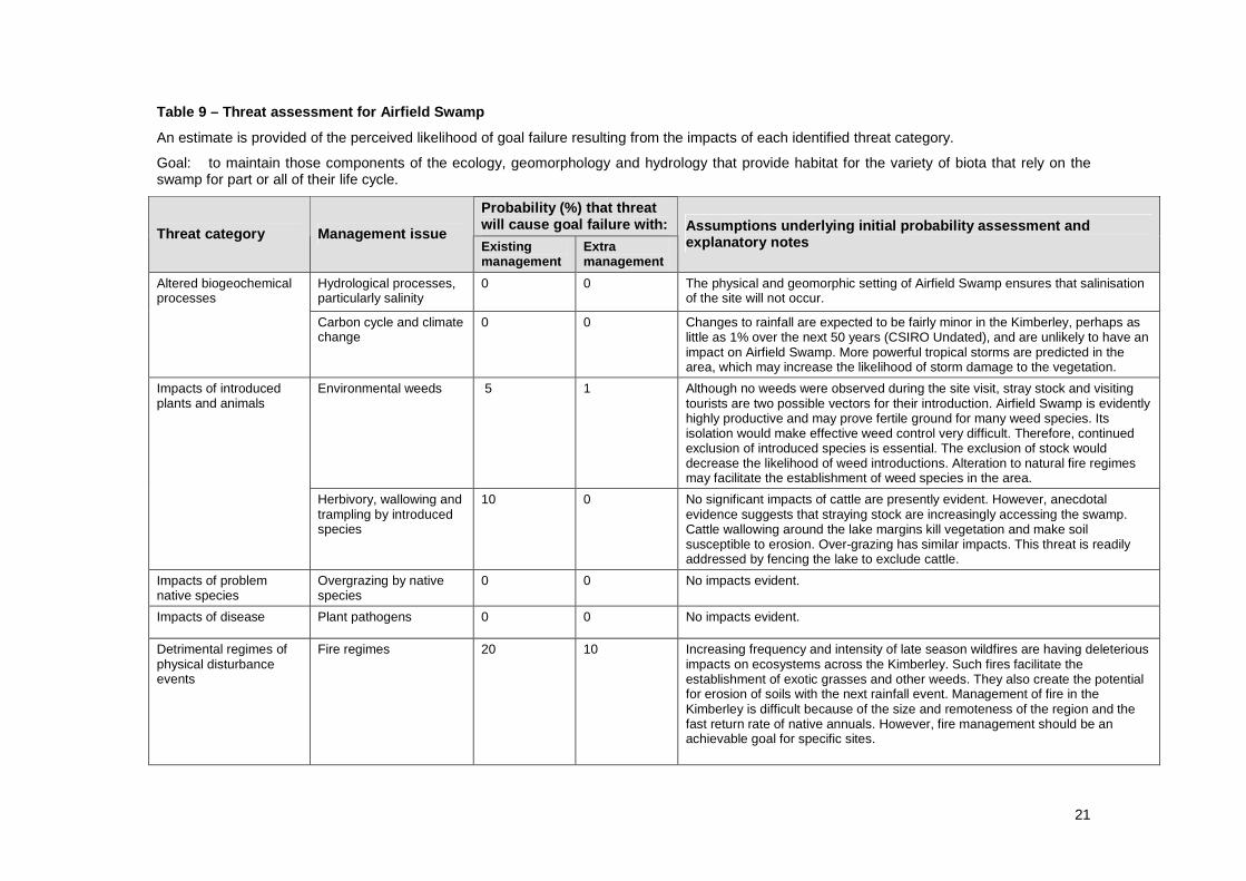
Threats to Airfield Swamp must be considered in relation to their likelihood of causing the failure of the above management goal for the swamp. An assessment is made of the probability that goal failure will result due to the impacts of each threatening process identified at the site, or potentially acting there. The results of this assessment are presented in Table 9.
In summary, failure to achieve the management goal for Airfield Swamp is most likely to result from the impacts of alteration to natural fire regimes, stray cattle or weeds. The level of threat to the swamp is relatively low. However, this situation may change if proposed mining on the Mitchell Plateau occurs. Mining in the area would be highly detrimental to the plateau in general and is likely to impact on the values of Airfield Swamp.
Altered fire regimes are a major threat to biodiversity across the Kimberley region. The Environmental Protection Authority recently released an issues paper that detailed the current and future impacts of changes to the natural frequency and intensity of wildfire in that region (Russell-Smith 2005). That paper found that the season of burning has changed during the period of European occupation of the region. Most Aboriginal burning in the Kimberley occurred through the dry season, whereas today, most fires occur at the end of the dry season. Late dry season fires in the Kimberley today have major impacts across all land use and industry sectors. In particular, fire-sensitive vegetation in the Kimberley is being severely impacted upon by intense late dry season fires. It is likely that fires in recent times have had a major impact on small to medium sized animals such as bandicoots. Together with the effects of grazing on grass species and seed availability, fire may also be having a major impact on many birds. Late dry season fires can also have significant impacts on soil loss, loss of nitrogen in smoke, increased greenhouse gas emissions, and impacts on air quality and human health.
In the context of Airfield Swamp, fire has the potential to facilitate the establishment of weed species, expose soils to erosion, cause the loss of fire-sensitive flora taxa and negatively impact on fauna. It is very difficult to manage fire in the Kimberley. Native perennial grasses accumulate biomass very rapidly, meaning that prescribed burning is largely ineffective in establishing buffers to limit the spread of fires. Any fire control measures would need to be maintained annually to ensure their continued effectiveness.
The second threat to Airfield Swamp is the impact of cattle on the site. At the time of the site visit, there was no evidence of grazing or wallowing around the lake. However, anecdotal evidence suggests that stray cattle do visit the site. Cattle graze palatable plant species, trample other plants, cause soil disturbance and act as a vector for the introduction of weeds. Soil disturbance also increases the likelihood of weed species becoming established. Disturbed and overgrazed areas are more likely to be eroded, leading to increased rates of sedimentation in the swamp and increased turbidity. Deposition of sediments is a serious issue, as it alters the geomorphology of wetlands and so changes their character. Preventing the impact of cattle at the lake is achievable with stock exclusion fencing.
Wetlands are highly productive environments, but are also easily disturbed. Fires, pest animals, stock and human activities may all disturb native vegetation and create the niche required for exotic plants to become established. Weed propagules are introduced via inflowing water, grazing stock, exotic animals, visiting waterbirds or wind. Once established, the productivity of the ecosystem often allows weed populations to flourish and exclude native plants. An additional problem is the difficulty in implementing weed control in wetland environments. The fragility of the system and fluxes of water usually make chemical weed control inappropriate. Mechanical control is often complicated by difficulty in accessing infestations.
Fortunately, there is currently no evidence of weed invasion at Airfield Swamp. The potential for weed propagules to be introduced to the site remains a concern however, particularly if cattle are accessing the

20
water body. Cattle exclusion and appropriate fire management are the best tools available to prevent future weed outbreaks.
21
Table 9 – Threat assessment for Airfield Swamp
An estimate is provided of the perceived likelihood of goal failure resulting from the impacts of each identified threat category.
Goal: to maintain those components of the ecology, geomorphology and hydrology that provide habitat for the variety of biota that rely on the swamp for part or all of their life cycle.
Probability (%) that threat will cause goal failure with:
Threat category Management issue Existing management
Extra management
Assumptions underlying initial probability assessme nt and explanatory notes
Hydrological processes, particularly salinity
0 0 The physical and geomorphic setting of Airfield Swamp ensures that salinisation of the site will not occur.
Altered biogeochemical processes
Carbon cycle and climate change
0 0 Changes to rainfall are expected to be fairly minor in the Kimberley, perhaps as little as 1% over the next 50 years (CSIRO Undated), and are unlikely to have an impact on Airfield Swamp. More powerful tropical storms are predicted in the area, which may increase the likelihood of storm damage to the vegetation.
Environmental weeds 5 1 Although no weeds were observed during the site visit, stray stock and visiting tourists are two possible vectors for their introduction. Airfield Swamp is evidently highly productive and may prove fertile ground for many weed species. Its isolation would make effective weed control very difficult. Therefore, continued exclusion of introduced species is essential. The exclusion of stock would decrease the likelihood of weed introductions. Alteration to natural fire regimes may facilitate the establishment of weed species in the area.
Impacts of introduced plants and animals
Herbivory, wallowing and trampling by introduced species
10 0 No significant impacts of cattle are presently evident. However, anecdotal evidence suggests that straying stock are increasingly accessing the swamp. Cattle wallowing around the lake margins kill vegetation and make soil susceptible to erosion. Over-grazing has similar impacts. This threat is readily addressed by fencing the lake to exclude cattle.
Impacts of problem native species
Overgrazing by native species
0 0 No impacts evident.
Impacts of disease Plant pathogens 0 0 No impacts evident.
Detrimental regimes of physical disturbance events
Fire regimes 20 10 Increasing frequency and intensity of late season wildfires are having deleterious impacts on ecosystems across the Kimberley. Such fires facilitate the establishment of exotic grasses and other weeds. They also create the potential for erosion of soils with the next rainfall event. Management of fire in the Kimberley is difficult because of the size and remoteness of the region and the fast return rate of native annuals. However, fire management should be an achievable goal for specific sites.
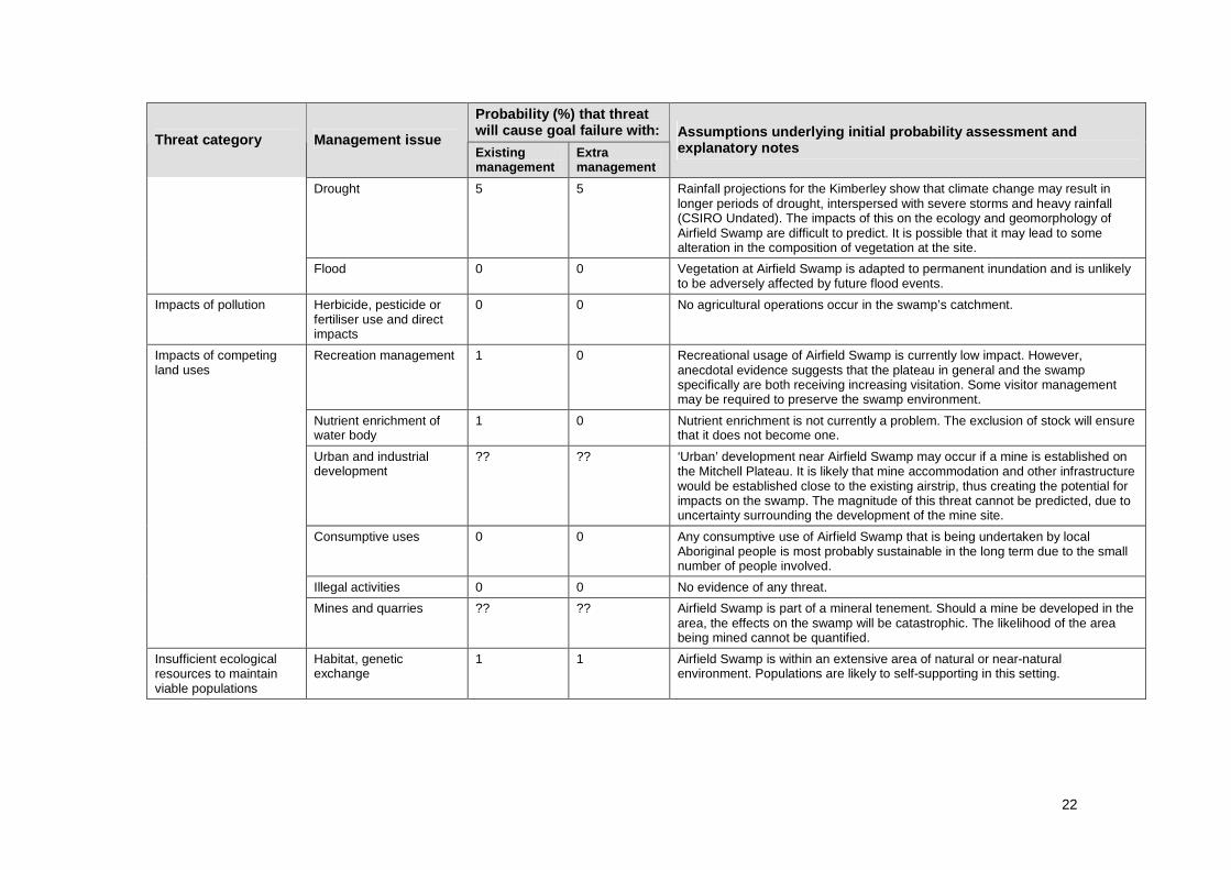
22
Probability (%) that threat will cause goal failure with:
Threat category Management issue Existing management
Extra management
Assumptions underlying initial probability assessme nt and explanatory notes
Drought 5 5 Rainfall projections for the Kimberley show that climate change may result in longer periods of drought, interspersed with severe storms and heavy rainfall (CSIRO Undated). The impacts of this on the ecology and geomorphology of Airfield Swamp are difficult to predict. It is possible that it may lead to some alteration in the composition of vegetation at the site.
Flood 0 0 Vegetation at Airfield Swamp is adapted to permanent inundation and is unlikely to be adversely affected by future flood events.
Impacts of pollution Herbicide, pesticide or fertiliser use and direct impacts
0 0 No agricultural operations occur in the swamp’s catchment.
Recreation management 1 0 Recreational usage of Airfield Swamp is currently low impact. However, anecdotal evidence suggests that the plateau in general and the swamp specifically are both receiving increasing visitation. Some visitor management may be required to preserve the swamp environment.
Nutrient enrichment of water body
1 0 Nutrient enrichment is not currently a problem. The exclusion of stock will ensure that it does not become one.
Urban and industrial development
?? ?? ‘Urban’ development near Airfield Swamp may occur if a mine is established on the Mitchell Plateau. It is likely that mine accommodation and other infrastructure would be established close to the existing airstrip, thus creating the potential for impacts on the swamp. The magnitude of this threat cannot be predicted, due to uncertainty surrounding the development of the mine site.
Consumptive uses 0 0 Any consumptive use of Airfield Swamp that is being undertaken by local Aboriginal people is most probably sustainable in the long term due to the small number of people involved.
Illegal activities 0 0 No evidence of any threat.
Impacts of competing land uses
Mines and quarries ?? ?? Airfield Swamp is part of a mineral tenement. Should a mine be developed in the area, the effects on the swamp will be catastrophic. The likelihood of the area being mined cannot be quantified.
Insufficient ecological resources to maintain viable populations
Habitat, genetic exchange
1 1 Airfield Swamp is within an extensive area of natural or near-natural environment. Populations are likely to self-supporting in this setting.
23
6. Knowledge Gaps and Recommendations for Future Monitoring
There is relatively little known about wetlands of the Kimberley region. The remoteness of the area has resulted in a lack of survey effort. While this IAI RCM survey has provided a ‘snapshot’ of the ecological character of Airfield Swamp, repeat surveys are required to develop an understanding of the ecosystem and to detect any trends that emerge over time.
Long-term monitoring will certainly be required if any mining and/or development were to proceed in the area. Airfield Swamp’s proximity to the Mitchell Airstrip, a likely central hub for development, makes it especially susceptible to impacts from mining, development and increased tourist visitation. Survey work conducted prior to development would provide a good idea of baseline condition. This could then be used to determine if changes are occurring to the ecosystem as a result of development.
Notable knowledge gaps include a lack of information regarding the hydrology of Airfield Swamp. There is also a lack of documented data on vertebrate fauna, including waterbirds, fish, frogs and reptiles (such as turtles). An inventory of fauna at Airfield Swamp may be an important study topic considering cane toads have already crossed the Western Australian border and are expected to invade the Kimberley in the near future.
Several aquatic invertebrate taxa were recorded during the current survey did not appear to match known described species and may be new. However, for the present, taxonomic impediments and a lack of survey data for the Kimberley region prevent much further discussion of these. Therefore, repeated surveys of aquatic invertebrates at Airfield Swamp and the Kimberley region are highly recommended to determine the status of these taxa.
24
References Bureau of Meteorology. (2009) Climate Statistics for Australian Locations. Bureau of Meteorology.
<http://www.bom.gov.au/climate/averages/> Accessed on 5 January 2009. CSIRO. (Undated) Climate Change in the Kimberley Region. CSIRO Marine and Atmospheric Research.
<www.sharingknowledge.net.au/files/kimberleyv1_2006.pdf> Accessed on 04/09/2008. Environment Australia. (2001) A Directory of Important Wetlands in Australia, Third Edition. Environment
Australia, Canberra. Graham, G. (2001) North Kimberly (NK1 - Mitchell subregion). In A Biodiversity Audit of Western
Australia's 53 Biogeographic Subregions in 2002. (McKenzie, N. L., May, J. E., and McKenna, S., eds). Pages 326-331. Department of Environment and Conservation, Perth, Australia.
Handley, M. (1996) Australian Wetlands Conservation Project : final report. prepared for the Australian
Heritage Commission, Canberra, Australia. Russell-Smith, J. (2005) Fire in the Kimberley and Inland Regions of WA – Issues Paper. Environmental
Protection Authority, Perth, Australia. Wallace, K. J., B.C. Beecham., B.H. Bone. (2003) Managing Natural Biodiversity in the Western
Australian Wheatbelt: a conceptual framework. Department of Conservation and Land Management, Perth, W.A.
Wunambal Gaambera Aboriginal Corporation. (2001) Ngauwudu Management Plan. Wunambal People,
Mitchell Plateau, Australia.
25
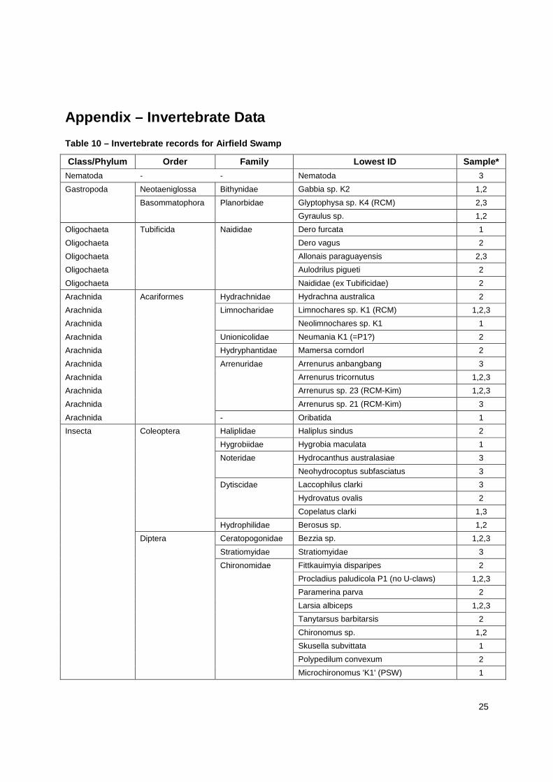
Appendix – Invertebrate Data Table 10 – Invertebrate records for Airfield Swamp
Class/Phylum Order Family Lowest ID Sample*
Nematoda - - Nematoda 3
Gastropoda Neotaeniglossa Bithynidae Gabbia sp. K2 1,2
Basommatophora Planorbidae Glyptophysa sp. K4 (RCM) 2,3
Gyraulus sp. 1,2
Oligochaeta Tubificida Naididae Dero furcata 1
Oligochaeta Dero vagus 2
Oligochaeta Allonais paraguayensis 2,3
Oligochaeta Aulodrilus pigueti 2
Oligochaeta Naididae (ex Tubificidae) 2
Arachnida Acariformes Hydrachnidae Hydrachna australica 2
Arachnida Limnocharidae Limnochares sp. K1 (RCM) 1,2,3
Arachnida Neolimnochares sp. K1 1
Arachnida Unionicolidae Neumania K1 (=P1?) 2
Arachnida Hydryphantidae Mamersa corndorl 2
Arachnida Arrenuridae Arrenurus anbangbang 3
Arachnida Arrenurus tricornutus 1,2,3
Arachnida Arrenurus sp. 23 (RCM-Kim) 1,2,3
Arachnida Arrenurus sp. 21 (RCM-Kim) 3
Arachnida - Oribatida 1
Insecta Coleoptera Haliplidae Haliplus sindus 2
Hygrobiidae Hygrobia maculata 1
Noteridae Hydrocanthus australasiae 3
Neohydrocoptus subfasciatus 3
Dytiscidae Laccophilus clarki 3
Hydrovatus ovalis 2
Copelatus clarki 1,3
Hydrophilidae Berosus sp. 1,2
Diptera Ceratopogonidae Bezzia sp. 1,2,3
Stratiomyidae Stratiomyidae 3
Chironomidae Fittkauimyia disparipes 2
Procladius paludicola P1 (no U-claws) 1,2,3
Paramerina parva 2
Larsia albiceps 1,2,3
Tanytarsus barbitarsis 2
Chironomus sp. 1,2
Skusella subvittata 1
Polypedilum convexum 2
Microchironomus 'K1' (PSW) 1
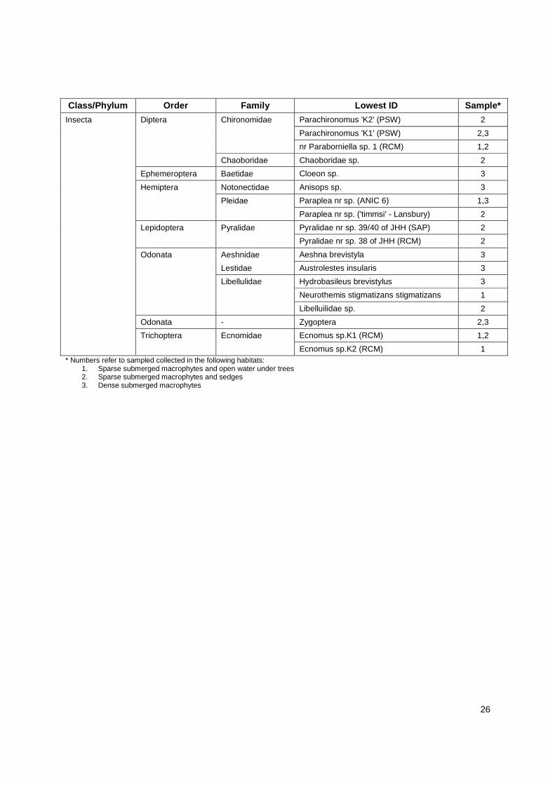
26
Class/Phylum Order Family Lowest ID Sample*
Insecta Diptera Chironomidae Parachironomus 'K2' (PSW) 2
Parachironomus 'K1' (PSW) 2,3
nr Paraborniella sp. 1 (RCM) 1,2
Chaoboridae Chaoboridae sp. 2
Ephemeroptera Baetidae Cloeon sp. 3
Hemiptera Notonectidae Anisops sp. 3
Pleidae Paraplea nr sp. (ANIC 6) 1,3
Paraplea nr sp. ('timmsi' - Lansbury) 2
Lepidoptera Pyralidae Pyralidae nr sp. 39/40 of JHH (SAP) 2
Pyralidae nr sp. 38 of JHH (RCM) 2
Odonata Aeshnidae Aeshna brevistyla 3
Lestidae Austrolestes insularis 3
Libellulidae Hydrobasileus brevistylus 3
Neurothemis stigmatizans stigmatizans 1
Libelluilidae sp. 2
Odonata - Zygoptera 2,3
Trichoptera Ecnomidae Ecnomus sp.K1 (RCM) 1,2
Ecnomus sp.K2 (RCM) 1 * Numbers refer to sampled collected in the following habitats:
1. Sparse submerged macrophytes and open water under trees 2. Sparse submerged macrophytes and sedges 3. Dense submerged macrophytes
![514 Batman's Hill [ASSEMBLY.] Swamp.€¦ · Batman's Hill swamp, adjoining the Mel bourne gas works, the site of Mr. "Vil Iiams' factory." The honorable member observed that the](https://img.pdfslide.us/doc/110x75/5fd46427b0effc5e86767e22/514-batmans-hill-assembly-swamp-batmans-hill-swamp-adjoining-the-mel-bourne.jpg)