Embed Size (px)
Citation preview
Current Research (2014) Newfoundland and Labrador Department of Natural ResourcesGeological Survey, Report 14-1, pages 45-62
RARE-EARTH ELEMENT (REE) MINERALIZATION IN THE MISTASTIN
LAKE AND SMALLWOOD RESERVOIR AREAS,
LABRADOR: FIELD RELATIONSHIPS AND PRELIMINARY
U–Pb ZIRCON AGES FROM HOST GRANITOID ROCKS
A. Kerr and M.A. Hamilton1
1Jack Satterly Geochronology Laboratory, Department of Geology,
University of Toronto, 22 Russell Street, Toronto, ON, M5S 3B1
ABSTRACT
In the large and poorly known area underlain by the Mesoproterozoic Mistastin batholith, geophysical and surficial geo-chemical data highlight two areas that are inferred to represent small, compositionally evolved plutonic complexes. Explo-ration shows that these both contain REE mineralization, including concentrations in satellite veins and dykes, and also dif-fuse disseminated mineralization associated with mafic mineral and oxide concentrations. In both areas, the surrounding(older?) rocks are rapakivi-textured granites, but the age relationships are not everywhere clear. The U–Pb geochronologicaldata from the Ytterby 2 granite and Ytterby 3 syenite–granite indicate emplacement ages of 1423 ± 2 Ma and 1439 ± 3 Ma,respectively. These rule out correlation between these units, and with the well-known Strange Lake Intrusion (ca. 1240 Ma),which contains the best-known REE mineralization in the wider area. The data instead suggest that the mineralized granitesare an integral part of the Mistastin batholith, and provide the first fully documented ages from this extensive body. Like othermajor Mesoproterozoic igneous complexes elsewhere in the region, it appears that the Mistastin batholith includes rocksformed over tens of millions of years. The dated samples have strongly negative εNd (-9) at the time of their crystallization,suggesting significant input from older material; likely continental crust.
In the Michikamats Lake area, near the Smallwood Reservoir, a granite unit was previously dated at ca. 1459 Ma. A sub-sequent aeromagnetic survey defined prominent ring-like features within this unit, and reconnaissance exploration foundanomalous REE values associated with syenites. A sample of syenite was investigated to determine its temporal relationshipto the surrounding granite unit. The results indicate an identical age of 1459 ± 3 Ma, showing that it is not a discrete youngerunit, but is instead likely related to the surrounding granite.
Results from granites and syenites containing REE mineralization in adjacent Québec indicate age groupings of ca. 1410Ma and ca. 1480 Ma, distinct from those obtained in this study. However, the younger of these ages (from the Misery Lakering complex) suggests that it could represent a young component of the greater Mistastin batholith, which surrounds it. Theca. 1480 Ma ages come from the Smallwood Reservoir area, and with the ca. 1459 Ma age from Michikamats Lake, may definea similarly protracted magmatic event associated with the ca. 1469 Ma Michikamau anorthosite intrusion.
INTRODUCTION
Exploration for rare-earth element (REE) mineraliza-
tion across Labrador and adjacent Québec between 2009
and 2011 targeted several areas (Figure 1; summarized by
Kerr, 2011). The largest exploration project was actually in
Québec, adjacent to the previously known Strange Lake
REE–Zr–Nb deposit, which currently sits within Exempt
Mineral Lands (EML) in Labrador. This exploration effort
defined a discrete REE deposit (the B-Zone) in Québec a
few kilometres west of the original discovery, and pre-feasi-
bility studies for its potential development are currently
underway. The activity in the Strange Lake area awakened
interest in a poorly known area south of Strange Lake, along
the Québec-Labrador border (Figure 1), based on the idea
that similar mineralized intrusions might exist there. In 2010
and 2011, the part of Labrador south and west of Mistastin
Lake was explored for the first time, and REE mineraliza-
tion was discovered in association with compositionally
evolved granitoid rocks. The area is not mapped in detail,
and its geology remains poorly known, particularly in
Labrador. In adjacent Québec, the alkaline syenite ring com-
45
CURRENT RESEARCH, REPORT 14-1
46
Figure 1. Simplified geological map of Labrador showing areas of interest for REE exploration, and also relevant areas inQuébec. The approximate boundaries of high-resolution aeromagnetic surveys completed in both provinces released in 2010and 2012 are also indicated.
A. KERR AND M.A. HAMILTON
plex at Misery Lake (Figure 1) was outlined via aeromag-
netic surveys completed in 2009 by the Geological Survey
of Canada (GSC, 2010). This is now an active exploration
project for REE (Quest Rare Minerals, website informa-
tion). In the Smallwood Reservoir area, this same survey
revealed other ring-complex-like features in both Labrador
and Québec, and initial exploration indicates local REE
enrichment. Similar aeromagnetic surveys were completed
along the border region north of Misery Lake in 2011 (GSC,
2012), largely in response to exploration developments.
These latter data have yet to be interpreted in detail, but
should prove invaluable to future mapping efforts. Should a
mining operation eventually develop in Québec at Strange
Lake, the challenges to exploration posed by the remote
nature of the border region will diminish; thus, there is a
new incentive to investigate and better understand its geolo-
gy.
This article discusses the Mistastin Lake and Small-
wood Reservoir areas, partly with reference to the new gov-
ernment geophysical data, and provides some descriptive
information on rock types and mineralization. It is based on
limited field work completed in 2010 and 2011, and detailed
exploration results from these areas remain confidential as
of publication. The report also presents results of U–Pb zir-
con geochronological work, and discusses the new ages in
the context of results obtained from similar research in adja-
cent Québec.
REGIONAL GEOLOGICAL FRAMEWORK
The areas discussed in this report lie within the
Churchill Province of the Canadian Shield (Figure 1). Much
of the Churchill Province is a vast expanse of generally
high-grade metamorphic rocks that includes reworked
Archean basement (generally represented by complex
orthogneisses) and remnants of Paleoproterozoic
supracrustal rocks, largely of pelitic to psammitic composi-
tion, but also including calc-silicate rocks, amphibolites and
mafic granulites. The gneisses are intruded by Paleoprotero-
zoic granitoid rocks, which are syntectonic to posttectonic
with respect to the regional deformation. The Paleoprotero-
zoic history of the region is not discussed further in this
report, but is summarized and discussed by van der Leeden
et al. (1990) and Wardle et al. (1990), for Québec and
Labrador, respectively.
Younger rocks in this part of the Churchill Province are
undeformed gabbro, anorthosite and related intermediate
and granitoid rocks of Mesoproterozoic age, overlain by ter-
restrial sedimentary rocks. The intrusive rocks are part of a
large magmatic province that extends right across northern
Labrador and Québec (Figure 1). Important examples are
the 1340 Ma to 1290 Ma Nain Plutonic Suite in coastal
Labrador (Ryan, 1998) and the ca. 1450 Ma Harp Lake
Intrusive Suite in central Labrador (Emslie, 1980), both of
which also intrude the Archean Nain Province. Within the
Churchill Province, the largest Mesoproterozoic intrusive
complex is termed the ‘Mistastin batholith’ (Emslie et al.,1980). This is dominated at surface by granitoid rocks, with
only scattered areas of anorthosite and gabbro (Figures 1
and 2), but mafic rocks are interpreted to be more abundant
at depth. The geochronology of the Mistastin batholith is
poorly known, but previously reported U–Pb data suggested
an age of ca. 1420 Ma (J.C. Roddick, in Emslie and Stirling,
1993). In the Smallwood Reservoir area, the Michikamau
Intrusion includes layered mafic rocks, anorthosite and less-
er diorite and syenite (Emslie, 1968). Early investigations of
these rocks suggested a U–Pb age of ca. 1460 Ma (Krogh
and Davis, 1973), but Kerr and McNicoll (2010) subse-
quently obtained an older U–Pb baddeleyite age of 1469 ± 1
Ma from anorthosite. A granite body located to the west of
the Michikamau Intrusion was reported to have an age of
1459 ± 2 Ma (Krogh, 1993; James et al., 1994). This body
is known as the Michikamats Intrusion, after Michikamats
Lake (James et al., 1994) and the syenitic unit dated as part
of this study lies within its confines. Other transborder gran-
itoid intrusions north and west of the Michikamau Intrusion,
including the Ramusio granite and the Juillet syenite (Figure
1), were previously assumed to be of Mesoproterozoic age,
and this inference is now confirmed by recent U–Pb
geochronology in Québec (David et al., 2012).
GEOLOGY AND REE MINERALIZATION
IN THE MISTASTIN LAKE AREA
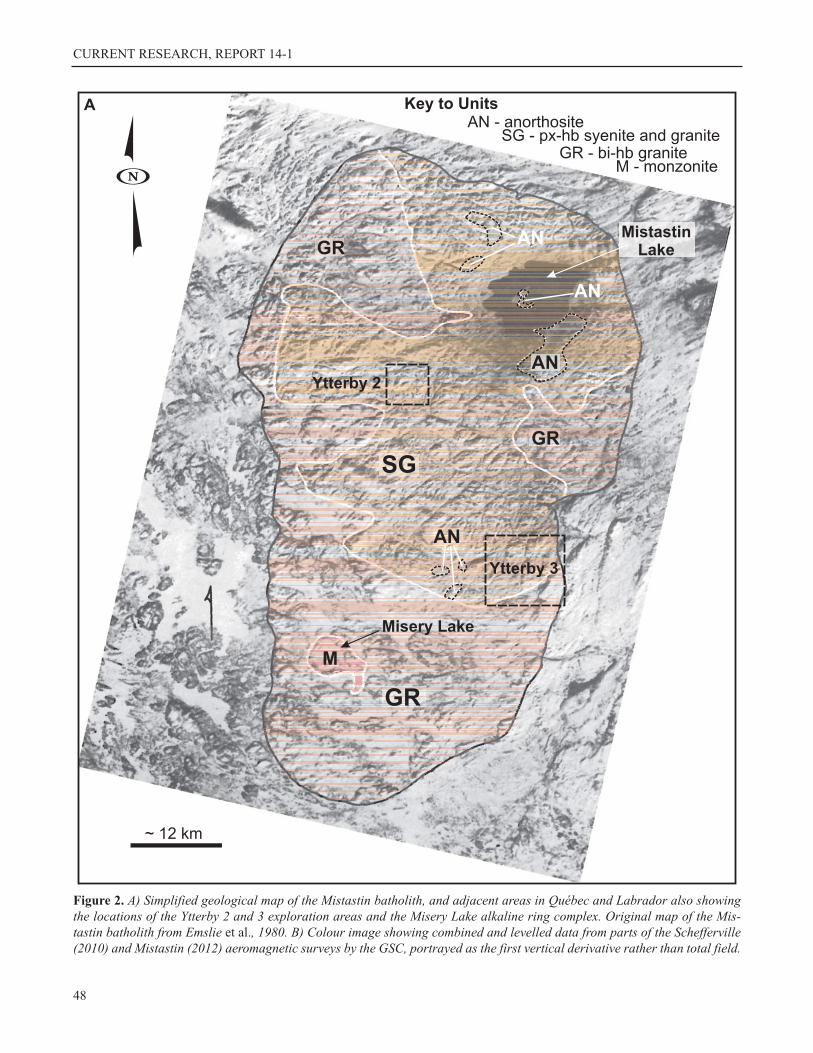
GENERAL INFORMATION
The geology of the Mistastin batholith in Labrador and
around the Québec border (Figures 1 and 2A) is very poor-
ly known. Mistastin Lake itself fills a Cenozoic meteorite
crater, around which remnants of a impact melt sheet occur,
and this is the only area that has received detailed study
(Currie, 1971; Grieve, 1975; Marion and Sylvester, 2010).
The batholith was mapped at a reconnaissance scale by
Emslie et al. (1980), who defined two broad units, i.e., an
inner zone of older pyroxene- and pyroxene-bearing quartz
monzonite, syenite and granite, surrounded by an outer zone
of younger biotite–hornblende granite (Figure 2A). Both
granitoid units are widely characterized by plagioclase man-
tles developed on K-feldspar phenocrysts (rapakivi texture)
and also by deep weathering. Emslie et al. (1980) also noted
texturally distinct monzonitic rocks belonging to what is
now termed the Misery Lake ring complex in Québec.
Anorthositic rocks were mapped mostly in the area around
Mistastin Lake, and were suggested to represent a deeper
seated component of the complex. Field work in 2010 and
2011, and exploration activity, suggest that gneissic rocks,
47
CURRENT RESEARCH, REPORT 14-1
48
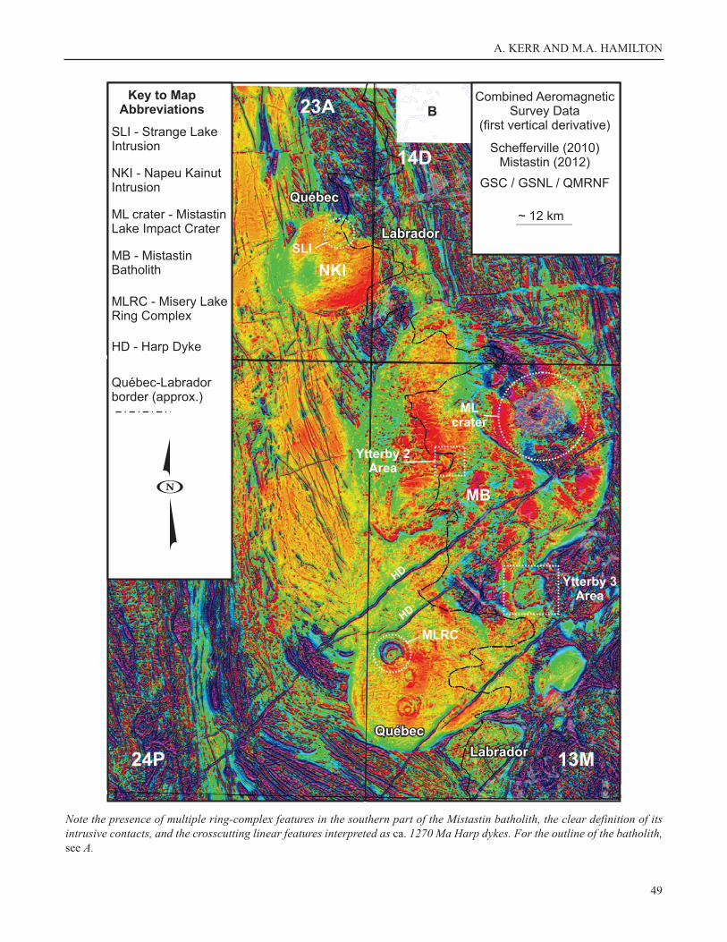
Figure 2. A) Simplified geological map of the Mistastin batholith, and adjacent areas in Québec and Labrador also showingthe locations of the Ytterby 2 and 3 exploration areas and the Misery Lake alkaline ring complex. Original map of the Mis-tastin batholith from Emslie et al., 1980. B) Colour image showing combined and levelled data from parts of the Schefferville(2010) and Mistastin (2012) aeromagnetic surveys by the GSC, portrayed as the first vertical derivative rather than total field.
A. KERR AND M.A. HAMILTON
49
Note the presence of multiple ring-complex features in the southern part of the Mistastin batholith, the clear definition of itsintrusive contacts, and the crosscutting linear features interpreted as ca. 1270 Ma Harp dykes. For the outline of the batholith,see A.
CURRENT RESEARCH, REPORT 14-1
presumably remnants of older country rocks, are locally
abundant. The combined aeromagnetic data from the GSC
surveys provide a striking image of the batholith and its
country rocks, and also adjacent plutonic complexes (Figure
2B). These results have yet to be interpreted in detail, but
will obviously be invaluable in future investigations.
In addition to the general concept that evolved granitoid
rocks with REE potential might occur south of Strange
Lake, regional radiometric and aeromagnetic surveys com-
pleted prior to 2009, and surficial geochemical data from
both provinces, provided first-order targets for exploration.
Midland Exploration Ltd (Midland) acquired mineral rights
in both provinces, and named their properties Ytterby 1, 2, 3
and 4 (Figures 1 and 2). The name is drawn from the town
of Ytterby in Sweden, for which four of the REE are named
(yttrium, ytterbium, terbium and erbium). Of these four
exploration areas, Ytterby 1 is located mostly in Québec
south and west of Strange Lake, and Ytterby 3 is located
entirely in Labrador. The Ytterby 2 and Ytterby 4 areas sit
on both sides of the interprovincial boundary (Figure 1). In
addition to seeking bedrock mineralization, the company is
currently assessing the well-defined glacial dispersion train
from the Strange Lake deposit, but this work is not dis-
cussed here. The Ytterby 2 and Ytterby 3 areas are located
within granitoid rocks of the Mistastin batholith (Figure 2),
whereas the Ytterby 4 area is located within the Ramusio
granite, a separate intrusion located to the south (Figure 1).
Only the Ytterby 2, 3 and 4 areas are discussed in this report.
The assessment reports for exploration work remain confi-
dential as of publication, but information is provided via a
presentation on the Midland Exploration website, and also
by Banville (2011).
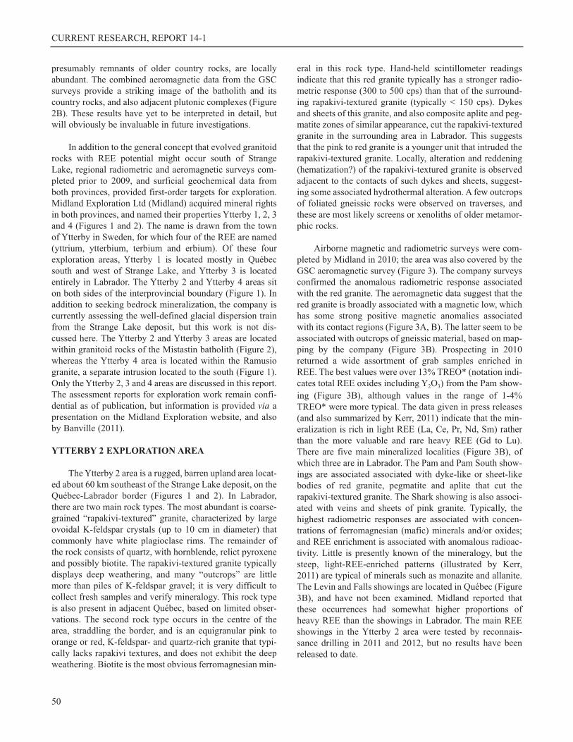
YTTERBY 2 EXPLORATION AREA
The Ytterby 2 area is a rugged, barren upland area locat-
ed about 60 km southeast of the Strange Lake deposit, on the
Québec-Labrador border (Figures 1 and 2). In Labrador,
there are two main rock types. The most abundant is coarse-
grained “rapakivi-textured” granite, characterized by large
ovoidal K-feldspar crystals (up to 10 cm in diameter) that
commonly have white plagioclase rims. The remainder of
the rock consists of quartz, with hornblende, relict pyroxene
and possibly biotite. The rapakivi-textured granite typically
displays deep weathering, and many “outcrops” are little
more than piles of K-feldspar gravel; it is very difficult to
collect fresh samples and verify mineralogy. This rock type
is also present in adjacent Québec, based on limited obser-
vations. The second rock type occurs in the centre of the
area, straddling the border, and is an equigranular pink to
orange or red, K-feldspar- and quartz-rich granite that typi-
cally lacks rapakivi textures, and does not exhibit the deep
weathering. Biotite is the most obvious ferromagnesian min-
eral in this rock type. Hand-held scintillometer readings
indicate that this red granite typically has a stronger radio-
metric response (300 to 500 cps) than that of the surround-
ing rapakivi-textured granite (typically < 150 cps). Dykes
and sheets of this granite, and also composite aplite and peg-
matite zones of similar appearance, cut the rapakivi-textured
granite in the surrounding area in Labrador. This suggests
that the pink to red granite is a younger unit that intruded the
rapakivi-textured granite. Locally, alteration and reddening
(hematization?) of the rapakivi-textured granite is observed
adjacent to the contacts of such dykes and sheets, suggest-
ing some associated hydrothermal alteration. A few outcrops
of foliated gneissic rocks were observed on traverses, and
these are most likely screens or xenoliths of older metamor-
phic rocks.
Airborne magnetic and radiometric surveys were com-
pleted by Midland in 2010; the area was also covered by the
GSC aeromagnetic survey (Figure 3). The company surveys
confirmed the anomalous radiometric response associated
with the red granite. The aeromagnetic data suggest that the
red granite is broadly associated with a magnetic low, which
has some strong positive magnetic anomalies associated
with its contact regions (Figure 3A, B). The latter seem to be
associated with outcrops of gneissic material, based on map-
ping by the company (Figure 3B). Prospecting in 2010
returned a wide assortment of grab samples enriched in
REE. The best values were over 13% TREO* (notation indi-
cates total REE oxides including Y2O3) from the Pam show-
ing (Figure 3B), although values in the range of 1-4%
TREO* were more typical. The data given in press releases
(and also summarized by Kerr, 2011) indicate that the min-
eralization is rich in light REE (La, Ce, Pr, Nd, Sm) rather
than the more valuable and rare heavy REE (Gd to Lu).
There are five main mineralized localities (Figure 3B), of
which three are in Labrador. The Pam and Pam South show-
ings are associated associated with dyke-like or sheet-like
bodies of red granite, pegmatite and aplite that cut the
rapakivi-textured granite. The Shark showing is also associ-
ated with veins and sheets of pink granite. Typically, the
highest radiometric responses are associated with concen-
trations of ferromagnesian (mafic) minerals and/or oxides;
and REE enrichment is associated with anomalous radioac-
tivity. Little is presently known of the mineralogy, but the
steep, light-REE-enriched patterns (illustrated by Kerr,
2011) are typical of minerals such as monazite and allanite.
The Levin and Falls showings are located in Québec (Figure
3B), and have not been examined. Midland reported that
these occurrences had somewhat higher proportions of
heavy REE than the showings in Labrador. The main REE
showings in the Ytterby 2 area were tested by reconnais-
sance drilling in 2011 and 2012, but no results have been
released to date.
50
A. KERR AND M.A. HAMILTON
The red granite in the Ytterby 2 area was sampled for
geochronological study on a hilltop located just a few hun-
dred metres inside Labrador, roughly 4 km west of the Pam
showing (Figure 3B), at UTM coordinates
455408E/6182632N (NAD 1927). The sampling locality for
AKZ-11-01 is close to the contact between the red granite
and the rapakivi-textured granite (Figure 3B), but the con-
tact itself is not exposed.
YTTERBY 3 EXPLORATION AREA
The Ytterby 3 exploration area is located in Labrador,
about 90 km southwest of Strange Lake, and 10 to 20 km
north of the interprovincial border (Figures 1 and 2). It is a
rugged area typified by high hills and deeply incised valleys.
Upland areas are barren and rocky, but some of the lower
elevations contain scrubby and obstructive vegetation.
There are two main rock types in the area. The perimeter of
the area consists of rapakivi-textured granite, locally very
coarse grained, which is closely similar to equivalent rocks
observed in the Ytterby 2 area. The central part of the Ytter-
by 3 area is also underlain by coarse-grained granitoid
rocks, but these lack mantled-feldspar textures and are in
general more homogeneous, and locally equigranular to
seriate, rather than porphyritic. Diffuse veins, dykes and
sheets of fine- to medium-grained pink granite are common
in this central unit. In some areas, this central unit appears
syenitic rather than granitic in composition, with little or no
quartz. Contacts between the central syenite–granite unit
and the surrounding rapakivi-textured granite were observed
in a few locations, but these seem to be planar, and it was not
possible to discern age relationships from vein-like off-
shoots or xenolith-host relationships. Foliated gneissic rocks
dominated several outcrops and, according to Midland’s
mapping, these form a discrete unit in the northeast, in part
coincident with the contact against surrounding rapakivi-
textured granite.
As in the case of the Ytterby 2 area, the central syen-
ite–granite unit is broadly associated with a magnetic low
(Figure 4A), and this has a circular shape. The strongest pos-
itive magnetic anomalies are associated wih an arcuate zone
of gneisses that seems to define the northeast side of the cen-
tral syenite–granite unit (Figure 4B). Airborne radiometric
surveys completed by the company suggest stronger local
responses in parts of the central syenite–granite unit, which
are interpreted a separate ‘phase’; however, no clear textur-
al or mineralogical differences between these and surround-
ing areas are evident. The central syenite–granite unit is
interpreted by Midland as a younger intrusion emplaced into
the rapakivi granite, but this relationship cannot be con-
firmed from the limited field observations, and other inter-
pretations cannot be discounted (see later discussion).
51
Figure 3. Information from the Ytterby 2 exploration area. A) High-resolution aeromagnetic survey, first vertical derivative;B) simplified geological map, indicating the main locations of REE mineralization. Information from Midland Explorationwebsite/presentations, and also Geological Survey of Canada data. The location of geochronology sample AKZ-11-01 is indi-cated.
CURRENT RESEARCH, REPORT 14-1
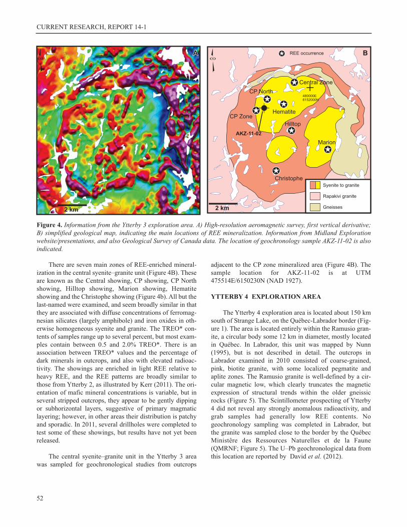
There are seven main zones of REE-enriched mineral-
ization in the central syenite–granite unit (Figure 4B). These
are known as the Central showing, CP showing, CP North
showing, Hilltop showing, Marion showing, Hematite
showing and the Christophe showing (Figure 4b). All but the
last-named were examined, and seem broadly similar in that
they are associated with diffuse concentrations of ferromag-
nesian silicates (largely amphibole) and iron oxides in oth-
erwise homogeneous syenite and granite. The TREO* con-
tents of samples range up to several percent, but most exam-
ples contain between 0.5 and 2.0% TREO*. There is an
association between TREO* values and the percentage of
dark minerals in outcrops, and also with elevated radioac-
tivity. The showings are enriched in light REE relative to
heavy REE, and the REE patterns are broadly similar to
those from Ytterby 2, as illustrated by Kerr (2011). The ori-
entation of mafic mineral concentrations is variable, but in
several stripped outcrops, they appear to be gently dipping
or subhorizontal layers, suggestive of primary magmatic
layering; however, in other areas their distribution is patchy
and sporadic. In 2011, several drillholes were completed to
test some of these showings, but results have not yet been
released.
The central syenite–granite unit in the Ytterby 3 area
was sampled for geochronological studies from outcrops
adjacent to the CP zone mineralized area (Figure 4B). The
sample location for AKZ-11-02 is at UTM
475514E/6150230N (NAD 1927).
YTTERBY 4 EXPLORATION AREA
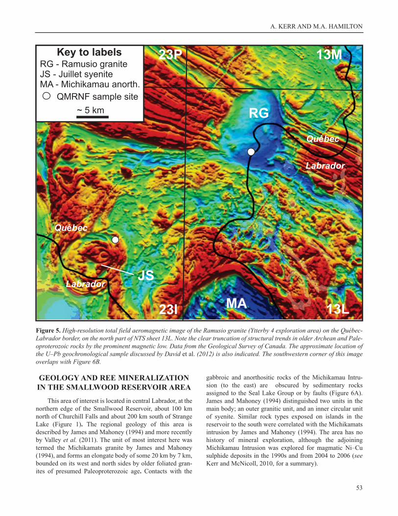
The Ytterby 4 exploration area is located about 150 km
south of Strange Lake, on the Québec-Labrador border (Fig-
ure 1). The area is located entirely within the Ramusio gran-
ite, a circular body some 12 km in diameter, mostly located
in Québec. In Labrador, this unit was mapped by Nunn
(1995), but is not described in detail. The outcrops in
Labrador examined in 2010 consisted of coarse-grained,
pink, biotite granite, with some localized pegmatite and
aplite zones. The Ramusio granite is well-defined by a cir-
cular magnetic low, which clearly truncates the magnetic
expression of structural trends within the older gneissic
rocks (Figure 5). The Scintillometer prospecting of Ytterby
4 did not reveal any strongly anomalous radioactivity, and
grab samples had generally low REE contents. No
geochronology sampling was completed in Labrador, but
the granite was sampled close to the border by the Québec
Ministêre des Ressources Naturelles et de la Faune
(QMRNF; Figure 5). The U–Pb geochronological data from
this location are reported by David et al. (2012).
52
Figure 4. Information from the Ytterby 3 exploration area. A) High-resolution aeromagnetic survey, first vertical derivative;B) simplified geological map, indicating the main locations of REE mineralization. Information from Midland Explorationwebsite/presentations, and also Geological Survey of Canada data. The location of geochronology sample AKZ-11-02 is alsoindicated.
A. KERR AND M.A. HAMILTON
GEOLOGY AND REE MINERALIZATION
IN THE SMALLWOOD RESERVOIR AREA
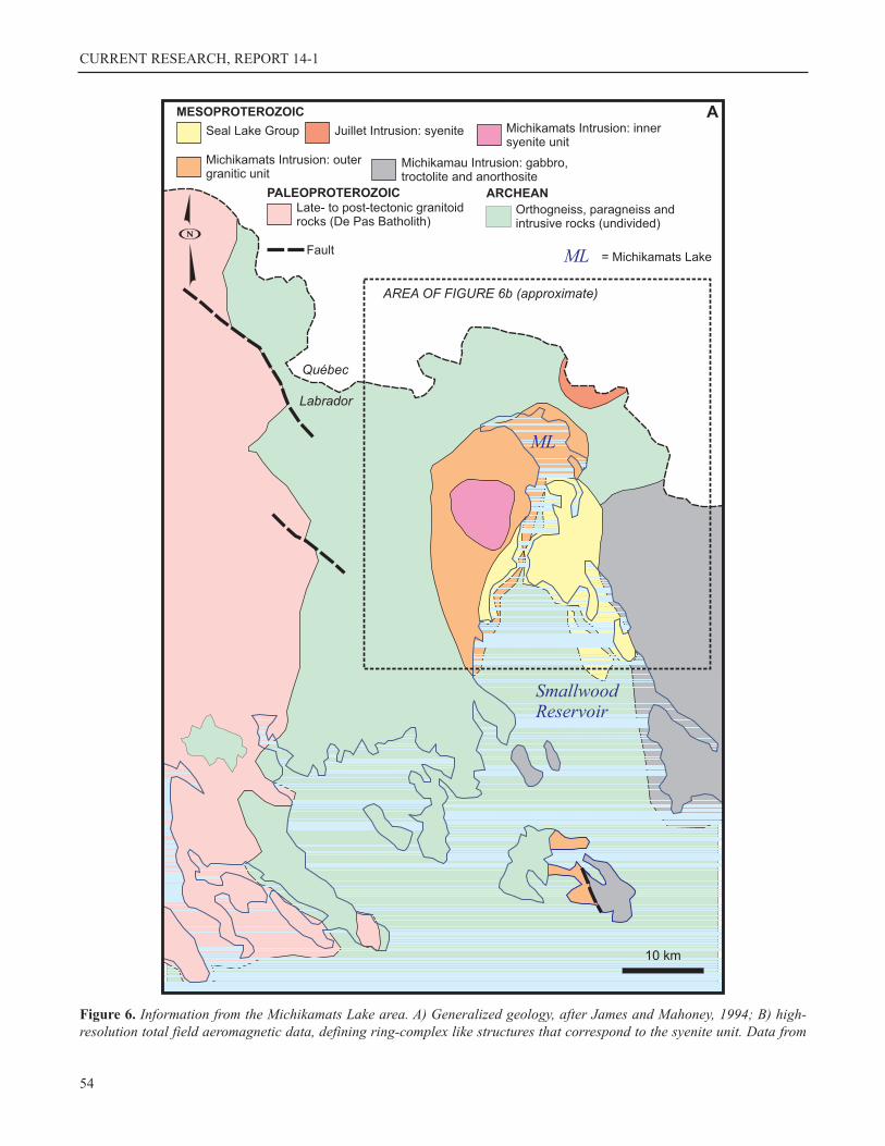
This area of interest is located in central Labrador, at the
northern edge of the Smallwood Reservoir, about 100 km
north of Churchill Falls and about 200 km south of Strange
Lake (Figure 1). The regional geology of this area is
described by James and Mahoney (1994) and more recently
by Valley et al. (2011). The unit of most interest here was
termed the Michikamats granite by James and Mahoney
(1994), and forms an elongate body of some 20 km by 7 km,
bounded on its west and north sides by older foliated gran-
ites of presumed Paleoproterozoic age. Contacts with the
gabbroic and anorthositic rocks of the Michikamau Intru-
sion (to the east) are obscured by sedimentary rocks
assigned to the Seal Lake Group or by faults (Figure 6A).
James and Mahoney (1994) distinguished two units in the
main body; an outer granitic unit, and an inner circular unit
of syenite. Similar rock types exposed on islands in the
reservoir to the south were correlated with the Michikamats
intrusion by James and Mahoney (1994). The area has no
history of mineral exploration, although the adjoining
Michikamau Intrusion was explored for magmatic Ni–Cu
sulphide deposits in the 1990s and from 2004 to 2006 (seeKerr and McNicoll, 2010, for a summary).
53
Figure 5. High-resolution total field aeromagnetic image of the Ramusio granite (Ytterby 4 exploration area) on the Québec-Labrador border, on the north part of NTS sheet 13L. Note the clear truncation of structural trends in older Archean and Pale-oproterozoic rocks by the prominent magnetic low. Data from the Geological Survey of Canada. The approximate location ofthe U–Pb geochronological sample discussed by David et al. (2012) is also indicated. The southwestern corner of this imageoverlaps with Figure 6B.
CURRENT RESEARCH, REPORT 14-1
54
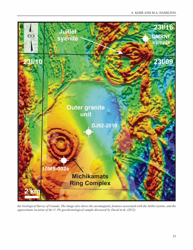
Figure 6. Information from the Michikamats Lake area. A) Generalized geology, after James and Mahoney, 1994; B) high-resolution total field aeromagnetic data, defining ring-complex like structures that correspond to the syenite unit. Data from
A. KERR AND M.A. HAMILTON
55
the Geological Survey of Canada. The image also shows the aeromagnetic features associated with the Juillet syenite, and theapproximate location of the U–Pb geochronological sample discussed by David et al. (2012).
CURRENT RESEARCH, REPORT 14-1
Exploration attention was focused on the Michikamats
intrusion in 2009, following release of aeromagnetic surveys
by the GSC (2010). These data indicated well-defined ring-
like magnetic structures (Figure 6B) approximately coinci-
dent with the syenite unit mapped by James and Mahoney
(1994). This pattern resembled a similar ring-complex struc-
ture identified at Misery Lake within the Mistastin batholith
in Québec (see Figure 2B), which quickly became an explo-
ration target. The aeromagnetic survey also defined some
other ring-like structures in closely adjacent areas of
Québec. One of these is associated with a unit termed the
Juillet syenite, which also extends into Labrador, but does
not appear to truncate the broader magnetic low associated
with the Michikamats granite (Figure 6B).
In 2010, FieldEx Exploration completed reconnais-
sance exploration in the Michikamats Lake area. Some ini-
tial results from the work were placed on the company web-
site, but no formal press releases were issued. In summary,
prospecting returned grab samples with variably anomalous
REE contents, with TREO* values ranging from 0.25% to
0.9%. Most of the anomalous samples were located in the
central part of the ring structure, and were associated with
elevated radioactivity (Figure 6B). In 2011, the area was
mapped and sampled by GSNL (T. van Nostrand, unpub-
lished data, 2014) but no analytical data are presently avail-
able from this work. However, the information released
from exploration suggests that mineralized samples are
enriched in the light REE. Valley et al. (2011) report elevat-
ed La and Ce values from routine analyses.
The Michikamats outer granite unit was previously
sampled for geochronology in 1993, at a location on the
Smallwood Reservoir (UTM 412309E / 6052830N, NAD
1927). The data were interpreted to give a crystallization age
of 1459 ± 2 Ma (Krogh, 1993; James and Mahoney, 1994).
The inner syenitic unit associated with the ring-like magnet-
ic features was visited and sampled by the Québec Ministère
des Ressources Naturelles et de la Faune (QMRNF) as part
of a regional project in 2010 (Figure 6B), and this sample
was donated to GSNL for analysis. The sample location
coordinates are 407169E / 6047487N (NAD 1927), and the
rock type is a homogeneous coarse-grained pale-brown
syenite (J. Goutier, personal communication, 2010; hand
sample observations). Information from subsequent field
work by GSNL (T. van Nostrand, personal communication,
2012) suggests that this rock type is typical of the ‘outer
rings’ as defined by aeromagnetic data. The Juillet syenite
was also sampled as part of the QMRNF project (Figure
6B). The rationale for completing a second U–Pb determi-
nation in the Michikamats Lake area was to ascertain if this
central syenite, with its distinctive ring-complex features,
represented a discrete unit with a younger age than the sur-
rounding granite.
U–Pb GEOCHRONOLOGY
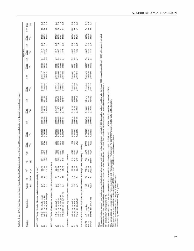
GENERAL INFORMATION
Data from four samples are reported here. Although the
results from the outer unit of the Michikamats granite are
available in an unpublished contract report (Krogh, 1993),
these data are tabulated here in the interests of easier and
wider access. The remaining samples were collected in 2010
(Michikamats inner unit) and 2011 (Ytterby 2 and Ytterby 3
areas); coordinates are listed in the preceding section. All
samples were analyzed at the Jack Satterly Geochronology
Laboratory, although the facility was located at the Royal
Ontario Museum in the 1990s, rather than at the University
of Toronto.
Sample processing and analytical techniques are not
outlined in detail in this report. However, Krogh (1993)
describes the methods employed at that time, and details of
current techniques and U–Pb analytical protocols are pro-
vided in Kamo et al. (2011). The main differences between
analyses in the 1990s and 2012 lie in the number of individ-
ual grains contained within analysis fractions (typically a
single grain is analyzed today, rather than multigrain frac-
tions) and in the modern use of chemical abrasion rather
than physical abrasion techniques to remove areas of possi-
ble Pb loss from individual zircon grains (Mattinson, 2005).
The complete U–Pb analytical and isotopic data are listed in
Table 1. Data for the Michimakats outer granite are tran-
scribed directly from Krogh (1993).
RESULTS FROM THE MISTASTIN BATHOLITH
AREA
The samples from the Mistastin Lake area have fairly
simple zircon populations dominated by high-quality, trans-
parent, faceted grains. There are no obvious physical signs
of inheritance in these grains, although they were not
imaged through back-scattered electron or cathodolumines-
cence techniques. The U–Pb isotopic data show that the
samples from Ytterby 2 and Ytterby 3 exploration areas
have demonstrably different ages, but that one does contain
some inheritance.
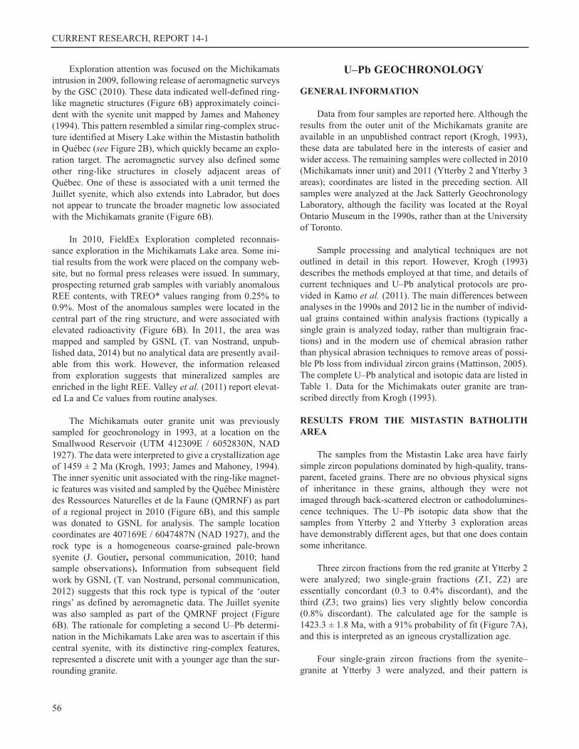
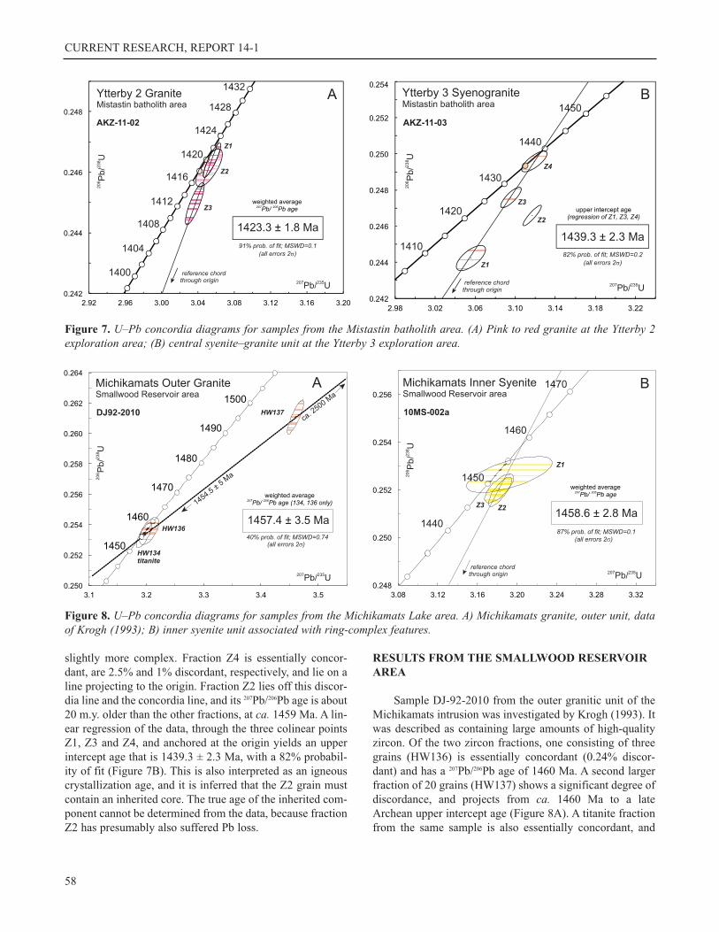
Three zircon fractions from the red granite at Ytterby 2
were analyzed; two single-grain fractions (Z1, Z2) are
essentially concordant (0.3 to 0.4% discordant), and the
third (Z3; two grains) lies very slightly below concordia
(0.8% discordant). The calculated age for the sample is
1423.3 ± 1.8 Ma, with a 91% probability of fit (Figure 7A),
and this is interpreted as an igneous crystallization age.
Four single-grain zircon fractions from the syenite–
granite at Ytterby 3 were analyzed, and their pattern is
56
A. KERR AND M.A. HAMILTON
57
Tab
le 1
. Z
ircon U
-Pb isoto
pic
data
for
gra
nites a
nd s
yenites fro
m the M
ista
stin b
ath
olit
h a
nd S
mallw
ood R
eserv
oir a
rea, Labra
dor
and Q
uebec-L
abra
dor
bord
er
regio
n
Age
s (M
a)
Fra
ctio
nD
escr
iptio
nW
eigh
tU
Pb
TP
bC
Th/
U20
6 Pb/
206 P
b/±
220
7 Pb/
± 2
207 P
b/±
220
6 Pb/
± 2
207 P
b/±
220
7 Pb/
± 2
Dis
c.
(g)
(ppm
)(p
g)(p
g)20
4 Pb
238 U
235 U
206 P
b23
8 U23
5 U20
6 Pb
(%)
AK
Z-1
1-01
Ytte
rby
2 G
rani
te, M
ista
stin
bat
holit
h ar
ea (
sam
pled
by
A. K
err)
Z1
n=
1; 2:1
fla
t, c
lr, cls
, euh p
r
2.7
52
66.7
20.6
10.7
43
6249
0.2
46393
0.0
00462
3.0
5446
0.0
0787
0.0
89909
0.0
00117
1419.8
2.4
1421
.42.0
1423.6
2.5
0.3
Z2
n=
1; 2:1
clr, cls
, euh p
r, inc
2.3
43
33.8
40.8
20.7
69
2344
0.2
46141
0.0
00508
3.0
5114
0.0
1186
0.0
89904
0.0
00252
1418.5
2.6
1420.5
3.0
1423.5
5.4
0.4
Z3
n=
2; 2:1
clr, cls
, euh &
brk
n p
r
3.1
123
107.3
20.8
00.6
85
7769
0.2
44961
0.0
00569
3.0
3543
0.0
0849
0.0
89872
0.0
00137
1412.4
2.9
1416.6
2.1
1422.8
2.9
0.8
AK
Z-1
1-02
Ytte
rby
3 S
yeno
gran
ite, M
ista
stin
bat
holit
h ar
ea (
sam
pled
by
A. K
err)
Z1
n=
1; 3:1
clr, cls
, euh p
r
2.5
57
32.6
00.8
00.6
97
2359
0.2
44235
0.0
00566
3.0
5476
0.0
1197
0.0
90713
0.0
00263
1408.7
2.9
1421
.43.0
1440.6
5.5
2.5
Z2
n=
1; eq, clr, cls
, euh, pr
2.3
118
116.5
80.6
50.9
69
9652
0.2
46592
0.0
00465
3.1
1571
0.0
0747
0.0
91638
0.0
00098
1420.9
2.4
14
36.6
1.8
1459.9
2.0
3.0
Z3
n=
1; 2:1
clr, cls
, euh, pr,
inc
2.4
107
106.7
01.3
20.7
52
4623
0.2
47581
0.0
00465
3.0
9461
0.0
0845
0.0
90654
0.0
00148
1426.0
2.4
143
1.4
2.1
1439.3
3.1
1.0
Z4
n=
1; stu
bb
y c
lr, cls
, euh, pr,
inc
2.1
99
75.7
21.4
60.8
59
2895
0.2
49577
0.0
00467
3.1
1791
0.0
1041
0.0
90606
0.0
00208
1436.3
2.4
1437.1
2.6
1438.3
4.4
0.2
10M
S-0
02a
Coa
rse
syen
ite, r
ing
com
plex
, Mic
hika
mat
s La
ke a
rea
(pro
vide
d by
J. G
outie
r)
Z1
n=
1; eq, clr, cls
, euh p
r
3.2
114
68.6
56.1
30.5
29
687
0.2
52635
0.0
00614
3.1
9118
0.0
3522
0.0
91613
0.0
00881
1452.1
3.2
1455
.08.5
1459.4
18.3
0.6
Z2
n=
1; eq, clr, cls
, euh p
r
2.6
138
76.2
81.2
40.4
87
3736
0.2
51910
0.0
00500
3.1
8155
0.0
0968
0.0
91599
0.0
00173
1448.3
2.6
145
2.7
2.4
1459.1
3.6
0.8
Z3
n=
2; 2:1
clr, cls
, euh, pr
3.7
87
89.9
02.1
80.6
27
2425
0.2
52049
0.0
00488
3.1
8064
0.0
1176
0.0
91523
0.0
00246
1449.0
2.5
1452
.52.9
1457.5
5.1
0.6
DJ9
2-20
10 G
rani
te, M
ichi
kam
ats
Lake
are
a (d
ata
tran
scrib
ed fr
om K
rogh
, 199
3; s
ampl
ed b
y D
. Jam
es)
HW
136
n=
3, pr,
abr,
inc
20.0
72
392.0
07.9
00.4
80
70592
0.2
53540
0.0
00740
3.2
0341
0.0
1414
0.0
91630
0.0
00320
1456.7
3.8
1458.0
3.4
1459.8
7.4
0.2
HW
137
n=
20, pr,
abr
50.0
63
892.5
05.6
20.5
69
14292
0.2
61060
0.0
00920
3.4
6063
0.0
1194
0.0
96140
0.0
00180
1495.2
4.8
1518.3
2.8
1550.6
4.4
4.0
HW
134
Titanite, dark
bro
wn, fr
ac
133.0
94
3473.0
0203.8
00.3
91
1038
0.2
53250
0.0
00660
3.1
9408
0.0
1102
0.0
91470
0.0
00200
1455.2
3.4
1455.7
2.8
145
6.5
4.8
0.1
Notes:
All
analy
zed fra
ctions r
epre
sent best qualit
y, cra
ck-
and o
ptically
core
-fre
e z
ircon, pre
treate
d v
ia c
hem
ical abra
sio
n m
eth
ods (
1000°C
annealin
g a
nd a
cid
leachin
g, after
Mattin
son, 2005
), e
xcept th
ose o
f K
rog
h (
1993
), w
hic
h w
ere
air-a
bra
ded.
Abbre
via
tions: clr -
cle
ar;
cls
- c
olo
urless; euh -
euhedra
l; e
q -
equant; p
r -
prism
, brk
n -
bro
ken; in
c -
min
or
fluid
inclu
sio
ns; fr
ac -
fra
ctu
red; abr
- re
ceiv
ed a
ir-a
bra
sio
n p
retr
eatm
ent.
Pb
T is tota
l am
ount
(in p
ico
gra
ms)
of P
b.
Pb
C is tota
l m
easure
d c
om
mon P
b (
in p
icogra
ms)
assum
ing the isoto
pic
com
positio
n o
f la
bora
tory
bla
nk: 2
06/2
04 -
18.2
21; 207/2
04 -
15.6
12; 208/2
04 -
39.3
60 (
err
ors
of 2%
).
Pb/U
ato
mic
ratios a
re c
orr
ecte
d for
spik
e, fr
actionation, bla
nk, and, w
here
necessary
, in
itia
l com
mon P
b; 206P
b/2
04P
b is c
orr
ecte
d for
spik
e a
nd fra
ctionation.
Th/U
is m
odel valu
e c
alc
ula
ted fro
m r
adio
genic
208P
b/2
06P
b r
atio a
nd 2
07P
b/2
06P
b a
ge, assum
ing c
oncord
ance.
Dis
c. (%
) -
per
cent dis
cord
ance for
the g
iven 2
07P
b/2
06P
b a
ge.
Ura
niu
m d
ecay c
onsta
nts
are
fro
m J
affey e
t al. (
1971).
CURRENT RESEARCH, REPORT 14-1
slightly more complex. Fraction Z4 is essentially concor-
dant, are 2.5% and 1% discordant, respectively, and lie on a
line projecting to the origin. Fraction Z2 lies off this discor-
dia line and the concordia line, and its 207Pb/206Pb age is about
20 m.y. older than the other fractions, at ca. 1459 Ma. A lin-
ear regression of the data, through the three colinear points
Z1, Z3 and Z4, and anchored at the origin yields an upper
intercept age that is 1439.3 ± 2.3 Ma, with a 82% probabil-
ity of fit (Figure 7B). This is also interpreted as an igneous
crystallization age, and it is inferred that the Z2 grain must
contain an inherited core. The true age of the inherited com-
ponent cannot be determined from the data, because fraction
Z2 has presumably also suffered Pb loss.
RESULTS FROM THE SMALLWOOD RESERVOIR
AREA
Sample DJ-92-2010 from the outer granitic unit of the
Michikamats intrusion was investigated by Krogh (1993). It
was described as containing large amounts of high-quality
zircon. Of the two zircon fractions, one consisting of three
grains (HW136) is essentially concordant (0.24% discor-
dant) and has a 207Pb/206Pb age of 1460 Ma. A second larger
fraction of 20 grains (HW137) shows a significant degree of
discordance, and projects from ca. 1460 Ma to a late
Archean upper intercept age (Figure 8A). A titanite fraction
from the same sample is also essentially concordant, and
58
Figure 7. U–Pb concordia diagrams for samples from the Mistastin batholith area. (A) Pink to red granite at the Ytterby 2exploration area; (B) central syenite–granite unit at the Ytterby 3 exploration area.
Figure 8. U–Pb concordia diagrams for samples from the Michikamats Lake area. A) Michikamats granite, outer unit, dataof Krogh (1993); B) inner syenite unit associated with ring-complex features.
A. KERR AND M.A. HAMILTON
overlaps the concordant zircon fraction HW136 (Figure
8A). Krogh (1993) suggested a crystallization age of 1459 ±
2 Ma based on the zircon data, but using the weighted aver-
age of the 207Pb/206Pb ages for fractions HW134 and HW136
gives a slightly younger age of 1457.4 ± 3.5 Ma (Figure
8A). This is within uncertainty of the previous estimate, and
has little impact upon interpretation.
Sample 10-MS-002a, from the inner syenite unit of the
Michikamats intrusion, contained a simple zircon popula-
tion of colourless, well-formed grains. The three analyzed
fractions are very slightly discordant (~0.5%), and one frac-
tion (Z1) has a significantly larger uncertainty than the oth-
ers. All three near-concordant analyses define a narrow
range of 207Pb/206Pb ages, and a weighted average of all frac-
tions yields an age of 1458.6 ± 2.8 Ma (Figure 8B). This is
interpreted as the time of igneous crystallization, and is
essentially identical to the age previously obtained from the
outer granite unit.
Sm–Nd ISOTOPE GEOCHEMISTRY
The samples from the Ytterby 2 and Ytterby 3 areas
were also analyzed for Sm and Nd isotopic compositions at
Memorial University. The preparation methods and analyti-
cal techniques correspond to those summarized by Kerr and
Wardle (1997). Results are shown in Table 2. The two sam-
ples have closely similar εNd signatures at the time of crys-
tallization (-9.1 and -8.9), which are identical within uncer-
tainties. This similarity is also reflected in their narrow
range of calculated depleted-mantle model ages (2310 Ma–
2343 Ma). These negative εNd values are well below the
expected range of mantle-derived magmas at ca. 1430 Ma
(around +4.7) and indicate significant input from older
material to these granitic magmas. The most likely source
for such material is the continental crust of the Churchill
Province, which contains Archean and Paleoproterozoic
rocks.
DISCUSSION AND CONCLUSIONS
This report presents the first fully documented U–Pb
zircon ages from the area of the Mistastin batholith in
Labrador. The Ytterby 2 and Ytterby 3 granitoid units are
almost 200 m.y. older than the Strange Lake Intrusion (1240
Ma; Miller et al., 1997) and thus cannot be related to it. The
Ytterby 2 and Ytterby 3 mineralized granitoid rocks appear
instead to be an integral part of the Mistastin batholith, and
suggest that this extensive and poorly known intrusive com-
plex has potential for REE mineralization. The new data
provide the best information on the age range of the Mis-
tastin batholith, which was previously cited as ‘ca. 1.42 Ga’.
(Emslie and Stirling, 1993), but without analytical or loca-
tional data. The new results from Ytterby 2 are broadly con-
sistent with the earlier inference by Emslie and Stirling
(1993) but the results from the Ytterby 3 area suggest that
the batholith also includes significantly older rocks. Its age
span is now defined as from at least ca. 1439 to 1423 Ma.
The pink to red granite in the Ytterby 2 area clearly intrudes
the surrounding rapakivi-textured granite, indicating that
this unit must be older than 1423 Ma, but the relationship of
the inner syenite–granite unit in the Ytterby 3 area to the sur-
rounding rocks is less clear. If it is a younger intrusion, as
suggested by Midland, this implies that the rapakivi-tex-
tured granites in that area are older than 1439 Ma. Howev-
er, it is also possible that the syenite–granite unit could be an
older inlier, perhaps protruding through a sheet-like upper
(younger) rapakivi granite unit. Thus, we cannot be sure that
the age provides a minimum constraint on the surrounding
granitoid unit. The Sm–Nd isotopic data from Ytterby 2 and
Ytterby 3 units indicate that both intrusions contain signifi-
cant amounts of older crust. The Nd isotopic data reported
by Emslie et al. (1994) from the Nain Plutonic Suite show
that plutonic rocks in its western part (underlain by
Churchill Province basement rocks) have broadly similar
negative Nd isotopic signatures. However, these strongly
negative εNd values differ from the much more neutral val-
ues (-1 to -3) that characterize the younger Strange Lake
59
Table 2. Sm–Nd isotopic data
Sample Number AKZ-11-01 AKZ-11-02
Unit Ytterby 2 Ytterby 3
Details red granite quartz syenite
Assumed Age (Ma) 1423 1439
Nd (ppm) 64.98 162.33
Sm (ppm) 9.96 26.06
147Sm/144Nd 0.0928 0.0971143Nd/144Nd 0.511204 0.511245
εNd (CHUR) -9.1 -8.8
Model Age (Ma) 2310 2343
Notes:
Present-day CHUR values used in calculation of εNd are as
follows:147Sm/144Nd = 0.1966; 143Nd/144Nd = 0.512638.
Model age calculations use the model of DePaolo (1988),
for depleted mantle evolution.
Analytical errors are < ± 0.00005 for 147Sm/144Nd, and < ±
.000025 for 143Nd/144Nd (2 sigma); error in εNd is estimated
at < ± 0.4 ε units.
CURRENT RESEARCH, REPORT 14-1
Intrusion (A. Kerr, unpublished data, 2014). Given that the
older rocks of the Churchill Province are broadly similar in
both areas, there must be important differences in the petro-
genesis of the Strange Lake Intrusion and the Ytterby 2 and
3 granites.
Although the Michikamats granite had already provid-
ed a U–Pb zircon age of ca. 1459 Ma (Krogh, 1993), the
absolute age of the inner syenite ring-complex unit was
unknown, although it was inferred to be younger in a rela-
tive sense. The U–Pb age of the syenite unit is now shown
to be identical to that of the outer granite, indicating that
they are closely related. These ca. 1458 Ma intrusive rocks
could have a broad genetic relationship to the nearby
Michikamau Intrusion, although the anorthositic rocks in the
complex are somewhat older at around 1469 Ma (Kerr and
McNicoll, 2010).
Three U–Pb zircon dates were obtained from prospec-
tive granitoid rocks in adjacent Québec during the same time
period as this study. The results are presented by David et al.(2012), and merit discussion in the context of new informa-
tion presented here. Results from the ring complex at Mis-
ery Lake, represented by pegmatitic alkaline syenite, were
interpreted to indicate a crystallization age of 1409.7 ± 1.7
Ma, based on a weighted average of the 207Pb/206Pb ages. This
age is younger than that obtained from the Ytterby 2 granite,
but it could still form part of the broad magmatic event rep-
resented by the Mistastin batholith, in the same way that the
ca. 1290 Ma Flowers River ring complex forms the
youngest component of the ca. 1330 to 1300 Ma Nain Plu-
tonic Suite (Ryan, 1998). David et al. (2012) also present
data from the Ramusio granite (Ytterby 4 area; see Figure 5
for location), which yielded an age of 1481.7 ± 4.3 Ma,
based on concordant and slightly discordant zircon frac-
tions. The Ramusio granite is thus significantly older than
the Mistastin batholith, but only slightly older than the
Michikamau Intrusion, located to its southwest. To date, no
indications of REE mineralization are reported from the
Ramusio granite, either by Midland Exploration or by the
Québec MRNF (David et al., 2012). The third age determi-
nation in the Québec study was from the Juillet intrusion, a
syenitic body located on the Québec-Labrador border north-
east of the Michikamats granite (Figures 1 and 6). There are
some indications of REE mineralization in this unit, accord-
ing to David et al. (2012), but no details are available. This
provided discordant zircon fractions, indicating an upper
intercept crystallization age of 1479.9 +12.6/- 5.4 Ma, close-
ly similar to that obtained from the Ramusio granite, but
older than the two ages from the Michikamats Lake area
presented here.
The combined data from this study and that of David etal. (2012) suggest that the Mesoproterozoic magmatic histo-
ry of this part of the Canadian Shield is complex and episod-
ic, extending from ca. 1480 Ma (Juillet and Ramusio) to ca.1240 Ma (Strange Lake), with the Mistastin batholith
emplaced between 1439 Ma and 1410 Ma, if Misery Lake is
included as part of it. Of these intrusions, only one (the
Ramusio granite) seems to lack any indications of REE min-
eralization. On this basis, it would not appear that age is a
fundamental control on prospectivity for REE in Mesopro-
terozoic intrusive rocks across the region, although age may
influence the style and extent of mineralization. From the
perspective of regional geology, the combined geochrono-
logical data define two temporal associations. The results
from Ytterby 2, Ytterby 3 and Misery Lake (and earlier
unpublished data quoted by Emslie and Stirling, 1993)
imply that the Mistastin batholith formed over a protracted
time interval (ca. 1439 to 1410 Ma), just like other better-
known composite intrusive complexes such as the Nain Plu-
tonic Suite (Ryan, 1998; Myers et al., 2008). In the Small-
wood Reservoir area, the ages from the Ramusio granite
(Ytterby 4 area), Juillet syenite and the Michikamats intru-
sion may imply a similarly protracted period of magmatism
broadly associated with the ca. 1469 Ma Michikamau Intru-
sion. More work is required to substantiate these patterns
and to establish temporal links between granitoid rocks and
mafic–anorthositic rocks in the Mistastin batholith. A sam-
ple of the rapakivi-textured granite from the Ytterby 2 area
is currently under investigation, and it is possible that
archived material held by M.A. Hamilton from the work of
Emslie et al. (1980) may be of value in this context.
ACKNOWLEDGMENTS
Reconnaissance field work in selected areas of the Mis-
tastin batholith was conducted with the assistance and hos-
pitality of Midland Exploration, and Robert Banville is
thanked for sharing information from exploration work, and
for many interesting discussions. Gerry Kilfoil is thanked
for his assistance in developing the images of geophysical
data. Jean Goutier is thanked for providing the sample from
the Michikamats Lake area and for assisting with other
information from the Québec MRNF. We also thank Hamish
Sandeman for a review that improved the contents of the
article.
REFERENCES
Banville, R.
2011: Midland’s new rare-earth-elements (REE) dis-
coveries at Ytterby 2 and 3 near the Québec-Labrador
border. Geological Association of Canada, Newfound-
land and Labrador Section, Annual technical meeting.
Abstract published in Atlantic Geology, Volume 47.
Currie, K.L.
1971: Geology of the resurgent cryptoexplosion crater
60
A. KERR AND M.A. HAMILTON
at Mistastin Lake, Labrador. Geological Survey of
Canada, Bulletin 207, 62 pages.
DePaolo, D.J.
1988: Neodymium Isotope Geochemistry: An Introduc-
tion. Springer Verlag, Berlin, 187 pages.
David, J., Simard, M., Bandayayera, D., Goutier, J, Ham-
mouche, H., Pilote, P. and LeClerc, F.
2012: Datations U-Pb effectuées dans les provinces du
Supérieur et de Churchill en 2010-11. Québec Ministère
des Ressources Naturelles et de la Faune, Rapport
2012-01, 33 pages.
Emslie, R.F.
1968: The geology of the Michikamau Intrusion,
Labrador (13L, 23I). Geological Survey of Canada,
Paper 68-57, 85 pages.
1980: Geology and petrology of the Harp Lake Com-
plex, central Labrador: an example of Elsonian magma-
tism. Geological Survey of Canada, Bulletin 293, 136
pages.
Emslie, R.F., Cousens, B., Hamblin, C. and Beilecki, J.
1980: The Mistastin Batholith, Labrador - Québec: An
Elsonian composite rapakivi suite. Geological Survey
of Canada, Paper 80-1A, pages 95-100.
Emslie, R.F., Hamilton, M.A. and Thériault, R.J.
1994: Petrogenesis of a mid-Proterozoic anorthosite-
mangerite-charnockite-granite (AMCG) complex: Iso-
topic and chemical evidence from the Nain Plutonic
Suite. Journal of Geology, Volume 102, pages 539-558.
Emslie, R.F. and Stirling, A.R.
1993: Rapakivi and related granitoids of the Nain Plu-
tonic Suite: Geochemistry, mineral assemblages and
fluid equilibria. Canadian Mineralogist, Volume 31,
pages 821-847.
Geological Survey of Canada
2010: Geophysical series, parts of NTS 13L, 13M, 23I,
23J, 23O, 23P. Geological Survey of Canada, Open File
6532, scale 1:250 000. (Compilers Dumont, R., Fortin,
R., Hefford, S. and Doshaler, F.)
2012: Aeromagnetic survey, Mistastin Batholith. Geo-
logical Survey of Canada, Open Files 7154 to 7168
inclusive, 1:50 000 scale. (Compilers Dumont, R. and
Janes, A.)
Grieve, R.A.F.
1975: Petrology and chemistry of the impact melt at
Mistastin Lake crater, Labrador. Geological Society of
America Bulletin, Volume 86, pages 1617-1629.
Jaffey, A.M., Flynn, K.F., Glendenin, L.E., Bentley, W.C.
and Essling, A.M.
1971: Precision measurements of half-lines and specif-
ic activities of 235U and 238U. Physical Review, Volume
C4, pages 1889-1906.
James, D.T. and Mahoney, K.L.
1994: Structural, metamorphic and intrusive relations in
the hinterland of the eastern Churchill Province, west-
ern Labrador. In Current Research. Newfoundland
Department of Mines and Energy, Geological Survey
Branch, Report 94-1, pages 375-385.
Kamo, S.L., Heaman, L.M. and Gover, C.F.
2011: Evidence for post-1200 Ma - pre-Grenvillian
supracrustal rocks in the Pinware terrane, eastern
Grenville Province at Battle Harbour, Labrador. Cana-
dian Journal of Earth Sciences, Volume 48, pages 371-
387.
Kerr, A.
2011: Rare-earth element (REE) mineralization in
Labrador: A review of known environments and the
geological context of current exploration activity. InCurrent Research. Newfoundland and Labrador Depart-
ment of Natural Resources, Geological Survey Branch,
Report 11-1, pages 109-145.
Kerr, A. and McNicoll, V.
2010: U-Pb ages from mafic rocks associated with
orthomagmatic Ni–Cu–Co sulphide mineralization in
west-central Labrador. In Current Research. Newfound-
land Department of Natural Resources, Geological Sur-
vey Branch, Report 10-1, pages 23-41.
Kerr, A. and Wardle, R.J.
1997: Definition of an Archean–Proterozoic crustal
suture by isotopic studies of basement intersections
from offshore wells in the southern Labrador Sea.
Canadian Journal of Earth Sciences, Volume 34, pages
209-214.
Krogh, T.E.
1993: Report on Labrador geochronology, 1992-93.
Newfoundland and Labrador Department of Mines and
Energy, File [LAB/0977].
Krogh, T.E. and Davis, D.W.
1973: The significance of the inherited zircons on the
age and origin of igneous rocks - an investigation of the
age of the Labrador adamellites. Carnegie Institute of
Washington Yearbook, Volume 72, pages 610-613.
61
CURRENT RESEARCH, REPORT 14-1
Marion, C. and Sylvester, P.J.
2010: Composition and heterogeneity of anorthositic
impact melt at Mistastin Lake crater, Labrador. Plane-
tary and Space Science, Volume 58, pages 552-573.
Mattinson, J.M.
2005: Zircon U-Pb chemical abrasion (CA-TIMS)
method: Combined annealing and multi-step partial dis-
solution analysis for improved precision and accuracy
and of zircon ages. Chemical Geology, Volume 220,
pages 47-66.
Miller, R.R., Heaman, L.M. and Birkett, T.C.
1997: U-Pb zircon age of the Strange Lake peralkaline
complex: implications for Mesoproterozoic peralkaline
magmatism in north-central Labrador. Precambrian
Research, Volume 81, pages 67-82.
Myers, J.S., Voordouw, R.J. and Tettelaar, T.A.
2008: Proterozoic anorthosite-granite Nain batholith:
Structure and intrusion processes in an active litho-
sphere-scale fault zone, northern Labrador. Canadian
Journal of Earth Sciences, Volume 45, pages 909-946.
Nunn, G.A.
1995: Bedrock geology of the Kanairiktok River head-
waters area, NTS area 13L/NW, Labrador. Newfound-
land and Labrador Department of Mines and Energy,
Map 94-122. File Number [13L/0078]
Ryan, B.
1998: The Mesoproterozoic Nain Plutonic Suite in east-
ern Canada, and the setting of the Voisey’s Bay Ni-Cu-
Co sulphide deposit. Geoscience Canada, Volume 74,
pages 173-188.
Valley, P., Bulle, F. and Skipton, D.
2011: Geology of the southeastern Churchill Province,
western Labrador. In Current Research. Newfoundland
Department of Natural Resources, Geological Survey
Branch, Report 11-1, pages 295-313.
van der Leeden, J., Belanger, M., Danis, D., Gerard, R. and
Martelin, J.
1990: Lithotectonic domains in the high-grade terrain
east of the Labrador Trough (Québec). Geological
Association of Canada, Special Paper 37, pages 371-
386.
Wardle, R.J., Ryan, B. and Ermanovics, I.
1990: The eastern Churchill Province, Torngat and New
Québec orogens: An overview. Geoscience Canada,
Volume 17, pages 217-222.
62


![From isotropic to layered gabbro - [CRPG-Recherche]recherche.crpg.cnrs-nancy.fr/IMG/pdf/Talk-DJ-Oman2012-ppt.pdf · 1 From isotropic to layered gabbro Evolution record in the Oman](https://img.pdfslide.us/doc/110x75/5e6d40347a1ab151ff3a4920/from-isotropic-to-layered-gabbro-crpg-recherche-1-from-isotropic-to-layered.jpg)