Embed Size (px)
Citation preview

Monitoring Ranunculion fluitantis andCallitricho-BatrachionVegetation Communities
Conserving Natura 2000 RiversMonitoring Series No. 11

Monitoring Ranunculion fluitantis and Callitricho-Batrachion Vegetation Communities
Conserving Natura 2000 Rivers Monitoring Series No. 11
For more information contact:The Enquiry ServiceEnglish NatureNorthminster HousePeterboroughPE1 1UAEmail: [email protected]: +44 (0) 1733 455100Fax: +44 (0) 1733 455103
This document was produced with the support of the European Commission’s LIFE Nature Programme. Itwas published by Life in UK Rivers, a joint venture involving English Nature (EN), the CountrysideCouncil for Wales (CCW), the Environment Agency (EA), the Scottish Environment Protection Agency(SEPA), Scottish Natural Heritage (SNH), and the Scotland and Northern Ireland Forum for EnvironmentalResearch (SNIFFER).
© (Text only) EN, CCW, EA, SEPA, SNH & SNIFFER 2003
ISBN 1 85716 725 2
A full range of Life in UK Rivers publications can be ordered from:The Enquiry ServiceEnglish NatureNorthminster HousePeterboroughPE1 1UAEmail: [email protected]: +44 (0) 1733 455100Fax: +44 (0) 1733 455103
This document should be cited as: Life in UK Rivers (2003). Monitoring Watercourses Characterised byRanunculion fluitantis and Callitricho-Batrachion Vegetation Communitites. Conserving Natura 2000 RiversMonitoring Series No. 11, English Nature, Peterborough.
Technical Editor: Lynn ParrSeries Ecological Coordinator: Ann Skinner
Cover design: Coral Design Management, Peterborough.Printed by Astron Document Services, Norwich, on Revive, 75% recycled post-consumer waste paper,Elemental Chlorine Free. 1M.

Conserving Natura 2000 RiversThis protocol for monitoring watercourses characterised by Ranunculus fluitantis and Callitricho-Batrachion vegetation communities has been produced as part of Life in UK Rivers – a project todevelop methods for conserving the wildlife and habitats of rivers within the Natura 2000 network ofprotected European sites.The project’s focus has been the conservation of rivers identified as SpecialAreas of Conservation (SACs) and of relevant habitats and species listed in annexes I and II of theEuropean Union Directive on the Conservation of Natural Habitats and of Wild Fauna and Flora(92/43/EEC) (the Habitats Directive).
One of the main products is a set of methods for monitoring species and habitats, which complementsreports containing the best available information on their ecological requirements. Each report hasbeen compiled by ecologists who are studying these species and habitats in the UK, and has beensubject to peer review, including scrutiny by a Technical Advisory Group established by the projectpartners. In the case of the monitoring techniques, further refinement has been accomplished by field-testing and by workshops involving experts and conservation practitioners.
Conservation strategies have also been produced for seven different SAC rivers in the UK. In these,you can see how the statutory conservation and environment agencies have developed objectives forthe conservation of the habitats and species, and drawn up action plans with their local partners forachieving ‘favourable conservation status’.
Life in UK Rivers is a demonstration project and, although the reports have no official status in theimplementation of the directive, they are intended as a helpful source of information for organisationstrying to set conservation objectives and to monitor for ‘favourable conservation status’ for thesehabitats and species.They can also be used to help assess plans and projects affecting Natura 2000sites, as required by Article 6.3 of the directive.
Favourable conservation status The purpose of designating and managing SACs is to maintain at, or restore to, ‘favourable conservationstatus’ the habitats and species listed on annexes I and II of the directive.
The conservation status of a natural habitat can be taken as favourable when:
Its natural range and areas it covers within that range are stable or increasing.
The specific structure and functions necessary for its long-term maintenance exist and are likely to exist for the foreseeable future.
The conservation status of its typical species is favourable.
The conservation status of a species may be taken as favourable when:
Population data indicate that the species is maintaining itself on a long-term basis as a viable component of its natural habitats.
The species’ natural range is neither being reduced nor is likely to be reduced for the foreseeable future.
There is, and will probably continue to be, a sufficiently large habitat to maintain its populations on a long-term basis.
The conservation status of a species or habitat has thus to be assessed across its entire natural rangewithin the European Union, in both protected sites and the wider countryside, and over the long term.
Monitoring techniquesThe Habitats Directive requires the condition of the habitats and species for which an SAC has beendesignated to be monitored, so that an evaluation can be made of the conservation status of thesefeatures and the effectiveness of management plans. An assessment of conservation status must,therefore, be applied at both site and network level.
Monitoring Ranunculion fluitantis and Callitricho-Batrachion Vegetation Communities
1

Conserving Natura 2000 Rivers
2
Standard monitoring methods and a coherent assessment and reporting framework are essential toallow results to be both compared and aggregated within and across EU member states.
While the directive outlines the data reporting required from member states at a national level, it didnot set out detailed assessment techniques for data collection at habitat and species level.
The Conserving Natura 2000 Rivers series of monitoring protocols seeks to identify monitoringmethods and sampling strategies for riverine species and the Ranunculus habitat type that are field-tested, cost-effective, and founded on best scientific knowledge.
Titles in the monitoring and ecology series are listed inside the back cover of this report, and copies ofthese, together with other project publications, are available on the project website:www.riverlife.org.uk.
Monitoring Ranunculion fluitantis and Callitricho-Batrachion Vegetation Communities
3
Contents
1 Introduction 51.1General introduction 51.2 Steps in a monitoring strategy 51.3 Integrated monitoring on Natura 2000 rivers 51.4 Monitoring river macrophytes in the UK 61.5 Recommended method for macrophyte monitoring 7
2 Holmes method for surveying macrophytes and determinining river 8community type
3 Rapid assessment method 163.1 Survey details 163.2 Macrophyte assessment (Section A) 163.3 Structural assessment (Section B) 163.4 Management and secondary attributes (Section C) 173.5 Photographs 183.6 Additional notes 18
References 22
Appendix A: Case studies 23A1 Wensum 23A2 Lambourn 25
Appendix B: Draft Favourable Condition Table 26

Conserving Natura 2000 Rivers
4

1 Introduction1.1 General introductionThis protocol is applicable to monitoring of the interest feature Habitat H3260 for Special Areas ofConservation (SACs), which is defined by the EU Interpretation Manual of European Union Habitats (EU1999) as ‘Watercourses of plain to montane levels, with submerged or floating vegetation of theRanunculion fluitantis and Callitricho-Batrachion (low water level during summer) or aquatic mosses’.
The report by Hatton-Ellis et al. (2003) proposes a classification of the vegetation types representingthe Ranunculion fluitantis and Callitricho-Batrachion communities in UK rivers.This is based on an analysisof over 250 rivers surveyed by the project partners for their plant communities and catchment geology.This report also reviews the ecological requirements of these plant communities and the factorsinfluencing their distribution.
The monitoring methodology presented here focuses on the extent and composition of the Ranunculionfluitantis/Callitricho-Batrachion plant communities, for comparison with the characteristic communities inthe classification for that river type.The presence of algae and other atypical plant species (and theabsence of typical plant species) can signal impacts on the conservation status of the SAC river. It isimportant that this is confirmed by monitoring of physical and chemical attributes of the river in thatmonitoring stretch.This should enable the cause of any adverse effects to be identified and remedialaction to be taken.
The dynamic nature of the Ranunculion fluitantis/Callitricho-Batrachion plant communities means thatmonitoring needs to be undertaken periodically over a number of years to differentiate betweennatural fluctuations in plant populations (for example, in response to weather) and those that resultfrom human impacts. Background monitoring of physical and chemical attributes in the river is likely toprovide a more reliable indication of adverse changes and the need for conservation action.
1.2 Steps in a monitoring strategy
1. Definition of river type (altitude, geology, flow regime, plant/animal communities).
2. Selection of monitoring units (homogenous stretches – for example, headwater tributaries, upper,middle and lower stretches of main rivers).
3. Identify attributes to be monitored (plant community, channel modifications, substrate of riverbed,flows, water quality, invasive alien species).
4. Set targets for 'favourable conservation status' for each attribute monitored (for example, extent andcomposition of plant community, maximum phosphorus concentrations for different river types).
5. Identify indicators of ‘unfavourable’ condition (for example, algal growth, presence of invasive species,high levels of modification, siltation of substrate).
6. Establish and test monitoring methodologies.
7. Develop an assessment protocol – what are the tests for a river unit to move from 'unfavourable' to'favourable' (and vice versa)?
8. Establish a programme of monitoring frequency and standard reporting. Set up database for storageof monitoring results. Institute a validation process to ensure consistency of assessments.
1.3 Integrated monitoring on Natura 2000 rivers
It is cost-effective to integrate the monitoring of all the Annex II species with the monitoring of theRanunculus vegetation Annex 1 habitat.This can be done by:
Monitoring Ranunculion fluitantis and Callitricho-Batrachion Vegetation Communities
5

1. Selecting the same (or compatible) monitoring units.
2. Utilising the same environmental data (flows, water quality, physical habitat).
3. Storing the results in the same database.
By integrating Natura 2000 monitoring with monitoring for other purposes, considerable savings can bemade. For instance, most rivers are already monitored for flow, chemical quality and biological quality(invertebrates).These data can be interrogated against the targets set for favourable conservationstatus. From 2006, monitoring of attributes such as morphology, plant communities and fish will berequired under the Water Framework Directive. Co-operation may be required between the officialbodies responsible for monitoring under the Habitats Directive with the bodies responsible under theWater Framework Directive to ensure that the data are collected in such a way as to allow them to beused for both purposes. It is already becoming clear that many of the targets being considered for goodecological quality for all rivers under the Water Framework Directive are unlikely to be stringentenough to secure favourable conservation status for the selected Natura 2000 rivers and the speciesthey support. It will be important, therefore, to differentiate between the targets for each directivewhen making assessments.
1.4 Monitoring river macrophytes in the UK
A methodology for recording plant communities in rivers was pioneered from 1978 by the NatureConservancy Council of Great Britain (Holmes 1983).The NCC was replaced in 1990 by EnglishNature, the Countryside Council for Wales and Scottish Natural Heritage.These bodies co-operate tomaintain a common database of river plant surveys, which contains information on over 300 rivers,including some repeat surveys.
Analysis of this database produced a classification of rivers in Britain into 10 types according to theirgeology and plant communities.This was most recently updated and published in 1999 by the JointNature Conservation Committee (JNCC) (Holmes 1999).The best examples of each type of river havebeen selected as statutory Sites of Special Scientific Interest (SSSI).This network of rivers provided thebasis for selecting Natura 2000 rivers, though a few were added to meet the needs of Annex II species.
The Life in UK Rivers project has tried to establish whether the Holmes (1983) methodology is asuitable and cost-effective way of monitoring plant communities for favourable conservation status.Themethodology was designed for classifying rivers into types, entailing the survey of all plants in the riverchannel and on the banks, together with habitat features, in two continuous 500 m stretches at 7 kmintervals along the river. The Holmes (1983) methodology is set out in Section 2.
The project also commissioned trials of a rapid-assessment methodology initially suggested by EnglishNature, which involves 10 m wide transects every 100 m in a 500 m stretch (Section 3).This is lesstime-consuming than the Holmes (1983) methodology and seeks to provide more quantifiedinformation, which could be compared at subsequent visits. It also focuses on the presence of negativeindicator species (for example, those that thrive at high nutrient concentrations). However, it may notpick up important changes in the river at a reach scale, and there is as yet no national database thatwould allow the analysis of the information.
The project convened workshops of experts to discuss the results of the trials and how an accurateassessment methodology could be designed.There was no overall consensus on the best method,mainly in view of the variability of the plant community from one year to another, and the need forsubjective judgment as to whether changes were natural or due to human impact.This is why it isimportant to record and assess other attributes such as water quality and siltation.
The project partners are now working under the Water Framework Directive on a scoring system forriver plants.This may prove a useful tool, which could be adapted in the future for assessment ofRanunculion fluitantis and Callitricho-Batrachion plant communities.
Conserving Natura 2000 Rivers
6

1.5 Recommended method for macrophyte monitoring
The view reached by Life in UK Rivers is that 500 m stretches of river could be chosen in eachmonitoring unit for repeat monitoring using the rapid assessment methodology.These could beselected in one or more of the following categories:
(a) Favourable stretch with characteristic vegetation (to see if there are adverse changes over time).
(b) Unfavourable stretch with negative indicator species (to see if the vegetation becomes more characteristic over time).
Ideally, the monitoring stretches (or 'plots') should be chosen after a continuous survey of the riverusing the Holmes (1983) methodology – though this could be time-consuming and expensive.Otherwise, the 'plots' would have to be chosen subjectively by an expert in river plant ecology.
By definition, baseline assessment is undertaken once at any given location. Survey timing should bestandardised, based on the geographical location of the river and existing knowledge of vegetationdevelopment and phenology. Surveys should generally be undertaken between mid-June and the end ofAugust, with subsequent monitoring visits at the same time of year. In some rivers, managementactivities such as weed cutting will affect survey timing. Fieldwork should be undertaken before cuttingwhere possible. If cutting takes place before the survey, a period of at least four weeks should beallowed before survey/monitoring.
As far as possible, all macrophyte taxa should be recorded to species level, together with estimates ofpercentage cover of each species within each plot.Where species determinations cannot be made,samples should be taken, in clearly labelled, sealed polythene bags for later identification or specialistverification.
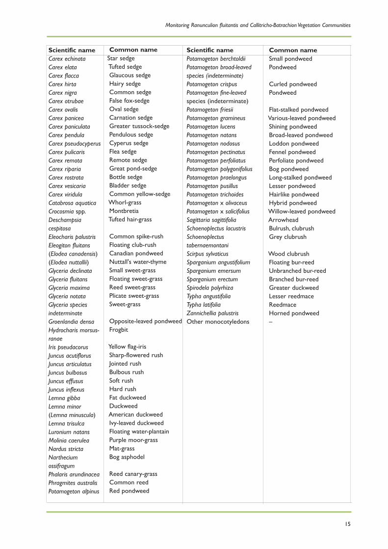
Recording should encompass the entire channel and immediate banksides.This requires recording of allspecies that are submerged or partly submerged in the river at low flow levels, and marginal speciesattached to or rooted on substrates that are likely to be submerged for more than 85% of the time.Achecklist of aquatic species relevant to the UK is reproduced in Section 2.
Where the full width of the channel is not accessible from one bank, survey should be undertaken fromboth banks.Where only one bank is accessible, the monitoring plot should be extended laterally withinthe larger monitoring site to encompass an area comparable to a 10 m section of the whole riverchannel and as wide a range of microhabitats as possible.
For rapid assessment, monitoring should be undertaken without recourse to boats or other moretime-consuming methods. However, in most cases, it will be necessary to enter the river by wading.Where wading is not possible, recording should be undertaken with the use of sampling grapnels.
Appropriate health and safety assessment and management should be observed before undertaking anyfieldwork.The hazards and risks when working beside and within rivers are considerable, and strictadherence to safe working practices is essential. Ideally, all fieldwork should be undertaken by teams oftwo or more workers. Departure from this approach should be justified by clear site-specific riskassessment and management.This need not increase the overall labour requirements for a survey ormonitoring programme since doubling-up often increases efficiency – especially where equipment isrequired, such as ranging poles, tape measures, glass-bottomed buckets, etc. All surveys should beundertaken using appropriate equipment and suitable clothing.
Special caution should be observed in relation to exposure to waterborne disease, such as Weill’sdisease. Appropriate health and safety guidance and risk assessment requirements should be observedon this and other working practices associated with working in and near flowing water.
Monitoring Ranunculion fluitantis and Callitricho-Batrachion Vegetation Communities
7

2 Holmes method for surveying macrophytes anddetermining river community typeMacrophytes from two 0.5 km lengths, one upstream and one downstream of a specific grid reference,are surveyed using a check-list of species.To aid future surveys it is important that each length is clearlyidentifiable by reference to an obvious feature at the site, as well as to a six-figure grid reference.Where possible, recording is done by wading in the channel, but for deep and wide rivers it isnecessary to walk the banks using a grapnel for sampling, or use a boat.
The survey at each site includes the entire channel and immediate banksides, with separate recordsbeing made for those macrophytes found in the river and those found on the bank.This is an attemptto distinguish between species that occur more or less permanently submerged (if only their basalparts), and those that are subjected to only periodic submergence.The former are referred to as ‘river’records and the latter as ‘bank’ records.
To make the separation of these records objective, the following guidelines should be observed whendefining the limits of the river being surveyed. At the sides of the river, all parts of the substratumlikely to be submerged for more than 85% of the year are included.The ‘bank’ can be usefully defined asthe parts of the side of the river (or islands) that are submerged for more than 50% but less than 85%of the time.
In general terms, therefore, ‘river’ records are reserved for macrophytes occurring in the region of theriver that is rarely uncovered, and shallow sections that have an upper limit that may be exposed for amaximum of 50 days in any year. ‘Bank’ records are for plants that occur above the limit of the ‘river’plants, and are thus out of the water for more than 50 days in a year, yet will be submerged, or partiallyso, during average flow periods.The upper limit of the ‘bank’ excludes all the areas submerged duringthe 150 days of each year when river flows are at their highest. Such estimates have to involveguesswork, but estimates of submergence levels do allow better interpretation of the data and clearerinsights into the ecology of individual species and communities at different sites.
The macrophyte survey concentrates on recording the presence or absence of species on the check-list and should be limited to the channel and base of the banks. Additional species of interest are notedbut not used in the classification.
Survey results are tabulated, with any species present within a 0.5 km site being denoted by a doubleset of numbers, either under ‘R’ for river or ‘B’ for bank (note that in the case of marginal plants it isnot uncommon for the species to be recorded in both habitats.)
The two numbers are essentially estimates of abundance.The first number in each column (r), refers tothe relative abundance of one species against the other species present, but does not indicate howmuch of the site it covers. Assessment is made on a scale of 1–3, which roughly accords to a simplifiedDAFOR scale:
1 = Rare2 = Occasional or Frequent3 = Abundant or Dominant
The second number (a) refers to absolute abundance or percentage cover and is a semi-objectiveassessment based on the percentage of the riverbed or bank covered by each macrophyte species.Again assessment is on a scale of 1–3:
1 = <0.1% cover of the channel (river) or at its wetted margins (bank).2 = 0.1 - 5.0% cover.3 = >5% cover.
Visualising the relative abundance of one species compared with all the others present in a 0.5 kmlength of river is relatively straightforward, but estimating the actual cover value is more difficult. As ageneral guide, it is valuable to envisage a dense stand of vegetation that stretches from bank to bank
Conserving Natura 2000 Rivers
8

and extends for 5 m downstream as covering 1% of the 500 m stretch. Similarly, an unbroken stand of25 m represents 5%. Bank cover is best recorded from one bank in very wide rivers. In such cases, acontinuous fringe of a single species stretching 5 m represents 1%. If both banks are clearly visible andbeing recorded, then a continuous stand of 10 m represents 1% cover. A species with cover value 3means, for instance, that it completely covers the stream bed for 25 m, or it covers half the bed for 50m, a quarter of the bed for 100 m, or that it occurs throughout the whole 500 m, but more sparsely.For a score of 3 to be given, bank taxa must conform to one of the following:
i) Be similarly abundant along both banks with a continuous fringe of 50 m.
ii) Form a co-dominant fringe of 100 m.
iii) Occur as 50 plants or colonies covering 1 metre each.
Table 1 gives an example of how data should be recorded.The first figure in each column representsthe relative abundance of the species, while the second figure represents the cover value. River andbank records are made separately.
In the examples in Table 1, therefore:
Species A is dominant in both 0.5 km lengths of the river. It covers more than 5% of the river channel but does not occur on the banks.
Species B is rare. It is present in both river and bank habitats in both lengths but at a cover value of less than 0.1%.
Species C is present only in the upstream length. It is co-dominant with Species D on the banks by covering >5%, and is frequent relative to other species within the river channel, but covers <0.1%.
Species D is present in both upstream and downstream lengths, and is the dominant species on the banks. Although relative to other species, it occurs at the same frequency in both river channel sites. Cover is between 0.1–5% in the upstream site and <0.1% in the downstream site.
Species E is dominant in the river channel in the upstream site but it is only frequent in the downstream site. Cover values are >5% in the former and 0.1–5% in the latter.The species does not occur on the banks.
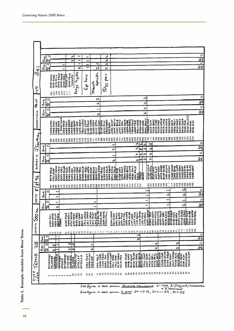
Table 2 and figures 1 and 2 show example checklists and diagrams from the River Teme.
Monitoring Ranunculion fluitantis and Callitricho-Batrachion Vegetation Communities
9
Table 1. Standard method of recording macrophyte abundance.
UPSTREAM 0.5 km DOWNSTREAM 0.5 kmRiver Bank River Bank
Species r a r a r a r aA 3 3 3 3B 1 1 1 1 1 1 1 1C 2 1 3 3D 2 2 3 3 2 1 3 3E 3 3 2 2
Conserving Natura 2000 Rivers
10
Tabl
e 2.
Exa
mpl
e ch
eckl
ist
from
Riv
er T
eme.
Monitoring Ranunculion fluitantis and Callitricho-Batrachion Vegetation Communities
11
DEPTH<0.25 m 40.25–0.5 m 30.5–1.0 m 1>1.0 m 1
WIDTH<5 m 05–10 m 410–20 m 2>20 m 0
SUBSTRATESBedrock 0Boulders 3Cobbles 3Pebbles 3Gravel 2Sand 0Silt/mud 3Clay 0
HABITATS AND FLOWPool 2Slack 2Riffle 3Rapid 1Run 0Waterfall 0Exposed rock 3
MARGINAL FRINGES<1 m 31–2 m 0>2 m 0
TOTAL VEG AREA (%)Bryophytes 20<Algae 60–70Emergents 5–10Submergents <2Floating 0
1 =
<5%
,2 =
5–2
5%,3
= 2
5–50
%,4
= >
50%
River level very low. A lot of silt overlying other substrates.
Figure 1. Example habitat checklist for River Teme.

Conserving Natura 2000 Rivers
12
Figure 2. Example habitat diagram for River Teme.

Monitoring Ranunculion fluitantis and Callitricho-Batrachion Vegetation Communities
13
Scientific nameAlgaeBatrachospermum spp.Chara spp.Cladophora aegagropila
Cladophora/Rhizoclonium agg.Enteromorpha spp.Filamentous green algae (other)Hildenbrandia rivularisHydrodictyon reticulatumLemanea fluviatilisNitella spp.Vaucheria spp.
LichensCollema dichotomumEncrusting lichensFoliose lichens
LiverwortsChiloscyphus polyanthosConocephalum conicumJungermannia spp.Lunularia cruciataMarchantia polymorphaMarsupella spp.Nardia spp.Pellia endiviifoliaPellia epiphyllaPorella spp.Riccardia spp.Scapania undulata
MossesAmblystegium fluviatileBlindia acutaBrachythecium plumosumBrachythecium rivulareBrachythecium rutabulumBryum pseudotriquetrumCalliergon cuspidatumCinclidotus fontinaloidesCratoneuron filicinumDichodontium pellucidum/flavescensDicranella palustrisFissidens crassipes/curnovii/rufulusFontinalis antipyreticaFontinalis squamosaHygrohypnum luridum/ochraceum
Common name
Frogspawn algaStonewortCarpet
blanketweedBlanketweedTubeweed––Netweed–StonewortMole-pelt alga
River jelly-lichen––
––––––––––––
– –––––––––
––Willowmoss––
Scientific nameMosses (continued)Hyocomium armoricumIsothecium holtiiLeptodictyum ripariumOctodiceras fontanumOrthotrichum spp.Philonotis fontanaPolytrichum communeRacomitrium aciculareRhynchostegium riparioidesSchistidium agassiziiSchistidium rivulareSphagnum spp.Thamnobryum alopecurum
Pteridophytes (Azolla spp.)Equisetum fluviatileEquisetum palustreHymenophyllum spp.Osmunda regalisOther Ferns
DicotyledonsAchillea ptarmicaAngelica sylvestrisApium inundatumApium nodiflorumBerula erectaBidens cernuaBidens tripartitaCallitriche hamulata/brutiaCallitriche hermaphroditicaCallitriche obtusangulaCallitriche platycarpaCallitriche spp. indeterminateCallitriche stagnalisCaltha palustrisCardamine amaraCeratophyllum demersum(Crassula helmsii)Dipsacus fullonumEpilobium hirsutumEupatorium cannabinum(Fallopia japonica)Filipendula ulmariaGalium palustre(Heracleummantegazzianum)Hippuris vulgaris
Common name
–––––––––––––
Water fernWater horsetailMarsh horsetailFilmy fernsRoyal fern–
SneezewortWild angelicaLesser marshwortFools' watercressLesser water-parsnipNodding bur-marigoldTripartite bur-marigoldIntermediate water-starwortAutumnal water-starwortBlunt-fruited water-starwortVarious-leaved water-starwortWater-starwortCommon water-starwortMarsh marigold, kingcupLarge bitter-cressRigid hornwortNew Zealand water stonecropTeaselGreat willowherbHemp-agrimonyJapanese knotweedMeadowsweetMarsh bedstrawGiant hogweed
Marestail
Checklist of aquatic macrophyte species

Conserving Natura 2000 Rivers
14
Scientific name(Hydrocotyle ranunculoides)Hydrocotyle vulgaris(Impatiens capensis)(Impatiens glandulifera)Littorella unifloraLotus pedunculatusLycopus europaeusLysimachia vulgarisLythrum salicariaMentha aquaticaMenyanthes trifoliata(Mimulus spp.)Montia fontana(Montia sibirica)Myosotis scorpioidesMyosoton aquaticumMyrica galeMyriophyllum alterniflorum(Myriophyllum aquaticum)Myriophyllum spicatumNuphar luteaNymphaea albaOenanthe crocata
Oenanthe fistulosaOenanthe fluviatilisPersicaria amphibiaPersicaria hydropiperPetasites hybridusPotentilla erectaPotentilla palustrisPulicaria dysentericaRanunculus aquatilis
Ranunculus circinatus
Ranunculus flammulaRanunculus fluitansRanunculus hederaceusRanunculus omiophyllusRanunculus peltatusRanunculus penicillatus ssp.penicillatusRanunculus penicillatus ssp.pseudofluitansRanunculus penicillatus ssp.pseudofluitans var.vertumnusRanunculus sceleratusRanunculus subgenusBatrachium indeterminatespp.
Common nameFloating pennywortMarsh pennywortJewelweedHimalayan balsamShoreweedMarsh birdsfoot-trefoilGypsywortYellow loosetrifePurple loosetrifeWater-mintBogbeanMonkeyflowerBlinksPink purslaneWater forget-me-notWater chickweedBog myrtleAlternate water-milfoilParrot's-featherSpiked water-milfoilYellow water-lily White water-lilyHemlock water-dropwortTubular water-dropwortRiver water-dropwortAmphibious bistortWater-pepperButterburTormentilMarsh cinquefoilFleabaneCommon water-crowfoot
Fan-leaved water- crowfoot
Lesser spearwortRiver water-crowfootIvy-leaved crowfootRound-leaved crowfootPond water-crowfootStream water-crowfoot
Brook water-crowfoot
Brook water-crowfoot
Celery-leaved buttercup
Water-crowfoot
Scientific nameRanunculus trichophyllus
Rorippa amphibiaRorippa nasturtium-aquaticum/microphyllum agg.Rorippa palustrisRorippa sylvestrisRumex hydrolapathumSagina procumbensScrophularia auriculataScutellaria galericulataSenecio aquaticusSolanum dulcamara
Stachys palustrisStellaria uliginosaSymphytum officinaleTussilago farfaraUtricularia spp.Valeriana officinalisVeronica anagallis-aquaticaVeronica anagallis-aquatica/catenata (indeterminate)Veronica beccabungaVeronica catenataVeronica scutellataViola palustrisOther non-aquaticdicotyledons
Trees and shrubsAlnus glutinosa(Rhododendron ponticum agg.)Salix spp.Conifererous treesOther deciduous trees andshrubs
Monocotyledons(Acorus calamus)Alisma lanceolatum
Alisma plantago-aquaticaAlopecurus geniculatusBolboschoenus maritimusButomus umbellatusCarex acutaCarex acutiformisCarex aquatilisCarex curtaCarex disticha
Common nameThread-leaved water-crowfoot
Great yellow-cressWater-cress
Marsh yellow-cressCreeping yellow-cressGreat water-dockPearlwortWater figwortSkullcapMarsh ragwortBittersweet, woody nightshade
Marsh woundwortBog stitchwortComfreyColtsfootBladderwortValerianBlue water-speedwellWater-speedwell
BrooklimePink water-speedwellMarsh speedwellMarsh violet
AlderRhododendronWillow––
Sweet-flagNarrow-leaved water-plantain
Water-plantainMarsh foxtailSea clubrushFlowering rushSlender tufted-sedgeLesser pond-sedgeWater sedgeWhite sedgeBrown sedge
Monitoring Ranunculion fluitantis and Callitricho-Batrachion Vegetation Communities
15
Scientific nameCarex echinataCarex elataCarex flaccaCarex hirtaCarex nigraCarex otrubaeCarex ovalisCarex paniceaCarex paniculataCarex pendulaCarex pseudocyperusCarex pulicarisCarex remotaCarex ripariaCarex rostrataCarex vesicariaCarex viridulaCatabrosa aquaticaCrocosmia spp.DeschampsiacespitosaEleocharis palustrisEleogiton fluitans(Elodea canadensis)(Elodea nuttallii)Glyceria declinataGlyceria fluitansGlyceria maximaGlyceria notataGlyceria speciesindeterminateGroenlandia densaHydrocharis morsus-ranaeIris pseudacorusJuncus acutiflorusJuncus articulatusJuncus bulbosusJuncus effususJuncus inflexusLemna gibbaLemna minor(Lemna minuscula)Lemna trisulcaLuronium natansMolinia caeruleaNardus strictaNartheciumossifragumPhalaris arundinaceaPhragmites australisPotamogeton alpinus
Common nameStar sedgeTufted sedgeGlaucous sedgeHairy sedgeCommon sedgeFalse fox-sedgeOval sedgeCarnation sedgeGreater tussock-sedgePendulous sedgeCyperus sedgeFlea sedgeRemote sedgeGreat pond-sedgeBottle sedgeBladder sedgeCommon yellow-sedgeWhorl-grassMontbretiaTufted hair-grass
Common spike-rushFloating club-rushCanadian pondweedNuttall's water-thymeSmall sweet-grassFloating sweet-grassReed sweet-grassPlicate sweet-grassSweet-grass
Opposite-leaved pondweedFrogbit
Yellow flag-irisSharp-flowered rushJointed rushBulbous rushSoft rushHard rushFat duckweedDuckweedAmerican duckweedIvy-leaved duckweedFloating water-plantainPurple moor-grassMat-grassBog asphodel
Reed canary-grassCommon reedRed pondweed
Scientific namePotamogeton berchtoldiiPotamogeton broad-leavedspecies (indeterminate)Potamogeton crispusPotamogeton fine-leavedspecies (indeterminate)Potamogeton friesiiPotamogeton gramineusPotamogeton lucensPotamogeton natansPotamogeton nodosusPotamogeton pectinatusPotamogeton perfoliatusPotamogeton polygonifoliusPotamogeton praelongusPotamogeton pusillusPotamogeton trichoidesPotamogeton x olivaceusPotamogeton x salicifoliusSagittaria sagittifoliaSchoenoplectus lacustrisSchoenoplectustabernaemontaniScirpus sylvaticusSparganium angustifoliumSparganium emersumSparganium erectumSpirodela polyrhizaTypha angustifoliaTypha latifoliaZannichellia palustrisOther monocotyledons
Common nameSmall pondweedPondweed
Curled pondweedPondweed
Flat-stalked pondweedVarious-leaved pondweedShining pondweedBroad-leaved pondweedLoddon pondweedFennel pondweedPerfoliate pondweedBog pondweedLong-stalked pondweedLesser pondweedHairlike pondweedHybrid pondweedWillow-leaved pondweedArrowheadBulrush, clubrushGrey clubrush
Wood clubrushFloating bur-reedUnbranched bur-reedBranched bur-reedGreater duckweedLesser reedmaceReedmaceHorned pondweed–
Conserving Natura 2000 Rivers
16
3 Rapid assessment methodSelect a representative site.Walk the length of site observing overall character and vegetation. Recordgeneral attributes of the reach – for example, diversity and type of features and signs of impacts (seebelow). Choose representative locations for 10 m samples – well-developed macrophytes are mostlikely to occur in a riffle, run or glide, but sampling should aim to represent the full range of conditionspresent in the 500 m site. Recording the plant assemblage and physical characteristics of the channelwill usually require you to enter the channel by wading unless flow conditions should prevent this.
3.1 Survey details
Record the following:
Details of river, tributary and site unit as appropriate.
Site no./Plot no. Site no. refers to 500 m site (may be the same as the site unit no.). Plot no. refers to 10 m sample plot.
Date of survey.
Surveyor initials.
NGR. Grid reference to 6 or 8 figures (using GPS).
3.2 Macrophyte assessment (SECTION A)Record the following:
Target community from previous baseline surveys (where available).
All macrophyte species present in 10 m sample plot.
Taxa only from channel and bank margins considered part of the river habitat as defined in JNCC survey method (JNCC 1999).
Assign % cover values to all taxa to nearest 10%. Scarce species should be determined where possibleas <5% or <1% cover.
Notes should be made where relevant on the condition of ‘key’ plants – for example, Ranunculus spp.and epiphytic algae.
In addition to noting ‘negative indicator species’, cover of negative indicators such as algae orPotamogeton pectinatus and non-native invasive species may be recorded as combined cover estimates,using River Habitat Survey (RHS) conventions for cover:
1 = present
E = extensive (>33%).
Attention is drawn to the importance of negative indicators, species tolerant of eutrophic conditionsand, specifically, of filamentous algae.
The presence of two or more negative indicator species or a high cover of such species is consideredunfavourable.
3.3 Structural assessment (SECTION B)
Physical habitat assessment should follow River Habitat Survey (RHS) conventions wherever possible(Raven et al. 1998).Thus, bankside vegetation structure is described as follows:

Monitoring Ranunculion fluitantis and Callitricho-Batrachion Vegetation Communities
17
Category RHS vegetation typesU – Uniform Predominantly one type (no scrub or trees) BryophytesS – Simple 2 or 3 vegetation types Short herbs/creeping grassesC – Complex 4 or more vegetation types. Tall herbs/grasses
Scrub/brambles, etc.Saplings and trees
The width of any riparian ‘buffer’ should also be recorded in the notes section of the form.Wherepossible, the percentage of the channel under shade should also be noted. If shade is predominantlyfrom one or other bank, each bank may be recorded separately.
Bank and channel modifications are described as RS Re-sectioned or RI Re-inforced.
Substrate character is described using RHS codes, listed on the form as follows:
NV Not visible CO Cobbles SA Sand PE Peat
BE Bedrock P Pebbles SI Silt EA Earth
BO Boulders G Gravel CL Clay AR Artificial
Bank and channel substrate should be recorded separately. In addition, substrate stability should beassessed and recorded by the addition of initial letters as follows (S) Stable, (U) Unstable and/or (D)Depositing.
The form also allows recording of channel bars, including mid-channel, side or point bars, indicatingwhether the bar is extensive – and whether or not vegetated by an initial (V).
Flow characteristics should be described as follows:
RAPID An area of broken, standing waves, forming distinct whitewater conditions, normally over cobble or boulder substrates.
RIFFLE Fast flowing, shallow water whose surface is distinctly disturbed.
RUN/GLIDE Fast or moderate flowing, often deeper water whose surface is rarely broken or disturbed except for occasional swirls and eddies.
POOL Discrete area of slow flowing water, relatively deeper than surrounding water, often turbulent and with back currents.
SLACK Deep, slow flowing water, uniform in character.
Details of water depth and width should also be recorded, together with an indication of water clarity.Except where otherwise indicated on the form, the extent of physical features noted should berecorded using the simple RHS notation 1 = present; E = extensive (>33%).
3.4 Management and secondary attributes (SECTION C)
While macrophyte and physical data should be recorded for each 10 m plot, a number of attributes arelikely to span greater distances and assist in characterising the general state of the stretch of riverunder scrutiny. Such attributes may be of importance in understanding changes in condition and anyassociated causes.
These characteristics should be recorded at the 500 m scale of the wider monitoring site and will bethe same for all 10 m plots within the site.The convention for denoting the extent of the attribute is 1 = present; E = extensive (>33%).
Alders should be recorded as either healthy or diseased (Phytophthora).
Weed cutting can be either positive (25%+ flowering Ranunculus spp., checkerboard pattern) ornegative (encouraging domination of Ranunculus spp., indiscriminate, etc).

Conserving Natura 2000 Rivers
18
Invasive species should be named in the notes section and recorded here as present or extensiveacross the 500 m site.
Rehabilitation/enhancement records habitat rehabilitation and management.
3.5 Photographs
Photographs should be taken to illustrate the vegetation and physical structure at each 10 m sampleplot and any impacts. Additional photographs should be taken where appropriate to illustrate theoverall character of the 500 m site.
Photographs should be taken with a standard 35 mm camera and 45–50 mm, polarised lens orequivalent. All photographs should be accurately located, either by reference to 10 m sample locationor by separate six- to eight-figure grid reference (using GPS wherever possible).
All photographs should be clearly labelled with River Name, Site No., Plot No. and Date.
3.6 Additional notes
The notes section of the form should be used to clarify or extend observations made elsewhere onthe form. A range of prompts to memory is included at the head of the notes section to assist inmaking appropriate observations. Notes may cover plant health, including indications of general plantcondition – for example, growth form, epiphytic algae, flowering, fruiting – and any apparent causes ofpoor plant condition.
Survey constraints should be noted and any additional habitat observations. Impacts present in the10 m plot or in the wider 500 m site should be described more fully if possible.
A sketch map should be included if appropriate.
The presence of each Habitat Modification Score (HMS) feature should also be noted in each 10 m plotand over the 500 m site. HMS scoring features include:
Modifications in 10 m plot Modifications in 500 m siteReinforcement to banks (RI) Artificial bed materialReinforcement to bed (RI/AR) Reinforced whole bankResectioned bank or bed Resectioned bankTwo-stage bank modification (BM) EmbankmentEmbankment (EM) Set-back embankmentCulvert (CV) Two-stage channelDam, weir, ford (DA, FO) Weed-cuttingBank poached by livestock (PC) Bank-mowing
CulvertDam, weir, ford
Total no. in 500 m site FootbridgeRoadbridgeEnhancements, such as groynesSite partly or extensively (>33%) affected by flow control Partly or extensively (>33%) re-aligned channel

Monitoring Ranunculion fluitantis and Callitricho-Batrachion Vegetation Communities
19
RAPID ASSESSMENT FORMRiver: Site No/Site Code: Date:
Trib/Site: NGR: Surveyor:
A: MACROPHYTE ASSESSMENT: (5 x 10 m transects across representative section).Eutrophication-tolerant species should be marked with an asterisk. Communities predominantlycomposed of these species should be viewed as unfavourable.
Target community: JNCC type: CB type:
Species: estimated % cover (Use 500 m column to mark presence of additional species of note)
Plot No. 1 2 3 4 5 (500 m)
Total taxa: Negative indicators: 1 = present; E = extensive (>33%)Negative indicators (500 m)Invasive species (500 m)

Conserving Natura 2000 Rivers
20
RAPID ASSESSMENT FORMRiver: Site No/Site Code: Date:
Trib/Site: NGR: Surveyor:
B. STRUCTURAL ASSESSMENT: (Add data for 500 m if different from 10 m plots)
Banks: Left bank Right bankPlot no. 1 2 3 4 5 500 m 1 2 3 4 5 500 mBank height (cm)Shading % totalBank-top vegetation (B/U/S/C)Bank-face vegetation (B/U/S/C)Bank modification (RS RI Other)Land use/buffer (500 m) (B/U/S/C)
Substrates: (ring extensive): NV BE BO CO P G SA SI CL PE EA AR Plot no. 1 2 3 4 5 (500 m)Channel: add (S) stable (U) unstable (D) depositing Bank: add (S) stable (U) unstableBars: (P) Present (V) if vegetatedChannel modifications: 1 = present; E = extensive (>33%) except where indicatedPlot no. 1 2 3 4 5 (500 m)Re-sectioned (RS)Re-inforced (RI)Other: (Define)Flow: 1 = present; E = extensive (>33%) except where indicatedPlot no. 1 2 3 4 5 (500 m)RapidRiffleRun/GlidePoolSlackWidth (water) (m)Depth (cm)Photographs (Y/N)Notes:

Monitoring Ranunculion fluitantis and Callitricho-Batrachion Vegetation Communities
21
RAPID ASSESSMENT FORMRiver: Site No/Site Code: Date:Trib/Site: NGR: Surveyor:
C. MANAGEMENT AND SECONDARY ATTRIBUTES 1 = present; E = extensive (>33%) (Add total extent or no. for 500 m)
Plot no. 1 2 3 4 5 (500 m)AbstractionImpoundment (US/DS)PoachingInvasive speciesOutfallsRun-offTippingBridgesSwan grazingWeed cutting (channel)Mowing (banks)Fisheries managementFencing (LB)Fencing (RB)Mature IslandSide channelsDeflectorsAlders (healthy-h/diseased-d)Leafy debris (in-channel)Open water (e.g. ponds)WetlandRehabilitation/EnhancementAdditional Photos (Y/N)
D. ADDITIONAL NOTES

Conserving Natura 2000 Rivers
22
ReferencesGrieve N, Clarke S, Caswell B & Newman J (2003). Comparative Macrophyte Surveys on Selected RiverineSACs. English Nature, Peterborough.
Hatton-Ellis TW, Grieve N & Newman J (2003) Ecology of Watercourses characterised by Ranunculionfluitantis and Callitricho-Batrachion vegetation. Conserving Natura 2000 Rivers Ecology Series No. 11,Peterborough.
Holmes NTH, Boon P & Rowell T (1999). Vegetation communities of British rivers: a revised classification.Joint Nature Conservation Committee, Peterborough.
Holmes NTH (1983). Focus on Nature Conservation No.4.Typing British Rivers According to their Flora.Nature Conservancy Council, Peterborough.
JNCC (1999). Statement On Common Standards For Monitoring Designated Sites. Joint NatureConservation Committee, Peterborough.
Raven PJ, Holmes NTH, Dawson FH, Fox PJA, Everard M, Fozzard IR & Rouen KJ (1998). River HabitatQuality – the physical character of rivers and streams in the UK and Isle of Man. River Habitat Survey,Report No. 2. Environment Agency, Bristol.

Monitoring Ranunculion fluitantis and Callitricho-Batrachion Vegetation Communities
23
Appendix A: Case studies
A1 River Wensum
The Centre for Aquatic Plant Management (CAPM) was commissioned by English Nature tocharacterise the macrophyte communities of the River Wensum SAC. A summary of the results of thesurvey (Grieve et al. 2003) is given below.
Forty-one km of the River Wensum were surveyed in sections between East Raynham and NewCotessey, as well as a 4 km section of the River Tatt directly upstream of the confluence with theWensum.These sections of river were surveyed in 500 m sites using a new transect method (Section3), developed as a rapid baseline assessment of the composition and abundance of the macrophytecommunity along the river length.
In addition, five 1 km sites down the river were surveyed using the Holmes (1983) macrophyte surveymethod.
The channel macrophyte community was generally dominated by Sparganium emersum, Potamogetonpectinatus and Potamogeton perfoliatus, with a high frequency of occurrence and relatively high cover offilamentous algae.
Plants important on a local or national scale that were found on the river during this survey were asfollows:
Oenanthe fluviatilis (a nationally scarce species)Ranunculus penicillatus subsp. pseudofluitansBerula erectaButomus umbellatusCatabrosa aquatica (important species in a regional context).
Two species of regional importance previously found on the river, Groenlandia densa and Hippurisvulgaris, were not detected during this survey.
The substrate of the channel was found to be predominately silty, with few clean gravel pebblestretches present, except immediately downstream of mills. Increasing siltation was a major impact onthe habitat quality of the river.
Land adjacent to the river was mostly grassland, usually managed by grazing. A significant amount ofthis grazing land was unmanaged or abandoned, resulting in undisturbed habitat provided by meadowsand wet pastures.The riparian strip was generally unmanaged, usually with tall herbs dominated bynettles, but some woodland, wet woodland and wetland areas were also seen, especially aboveFakenham and on the River Tat.
The river types (Holmes 1999) found from the five 1 km sites surveyed were types AIIIb and AIVa atthe site upstream of Fakenham, and types AIIb, AIIc, and AIVa at the four sites below Fakenham.Thesetypes represent chalk/oolite streams and high base-flow rivers (IIIb), lowland, clay-dominated rivers(IIb/c), and base-rich/neutral impoverished rivers, normally close to source (Iva)
Using the Favourable Condition Table (Generic Attributes) (see Appendix B) to assess the conservationstatus of Habitat 3260 (Watercourses of plain to montane levels with the Ranunculion fluitanitis andCallitricho-Batrachion vegetation), the survey results raise concerns about the following attributes:
Composition (typical species, habitat extent)Large stretches of the river do not have the plant community associated with this habitat (thedescription of the habitat does not include river type II).
Where the community does occur, characteristic species such as Ranunculus spp. are missing, andnegative indicators, such as Potamogeton pectinatus, are often dominant.

Conserving Natura 2000 Rivers
24
River morphology (habitat structure and functions)Much of the Wensum has been modified by mills and impoundments, while flood defence and landdrainage works have straightened, overwidened and overdeepened the river.This loss of the naturaldynamics of the river is considered an indicator of unfavourable condition.
River substrate (habitat structure and functions)The channel should be dominated by clean gravels.The level of siltation in the Wensum is also anindicator of unfavourable condition.
Overall it would be difficult for the Wensum to achieve favourable conservation status for this habitatunder present conditions/management.
An example of the details provided for a site is given below.
Site number River NGR Date Surveyor1 Tat TF851288 11/7/02 SCSummaryResectioned channel (small ditch-like) through rough pasture/wetland. Extensive patches of cleangravel pebble substrate but some silty sections. Channel plants dominated by Callitriche spp. andemergent herbs with a 10% fringe of grasses (predominately Glyceria maxima).
Substrate (% cover of bed) : Silt: 70 Gravel/pebble: 30
Macrophytes Relative abundance % Cover
Callitriche spp. 3 10Glyceria maxima 3 10Myosotis scorpioides 3 10Phalaris arundinacea 3 10Rorippa nasturtium-aquaticum 3 10Veronica anagallis-aquatica 3 5Mentha aquatica 2 1Veronica beccabunga 2 1Berula erecta 1 1Epilobium hirsutum 1 1Filipendula ulmaria 1 1Juncus spp. 1 1Lemna spp. 1 1Sparganium emersum 1 1Sparganium erectum 1 1Veronica anagallis-aquatica x catenata 1 1Zannichellia palustris 1 1

Monitoring Ranunculion fluitantis and Callitricho-Batrachion Vegetation Communities
25
A2 River Lambourn
A2.1 ObjectivesThe primary objective was to characterise the botanical communities of the river and compare plantsurvey methodologies.While the focus was on the plant community, broad data were also collected forother species of interest – for example, bullhead and brook lamprey habitat – together withobservations of some of the key attributes, such as substrate, adjacent wetland and coarse woodydebris (CWD).This was to provide additional information for the sustainable management of thewatercourse and identify issues relevant to attaining the conservation objectives.
A2.2 Summary2002 was a good year to survey the vegetation (with two previous years of good groundwaterrecharge), and the records are considered to provide a sound baseline for the system. A series ofscientific investigations into the ecology and dynamics of macrophytes in the Lambourn have beenundertaken (Ham et al. 1981, Ham et al. 1982,Wright et al. 1982) and a more recent follow-up study inthe late 1990s (Wright et al. 2002).
The importance of climate (rainfall and discharge) has also been recognised in the studies on the riverLambourn (Ham et al. 1982,Wright et al. 1987).Years of prolonged low flows alter conditions in theriver with increased siltation, a reduction in Ranunculus and increase in marginal herbs (Rorippanasturtium aquaticum, Apium nodiflorum) and increased Callitriche spp.
Annual variations in climate drive the processes in the channel, and the effects of natural dynamics indetermining community composition and river conditions needs to recognised, in addition tomanagement and human impacts. It should also be borne in mind that the data collected during thesurvey represents a single point in time, and that the system is in a continuous state of change relatingto a hierarchy of processes (for example, geology, climate, geomorphology, community ecology, andsediment interactions).
Example of plant distribution in River Lambourn in 2002
RIVER LAMBOURN SITE No. L11 NGR SU357769 DATE 3-9-02SUMMARY
Predominantly shady with more mosses than previous sections, and Ranunculus peltatus in open sections.
Long riffles, with a clean substrate and good flow. (Good habitat for bullhead, Cottus gobio).
CWD and tree roots occur frequently.
Banks are steep (modified in the past) and tree-lined.
Plant name % coverRanunculus peltatus 40Callitriche stagnalis 1Veronica anagillis-aquatica 5Amblystegium fluviatile 1Fontinalis antipyretica 20Apium nodiflorum 1Mentha aquatica 10Myosotis scorpioides 1Rorippa nasturtium-aquaticum 1Iris pseudacorus 1

Conserving Natura 2000 Rivers
26
App
endi
x B
:Dra
ft F
avou
rabl
e C
ondi
tion
Tab
lePr
epar
ed fo
r th
e JN
CC
by
Engl
ish
Nat
ure,
Cou
ntry
side
Cou
ncil
for W
ales
and
Sco
ttis
h N
atur
al H
erita
ge (
May
200
3).N
ote:
Att
empt
ing
to a
sses
s th
e su
stai
nabi
lity
of t
heha
bita
t is
impo
rtan
t w
hen
usin
g th
is g
uida
nce,
as t
his
is a
n in
tegr
al p
art
of t
he c
once
pt o
f fav
oura
ble
cons
erva
tion
stat
us (
FCS)
.For
hab
itats
,the
key
com
pone
nts
used
for
asse
ssin
g FC
S in
clud
e ha
bita
t ex
tent
,hab
itat
stru
ctur
e an
d fu
nctio
ning
,and
typ
ical
spe
cies
.The
app
ropr
iate
FC
S co
mpo
nent
is in
clud
ed in
par
enth
eses
bel
ow e
ach
attr
ibut
e.
Com
men
tsR
iver
flow
affe
cts
a ra
nge
of h
abita
t fa
ctor
s of
cri
tical
impo
rtan
ce t
o ch
arac
teri
stic
flor
a an
d fa
una,
incl
udin
g cu
rren
t ve
loci
ty,w
ater
dep
th,w
ette
d ar
ea,s
ubst
rate
qua
lity,
diss
olve
d ox
ygen
leve
ls a
nd w
ater
tem
pera
ture
.The
mai
nten
ance
of b
oth
flush
ing
flow
s an
d se
ason
al b
ase
flow
s,ba
sed
on n
atur
alhy
drol
ogic
al p
roce
sses
,is
vita
l.D
etai
led
inve
stig
atio
ns o
f hab
itat-
flow
rel
atio
nshi
ps m
ay in
dica
te t
hat
am
ore
or le
ss s
trin
gent
thr
esho
ld m
ay b
e ap
prop
riat
e fo
r a
spec
ified
rea
ch;h
owev
er,a
pre
caut
iona
ryap
proa
ch w
ould
nee
d to
be
take
n to
the
use
of l
ess
stri
ngen
t va
lues
.A
s a
guid
elin
e,at
leas
t 90
% o
f the
natu
ralis
ed d
aily
flow
sho
uld
rem
ain
avai
labl
e to
the
riv
er t
hrou
ghou
t th
e ye
ar.N
atur
alis
ed fl
ow is
defin
ed a
s th
e flo
w in
the
abs
ence
of a
bstr
actio
ns a
nd d
isch
arge
s.T
his
may
be
mod
ified
acc
ordi
ng t
o th
esp
ecifi
c se
nsiti
vity
of t
he r
iver
typ
e,w
ith r
egul
ated
riv
ers
havi
ng s
omew
hat
low
er s
ensi
tivity
tha
nun
regu
late
d on
es.H
owev
er,a
ny r
elax
atio
n of
the
gui
delin
e fig
ure
shou
ld r
elat
e to
the
des
irab
ility
and
ecol
ogic
al s
usta
inab
ility
of r
egul
atin
g st
ruct
ures
.The
ava
ilabi
lity
and
relia
bilit
y of
dat
a is
pat
chy
- lo
ng-
term
gau
ged
data
can
be
used
unt
il ad
equa
te n
atur
alis
ed d
ata
beco
me
avai
labl
e,al
thou
gh t
he im
pact
of
abst
ract
ions
on
hist
oric
al fl
ow r
ecor
ds s
houl
d be
con
side
red.
A w
ide
rang
e of
wat
er q
ualit
y pa
ram
eter
s ca
n af
fect
the
sta
tus
of in
tere
st fe
atur
es,b
ut s
tand
ard
biol
ogic
al m
onito
ring
tec
hniq
ues
prov
ide
a re
ason
ably
inte
grat
ed p
ictu
re in
rel
atio
n to
man
y pa
ram
eter
s.T
he c
hem
ical
mod
ule
of t
he G
QA
sch
eme
sets
sta
ndar
ds fo
r di
ssol
ved
oxyg
en,b
ioch
emic
al o
xyge
nde
man
d an
d to
tal a
mm
onia
.It
ther
efor
e co
vers
a n
umbe
r of
wat
er q
ualit
y pa
ram
eter
s w
hich
com
mon
lyca
use
prob
lem
s w
ithin
riv
er s
yste
ms.
The
sys
tem
in S
cotla
nd d
iffer
s fr
om t
hat
used
els
ewhe
re in
the
UK
.A
sca
le o
f fiv
e w
ater
qua
lity
clas
ses
are
used
(A
1,A
2,B,
C,D
) fo
r as
sess
ing
wat
er c
hem
istr
y,bi
olog
y,nu
trie
nts,
aest
hetic
con
ditio
n,an
d to
xic
subs
tanc
es.T
he o
vera
ll cl
assi
ficat
ion
of a
wat
er is
giv
en b
y th
elo
wes
t cl
ass
deri
ved
from
the
se v
alue
s.A
ll cl
assi
fied
reac
hes
with
in t
he s
ite t
hat
cont
ain,
or s
houl
dco
ntai
n,A
tlant
ic s
alm
on s
houl
d co
mpl
y w
ith t
he t
arge
ts g
iven
.
Att
ribu
teFl
ow [
Hab
itat
stru
ctur
e an
dfu
nctio
ning
]
Wat
er q
ualit
y[H
abita
tst
ruct
ure
and
func
tioni
ng]
Targ
ets
Flow
reg
ime
shou
ldbe
cha
ract
eris
tic o
fth
e ri
ver.
Ecol
ogic
alflo
w c
rite
ria
alre
ady
laid
dow
n fo
r th
eri
ver
(e.g
.for
pass
age
of m
igra
ting
salm
on)
shou
ld a
lso
be c
ompl
ied
with
.N
o ob
viou
spr
oble
ms
with
wat
er a
vaila
bilit
yw
ithin
the
mon
itori
ng u
nit.
Biol
ogic
al G
QA
Cla
ss:a
/A o
r b/
B,de
pend
ing
on r
each
type
.In
addi
tion,
nodr
op in
cla
ss fr
omex
istin
g si
tuat
ion.
Che
mic
al G
QA
Cla
ss:a
/A o
r b/
B,de
pend
ing
on r
each
type
.In
addi
tion,
nodr
op in
cla
ss fr
omex
istin
g si
tuat
ion.
Wat
er Q
ualit
yC
lass
:A1
or A
2de
pend
ing
on r
each
type
.In
addi
tion,
nodr
op in
cla
ss fr
omex
istin
g si
tuat
ion.
Met
hod
of a
sses
smen
tD
ata
and
expe
rt o
pini
onfr
om r
elev
ant
envi
ronm
ent
agen
cy.
Fiel
d ob
serv
atio
ns.
Engl
and,
Wal
es a
nd N
Ion
ly (
Envi
ronm
ent A
genc
yan
d En
viro
nmen
tal
Prot
ectio
n st
anda
rdm
onito
ring
pro
toco
l).
Engl
and,
Wal
es a
nd N
Ion
ly (
Envi
ronm
ent A
genc
yan
d En
viro
nmen
tal
Prot
ectio
n m
onito
ring
prot
ocol
)
Scot
land
onl
y (S
EPA
stan
dard
mon
itori
ngpr
otoc
ol)
Monitoring Ranunculion fluitantis and Callitricho-Batrachion Vegetation Communities
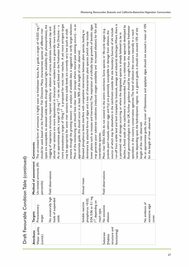
27
Com
men
tsT
he u
n-io
nise
d fo
rm o
f am
mon
ia is
hig
hly
toxi
c to
fres
hwat
er fa
una.
As
a gu
ide,
a ta
rget
of <
0.02
5 m
g l-1
shou
ld b
e us
ed,b
ased
on
the
Fres
hwat
er F
ish
Dire
ctiv
e.M
any
char
acte
rist
ic s
peci
es o
f diff
eren
t ri
ver
type
s ar
e su
scep
tible
to
elev
ated
sol
ids
leve
ls,t
hrou
gh r
educ
ed li
ght
avai
labi
lity
(for
phot
osyn
thes
is),
the
clog
ging
of r
espi
rato
ry s
truc
ture
s,im
paire
d vi
sibi
lity
or s
iltat
ion
of c
oars
e su
bstr
ates
.Low
land
cla
y an
dal
luvi
al r
iver
sec
tions
are
mor
e de
posi
tiona
l in
char
acte
r an
d re
side
nt b
iota
are
gen
eral
ly m
ore
tole
rant
.A
s an
app
roxi
mat
e gu
ide,
a ta
rget
of 2
5 m
g l-1
can
be u
sed,
base
d on
the
Fre
shw
ater
Fis
h D
irect
ive
– a
mor
e pr
ecau
tiona
ry t
arge
t of
10m
g l-1
is p
ropo
sed
for
mos
t ri
ver
reac
hes.
A y
et m
ore
stri
ngen
t ta
rget
may
be
appr
opri
ate
for
som
e ri
ver
sect
ions
whe
re s
olid
s le
vels
are
cur
rent
ly v
ery
low
(su
ch a
s ch
alk
stre
ams
thro
ugh
the
grow
ing
seas
on)
- an
ana
lysi
s of
ava
ilabl
e da
ta is
sug
gest
ed t
o ve
rify
tar
get
sele
ctio
n.M
ost
of t
he m
onito
ring
uni
t sh
ould
hav
e cl
ear
wat
er (
exce
pt w
here
nat
ural
pea
t st
aini
ng o
ccur
s) -
as
anap
prox
imat
e gu
ide,
this
sho
uld
occu
r in
at
leas
t 90
% o
f the
leng
th o
f riv
er o
bser
ved.
Elev
ated
pho
spho
rus
leve
ls in
terf
ere
with
com
petit
ive
inte
ract
ions
bet
wee
n pl
ant
spec
ies,
lead
ing
todo
min
ance
by
atta
ched
form
s of
alg
ae a
nd a
loss
of c
hara
cter
istic
pla
nt s
peci
es (
whi
ch m
ay in
clud
elo
wer
pla
nts
such
as
mos
ses
and
liver
wor
ts).
The
res
pira
tion
of a
rtifi
cial
ly la
rge
grow
ths
of b
enth
ic a
lgae
may
gen
erat
e po
or s
ubst
rate
con
ditio
ns (
redu
ced
oxyg
en a
vaila
bilit
y an
d in
crea
sed
silta
tion)
for
fish
and
inve
rteb
rate
spe
cies
.M
ost
rive
r SS
SIs/
ASS
Is d
o no
t ex
tend
to
the
entir
e ca
tchm
ent.
Som
e sp
ecie
s or
life
-cyc
le s
tage
s (e
.g.
juve
nile
pea
rl m
usse
ls,s
alm
on e
ggs
and
fry)
are
pot
entia
lly s
usce
ptib
le t
o da
mag
e fr
om s
iltat
ion,
the
sour
ce o
f whi
ch m
ay li
e el
sew
here
in t
he c
atch
men
t ou
tsid
e th
e si
te b
ound
ary.
Sour
ces
of s
ilt in
clud
eru
n-of
f fro
m a
rabl
e la
nd a
nd la
nd t
ram
pled
by
lives
tock
,sew
age
and
indu
stri
al d
isch
arge
s.W
here
the
re is
a pe
rcei
ved
risk
of d
amag
e oc
curr
ing,
or w
here
the
des
igna
ted
spec
ies
is a
lread
y be
lieve
d to
be
inde
clin
e,a
fluvi
al a
udit
of t
he c
atch
men
t is
rec
omm
ende
d.T
his
is a
rel
ativ
ely
new
app
roac
h de
velo
ped
byflu
vial
geo
mor
phol
ogis
ts in
the
UK
;fur
ther
gui
danc
e sh
ould
be
soug
ht fr
om t
he a
ppro
pria
te fr
eshw
ater
spec
ialis
ts in
the
cou
ntry
con
serv
atio
n ag
enci
es.T
he le
vel o
f silt
atio
n th
at o
ccur
s na
tura
lly in
a r
each
vari
es d
epen
ding
upo
n th
e hy
drod
ynam
ic r
egim
e;as
a g
ener
al g
uide
,it
shou
ld n
ot e
xcee
d 10
% o
f the
leng
th o
f the
riv
er o
bser
ved.
As
an a
ppro
xim
ate
guid
e,th
e co
ver
of fi
lam
ento
us a
nd e
piph
ytic
alg
ae s
houl
d no
t ex
ceed
a m
ean
of 1
0%fo
r th
e le
ngth
of r
iver
obs
erve
d.
Att
ribu
teW
ater
qua
lity
(con
td.)
Subs
trat
e[H
abita
tst
ruct
ure
and
func
tioni
ng]
Targ
ets
Prec
autio
nary
targ
et
No
unna
tura
lly h
igh
load
s of
sus
pend
edso
lids
Solu
ble
reac
tive
phos
phor
us:<
0.02
,0.
04,0
.06
or 0
.1 m
gl-1
,dep
endi
ng o
nre
ach
type
.N
o ex
cess
ive
silta
tion.
No
evid
ence
of
exce
ssiv
e al
gal
cove
r.
Met
hod
of a
sses
smen
tU
n-io
nise
d am
mon
ia (
95-
perc
entil
e)
Fiel
d ob
serv
atio
ns
Ann
ual m
ean
Fiel
d ob
serv
atio
ns
Dra
ft Fa
vour
able
Con
ditio
n Ta
ble
(con
tinue
d)

Conserving Natura 2000 Rivers
28
Com
men
tsT
he r
iver
sho
uld
supp
ort
all o
f the
hab
itat
feat
ures
nec
essa
ry fo
r de
sign
ated
inte
rest
feat
ures
to
thri
ve,
in c
hara
cter
istic
pro
port
ions
*.R
HS
prov
ides
a g
ener
al in
dica
tor
of h
abita
t di
vers
ity a
nd c
hara
cter
.W
iden
ing
or d
eepe
ning
of c
hann
els,
and
exte
nsiv
e ar
tific
ial r
einf
orce
men
t of
ban
ks,a
re in
dica
tors
of
unfa
vour
able
con
ditio
n.H
eadw
ater
sec
tions
are
par
ticul
arly
vul
nera
ble
to r
epro
filin
g.
In-c
hann
el v
eget
atio
n of
the
riv
er s
houl
d be
dom
inat
ed b
y ch
arac
teri
stic
spe
cies
.
Non
-nat
ive
spec
ies
cons
titut
e a
maj
or t
hrea
t to
man
y ri
ver
syst
ems.
For
exam
ple,
spec
ies
such
as
sign
alcr
ayfis
h ha
ve b
een
resp
onsi
ble
for
muc
h of
the
dec
line
of n
ativ
e cr
ayfis
h th
roug
h co
mpe
titio
n,ha
bita
tda
mag
e an
d th
e in
trod
uctio
n of
cra
yfis
h pl
ague
.
Att
ribu
teH
abita
tst
ruct
ure
[Hab
itat
stru
ctur
e an
dfu
nctio
ning
]
Plan
tco
mm
unity
[Typ
ical
spec
ies]
Non
-nat
ive/
intr
oduc
edsp
ecie
s[T
ypic
alsp
ecie
s]
Targ
ets
Cha
nnel
form
sho
uld
be g
ener
ally
char
acte
rist
ic o
f riv
erty
pe w
ithpr
edom
inan
tlyun
mod
ified
pla
nfor
man
d pr
ofile
.
Bank
and
rip
aria
nzo
ne v
eget
atio
nst
ruct
ure
shou
ld b
ene
ar-n
atur
al.
No
or m
inim
al im
pact
on r
iver
flow
from
inst
ream
str
uctu
res.
Pres
ence
of
char
acte
rist
ic p
lant
spec
ies;
abse
nce
ofin
dica
tors
of
unfa
vour
able
cond
ition
.Ful
l det
ails
of t
arge
ts a
re g
iven
inth
e ri
ver
SSSI
prot
ocol
.N
o im
pact
on
nativ
ebi
ota
from
non
-nat
ive
or in
trod
uced
spe
cies
Met
hod
of a
sses
smen
tA
sses
s ri
ver
mor
phol
ogy
usin
g R
iver
Hab
itat
Surv
ey(s
ee S
ectio
n 3)
.
Surv
ey o
f rep
rese
ntat
ive
stre
tche
s at
inte
rval
s of
abou
t 5
km (
see
Sec
tion
2).
Aqu
atic
mac
roph
ytes
–m
etho
d as
abo
ve.
Oth
er o
rgan
ism
s –
expe
rtju
dgem
ent
on t
he b
asis
of
exte
rnal
rep
orts
.
* Tec
hniq
ues
for
asse
ssin
g w
heth
er h
abita
t fe
atur
es a
re c
hara
cter
istic
of t
he r
iver
are
und
er d
evel
opm
ent
by t
he E
nviro
nmen
t Age
ncy.
Monitoring Ranunculion fluitantis and Callitricho-Batrachion Vegetation Communities
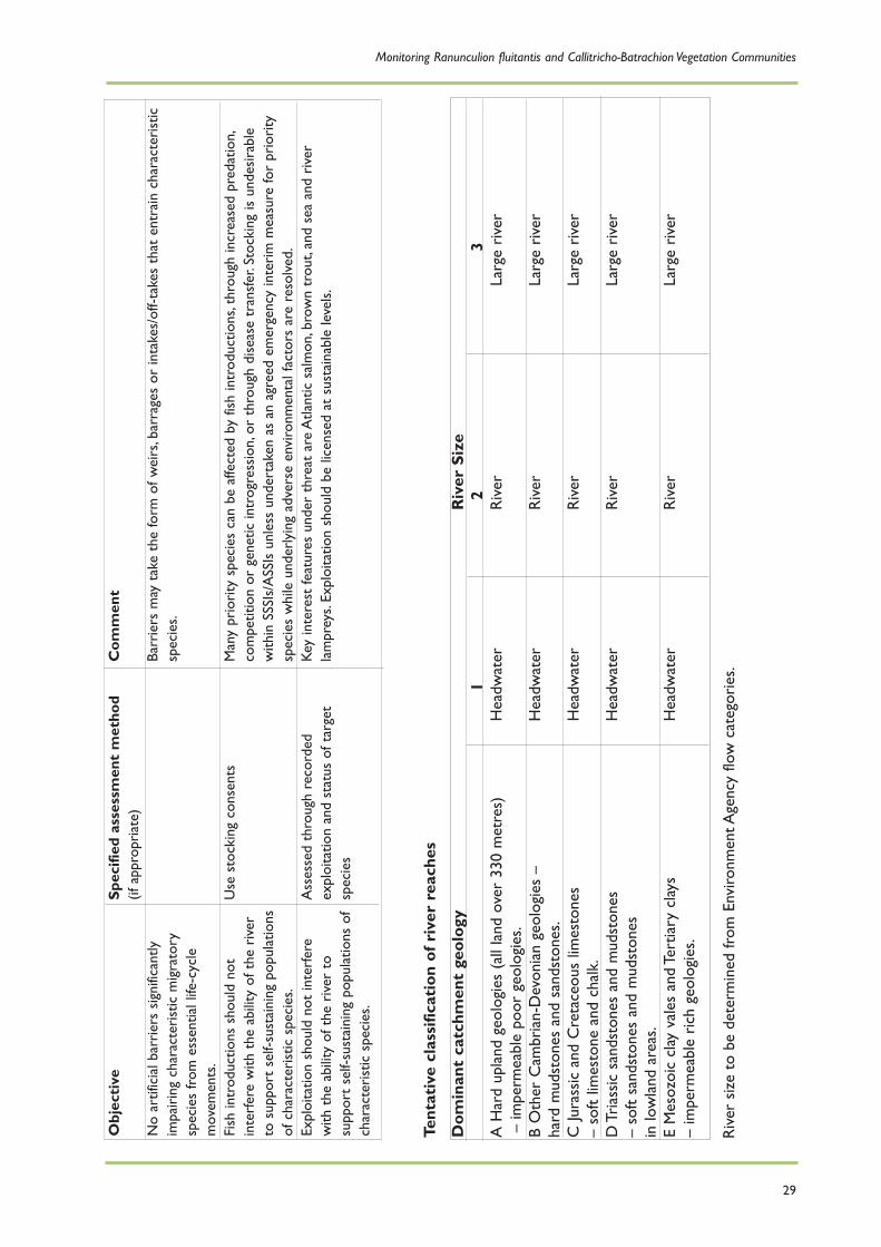
29
Com
men
t
Barr
iers
may
tak
e th
e fo
rm o
f wei
rs,b
arra
ges
or in
take
s/of
f-tak
es t
hat
entr
ain
char
acte
rist
icsp
ecie
s.
Man
y pr
iori
ty s
peci
es c
an b
e af
fect
ed b
y fis
h in
trod
uctio
ns,t
hrou
gh in
crea
sed
pred
atio
n,co
mpe
titio
n or
gen
etic
intr
ogre
ssio
n,or
thr
ough
dis
ease
tra
nsfe
r.St
ocki
ng is
und
esir
able
with
in S
SSIs
/ASS
Is u
nles
s un
dert
aken
as
an a
gree
d em
erge
ncy
inte
rim
mea
sure
for
prio
rity
spec
ies
whi
le u
nder
lyin
g ad
vers
e en
viro
nmen
tal f
acto
rs a
re r
esol
ved.
Key
inte
rest
feat
ures
und
er t
hrea
t ar
e A
tlant
ic s
alm
on,b
row
n tr
out,
and
sea
and
rive
rla
mpr
eys.
Expl
oita
tion
shou
ld b
e lic
ense
d at
sus
tain
able
leve
ls.
Obj
ecti
ve
No
artif
icia
l bar
rier
s si
gnifi
cant
lyim
pair
ing
char
acte
rist
ic m
igra
tory
spec
ies
from
ess
entia
l life
-cyc
lem
ovem
ents
.Fi
sh in
trod
uctio
ns s
houl
d no
tin
terf
ere
with
the
abi
lity
of t
he r
iver
to s
uppo
rt s
elf-s
usta
inin
g po
pula
tions
of c
hara
cter
istic
spe
cies
.Ex
ploi
tatio
n sh
ould
not
inte
rfer
ew
ith t
he a
bilit
y of
the
riv
er t
osu
ppor
t se
lf-su
stai
ning
pop
ulat
ions
of
char
acte
rist
ic s
peci
es.
Spec
ified
ass
essm
ent
met
hod
(if a
ppro
pria
te)
Use
sto
ckin
g co
nsen
ts
Ass
esse
d th
roug
h re
cord
edex
ploi
tatio
n an
d st
atus
of t
arge
tsp
ecie
s
Dom
inan
t ca
tchm
ent
geol
ogy
Riv
er S
ize
1 2
3A
Har
d up
land
geo
logi
es (
all l
and
over
330
met
res)
Hea
dwat
erR
iver
Larg
e ri
ver
– im
perm
eabl
e po
or g
eolo
gies
.B
Oth
er C
ambr
ian-
Dev
onia
n ge
olog
ies
– H
eadw
ater
Riv
erLa
rge
rive
rha
rd m
udst
ones
and
san
dsto
nes.
C Ju
rass
ic a
nd C
reta
ceou
s lim
esto
nes
Hea
dwat
erR
iver
Larg
e ri
ver
– so
ft lim
esto
ne a
nd c
halk
.D
Tri
assi
c sa
ndst
ones
and
mud
ston
es
Hea
dwat
erR
iver
Larg
e ri
ver
– so
ft sa
ndst
ones
and
mud
ston
es
in lo
wla
nd a
reas
.E
Mes
ozoi
c cl
ay v
ales
and
Ter
tiary
cla
ys
Hea
dwat
erR
iver
Larg
e ri
ver
– im
perm
eabl
e ri
ch g
eolo
gies
.
Tent
ativ
e cl
assi
ficat
ion
of r
iver
rea
ches
Riv
er s
ize
to b
e de
term
ined
from
Env
ironm
ent A
genc
y flo
w c
ateg
orie
s.

Conserving Natura 2000 RiversEcology Series
1 Ecology of the White-clawed Crayfish, Austropotamobius pallipes2 Ecology of the Freshwater Pearl Mussel, Margaritifera margaritifera3 Ecology of the Allis and Twaite Shad, Alosa alosa and A. fallax4 Ecology of the Bullhead, Cottus gobio5 Ecology of the River, Brook and Sea Lamprey, Lampetra fluviatilis, L. planeri and Petromyzon marinus6 Ecology of Desmoulin’s Whorl Snail, Vertigo moulinsiana7 Ecology of the Atlantic Salmon, Salmo salar8 Ecology of the Southern Damselfly, Coenagrion mercuriale9 Ecology of the Floating Water-plantain, Luronium natans10 Ecology of the European Otter, Lutra lutra11 Ecology of Watercourses Characterised by Ranunculion fluitantis and Callitricho-Batrachion Vegetation
Monitoring Series
1 A Monitoring Protocol for the White-clawed Crayfish, Austropotamobius pallipes2 A Monitoring Protocol for the Freshwater Pearl Mussel, Margaritifera margaritifera3 A Monitoring Protocol for the Allis and Twaite Shad, Alosa alosa and A. fallax4 A Monitoring Protocol for the Bullhead, Cottus gobio5 A Monitoring Protocol for the River, Brook and Sea Lamprey, Lampetra fluviatilis, L. planeri and
Petromyzon marinus6 A Monitoring Protocol for Desmoulin’s Whorl Snail, Vertigo moulinsiana7 A Monitoring Protocol for the Atlantic Salmon, Salmo salar8 A Monitoring Protocol for the Southern Damselfly, Coenagrion mercuriale9 A Monitoring Protocol for the Floating Water-plantain, Luronium natans10 A Monitoring Protocol for the European Otter, Lutra lutra11 A Monitoring Protocol for Watercourses Characterised by Ranunculion fluitantis and
Callitricho-Batrachion Vegetation
These publications can be obtained from:
The Enquiry ServiceEnglish NatureNorthminster HousePeterboroughPE1 1UAEmail: [email protected]: +44 (0) 1733 455100Fax: +44 (0) 1733 455103
They can also be downloaded from the project website: www.riverlife.org.uk

River plant diversity is declining across Europe due tonutrient enrichment, siltation, over-abstraction and
damaging management practices.
Ranunculion fluitantis and Callitricho-Batrachion vegetationcommunities form an important aquatic habitat typethat is protected by European legislation.They have a
key role in influencing flow, nutrient and sedimentdynamics in river systems, and provide
important habitat for invertebrates and fish.
This report suggests monitoring methods that can beused to assess the conservation status of Ranunculion
fluitantis and Callitricho-Batrachion vegetation communities, and what conservation action is
necessary for their survival.
The Life in UK Rivers project was established to develop methods forconserving the wildlife and habitats of rivers within the Natura 2000
network of protected European sites.
Set up by the UK statutory conservation bodies and the EuropeanCommission’s LIFE Nature programme, the project has sought to identifythe ecological requirements of key plants and animals supported by river
Special Areas of Conservation.
In addition, monitoring techniques and conservation strategies have beendeveloped as practical tools for assessing and maintaining these
internationally important species and habitats.
Information on Conserving Natura 2000 Rivers and the Life in UK Rivers project can be found at
www.riverlife.org.uk
This document was produced with the support of the European Commission’s LIFE NatureProgramme and published by the Life in UK Rivers project - a joint venture involving EnglishNature, the Countryside Council for Wales, the Environment Agency, the Scottish EnvironmentProtection Agency, Scottish Natural Heritage and the Scotland and Northern Ireland Forum
for Environmental Research.