Embed Size (px)
Citation preview
PAN-AFRICAN UNIVERSITY
INSTITUTE FOR WATER AND ENERGY SCIENCES
(Including CLIMATE CHANGE)
Master Dissertation
Submitted in partial fulfillment of the requirements for the Master degree in
[Water Engineering]
Presented by
RAMADAN MARNE
(PAUWES/2017/MWE/03)
Defended on 02/09/2019 Before the Following Committee:
Chair Abdelbaki Chérifa Dr. PAUWES
Supervisor Abubakar Ismail Prof. Ahmadu Bello University
Co-supervisor Bakhodir Mirzaev Mr. IsDB
External Examiner Bessedik Madani Dr. University of Tlemcen
Internal Examiner Kamila Baba Hamed Prof. University of Tlemcen
WATER HARVESTING STRUCTURE SUSTAINABILITY
i
DECLARATION
I, RAMADAN MARNE, hereby declare that this thesis represents my personal work, realized
to the best of my knowledge, without plagiarism. I also declare that all information, material
and results from third parties have been fully cited and referenced according to the academic
rules and regulations.
S igned
Name: RAMADAN MAREN Date: 01/10/2019
CERTIFICATION
the submitted final version was done with the approval of the supervisor, and that all corrections
were added as recommended by the examination committee.
Signed
Name: Ramadan MARNE Date: 01/10/2019
Signed
Name: Prof. ABUBAKAR Ismail Date: 01/10/2019
ii
ABSTRACT
WH comprises all forms of activities where water is collected, stored and used either in the
blue or green form. It involves the direct collection of rain that falls onto the roofs, grounds
and runs off, as well as floodwater harvesting. Abougoudam District in Chad has been
characterized by irregularities in the rainfall intensities with short duration. The district has a
long period of the dry season with only four months of rain. The rainfall is unevenly distributed
spatially and temporally, therefore, affecting water availability for humans, livestock
consumption and off-season irrigation. Water harvesting structures have been proven to
provide a cost-effective, environmentally friendly, affordable and relatively simple solution to
supplement water for the intended use. The adaptability of sustainable WHSs may increase
adoption rate in areas with chronic water shortages through a public-private partnership. The
objective of this study was to analyse various water harvesting practices in arid regions and
propose sustainable structures that incorporated the technical feasibility, economic and socio-
cultural acceptability to be implemented in Abougoudam district, Chad and other arid regions
of Africa. The probability analysis was used to design rainfall for WH and ArcGIS 10.5 was
used to generate the soil map in order to avoid soils that are not suitable for WH. 150 sample
questionnaire was administered to the local community of Abougoudam district to assess their
willingness to adopt WH. A field survey in Chad and literature review were conducted to assess
the best practices. The results from the rainfall analysis revealed that rain with a probability of
more than 50% might be considered to supplement water for the intended use. The soil map
showed 40 to 60% of vertisols to be avoided for WH. 100% of the local community were ready
to adopt WH. The results from the field survey and literature review revealed that water
spreading weirs, Hafir system, Sand dam, permeable rock dam, rooftop, Zai pit and Stone lines
are the best practices that could be adaptable in Chad and most specifically in Abougoudam
District but water spreading weir, Sand dam and combination of the zaï pit and stones lines
were more preferable. This was because of their capacity to regenerate degraded lands in valley
regions, reduce evaporation and recharge groundwater. Hafir system is also considered because
of their potential to provide water both for human and livestock. The sustainability of these
structures could be addressed by incorporating the policy brief developed at the end of this
study into the national policy.
Key Words: Rainfall, soil map, WH, policy brief, water spreading weirs, Hafir systems, Sand
dam, permeable rock dam, rooftop, Zai pit and Stone lines
iii
Résumé
La récupération d'eau comprend toute forme d’activité dans laquelle l'eau est collectée, stockée
et utilisée sous forme bleue ou verte. Cela implique la collecte directe des précipitations sur les
toits, les sols et les écoulements, ainsi que la récupération des eaux de crue. Le district
d'Abougoudam au Tchad a été caractérisé par des irrégularités d'intensité des précipitations de
courte durée. La région est marquée par une longue période de saison sèche avec seulement
quatre mois de pluie. La pluviosité est inégalement répartie dans le temps et dans l'espace,
affectant par conséquent la disponibilité d’eau pour les Hommes, la consommation du bétail et
l'irrigation des cultures pendant la saison sèche. Il a été prouvé que les systèmes de collecte
d’eau constituaient une solution rentable, écologique, abordable et relativement simple pour
augmenter la disponibilité en eau afin d’atteindre la demande. L'adaptabilité des systèmes
durable dans la collecte d’eau peut augmenter le taux d'adoption dans les zones de pénurie
chronique d'eau grâce à un partenariat public-privé. L'objectif de cette étude était d'analyser les
diverses pratiques des systèmes de collecte d’eau dans les régions arides et de proposer des
systèmes durables intégrant la faisabilité technique et la conception, l'acceptabilité économique
et socioculturelle à réaliser dans le district d'Abougoudam, au Tchad et dans d'autres régions
arides d'Afrique. L'analyse de la probabilité a été utilisée pour calculer la précipitation qui
pourrait être choisie pour la collecte d’eau afin d’atteindre les besoins en eau et ArcGIS 10.5 a
été utilisée pour générer la carte du sol afin d'éviter les sols qui ne conviennent pas au stockage
de l’eau collectée. Une enquête de 150 questionnaires a été administrée à la communauté locale
du district d'Abougoudam afin d'évaluer leur volonté d'adopter les systèmes de collecte d’eau.
Une enquête sur le terrain au Tchad et des revues de la littérature ont été menées pour évaluer
les meilleures pratiques des systèmes de collecte d’eau. Les résultats de l'analyse des
précipitations ont révélé que l'on pouvait considérer que les précipitations avec une probabilité
supérieure à 50% pour augmenter la disponibilité en eau afin d’atteindre les besoins en eau. La
carte du sol a montré que 40 à 60% des argiles noires devaient être évités. 100% de la
communauté locale avait exprimé leur volonté d’adopter les systèmes de collecte d’eau. Les
résultats de l'enquête sur le terrain et de l'analyse de la littérature ont révélé que les seuils
d'épandage, le système d’Hafir, le barrage en sable, les digues filtrantes, le toit, la fosse de Zaï
et les cordons pierreux sont les meilleures pratiques pouvant être adaptées au Tchad et plus
particulièrement dans le district d'Abougoudam. Le seul d’épandage, le barrage en sable et la
combinaison de la fosse de zaï et les cordons pierreux étaient plus préférables. Cela était dû à
leur capacité de régénérer les terres dégradées dans les vallées, à réduire l'évaporation et à

iv
recharger les eaux souterraines. Le système d’Hafir a été également pris en compte en raison
de son potentiel d'approvisionner l’eau pour les Hommes et le bétail. La durabilité de ces
systèmes pourrait être abordée en incorporant la note politique à la fin de cette étude dans la
politique nationale.
Mots clés: Précipitation, carte du sol, collecte d’eau, note politique, seuil d'épandage, système
d’Hafir, digues filtrantes, toit, fosse de Zaï et cordons pierreux

v
DEDICATION
I dedicate this work to my late father in the person of MARNE SALEH and my mother who
has always been there to ensure that I progress with my education.

vi
ACKNOWLEDGEMENTS
First of all, I would like to express my deepest gratitude to Almighty Allah for making this
research come true. I thank the African Union Commission(AUC) for awarding me the
scholarship to study the Master’s Degree in Water Engineering at the Pan African University
Institute of Water and Energy Sciences (including Climate Change), PAUWES. I also
appreciate the research grant given to me by the member states of the African Union(AU) that
allowed me to carry out smooth research. My sincere appreciation goes to my supervisors, Mr.
Bakhodir Mirzaev and Prof. Abubakar Ismail for their guidance to successfully complete this
research.
It is a great pleasure to express my delight in working with the Director of PAUWES, Water
Coordinator, members of staff and a special thanks goes to Deputy Director, Prof. Chewki
Ziani for always being there for students’ matter.
I also extend my thanks to the Regional Manager of the Islamic Development Bank in Nigeria,
Mr. Mayoro Niang and my internship supervisor, Mr. Ougfaly Badji.
Lastly, I thank my parents and family for their prayers and support. To my friends in Water
Engineering, class of 2018/2019 for their assistance during my classwork as well as making
my entire stay in Algeria such a wonderful moment.
vii
TABLE OF CONTENTS
DECLARATION ........................................................................................................................ i
CERTIFICATION ...................................................................................................................... i
ABSTRACT ............................................................................................................................... ii
Résumé ..................................................................................................................................... iii
DEDICATION ........................................................................................................................... v
ACKNOWLEDGEMENTS ...................................................................................................... vi
TABLE OF CONTENTS ......................................................................................................... vii
LIST OF TABLES .................................................................................................................... xi
LIST OF FIGURES ................................................................................................................. xii
LIST OF EQUATIONS .......................................................................................................... xiv
LIST OF ABBREVIATIONS .................................................................................................. xv
CHAPTER ONE ........................................................................................................................ 1
1.0 INTRODUCTION ....................................................................................................... 1
1.1 BACKGROUND ......................................................................................................... 1
1.2 PROBLEM STATEMENT ......................................................................................... 3
1.3 Objectives of the study ................................................................................................ 3
1.3.1 Main Objectives ................................................................................................... 3
1.3.2 Specific objectives ............................................................................................... 4
1.4 Research Questions ..................................................................................................... 4
1.5 Hypothesis ................................................................................................................... 4
1.6 SCOPE OF THE STUDY ........................................................................................... 4
1.7 RELEVANCE OF THE STUDY ................................................................................ 5
1.8 STRUCTURE OF THE THESIS ................................................................................ 6
CHAPTER TWO ....................................................................................................................... 7
2.0 LITERATURE REVIEW ............................................................................................ 7
2.1 Definitions of Water Harvesting .............................................................................. 7
2.2 Components of Water Harvesting Systems ............................................................. 7
2.3 Classification of water harvesting systems .............................................................. 9
2.3.1 Floodwater harvesting ...................................................................................... 9
2.3.1.1 Floodwater diversion system ....................................................................... 9
2.3.1.2 Wadi bed system .......................................................................................... 9
2.3.2 Groundwater harvesting ................................................................................. 11
viii
2.3.2.1 Dams ......................................................................................................... 11
2.3.2.2 Water Wells .............................................................................................. 11
2.3.2.3 Cisterns ...................................................................................................... 11
2.3.2.4 Aquifers ..................................................................................................... 12
2.3.3 Rainwater harvesting ...................................................................................... 13
2.3.3.1 Rooftop water harvesting ........................................................................... 13
2.3.3.2 Microcatchment Water Harvesting ............................................................ 14
2.3.3.3 Macrocatchment water harvesting ............................................................. 15
2.4 Water Harvesting Structures in Arid Regions ...................................................... 16
2.4.1 Haffir .............................................................................................................. 16
2.4.2 Sand Dams...................................................................................................... 17
2.4.3 Permeable rock dam ...................................................................................... 18
2.4.4 Planting pits .................................................................................................... 19
2.4.5 Water spreading weirs .................................................................................... 19
2.4.6 Tabia ............................................................................................................... 20
2.4.7 Hillside runoff/Conduit system ...................................................................... 21
2.4.8 Trapezoidal bunds .......................................................................................... 21
2.4.9 Check dam ..................................................................................................... 22
2.4.10 Rock catchment masonry dams ..................................................................... 22
2.4.11 Recharge well ................................................................................................. 23
2.4.12 Stones lines/bunds .......................................................................................... 24
2.4.13 Eyebrow terraces: ........................................................................................... 24
2.4.14 Mechanised demi-lunes (Vallerani-type basins) ............................................ 25
2.4.15 Semi-circular bunds........................................................................................ 25
2.4.16 Negarim .......................................................................................................... 26
2.4.17 Meskat ........................................................................................................... 26
2.4.18 Rooftop systems ............................................................................................. 27
2.5 Economic Viability of Water Harvesting Structures ............................................. 28
2.6 Operation and Maintenances of Water Harvesting Structures .............................. 29
2.7 Benefits of water harvesting .................................................................................. 30
2.8 Policy on Water Harvesting Structures ................................................................. 30
CHAPTER THREE ................................................................................................................. 32
3.0 RESEARCH APPROACH ........................................................................................ 32
3.1 General presentation of the study area .................................................................. 32
3.1.1 Location and description of the case study .................................................... 34
ix
3.1.2 Vegetation and Flora ...................................................................................... 34
3.1.3 Fauna .............................................................................................................. 35
3.1.4 Climate ........................................................................................................... 36
3.1.5 Hydrography................................................................................................. 37
3.2. Legal Framework of Chadian’s Water Regime .................................................... 38
3.3 Data collection and Methods ................................................................................. 40
3.3.1 Introduction .................................................................................................... 40
3.3.2 Rainfall data ................................................................................................... 40
3.3.3 Soil data .......................................................................................................... 42
3.3.3 Water consumption data ................................................................................. 42
3.3.4 Sampling approach ......................................................................................... 42
3.3.5 Expert sampling.............................................................................................. 43
3.3.6 Questionnaire ................................................................................................. 43
3.3.7 Selection considerations of Best Practices of Water Harvesting Structures .. 44
3.3.8 Development of a policy brief ........................................................................ 45
3.3.9 Research design .............................................................................................. 47
3.4 Data Analysis ......................................................................................................... 49
CHAPTER FOUR .................................................................................................................... 50
4.0 RESULT AND DISCUSSION.................................................................................. 50
4.1 Assessment of Annual rainfall data series for Abougoudam District ................... 50
4.1.1 Variability of Annual Rainfall........................................................................ 50
4.1.2 Design of Rainfall .......................................................................................... 51
4.2 Soil Mapping of Abougoudam District ................................................................. 53
4.3 Analysis of Water Consumption Pattern in Abougoudam District ....................... 54
4.4 Key informant interviews ...................................................................................... 55
4.5 Assessment of the questionnaire............................................................................ 57
4.6 Best practices of WHSs to be proposed in Chad and other arid regions of Africa 59
4.6.1 Water spreading weir in dry valleys ............................................................... 59
4.6.2 Hafir system ................................................................................................... 65
4.6.3 Sand Dam ....................................................................................................... 68
4.6.4 Permeable rock dam ....................................................................................... 71
4.6.5 Rooftop water harvesting ............................................................................... 72
4.6.6 Zai pit (Tassa)................................................................................................. 74
4.6.7 Stones line bunds ............................................................................................ 76
4.7 Policy brief on the sustainability of water harvesting structures in Chad ............. 77
x
CHAPTER FIVE ..................................................................................................................... 81
5.0 CONCLUSION AND RECOMMENDATIONS ...................................................... 81
5.1 CONCLUSION ..................................................................................................... 81
5.2 RECOMMENDATIONS....................................................................................... 83
5.3 FUTURE PROSPECTS ......................................................................................... 84
REFERENCE ........................................................................................................................... 85
APPENDICES ......................................................................................................................... 93
Appendix A: Questionnaire .............................................................................................. 93
Appendix B: Graphical calculation of specific flow ........................................................ 94
Appendix C: Heinz BENDER classification .................................................................... 94
Appendix D: Isohyet maps for obtaining the values of decennial annual rainfall (Pan)
and decennial daily rainfall (P10) ...................................................................................... 95
Appendix E: BUDGET ............................................................................................................ 96
Appendix F: Work Plan ........................................................................................................... 97

xi
LIST OF TABLES
Table 2. 1 Runoff coefficients of traditional roofing materials ............................................... 27
Table 3. 1 Summary of data collection and techniques……. ………………………………..47
Table 4. 1 Ranked Annual Rainfall Data Abougoudam District……………………………..52
Table 4. 2 Domestic water supply consumption ...................................................................... 54
Table 4. 3 Livestock water demand ........................................................................................ 55
Table 4. 4 Results of sample household questionnaire ........................................................... 58
Table 4. 5 Components of water spreading weir and their characteristics .............................. 62
Table 4. 6 Dimensions of an improved haffir system with a size of 30000 m3 ....................... 66
Table 4. 7 ALDEV design recommendations for cost-efficient sand storage dams ............... 69
xii
LIST OF FIGURES
Figure 2. 1 the components of two water harvesting systems: a) catchment area, storage
facility and application area are linked by a conveyance system) catchment area, storage and
target area………......................................................................................................................8
Figure 2. 2 Floodwater diversion system………………………………………………….....10
Figure 2. 3 photo of Water spreading weir in AKA village, Chad…………………………..10
Figure 2. 4 Photo of water well-constructed in a wadi bed, northeast of Chad....................12
Figure 2. 5 Groundwater Harvesting Qanat……………………………………………........ 13
Figure 2. 6 Schematic of a rooftop water harvesting………………………………………...14
Figure 2. 7 Microcatchment WH…………………………………………………………….15
Figure 2. 8 Diagram of a Macro WH (Hillside conduit system).The farmland is levelled and
surrounded by levees with a spillway to evacuate excess water from the farmland. When the
water fills the farmlands, the water is allowed to join the wadi………………………….......15
Figure 2. 9 Classification of water harvesting systems………………………………………16
Figure 2. 10 Components of standard Hafir system in Sudan……………………………… 17
Figure 2. 11 A Sand dam in eastern Kenya………………………………………………… .18
Figure 2. 12 Dimensions of permeable rock dam……………………………………………18
Figure 2. 13 Planting pit (tassa) in Burkina Faso…………………………………………….19
Figure 2. 14 Water spreading weir……………………………………………………… ….20
Figure 2. 15 Tabia with natural water collection (upper) and tabia on an expanded system
with additional floodwater diversions (lower)………………………………………………20
Figure 2. 16 Hillside runoff system…………………………………………………………21
Figure 2. 17 Sketch of a trapezoidal bund………………………………………………........21
Figure 2. 18 Small check dam, Rajasthan India…………………………………………….. 22
Figure 2. 19 Rock catchment dam…………………………………………………………....23
Figure 2. 20 Component of the recharge well (left), a recharge well-constructed behind a
gabion check dam after rain (right)…………………………………………………………..23
Figure 2. 21 The dimension of Stones lines………………………………………………….24
Figure 2. 22 Eyebrow terrace from the side and above………………………………….......24
Figure 2. 23 Fully mechanised Vallerani micro-basins………………………………………25
Figure 2. 24 The layout of a semi-circular bund system……………………………………..25
Figure 2. 25 Arrangement of several negarim (left); Close-up of a single negarim (right)….26
Figure 2. 26 Meskat Microcatchment in Tunisia……………………………………………27
Figure 3. 1 Map of CHAD………………………………………………………………......33
xiii
Figure 3. 2 Map of Chad showing the 23 Regions and the location of Ouaddaï region shaded
in yellow colour……………………………………………………………………………...35
Figure 3. 3 Map of Ouaddaï region showing Abougoudam district shaded in grey colour....36
Figure 3. 4 Map of the study area showing the stream networks of the Wadis……………..38
Figure 3. 5 Average Monthly temperatures for Abougoudam……………………………....41
Figure 3. 6 Flow chart of the research methodology……………………………………........48
Figure 4. 1 Average Month of Rainfall in Abougoudam District…………………………....50
Figure 4. 2 Annual Rainfall Data from 1999 to 2018 ............................................................ .52
Figure 4. 3 Hydrological Soil Groups (HSGs)....................................................................... .53
Figure 4. 4 Regions with existing WHSs shaded in blue and regions with potential for WHSs
shaded in red. ........................................................................................................................... 57
xiv
LIST OF EQUATIONS
Equation 4. 1 The probability in % of the annual yearly rainfall ........................................... 51
Equation 4. 2 Average slope of the channel Sl ....................................................................... 60
Equation 4. 3 Longitudinal slope (SL) .................................................................................... 60
Equation 4. 4 Average decennial daily precipitation over the watershed (Pm10) ................... 61
Equation 4. 5 Rainfall coefficient of reduction (PC) ............................................................... 61
Equation 4. 6 Decennial flood flow …………........................................................................61
Equation 4. 7 Flow on the weir / low or high wings .............................................................. 62
Equation 4. 8 Normal depth of flow downstream of the weir ................................................ 62
Equation 4. 9 Weir foundations .............................................................................................. 63

xv
LIST OF ABBREVIATIONS
AfDB African Development Bank
AGH Action Against Hunger
DWR Directorate of Water Resources
FAO Food and Agriculture Organisation
FEWS NET Famine Early Warning Systems Network
FIDA Fonds International de Développement Agricole Fonds
FWH Floodwater Harvesting
GIZ Deutsche Gesellschaft für Internationale Zusammenarbeit
GWH Groundwater Harvesting
ha Hectare
IsDB Islamic Development Bank
JRC Joint Research Centre
KfW Kreditanstalt für Wiederaufbau
LDP Local Development Plan
m Meter
MEWAF Ministry of Environment, Water and Fisheries
NGOs Non-Government Organisations
NISEDS National Institute of Statistics, Economic and Demographic Studies
O&M Operation and Maintenance
OCHA United Nations Office for the Coordination of Humanitarian Affairs
RWH Rainwater Harvesting
SDGs Sustainable Development Goals
UN United Nations
UNDP United Nations Development Programme
UNESCO United Nations Educational, Scientific and Cultural Organization
UNICEF United Nations Children’s Fund
USAID United States Agency for International Development
WH Water Harvesting
WHO World Health Organisation
WHSs Water Harvesting Structures
WHTs Water Harvesting Techniques
WMO World Meteorological Organization
US$ United Nations Dollar
1
CHAPTER ONE
1.0 INTRODUCTION
1.1 BACKGROUND
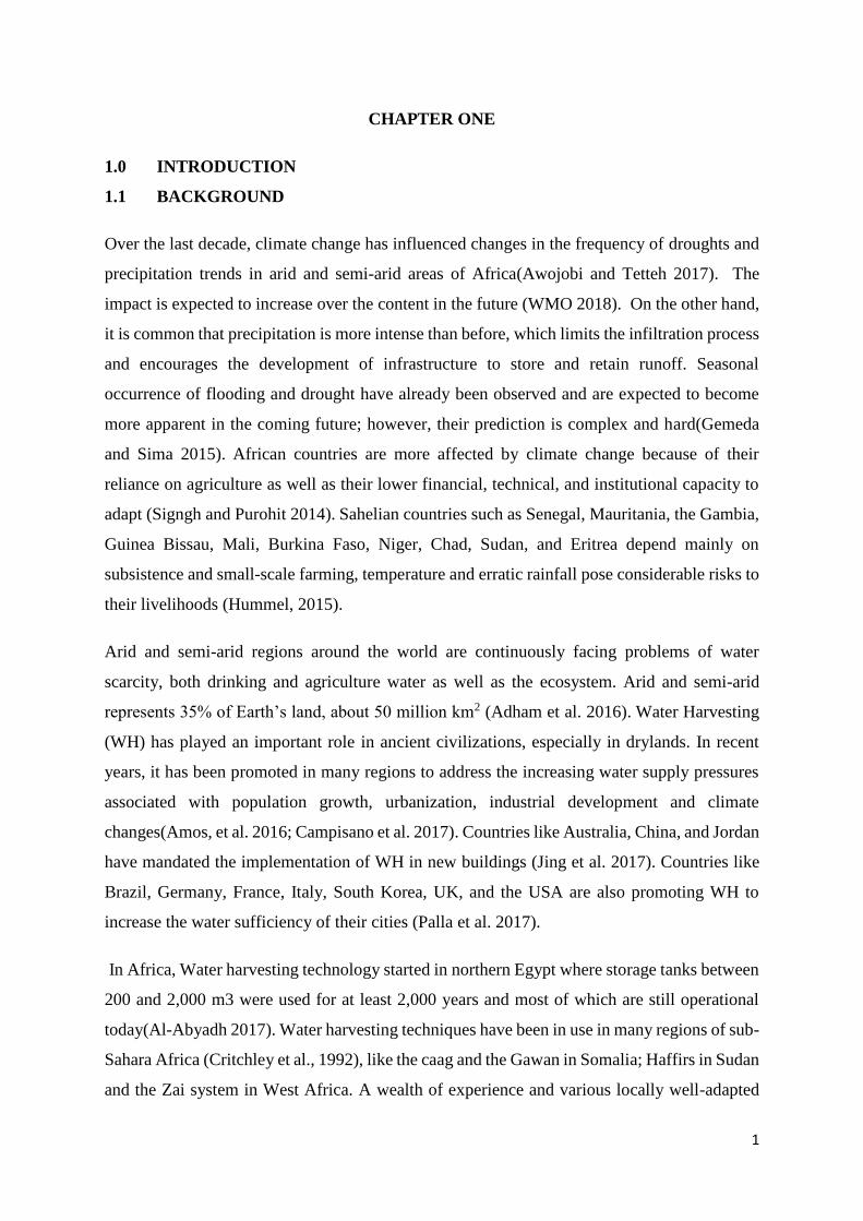
Over the last decade, climate change has influenced changes in the frequency of droughts and
precipitation trends in arid and semi-arid areas of Africa(Awojobi and Tetteh 2017). The
impact is expected to increase over the content in the future (WMO 2018). On the other hand,
it is common that precipitation is more intense than before, which limits the infiltration process
and encourages the development of infrastructure to store and retain runoff. Seasonal
occurrence of flooding and drought have already been observed and are expected to become
more apparent in the coming future; however, their prediction is complex and hard(Gemeda
and Sima 2015). African countries are more affected by climate change because of their
reliance on agriculture as well as their lower financial, technical, and institutional capacity to
adapt (Signgh and Purohit 2014). Sahelian countries such as Senegal, Mauritania, the Gambia,
Guinea Bissau, Mali, Burkina Faso, Niger, Chad, Sudan, and Eritrea depend mainly on
subsistence and small-scale farming, temperature and erratic rainfall pose considerable risks to
their livelihoods (Hummel, 2015).
Arid and semi-arid regions around the world are continuously facing problems of water
scarcity, both drinking and agriculture water as well as the ecosystem. Arid and semi-arid
represents 35% of Earth’s land, about 50 million km2 (Adham et al. 2016). Water Harvesting
(WH) has played an important role in ancient civilizations, especially in drylands. In recent
years, it has been promoted in many regions to address the increasing water supply pressures
associated with population growth, urbanization, industrial development and climate
changes(Amos, et al. 2016; Campisano et al. 2017). Countries like Australia, China, and Jordan
have mandated the implementation of WH in new buildings (Jing et al. 2017). Countries like
Brazil, Germany, France, Italy, South Korea, UK, and the USA are also promoting WH to
increase the water sufficiency of their cities (Palla et al. 2017).
In Africa, Water harvesting technology started in northern Egypt where storage tanks between
200 and 2,000 m3 were used for at least 2,000 years and most of which are still operational
today(Al-Abyadh 2017). Water harvesting techniques have been in use in many regions of sub-
Sahara Africa (Critchley et al., 1992), like the caag and the Gawan in Somalia; Haffirs in Sudan
and the Zai system in West Africa. A wealth of experience and various locally well-adapted
2
runoff farming were found in Morocco's Anti Atlas region (Prinz 1996). Traditional runoff
farming such as lacs collinaires, rainwater storage ponds are used for agriculture and open
ponds are mainly used for livestock. The largest tank in the world is likely the YerebatanSarayi
in Istanbul, Turkey which was constructed during the time of Caesar Justinian (AD 527- 565).
The size of the tank was estimated about 9800 m2 with a capacity of 80,000 m3. The ruins of
dams and storage tanks were found in Yemen in Yemen and the country’s spectacular mountain
terraces confirm a long history of water harvesting(Al-komaim 2018). The breakdown of the
Marib dam is mentioned in the Koran which is an evidence of water harvesting practices in the
history of Yemen. The concentration and collection of rainfall through storage use for
beneficial purposes is referred to as water harvesting (Salman 2017).
Only a few countries around the world have the natural and financial means to increase water
demands or can manage the available water resources efficiently in order to address water
scarcity issues and the importance of water-use efficiency increase in terms of US dollars per
cubic meters (US$/m3) of water(SDGs 2018). Based on the SDG report, more than 2 billion
people live in countries experiencing high water stress which affects the sustainability and
limits social and economic development (UN 2016). Countries living with high water stress
are Northern Africa, Western, Central and Southern Asia as well as Sub-Saharan
Africa(UNESCO 2019).
With the increase in population and the effects of climate change, the water stress is likely to
affect the demands for domestic water supply, livestock and agricultural production(Jayne and
Yeboah 2017). 70% of available water, as well as 90% of it in arid regions, is needed in
agricultural production in order to mitigate against food security and the availability of water
for human consumption and livestock is also decreasing drastically(Bangira 2018). Therefore,
there is a need to save a little fraction of water which can significantly alleviate water stress in
arid regions(World Bank Group 2018).
This study seeks to analyse the various water harvesting design and techniques in arid regions
in the light of adopting some of the techniques that have worked so far, specifically in Chad.
In addition, the techniques can also be extended to other arid regions of Africa through an
integrated approach.
3
1.2 PROBLEM STATEMENT
Climate change and aridity have affected the spatial and temporal distribution of rainfall
resulting in excess runoff which is lost through the environment and disappears before it can
be used (Rose 2015). Whether it is dedicated to consumption or to agriculture, the need for
water is indeed, a reality that no one can challenge. Millions of Sahelian still lack access to
water even though the Sahel has remarkable potential for water resources (Bewket, 2012). The
pastoral situation was characterized by very low availability of natural pastures in pastoral areas
of Sahelian countries. Livestock continues to feed with the residual forage mass-produced
during the rainy season(Zalagou, Binta and Abdoul Aziz 2018).
The growing shortage affecting the most valuable resource of our planet is brutally reminded
by Cape Town, South Africa, which made the headlines by declaring to be preparing for “Day
Zero", that day when the tap of the city will be dried(Nissen-petersen 2010; J R C 2018).
For instance in Chad, areas with high agricultural potential suffer from a delay in the onset of
the rainy season or sequences of a long dry period which affects the agricultural
production(FEWS NET 2018). Due to partial overwintering and poor rainfall distribution,
plantings to date are estimated at only 10 to 15 percent versus 25 to 30 percent in a normal
year. Poor households will not be able to meet their basic food needs. Water is scarce and
animals travel 5-10 km to reach pastoral wells. The lack of pasture that resulted in high forage
deficit would continue to degrade the physical condition of the livestock. This situation affects
the economy and the social activities of the population(USAID 2019). However, there is a need
to promote technology that will improve ways to increase drinking water supply, pastoral water
and improve the climate resilience of agricultural production systems.
In view of the current situation which affects most of the arid regions of Africa, It is strongly
felt that Water harvesting structures are the solution to overcome such water shortages in
regions with inadequate water by considering the feasibility studies.
1.3 Objectives of the study
1.3.1 Main Objectives
The main objective of this study is to analyse the various water harvesting practices in arid
regions and propose sustainable structures that incorporated the technical feasibility, economic
and socio-cultural acceptability to be implemented in Chad and other arid parts of Africa.
4
1.3.2 Specific objectives
The specific objectives of the study were to:
1) Assess the technical specification and design of WHSs,and identify best practices in
arid regions;
2) Assess both the institutional and beneficiaries’ financial capacity on proper Operation
and Maintenance (O&M) activities of the water harvesting structures;
3) Propose best practices of WHSs that is economically and financially affordable, and
socio-culturally acceptable in arid regions;
4) Develop a policy brief on WHSs sustainability in Chad and other arid regions of Africa.
1.4 Research Questions
1. What are the best practices of WHSs, design, techniques that have performed well to
meet water demand for humans, livestock and agricultural production?
2. What is the effective mechanism to enhance the institutional and beneficiaries’ financial
capacity on O&M to ensure the sustainability of WHSs?
3. Does the current WHSs consider the technical and economic feasibility and the
acceptability by the users?
4. What are the effective guidelines on water policy to ensure the sustainability of WHSs?
1.5 Hypothesis
1. There is now several good practices and experiences of WHSs and design that provide
water for the intended uses during the dry seasons.
2. Stakeholder participation in the planning, design, implementation, and O&M will
increase the effectiveness and assure sustainability of the WHSs.
3. Incorporating water harvesting techniques, cost-benefit and socio-cultural acceptability
will ensure sustainability.
4. Guidelines will serve as a means to ensure the sustainability of WHSs.
1.6 SCOPE OF THE STUDY
The ever-increasing pressures on water resources and chronic shortages that affect water
demand for food, humans, and livestock, water harvesting techniques can be employed as a
solution to increase the required water supply.
This study is restricted to the design and assessment of water harvesting techniques that have
performed well in arid regions, proper Operation and Maintenance of the techniques to ensure
5
capacity building of the Institutions, Water User Associations and the Beneficiaries, the
proposition of some of the techniques to be adopted in Chad and other arid regions of Africa.
It will also provide brief policy guidelines that will ensure the sustainable management of the
structures. This research will be conducted for a period of five to six months.
1.7 RELEVANCE OF THE STUDY
The population of the African continent is expected to increase from 1 billion to 3 billion by
2050 and 1 billion Africans already live under extreme poverty (Christopher 2016). The
population in Africa that suffers from a chronic shortage of water is estimated to 200 million,
one-quarter lack food and two-thirds of the population live in a rural area and depend on rainfed
agriculture which is limited by erratic water resources (UNDP 2018). Ninety-five percent of
the agriculture depends on rainfall but most of it is lost through evaporation and runoff without
being captured for use (Falkenmark 2016). Due to the current increase in temperature and
rainfall variability, the ever-increasing pressure on water resources will affect water needed for
agriculture growth, human beings, and livestock (UN-Water 2018).
Moreover, It will not be possible to achieve the SDGs (end hunger, food, poverty, health, water,
and sanitation) without an African water revolution (green water) (World Bank Group 2018).
Water harvesting innovation techniques under pan-Africanism ownership are proposed to
coordinate investments between private and public, funded by national and international
resources (Bangira 2018). As a strategy for African Green Water Plan, a minimum of USD 100
billion investments in green water will be needed to build resilience for food security and
human well-being.
However, it is clear that Africa has a vast untapped potential in water harvesting investments.
This study will provide a practical approach that will be needed to attract water harvesting
investments in Chad. In addition to that, the study will propose sustainable Water harvesting
structures to supplement water needed for agricultural growth, humans, and livestock, Improve
the socio-economic activities leading to job creation for African youths and women and
develop a policy brief that will enable the sustainability of water harvesting structures.
6
1.8 STRUCTURE OF THE THESIS
This research consisted of 5 chapters.
Chapter one gave a broad introduction to some key features of the study. It began with a
background overview of the impacts of climate change in Arid and Semi-arid regions, the
traditional use of water harvesting in arid and semi-arid regions and the regions facing water
stress. It also includes the problem statement, the objectives, research question, the hypothesis,
the rationale of the study and ended up with the structures of the thesis.
Chapter 2 reviewed the definitions of water harvesting, components of water harvesting
systems, classifications of water harvesting systems, types of water harvesting in Arid Regions,
the economic viability of water harvesting structures, O&M of water harvesting structures and
the benefits of water harvesting including policy on water harvesting structures.
Chapter 3 outlined the data and methods employed for the research and It also described the
geographical location, Vegetation and Flora, Climate, Hydrography of the study area and the
Legal Framework on Chadian’s Water Regime.
Chapter 4 presented the results obtained from the field survey and desk study, the discussion
of results analyses of the study area and the brief policy developed for the sustainability of the
structures.
Chapter 5 concluded the study and recommended the way forward for future prospects of water
harvesting structures in Chad and other arid regions of Africa.
7
CHAPTER TWO
2.0 LITERATURE REVIEW
2.1 Definitions of Water Harvesting
Water harvesting (WH) is the collection and storage of rainwater and runoff in a natural or
artificial storage facility to be used instantly or before the beginning of next season(Tobin and
Asogun 2013) to provide water needs for humans and livestock consumption, the irrigation of
annual crops, pastures and trees and for groundwater recharge(Bunclark et al. 2018).WH
comprises all forms of activities where water is harnessed, stored and used either in the blue or
green form. It involves the direct collection of rain that falls onto the roofs, grounds and runs
off, as well as floodwater harvesting(Haile and Merga 2002). There are many ways in which
WH can be achieved, and the collected water is stored in cisterns, micro-catchment, macro-
catchment or use for groundwater recharge(FAO 2015). However, there is a difference between
rainwater harvesting and water harvesting: rainwater harvesting is harnessing and storing
runoff water on the surfaces that rain has directly fallen onto while WH is the gathering and
concentration of any form of water, which can be runoff or creek flow for multiple usages. WH
is also known as the process of collecting and storing runoff water for productive and beneficial
use with different types of techniques and structures to increase the availability of surface water
and recharge groundwater in dry areas(Ziadat et al. 2012).
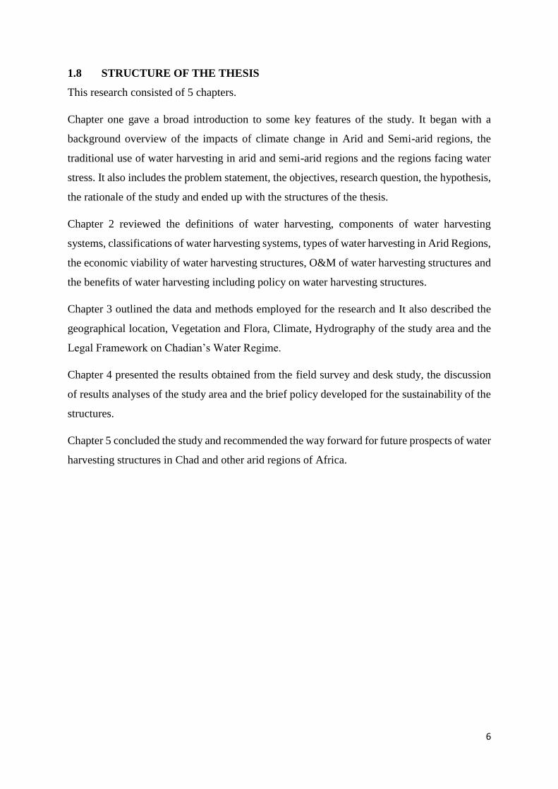
2.2 Components of Water Harvesting Systems
Water harvesting systems (WHSs) consist of a catchment area, storage facility and the target
area or application area(Dwiratna et al. 2018). Sometimes a conveyance system is needed to
move the water from the catchment area to the storage facility and then the target area(HARB
2015). They may be cases where the components are made adjacent to each other or
conveyance is needed in other cases (Figure 1)(Prinz 2013). The storage facility and the target
area may be the same in the case where water is stored in the soil profile for direct uptake by
the plants.
The Catchment area also called runoff area: it is an area of land where runoff is stored and
flowed downstream in regions or locations where the runoff is needed for use or where the
slope is fit for the runoff to be carried(Tasawwar 2018). It is also referred to as the portion of
land where all or part of the precipitation runs off to the limits of an area. It varies from micro-
catchment (a few square meters) to macro-catchment (as large as several square kilometers).
8
The limit of the land can be a rooftop, paved road, agricultural and non-agricultural land,
complex basement, natural slopes or even a marginal land(Hamid and Nordin 2011).
The storage facility is the most expensive component of a water harvesting system(Lee and
Kim 2013). Therefore, careful design analysis is preferred to choose an optimal capacity of a
storage surface adapted to the local conditions of the area (availability of materials and skills)
with the cheapest possible cost(Lade 2013). It is defined as the place where runoff is harnessed
and held from the catchment area at the time when it occurs until it is made available for potable
and non-potable uses. It can be used for human and animal consumption, agricultural
production as well as other uses. The Storage system can be surface tanks, jars, dams, reservoirs
or ponds; underground reservoirs as cisterns, groundwater recharge ponds and water storage in
the soil profile as soil moisture (Gould and Nissen-Petersen, 2003).
Target area: This is the place where the harvested water is made available either for domestic
use (human consumption and other domestic uses), for livestock consumption and agricultural
production including supplemental irrigation(Malesu 2006).
Conveyance system: In the case of overland flow, runoff is transported through rill, gully, and
natural channel, an artificial channel which is stored in the soil or into specifically designed
storage systems. However, for rooftop WH, runoff is conveyed through gutters and pipes(Mati
et al. 2005).
Figure 2. 1 the components of two water harvesting systems: a) catchment area, storage facility
and application area are linked by a conveyance system) catchment area, storage and target
area. (source: Prinz 2013; Dwiratna et al. 2018)
Storage
Catchment
(Roof/Ground)
Target
area
Runoff
a
)
b
)
9
2.3 Classification of water harvesting systems
The criteria mostly used to classify water harvesting systems (WHSs) are the runoff generating
process, catchment area and size, and the type of water storage facility. Rainfall, rivers and
lakes are considered as the runoff generating processes (Oweis et al. 2012; Tuinhof et al. 2012).
The storage facility could be within a soil profile, a cistern or a reservoir and the size of the
water storage determines whether the system is a micro or macro scheme. There are mainly
three (3) categories of WHSs that have been developed and practiced over the years. The
categorization of each WHSs depends on the method and technique employed to supplement
water needs for the intended use (Mekdaschi and Liniger 2013). The catchment size, the
method of the water storage system and the final use are taken into account to categorize the
WHSs. Hence, the three (3) classes of WHSs include Floodwater Harvesting (FWH),
Rainwater Harvesting (RWH) and the Groundwater Harvesting (GWH)(Bunclark et al. 2018).
2.3.1 Floodwater harvesting
The collection and storage of temporary channel flow for irrigating crops, fodder, and trees,
and for groundwater recharge are referred to as floodwater harvesting (FWH). Water spreading
or spate irrigation is the term used instead of FWH. The main characteristics of FWH are the
concentration of a turbulent ephemeral channel flow either by diverting spate flow from rivers
and large gullies or using natural flooding or impounding water within valley floor/Channel
bed (Pereira et al. 2002). Generally, the annual rainfall ranges from 100-700 mm. FWH is an
option to provide optimal water use during flood events in areas where the evaporation rate
exceeds the annual rainfall (Van Steenbergen et.al. 2010). The catchment area varies from 2 to
50 km2 in size and the catchment area ratio is 100:1 to 10,000:1. There are two (2) types of
FWH systems which are: FWH diversion system and Wadi bed system (Ratsey, 2011).
2.3.1.1 Floodwater diversion system
Spate irrigation is generally the alternative name of the floodwater diversion system. In this
system, the channel water flow is either forced to leave its natural course or transported to the
closed by fields or overflow the channel bank of a river or stream to flood farmlands as an
irrigation method (Majdoub et al. 2014).
2.3.1.2 Wadi bed system
Wadi bed system or floodwater within a streambed is a system whereby,(Oweis, Prinz, and
Hachum 2013) the water flow is blocked either on the surface to inundate the valley of a flood
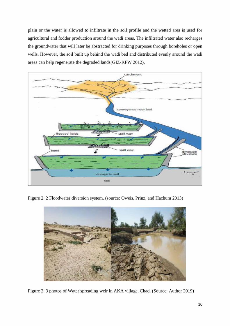
10
plain or the water is allowed to infiltrate in the soil profile and the wetted area is used for
agricultural and fodder production around the wadi areas. The infiltrated water also recharges
the groundwater that will later be abstracted for drinking purposes through boreholes or open
wells. However, the soil built up behind the wadi bed and distributed evenly around the wadi
areas can help regenerate the degraded lands(GIZ-KFW 2012).
Figure 2. 2 Floodwater diversion system. (source: Oweis, Prinz, and Hachum 2013)
Figure 2. 3 photos of Water spreading weir in AKA village, Chad. (Source: Author 2019)

11
2.3.2 Groundwater harvesting
Groundwater harvesting (GWH) involves the methods and techniques used to abstract water
from the ground for productive and beneficial use. It encompasses all methods, traditional or
contemporary of WH and has been used as a storage method for other forms of WHSs such as
FWH and RWH (Rockström 2002). However, many of these techniques require a particular
terrain to force the water leaves its original course and infiltrate into the soil that later will be
used for crop production, human and animal consumption. Underground dams, sand dams,
wells, cisterns and aquifers have been used as traditional methods for GWH. Wells such as
open wells which are artificial holes dug to reach the groundwater table. This type of wells still
in practice up to date. They were probably the first structures used in many regions of the world
to exploit the groundwater (Van Steenbergen and Tuinhof 2009).
2.3.2.1 Dams
The abstraction of groundwater from the soil profile, either trapped in shallow layers of sand
or from the water table constitutes an interesting practice of WH. Storing water beneath the
ground surface is an attractive way of harnessing water (SIWI 2001). It reduces evaporation
losses from the ground surface and also improves the quality of the water. Sand dams and
subsurface dams where water is impounded behind a small wall in a sandy riverbed in an
effective and cheap form of WH (Ibrahim 2012).
2.3.2.2 Water Wells
Water wells are artificial holes that reach the groundwater table. They were probably the first
hand-dug shallow wells that were dug in the beds of temporary streams or wadi beds to tap the
water from the ground to the surface (Issar 2001). The use of water wells has been practiced
over many years, dating back to 8100-7500 BC. Wells are forms of WH that have employed to
meet the water needs for crop production, human and livestock consumption in a particular
region (Mays 2010b). Modem technologies have increased the return from wells, making it
easier to obtain groundwater.
2.3.2.3 Cisterns
Cisterns are artificial underground or caves built to store water. The walls of these cisterns are
always plastered to prevent evaporation, deep percolation. The underground cisterns are made
to supply water for domestic and agricultural purposes in areas liable to droughts. There are
two types of cisterns, one is shaped like a bottle and the other has a circular shape. The ground
12
is excavated in a way that forms the shapes of the cisterns. The surface of the cisterns is covered
with polyethylene or plastered with concrete to prevent seepage. The two (2) types of cisterns
are often expensive and difficult to construct. Farmers cannot build them because of their
complexity (Alem 2003).
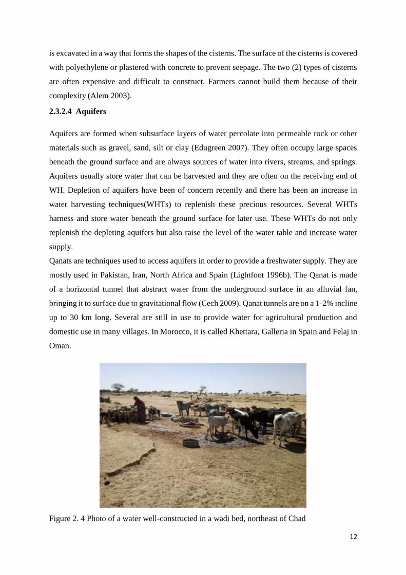
2.3.2.4 Aquifers
Aquifers are formed when subsurface layers of water percolate into permeable rock or other
materials such as gravel, sand, silt or clay (Edugreen 2007). They often occupy large spaces
beneath the ground surface and are always sources of water into rivers, streams, and springs.
Aquifers usually store water that can be harvested and they are often on the receiving end of
WH. Depletion of aquifers have been of concern recently and there has been an increase in
water harvesting techniques(WHTs) to replenish these precious resources. Several WHTs
harness and store water beneath the ground surface for later use. These WHTs do not only
replenish the depleting aquifers but also raise the level of the water table and increase water
supply.
Qanats are techniques used to access aquifers in order to provide a freshwater supply. They are
mostly used in Pakistan, Iran, North Africa and Spain (Lightfoot 1996b). The Qanat is made
of a horizontal tunnel that abstract water from the underground surface in an alluvial fan,
bringing it to surface due to gravitational flow (Cech 2009). Qanat tunnels are on a 1-2% incline
up to 30 km long. Several are still in use to provide water for agricultural production and
domestic use in many villages. In Morocco, it is called Khettara, Galleria in Spain and Felaj in
Oman.
Figure 2. 4 Photo of a water well-constructed in a wadi bed, northeast of Chad
13
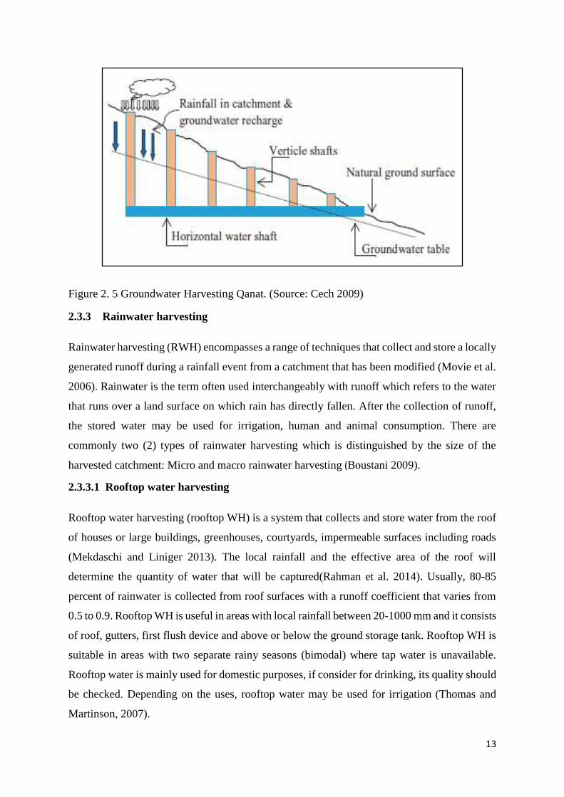
Figure 2. 5 Groundwater Harvesting Qanat. (Source: Cech 2009)
2.3.3 Rainwater harvesting
Rainwater harvesting (RWH) encompasses a range of techniques that collect and store a locally
generated runoff during a rainfall event from a catchment that has been modified (Movie et al.
2006). Rainwater is the term often used interchangeably with runoff which refers to the water
that runs over a land surface on which rain has directly fallen. After the collection of runoff,
the stored water may be used for irrigation, human and animal consumption. There are
commonly two (2) types of rainwater harvesting which is distinguished by the size of the
harvested catchment: Micro and macro rainwater harvesting (Boustani 2009).
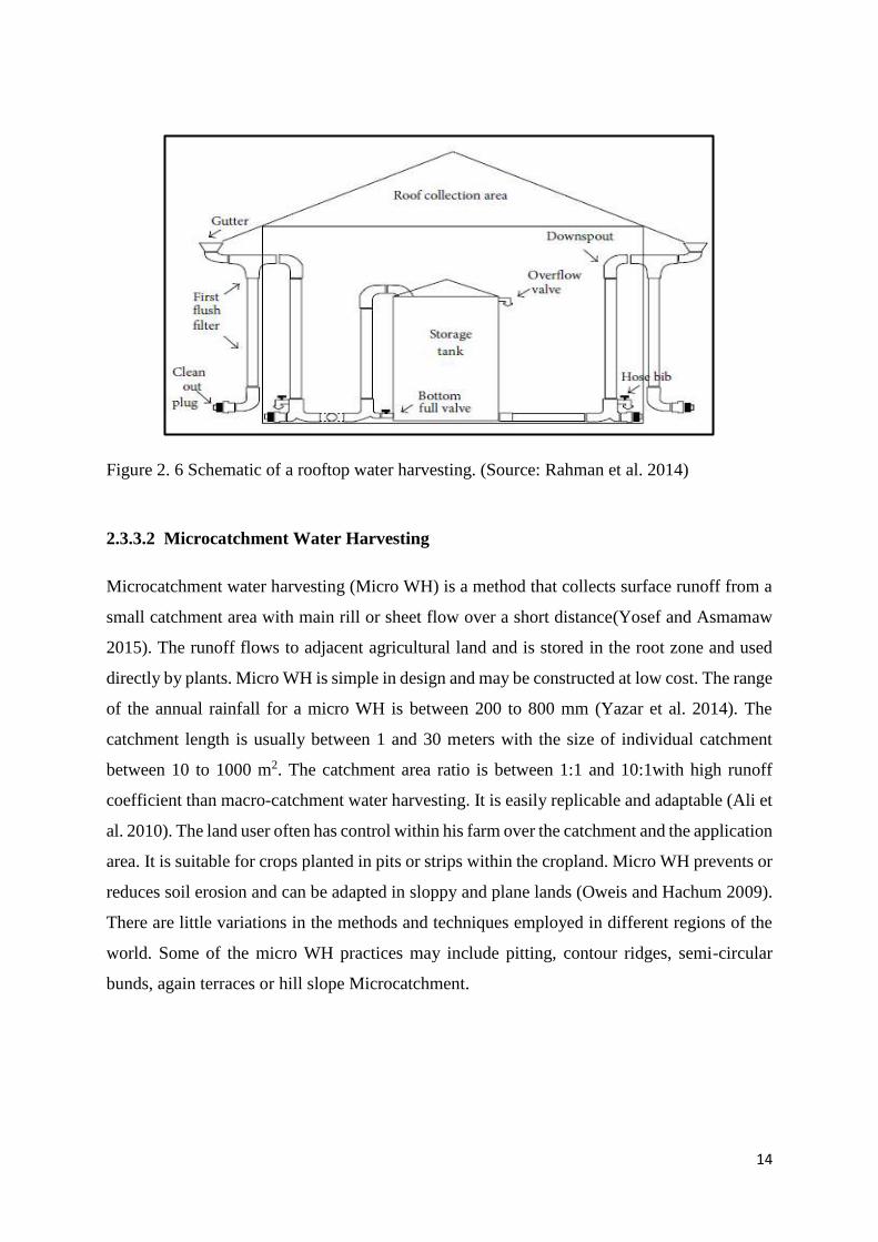
2.3.3.1 Rooftop water harvesting
Rooftop water harvesting (rooftop WH) is a system that collects and store water from the roof
of houses or large buildings, greenhouses, courtyards, impermeable surfaces including roads
(Mekdaschi and Liniger 2013). The local rainfall and the effective area of the roof will
determine the quantity of water that will be captured(Rahman et al. 2014). Usually, 80-85
percent of rainwater is collected from roof surfaces with a runoff coefficient that varies from
0.5 to 0.9. Rooftop WH is useful in areas with local rainfall between 20-1000 mm and it consists
of roof, gutters, first flush device and above or below the ground storage tank. Rooftop WH is
suitable in areas with two separate rainy seasons (bimodal) where tap water is unavailable.
Rooftop water is mainly used for domestic purposes, if consider for drinking, its quality should
be checked. Depending on the uses, rooftop water may be used for irrigation (Thomas and
Martinson, 2007).
14
Figure 2. 6 Schematic of a rooftop water harvesting. (Source: Rahman et al. 2014)
2.3.3.2 Microcatchment Water Harvesting
Microcatchment water harvesting (Micro WH) is a method that collects surface runoff from a
small catchment area with main rill or sheet flow over a short distance(Yosef and Asmamaw
2015). The runoff flows to adjacent agricultural land and is stored in the root zone and used
directly by plants. Micro WH is simple in design and may be constructed at low cost. The range
of the annual rainfall for a micro WH is between 200 to 800 mm (Yazar et al. 2014). The
catchment length is usually between 1 and 30 meters with the size of individual catchment
between 10 to 1000 m2. The catchment area ratio is between 1:1 and 10:1with high runoff
coefficient than macro-catchment water harvesting. It is easily replicable and adaptable (Ali et
al. 2010). The land user often has control within his farm over the catchment and the application
area. It is suitable for crops planted in pits or strips within the cropland. Micro WH prevents or
reduces soil erosion and can be adapted in sloppy and plane lands (Oweis and Hachum 2009).
There are little variations in the methods and techniques employed in different regions of the
world. Some of the micro WH practices may include pitting, contour ridges, semi-circular
bunds, again terraces or hill slope Microcatchment.
15
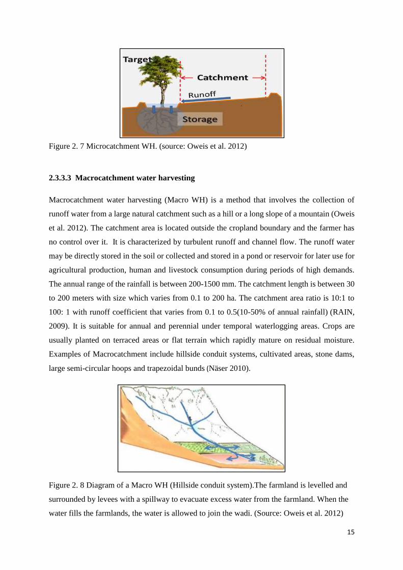
Figure 2. 7 Microcatchment WH. (source: Oweis et al. 2012)
2.3.3.3 Macrocatchment water harvesting
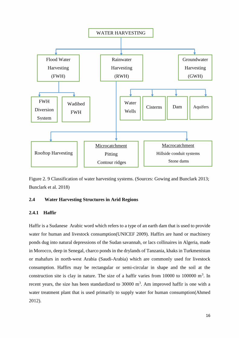
Macrocatchment water harvesting (Macro WH) is a method that involves the collection of
runoff water from a large natural catchment such as a hill or a long slope of a mountain (Oweis
et al. 2012). The catchment area is located outside the cropland boundary and the farmer has
no control over it. It is characterized by turbulent runoff and channel flow. The runoff water
may be directly stored in the soil or collected and stored in a pond or reservoir for later use for
agricultural production, human and livestock consumption during periods of high demands.
The annual range of the rainfall is between 200-1500 mm. The catchment length is between 30
to 200 meters with size which varies from 0.1 to 200 ha. The catchment area ratio is 10:1 to
100: 1 with runoff coefficient that varies from 0.1 to 0.5(10-50% of annual rainfall) (RAIN,
2009). It is suitable for annual and perennial under temporal waterlogging areas. Crops are
usually planted on terraced areas or flat terrain which rapidly mature on residual moisture.
Examples of Macrocatchment include hillside conduit systems, cultivated areas, stone dams,
large semi-circular hoops and trapezoidal bunds (Näser 2010).
Figure 2. 8 Diagram of a Macro WH (Hillside conduit system).The farmland is levelled and
surrounded by levees with a spillway to evacuate excess water from the farmland. When the
water fills the farmlands, the water is allowed to join the wadi. (Source: Oweis et al. 2012)
16
Figure 2. 9 Classification of water harvesting systems. (Sources: Gowing and Bunclark 2013;
Bunclark et al. 2018)
2.4 Water Harvesting Structures in Arid Regions
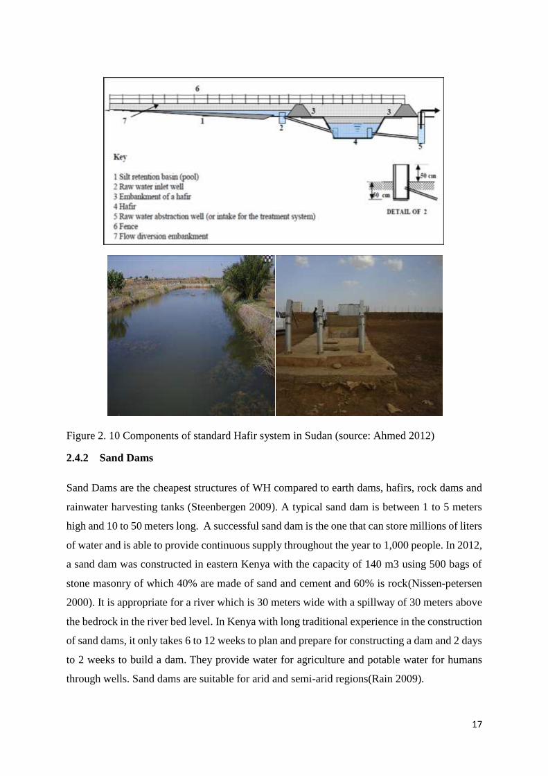
2.4.1 Haffir
Haffir is a Sudanese Arabic word which refers to a type of an earth dam that is used to provide
water for human and livestock consumption(UNICEF 2009). Haffirs are hand or machinery
ponds dug into natural depressions of the Sudan savannah, or lacs collinaires in Algeria, made
in Morocco, deep in Senegal, charco ponds in the drylands of Tanzania, khaks in Turkmenistan
or mahafurs in north-west Arabia (Saudi-Arabia) which are commonly used for livestock
consumption. Haffirs may be rectangular or semi-circular in shape and the soil at the
construction site is clay in nature. The size of a haffir varies from 10000 to 100000 m3. In
recent years, the size has been standardized to 30000 m3. Am improved haffir is one with a
water treatment plant that is used primarily to supply water for human consumption(Ahmed
2012).
WATER HARVESTING
Flood Water
Harvesting
(FWH)
Rainwater
Harvesting
(RWH)
Groundwater
Harvesting
(GWH)
Microcatchment
Pitting
Contour ridges
Rooftop Harvesting
Macrocatchment
Hillside conduit systems
Stone dams
Wadibed
FWH
FWH
Diversion
System
Dam Water
Wells Cisterns Aquifers
17
Figure 2. 10 Components of standard Hafir system in Sudan (source: Ahmed 2012)
2.4.2 Sand Dams
Sand Dams are the cheapest structures of WH compared to earth dams, hafirs, rock dams and
rainwater harvesting tanks (Steenbergen 2009). A typical sand dam is between 1 to 5 meters
high and 10 to 50 meters long. A successful sand dam is the one that can store millions of liters
of water and is able to provide continuous supply throughout the year to 1,000 people. In 2012,
a sand dam was constructed in eastern Kenya with the capacity of 140 m3 using 500 bags of
stone masonry of which 40% are made of sand and cement and 60% is rock(Nissen-petersen
2000). It is appropriate for a river which is 30 meters wide with a spillway of 30 meters above
the bedrock in the river bed level. In Kenya with long traditional experience in the construction
of sand dams, it only takes 6 to 12 weeks to plan and prepare for constructing a dam and 2 days
to 2 weeks to build a dam. They provide water for agriculture and potable water for humans
through wells. Sand dams are suitable for arid and semi-arid regions(Rain 2009).
18
Figure 2. 11 A Sand dam in eastern Kenya. (Source: Rain 2009)
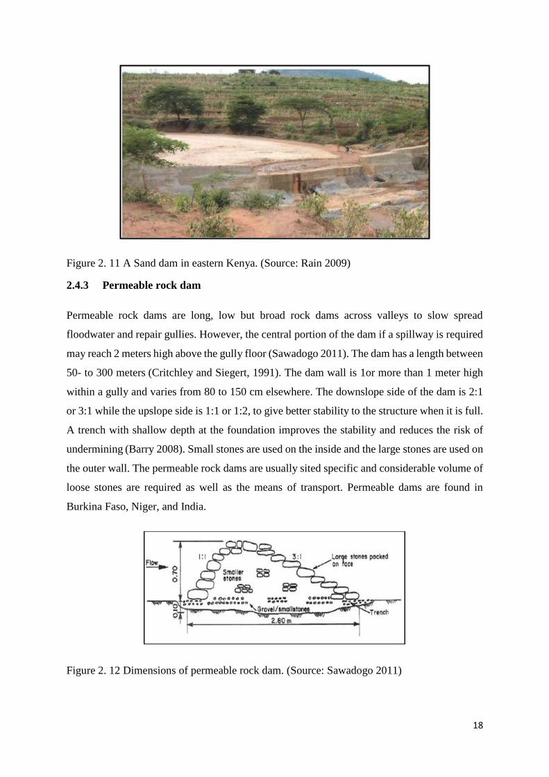
2.4.3 Permeable rock dam
Permeable rock dams are long, low but broad rock dams across valleys to slow spread
floodwater and repair gullies. However, the central portion of the dam if a spillway is required
may reach 2 meters high above the gully floor (Sawadogo 2011). The dam has a length between
50- to 300 meters (Critchley and Siegert, 1991). The dam wall is 1or more than 1 meter high
within a gully and varies from 80 to 150 cm elsewhere. The downslope side of the dam is 2:1
or 3:1 while the upslope side is 1:1 or 1:2, to give better stability to the structure when it is full.
A trench with shallow depth at the foundation improves the stability and reduces the risk of
undermining (Barry 2008). Small stones are used on the inside and the large stones are used on
the outer wall. The permeable rock dams are usually sited specific and considerable volume of
loose stones are required as well as the means of transport. Permeable dams are found in
Burkina Faso, Niger, and India.
Figure 2. 12 Dimensions of permeable rock dam. (Source: Sawadogo 2011)
19
2.4.4 Planting pits
Planting pits are small basins planted with a few seeds of annual or perennial crops. The pits
have different sizes, shapes and densities (pits/ha) (Critchley and Mutunga 2001). They are
usually 20-30 cm wide and 20-30 cm deep and spaced 60 cm – 1 m apart. The catchment area
ratio is 3:1. Pits are dug by hand. Manure or fertilizer are often added to the pit. The dug earth
is placed downslope of the pit and may be formed into a small ridge to capture rainfall and
runoff effectively (Mati 2005). Pits are often combined with stones lines to regenerate
cultivated areas that have been degraded. Planting pits are applied on slope land of 0 to 5% that
receives rainfall of 350 to 600 mm/yr. They are called tassa in Niger, Zai pits in Burkina Faso,
Chololo pits in Tanzania, gun pits in Sudan, kofyar in Nigeria, Yamka in Kyrgyzstan
(Ouédraogo and Sawadogo 2001).
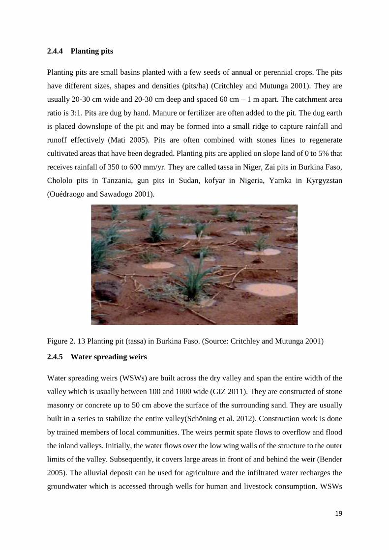
Figure 2. 13 Planting pit (tassa) in Burkina Faso. (Source: Critchley and Mutunga 2001)
2.4.5 Water spreading weirs
Water spreading weirs (WSWs) are built across the dry valley and span the entire width of the
valley which is usually between 100 and 1000 wide (GIZ 2011). They are constructed of stone
masonry or concrete up to 50 cm above the surface of the surrounding sand. They are usually
built in a series to stabilize the entire valley(Schöning et al. 2012). Construction work is done
by trained members of local communities. The weirs permit spate flows to overflow and flood
the inland valleys. Initially, the water flows over the low wing walls of the structure to the outer
limits of the valley. Subsequently, it covers large areas in front of and behind the weir (Bender
2005). The alluvial deposit can be used for agriculture and the infiltrated water recharges the
groundwater which is accessed through wells for human and livestock consumption. WSWs
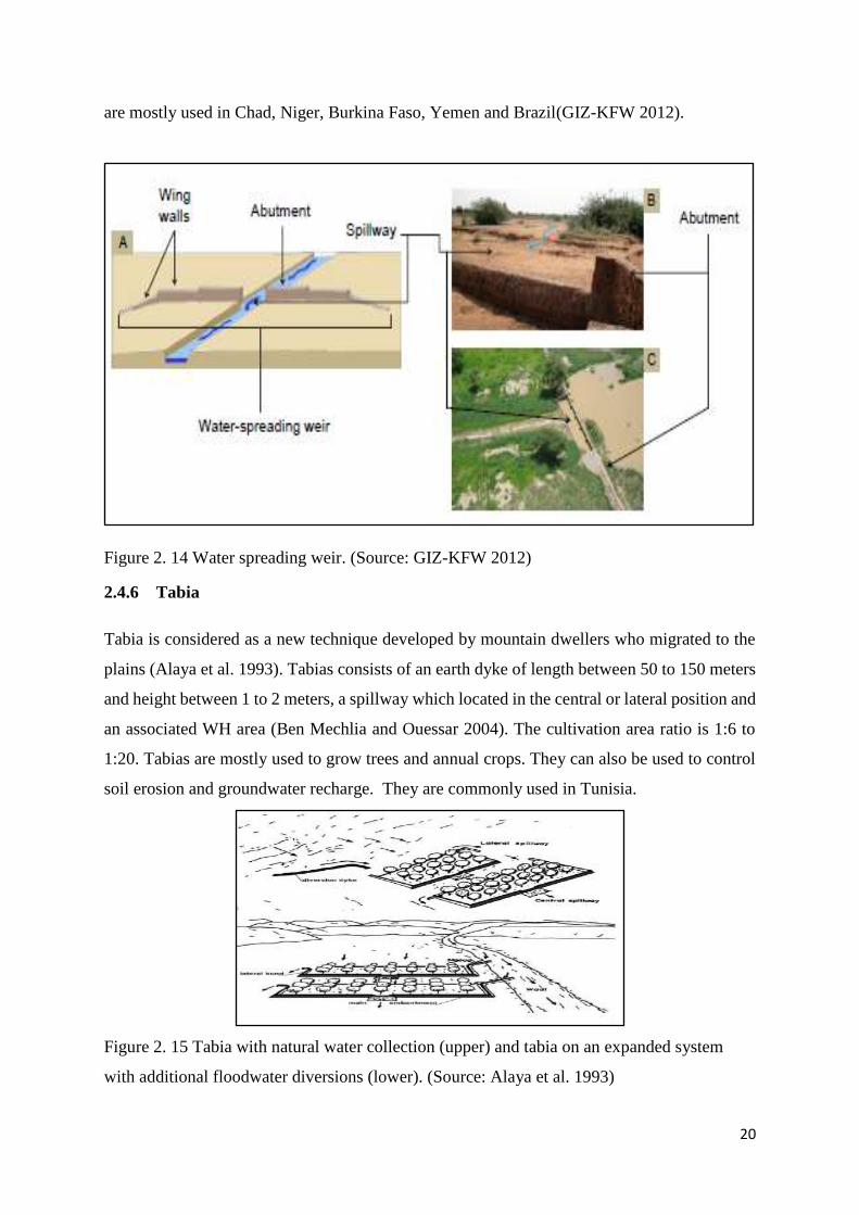
20
are mostly used in Chad, Niger, Burkina Faso, Yemen and Brazil(GIZ-KFW 2012).
Figure 2. 14 Water spreading weir. (Source: GIZ-KFW 2012)
2.4.6 Tabia
Tabia is considered as a new technique developed by mountain dwellers who migrated to the
plains (Alaya et al. 1993). Tabias consists of an earth dyke of length between 50 to 150 meters
and height between 1 to 2 meters, a spillway which located in the central or lateral position and
an associated WH area (Ben Mechlia and Ouessar 2004). The cultivation area ratio is 1:6 to
1:20. Tabias are mostly used to grow trees and annual crops. They can also be used to control
soil erosion and groundwater recharge. They are commonly used in Tunisia.
Figure 2. 15 Tabia with natural water collection (upper) and tabia on an expanded system
with additional floodwater diversions (lower). (Source: Alaya et al. 1993)
21
2.4.7 Hillside runoff/Conduit system
This system is suitable in hilly or mountainous regions with an annual rainfall of 100 to 600
mm/year. The catchment to application ratios(C:A) is 10:1 to 100: 1,it can reach 175:1 (Prinz
2011).Concentrated runoff water on a slope greater than 10% is guided through small conduits
and deliver to flatlands at the foot of the between 0 to 10%. Farmlands are levelled and
surrounded by impounding walls with a spillway to drain excess water downstream farmlands.
This type of structure is called sylaba in Pakistan, caag in Somalia and takyr cultivation in
Turkmenistan. The system is also practiced in Israel (Liniger 2007).
Figure 2. 16 Hillside runoff system. (Source: Prinz, 2011)
2.4.8 Trapezoidal bunds
They consist of earthen bunds with base bunds, connected to two side bunds at an angle of
about 135° and a distance between the tips of 10 to 100 meters on a slope of land between 0 to
10%. The excess water is discharged around the tips of the side bunds (Taamallah 2010). They
are often constructed using machinery and the wings of the side bunds are usually reinforced
with stone. They are suitable in areas with an annual rainfall of 200 to 400 mm with a catchment
area ratio of 15:1 to 100:1. The structures collect runoff water from outside catchments upslope
and are used for annual and perennial crops as well as pastures (Oweis et al., 2012).
Figure 2. 17 Sketch of a trapezoidal bund. (Source: Taamallah 2010)
22
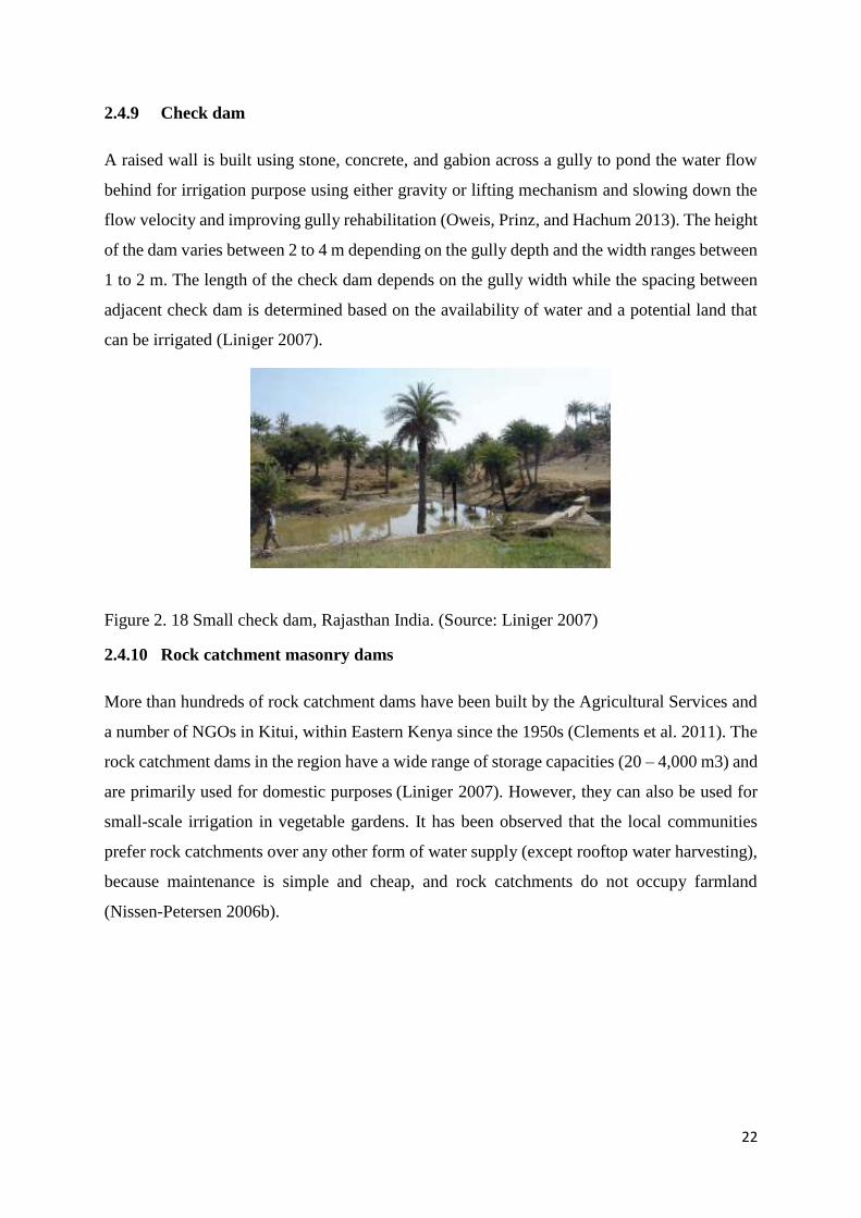
2.4.9 Check dam
A raised wall is built using stone, concrete, and gabion across a gully to pond the water flow
behind for irrigation purpose using either gravity or lifting mechanism and slowing down the
flow velocity and improving gully rehabilitation (Oweis, Prinz, and Hachum 2013). The height
of the dam varies between 2 to 4 m depending on the gully depth and the width ranges between
1 to 2 m. The length of the check dam depends on the gully width while the spacing between
adjacent check dam is determined based on the availability of water and a potential land that
can be irrigated (Liniger 2007).
Figure 2. 18 Small check dam, Rajasthan India. (Source: Liniger 2007)
2.4.10 Rock catchment masonry dams
More than hundreds of rock catchment dams have been built by the Agricultural Services and
a number of NGOs in Kitui, within Eastern Kenya since the 1950s (Clements et al. 2011). The
rock catchment dams in the region have a wide range of storage capacities (20 – 4,000 m3) and
are primarily used for domestic purposes (Liniger 2007). However, they can also be used for
small-scale irrigation in vegetable gardens. It has been observed that the local communities
prefer rock catchments over any other form of water supply (except rooftop water harvesting),
because maintenance is simple and cheap, and rock catchments do not occupy farmland
(Nissen-Petersen 2006b).
23
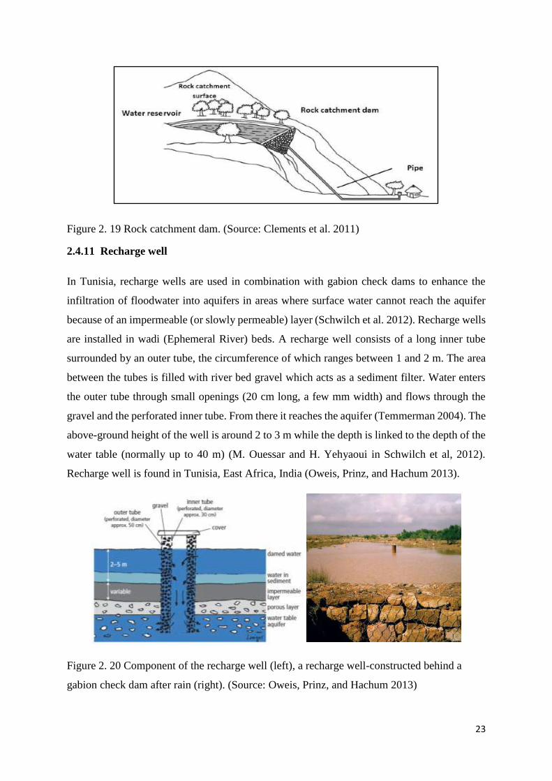
Figure 2. 19 Rock catchment dam. (Source: Clements et al. 2011)
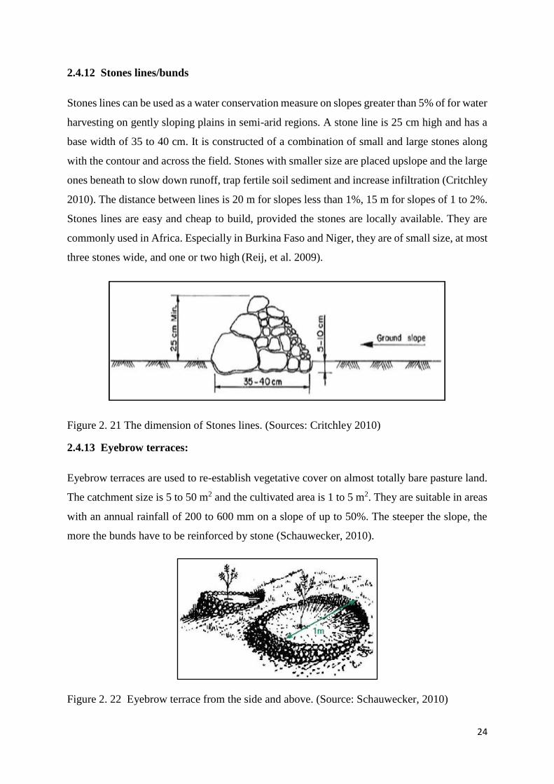
2.4.11 Recharge well
In Tunisia, recharge wells are used in combination with gabion check dams to enhance the
infiltration of floodwater into aquifers in areas where surface water cannot reach the aquifer
because of an impermeable (or slowly permeable) layer (Schwilch et al. 2012). Recharge wells
are installed in wadi (Ephemeral River) beds. A recharge well consists of a long inner tube
surrounded by an outer tube, the circumference of which ranges between 1 and 2 m. The area
between the tubes is filled with river bed gravel which acts as a sediment filter. Water enters
the outer tube through small openings (20 cm long, a few mm width) and flows through the
gravel and the perforated inner tube. From there it reaches the aquifer (Temmerman 2004). The
above-ground height of the well is around 2 to 3 m while the depth is linked to the depth of the
water table (normally up to 40 m) (M. Ouessar and H. Yehyaoui in Schwilch et al, 2012).
Recharge well is found in Tunisia, East Africa, India (Oweis, Prinz, and Hachum 2013).
Figure 2. 20 Component of the recharge well (left), a recharge well-constructed behind a
gabion check dam after rain (right). (Source: Oweis, Prinz, and Hachum 2013)
24
2.4.12 Stones lines/bunds
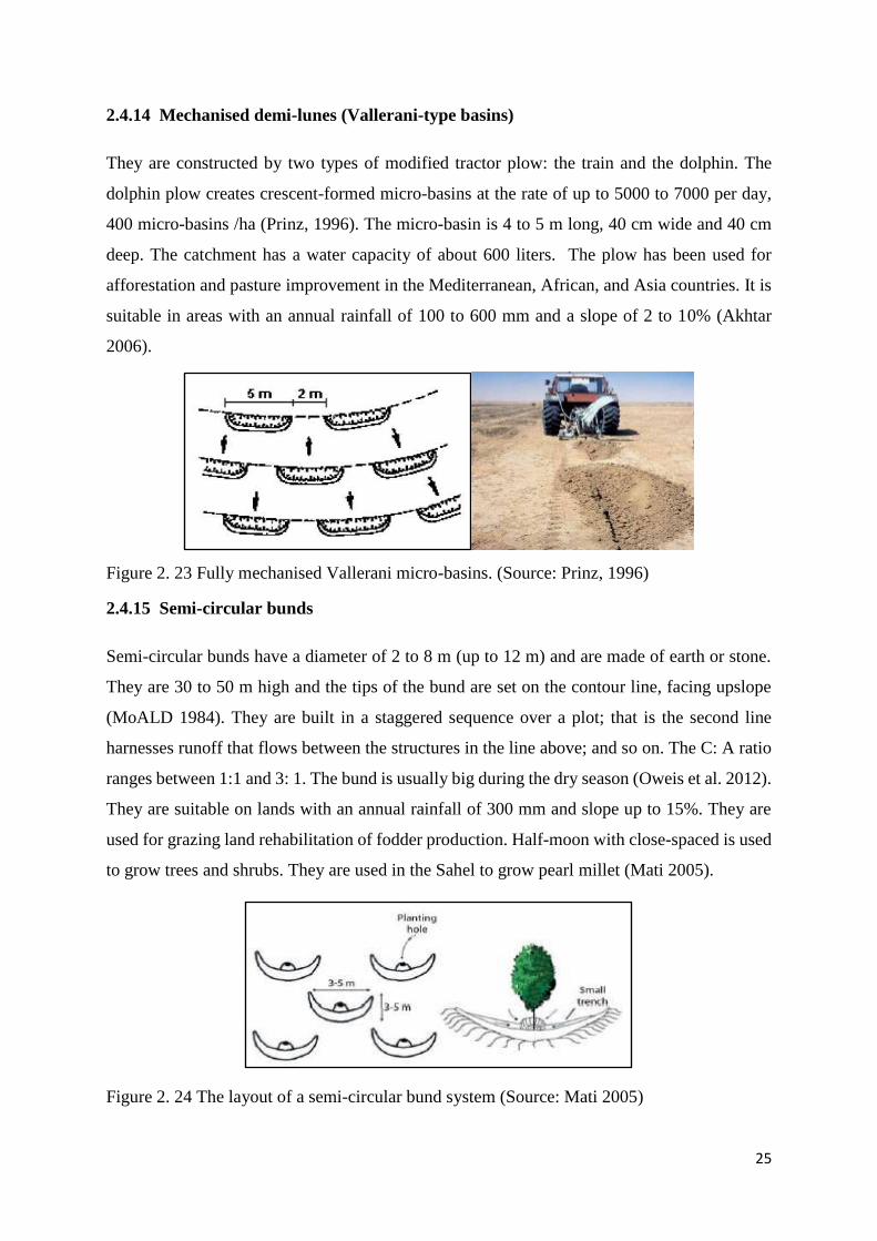
Stones lines can be used as a water conservation measure on slopes greater than 5% of for water
harvesting on gently sloping plains in semi-arid regions. A stone line is 25 cm high and has a
base width of 35 to 40 cm. It is constructed of a combination of small and large stones along
with the contour and across the field. Stones with smaller size are placed upslope and the large
ones beneath to slow down runoff, trap fertile soil sediment and increase infiltration (Critchley
2010). The distance between lines is 20 m for slopes less than 1%, 15 m for slopes of 1 to 2%.
Stones lines are easy and cheap to build, provided the stones are locally available. They are
commonly used in Africa. Especially in Burkina Faso and Niger, they are of small size, at most
three stones wide, and one or two high (Reij, et al. 2009).
Figure 2. 21 The dimension of Stones lines. (Sources: Critchley 2010)
2.4.13 Eyebrow terraces:
Eyebrow terraces are used to re-establish vegetative cover on almost totally bare pasture land.
The catchment size is 5 to 50 m2 and the cultivated area is 1 to 5 m2. They are suitable in areas
with an annual rainfall of 200 to 600 mm on a slope of up to 50%. The steeper the slope, the
more the bunds have to be reinforced by stone (Schauwecker, 2010).
Figure 2. 22 Eyebrow terrace from the side and above. (Source: Schauwecker, 2010)
25
2.4.14 Mechanised demi-lunes (Vallerani-type basins)
They are constructed by two types of modified tractor plow: the train and the dolphin. The
dolphin plow creates crescent-formed micro-basins at the rate of up to 5000 to 7000 per day,
400 micro-basins /ha (Prinz, 1996). The micro-basin is 4 to 5 m long, 40 cm wide and 40 cm
deep. The catchment has a water capacity of about 600 liters. The plow has been used for
afforestation and pasture improvement in the Mediterranean, African, and Asia countries. It is
suitable in areas with an annual rainfall of 100 to 600 mm and a slope of 2 to 10% (Akhtar
2006).
Figure 2. 23 Fully mechanised Vallerani micro-basins. (Source: Prinz, 1996)
2.4.15 Semi-circular bunds
Semi-circular bunds have a diameter of 2 to 8 m (up to 12 m) and are made of earth or stone.
They are 30 to 50 m high and the tips of the bund are set on the contour line, facing upslope
(MoALD 1984). They are built in a staggered sequence over a plot; that is the second line
harnesses runoff that flows between the structures in the line above; and so on. The C: A ratio
ranges between 1:1 and 3: 1. The bund is usually big during the dry season (Oweis et al. 2012).
They are suitable on lands with an annual rainfall of 300 mm and slope up to 15%. They are
used for grazing land rehabilitation of fodder production. Half-moon with close-spaced is used
to grow trees and shrubs. They are used in the Sahel to grow pearl millet (Mati 2005).
Figure 2. 24 The layout of a semi-circular bund system (Source: Mati 2005)
26
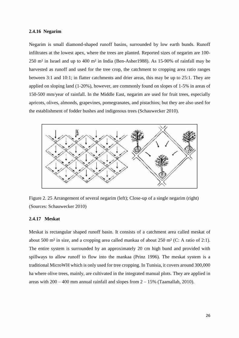
2.4.16 Negarim
Negarim is small diamond-shaped runoff basins, surrounded by low earth bunds. Runoff
infiltrates at the lowest apex, where the trees are planted. Reported sizes of negarim are 100-
250 m² in Israel and up to 400 m² in India (Ben-Asher1988). As 15-90% of rainfall may be
harvested as runoff and used for the tree crop, the catchment to cropping area ratio ranges
between 3:1 and 10:1; in flatter catchments and drier areas, this may be up to 25:1. They are
applied on sloping land (1-20%), however, are commonly found on slopes of 1-5% in areas of
150-500 mm/year of rainfall. In the Middle East, negarim are used for fruit trees, especially
apricots, olives, almonds, grapevines, pomegranates, and pistachios; but they are also used for
the establishment of fodder bushes and indigenous trees (Schauwecker 2010).
Figure 2. 25 Arrangement of several negarim (left); Close-up of a single negarim (right)
(Sources: Schauwecker 2010)
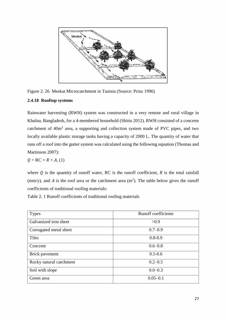
2.4.17 Meskat
Meskat is rectangular shaped runoff basin. It consists of a catchment area called meskat of
about 500 m² in size, and a cropping area called mankaa of about 250 m² (C: A ratio of 2:1).
The entire system is surrounded by an approximately 20 cm high bund and provided with
spillways to allow runoff to flow into the mankaa (Prinz 1996). The meskat system is a
traditional MicroWH which is only used for tree cropping. In Tunisia, it covers around 300,000
ha where olive trees, mainly, are cultivated in the integrated manual plots. They are applied in
areas with 200 – 400 mm annual rainfall and slopes from 2 – 15% (Taamallah, 2010).
27
Figure 2. 26 Meskat Microcatchment in Tunisia (Source: Prinz 1996)
2.4.18 Rooftop systems
Rainwater harvesting (RWH) system was constructed in a very remote and rural village in
Khulna, Bangladesh, for a 4-membered household (Shittu 2012). RWH consisted of a concrete
catchment of 40m2 area, a supporting and collection system made of PVC pipes, and two
locally available plastic storage tanks having a capacity of 2000 L. The quantity of water that
runs off a roof into the gutter system was calculated using the following equation (Thomas and
Martinson 2007):
𝑄 = RC × 𝑅 × 𝐴, (1)
where 𝑄 is the quantity of runoff water, RC is the runoff coefficient, 𝑅 is the total rainfall
(mm/y), and 𝐴 is the roof area or the catchment area (m2). The table below gives the runoff
coefficients of traditional roofing materials:
Table 2. 1 Runoff coefficients of traditional roofing materials
Types Runoff coefficients
Galvanized iron sheet >0.9
Corrugated metal sheet 0.7–0.9
Tiles 0.8-0.9
Concrete 0.6–0.8
Brick pavement 0.5-0.6
Rocky natural catchment 0.2–0.5
Soil with slope 0.0–0.3
Green area 0.05–0.1
28
For the study, RC was taken as 0.8, 𝑅 was 1800 mm/y (for Khulna region), and 𝐴 was 40m2,
the quantity of water (𝑄) was found to be 57.6m3/y (≈57600 L/y). Thus the amount of water to
be harvested was 157 L/day. Four months as rainy season was assumed, the amount of water
that could be harvested was 157 × 30 × 4 = 18840L, which was more than enough for storing
the required amount of water (3600 L) for drinking, cooking, and food preparation purposes
for the studied household(Biswas and Mandal 2014).
In Thailand, jars of 100 to 3000 liters are used to store water from the rooftop for drinking
purposes. A 2000 liters jar store a sufficient quantity of water to be used by the six-person
household during the dry season and it is the most commonly used (UNEP 2002).
Brick tanks of 25,000 liters are the most used water storage facility in Sri Lanka, Uganda, and
Nepal. The tanks are made of backed bricks, cut stones, compressed soil, bricks and concrete
quarry (Worm and Hattum 2006).
Ferro-cement tanks are made using a solid mold of either corrugated or flat galvanised steel
sheet made in curve section that bolt together forming a cylinder (Worm and Hattum 2006).
Mesh is wrapped around the mold and galvanised wire wound in a spiral around the tank with
spacing at the bottom and a larger space at the top. The mesh is then plastered over with mortar,
which is left to cure overnight. The form is then dismantled and the inside plastered with mortar
the straight cylinder design using sheet metal for the mold is the most used Ferro-cement tank.
They are used in South Africa, Sri Lanka and Thailand and Burkina Faso (Thomas and
Martinson 2007). Most of the rooftop tanks adopted in arid regions are mostly concrete tanks,
PVC tanks, impluvium tanks, fero cement tanks and CPVC tanks respectively(Salman 2017).
2.5 Economic Viability of Water Harvesting Structures
The use of planting pits in Burkina Faso increase the yield to 0.3 – 0.4 t/ha in a year of low
rainfall, and up to 1.5 t/ha in a year of good rainfall compare to zero yields without the pits.
Half-moons were used to grow sorghum grain, the yields were higher compared to normally
plowed fields on completely degraded soils. The same studies on ngoro pits in Tanzania
revealed that 2 m wide pits had the highest maize grain yield (1.85 t/ha) compared to 1 m wide
(1.44 t/ha) and 1.5 m wide pits(1.66 t/ha) (Malley et al., 2004). An earth dam constructed to
increase agricultural production of sorghum and tomato was modelled for study sites in Burkina
Faso and Kenya. Earth dam establishment resulted in a net profit of 626 US$/y/ ha for Burkina
Faso and 477 US$/y/ha for Kenya depending on the opportunity cost of labour, compared to
29
83 US$/y/ha and 130 US$/y/ha of the current farming practices. A study conducted in Kenya
revealed that a sand dam used by 25 families had a net income of US$ 3,000/year (Tuinhof et
al., 2012). Another study conducted in Tanzania showed that earth dams are the cheapest per
cubic meter compared to above or underground tanks(Lunduka 2016). They are used by a large
number of beneficiaries. Improving Resilience in Dry using Water spreading weirs showed the
area under cultivation increased from 2,847 to 8,132 ha, the yields increased from 333 to 675
kg/ha and the production augmented from 948 to 5,489 tonnes(Schöning et al. 2012). Negarims
are techniques developed in Israel for fruit trees production but are not always viable. The
benefit in arid and semi-arid regions after many years will be the soil conservation effect and
grass for fodder until the trees become productive. A study in Senegal showed that with a US$
600 investment and a water tank with an average lifespan of 15 to 20 years, the annual costs of
the structure would be around US$ 40. This is a low-cost, effective and sustainable water
supply option for areas which suffer water quality or quantity problems (Van Steenbergen and
Tuinhof, 2009).
2.6 Operation and Maintenances of Water Harvesting Structures
Food and Agricultural Organization of the United States (FAO) technical guideline on
Planning, Construction and Operation of Water Harvesting Structures was carried out in South
Sudan (FAO 2012). Based on analysis by FAO, the management committee should be
established with clear roles and responsibilities and received appropriate training for
sustainable water harvesting structures. However, the management committee should establish
a water user fee from the beginning with the agreement of the community, with low cost and
then, the cost can be increased gradually with time when the community feels a sense of
ownership (Eshetu 2014). The fees can be used for the operation and maintenance of the
systems. According to FAO, the role and responsibilities of stakeholders should be clear from
the planning stage to avoid misunderstanding. Government commitment and low-cost
technology are key factors in the choice of the system(FAO 2015). A regular maintenance
schedule and budget allocation for the maintenance is very important. A delay in the
maintenance of the WH facility will lead to greater costs or to complete failure of WH facilities.
Operation and Maintenance (O&M) of WHTs should exclusively be done by communities.
This is highly relevant for any kind of WH structures includes dams (surface catchment systems
and small scale dams) (AFDB 1999). The obligation of users to ensure low soil erosion from
the catchment area and annual desilting must be included in the workshops or interactions with
30
the beneficiary groups (Nissen-Petersen et. al. 2005). For earth dams and water ponds, erosion
at the catchment should be assured, silt traps should be emptied annually, cracks in the
embankments should be repaired instantly, and fence preventing livestock from entering the
structures should be maintained. It is crucial that the beneficiaries should work themselves.
Rooftop water harvesting using jars as a storage facility, the jar should be clean Once or Twice
a year and fishing contaminated water. The maintenance cost is US$ 15 per year and 100
percent of the money is met by the beneficiaries (Harma 2001).
2.7 Benefits of water harvesting
The excess water collected during heavy rainstorms in large storage facilities helps reduce
floods in some low lying areas(FAO, 2001).WH also contributes to the reduction of soil erosion
and contamination of surface water with pesticides and fertilizers from runoff water which
results in cleaner lakes and ponds. WHSs rehabilitate degraded lands in arid regions to combat
desertification. WH can be used to replenish groundwater and restore the ecosystems.WH
increases infiltration and water retention in the soil profile (World Bank, 2006). WH is used to
re-establish vegetation cover to improve crop growth in order to alleviate poverty and increase
food security in drylands. It can improve the availability of clean and safe water for human and
livestock consumption. WH has improved the livelihoods of poor farmers in Somalia and
Ethiopia. Through WH adoption, the workload of women is reduced significantly (Liniger and
Critchley 2007).
2.8 Policy on Water Harvesting Structures
Policies were recommended by Cleveland in arid-located regions of America that intend to
pursue their own implementation of water harvesting techniques by reviewing the Policies of
existing water harvesting techniques in the southwest semi-humid region of the united states
of America. Water Harvesting structures should be made mandatory for all new commercial
building(Cleveland 2013). Kloss concluded by saying that little policies are developed in arid
regions and encourage more research on policies for water harvesting techniques in arid regions
in general (Kloss, C. 2008). A study on the Effectiveness of National Rainwater Policy and
Strategy in Sri Lanka showed that the Policy has not given an effective framework for the area
of RWH, and also the law is very silent and not in practice(Dissanayake and Ranasinghe 2016).
Studies on WH policies by FAO and AgWA showed that communities that plan to implement
WHSs should collect necessary data, engage the communities, including nongovernmental
organizations (NGOs), in planning WHSs( FAO and AgWA 2014). Specific institution or
31
department within an existing institution should be encouraged to participate in the planning
and implementation stage of the water harvesting project so that it can supervise the project
after its implementation. A study by Maher on WH policies in Jordan also stated that priority
should be given to WH within the government agenda with a specific accent on ensuring the
sustainability of WHSs(Maher et al. 2018). A comprehensive database should be developed for
water harvesting to include biophysical studies, socioeconomic studies, hydrologic and
technical studies as well as increase funding for WH should be integrated into the national
budget.
This study will incorporate the technical feasibility, economic and social acceptability of water
harvesting techniques to ensure the sustainability of WHSs that will be adopted in Chad and
other arid regions of Africa.
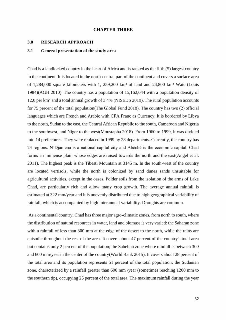
32
CHAPTER THREE
3.0 RESEARCH APPROACH
3.1 General presentation of the study area
Chad is a landlocked country in the heart of Africa and is ranked as the fifth (5) largest country
in the continent. It is located in the north-central part of the continent and covers a surface area
of 1,284,000 square kilometers with 1, 259,200 km² of land and 24,800 km² Water(Louis
1984)(AGH 2010). The country has a population of 15,162,044 with a population density of
12.0 per km2 and a total annual growth of 3.4% (NISEDS 2019). The rural population accounts
for 75 percent of the total population(The Global Fund 2018). The country has two (2) official
languages which are French and Arabic with CFA Franc as Currency. It is bordered by Libya
to the north, Sudan to the east, the Central African Republic to the south, Cameroon and Nigeria
to the southwest, and Niger to the west(Moustapha 2018). From 1960 to 1999, it was divided
into 14 prefectures. They were replaced in 1999 by 28 departments. Currently, the country has
23 regions. N’Djamena is a national capital city and Abéché is the economic capital. Chad
forms an immense plain whose edges are raised towards the north and the east(Angel et al.
2011). The highest peak is the Tibesti Mountain at 3145 m. In the south-west of the country
are located vertisols, while the north is colonized by sand dunes sands unsuitable for
agricultural activities, except in the oases. Polder soils from the isolation of the arms of Lake
Chad, are particularly rich and allow many crop growth. The average annual rainfall is
estimated at 322 mm/year and it is unevenly distributed due to high geographical variability of
rainfall, which is accompanied by high interannual variability. Droughts are common.
As a continental country, Chad has three major agro-climatic zones, from north to south, where
the distribution of natural resources in water, land and biomass is very varied: the Saharan zone
with a rainfall of less than 300 mm at the edge of the desert to the north, while the rains are
episodic throughout the rest of the area. It covers about 47 percent of the country's total area
but contains only 2 percent of the population; the Sahelian zone where rainfall is between 300
and 600 mm/year in the center of the country(World Bank 2015). It covers about 28 percent of
the total area and its population represents 51 percent of the total population; the Sudanian
zone, characterized by a rainfall greater than 600 mm /year (sometimes reaching 1200 mm to
the southern tip), occupying 25 percent of the total area. The maximum rainfall during the year
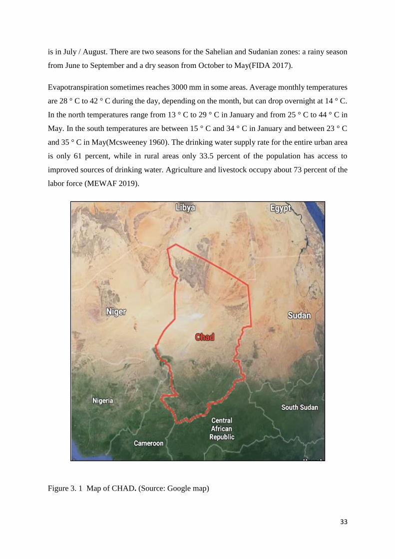
33
is in July / August. There are two seasons for the Sahelian and Sudanian zones: a rainy season
from June to September and a dry season from October to May(FIDA 2017).
Evapotranspiration sometimes reaches 3000 mm in some areas. Average monthly temperatures
are 28 ° C to 42 ° C during the day, depending on the month, but can drop overnight at 14 ° C.
In the north temperatures range from 13 ° C to 29 ° C in January and from 25 ° C to 44 ° C in
May. In the south temperatures are between 15 ° C and 34 ° C in January and between 23 ° C
and 35 ° C in May(Mcsweeney 1960). The drinking water supply rate for the entire urban area
is only 61 percent, while in rural areas only 33.5 percent of the population has access to
improved sources of drinking water. Agriculture and livestock occupy about 73 percent of the
labor force (MEWAF 2019).
Figure 3. 1 Map of CHAD. (Source: Google map)
34
3.1.1 Location and description of the case study
The Ouaddaï Region is made up of three Departments: Ouara, Assoungha and Abdi. It covers
an area of 29 940 square kilometers and is bounded on the north by the Wadi Fira region, on
the east by Sudan, on the south by Dar Sila and on the west by the Batha. The Ouaddaï has
997257 inhabitants (NISEDS 2019) distributed among the main ethnic groups which are:
Ouaddaïens, Goranes, Zaghawas, Massalites, Peuls, Haoussas, Tamas, for and Arabs.
The region has a domestic livestock population of 2,119,020 heads of cattle; 5,361,870 heads
of goats /ovines, 100,067 head, of camels, 131,247 head of equine, 413,589 heads of
asins(OCHA 2012). The district of Abougoudam is located about 20 km south-west of Abéché
city, Ouara Department, Ouaddaï region. It is between 13 ° and 14 ° North latitude and 20 °
and 21 ° East longitude. The district is bordered on the north by the Khachim Al Wadi and
Mandjobok Township, on the south by the Massalat Township(Adey et al. 2017), on the west
by the Guéri Township and the Batha East County and on the east by the Ouadi Hamra and
Marfa Township. Its area is estimated at 2320 Km². Currently, Abougoudam has 27 townships
in which live 62 161 inhabitants (National Institute of Statistics, Economic and Demographic
Studies (NISEDS 2019) and is mainly composed of farmers and/or cattle breeders. The area
has an estimated domestic livestock population of cattle 75006, goats 102420, camel 6599,
horses 13300, donkeys 31157, and sheep 77944. Cattle and sheep farming is professionally
practiced by nomadic, semi-nomadic and sedentary Arabs. The population lives mainly on
agriculture and livestock products. Livestock is frequently confronted with the difficulties of
water, pasture, epizootic and also conflicts in case of stray animals in the fields(LDP 2014).
The relief of Abougoudam is characterized by important mountain ranges and hills. There are
important mountains such as Hadjer Abougoudam, located 5 km north of Abougoudam town
nationally recognized. Other less important mountains are those of Atim located at 20 km south
of Abougoudam and are located precisely in the village of Atim and others are: Damire Al
Hadjer, Kakara, Andinga, Hadjer Tarfana, Djemile, Kamack, Hireine, Kadama, all located in
the south of the district, bear the names of the villages bordering them.
The area was also marked by painful events in the past, the most important of which are: the
famines of the years 1914 and 1985 that had caused thousands of deaths and displaced.
3.1.2 Vegetation and Flora
The district presents in its generality little vegetation consisting of species of trees and shrubs
distributed according to the topography of the ground. The grass cover is medium(H. GILLET
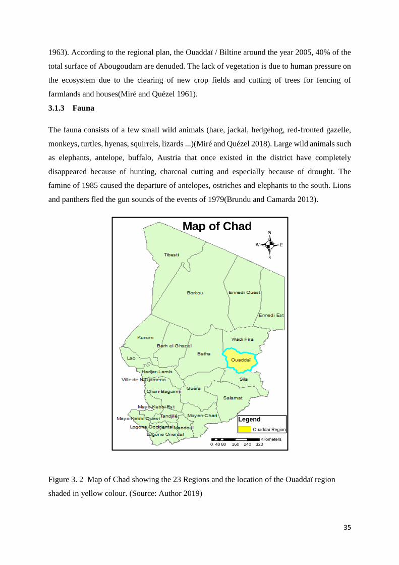
35
1963). According to the regional plan, the Ouaddaï / Biltine around the year 2005, 40% of the
total surface of Abougoudam are denuded. The lack of vegetation is due to human pressure on
the ecosystem due to the clearing of new crop fields and cutting of trees for fencing of
farmlands and houses(Miré and Quézel 1961).
3.1.3 Fauna
The fauna consists of a few small wild animals (hare, jackal, hedgehog, red-fronted gazelle,
monkeys, turtles, hyenas, squirrels, lizards ...)(Miré and Quézel 2018). Large wild animals such
as elephants, antelope, buffalo, Austria that once existed in the district have completely
disappeared because of hunting, charcoal cutting and especially because of drought. The
famine of 1985 caused the departure of antelopes, ostriches and elephants to the south. Lions
and panthers fled the gun sounds of the events of 1979(Brundu and Camarda 2013).
Figure 3. 2 Map of Chad showing the 23 Regions and the location of the Ouaddaï region
shaded in yellow colour. (Source: Author 2019)
0 80 160 240 32040Kilometers
Legend
Ouaddaï Region
Map of Chad
.
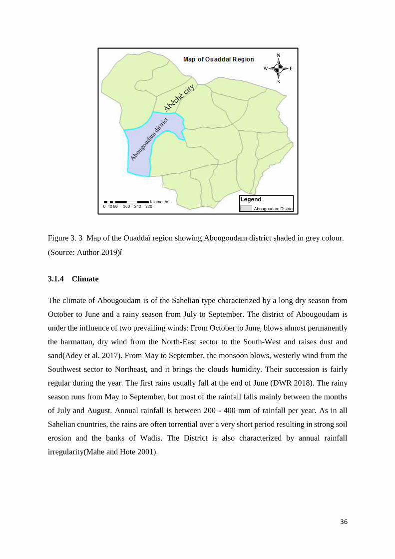
36
Figure 3. 3 Map of the Ouaddaï region showing Abougoudam district shaded in grey colour.
(Source: Author 2019)ï
3.1.4 Climate
The climate of Abougoudam is of the Sahelian type characterized by a long dry season from
October to June and a rainy season from July to September. The district of Abougoudam is
under the influence of two prevailing winds: From October to June, blows almost permanently
the harmattan, dry wind from the North-East sector to the South-West and raises dust and
sand(Adey et al. 2017). From May to September, the monsoon blows, westerly wind from the
Southwest sector to Northeast, and it brings the clouds humidity. Their succession is fairly
regular during the year. The first rains usually fall at the end of June (DWR 2018). The rainy
season runs from May to September, but most of the rainfall falls mainly between the months
of July and August. Annual rainfall is between 200 - 400 mm of rainfall per year. As in all
Sahelian countries, the rains are often torrential over a very short period resulting in strong soil
erosion and the banks of Wadis. The District is also characterized by annual rainfall
irregularity(Mahe and Hote 2001).
Legend
Abougoudam District0 80 160 240 32040
Kilometers
.
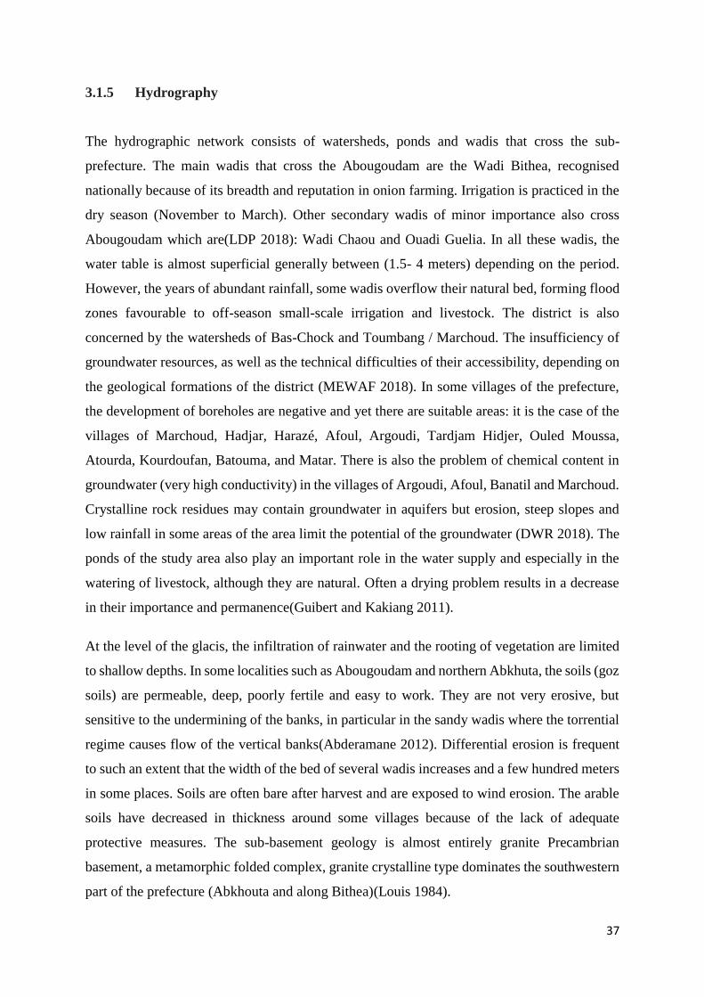
37
3.1.5 Hydrography
The hydrographic network consists of watersheds, ponds and wadis that cross the sub-
prefecture. The main wadis that cross the Abougoudam are the Wadi Bithea, recognised
nationally because of its breadth and reputation in onion farming. Irrigation is practiced in the
dry season (November to March). Other secondary wadis of minor importance also cross
Abougoudam which are(LDP 2018): Wadi Chaou and Ouadi Guelia. In all these wadis, the
water table is almost superficial generally between (1.5- 4 meters) depending on the period.
However, the years of abundant rainfall, some wadis overflow their natural bed, forming flood
zones favourable to off-season small-scale irrigation and livestock. The district is also
concerned by the watersheds of Bas-Chock and Toumbang / Marchoud. The insufficiency of
groundwater resources, as well as the technical difficulties of their accessibility, depending on
the geological formations of the district (MEWAF 2018). In some villages of the prefecture,
the development of boreholes are negative and yet there are suitable areas: it is the case of the
villages of Marchoud, Hadjar, Harazé, Afoul, Argoudi, Tardjam Hidjer, Ouled Moussa,
Atourda, Kourdoufan, Batouma, and Matar. There is also the problem of chemical content in
groundwater (very high conductivity) in the villages of Argoudi, Afoul, Banatil and Marchoud.
Crystalline rock residues may contain groundwater in aquifers but erosion, steep slopes and
low rainfall in some areas of the area limit the potential of the groundwater (DWR 2018). The
ponds of the study area also play an important role in the water supply and especially in the
watering of livestock, although they are natural. Often a drying problem results in a decrease
in their importance and permanence(Guibert and Kakiang 2011).
At the level of the glacis, the infiltration of rainwater and the rooting of vegetation are limited
to shallow depths. In some localities such as Abougoudam and northern Abkhuta, the soils (goz
soils) are permeable, deep, poorly fertile and easy to work. They are not very erosive, but
sensitive to the undermining of the banks, in particular in the sandy wadis where the torrential
regime causes flow of the vertical banks(Abderamane 2012). Differential erosion is frequent
to such an extent that the width of the bed of several wadis increases and a few hundred meters
in some places. Soils are often bare after harvest and are exposed to wind erosion. The arable
soils have decreased in thickness around some villages because of the lack of adequate
protective measures. The sub-basement geology is almost entirely granite Precambrian
basement, a metamorphic folded complex, granite crystalline type dominates the southwestern
part of the prefecture (Abkhouta and along Bithea)(Louis 1984).
38
Figure 3. 4 Map of the study area showing the stream networks of the Wadis. (Source:
ArcGIS)
3.2. Legal Framework of Chadian’s Water Regime
Access to the freshwater of sufficient quantity and quality is essential for all aspects of life and
for sustainable development. The fundamental right to water and sanitation is widely
recognized by the Member States of the United Nations(SDG6 2018). Water resources are
intrinsically associated with all dimensions of development such as food security, health
promotion and poverty reduction, for contributing to the growth of agriculture, industry and
energy production, as well as the preservation of ecosystem health. However, the right to water
is most effective when nations incorporate it in their domestic water policies and legal
framework. The state of the nation has the obligation to enforce the right to water into their
judiciary law if it is being compromised(FAO 2018).
In Chad, The Ministry of Environment, Water and Fisheries (MEWAF) is responsible for
implementing and monitoring the policy adopted by the Government in the field of
environment, urban, village, pastoral water supply and sanitation. It is also in charge of the
design and the implementation of the water points and hydraulic installations. Other
stakeholders include Ministry of production, Irrigation and Agricultural Equipment and the
0 80 160 240 32040Kilometers
.
39
Ministry of Livestock and Animal production; Ministry of Urbanism and Habitat and the
Ministry of Public Health.
The Water Law (No. 016 / PR / 99 of 18/08/1999) is the only recent official document defining
a regulatory framework for the water sector in Chad. A document to enforce this law was only
published in 2002. It is a general document that focused on aspects of public service in urban
areas, while aspects relating to village water supply and pastoral (wells, boreholes, various
equipment, etc.) are not mentioned in the official document(MEWAF 2018).
Unfortunately, the Sustainable Development Goals (SDGs6: Ensure access for all to water and
sanitation and ensure sustainable management of water resources) is recognized under the
Chadian law but the rights to water are not explicitly included in the Chadian Constitution. It
stated that all everyone has the right to a healthy environment. The right to water and sanitation
is embodied in the right to a healthy environment. It very unfortunate that the right to water is
not recognized as a basic right but as a sovereign right of the government.
The Master plan of Water and Sanitation (SDEA), a living document of water policy in Chad
which has been validated by the nation and approved in 2003. The SDEA is not robust as it
should be because the water in general and pastoral hydraulics, in particular, suffers from a
lack of a regulatory framework, which often leads to overlapping institutional stakeholders,
particularly between the Ministry of Environment, Water, and Fisheries(MEWAF);Ministry of
production, Irrigation and Agricultural Equipment and the Ministry of Livestock and Animal
Production.
Chad does not have an agency that is in charge of basin management, however, there is the
Directorate General of Water Resources of the MEWAF that plays this role. Similarly, there is
the National Water Fund whose prerogatives are limit in seeking funding in the framework of
drinking water supply.
Some of the Articles state:
Article 1: The management of fluvial or underground water and that of the exploitation
and hydraulic works are subject to the respect of the international agreements. All water
resources, located within the limits of the national territory are a collective good. As
such, they are an integral part of the public domain of the state which is unchangeable
and imprescriptible.
40
Article 2: The Water User Association (WUA) of drinking water has the sole
responsibility for the operation and management of public drinking water supply.
Article 45: The water price of potable water is defined by a regulatory body.
Article 74: Artificial use or accumulation of rainwater falling on private property is
permitted provided that such water remains on the land.
Article 75: In the case of artificial accumulation on private funds, the holding is
required to declare the capacity, the final destination and the water use regime, in
accordance with Article 79 below.
Article 79: Anyone harvesting groundwater or existing surface water for profit-making
is required to declare his operation within six months to the Administration
concerned(Vullien 2012).
According to laws governing water in chad, WH is free and has no restriction from the state.
This favours the peaceful adoption of WH in Abougoudam district.
3.3 Data collection and Methods
3.3.1 Introduction
This research focused mainly to analyse successful water harvesting techniques in arid regions
with the intention of attracting investments in Chad. This research proposed proven techniques
that would be implemented in Chad to stabilize water demands for humans, livestock and
agriculture. It also developed a knowledge product to ensure the sustainability of the structures.
In order to achieve the objectives of this research, physical, economic and socio-cultural data
had to be obtained and analysed. As such, the field survey and desk study was conducted.
3.3.2 Rainfall data
It is not possible to pursue WH technologies without considering one of its major components
which is precipitation. Rainfall must be available for WH uptakes. It is of considerable
importance to obtain and assess rainfall data for a minimum of 10 years to have a solid
impression of the rainfall pattern in a particular study area before choosing WH as an option to
supplement water for agriculture, humans and livestock. Long term data help to identify and
understand the sharp increase of rainfall over a wide range of data. Rainfall data (Weather
Station of Abéché) of Abougoudam district and the current monthly temperature were obtained
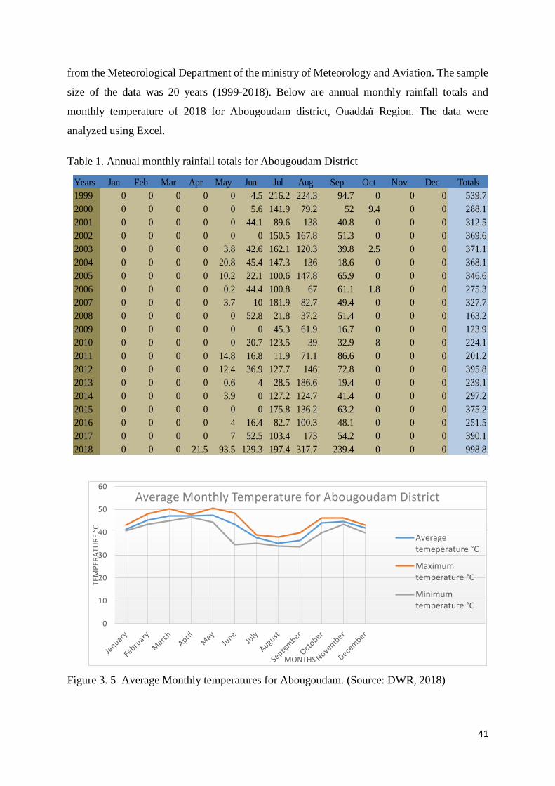
41
from the Meteorological Department of the ministry of Meteorology and Aviation. The sample
size of the data was 20 years (1999-2018). Below are annual monthly rainfall totals and
monthly temperature of 2018 for Abougoudam district, Ouaddaï Region. The data were
analyzed using Excel.
Table 1. Annual monthly rainfall totals for Abougoudam District
Figure 3. 5 Average Monthly temperatures for Abougoudam. (Source: DWR, 2018)
Years Jan Feb Mar Apr May Jun Jul Aug Sep Oct Nov Dec Totals
1999 0 0 0 0 0 4.5 216.2 224.3 94.7 0 0 0 539.7
2000 0 0 0 0 0 5.6 141.9 79.2 52 9.4 0 0 288.1
2001 0 0 0 0 0 44.1 89.6 138 40.8 0 0 0 312.5
2002 0 0 0 0 0 0 150.5 167.8 51.3 0 0 0 369.6
2003 0 0 0 0 3.8 42.6 162.1 120.3 39.8 2.5 0 0 371.1
2004 0 0 0 0 20.8 45.4 147.3 136 18.6 0 0 0 368.1
2005 0 0 0 0 10.2 22.1 100.6 147.8 65.9 0 0 0 346.6
2006 0 0 0 0 0.2 44.4 100.8 67 61.1 1.8 0 0 275.3
2007 0 0 0 0 3.7 10 181.9 82.7 49.4 0 0 0 327.7
2008 0 0 0 0 0 52.8 21.8 37.2 51.4 0 0 0 163.2
2009 0 0 0 0 0 0 45.3 61.9 16.7 0 0 0 123.9
2010 0 0 0 0 0 20.7 123.5 39 32.9 8 0 0 224.1
2011 0 0 0 0 14.8 16.8 11.9 71.1 86.6 0 0 0 201.2
2012 0 0 0 0 12.4 36.9 127.7 146 72.8 0 0 0 395.8
2013 0 0 0 0 0.6 4 28.5 186.6 19.4 0 0 0 239.1
2014 0 0 0 0 3.9 0 127.2 124.7 41.4 0 0 0 297.2
2015 0 0 0 0 0 0 175.8 136.2 63.2 0 0 0 375.2
2016 0 0 0 0 4 16.4 82.7 100.3 48.1 0 0 0 251.5
2017 0 0 0 0 7 52.5 103.4 173 54.2 0 0 0 390.1
2018 0 0 0 21.5 93.5 129.3 197.4 317.7 239.4 0 0 0 998.8
0
10
20
30
40
50
60
TEM
PER
ATU
RE
°C
MONTHS
Average Monthly Temperature for Abougoudam District
Averagetemeperature °C
Maximumtemperature °C
Minimumtemperature °C
42
3.3.3 Soil data
Soil data is needed before sitting water harvesting structures in a specific location. Soil
characteristics are to be considered for the stability of the structure. The soil data for the study
area was obtained from the Ministry of Production, Irrigation and Agricultural Equipment. The
Digital Soil Map of the World (DSMW) was downloaded from the Fao Soil Map
(http://www.fao.org/geonetwork/srv/en/metadata.show?id=14116) and the administrative
areas of Chad were also downloaded from diva-gis.org/data down. The clip analysis tool in
ArcGIS 10.5 was used to clip the soil map of the study area and then the feature to raster tool
was used to divide the soil hydrological groups (HSHs) of the study area. The soil map of the
study area with its characteristics was shown and discussed in chapter 4.
3.3.3 Water consumption data
Water consumption data is required to show the water consumption pattern in the study area.
This will give knowledge on water demand for humans, livestock and agriculture. The
consumption patterns also vary from continent to continent, with about 5 liters per day or less
in most African countries. The minimum water consumption of 20 liters per day per person is
required in rural communities in third world countries. The amount of rainfall in Abougoudam
is sufficient to surpass such values and rescue inhabitants facing water scarcity.
The equation used in order to obtain the water consumption per capita in the study area takes a
series of factors into consideration. Normally, the simple estimation will be: the water use (in
liters) multiplied by the number of persons in the house and then multiplied by the number of
days in a year (WHO and UN standard figure). Camels consumption per day= 144 liters/week
(camels drink weekly not daily; hence camels consumption is about144liter/week. Cows and
donkeys consumption per day= 72 liters/day; Sheep’s and goats consumption per day=
18liter/day. The data on water consumption pattern was obtained from the Nation non-
Government Organization (NGO) HELP. It was then analysed and presented in chapter 4.
3.3.4 Sampling approach
There are two important sampling approaches when scientific research is considered.
Probability and non-probability sampling methods are the two major approaches which are
further divided into many subcategories. Probability sampling implies the random selection
while non-probability sampling does not. Non-probability is divided into accidental sampling
and purposive sampling.
43
The purposive sampling method is considered for this study. This method is suitable in a
situation where there is a target group for sampling. It is also characterized by focusing on a
particular target group of the population. In this method, the information needed is obtained
from the target population but care should be taken so that a set of groups in the target
population that are more readily accessible should not be given much weight or consideration.
There are two (2) types of this method which are: snowball sampling and expert sampling
methods.
3.3.5 Expert sampling
This method is applicable in a situation where the information needed is obtained from
individuals that have extensive knowledge on the research topic. Such individuals provide
resourceful information that is relevant and might have been very difficult for the researcher to
obtain within the stipulated time. In this study, a set of meeting was carried out with water
experts in Chad to have in-depth knowledge of the existing WHSs and potential areas for WH.
A consultative approach was adopted with key stakeholders, which involved discussions with
the extension officers. The first discussion was carried out with the experts of the Ministry of
Environment, Water and Fisheries (Department of hydraulic pastorals) and the Ministry of
Water and Sanitation (Department of domestic water supply). Through the discussion, valuable
information on regions with existing WHSs, the type of systems, O&M of the systems, cost of
WHSs, areas with potential for WH and the financial capacity of the government to adopt WH
was obtained.
The second discussion was carried out with the experts of the Ministry of Production, Irrigation
and Agricultural Equipment (department of rural agriculture). The information on areas with
existing WHSs to improve irrigation during dry season and areas in need of irrigation practices
was obtained. A focus group discussion was conducted with the management community and
farmers of one of the WHSs in AKA village, northeast of Chad to provide information on O&M
and the benefit of the WHSs. An interview was also conducted with a farmer and villagers that
make use of the water stored in the micro rock dam located in tologone, northeast of Chad. The
information was presented and discussed in chapter 4.
3.3.6 Questionnaire
In this study, the questionnaire was adapted to collect relevant information with regards to the
adoption of WH in Chad. It is a standard form of questionnaires that provide quantitative
44
information on WH uptake. The data obtained by this questionnaire was then analysed with the
help of the Statistical Package for the Social Sciences (SPSS). The questionnaire is composed
of semi-structured closed-ended and open-ended questions which were administered by a
researcher and an assistant. The closed-ended questions allowed the respondents to make an
answer choice from the list of answers. Open-ended questions allowed the respondents to
express their opinion independent of any influence from the part of the researcher.
One hundred and fifty(150) questionnaires in total were administered in five(5) villages in
Abougoudam municipality with their geographical coordinates, which include Djawami with
coordinates of 13°62,559’ N and 20°67,920’ Matar with coordinates of 13°37,556’N and
20°40,748’E,Attim with coordinates of 13°63,211’ N and 20°68,423’ Abougoudam town with
coordinates of 13°84,361’ N and 20°83,675’ E and chikalfagara West with coordinates of
13°65,626’N and 20°74,351’E. The questionnaires were administered and collected at the
residences of the respondents. Most of the respondents were not literate enough to understand
the questions. In such cases, the questions were communicated to the respondents in local
Arabic.
The questionnaires were divided into three (3) sections. Section A gave general information on
the respondents. It was set to assess their demographics and level of education. Section B
targeted Households, Farmers and livestock header. This part of the questionnaire was to
collect information on existing water sources, need for an alternative source of water,
willingness to pay for water fee, the income of the respondents and their perception to the
different sources of water available. Section C of the questionnaire was to assess the
respondents’ knowledge of WH, its practices during the dry season and possible adoption.
3.3.7 Selection considerations of Best Practices of Water Harvesting Structures
To effectively select a Water Harvesting technique that is suitable for a local community, the
characteristics of the different techniques need to be assessed. They include those that are
typically physical (hydrologic, terrain and technical), culturally acceptable and socioeconomic
(institutional and economic) in nature (Tumbo et al. 2011).
WH should be technically physical depending on the local condition of the field. However, it
is important to take into account the socio-cultural acceptable of the technique by the
community and the need for sustainable management after implementation. Sustainability of
WH techniques is very important in the success of the technique and it is also necessary if the
45
available water is to be used by many people in one village or between several villages. Many
examples of water harvesting projects have failed to meet the expected targets as a result of
improper design, lack of financial capacity to O&M the techniques, or simply the techniques
were not accepted by the beneficiaries because of cultural, environmental or economic reasons.
The technical feasibility, availability of labour, know-how, the cost and most especially, the
quantity and quality of water need to be considered. Water quality is very important when the
structure is to provide water for domestic use. When the water is considered for irrigation
purposes, the quality is less important (Lasage and Verburg 2015). Every year, there is
freshwater water available to provide water for the intended use for the population on earth.
However, Arid and Semi-Arid Regions are faced with climate change, rainfall variability, high
evaporation, and increase in runoff and population growth which affect the current water
supply to meet the demand of its current population (Qadir et al. 2007).
WH is an alternative source to bridge the gap between the supply and the demand but its
feasibility should be investigated. WH is becoming an important strategy to deal with water
scarcity or water stress, it is important to consider the factors involved in selecting the
appropriate WH technique to maximize hydrological returns. It is tempting to assume that a
technique which works in one area will also work in another, apparently similar zone. However,
there may be technical difference such as the availability of stone or intensity of rainfall, and
obvious socio-economic differences (Critchley and Siegert 1991).
The selection criteria of best practices for this research to be adopted in Chad and other Arid
Regions of Africa are the design, technical specification cost-benefit, sustainable O&M,
Adaptability, Challenges and the socio-cultural acceptability of the structures. The data was
obtained from the field survey in Chad and online papers.
3.3.8 Development of a policy brief
Investment in the water sector for food security, health promotion and poverty reduction by
both the public and private sectors require an enabling environment with supporting, socially
integrated water institutions most especially in Sub-Saharian Africa. From the integrated
management outlook, long-lasting policies will make the uptake of technology easier especially
where they are several uses of systems combined together. There is a need for conducive
policies to encourage private sectors to invest in innovative water technologies in a cost-
effective manner (Molden, 2007). In the past, the major driven force behind investment in water
46
for agriculture was the fear of famine the poor farmer in the rural areas (de Fracture et al.,
2010). The current investment in the water sector is driven by the need to change the type of
food, and the sources of energy which increase the need for water to produce meat, high-quality
food and biofuel crops as a result of population growth (de Fracture and Wichelns, 2010).
Increase in water supply and agricultural production still a key option to reduce poverty and
hunger. The future of water supply and agricultural production in Africa largely depends on
government policy and decision makings (Jayne et al., 2010). Small scale water technologies
for humans, livestock and agricultural growth have often been unsuitable or contrary to the
investment.
When donors make money available to invest in the water sector, government prefer to large
scale water technologies for water management forgetting the fact small scale technologies,
like water harvesting that provide a more cost-effective way of increase the benefit of local
farmers thereby increasing the socio-economic activities of the local communities in order to
achieve the Sustainable Development Goals.
The institutions in charge of water management may need to change their policies in order to
attract more investment in the water sector. Usually, the poorest stakeholders almost have little
voice and political power to understand clearly the access to water, cost involved and the water
allocation. Capacity-building should be integrated into local policies.
Review of FAO, IsDB report on water harvesting policies, a book by William Critchley on
Water Harvesting in Sub-Saharian Africa and the legal framework on water management in
Chad were used to generate information for the checklist policy brief on sustainable
management of WHSs.
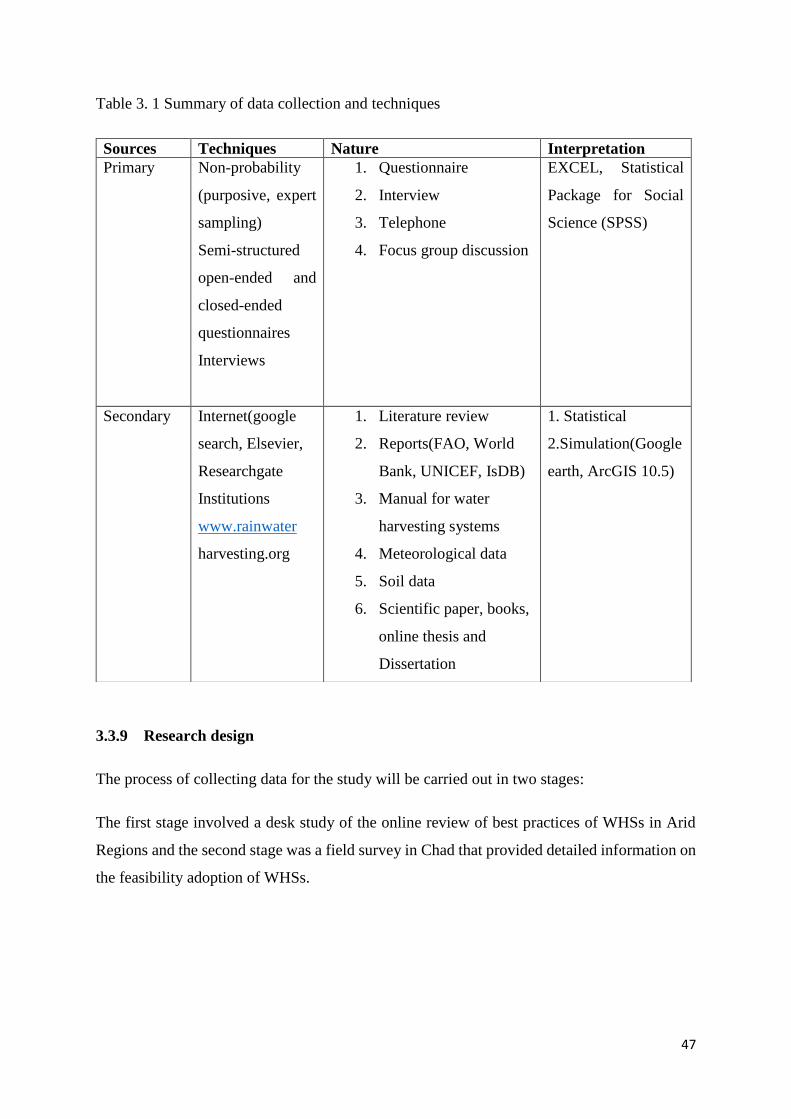
47
Table 3. 1 Summary of data collection and techniques
3.3.9 Research design
The process of collecting data for the study will be carried out in two stages:
The first stage involved a desk study of the online review of best practices of WHSs in Arid
Regions and the second stage was a field survey in Chad that provided detailed information on
the feasibility adoption of WHSs.
Sources Techniques Nature Interpretation
Primary Non-probability
(purposive, expert
sampling)
Semi-structured
open-ended and
closed-ended
questionnaires
Interviews
1. Questionnaire
2. Interview
3. Telephone
4. Focus group discussion
EXCEL, Statistical
Package for Social
Science (SPSS)
Secondary Internet(google
search, Elsevier,
Researchgate
Institutions
www.rainwater
harvesting.org
1. Literature review
2. Reports(FAO, World
Bank, UNICEF, IsDB)
3. Manual for water
harvesting systems
4. Meteorological data
5. Soil data
6. Scientific paper, books,
online thesis and
Dissertation
1. Statistical
2.Simulation(Google
earth, ArcGIS 10.5)
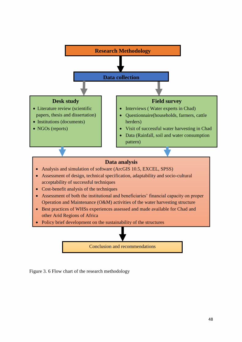
48
Figure 3. 6 Flow chart of the research methodology
Research Methodology
Data collection
Desk study
Literature review (scientific
papers, thesis and dissertation)
Institutions (documents)
NGOs (reports)
Field survey
Interviews ( Water experts in Chad)
Questionnaire(households, farmers, cattle
herders)
Visit of successful water harvesting in Chad
Data (Rainfall, soil and water consumption
pattern)
Data analysis
Analysis and simulation of software (ArcGIS 10.5, EXCEL, SPSS)
Assessment of design, technical specification, adaptability and socio-cultural
acceptability of successful techniques
Cost-benefit analysis of the techniques
Assessment of both the institutional and beneficiaries’ financial capacity on proper
Operation and Maintenance (O&M) activities of the water harvesting structure
Best practices of WHSs experiences assessed and made available for Chad and
other Arid Regions of Africa
Policy brief development on the sustainability of the structures
Conclusion and recommendations
49
3.4 Data Analysis
This study made use of both primary and secondary data. The researcher analysed meticulously
the primary data that were obtained from the field survey. The soil map of Abougoudam district
was constructed using GIS(ArcGIS 10.5) which is a software designed to collect, store, process,
analyze, manage and present all types of spatial and geographic.GIS is used by government
agencies, scientists, people, individuals and research institutions. The rainfall and water
consumption data were assessed using Microsoft excel while the questionnaire was analyzed
using SPSS. The case study of WHSs best practices was assessed. However, the secondary
data obtained from the literature review were also used for the study.
The data were represented in the form of bar chart, table, graph, figures and text.
The results of data were presented in an orderly manner followed by the discussion to simply
coherency and understanding. The results and discussion are the focus of chapter 4 below.
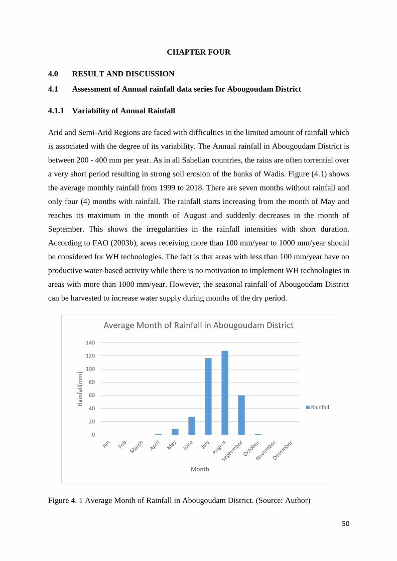
50
CHAPTER FOUR
4.0 RESULT AND DISCUSSION
4.1 Assessment of Annual rainfall data series for Abougoudam District
4.1.1 Variability of Annual Rainfall
Arid and Semi-Arid Regions are faced with difficulties in the limited amount of rainfall which
is associated with the degree of its variability. The Annual rainfall in Abougoudam District is
between 200 - 400 mm per year. As in all Sahelian countries, the rains are often torrential over
a very short period resulting in strong soil erosion of the banks of Wadis. Figure (4.1) shows
the average monthly rainfall from 1999 to 2018. There are seven months without rainfall and
only four (4) months with rainfall. The rainfall starts increasing from the month of May and
reaches its maximum in the month of August and suddenly decreases in the month of
September. This shows the irregularities in the rainfall intensities with short duration.
According to FAO (2003b), areas receiving more than 100 mm/year to 1000 mm/year should
be considered for WH technologies. The fact is that areas with less than 100 mm/year have no
productive water-based activity while there is no motivation to implement WH technologies in
areas with more than 1000 mm/year. However, the seasonal rainfall of Abougoudam District
can be harvested to increase water supply during months of the dry period.
Figure 4. 1 Average Month of Rainfall in Abougoudam District. (Source: Author)
0
20
40
60
80
100
120
140
Rai
nfa
ll(m
m)
Month
Average Month of Rainfall in Abougoudam District
Rainfall
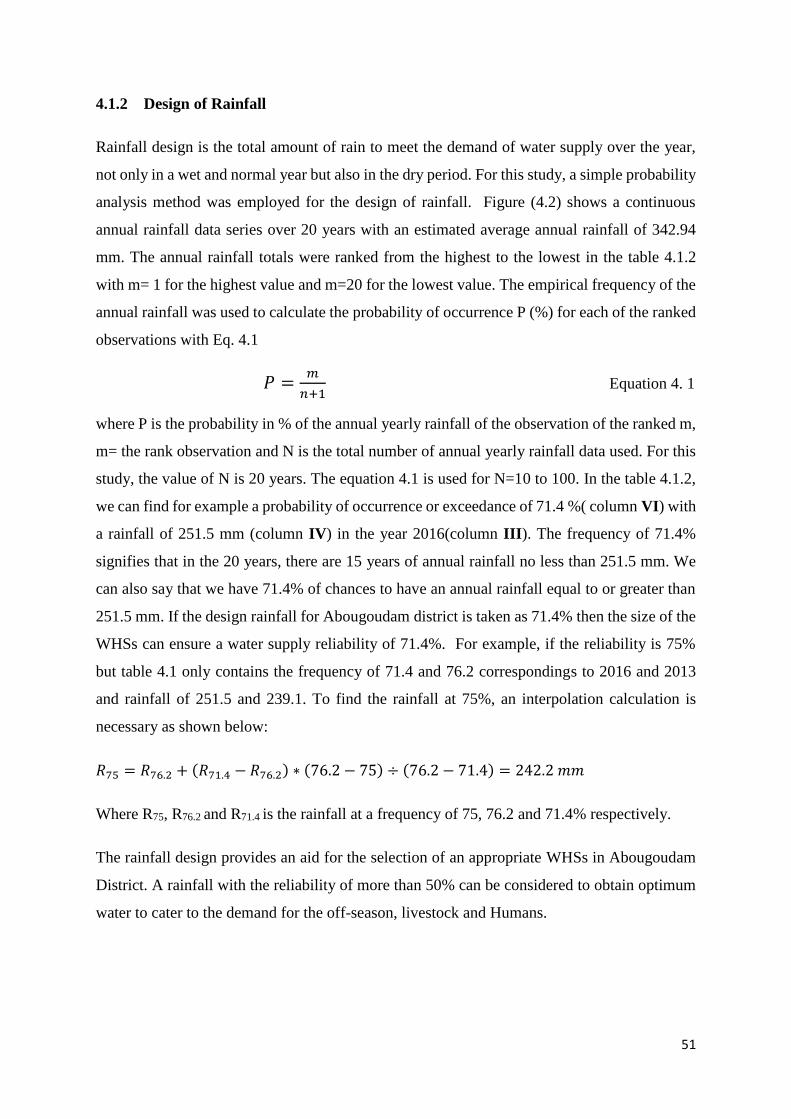
51
4.1.2 Design of Rainfall
Rainfall design is the total amount of rain to meet the demand of water supply over the year,
not only in a wet and normal year but also in the dry period. For this study, a simple probability
analysis method was employed for the design of rainfall. Figure (4.2) shows a continuous
annual rainfall data series over 20 years with an estimated average annual rainfall of 342.94
mm. The annual rainfall totals were ranked from the highest to the lowest in the table 4.1.2
with m= 1 for the highest value and m=20 for the lowest value. The empirical frequency of the
annual rainfall was used to calculate the probability of occurrence P (%) for each of the ranked
observations with Eq. 4.1
𝑃 =𝑚
𝑛+1 Equation 4. 1
where P is the probability in % of the annual yearly rainfall of the observation of the ranked m,
m= the rank observation and N is the total number of annual yearly rainfall data used. For this
study, the value of N is 20 years. The equation 4.1 is used for N=10 to 100. In the table 4.1.2,
we can find for example a probability of occurrence or exceedance of 71.4 %( column VI) with
a rainfall of 251.5 mm (column IV) in the year 2016(column III). The frequency of 71.4%
signifies that in the 20 years, there are 15 years of annual rainfall no less than 251.5 mm. We
can also say that we have 71.4% of chances to have an annual rainfall equal to or greater than
251.5 mm. If the design rainfall for Abougoudam district is taken as 71.4% then the size of the
WHSs can ensure a water supply reliability of 71.4%. For example, if the reliability is 75%
but table 4.1 only contains the frequency of 71.4 and 76.2 correspondings to 2016 and 2013
and rainfall of 251.5 and 239.1. To find the rainfall at 75%, an interpolation calculation is
necessary as shown below:
𝑅75 = 𝑅76.2 + (𝑅71.4 − 𝑅76.2) ∗ (76.2 − 75) ÷ (76.2 − 71.4) = 242.2 𝑚𝑚
Where R75, R76.2 and R71.4 is the rainfall at a frequency of 75, 76.2 and 71.4% respectively.
The rainfall design provides an aid for the selection of an appropriate WHSs in Abougoudam
District. A rainfall with the reliability of more than 50% can be considered to obtain optimum
water to cater to the demand for the off-season, livestock and Humans.
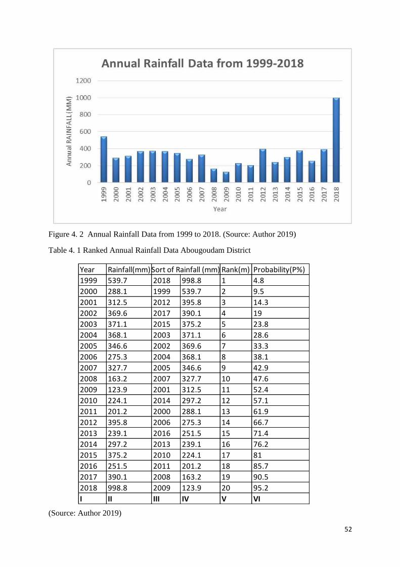
52
Figure 4. 2 Annual Rainfall Data from 1999 to 2018. (Source: Author 2019)
Table 4. 1 Ranked Annual Rainfall Data Abougoudam District
(Source: Author 2019)
Year Rainfall(mm) Rank(m) Probability(P%)
1999 539.7 2018 998.8 1 4.8
2000 288.1 1999 539.7 2 9.5
2001 312.5 2012 395.8 3 14.3
2002 369.6 2017 390.1 4 19
2003 371.1 2015 375.2 5 23.8
2004 368.1 2003 371.1 6 28.6
2005 346.6 2002 369.6 7 33.3
2006 275.3 2004 368.1 8 38.1
2007 327.7 2005 346.6 9 42.9
2008 163.2 2007 327.7 10 47.6
2009 123.9 2001 312.5 11 52.4
2010 224.1 2014 297.2 12 57.1
2011 201.2 2000 288.1 13 61.9
2012 395.8 2006 275.3 14 66.7
2013 239.1 2016 251.5 15 71.4
2014 297.2 2013 239.1 16 76.2
2015 375.2 2010 224.1 17 81
2016 251.5 2011 201.2 18 85.7
2017 390.1 2008 163.2 19 90.5
2018 998.8 2009 123.9 20 95.2
I II III IV V VI
Sort of Rainfall (mm)
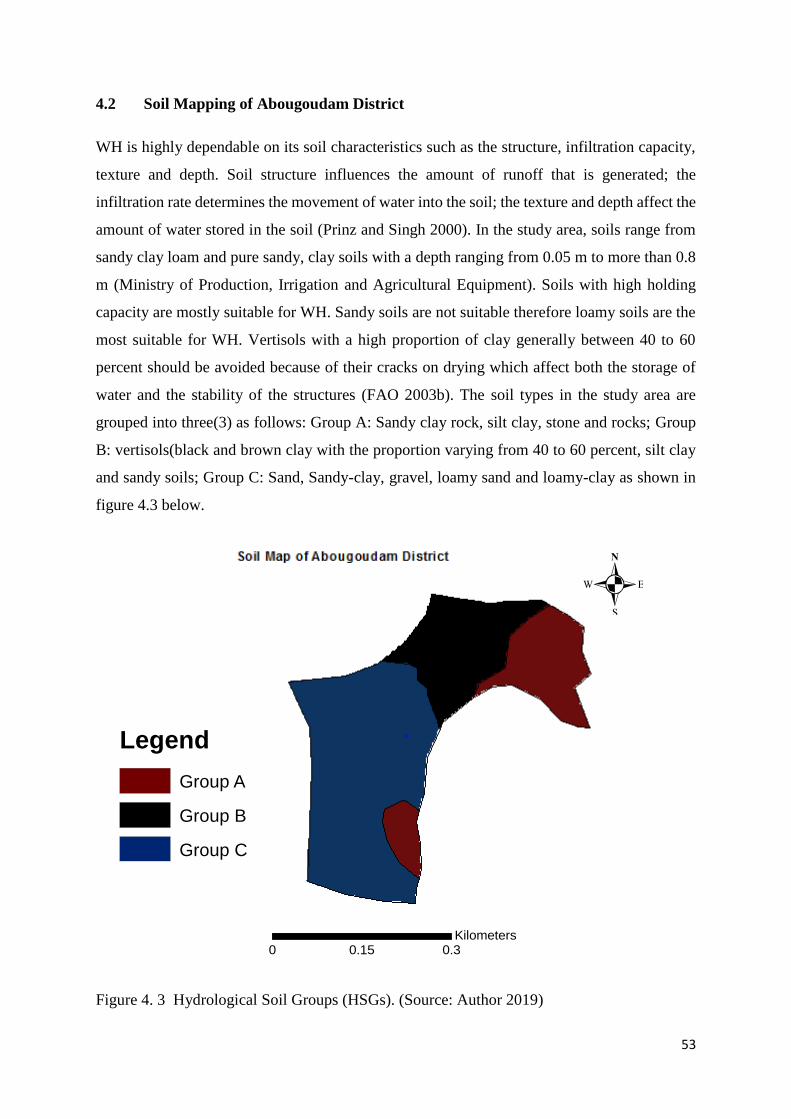
53
4.2 Soil Mapping of Abougoudam District
WH is highly dependable on its soil characteristics such as the structure, infiltration capacity,
texture and depth. Soil structure influences the amount of runoff that is generated; the
infiltration rate determines the movement of water into the soil; the texture and depth affect the
amount of water stored in the soil (Prinz and Singh 2000). In the study area, soils range from
sandy clay loam and pure sandy, clay soils with a depth ranging from 0.05 m to more than 0.8
m (Ministry of Production, Irrigation and Agricultural Equipment). Soils with high holding
capacity are mostly suitable for WH. Sandy soils are not suitable therefore loamy soils are the
most suitable for WH. Vertisols with a high proportion of clay generally between 40 to 60
percent should be avoided because of their cracks on drying which affect both the storage of
water and the stability of the structures (FAO 2003b). The soil types in the study area are
grouped into three(3) as follows: Group A: Sandy clay rock, silt clay, stone and rocks; Group
B: vertisols(black and brown clay with the proportion varying from 40 to 60 percent, silt clay
and sandy soils; Group C: Sand, Sandy-clay, gravel, loamy sand and loamy-clay as shown in
figure 4.3 below.
Figure 4. 3 Hydrological Soil Groups (HSGs). (Source: Author 2019)
.
0 0.30.15Kilometers
Legend
Group A
Group B
Group C
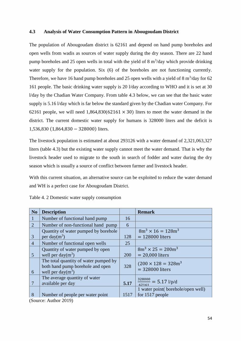
54
4.3 Analysis of Water Consumption Pattern in Abougoudam District
The population of Abougoudam district is 62161 and depend on hand pump boreholes and
open wells from wadis as sources of water supply during the dry season. There are 22 hand
pump boreholes and 25 open wells in total with the yield of 8 m3/day which provide drinking
water supply for the population. Six (6) of the boreholes are not functioning currently.
Therefore, we have 16 hand pump boreholes and 25 open wells with a yield of 8 m3/day for 62
161 people. The basic drinking water supply is 20 l/day according to WHO and it is set at 30
l/day by the Chadian Water Company. From table 4.3 below, we can see that the basic water
supply is 5.16 l/day which is far below the standard given by the Chadian water Company. For
62161 people, we will need 1,864,830(62161 × 30) liters to meet the water demand in the
district. The current domestic water supply for humans is 328000 liters and the deficit is
1,536,830 (1,864,830 − 328000) liters.
The livestock population is estimated at about 293126 with a water demand of 2,321,063,327
liters (table 4.3) but the existing water supply cannot meet the water demand. That is why the
livestock header used to migrate to the south in search of fodder and water during the dry
season which is usually a source of conflict between farmer and livestock header.
With this current situation, an alternative source can be exploited to reduce the water demand
and WH is a perfect case for Abougoudam District.
Table 4. 2 Domestic water supply consumption
(Source: Author 2019)
No Description Remark
1 Number of functional hand pump 16
2 Number of non-functional hand pump 6
3
Quantity of water pumped by borehole
per day(m3) 128
8m3 × 16 = 128m3
= 128000 liters
4 Number of functional open wells 25
5
Quantity of water pumped by open
well per day(m3) 200
8m3 × 25 = 200m3
= 20,000 liters
6
The total quantity of water pumped by
both hand pump borehole and open
well per day(m3)
328 (200 × 128 = 328m3
= 328000 liters
7
The average quantity of water
available per day 5.17 328000
62161= 5.17 l/p/d
8 Number of people per water point 1517
1 water point( borehole/open well)
for 1517 people
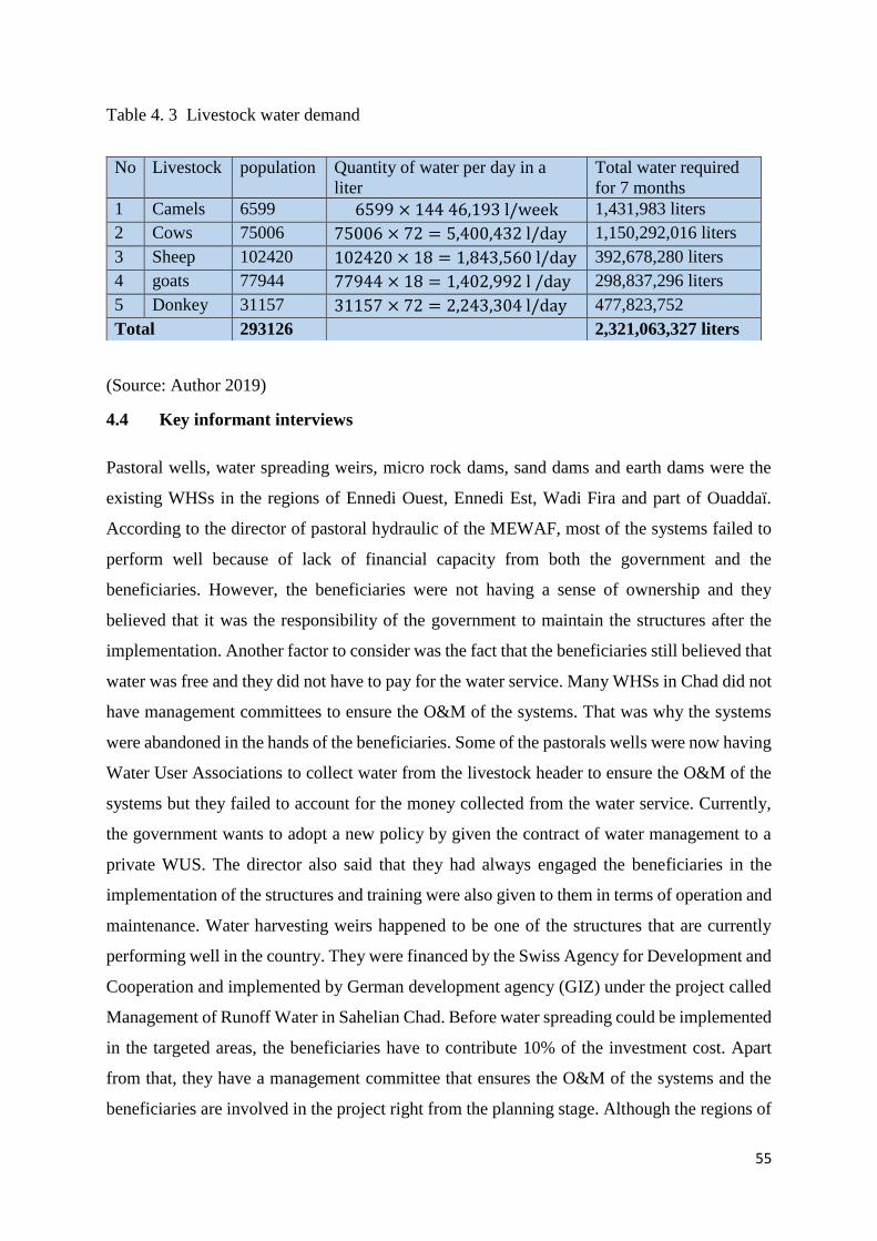
55
Table 4. 3 Livestock water demand
(Source: Author 2019)
4.4 Key informant interviews
Pastoral wells, water spreading weirs, micro rock dams, sand dams and earth dams were the
existing WHSs in the regions of Ennedi Ouest, Ennedi Est, Wadi Fira and part of Ouaddaï.
According to the director of pastoral hydraulic of the MEWAF, most of the systems failed to
perform well because of lack of financial capacity from both the government and the
beneficiaries. However, the beneficiaries were not having a sense of ownership and they
believed that it was the responsibility of the government to maintain the structures after the
implementation. Another factor to consider was the fact that the beneficiaries still believed that
water was free and they did not have to pay for the water service. Many WHSs in Chad did not
have management committees to ensure the O&M of the systems. That was why the systems
were abandoned in the hands of the beneficiaries. Some of the pastorals wells were now having
Water User Associations to collect water from the livestock header to ensure the O&M of the
systems but they failed to account for the money collected from the water service. Currently,
the government wants to adopt a new policy by given the contract of water management to a
private WUS. The director also said that they had always engaged the beneficiaries in the
implementation of the structures and training were also given to them in terms of operation and
maintenance. Water harvesting weirs happened to be one of the structures that are currently
performing well in the country. They were financed by the Swiss Agency for Development and
Cooperation and implemented by German development agency (GIZ) under the project called
Management of Runoff Water in Sahelian Chad. Before water spreading could be implemented
in the targeted areas, the beneficiaries have to contribute 10% of the investment cost. Apart
from that, they have a management committee that ensures the O&M of the systems and the
beneficiaries are involved in the project right from the planning stage. Although the regions of
No Livestock population Quantity of water per day in a
liter
Total water required
for 7 months
1 Camels 6599 6599 × 144 46,193 l/week 1,431,983 liters
2 Cows 75006 75006 × 72 = 5,400,432 l/day 1,150,292,016 liters
3 Sheep 102420 102420 × 18 = 1,843,560 l/day 392,678,280 liters
4 goats 77944 77944 × 18 = 1,402,992 l /day 298,837,296 liters
5 Donkey 31157 31157 × 72 = 2,243,304 l/day 477,823,752
Total 293126 2,321,063,327 liters
56
Ennedi Ouest, Ennedi Est and Wadi Fira had existing WHSs, still investment was needed to
supplement the water need for the local community that still had a high demand for water
supply in the regions. Moreover, the region of Guera, Ouaddaï, Salamat and Mayo-kebbi Est
were given great attention as regions that need the implementation of WHSs to increase water
supply for livestock, humans and off-season irrigation but the government did not have the
financial capacity to engage in the implementation of the WHSs and were in need of financial
assistance from the financial institutions. According to the water experts, the cost of a pastoral
well was 30,000,000 million FCFA ($53,000 depending on the regions. The cost of sand dams
and earth dams varied from 60,000,000 to 90,000,000 million FCFA($103000 to 1540000) and
the cost of water spreading weirs ranged between 60,000,000 to 100,000,000 FCFA($103000
to 1710000 depending on the regions.
According to the management committee of water spreading weir located in AKA village
(N14°32’36, 4 and 22°01’41, 0 E), Wadi Fira where the field visit was undertaken, and they
were organized in 9 groups. Each group pays 1000 FCFA ($1.8) every day as a contribution to
the maintenance of the system. Apart from that, any beneficiary that was practicing off-season
irrigation around the wadi where the structure was located, had to pay 2500 FCFA($5) with
farmland of 2h in size after harvest and 1200 FCFA ($3) if the farmland was just 1h. Onions,
garlic, groundnuts were the crops grown during the dry season. The money was used for the
operation and maintenance of the system. The management committee also said that they could
handle minor repair but they could not handle the major repair of the structure.
In terms of benefits from the water spreading weirs, there was water available for off-season
irrigation throughout the dry season. Most of the degraded lands were regenerated as the result
of water spreading weirs. The beneficiaries were also able to send their children to school from
the income generated from the post-rainy season irrigation and they also engaged in bricklaying
for sale. There was water available for livestock which limited their migration to the southern
part of the country in search of fodder and water.
The micro rock dam located in tologone(N15°01’42,42 and 21°57’47,1 E) at 30 kilometers
from Iriba town in the region of Wadi firm was also another successful WHSs in Chad in terms
of water availability throughout the drying season. There was a huge quantity of water in the
reservoir of the dam but a little amount of it was used for off-season irrigation. Thousands of
livestock got their drinking water from the dam. The dam had no management committee
therefore, water was used free of charge. One of the challenges with the dam was that when
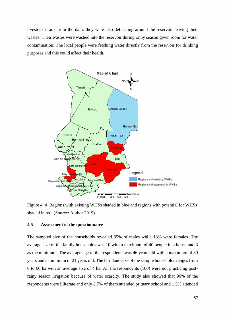
57
livestock drank from the dam, they were also defecating around the reservoir leaving their
wastes. Their wastes were washed into the reservoir during rainy season given room for water
contamination. The local people were fetching water directly from the reservoir for drinking
purposes and this could affect their health.
Figure 4. 4 Regions with existing WHSs shaded in blue and regions with potential for WHSs
shaded in red. (Source: Author 2019)
4.5 Assessment of the questionnaire
The sampled size of the households revealed 85% of males while 13% were females. The
average size of the family households was 10 with a maximum of 40 people in a house and 3
as the minimum. The average age of the respondents was 46 years old with a maximum of 80
years and a minimum of 21 years old. The farmland size of the sample households ranges from
0 to 60 ha with an average size of 4 ha. All the respondents (100) were not practicing post-
rainy season irrigation because of water scarcity. The study also showed that 96% of the
respondents were illiterate and only 2.7% of them attended primary school and 1.3% attended
.
0 80 160 240 32040Kilometers
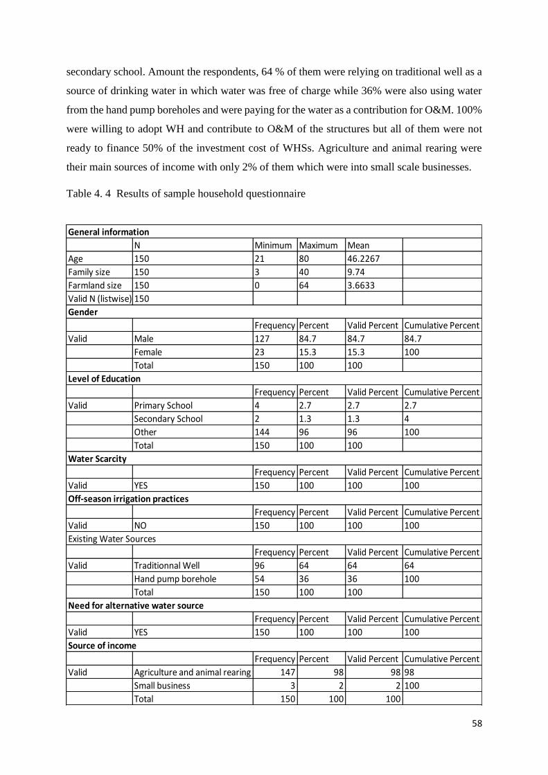
58
secondary school. Amount the respondents, 64 % of them were relying on traditional well as a
source of drinking water in which water was free of charge while 36% were also using water
from the hand pump boreholes and were paying for the water as a contribution for O&M. 100%
were willing to adopt WH and contribute to O&M of the structures but all of them were not
ready to finance 50% of the investment cost of WHSs. Agriculture and animal rearing were
their main sources of income with only 2% of them which were into small scale businesses.
Table 4. 4 Results of sample household questionnaire
N Minimum Maximum Mean
Age 150 21 80 46.2267
Family size 150 3 40 9.74
Farmland size 150 0 64 3.6633
Valid N (listwise) 150
Frequency Percent Valid Percent Cumulative Percent
Valid Male 127 84.7 84.7
Female 23 15.3 15.3
Total 150 100 100
Frequency Percent Valid Percent Cumulative Percent
Valid Primary School 4 2.7 2.7
Secondary School 2 1.3 1.3
Other 144 96 96
Total 150 100 100
Frequency Percent Valid Percent Cumulative Percent
Valid YES 150 100 100
Frequency Percent Valid Percent Cumulative Percent
Valid NO 150 100 100
Frequency Percent Valid Percent Cumulative Percent
Valid Traditionnal Well 96 64 64
Hand pump borehole 54 36 36
Total 150 100 100
Frequency Percent Valid Percent Cumulative Percent
Valid YES 150 100 100
Frequency Percent Valid Percent Cumulative Percent
Valid Agriculture and animal rearing 147 98 98
Small business 3 2 2
Total 150 100 100
Need for alternative water source
100
Source of income
98
100
100
Off-season irrigation practices
100
Existing Water Sources
64
100
2.7
4
100
Water Scarcity
Gender
84.7
100
Level of Education
General information
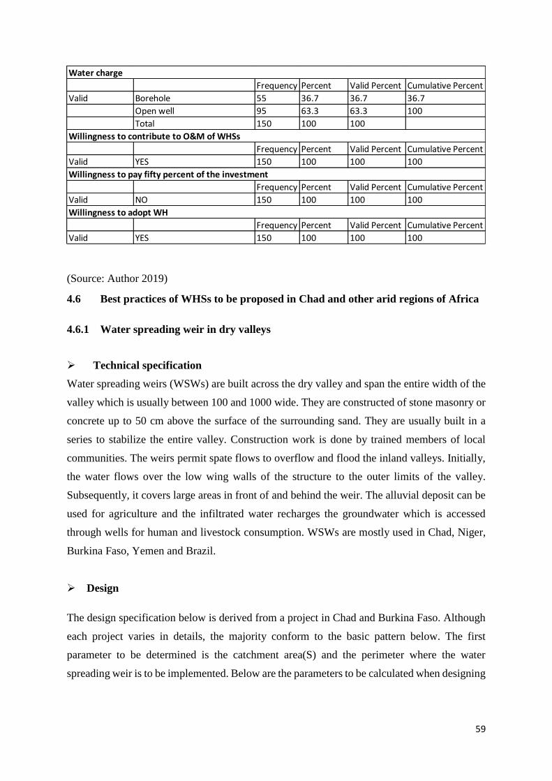
59
(Source: Author 2019)
4.6 Best practices of WHSs to be proposed in Chad and other arid regions of Africa
4.6.1 Water spreading weir in dry valleys
Technical specification
Water spreading weirs (WSWs) are built across the dry valley and span the entire width of the
valley which is usually between 100 and 1000 wide. They are constructed of stone masonry or
concrete up to 50 cm above the surface of the surrounding sand. They are usually built in a
series to stabilize the entire valley. Construction work is done by trained members of local
communities. The weirs permit spate flows to overflow and flood the inland valleys. Initially,
the water flows over the low wing walls of the structure to the outer limits of the valley.
Subsequently, it covers large areas in front of and behind the weir. The alluvial deposit can be
used for agriculture and the infiltrated water recharges the groundwater which is accessed
through wells for human and livestock consumption. WSWs are mostly used in Chad, Niger,
Burkina Faso, Yemen and Brazil.
Design
The design specification below is derived from a project in Chad and Burkina Faso. Although
each project varies in details, the majority conform to the basic pattern below. The first
parameter to be determined is the catchment area(S) and the perimeter where the water
spreading weir is to be implemented. Below are the parameters to be calculated when designing
Frequency Percent Valid Percent Cumulative Percent
Valid Borehole 55 36.7 36.7
Open well 95 63.3 63.3
Total 150 100 100
Frequency Percent Valid Percent Cumulative Percent
Valid YES 150 100 100
Frequency Percent Valid Percent Cumulative Percent
Valid NO 150 100 100
Frequency Percent Valid Percent Cumulative Percent
Valid YES 150 100 100
100
Willingness to pay fifty percent of the investment
100
Willingness to adopt WH
100
Water charge
36.7
100
Willingness to contribute to O&M of WHSs
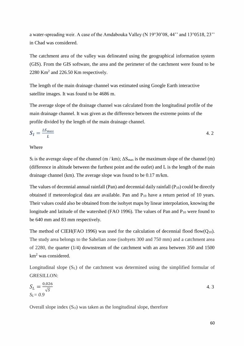
60
a water-spreading weir. A case of the Amdabouka Valley (N 19°30’08, 44’’ and 13°0518, 23’’
in Chad was considered.
The catchment area of the valley was delineated using the geographical information system
(GIS). From the GIS software, the area and the perimeter of the catchment were found to be
2280 Km2 and 226.50 Km respectively.
The length of the main drainage channel was estimated using Google Earth interactive
satellite images. It was found to be 4686 m.
The average slope of the drainage channel was calculated from the longitudinal profile of the
main drainage channel. It was given as the difference between the extreme points of the
profile divided by the length of the main drainage channel.
𝑺𝒍 =∆𝑺𝒎𝒂𝒙
𝑳 4. 2
Where
Sl is the average slope of the channel (m / km); ΔSmax is the maximum slope of the channel (m)
(difference in altitude between the furthest point and the outlet) and L is the length of the main
drainage channel (km). The average slope was found to be 0.17 m/km.
The values of decennial annual rainfall (Pan) and decennial daily rainfall (P10) could be directly
obtained if meteorological data are available. Pan and P10 have a return period of 10 years.
Their values could also be obtained from the isohyet maps by linear interpolation, knowing the
longitude and latitude of the watershed (FAO 1996). The values of Pan and P10 were found to
be 640 mm and 83 mm respectively.
The method of CIEH(FAO 1996) was used for the calculation of decennial flood flow(Q10).
The study area belongs to the Sahelian zone (isohyets 300 and 750 mm) and a catchment area
of 2280, the quarter (1/4) downstream of the catchment with an area between 350 and 1500
km2 was considered.
Longitudinal slope (SL) of the catchment was determined using the simplified formular of
GRESILLON:
𝑆𝐿 =0,026
√𝑆 4. 3
SL= 0.9
Overall slope index (SO) was taken as the longitudinal slope, therefore
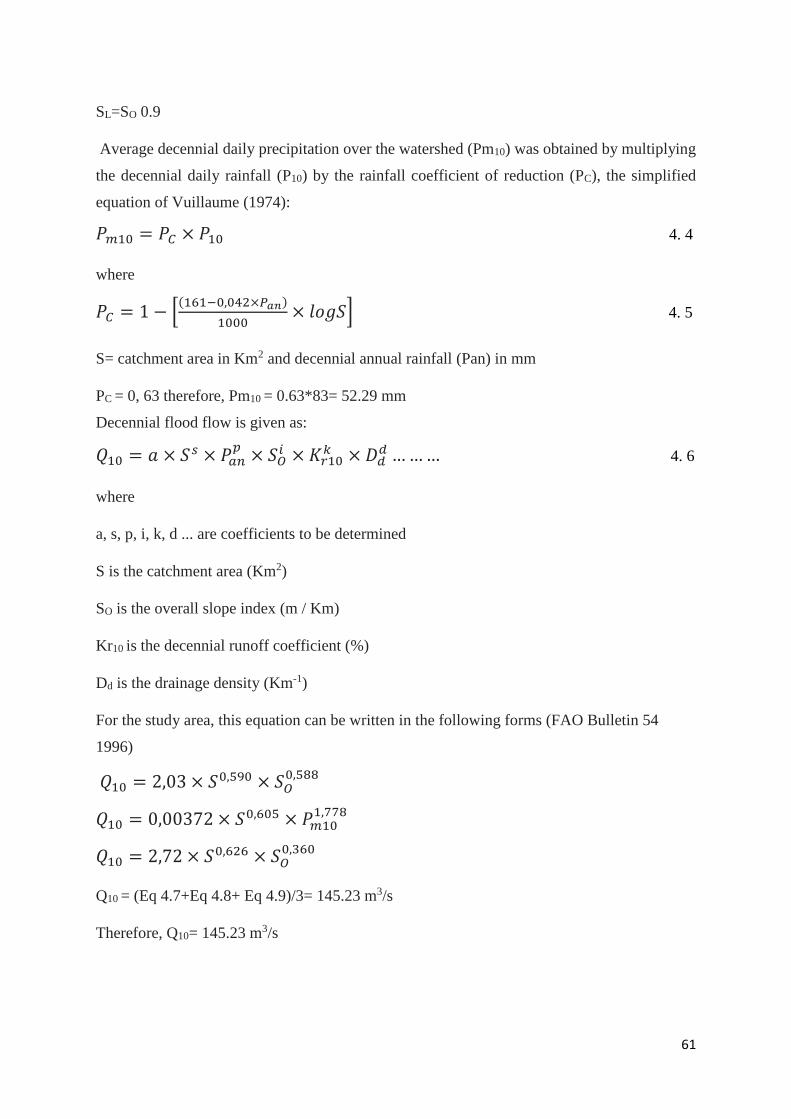
61
SL=SO 0.9
Average decennial daily precipitation over the watershed (Pm10) was obtained by multiplying
the decennial daily rainfall (P10) by the rainfall coefficient of reduction (PC), the simplified
equation of Vuillaume (1974):
𝑃𝑚10 = 𝑃𝐶 × 𝑃10 4. 4
where
𝑃𝐶 = 1 − [(161−0,042×𝑃𝑎𝑛)
1000× 𝑙𝑜𝑔𝑆] 4. 5
S= catchment area in Km2 and decennial annual rainfall (Pan) in mm
PC = 0, 63 therefore, Pm10 = 0.63*83= 52.29 mm
Decennial flood flow is given as:
𝑄10 = 𝑎 × 𝑆𝑠 × 𝑃𝑎𝑛𝑝
× 𝑆𝑂𝑖 × 𝐾𝑟10
𝑘 × 𝐷𝑑𝑑 … … … 4. 6
where
a, s, p, i, k, d ... are coefficients to be determined
S is the catchment area (Km2)
SO is the overall slope index (m / Km)
Kr10 is the decennial runoff coefficient (%)
Dd is the drainage density (Km-1)
For the study area, this equation can be written in the following forms (FAO Bulletin 54
1996)
𝑄10 = 2,03 × 𝑆0,590 × 𝑆𝑂0,588
𝑄10 = 0,00372 × 𝑆0,605 × 𝑃𝑚101,778
𝑄10 = 2,72 × 𝑆0,626 × 𝑆𝑂0,360
Q10 = (Eq 4.7+Eq 4.8+ Eq 4.9)/3= 145.23 m3/s
Therefore, Q10= 145.23 m3/s
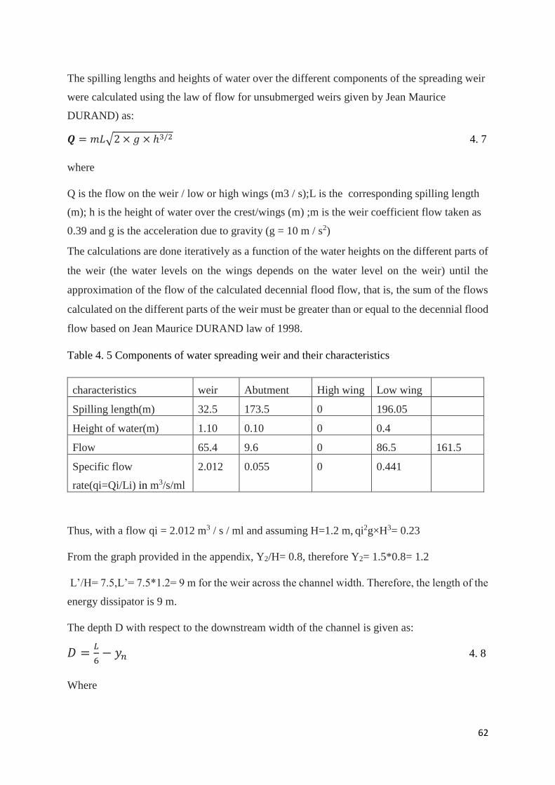
62
The spilling lengths and heights of water over the different components of the spreading weir
were calculated using the law of flow for unsubmerged weirs given by Jean Maurice
DURAND) as:
𝑸 = 𝑚𝐿√2 × 𝑔 × ℎ3/2 4. 7
where
Q is the flow on the weir / low or high wings (m3 / s);L is the corresponding spilling length
(m); h is the height of water over the crest/wings (m) ;m is the weir coefficient flow taken as
0.39 and g is the acceleration due to gravity (g = 10 m / s2)
The calculations are done iteratively as a function of the water heights on the different parts of
the weir (the water levels on the wings depends on the water level on the weir) until the
approximation of the flow of the calculated decennial flood flow, that is, the sum of the flows
calculated on the different parts of the weir must be greater than or equal to the decennial flood
flow based on Jean Maurice DURAND law of 1998.
Table 4. 5 Components of water spreading weir and their characteristics
characteristics weir Abutment High wing Low wing
Spilling length(m) 32.5 173.5 0 196.05
Height of water(m) 1.10 0.10 0 0.4
Flow 65.4 9.6 0 86.5 161.5
Specific flow
rate(qi=Qi/Li) in m3/s/ml
2.012 0.055 0 0.441
Thus, with a flow qi = 2.012 m3 / s / ml and assuming H=1.2 m, qi2g×H3= 0.23
From the graph provided in the appendix, Y2/H= 0.8, therefore Y2= 1.5*0.8= 1.2
L’/H= 7.5,L’= 7.5*1.2= 9 m for the weir across the channel width. Therefore, the length of the
energy dissipator is 9 m.
The depth D with respect to the downstream width of the channel is given as:
𝐷 =𝐿
6− 𝑦𝑛 4. 8
Where
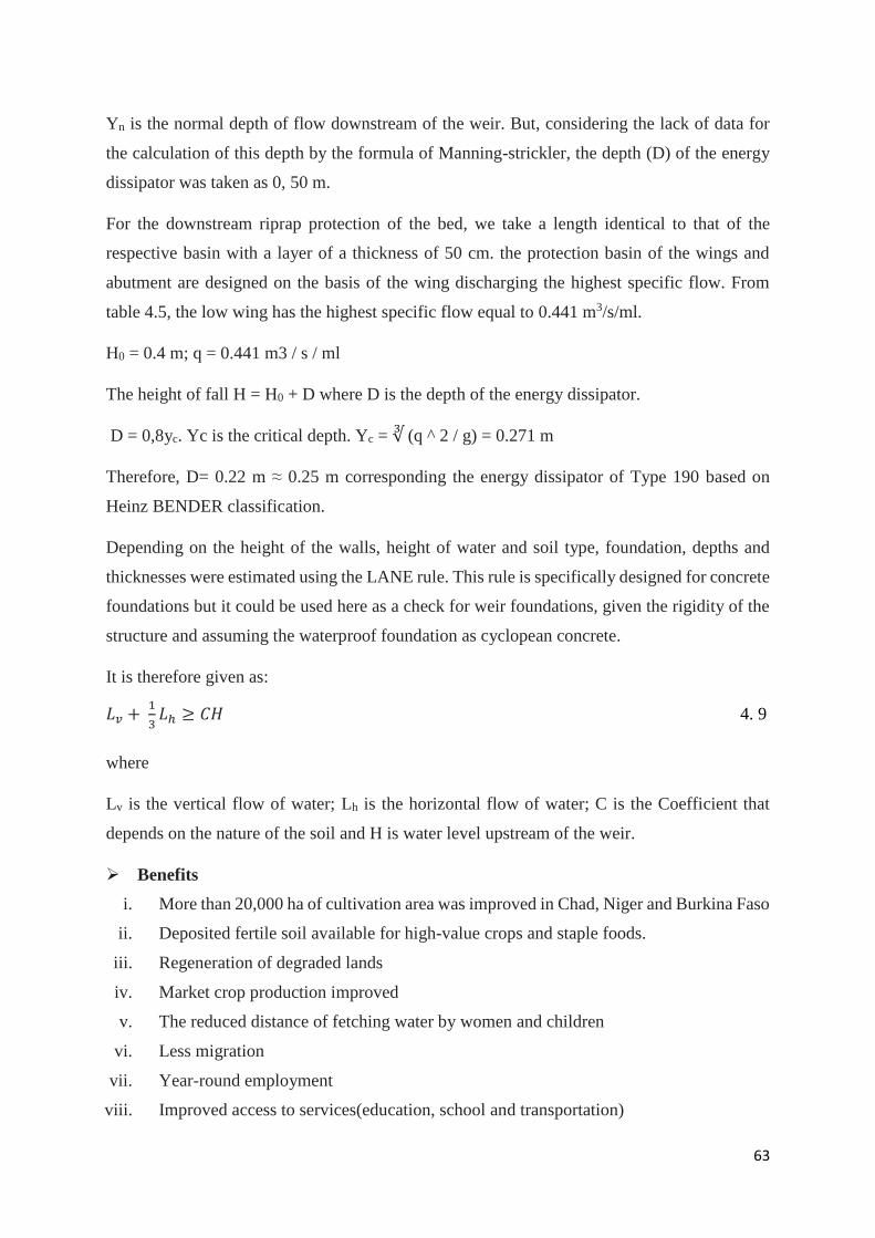
63
Yn is the normal depth of flow downstream of the weir. But, considering the lack of data for
the calculation of this depth by the formula of Manning-strickler, the depth (D) of the energy
dissipator was taken as 0, 50 m.
For the downstream riprap protection of the bed, we take a length identical to that of the
respective basin with a layer of a thickness of 50 cm. the protection basin of the wings and
abutment are designed on the basis of the wing discharging the highest specific flow. From
table 4.5, the low wing has the highest specific flow equal to 0.441 m3/s/ml.
H0 = 0.4 m; q = 0.441 m3 / s / ml
The height of fall H = H0 + D where D is the depth of the energy dissipator.
D = 0,8yc. Yc is the critical depth. Yc = ∛ (q ^ 2 / g) = 0.271 m
Therefore, D= 0.22 m ≈ 0.25 m corresponding the energy dissipator of Type 190 based on
Heinz BENDER classification.
Depending on the height of the walls, height of water and soil type, foundation, depths and
thicknesses were estimated using the LANE rule. This rule is specifically designed for concrete
foundations but it could be used here as a check for weir foundations, given the rigidity of the
structure and assuming the waterproof foundation as cyclopean concrete.
It is therefore given as:
𝐿𝑣 + 1
3𝐿ℎ ≥ 𝐶𝐻 4. 9
where
Lv is the vertical flow of water; Lh is the horizontal flow of water; C is the Coefficient that
depends on the nature of the soil and H is water level upstream of the weir.
Benefits
i. More than 20,000 ha of cultivation area was improved in Chad, Niger and Burkina Faso
ii. Deposited fertile soil available for high-value crops and staple foods.
iii. Regeneration of degraded lands
iv. Market crop production improved
v. The reduced distance of fetching water by women and children
vi. Less migration
vii. Year-round employment
viii. Improved access to services(education, school and transportation)
64
ix. Availability of forage, food security assured through crops and livestock farming.
x. Reduction of poverty
xi. Bricks made for sale
Cost
The construction cost is between EUR 600 to 1500 per ha. It varies from $ 20,000 to 70,000 in
the Sahel regions. The availability of local materials and labour may decrease the construction
cost.
Socio-cultural acceptability
Water spreading weirs have been implemented by 100% of land user families with external
support. The construction of WSWs has directly benefited between 4000 and 8000 households
in Eastern Chad. More than 370 WSWs have been implemented in the Sahel regions (Chad,
Niger and Burkina Faso) benefitting 40,000 households in total.
Challenges
i. Lack of know-how and experience of WSWs, only a few countries, engineering
firms and construction companies that have contributed to the improvement of the
technology.
ii. No documents on the know-how technology, therefore, limit the spread of WSWs to
other countries
iii. The investment cost depends solely on institution or external funding
iv. Market price drop and lack of sale as a result of excess production
v. Lack of necessary means and experience by the local communities to fund activities
in the valleys
vi. Lack of sufficient capacity by the local communities to maintain the systems
Sustainable operation and maintenance
i. Involving all stakeholders at the beginning in the planning and implementation,
training local helpers and craftsmen during the construction process and setting up a
management committee for the task of supporting construction, organising the use of
the weirs and maintaining them
ii. Encouraging each farmer and livestock header to pay for the water use depending on
the tariff set by the management committee and the users
65
iii. A participatory approach involving all stakeholders to create a sense of ownership
and lay a foundation for successful future use
iv. Removal of excess soil at the back of the weir to prevent overtopping
v. 10% contribution to the investment cost from the beneficiaries
vi. Continuous training after the implementation in order to help the stakeholders to have
the necessary skills and experience on the O&M of the system
vii. 10% allocation of the investment after implementation for O&M
viii. Engaging in contract farming with wholesalers
Adaptability
WSWs are mostly used in arid and semi regions. Currently, they are used in areas receiving
annual rainfall ranging from 50 to 1,200 mm/year. They are suitable for the rehabilitation of
shallow and wide dry valleys in which severe gully erosion prevents regular flooding. They are
also used for improving agricultural productivity in more or less intact valley floors.
4.6.2 Hafir system
Technical specification
Hafirs are manmade ground reservoirs dug in the earth at suitable locations to store water for
drinking purposes for both human and livestock use during the dry season. The concept is that
water running in natural streams during the rainy season is diverted into natural depression.
Haffirs are rectangular or semi-circular in shape. Hafir size in Sudan in the past varied by State,
from 15,000m3 to 100,000m3. The current practice is 30,000m3 in North Sudan and 10,000 to
30, 000 m3 in Southern Sudan. Hafirs are usually fenced and protected to decrease pollution
and hygiene hazards. An excavated hafir or improved haffir is the one with a water treatment
system to supply safe drinking water-primarily for human consumption. The bottom of the
hafir is compacted or line with Masonry, concrete or durable plastic sheets to reduce seepage.
Hafirs are selected in a place where there are clay soil and available materials.
Design
Hafir systems are simple hydraulic structures that deal with the impoundment of water. The
components of a hafir system consist of feeding facilities, drainage facilities, and seepage
control structures. The design and peak flows have to be estimated by hydrological studies.
Table 4.5 shows the dimension of improved hafir system of 30,000 m3 and equation 4.6 gives
the formular for calculating any dimension of a haffir system developed by UNICEF.
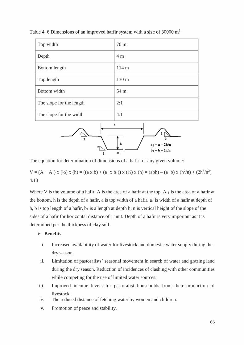
66
Table 4. 6 Dimensions of an improved haffir system with a size of 30000 m3
Top width 70 m
Depth 4 m
Bottom length 114 m
Top length 130 m
Bottom width 54 m
The slope for the length 2:1
The slope for the width 4:1
The equation for determination of dimensions of a hafir for any given volume:
V = (A + A1) x (½) x (h) = ((a x b) + (a1 x b1)) x (½) x (h) = (abh) – (a+b) x (h2/n) + (2h3/n2)
4.13
Where V is the volume of a hafir, A is the area of a hafir at the top, A 1 is the area of a hafir at
the bottom, h is the depth of a hafir, a is top width of a hafir, a1 is width of a hafir at depth of
h, b is top length of a hafir, b1 is a length at depth h, n is vertical height of the slope of the
sides of a hafir for horizontal distance of 1 unit. Depth of a hafir is very important as it is
determined per the thickness of clay soil.
Benefits
i. Increased availability of water for livestock and domestic water supply during the
dry season.
ii. Limitation of pastoralists’ seasonal movement in search of water and grazing land
during the dry season. Reduction of incidences of clashing with other communities
while competing for the use of limited water sources.
iii. Improved income levels for pastoralist households from their production of
livestock.
iv. The reduced distance of fetching water by women and children.
v. Promotion of peace and stability.
67
vi. Availability of more time for grazing and resting favours improved productivity.
vii. Provision of safe drinking improves the health conditions of the local population.
viii. Improved income farmers.
Cost
Hafir systems required significant capital investment cost for construction. The construction
cost ranges from $ 17 to 22.5 per m3.
Socio-cultural acceptability
Hafirs systems are popular in Soudan indicating the level of acceptability by the local
communities. It is the most used WH technique in Sudan.
Challenges
i. Lack of repair and maintenance services and inability to purchase the spare parts
by the local communities.
ii. The inability of local authorities to provide support because of limited capacity,
including technical, human resource, budgetary and practical skills.
iii. Often, the pumps break down for lack of a minor spare part or a technician with
ordinary-level skills to repair.
iv. There is no money to procure unavailable parts or no one would accept the
responsibility for procuring them. As a result, the pump could no longer be used
and the community members are forced to collect water from the haffir directly.
v. The inability of Haffir systems to serve the local communities long enough
because of limited storage size and excess of users In Kapoeta Eastern Sudan.
Subsequently, cattle could still be driven to other places to obtain water and
pasture during the critical period of the dry season.
vi. Increased incidences of Water-related diseases among local communities drinking
water from the hafir.
vii. The large surface of the hafir system is subject to evaporation.
Sustainable Operation and Maintenance
i. Allocation of 25% of the investment cost for O&M.
ii. Monitoring of water quality from the hafir.
iii. Appropriate design of the hafir system with adequate storage capacity based on
demand and population growth.
68
iv. Effective use of water from the hafir.
v. Encouraging the users to pay a water fee based on the tariff set by the
management committee and the users.
vi. Training of all stakeholders with the appropriate skills on the O&M of the haffir
systems.
vii. Engaging women in water decision making.
Adaptability
Hafir systems are most used in Arid and Semi-Arid Regions with limited existing water
resources. Areas with pastoral headers, remote and difficult to access where there are clay soil
and available local materials. Hafir systems are used in Sudan or lacs collinaires in Algeria,
made in Morocco, deep in Senegal, charco ponds in the drylands of Tanzania, khaks in
Turkmenistan or mahafurs in north-west Arabia (Saudi-Arabia).
4.6.3 Sand Dam
Technical specification
Sand dam (or sand storage dam) is a small dam build on and into the riverbed of the seasonal
sand river to provide water for humans, livestock and off-season irrigation. Typical sand has
between 1 to 5 meters high and 10 to 50 meters across the river bed. During the rainy seasons,
it captures water and coarse sand upstream of the sand dam wall. The water trickles through
the trapped sand and provides a reservoir from which water can be taken through pipes and
pumps. A sand dam can store up to 40 million liters of water, protecting it from evaporation
and contamination by holding it safely within the sand. There are three types of sand dams:
Stone-masonry dam which is built with concrete blocks or rubble stones and it is durable and
cheap where construction materials are available; Reinforced concrete dam consists of thin
wall made of reinforced concrete, it is durable, relatively expensive but suitable for any type
of dam and an earth dam consisting of impermeable soil materials (clay soil or black soils) but
it can be easily damaged or destroyed by underground flow they are not popular. Site selection,
community involvement and water use assessment are very important in choosing sand dams
for implementation.
Design
They are four (4) components of a sand dam which are: the dam spillway, the wing walls and
the stilling basin. One fundamental design principle is that the dam yields as much water as
69
possible without increasing the construction cost. For doing so, the dam is built on an
underground dyke with a gentler slope to produce higher throwbacks. It is required that the
water level and the maximum flood level remain below the riverbank after construction. This
prevents spilling over the bank and creating a new river. The maximum height of the spillway
is the difference between the height of the lowest riverbank (m) and the height of the maximum
flood level (m). The design of the sand storage dam is based on the African Land Development
Board (ALDEV) in which the total final maximum spillway height allows a safe discharge of
overflowing water. It is recommended to have a fixed stage heights from 20cm to 60 cm on a
case by case basis. Table 4.1 below gives the design for cost-efficient sand storage dam with
h, the height of the spillway. The foundation of the dam is built on murram clay or bedrock to
prevent seepage.
Table 4. 7 ALDEV design recommendations for cost-efficient sand storage dams
ALDEV variables (m)
Base of dam h × 0.75
The slope of the front wall h × 0.125
Base of trench h × 0.55
Vertical back wall h × 0.2
With of apron h × 0.75
With of crest h × 0.2
Depth of trench 1-2
Benefits
i. Less evaporation (water storage in sand).
ii. Less contamination with sand (not direct contact of water with livestock and other
animals).
iii. Increased fodder production.
iv. Increased drinking water availability of better quality.
v. Increased farm income.
vi. Reduced water-related diseases.
vii. Increased animal production.
viii. Increased school attendance.
ix. Reduction of distance covered for fetching water women and children.
70
Cost
Sand dams are the world’s lowest-cost method of capturing rainwater in dry rural areas by a
factor of 3 to 30 times compared to rainwater harvesting tanks, earth dams, haffirs and rock
catchments There even less expensive where local materials are available with labour. In 2012,
in Machakos County, Kenya, the cost of materials and technical support for a dam using 250
bags of cement is $7, 000 and $11, 700 for a 500 bag dam. In general, the unit cost is 10 – 25
pe rm3, 1.82 per m3.
Socio-cultural acceptability
Over 500 sand have been constructed in Kituï District of Kenya and 100% of land user families
have implemented the technology with external material support. Sand dams have a high
degree of acceptability.
Challenges
i. No control over the use of water.
ii. Risk of water contamination by livestock if proper care is not taken.
iii. Risk of the high rate of erosion downstream.
iv. 2 to 7 years required for the sand dam to fill in with sand.
v. The technology is labour intensive and external aid is needed for implementation.
Sustainable operation and maintenance
i. Awareness of the contamination risk of water from the sand dam.
ii. Effective management and water use from the reservoir
iii. Encouraging users to pay a water fee based on the tariff set by the management
committee and the users.
iv. Regular monitoring and utilization of the dam
v. Involving all stakeholders to ensure operation, management and maintenance after
implementation.
vi. The proper linkage between the local community, local administration and
government sector to ensure technical and advisory assistance for the community.
vii. Training the stakeholders with the appropriate skills to maintain the system.
viii. Allocating 10% of the investment cost for operation and maintenance.
ix. Involving women in water decision- making.
x. Engaging in contract farming with wholesalers.
71
Adaptability
Sand dams are used in Arid and Semi-arid regions where suitable sandy river beds are usually
seasonally dry. Sand dams are technically replicable. They are mostly used in Kenya and are
also found in Ethiopia, Chad and Burkina Faso.
4.6.4 Permeable rock dam
Technical specification
Permeable rock dams are forms of floodwater harvesting where runoff waters are spread in the
bottom of valleys to improve agricultural production and at the same time to control gully
erosion. The structures are usually long, low dam walls made from loose stone. The central
part of the dam is perpendicular to the valley, while the wall extensions to either side curve
back down the valleys almost following the contour. The concept is that the runoff water that
accumulates in the middle of the valley to create a gully is spread across the valley floor to give
favourable condition for crop growth. During peak flows, the excess water infiltrates through
the dam or overtops it. As water continues to infiltrate, the dam is silted up with fertile soils.
Normally series of dams are built along the same valley bed to stabilize the valley system
entirely. The technique is labour intensive and needs a group approach, as well as some
assistance to transport the stones.
Design
The dam wall is about 7 cm high and it may be as low as 50 in some areas. The middle section
of the dam including the spillway (if needed) may have a maximum height of 2 m above the
gully bed. The dam spreader (wall) can be as long as 1000 meters across the widest valley beds.
The lengths normally range between 50 to 300 meters. The number of stones used can be 2000
tonnes in the largest structures.
The dam wall is made of loose stone, positioned with care, the larger boulder form the
framework and the smaller stones are packed in the middle like a sandwich. The side slope
ranges from 3:1 or 2:1(horizontal: Vertical) on the downstream side and 1:1 or 1:2 on the
upstream side. The structure is more stable with shallower side slopes but very expensive. It is
recommended to set the dam wall in a trench of about 10 cm depth to prevent undermining by
runoff waters. It is strongly advisable to place the layer of gravel, or at least smaller stones in
the trench when they are erodible soils.
72
Benefits
i. Erosion control and increased crop yield.
ii. Fertile deposits finning in gullies, therefore land management improved.
iii. Boost the groundwater level.
iv. The yield of sorghum increased from 1 to 1.9 ha as a result of rock permeable dam.
v. Used for growing rice, millet and peanuts.
Cost
Permeable rock dam providing water supplies and erosion control to plots of 2 to 2.5 ha costs
about $500 to 650 for transportation of material about 300 to 600 person-days of labour.
Socio-cultural acceptability
The technology is accepted by local communities in Burkina Faso.
Challenges
i. High Stone transportation cost;
ii. Huge quantity of stone needed
iii. Specific to a site
Sustainable operation and maintenance
i. Replacing washed off stones.
ii. Repair of small damage to prevent deterioration.
iii. Careful observation of the construction method.
iv. Allocation of 5% of investment cost for repair.
Adaptability
Permeable rocks are used in Arid and semi-arid regions where the annual rainfall is between
200 to 750 mm/year. They are suitable for all agricultural soil with the best slope of 2%for the
effective spread of water across the valleys. They are mostly used in Burkina Faso.
4.6.5 Rooftop water harvesting
Technical specification
Rooftop and courtyard WH provide water very close to the household. Rainwater is collected
as it runs off the catchment area of house roofs or paved/compacted surface in and around the
73
courtyard. The collected water is transported through a conveyance system of gutters and
downpipes to underground above ground storage facilities or a combination of both. The
storage facilities are called tank of various types, jar or cistern. Rooftop materials used for
water harvesting are galvanized iron aluminum or cement sheets. Gutters, downpipes, filtration
and storage facilities could b made of local materials or manufactured the bigger the roof, the
higher the runoff yield. In tropics, only 85% of water runoffs and15% is lost to evaporation.
Design
The quantity of water that runs off a roof into the gutter system could be calculated using the
following equation:
𝑄 = RC × 𝑅 × 𝐴, 4.15
where 𝑄 is the quantity of runoff water, RC is the runoff coefficient, 𝑅 is the total rainfall
(mm/y), and 𝐴 is the roof area or the catchment area (m2). The method of estimating water
demand is as follows: the water use (in liters) multiplied by the number of persons in the house
and then multiplied by the number of days without the rain. The size of the storage facility is
estimated when water demand is known.
For Abougoudam District with an average household of 10 people based on the questionnaire,
annual rainfall of 312.5 mm/year(0.3125 m/year) with a probability of 52.4%, a roof catchment
of 281 m2 and runoff coefficient of 0.9 (corrugated sheet metal mostly used in Chad).
The total amount of water harvested in a year =0.3125 × 0.9 × 281 = 79.03125 m3/year =
79031.25 l/year = 216.52 l/day which is enough to supply a household of 10 people with a
water demand of 200 l/day (20 l/p/d). The size of the storage facility is the difference between
the total amount of water harvested and the total water demand in a year. The total water
demand in a year=20 × 10 × 365 = 73000 l/year. The size of the storage facility= 79031.25
l/year-73000 l/year= 6031.25 l/year= 6.031 m3/year.
Benefits
i. Increased reliability of clean and affordable drinking water for domestic use,
hygiene, livestock consumption, irrigation of kitchen gardens.
ii. Reduced distance covered by women and children to fetch water, therefore
enhancing their health condition.
iii. Enabling water storage for off-season use.
74
iv. Water management at the household level, therefore avoiding conflict on water
management at the community level.
Cost
The cost of rooftop water harvesting depends on the tank, gutter, downpipe and filtration
system, the volume of materials, design, where and how the system is constructed. It may
require a high capital cost from the beginning but the running cost is very cheap. $600 was
used to adopt rooftop in Senegal with a tank of up 20 years life span. Galvanized iron roof with
22m3 in Botswana cost $2,000 with $13 labour cost. Ferro-cement jar of 90 m3 cost $2,555.
Socio-cultural acceptability
Rooftop water harvesting is used in Botswana, Burkina Faso, Ghana, Kenya, Nigeria, Senegal,
South Africa, Uganda in Africa; China, Kyrgyzstan, India, Indonesia, Japan, Nepal, Sri Lanka,
Tajikistan, Thailand in Asia and Brazil, Australia, Germany, Spain.
Challenges
i. Reliance on rainfall and adequate storage capacity.
ii. Risk of contamination of water from a high level of phosphate bird drops and
accumulation of dust on the roof which are washed into the storage facility.
Sustainable operation and maintenance
i. Removal of contaminants using the first-flush diversion.
ii. Regular cleaning of tanks.
iii. Disinfection of water when considered for domestic drinking.
iv. Need for information, education and training on the technology.
Adaptability
The technology is suitable in arid and semi-arid areas where rainwater is the most suitable
accessible source of water.
4.6.6 Zai pit (Tassa)
Technical specification
Zai pit (planting pit) is Microcatchment technique that is practiced on land which is not very
permeable so that runoff can be captured. Zai is hand-dug technology to improve infiltration
of runoff. Manure and fertilizer are added to the pit resulting in improved crop yields. The dug
earth is placed downslope of the pit and may be formed into a ridge to capture rainfall and
75
runoff effectively. Zai pits are often combined with stones lines to regenerate cultivated areas
that have been degraded. They normally used to grow sorghum, maize, millet, cowpeas, sweet
potatoes, groundnuts and bananas.
Design
Zai pits are usually 20 to 30 cm wide and 20 to 30 cm deep and spaced 60 cm to 1 m apart. The
catchment ratio is 3:1. They are applied on a slope of 0 to 5%.
Benefits
i. Rehabilitation of degraded lands.
ii. Increased sorghum yield. From 0.7 to 1.0 t/ha/
iii. Increased yield millet in Tanzania from 124 kg/ha to 360 kg/ha.
iv. Increased farm income.
v. Increased fodder production.
Cost
The cost of zaï pit estimated in terms of the time it takes a farmer to dig the holes and fill them
with organic matter. It requires between 30 to 70 people per hectare as input for digging the
holes depending on the hardness of the ground. For the fertilization with manure and
compositing, 20 person-days per hectare. If the wear and tear cost of materials by the farmers
are taken into account, the cost may be estimated at about 8$ha.In Niger, it is $ 65/ha.
Socio-culture acceptability
The technique has no negative use in the countries where it has been practiced. Therefore, there
is no contradiction in social-cultural practices. They are called tassa in Niger, Zai pits in
Burkina Faso, Chololo pits in Tanzania, gun pits in Sudan, kofyar in Nigeria, Yamka in
Kyrgyzstan.
Challenges
i. Efforts needed to watch the state of the holes by the farmers.
ii. Subject to waterlogging in a very wet season.
iii. Labour requirement for repair and maintenance.
Sustainable operation and maintenance
i. Checking of holes before planting.
ii. Checking of holes after every storm.
76
iii. Filling of holes with the required amount of organic manure.
iv. Adequate digging of holes with debris evenly placed in the holes.
Adaptability
Zai pit can be used in all Sahelian countries.
4.6.7 Stones line bunds
Technical specification
Stones lines (stones bunds) are laid along the contour to rehabilitate barren or crusted soils.
They are often used in combination with zaï pits by farmers to regenerate their degraded lands
and increase crop yields. The stones lined along contour do not collect runoff but keep it spread
thereby slowing the speed of runoff in order to allow it infiltrate, which is further improve
through the use of zaï pits. The farmers usually start by lining the stones at the lower points of
the field and work upslope. Since the stones are not easily damaged by runoff they start at
lower points to collect enough runoff for crop production in a year with less than average or
irregular rainfall. Stone lines are constructed by mixing both small and large stones. Small
stones are placed upslope and the larger ones below to slow down runoff catch fertile soil
sediment. Stone lines are easy and cheap to construct provided stones are locally available.
Design
The height of line/bund is 25 cm with a base with of 35 to 40 cm. The bund is usually laid in a
shallow trench with a depth ranging from 5 to 10 cm, which helps in being not undermined by
runoff. The mixture of both small and large stones allow effective harvesting of runoff. Bunds
spacing of 20 m is laid on a slope of less than 1% while the spacing of 15 m is laid on a slope
of 1 to 2%.
Benefits
i. Improved water availability for plants.
ii. Increased farmers’ income.
iii. Improved erosion knowledge.
iv. Regeneration of degraded land.
v. Increased soil organic matter.
77
Cost
The cost of stones linked to the availability of stones and transportation. It is cheap wherever
stones are available. In Niger, the cost is $31/ha.In Kenya, it ranges from $32 to 62/ha with a
maintenance cost of $30/year.
Socio-cultural acceptability
Stones line have been traditionally used by farmers in Katanga, Burkina Faso. They are also
used in Niger and Kenya. The concept of stone lines has been readily accepted. Farmer to
farmer extension is effective to spread the technology.
Challenges
i. Shortage of stones.
ii. Increased in establishment cost.
Sustainablee operation and maintenance
i. Relaying of stones from time to time as a result of siltation.
ii. Preventing bund overtopping to reduce risk of gully formation and bund
undercutting on the downstream face.
Adaptability
Stone lines are common throughout Africa, both in dry and humid regions. They are suitable
in areas receiving between 200 mm to 750 mm per year.
4.7 Policy brief on the sustainability of water harvesting structures in Chad
Water harvesting is a traditional practice that has been employed over the years to supplement
water for humans, livestock and off-season irrigation. Most of the structures failed to perform
well in the past because of improper design; the beneficiaries were not involved in the planning
and implementation of the structures; there was lack of proper operation and maintenance of
the structures and there was also lack of knowledge on the impact of WHSs. The existing water
resources may not be able to meet the growing demand for humans, livestock and agricultural
production for sustainable development. As a result of climate change, rainfall variability and
increase in temperature, there is a growing interest level to invest in WH to supplement water
for the intended use. Below are some of the issues related to the sustainability of WHSs and
possibly incorporating them into policies may attract investment in order to improve the
livelihoods of the local communities with chronic water shortages.
78
Overlapping of Institutional stakeholders: WH projects are implemented to provide water for
humans, livestock and off-season irrigation. The Ministry of Environment, Water and Fisheries
is the only one handling water projects. Since the beneficiaries are expected to be responsible
for the O&M, involving the Ministry of Agriculture at the planning stage helps to provide
advice to the farmers on how to grow high-value crops to increase their income, thereby willing
to contribute for the management of the structures.
Farmer-livestock conflict: During the dry season, water demand for off-season and livestock is
high. Introducing water harvesting techniques in pasture lands helps to limit movement of
livestock to the nearby farmlands. This could prevent the destruction of the crops grown.
Therefore, the farmers will be able to contribute after selling their products.
Land tenure and WH projects: WH projects are mostly managed at the community level. WH
project may be implemented between two administrative areas and this may bring conflict over
the use of the water. Defining the responsibility of each administrative area over the use of the
water will help in the management of the system.
WH projects and socio-cultural acceptability: WH harvesting is mostly implemented without
consulting the beneficiaries on the choice of the structure and what they really need.
Developing a small, medium and strategic water harvesting structures in an economically
efficient, socially acceptable and environmentally responsive manner, promote beneficiary’s
awareness for contributing and improving their water harvesting infrastructures.
The socio-economic and political context of WH projects: A sound understanding of the socio-
economic and political context selected areas, where WH structures are constructed, help in
designing appropriate strategies for sustainable use and management of WH structures,
particularly if the WH structures are intended to address livelihoods.
WH projects and issues of water demand: As a result of irregularities in rainfall, increase in the
population of humans and livestock and extension of farmlands during the dry season may
affect the reliability of the structures to provide adequate water supply to the intended users.
Therefore, designing the adequate storage capacity through carefully estimated demand levels,
water losses consideration of unforeseen variations with the seasonal rainfall will help to ensure
the management of the system.
79
Non-participation of all stakeholder in WH projects: Beneficiaries are always omitted in the
planning and selection of WHSs. The participation of all key stakeholders in the entire process
from the choice to site selection through implementation and management will ensure the
sustainability of the system.
Supervision and monitoring of WH projects: WH is implemented by considering just a water
scarcity problem in a particular area without given attention to the supervision and monitoring
of system after implementation affects the sustainability of the structure. Therefore,
establishing proper supervision and monitoring mechanisms before starting any construction
with defined and clear responsibilities at national, regions and local levels will ensure the
sustainability of the structure.
Water tariff in WH projects: Water is free in Chad, therefore, most water users feel that it is
the responsibility of the government to provide water and ensure the operation and maintenance
which is not mostly the case. Setting up WH management committees, engaging farmers in
growing high-value crops, encouraging water use service fee in cash or in-kind where possible,
this could help in using water more efficiently and generate revenue to maintain existing water
infrastructure and build new facilities where needed
Knowledge on proposed WHSs: Implementation of WH technologies could be an existing or
new facility to the beneficiaries, therefore promoting technologies that the users are able to
maintain will surely ensure the sustainability of the structure.
Public-private partnership: Most WH projects is only discussed between the government and
the financial institution without involving the direct users to understand their needs and the
government always decide on the behalf. The financial institution does not have any idea on
what the beneficiaries need at the local level. Increasing private sector participation in WH
harvesting related projects and discussing directly with the beneficiaries to understand their
needs will help in sustaining the structures.
Management of WHSs: Beneficiaries may not be conversant with the WH technologies put in
place. Strengthening trained and equipped management committees and beneficiaries even
after implementation of the structures will ensure sustainability.
Participation of Beneficiaries in WH projects: Enable communal WH projects beneficiaries,
citizens, to fully participate effectively in the formulation and implementation. Protection zones
80
for all drinking water sources shall be delineated and monitored
Climate change and erosion: The effect of climate change and erosion may not be clear to the
beneficiaries and with the variation of rainfall and increase in temperature affect the reliability
of WHSs to provide the water needed during the dry season. This could reduce the trust of the
beneficiaries. There is a need to educate the beneficiaries on the effect of climate change and
erosion possibly provide a mitigating measure, for example, encouraging beneficiaries to plant
trees that uptake less water around the catchment to minimize evaporation.
Based on the above-mentioned issues, the sustainability of WHSs may be achieved if they
could be incorporated into the policies governing water resources.
81
CHAPTER FIVE
5.0 CONCLUSION AND RECOMMENDATIONS
5.1 CONCLUSION
Chad as part of Arid and Semi-Arid Regions is faced with difficulties in the limited amount of
rainfall which is associated with the degree of its variability. Abougoudam District which is
located at 17 km from Abéché City in the region of Ouaddaï has seven (7) months without
rainfall with a high increase in temperature and only four months with rain. From figure 4.1,
the rain starts increasing from May and reaches its peak in the month of August and suddenly
decreases in the month of September. This shows the irregularities in the rainfall intensities
with short duration. The District has 16 hand pump boreholes and 25 open wells with a yield
of 8 m3/day for 62161. From table 4.3, the basic water supply is 5.16 l/p/day which is far below
the basic drinking water supply standard set by the Chadian Water Company (30 l/p/d). The
current domestic water supply for humans is 328000 liters with a deficit of 1,536,830 liters. As
for livestock, the water demand is 2,312,063,327 liters. The results of the designed rainfall
totals from 1999 to 2018 showed that an annual rainfall with the probability of more than 50%
might be able to supplement the water demand in the Abougoudam District with the adoption
of WHSs.
The soil map of the case study was generated using ArcGIS 10.5. The result showed three (3)
group of soil: Group A: Sandy clay rock, silt clay, stone and rocks; Group B: vertisols (black
and brown clay with the proportion varying from 40 to 60 percent, silt clay and sandy soils;
Group C: Sand, Sandy-clay, gravel, loamy sand and loamy-clay. Vertisols should be avoided
because of their cracks on drying which affect both the storage of water and the stability of
WHSs.
From the result of the questionnaire, the population of Abougoudam District is willing (100%)
to adopt water harvesting but government and beneficiaries have shown the weak financial
capacity to adopt and maintain WHSs. Increasing public-private partnership and integrating
WH into socio-economic development programs make it attractive enough for sponsorship by
donor organization especially the United Nations and IsDB in their attempt to eradicate poverty
and foster environmental sustainability in order to achieve the SDGs(goal number 2and 6).
With regard to best practices of WHSs to supplement water for human, livestock and off-season
irrigation, Water spreading weirs, Hafir system, Sand dam, permeable rock dam, rooftop, Zai
82
pit and Stone lines have been highlighted in this study. The analysis focused on technical
specification, design, socio-cultural acceptability, cost-benefit, challenges, sustainable O&M
and adaptability. These factors have to be addressed properly to ensure that any WH system is
able to perform cost-efficiently and improve the livelihoods of the local community.
Based on adaptability, the technologies mentioned above could be adopted in Chad and most
specifically in Abougoudam District but water spreading weir, Sand dam and combination of
the zaï pit and stones lines are more preferable. This is because of their capacity to regenerate
degraded lands in valley regions, reduce evaporation, recharge groundwater and have the
potential to improve water supply for humans, livestock and off-season irrigation through
wells. They have also proven to increase crop yields in order to fight food insecurity, this is
very important since Chad has been pointed out as a country that suffers from very high food
insecurity in WFP 2018 report. Another factor that needs to be considered is that most off-
irrigation are practiced around the wadi bed and the local communities got most of their
drinking water from the wells in the wadis which has become part of their culture. In addition
to that, there are also available local materials which could be used to reduce the construction
cost. Hafir system could also be considered because of its potential to provide water both for
human and livestock.
The sustainability of these structures could be addressed by incorporating overlapping of
Institutional stakeholders; Farmer-livestock conflict; Land tenure and WH projects;WH
projects and socio-cultural acceptability; The socio-economic and political context of WH
projects; WH projects and issues of water demand; Non-participation of all stakeholder in WH
projects; Supervision and monitoring of WH projects; Water tariff in WH projects; Knowledge
on proposed WHSs; Public-private partnership and Management of WHSs into the national
policy.
The government has the responsibility to provide water for her population and the population
also have the responsibility to provide water for themselves. Therefore, both parties have to
work hand in hand to ensure the sustainability of WHSs. WH sustainability has worked in
Sudan, Kenya, India, Burkina Faso, Jordan and other Arid and Semi-Arid Regions of the world,
it can also work in Abougoudam District. "Change is the law of life and those who look only
to the past or present are probably to miss the future," said John F. Kennedy. It is always better
83
to look into the future. Could WH be the future of Abougoudam District population suffering
from chronic water shortage?
5.2 RECOMMENDATIONS
In view of the above discussion and conclusion, this study recommends the following that
would be beneficial to the adoption and sustainability of WHSs in Chad and other Arid Regions
of Africa:
Improving the financial capacity of the Chadian government and beneficiaries with the
support of the international financing organizations to unlock the potential investment
in water harvesting. Improving the capacity of the Chadian government and local
community on the issue of O&M of water harvesting through training and provide the
institution and local communities with the right training on water harvesting
technologies.
Encouraging the beneficiaries to pay for water fee by improving their livelihoods
because water is used free of charge in areas with water harvesting projects apart from
water spreading weirs. This could affect the maintenance of the structures.
Setting up WUA for community water harvesting projects because the study revealed
that only water spreading weirs have management committees amount all WHSs in
Chad.
Sensitizing the local community on water harvesting and its impacts because the
beneficiary may not be aware of the technology.
Reducing tax on construction materials such as cement and steel bar by the government
because the study has revealed that water harvesting projects in Chad are more
expensive compared to other regions in Africa.
Creating the spirit of ownership right from the planning stage of the projects since the
O&M is solely the responsibility of the local community. It could give input in the
sustainability of the structures.
Building a comprehensive database for water harvesting to include biophysical studies,
socioeconomic studies, hydrologic and technical studies. This could provide necessary
information on the areas considered for WH adoption.
84
Minimizing sediment caused by soil erosion by delineating bare soil areas on sloping
terrains and planting them.
Delineating and monitoring all drinking water sources to enhance water quality.
The inclusion of policy brief into the national policy to ensure the sustainability of
WHSs in Chad and other Arid Regions of Africa.
5.3 FUTURE PROSPECTS
The future of WH in Chad will depend on the public and private partnership between the
Chadian government and the financial institutions to unlock the potential investment to
improve the socio-economic activities of the local community. Abougoudam has the potential
for animal production and off-season irrigation for high-value crops to contribute to the
national economy and create employment for the local population. WH is an ancient practice
that has been employed to supplement water for humans, livestock and off-season irrigation.
The future lies in the adoption of WHSs that have performed well to provide water for the
intended use. The renewal interest in WH adoption is on the increase in areas that the existing
water resources could not meet their water demand. The use of green water and its impacts will
definitely enhance the livelihoods of the local communities but the sustainability of the
structures should be addressed properly in order to mitigate against the impacts of climate on
water supply, food security and physical condition of livestock. Chronic water shortages will
surely be felt in the future but WH will reduce the degree of the severity in Abougoudam
district, Chad and other Arid Regions of Africa.
85
REFERENCE
1. Abderamane, Hamit. 2012. “Study of the Hydrogeochemical Functioning of the System
Aquifer of Chari Baguirmi (Republic of Chad).”
2. Adey, Souleymane Adam, Abdenbi Zine El-abidine, Mahamat Ali Mustapha, and Najib
Gmira. 2017. “Climatic Trends in the Sahel during 1950 - 2014 : A Case Study of
Ouaddaï Region in Chad.” Mediterranean Journal of Biosciences 1(5): 213–23.
3. Adham, Ammar, Michel Riksen, Mohamed Ouessar, and Coen Ritsema. 2016.
“Identification of Suitable Sites for Rainwater Harvesting Structures in Arid and Semi-
Arid Regions : A Review.” International Soil and Water Conservation Research: 2095–
6339. http://dx.doi.org/10.1016/j. iswcr.2016.03.001i.
4. AfDB, 1999. Operations Manual. AfDB Group.
5. AGH. 2010. Race Against Hunger: CHAD.
6. Ahmed, Khalid Ahmed Sirelkhatim. 2012. Quantitative Assessment of Haffir Water
Management in Kassala State, Sudan.
7. Akhtar Ali, Theib Oweis, Atef Abdul Aal, Mohamed Mudabbar, Khaled Zubaidi, and
Adriana Bruggeman. 2006.The Vallerani Water Harvesting System. ICARDA Caravan
No. 23. (http://www.vallerani.com/images/Caravan-23.pdf).
8. Al-Abyadh, Mohamed Abdullah. 2017. Evaluating the Potential of Road Rain Water
Harvesting in Yemen – Rural Roads Abstract : Yemen.
9. Alaya, K., Viertmann, W., Waibel, Th. 1993. The tabias. Arabe printing house of
Tunisia.
10. Alem, G.2003, Water Harvesting: A Water Security Strategy For Mitigating The Impact
Of Drought In Ethiopia. Water Security in the 21 St Century. pp 1-5.
11. Ali A, Yazar A, Abdul Aal A, Oweis T, Hayek P (2010) Micro-catchment water
harvesting potential of an arid environment. Agric Water Manag 98:96–104.
12. Al-komaim, Muhammed Dahan Abdulrahman. 2018. “Site Suitability Analysis for
Different Indigenous Rainwater Harvesting Systems – A Case Study of Sana ’ a Water
Basin, Republic of Yemen Master ’ s Thesis Site Suitability Analysis for Different
Indigenous Rainwater Harvesting Systems – A Case Study of.” Wageningen University
& Research.
13. Amos, et al. 2016. “Economic Analysis and Feasibility of Rainwater Harvesting
Systems in Urban and Peri-Urban Environments : A Review of the Global Situation with
a Special Focus on Australia and Kenya.” MDPI.
14. Angel, J M et al. 2011. GEOLOGICAL MAP AND MINERAL RESOURCES OF THE
REPUBLIC OF CHAD.
15. Ashkenazi, Avni and Avni 2012 E. Ashkenazi, Y. Avni, and G. Avni. “A
Comprehensive Characterization of Ancient Desert Agricultural Systems in the Negev
Highlands of Israel”. Journal of Arid Environments 86 (2012), 55–64.
16. Awojobi, Oladayo Nathaniel, and Jonathan Tetteh. 2017. “THE IMPACTS OF
CLIMATE CHANGE IN AFRICA: A REVIEW OF THE SCIENTIFIC
LITERATURE.” JOURNAL OF INTERNATIONAL ACADEMIC RESEARCH FOR
MULTIDISCIPLINARY 5(11): 39–52.
17. Bangira, Courage. 2018. “Food Security as a Water Grand Challenge.” Journal of
Contemporary Water Research & Education (165): 59–66.
18. Barry, B., Olaleye A. O. , Zougmoré, R. and Fatondji D. ( 2008 ) ‘Rainwater harvesting
technologies in the Sahelian zone of West Africa and the potential for out scaling’,
IWMI Working Paper 126, International Water Management Institute, Colombo, Sri
Lanka, 40 pp.
19. Ben-Asher, J. (1988). A Review of Water Harvesting in Israel. World Bank Working
Paper 2. World Bank Sub-Saharan Water Harvesting Study, p. 47-69.
86
20. Bender, H. (2005): Technical recommendations. Version 2005. Water spreading weirs
in the Sahelian zone. KfW-GKW-Pöyry.
21. Ben Mechlia, N., Ouessar, M. 2004. Water harvesting systems in Tunisia.
22. Bewket, W. (2012). Climate change perceptions and adaptive responses of smallholder
farmers in the central highlands of Ethiopia. International Journal of Environmental
Studies, 69, 1–17. https://doi.org/10.1080/00207233.2012.683328.
23. Biswas, Biplob Kumar, and Bablu Hira Mandal. 2014. “Construction and Evaluation of
Rainwater Harvesting System for Domestic Use in a Remote and Rural Area of Khulna,
Bangladesh.” International Scholarly Research Notices.
24. Boustani 2009 F. Boustani. “sustainable water Utilization in Arid Region of Iran by
Qanats”. International Journal of Human and Social Sciences 4 (2009), 505–508.
25. Brundu, Giuseppe, and Ignazio Camarda. 2013. “The Flora of Chad : A Checklist and
Brief Analysis.” PhytoKeys 17: 1–17.
26. Bunclark, Lisa, et al. 2018. “Understanding Farmers’ Decisions on Adaptation to
Climate
Change : Exploring Adoption of Water Harvesting Technologies in Burkina Faso.”
Global Environmental Change 48(July 2017): 243–54.
https://doi.org/10.1016/j.gloenvcha.2017.12.004.
27. Buritz K. and Dudeck, E. 1986, Le project Agro-Ecologie. Philosophie et principes
d'intervention après 4 ans d'experience. ORD du Yatenga/ORD du Sahel/DED, Burkina
Faso.
28. Campisano, Alberto, et al. 2017. “Urban Rainwater Harvesting Systems : Research,
Implementation and Future Perspectives.” Water Research 115: 195–209.
http://dx.doi.org/10.1016/j.watres.2017.02.056.
29. Cech 2009 T.V. Cech. Principles of Water Resources: History, Development,
Management, and Policy. JohnWiley & Sons, 2009.
30. Clements, R., Haggar, J., Quezada, A. and J.Torres. 2011. Technologies for Climate
Change Adaptation: Agriculture Sector. Roskilde: UNEP Risø Centre on Energy,
Climate and Sustainable Development.
31. Cleveland, Jenna. 2013. Policies for Implementing Water Harvesting in Arid Regions.
ARIZONA.
32. Christopher, Ward. 2016. Improved Agricultural Water Management for Africa ’ s
Drylands. Washington: World Bank.
33. Critchley, W.; Reij, C. and Seznec, A. 1992a, Water Harvesting for Plant Production.
Vol 2. Case Studies and Conclusions from Sub-Saharan Africa. World Bank Techn.
Paper 157.
34. Critchley, W. 2010. More People More Trees: Environmental recovery in Africa.
Practical Action Publishing, Rugby.
35. de Fraiture , C., Molden, D. And Wichelns, D. ( 2010 ) ‘Investing in water for food,
ecosystems, and livelihoods: An overview of the comprehensive assessment of water
management in agriculture’, Agricultural Water Management, vol. 97, no. 4, pp. 495 –
501.
36. de Fraiture, C. and Wichelns, D. ( 2010 ) ‘Satisfying future water demands for
agriculture’, Agricultural Water Management, vol. 97, no. 4, pp. 502 – 511.
37. DWR., 2018. Annual report of the Directorate of Water Resources and Meteorology of
Chad. 25 p.
38. Dissanayake, Dmsb, and Padmi Ranasinghe. 2016. Effectiveness of National Rainwater
Policy and Strategy in Sri Lanka.
39. Dwiratna, Sophia, Nurpilihan Bafdal, Chay Asdak, and Nono Carson. 2018. “Study of
Runoff Farming System to Improve Dryland Cropping Index in Indonesia.”
87
International Journal on Advanced Science, Engineering and Information Technology
8(2):390.
http://ijaseit.insightsociety.org/index.php?option=com_content&view=article&id=9&I
temid=1&article_id=3268.
40. EduGreen, 2007. Water Conservation. [html] New Delhi: EduGreen. Available at:
<http://edugreen.teri.res.in/explore/water/conser.htm> [Accessed 4 November 2011]
Enfors, E., 2009. Traps and Transformations, exploring the potential of water system
innovations.
41. El-Amami, S. (1983). Les amenagements hydrauliques traditionels en Tunisie. Centre
de Recherche du Genie Rural, Tunis, Tunisia.
42. Erik Nissen-Petersen et. al. 2005. Water from ponds, pans and dams RELMA Technical
Handbook No. 32. [email protected].
43. Eshetu Abate, 2009, Technical Guideline for Improved Haffir, Government of Sudan
and Government of Southern Sudan.
44. Eshetu Abate, 2014, Draft Technical WH Assessment Report in Lakes, Eastern
Equatoria and the Western Equatoria States, South Sudan, FAO and UNEP.
45. Falkenmark, Malin. 2016. CALL FOR AN AFRICAN WATER Outcome from the Malin
Falkenmark Symposium at World Water Week in Stockholm 2016 : A Triple Green
Future for Humanity. Stockholm.
46. FAO (2001). Water Harvesting in Western and Central Africa. RAF/Publication, FAO,
Rome, Italy.
47. FAO . 2018. Accounting for Water Governance and Sustainable Development.
48. FAO, August 2012, Sustainable food security through community-based livelihoods
development and water harvesting project, RSS, Financed by the Canadian International
Development Agency.
49. FAO and AgWA, 2014. Tool for institutional and policy evidence-based analysis of
Agricultureµ Water Management (AWM) at country level: Guiding document. Not
published.
50. FAO. 2015. Planning, Construction and Operation of Water Harvesting Structures in
South Sudan.
51. FEWS NET. 2018. CHAD Food Security Outlook: Household Food Consumption in the
Sahel Deteriorates during Lean Season. N’Djamena.
52. FIDA. 2017. Analysis of Climatic and Environmental Vulnerability of Agro-Pastoral
Systems in West Central Chad.
53. Gemeda, Dessalegn Obsi, and Akalu Dafisa Sima. 2015. “The Impacts of Climate
Change on the African Continent and the Way Forward.” Journal of Ecology and the
Natural Environment Review 7(10): 256–62.
54. Ghisi, E., Bressan, D.L., Martini, M., 2007. Rainwater tank capacity and potential for
potable water savings by using rainwater in the residential sector of southeastern Brazil.
Build. Environ. 42, 1654–1666.
55. GIZ (Deutsche Gesellschaft für Internationale Zusammenarbeit), 2011. Fact sheet:
Water Spreading Weirs. GIZ, Eschborn and KfW Entwicklungsbank, Frankfurt.
http://www.solutionsforwater.org/wp-content/uploads/2011/12/Flyer-
Nexus_waterspreading-weirs.pdf
56. GIZ-KFW. 2012. Water-Spreading Weirs for the Development of Degraded Dry River
Valleys.
57. Gould, J. and Nissen-Petersen, E. (2003) Rainwater Catchment Systems for Domestic
Supply-Design, Construction and Implementation. ITDG Publishing, London, ISBN
1853394564 9781853394560.
58. Gowing, J., Bunclark, L., 2013. Water harvesting experience in East and West Africa
88
−prospects for sustainable intensification of rainfed agriculture. Agric. Dev. 20.
59. Guibert, Bertrand, and Lagnaba Kakiang. 2011. Study of the Hydrogeochemical
Functioning of the System Aquifer of Chari Baguirmi (Republic of Chad).
60. H. GILLET. 1963. “AGRICULTURE, VEGETATION, AND SOIL OF CENTER
CHAD.” Journal of Tropical Agriculture and Applied Botany 10: 53–160.
61. Haile, Mitiku, and Sorssa Natea Merga. 2002. Drylands Coordination Group report The
Experiences of Water Harvesting in the Drylands of Ethiopia: Principles and Practices.
http://www.drylands-group.org.
62. Hamid, Turahim Abd, and Basir Nordin. 2011. “Green Campus Initiative: Introducing
RWH System in Kolej Perindu 3 UiTM Malaysia.” 3rd ISESEE 2011 - International
Symposium and Exhibition on Sustainable Energy and Environment (June): 135–38.
63. HARB, RAYAAN. 2015. “Assessing the Potential of Rainwater Harvesting System At
the Middle East Technical University – Northern Cyprus Campus.” TECHNICAL
UNIVERSITY-NORTHERN CYPRUS.
64. Harma, C. (2001) Socioeconomic Indicative Impact Assessment and Benchmark Study
on Rooftop Rainwater Harvesting, Kabhrepalanchok District, Nepal, a report submitted
to ICIMOD, Kathmandu, Nepal.
65. Hummel, D. (2015). Climate change, land degradation and migration in Mali and
Senegal – some policy implications. Migration and Development, 5(2), 211–233.
https://doi.org/10.1080/21632324.2015.1022972.
66. Ibrahim, Ahmed. 2012. “INVESTIGATION OF RAINWATER HARVESTING
TECHNIQUES IN YATTA DISTRICT, KENYA MASTER OF SCIENCE ( Research
Methods ) JOMO KENYATTA UNIVERSITY OF.”
67. Issar 2001 A. Issar. The Knowledge of the Principles of Groundwater Flow in the
Ancient Levant. International Symposium OH2 Origins and History of Hydrology.
Dijon, 2001.
68. Jayne, T. S., Mather, D. and Mghenyi, E. ( 2010) ‘Principal challenges confronting
smallholder agriculture in Sub-Saharan Africa’, World Development, vol. 38, no. 10,
pp. 1384– 1398.
69. Jayne, Thomas, and Felix Kwame Yeboah. 2017. The Future of Work in African
Agriculture : Trends and Drivers of Change.
70. Jing, X., Zhang, S., Zhang, J., Wang, Y., Wang, Y., 2017. Assessing the efficiency and
economic viability of rainwater harvesting systems for meeting non-potable water
demands in four climatic zones of China. Resour. Conserv. Recycle. 126, 74–85.
71. Kim, K., Yoo, C., 2009. Hydrological modeling and evaluation of rainwater harvesting
facilities:a case study on several rainwater harvesting facilities in Korea. J. Hydrol. Eng.
14, 545–561.
72. Kloss, C. 2008. “Managing Wet Weather with Green Infrastructure Municipal
Handbook: Rainwater Harvesting Policies.” EPA, December.
73. Lade, Omolara Oyewumi. 2013. “A MULTI-CRITERIA DECISION ANALYSIS
FRAMEWORK FOR SUSTAINABLE RAINWATER HARVESTING SYSTEMS IN
IBADAN.”
74. Lasage R, Verburg PH (2015) Evaluation of small scale water harvesting techniques for
semi-arid environments. J Arid Environ 118:48–57.
75. LDP. 2014. LOCAL DEVELOPMENT PLAN OF CANTON OUADI CHOCK.
76. Lee, Sangho, and Reeho Kim. 2013. “Rainwater Harvesting Rainwater.” Encyclopedia
of Sustainability Science and Technology: 8688–8702.
77. Lightfoot 1996b D.R. Lightfoot. “Syrian Qanat Romani: History, Ecology,
Abandonment”. Journal of Arid Environments 33 (1996), 321–336.
78. Liniger, H. and W. Critchley (eds). 2007. Where the land is greener – case studies and
89
analysis of soil and water conservation initiatives worldwide. World Overview of
Conservation Approaches and Technologies (WOCAT).
79. Lunduka, Rodney. 2016. Economic Analysis of Rainwater Harvesting And. Lilongwe.
80. Mahe, G I L, and Y A N N L Hote. 2001. “Trends and Discontinuities in Regional
Rainfall of West and Central Africa : 1951-1989.” Hydrological Sciences-Jour
46(April).
81. Maher, Salman, Claudia Casarotto, Maria Bucciarelli, and Maria Losacco. 2018. An
Assessment of Policies, Institutions and Regulations for Water Harvesting, Solar
Energy, and Groundwater in {Jordan}. http://www.fao.org/3/i8601en/I8601EN.pdf.
82. Malesu, Maimbo M. 2006. Rainwater Harvesting Innovations in Response to Water
Scarcity.
83. Majdoub R, Khlifi S, Salem AB, Masada Y.2014. Impacts of the Meskat water-
harvesting system on soil horizon thickness, organic matter, and canopy volume of the
olive tree in Tunisia.Desalin Water Treat 52(10–12):2157–2164.
84. Malley, Z.J.U., Kayombo, B., Willcocks, T.J. and P.W. Mtakwa. 2004. Ngoro: an
indigenous, sustainable and profitable soil, water and nutrient conservation system in
Tanzania for sloping land. Soil and Tillage Research 77(1):47-58.
85. Mati, Bancy M, Maimbo Malesu, Alex Oduor, and ICRAF. 2005. Promoting Rainwater
Harvesting Eastern and Southern Africa, The RELMA Experience, ICRAF Working
Paper.
86. Mati, B. M. 2005. Overview of water and soil nutrient management under smallholder
rainfed agriculture in East Africa. Working Paper 105. International Water Management
Institute (IWMI), Colombo, Sri Lanka.
87. Mays 2010b L. Mays. Ancient Water Technologies. 1st ed. Springer, 2010.
88. Mcsweeney, C. 1960. UNDPClimate Change Country Profiles Temperature GCM
Projections of Future Climate Temperature.
89. MEWAF(Ministry of Environment, Water and Fisheries. 2018: Manual on Water
Resources in Chad.
90. MEWAF. 2018. Republic of Chad: Water Laws.
91. Miré, Ph Bruneau De, and P Quézel. 2018. “Taxonomic and Biogeographical Remarks
on the Flora of the Mountains of the Southern Edge of the Sahara and More Specifically
of Tibesti and Djebel Mara.” Journal of Tropical Agriculture and applied botany 8(4–
5): 110–33.
92. MoALD, 1984. Runoff Harvesting for Crops, Range and Tree Production in the
BPSAAP-area. BPS AAP Interim Report, ch. 12: 78-113, Nairobi, Kenya.
93. Molden, D. ( 2007 ) Water for Food, Water for Life: A comprehensive assessment of
water management in agriculture, Earthscan and International Water Management
Institute, London and Colombo.
94. Mobile et al. 2006 H. Motiee, E. Mcbean, A. Semsar, B. Gharabaghi, and V.
Ghomashchi. “Assessment of the Contributions of Traditional Qanats in Sustainable
Water Resources Management”. International Journal of Water Resources Development
22 (2006), 575–588.
95. Moustapha, Oumar A L I. 2018. Presentation of Chad
96. Mekdaschi SR, Liniger H. 2013. Water harvesting: guidelines for good practice. Centre
for
Development and Environment (CDE), Bern; Rainwater Harvesting Implementation
Network (RAIN), Amsterdam; MetaMeta, Wageningen; the International Fund for
Agricultural Development (IFAD), Rome.
97. Mutunga, K. and W. Critchley. 2001. Farmers’ Initiatives in Land Husbandry:
Promising Technologies for the Drier Areas of East Africa. Regional Land Management
90
Unit (RELMA), Swedish International Development Cooperation Agency (Sida).
RELMA Technical Report Series 27. Nairobi.
98. Näser 2010 C. Näser. “The Great Hafir at Musawwarat es-Sufra: Fieldwork of the
Archaeological Mission of Humboldt University Berlin in 2005 and 2006”. In Between
the Cataracts. Proceedings of the 11th Conference of Nubian Studies, Warsaw
University, 27 August – 2 September 2006. Vol. 2. PAM Suppl. Series 2.2/1. Fascicule
1: Session Papers. 2010, 39–46.
99. NISEDS(National Institute of Statistics, Economic and Demographic Studies).2019.
Demographic Outlook for Chad from 1998 to 2018.N'Djamena-Chad.
100. Nissen-petersen, Erik. 2000. WATER FROM SAND RIVERS.
101. Nissen-Petersen E. 2006c. Water from Small Dams: a handbook for technicians,
farmers and other on-site investigations, designs, cost estimates, construction and
maintenance of small earth dams. ASAL Consultants Ltd., Nairobi, Kenya. For the
Danish International Development Agency (DANIDA) in Kenya.
102. Nissen-petersen, Erik. 2010. There Is Water in Drylands. Miti.
103. OCHA. 2012. Regional Profile of Ouaddaï.
104. Ouédraogo, A. and Sawadogo, H. ( 2001 ) ‘Three models of extension by farmers
innovators in Burkina Faso’, in C. Reij and A. Waters-Bayer (eds), Farmer Innovation
in Africa: a source of inspiration for agricultural development, Earthscan, London.
105. Oweis T, Hachum A.2009. Water harvesting for improved rainfed agriculture in dry
environments. In: Wani SP et al (eds) Rainfed agriculture: unlocking the potential. CAB
International, Wallingford, p 164.
106. Oweis, T., Prinz. D. & Hachum. A. 2012. Rainwater Harvesting for Agriculture in the
Dry Areas. CRC Press – Balkema, Taylor & Francids Group, London & Leiden.
107. Oweis, Theib, Dieter Prinz, and Ahmed Hachum. 2013. 53 Journal of Chemical
Information and Modeling Water Harvesting; Indigenous Knowledge for the Future of
the Drier Environments.
108. Palla, A., Gnecco, I., La, B.P., 2017. The impact of domestic rainwater harvesting
systems in stormwater runoff mitigation at the urban block scale. J. Environ. Manag.
191, 297–305.
109. Pereira LS, Cordery I, Iacovides I (2002) Coping with water scarcity. International
Hydrological Programme (IHP)-VI. Technical documents in hydrology no. 58
UNESCO, Paris, 272 p
110. Prinz, D.1996. Water Harvesting: Past and Future. In: Pereira LS (ed) Sustainability of
irrigated agriculture. In: Proceedings of the NATO advanced research workshop,
Vimeiro, 21– 26.03.1994, Balkema, Rotterdam, pp 135–144.
111. Prinz, D. 2011. The Concept, Components and Methods of Rainwater Harvesting. In
2nd Arab Water Forum “Living with Water Scarcity”.
112. Prinz, Dieter. 2013. Rainwater Harvesting Methods and Floodwater Management
Water Harvesting Methods ( with Special Reference to Microcatchment and Rooftop
Water Harvesting ).
113. Qadir M, Sharma BR, Bruggeman A, Choukr-Allah R, Karajeh F (2007) Non-
conventional water resources and opportunities for water augmentation to achieve food
security in water-scarce countries. Agric Water Manag 87:2–22
114. Rahman, Sadia, et al. 2014. “Sustainability of Rainwater Harvesting System in Terms
of Water Quality.” : 10.
115. RAIN (Rainwater Harvesting Implementation Network). 2009. A practical guide to
sand dam implementation: Water supply through local structures as an adaptation to
climate change. RAIN Foundation / Acacia Water / Ethiopian Rainwater Harvesting
Association / Action for Development / Sahelian Solutions Foundation.
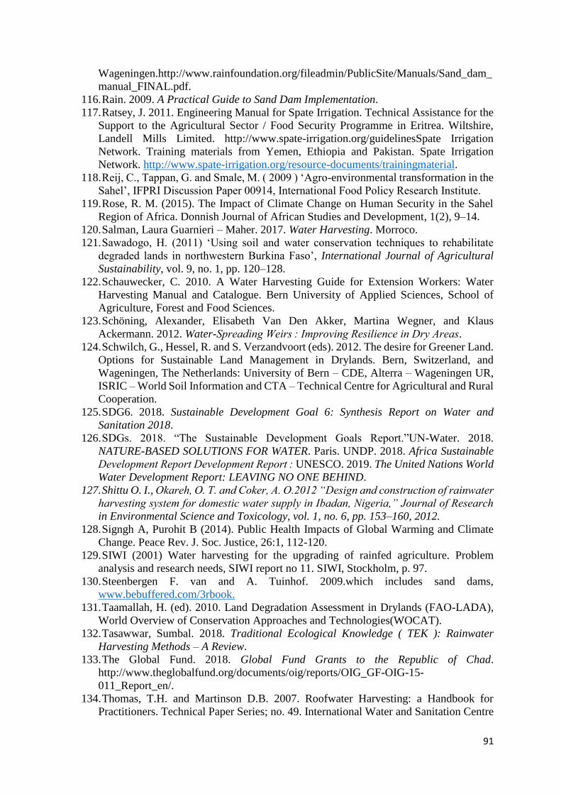
91
Wageningen.http://www.rainfoundation.org/fileadmin/PublicSite/Manuals/Sand_dam_
manual_FINAL.pdf.
116. Rain. 2009. A Practical Guide to Sand Dam Implementation.
117. Ratsey, J. 2011. Engineering Manual for Spate Irrigation. Technical Assistance for the
Support to the Agricultural Sector / Food Security Programme in Eritrea. Wiltshire,
Landell Mills Limited. http://www.spate-irrigation.org/guidelinesSpate Irrigation
Network. Training materials from Yemen, Ethiopia and Pakistan. Spate Irrigation
Network. http://www.spate-irrigation.org/resource-documents/trainingmaterial.
118. Reij, C., Tappan, G. and Smale, M. ( 2009 ) ‘Agro-environmental transformation in the
Sahel’, IFPRI Discussion Paper 00914, International Food Policy Research Institute.
119. Rose, R. M. (2015). The Impact of Climate Change on Human Security in the Sahel
Region of Africa. Donnish Journal of African Studies and Development, 1(2), 9–14.
120. Salman, Laura Guarnieri – Maher. 2017. Water Harvesting. Morroco.
121. Sawadogo, H. (2011) ‘Using soil and water conservation techniques to rehabilitate
degraded lands in northwestern Burkina Faso’, International Journal of Agricultural
Sustainability, vol. 9, no. 1, pp. 120–128.
122. Schauwecker, C. 2010. A Water Harvesting Guide for Extension Workers: Water
Harvesting Manual and Catalogue. Bern University of Applied Sciences, School of
Agriculture, Forest and Food Sciences.
123. Schöning, Alexander, Elisabeth Van Den Akker, Martina Wegner, and Klaus
Ackermann. 2012. Water-Spreading Weirs : Improving Resilience in Dry Areas.
124. Schwilch, G., Hessel, R. and S. Verzandvoort (eds). 2012. The desire for Greener Land.
Options for Sustainable Land Management in Drylands. Bern, Switzerland, and
Wageningen, The Netherlands: University of Bern – CDE, Alterra – Wageningen UR,
ISRIC – World Soil Information and CTA – Technical Centre for Agricultural and Rural
Cooperation.
125. SDG6. 2018. Sustainable Development Goal 6: Synthesis Report on Water and
Sanitation 2018.
126. SDGs. 2018. “The Sustainable Development Goals Report.”UN-Water. 2018.
NATURE-BASED SOLUTIONS FOR WATER. Paris. UNDP. 2018. Africa Sustainable
Development Report Development Report : UNESCO. 2019. The United Nations World
Water Development Report: LEAVING NO ONE BEHIND.
127. Shittu O. I., Okareh, O. T. and Coker, A. O.2012 “Design and construction of rainwater
harvesting system for domestic water supply in Ibadan, Nigeria,” Journal of Research
in Environmental Science and Toxicology, vol. 1, no. 6, pp. 153–160, 2012.
128. Signgh A, Purohit B (2014). Public Health Impacts of Global Warming and Climate
Change. Peace Rev. J. Soc. Justice, 26:1, 112-120.
129. SIWI (2001) Water harvesting for the upgrading of rainfed agriculture. Problem
analysis and research needs, SIWI report no 11. SIWI, Stockholm, p. 97.
130. Steenbergen F. van and A. Tuinhof. 2009.which includes sand dams,
www.bebuffered.com/3rbook.
131. Taamallah, H. (ed). 2010. Land Degradation Assessment in Drylands (FAO-LADA),
World Overview of Conservation Approaches and Technologies(WOCAT).
132. Tasawwar, Sumbal. 2018. Traditional Ecological Knowledge ( TEK ): Rainwater
Harvesting Methods – A Review.
133. The Global Fund. 2018. Global Fund Grants to the Republic of Chad.
http://www.theglobalfund.org/documents/oig/reports/OIG_GF-OIG-15-
011_Report_en/.
134. Thomas, T.H. and Martinson D.B. 2007. Roofwater Harvesting: a Handbook for
Practitioners. Technical Paper Series; no. 49. International Water and Sanitation Centre
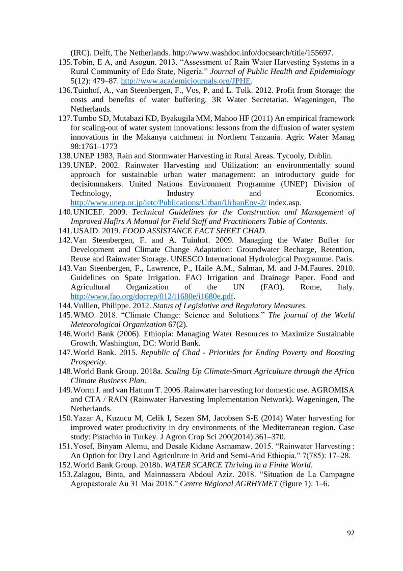
92
(IRC). Delft, The Netherlands. http://www.washdoc.info/docsearch/title/155697.
135. Tobin, E A, and Asogun. 2013. “Assessment of Rain Water Harvesting Systems in a
Rural Community of Edo State, Nigeria.” Journal of Public Health and Epidemiology
5(12): 479–87. http://www.academicjournals.org/JPHE.
136. Tuinhof, A., van Steenbergen, F., Vos, P. and L. Tolk. 2012. Profit from Storage: the
costs and benefits of water buffering. 3R Water Secretariat. Wageningen, The
Netherlands.
137. Tumbo SD, Mutabazi KD, Byakugila MM, Mahoo HF (2011) An empirical framework
for scaling-out of water system innovations: lessons from the diffusion of water system
innovations in the Makanya catchment in Northern Tanzania. Agric Water Manag
98:1761–1773
138. UNEP 1983, Rain and Stormwater Harvesting in Rural Areas. Tycooly, Dublin.
139. UNEP. 2002. Rainwater Harvesting and Utilization: an environmentally sound
approach for sustainable urban water management: an introductory guide for
decisionmakers. United Nations Environment Programme (UNEP) Division of
Technology, Industry and Economics.
http://www.unep.or.jp/ietc/Publications/Urban/UrbanEnv-2/ index.asp.
140. UNICEF. 2009. Technical Guidelines for the Construction and Management of
Improved Hafirs A Manual for Field Staff and Practitioners Table of Contents.
141. USAID. 2019. FOOD ASSISTANCE FACT SHEET CHAD.
142. Van Steenbergen, F. and A. Tuinhof. 2009. Managing the Water Buffer for
Development and Climate Change Adaptation: Groundwater Recharge, Retention,
Reuse and Rainwater Storage. UNESCO International Hydrological Programme. Paris.
143. Van Steenbergen, F., Lawrence, P., Haile A.M., Salman, M. and J-M.Faures. 2010.
Guidelines on Spate Irrigation. FAO Irrigation and Drainage Paper. Food and
Agricultural Organization of the UN (FAO). Rome, Italy.
http://www.fao.org/docrep/012/i1680e/i1680e.pdf.
144. Vullien, Philippe. 2012. Status of Legislative and Regulatory Measures.
145. WMO. 2018. “Climate Change: Science and Solutions.” The journal of the World
Meteorological Organization 67(2).
146. World Bank (2006). Ethiopia: Managing Water Resources to Maximize Sustainable
Growth. Washington, DC: World Bank.
147. World Bank. 2015. Republic of Chad - Priorities for Ending Poverty and Boosting
Prosperity.
148. World Bank Group. 2018a. Scaling Up Climate-Smart Agriculture through the Africa
Climate Business Plan.
149. Worm J. and van Hattum T. 2006. Rainwater harvesting for domestic use. AGROMISA
and CTA / RAIN (Rainwater Harvesting Implementation Network). Wageningen, The
Netherlands.
150. Yazar A, Kuzucu M, Celik I, Sezen SM, Jacobsen S-E (2014) Water harvesting for
improved water productivity in dry environments of the Mediterranean region. Case
study: Pistachio in Turkey. J Agron Crop Sci 200(2014):361–370.
151. Yosef, Binyam Alemu, and Desale Kidane Asmamaw. 2015. “Rainwater Harvesting :
An Option for Dry Land Agriculture in Arid and Semi-Arid Ethiopia.” 7(785): 17–28.
152. World Bank Group. 2018b. WATER SCARCE Thriving in a Finite World.
153. Zalagou, Binta, and Mainnassara Abdoul Aziz. 2018. “Situation de La Campagne
Agropastorale Au 31 Mai 2018.” Centre Régional AGRHYMET (figure 1): 1–6.

93
APPENDICES
Appendix A: Questionnaire
SECTION A: General Information
Name of City/Village……………………………………………………………………….......
Gender……Male……………………………... Female ……………………………………….
Age……………………………………………………………………………………………...
Family members………………………………………………………………………………...
Level of Education
Primary School Secondary School University Others
SECTION B
1. Do you face water scarcity? Yes No
2. What is your existing water source?
3. Do you pay for water fee? borehole Open well
4. What is the source of your income?
5. Do you practice off-season irrigation? Yes No
6. What is the problem with the actual water source? Quantity Quality both
7. Do you need another source of water than the current one? Yes No
8. Do you own farmland? Yes No
9. What is the size of your farmland?
SECTION C
10. Are you aware of water harvesting? Yes No
11. Do you practice any kind of water harvesting? Yes
12. Are you willing to participate in water harvesting to improve your water needs if the
government provides 50% of the installation costs? Yes No
13. Are you willing to contribute to the operation and maintenance cost after installation of
the system? Yes No
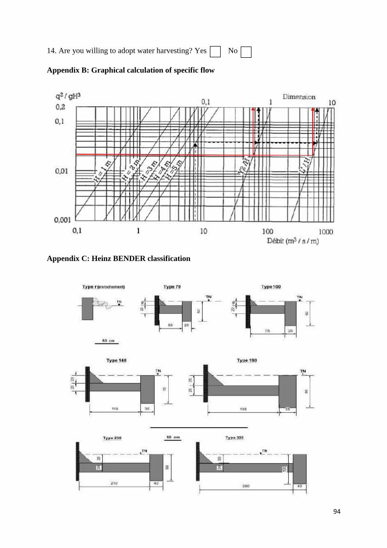
94
14. Are you willing to adopt water harvesting? Yes No
Appendix B: Graphical calculation of specific flow
Appendix C: Heinz BENDER classification
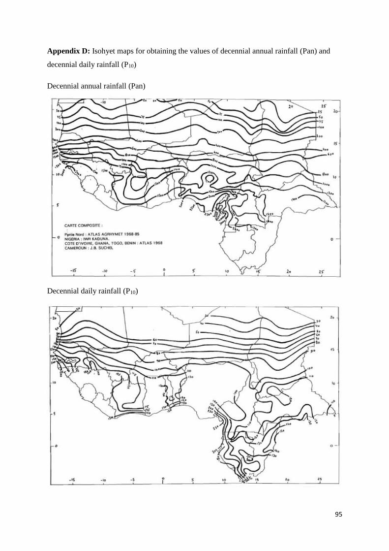
95
Appendix D: Isohyet maps for obtaining the values of decennial annual rainfall (Pan) and
decennial daily rainfall (P10)
Decennial annual rainfall (Pan)
Decennial daily rainfall (P10)
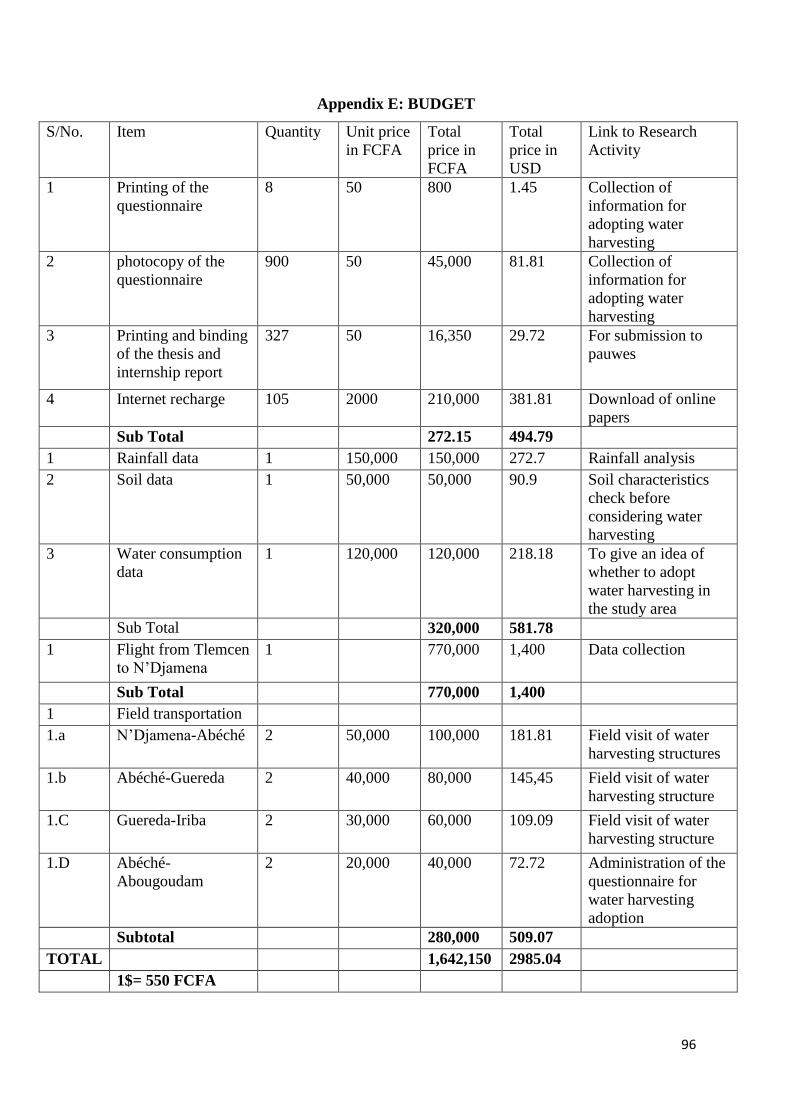
96
Appendix E: BUDGET
S/No. Item Quantity Unit price
in FCFA
Total
price in
FCFA
Total
price in
USD
Link to Research
Activity
1 Printing of the
questionnaire
8 50 800 1.45 Collection of
information for
adopting water
harvesting
2 photocopy of the
questionnaire
900 50 45,000 81.81 Collection of
information for
adopting water
harvesting
3 Printing and binding
of the thesis and
internship report
327 50 16,350 29.72 For submission to
pauwes
4 Internet recharge 105 2000 210,000 381.81 Download of online
papers
Sub Total 272.15 494.79
1 Rainfall data 1 150,000 150,000 272.7 Rainfall analysis
2 Soil data 1 50,000 50,000 90.9 Soil characteristics
check before
considering water
harvesting
3 Water consumption
data
1 120,000 120,000 218.18 To give an idea of
whether to adopt
water harvesting in
the study area
Sub Total 320,000 581.78
1 Flight from Tlemcen
to N’Djamena
1 770,000 1,400 Data collection
Sub Total 770,000 1,400
1 Field transportation
1.a N’Djamena-Abéché 2 50,000 100,000 181.81 Field visit of water
harvesting structures
1.b Abéché-Guereda 2 40,000 80,000 145,45 Field visit of water
harvesting structure
1.C Guereda-Iriba 2 30,000 60,000 109.09 Field visit of water
harvesting structure
1.D Abéché-
Abougoudam
2 20,000 40,000 72.72 Administration of the
questionnaire for
water harvesting
adoption
Subtotal 280,000 509.07
TOTAL 1,642,150 2985.04
1$= 550 FCFA

97
Appendix F: Work Plan

98