Embed Size (px)
Citation preview

NORTH CAROLINA STATE UNIVERSITY
-AT RALEIG
AT RALEIGIL.A
SCHOOL OF PHYSICAL AND MATHEMATICAL SCIENCES
DEPARTMENT OF GEOSCIENCES
Box 5966 ZIp
CO n
E r- 0O.; C ,s
N HO
0A sc O
II-
1H
. W4~~~C.
MZO
!i,~ Z .'5
0H W, "' ~!H 0H :O.
Oa 4 0 -U
HE.4 %
,! ,, .= 0
I C~ E4 >t-
H H·~ ~1
e4 w4~ P I-" ) .
a.,
ln Sz S:=
O~ 34 ,
0I-4 .'
I ~ 1 X ,,-I
n U U-Z IN 0W d Wi
i O oA X
W00.+I P. Fd *
27607 E7 2.- 1 0 0.. 5
Investigation Title: Utilization of ERTS-A Data in GeologicalEvaluation, Regional Planning, Forest Management, andWater Management in North Carolina
Proposal No. 18
GSFC ID UN 281
Principal Investigator: Charles W. Weiby -
Date: July 1972
The objective of the contract is to demonstrate the usefulnessof ERTS-A data to various state and local agencies.
The period 1 May - 30 June has been spent acquainting the StateAgencies cooperating in the investigation with the details ofthe program. Time has been spent also in contacting variouskey personnel at the federal, state and local level for theircooperation in the program. Cooperation of the North CarolinaState University Agricultural Research Stations has bn.e1tained.Discussions have been held also with the State office o SoilConservation Service to outline problems of mutual intereand concern.
In conjunction with the ERTS program, and supplementing it, pro-posals have been submitted for funding of viewers; bids are beingrequested for a multispectral camera whose purchase was authorizedin the Spring.
During July additional contacts will be made with various federal,state and local agencies to obtain their assistance in definingparticular problems to which ERTS-A data may be applicable.
At this point in time the funds appear adequate to complete thecontract. The cooperating state agencies are arranging to transfertheir contributions into the University's accounting system.
Made available under NASA sponsorship inthe interest of early and wide disseminationof Earth Resources Survey Program informationand without liability for any use madethereof.
r [ INI!IrI . N;onTII (' Agmvml'. \A i ia lm }rid v, I'rcsid:ult, c,,ipriwss: No.rth (Cm'Ili: . State [lIlilc.sitv ait tl,dci:ih4North Catmli.,' a: Ch,!f'l i Hill, thel: [;Iti'crsi:t f .";rI-II (I Cl,'o li (1 ( c';l/.o . I th I IiLl'esit t of N, rtlh C,:olina , t
t 1 ,' I, 1 jrsilrt' ) of North Car. lhi. ,t A .! eilh., atl the i /. ./ , { /' of N rIl: (,.'olina it Wilm hi o oIkl.o
the Ull/iv'.Wit v (dt C;,';,-a .,/,. ,
' ..I
,. .~ .4.
AL l.
:E .
L I%
https://ntrs.nasa.gov/search.jsp?R=19720020663 2019-08-14T03:40:39+00:00Z

NORTHI-I CAROLINA STATE UNIVERSITY AT RALEIGI-H
SCHOOL OF PHYSICAL AND MATHEMATICAL SCIENCES
DEPARTMENT OF GEOSCIENCESBox 5966 ZiP 27607 £ 72 1 O 0.5
Investigation Title: Utilization of ERTS-A Data in GeolQgicalEvaluation, Regional Planning, Forest Management, andWater Management in North Carolina
Proposal No. 18
GSFC ID UN 281
Principal Investigator: Charles W. Weiby
Date: July 1972
The objective of the contract is to demonstrate the usefulnessof ERTS-A data to various state and local agencies.
The period 1 May - 30 June has been spent acquainting the StateAgencies cooperating in the investigation with the details ofthe program. Time has been spent also in contacting variouskey personnel at the federal, state and local level for theircooperation in the program. Cooperation of the North CarolinaState University Agricultural Research Stations has been-obtained.Discussions have been held also with the State office oft-heSoil Conservation Service to outline problems of mutual intergt-and concern.
In conjunction with the ERTS program, and supplementing it, pro-posals have been submitted for funding of viewers; bids are beingrequested for a multispectral camera whose purchase was authorizedin the Spring.
During July additional contacts will be made with various federal,state and local agencies to obtain their assistance in definingparticular problems to which ERTS-A data may be applicable.
At this point in time the funds appear adequate to complete thecontract. The cooperating state agencies are arranging to transfertheir contributions into the University's accounting system.
Made available under NASA sponsorship inthe interest of early and wide disseminationof Earth Resources Survey Program informationand without liability for any use madethereof.
-- --.
Reproduced by - '
NATIONAL TECHNICALINFORMATION SERVICE
U S Deportment of CommerceSpringfield VA 22151
/
'rm,: LI: lii ., ,,. r ,, ,.. \xil vio,,, Ir Piv . 'r'q. cra i-c: .\',\ i ( N..,,!ji, SiW.i Jhidi .:. titi , aIn . h, [lii ,,, :tp I
N'oth (. , ,; , (; (' , ,I t ; | i i ll, , I { l,; t . e .: ;, ' f \ .\,: hI ( 'l, ,l: t 1:; , ; ( ;, Icul'.,! ,,! (, th I,, i O/ii I / i . if ".I" ;II I!I I (.oil,., ,t t 4 Iht t,
!1 i,,' l I I i I '; 1 / i U , 1: (li i ca: at . I , ,! C , ; :i ,1 : (; io ,zI , . i , ,Ii j , \, ,a', ,1,I (:a!,.. .ii CIllli )i :ii, .it. Liuji, :~~iiv if Xiii L ii A~~~b.:iiL. :1 Ha C Ia> .'i~~ i/ Niali (.Xia~~a~a
I .
94vtd
in thesen ir
~~~~~~~~~~~~/ ~~~Progra
E RTS-1 IM eAGEREYfor an
A -s
A IRJ. I ~il t N Av
OF EAS ~ R 'AOFIEASTELRN AFRICAA FIRST LOOK AT THE
d.a$,affh, e th,,- rAi'; .- ,,,4 s¾.'..... , ti ter-s' Of Csr'v ":,; " :i £H ,
yamu hiior,':,1s tio!I : .red ; ii,,ri 1'-;s.e mny use M.de ri'er,, f .,
E7.3I
I . o. 0 / , ,'J ,
GEOLOCGICAL STRUCTUREOF SELECTED AREASP. A. MOHR
-- -/, ........ ; u et.khst ~~l;~~~~~~~~~~~~ :'....; ... .. .:,, ):1jb l ~l~~ >,.
Reproduced by j,. , ; ........ ....
NATIONAL TECHNICAL -...... ,*INFORMATION SERVICE
U S Deportment of CommerceSpringfield VA 22151
Smithsonian Ast rophysical Observato-ySPECIA[L REPORT 347

Research in Space Science
SAO Special Report No. 347
ERTS-1 IMAGERY OF EASTERN AFRICA:
A FIRST LOOK AT THE GEOLOGICAL STRUCTURE
OF SELECTED AREAS
Paul A. Mohr
December 20, 1972
Smithsonian InstitutionAstrophysical Observatory
Cambridge, Massachusetts 02138
,-211-056

TABLE OF CONTENTS
ABSTRACT .......... * ............................ vii
1 INTRODUCTION ..................................... 1
2 GEOGRAPHY ..................................... 3
3 GEOLOGY ....................................... 5
3.1 Yemen ...................................... 5
3.2 Lake Rudolph-Kavirondo Gulf . . .................... 17
3.3 Lake Tanganyika ....... . . ...................... 24
3.4 Lake Malawvi .................................. 34
3.5 Other Regions ................................. 44
3.5. 1 Aswa mylonite zone ........................ 44
3.5.2 Afar, Ethiopia ............................ 45
4 REFERENCES ..................................... 53
iii

ERTS-1 IMAGES
Image Number Page
212 ERTS-1 image of Bab-el-Mandeb region, showing ENE-WSWfracture zone, downwarped Trap Series basalts (TKt), and UpperMiocene volcanoes of Gulf of Aden coast .................... 6
.. 7I ERTS-1 image of Yemen, between Ta'iz and Manakhah, showingupfaulted strip of Precambrian (PC), possible Tertiary granite (Tg),and Quaternary basalt field (Qp) ......................... 7
210 ERTS-1 image of the Sant a region of Yemen, showing Precambrianterrain (PC), Jurassic limestones (J) with joint directions, Trapbasalts (TP), Quaternary basalts (Qp), Tertiary granite (Tg), andQuaternary sediments (Q) ....................... 8
209 ERTS-1 image of northern Yemen, showing Precambrian terrain(PC), Permian sandstones (P), Jurassic limestones (J), granite (G),and Quaternary sand dunes (Qs) ......................... 9
223 ERTS-1 image of northeastern Eritrea, showing Trap Series basalts(T) on the regionally exposed Precambrian ................. 15
231 ERTS-1 image of the northern Lake Rudolf region ............. 18
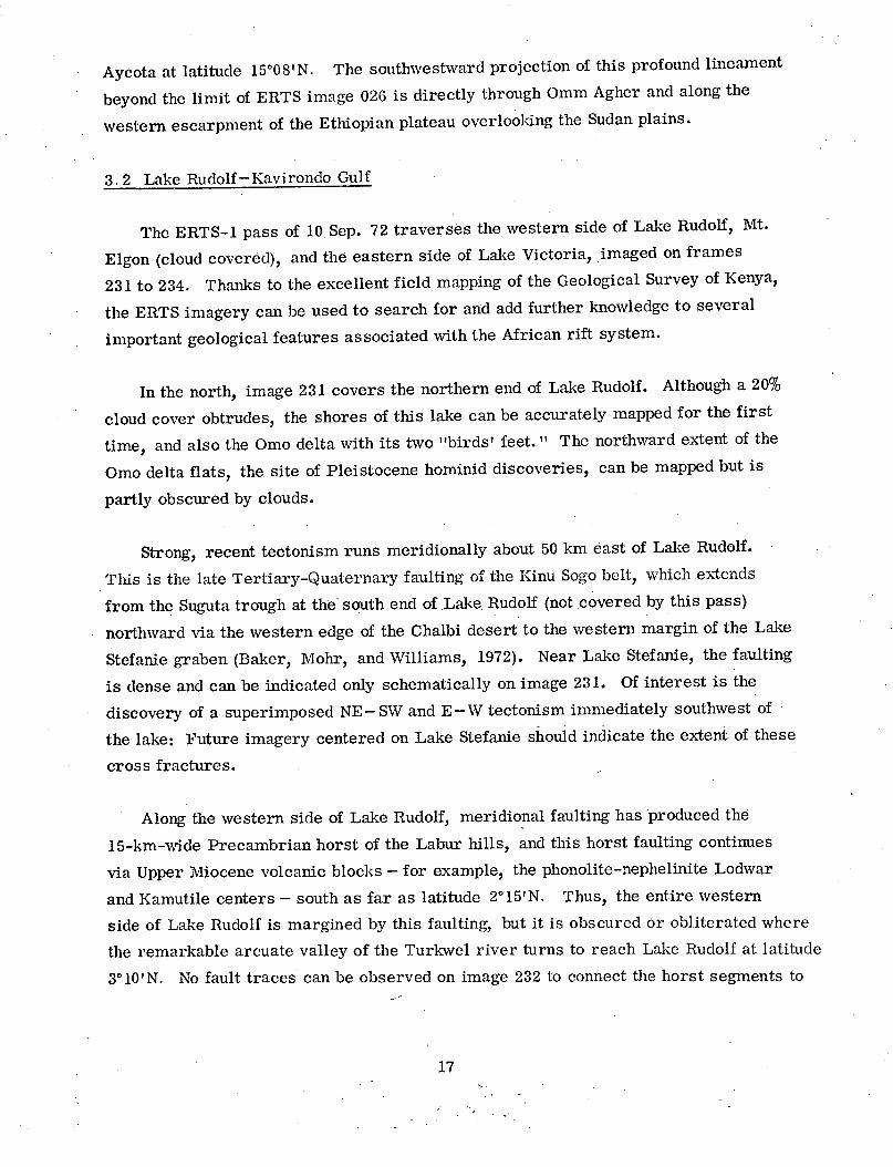
232 ERTS-1 image of the lower Turlavel valley and southern Lake Rudolfregion, showing Precambrian terrain (PC), Tertiary basalts (Tv),Miocene nephelinite-phonolites (MNp), Miocene basalt (MP), andPliocene basalt (P) ................................. 19
234 ERTS-1 image of the Kavirondo Gulf, eastern Lake Victoria ...... 20
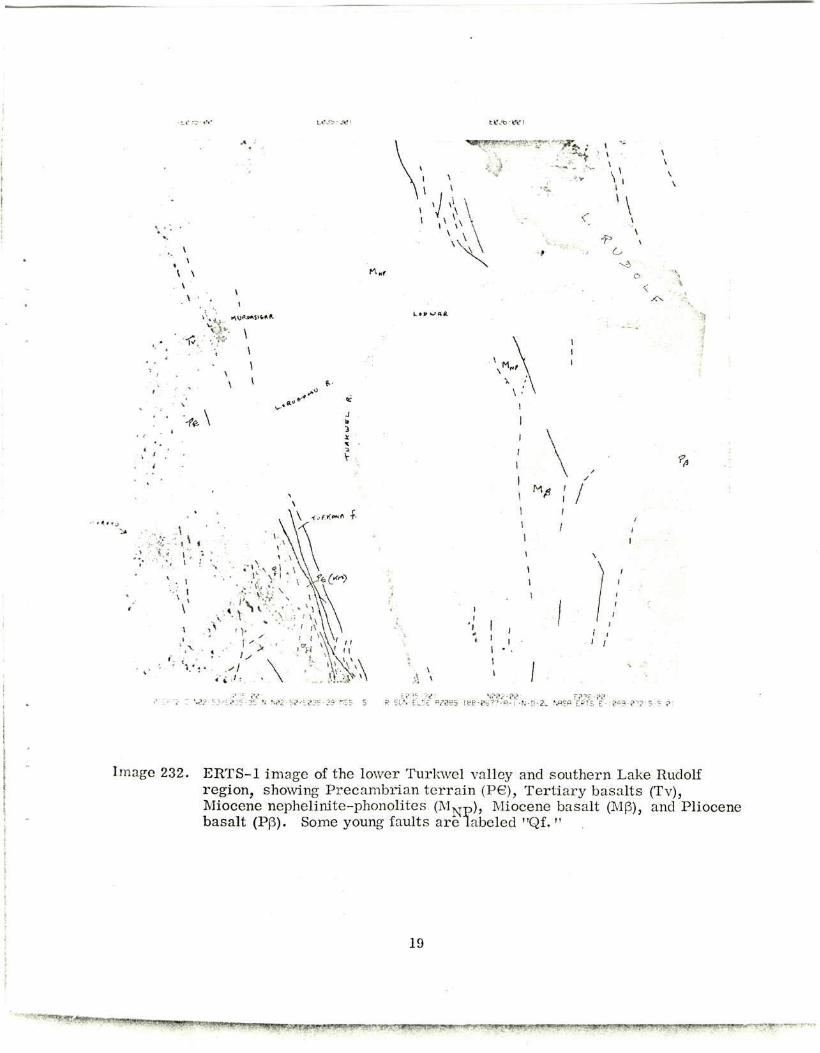
033 ERTS-1 image of the western margin of the Gregory Rift, showingthe sharp conjunction of the Turkana and Kerio faulting .......... 22
181 ERTS-1 image of the northern end of Lake Tanganyika and Ruzizigraben. ......................................... 25
182 ERTS-1 image of the north-central Lake Tanganyika region ....... 26
183 ERTS-1 image of the central Lake Tanganyika region, includingupper Lukuga valley and Kungwe horst (with granite "G") ........ 27
184 ERTS-1 image of the region southwest of Lake Tanganyika, showingKibaran porphyries (P) contrasting with Bukoban terrain (Bu) ..... 28
iv
ERTS-1 IMAGES (Cont.)
Image Number Page
240 ERTS-1 image of the eastern Lake Rukwa region and the Mt. Rungwevolcanic center .................................... 33
041 ERTS-1 image of northern Luangwa valley .................. 35
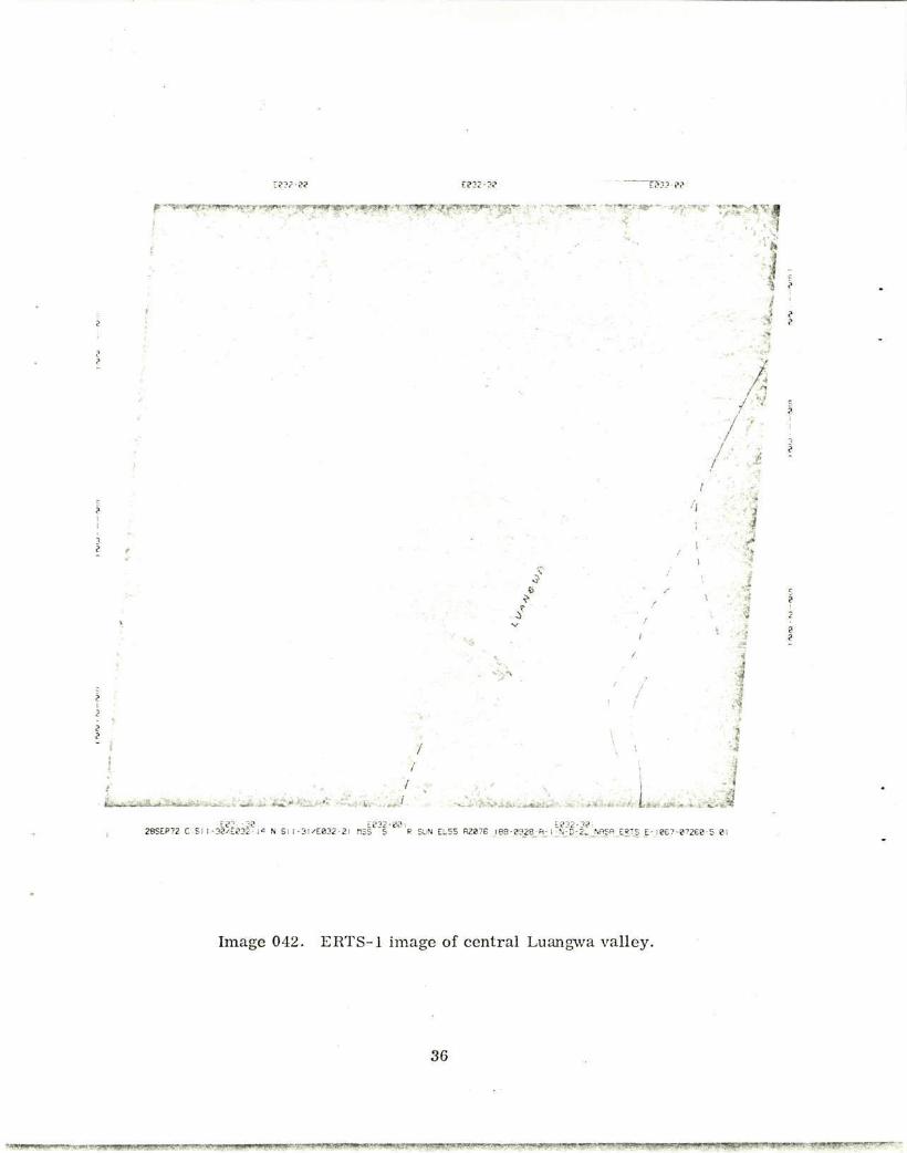
042 ERTS-1 image of central Luanga valley ................... 36
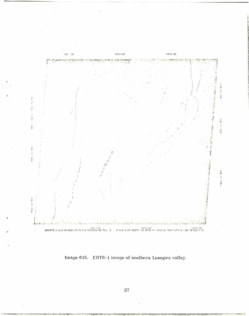
043 ERTS-1 image of southern Luangwa valley .................. 37
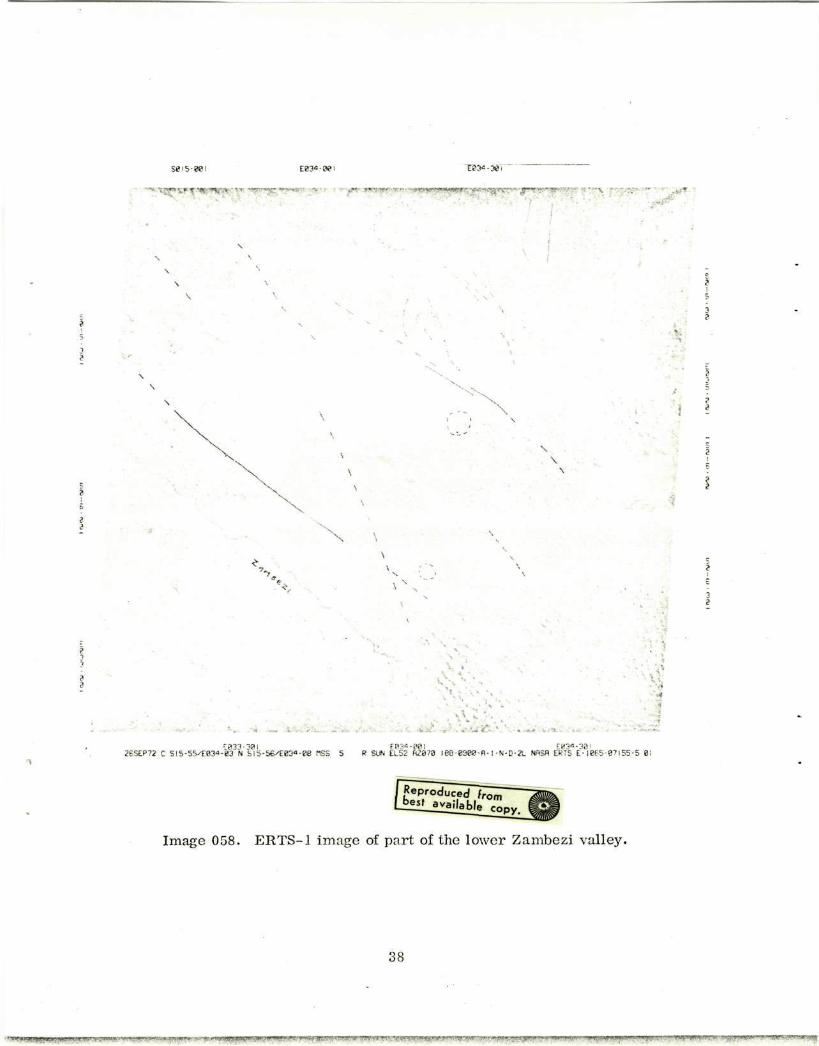
058 ERTS-1 image of part of the lower Zambezi valley ............. 38
057 ERTS-1 image of the region southwest of Lake Malawi and LakeMalombe, indicating end-Precambrian granites (G) ............ 39
056 ERTS-1 image of south-central Lake Malawi, indicating end-Precambrian granites (G) ............................. 40
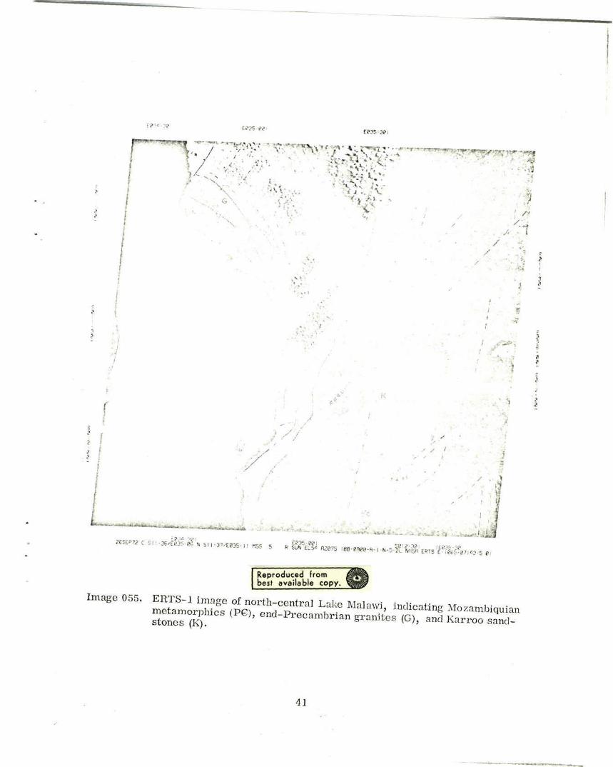
055 ERTS-1 image of north-central Lake Malawi, indicating Mozambiquianmetamorphics (PC), end-Precambrian granites (G), and Karroosandstones (K) ..................................... 41
176 ERTS-1 image of the Aswa mylonite zone, west of Nimule, on theSudan-Uganda border ................................ 46
136 ERTS-1 image of southern Afar, with fault belts partially revealedthrough cloud cover ................................. 48
157 ERTS-1 image of eastern Afar and southern Danakil horst, showingmeridional alignment of volcanic centers along the western edge ofthe image and complex fantail fault belts in the south .......... 49
158 ERTS-1 image of Lake Abbe and Gulf of Tajura region of Afar,showing fantail faulting in the north; the interrelationships of theGawa, GumS, and Dobi gr'ben, again in the north; the Damahalivolcanic shield immediately west of Lake Abbe; the Wonji faultbelt and fresh graben south of Gabillema volcano, near the southwestcorner of the image; and Tendah6 cotton plantation on the westernedge, near the center of the image .............. 50
v

ABSTRACT
ERTS imagery of the African rift system resolves the major Cainozoic faults,
zones of warping, and associated volcanism. It also clearly depicts the crustal
"grain" of the Precambrian rocks where these are exposed.
New structural features, or new properties of known features - such as greater
extent, continuity, and linearity- are revealed by the ERTS imagery. This applies,
for example, to the NE-SW fracture zones in Yemen, the Aswa mylonite zone at the
northern end of the Western Rift, the Nandi fault of western Kenya, the linear faults of
the Elgeyo escarpment in the Gregory Rift, and the hemibasins of warped Tertiary lavas
on the Red Sea margin of Yemen, matching those of the Ethiopian plateau-Afar margin.
A tentative scheme is proposed, relating the effect on the pattern of Cainozoic
faulting of the degree of obliquity to Precambrian structural trend. It is particularly
noteworthy that, even where the Precambrian grain determines the rift faulting to be
markedly oblique to the overall trend of the rift trough- for example, in central
Lake Tanganyika - the width of the trough is not significantly increased.
Some ground-mapped lithological boundaries are obscure on ERTS imagery.
This is partly due to the limitations of satellite imagery, but it also seems that pres-
ent approaches to mapping of Precambrian terrain in Africa may require radical
revision with the input of satellite imagery.
vii
RESUME
Les images prises par ERTS du systeme de cassures africaines permettent de
voir les plus importantes failles du CainozoYque, les zones de plissement et le
volcanisme associ6. Elles montrent aussi clairement le "grain" de la croOte des
roches pr6cambriennes, la oU elles sont expos6es.
De nombreux traits structuraux ou de nouvelles proprietes de traits connus,
telles que plus grande etendue, continuite et linearite, sont revelees par les
images de ERTS. Ceci s'applique par exemple aux zones de la cassure NE-SO dans
le Yemen, a la zone mylonite de l'Aswa a l'extremite nord du Fosse de l'Ouest, ala faille de Nandi au Kenya de l'ouest, aux failles lineaires de l'escarpement
de l'Elgeyo dans le fosse de Gregory et aux h6mibassins de laves plissees du
tertiaire au bord de la Mer Rouge dans le Yemen, correspondant a ceux du plateau
ethiopien, au bord de l'Afar.
On suggere de relier l'effet sur la configuration de la faille du Cainozo~que
du degre d'obliquit6 par rapport a la direction structurale precambrienne. I1 est
particulierement remarquable que m~me la ob le grain pr6cambrien oblige la faille
a etre assez oblique par rapport a la direction g6nerale du creux du foss6 - par
exemple au centre du lac Tanganyika - la largeur du creux ne soit pas augment6e,
d'une faqcn appreciable.
Quelques unes des limites lithologicales etablies A terre sont obscures sur
les images de ERTS. Ceci est du en partie aux limitations des images par satellite,
mais il semble aussi que les approches actuelles de cartographie du terrain pr6-
cambrien en Afrique puissent @tre sujettes a une revision radicale due a l'arriv6edes images par satellite.
viii
KOHCMEKT
M3oo00paeHMa ACpHKaHCKOH CZCTembI pa3ZOMOB M Fpa6eHOB, nrepexaHHble
CO CnYTHHKa ERTS, .akT RCHyl KaPTHHy KaMHO30HCKHX pa3jfOMOB k 30H
CKJiagqaTOCTZ k CBR3aHHbIX C HkMk ByRKaHz3Ma. Ha 3THX Z30opaxeHMKX
TaKXe MO)HO ECHO BMzeTb KOpOByiO "TeKCTypy" FOpHbIX nOPO9 B MeCTaX MX
0GHa)KeHvk.
Z3o0paKeHMa, nonyqeHHbIe CO CIYTHHKOB ERTS, nrO3BOTIHI BbIEBHTb
HOBble CTpyKTypHbIe OcoteHHOcTZ, iIM, BepHee, HoBbIe t1ePTbI paHee H3BeCT-
HbAx OCOOeHHOCTek - Oo.bmee rpOCTzpaHMe, CnOIMHOCTB H JIHefiHOCTb CTpyK-
Typ. oTO CnpaBeZJiHBO, HanpMep, B OTHOileHMM 30H Tpei1TH B leMeHe,
npOCTHpDaiJwXC C CeBepO-BOCTOKa Ha iro-3anaa, 30HbI MAJIOHHTOB ACBa Ha
CeBepHOM Kpai 3anaZHoro pHZTa, CbpOCOBOH BEarZHbl HaHZW, B 3anarHO2
KeHHH, JIHHe2HbIX CbPOCOB irFehcKoro BepTzKanbHOrO O6Ha)KeHMHa nopc, B
30He pa3JIOMOB H Fpa6eHOB Fperopz, H reiMMzbacceiHoB TpeTHM4HOrO BO3paCTa
B IOrpaHklqHOfi 30He HleMeH Co CTOPOHb! KpaCHOrO MOpi. Tk JIaBOBbie
HarpOMO)fgeHZa CXOgHbI C o6pa3OBaHIlaMH Ha rpaHHLe Me)Ay nIaTO OdHonzH
H nyCTbIHe2 Acap.
B HaCTOmieHl pa6oTe BbIBFraOTCI npe,9BapZTerlbHhIe 3aKJiT4eHHR o TOM,
YTO TtIl Ka2H030OCKZX pa3n0OMOB H C6pOCOB 3aBHCiT OT CTeneHM AX HaK.IOHa
OTHOCHTenJbHO oObero HanpaBjieHHa npOCTzpaHZR ZoKeMGpHkCKHX CTpyKTyp.
0coGeHHo cnegyeT OTMeTZTb, qTO aace B TeX CJiyqatax, rFe ZoKeM0pHMcKaR
TeKCTypa nOKa3bIBaeT, 4TO CCpOCOBbIe HapyLieHZa H pa3JIobi pacrnOJaraKTTca
RBHO KOCO no OTHOmeHAMo K oti0eMy HarIPaBieHFIC pH(tTOBOn CZHKJIHaIz (TpOrFa)
HainpzMep, B UeHTpaJIbHOH HaCTI o3epa TaHraHbiKa-3aMeTHoro yBewMqeHHa
UIIPHHbI CZHKJIAHaJiH (TpOra) He Hat~.iczhaeTCE.
HeKOTOpble JiTOJiOrz4eCKze FpaHZLbl, zMeioiHecR Ha TonOFpaStzeCKVx
KapTax, HeqCHbI Ha Z3o0paKeHzkx, nepezaHHbIX C MccjieOBaTefbCKOFO CnyT-
HyKa ERTS. qaCTHMHO 3TO OoLCHieTCa OFpaHWq4eHHbMH BO3MOKHOCT9MMI nO.iy-
qeHMa L-eTKHX CHAMKOB CO CnyTHZKOB, HO B TO .:e BpeMa HanpamuBaeTcH
BbIBOZ, -ITO C nOJIyqeHAeM H300pa)KeHEI C nlOMO1bD CEyTHAKa EOTpetyeTcR
pazRKanibHO nepeCMoTPeTb COBPeMeHHbIH nOOXOZ K BOIPOCY KapTOFpaSHDOBaHZa
,UOKeMOpMHCKHX CTPYKTYP B A$PEKe.
ix
ERTS-1 IMIAGERY OF EASTERN AFRICA:
A FIRST LOOK AT THE GEOLOGICAL STRUCTURE OF SELECTED AREAS
Paul A. Mohr
1. INTRODUCTION
Owing to the wide interest in the African rift system, and the continuing discus-
sion over its place in the global plate-tectonic scheme, the writer proposed to NASA
that imagery from the Earth Resources Technology Satellite (ERTS) be made of
eastern Africa. This would make possible, for the first time, a mapping of the whole
of this continental crustal-fracture system on a unified basis. The structural geology
of parts of the African rift system remain poorly known from ground surveying, and
thus it was hoped also to fill in some "gaps."
The proposal was approved by NASA for the ERTS-A project, and wvith the success-
ful launching of ERTS-i, the first batches of multispectral scanner imagery are now
becoming available. Their general excellence demands a preliminary analysis of
selected areas, to bring to public notice the potential value of this imagery. In fact,
the original contract was for return-beam vidicon imagery, but a problem with this
system in ERTS-1 has necessitated using the alternative of multispectral scanner
imagery.
2The area under contract to be imaged is approximately 5 million km2 . This is
equivalent to two-hundred 1. 5 degree-square images, presuming no overlap. The de-
tailed mapping that can be done from this large amount of imagery may well supply the
mining and geological survey departments of eastern Africa with abundant work that
This work was supported in part by contract NAS 5-21748 from the National Aeronauticsand Space Administration.
1

can continue concomitantly with the improvement of ground resolution in subsequentsatellite imagery. The writer is contracted to map and study only the major rift
structures revealed by ERTS-1, and it is to selected areas where imagery is alreadyavailable (as of October 1972) that attention is given here. Analysis has been made
from hand-lens examination of 24 X 24 cm prints, each covering 150 X 150 km on the
ground, reproduced at a scale of 1:1 million.
2

2. GEOGRAPHY
The ERTS-1 imagery shows, for the first time, accurate outlines of some of the
more remote rift valley lakes - for example, Lakes Rudolf, Stefanie, and Rukwa.Shallow and deep areas in the lakes are revealed by brightness contrasts, and deltas
are clearly delineated - for example, the two "birds' feet" of the Omo at the northern
end of Lake Rudolf (cf. the map of the Omo delta given in Butzer, 1971, Figure 2-1).
Image resolution must be of the order of 50 m or slightly better because the main
roads cut through forest show up clearly (e. g., in western Kenya, eastern Malawi,and the Katanga mining belt). Roads cut through bush are less easily distinguished
(e.g., in southern Tanzania), and those in scrub or desert are not always possible to
locate (e. g., Eritrea and Yemen).
There seems no doubt that geographical factors such as drainage patterns, forest
cover, and land utilization can be fruitfully studied from the ERTS-1 imagery ofeastern Africa. However, these may require examination techniques different fromthe simple one used in the present geological mapping. Eye or lens examination was
made of black and white prints of ERTS imagery taken in spectral band 2 (NASA Data-
Processing Facility band 5), covering the range 6000 to 7000 A. As shown by U2
aircraft flights over Arizona, and confirmed from the ERTS-1 imagery, geological
structures usually show up most clearly in the red.
3

3. GEOLOGY
The following areas are selected for interpretation: Yemen, Lake Rudolf and
eastern Lake Victoria, Lake Tanganyika and Lake Rukwa, and Lake Malawi; and
brief comments are given on the Sudan-Uganda border region and on eastern Afar,
Ethiopia.
3. 1 Yemen
The geology of the Yemen is an important and little-known element in the study
of the African rift system, because according to the theory of continental drift, the
Yemen was originally situated in the present Afar region of Ethiopia. Thus, the pre-
Miocene structures can be expected to be continuous with those of the Ethiopian and
Somalian plateaus.
*
ERTS images 209 to 212 result from the 6 Sep. 72 pass made over central
Yemen, from the Yemeni-Arabian border in the north to Bab-el-Mandeb in the south.
The main structural lineaments extracted from this imagery are shown on the image
reproductions.
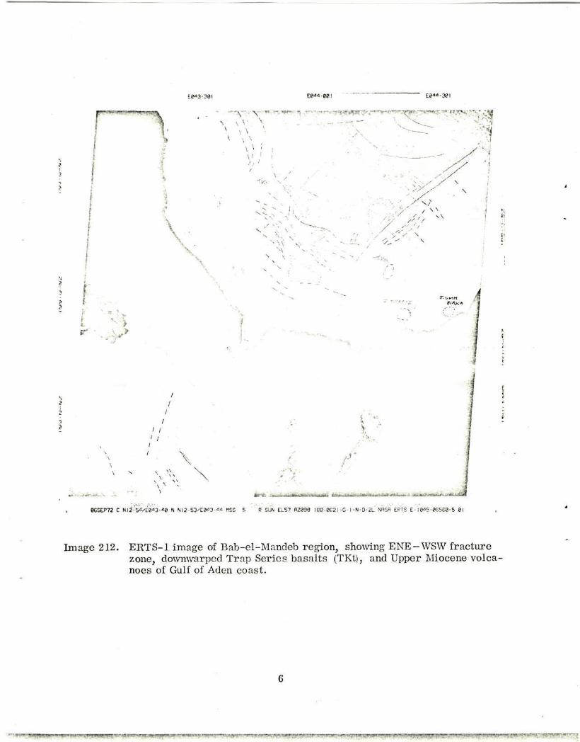
Image 212 covers the region of Bab-el-Mandeb, the straits connecting the Red
Sea and Gulf of Aden. Several major structural features are revealed on the Yemeni
side of the straits: On the western side, in the French Territory of Afar and Issa,
abundant Pliocene-Quaternary lavas tend to obscure any fundamental lineaments.
Along the Gulf of Aden coast, east of Bab-el-Mandeb, the line of strato-volcanoes
described by Gass, Cox, and Mallick (1965) shows up clearly: Perim Island, J.
(Jebel) At Turbah, J. Khariz, and J. Umm Birka (the Aden volcanoes lie east of
image 212). These volcanoes belong to the alkali olivine basalt-comendite suite and
are of Upper Miocene-Pliocene age (Cox, Gass, and Mallick, 1969). The caldera on
,The image identification numbers used in this report are the frame numbers forgiven satellite pass days. It is important to note that these are not the official NASAidentification numbers, which are rather long-winded and can be found at the rightend of the bottom legend on the image reproductions.
5
E0«-B0l E0i"-30l
\ i
\ \ \ ' y - T . ><. - I
; j
s ... \
V
sr W»
1 L»Kt«
' /
..»
I a i -i>i !^ri 'I Bfert^ifiif- riivfrirtteLKUzliej*
06SEP72 C N12-5^E0"3- i0 N NI2-53/E8"»3-« MSS 5 R SUN EL57 RZ038 188-8621 -G-1 -N-D-2L NASA ERTS E-!a"5-06568-5 81
Image 212. ERTS-1 image of Bab-el-Mandeb region, showing ENE-WSW fracture zone, downwarped Trap Series basalts (TKt), and Upper Miocene volcanoes of Gulf of Aden coast.
G
IE0O3-30 E01O-30I
f I I J * " 1 ^ ; ' . ' l i V ' > " ( , » ' - f t ; i - V '<• « ; . . • . : , • "Vj,- , "
\ !
V \ i \ V; ;AW\/,A /
-Tc
V ;
:\x !
\ I \ \ , / / 5
/
I
/ /
/ /
(
\
s I—-^—. *iligrtfiftfl''iil „T.:.
\ \
*V< •x w /
X / v
E?"3?-??!
• ' • • , . • •
N0t 3-301 IE0j"-B0 r^aa. ??[
' • • • " - 1M
• t ' \
0ESEP72 C NI<"-2l/E0O"-0i N Nl«- I 3/EE!<"'-05 n£S 5 R SUN EL57 H2I0I IB8-862I -G-1 -N-D-2L NfiSfl ERTS E • ie*>S-P655«-5 01
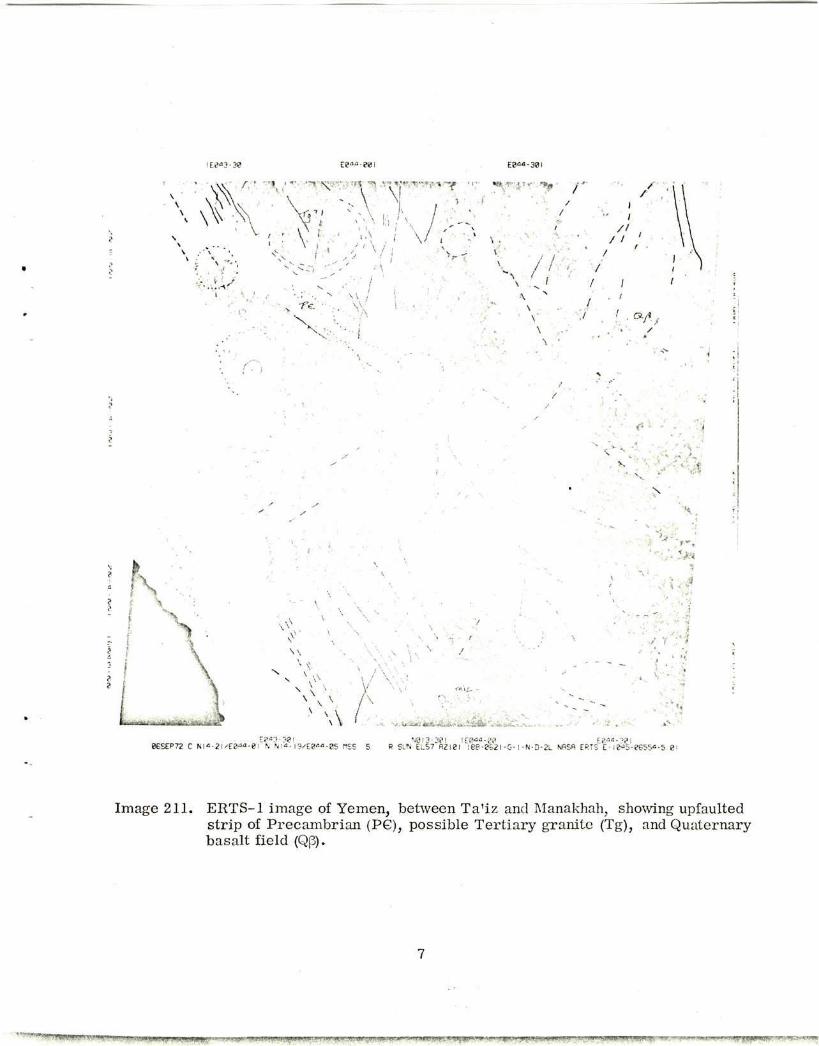
Image 211. ERTS-1 image of Yemen, between Ta'iz and Manakhah, showing upfaulted strip of Precambrian (PG), possible Tertiary granite (Tg), and Quaternary basalt field (Qp).
7
E*u-Wl W-3>\ E?«S-MI
86SEP72 C NI5-<18/E0':«-22 N N)5-"£/E&>c-2& rtSS 5 R SUN EL57 R2I83 188-e621 -G-1-N-D-2L NASA ERTS E-18aS-0S55!-5 21
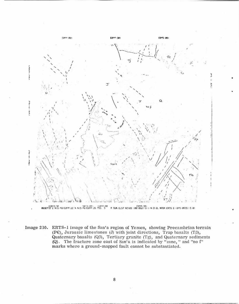
Image 210. ERTS-1 image of the San'a region of Yemen, showing P recambr ian t e r r a in (PG), J u r a s s i c l imestones (J) with joint di rect ions , Trap basal ts (Tp), Quaternary basal ts (Q(3), Te r t i a ry granite (Tg), and Quaternary sediments (Q). The fracture zone eas t of San'a is indicated by "zone, " and "no f" ma rks where a ground-mapped fault cannot be substantiated.

. \ZW-2Q E8aa-38l E8«S-e8l
86SEP72 C Hn-\^Ed""-a3 N Nl 7- 12'E2<">-"8 HSS 5 R SUN EL57 R2I8S IB8-B62I-G-I-N-D-2L NRSfl ERTS E-18«5 - BGS-«5 - 5 Bl
Image 209. ERTS-1 image of northern Yemen, showing Precambrian terrain (P6), Permian sandstones (P), Jurassic limestones (J), granite (G), and Quaternary sand dunes (Qs).
9

J. Khariz is easily identified on image 212, but that of the more denuded J. Umm Birka
center is obscure (Gass and Mallick, 1968). Another possible late-Tertiary volcanic
center is visible 30 km north of J. At Turbah, near the coast of the Red Sea.
Immediately inland from these strato-volcanoes lies a belt of older, flood basaltic
lavas, referred to the Eocene(-Oligocene?) Trap Series (Lipparini, 1954; Geukens,
1960). Here, as elsewhere in the Trap Series of Yemen and Ethiopia, circular features
are observed on the satellite imagery, probably representing deeply denuded relics
of old eruptive centers. Two such centers lie, respectively, 20 km north and 50 km
north-northwest of J. Khariz (ERTS image 212), and both have ellipse long axes
approximately perpendicular to the NW-SE Red Sea structural trend. Perpendicularity
of caldera long axes to rift structures is known from field studies in Ethiopia.
Gass et al. (1965) mention the existence of a monoclinal warp paralleling the north-
western coast of the Gulf of Aden, the seaward pitch being about 5 ° . Pitching strata
are revealed at 13°05'N, 44°10'E on image 212, but a severe, fundamental structure,
unreported from ground surveys (e.g., Greenwood and Bleackley, 1967) runs parallel
to and immediately north of the broad, coastal monocline. This structure appears to
be a fracture zone, trending NE - SW, about 5 km wide and 50 km inland from the
Gulf of Aden. At its western end, it peters out against the Red Sea coastal downwarp;
to the east, Apollo 9 oblique photography (photo AS9-24-3672) indicates that the zone
continues beyond the limit of ERTS image 212, curving north-northeastward into a
single fault east of the Yemeni border with Arabia.
The fracture zone appears to be one of intense crustal slicing, without evidence
of any horizontal displacements. But while the zone has affected at least the older
Trappean basalts, it may be a lineament of long-standing activity, reactivated in a
different response with the initiation of the Red Sea and Gulf of Aden rifts. Thus,
its latest role may have been to act as a hinge zone for the coastal monocline, though
it also forms the southern margin of a Tertiary uplifted plateau block (see below).
In these features it rather resembles the marginal graben of western Afar, Ethiopia
(Mohr, 1962). The zone is crossed by NW-SE lineations of Red Sea trend in its
central sector, where Geukens (1960) indicates the presence of a single, large fault.
Geukens makes the fault a boundary between Trap Series terrain to the northeast and
older rocks to the southwest, but the ERTS imagery reveals a more complex situation
(see below).
10
The Red Sea coastal structures, north of Bab-el-Mandeb, are dominated by a
chain of arcuate heniibasins, open to the coast. They form a zone about 20. km wide,
rising from the coastal plain about 30 km inland from the Red Sea. The basins are
arcuate downwarps of the Trap Series basalts and are typically cut by strong antithetic
faulting. Very similar features have been described from the eastern margin of the
Ethiopian plateau with Afar (Alohr, 1967a, 1971a), and of course the Ethiopian and
Yemeni hemibasins would have been contiguous before continental drift (Laughton,
1966). It seems that initiation of the Red Sea here took the form of basins subsiding
contemporaneously with extrusion of Trap basalts.
In the "corner" of the southwest Arabian highlands, about 100 km northeast of
Bab-el-Mandeb, lies an isolated block of Precambrian rocks whose outcrop is capable
of being precisely mapped from the ERTS imagery. Unfortunately, such is the dis-
parity between the imagery and existing maps (e.'g., U. S. Geological Survey Map of
the Arabian Peninsula, 1963) that without accurate ground information, the writer is
unable to assign the appropriate lithologies to the imagery.
From a study of drainage slopes, it can be said that in the northern part of the
block the dark terrain stands higher than the light terrain, but in the south the light
terrain appears to be a flat-lying plateau dissected by darker canyons. The most
probable interpretation is that the lighter terrain is formed of Precambrian rocks
capped with subhorizontal sandstones of the Cretaceous Tawilah Group (the
Precambrian thus exposes directly in the darker canyons), and that the very dark
terrain in the north represents a southerly extension of the previously mapped limit
of the Trap Series basalts (Geukens, 1960, 1967). Ground surveys are now required,
an ERTS-1 stimulus that was to be expected even before the satellite was launched!
The boundaries of this ancient highlands block are formed to the southeast by the
fracture zone described previously, to the southwest by a sinuous fault of Red Sea
trend, to the northeast by a belt of Red Sea trend faults that curve to adjust to a
Gulf of Aden trend, and to the northwest by a 40-km-long fault precisely parallel to
the fracture zone, 40 km to the southeast. Unlike the fracture zone, this boundary
is a single, normal fault, upthrown south. It is noteworthy that the northwest boundary
of the block is abruptly terminated at both ends by the Red Sea structural trend,
11
suggesting that Red Sea tectonism has been dominant over Gulf of Aden tectonism in
this region, at least during the Neogene and Quaternary.
Proceeding north to ERTS image 211: The city of Ta'iz is situated at 13°34'N,
44°02'E, among Trap Series basalt flows, subhorizontally disposed. South of the
city rises J. Sabir, a Tertiary granite massif piercing the Trap Series (Geukens,
1960). This granite is visible on image 211, and 5 km to the west, a twin crater
in the Trap Series can be seen. Tertiary granites are numerous in the vicinity of
Mlanakhah, 200 km farther north, where they mark the westerly limit of the highlands
Trap Series outcrop (Comucci, 1933; Karrenberg, 1957). Similar granites, of
Miocene age, intrude the Trap Series of the Ethiopian plateau-Afar margin (Brinckmann
and Kursten, 1969; Black, Morton, Rex, and Shackleton, 1972).
The Trap Series on image 211 forms dark terrain, without strong structural
lineation except near the coastal downwarps. No downwarping is evident on the imagery,
north of latitude 14°0 0'N. Between Ta'iz and San'a, numerous ill-defined circular
structures, up to 5 km in diameter, may represent old eruption centers in the Trap
Series. The frequency of such centers suggests that in forming the Trap Series,
central-type eruptions were at least as important as dike-fissure eruption. This is
especially the case in the vicinity of Manakhah (15°02'N, 43°50'E), where the circular
features show a tendency to be situated along the subsequent north-northwest-trending
margin faults of the Red Sea. Perhaps there is an association between such circular
features and the absence of monoclinal warping and dike fissures.
South of Manakhah occurs an upfaulted block of Precambrian rocks, trending
southeast, oblique to the south-southeast-oriented coastline of Yemen. The Red Sea
narrows in the Yemen region; farther north the typical Red Sea structural trend is
NWV-SE, and this is extending into the Yemeni highlands in the Manakhah region in the
form of block faulting. ERTS image 211 shows some large (15 to 25 km. in diameter)
circular features to be associated with the faulting of this Precambrian block. The
largest, centered at 15°00'N, 43°45'E and traversed by a north-northeast lineament,
may be either a tectonic ring structure or, less likely, a granitic intrusion. Two
smaller circular features, east and west of the largest circle, are again light colored
and may represent silicic igneous centers. But a 20-km-diameter feature immediately
south of the Precambrian block is dark colored and presumably marks a big Trappean
center.
12

Commencing north of the Precambrian block, from latitude 15°00 'N, numerousfresh faults extend north-northwestward and can be indicated only schematically onimage 210. Such relatively new faulting has a very narrow trace on ERTS imageryand can easily be overlooked in deference to older structures that are now emphasized
by selective denudation- c.uttion! The intense belt of highland-margin faulting is
marked by at least nine small light-colored intrusions that are almost certainly
Tertiary granites (Geukens, 1960). The belt passes beyond the western limit of
image 210... . . .
In the northeastern corner of image 211, an extensive area around 14°40'N,44140'E is covered by the Dhama-Reda Quaternary basalt field (Geukens, 1960).Geukens considers the volcanism to be related to E-W tectonism, but what fewlineaments remain unobscured by the voluminous cones and lavas trend NNE-NE.
This direction is paralleled by a second Quaternary basalt field, 100 km farther
north (see below). The Dhama-Reda tectonism forms a weak but persistent tectonic
grain that extends southwest to the Ta'iz region, where it may be related to the
outcropping of NNW-SSE strips of Precambrian rocks.
About 50 km east of San'a, and clearly shown on ERTS image 210, occurs another
intense fracture zone of similar form to the one near the Gulf of Aden coast. Thisfracture zone was recognized by Geukens (1960) and termed the Sirwah-Marib fracture
zone. It averages 3 km in width and trends northeastward (this also. happens to be
the trend of the Gulf of Aden transform faults). The zone is clearly delineated for
50 km, and farther northeast it is superimposed by lines of Quaternary basalt centers.Small parallel lineaments occur on either side of the zone. Some NNW-NW lineaments
cross the zone without any lateral displacement, so again there has been no wrenchmovement along a major fracture zone. And again, the Sirwah-Marib fracture zone
separates Precambrian (and Mesozoic) terrain from Trap Series volcanics, suggest-
ing that in many sectors the margin to Tertiary volcanism was determined by tectonicfactors, and not merely by overlap.
Deformed Precambrian and Miesozoic rocks occur immediately southeast of theSirwah-Marib fracture zone. To the northwest, the Oligocene-early Miocene TrapSeries (Brown, 1970) extends for 100 km, lying on undisturbed Jurassic limestones.
13

The limestones show jointing in a NNW-NW direction, parallel to the young, highland-
margin faulting described above.
Directly north of San'a, there is a large Quaternary basalt field betwveen theWadis Khusukir and Kharid. Numerous small cones in this field are associated with
north-northwest fractures, and prelava and postlava fractures can be observed on the
ERTS imagery. The most recent lavas have broken out eastward. - Despite the young
north-northwest faults, the San'a Quaternary basalts, like other occurrences of such
lavas in Yemen, are situated on a NE-SW lineation belt exposed in the Mesozoic
sediments and Trap Series 50 km west of San'a, although in this instance the lineation
is admittedly weakly developed.
Farther north from San'a, on ERTS image 209, the west-northwest-trending
J. Barach fault (Geukens, 1960) limits Precambrian and trough-faulted Permian sand-
stones in the north, against Jurassic limestones to the south. This extensive fault,
traversed by later, smaller faults of NE-SW trend, can now be mapped accurately forthe first time. The Permian Wajid Sandstone is preserved in north-northwest-faulted
troughs where these intersect the J. Barach fault. The Precambrian terrain north of
the J. Barach fault (the Medina Series of Geukens (1960)) contains light-colored, circu-
lar features, 5 to 15 km in diameter. It is not yet known whether these are related tothe problematic Mafflouk laccoliths intruding the Jurassic sediments, south of the
J. Barach fault (Geukens, 1960).
In summary, the ERTS satellite images of the Yemen confirm the fine recon-
naissance ground surveys of Geukens (1960), but inevitably add very considerably to
this work at the 1:1 million mapping level. The writer considers that the ERTS
imagery of Yemen is another giant step.
ERTS image 223 (10 Sep. 72), covering northern Eritrea, can conveniently be
appended to this discussion, as it presents the opposing coastal plain and hinterland
across the Red Sea from Yemen.
The margin between the coastal plain, a zone whose downwarping is not revealed
on the ERTS image, and the Eritrean highlands is clearly visible. This margin is
14

\
i I
: i
' /
^ w f l W f i * 1 " r?^&£>?SF*r>FT
[•
-7.t
\ \
\ \ \ i
\ Hi \
N M ' / ' / ,'i
/ /
,• . s •. „„ / -/>
wis-eai
i I 1 ' n
i j i
rtSnA««
\
Ea39-?e .• ••• V [ ". •': ' " ' > - • * ' ' - : " '. N 5 - 5 a / t e 3 8 - « nSS 5 R SUN ELS"7 aZ IKe i e 9 - 8 6 7 7 - R - l - N - D - 2 L NBSfl ERTS £-:<>•=?-(»' 81 -5 I'
Image 223. ERTS-1 image of nor theas te rn Er i t r ea , showing Trap Series basa l t s (T|3) on the regionally exposed P recambr i an . A young fault in the west half of the image is indicated by "Qf. " Note the si te of Asmara , hidden under pollution cloud.
15
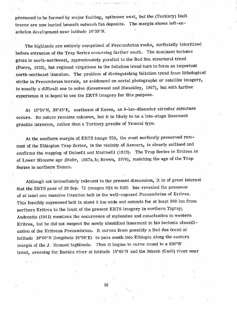
presumed to be formed by major faulting, upthrown west, but the (Tertiary) fault
traces are now buried beneath outwash fan deposits. The margin shows left-en-
echelon development near latitude 160 30'N.
The highlands are entirely comprised of Precambrian rocks, surficially lateritized
before extrusion of the Trap Series occurring farther south. The dominant tectonic
grain is north-northwest, approximately parallel to the Red Sea structural trend
(Porro, 1935), but regional virgations in the foliation trend turn to form an important
north-northeast lineation. The problem of distinguishing foliation trend from lithological
strike in Precambrian terrain, as evidenced on aerial photographs or satellite imagery,
is usually a difficult one to solve (Greenwood and Bleackley, 1967), but with further
experience it is hoped to use the ERTS imagery for this purpose.
At 15°55'N, 38°45'E, northeast of Keren, an 8-km-diameter circular structure
occurs. Its nature remains unknown, but it is likely to be a late-stage Basement
granitic intrusion, rather than a Tertiary granite of Yemeni type.
At the southern margin of ERTS image 223, the most northerly preserved rem-
nant of the Ethiopian Trap Series, in the vicinity of Asmara, is clearly outlined and
confirms the mapping of Dainelli and Marinelli (1912). The Trap Series in Eritrea is
of Lower Miocene age (Mohr, 1967a, b; Brown, 1970), matching the age of the Trap
Series in northern Yemen.
Although not immediately relevant to the present discussion, it is of great interest
that the ERTS pass of 29 Sep. 72 (images 024 to 026) has revealed the presence
of at least one massive lineation belt in the well-exposed Precambrian of Eritrea.
This forcibly expressed belt is about 5 km wide and extends for at least 300 km from
northern Eritrea to the limit of the present ERTS imagery in northern Tigray;
Andreatta (1941) mentions the occurrence of mylonites and cataclasites in western
Eritrea, but he did not suspect the newly identified lineament in his tectonic classifi-
cation of the Eritrean Precambrian. It curves from possibly a Red Sea trend at
latitude 18°0 0'N (longitude 380 00'E) to pass south into Ethiopia along the eastern
margin of the J. Hamoet highlands. Then it begins to curve round to a S30°W
trend, crossing the Baraka river at latitude 15°45'N and the Mareb (Gash) river near
16
Aycota at latitude 15°08'N. The southwestward projection of this profound lineamentbeyond the limit of ERTS image 026 is directly through Omm Agher and along thewestern escarpment of the Ethiopian plateau overlooking the Sudan plains.
3.2 Lake Rudolf-Kavirondo Gulf
The ERTS-1 pass of 10 Sep. 72 traverses the western side of Lake Rudolf, Mt.Elgon (cloud covered), and the eastern side of Lake Victoria, imaged on frames231 to 234. Thanks to the excellent field mapping of the Geological Survey of Kenya,the ERTS imagery can be used to search for and add further knowledge to severalimportant geological features associated with the African rift system.
In the north, image 231 covers the northern end of Lake Rudolf. Although a 20%cloud cover obtrudes, the shores of this lake can be accurately mapped for the firsttime, and also the Omo delta with its two "birds' feet." The northward extent of theOmo delta flats, the site of Pleistocene hominid discoveries, can be mapped but ispartly obscured by clouds.
Strong, recent tectonism runs meridionally about 50 km east of Lake Rudolf.This is the late Tertiary-Quaternary faulting of the Kinu Sogo belt, which extendsfrom the Suguta trough at the south end of Lake Rudolf (not covered by this pass)northward via the western edge of the Chalbi desert to the western margin of the LakeStefanie graben (Baker, Mohr, and Williams, 1972). Near Lake Stefanie, the faultingis dense and can be indicated only schematically on image 231. Of interest is thediscovery of a superimposed NE-SW and E-W tectonism immediately southwest ofthe lake: Future imagery centered on Lake Stefanie should indicate the extent of thesecross fractures.
Along the western side of Lake Rudolf, meridional faulting has produced the15-km-wide Precambrian horst of the Labur hills, and this horst faulting continuesvia Upper Miocene volcanic blocks - for example, the phonolite-nephelinite Lodwarand Kamutile centers - south as far as latitude 2°15'N. Thus, the entire westernside of Lake Rudolf is margined by this faulting, but it is obscured or obliterated wherethe remarkable arcuate valley of the Turkwel river turns to reach Lake Rudolf at latitude3°10'N. No fault traces can be observed on image 232 to connect the horst segments to
17

V *
, til
• i 1 f t • . ' < \ '*fv> ? .*VV'.''
v*
. •
» %
vc , I
\ \ U. RUDOLF
i' /
rf
«.. i
4
--•*- J t
v-;*»** % ! * ;
•
:?S£P">2 : :'•:• I9/ES35-55 N N8"-l?- '£e3S- s R SUN ELS? Rzee7 lee-K1.'--*-;-'.-r-2L NRSA ERTS E-ie^s e?< 3-s ei
Image 231. ERTS-1 image of the northern Lake Rudolf region.
18
! » W . " ' , -t»linnii|j.^r.r-.r-;' • ..' ..ijil]W]n.wJ;.lw.!^._F, J i w i ^ y s w ^ q r ^ y •^wMHrw'wwtwffy-• - ->?>="r:̂ -.
\
\ K„r
-0 . v l *
-fc
\ <u*K"»0 t-
.1 i.« i •.
\ S i ' . .•• - .MY
f> • Ww"
i M < - : /
• • i i • .
11
%
. . ' -v ' --v>5-35 N N82-se,'E83S-3S res s R SUN ELSE Rzees ie8-e6T7-fi-i-N-D-2L NRSA ESTS E- ? « ? ^ s s ei
Image 232. ERTS-1 image of the lower Turkwel valley and southern Lake Rudolf region, showing Precambrian terrain (P6), Tertiary basalts (Tv), Miocene nephelinite-phonolites (M^p), Miocene basalt (Mf3), and Pliocene basalt (Pp). Some young faults are labeled "Qf. "
19
V
. •* < .V-
vv
Kftt>fl» (oaoA)
A i
\
M
•*±:*m^*U*,M ttajkisS&Ju. . .^.^-' . .^jAafca'i . f»tttWi!
iEe3«-33 Ee35-00i 2RSFP72 C N0I• 29-^235-1? N N?l-27/EB35-23 nSS S
Ee35-30l R SUN EL58 R2S9S l88-e926-B-I-N-D-2L NflSB ERTS £-1867-87221-5 01
vi 1 t
! 3
1
V
N
3 a I
? §
Image 033. ERTS-1 image of the wes te rn margin of the Gregory Rift, showing the sharp conjunction of the Turkana and Kerio faulting.
20
•"M^ppyWI.pii^g^.W IffWtO^ " g1?^"*^?**??'1'*^ *n$r&*sm~*~~

PSM '"••'*• # * SE'ffx
% , ^
' „ •
-*?.£-v . '
V * » » «
t^'H • * ! < ' $ - - * : ' , '
•'
, ry
« ' * • • . ' • „ • , / • - - « •
•̂*«^u ilk * .•. ''i'-;* K i '<< , - T i * . «* •<• ' • ' > • ( . - . • • '
r- Kg* -l
• > * • - . , • *
*.<<• n . I -<,,V * t * , -
\
1
E23« a \ " . ' . ' , • t e " . J PISS 5 R R W ELS6 S2?c . lee B€ '7 R l - N D-2t NASA ERTE E- i"1? < ? ' . . ' - - •'
Image 234. ERTS-1 image of the Kavirondo Gulf, eastern Lake Victoria.
21
•' -y.-!T- ww**?* •'.• i -t̂ rr ̂ T ^ * - " ^ ^ * ^ - * 8 * * ^ ^ * * ^ *-<^ - r w y ^ , i g ^ g O T y ) ! W ? y w ? i f T ^ • X K - W ^ ' - ' V
the north and the south, suggesting that the faulting predates the surface sediments of
the Turkwvel.
Similarly, the strongly expressed Turkana fault, trending north-northwest close
to longitude 35°E on image 232, cannot be traced with certainty across the fluvial
plains of the Lorugunu. If there is recent faulting on this side of Lake Rudolf, it
is not manifested in any large displacements or extensive traces. The Turkana fault
can be observed in the Miocene basaltic mnassif of the MIuruasigar hills, north of the
Lorugumu valley, and also south along the western margin of the Turkwvel valley.
Fairburn and MIatheson (1970) have mapped the Lorugumu valley region in detail,
and the ERTS imagery generally confirms the identification of their lithological
boundaries. However, their subdivisions of the Precambrian are less easy to dis-
tinguish- for example, in the Okabaa syncline at 2°35'N, 35 °10'E. Fairburn and
Matheson (1970, pp. 47-48) infer the presence of faults on the floor of the Turkwel
valley, but none of these can be identified on the ERTS imagery. Repeat imagery of
this region is desirable, with different sun angles.
At the western edge of image 232, the Moroto nephelinite-phonolite cone clearly
exhibits its central intrusion, in the form of an "erosional caldera" (Varne, 1967).
Despite its alignment with centers of similar magma type and age (Nixon and Clark,
1967), no strong linking faults can be identified.
Image 233 gives the first ERTS picture of a well-known sector of the Eastern Rift
(Baker et al., 1972). Image 033 (28 Sep. 72) covers the same area and, for reasons
not yet understood, brings out the fundamental structures more clearly. The Turkana
fault zone continues south to the Cherangani hills, where it is intercepted by the
Quaternary faulting of the Elgeyo escarpment, forming the western margin of the
Gregory Rift. The regional interplay between the south-southeast-trending faults of
the upper Turkwvel valley (including the Turkana fault) and the remarkably linear north-
northeast-trending faults of the Kerio valley (including the Elgeyo escarpment) is
revealed for the first time. Despite some local adjustments through curving faults,
the Kerio structures appear to cut off the Turkwel faults abruptly. The inference is
that the faulting of the upper Turkwel valley, though locally rejuvenated, belongs to an
earlier phase of rifting with a somewhat different stress field than later developed
for the main phase of Quaternary rifting.
22
Future imagery of the Gregory Rift is awaited, to see if a south-southeastward
projection of the Turkwel faulting can be identified along the complex eastern escarp-
ment near Lake Hannington (Baker et al., 1972, Figure 12), and again to see whether
it may be cut across by fundamental, linear Quaternary faults.
East of the Cherangani hills, the rift floor is first encountered in the 20-km-wide
Kerio graben, which is separated from the main part of the rift floor farther east by
the Kamasia-Tiati platform. This platform appears to be cut by small, sinuous frac-
tures that are too short and numerous to be indicated in image 033. McClenaghan,
Weaver, and Webb (1971) indicate the presence here of a Pliocene zone of monoclinal
warping.
On the plateau west of the rift, a sinuous north-northwest tectonic grain in the
Precambrian Mozambique Belt is exposed along the Kenya-Uganda border, crossed by
linear NE-SW fractures in the vicinity of the Oboa (Kadam) nephelinite center. The
Miocene phonolites of the Uasin Gishu plateau, south of the Cherangani hills, appear
to be virtually unfractured.
The next most southerly image, ERTS 234, and the last to be discussed in this
section, is centered on the Kavirondo Gulf, eastern Lake Victoria. This Gulf
occupies a small rift valley, transverse to the main Gregory Rift (Shackleton, 1951;
Baker et al., 1972).
A fundamental crustal boundary extends southward from Mt. Elgon, marked by
the Nandi escarpment (Sanders, 1965). This escarpment is due to a "great thrust and
wrench-fault zone which is the westernmost expression of penetrative eastward dipping
thrusts" affecting the Precambrian rocks 70 km farther to the east (Sanders, 1965,
p. 4). Within and west of this zone are exposed Nyanzian granitic rocks; to the east
the Nyanzian is increasingly covered by the metasediments of the Mozambique Belt.
After some decades of geological debate, it has been established that the Nandi
escarpment is not an expression of normal faulting.
The Nandi escarpment shows up clearly on ERTS image 234, and as mapped on
the ground, it turns from southeast to south to meet the northern escarpment of the
Kavirondo rift perpendicularly. The Nandi faulting has not been traced farther on the
23
ground, but ERTS image 234 reveals a small volcanic center within the Kavirondo rift
on a projection of the Nandi faulting; and south of this rift some definite lineaments
continue due south, close to the boundary of the Bukoban (to the west) and the Mau
phonolites (to the east). This lithological boundary shows up quite well on the ERTS
imagery.
The junction of the Kavirondo and Gregory rifts is cloud covered on image 234.
The western sector of the Kavirondo rift shows the northern fault, as mapped by
Shackleton (1951), though the western continuation of this fault as a monoclinal flexure
to the shores of Lake Victoria cannot be distinguished. Along the southern margin
of the rift, the linear Sondu escarpment shows up clearly, but again its western con-
tinuation as the Kaniamura escarpment - and also its easterly extent into a monoclinal
flexure (Shackleton, 1951) - cannot be certainly identified. On the southern shores of
the Kavirondo Gulf, the Homa carbonatite center (LeBas, in preparation) shows up
clearly, but the Kisingiri centers are partly obscured by cirrus cloud and cannot be
distinguished.
3.3 Lake Tanganyika
*Lake Tanganyika lies within the Western Rift. The Cainozoic faulting that bounds
this lake has frequently been shown in schematic form (e. g., McConnell, 1972; King,
1970), but detailed structural mapping of this region is limited. Lake Tanganyika is
bordered by Tanzania, Zaire (Congo), Burundi, and Zambia, and the value of an
integrated mapping scheme using ERTS imagery is correspondingly emphasized.
The ERTS pass of 13 Sep. 72 (images 181 to 184) covers Lake Tanganyika as far
south as latitude 7 ° S. The eastern portion of Lake Rukwa (image 240) was covered
on 10 Sep. 72, so that there currently remains a gap between longitudes 30°30'E and
32°E.
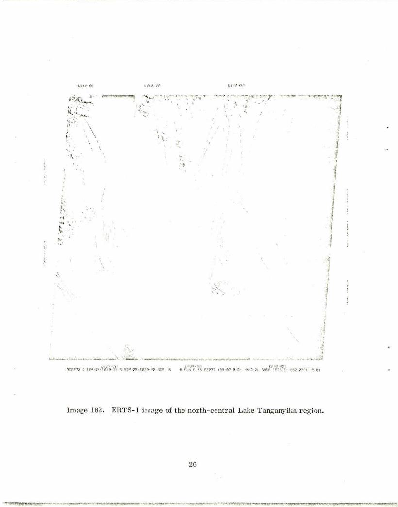
The northern end of Lake Tanganyika (ERTS image 181) is contained in a 20-kim-
wide graben; the trend is N-S where occupied by the lake but curves to the north-
northwest up the Ruzizi valley. The evidently young Quaternary faulting that bounds
.Without wishing to raise Cain, this writer demurs from Cenozoic. He is not awarethat our's is an era empty of life, not just yet anyway. Cainozoic more accuratelyreflects the graveyard of our ancestors, rather than the cenotaph of their hopes.
24

•:••„„,.
I3SEP72 C S82-57/E029-56 N fSS 5 P SUN EL55 AZ878 I88-87I9-G- ! -N-D-ZL NK=a EPTS E- !^52"
Image 181. ERTS-1 image of the nor thern end of Lake Tanganyika and Ruzizi graben.
25
, ; i ' . . •- <wi iin^m^»)iii»,Hi„ - ^ - . . , , . . . . . . - - .
**i^ n. •••, ;' ': ; • j y .;*.-
\
• •
V •it ' I • •
H
' *-r<r:r
•
V V
3* . . .
Ee29-eei EMS-381 13EEP-'? C Se*-2*/e029-35 N S8<!-25^823-•=? r!SS 5 R SUN ELb5 RZ877 188-
Ee3e-88i ?I9-G-I-N-D-2L NflSH ERTS E-I852-87«I1-5 81
Image 182. ERTS-1 image of the north-central Lake Tanganyika region.
26
'' " . ' W * l*R-'i^w?f • • ' T ' , ^ ' ^ f : r T W , n f f ' : ^ W ^ »'• • ^ ! ^ V ^ ^ ? ^ ^ , n y W T ^ * ^ . ^ r ; ^ « ^ * » j * s ^ i < ^ , p y

eje-e?!
X *>;-«.,« s ,
?S«8S C 585-58^829-15 N Se5-52'E029-20 HSS"
-881 E829-38I
P SUN EL5a RZ07S 188-8719-0-1-N-D-2L NRSfl ERTS E-1852-07*13-5 81
Image 183. ERTS-1 image of the central Lake Tanganyika region, including upper Lukuga valley and Kungwe hors t (with grani te "G") .
27
•w*!*Sfs*pw.?-:?^!ww*rr^^ • ymyjWff-w-.i

E829-B8I IEM9:33
\ \
•
i
-E828-38I E829-WI
I3SEP72 C S87-I7/E828-55 N S97-I3.-E023-08 HSS 5 R SUN ELb3, A2073 188-8719-0- I -N-D-2L NASA ERTS E-ie52->""7a2S-5 81
Image 184. ERTS-1 image of the region southwest of Lake Tanganyika, showing Kibaran porphyries (P) contrasting with Bukoban terrain (Bu).
28

this graben is axial to the much larger, 60-km-wide trough of the Lake Tanganyika rift.Thus the margins of this rift, each about 15 to 20 km across, comprise dissectedslopes that decline rather regularly from the plateau rim down to the graben floor.l¥ajor faulting within these marginal zones generally appears to be rare. Whethermajor faulting determines the plateau rims cannot be stated from image 181, wherecloud completely obscures this ground, but the precisely arcuate plan of the easternBurundi rim of the Tanganyika rift suggests that it is the result of tectonic controlrather than an accident of denudational recession. It is also possible that the LakeTanganyika rift represents a young graben within an older warped trough - future
ERTS imagery may help decide on this point.
The freshness of the faulting at the northern end of Lake Tanganyika, and alongthe Ruzizi valley, conforms with this region being the most seismically active in theentire African rift system, although the density of faulting is much less here than itis in many parts of the Eastern Rift. Fairhead and Girdler (1971) have plotted somerecent epicenters along the eastern boundary of the northern Tanganyika graben.
In Burundi, well to the east of the lake, broadly folded Burundian conglomeraticphyllites that were involved in the Kibaran tectonism about 1300 m. y. ago (Cahen,1970) are exposed. The structural grain of these rocks, reflected in the drainagepattern, is observed to run NE-SW, distinctly oblique to the Tertiary rift faulting andnoted as being so by McConnell (1972). Thirty kilometers southeast of Usumbura
(Bujumbura), arcuate tectonism is developed on the rim of the rift, suggestive ofanticlockwise rotational movement.
Northwest of Lake Tanganyika, and along the immediate eastern fringe of the lake,runs the Rusizian gneiss belt, a product of the Ubendian tectonic episode some2100 m.y. ago. The structural grain of this belt is N-NNW and is closely paralleledby the rift structures at the north end of the lake. But the same belt turns NW-SEfarther south, cutting sharply across the rift trough. This raises the vexed question,which cannot be gone into here, of whether the rift valleys of Africa are independentstructures that merely take advantage of the Precambrian crustal grain where suitable
(Baker et al., 1972), or whether the rift valleys and Precambrian structures are
29
intimately related to the point of being expressions of the same, long-standing sub-
crustal process (McConnell, 1972). Nevertheless, accumulated evidence from ERTS
imagery of the Western Rift (in the Eastern Rift, the Precambrian rocks are largely
covered by Cainozoic volcanics) may well prove critical in this argument.
Near latitude 4°S, the 8-km-wide Cape Banza horst protrudes north from the
western shore of Lake Tanganyika. It is separated from the western marginal zone
of the rift by a shallow graben (Burton Bay) 15 km in width. The structural alignment
of the horst suggests a continuity from the Rusizian gneiss belt at the northeastern
end of the lake. South of Burton Bay, the structural grain curves from N-S to NW-SE
and enters the lake. This curvature is an adjustment to the regional NW-SE trend of
the Ubendides (Cahen, 1970), and it is notable that it occurs where the younger
Burundian-Kibaride tectonism attempts (but fails) to traverse the Ubendides. No
major rift marginal fault can be detected on ERTS image 182, south of Burton Bay
(cf. McConnell, 1972).
The ERTS imagery gives sharp expression to a narrow zone of Cainozoic faulting
at latitude 5°S on the eastern side of Lake Tanganyika. This faulting trends NW-SE,
upthrown northeast, and bounds an uplifted block northeast of the Kiyimbi River.
The Kiyimbi faulting precisely follows the Precambrian Ubendide grain of eastern
Zaire. South of latitude 5° S, the Kiyimbi faulting is progressively more strongly
matched by the parallel development, about 10 km to the northeast, of southwest-
upthrown faulting along the lake shore. Thus a long, narrow horst extends along the
western margin of the lake, to just north of the Lukuga effluence, and is on a precise
alignment with the Kungwe horst on the eastern side of the lake (see below). Here,
between latitudes 5°30'S and 6°00'S, the Lake Tanganyika trough exhibits its renowned
"kink" in traversing across two parallel NW-SE structural depressions.
Forty kilometers south of Bujumbura, the eastern shoreline of Lake Tanganyika
turns abruptly from the meridional, Rusizian trend to an 80-km-long stretch trending
SSE-SE. The abruptness of this turn and the linearity of the shore south of the turn
are not indicated on existing maps. Despite the linear trend, there is no evidence on
the ERTS imagery (image 182) for any controlling NNW-SSE faults. Indeed, the
Burundian terrain of the hinterland to the east intercepts the lake with a NNE-SSW
structural trend.
30

Thec eastern shoreline of Lake Tanganyika makes another abrupt turn, 50 km north
of Kigoma, back to a N-NNE trend. Here, the Cainozoic faulting determining the shore-line is closely associated with a major Precambrian lithological boundary, separating
Burundian rocks to the west from the late-Precambrian Bukoban to the east. TheB3ulkoban has been mapped by the Geological Survey of Tanzania as virtually undeformed,
sedimentary elastic formations, and the lack of deformation is consistent with a struc-
tural featurelessness on ERTS image 182, east and northeast of Kigoma
(4°52'S, 29°38'E). Nevertheless, the Burundian-Bukoban boundary is not outstanding,
and to map it from the ERTS imagery may prove difficult.
South of Kigoma, Bukoban terrain shows a north-northwest structural grain that
intensifies toward the coast at latitude 5°30'S. This grain may be in part, or even
entirely, due to the Cainozoic faulting that forms the northeast margin of the Ubende
graben (McConnell, 1972, Figure 4). Future ERTS imagery to the east of Lake
Tanganyika will help resolve the problem of the eastward continuation of this graben.
The southern margin of the Ubende graben is formed by the Kungwe horst, whichbulges westward into Lake Tanganyika at latitude 6°S. The horst is composed of
Ubendian rocks, and the Cainozoic faults follow the NW-SE Precamnbrian structuralgrain exactly. The Kungwve horst is on the precise southeast-projecting alignment
of the NW-SE horst on the western side of the lake, north of the Lukuga effluence;
and in fact, connection occurs in the form of a shallow sill in the lake (R. B. McConnell,
1972, personal communication). It is in traversing this sill that Lake Tanganyika
obtains its kink in geographical plan. No example of a transverse NE-SW lineament
can be observed on either side of the lake in the vicinity of the kink, though ERTSpasses to either side of the present one are required to substantiate this conclusion.
The ERTS pass of 13 Sep. 72 leaves Lake Tanganyika, southeast of the Kungwehorst, and reaches the northern fringe of the Lake Mweru basin. The Karroo sediments
of the Lukuga valley, and the extensive Bukoban terrain to the south, are marked by
a weakly developed NNW- NW lineation of Ubendian trend. Along the shoreline of
Lake Tanganyika, south of the Lukuga effluence, strong but short arcuate faulting
31

forms the rift margin. This faulting turns from north-northwest to north-northeast,
where, south of latitude 6°30'S, a wide belt of Kibaran volcanic porphyries is
encountered (Cahen, 1970). Their light color and the lack of cultivation distinguishthese Precambrian volcanics quite clearly from the neighboring lithology. The
marked NNE-SSW structural grain of these volcanics extends to the eastern side of
Lake Mweru, a site of active seismicity (Fairhead and Girdler, 1971).
Farther wvest, the ERTS pass of 14 Sep. 72 (images 086 to 089) reveals thestrong NNE-SSW faulting along the eastern side of the Upemba graben (Cahen, 1954). It
is hoped that future ERTS imagery will show the precise relationships of these south-
southwest-trending offshoots to the Western Rift itself.
The ERTS pass of 10 Sep. 72 (image 240) and, more recently, that of 29 Sep. 72(images 063 and 064) cover the greater part of Lake Rukwa. The Rukwa rift links the
Lake Tanganyika rift with the Lake Malawi rift, but the fault pattern of this link is not
well known.
Unfortunately, images 063 and 064, covering the western end of Lake Rukwa and
the southern tip of Lake Tanganyika, are interfered by stratocirrus cloud. Image 240,
though of low contrast, is cloud free and covers the eastern end of Lake Rukwa and the
Mbeya region.
The linear northern shore of Lake Rukwa is determined by a major northwest-
trending rift fault, upthrown northeast. Whether this fault continues to the Ubende
graben (see above) cannot be determined from image 063, but to the southeast it boundsthe Mbeya horst (Brown, 1962) immediately before meeting the NE-SW Usangu fault of
the Eastern Rift at Mbeya town. The southwestern margin (Songwe scarp) of the Mbeyahorst appears offset en-echelon from the main Rukwa escarpment, and is the site
of a peculiarly linear Middle Cretaceous carbonatite (Brown, 1964).
The Songwe and Usangu scarps meet without any adjusting faults. However, the
Rukwa faulting would appear to be more fundamental here, because the Neogene-
Quaternary volcanic center of Rungwe (Harkin, 1960) lies on its projection, 15 kmsoutheast of the scarp termination at Mbeya. The structural grain of the cratonic
(> 2500 m.y.) Precambrian rocks of the Mbeya horst parallels the Rukwa escarpment.
32

/
? «
. . • . . ... • • i £ & » * ;
v - « ' i . i ' : ; 53 •• see «3>E&32~-S8 - ; C 5 R SUN EL52 ROTTS NRSfl ERTP E-10*5-87251 -5 B
Image 240. ERTS-1 image of the eastern Lake Rukwa region and the Mt. Rungwe volcanic center. Panda Hill carbonatite complex is indicated by "C".
33
By contrast, no definite lineations of NE-SW trend can be identified crossing theRukwa rift south of Mbeya (cf. McConnell, 1972, Figure 4), though beyond this riftcommences the NE-SW Luangwa rift (deSwardt, Garrard, and Simpson, 1965) withits notably arcuate boundary structures (images 041 to 043, 28 Sep. 72).
Both the Rungwe lavas and the Panda Hill carbonatite show up well on the ERTSimagery. However, the Mbozi block, immediately south of Lake Rukwa (Pallister,1971), is not delineated.
The southern margin of the Rukwa rift is formed by a powerful and persistentfault, but gently curvilinear, in contrast to the linear northern-margin fault. Theplateau south of the southern margin is formed of Ubendide granitoid metasedimentsand metavolcanics (McConnell, 1972) whose structural grain again parallels that of therift, though the grain is very weakly expressed on the ERTS imagery (240 and 064).Discussion of major virgations at the southern end of Lake Tanganyika (image 064)is deferred until cloud-free imagery is available.
The ERTS imagery of the Lakes Tanganyika and Rukwa rifts shows that where thePrecambrian structural grain is parallel to that of the Cainozoic rift faulting, thelatter is persistent, with few or no en-echelon offsets. But where the regional rifttectonism begins to turn from parallelism with the Precambrian structures, the riftfaults are short and frequently offset, or are strongly arcuate. Where markedlyoblique to the Precambrian structures, rift faults tend to resume a persistent lineartrend, in concordance with the regional rift pattern.
3.4 Lake Malawi
ERTS-1 imagery of the Lake Malawi (Nyasa) rift is currently limited to the passesof 8 and 26 Sep. 72 (images 020 to 022 and 055 to 058, respectively). These passesare almost duplicates and cover the lake from its eastern side at latitude 11°S to thehighlands southwest of the lake.
34
•:?-•;-?? -:a?2 •?? EB33-??
*
9
*»-v-V\. -
-!
. •
28SEP72 C SlB-0«/EB32-35 N ;-a-e5/E;e32-'li nss s EB32-30I EB33-08I
R SUN EL55 RZa?8 188-8928-fl-1-N-D-2. NRSfl ERTS E- IB67-072S3-S 81
Image 041. ERTS-1 image of northern Luangwa valley.
35
I!?? 00 E03230 ER3-W
i I ?
•
v
/ / I
5
I
? T
/ I V - : ~i
E83I-3B E032-001 E032-30.
28SEP72 C SII-30/E032i" N SI 1-31'E032-2I RSS S R SON ELS5 R207B 188-8928-fl-I-N-B-2L NflSfl E?TS £-1067-27260-5 01
Image 042. ERTS-1 image of central Luangwa valley.
36
rr^^fffwirw^ff,1?!!!.>.*••"!,-',rr^"-^y.•*<"."'.HMWHW'WE*- W,iBy.vr.- t tmrx.yf^tm^'*>**^$?pvjv>y*, vwi^V^^^Jifom. ,r IIII;*''?! JM-̂ L'i-l1'' w*J.7«!*,,«l?J3^,,Wr^*<r"i •
:e?2 f! E?3?-3?i
\
i / i
s • '
I
i
; -5 0
» : -• '
^
I I :
I i
h Li J
/
• . •:??• :•? L??2-??'
/ f t
28SEP72 C SI2-5E'Ee3l-53 N Si?-58?f2?2-?B 1SS 5 R SUN E^S« RZ874 I88-B928-R-I-N-D-2L EM2-38I
ERTS E-!eE7-e72e2 5 81
Image 043. ERTS-1 image of southern Luangwa valley.
37
t - y - r r - r - - , ••-• - y K W v"«r**'v&fL VffK >*»* "̂
se>5-eei EB3*-3Si
. . . . -. . .« ......... -.,.. j|i;jgy!;i|l«Hf; f>\V '
N.
s
« i
E833-30I FM^-aai EB3*-38I 2esEP?2 c sis-s5'E03d-e3 N bis-se/Eesi-ee res s R SUN EL52 Rztna ie8.e9e0-R-:-N-D-2L NBSH ERTS E-ief5-97i55-5 a;
Reproduced from
Image 058. ERTS-1 image of par t of the lower Zambezi valley.
38
- • • . • - - . i f f ^ l S ^ ^
;N ^
E33T-® i
/ " y
^ , ' j **l
i i •
I \ /
'\
N \
X
\ X
\
N
N
X
S s
•
\
X
x -rf S,
X X
X X
•t S
t
•
X
\
s
• v
% • V \
N
\ s
\ X
\ V \
v
i
X
i \ x
\ / v
\ ' \ \ )\ >
\ \
\
\ :
v |
i \k \\
i
j
-
f ? ?
i
£
I •\ \i \\ h***
I M M me
\ XX I
i.'_J 14 .
' A
1 > \ i I , ,
i
: \ v . \
' . ^ * t : 4 ; ; ^ . • * . . . : ^ ^ . ^ ^ .
Ee3a-sei Ee3"-3pi re^-aai 26SEP72 C SI«-29/F?T>-2« N SI*-38>EB3«-3e nSS 5 R SUN ELS3 P287I l83-0D8e-H- I -N-D-2L NFISfl ERTS E- IP6J-a?"lS2-5 ei
Image 057. ERTS-1 image of the region southwest of Lake Malawi and Lake Malombe, indicating end-Precambrian granites (G).
39

\
•
?
\ a a
; (
/ I
•
—.' ' •• • '•>« •A i l
if?3"-ee tes^-sei t?3S-e?i 26SEP7? C SI3-82^E830-«S N SI3-8<VE83"-50 HSS S f SUN ELS" AZ873 iee-8S08-B-I-N-D-2L WSfl ERTS E- 1065-871=8-5 8!
Reproduced from best available copy.
Image 056. ERTS-1 image of south-central Lake Malawi, indicating end-Precambrian granites (G).
40
•?-•-•-•? EMS-Ml
\ ' > V . . . U r. V i .
\ V
/ /
/ . BS»1
f
i
^-***^JiJt*i±Ui±i^
26SEP72 c SI I -36sEe35-K N SII-3?/Ee35-l|
? / • / 1 /
"SS 5 R I S f e S i RZ67S 188-e9e8-R. l -N-0- |eJ^ :ERTs' f?ry 96S-87l«3-5 e
Reproduced (rom best available copy.
— Etgsr&SSSJS^&^}£~2«r
41

The extensive work of the Geological Survey of Malawi, summarized in its 1966
Geological Map of Malawi, is generally confirmed from the ERTS imagery. However,
the immediate bounds of the Lake Malawi rift include sectors in Mozambique and
southernmost Tanzania, where its tectonics remain rather poorly known. The ERTS
imagery therefore provides an ideal base for a unified structural gelogical map of this
rift.
The western margin of the Lake Malawi rift, west of Lake Malombe, shows up
clearly as a double escarpment (images 022 and 057). The continuation southward of
this faulting into the north-northeast-trending Shire rift is not clear, however. [Note:
The eastern margin of the Slhire rift, curving south-southwestward from the eastern
boundary faulting of Lake Malombe, lies just beyond the limits of the present ERTS
imagery. ] The easterly fault of the western-margin fault pair is made up of short
arcuate sectors, convex toward the downthrown side. The westerly fault is quite linear,
with a trend of 345° , and is more extensive than shown on the 1966 Geological Map of
Malawi. It would be interesting to check if the easterly arcuate faults are near-surface
vertical fractures extending up from an east-hading crustal fault plane expressed at the
surface by the westerly trace.
The western-margin faulting, in this southern sector, terminates north in a
northwest-trending zone of two perpendicular sets of fracturing, about latitude 14°S.
Bloomfield (1970) notes that in this region the Dedza perthitic complex of the
Mozambique Belt bears superimposed fold patterns: NW-SE (F1) regional isoclinal
folding of the paragneisses, whose trend was reinforced by Mesozoic dike intrusions,
and NE-SW (F2) broad, open folds. The ERTS imagery confirms that the denser
lineation pattern is the NW-SE one (Bloomfield, 1970, Figure 3a). Precambrian
lithological boundaries in this region, including that of the Dedza complex, are generally
transitional and not sharply delineated on the ERTS imagery. An exception is the
arcuate outcrop of calc-silicate granulites situated near 14° 10'S, 34 ° 10'E.
The uplifted hinterland, west of the western margin fault near latitude 14°30'S,
exposes two contrasting terrains on ERTS image 057. In the north, a lighter colored
terrain with a NW-SE structural grain can be identified with the "Basement" gneisses
42
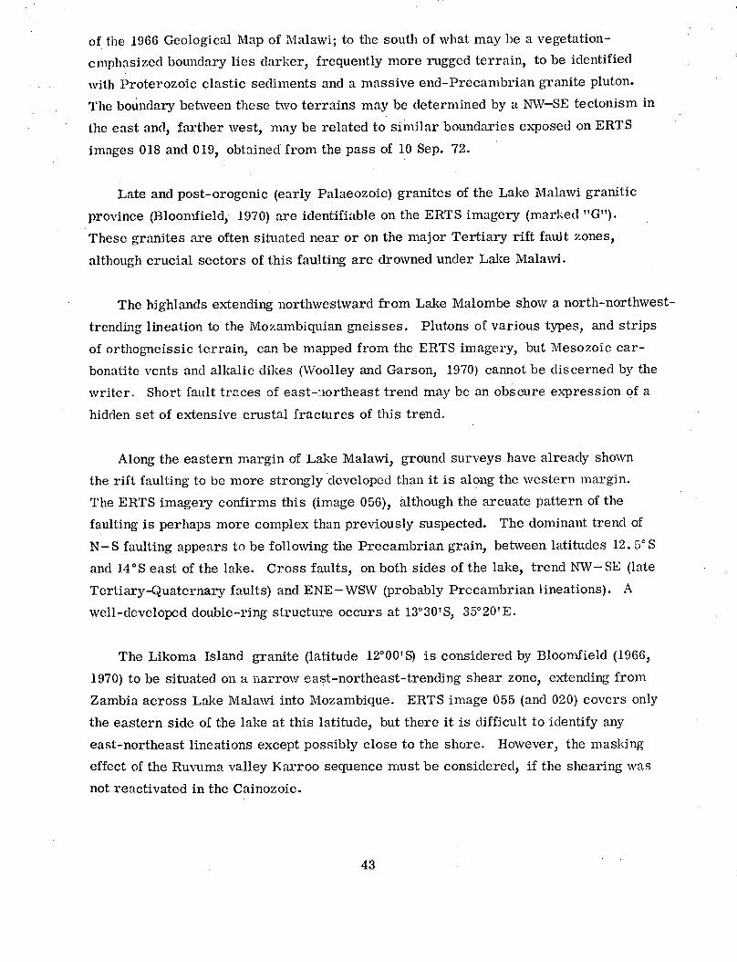
of the 1966 Geological Map of Malawi; to the south of what may be a vegetation-
cmphasized boundary lies darker, frequently more rugged terrain, to be identified
with Proterozoic elastic sediments and a massive end-Precambrian granite pluton.
The boundary betwveen these two terrains may be determined by a NW-SE tectonism in
the east and, farther west, may be related to similar boundaries exposed on ERTS
images 018 and 019, obtained from the pass of 10 Sep. 72.
Late and post-orogenic (early Palaeozoic) granites of the Lake Malawi granitic
province (Bloomnfield, 1970) are identifiable on the ERTS imagery (marked "G").
These granites are often situated near or on the major Tertiary rift fault zones,
although crucial sectors of this faulting are drowned under Lake Malawi.
The highlands extending northwestward from Lake Malombe show a north-northwest-
trending lineation to the Mozambiquian gneisses. Plutons of various types, and strips
of orthogneissic terrain, can be mapped from the ERTS imagery, but Mesozoic car-
bonatite vents and alkalic dikes (Woolley and Garson, 1970) cannot be discerned by the
writer. Short fault traces of east-nlortheast trend may be an obscure expression of a
hidden set of extensive crustal fractures of this trend.
Along the eastern margin of Lake Malawi, ground surveys have already shown
the rift faulting to be more strongly developed than it is along the western margin.
The ERTS imagery confirms this (image 056), although the arcuate pattern of the
faulting is perhaps more complex than previously suspected. The dominant trend of
N-S faulting appears to be following the Precambrian grain, between latitudes 12. 5°S
and 14°S east of the lake. Cross faults, on both sides of the lake, trend NW-SE (late
Tertiary-Quaternary faults) and ENE-WSW (probably Precambrian lineations). A
well-developed double-ring structure occurs at 13°30'S, 35°20'E.
The Likoma Island granite (latitude 12°00'S) is considered by Bloomfield (1966,
1970) to be situated on a narrow east-northeast-trending shear zone, extending from
Zambia across Lake Malawi into Mozambique. ERTS image 055 (and 020) covers only
the eastern side of the lake at this latitude, but there it is difficult to identify any
east-northeast lineations except possibly close to the shore. However, the masking
effect of the Ruvulma valley Karroo sequence must be considered, if the shearing was
not reactivated in the Cainozoic.
43
The Ruvuma valley declines northeastward away from the east side of Lake Malawi
.; latitude 12°S. For the first 60 kin, it is separated from the lake by a narrow
sqinuous horst, reminiscent of the Kiyimbi horst, west of Lake Tanganyika (see
S5¢ction 3.3). The denuded aspect of this horst may testify to a Mesozoic initiation
off the faulting (Dixey, 1956). The horst widens into a highland block to the north,
wihere the structural trend of the Mozambique Belt metamorplhics curves from north
to northwest in a great arc, and thus turns away from the northeast trend of the
rBuvuma trough.
The lake shore follows the Mozambiquian trend, but has an accentuated curve due
to the headland protruberance of the Liuli granitic massif, at latitude 11°00'S. The
rift faulting runs close to the granite-metamorphics boundary and appears to be ter-
r.iinated by a NE-SW cross fault at the northern end of the granite (also at the
r:northerly limit of image 055).
The NE-NNE trending trough of the Ruvuma valley cuts across the Precambrian
grain. It is interesting that the rift faulting has preferred to follow the earlier of
these two structures here. The thick, undeformed sedimentary sequence of the Karroo
-HIaughton, 1963) shows weakly some northeast and north-northeast lineations, reflect-
-:;g a Karroo tectonism that probably extended to the Rufiji valley and the Tanzanian
c(ast, near Dar-es-Salaam. This will be sought on future ERTS imagery.
.. 5 Other Regions
Single ERTS images cover some other regions of special interest. Selected here
a9re the Aswa mylonite zone, at the northern end of the Western Rift, and part of Afar,
Fthiopia. It is of Ethiopia that the writer has some ground experience, but thus far,
very little cloud-free ERTS imagery of this country is available.
. 5.1 Aswa mylonite zone
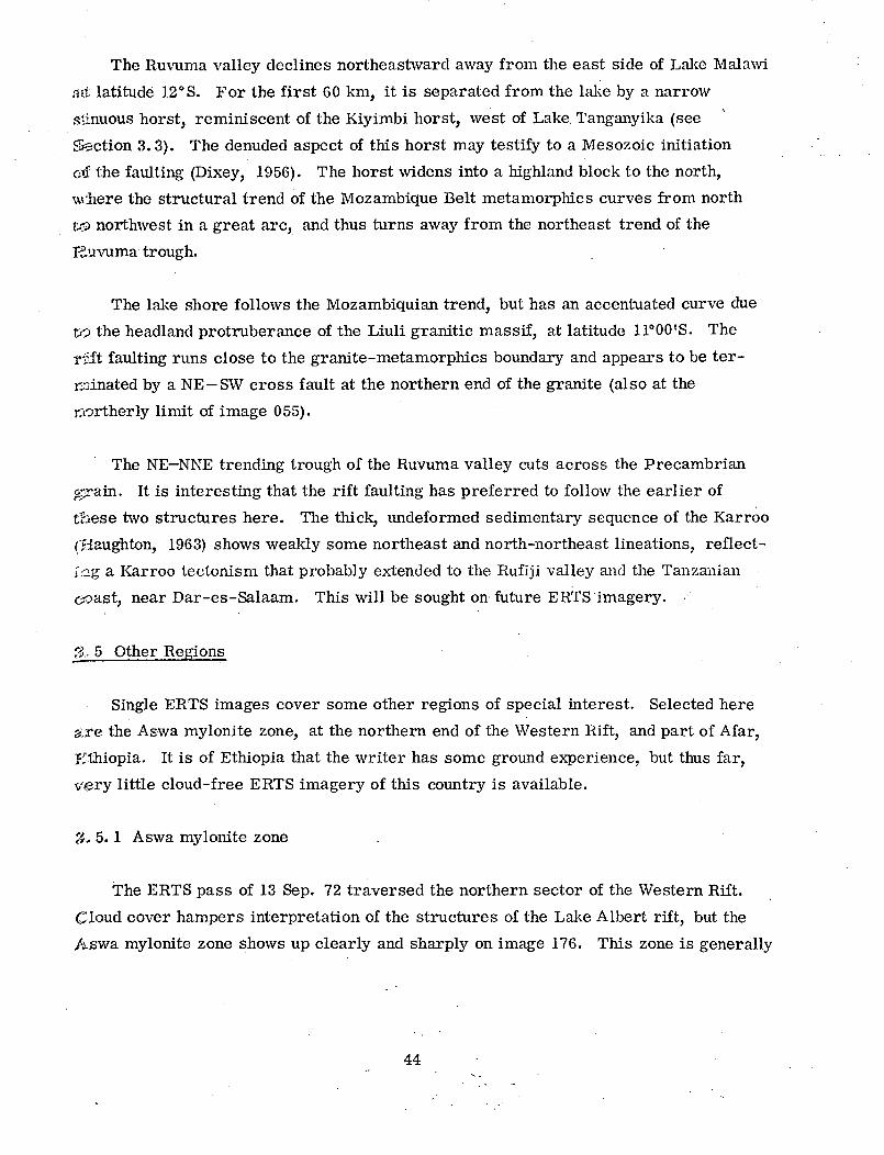
The ERTS pass of 13 Sep. 72 traversed the northern sector of the Western Rift.
Cloud cover hampers interpretation of the structures of the Lake Albert rift, but the
Aswa mylonite zone shows up clearly and sharply on image 176. This zone is generally
44

recognized to cut abruptly across and to terminate the NE-SW faulting of the Western
Rift, north of Lake Albert (Whiteman, 1965). Cloud cover on the ERTS imagery is too
great to investigate whether or not there is any NE-SW faulting continuing across the
unexplored country to the north of the Aswa mylonite zone, but the zone itself can be
described here.
The White Nile at latitude 3. 5°N, following a course of about 070 ° parallel to the
"final" rift faulting, abruptly turns at Nimule to 315 ° . This is the trend of the Aswa
mylonite zone, which extends northwest from Nimule for at least 200 km. Whiteman
(1971) has summarized what little is known about this zone in Sudan from reconnaissance
ground traverses. Its southeasterly extension into Uganda has been studied by Almond
(1969), who considers that the zone extends under Mt. Elgon to continue as the Nandi
fault (see Section 3. 2). If this is the case, this is a fundamental late-Precambrian
lineament at least 700 km long.
ERTS image 176 shows the Aswa mylonite zone in Sudan to be a severe fracture
zone with a flattened S-shaped plan. The fracturing is splayed clockwise in both
directions from a nexus at 4°20'N, 31°25'E. This fits with Almond's (1969) proposal
for sinistral shear along the Aswa zone in Uganda. Young volcanic cones on the
northern fringe of the western arm of the zone reveal a previously unreported Quater-
nary volcanic activity, consonant with recent seismicity in this region (Almond, 1969;
Mohr, 1969).
Two ring structures, 6 to 8 km in diameter, occur north of Nimule.
3.5.2 Afar, Ethiopia
The only window to date (October 1972) in the "kremt" cloud cover of Ethiopia
is over part of southern Afar. Afar is a triple-rift junction, and its structures are
complex and controverted (Tazieff, Varet, Barberi, and Giglia, 1972; Mohr, 1967a,
1970, 1972).
45
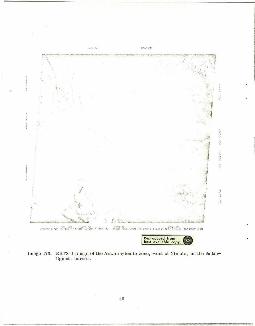
- <**SP£V
• • • •
I
fc/L*
.
£
?fc...viWl * f,: v . . .<*, ' . . , - . «£•. ^ ;
• i " M l INee3-3B EB3J-38I Ee32-OTI EP72 C » ' • - I7/E03I-37 N N*>-15-^031 -«l OSS 5 R SUN ELS7 R288S I88-B7J9-G-I-N-D-2L_NRSfi ERTS E-l052-0738«»-5 01
Reproduced from mm best available copy. ^ f l f
Image 176. ERTS-1 image of the Aswa mylonite zone, west of Nimule, on the Sudan-Uganda border .
46
• ..,-.;r«fT'i'-i!'/ir.'U'»wn' • r • • - - V-.~' • ; > * « * - : « • ? - » W L T T ? w f f < ^y«p W ww>»yT<^ U; BWP. • ,:^1 l r-• - " ^ P ^ g y ^ ^ ^ ' * " ' ^ • ^ T T ^ •

Image 136, from the pass of 7 Sep. 72, confirms the existence of the fault beltsmapped previously (Mohr, 1967a, 1970, 1972; Taieb, Coppens, Johanson, and Kalb,1972). As expected, however, the ERTS imagery provides a much better basis forunified regional mapping of the more important structures. For example, despite
poor contrast, image 176 reveals the arcuate faulting extending northwest from
Langudi volcano (10°35'N, 41°0 0'E), the parallel existence of the Issa graben (Taieb
et al., 1972) and a fault belt 40 km farther east (Molhr, 1967a, 1972), and the existence
of important NE-SW fractures in the Aisha horst, south of the Gulf of Tajura (see also
ERTS image 172, 24 Sep. 72). These last are notably parallel to a proposed trans-
form fault in the Gulf of Tajura (Roberts and Whitmarsh, 1969), and suggest that this
region may be of transitional oceanic-continental character.
All rules exist to be broken. The writer's resolve not to discuss any imagery
received after the end of October was dissolved with the arrival on 10 November oftwo superb images of Afar. Image 157 of the pass of 13 Oct. 72 covers the eastern
corner of Afar and the southern half of the Danakil horst. Image 158 covers the Lake
Abbe-Gulf of Tajura region, immediately to the south.
Images 157 and 158 are of extraordinary clarity, and show in fine detail the almost
catastrophic structural deformation of this awesome, slightly eerie global tectonicnexus. The results of ground-based geological surveys of Afar have been discussed
by Tazieff et al. (1972) and Mohr (1967a, 1971b, 1972). Essentially, the late TertiaryAfar Series flood basalt-mugearite sequence forms a visible basement that has been
intensely sliced by a complex mesh of Lower-Middle Quaternary fault belts. LateQuaternary faulting has rejuvenated some of these belts, but without drastically modi-
fying some extensive Middle-late Quaternary sedimentary basins (Taieb et al., 1972).These basins show up light on the ERTS imagery, especially the saline deposits of
the Lake Assal and Dobi graben.
Detailed mapping of Afar from ERTS imagery is the province of Dr. P. Kronberg
(Clausthal), but points of interest in relation to the writer's earlier work can be
briefly mentioned.
47
gUl'CM •?UrtllJ
4 *
, . ( ' > . '
• ' • : i
i
_.
M
J
*
.' El 72 C NIB • ?•.•;.<"-•• -33 ".'v9-5?-Ft>«i -37 HSS 5 ° SUN EL57 P?P9" IB8-B63S-N-!-K-D-21 NBSB E=TS V i ear-P1??"1-" 8!
J be Reproduced from best available copy.
Image 136. ERTS-1 image of southern Afar, with fault belts partially revealed through cloud cover.
48

£?<^-?? i?"2-~e
• • • ! "STS"*, T,-"
,; . -'
H
,f"
%-•
•
-. . . ' • • . . .
» ; * * • ' ' ' v*.i.^.;;*~ .«.*'*
30CT72 C N I 3 - K ^ 2 - I S N NI2-S7/E8-2-28 nss 5 Pc 2 " f [ R SUN EL5" flZl2' I «8 - I I37 -B- I
E8«2-38 'N-"0 2L NBSfl ERTS E- !062-0?820-S 81
Reproduced from best available copy.
image-and complex fantail fault belts in the south.
49
- .]»»«•'••!••'»».«•,,. •<lti.mH>IWWMiiim*wn;»*^"J«w^ T W K W ^ f - W I W * ^ ••w'**^«,B••K^p*r^r*,w,^'^^s','
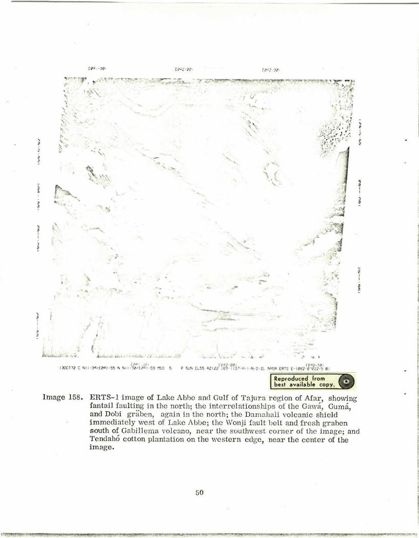
I ' • • • • • • • • - •
;..
:?-;• w
^ „ „ _ ^ r ~ . - ^ ^ a j ^ y . ^ y i ^ t ^ j m y rr •-.,-,-,* * •
« •
•
!
i, ' • { ,- . *
^ » , H * ; . ; ; -
(
• •
'
) a 1
N 0 1 1
a a
Nl I -3a^E0-a I -55 N Nl I-38^E0«I-59 rtSS 5 F0«2-88l E0O2-38I
P SUN EL55 HZI22 189-1 I37-fl-1-N-D-2L NflSR ERTS E-iee2-e7222-S 6!
Reproduced from best available copy.
Image 158. ERTS-1 image of Lake Abbe and Gulf of Tajura region of Afar, showing fantail faulting in the north; the in terre la t ionships of the Gawa, Guma, and Dobi griiben, again in the north; the Damahali volcanic shield immediately west of Lake Abbe; the Wonji fault belt and. fresh graben south of Gabillema volcano, nea r the southwest corner of the image; and Tendaho cotton plantation on the wes te rn edge, near the center of the image.
50

The Dubbi volcanic alignment (Mohr, 1967a), traversing the central Danakil horst
in a NNE-SSW direction, is clearly apparent on image 157, yet no large crustal dis-
placements of this trend are in evidence on the surface to link the centers. A funda-
mental lineament is presumably buried beneath the young lavas and tuffs of the region,
and poses a caution on the relating of surficial and transcrustal fractures.
A huge fantail of fine, crustal fracturing extends northwestward from Gubet
Kharab, via Lake Assal. The remarkable, sinuous Gawa graben is part of this fan-
tail, but the arcuate Guma graben (Mohr, 1971b) is a separate, major entity, which
may be a surface expression of a crustal nucleus responsible for the form of the fan-
tail. Another hypothesis has been pvt forward by Mohr (1968), in terms of an arcuate
stress pattern.
The southeast-trending fault belts of northern and western Afar project across
to the Lake Abbe region, but ERTS image 158 suggests that a major curvilinear
adjustment, southward to a south-southwest-trending (Wonji fault belt) direction,
occurs immediately west of Lake Abbe. Damahali volcano is situated on this curving,
linldking fault belt. West of this newly recognized belt, the faults are more locally
irregular in pattern, though just as dense, compared with the majestic sweep of faults
to the east. This suggests a regional pattern of stress accumulation to the east, in
possibly thinner crust, compared with local resistances to such a pattern, in possibly
thicker crust, to the west.
The boundary between the NW-SE fault belts north and northeast of Lake Abbe
and the E-W fault belts south and southeast of the lake (Mohr, 1967a) appears from
ERTS image 158 to be an east-northeast-trending linear fracture zone. Though outside
the region mapped by Mohr (1967a), this zone must be considered a candidate for a
"cross-rift lineament," subject to ground confirmation of its existence. Smaller such
lineaments are expressed at latitude 11°35'N at the western edge of image 158, cros-
sing the western end of the Gawa graben, but conclusive evidence for the hotly con-
troverted existence of cross-rift lineaments must await good imagery of southwestern
Afar, close to the main Ethiopian rift.
51
The form of the Aisha horst is more complex than had previously been realized.- It .-s southerm.seator may indeed be merely a northward protruberance from the
Somalian plateau, and other exposures of ancient, continental-type rocks may be
"islands" in quasi-oceanic crust. This question remains open, but revisions to theplate-tectonic scheme of Mohr (1972) are already indicated and further emphasizethe value of the ERTS imagery to structural geology and plate tectonics.
52
4. REFERENCES
ALMOND, D. C.
1969. Structure and metamorphism of the Basement Complex of north-east
Uganda. Overseas Geol. Min. Res., vol. 10, pp. 146-163.
ANDREATTA, C.
1941. Appunti geologico-petrographici su alcuni problemi dello zocolo cristal-
lino dell'Eritrea. Rend. Reale Accad. Ital., vol. 2, pp. 766-776.
BAKER, B. H., MOHR, P. A., and WILLIAMS, L. A. J.
1972. Geology of the eastern rift system of Africa. Spec. Rep. Geol. Soc. Amer.,
no. 136.
BLACK, R., MORTON, W. H., REX, D. C., and SHACKLETON, R. M.
1972. Sur la decouverte en Afar (Ethiopie) d'un granite hyperalcalin mniocene:
Le massif de Limmo. C. R. Acad. Sci. Paris, vol. 274, pp. 1453-1456.
BLOOMFIELD, K.
1966. A major ENE dislocation zone in central Malawi. Nature, vol. 211,
pp. 612-614.
1970. Orogenic and post-orogelnic plutonism in Malawi. In African .?jmatis
and Tectonics, ed. byT. N. Clifford and I. G. Gass, Hafner Publ; Co.,
Darien, Conn., pp. 119-155.
BRINCKMANN, J., and KUIJRSTEN, M.
1969. Granitische gesteine in den randschollen der Danakil-depression (Athiopien).
Geol. Jahrb., Hannover, vol. 87, pp. 51-60.
BROWN, G. F.
1970. Eastern margin of the Red Sea and the coastal structures in Saudi Arabia.
Phil. Trans. Roy. Soc. London, vol. 267A, pp. 75-87.
BROWN, P. E.
1962. The tectonic and metamorphic history of the Pre-Cambrian rocks of the
Mbeya region, southwest Tanganyika. Quart. Journ. Geol. Soc. London,
vol. 118, pp. 295-317.
1964. The Songwve scarp carbonatite and associated feldspathization. Quart. Journ.
Geol. Soc. London, vol. 120, pp. 223-240.
53
BUTZER, K. W.
1971. Recent history of an Ethiopian delta (the Orno river and the level of Lake
Rudolf). Univ. Chicago Dept. Geog. Res. Paper 136, 184 pp.
CAHEN, L.
1954. Geologie du Congo Belge. Vaillant-Carmalme, Liege, 577 pp.
1970. Igneous activity and mineralisation episodes in the evolution of the Kibaride
and Katangide orogenic belts of central Africa. In African Magmatism and
Tectonics, ed. by T. N. Clifford and I. G. Gass, Hafner Publ. Co.,
Darien, Conn., pp. 97-117.
COMUCCI, P.
1933. Rocce dello Iemen raccolte dalla missione de S. E. Gasparini. Period.
Min., vol. 4, pp. 89-131.
COX, K. G., GASS, I. G., and MIALLICK, D. I. J.
1969. The evolution of the volcanoes of Aden and Little Aden, South Arabia.
Quart. Journ. Geol. Soc. London, vol. 124, pp. 283-308.
DAINELLI, G., and MARINELLI, O.
1912. Risultati Scientifici di un Viaggio nella Colonia Eritrea. Galletti e Cocci,
Firenze, 601 pp.
deSWARDT, A. M. J., GARRARD, P., and SIMPSON, J. G.
1965. Major zones of transcurrent dislocation and superposition of orogcnic
belts in parts of central Africa. Geol. Soc. Amer. Bull., vol. -76,
pp. 89-102.
DIXEY, F.
1956. The East African rift system. Overseas Geol. Min. Res. Bull. Suppl.,
no. 1, 77 pp.
FAIRBURN, W. A., and MATIHESON, F. J.
1970. Geology of the Loiya-Lorugumu area. Geol. Survey Kenya, Rep. No. 85,
52 pp.
FA]RHEAD, J. D., and GIRDLER, R. W.
1971. The seismicity of Africa. Geophys. Journ., vol. 24, pp. 271-301.
GASS, I. G., COX, K. G., and MALLICK, D. I. J.
1965. Royal Society volcanological expedition to the South Arabian Federation
and the Red Sea. Nature, vol. 205, pp. 952-955.
GASS, I. G., and MALLICK, D. I. J.
1968. Jebel Khariz: An Upper Miocene strato-volcano of comenditic affinity on
the South Arabian coast. Bull. Volcanol., vol. 32, pp. 33-88.
54
GEUKENS, F.
1960. Contribution' la geologie du Y6 men. Mem. Inst. G6'ol. Louvain, no. 21,
pp. 117-180.
1967. Geology of the Arabian Peninsula: Yemen. U. S. Geol. Survey Prof.
Paper 560-B, pp. 1-23.
GREENWOOD, J. E. G. W., and BLEACKLEY, D.
1967. Geology of the Arabian Peninsula: Aden Protectorate. U. S. Geol. Survey
Prof. Paper 560-C, pp. 1-96.
HARKIN, D. A.
1960. The Rungpve volcanics at the northern end of Lake Nyasa. Mem. Geol.
Survey Tanganyika, no. 2, 172 pp.
HAUGHTON, S. H.
1963. Stratigraphic History of Africa South of the Sahara. Oliver and Boyd,
Edinburgh, 365 pp.
IKARRENBERG, H.
1957. Junger magmatismus und vulkanismus in Sidwestarabien (Jemen). Intl.
Geol. Congr., Mexico City, vol. Vulc. Ceno. 1, pp. 171-185.
KING, B. C.
1970. Vulcanicity and rift tectonics in East Africa. In African Magmatism and
Tectonics, ed. by T. N. Clifford and I. G. Gass, Hafner Publ. Co.,
Darien, Conn., pp. 263-283.
LAUGHTON, A. S.
1966. The Gulf of Aden, in relation to the Red Sea and the Afar depression of
Ethiopia. Geol. Survey Canada, paper 66-14, pp. 78-97.
LIPPARINI, T.
1954. Contributi alla conoscenza geologica del Yemen. Boll. Serv. Geol. Ital.,
vol. 76, pp. 93-120.
McCLENAGHAN, M P., WEAVER, S. D., and WEBB, P. K.
1971. Pliocene trachyte volcanoes of the northern Rift Valley, Kenya. Journ.
Geol. Soc. London Proc., vol. 127, p. 294.
McCONNELL, R. B.
1972. Geological development of the rift system of eastern Africa. Bull. Geol.
Soc. Amer., vol. 83, pp. 2549-2572.
55
MOHR, P. A.
1962. The Ethiopian rift system. Bull. Geophys. Obs. Addis Ababa, no. 5,
pp. 33-62.
1967a. The Ethiopian rift system. Bull. Geophys. Obs. Addis Ababa, no. 11,
pp. 1-65.
1967b. Review of the geology of the Simien Mountains. Bull. Geophys. Obs.
Addis Ababa, no. 10, pp. 99-112.
1968. Annular faulting in the Ethiopian rift system. Bull. Geophys. Obs. Addis
Ababa, vol. 12, pp. 1-9.
1969. Relationships between recent Middle East and African earthquakes. Nature,
vol. 223, pp. 516-518.
1970. The Afar triple junction and sea-floor spreading. Journ. Geophys. Res.,
vol. 75, pp. 7340-7352.
1971 la. Ethiopian tertiary dike swarms. Smithsonian Astrophys. Obs. Spec. Rep.
No. 339, 85 pp.
1971b. Tectonics of the Dobi graben region, central Afar, Ethiopia. Bull. Geophys.
Obs. Addis Ababa, vol. 13, pp. 73-89.
1972. Surface structure and plate tectonics of Afar. Tectonophys., vol. 15,
pp. 3-18.
NIXON, P. H., and CLARK, L.
1967. The alkaline centre of Yelele and its bearing on the petrogenesis of other
eastern Uganda volcanoes. Geol. Mag., vol. 104, pp. 455-472.
PALLISTER, J. W.
1971. The tectonics of East Africa. In Tectonics of Africa, UNESCO (Paris)
Earth Sci. Ser., no. 6, pp. 511-542.
PORRO, C.
1935. Esplorazione geologica della zona costiera Eritrea a nord di Massaua.
Mem. Reale Accad. Sci. Torino, no. 68, pp. 241-276.
ROBERTS, D. G., and WHITMARSH, R. B.
1969. Bathymetric and magnetic survey of the Gulf of Tadjura, western Gulf of
Aden. Earth Planet. Sci. Lett., vol. 5, pp. 253-258.
SANDERS, L. D.
1965. Geology of the contact between the Nyanza Shield and the Mozambique
Belt in western Kenya. Geol. Survey Kenya Bull., no. 7, 45 pp.
56
SIIACKLETON, R. M.
1951. A contribution to the geology of the Kavirondo rift valley. Quart. Journ.
Geol. Soc. London, vol. 106, pp. 345-392.
TAIEB, M., COPPENS, Y., JOHANSON, D. C., and KALB, J.
1972. Depots sedimentaires et faunes du Pliopleistocene de la basse vallee de
l'Awash (Afar central, Ethiopie). C. R. Acad. Sci. Paris, vol. 275,
pp. 819-822.
TAZIEFF, H., VARET, J., BARBERI, F., and GIGLIA, G.
1972. Tectonic significance of the Afar (or Danakil) depression. Nature, vol. 235,
pp. 144-147.
VARNE, R.
1967. The growth of the Moroto volcano, eastern Uganda. Bull. Volcanol.,
vol. 31, pp. 163-174.
WHITEMAN, A. J.
1965. A summary of present knowledge of the rift valley and associated structures
in Sudan. In Report of the UMC/UNESCO Seminar on the East African Rift
System, Univ. Coll. Nairobi Press, Nairobi, pp. 34-46.
1971. The Geology of the Sudan Republic. Oxford Univ. Press, Oxford, 290 pp.
WOOLLEY, A. R., and GARSON, M. S.
1970. Petrochemical and tectonic relationship of the Malawi carbonatite-alkaline
province anid the Lupata-Lebombo volcanics. In African Magmatism and
Tectonics, ed. by T. N. Clifford and I. G. Gass, Hafner Publ. Co.,
Darien, Conn., pp. 237-262.
57
BIOGRAPHICAL NOTE
PAUL A. MOHR received his B. Sc. in 1952 and Ph.D. in 1955 in geochemistry
from Manchester University, under Professor W. A. Deer.
Before joining Smithsonian Astrophysical Observatory in 1967, he spent 10 years
at Haile Selassie I University (formerly University College, Addis Ababa), with inter-
vening 1-year research fellowships at Sheffield University and Cambridge University.
Since joining the Smithsonian Astrophysical Observatory, he has retained his
interest in Ethiopian rift valley studies: in particular, in the relationships between
tectonism and volcanism, and in establishing precise geodetic nets to detect crustal
deformation in the rift.
,5c