Embed Size (px)
Citation preview
7 A " 193 5.2 M ryA n R N UP*P?
"NCLASS IFE C.1 3d t~f N O~Vi
apEND
-- I
Iia -3
Final
SN0In
DTICELECTED
Technical Support DocumentFor Record Of Decision
1 Cape Newenham, AFS
Prepared for
USAF OEHLBrooks, AFB, Texas
January 18, 1988
lAmoved fw PubftmI 2 1 0AM~ulbuUog UnWiIedt
FINAL
INSTALLATION RESTORATION PROGRAM.
TECHNICAL SUPPORT DOCUMENT
FOR RECORD OF DECISION
CAPE NEWENHAM
Prepared for:
USAF OEHL
Brooks AFB, TX
Prepared by:
Woodward-Clyde Consultants
701 Sesame Street
Anchorage, AK 99503
71/46/2
71/21/1
RECORD OF DECISION
Installation: The Cape Newenham AFS, is located in the Southern
Bering Sea Province of Alaska. The area is surrounded by rocky
terrain supporting an alpine tundra habitat.
Scope of Decision: This record of decision and supplemental support
document applies to six potential hazardous waste sites identified at
Cape Newenham AFS. The recommendations for all six sites are the
same; therefore, a single document for the entire installation is
warranted.
Statement of Basis:
The findings and decisions on the Cape Newenham AFS presented in this
report are based on the following:
- 1987 site visit by personnel of Woodward-Clyde Consultants
and the U.S. Air Force.
- Comprehensive literature search and review.
- Information gathered from governmental regulatory agencies
and a review of active environmental permits issued by state
and federal agencies. The following permits or approvals
have been issued for sites identified during Phase I:
Solid Waste Disposal Permit (site 1b)
Dredge and Fill Permit (site Ib) Ion For
- Review of the physical, chemical and toxicological :'id
characteristics of suspected or known contaminants. oltIon----.
- Preliminary Assessment Form submitted by EPA. ,ltionlI ek~billty Codea
S "AviJI end/or ..
ist p
.0 -
71/21/2
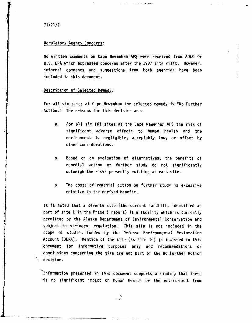
Regulatory Agency Concerns:
No written comments on Cape Newenham AF$ were received from ADEC or
U.S. EPA which expressed concerns after the 1987 site visit. However,
informal comments and suggestions from both agencies have been
included in this document.
Description of Selected Remedy:
For all six sites at Cape Newenham the selected remedy is "No Further
Action." The reasons for this decision are:
o For all six (6) sites at the Cape Newenham AFS the risk of
significant adverse effects to human health and the
environment is negligible, acceptably low, or offset by
other considerations.
o Based on an evaluation of alternatives, the benefits of
remedial action or further study do not significantly
outweigh the risks presently existing at each site.
o The costs of remedial action on further study is excessive
relative to the derived benefit.
It is noted that a seventh site (the current landfill, identified as
part of site 1 in the Phase I report) is a facility which is currently
permitted by the Alaska Department of Environmental Conservation and
subject to stringent regulation. This site is not included in the
scope of studies funded by the Defense Environmental Restoration
Account (DERA). Mention of the site (as site Ib) is included in this
document for informative purposes only and recommendations or
conclusions concerning the site are not part of the No Further Action
decision.
Information presented in this document supports a finding that there
is no significant impact on human health or the environment from
DEPARTMENT OF THE AIR FORCEHEADOUARTERS ALASKAN AIR COMMAND
ELMENDORF AIR FORCE BASE. ALASKA 99506-50010 44
DEP 22 MAR 1988
No Further Action Document (NFAD), Cape Newenham Air Force Station (AFS),Alaska
Defense Technical Information CenterCameron StationAlexandria, Virginia 22314
1. The Alaskan Air Command is proud to forward the No Further Action Document(NFAD) for Cape Newenham AFS, Alaska (Atch 1) to you for inclusion into thedata base maintained by your organization. The attached document is the finalreport in the Installation Restoration Program for this location. Thedistribution of this document is unlimited. Atch 2 is the OTIC Form 50completed for this document.
2. The Installation Restoration Program (IRP) is a Department of Defense(DOD) program to identify, evaluate and remediate environmental problemsassociated with past waste disposal at DoD facilities. With the passage ofthe Superfund Amendments and Reauthorization Act (SARA) in 1986, the IRPprogram is closely aligned with the waste site remediation process as definedin the National Contingency Plan (NCP).
3. We hope the information provided is helpful. If you have any questions,please contact Mr James W. Hostman, HQ AAC/DEPV, Elmendorf AFB, AK 99506-5001,phone (907) 552-4151.
[ f c /
WILLIAM C. MCKINNIS, Maj, USAF 2 AtchChief, Prog Dev & Rqmts Div 1. Final NFAD, Cape Newenham AFS,
Feb 882. OTIC Form 50
I,)I) ( ) l', \""-rj j 'r ,
71/21/3
suspected or confirmed past contamination at the Cape Newenham AFS.
The recommended remedy is no further action with regard to
investigation or clean-up of six (6) sites identified as possible
areas of contamination at the Air Force station.
Declarations:
The Comprehensive Environmental Response, Compensation and Liability
Act of 1980 (CERCLA) as amended, and the National Contingency Plan Act
(NCP) as amended, provide for Trustee and Regulatory Agencies to
determine the appropriate actions at Federal facilities where oil or
hazardous substances may have been used or disposed.
Based on the best, currently available information for all six (6)
sites at Cape Newenham AFS, the risk of significant adverse effects to
human health and the environment is negligible, acceptably low, or
offset by other considerations. Such considerations include avoidance
of environmental damage resulting from further investigations or
clean-up and absence of exposure to human receptors due to remoteness
of the installation. In all cases, further clean-up activities would
create a disproportionate amount of damage, especially to the fragile
tundra ecosystem, relative to the amount of contamination which could
be recovered and to other derived benefits. Other considerations
include the absence of significant exposure to human receptors due to
remoteness of the installation. In summary the "No Further Action"
alternative will adequately protect public health, welfare, and the
environment.
The Air Force determines that the action being taken is appropriate
when balanced against the availability of Defense Environmental
Restoration Act (DERA) or other monies for use at potentially
contaminated sites. Specific attributes of the site that suggest or
support the "No Further Action" alternative are as follows:
o Deep permafrost and frozen soils preclude the possibility of
significant vertical migration of potential contaminants.
71/21/4
0 The absence of significant migration pathways indicates that
the mobility of potential contaminant is extremely limited.
o Human health risks are negligible.
0 Contamination was not observed at any site.
o No threatened or endangered species are known to use or
exist on the installation.
0 No economically or commercially important species use or
exist on the installation.
o Unique or sensitive environmental areas and receptors will
not be affected.
Thomas T. Walker, Colonel, USAF Date
Commander11 Tactical Control Group
REVIEW AND CONCURRENCE:
Stte of A1&I a Da'ta,Department of Environmental Conservation
'ited tates Etfvironmental Protection Agencyregion 10, Alaska Operations Office
71/94/1
TABLE OF CONTENTS
Page
1.0 SUMMARY 1-1
1.1 Introduction 1-1
1.2 Site Description and Setting 1-1
1.3 Site History 1-4
1.4 Current Site Status 1-4
1.4.1 Site Visit 1-4
1.4.2 Risk Screening 1-9
1.5 Alternatives 1-11
1.6 Consistency with Environmental Laws 1-11
1.7 Conclusion 1-11
2.0 TECHNICAL ATTACHMENTS 2-1
2.1 Site Description 2-1
2.1.1 Location 2-1
2.1.2 Environmental Setting 2-1
2.1.2.1 Geology 2-1
2.1.2.2 Hydrology 2-2
2.1.2.3 Biota 2-2
2.1.3 Site History 2-4
2.1.4 Site Operations 2-5
2.1.5 Chemicals Used 2-6
2.1.6 Previous Studies 2-6
2.2 Current Site Status 2-8
2.2.1 Findings from Previous IRP Studies 2-8
2.2.2 Observations from Site Visit 2-8
2.2.3 Findings from the Literature Search 2-10
2.2.4 Consistency with Environmental Laws 2-11
2.2.4.1 Resource Conservation and
Recovery Act (RCRA) 2-11
2.2.4.2 Clean Water Act 2-13
71/94/2
TABLE OF CONTENTS (Continued)
Page
2.2.4.3 Safe Drinking Water Act 2-13
2.2.4.4 Coastal Zone Management Act 2-14
2.3 Potential Contaminants 2-14
2.3.1 Waste Accumulation Areas 1 and 2
(Site 1a) 2-14
2.3.2 Active Landfill (Site 1b) 2-15
2.3.3 Upper Camp Dump Area (Site 2) 2-15
2.3.3.1 Ethylene Glycol 2-15
2.3.3.2 Wastewater 2-16
2.3.3.3 Waste Oils 2-16
2.3.3.4 Scrap Metal, Wood, Drums and
Cultural Debris 2-16
2.3.4 Road Oiling - Lower Camp (Site 3) 2-18
2.3.4.1 Waste Oils/Hydraulic Fluid 2-18
2.3.5 Waste Accumulation Area 3 - Lower Camp
(Site 4) 2-18
2.3.5.1 Waste Oils/Thinners 2-19
2.3.6 Landfill - Lower Camp (Site 5) 2-19
2.3.6.1 Shop Wastes (Oils and Lubricants) 2-19
2.3.6.2 Solvents 2-19
2.3.7 White Alice Site (Site 6) 2-20
2.3.7.1 PCBs 2-20
2.3.7.2 Liquid Wastes 2-21
2.3.7.3 Chlorinated Solvents 2-21
2.3.7.4 Batteries and Electrical Generation
Equipment 2-22
2.4 Contaminant Movement/Transport Mechanisms 2-22
2.4.1 Waste Accumulation Areas 1 and 2 (Site la) 2-22
2.4.2 Upper Camp Dump Area (Site 2) 2-23
2.4.2.1 Ethylene Glycol 2-23
2.4.2.2 Waste Lube Oils 2-23
2.4.2.3 Gasoline/Kerosene/Aviation Gas 2-24
71/94/3
TABLE OF CONTENTS (Continued)
Page
2.4.2.4 Diesel 2-25
2.4.2.5 Chlorinated Solvents 2-26
2.4.3 Road Oiling - Lower Camp (Site 3) 2-26
2.4.4 Waste Accumulation Area 3 (Site 4) 2-27
2.4.4.1 Paint Thinners 2-27
2.4.4.2 Waste Lube Oils 2-27
2.4.5 Landfill - Lower Camp (Site 5) 2-28
2.4.5.1 Waste Oils/Lubricants 2-28
2.4.6 White Alice Site (Site 6) 2-28
2.4.6.1 PCBs 2-29
2.4.6.2 Chlorinated Solvents 2-30
2.4.6.3 Batteries/Electrical Generation
Equipment 2-30
2.5 Qualitative Risk Assessment 2-31
2.5.1 General Approach 2-31
2.5.2 Definition of Risk 2-31
2.5.3 Specific Approach 2-32
2.5.4 Logic Supporting the Assessment 2-35
2.5.4.1 Waste Accumulation Areas 1 and 2
(Site la) 2-35
2.5.4.2 Upper Camp Dump Area (Site 2) 2-40
2.5.4.3 Road Oiling (Site 3) 2-41
2.5.4.4 Waste Accumulation Area No. 3
(Site 4) 2-43
2.5.4.5 Landfill - Lower Camp (Site 5) 2-44
2.5.4.6 White Alice Site (Site 6) 2-44
2.6 Alternatives Analysis 2-46
2.6.1 Purpose 2-46
2.6.2 Evaluation Criteria and Method 2-47
2.6.3 Alternatives to be Evaluated 2-49
2.6.3.1 Waste Accumulation Areas I and
2 (Site la) 2-49
71/94/4
TABLE OF CONTENTS (Concluded)
Page
2.6.3.2 Upper Camp Dump Area (Site 2) 2-49
2.6.3.3 Road Oiling (Site 3) 2-49
2.6.3.4 Waste Accumulation Area 3 (Site 4) 2-50
2.6.3.5 White Alice Site (Site 6) 2-50
2.6.4 Results 2-50
2.6.4.1 Waste Accumulation Areas 1 and
2 (Site la) 2-50
2.6.4.2 Upper Camp Dump (Site 2) 2-51
2.6.4.3 Road Oiling (Site 3) 2-51
2.6.4.4 Waste Accumulation Area 3
(Site 4) 2-51
2.6.4.5 White Alice Site (Site 6) 2-52
2.7 Summary 2-52
2.8 Bibliography and Contacts 2-52
71/20/1
1.0
SUMMARY
1.1 INTRODUCTION
The Cape Newenham AFS, located in Alaska's Bering Sea Province, was
investigated under Phase I of the Installation Restoration Program
(IRP). The findings of that study indicated six potentially
contaminated areas at the installation (Eng. Sci. 1985). The report
recommended follow-up action for all sites. A 1987 field visit
verified that cleanup activities at all six sites had occurred. The
following document presents the information collected in support of no
further action at Cape Newenham AFS.
1.2 SITE DESCRIPTION AND SETTING
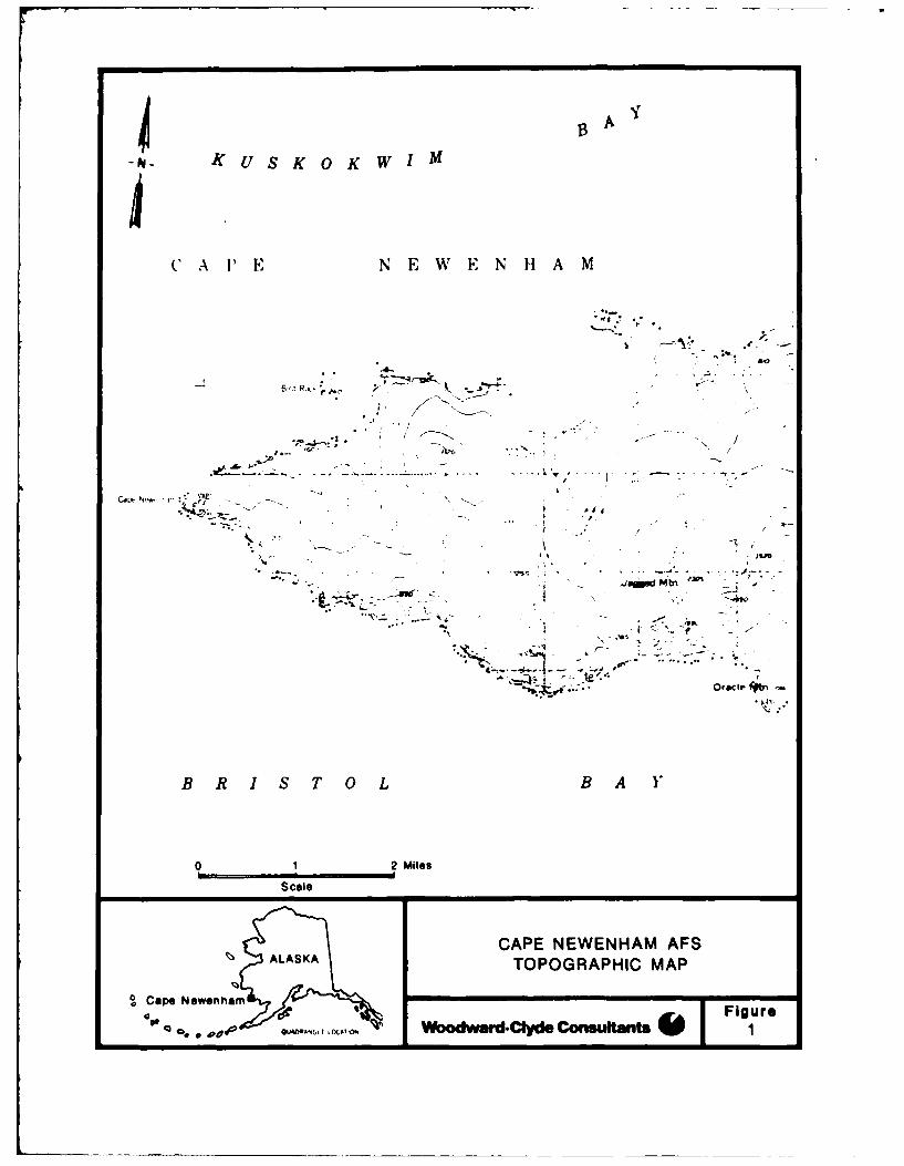
The Cape Newenham AFS is located on a small peninsula on the southwest
coast of Alaska about 770 km southwest of Anchorage (Figure 1). The
Air Force Station consists of approximately 950 hectares surrounded by
the To~iak National Wildlife Refuge (NWP). The nearest settlement is
Platinum, a Native Alaskan mining community about 50 km to the
northwest. The topography in the vicinity of the cape is steep and
rocky. One unnamed drainage is found within the boundaries of the
installation. The creek flows through the valley, past the airstrip
and into Kuskokwim Bay. The rugged terrain of the area supports a
dwarf, shrubland, alpine tundra.
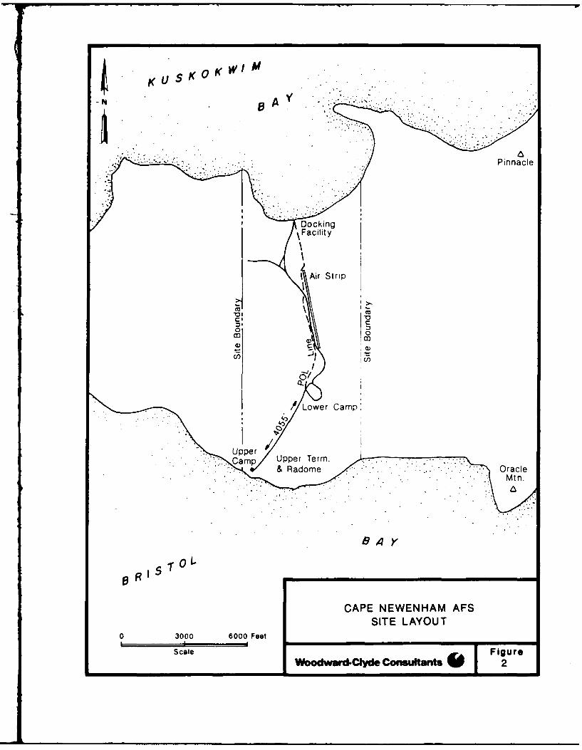
Cape Newenham AFS is divided into an Upper and Lower Camp (Figure 2).
They are connected by a tramway and a road. An airstrip is located at
the Lower Camp and several gravel roads connect the buildings of the
I-I
1 3 A
- P -I U S K 0 K WIM
C" A P' E N E W E N H A M
.4*0
-,vv
B R I S.70LB
h r4
" - ~~ ~~~.. . . . ...... .. .',. . . . . -. . . .- " "
-.-
,, b&%l W00dww' C 'd ,nsufrf
-- o
--
..... ... ... .. ..... .o,......
B R I S T 0 L B A I
01 2 Mlles
Scale
CAPE NEWENHAM AFS
~ ALASKATOPOGRAPHIC MAP
Ca~pe NewenhamFiur
I A Fgrse Ja. Odad CyeCnslat
-p4~~ *KsKWM
N0
CampI Upp r er
CL:CAENWNA0F
ScaleeOrcl
71/20/4
camp (Figure 3). A 10-cm POL line crosses the land to the beach. The
Upper Camp contains a terminal and radar facility (Figure 4).
1.3 SITE HISTORY
Cape Newenham AFS was one of the original Aircraft Control and Warning
sites constructed in Alaska as part of the Air Defense System; it
became operational in 1954. In 1957 a White Alice station was added.
In 1979, an Alascom satellite earth terminal system replaced the White
Alice facility; all White Alice structures were demolished and buried
by 1987.
The Phase I report identified six potential sites of contamination at
Cape Newenham (Table 1). Site 1 includes two waste accumulation areas
at the presently active landfill. Sites 2, 4 and 5 are previously
used dumpsites or waste accumulation areas, site 3 is an area of past
road oiling, and site 6 is the abandoned, demolished and cleaned up
White Alice site.
1.4 CURRENT SITE STATUS
1.4.1 Site Visit
The Cape Newenham AFS was visited by representatives from the U.S. Air
Force and Woodward-Clyde Consultants. The visit took place on August
26, 1987 and was part of a trip to other LRRS installations in Alaska.
A written synopsis of the visit is on file with the Alaska Air
Command, Elmendorf AFB, AK.
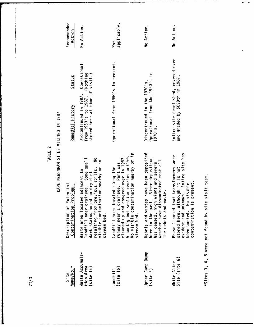
Sites visited at Cape Newenham AFS (Table 2) include a landfill and a
waste accumulation area (both in site 1), an upper camp dump area
(site 2), and a White Alice site (site 6). An area of road oiling
(site 3), another waste accumulation area (site 4), and an abandonedlandfill (site 5), all identified in the Phase I report had either
been cleared and graded or could not be located by the field survey
crew.
1-4
z -z
00
ICJ)
3 C-)
0 UJ W
0 ) 0iiE) C )U D m 1
2 00 D
a: w
00
-0 c4 u ~0 U)
U-a 0z0 wC. 73
00 C'4 )
~3C O~i~r>C
oC E-0
a) 0< ~ a)
C) UC 0
-C) .- 0
CJ
U)
C •
cwf LL
0
•~~~~~c .t O u -Q))
U)Z 0 4
I-0 m)0crtLJQ.
JO 0~O<do
Ur)
m DUU
0 0
143
o c: 0
Sr-- - -
4_-7 -." / j
..- -- 4142 /
cr
< 0 CA 0
/ JL U
cr!
S/ u. c ,."
0 10
.--
a c0
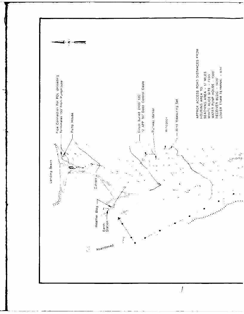
LOWER CAMP FACILITIESCAPE NEWENHAM AFS
Woodward.Clyde Consultants 3W oo3
N
PARKING ARE,,%.
C 20
S ca
/ //0
'I -/
CAPE NEWENHAM AFSUPPER CAMP FACILITIES
20 40 Feet
caie ArA Figure
Wodward-Cld Consultants mr 4
- 7- /b , m m m m m -
L L S.- SL S_""C..0. 0 .. 0 .. 0 ..C 4-) r 41 C +. C 4-) 4-) C0.- (1) 0.- O'" 0"-- () 0"- 41) 0S"- C - - C- .- C - '- C
4,-- 0 " 0.0 4 0.0 4-) .0 - 0. " 4-UE- UE-- U.- , ,E-- u , E- - U ."
CA -cc 4A -CC U) :x in CC U) C U CCto-0 AA) MU tnU)0 V) ' V) Q) u
Q ,- 0C , CCO Q -0 0O ,- 0 CL rrr 0 CC 0. .,.-to0.0C 0o Cl. Oto0 .L toa C. Ot4)0 , m I I a I i -
3W I 3 ) a30) ( 3) W 30) U X. W.0
0 E 0.- 0W W WW 0- 0) otoL.- OtL St( .- OtoL_ Oto&_ 0 t 0
U_ U.) izU LU ) (0U LLA..U)10U LLU 4 CCU LL.UV)(0 U LA_ (A C
0 cm
o' C "* .- CO"
4 0 4-) 0 0U) 0 0 4- 0 S_ - 40
C- 0 o -L -
o 4.• ) L *V 0
r-t --) cu '04-) .,--) - CL 0 - LO
-- - o o -- - "
, - C) CC ,- C)L_ LO m~ 0 c
1-0 O4 m- V; LA*
• " ) . .-4 -" ) * U ) U,- ",- to
V-) - (A 4- Ca I CD- 0> C0- (a 0
C C. r- 0 )- r" C .,o 0 0 -4 0) -4 4-) -4 , 0. ea
• ,**- *- -4.- 0 '
- ._ L 4-) 4-) 4-) CQE )
LO 0 to t0 '( "- 0 0 C-O "--4 - - $_ 4-) L C)
U) In $ cW 0 4--. - E E 0. Q)U)0 cu) 0)
S 0 :3 ) :U U r C) Cu Q C) C
-U U - -L A . ( -LA 0 "L) CC C o -Q 41).- * 4-Oa) 4-) C
V) 'A C -4 QOU CL I Q-4 CU 0n- 0) .- 4- , 0 0 - 0 0-
.) 41 4- C) D - "E U.) 0 U E CE "C-E V) 00 UA U)-.r- 4A ) U)A tor-..
LA a)W toO 0-,- to M I- _ o" 0 (nO .- L S .- n.00-1 LUJ ck : -: - 4.J _j 4 M - M4~- 0 4- 0
cc
LUJ S.. 4--I Ca) (U 0 0
U) 4-) 0Q S_~ 0C= CL- ) o U). 100) 0 4-J U)
4-) 0D UVo0 a) 0 w) r_ C0.LLU4 U) 0-4- > (U 41) .- C U) -
V) 0(0) CA)4-)C CC 0) 4-> faC rC "D
U)V)~) 30 C>r_4-) CO Cr0.U CL 0 .U to (0- o
- S_. E cu m = O4J InU cWVo0 0 OU) - L.)4-) CU_ L- U)W U)U)
4-)0 U) t 0 .9--LC 0 - 4-.- tL.)C - 4--- +j4)O 0 Ca.- a)-- 4)Q_W .0 4-- 0+) Q)0 0)L V) S_4--4-)O 0 to CL.4- 4A U)
0.0L CL tW ea C)cu r 0 0) Oj0W)(.CA CL0 *EV- - V rC) 4-0(U)
4- C to 0 0a) (a "00 m .- .00 0 ) I. VL) 4-J CO0 E3 0)
V )- 4-O0CQ to L 4 CA c. 44A- U) =3 4-~ 'a-o U)Cr
0Oto 'a 'a-- a))U )O U) OA 0U () *0C c ~ 4- 4- -- E ~ )L_ 41' MU
ea) ) U)'10 -00 - 4- 0)06 E - toOm 4- 0OV U 4-) to * V-').- to U) .- ) 3: U) 0 ) CUQ ) * U)U00 U-L4-J 4-0)U4-) (U .- 4)._ 0) 00c)uC c "04-3 4- CL4-)LS-W fj~ V0E CL 04- 0 Ca.00) o - CUt ) OU.0V U ) O_ .- U 0UU0 4-) U)a)L) CL rotoa lA .0to W .- toD. > U.4-3 tom=0n V LA .. 3c 4 V) 3U -0L 30 W 4- c 039 0 Ln O
to .4-J C t
4 4-(A 41)
&A CO. CL 0. m .- 4 0. UW4toto to E -E r= U o E E
u U0..Jt m Cto(- .(c- a0)CD- -toC- *
0; axL S L) Cl -) O S C L.) c L)LC) CC)cc .. too CC
W-. ) (U c'.JC'.4 L LW 0) LW Q 4-L1W4 0)clJ4-0 4- C 0.4) 1 0 CU41 4- C ) 4J' '0 )4-) +.) 0)
-- E 0)O G 'a =-- faoX- ) 0 3-_ C3- - *4-)
r_ r_ 0 0cu0 0 .
u ax 4-> 4-L4.) 0 L
+~0.
cm- 0 00 0 0)
(a 44 0$- > 00
a)) 4 A0 0(71CL 0 .- 4-) CD
4-) CD-->C)L
( 4-f 0l (-j0) 0C> 0LC
a) 4---7
-4E E 00Cr 0 r_0 Euo
0 0 4-J S- .Lr 4- 4-'(ea 4- 4
-4 = - 1. (a =( 4-'0
00) 0 0
r-( 4-4 a 4-j IA 0).z 0 4) ~ 0 to-'AW
aA ) u EL u- s-CI- E (A0 o) w L(Vr- 4J-
L. 0. 4-'C 06M a- O 0CIfS ~ 4- A 0) C:0-4 LLJ (V
-! LA!
:t V - 0 4 (A
=~U 0 00 > S) .- 0 Q) .- LA .- CL -0 - D
(V -(~' 0 4A-OS- M W-
CA S- CL) 3 U> 0l. - ) 0 +j -)0o A 0 M0).0 Wa)>4- SO(AU.S +.) ).j 4.)4-). L- D0Q 0( 4)0c39 E L > S- (A (V Ca. LA0LI! 4-0--.c o) 00 m w W E E V) E
c fV) D. S LC -00 r- C0 a 1 0'- (Va0 (a( 0 >( ro OV 4- 4-' 0LU - u >, ;. - E c -0 a) to a V (4-c a4-) 4-)a- (V (V - S- 0 CV (V0 U - -- 0L U 0cx. E L *' 0V =W DL- - a)0Iv rCAto .0Wa 4-J
L) +) 0) 00c a V0 W 4-) > -- V0 Q S-0 .- ( Lto ea a -- 0 a)eoS-r-cc M A -( /5 W 4-) M 0 W) (0
4-.0 'a - )4- -- -- 0 .0 CU E )) 0 > D. >
0 L W( ' t'aS u to o4- E 'A W) (a( (a-a0410 -Lw o. Q 0S OLU t Q 4+-).='o3t =4- c 0 0)m 1041) 4) '-4-) 4 LA M 4- -e 4-'
4-0r u 0E L(A rVV (V M -00 0 S a0v m eato r 0 (Vo. 0L V 0D :3
04-) (L) )4- c S- S- 3 (v - > 4- 'o 'a
4-)-- - to r .0 a0 0).0.0 fo 0n S 0 OC. E (VO4-W )" - a" m( L.0 - 4-'
.(V 0 - E .- > 4-tfL E (A - Q)QW "aao.0ES- 4-J Q)4- -- C fV 4-fo r C--V CO- UC 0 WW W CLVr 0u r 4 'Q be =-0W V3: V0 > LW4 41 0 (L D -4-) 4-V) 0 (A QLS V)Lnl S-W S- .0 S- Ln o ) o .V - a)
00 ~ - L-> .jLcn( 0.0.03er m 4-1 a- (U(U.0 u 0
E~ Ln
cm)
* W( -. 0 (Vt--0 c SL- --- w .r 4
4-J 0, a ) W-0 LW 0) Ww0 4-)Q04J '04-J CU 4-) 4J4) 4-'
viC/ E (A 00 .- C -- CL- 4-)(V (v CA to 0 0A0- V)

71/20/9
There are no wastes currently stored in the waste accumulation area
(site la) adjacent to the landfill. Evidence of a few small spills
was seen, appearing as dark stains generally less than 1 m in
diameter. The storage area is dry and well drained. The surrounding
vegetation and waters do not show signs of contamination.
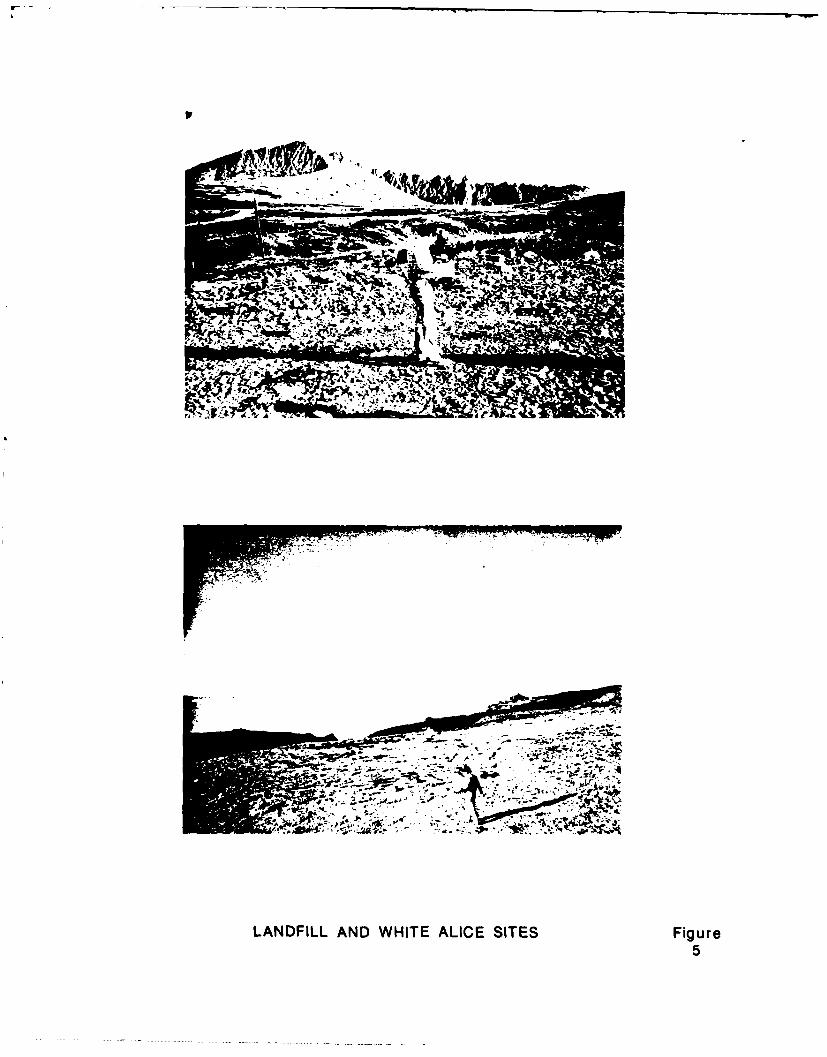
The current landfill (site ib), located along the western side of the
runway, was examined by the survey team. However, this site is
currently permitted by the Alaska Department of Environmental
Conservation and is, therefore, beyond the scope of this document.
The landfill appears to be mostly dry, with no obvious effluent
(Figure 5). Contamination was not apparent during the site visit, and
a small stream flowing along the eastern margin was also free from any
signs of contamination.
The Upper Camp dump area (site 2) is situated on a steep slope subject
to high winds and severe weather. Two or three large metal structural
pieces were observed by the field team. No signs of contamination
were apparent. It is likely that any debris noted during Phase I
investigations, has since been blown from the site.
The entire White Alice site (site 6) was recently demolished and
buried. The field survey team did not observe any signs of
contamination, and there is no evidence of structures, wastes, or
debris visible on the surface (Figure 5). This observation does not
agree with the Phase I report which indicates the presence of
transformers. The disposition of the transformers is not known.
1.4.2 Risk Screening
Environmental and health risks were assessed at the six sites
identified in the Phase I. As stated above, assessment of the
landfill (site 1b) is beyond the scope of this report. Risks
associated with the remaining sites were determined to be negligible
or not high enough to warrant further action.
1-9
, -,v
L4
701M . . ,- -- "-7 . . A,!lW
, . --.'/' :° . ; -4w ."' ..
LANDFILL AND WHITE ALICE SITES Figure5
71/20/11
1.5 ALTERNATIVES
Alternative actions were considered for all six sites at Cape Newenham
AFS. No further action is the preferred alternative at all sites.
1.6 CONSISTENCY WITH ENVIRONMENTAL LAWS
The Cape Newenham AFS was found to be in compliance with the following
environmental laws:
o Resource Conservation and Recovery Act (RCRA)
o Clean Water Act
o Safe Drinking Water Act
o Coastal Zone Management Act.
1.7 CONCLUSION
Based on a comprehensive literature search, observations made during a
site visit in 1987, information gathered from government regulatory
agencies, and the characteristics of suspected or known contaminants,
the health and environmental risks at all five sites assessed at Cape
Newenham were judged to be negligible to low. An analysis of action
alternatives determined that no further action was the preferred
alternative for all five sites.
1-11
73/5/1
2.0
TECHNICAL ATTACHMENTS
2.1 SITE DESCRIPTION
2.1.1 Location
Cape Newenham is a small peninsula on the southwest coast of Alaska,
located in the Bering Sea province about 770 km southwest of
Anchorage. The cape is situated at the southern terminus of the
Ahklun Mountains between Bristol Bay and Kuskokwim Bay (Figure 1).
The Air Force Station (AFS) at Cape Newenham consists of 950 hectares
surrounded by the Toaiak National Wildlife Refuge (NWR). The
installation is located at latitude 58'39' North and longitude 162004 '
West, and is only accessible by sea or air. The nearest settlement is
Platinum, a Native Alaskan mining community 50 km northwest with a
population of about 55 (Eng. Sci. 1985, U.S. Dept. of Interior 1986).
2.1.2 Environmental Setting
2.1.2.1 Geology
The Togiak NWR area is reportedly a jumbled, remnant ophiolite
sequence (i.e., ancient continental subduction zone) of mafic and
ultramafic rock (i.e., rock type high in magnesium and iron). Cape
Newenham is described as representing a high pressure metamorphism and
terrain juxtaposition of Late Triassic - Early Jurassic time (200
million years). The cape is cut by a north-south trending, low angle,
normal fault at Security Cove (Box 1984).
2-1
73/5/2
The bedrock geology of the Cape Newenham AFS consists of metagabbro,
greenstone, and serpentinized ultramafic rock (Hoare and Coonrad
1978). Engineering Science describes the bedrock at the installation
as a dense, fractured volcanic greenstone. In the valley where the
Lower Camp is located (Figure 2), the bedrock is reportedly overlain
with 27 m of poorly-sorted sediments and talus consisting of boulders,
broken rock, gravel, and silt. The sediments have developed as a
result of weathering of the bedrock. Bedrock outcrops are common on
the steep valley walls and escarpments (Eng. Sci. 1985).
2.1.2.2 Hydrology
The upper valley in section 7 of Cape Newenham AFS (see Figure 1) is
the principal recharge zone of ground water for the installation.
Water collects and drains northward, downslope, into shallow aquifers
and surface streams. The valley near the Lower Camp (el. 212 m)
consists of a thick zone (approx. 30 m) of permeable, course grained
talus and alluvium. This material generally contains ground water at
shallow depths which may occur under artesian conditions (Eng. Sci.
1985). Permafrost may occur as isolated lenses, but is restricted to
fine-grained, unconsolidated sediments (Eng. Sci. 1985).
The topography of Cape Newenham is steep, rugged and rocky. The
southern shore consists of high rocky escarpments, which plunge from
240 to 600 m, directly into Bristol Bay. All streams on the peninsula
run north through steep-sided, U-shaped valleys into Kuskokwim Bay.
One unnamed drainage is found within the boundaries of the
installation. The headwaters are a small lake at a 230-m elevation.
The creek flows through the valley, past the airstrip and into
Kuskokwim Bay (USGS map, 1971).
2.1.2.3 Biota
The Cape Newenham AFS is surrounded by the Togiak NWR. In 1969,
107,000 hectares were set aside to establish the Cape Newenham NWR.
2-2
73/5/3
In 1980, the Cape Newenham NWR became part of the Togiak NWR which
encompasses 1.9 million hectares. The Cape Newenham area is prime
habitat for pelagic birds and sea mammals. Cliffs on the Bristol Bay
side of Cape Newenham maintain one of the largest nesting colonies of
seabirds in the eastern Bering Sea. Field observations estimate that
1 to 2 million murres (Uria spp.), kittiwakes (Rissa spp.) and puffins
(Puffinus spp.) nest here (U.S. Dept. of Interior 1974). Cormorants
(Phacrocorax spp.), bald eagles (Haliaectus leucocephalus), guillemots
(Ceppus spp.), auklets (Aethia spp.), and endangered peregrine falcons
(Falco peregrinus) are also sighted frequently.
The northern Kuskokwim Bay side of Cape Newenham supports abundant
growths of eelgrass (Zostera marina) which thrive in the shallow bays
and coves. Waterfowl from all over the world stop here to feed on the
eelgrass during migratory travels. Common sightings include several
species of eiders (Somateria spp.), Canadian geese (Branta
canadensis), emperor geese (Philacte canagica), brant geese (Branta
bernicla), pintails (Anas spp.), greenwinged teal (Anas carolinensis),
golden eyes (Bucephala spp.), and many other species of geese and
ducks (U.S. Dept. of Interior 1974). Marine mammals, which thrive in
the bays and rocky shores of Cape Newenham, include walrus (Obodenus
rosmarus), Stellar sea lions (Eumetopias jubata), harbor seals (Phoca
vitulina), ringed seals (Pusa hispida), ribbon seals (Histriophoca
fasciata), bearded seals (Erignathus barbatus), and the endanoered
gray whale (Eschrichtus glaucus) (U.S. Dept. of Interior 1986).
The rugged, rocky terrain at Cape Newenham supports a dwarf, shrubland
alpine tundra. This habitat is typically low shrubby plants scattered
with barren rock, and is generally dominated by arctic willow (Salix
arctica), dwarf willow (Salix herbacea), forked woodrush (Luzula
divaricata), crowberry (Empetrum nigrum), bearberry (Arctostaphylos
alpina), labrador tea (Lectum groenlandicum), mountain avens (Geum
alpine), and a variety of mosses and lichens (U.S. Dept. of Interior
1986). Vegetative cover is more common on the sediments and alluvium
of drainage paths and valleys. One plant species which is only known
to occur at Cape Newenham and Kagati Lake is under investigation for
2-3
73/5/4
endangered species eligibility (Murray 1987). The plant is a type of
wormwood (Artemisia glomerat var. subglabra). It is not known if it
occurs within the boundaries of the Cape Newenham facility.
2.1.3 Site History
In 1943, the U.S. Dept. of Interior withdrew 5,780 hectares at Cape
Newenham for military purposes. The United States Air Force
relinquished all but 950 hectares to the Bureau of Land Management in
1958. The USAF maintained a 2-km wide strip of land that dissects the
peninsula. In 1969 all of Cape Newenham except the AFS became part of
the Cape Newenham NWR (BLM records).
Archaeological evidence indicates that various cultures have
periodically inhabited Cape Newenham for 4000 to 5000 years (U.S.
Dept. of Interior 1986). Consequently, the Calista Native Corporation
has submitted applications to obtain several small sites in the Cape
Newenham area for protection under historical site status (ANCSA 1971,
section 14(h)). One of the sites pending adjudication is located
within the station boundaries. The site is approximately 1/2 by 1/4
km at Kuskokwim Bay, near the boat dock. The Bureau of Land
Management received an amended application for this land from Calista
Corporation in 1987.
Cape Newenham AFS was one of the ten original Aircraft Control and
Warning (AC&W) sites constructed in Alaska as part of the Air Defense
System. The installation became operational in 1954 and maintained a
military staff of 94. In 1957 a White Alice station was built on a
ridge near the center of section 5, on a separate parcel of land
(Figure 1). In 1979 the White Alice station was deactivated and
replaced with the Alascom satellite earth terminal system; in 1987 all
structures were demolished and buried. Eighty military positions were
eliminated when RCA was contracted to provide support services. The
installation of a Joint Surveillance System (JSS) in 1982, which
transmitted radar and beacon data by satellite directly to Elmendorf
Regional Operation and Control Center (ROCC), eliminated all military
2-4
73/5/5
positions and permitted total operation by RCA. The installation of
Minimally Attended Radar (MAR) in 1984 allowed the RCA staff to be
reduced to a total of seventeen (Eng. Sci. 1985).
The nearest community to Cape Newenham AFS is Platinum, located 50 km
northwest on the shores of Goodnews Bay. The village is located
within a major hard metal province. The Goodnews Bay Mining Co.
located near Platinum, is the only domestic producer of platinum
(U.S. Dept. of Interior 1974).
2.1.4 Site Operations
Cape Newenham AFS is divided into an Upper and Lower Camp. They are
connected by a 1230-m tramway and a road (Figure 2). The radar
facility and upper terminal are located at the Upper Camp (Figure 4).
Facilities in use at the Lower Camp include the airstrip, power plant,
composite building for housing and operations, 10-cm POL line
extending from the Lower Camp to the beach landing, and two POL tanks
(Figure 3). Some of the facilities have been abandoned, including the
White Alice site and the sewage lagoon.
A diesel-burning power plant provides electricity for the installation
(see Figure 3). A septic system treats the sewage. Until 1986 sewage
was treated in the sewage lagoon by an extended aeration process. The
resulting sludge was deposited in the solid waste landfill. In 1986
the station switched to a septic system because the sewage lagoon
proved impractical for only 17 personnel (Humphrey 1987).
Drinking water is obtained at Cape Newenham AFS from a gallery system.
The gallery consists of a vertical pipe, 1.2 m in diameter and 5.5 m
long, connected underground to a perforated lateral pipe, 1.2 m in
diameter and 25 m long. Water collects in the lateral pipe and is
pumped into holding tanks for station use. The water can then be
pumped around the site to various locations. The drinking water is
chlorinated prior to use (USGS Water Resources 1966).
2-5
73/5/6
2.1.5 Chemicals Used
Standard operating procedures at Cape Newenham AFS have the potential
to generate hazardous material. Table 3 supplies a list of hazardous
materials on inventory at the installation in 1985. The list was
compiled by the operator, RCA. Activities using the items in Table 3
include building construction and maintenance, power plant operation
and maintenance, vehicle and aircraft maintenance, water purification,
use of solvents for cleaning, heat exchange processes, fuel storage
and dispensing, tram maintenance and operation, and others.
2.1.6 Previous Studies
The IRP (Installation Restoration Program) was set up as a four-phase
program:
Phase I Problem Identification/Records Search
Phase II Problem Confirmation and Quantification
Phase III Technology Base Development
Phase IV Corrected Action Development
Phase I was completed by Engineerina Science in 1985 for the Long
Range Radar Stations (LRPS). The report divided the LRRS into a
northern and a southern region. Cape Newenham AFS is one of five
southern region LRRS' considered. The Phase I investigations were
prepared for the Air Force Engineering and Service Center in 1985.
A water supply study was done in 1964-65 by USGS Water Resources
Division for the USAF/ACC. The data from this study is on file with
the USGS.
2-6
70/37
TABLE 3
LIST OF HAZARDOUS MATERIALS ON SITE MAY 1985AT CAPE NEWENHAM AFS
MATERIAL NAME CONTAINER TYPE
Adhesive spray-on Aerosol 17 oz. canPaint, unused 1-Gallon canPaint, unused Quart canPaint, unused 5-Gallon canFaint, unused Aerosol canPaint remover 1-Gallon canPaint thinner 5-Gallon canPaint thinner 1-Gallon canAlkali cleaning compound 1-Gallon car,Alkali cleaning compound 12-oz. bottleAlcohol, denatured 1-Gallon canPropane (hand held) CylinderCutting fluid 1-Gallon ganWood filler 1-Pint canCorrosion preventative 1-Pint canPenetrating oil 1-Pint canMetal polish 1-Pint canCleaning compound 1-Gallon canCleaning compound 5-Gallon canAntiquing solvent 1-Quart bottleElectrolite acid 1-Gallon1Windshield cleaner 1-Quart1
Calcium hypochlorite 1-Quart lARCFT lube oil 1-Gallon canARCFT lube oil 1-Quart lSealing compound 1-Quart'Mold cleaner, ceramic 1-Pint1
Epoxy resin 1-Pint1Plastic filler 1-Pint1Chlorinator pellets 10-Gallon drumCasket seal compound 1-Pint l
Celite 28 24" x 36" bagsDe-icer Aerosol spray canOxygen (full) 225-CF cylinderAcetylene (full) 225-CF cylinderOxygen & acetylene (empty) 225-CF cylinderBrake fluid 1-gallon1Acetic acid VaseOil, lube HD030 55-Gallon drumAntifreeze, glycol (unused) 55-Gallon drumCivil Air Patrol jet fuel 55-Gallon drumsEther Aerosol canLight grease, unused 1-Pound'Aircraft grease, unused l-Quart1Refrigerant (Freon unused) 30-lb cylinder
'Type of container unknown.The above itemized hazardous materials include the White Alice site.Note: These substances are not expected to be found at any Cape Newenham disposal
sites. Hazardous waste materials and substances for retrogradation aretransported to Elmendorf AFB. Used oils are containerized to await shipment offsite.
Source: RCA/OKS Cape Newenham
73/5/8
2.2 CURRENT SITE STATUS
2.2.1. Findings from Previous IRP Studies
Phase I (Eng. Sci. 1985) considered six potential contamination areas
at Cape Newenham AFS (see Table 1 for site descriptions). Site I is
Waste Accumulation Areas 1 and 2 and Landfill 2 at the Lower Camp.
Site 2 is the Upper Camp Dump Area. Site 3 is an area of Lower Camp
road oiling. Site 4 is Waste Accumulation Area 3 at the Lower Camp.
Site 5 is Lower Camp Landfill 1. Finally, the White Alice Site is
designated as site 6. Engineering Science rated all 6 areas/sites as
Follow-up Action Warranted. Their assessment was based on field
inspections, file data, interviews, environmental setting and HARM
rating scale.
2.2.2 Observations from Site Visit
Cape Newenham was visited in August 1987 by representatives of the
U.S. Air Force and Woodward-Clyde Consultants. The purpose of the
visit was to observe current conditions at the six potential
contamination sites and to evaluate the conclusions of the Phase I
report. Many of the potential contamination areas/sites identified in
the Phase I report have been since covered over and/or cleaned up.
The 5099th Civil Engineering Operations Squadron (CEOS) buried and
graded both the landfill (site 5) and waste accumulation area (site 4)
near the Lower Camp, both of which had not been operational for some
time (see Figure 3). The 5099th CEOS also recently cleaned and
covered the landfill and waste accumulation areas (site 1) near the
airstrip. The White Alice Site (site 6) was demolished and buried as
well.
Because of the recent cleanup, Woodward-Clyde personnel were able to
visually locate only three of the six sites identified in Phase I.
These were sites 1, 2 and 6. Engineering Science (1985) classified
Waste Accumulation Areas 1 and 2, and Landfill 2 as one site (site 1).
Woodward-Clyde assessed the waste accumulation areas and the landfill
2-8
73/5/9
separately and designated them as sites la and Ib, respectively.
Thus, for purposes of this report only four sites (la, 1b, 2 and 6)
could be identified. The covered and graded, abandoned landfill and
waste area (sites 4 and 5) near the Lower Camp Complex could not be
located during the 1987 site visit. Furthermore, road oiling (site 3)
was discontinued in the 1970's. No evidence of contamination from
road oiling could be found. Each of the sites is described below:
Site la is adjacent to the landfill (identified in Phase I as Waste
Accumulation Areas Nos. 1 and 2 of site 1). No wastes are currently
stored in this location. Much of the site is revegetated,
particularly the peripheral areas. Several small dark stains were
visible (generally less than 1 meter in diameter) and are probably the
result of spills or leaks. The area appeared dry and well-drained.
Surrounding vegetation and nearby waters showed no signs of stress or
contamination.
Site lb is located along the western side of the runway (identified in
Phase I as Landfill No. 2 of site 1) and was recently cleaned and
covered over by the 5099th. The landfill appears dry, with no obvious
inflows or effluents. No signs of contamination were noted. A small
stream flows along the eastern margin of the landfill and empties into
Kuskokwim Bay a few hundred meters downstream from the site. The
vegetation in the streambed was healthy, the water appeared clean and
free of contamination. (Some rusted scrap was found in the stream
channel.)
The Upper Camp Dump Area (site 2) is located on a steep slope beneath
the Radome. Debris and wastes were deposited here in the past,
although its use was discontinued in the 1970s. This area is subject
to high winds and severe weather. There was no evidence of any debris
or wastes other than two or three large heavy metal structural pieces.
No signs of contamination were apparent.
As stated above, no evidence of contaminants from road oiling (site 3)
were visible during the site visit.
2)-9
II ~~~~r
......... . .......... .........................

73/5/10
The waste accumulation area (site 4) at the Lower Camp has been graded
and leveled. No signs of contamination were apparent and any evidence
which existed during the Phase I investigation has been buried. The
actual boundaries of the site are no longer visible.
Site 5, the old landfill, also has been graded and buried. The
appearance of the site during the site visit was similar to that of
site 4.
The White Alice Site (site 6) was demolished and covered over by the
5099th in 1987. There is no evidence of any structures, wastes, or
debris visible on the surface. The Phase I report noted that
transformers were seen stored on the site (not mentioned whether
inside or outside of building). It is not known if the transformers
have been deposited and buried here. The site has been filled and
graded. There are no visible signs of contamination.
2.2.3 Findings from the Literature Search
The Phase I report (Eng. Sci. 1985) provides most of the site specific
information. The Cape Newenham AFS is reported to be underlain by
isolated masses of permafrost which are usually restricted to
predominately fine-grained sediments (Ferrians 1965).
The local topography is steep and rugged. The southern border is very
steep with 600 meter cliffs dropping directly to sea level. The Upper
Camp is located in this terrain. The cape slopes more gradually to
the north over 3 km to Kuskokwim Bay. The Lower Camp is at about 200
meters above mean sea level (MSL). Most drainages at the AFS flow
into an unnamed creek which flows predictably north into Kuskokwim
Bay (Eng. Sci. 1985).
The hydrology of the Upper Camp at the AFS consists of poorly-sorted
coarse talus on steep slopes over bedrock. Groundwater may occur in
these sediments seasonally as perched water, but discharge of runoff
into bedrock or downslope is more likely. The Lower Camp hydrology is
2-10
73/5/11
dominated by thick talus and alluvium (27 meters). These
unconsolidated, highly permeable sediments generally contain ground
water at shallow depths (1 to 2 meters). The talus/alluvial material
receives recharge from upslope and discharges downslope. It is
reported that ground water in bedrock flows under artesian conditions
at the Lower Camp area (Eng. Sci. 1985). Bedrock is about 27 meters
below the surface. Two drinking water wells have been installed in
bedrock since 1975. The first one silted up and the second was
abandoned. The present drinking water source is a gallery, about 6
meters deep, which serves as a "collecting pan" for shallow water
percolation. The water is then pumped out and into holding tanks.
The gallery is currently the only fresh drinking water source at the
AFS. The gallery is located just south of the road leading to the
White Alice site, and east of the small creek. It has been in
operation since before 1965 (USGS Water Resources Div. 1966).
The geology is primarily a fractured volcanic greenstone as bedrock
with varying thicknesses of accumulated talus and alluvium overlying.
The accumulated residuum is thin at higher elevations but increases in
depth at lower elevations. A well log taken near the Lower Camp shows
depth to bedrock as 89 feet (27 meters). The log shows the
constituents of the poorly sorted talus/alluvium (Figure 6).
Permafrost may occur as isolated lenses in the fine silts.
The mean annual precipitation at Cape Newenham is 102.3 cm (Alaska
Weather Service).
2.2.4 Consistency with Environmental Laws
2.2.4.1 Resource Conservation and Recovery Act (RCRA)
Subtitle C-Hazardous Waste Management. Defines hazardous wastes
and prohibits disposal except in permitted facilities. Cape
Newenham AFS is in compliance with Subtitle C.
2-11
Elevation: 650' (Approx.) Ground Surface
0- ___
1 Clay & Boulders- .Water Level
Tundra6-
be
Silt & Boulders
0~ 0 O
25.5
U Rock &SiltU.a:
36
z0Cc
0 Gray Silt
0w
wLL 66- V 1"z 0.-00
~c2~ 0 - Silt & Boulders
o0
89- - fo
-- Rock
99-
Note Water Level Measured June 17, 1975in Lower Camp Area
CAPE NEWENHAM AFSWELL LOG
Source Modified from U.S. Geological SurveyWater Resources Division File Data,undated. Fgr
73/5/13
Subtitle D-State or Regional Solid Waste Plans. State or
regional permits are required for non-hazardous waste disposal
facilities. The current landfill (site 1b) is permitted until
April 1, 1988 by the Alaska Department of Environmental
Conservation at which time it must be renewed. The disposal of
hazardous substances in the landfill is prohibited by the permit.
2.2.4.2 Clean Water Act
Section 303-Water Quality Standards and Implementation Plans.
This requires water quality standards for all surface waters to
be implemented by the states. In Alaska these have been
promulgated by ADEC. There is no evidence State water quality
standards are being violated at Cape Newenham AFS.
Section 311-Oil and Hazardous Substance Liability. Accidental or
intentional discharges of oil and hazardous substances are
regulated. No evidence of contamination by previous road oiling
exists.
Section 404-Permits for Dredged or Fill Material. Modifications
to the wetlands require a Discharge of Dredged or Fill Material
Permit from the Army Corps of Engineers. A permit was issued on
March 12, 1987 for the current landfill (site 1b).
2.2.4.3 Safe Drinking Water Act
Section 1412-National Drinking Water Regulations. It is unlikely
that drinking water standards as promulgated by the Safe Drinking
Water Act (SDWA) will be exceeded by potential contamination at
Cape Newenham AFS.
Section 1413-State Primacy Enforcement Responsibility. The State
of Alaska has assumed primacy for enforcement of the SDWA. The
water supply at Cape Newenham is classified as class C (serving
25 persons or less). A permit is not required nor is monitoring.
2-13
73/5/14
However, the installation routinely monitors for State primary
contaminants and submits results to ADEC. The water supply is
Public Water Supply No. 260480.
2.2.4.4 Coastal Zone Management Act
Consistency with the Alaska Coastal Management Program must be
demonstrated for all construction initiated after October 1983 within
coastal areas in Alaska. Certificates of consistency for construction
and operation of the Cape Newenham Installation were not required at
any of the potential contamination sites at Cape Newenham because of
this time limitation.
2.3 POTENTIAL CONTAMINANTS
Hazardous substances which have the potential to exist in the
environment at Cape Newenham AFS include many substances commonly used
at LRRS installations. The most important of these are fuels,
solvents, PCBs, battery contents, lubricants and oils, and antifreeze.
All six sites identified in the Phase I report exhibited historical
evidence of contamination. However, contamination was visible only at
Site la during the 1987 site visit. This amounted to only a few small
soil stains. Each site is discussed below.
2.3.1 Waste Accumulation Areas 1 and 2 (Site la)
The waste accumulation area is located upslope from the landfill. No
wastes are currently stored there. Historically, waste substances
were stored in 55-gal drums at the site. Some residual contamination
was evident as small (less than I m diameter), dark stains apparently
caused by spillage. The stains appear non-soluble and may be residual
heavy petroleum products (e.g., diesel fuel or lube oil). There is no
evidence of major spillage, although the amounts and types of
contaminants remain undetermined. The area appears to be dry and well
drained. The surrounding vegetation shows no sign of stress.
2-14
73/5/15
2.3.2 Active Landfill (Site Ib)
The landfill is currently permitted by the Alaska Frepartment of
Environmental Conservation (ADEC). That permit was issued March 23,
1983 and expires April 1, 1988. It prohibits the disposal of
combustible material, hazardous material, liquid wastes, solvents,
sewage, oil and greases, and toxic substances. There was no evidence
of contamination during the 1987 site visit. The landfill had been
recently cleaned and graded. The area was dry with no visible
leachate or vegetation stress. Some debris, mostly scrap metal, was
found in the toe of the fill and in the adjacent stream, but odors,
discoloration, or oil sheens were not present in the water.
Historically, there has been no reported hazardous material disposed
in the landfill.
2.3.3 Upper Camp Dump Area (Site 2)
It is reported in Phase I (Eng. Sci. 1985) that ethylene glycol,
wastewater from the radar facility, containers with waste oils, scrap
metal, wood, 55-gallon drums and other debris were disposed of at this
site in the 1950's and 1960's. The Upper Camp Dump Area has not been
used as a dumping area since that time.
2.3.3.1 Ethylene Glycol
An unknown volume of ethylene glycol (anti-freeze) was apparently
disposed at this site. Ethylene glycol is a two-carbon molecule with
two hydroxyl groups which gives the compound infinite solubility in
water. Because ethylene glycol has a high boiling point (197.50 C)
and very low volatility, it is most commonly used as radiator
antifreeze (freezing point -130 C).
Toxicity data for ethylene glycol is:
Threshold Limit Value (TLV) (Air): 100 ppm
Lethal Dose Low (LDL): 710 mg/kg (oral-human)
2-15

73/5/16
Toxic Concentration Low (TCL): 1000 mg/m 3 (inhalation-
human)
Receptors: Major species threatened - lethal to fish at
2000-3000 ppm; lethal to biota using water supply
2.3.3.2 Wastewater
The type of materia; likely to be present in wastewater from the
Upper Camp is very limited because the Upper Camp was relatively
remote from the lower, main camp. The wastewater would have contained
sanitary wastes and small amounts of soaps and other cleaning
compounds. These cleaning compounds are non-hazardous materials and
are readily biodegradable.
2.3.3.3 Waste Oils
The Upper Camp Dump Area is expected to have been utilized for
disposing minor amounts of lube oils. These lube oils were used to
keep the radar equipment working smoothly. Typically, a drum of lube
oil would have a pump type dispenser for filling small containers.
Lube oils are essentially non-volatile petroleum hydrocarbons and do
not evaporate because of their high boiling point. They are insoluble
in water and are less dense than water. Lube oils frequently contain
trace amounts of metals such as chromium to improve wear stability
under high temperatures and pressure. Various formulations of lube
oils may include trace amounts of anti-oxidants to extend the useful
lifetimes of the oil, but these materials are usually non-hazardous
and biodegradable. The lube oil itself is not a hazardous material
and is essentially non-toxic unless ingested in large quantities.
2.3.3.4 Scrap Metal, Wood, Drums and Cultural Debris
The Upper Camp dump was used for periodic disposal of scrap metal,
wood, empty and crushed drums, and other cultural debris. Empty
crushed drums were brought from the lower camp and disposed. These
2-16
73/5/17
drums originally contained aviation gasoline, lube oils, and other
bulk materials. The aviation gas and related petroleum products were
used for fueling vehicles, and heat and electric generation. Minor
spills of these materials can be expected from routine transfer and
handling, but the amounts of these materials spilled in the Upper Camp
area is likely to be minimal.
Aviation gas is a low molecular weight, volatile, petroleum
hydrocarbon which will rapidly evaporate. Aviation gas is virtually
insoluble in water and is less dense (dens. = 0.7) at 15' C) than
water. Therefore, it will float on top of either water or ice and
will be rapidly dispersed and biodegraded in the environment. The
short term inhalation limit for humans is 500 ppm for 30 mins. The
ingestion toxicity (LD50) to humans is 0.5-5.0 g/Kg. Aquatic toxicity
was found to be 91 ppm/24 hr/juvenile American shad/salt water (Sax
1984).
Gasoline, kerosene, diesel, and fuel oils in general are given a
toxicity rating of 3. This corresponds to a moderately toxic rating,
with a probable oral lethal dose to humans of 0.5-15.0 gm/Kg. The
toxicity level of any given fuel is usually based on the content of
benzene and other aromatic hydrocarbons, so these parameters must be
known in order to adequately classify their toxicity levels.
Threshold limit values have been established for gasoline and are
given below:
Time-Weighted Average (TWA) Short Term Exposure Limit (STEL)
ppm mg/mi3 ppm mq/m 3
300 900 500 1,500
It is also reported by Engineering Science (1985) that minor amounts
of solvent were disposed. The only solvents reported were ether,
alcohol and paint thinner. All of these materials are extremely
volatile and rapidly evaporate even under arctic conditions. These
2-17
73/5/18
solvents would have been used for small degreasing jobs (tools, etc.)
or as paint thinners and as such may have been subject to small spills
in transfer or handling operations. Trace amounts of these solvents
were likely discharged in the wastewater.
During the 1987 site visit, no evidence of hazardous waste was
observed at the site. However, two or three large heavy metal
structural pieces were visible. There was no sign of any other
remaining contamination.
2.3.4 Road Oiling - Lower Camp (Site 3)
Road oiling took place at the Lower Camp during the 1950's to the
1970's. Waste oils and hydraulic fluid were applied to the roads as a
dust palliative and disposal method (Eng. Sci. 1985).
2.3.4.1 Waste Oils/Hydraulic Fluid
Until recently, the practice of road oiling to control dust was an
accepted practice throughout the United States. Oils used in this
manner do not release hazardous materials into the environment because
neither waste oils nor hydraulic fluid contain more than trace amounts
of hazardous materials. Surface disposal of oil brings the oil into
contact with organisms which readily biodegrade most petroleumhydrocarbons leaving small amounts of weathered insoluble and immobile
polynuclear aromatic hydrocarbons.
There was no evidence of contamination found on or along the roads
during the 1987 visit. The vegetation along the roads appeared to behealthy and stress-free. No dark or insoluble staining was apparent
on or along the roads.
2.3.5 Waste Accumulation Area 3 - Lower Camp (Site 4)
This waste accumulation area was used to store drummed wastes in the
1950s, 1960s and 1970s. These drummed wastes were not buried, and
2-18
73/5/19
have since been removed. During Phase I some evidence of minor spills
and leaks from stored waste oils and thinners was noted (Eng. Sci.
1985).
2.3.5.1 Waste Oils/Thinners
Some accumulated waste oils and thinners in Lower Camp may have been
spilled in routine handling and transferring operations. Such surface
spillage does not represent a continuing potential contamination
source. Waste oils and thinners readily biodegrade or evaporate;
therefore, no further cleanup action is necessary.
The waste accumulation area was visited in 1987 but the boundaries of
the site were unclear. Since the area had been cleaned and graded,
there were no visible signs of contamination in the vicinity. The
area was dry and well drained and the vegetation appeared to be
healthy with no sign of stress.
2.3.6 Landfill - Lower Camp (Site 5)
This landfill, located at the Lower Camp, was used in the 1950s. It
encompassed less than 50 m2 and was reportedly used to dispose of
refuse and shop wastes (e.g., oils and lubricants). The landfill has
been covered with 2 to 3 m of fill (Eng. Sci. 1985).
2.3.6.1 Shop Wastes (Oils and Lubricants)
Lube oils are non-volatile petroleum hydrocarbons that do not
evaporate, are insoluble in water, and are less dense than water.
See section 2.3.3.3 for detailed discussion of lube oils.
2.3.6.2 Solvents
As discussed in Section 2.3.3.4, solvents containing ether, alcohol,
or paint thinner are extremely volatile and rapidly evaporate when
exposed to the atmosphere. Therefore, there can be no lasting effects
2-19
73/5/20
from routine spillage of these solvents during transfer and handling
operations.
The landfill was unrecognizable at the time of the 1987 site visit and
the landfill boundaries could not be delineated. There were no
visible signs of contamination in the general area. The vegetation
was healthy and free from signs of stress and the site appeared to be
dry and well drained.
2.3.7 White Alice Site (Site 6)
The White Alice site at Cape Newenham AFS was in operation from the
1950s to the 1970s. During its operation, the facility generated
wastes such as ethylene glycol (418 L per year), motor oil (840 L per
year), waste batteries, and electrical generation debris such as
transformers, capacitors, etc. After the 1970s, the site was used to
store liquid wastes, which spilled and leaked on the ground. In 1984,
thirteen transformers and 1200 L of PCB oil from the White Alice site
were shipped from the installation; no contaminated soil was shipped
(Eng. Sci. 1985).
2.3.7.1 PCBs
In the event that PCB contamination occurred during the operation of
the site, toxicity data for PCBs has been included. PCBs have been
established as suspected human carcinogens by the IARC (International
Agency on Research on Cancer). The Time-Weighted Average for PCBs is
1.0 mg/m3 for skin contact, 10 mg/m 3 for inhalation (human). There is
a moderate to high acute danger for ingesting PCBs orally, by
inhalation, or through skin contact, especially when exposed
simultaneously to carbon tetrachloride. The higher the chloride
content, the greater the toxicity level. Oxides of PCBs are more
toxic than their unoxidized counterparts.
PCBs are very persistent in the environment. Their adsorption in
soils depends on the presence of organic matter. Once adsorbed, PCBs
2-20
73/5/21
do not readily desorb. The implication is that PCBs will not leach or
diffuse in soils; transport into the hydrosphere from contaminated
soils will be through erosion of soil particles or sediment, not by
desorption or dissolution. PCBs undergo some degradation by
microorganisms and photochemical reactions, but these reactions are
believed to be relatively slow and insignificant.
The potential receptors for PCBs include fish, waterfowl and
reproducing phytoplankton. Because they are lipophilic and very
stable, bioaccumulation of PCBs in exposed organisms is likely. If
the risk of exposure to organisms by any potentially contaminated
soils is effectively removed, then the environmental exposure risk is
substantially reduced.
2.3.7.2 Liquid Wastes
These may include solvents, lube oils, gasoline, and anti-freeze. All
of these components are discussed in Section 2.3.3.
3.2.7.3 Chlorinated Solvents
Chlorinated solvents such as trichloroethylene (TCE) and
dichloroethane isomers (DCE) are used almost exclusively for
degreasing machinery and metal parts. Typical solvent usage would
include pouring solvent on a rag and using the rag to degrease
equipment. Small amounts of solvents may be spilled during usage.
Because the chlorinated solvents are highly volatile and rapidly
evaporate in air and water, spills on surfaces are Lbually of no
concern. However, disposal of significant quantities of chlorinated
solvents such as TCE and DCE can produce long term groundwater
contamination. Chlorinated solvents are not retadily degraded by
microorganisms; however, over time (1+ months) they are eventually
transformed by biotic and abiotic mechanisms into other degradation
products, including carbon dioxide and hydrochloric acid.
2-21
73/5/22
Toxicity data for TCE and DCE are given below:
TCE: LDL (oral-human): 7 g/Ko
TCL (inhalation-human): 6900 mg/rm3
TWA: 350 ppm, 1900 mg/m 3
STEL: 450 ppm, 2450 rg/m3
Irritant to skin/eye (human): 5 ppm
Aquatic toxicity: 100-1000 ppm; positive animal
carcinogenic determination.
DCE: TCL (inhalation-human): 25 ppm
TWA: 200 ppm, 810 mg/rn3
STEL: 250 ppm, 1010 mg/m3
2.3.7.4 Batteries and Electrical Generation Equipment
Batteries, capacitors, transformers, and related used or broken
equipment has been removed from the site. Some potential
contamination of buried soils resulting from spills or leas of fluids
may remain on site. Although battery acid is a hazardous material,
the acid will be rapidly neutralized by soils. Trace amounts of lead
may remain, but the mobility of lead particulates is negligible.
Oils from electrical generation equipment may have leaked to the soils
before removal. The oil in transformers and capacitors probably
contained PCBs (see Section 2.3.7).
2.4 CONTAMINANT MOVEMENT/TRANSPORT MECHANISMS
2.4.1 Waste Accumulation Areas I and 2 (Site la)
These waste accumulation areas (site la) are no longer used. Some
evidence of past hazardous substance spillage exists, but no obvious
potential migratory paths exist. The area consists of an unvegetated
region less than 1,525 m2 . The rest of the site has been reclaimed
2-22
73/5/23
with apparently healthy vegetation. The area is dry and well drained
with no obvious effluents. Very little potential exists for
contaminant migration from the site; therefore, further action is not
warranted for the site.
2.4.2 Upper Camp Dump Area (Site 2)
The dump area at the Upper Camp (site 2) is located on the northwest
slope of a steep mountain. Although no contaminants were disposed
here after the 1970's, compounds such as antifreeze, waste oils, and
petroleum products were dumped in the 1950s and 1960s. Almost all of
the contaminants have been washed down the slope by precipitation.
The area receives about 0.75 m of precipitation annually. Any
remaining contamination is negligible. Of the contaminants known to
be present during the dump's operation, the fate of some of these in
the environment is presented below.
2.4.2.1 Ethylene Glycol
Because ethylene glycol is infinitely soluble in water, as well as
biodegradable, it poses no long-term contamination threat. The
solubility factor implies that any ethylene glycol spilled at the sitewill have been washed away by precipitation. Additionally,
biodegradation is an important fate process since many strains ofbacteria use ethylene glycol as their sole carbon source. In
laboratory biodegradation rate tests, a 10 mg/L concentration of
ethylene glycol was completely degraded within 3 days at 20' C. At 8"
C, it took 14 days for complete biodegradation (EPA 1979). Therefore,
it is highly unlikely that any lasting or continuing detrimental
effects have resulted from spillage of ethylene glycol.
2.4.2.2 Waste Lube Oils
Lube oils are non-volatile, straight-chain petroleum hydrocarbons that
are less dense than water and insoluble in water. Therefore, they are
most likely to float on water and be washed downslope with
2-23
73/5/24
precipitation. Because lube oils are hydrophobic, migration in soilby groundwater pathways is generally insignificant. The small amounts
of lube oils potentially remaining at the site would pose little
threat to the virtually non-existent and/or seasonal water table.
2.4.2.3 Gasoline/Kerosene/Aviation Gas
These petroleum products undergo alterations from pfysical,
biological, or chemical processes occurring over time frames ranging
from days to years. The magnitude of transformation increases with
time. Although the biodegradation and physical processes proceed at
slower rates in the arctic than in warmer climates, a substantial
change in composition of materials is likely to have occurred during
the last 10 to 15 years. Evaporation and dissolution are important
physical processes. In addition, photochemical and microbial
oxidations are possible. Weathered petroleum products generally
exhibit the following characteristics:
o Loss of low boiling hydrocarbons from evaporation.
o Loss of low boilinc hydrocarbons from dissclution.
o Increase in relative proportions of naphthenic compounds.
o Increase in relative proportions of highly branched
alkylated compounds from biodegradation relative to straight
chain compounds.
o Increase in relative proportions of polycyclic compounds
relative to saturated compounds.
As petroleum hydrocarbons age or weather, the most persistent
compounds, polycyclic aromatic hydrocarbons, remain the longest.
These compounds may slowly be removed by biodegradation,
biotransformation, photolytic, or oxidative processes.
2-24
73/5/25
The rate of biodegradation of the weathered petroleum hydrocarbons
slows substantially as the molecular weight increases. For instance,
naphthalene has a half-life of 5 hours under controlled microbial
transformation experiments. Under the same conditions, benzo[a]pyrene
will require 21,000 hours to degrade by one half. The relative
mobilities of these two materials show a similar relationship.
Naphthalene is much more mobile than the more complex ring system of
benzo[a]pyrene.
With the possible exception of Bunker C, petroleum hydrocarbon
materials are generally less dense than water and will float on top of
the water surface. Trace amounts of petroleum constituents will
dissolve in water (principally benzene, toluene, and xylene), but for
the most part petroleum hydrocarbons are virtually insoluble in water.
2.4.2.4 Diesel
Diesel fuel is relatively insoluble in water. Furthermore, adsorption
of diesel fuel constituents on organic soils can be siqnificant.
Thus, once fuel is spilled, especially on soil with high humic content
such as the peats in Alaskan tundra, migration is unlikely except
where hydraulic gradients are sufficiently steep. Once infiltration
has taken place, lateral migration is virtually negligible because of
the hydrophobic characteristics of petroleum compounds typical in
diesel, and the adsorptive capacity of humic soils.
Because of the low volatility of diesel fuel, particularly after many
years of weathering, air transport of hazardous substances from a
spill is not a significant concern. Because diesel fuel is a complex
mixture of hydrocarbons, it is speculative to discuss the processes
contributing to its fate over time. Biodegradation and chemical
transformations, as well as physical processes such as volatilization
and differertial adsorption on soils, will occur in fuel spills. The
possible exposure to environmental receptors is essentially negligible
and human exposure to hazardous levels would be possible only through
direct ingestion of cortamirated soils.
73/5/26
2.4.2.5 Chlorinated Solvents
1,1,1-trichloroethane (TCE):
Due to the high vapor pressure of TCE, volatilization to the
atmosphere is rapid. Consequently, this is the most significant
process for removal of TCE from both air and water. Based on
laboratory studies, the half-life of TCE has been calculated at
between 20 and 90 min. in shallow surface water. However, any
quantity of non-volatilized TCE that migrates to groundwater can
present long-term contamination, since competing degradation
mechanisms are not significant.
1,1-dichloroethane (DCE):
Like TCE, the major transport mechanism for DCE to the environment is
volatilization. The tropospheric lifetime of DCE, estimated by
extrapolating from the reported lifetime of TCE, is less than one day
(Callahan 1979). Photolysis, biotransformation/biodegradation, and
bioaccumulation are all considered insignificant degradative
processes. Hydrolysis of DCE occurs too slowly (half-life estimated
at 1+ years) to be considered a significant fate process. As in the
case of TCE, any quantity of DCE not immediately volatilized may
persist in the environment. However, in the case of DCE, the probable
maximum lifetime is several years. In the arctic environment, this
lifetime is probably extended.
2.4.3 Road Oiling - Lower Camp (Site 3)
Road oiling was concluded in the 1970's. It is possible that waste
oils from the road oiling actions migrated or were directly sprayed
into the drainage. Since the 1970's any contaminants that did migrate
into the streams and drainages have since been transported off site or
have been sufficiently degraded. Contaminants may have migrated in
airborne dust particles from the roads. However, since the surface
disposal of oil brings the oil into contact with organisms which
readily biodegrade most petroleum hydrocarbons, only the insoluble and
immobile polynuclear aromatic hydrocarbon (PAH) portion remains. PAHs
2-26
73/5/27
are readily adsorbed onto humic, carbon-rich soils. These hazardous
materials are slowly degraded by photolytic, oxidative and biological
processes. In some circumstances, lower molecular species such as
naphthalene will sublime (a form of evaporation) and be removed from
the surface environment. The 1987 site visit found no evidence of
residual contamination. Further consideration of migration pathways
is not provided since the tendency for current levels of contaminants
to migrate are inconsequential. For these reasons, no additional
action is recommended at site 3.
2.4.4 Waste Accumulation Area 3 (Site 4)
Site 4, the Lower Camp waste accumulation area, was in service prior
to the 1970's. It has since been cleared and graded. Although there
are reports of past waste oil and paint thinner spills and leaks at
this site, no evidence of contamination could be found during the 1987
site visit. The area was dry and well drained. The specific
historical waste area boundaries could not be detected. Although
there may be small amounts of residual contaminants, there are no
existing migration paths. Therefore, the potential for harm is
negligible, and no further action is warranted for site 4.
2.4.4.1 Paint Thinners
Since the compounds in paint thinners are extremely volatile and
quickly evaporate when exposed to the atmosphere, any spills having
occurred at this site are insignificant in terms of long-term
contamination effects.
2.4.4.2 Waste Lube Oils
See discussion, Section 2.4.2.2 for fate of waste lube oils in the
environment.
2-27

73/5/28
2.4.5 Landfill - Lower Camp (Site 5)
The landfill at the Lower Camp (site 5) is located near site 4. It
has not been used since the 1970's. The site has been cleared and
filled. Shop wastes (e.g., waste oils and lubricants) may have been
disposed at the landfill, but during the 1987 site visit no signs of
residual contamination were observed. The historical landfill
boundaries were not obvious and the area contained healthy vegetation
and dry soils. No Potential migration paths were apparent. Any
residual contamination is well contained with negligible threat of
movement. Therefore, further action is not warranted at site 5.
2.4.5.1 Waste Oils/Lubricants
See discussion, Section 2.4.2.2 for fate of waste lube oils in the
environment.
2.4.6 White Alice Site (Site 6)
In 1986 the White Alice Site (site 6) was cleared and graded.
Previous to clearing, liquid wastes were repcrtedly stored at site 6.
These wastes included electrical and communication generation
equipment which possibly contained PCBs. Minor spills and leaks of
these materials reportedly occurred. PCBs, waste oils, lubricants and
solvents may have been buried at the White Alice Site, but the
potential for migration of the chemicals is minimal. The site is
located on a ridge with no obvious drainages running through the area.
At the time of the 1987 visit, the site had been cleared and graded,
and no evidence of any structures, wastes or debris were visible. The
potential for contaminant migration from any unknown residual
contamination is unknown or minimal since the site is now covered with
six feet of clean fill and the exact location of this is unknown.
2-28
73/5/29
2.4.6.1 PCBs
PCB compounds vary widely in composition and their persistence in the
environment is dependent on the number and position of chlorine atoms
per molecule. The primary fate processes of PCBs with four or fewer
chlorine atoms is biodegradation. Those with more than four are
extremely resistant to this process. The rate of biodegradation
depends on the concentration of PCBs, composition and distribution of
biota, and other physical factors. Based on laboratory experiments of
biodegradation of mono-chloro PCBs, the half-life was estimated at
between 100 and 175 hrs. Di-chloro PCBs were significantly degraded
after 33 days, but tetra- and penta-chloro species remain virtually
unchanged over long periods of time (Callahan 1979).
The heavier PCBs (5+ chlorine atoms) have been shown to degrade in the
laboratory by irridation with short-wave UV light. From laboratory
experiments aimed at simulating PCB photolysis under environmental
conditions, it was estimated that approximately one chlorine atom may
be lost from each highly chlorinated molecule annually (Callahan
1979). The resulting lighter compounds are subsequently degraded by
biodegradation. Although this fate process is slow, it is considered
significant since no other process is known to degrade the heavier
PCBs. It should be emphasized that it is unknown if this process is
actually at work in the environment, since these results are based on
experimental laboratory conditions only. Additionally, this process
is significant to potential contaminant spills at the White Alice Site
only if a PCB contamination spill occurred and persisted in the photic
zone.
Other processes attributable to non-destructive distribution and
transport of PCBs in the environment are adsorption, bioaccumulation,
and volatilization. PCB compounds have a high affinity to sediments
or soils in soil-water systems. The tendency for adsorption increases
with the degree of chlorination and the organic content of the
absorbent. If contamination is known to be significartly high,
sediments in soil-water systems can serve as reservoirs for future
2-29
73/5/30
slow release of PCBs. However, high concentrations of PCBs have not
been detected at Cape Newenham, and the potential for long-term
pollution is expected to be minimal.
The extent to which PCBs are bioaccumulated in aquatic and terrestrial
organisms is directly related to the number of chlorine atoms per
molecule. Because the heavier species are more resistant to
biodegradation, these compounds bioaccumulate and are passed along
food chains.
Finally, volatilization accounts for the widespread distribution of
PCBs via atmospheric transport and subsequent fallout with dust or
rain. Volatilization of PCBs from soils high in organic content is
greatly reduced due to adsorption by organic materials. Although a
slow process, volatilization is an important fate process because PCBs
are not degraded but remain persistent in the environment.
2.4.6.2 Chlorinated Solvents
For detailed discussion of TCE and DCE movement, see Section 2.4.2.
2.4.6.3 Batteries/Electrical Generation Equipment
PCBs:
See discussion in Section 2.4.6 for fate of PCBs in the environment.
Lead:
The primary fate processes for lead in the environment is adsorption
to inorganic solids and organic materials which severely limits its
mobility. Volatilization, biotransformation, and photolysis are other
fate processes which apply to lead degradation, but these are
dependent upon the presence of lead complexes. In the aquatic
environment lead is bioaccumulated by organisms, but not generally
biomagnified.
2-30
73/5/31
2.5 QUALITATIVE RISK SCREENING
2.5.1 General Approach
This is a qualitative risk screening of contamination at Cape Newenham
AFS. The screening is qualitative because it relies on field
observations and indirect data evaluations rather than direct and
quantitated field or laboratory measurements. Many quantitative
methodologies for risk screening are available ranging from
statistical probability evaluations to numerical rating systems.
However, an initial qualitative screening is necessary to justify the
expense and effort necessary to satisfy the data requirements of more
rigorous quantitative approaches. The purpose of this section is to
provide the initial screening.
2.5.2 Definition of Risk
Risk is "the probability that a consequence of defined magnitude will
occur2" The three key concepts of this definition are probability,
consequence and defined magnitude. Each is discussed below:
o Probability - According to the above definition of risk, the
mere presence of a hazardous substance at a site does not
constitute significant risk; risk is the probability of
adverse effects to humans or other receptors exposed to the
hazardous substance. When that probability is negligible,
risk will be considered to be negligible. Conversely, when
that probability is not negligible, identifiable risks will
be assumed to be present. Thus, probability is evaluated
qualitatively rather than quantitatively in this document.
o Consequence - A consequence is an adverse effect on a
receptor(s) caused by exposure to oil or hazardous
substances. Receptors can be human or environmental
resources. Environmental receptors include surface water,
ground water, air, soils, vegetation or wildlife. For a
2-31
73/5/32
receptor to be adversely affected by a contaminant, three
general conditions must be met. First, contamination must
be present in the environment. Second, the receptor must be
exposed to that contaminant. Exposure is a function of
contaminant release mechanisms, paths of migration, and
chemical fate processes. Third, adverse effects are
possible only if receptors are exposed to sufficient
quantities of contaminant and for sufficient intervals of
time. This third condition introduces the concept of effect
threshold, or the level of exposure necessary to cause an
effect. For thresholds to be exceeded, toxicity of
contaminants must be sufficiently high, their quantities or
concentrations sufficiently large, and their durations/
frequencies of contact with receptors sufficiently long to
cause adverse impacts. The screening procedure used here
estimates the qualitative probability of these three
conditions being present at a site.
o Defined Magnitude - What constitutes an adverse effect must
be established. That is, the magnitude of effect necessary
to qualify as adverse or as a consequence must be defined.
In general, for an effect to be considered adverse, it must
be of sufficient magnitude to create health hazards, cause
exceedences of environmental and health standards or
regulations, or lead to significant environmental
perturbations.
2.5.3 Specific Approach
Risk can be either negligible, or present. For thqse sites assigned a
negligible risk, no further action will be recommended. For sites
where risks are present a preferred remedy will be selected from two
or more alternatives. On of these alternatives may be "No Further
Action." For no further action to be recommended at a site that has
identifiable risks, one of the following conditions must be met:
2-32
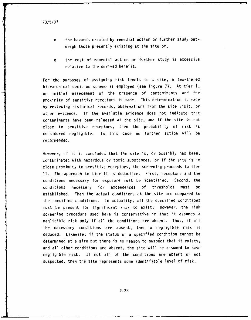
73/5/33
o the hazards created by remedial action or further study out-
weigh those presently existing at the site or,
o the cost of remedial action or further study is excessive
relative to the derived benefit.
For the purposes of assigning risk levels to a site, a two-tiered
hierarchical decision scheme is employed (see Figure 7). At tier I,
an initial assessment of the presence of contaminants and the
proximity of sensitive receptors is made. This determination is made
by reviewing historical records, observations from the site visit, or
other evidence. If the available evidence does not indicate that
contaminants have been released at the site, and if the site is not
close to sensitive receptors, then the probability of risk is
considered negligible. In this case no further actior, will be
recommended.
However, if it is concluded that the site is, or possibly has been,
contaminated with hazardous or toxic substances, or if the site is in
close proximity to sensitive receptors, the screening proceeds to tier
II. The approach to tier II is deductive. First, receptors and the
conditions necessary for exposure must be identified. Second, the
conditions necessary for exceedences of thresholds must be
established. Then the actual conditions at the site are compared to
the specified conditions. In actuality, all the specified conditions
must be present for significant risk to exist. However, the risk
screening procedure used here is conservative in that it assumes a
negligible risk only if all the conditions are absent. Thus, if all
the necessary conditions are absent, then a negligible risk is
deduced. Likewise, if the status of a specified condition cannot be
determined at a site but there is no reason to suspect that it exists,
and all other conditions are absent, the site will be assumed to have
negligible risk. If not all of the conditions are absent or not
suspected, then the site represents some identifiable level of risk.
2-33
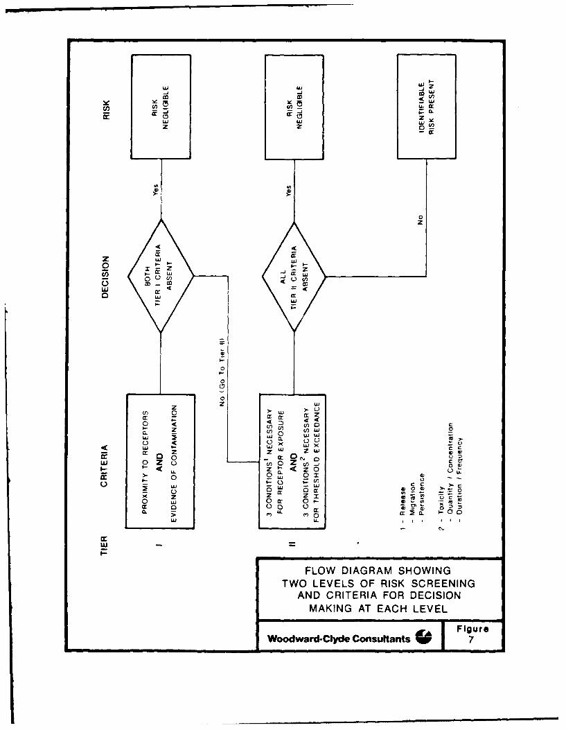
w 0w
z 2
Z W
w 4r
0
0
00
0 4 C)c)LA ZL U) Uj0
C) CL 0 w T>
0 4 0x~~I. < -wxC
0~ gw .0 - 0CC
x z ze0 S.-f 0 -0 -- ;~ 0
w-
FLOW DIAGRAM SHOWINGTWO LEVELS OF RISK SCREENING
AND CRITERIA FOR DECISIONMAKING AT EACH LEVEL
73/5/35
2.5.4 Logic Supporting the Screening
Previous studies identified six sites at Cape Newenham AFS as having
the potential to be contaminated with oil or hazardous waste.
However, during the 1987 field inspection, site 1 was redefined as two
separate sites - site la, the waste accumulation areas, and site lb,
the active landfill. Site lb is currently permitted by ADEC and,
therefore, was not included in this risk screening. Of the remaining
sites, only the Lower Camp landfill (site 5) had no evidence of
contamination and was not in close proximity to sensitive receptors.
Thus, site 5 was assigned a negligible risk at Tier I in the risk
screening (Table 4). At the remaining five sites, contamination was
either observed or suspected, or sensitive receptors were nearby.
These sites were, therefore, assessed at tier II.
For sites la, 2, 3, 4, and 6, the potential hazards and conditions
necessary to produce them were identified. The conditions necessary
to allow exposure of receptors to threshold levels of contaminants are
listed in Table 4. Finally, conditions at the site were compared with
hypothetical "necessary conditions." Table 4 summarizes the
conclusions of the risk screening. The rationale for the probability
screenings is discussed in detail below.
2.5.4.1 Waste Accumulation Areas I and 2 (Site la)
This is the site of possible spillage of liquid wastes. However,
historical evidence of spillage exists and the site was, therefore,
subject to a tier II screening. Those wastes have not been identified
nor has spillage been confirmed. Possible receptors include humans
and water resources. Potential health hazards are possible through
direct human contact with chemical contaminants. Furthermore, health
and environmental hazards exist should ground and surface waters
become contaminated and state water quality standards could be
violated. Critical or unique wildlife habitat and protected species
of plants and animals are not known to exist in the immediate vicinity
and, therefore, are not identified as receptors. The following
2-35
~X 0U a)
Lt)
LU Un
LL) LU >
LUJ
o~ 4-'0~~ LU4).
LUD
-- :t La-C
a- L) vi4-'LU CC (Z LUJ 0 L-
LA- X 0-0
~LU 0-L4-
4-) U)
to ~ Cl L
EO
LO. 41~
0x - 4) 0 )
0 0) 4-)
LA- 4) 04-)
a:) L/ Lu a) CLu 0 L. +.)
~z .4-' 41.0 0
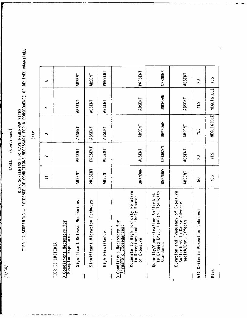
L&i
-LIi LIi JL ) Lf) 2ELi- V) L
t J Lai V) C0 Lii
LL.~
Li.. LiiLJ AJ
o) -J 0 o CI
V)L.) -
#-D I.--0
L U )LAJ LLi Lii EI) lz V LAi Lo
Li3 L.J Ed) cc cc>Q/)L)
w -)
LLi Lii CD= Li.LA VI LAJ &i 2-1 V)
CD 4~) rVLi) Li') V) V)1. ) Lii
C L V ) cc ccc
*J J CM 3Lo LJ = I-AJC
W.C)Lii 1) LLi LiiZ U
L&V) m cc c tCO Z
-J J LA
3:- 4--S
EU~~4 La) Li) Li iiL
ro >)4
to 4-))Lii C-
S- 0J Ed) 0 )
Li.J o d EUCJ 0 . )r V)4
* C . 4- 41=cu LV) to :3 to- w
L. Q) -Ci w'- fa4 o-1 .. -. C.- CoccL A
L cu Q)Q ( oCA LL 4j 04-)iULL. 0 - m Q) v0 L-(1) U i CLi- cLi4- :3 4- -.. Q 0 %-~ Q 041Q
cx cc uL - -) V) ) I 0 -) :3 0 1 UC c 4
= U EU fu Ca CA x a - w.- L -Li) Ci L w LuJ 4)EU 4i -*) Ci) m4-- 0
U* EL 0i +j wU 0) C> L V e- mL4- Cl cfl - LC uii W CL
.Cl S-i 4) 4._ 4- ECJ 04 0 f MC (a
4- ) 4-U, 4-i 4-) - 4)>Ce )V) 0-4)
L) 0 C C .CV- 00- C04- :3 CJ C0) -: rr Cm n
CY 0C 0=Lii Li i (
73/5/38
assessment of conditions necessary for adverse effects is an
evaluation of the potential for those receptors listed above to be
significantly exposed to contaminants.
o Release Mechanisms - Contaminants, if present, could be
released from the site by volatilization, by mobilization
with solvents or water, or by mechanical transport of
affected soils. Because of the age of possible contaminants
at the site and the relatively small volumes which would
have been spilled, most volatilization of the lower
molecular weight compounds would have occurred by now. A
large solvent or fuel spill would be required to solubilize
non-polar hydrocarbons and to transport them into surface or
ground waters. This is an unlikely event. Due to the large
amount of precipitation in the area, and water soluble
compounds that were originally present, have been previously
leached from the soil. Other compounds with higher
adsorption coefficients would tend to remain in the soil.
The intentional movement of contaminated soil is unlikely
because of the remoteness of the site. Movement from
erosive processes is improbable because of relatively flat
terrain and the stability of soils.
o Migration Pathways - Ingestion of contaminated soil by
humans is unlikely. Volatile fractions of the contaminants
would have volatilized from the surface by this time and
accumulations of threshold air concentrations are unlikely.
Other potential pathways to human and environmental
receptors include surface or subsurface migration into
surface and ground waters. The drinking water supply for
the installation is located up-gradient from the spill and
cannot be affected. The surface gradient at site la is
relatively flat, but the site is close (50 m) to a stream
and is underlain by permeable soils. Therefore, vertical or
horizontal migration could be expected if large quantities
of contaminants were present. However, the amount of
L-38
73/5/39
contaminants could not be confirmed either through review of
historical records or by visual observations during the site
visit.
o Persistence - The age of the spillage at site la is such
that significant weathering, volatilization, chemical
transformation, and biodegradation may have already
occurred. No evidence of hiyhly persistent compounds was
found.
o Toxicity - Conclusive evidence that toxic or hazardous
substances were spilled at the site does not exist. The
toxicity of components present in the small soil stains is
unknown.
o Quantity/Concentration - There is no evidence of the amount
of liquid wastes that were spilled at site la. The number
and size of soil stains present and the vigor of vegetation
at the site indicate that any previous spillage was minimal.
o Duration and Frequency of Exposure - Ground water and
surface waters could be exposed to contaminants from
spillage. However, the water gallery is located up-gradient
from site la. Due to the water supply location, the
distance from the living quarters, and the overall
remoteness of the site, it is improbable that humans could
be exposed to toxic concentrations of contaminants either
orally, dermally or through respiratory routes. If exposure
were to occur it would be very infrequent and of short
duration.
It is concluded that there is an identifiable risk of receptor
exposure to possible contaminants at site la. However, this risk
exists only because of the presence of significant migration pathways
(ground water and surface water). Evidence does not exist which
indicates that hazardous substances are present in high enough
2-39
73/5/40
concentrations to pose a significant risk. Release mechanisms are not
available. Therefore No Further Action is recommended.
2.5.4.2 Upper Camp Dump Area (Site 2)
The Phase I document (Eng. Sci. 1985) reported that waste oils and
ethylene glycol were dumped over the side of steep talus slopes at the
Upper Camp. Therefore, a tier II screening was performed. Quantities
of contaminants are unknown and the site has been cleaned. No
evidence of contamination was observed during the site visit.
Health effects through direct human contact with hazardous substances
are improbable due to the remoteness of the site and its steep,
inaccessible terrain. It is unlikely that important ground water or
surface water resources would be affected, but contaminants which are
mobilized from site 2 could ultimately enter Bristol Bay. Critical or
unique wildlife habitats and protected species of plants and animals
are not known to exist in the immediate vicinity of the site and,
therefore, are not identified as receptors. The following assessment
is an evaluation of the potential for receptors to be significantly
exposed to contaminants.
o Release Mechanisms - For contaminants to be released from
site 2 a large solvent spill would be necessary to mobilize
non-polar compounds. This is unlikely. Volatilization is
not a significant release mechanism because of the age of
the dump and the lack of adsorptive humic soils; any lower
molecular weight compounds originally present would have
volatilized. Due to the high precipitation rates and the
extreme gradient at the site, water-soluble compounds such
as ethylene glycol would have previously migrated off-site.
o Migration Pathways - The extremely high gradient provides a
surface pathway from the site into Bristol Bay.
2-40
73/5/41
o Persistence - The age and location of the possible spillage
at site 2 is such that significant weathering, mobilization,
or chemical transformation may have already occurred. No
evidence exists that highly persistent compounds were
disposed of at the site.
o Toxicity - Conclusive evidence that toxic or hazardous
substances were spilled at site 2 does not exist.
Substances reportedly dumped include lube oils, wastewater
and ethylene glycol. Ethylene glycol is the most toxic of
these but its toxicity is relatively low (see Section
2.3.3.1).
o Quantity/Concentration - There is no evidence of the amount
of liquid wastes spilled at site 2. However, the total
volume was probably minimal because of the remoteness of the
site.
o Duration and Frequency of Exposure - Because of the
inaccessibility of the site, the steepness of the slope, and
the distance to Bristol Bay and other significant water
resources, it is improbable that human or other biotic
receptors would be exposed to toxic concentrations of
potential contaminants.
It is concluded that there is an identifiable risk of receptor
exposure to presumed contaminants at site 2. However, this risk
exists only because of the existence of migration pathways. Potential
contaminants are relatively non-toxic or would have previously
migrated from the site. No visual evidence of contamination exists.
Therefore, the recommended action is No Further Action.
2.5.4.3 Road Oiling (Site 3)
Visual evidence of contamination from road oiling was not observed
during the site visit, but a tier II screening was performed because
2-41
73/5/42
of historical evidence. Potential health hazards are possible only
through accidental ingestion of contaminated soils. Critical or
unique wildlife habitat and protected species of plants and animals
are not known to exist in the immediate vicinity and, therefore, are
not identified as receptors. The following assessment of conditions
necessary for adverse effects is an evaluation of the potential for
receptors to be significantly exposed to contaminants.
o Release Mechanisms - Road oils, if present, could be
released by mobilization with solvents or by mechanical
transport of affected soils. A large solvent or fuel spill
would be required to solubilize non-polar hydrocarbons and
to transport them into surface or ground waters. This is
improbable. Because of the large amount of precipitation,
any water soluble compounds are likely to have been leached
from the soil. Others with higher adsorption coefficients
would tend to remain in the soil. Intentional or erosive
movement of soil is unlikely.
0 Migration Pathways - Ingestion of contaminated soil by
humans is unlikely. Due to the age of possible
contamination, mobilization would be improbable and the
existence of migration pathways extremely limited.
0 Persistence - Oil is not persistent in the environment. It
is subject to weathering, chemical transforma ion and
biodegradation.
0 Toxicity - Lube oil is not toxic unless ingested in large
quantities.
o Quantity/Concentration - There is no evidence of the volume
of oil used as a dust suppressant. The lack of visual
evidence of contamination indicates that minimal quantities
were applied to the road system.
2-42
73/5/43
o Duration and Frequency of Exposure - Humans, through
accidental ingestion of contaminated soil, are the only
possible receptors. Ingestion is unlikely.
All conditions necessary for receptor exposure or threshold exceedence
are absent or unknown. Therefore, site 3 presents a negligible risk.
2.5.4.4 Waste Accumulation Area No. 3 (Site 4)
Evidence of contamination at site 4 was noted in historical records.
Therefore, a tier II screening was made.
Quantities of contaminants are unknown. However, the site has been
cleaned and no evidence of contamination was observed during the site
visit. Critical or unique wildlife habitat and potential species of
plants and animals are not known to exist in the immediate vicinity
and, therefore, are not identified as receptors. Surface waters will
not be affected. The only possible critical receptor is ground water.
o Release Mechanisms - A large solvent or fuel spill would be
necessary to mobilize spilled oil. This is unlikely. Other
possible contaminants are volatile or water soluble and
would have dissipated by now.
o Migration Pathways. The only potential migration pathways
are vertical movement into the ground water in the event of
a solvent or fuel spill and the physical removal of
contaminated soil. Both are unlikely.
o Resistance - The age of spillage is such that significant
weathering, volatilization, chemical transformation, and
biodegradation may have already occurred. No evidence of
highly persistent compounds was found.
o Toxicity - Conclusive evidence that toxic or hazardous
substances were spilled at the site does not exist. The
2-43
73/5/44
toxicity of compounds in the stains observed during Phase I
is unknown.
o Quantity/Concentration - There is no evidence of the volume
of liquid waste spilled at site 4. The size of soil stains
as described in the Phase I report indicate that spillage
was minimal.
o Duration and Frequency of Exposure - It is unlikely that
human or environmental receptors would be exposed to
possible contaminants for sufficient duration to present a
hazard.
It is concluded that there is a negligible risk of receptor exposure
to potential contaminants at site 4.
2.5.4.5 Landfill - Lower Camp (Site 5)
Site 5 is not located near sensitive receptors nor was evidence found
that contaminants are present in the landfill. The site has been
cleaned and graded and presently lies under several inches of gravel
fill. It was assigned a negligible risk at tier I and recommended for
No Further Action.
2.5.4.6 White Alice Site (Site 6)
The White Alice Site has been dismantled, cleaned, and buried. The
area where the facility was located was filled and graded in 1987.
There was no visual evidence of contamination found during the site
visit and there are no known receptors in close proximity to the site.
Ground water is the only potential receptor. Information of
hydrogeology in the area is lacking but because of the elevation and
remoteness of the site it is doubtful that important groundwater
resources could be affected. However, the Phase I report indicates
that transformers were used at the White Alice Site and stored. Due
to the possible existence of transformers, the potential for PCB
2-44

73/5/45
contamination must be considered even though confirmatory evidence
does not exist. Therefore, site 6 was evaluated at tier II in the
risk screening. The following discussion analyzes whether the
conditions necessary for non-negligible risk are present at site 6.
0 Release Mechanisms - PCBs are insoluble in water. If they
are present at the site, a large solvent or fuel spill would
be necessary to mobilize them. This is unlikely because of
the remoteness of the site from normal operating activities
at the installation. The only other potential release
mechanism is mechanical removal of contaminated soil. This
is unlikely because the site has already been filled and
leveled.
o Migration Pathways - The only migration pathway is vertical
movement through soil into ground water. This is unlikely
because of the insoluble properties of PCBs and their
relatively high adsorptivities to organic soil particles.
o High Persistence - PCBs are extremely persistent in the
environment. They are very stable compounds that do not
undergo significant chemical transformation or
biodegradation. Therefore, persistence, one condition
necessary for receptor exposure, may be present at site 6.
This depends upon whether PCBs are in fact present in
significant quantities at the site.
o Toxicity - PCBs are very toxic and are suspected
carcinogens (see Section 2.3.7.1). Routes of exposure
include ingestion, skin contact and inhalation. They have
relatively high bioconcentration factors.
o Quantity/Concentration - PCBs are not known to be present at
site 6. Their presence is only suspected. Therefore,
quantities are unknown.
2-45
73/5/46
0 Duration and Frequency of Exposure - It is improbable that
humans would be exposed to toxic concentrations of PCBs
either orally, dermally or through respiratory routes.
In conclusion a risk of PCB contamination is present at site 6. This
risk exists only because of the potential for PCB contamination and
their high persistence and toxicity. However, conclusive evidence
that contamination actually exists at the site cannot be found.
Because of this and the remoteness of the site, the distance from the
living quarters, the location of the water supply relative to the
site, the insolubility of PCBs, and the containment of potential PCB
contamination under fill and gravel, the risk associated with
potential PCBs at site 6 is very low.
2.6 ALTERNATIVES ANALYSIS
2.6.1 Purpose
Based on previous studies, a site visit and literature search, five
sites of potential concern were identified at Cape Newenharn AFS and
evaluated at tier II in the risk assessment. These sites are:
o Site la: Waste Accumulation Area 1 & 2
o Site 2: Upper Camp Dump
o Site 3: Road Oiling
o Site 4: Waste Accumulation Area 3
o Site 6: White Alice Site
A qualitative risk screening (see Table 4) concluded that sites 3 and
4 do not present a significant risk to human health or to the
environment. A potential risk was judged to be present at sites la,
2, and 6 because of the presence of significant migration pathways at
sites la and 2, the presence of exposive routes at site 6, and the
fact that the presence of toxic substances has riot been ruled out at
any of these three sites. However, at each of the sites delineated
above, some small amounts of residual contaminants are known to exist
2-46

73/5/47
or might be found to exist if further studies are completed. Results
of the risk screening suggest that the known or probable levels of
contamination are so slight or of so little concern relative to health
or environmental impact that no further action should be taken at
these sites. This section examines feasible alternatives to "no
further action" to determine if any other course of action regarding
these sites would result in a lesser risk to human health or the
environment.
The Comprehensive Environmental Response and Compensation Liability
Act (CERCLA, as amended by the Superfund Amendments and
Reauthorization Act--SARA) govern federal agency response to
contamination of federal facilities by oil or hazardous substances.
The National Contingency Plan calls for cost-effective remedies to be
implemented for sites where a significant risk to human health or the
environment is shown to exist; such sites are enrolled on the
"National Priority List" (called NPL). Guidance for selecting cost-
effective remedies for NPL sites is available in EPA document
EPA/540/G-85/003, "Guidance for Feasibility Studies Under CERCLA." No
specific guidance exists for selecting cost-effective remedies for
non-NPL sites such as those at Cape Newenham AFS. The alternatives
analysis presented in the following paragraphs is modeled after the
above-referenced EPA guidance, and is generally in compliance with the
requirements of the National Contingency Plan (40 CFR 300).
2.6.2 Evaluation Criteria and Method
EPA guidance ("Guidance for Feasibility Studies Under CERCLA)
describes an evaluation method for alternative remedies that includes
the following evaluation criteria:
o Performance level (how effective will the alternative be in
abating the hazard, and in reducing risk)
o Useful life (how long will the alternative last)
o Risk of increased exposure (will the alternative create new
opportunities for receptors to be exposed to contaminants)
2-47

73/5/48
o Environmental impact (will the alternative cause disturbance
or loss of environmental re. ources)
o Cost (Rough, Order-of-Magnitude cost is used: is the
economic cost of the alternative low, moderate or high).
o Implementability (what infrastructural, administrative or
logistic requirements does the alternative have).
o Institutional impacts (does the alternative place a burden
on local community institutions)
o Socioeconomic impacts (does the alternative affect
employment, housing, or other socioeconomic factors)
o Safety (what is the health risk to site workers and
surrounding residents of the alternative remedial measure)
o Reliability (what are the maintenance, inspection and
replacement requirements of the alternatives)
The last four evaluation factors are not considered in the evaluation
that follows. Institutional factors are not relevant because no local
community institutions or interactions are involved. Socioeconomic
impacts are not relevant because the sites are remote and are not
economically interactive with local communities; the remedial
alternatives considered are relatively specialized and would not
present employment or income opportunities to local communities.
Safety impacts are not relevant because none of the known or potential
contamination problems and none of the alternative actions present a
significant risk to workers or residents of the sites. Reliability is
not a relevant factor because none of the alternatives are active
treatment systems or have any maintenance or replacement requirement.
The six evaluation factors (the first six in the list above) will be
applied to each alternative at each site, using a tabular format with
the following headings:
Risk of
Alter- Performance Useful Increased Env. ROM
native Level Life Exposure Impact Cost Implementability
Rough Order-of-Magnitude
2-48
73/5/49
The alternatives will be ranked based on a qualitative scoring that
considers performance level, useful life and risk of increased
exposure to be relatively more important than environmental impact.
Environmental impact will be considered to be relatively more
important than ROM cost and implementability.
2.6.3 Alternatives to be Evaluated
Two or more alternative remedies were considered at each of the five
sites evaluated at tier II in the risk screening. These alternatives
are presented below for each of the sites.
2.6.3.1 Waste Accumulation Areas I and 2 (Site la)
o no further action
o excavation of contaminated soils beneath the storage area
and aeration through spreading on dirt roads
o further investigation of the site, consisting of test
borings in and around the site to determine the extent of
contamination, and installation of groundwater monitoring
wells to confirm local groundwater conditions and detect
contamination in the ground water.
2.6.3.2 Upper Camp Dump Area (Site 2)
o no further action
o further investigation of the site, consisting of a
geophysical survey to locate the extent of buried waste and
test borings to detect contamination in the dump site.
2.6.3.3 Road Oiling (Site 3)
o no further action
o further investigation of the site consisting of test borings
to determine the extent of contamination, if any, and
2-49
73/5/50
installation of monitoring wells to confirm groundwater
conditions
o no active remedial alternative is proposed due to the lack
of confirmation of contamination
2.6.3.4 Waste Accumulation Area 3 (Site 4)
o no further action
o further investigation of the site consisting of test borings
and monitoring well installation as for sites la and 3o no active remedial alternative is proposed
2.6.3.5 White Alice Site (Site 6)
o no further action
o further investigation consisting of test borings and
monitoring well installation, some excavation of therecently applied fill material may be necessary to
facilitate the investigation
2.6.4 Results
The following results are presented for each site evaluated in tier IIscreening in table format as described in section 2.6.2 of this
report.
2.6.4.1 Waste Accumulation Areas 1 and 2 (Site la)
Risk of
Alter- Performance Useful Increased Env. ROY,
native Level Life Exposure Impact Cost Implementability
no action mod high neg neg neg good
excavation mod high low mod high very poor
investigation low low low mod high poor
2-50

73/5/51
Preferred alternative: no action
2.6.4.2 Upper Camp Dump (Site 2)
Risk of
Alter- Performance Useful Increased Env. ROM
native Level Life Exposure Impact Cost Implementability
no action high high very low neg neg good
investigation low low very low high high fair
Preferred alternative: no action
2.6.4.3 Road Oiling (Site 3)
Risk of
Alter- Performance Useful Increased Env. ROM
native Level Life Exposure Impact Cost Implementability
no action high high very low neg neg good
investigation low low low mod very high poor
Preferred alternative: no action
2.6.4.4 Waste Accumulation Area 3 (Site 4)
Risk of
Alter- Performance Useful Increased Env. ROM
native Level Life Exposure Impact Cost Implementability
no action high high very low neg neg good
investigation low low very low high high fair
Preferred alternative: no action
2-51
73/5/52
2,6.4.5 White Alice Site (Site 6)
Risk of
Alter- Performance Useful Increased Env. ROM
native Level Life Exposure Impact Cost Implementability
no action high high very low neg neg good
investigation low low low mod very high poor
Preferred alternative: no action
2.7 SUMMARY
At all of the sites considered in the risk screening, the no action
alternative is the preferred alternative because it presents the lowest or
same risk to human health as other alternatives, and a lower environmental
and economic cost than any other alternative.
2.8 BIBLIOGRAPHY AND CONIACTS
Alderhold, W. 1987. Project Manager, Cape Newenham 1982 construction.
Nealand Co., Inc. Homer, Alaska. Personnal Communication. (907)
235-8141.
American Conference of Governmental Industrial Hygienists, 1986-1987,
Threshold of Limit Values and Biological Exposure Indices for
1986-1987.
Box, S.E. 1984. Geologic Setting of High Pressure Metamorphic Rocks of
the Cape Newenham Area. USGS 1984 Circular, pgs. 37-42.
Bureau of Land Management. 1943. Land Ownership Plats, Pending
Historic Site Claims. Dept. of Interior withdrawal.
Callahan, M., et al. 1979. Water-Related Environmental Fate of 129
Priority Pollutants, Volume I. EPA Doc. #440/4-79-029A.
2-52
73/5/53
Callahan, M., et al. 1979. Water-Related Environmental Fate of 129
Priority Pollutants, Volume II. EPA Doc. #440/4-79-029B.
Engineering Science. 1985. I.R.P. Phase I Report, Southern Region LRRS.
Prepared for the USAF Engineering Service Center.
Feldman, M.H. 1973. Petroleum Weathering: Some Pathways, Fate, and
Disposition on Marine Waters. EPA Doc. #660/3-73-013.
Gosselin, R.E., Smith, R.P., and H.C. Hodge. 1984. Clinical Toxicology of
Commerical Products, 5th ed.
Gusey, W.F. 1979. The Fish and Wildlife Resources of the Southern Bering
Sea Region. Prepared for Environmental Affairs, Shell Oil Company.
Hoare, J.M., and Coonrad, W.L. 1977. New Geologic Map of Goodnews -
Hagemeister Island Quadrangles, Alaska. USGS 1977 Circular pgs.
50-55.
Humphrey, C. 1987. Civil Engineering Management, 11th Tactical Control
Group, Alaska Air Command, U.S. Air Force, Elmendorf AFB, Alaska.
Personal communication. (907) 552-3691.
Murie, O.J. 1959. Fauna of the Aleutian Islands and Alaska Peninsula.
Murray, D.F., Lipkin, R. 1987. Candidate Threatened and Endangered Plants
of Alaska. University of Alaska Museum, Fairbanks.
Raassen, C.D., Amdur, M.D., and J. Doull, Eds. 1986. Casarett & Doull's
Toxicology: The Basic Science of Poisons. 3rd Ed.
Sax, N. Irving. 1984. Dangerous Properties of Industrial Materials. 6th
Ed.
Sax, N. Irving. 1985. Hazardous Chemical Information Annual #1.
2-53
73/5/54
U.S. Army Corps of Engineers. Latest update. Construction and AFS As
Builts and Layouts. COE, Alaska District, Anchorage, Alaska.
U.S. Department of Interior. 1986. Togiak National Wildlife Refuge,
Final Comprehensive Conservation Plan, Wilderness Review and
Environmental Impact Statement. Prepared by U.S. Fish and
Wildlife Service, Region 7, Anchorage, Alaska.
U.S. Department of Interior. 1974. Proposal for the Togiak National
Wildlife Refuge. Prepared by Alaska Planning Group, U.S. Dept.
of Interior.
U.S. EPA. 1980. Ambient Water Quality Criteria for Benzenes. EPA Doc.
#440/5-80-018.
U.S. EPA. 1980. Ambient Water Quality Criteria for Polynuclear Aromatic
Hydrocarbons. EPA Doc. #440/5-80-069.
USGS. 1947 revised 1971. Topographic Map, 1:630,000 Hagemeister
Quadrangle.
USGS, Water Resource Division. No Date. Water Source Used by the
USAF in Alaska, 1964-65, Cape Newenham. pgs. 52-55.
Weiss, G., Ed. 1980. Hazardous Chemical Data Book, Environmental Health
Review #4.
Westlake, D.W.S., and F.D. Cook. 1980. Petroleum Biodegradation Potential
of Northern Puget Sound and Strait of Juan de Fuca Environments. EPA
Doc. #600/7-70-133.
Zenone, C. 1987. Hydrologist, USGS Water Resources Division, 4230
University Drive, Suite 201, Anchorage, Alaska. Personal
communication. (907) 271-4138.
2-54