Embed Size (px)
Citation preview
Water, leisure and nature. The Besòs River
features a recovered environment in which
nature and leisure exist side by side, in
the very heart of the Barcelona metropoli-
tan area, along the last stretch to the river
mouth on the Mediterranean Sea. Its ex-
ceptional location offers the people of the
riverside municipalities a large quality, safe
and easily accessible green space in which
to enjoy their leisure time and peace and
quiet.
The park’s landscapes are highly diverse
and reflect the zonal division of its design:
The purifying reed area in the upper zone
increases the river’s water quality and cre-
ates a habitat apt for wild fauna; The pub-
lic area in the middle zone features traffi-
cable grass areas and inflatable weirs that
increase the river’s apparent flow and cre-
ate a pleasant landscape; The river mouth
features a mosaic of aquatic and brackish
water Mediterranean plants, which is used
by birds mainly at migration times.
English
ww
w.d
iba
.ca
t/pa
rcs
n/p
arc
fluv
ial
Direcció d
e Com
unicació. Cover p
hoto: Kim
Castells. D
L:
The Besòs River Park
The Besòs River Park is set along the last nine kilometres of the
course of the Besòs River, from the confluence of the Besòs
and Ripoll rivers to the river mouth on the Mediterranean Sea.
Covering a total area of 115 hectares, this is one of the largest
green spaces in the Barcelona metropolitan area and is part of
the urban continuum of the cities of Barcelona, Santa Coloma
de Gramenet, Sant Adrià de Besòs and Montcada i Reixac.
Despite intense human pressure, the Besòs River Park features
a large number of environments that are home to a consider-
able diversity of organisms and link the Collserola massif to the
Serralada de Marina mountain range, and the seafront to the
region’s inland area.
Since 2000, Barcelona Provincial Council has administered
the park on the basis of a management agreement with the
councils of Barcelona, Montcada i Reixac, Sant Adrià de Besòs
and Santa Coloma de Gramenet, and the Consortium for the
Defence of the Besòs River Basin. It is managed in accordance
with the terms of the Operation and Maintenance Plan, the Land
Use Plan and the park’s Emergency Plan.
er area of river meadow, both of which are irrigated with
treated groundwater. The reed is the species planted in
the 8 hectares of wetlands, which are designed to improve
water treatment. The river meadow stretches among these
areas of reeds in accordance with the scale and frequency
of spates of the Besòs River, known locally as “Besotades”.
The river mouth features a mosaic of vegetation adapted
to high salinity, such as the salt cedar and Mediterranean
saltbush, aquatic plants such as the bulrush and the chaste
tree, and a mound with Mediterranean plants.
Fauna
Environmental recovery and gradual improvement of wa-
ter quality have encouraged the creation of new habitats of
interest for fauna. Thanks to these improvements and the
park’s location along the final stretch of the Besòs, over two
hundred different species of birds have been observed.
Although water birds such as the grey heron, the mallard,
the common moorhen and the little ringed plover can be
observed throughout the park, the wetland reed areas are
more attractive for small passeriform birds, while birds rare-
ly spotted in the park may be seen in the river mouth dur-
ing the spring and autumn migration periods.
The park’s most interesting fish are the eel and the chub.
There are also some
noteworthy verte-
brates such as the
tree frog, the Natterjack
toad and the stripe-necked
terrapin.
Public area
The 5 km area for public use runs
alongside the Besòs River, from
the bridge by the B-20 (right bank)
or from Can Zam Nord (left bank),
to the municipality of Santa Colo-
ma de Gramenet, and to the rail-
way bridge in Sant Adrià de Be-
sòs. This area’s tarmacked road
may be travelled either on foot or
by bicycle.
The left bank is wide enough for
a signposted bicycle lane. In order
to create a more attractive land-
scape, a total of eleven inflatable
weirs regulate the water level to
give the impression of greater wa-
ter flow.
Safe public use in the event of the
flooding of a Mediterranean river
such as the Besòs would not be
possible without the Besòs Hydrological Warning System
(SAHBE). This system constantly analyses meteorologi-
cal and hydrological data and warns managers, authori-
ties and users of possible flooding of the river. A state
of emergency can therefore be activated with enough
advance warning.
The SAHBE is enhanced by the Public Use Control Serv-
ice, which comprises informers who travel by bicycle and
ensure the park is evacuated when the river is in spate.
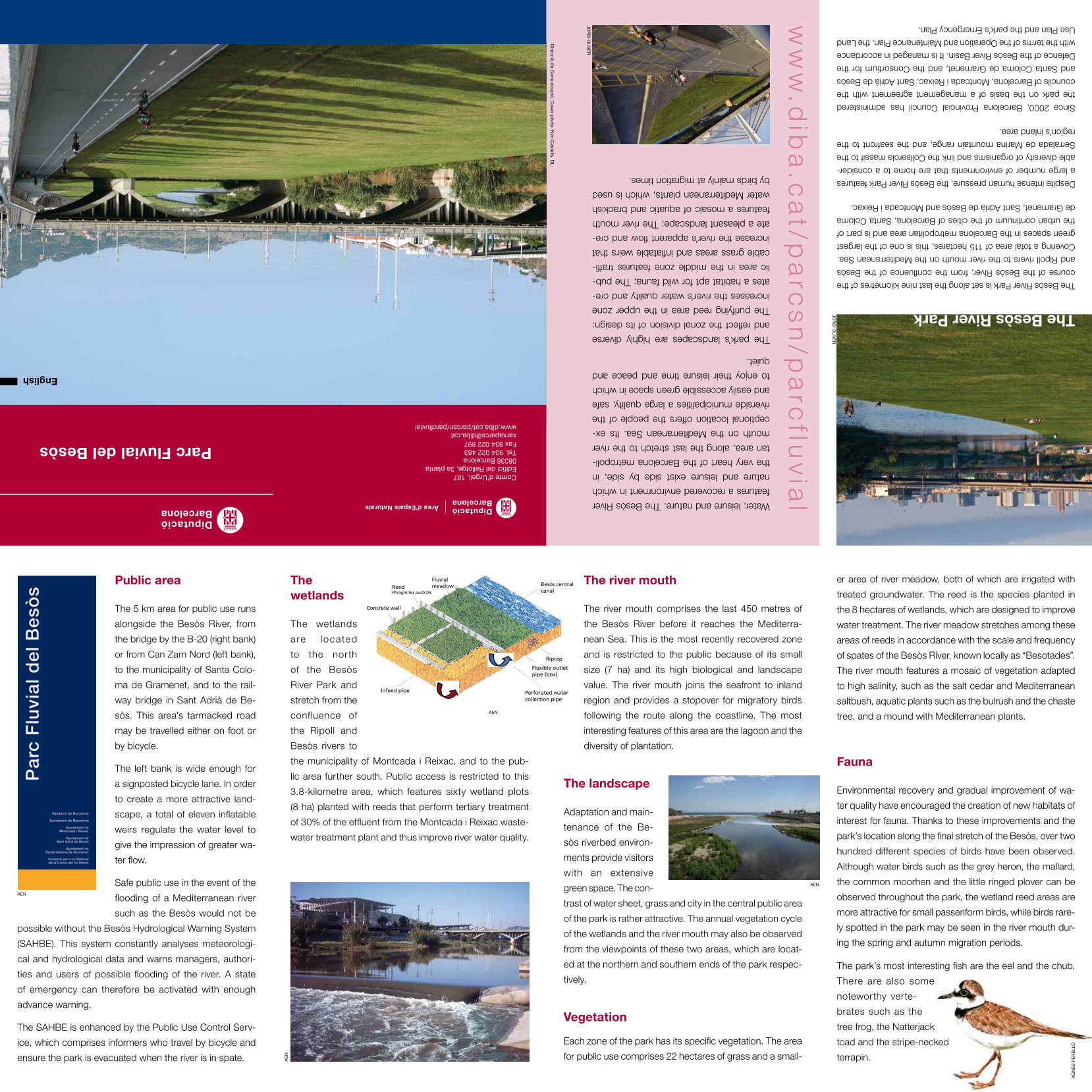
The wetlands
The wetlands
are located
to the north
of the Besòs
River Park and
stretch from the
confluence of
the Ripoll and
Besòs rivers to
the municipality of Montcada i Rei xac, and to the pub-
lic area further south. Public access is restricted to this
3.8-kilometre area, which features sixty wetland plots
(8 ha) planted with reeds that perform tertiary treatment
of 30% of the effluent from the Montcada i Reixac waste-
water treatment plant and thus improve river water quality.
The river mouth
The river mouth comprises the last 450 metres of
the Besòs River before it reaches the Mediterra-
nean Sea. This is the most recently recovered zone
and is restricted to the public because of its small
size (7 ha) and its high biological and landscape
value. The river mouth joins the seafront to inland
region and provides a stopover for migratory birds
following the route along the coastline. The most
interesting features of this area are the lagoon and the
diversity of plantation.
The landscape
Adaptation and main-
tenance of the Be-
sòs riverbed environ-
ments provide visitors
with an extensive
green space. The con-
trast of water sheet, grass and city in the central public area
of the park is rather attractive. The annual vegetation cycle
of the wetlands and the river mouth may also be observed
from the viewpoints of these two areas, which are locat-
ed at the northern and southern ends of the park respec-
tively.
Vegetation
Each zone of the park has its specific vegetation. The area
for public use comprises 22 hectares of grass and a small-
AEN
JOR
DI O
LIVE
R
Comte d’Urgell, 187Edi�ci del Rellotge, 3a planta08036 BarcelonaTel. 934 022 483Fax 934 022 [email protected] www.diba.cat/parcsn/parc�uvial
Parc Fluvial del Besòs
Àrea d’Espais Naturals
AE
N
Besòs central canal
Fluvial meadow
Concrete wall
ReedPhragmites australis
Infeed pipe Perforated water collection pipe
Flexible outlet pipe (box)
Riprap
AEN
AEN
JOR
DI O
LIVE
R
Ag
Nè
s P
ER
ELL
ó

THE BESÒS RIVER PARK
WETLANDS
PUBLIC AREA
RIVER MOUTH
�
� �
Conventional symbols
Motorway
Road
Railway
Population centre
Summit
Metro
Tram
Railway station
Wetlands
Meadow
Lawn
Paved avenue
Paths on duty
Park access
Inflatable dam
Park viewpoint trails
Wetland trails
Valuable features in this area can be observed at Montcada
i Reixac, on a circular trail that joins up with the Casa de
les Aigües. Explanatory panels are provided. The river may
be crossed using the pedestrian walkway or Montcada
bridge.
At Santa Coloma de Gramenet, the public area cycle lane
joins up with the cycle lane outside the park, which follows
the wetlands along the left bank of the river (in the direc-
tion of flow).
River mouth trail
This zone can be observed from the viewpoints by follow-
ing a trail at Sant Adrià de Besòs: The Coastal Park, the
Park of Peace and Maristany bridge. Explanatory panels
are provided.
Park opening times
Spring (from 21/03 to 20/06): 10 am to 6 pm
Summer (from 21/06 to 20/09): 10 am to 9 pm
Autumn (from 21/09 to 20/12): 10 am to 6 pm
Winter (from 21/12 to 20/03): 10 am to 5 pm
Park contact details
Barcelona Provincial CouncilDepartment of Natural AreasTerritorial Action Technical OfficeComte d’Urgell, 187
Edifici del Rellotge, 3a planta
08036 Barcelona
Tel. 934 022 483 · Fax 934 022 897
[email protected] · www.diba.cat/parcsn/parcfluvial
Barcelona City CouncilPlaça de sant Jaume, 1. 08002 Barcelona
Tel. 934 027 000 · Fax 933 170 139
[email protected] · www.bcn.cat
Montcada i Reixac Town Council Av. de la Unitat, 6. 08110 Montcada i Reixac
Tel. 935 726 474 · Fax 935 726 493
[email protected] · www.montcada.cat
Sant Adrià de Besòs Town CouncilPlaça de la Vila, 12. 08930 sant Adrià de Besòs
Tel. 933 812 004 · Fax 933 817 056
[email protected] · www.sant-adria.net
Santa Coloma de Gramenet Town Council Plaça de la Vila, s/n. 08921 santa Coloma de gramenet
Tel. 934 624 000 · Fax 934 660 067
[email protected] · www.grame.net
Access
The park has 20 entrances with ramps and stairs.Each entrance has an electronic panel that features information on the park’s status.
Public transport
•Train R1 Barcelona - Maçanet Massanes Station: Sant Adrià de Besòs R2 Nord Barcelona - Maçanet Massanes Station: Montcada i Reixac R2 Barcelona - Granollers Centre Station: Montcada i Reixac
•Metro L1 Baró de Viver o Santa Coloma L2 Artigues Sant Adrià L9 / L10 Bon Pastor o Can Peixauet
•Buses TUGSAL: B-14, B-16, B-18, B-19, B-20, B-21, B-23, B-25,
B-26, B-30, B-31 TMB: 35, 42, 43, 44 BD7 Badalona City
•Tram (Trambesòs) T4 Ciutadella Vila Olímpica - Sant Adrià station Stop: Sant Adrià station T5 Ciutadella Vila Olímpica - Gorg Stop: Sant Joan Baptista
P R O V Í N C I AD E B A R C E L O N A
Barcelona
CA
RTO
GR
AP
HY:
XP
N
Emergency 112
Parc Fluvial del Besòs
Rules of use
Please observe the park’s opening hours.
Danger of floods. Please heed the warnings.
Follow the indications on the panel.
Dogs must be kept on a lead.
Please collect your dog’s excrement.
Do not use motor vehicles.
Do not enter the water.
The water in the irrigation network is not drinkable.
Please put rubbish in the waste bins and containers.