Embed Size (px)
Citation preview
Page 1, November 2017 Near Northside
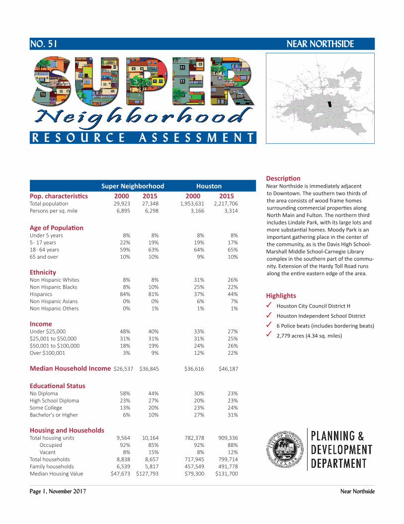
DescriptionNear Northside is immediately adjacent to Downtown. The southern two thirds of the area consists of wood frame homes surrounding commercial properties along North Main and Fulton. The northern third includes Lindale Park, with its large lots and more substantial homes. Moody Park is an important gathering place in the center of the community, as is the Davis High School-Marshall Middle School-Carnegie Library complex in the southern part of the commu-nity. Extension of the Hardy Toll Road runs along the entire eastern edge of the area.
Highlights Houston City Council District H
Houston Independent School District
6 Police beats (includes bordering beats)
2,779 acres (4.34 sq. miles)
Super Neighborhood HoustonPop. characteristics 2000 2015 2000 2015Total population 29,923 27,348 1,953,631 2,217,706 Persons per sq. mile 6,895 6,298 3,166 3,314
Age of PopulationUnder 5 years 8% 8% 8% 8%5 - 17 years 22% 19% 19% 17%18 - 64 years 59% 63% 64% 65%65 and over 10% 10% 9% 10%
EthnicityNon Hispanic Whites 8% 8% 31% 26%Non Hispanic Blacks 8% 10% 25% 22%Hispanics 84% 81% 37% 44%Non Hispanic Asians 0% 0% 6% 7%Non Hispanic Others 0% 1% 1% 1%
IncomeUnder $25,000 48% 40% 33% 27%$25,001 to $50,000 31% 31% 31% 25%$50,001 to $100,000 18% 19% 24% 26%Over $100,001 3% 9% 12% 22%
Median Household Income $26,537 $36,845 $36,616 $46,187
Educational StatusNo Diploma 58% 44% 30% 23%High School Diploma 23% 27% 20% 23%Some College 13% 20% 23% 24%Bachelor's or Higher 6% 10% 27% 31%
Housing and HouseholdsTotal housing units 9,564 10,164 782,378 909,336 Occupied 92% 85% 92% 88% Vacant 8% 15% 8% 12%Total households 8,838 8,657 717,945 799,714Family households 6,539 5,817 457,549 491,778Median Housing Value $47,673 $127,793 $79,300 $131,700
NEAR NORTHSIDENO. 51
R E S O u R c E A S S E S S m E N T
Super Neighborhood Houston
Page 2, November 2017 Near Northside
Near Northside: Land Use
MAIN
JENSEN
FULTON
ELYSIAN
CAVALCADE
AIRLINE
QUITMAN
IRVINGTO
N
LYONS
PATTON
KELLEY
HOU
STON
STUDEW
OO
DCROCKETT
WHITE OAK
COLLINGSWORTH
HOGAN
PECORE
LORRAINE
HARDY
TAYL
OR
11TH
LIBERTY
SAWYER
MOP
JENSE
N
HARDY
IH 45
US
59
IH 610
IH 10
IH 45
IH 610
IH 10
US 59
Freeway
Rail Road
Super Neighborhood Boundary
Single-family Residential
Multi-family Residential
Commercial
Office
Industrial
Public and Institutional
Transportation and Utilities
Parks and Open Space
Undeveloped
Agricultural Production
Open Water
Unknown
Source: City of Houston GIS Database,
Date: November 16, 2017
Harris County Appraisal District
I 0 0.5 10.25Miles
Page 3, November 2017 Near Northside
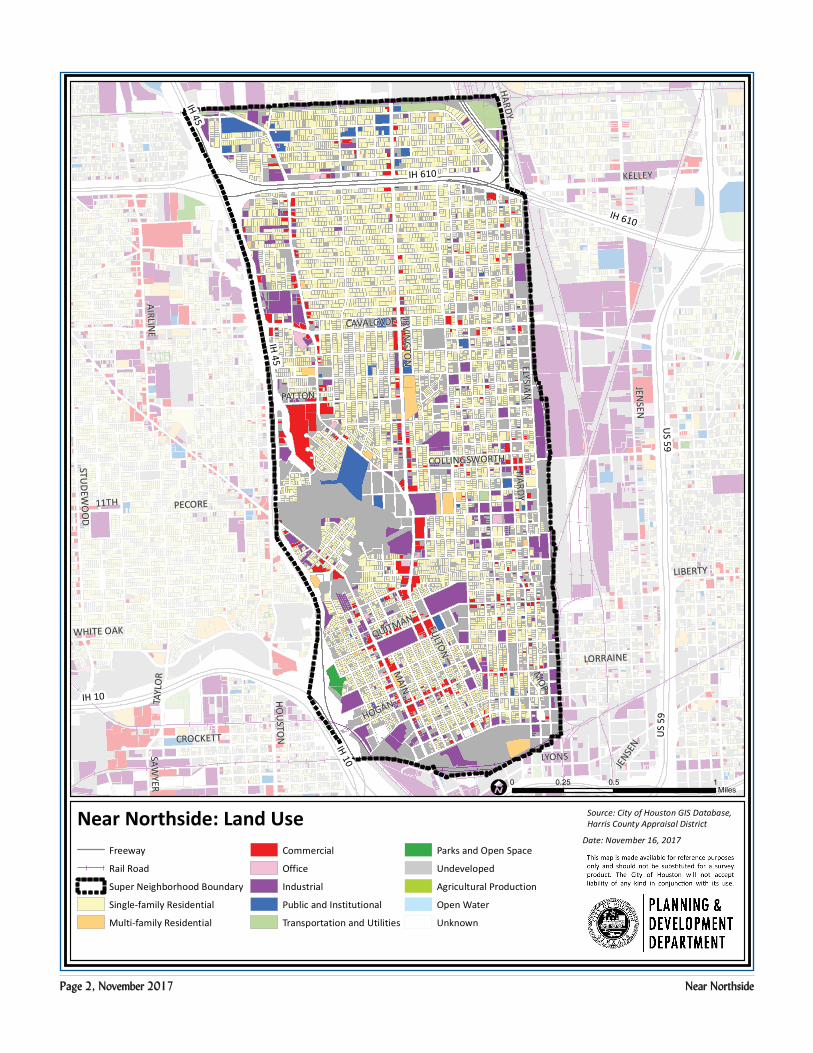
Near Northside: Public Facilities Source: City of Houston GIS Database
Date: October 2017
Council District H
Council District B
Council District C
MAIN
JENSEN
FULTON
ELYSIAN
CAVALCADE
AIRLINE
IRVINGTO
N
QUITMAN
LYONS
PATTON
KELLEY
STUDEW
OO
D
HOU
STON
WHITE OAK
CROCKETT
HARDY
COLLINGSWORTH
HOGAN
PECORE
LORRAINE
11TH
STUDEM
ONT
TAYL
OR
SAWYER
20TH
MOP
HARDY
JEN
SEN
IH 45
US
59
IH 610
IH 10
HARDY TOLL
HARDY TOLLIH 610
IH 10
IH 45
IH 610
IH 10
IH 10
US 59
Community Centers
Fire Station
ÆP Harris County Hospitals
ÆP Private Hospitals
ÆP Other Health Facilities
Æc Library
Metro Rail Stations
Police Station
Rail Road
å School
Parks
I0 0.5 10.25
Miles
Super Neighborhood Boundary
Metro Rail Line¬(Å
AirportsZ
TIRZ
Hardy / NearNorthside
TIRZ
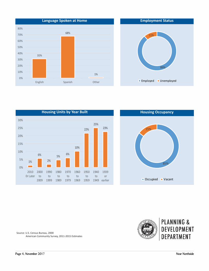
Page 4, November 2017 Near Northside
Language Spoken at Home Employment Status
Housing Units by Year Built Housing Occupancy
89%
11%
Employed Unemployed
1%
6%
2%5%
6%
10%
22%25%
23%
0%
5%
10%
15%
20%
25%
30%
20100r Later
2000 to
2009
1990 to
1999
1980 to
1989
1970 to
1979
1960 to
1969
1950 to
1959
1940 to
1949
1939 or
earlier
31%
68%
1%0%
10%
20%
30%
40%
50%
60%
70%
80%
English Spanish Other
85%
15%
Occupied Vacant
Source: U.S. Census Bureau, 2000 American Community Survey, 2011-2015 Estimates


![W W W Wollumbin StreetNullum Street Brisbane Street Attach 1 [EO-CM] Knox Park...e/oe/oe/oe/o e/o e/o e/o e/o e/o e/o e/o e/o e/o e/o sw s s s s s s s s s s sw sw sw sw sw sw sw sw](https://img.pdfslide.us/doc/110x75/5e2bc152ea1ec51fa10481be/w-w-w-wollumbin-streetnullum-street-brisbane-street-attach-1-eo-cm-knox-park.jpg)