Embed Size (px)
Citation preview

quickmag
Fast, 3D Magnetic GeologyMappingEncom QuickMag allows you to construct realistic geological models of magnetic anomalies and complete survey interpretations in hours rather than days.
Just point at an anomaly, choose a geological style and in seconds QuickMag will automatically construct a 3D model of the magnetic source.
Depth MappingMap the depth of cover for intrusions, dykes and folded bedding using fl exible 3D geological models that are built automatically. At the same time you will map geological boundaries, magnetic susceptibility and dip with options to explore changes along the geological trend.
Remanence MappingThe all new resultant magnetization estimation tool allows you to detect remanent magnetic events at sensitivities not previously possible.
You can detect magnetization departure angles as small as 10 degrees, allowing you to investigate historical surveys with new eyes and look for signs of alteration events or interpret differences in timing of intrusive events.

Fast, Realistic Modelling
How It WorksEncom QuickMag is based on ground-breaking research into automatic geological modelling techniques. It is suitable for mapping of magnetic dykes, bedded units such as steeply dipping folded volcanics, intrusive pipes and intrusive plugs. It maps the distribution of magnetic material across an unconformity surface.
This model style suits a wide range of geological mapping problems and the unconformity can be fl at, dipping, undulating or faulted. The adoption of this geological model makes it possible to automate the 3D construction of the magnetic unit below the unconformity.
The magnetic unit is approximated by a series of linked blocks where the depth, width, dip and magnetic property can vary from one block to the next. The axially linked attributes must conform to the selected geological style and this allows QuickMag to defi ne a wide range of geological shapes.
The automated Quick Match process builds a starting model for inversion which QuickMag then refi nes through its advanced regularised inversion technology.
Speed & ControlQuickMag optimises your time because it allows you to perform the model interpretation directly from the image view of your data. This is the natural way to work when interpreting magnetic data.
First you select the geological style and then you select the anomaly by dragging the mouse along the axis of the magnetic anomaly. QuickMag does the rest in a few seconds by building a model that best matches your style selection and the magnetic data.
If the match is poor, you can change the style to see if you can improve the result. Now you can build complex geological models without having to worry about the details of manual model construction.
Style variations include depth to the top unconformity surface, map shape at the unconformity, axial curvature along strike, dip changes along strike and magnetic susceptibility changes along strike. Faults can be introduced to model sharp breaks in depth, dip and susceptibility.
Magnetic susceptibility variations along strike can be used to investigate alteration characteristics in linear dyke-like anomalies where the thickness of the unit can be assumed to be constant.
Remanence estimation is a new feature in QuickMag which provides direct estimates of the target resultant magnetization vector direction and indirect estimation of the remanent magnetization vector.
Turn Magnetic Anomaliesinto Geology
Isolate
Quick Match
Select
3D Inversion

Quantitative Geology
Depth, Structure, Lithology & Remanence
DepthQuality depth determinations from magnetic data require an appropriate, constraining geological model or estimation errors may exceed 50% of the true depth.
With QuickMag you can easily select a suitable model or test a range of models to determine the most likely one. Unconformity depths are derived from multiple models and in special cases depths can be mapped along the axis of an individual model. Depth information can be exported as 3D models or tables for use in other products such as Encom ModelVision Pro, PA Professional and Encom Discover.
StructureStructural information derived from QuickMag can be used to distinguish between synclines and anticlines, map vertical and lateral fault throws, estimate dip and dip change and axial depth changes.
QuickMag is sensitive to dip changes along strike for individual models and can be used to detect structural distortions that may not be obvious in the magnetic images.
Fault throws can be estimated by depth changes along the axis of a model. An interpreted fault trace is digitized on the map and is used by the inversion engine to break the model at the nearest block boundary. The direction and amplitude of the fault throw can be read from the model report.
LithologyMagnetic susceptibility is an important physical property of rocks and within limited geological domains can be used to identify the probable rock type or formation. Because QuickMag builds realistic solid 3D geological models for each magnetic anomaly, the magnetic susceptibilities refl ect robust volume averages of the target properties.
Axial susceptibility variations for a specifi c model may detect subtle variation that could be associated with alteration events that have modifi ed the properties. This technique is limited to shallow bodies or dyke-like bodies where the thickness is expected to be constant.
RemanenceThe infl uence of remanence is present in most magnetic anomalies and until now, it has largely been ignored. QuickMag now provides a tool for direct estimation of the resultant magnetization vector which is the vector sum of the induced and remanent magnetic fi elds. QuickMag uses the magnetic moment method to derive the resultant magnetization vector from which you can compute the total departure angle as a fi rst order indicator of remanence.
QuickMag allows you to map total departure angle as a property that can help detect the presence of subtle remanence events that would previously go undetected.
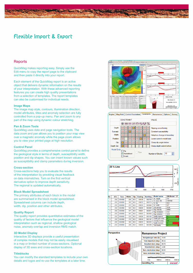
Reports
QuickMag makes reporting easy. Simply use the Edit menu to copy the report page to the clipboard and then paste it directly into your report.
Each element of the QuickMag report is an active object that delivers dynamic information on the results of your interpretation. With these advanced reporting features you can create high quality presentations from a selection of templates. The report templates can also be customised for individual needs.
Image MapsThe image map style, contours, illumination direction, model attributes, titles and anomaly selection are fully controlled from a pop-up menu. Pan and zoom to any part of the map using dynamic colour stretching.
Pan & Zoom ToolsQuickMag uses data and page navigation tools. The data zoom and pan allows you to position your map view over a magnetic anomaly while the page zoom allows you to view your printed page at high resolution.
Control PanelQuickMag provides a comprehensive control panel to defi ne the geological style in terms of depth, susceptibility width, position and dip shapes. You can insert known values such as susceptibility and clamp parameters during inversion.
Cross-sectionCross-sections help you to evaluate the results of the interpretation by providing visual feedback on data mismatches. Turn on the fi rst vertical derivative option to improve depth sensitivity. The regional is updated automatically.
Block Model SpreadsheetThe primary attributes of each block in the model are summarised in the block model spreadsheet. Spreadsheet columns can include depth, width, dip, position and other attributes.
Quality ReportThe quality report provides quantitative estimates of the quality of factors that infl uence the geological model interpretation such as regional, shallow geological noise, anomaly overlap and inversion RMS match.
3D Model DisplayInteractive 3D displays provide a useful presentation of complex models that may not be easily visualised in a map or limited number of cross-sections. Optional display of 3D axes and cross-section locations.
TitleblocksYou can modify the standard templates to include your own details and logos and re-use the templates at a later time.
Flexible Import & Export

Many Applications
Diamond Exploration
QuickMag provides diamond explorers with a tool that can be used to estimate depth of burial, surface area, magnetic susceptibility and shape.
The new remanence modelling capability makes it easier to investigate negative magnetic anomalies that exhibit high Konigsberger ratios. The remanence tool is excellent for studying variations in the resultant magnetization direction of inferred kimberlite pipes and in some cases can differentiate the timing of intrusive events.
Gold Exploration
QuickMag provides geoscientists with an effi cient tool for assessing the magnetic properties of the host rocks, burial depth and structural attributes that can help refi ne prospective host environments for gold deposits.
Alteration events associated with gold mineralisation may present as magnetite destruction zones or remanence events that are suited to QuickMag analysis.
Base Metals Exploration
Base metals can occur in a wide range of geological settings and QuickMag can help unravel the geology of the host rocks and in some cases the deposits may be suitable for direct analysis. Depth of cover, dip, magnetic susceptibility, magnetic remanence properties can all be used to assist in base metal exploration.
Alteration events associated with base metal emplacement may present as magnetite destruction zones or remanence events that are suited to QuickMag analysis.
Petroleum Exploration
QuickMag provides fast interpretation of depth to basement, petrophysical analysis of basement rocks and assistance with the mapping of basement geology.
You can also use it to interpret the location of volcanics or intrusions such as sills, dykes and diatremes that may infl uence seismic interpretations and velocity modelling. Accurate location of dykes is important as they can have signifi cant impact on hydrocarbon migration and trapping.
Engineering & Environmental
QuickMag helps engineers and environmental scientists to study near surface magnetic features. Examples include buried valleys for aquifer studies, intrusions within aquifer formations, sills and dykes that affect the structural competence of road and building foundations, mining hazards, buried waste and unexploded ordnance.

Flexible Inputs
QuickMag requires a total magnetic intensity grid with options for digital elevation grids and reference images. Support is provided for most popular grid formats including Encom, ER Mapper, Geosoft, Vertical Mapper, Surfer ASCII, Surfer Binary, GeoTiff, Arc ASCII, Arc Binary, USGS, ASEG GXF, USGS DEM, USGS SDTS. Reference images such as satellite imagery or aerial photography can be loaded in ER Mapper algorithms, ER Mapper ECW, GeoTiff, JPEG 2000 and MapInfo TAB formats.
Flexible Exports
The models can be exported to ASCII fi les, as 3D DXF fi les and ModelVision Pro compatible models for use in ModelVision Pro, PA Explorer, PA Professional and other products that can visualise 3D models. Work in progress can be saved in session fi les, project databases that are independent of the template, or templates that you may edit during a session.
ASCII Export
ASCII data for all or selected models can be exported with model summaries or block details. You can select the model channels and formats of attributes listed in the following table.
Note: The physical attributes of each model are computed subject to standard limitations of the magnetic method.
Windows Vista®, Windows® and Windows NT® are registered trademarks of Microsoft Corporation. MapInfo Professional® is a US registered trademark of Pitney Bowes Software Inc. QuickMag Document 3.0.04
Individual block X position (m)
Individual block Y position (m)
Individual block Z position (m)
Ground elevation above an individual block (m)
X of the model centre (m)
Y of the model centre (m)
Depth (m) below DEM if elevation grid specifi ed
Depth (m) below fl at ground surface (no DEM)
Elevation (m) of model above sea level
Block dip (degrees)
Block width (m)
Block axis extent (m)
Block depth extent (m)
TMI at X, Y location of block centre (nT)
Computed TMI model value over block centre (nT)
Block magnetic susceptibility
Anomaly shape - linear, elliptical (general), circular (pipe)
Area of upper surface of blocks (m2)
IGRF TMI fi eld intensity (nT)
IGRF TMI fi eld declination (deg)
IGRF TMI fi eld inclination (deg)
Magnetic units SI or cgs
Resultant magnetization declination (deg)
Resultant magnetization inclination (deg)
Resultant magnetization (nT)
Resultant declination departure from TMI (deg)
Resultant inclination departure from TMI (deg)
Total polar angular departure from TMI (deg)
Updated Q value following inversion
Remanence (NRM) declination (deg)
Remanence (NRM) declination (deg)
Remanence (NRM) inclination (deg)
Remanence (NRM) magnetization (nT)
Contaasdfaasdfact Encom
Asia-Pacifi c/AustraliaLevel 7, 1 Elizabeth PlazaNorth Sydney NSW 2060 AustraliaT + 61 2 9437 6255 F +61 2 9439 1773
Level 2, 1050 Hay StreetWest Perth WA 6005 AustraliaT +61 8 9226 0101 F +61 8 9226 0102
Americas26 Wellington Street East, Suite 500Toronto, Ontario M5E 1S2 CanadaT +1 416 594 5200 F +1 416 594 5201
Europe/United KingdomMinton Place, Victoria Street, WindsorBerkshire SL4 1EG United KingdomT +44 1753 848200 F +44 1753 621140
Export Parameter


![Permanent magnets Ferrite, ndFeB, alniCo & smCo … · NdFeB BLS Magnet [6] Permanent magnets BLS Magnet [7] Permanent magnets nDFeB magnets Grade Remanence Remanence Coercive force](https://img.pdfslide.us/doc/110x75/5b915de509d3f210288b8282/permanent-magnets-ferrite-ndfeb-alnico-smco-ndfeb-bls-magnet-6-permanent.jpg)


![Software Resources for Remanence Estimation...Software Resources for Remanence Estimation Pratt, D.A.[1] 1. Tensor Research David.Pratt@tensor-research.com.au ABSTRACT The recovery](https://img.pdfslide.us/doc/110x75/606925cc3383eb5efc2d010c/software-resources-for-remanence-software-resources-for-remanence-estimation.jpg)