Embed Size (px)
Citation preview
Queensland Transport andRoads Investment Program
2019–20 to 2022–23
North Coast
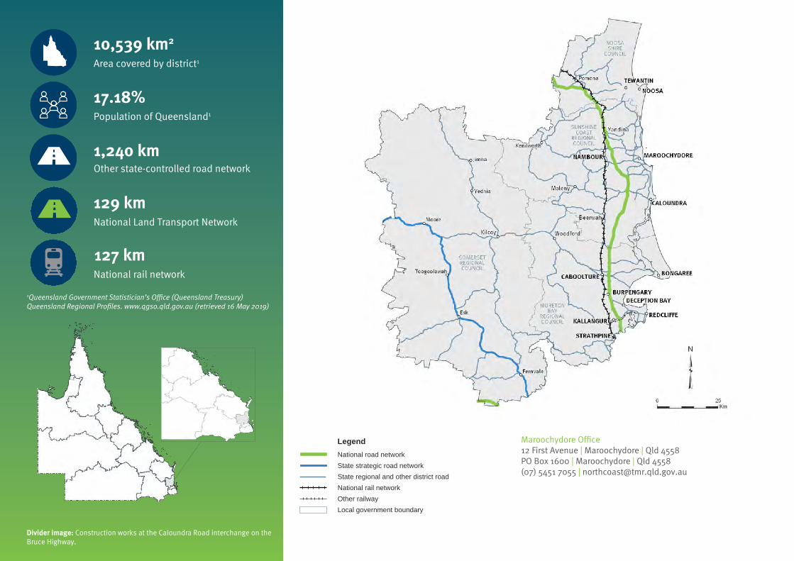
1Queensland Government Statistician’s Office (Queensland Treasury) Queensland Regional Profiles. www.qgso.qld.gov.au (retrieved 16 May 2019)
National rail network
127 km
Area covered by district1
10,539 km2
Population of Queensland1
17.18%
National Land Transport Network
129 km
Other state-controlled road network
1,240 km
LegendNational road networkState strategic road networkState regional and other district roadNational rail network
Local government boundaryOther railway
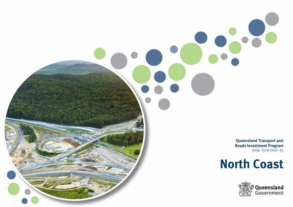
Divider image: Construction works at the Caloundra Road interchange on the Bruce Highway.
Maroochydore Office12 First Avenue | Maroochydore | Qld 4558PO Box 1600 | Maroochydore | Qld 4558(07) 5451 7055 | [email protected]
Queensland Transport and Roads Investment Program 2019–20 to 2022–23 | Page 73North Coast | District profile
North Coast
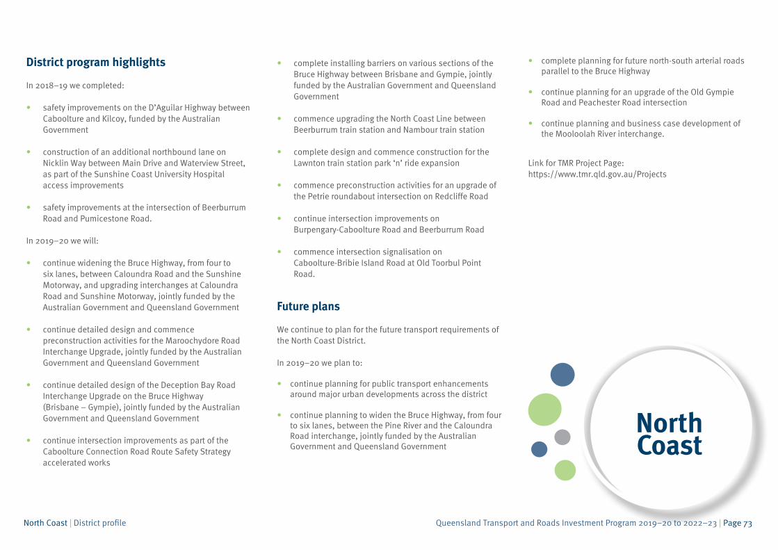
District program highlights
In 2018–19 we completed:
• safety improvements on the D’Aguilar Highway betweenCaboolture and Kilcoy, funded by the AustralianGovernment
• construction of an additional northbound lane onNicklin Way between Main Drive and Waterview Street,as part of the Sunshine Coast University Hospitalaccess improvements
• safety improvements at the intersection of BeerburrumRoad and Pumicestone Road.
In 2019–20 we will:
• continue widening the Bruce Highway, from four tosix lanes, between Caloundra Road and the SunshineMotorway, and upgrading interchanges at CaloundraRoad and Sunshine Motorway, jointly funded by theAustralian Government and Queensland Government
• continue detailed design and commencepreconstruction activities for the Maroochydore RoadInterchange Upgrade, jointly funded by the AustralianGovernment and Queensland Government
• continue detailed design of the Deception Bay RoadInterchange Upgrade on the Bruce Highway(Brisbane – Gympie), jointly funded by the AustralianGovernment and Queensland Government
• continue intersection improvements as part of theCaboolture Connection Road Route Safety Strategyaccelerated works
• complete installing barriers on various sections of theBruce Highway between Brisbane and Gympie, jointlyfunded by the Australian Government and QueenslandGovernment
• commence upgrading the North Coast Line betweenBeerburrum train station and Nambour train station
• complete design and commence construction for theLawnton train station park ‘n’ ride expansion
• commence preconstruction activities for an upgrade ofthe Petrie roundabout intersection on Redcliffe Road
• continue intersection improvements onBurpengary-Caboolture Road and Beerburrum Road
• commence intersection signalisation onCaboolture-Bribie Island Road at Old Toorbul PointRoad.
Future plans
We continue to plan for the future transport requirements of the North Coast District.
In 2019–20 we plan to:
• continue planning for public transport enhancementsaround major urban developments across the district
• continue planning to widen the Bruce Highway, from fourto six lanes, between the Pine River and the CaloundraRoad interchange, jointly funded by the AustralianGovernment and Queensland Government
• complete planning for future north-south arterial roadsparallel to the Bruce Highway
• continue planning for an upgrade of the Old GympieRoad and Peachester Road intersection
• continue planning and business case development ofthe Mooloolah River interchange.
Link for TMR Project Page: https://www.tmr.qld.gov.au/Projects
Queensland Transport and Roads Investment Program 2019–20 to 2022–23 | Page 74North Coast | District profile
Page intentionally blank
Queensland Transport and Roads Investment Program 2019–20 to 2022–23 | Page 75North Coast | National Network
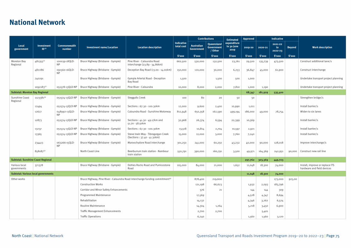
National Network
Localgovernment
Investment ID (1)
Commonwealthnumber
Investment name/Location Location description
Indicative total cost
Contributions Estimated expenditure to 30 June
2019
Approved Indicative
Work descriptionAustralian
Government
Queensland Government
/ Other2019-20 2020-21
2021-22 to
2022-23Beyond
$’000 $’000 $’000 $’000 $’000 $’000 $’000 $’000
Moreton Bay Regional
481355(2) 100039-18QLD-NP
Bruce Highway (Brisbane - Gympie) Pine River - Caloundra Road interchange (23.89 - 34.86km)
662,500 530,000 132,500 23,761 29,500 135,739 473,500 Construct additional lane/s
482286 091560-16QLD-NP
Bruce Highway (Brisbane - Gympie) Deception Bay Road (13.00 - 14.00km) 150,000 120,000 30,000 6,253 36,847 45,000 61,900 Construct interchange
740291 Bruce Highway (Brisbane - Gympie) Gympie Arterial Road - Deception Bay Road
1,500 1,500 500 1,000 Undertake transport project planning
1092183(3) 051578-13QLD-NP Bruce Highway (Brisbane - Gympie) Pine River - Caloundra 10,000 8,000 2,000 7,810 1,000 1,190 Undertake transport project planning
Subtotal: Moreton Bay Regional 68,347 181,929 535,400
Sunshine Coast Regional
1123381(4) 051574-13QLD-NP Bruce Highway (Brisbane - Gympie) Steggalls Creek 100 80 20 50 50 Strengthen bridge/s
12494 051574-13QLD-NP Bruce Highway (Brisbane - Gympie) Sections : 67.30 - 100.30km 12,000 9,600 2,400 10,990 1,011 Install barrier/s
12677 048992-13QLD-NP
Bruce Highway (Brisbane - Gympie) Caloundra Road - Sunshine Motorway 812,948 650,358 162,590 499,194 186,000 49,000 78,754 Widen to six lanes
12873 051574-13QLD-NP Bruce Highway (Brisbane - Gympie) Sections : 41.30 - 49.17km and 51.70 - 58.50km
32,968 26,374 6,594 22,399 10,569 Install barrier/s
13237 051574-13QLD-NP Bruce Highway (Brisbane - Gympie) Sections : 67.30 - 100.30km 13,518 10,814 2,704 10,597 2,921 Install barrier/s
13365 051574-13QLD-NP Bruce Highway (Brisbane - Gympie) Steve Irwin Way - Tibrogargan Creek (Sections : 37.40 - 41.30km)
15,000 12,000 3,000 7,760 7,240 Install barrier/s
234413 063266-15QLD-NP
Bruce Highway (Brisbane - Gympie) Maroochydore Road interchange 301,250 241,000 60,250 43,232 40,000 90,000 128,018 Improve interchange/s
858087(5) North Coast Line Beerburrum train station - Nambour train station
550,791 390,000 160,791 3,500 49,971 164,369 242,951 90,000 Construct new rail line
Subtotal: Sunshine Coast Regional 297,762 303,369 449,723
Various local governments
371378 Bruce Highway (Brisbane - Gympie) Dohles Rocks Road and Pumicestone Road
105,000 84,000 21,000 1,652 11,048 18,300 74,000 Install, improve or replace ITS hardware and field devices
Subtotal: Various local governments 11,048 18,300 74,000
Other works Bruce Highway, Pine River - Caloundra Road interchange funding commitment(6) 878,400 219,600 173,000 925,00
Construction Works 121,198 66,623 1,932 2,093 183,796
Corridor and Minor Safety Enhancements 576 21 144 144 309
Programmed Maintenance 17,569 4,528 4,347 8,694
Rehabilitation 14,132 4,346 3,262 6,524
Routine Maintenance 14,304 1,264 5,218 3,450 6,900
Traffic Management Enhancements 2,700 2,700 5,401
Traffic Operations 6,240 1,560 1,560 3,120
Queensland Transport and Roads Investment Program 2019–20 to 2022–23 | Page 76North Coast | National Network
Localgovernment
Investment ID (1)
Commonwealthnumber
Investment name/Location Location description
Indicative total cost
Contributions Estimated expenditure to 30 June
2019
Approved Indicative
Work descriptionAustralian
Government
Queensland Government
/ Other2019-20 2020-21
2021-22 to
2022-23Beyond
$’000 $’000 $’000 $’000 $’000 $’000 $’000 $’000
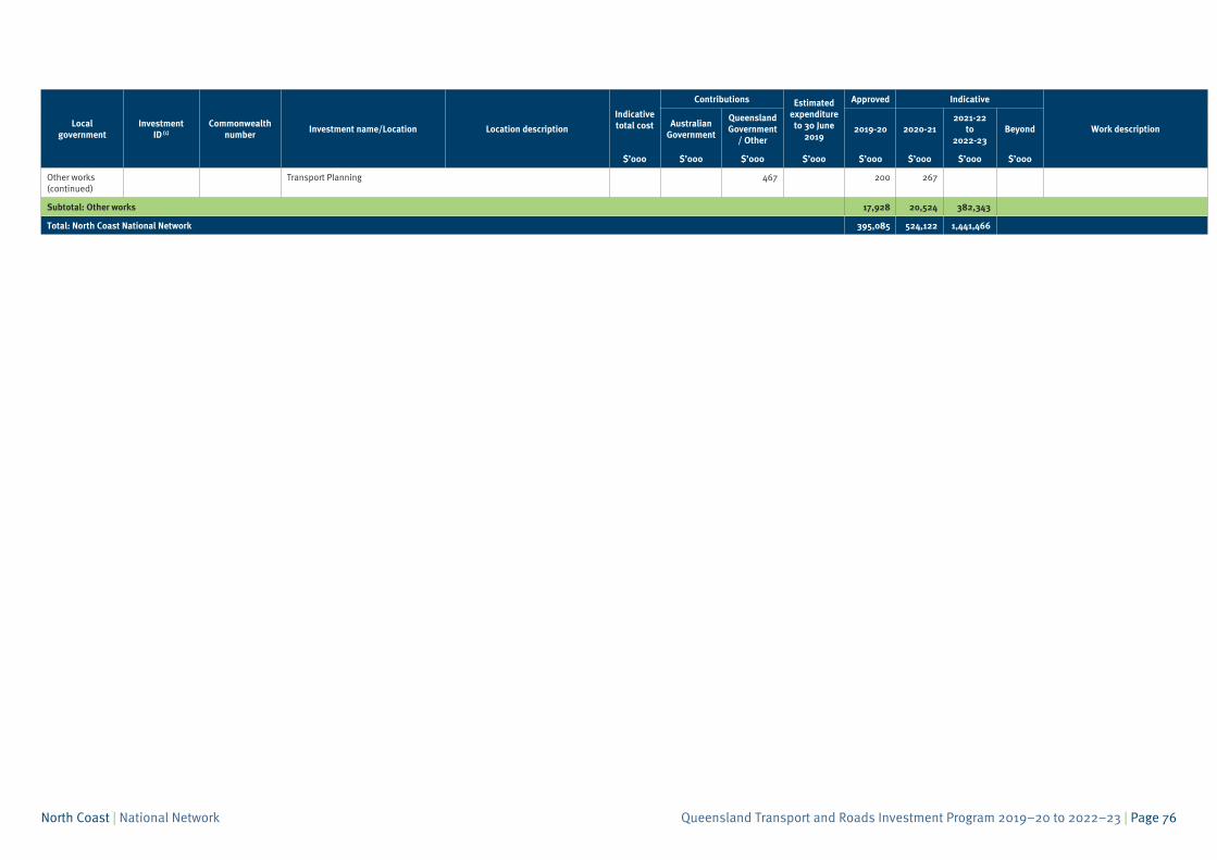
Other works (continued)
Transport Planning 467 200 267
Subtotal: Other works 17,928 20,524 382,343
Total: North Coast National Network 395,085 524,122 1,441,466
Queensland Transport and Roads Investment Program 2019–20 to 2022–23 | Page 77North Coast | National Network
Endnotes
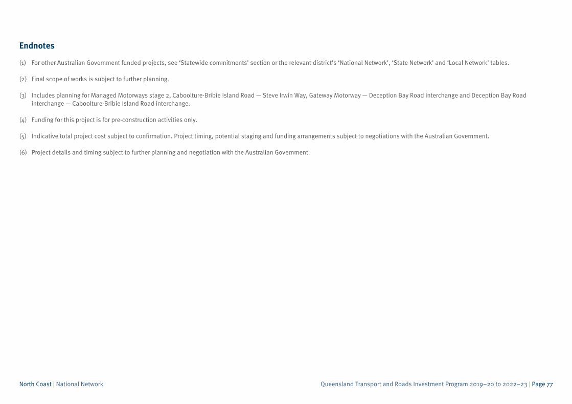
(1) For other Australian Government funded projects, see ‘Statewide commitments’ section or the relevant district’s ‘National Network’, ‘State Network’ and ‘Local Network’ tables.
(2) Final scope of works is subject to further planning.
(3) Includes planning for Managed Motorways stage 2, Caboolture-Bribie Island Road — Steve Irwin Way, Gateway Motorway — Deception Bay Road interchange and Deception Bay Roadinterchange — Caboolture-Bribie Island Road interchange.
(4) Funding for this project is for pre-construction activities only.
(5) Indicative total project cost subject to confirmation. Project timing, potential staging and funding arrangements subject to negotiations with the Australian Government.
(6) Project details and timing subject to further planning and negotiation with the Australian Government.
Queensland Transport and Roads Investment Program 2019–20 to 2022–23 | Page 78North Coast | National Network
Page intentionally blank
Queensland Transport and Roads Investment Program 2019–20 to 2022–23 | Page 79North Coast | State Network
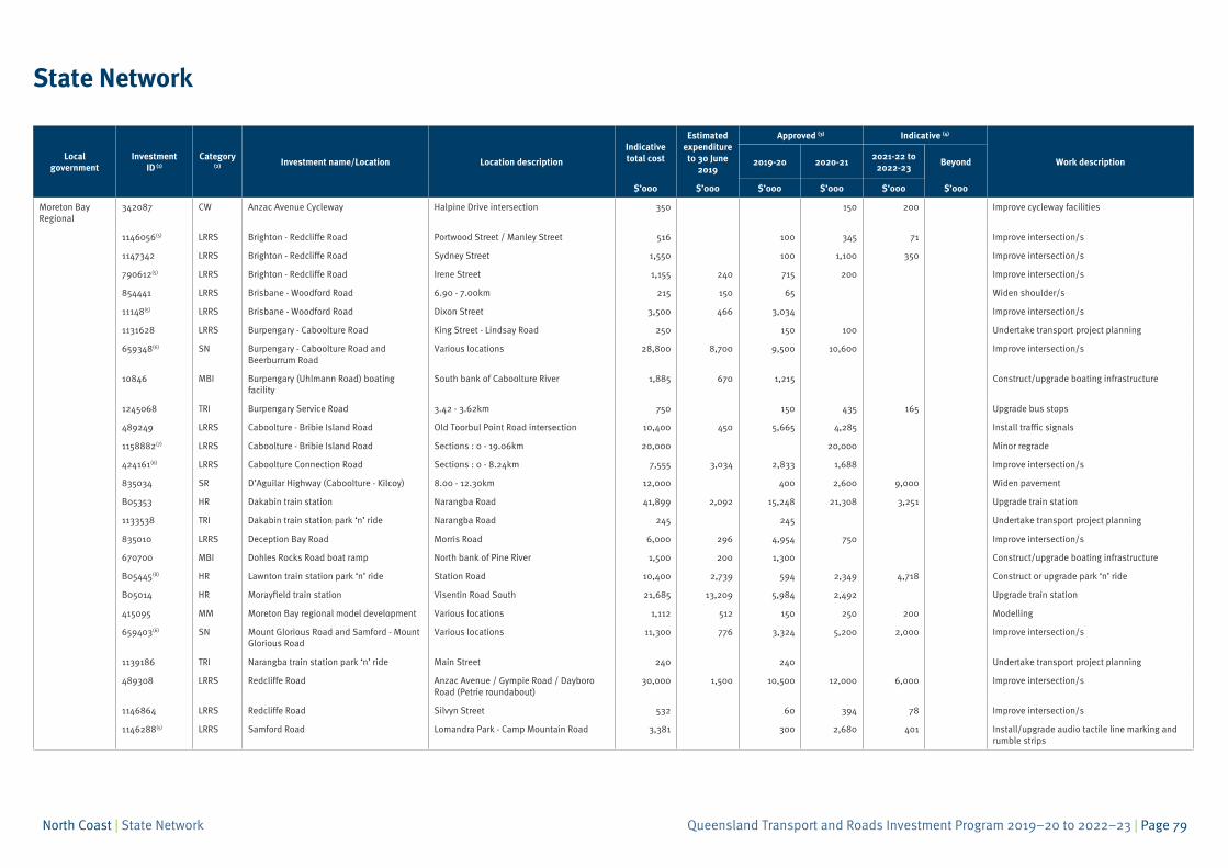
State Network
Local government
InvestmentID (1)
Category (2) Investment name/Location Location description
Indicative total cost
Estimatedexpenditure to 30 June
2019
Approved (3) Indicative (4)
Work description2019-20 2020-212021-22 to
2022-23Beyond
$’000 $’000 $’000 $’000 $’000 $’000
Moreton Bay Regional
342087 CW Anzac Avenue Cycleway Halpine Drive intersection 350 150 200 Improve cycleway facilities
1146056(5) LRRS Brighton - Redcliffe Road Portwood Street / Manley Street 516 100 345 71 Improve intersection/s
1147342 LRRS Brighton - Redcliffe Road Sydney Street 1,550 100 1,100 350 Improve intersection/s
790612(5) LRRS Brighton - Redcliffe Road Irene Street 1,155 240 715 200 Improve intersection/s
854441 LRRS Brisbane - Woodford Road 6.90 - 7.00km 215 150 65 Widen shoulder/s
11148(5) LRRS Brisbane - Woodford Road Dixon Street 3,500 466 3,034 Improve intersection/s
1131628 LRRS Burpengary - Caboolture Road King Street - Lindsay Road 250 150 100 Undertake transport project planning
659348(6) SN Burpengary - Caboolture Road and Beerburrum Road
Various locations 28,800 8,700 9,500 10,600 Improve intersection/s
10846 MBI Burpengary (Uhlmann Road) boating facility
South bank of Caboolture River 1,885 670 1,215 Construct/upgrade boating infrastructure
1245068 TRI Burpengary Service Road 3.42 - 3.62km 750 150 435 165 Upgrade bus stops
489249 LRRS Caboolture - Bribie Island Road Old Toorbul Point Road intersection 10,400 450 5,665 4,285 Install traffic signals
1158882(7) LRRS Caboolture - Bribie Island Road Sections : 0 - 19.06km 20,000 20,000 Minor regrade
424161(6) LRRS Caboolture Connection Road Sections : 0 - 8.24km 7,555 3,034 2,833 1,688 Improve intersection/s
835034 SR D’Aguilar Highway (Caboolture - Kilcoy) 8.00 - 12.30km 12,000 400 2,600 9,000 Widen pavement
B05353 HR Dakabin train station Narangba Road 41,899 2,092 15,248 21,308 3,251 Upgrade train station
1133538 TRI Dakabin train station park ‘n’ ride Narangba Road 245 245 Undertake transport project planning
835010 LRRS Deception Bay Road Morris Road 6,000 296 4,954 750 Improve intersection/s
670700 MBI Dohles Rocks Road boat ramp North bank of Pine River 1,500 200 1,300 Construct/upgrade boating infrastructure
B05445(8) HR Lawnton train station park ‘n’ ride Station Road 10,400 2,739 594 2,349 4,718 Construct or upgrade park ‘n’ ride
B05014 HR Morayfield train station Visentin Road South 21,685 13,209 5,984 2,492 Upgrade train station
415095 MM Moreton Bay regional model development Various locations 1,112 512 150 250 200 Modelling
659403(6) SN Mount Glorious Road and Samford - Mount Glorious Road
Various locations 11,300 776 3,324 5,200 2,000 Improve intersection/s
1139186 TRI Narangba train station park ‘n’ ride Main Street 240 240 Undertake transport project planning
489308 LRRS Redcliffe Road Anzac Avenue / Gympie Road / Dayboro Road (Petrie roundabout)
30,000 1,500 10,500 12,000 6,000 Improve intersection/s
1146864 LRRS Redcliffe Road Silvyn Street 532 60 394 78 Improve intersection/s
1146288(5) LRRS Samford Road Lomandra Park - Camp Mountain Road 3,381 300 2,680 401 Install/upgrade audio tactile line marking and rumble strips
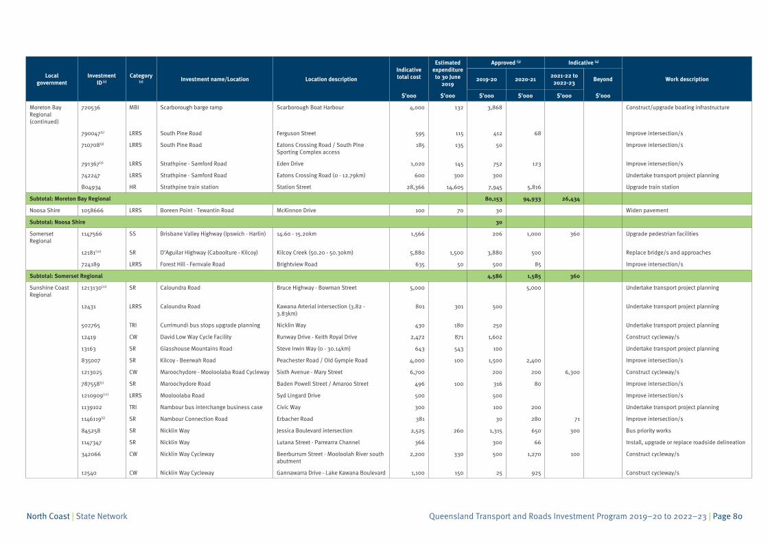
Queensland Transport and Roads Investment Program 2019–20 to 2022–23 | Page 80North Coast | State Network
Local government
InvestmentID (1)
Category (2) Investment name/Location Location description
Indicative total cost
Estimatedexpenditure to 30 June
2019
Approved (3) Indicative (4)
Work description2019-20 2020-212021-22 to
2022-23Beyond
$’000 $’000 $’000 $’000 $’000 $’000
Moreton Bay Regional (continued)
720536 MBI Scarborough barge ramp Scarborough Boat Harbour 4,000 132 3,868 Construct/upgrade boating infrastructure
790047(5) LRRS South Pine Road Ferguson Street 595 115 412 68 Improve intersection/s
710708(9) LRRS South Pine Road Eatons Crossing Road / South Pine Sporting Complex access
185 135 50 Improve intersection/s
791367(5) LRRS Strathpine - Samford Road Eden Drive 1,020 145 752 123 Improve intersection/s
742247 LRRS Strathpine - Samford Road Eatons Crossing Road (0 - 12.79km) 600 300 300 Undertake transport project planning
B04934 HR Strathpine train station Station Street 28,366 14,605 7,945 5,816 Upgrade train station
Subtotal: Moreton Bay Regional 80,153 94,933 26,434
Noosa Shire 1058666 LRRS Boreen Point - Tewantin Road McKinnon Drive 100 70 30 Widen pavement
Subtotal: Noosa Shire 30
Somerset Regional
1147566 SS Brisbane Valley Highway (Ipswich - Harlin) 14.60 - 15.20km 1,566 206 1,000 360 Upgrade pedestrian facilities
12181(10) SR D’Aguilar Highway (Caboolture - Kilcoy) Kilcoy Creek (50.20 - 50.30km) 5,880 1,500 3,880 500 Replace bridge/s and approaches
724189 LRRS Forest Hill - Fernvale Road Brightview Road 635 50 500 85 Improve intersection/s
Subtotal: Somerset Regional 4,586 1,585 360
Sunshine Coast Regional
1213130(11) SR Caloundra Road Bruce Highway - Bowman Street 5,000 5,000 Undertake transport project planning
12431 LRRS Caloundra Road Kawana Arterial intersection (3.82 - 3.83km)
801 301 500 Undertake transport project planning
502765 TRI Currimundi bus stops upgrade planning Nicklin Way 430 180 250 Undertake transport project planning
12419 CW David Low Way Cycle Facility Runway Drive - Keith Royal Drive 2,472 871 1,602 Construct cycleway/s
13163 SR Glasshouse Mountains Road Steve Irwin Way (0 - 30.14km) 643 543 100 Undertake transport project planning
835007 SR Kilcoy - Beerwah Road Peachester Road / Old Gympie Road 4,000 100 1,500 2,400 Improve intersection/s
1213025 CW Maroochydore - Mooloolaba Road Cycleway Sixth Avenue - Mary Street 6,700 200 200 6,300 Construct cycleway/s
787558(5) SR Maroochydore Road Baden Powell Street / Amaroo Street 496 100 316 80 Improve intersection/s
1210909(12) LRRS Mooloolaba Road Syd Lingard Drive 500 500 Improve intersection/s
1139102 TRI Nambour bus interchange business case Civic Way 300 100 200 Undertake transport project planning
1146119(5) SR Nambour Connection Road Erbacher Road 381 30 280 71 Improve intersection/s
845258 SR Nicklin Way Jessica Boulevard intersection 2,525 260 1,315 650 300 Bus priority works
1147347 SR Nicklin Way Lutana Street - Parrearra Channel 366 300 66 Install, upgrade or replace roadside delineation
342066 CW Nicklin Way Cycleway Beerburrum Street - Mooloolah River south abutment
2,200 330 500 1,270 100 Construct cycleway/s
12540 CW Nicklin Way Cycleway Gannawarra Drive - Lake Kawana Boulevard 1,100 150 25 925 Construct cycleway/s
Queensland Transport and Roads Investment Program 2019–20 to 2022–23 | Page 81North Coast | State Network
Local government
InvestmentID (1)
Category (2) Investment name/Location Location description
Indicative total cost
Estimatedexpenditure to 30 June
2019
Approved (3) Indicative (4)
Work description2019-20 2020-212021-22 to
2022-23Beyond
$’000 $’000 $’000 $’000 $’000 $’000
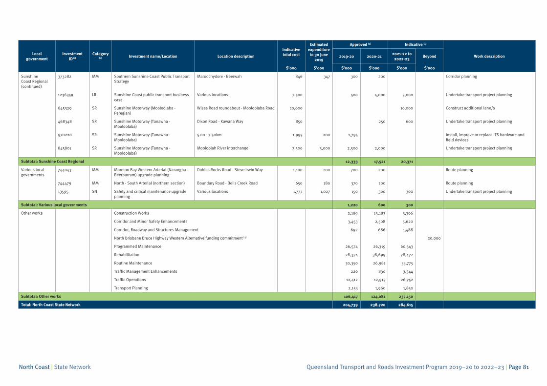
Sunshine Coast Regional (continued)
373282 MM Southern Sunshine Coast Public Transport Strategy
Maroochydore - Beerwah 846 347 300 200 Corridor planning
1236359 LR Sunshine Coast public transport business case
Various locations 7,500 500 4,000 3,000 Undertake transport project planning
845329 SR Sunshine Motorway (Mooloolaba - Peregian)
Wises Road roundabout - Mooloolaba Road 10,000 10,000 Construct additional lane/s
468348 SR Sunshine Motorway (Tanawha - Mooloolaba)
Dixon Road - Kawana Way 850 250 600 Undertake transport project planning
970220 SR Sunshine Motorway (Tanawha - Mooloolaba)
5.00 - 7.50km 1,995 200 1,795 Install, improve or replace ITS hardware and field devices
845801 SR Sunshine Motorway (Tanawha - Mooloolaba)
Mooloolah River interchange 7,500 3,000 2,500 2,000 Undertake transport project planning
Subtotal: Sunshine Coast Regional 12,333 17,521 20,371
Various local governments
744043 MM Moreton Bay Western Arterial (Narangba - Beerburrum) upgrade planning
Dohles Rocks Road - Steve Irwin Way 1,100 200 700 200 Route planning
744479 MM North - South Arterial (northern section) Boundary Road - Bells Creek Road 650 180 370 100 Route planning
13595 SN Safety and critical maintenance upgrade planning
Various locations 1,777 1,027 150 300 300 Undertake transport project planning
Subtotal: Various local governments 1,220 600 300
Other works Construction Works 2,189 13,183 3,306
Corridor and Minor Safety Enhancements 3,453 2,508 5,620
Corridor, Roadway and Structures Management 692 686 1,488
North Brisbane Bruce Highway Western Alternative funding commitment(13) 20,000
Programmed Maintenance 26,574 26,319 60,543
Rehabilitation 28,374 38,699 78,472
Routine Maintenance 30,350 26,981 55,775
Traffic Management Enhancements 220 830 3,344
Traffic Operations 12,412 12,915 26,752
Transport Planning 2,153 1,960 1,850
Subtotal: Other works 106,417 124,081 237,150
Total: North Coast State Network 204,739 238,720 284,615
Queensland Transport and Roads Investment Program 2019–20 to 2022–23 | Page 82North Coast | State Network
Endnotes
(1) For other Queensland Government funded projects, see the ‘Statewide commitments’ section or the relevant district’s ‘National Network’, ‘State Network’ and ‘Local Network’ tables.
(2) BW - Busways; CW - Cycleways; HR - Heavy Rail; HRNN - Heavy Rail National Network; LR - Light Rail; LRRS - Local Roads of Regional Significance; MBI - Maritime Boating Infrastructure;MNA - Maritime Navigational Aids; MM - Multi-modal; NN - National Network; OBI - Other Bus Infrastructure; ORI - Other Rail Infrastructure; SN - State Network; SR - State Regional; SS - StateStrategic; TRI - Transport-related Infrastructure.
(3) In some instances, projects may include limited funding for planning activities. This does not guarantee continued funding for construction.
(4) Allocations for projects scheduled to commence from 2021–22 and beyond are indicative for planning purposes. There may also be funding held at a district level pending works beingprioritised. Priorities may be re-evaluated annually on a needs basis, with some project budgets including an acceptable amount of contingency.
(5) Funded through the Queensland Government’s Safer Roads Sooner Program, as part of the Targeted Road Safety Program.
(6) Funded through the Queensland Government’s High Risk Roads Initiative, as part of the Targeted Road Safety Program.
(7) Represents Australian Government funding commitment as per the 2019–20 Federal Budget outcomes.
(8) Jointly delivered by Queensland Rail and Department of Transport and Main Roads.
(9) This project is fully funded by developer contributions.
(10) Part of the Australian Government’s Heavy Vehicle Safety and Productivity Program, jointly funded by the Australian Government and Queensland Government.
(11) Represents Australian Government’s commitment under Major Project Business Case Fund. Project details, timing and Queensland Government funding contribution subject to negotiationwith the Australian Government, including recognition of prior and existing planning funded by the Queensland Government.
(12) Funding for this project is for pre-construction activities only.
(13) Jointly funded under the Australian Government’s Major Project Business Case Fund.
Queensland Transport and Roads Investment Program 2019–20 to 2022–23 | Page 83North Coast | Local Network
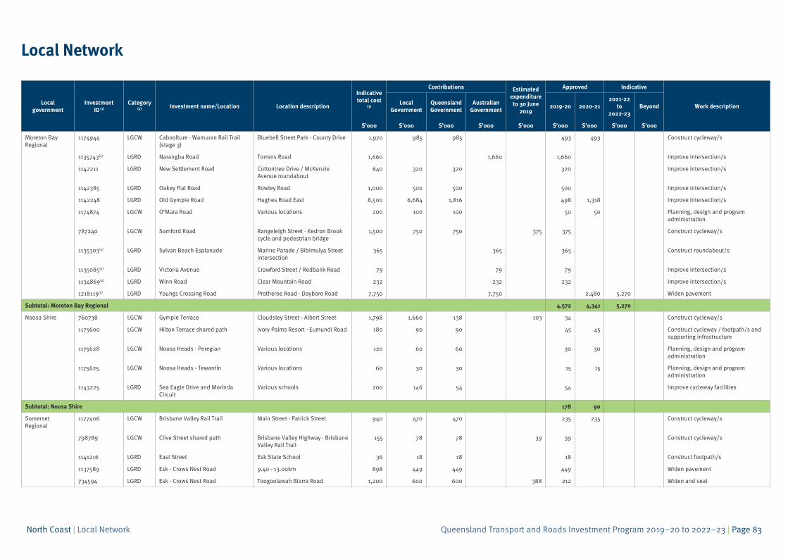
Local Network
Local government
Investment ID (1)
Category (2) Investment name/Location Location description
Indicative total cost
(3)
Contributions Estimatedexpenditure to 30 June
2019
Approved Indicative
Work descriptionLocal
GovernmentQueensland Government
Australian Government
2019-20 2020-212021-22
to 2022-23
Beyond
$’000 $’000 $’000 $’000 $’000 $’000 $’000 $’000 $’000
Moreton Bay Regional
1174944 LGCW Caboolture - Wamuran Rail Trail (stage 3)
Bluebell Street Park - County Drive 1,970 985 985 493 493 Construct cycleway/s
1135743(4) LGRD Narangba Road Torrens Road 1,660 1,660 1,660 Improve intersection/s
1142211 LGRD New Settlement Road Cottontree Drive / McKenzie Avenue roundabout
640 320 320 320 Improve intersection/s
1142385 LGRD Oakey Flat Road Rowley Road 1,000 500 500 500 Improve intersection/s
1142248 LGRD Old Gympie Road Hughes Road East 8,500 6,684 1,816 498 1,318 Improve intersection/s
1174874 LGCW O’Mara Road Various locations 200 100 100 50 50 Planning, design and program administration
787240 LGCW Samford Road Rangeleigh Street - Kedron Brook cycle and pedestrian bridge
1,500 750 750 375 375 Construct cycleway/s
1135303(4) LGRD Sylvan Beach Esplanade Marine Parade / Bibimulya Street intersection
365 365 365 Construct roundabout/s
1135085(4) LGRD Victoria Avenue Crawford Street / Redbank Road 79 79 79 Improve intersection/s
1134869(4) LGRD Winn Road Clear Mountain Road 232 232 232 Improve intersection/s
1218119(5) LGRD Youngs Crossing Road Protheroe Road - Dayboro Road 7,750 7,750 2,480 5,270 Widen pavement
Subtotal: Moreton Bay Regional 4,572 4,341 5,270
Noosa Shire 760738 LGCW Gympie Terrace Cloudsley Street - Albert Street 1,798 1,660 138 103 34 Construct cycleway/s
1175600 LGCW Hilton Terrace shared path Ivory Palms Resort - Eumundi Road 180 90 90 45 45 Construct cycleway / footpath/s and supporting infrastructure
1175628 LGCW Noosa Heads - Peregian Various locations 120 60 60 30 30 Planning, design and program administration
1175625 LGCW Noosa Heads - Tewantin Various locations 60 30 30 15 15 Planning, design and program administration
1143225 LGRD Sea Eagle Drive and Morinda Circuit
Various schools 200 146 54 54 Improve cycleway facilities
Subtotal: Noosa Shire 178 90
Somerset Regional
1177406 LGCW Brisbane Valley Rail Trail Main Street - Patrick Street 940 470 470 235 235 Construct cycleway/s
798789 LGCW Clive Street shared path Brisbane Valley Highway - Brisbane Valley Rail Trail
155 78 78 39 39 Construct cycleway/s
1141216 LGRD East Street Esk State School 36 18 18 18 Construct footpath/s
1137589 LGRD Esk - Crows Nest Road 9.40 - 13.00km 898 449 449 449 Widen pavement
734594 LGRD Esk - Crows Nest Road Toogoolawah Biarra Road 1,200 600 600 388 212 Widen and seal
Queensland Transport and Roads Investment Program 2019–20 to 2022–23 | Page 84North Coast | Local Network
Local government
Investment ID (1)
Category (2) Investment name/Location Location description
Indicative total cost
(3)
Contributions Estimatedexpenditure to 30 June
2019
Approved Indicative
Work descriptionLocal
GovernmentQueensland Government
Australian Government
2019-20 2020-212021-22
to 2022-23
Beyond
$’000 $’000 $’000 $’000 $’000 $’000 $’000 $’000 $’000
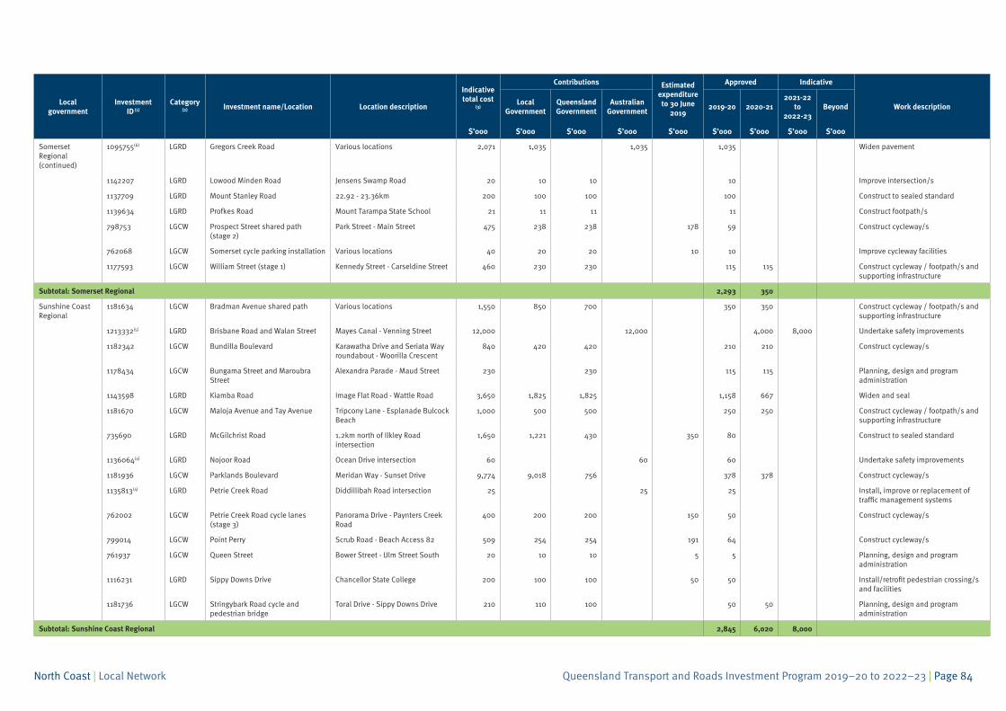
Somerset Regional (continued)
1095755(6) LGRD Gregors Creek Road Various locations 2,071 1,035 1,035 1,035 Widen pavement
1142207 LGRD Lowood Minden Road Jensens Swamp Road 20 10 10 10 Improve intersection/s
1137709 LGRD Mount Stanley Road 22.92 - 23.36km 200 100 100 100 Construct to sealed standard
1139634 LGRD Profkes Road Mount Tarampa State School 21 11 11 11 Construct footpath/s
798753 LGCW Prospect Street shared path (stage 2)
Park Street - Main Street 475 238 238 178 59 Construct cycleway/s
762068 LGCW Somerset cycle parking installation Various locations 40 20 20 10 10 Improve cycleway facilities
1177593 LGCW William Street (stage 1) Kennedy Street - Carseldine Street 460 230 230 115 115 Construct cycleway / footpath/s and supporting infrastructure
Subtotal: Somerset Regional 2,293 350
Sunshine Coast Regional
1181634 LGCW Bradman Avenue shared path Various locations 1,550 850 700 350 350 Construct cycleway / footpath/s and supporting infrastructure
1213332(5) LGRD Brisbane Road and Walan Street Mayes Canal - Venning Street 12,000 12,000 4,000 8,000 Undertake safety improvements
1182342 LGCW Bundilla Boulevard Karawatha Drive and Seriata Way roundabout - Woorilla Crescent
840 420 420 210 210 Construct cycleway/s
1178434 LGCW Bungama Street and Maroubra Street
Alexandra Parade - Maud Street 230 230 115 115 Planning, design and program administration
1143598 LGRD Kiamba Road Image Flat Road - Wattle Road 3,650 1,825 1,825 1,158 667 Widen and seal
1181670 LGCW Maloja Avenue and Tay Avenue Tripcony Lane - Esplanade Bulcock Beach
1,000 500 500 250 250 Construct cycleway / footpath/s and supporting infrastructure
735690 LGRD McGilchrist Road 1.2km north of Ilkley Road intersection
1,650 1,221 430 350 80 Construct to sealed standard
1136064(4) LGRD Nojoor Road Ocean Drive intersection 60 60 60 Undertake safety improvements
1181936 LGCW Parklands Boulevard Meridan Way - Sunset Drive 9,774 9,018 756 378 378 Construct cycleway/s
1135813(4) LGRD Petrie Creek Road Diddillibah Road intersection 25 25 25 Install, improve or replacement of traffic management systems
762002 LGCW Petrie Creek Road cycle lanes (stage 3)
Panorama Drive - Paynters Creek Road
400 200 200 150 50 Construct cycleway/s
799014 LGCW Point Perry Scrub Road - Beach Access 82 509 254 254 191 64 Construct cycleway/s
761937 LGCW Queen Street Bower Street - Ulm Street South 20 10 10 5 5 Planning, design and program administration
1116231 LGRD Sippy Downs Drive Chancellor State College 200 100 100 50 50 Install/retrofit pedestrian crossing/s and facilities
1181736 LGCW Stringybark Road cycle and pedestrian bridge
Toral Drive - Sippy Downs Drive 210 110 100 50 50 Planning, design and program administration
Subtotal: Sunshine Coast Regional 2,845 6,020 8,000
Queensland Transport and Roads Investment Program 2019–20 to 2022–23 | Page 85North Coast | Local Network
Local government
Investment ID (1)
Category (2) Investment name/Location Location description
Indicative total cost
(3)
Contributions Estimatedexpenditure to 30 June
2019
Approved Indicative
Work descriptionLocal
GovernmentQueensland Government
Australian Government
2019-20 2020-212021-22
to 2022-23
Beyond
$’000 $’000 $’000 $’000 $’000 $’000 $’000 $’000 $’000
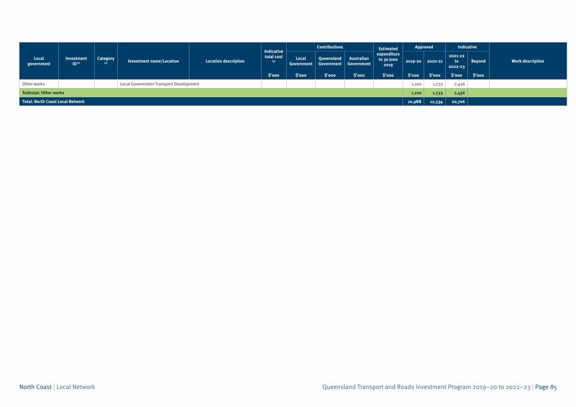
Other works Local Government Transport Development 1,100 1,733 7,436
Subtotal: Other works 1,100 1,733 7,436
Total: North Coast Local Network 10,988 12,534 20,706
Queensland Transport and Roads Investment Program 2019–20 to 2022–23 | Page 86North Coast | Local Network
Endnotes
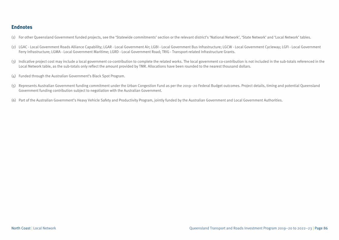
(1) For other Queensland Government funded projects, see the ‘Statewide commitments’ section or the relevant district’s ‘National Network’, ‘State Network’ and ‘Local Network’ tables.
(2) LGAC - Local Government Roads Alliance Capability; LGAR - Local Government Air; LGBI - Local Government Bus Infrastructure; LGCW - Local Government Cycleway; LGFI - Local GovernmentFerry Infrastructure; LGMA - Local Government Maritime; LGRD - Local Government Road; TRIG - Transport-related Infrastructure Grants.
(3) Indicative project cost may include a local government co-contribution to complete the related works. The local government co-contribution is not included in the sub-totals referenced in theLocal Network table, as the sub-totals only reflect the amount provided by TMR. Allocations have been rounded to the nearest thousand dollars.
(4) Funded through the Australian Government’s Black Spot Program.
(5) Represents Australian Government funding commitment under the Urban Congestion Fund as per the 2019–20 Federal Budget outcomes. Project details, timing and potential QueenslandGovernment funding contribution subject to negotiation with the Australian Government.
(6) Part of the Australian Government’s Heavy Vehicle Safety and Productivity Program, jointly funded by the Australian Government and Local Government Authorities.