Embed Size (px)
Citation preview
Evolution of Sedimentary Basins/Offshore Oil and Gas Investigations—Santa Maria Province
Edited by Margaret A. Keller
Bulletin 1995–AA
U.S. Department of the InteriorU.S. Geological Survey
Quaternary Tectonic Setting of South-Central Coastal CaliforniaBy William R. Lettis, Kathryn L. Hanson, Jeffrey R. Unruh,
Marcia McLaren, and William U. Savage
Chapter AA of
U.S. Department of the InteriorGale A. Norton, Secretary
U.S. Geological SurveyCharles G. Groat, Director
Version 1.0, 2004
This publication is available only online at:http://pubs.usgs.gov/bul/1995/aa/
Text edited by James W. Hendley IILayout by Stephen L. ScottManuscript approved for publication, May 10, 2004
Any use of trade, product, or firm names in this publicationis for descriptive purposes only and does not imply endorsement by the U.S. Government
Contents
Abstract ------------------------------------------------------------------------------------------------------ 1Introduction -------------------------------------------------------------------------------------------------- 1
Acknowledgments ------------------------------------------------------------------------------3Regional Plate Tectonic Setting ---------------------------------------------------------------------------3
Rates of Tectonic Deformation ---------------------------------------------------------------- 4Kinematic Domains of South-Central Coastal California -----------------------------------------------5Quaternary Deformation of the Los Osos and Offshore Santa Maria Basin Domains -------------- 6
Quaternary Faults and Folds of South-Central Coastal California ------------------------------- 6Los Osos Domain -------------------------------------------------------------------------------- 9
The San Luis/Pismo Block -------------------------------------------------------------- 10Casmalia Hills Block --------------------------------------------------------------------- 10Seismicity in the Los Osos Domain ---------------------------------------------------- 10
Quaternary Offshore Santa Maria Basin ---------------------------------------------------- 11Seismicity in the Offshore Santa Maria Basin ---------------------------------------- 11
Hosgri-San Simeon Fault Zone --------------------------------------------------------------- 12Kinematic Model for Quaternary Deformation of South-Central Coastal California --------------- 14Conclusions ------------------------------------------------------------------------------------------------- 16References -------------------------------------------------------------------------------------------------- 16
Figures 1. Map of study area showing major kinematic domains --------------------------------------- 2 2. Map showing Quaternary faults, the boundaries of the Los Osos domain from figure 1, and seismicity recorded by the PG&E Central Coast Seismic Network and the U.S. Geological Survey from October 1987 through January 1997 -------------------------------------------------------------------------------------- 7 3. Map showing Quaternary faults and P-wave first-motion focal mechanisms for earthquakes along the south central coastal region from Point Piedras Blancas to Point Arguello ---------------------------------------------------------------------------------- 8 4. Kinematic model showing combined late Cenozoic clockwise rotation of the western Transverse Ranges domain and distributed deformation within the Los Osos domain -------------------------------------------------------------------------------- 13
Table Modified San Andreas discrepancy estimates ------------------------------------------------ 5
Plate[In pocket]
1. Faults and Folds in the onshore and offshore regions of south-central California (scale 1:25,000)
III
1
AbstractRecent geodetic, geologic, and seismologic studies show
that the south-central coast of California is a region of active Quaternary deformation. Northeast-directed crustal shortening is occurring in a triangular-shaped region between the Hosgri-San Simeon fault system on the west, the Southern Coast Ranges on the northeast, and the western Transverse Ranges on the south. We informally call this region the Los Osos domain. In this study, we conducted detailed geological, seismologi-cal, and geophysical investigations to characterize the nature and rates of deformation in the domain. Locations of active and potentially active faults and folds are compiled at a scale of 1:250,000 for the entire domain based primarily on onshore geologic data and offshore geophysical data. Crustal shortening in the domain is accommodated by a series of prominent north-west-trending reverse faults and localized folding. The reverse faults separate distinct structural blocks that have little or no internal deformation. Hangingwall blocks are being uplifted at rates of up to 0.2 mm/yr. Footwall blocks are either static or slowly subsiding at rates of 0.1 mm/yr or less, except for local-ized areas of concentrated subsidence directly adjacent to some faults. The cumulative rate of crustal shortening is about 1 to 2 mm/yr across the northern part of the domain based on observed geologic deformation. Cumulative shortening across the central and southern parts of the domain is poorly constrained by geo-logic data and may approach 2 to 3 mm/yr.
Historical and instrumental seismicity generally are spa-tially associated with the uplifted blocks and bordering reverse faults to depths of about 10 km. Together with near-surface geological data and deeper crustal geophysical imaging that show high-angle faulting, the seismicity data indicate that the reverse faults probably extend to the base of the seismogenic crust. The base of the seismogenic crust may correspond with a mid-crustal detachment or decollement surface into which the reverse faults root. We speculate that the detachment may coin-cide, in part, with the top of a northeast-dipping slab of oceanic crust that extends beneath the western margin of the continent or with the brittle-ductile transition above the subducted slab.
The Los Osos domain of north-northeast/south-southwest crustal shortening is structurally detached from the offshore
Santa Maria Basin by the high-angle dextral San Simeon and Hosgri Fault Zones. Both the pattern and regional extent of deformation in the Los Osos domain contrast sharply with that of the offshore Santa Maria Basin. The basin is undergoing minor east-northeast/west-southwest crustal shortening at rates of less than 0.1 mm/yr and is moving northwestward at a rate of about 1 to 3 mm/yr relative to the Los Osos domain along the San Simeon and Hosgri Fault Zones. Geodetic data and the kinematics of north-northeast-directed crustal shortening of the Los Osos domain east of the Hosgri Fault Zone show that the rate and cumulative amount of right-slip along the Hosgri Fault Zone progressively decrease southward.
Quaternary deformation within the Los Osos domain is related to distributed dextral simple shear associated with Pacific-North American plate motion. Paleomagnetic data show that clockwise rotation of the western Transverse Ranges has occurred along the southern boundary of the domain during the past 6 m.y. During this time, the Salinian crustal block, which forms the eastern boundary of the Los Osos domain, has remained relatively stable. Internal shortening of the Los Osos domain has accommodated the relative motions of these border-ing crustal blocks, particularly the rotation of the western Trans-verse Ranges.
IntroductionIn recent years, considerable research has been conducted
to assess the Quaternary tectonic setting of south-central coastal California (see for example, Cluff and others, 1994). These studies generally focused on three topics—(1) understanding the tectonic setting of the offshore and onshore Santa Maria Basin and bordering areas, including studies of specific faults and the style of regional deformation within the basin, (2) evaluat-ing the rate and style of faulting along the Hosgri-San Simeon fault system to assess its role in accommodating strain along the Pacific-North American plate margin, and (3) evaluating the distribution and nature of seismicity in the region, including an evaluation of the location, size, and mechanism of the 1927 Lompoc, California, earthquake.
Interest in the Quaternary tectonics of south-central coastal California resulted, in part, from several concurrent activities—(1) intensive offshore exploration by the petroleum industry, (2) regional investigations of earthquake hazards performed as part of the Pacific Gas and Electric Company’s (PG&E) Long Term Seismic Program for the Diablo Canyon Power Plant (see
QUATERNARY TECTONIC SETTING OF SOUTH- CENTRAL COASTAL CALIFORNIABy W. R. Lettis1, K. L. Hanson2, J. R. Unruh1, M. McLaren3, and W. U. Savage3
1William Lettis & Associates, Inc., Walnut Creek, CA 94596.
2Geomatrix Consultants, Inc., San Francisco, CA 94111. 3Pacific Gas and Electric Company, San Francisco, CA 94177.
Introduction
2 Quaternary Tectonic Setting of South–Central Coastal California
LOS OSOS DOMAIN
OFFSHORE SANTA MARIA
DOMAIN
C
L
S
M
Jolon FaultSan Simeon Fault
Nacimiento Fault
Rinconada Fault
La Panza Fault
Juan
San
Fault
Syncline
Anticline
Fault, dashed where uncertain
Explanation
V
A
P H
Point Piedras
Blancas
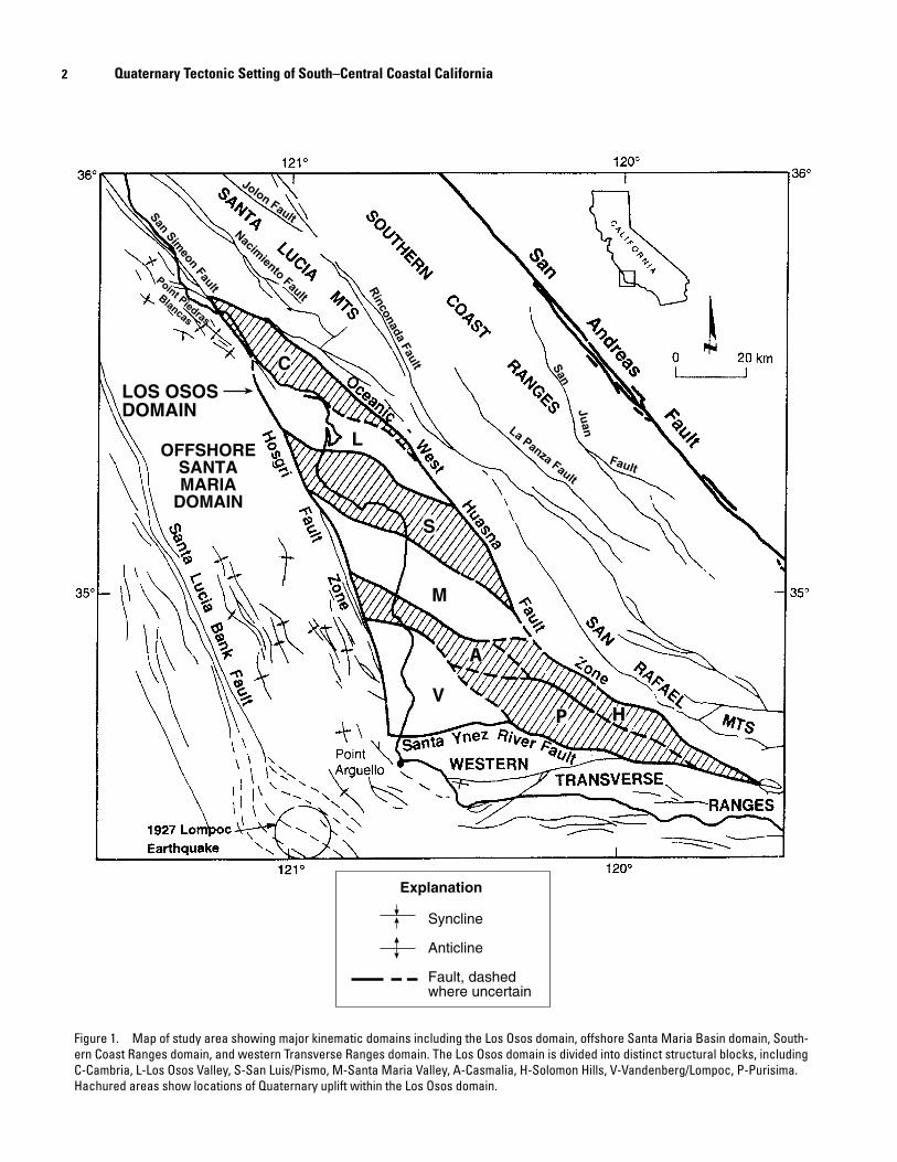
Figure 1. Map of study area showing major kinematic domains including the Los Osos domain, offshore Santa Maria Basin domain, South-ern Coast Ranges domain, and western Transverse Ranges domain. The Los Osos domain is divided into distinct structural blocks, including C-Cambria, L-Los Osos Valley, S-San Luis/Pismo, M-Santa Maria Valley, A-Casmalia, H-Solomon Hills, V-Vandenberg/Lompoc, P-Purisima. Hachured areas show locations of Quaternary uplift within the Los Osos domain.
3
for example, PG&E, 1988), (3) the acquisition and interpreta-tion of new geophysical data to assess deep crustal structure along the continental margin as part of the EDGE program (see for example, Trehu, 1991; Miller and others, 1992; Henrys and others, 1993; Howie and others, 1993), (4) com-pletion of numerous graduate student theses on the geology, geophysics and tectonics of selected areas in the region (see for example, Matz, 1987; Putzig, 1988; Killeen, 1988; Clark, 1990; Howie, 1991; Miller, 1991; Steritz, 1986; Nitchman and Slemmons, 1994; Sorlien and others, 1999), and (5) study of the Santa Maria Province by the U.S. Geological Survey.
These investigations provide important data on the loca-tions and character of late Quaternary folding and faulting in the region. In this paper, we synthesize these data to develop a comprehensive model of known and suspected Quaternary active faults and folds in the area and discuss the implications of the observed deformation for accommodating regional and local crustal strain along the Pacific-North American plate margin. Our study region is centered on the onshore Santa Maria Basin along the coast of south-central California (fig. 1). The region extends from Point Piedras Blancas on the north to Point Arguello on the south. The western and eastern mar-gins of the study region are the Santa Lucia Bank Fault and the Oceanic-West Huasna Fault Zone, respectively. As part of this synthesis, we compiled a 1:250,000 scale map showing the distribution of all known Quaternary active faults and folds in the region (plate 1).
In preparing this paper, we draw heavily upon our per-sonal knowledge of the region resulting from our participa-tion in PG&E’s Long-Term Seismic Program for the Diablo Canyon Power Plant. In addition, our interpretations incorpo-rate the results from several recently published investigations, including (1) detailed mapping of marine terraces along the California coast from San Simeon Point on the north to the Casmalia Hills on the south (Hanson and others, 1992, 1994; Clark and others, 1994); (2) detailed mapping, drilling, and trenching of fluvial, marine, and colluvial deposits at selected sites along several fault zones (Lettis and Hanson, 1992; Lettis and Hall, 1994; Hall and others, 1994); (3) analysis of several hundred borehole and water well records from the Los Osos Valley, Morro Bay, and Santa Maria Valley (Hanson and others, 1994; Lettis and Hall, 1994); (4) regional recon-naissance and interpretation of aerial photography in the southern and eastern Los Osos domain; and (5) the acquisition and interpretation of seismic reflection data within the Santa Maria Valley and bordering areas (PG&E, 1988). Offshore investigations included (1) analysis of near-shore bathymetry (2) acquisition and interpretation of high-resolution shallow seismic reflection, side-scan sonar, and deep-penetration (2 to 4 second) common-depth-point seismic reflection data, and (3) offshore sea-bottom sampling (Richard Willingham, 2003, written commun.) and, in part, are summarized in Sedlock and Hamilton (1991) and Clark and others (1991). In addi-tion, instrumental seismicity data were acquired from a dense network of seismographs in the region, including networks operated by the U.S. Geological Survey (USGS), California
Institute of Technology, and PG&E (McLaren and Savage, 2001). Information on deep crustal structure was obtained by the EDGE program, which involved the acquisition and inter-pretation of deep-crustal seismic reflection and refraction data by a consortium of industry and research institutions (Meltzer, 1988; 1991; Trehu, 1991; McIntosh and others, 1991; Miller and others, 1992; Henrys and others, 1993; Howie and others, 1993).
AcknowledgmentsWe thank PG&E for permission to publish the extensive
data collected during the Long-Term Seismic Program for the Diablo Canyon Power Plant. Support for preparing this paper was provided by PG&E and the Professional Development funds of William Lettis & Associates, Inc., and Geomatrix Consultants and is gratefully acknowledged.
This study could not have been completed without the support of numerous individuals: John Wesling participated in the mapping of marine terraces; Doug Clark, Tim Hall, Frank Bickner, and Pat Vaughn participated on the mapping and paleoseismic investigation of the San Simeon and Los Osos Fault Zones; Jan Reitman, Dick Willingham, Jerry Shiller, and Laurel DeSilvestro provided interpretations of offshore seismic reflection data; Lloyd Cluff, Kevin Coppersmith, and Doug Hamilton provided important ideas and encouragement throughout the study; and Burt Slemmons, Clarence Allen, and Bruce Bolt provided technical review and guidance at vari-ous stages of the study. The manuscript benefited greatly from technical reviews by Carl Wentworth and Burt Slemmons. We especially thank Margaret Keller for her technical review, encouragement, advice, and dedication for seeing the manu-script completed.
Regional Plate Tectonic SettingDeformation within south-central coastal California ulti-
mately is driven by distributed dextral shear arising from rela-tive motion between the Pacific and North American Plates. The plate boundary is a broad, heterogeneous zone of right-lat-eral strike-slip faulting centered along the San Andreas Fault (see for example, Atwater, 1970; Crowell, 1962; Wilson, 1965; Dickinson and Snyder, 1979) and extending in width from the western Great Basin to the Continental Slope (McCulloch, 1987). Within this broad region of distributed deformation, movement of large crustal blocks, such as rotation of the west-ern Transverse Ranges, has influenced the local pattern and style of deformation.
Cenozoic evolution of the plate boundary along the south-central California coast is summarized by Sedlock and Ham-ilton (1991). Transform motion between the Pacific and North American Plates was established sometime between 29 Ma (Atwater and Molnar, 1973) and 17 Ma (Graham, 1978), at which time it replaced orthogonal or oblique subduction along
Regional Plate Tectonic Setting
4 Quaternary Tectonic Setting of South–Central Coastal California
the plate margin (Atwater, 1970; Nicholson and others, 1994). Development of the transform plate margin involved a com-plex break-up of the subducting slab, including the creation of several microplates at the latitude of south-central California (Lonsdale, 1991). The study region is located within the for-merly overriding plate that is now coupled to the Pacific Plate as transcurrent motion became localized to the east along the San Andreas Fault.
The transform plate margin evolved from a transtensional boundary to a transpressional boundary during the late Pliocene and Quaternary. Transtensional and (or) extensional deforma-tion during the Miocene produced large, fault-bounded basins along the Continental Shelf (McCulloch, 1987; Crouch and Suppe, 1993) and in the southern Coast Ranges (Hall, 1981a). Crouch and Suppe (1993) suggest that crustal extension at this time involved the development of low-angle detachment faults and rift basins. Structures developed during this time produced a persistent structural grain that, in part, controlled the loca-tion and pattern of later Pliocene and Quaternary deformation. Transpressional deformation along the plate boundary began during the Pliocene and produced rapid uplift of the southern Coast Ranges (Page, 1981), folding and thrust faulting along the margin of the Pacific Plate throughout the Santa Maria Basin area (see for example, Namson and Davis, 1990; Page and Brocher, 1993), and tectonic inversion of Miocene basins by reactivation of earlier normal- or oblique-slip faults as reverse faults (PG&E, 1988; Smith and Angell, 1990; Clark and others, 1991; Meltzer and Levander, 1991). The “Queenie structure” in the interior of the offshore Santa Maria Basin and the Pismo Sycline in the interior of the San Luis Range are examples of Miocene basins that were uplifted and folded following the change to transpressional deformation along the plate boundary (see for example, Clark and others, 1991).
The onset of transpression during the Pliocene prob-ably resulted from (1) a change in the azimuth of Pacific Plate motion to a more northerly direction relative to the North Amer-ican Plate (Cox and Engebretson, 1985; Page and Engebretson, 1985; Zoback and others, 1987) from approximately 3.9 to 3.4 Ma (Harbert and Cox, 1989), (2) development of the indepen-dent Sierra Nevada Central-Valley (Sierran) microplate during the Pliocene (Argus and Gordon, 1991), (3) westward displace-ment of the Sierran microplate as a result of Basin and Range extension (Wright, 1976), and (or) (4) opening of the Gulf of California around 5 Ma and the resultant change in the rate and distribution of slip along faults of the San Andreas Fault system (Crowell, 1987).
Rates of Tectonic DeformationRates of deformation in south-central California gener-
ally are deduced from three types of information—(1) plate motion data, (2) geologic data (observed and modeled), and (3) geodetic data. The modern motion between the Pacific and North American (Sierran) Plates is estimated by the NUVEL-1 plate-motion model to be 48 ± 2 mm/yr, directed towards an azimuth of N35°W ± 2°, at latitude 36° (DeMets and others,
1987, 1990; Gordon and others, 1987). This predicted motion is approximately 6 to 8 mm/yr slower than, but in the same gen-eral direction as, that predicted by the RM2 model of Minster and Jordan (1978). More recently, Harbert (1991) suggested that since 2.7 Ma the azimuth of plate motion is N28.5°W. The NUVEL-1 plate motion rate has been further reduced by an additional 2 mm/yr using recent revisions to the paleomagnetic time scale (Feigl and others, 1990).
Estimates of relative motion between the Pacific and North American (Sierran) Plates based on geologic observations typically are less than those calculated by these plate motion models. Geologic and geodetic studies show that the San Andreas Fault accommodates 32 to 35 mm/yr of the motion between the North American (Sierran) and Pacific Plates, in a direction N41°W (Sieh and Jahns, 1984; Kroger and others, 1987; Jordan and Minster, 1988; Shen and Jackson, 1993). The difference in velocity between the plate motion rate and San Andreas Fault rate has been called the “San Andreas discrep-ancy” (Minster and Jordan, 1984). This discrepancy is accom-modated, in part, by extension and right shear in the Basin and Range province. Very long baseline interferometry (VLBI) data and Global Positioning System (GPS) data show that the Sierra Nevada-Central Valley microplate is moving about 12 to14 mm/yr toward the northwest relative to stable North America (Argus and Gordon, 1991; Dixon and others, 2000; Argus and Gordon, 2001). The combined displacement of the San Andreas Fault and extension of the Basin and Range, however, do not accommodate the total amount of relative plate motion predicted by some of the plate motion models described above. This difference is referred to as the “modified San Andreas dis-crepancy” (Argus and Gordon, 1991; Feigl and others, 1990).
Estimates of the magnitude of the modified San Andreas discrepancy, which can be decomposed into a component of translation parallel to the Pacific-North American (Sierran) plate margin and a component of shortening normal to the plate margin, have changed with the improvement in GPS and VLBI geodetic data. A summary of these recent geodetic studies is provided by Gordon (1991) and Feigl and others (1990). As shown on table 1, estimated rates of the decomposed modified San Andreas discrepancy parallel to and normal to the plate margin in the region west of the San Andreas Fault have been considerably reduced from initial estimates in the late 1970’s. Ward (1990), Argus and Gordon (1991), Feigl and others (1990), and Shen and Jackson (1993), for example, conclude that the component of deformation perpendicular to the San Andreas Fault is several times smaller than previously thought. These studies show that the rate of deformation occurring west of the San Andreas Fault in south-central California is about 4-5 mm/yr dextral shear parallel to the fault and about 2 mm/yr shortening perpendicular to the fault.
The fault-parallel component of the modified San Andreas discrepancy is reduced significantly if dextral slip on the Hosgri-San Simeon fault system is 1 to 3 mm/yr (Hanson and others, this volume; Hanson and Lettis, 1994). The remaining 1 to 4 mm/yr may be distributed among other major north-west-trending strike-slip and oblique-slip faults within the
5
California continental margin, including the Santa Lucia Bank, West Huasna, Nacimiento, and Rinconada Faults. The more recent analysis of VLBI and GPS data by Argus and Gordon (1990; 1991) and Feigl and others (1990) allow for, but do not require, up to 3 mm/yr of dextral slip on faults in offshore coastal central California such as the Hosgri-San Simeon Fault Zone. Alternatively, Ward (1990) concludes, on the basis of analysis of VLBI data, that there is no San Andreas discrep-ancy west of a point at 36°N, 120.6°W, although a few mm/yr of dextral strike-slip on offshore faults cannot be precluded. Sedlock and Hamilton (1991) also show that the displacement vector based on an integrated geologic deformation rate along a path that crosses the plate margin at approximately the same latitude and assumes a slip rate of 1 mm/yr on the Hosgri Fault is not significantly different than the relative plate motion determined using the NUVEL-1 model.
The northeast-directed contractional component of the modified San Andreas discrepancy is more difficult to resolve. Some workers have proposed that the southern Coast Ranges and Santa Maria Basin are contracting at a rate of 6 ± 2 mm/yr (Feigl and others, 1990) and that the shortening is accommo-dated by a detached fold-and-thrust belt (Namson and Davis, 1990). More recent GPS and VLBI data show that the rate of shortening normal to the San Andreas Fault in the Santa Maria Basin region is about 2 mm/yr or less (Ward, 1990; Argus and Gordon, 1991; Feigl and others, 1993) (table 1). Using available data on fault slip rates from this study, the cumulative rate of convergence across the Santa Maria Basin is about 2 ± 1 mm/yr.
Kinematic Domains of South-Central Coastal California
The south-central coastal region of California can be divided into several distinct kinematic domains based on dif-fering patterns and styles of Quaternary deformation (see for example, Sedlock and Hamilton, 1991; Clark and others, 1994). In this paper, we define these domains as the Los Osos, offshore Santa Maria Basin, western Transverse Ranges, and southern Coast Ranges domains (fig. 1). The domains are sepa-rated by active strike-slip or reverse-slip faults: the Hosgri-San Simeon fault system separates the Los Osos and offshore Santa Maria Basin domains (Hanson and others, this volume), the Santa Ynez and inferred Santa Ynez River Faults separate the Los Osos and western Transverse Ranges domains, and the Oceanic-West Huasna fault system separates the Los Osos and southern Coast Ranges domains (fig. 1; plate 1).
The Los Osos domain is a triangular region that lies between the offshore Santa Maria Basin on the west, the west-ern Transverse Ranges domain on the south, and the Santa Lucia and San Rafael Ranges of the southern Coast Ranges domain on the northeast (fig. 1; plate 1). The domain consists of a series of west-northwest-trending topographic lowlands and uplands, the most prominent of which are the Los Osos, Santa Maria, and Vandenberg-Lompoc Valleys and the Cam-bria, San Luis/Pismo, Casmalia, Solomon, and Purisima Hills. Near-surface bedrock platforms occur offshore along the
Kinematic Domains of South-Central Coastal California
Reference NW-directed dextral component
NE-directed contractional component
Minster and Jordan (1978; 1984) 6 – 25 mm/yr 4 – 13 mm/yr
Minster and Jordan (1987; RM2 Model)
13 ± 5 mm/yr 9 ± 3 mm/yr
Jordan and Minster (1988) ~ 6 mm/yr ~ 8 mm/yr
DeMets and others (1990) 4 mm/yr 7 mm/yr
Feigl and others (1990) 3 ± 1 mm/yr 6 ± 2 mm/yr
Ward (1990, Vm2 model) ~0 ~0
Argus and Gordon (1991) 5 ± 5 mm/yr 2 ± 3 mm/yr
Feigl and others (1993) 4 ± 2 mm/yr 2 ± 1 mm/yr
Shen and Jackson (1993) 0 - 4 mm/yr ~0
Table 1. Modified San Andreas discrepancy estimates

6 Quaternary Tectonic Setting of South–Central Coastal California
projections of the San Luis Range and Casmalia Hills, and sediment-filled basins occur along the projections of the Santa Maria and Los Osos Valleys (plate 1). In general, topographic uplands within the domain coincide with uplifting structural blocks, and the lowlands coincide with subsiding, tilting, or static structural blocks (Lettis and Hanson, 1992). In the off-shore region to the west, geophysical data indicate that the geomorphic character of the province continues out to, but not across, the Hosgri Fault Zone (Miller, 1991; Richard Willing-ham, 2003, written commun.).
The offshore Santa Maria Basin is characterized by regional subsidence, scattered faults, and broad, long-wave-length late Cenozoic folds that trend north-northwest, sub-parallel to the Hosgri and San Simeon Fault Zones (plate 1; McCulloch, 1987; Clark and others, 1991). These faults and associated folds are most prevalent in the southern portion of the basin (south of Point Sal) and include the Queenie, Lompoc, and Purisima structures. For convenience, we refer to this part of the offshore Santa Maria Basin as the southern sub-basin. In addition, a wide zone of folding and faulting locally deforms the northeastern margin of the basin. We refer to this zone as the Piedras Blancas anticlinorium (fig. 1, plate 1).
The western Transverse Ranges form the southern bound-ary of the study region. The ranges generally trend east-west and include the Santa Ynez and Topotopa Mountains. Qua-ternary north-directed crustal shortening is accommodated by folding and thrust faulting (Yeats, 1981, 1983; Rockwell and others, 1984, 1988; Rockwell, 1988; Namson and Davis, 1990). Paleomagnetic studies of Miocene volcanic and sedi-mentary rocks show that the western Transverse Ranges have rotated clockwise a total of approximately 90° as a rigid block (Luyendyk and others, 1985; Hornafius, 1985; Hornafius and others, 1986; Liddicoat, 1990; Luyendyk, 1991). Approxi-mately 55° of this rotation occurred between 17 and 11 Ma, and the remainder has occurred since 6 Ma (Hornafius, 1985; Hornafius and others, 1986).
The southern Coast Ranges domain forms the eastern boundary of the study region. Major faults in this domain include the West Huasna and Oceanic Faults along the south-western margin of the ranges and the Nacimiento, Rinconada, East Huasna, La Panza, and Jolon Faults within the ranges (plate 1). Aside from regional late Cenozoic uplift accommodated primarily by reverse displacement on the Oceanic-West Huasna fault system, the southern Coast Ranges appear to have acted largely as a rigid, relatively undeformed block since approxi-mately 50 Ma (Sedlock and Hamilton, 1991). The Nacimento Fault appears to be an inactive fault that juxtaposes the Creta-ceous Great Valley sequence against the Franciscan Complex. Cumulative dextral shear within this domain since the early Miocene appears to have been 50 km or less, and the majority of strike slip appears to have been accommodated by the Rinco-nada Fault along the eastern margin of the domain (Sedlock and Hamilton, 1991). Geomorphic and geologic evidence for Pliocene and younger slip on the Rinconada Fault is cited by Dibblee (1976) and PG&E (1988), with geomorphic evidence of late Quaternary slip decreasing northward along the fault.
Shen and Jackson (1993) summarize available geodetic data across the Rinconada Fault (Sauber and others, 1989; Harris and Segall, 1987; Sung and Jackson, 1988) and conclude that con-temporary slip on the fault probably is insignificant. Scattered microseismicity occurs between the Nacimiento and Oceanic Faults (fig. 2). These events have primarily reverse focal mecha-nisms on northwest-striking nodal planes (fig. 3), showing that the area is undergoing northeast-southwest oriented crustal shortening. We infer that this crustal shortening is produced by (1) a left-restraining transfer of dextral shear between the Rinconada and (or) San Andreas Faults to the south and the San Simeon-San Gregorio fault system to the north, (2) a left restraining bend along the Hosgri-San Simeon-San Gregorio fault system centered on the San Simeon Fault, and (or) (3) northeast-directed convergence of the Los Osos domain against the relatively stationary Salinian block to the northeast.
The Los Osos and offshore Santa Maria Basin domains are structurally and physiographically separated by the Hosgri-San Simeon fault system. This fault system includes the San Simeon Fault Zone north of the latitude of Point Estero and the Hosgri Fault Zone south of Point Estero (fig. 1; plate 1). The two fault zones are kinematically and structurally linked by the Hosgri-San Simeon pull-apart basin, a subsiding Quaternary basin located within a right en-echelon stepover between the two faults (DiSilvestro and others, 1990; Hanson and others, this volume).
Quaternary Deformation of the Los Osos and Offshore Santa Maria Basin Domains
The principal focus of this paper is to define and docu-ment the style of Quaternary deformation within and between the Los Osos and offshore Santa Maria Basin domains. The major Quaternary faults and folds in these domains are compiled at a scale of 1:250,000 on plate 1. The following sections describe the fault compilation shown on plate 1 and summarize evidence for the style and kinematics of defor-mation within the Los Osos and offshore Santa Maria Basin domains.
Quaternary Faults and Folds of South-Central Coastal California
Plate 1 presents a compilation of known late Cenozoic faults and folds in south-central coastal California. The compilation is based on a review of available literature and original geological and geophysical mapping. Sources used in preparing the compilation are listed on plate 1.
Different techniques and age criteria were used to iden-tify and map structures in the onshore and offshore regions. Onshore, faults and folds were identified primarily on the
7
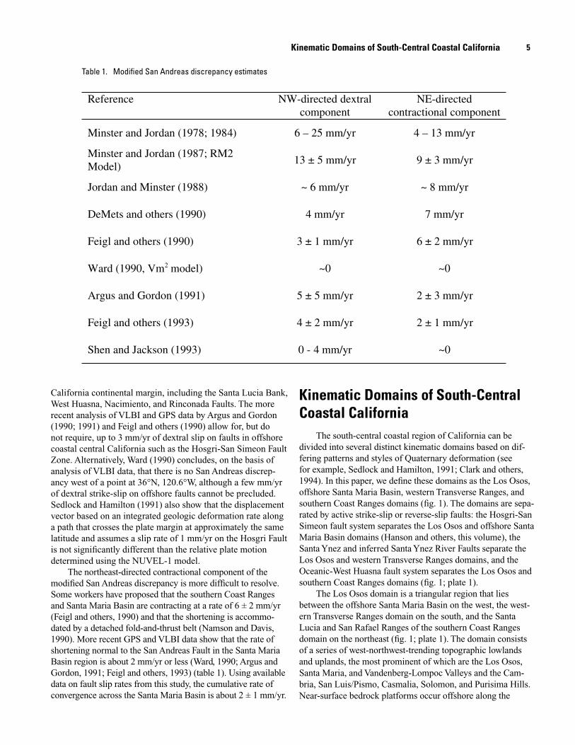
basis of geologic mapping at scales of 1:24,000, 1:12,000 and 1:6,000, supplemented by seismic reflection and borehole data. Faults are shown as active or inactive if they deform or do not deform, respectively, surficial deposits or geomorphic surfaces that are 500,000 years old or younger. Late Qua-
ternary marine terraces, fluvial terraces, and alluvial fans were the primary units used to assess fault activity. Faults that deform Pliocene or early Quaternary strata, but do not demonstrably deform late Quaternary deposits, are shown as potentially active. For faults compiled from other sources, we
Figure 2. Map showing Quaternary faults, the boundaries of the Los Osos domain from figure 1, and seismicity recorded by the PG&E Central Coast Seismic Network and the U.S. Geological Survey from October 1987 through January 1997 (from McLaren and Savage, 2001). The magnitude threshold for onshore and near offshore events (to about 10 km offshore) is about 1.0, whereas for farther offshore areas and near the north and south ends of the network coverage, it is about magni-tude 1.8. Horizontal and depth uncertainties for onshore and near offshore events is generally less than one kilometer and 1 to about 5 km for far offshore events. Seismicity patterns show that most of the earthquakes are occurring in three areas—(1) north of Point San Luis between the northwest-trending faults of the Nacimiento and West Huasna Faults to the northeast and the San Simeon and the Hosgri Fault Zones to the southwest (2) near Point Sal within the Casmalia block bounded by the Casmalia and Lions Head Faults east of the Hosgri Fault Zone and (3) the southern offshore Santa Maria Basin area west of the Hosgri Fault Zone. A small cluster of seismicity also occurs offshore north of Point Piedras Blancas associated with the Piedras Blancas anticlinorium. Notable quiescent areas are the central and northern offshore Santa Maria Basin, and the onshore Santa Maria Valley.
Quaternary Deformation of the Los Osos and Offshore Santa Maria Basin Domains
Data limit
50ʼ 30ʼ 121° 120°30ʼ
30ʼ
36°
35°
30ʼ
Continental
Slope
0 20 km
Oceano Fault
Cambr ia Fault
Oceanic -
West
FaultSanta Lucia
Zone
Bank Fault
Zone
Huasna
San Simeon F ault Zone
Wilmar A venue Fault
San Andreas Fault Z one
Fault
Santa Ynez Riv er Fault Zone
Nacimiento
Hosgri Fault Zone
Queenie
San Simeon/Hosgri stepover
Border of Los Osos domain and uplifted faultblocks
Fault
Fault
Zone
Los Osos
Explanation
Casmalia Fault
Lions Head
8 Quaternary Tectonic Setting of South–Central Coastal California
Los Osos Fault Zone
Oceano Fault
Oceanic
West
Fault
Santa Lucia
Zone
Bank Fault
Zone
Huasna
San Simeon Fault Zone
Wilmar Avenue Fault
San Andreas Fault Zone
SW Boundary Fault Zone
Casmalia Fault Zone
Hosgri Fault Zone
Purisima Structure
Queenie Lompoc Structure
���������
Point
Rinconda Fault
Nacimiento
ZoneCambria Fault
Lion's Head Fault
Santa Ynez River Fault Zone
Structure
Continental Slope
San Simeon/Hosgri stepover
Fault
50ʼ 30ʼ 121� 120�30ʼ
30ʼ
36�
35�
30ʼ
0 20 km
���������
��
��
��
��
May 29, 1980
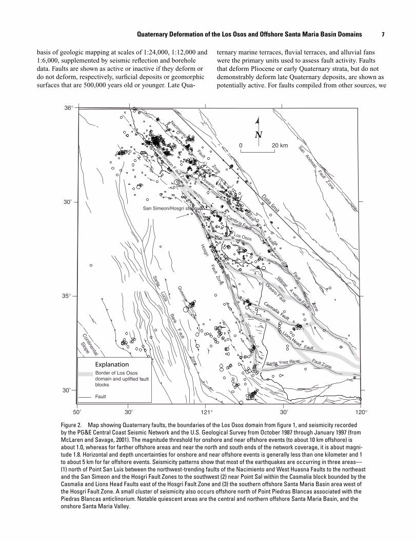
Figure 3. Map showing Quaternary faults and P-wave first-motion focal mechanisms from McLaren and Savage, 2001, (minimum, 20 first motions) from earthquakes along the south central coastal region from Point Piedras Blancas to Point Arguello. Focal mechanisms show (1) predominantly reverse and oblique-reverse motion between the Nacimiento and the San Simeon Fault Zones, (2) a mixture of strike slip, reverse, and oblique motion between the West Huasna-Oceanic and Hosgri Fault Zones, (3) strike slip motion along the northern Hosgri Fault Zone, and (4) reverse motion near the Casmalia Fault Zone and southwest of the Hosgri Fault Zone in the offshore Santa Maria Basin region.
9
adopted the interpretation of fault activity from that source using the 500,000 year criteria above or, if fault activity was not specified in the source, we judged faults to be potentially active if they deform Quaternary strata. Although abundant microseismicity occurs within the region (fig. 2), a confident association of seismicity to a specific onshore fault is not pos-sible. The Nacimiento Fault, for example, appears to be an abrupt boundary to seismicity in the northeastern part of the study area, but the seismicity is not localized along the fault and geologic data do not show evidence of late Quaternary activity; hence, the fault is shown as inactive.
The activity of onshore folds is more difficult to assess based on existing map information. Folds are shown as active or potentially active where they deform late Miocene or younger strata. Miocene and younger folds are shown as inactive where they are overlain by undeformed deposits or geomorphic surfaces 500,000 years old or younger. Detailed information on the absence of fold deformation, however, is available only in local areas along the coast where well-pre-served late Quaternary marine terraces provide strain datums to document the absence of deformation (Clark and others, 1990; Hanson and others, 1994).
Offshore faults and folds were identified primarily from interpretation of seismic reflection data (Richard Willingham, 2003, written commun.) and geomorphic features on the sea floor. Geomorphic features primarily include sea-floor scarps and anomalous bathymetric “highs.” Faults and folds are shown as active or inactive if they deform or do not deform, respectively, the early/late Pliocene unconformity (Clark and others, 1991). The unconformity represents a hiatus in time. It is underlain by deposits as young as 3.4 Ma and overlain by deposits as old as 2.8 Ma (Barron, 1986; Richard Willingham, 2003 written commun.). To provide conservative estimates of the locations and maximum rates of deformation, we assume that the unconformity is a datum that is as young as 2.8 Ma. On seismic-reflection profiles, the unconformity is a promi-nent reflector that separates the Foxen Mudstone and Sisquoc Formations in the offshore region. However, in many areas the early/late Pliocene unconformity is not preserved and younger Quaternary deposits rest unconformably on Miocene and older rocks. In these areas, geomorphic features were used to identify active faults and folds. In the absence of geomorphic features in these areas, faults and folds were classified as potentially active.
As shown on plate 1, numerous active and potentially active faults are present in the Los Osos and offshore Santa Maria Basin domains. Faults and folds in the Los Osos domain generally trend west-northwest to north-northwest. Faults in the offshore Santa Maria Basin domain generally trend north-northwest to north-south. These two domains appear to be structurally and kinematically detached by the San Simeon and Hosgri Fault Zones. The San Simeon Fault Zone is a prominent strike slip fault with well-pre-served geomorphic expression and a late Pleistocene slip rate of 1 to 3 mm/yr (Hall and others, 1994; Hanson and Lettis, 1994). The Hosgri Fault Zone is a high-angle fault
that locally deforms the sea floor (PG&E, 1988) and is well imaged on seismic-reflection data in the upper 1 to 2 km of the crust (Richard Willingham, 2003, written commun.). Other prominent faults in the study region include the Los Osos Fault with a slip rate of 0.2 to 0.8 mm/yr (Lettis and Hall, 1994) and the Oceanic-West Huasna Fault Zone that lies along the southwestern margin of the Santa Lucia Range. Prominent active folds in the region include the off-shore Queenie structure (Clark and others, 1991) and the Purisima and Lompoc folds in the southern part of the basin. The activity of onshore folds within the Los Osos domain is much less well expressed.
Los Osos Domain
The Los Osos domain is characterized by a series of west-northwest-striking reverse faults that bound similar-trending structural blocks (Lettis and others, 1989, 1994). From northeast to southwest, these blocks are the Cambria, Los Osos Valley, San Luis/Pismo, Santa Maria Valley, Cas-malia, Solomon Hills, Purisima Hills, and the Vandenberg/Lompoc blocks (fig. 1). Many of these structural blocks are coincident with west-northwest-trending Cenozoic synformal and antiformal folds that deform Miocene and Pliocene strata and with areas of uplifting hills or subsiding valleys.
Cenozoic strata of the Los Osos domain are underlain by accretionary prism rocks of the Franciscan complex (Dib-blee, 1950; Page, 1981; Hall 1973a,b; 1974, 1976, 1978; Hall and Corbato, 1967; Hall and Prior, 1975; Hall and others, 1979; McCulloch, 1987), as well as fragments of Coast Range ophiolite and Great Valley sequence strata (Hopson and others, 1981; Hall, 1991; McLean, 1991). Seismic reflection and refraction data suggest that the Franciscan complex of the Los Osos domain is underlain by an east-dipping slab of oce-anic crust that is locally imbricated along east-dipping reverse or thrust faults (Meltzer, 1988; Meltzer and Levander, 1991; Howie and others, 1993; Miller and others, 1992; Henrys and others, 1993). Basement of the western Transverse Range is, for the most part, unknown; however, Dibblee (1950) maps the Franciscan complex structurally overlain by strata similar to the Mesozoic Great Valley sequence (Vedder, 1987) at the westernmost end of the range and locally along the Santa Ynez Fault. These Mesozoic strata probably were deposited in a forearc basin east of the Franciscan trench along the south-ern California border (Keller and Prothero, 1987; Up de Graff and Luyendyk, 1989). Northeast of the Los Osos domain, Franciscan basement is tectonically juxtaposed against Salin-ian granitic basement along the Nacimiento and Rinconada Faults within the Santa Lucia and San Rafael Ranges.
Detailed studies were conducted to characterize the style and rate of Quaternary deformation in the San Luis/Pismo block, Casmalia Hills block, and adjacent blocks. In the fol-lowing sections, we summarize the evidence for this deforma-tion and present a kinematic model to explain the style and pattern of deformation in the Los Osos.
Quaternary Deformation of the Los Osos and Offshore Santa Maria Basin Domains
10 Quaternary Tectonic Setting of South–Central Coastal California
The San Luis/Pismo Block
The San Luis/Pismo block (fig. 1) is topographically the most prominent uplifted block in the Los Osos domain. The block is separated from the Los Osos Valley block to the north-east by the southwest-dipping Los Osos Fault Zone (Lettis and Hall, 1994) and from the Santa Maria Valley block to the south-west by a diffuse zone of northeast-dipping faults and south-west-facing monoclines (Lettis and others, 1994; Nitchman and Slemmons, 1994) (plate 1). The block is truncated to the north-west by the Hosgri-San Simeon Fault Zone and extends approxi-mately 70 km southeast to a juncture with the southeastern West Huasna Fault Zone. The San Luis/Pismo block underlies the San Luis Range and Irish Hills, and has a maximum surface width of approximately 18 km.
Deformation within and along the margins of the San Luis/Pismo block has been investigated by a variety of techniques, including detailed mapping of marine and fluvial terraces (Hanson and others, 1992; Lettis and Hanson, 1992; Killeen, 1989), mapping of pre-Quaternary bedrock (Hall, 1973a,b; Clark and others, 1988), and site-specific paleoseismic stud-ies of faults that included geomorphic mapping, drilling, and trenching (Lettis and Hall, 1994; Lettis and others, 1994). These studies define an elevated flight of marine terraces along the coastal perimeter of the block. The presence of the terraces shows that the block has been uplifted in the late Quaternary (past 500,000 years). Elevations of dated marine terraces show that the northwestern part of the block has undergone rigid uplift at a relatively constant rate (both spatially and temporarily) of 0.1 to 0.2 mm/yr during the late Quaternary (Hanson and others, 1992). The terraces do not show detectable internal fold or fault deformation associated with the northwest-trending Neogene Pismo Syncline or the Edna, San Miguelito, Indian Knob, and Pismo Faults (Lettis and others, 1994) (plate 1). Longitudinal profiles of Pleistocene stream terraces along San Luis Obispo Creek also confirm the absence of deformation within the block (Killeen, 1989). The creek is antecedent to uplift of the block and flows from northeast to southwest, orthogonal to the struc-tural grain. Detailed Quaternary mapping and paleoseismic trench studies also show the absence of deformation during the late Quaternary along the Edna and San Miguelito Faults.
Uplift of the San Luis/Pismo block is accommodated by reverse displacement along the bordering fault systems. Lettis and Hall (1994), for example, present geologic and geomorphic mapping and paleoseismic trench data showing that the Los Osos Fault Zone is a southwest-dipping reverse fault with a late Quaternary slip rate of 0.2 to 0.5 mm/yr. The fault is seg-mented, and at least one segment exhibits Holocene activity. Hanson and others (1992) and Nitchman and Slemmons (1994) provide marine terrace mapping, geophysical data, and paleo-seismic trench evidence for late Quaternary slip on faults along the southwestern margin of the block, which are informally named the Olson, San Luis Bay, Wilmar Avenue, Oceano and Pecho faults. These faults are moderately to steeply northeast-dipping reverse faults with late Quaternary slip rates of 0.01 to 0.1 mm/yr. To the southeast, the Santa Maria, Foxen Canyon,
and Little Pine Faults occur along trend and may have been active in the Quaternary (Dibblee, 1966; Schweickert, 1989).
Casmalia Hills Block
The Casmalia Hills block is bordered by the Casmalia Fault (Gray, 1980) (also called Orcutt Frontal Fault; see for example, Krammes and Curran, 1959) on the northeast, the Hosgri Fault Zone on the west, the Lions Head Fault on the southwest (Sylvester and Darrow, 1979), and the Purisima Hills on the southeast (plate 1). The block underlies the Cas-malia Hills and is approximately 55 km long and 7-9 km wide at the surface. Seismicity data (McLaren and Savage, 2001; Hanson and others, this volume), offshore seismic reflection data (Richard Willingham, 2003, written commun.), oil well data (Krammes and Curran, 1959), and onshore geologic map-ping (Woodring and Bramlette, 1950; Dibblee, 1950, 1966; Clark, 1990) show that the Casmalia and Lions Head Faults are reverse faults that dip steeply beneath the Casmalia block.
Similar to the San Luis/Pismo block, an elevated flight of marine terraces is present along the coastal perimeter of the Casmalia block (Clark, 1990; Clark and others, 1994). The presence of the terraces shows that the block has been uplifted in the late Quaternary. On the basis of estimated ages for these terraces, Clark (1990) reports an uplift rate of about 0.15 mm/yr. Although the Pleistocene part of the Paso Robles Formation and the Orcutt Sand are locally folded along the Casmalia Fault (Dibblee, 1966), field mapping of marine and fluvial terraces and surfaces within the block shows uniform late Quaternary block uplift with no significant internal faulting, tilting, or fold-ing (Clark, 1990). Clark (1990) presents two models to explain the uniform, block-style uplift with observed localized folding along the Casmalia fault and minor reverse and normal dis-placements on the Lions Head Fault—(1) continued anticlinal folding of the Casmalia Range above a listric blind thrust or reverse fault (similar to the model presented by Namson and Davis, 1990), and (2) uplift of a rigid structural block along high-angle reverse faults with localized drag folding at the sur-face along the Casmalia Fault. We favor the block uplift model for several reasons—(1) the Namson and Davis (1990) model of anticlinal folding above a blind thrust fault predicts rates of shortening (2-5 mm/yr) and uplift (~1 mm/yr) that far exceed observed rates of geologic deformation (0.15 mm/yr uplift), (2) uniform block uplift rather than anticlinal folding is docu-mented by the marine and fluvial terrace record, and (3) the nature and pattern of seismicity indicates high-angle reverse faulting beneath the block. We conclude, therefore, that uplift of the block is occurring via reverse displacement on the block-bounding Casmalia and Lions Head Faults.
Seismicity in the Los Osos Domain
Within the Los Osos domain, seismicity generally is con-centrated within the uplifting San Luis/Pismo and Casmalia
11
Hills structural blocks, and the western half of the down-dropped Los Osos Valley near the San Simeon/Hosgri stepover (fig. 2). The pattern of seismicity in the domain is abruptly truncated along the Hosgri Fault Zone; no modern instrumen-tal seismicity occurs in the northern and central offshore Santa Maria Basin west of the Hosgri Fault Zone, except events associated with the Piedras Blancas antiform. In the southern offshore Santa Maria Basin, seismicity occurs in the areas of active folding, including the Lompoc-Purisima fold trend and the Queenie structure.
Analysis of the instrumental seismicity provides important constraints on the nature and style of deformation in the Los Osos domain. The occurrence of seismicity associated with uplifting structural blocks shows that these blocks are active structures and supports the geologic evidence that uplift of the blocks is occurring by active faulting along the block margins. Hypocentral data show that the seismicity extends to depths of approximately 12 km, below which seismogenic deformation dies out. This observation indicates that the uplifting blocks are not detached by low-angle faults within the seismogenic crust but appear to extend at least to the base of the seismo-genic crust. Focal mechanism solutions within the Los Osos domain show predominantly reverse and right-oblique reverse displacement on planes that trend northwest to west-north-west (fig. 3). These are consistent with geologic observations of northwest- to west-northwest-striking active reverse faults along the block boundaries. The 1980 moment magnitude (M) 5.1 Point Sal earthquake, for example, occurred at a depth of between 6 and 9 km beneath the northwestern margin of the Casmalia Hills block (Hanson and others, this volume, fig. 7B). Focal mechanism solutions for the 1980 Point Sal event and the 1984 M3.4 aftershock show reverse displacement on a west-northwest-trending plane consistent with the trend of the Casmalia Fault along the northern margin of the block (Eaton, 1984; McLaren and Savage, 1987, 2001; Hanson and others, this volume, fig. 7) (fig. 3).
Quaternary Offshore Santa Maria Basin
The Quaternary offshore Santa Maria basin domain is bounded on the east by the Hosgri-San Simeon Fault Zone (discussed below) and on the west by the Santa Lucia Bank Fault, which separates the domain from the Santa Lucia Basin to the west (plate 1). This western boundary fault may have accommodated both dextral strike-slip and normal dip-slip displacements during the Neogene (McIntosh and others, 1991). Seismic reflection and drill-hole data show that during the Miocene the offshore Santa Maria Basin domain was either an actively subsiding, transtensional basin (McCulloch, 1987; Clark and others, 1991; McIntosh and others, 1991; Meltzer and Levander, 1991) or a region of highly extended crust or rifting (Crouch and Suppe, 1993).
Quaternary deformation of the offshore Santa Maria Basin domain, in contrast, is characterized by west-southwest-directed crustal shortening and reactivation of the north-north-
west-striking transtensional normal faults as thrust or reverse faults (Clark and others, 1991; McIntosh and others, 1991; Meltzer and Levander, 1991). Pliocene (and Quaternary) reac-tivation of the earlier-formed Miocene structures did not occur throughout the entire offshore Santa Maria Basin domain. Deformation was concentrated in the southern part of the basin, where the Lompoc, Purisima, and Queenie structures form prominent antiformal uplifts, and near Piedras Blancas in the northeastern part of the domain within the Piedras Blan-cas antiform (plate 1). Similar Quaternary structures are not present in the central and northern parts of the offshore Santa Maria Basin domain between these two areas. The antiformal uplifts in the southern part of the basin are bounded on one or both sides by Miocene normal faults that were reactivated in the Pliocene and Quaternary as moderately to steeply dipping thrust or reverse faults (Clark and others, 1991; McIntosh and others; 1991; Meltzer and Levander, 1991). On the basis of stratigraphic and structural relationships interpreted from seismic reflection profiles and oil industry well data, Clark and others (1991) concluded that principal growth of the Queenie structure occurred between 5.3 and 3.4 Ma because the early/late Pliocene unconformity is not significantly deformed across the fold. Minor late Quaternary folds in the sea floor adjacent to the Queenie structure, visible on seismic reflec-tion profiles, are evidence for continued post-3.4 Ma shorten-ing at a rate of 0.005 mm/yr. Clark and others (1991) further conclude that the reverse fault beneath the Queenie structure extends to the base of the seismogenic crust at a depth of 10 to 12 km. Seismic reflection profiles across the Purisima and Lompoc structures show strong evidence of post-early Plio-cene folding and, locally, evidence of warping or folding of the sea floor (Lettis and Hanson, 1991; Richard Willingham, 2003, written commun.). This deformation of the sea floor indicates that the Queenie, Lompoc, and Purisima structures are all active Quaternary features. Similarly, seismic reflection data across the Piedras Blancas antiform show evidence of post-early Pliocene deformation on individual folds (PG&E, 1988). Between the Piedras Blancas antiform and the southern part of the basin, however, geophysical and geologic data show that only a few scattered folds are present (plate 1; McCulloch, 1987; PG&E, 1988).
Seismicity in the Offshore Santa Maria Basin
Microseismicity within the offshore Santa Maria Basin is concentrated in the southern part of the basin west and north-west of Point Arguello and within the Piedras Blancas anti-form (fig. 2). There is no seismicity in the northern and central parts of the basin between these two areas, supporting the geo-logic evidence that there is no Quaternary deformation in this area. Seismicity in the southern part of the basin is evenly dis-tributed along the Lompoc, Purisima, and Queenie structural trends. Focal mechanism solutions for these earthquakes show primarily reverse and oblique displacements on moderately to steeply dipping north-northwest-striking planes coincident
Quaternary Deformation of the Los Osos and Offshore Santa Maria Basin Domains
12 Quaternary Tectonic Setting of South–Central Coastal California
with the surface trends of the antiformal structures (fig. 3). These data indicate that the Purisima, Lompoc, and Queenie structures are underlain by seismically active, moderately dip-ping reverse or thrust faults.
Microseismicity also occurs approximately 25 km south-west of Point Arguello, near the epicentral area of the 1927 M6.6 Lompoc earthquake (Helmberger and others, 1992). On the basis of analysis of teleseismic seismograms, and model-ing of regional seismograms and tsunami data, the Lompoc earthquake occurred approximately 25 km southwest of Point Arguello and was produced by nearly pure reverse slip on a plane striking N20°W and dipping 66° to the northeast (PG&E, 1988; Helmberger and others, 1992; Sataki and Somerville, 1992). There is no clear association of the 1927 earthquake with any specific fault, although its epicenter is located near the southern end of the Santa Lucia Bank Fault, where it splays into several north-northwest-trending traces. The earthquake could be associated with one of these traces.
Hosgri-San Simeon Fault Zone
The northwest-striking Hosgri-San Simeon Fault Zone forms the structural boundary between the Los Osos and offshore Santa Maria Basin domains and accommodates the contrasting styles, orientations, and rates of crustal shortening between these two domains (plate 1). The west-northwest-striking reverse faults and structural blocks of the Los Osos domain terminate abruptly against the north-northwest-trend-ing Hosgri-San Simeon Fault Zone and contrast with the more northerly trending contractional structures in the offshore Santa Maria Basin domain west of the Hosgri-San Simeon Fault Zone.
Numerous tectonic models have been proposed to explain the role of the Hosgri-San Simeon Fault Zone in Cenozoic tectonics of the south-central coast region. The fault zone has been interpreted as a strike-slip fault that, together with the San Gregorio Fault, accommodated large right-lateral displace-ments (80-150 km) during the Cenozoic (see for example, Hall, 1975; Silver, 1978; Graham and Dickinson, 1978). Alter-natively, the Hosgri Fault Zone is interpreted by some workers to be a former detachment fault that has been reactivated by Pliocene and younger northeast-southwest shortening (Crouch and others, 1984) or as a west-dipping Neogene normal fault rotated and reactivated as an east-dipping, high-angle reverse fault in the forelimb of a large, southwest-vergent fault-bend fold (Namson and Davis, 1990).
Numerous recent studies have been conducted to assess the style and rate of Quaternary deformation along the Hosgri-San Simeon Fault Zone. These studies are described by Hanson and others (this volume) and include (1) detailed mapping of offset marine terraces along the onshore reach of the San Simeon Fault Zone (Weber, 1983; Hanson and others, 1992; Hanson and Lettis, 1994), (2) paleoseismic trench investigations at several locations along the San Simeon Fault Zone (Hall and others, 1994), (3) interpretation of an extensive
suite of shallow high-resolution and CDP seismic reflection data across the Hosgri Fault Zone and the area of interaction between the San Simeon and Hosgri Fault Zones (Richard Willingham, 2003, written commun.), (4) analyses of compo-nents of slip along the Hosgri-San Simeon Fault Zone between Piedras Blancas and Point Arguello (Hanson and others, this volume) and (5) analysis of seismicity along the Hosgri-San Simeon Fault Zone (PG&E, 1988; McLaren and Savage, 2001; Hanson and others, this volume).
These studies provide direct evidence that the San Simeon and Hosgri Fault Zones form an integrated system of active right-lateral strike-slip faults, as well as evidence that the fault zone is not a listric southwest-verging thrust fault. Offset late Pleistocene marine terraces and Holocene fluvial deposits yield a right-lateral slip rate of 1-3 mm/yr on the San Simeon Fault Zone (Hanson and Lettis, 1994; Hall and others, 1994). Rates of vertical offset are less than 0.1 mm/yr. The San Simeon and Hosgri Fault Zones are mechanically linked across a right echelon stepover in the offshore Estero Bay area, which has produced a 3- to 5-km-wide pull-apart basin (DiSilvestro and others, 1990; Hanson and others, this volume). Active subsidence of this basin implies that dextral slip is transferred across the basin between the southern San Simeon Fault Zone and the northern Hosgri Fault Zone. Hanson and others (this volume) conclude that as much as 3 mm/yr of dextral slip is transferred southward across this pullapart basin from the San Simeon Fault Zone to the northern Hosgri Fault Zone. They conclude that dextral slip on the fault progressively decreases southward as slip is consumed by crustal shortening within the Los Osos domain (fig. 4). The component of vertical slip across the Hosgri Fault Zone is estimated from rates of coastal uplift deduced from elevated marine terraces east of the fault zone and from approximate rates of subsidence west of the fault zone. Rates of vertical slip range from 0.1 to 0.4 mm/yr. As reported by Hanson and others (this volume), the propor-tion between horizontal and vertical slip rate confirms that the Hosgri Fault Zone is a right-lateral strike-slip fault over most or all of its length. The ratio of horizontal to vertical slip is not consistent with southwest-vergent thrust or reverse movement during the Quaternary on the Hosgri Fault Zone.
In addition to these slip-rate data, constraints on the down-dip geometry of the Hosgri Fault Zone provided by seismic reflection data and patterns of seismicity support the interpretation that the Hosgri Fault Zone primarily accom-modates strike-slip displacement. Analysis of deep seismic reflection lines shows that the fault zone appears to be vertical or steeply dipping (Shih and Levander, 1989; Richard Willing-ham, 2003, written commun.). On deep seismic lines opposite northern Estero Bay, the fault appears to dip steeply to the west; south of Point Buchon, the fault zone appears to be verti-cal or to dip steeply to the east. The steep to vertical dip, and apparent changes in dip direction along strike, are consistent with strike-slip faulting. The seismic reflection data also show evidence for local pull-apart grabens and contractional flower structures along the Hosgri fault zone, structures that are char-acteristic of strike-slip deformation.
13
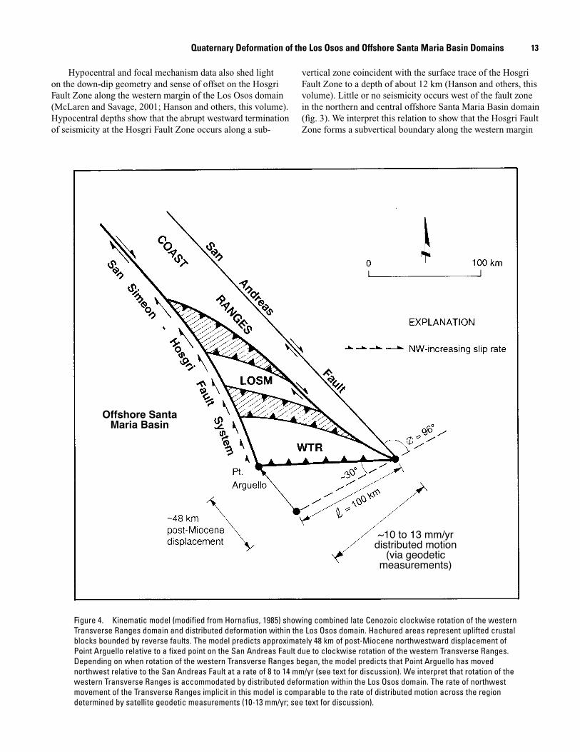
Hypocentral and focal mechanism data also shed light on the down-dip geometry and sense of offset on the Hosgri Fault Zone along the western margin of the Los Osos domain (McLaren and Savage, 2001; Hanson and others, this volume). Hypocentral depths show that the abrupt westward termination of seismicity at the Hosgri Fault Zone occurs along a sub-
vertical zone coincident with the surface trace of the Hosgri Fault Zone to a depth of about 12 km (Hanson and others, this volume). Little or no seismicity occurs west of the fault zone in the northern and central offshore Santa Maria Basin domain (fig. 3). We interpret this relation to show that the Hosgri Fault Zone forms a subvertical boundary along the western margin
��������������������������
~10 to 13 mm/yr distributed motion
(via geodetic measurements)
Figure 4. Kinematic model (modified from Hornafius, 1985) showing combined late Cenozoic clockwise rotation of the western Transverse Ranges domain and distributed deformation within the Los Osos domain. Hachured areas represent uplifted crustal blocks bounded by reverse faults. The model predicts approximately 48 km of post-Miocene northwestward displacement of Point Arguello relative to a fixed point on the San Andreas Fault due to clockwise rotation of the western Transverse Ranges. Depending on when rotation of the western Transverse Ranges began, the model predicts that Point Arguello has moved northwest relative to the San Andreas Fault at a rate of 8 to 14 mm/yr (see text for discussion). We interpret that rotation of the western Transverse Ranges is accommodated by distributed deformation within the Los Osos domain. The rate of northwest movement of the Transverse Ranges implicit in this model is comparable to the rate of distributed motion across the region determined by satellite geodetic measurements (10-13 mm/yr; see text for discussion).
Quaternary Deformation of the Los Osos and Offshore Santa Maria Basin Domains
14 Quaternary Tectonic Setting of South–Central Coastal California
of the Los Osos domain to at least a depth of 10 to12 km at the brittle-ductile transition zone. Focal mechanisms from earth-quakes occurring along the northern part of the Hosgri Fault Zone generally show right-lateral slip on vertical north-north-west-striking planes coincident with the surface trace of the Hosgri Fault Zone (fig. 3). On the basis of the seismic reflec-tion data and seismicity data, we conclude that north-north-east-directed crustal shortening within the Los Osos domain is separated from the seismically quiescent offshore Santa Maria Basin domain by right-lateral shear along a near-vertical, north-northwest-trending Hosgri Fault Zone.
Kinematic Model for Quaternary Deformation of South-Central Coastal California
Quaternary deformation of the south-central coastal region of California appears to result from relative dextral motion between the Pacific Plate and the Sierra Nevada-Cen-tral Valley microplate. In this section, we present a kinematic model for late Cenozoic deformation of the Los Osos and the western Transverse Ranges domains based on a synthesis of geologic, geodetic, and seismologic data. We adopt the inter-pretation of Hornafius (1985) that clockwise rotation of the western Transverse Ranges has deformed the Los Osos domain against the relatively stationary southern Coast Ranges to the northeast. We use the kinematic model to estimate the veloc-ity of northward movement of the western Transverse Ranges and shortening within the Los Osos domain, and interpret this velocity in the context of regional simple shear associated with plate motions.
Pliocene and Quaternary crustal shortening in the Los Osos domain is coeval with post-Miocene clockwise rota-tion of the western Transverse Ranges. As shown on plate 1, crustal shortening is oriented northeast-southwest, orthogonal to the trend of the uplifted crustal blocks and bounding reverse faults. In our model, we assume that the crustal shorten-ing resulted, in part, from rotation of the western Transverse Ranges as a rigid body about a “pivot” attached to the San Andreas Fault (fig. 4). Using this model, Hornafius (1985) showed that the component of northwest motion parallel to the San Andreas Fault (d) at the western end of the Transverse Ranges is given by
d= l [cos Ø - cos (Ø+ r)] (1)
where l is the distance along the western Transverse Ranges from the San Andreas Fault, Ø is the initial angle between the western Transverse Ranges and the San Andreas Fault prior to rotation, and r is the amount of rotation in degrees.
Following Hornafius (1985), we assume an approximately 100 km length for the western Transverse Ranges (l), an initial angle of 96° between the western Transverse Ranges and the
San Andreas Fault (Ø), and 30° of post-Miocene rotation (r). The kinematic model thus predicts approximately 48 km of northwest displacement of the western end of the Transverse Ranges parallel to the San Andreas Fault since the onset of late Cenozoic clockwise rotation. If this rotation occurred primarily during the past 6 m.y. (the age of the youngest rocks from which paleomagnetic data were obtained), the resulting northwestward displacement rate of Point Arguello relative to a fixed point on to the San Andreas Fault is approximately 8 mm/yr. If the deformation began approximately 3.5 Ma, as suggested by Namson and Davis (1988) based on regional stratigraphic and structural relationships, the resulting aver-age displacement rate of Point Arguello is approximately 14 mm/yr. On the basis of this kinematic model and these assumptions, we conclude that the average post-Miocene rate of northwestward motion of Point Arguello due to clockwise rotation of the western Transverse Ranges is 8 to 14 mm/yr.
If the western Transverse Ranges have rotated as a rigid body, then the rate of northwestward motion parallel to the San Andreas Fault along the length of the domain decreases from west to east. The clockwise rotation thus produces a velocity gradient of 8 to 14 mm/yr per 100 km perpendicu-lar to the San Andreas Fault. For comparison, geodetic data presented by Shen and Jackson (1993) show that the average velocity of reference stations near the western edge of the Los Osos domain in a direction subparallel to the San Andreas Fault is approximately 10 to13 mm/yr faster than stations located a few km west of the San Andreas Fault.
At least some of the geodetically determined velocity gradient across the Los Osos domain may be attributed to elastic deformation associated with the San Andreas Fault. Shen and Jackson (1993), for example, attribute the bulk of the velocity gradient to elastic strain associated with locking of the San Andreas Fault to a depth of 20 km. However, there are two problems with this model—(1) the assumed locking depth of 20 km is approximately 5 km deeper than most, but not all, of the seismicity associated with the San Andreas Fault (Hill and others, 1990) and thus may predict greater elastic strain than is presently accumulating, and (2) all of the elastic strain is presumably released by earthquakes on the San Andreas Fault. If the velocity gradient perpendicular to the fault is an exclusively elastic phenomenon, then the observed finite clockwise rotations, such as those associated with the western Transverse Ranges, must occur by other tec-tonic processes that produce distributed plastic deformation.
Feigl and others (1990) derived the velocities of stations in the western Transverse Ranges and Los Osos domains and observed that the rates of northwest-directed motion decrease between the western part of the domain and the San Andreas Fault. They subtracted a predicted deformation field associ-ated with accumulation of elastic strain on the San Andreas Fault from the observed velocity field to derive a residual velocity field that presumably reflects plastic deforma-tion independent of elastic strain on the San Andreas Fault. Assuming a locking depth of 25 km, Feigl and others (1990) observed that the residual velocity of stations POZO and
15
MADC near the eastern boundary of the Los Osos domain are 4 to 5 mm/yr slower than station VNDN at Point Arguello, thus suggesting the presence of a 4 to 5 mm/yr velocity gradi-ent across the Los Osos domain that is independent of elastic strain associated with a locked San Andreas Fault.
Feigl and others (1990) noted that increasing the locking depth (>25 km) on the San Andreas Fault is an implausible explanation for the residual velocity gradient across the Los Osos domain. Given the depth of seismicity associated with the San Andreas Fault (approximately 15 km; Hill and others, 1990), and the results of numerous studies showing that the San Andreas Fault is weak and supports very little shear stress (Zoback and others, 1987; Mount and Suppe, 1987), we believe that the locking depth of 25 km assumed by Feigl and others (1990) also is probably too deep. Thus, we conclude that the residual velocity gradient of 4 to 5 mm/yr across the Los Osos domain calculated by Feigl and others (1990) with an assumed 25 km locking depth is probably a minimum estimate of the non-elastic deformation. For comparison, this residual velocity gradient is similar to the 6 to 8 mm/yr abso-lute gradient across the domain determined by Shen and Jack-son (1993), which they interpreted as distributed elastic strain accumulation on the San Andreas Fault.
Because the Los Osos domain and western Transverse Range domain share a common boundary, rigid rotation of the western Transverse Ranges necessarily produces rotation of the southern boundary of the domain. If the eastern and western boundaries of the domain (the Coast Ranges and the offshore Santa Maria Basin, respectively) do not rotate and if the northeastern boundary of the Los Osos domain does not move northward at the same velocity as the western Trans-verse Ranges, then the Los Osos domain must absorb a large component of the distributed shear associated with rotation of the western Transverse Ranges. We therefore conclude that the 4 to 5 mm/yr or greater velocity gradient across the Los Osos domain represents distributed plate motion that is accommodated by internal deformation of the domain. The deformation is characterized by oblique reverse slip on west-northwest-striking faults that bound the structural blocks of the domain.
This kinematic interpretation does not require a large component of shortening perpendicular to the plate bound-ary to explain the crustal shortening of the Los Osos domain. Shen and Jackson (1993) determined the displacement rate vectors for five stations in the domain and observed that the motions of the stations are generally parallel, rather than oblique, to the San Andreas Fault. The stations do not consistently display a significant component of north-north-east-directed motion, suggesting that the Los Osos domain is not accommodating a large component of shortening per-pendicular to the plate boundary. Shen and Jackson (1993) determined the orientations and magnitudes of the principal components of the mean strain rate field for the central Los Osos domain and concluded that the rate of northwest-directed extension is not significantly different from the rate of northeast-directed shortening, consistent with a pure shear
strain component within an overall simple shear deformation field. Although the uncertainties in the data are large relative to the measured strain rates, the results of Shen and Jackson (1993) suggest that the observed northeast-directed crustal shortening may be primarily accommodating northwest dex-tral simple shear.
As stated earlier, the onshore Los Osos domain is struc-turally separated from the offshore Santa Maria Basin domain by the Hosgri-San Simeon Fault Zone (plate 1). Dextral slip on the fault zone progressively decreases southward from about 1 to 3 mm/yr to 0.5-2 mm/yr (Hanson and others, this volume). The northern and central parts of the offshore Santa Maria Basin domain are not deforming internally, but rather are moving northwest at a rate equal to or slightly less than the full “rescaled” NUVEL-1 velocity (Feigl and others, 1990) for the Pacific Plate relative to stable North America (46 mm/yr). The geodetic data described by Shen and Jack-son (1993) show that the absolute velocities of points within the Los Osos domain decrease northeastward, and thus the Los Osos domain is moving northward at somewhat lower velocities than the offshore Santa Maria Basin. Because the Hosgri-San Simeon Fault Zone accommodates this differen-tial motion, or velocity contrast, between the two domains, the kinematic model predicts a progressive southward decrease in the rate of relative right-lateral displacement on the fault zone, and the fault should terminate near the southern margin of the Los Osos domain where the velocity contrast dimin-ishes to near zero. The southward decrease in slip rate on the Hosgri Fault Zone agrees well with the analysis of slip rates based on geological and geophysical data presented by Hanson and others (this volume) that also shows progressive southward decay of slip on the Hosgri Fault Zone.
Geologic estimates of crustal shortening in the Los Osos domain can be estimated by summing the rate of slip on reverse and thrust faults in the domain. The resolved compo-nent of slip parallel to the Hosgri Fault Zone is a maximum of about 0.1 to 0.2 mm/yr for each of the Los Osos, Olson, San Luis Bay, Wilmar Avenue, Casmalia, and Lions Head Faults. As depicted on figure 4, if a horizontal slip rate of 1 mm/yr for the northern end of the Hosgri Fault Zone (the lower value of our preferred range) is used for the integrated model of slip distribution, then the southward decay of horizontal slip by crustal shortening in the Los Osos domain brings the rate of lateral slip on the Hosgri Fault Zone to less than 0.5 mm/yr south of Point Sal. Slip on the fault ultimately must decrease to zero where it dies out near Point Arguello. At this south-ern end of the fault, the Hosgri Fault Zone may be either an oblique-slip, strike-slip or reverse fault depending on the rela-tive rate of vertical movement on the fault which also must ultimately die out at the southern end of the fault.
Regional stress data show an apparent change in the direction of the maximum horizontal stress from northeast to east-west across a very narrow corridor coincident with the trace of the Hosgri Fault Zone (Mount and Suppe, 1992). This change can be readily explained if the Hosgri Fault Zone is a weak, near-vertical, strike-slip fault with mechanical charac-
Kinematic Model for Quaternary Deformation of South-Central Coastal California
16 Quaternary Tectonic Setting of South–Central Coastal California
teristics similar to the San Andreas Fault Zone (Zoback and others, 1987).
We interpret the relationship between stress and strain in the vicinity of the Hosgri Fault Zone to be an expression of strain partitioning. Recently proposed models of strain parti-tioning suggest that oblique strain in the lithospheric mantle and lower crust partitions into tangential and normal strain components in the upper crust, producing concurrently active, subparallel strike-slip and dip-slip faults with associated fold belts (Zoback and others, 1987; Mount and Suppe, 1987, 1992; Michael, 1990; Lettis and Hanson, 1991). The strain partitioning model predicts the development of subparallel strike-slip and reverse/thrust faults and folds, as is observed between the Hosgri Fault Zone and folds and thrust faults in the offshore Santa Maria Basin. East of the Hosgri Fault Zone, however, contractional structures in the Los Osos domain trend oblique to the Hosgri Fault Zone. We explain this deviation from the expected pattern required by strain partitioning by the influence of three tectonic mechanisms—noncoaxial strain due to the influence of preexisting basement structures, local dis-tortion of the regional stress field by elastic strain at the south-ern tip of the Hosgri Fault Zone, and post-Miocene clockwise rotation of the western Transverse Ranges as described above.
The contrasting styles and orientations of crustal shorten-ing across the Hosgri Fault Zone, as well as the near verti-cal boundary defined by the distribution of microseismicity (McLaren and Savage, 2001; Hanson and others, this volume), are not explained by the listric thrust model proposed by Crouch and others (1984) or the reactivated reverse fault model proposed by Namson and Davis (1990). The west-northwest-trending orientation of faults east of the fault zone is not compatible with active west-directed thrust or reverse faulting on the Hosgri Fault Zone. If the Hosgri Fault Zone were a southwest-verging listric thrust fault above a detach-ment, faults and folds east of the fault (in the hanging wall) should be subparallel to and not oblique to the fault. The Los Osos, Pecho, San Luis Bay, Casmalia, and Lions Head Faults, however, intersect the Hosgri Fault Zone from the east at oblique angles. Attributing all deformation in the region to contraction on thrust faults, therefore, is not correct. The east-northeast/west-southwest crustal shortening represented by these faults is mechanically more compatible with lateral slip along the more northerly trending Hosgri Fault Zone. Sorlien and others (1999) also note that structure-contour maps of deformed horizons show a spatial relationship between fault-ing and folding along the southern Hosgri Fault Zone that is consistent with right-lateral slip.
ConclusionsThis paper provides a synthesis of the Quaternary tectonic
setting of south-central coastal California. Plate 1 illustrates the distribution of all known and potentially active late Qua-ternary faults and folds in the region based on a review of recently published and unpublished data. Our interpretation of
the tectonic setting incorporates the data and conclusions pre-sented by Hanson and others (this volume).
South-central coastal California can be divided into several distinct tectonic domains characterized by unique pat-terns and styles of Quaternary deformation and seismicity. In particular, we define and describe the Los Osos and offshore Santa Maria Basin domains. These domains are separated by the dextral-slip Hosgri-San Simeon fault system, which has a late Quaternary slip rate of 1 to 3 mm/yr.
The offshore Santa Maria Basin domain is characterized by localized anticlinal deformation underlain in places by active southwest-verging reverse thrust faults. These faults are subparallel to the Hosgri Fault Zone, have associated micro-seismicity, and occur primarily in the southern part of the offshore Santa Maria Basin domain. The northern and central parts of the domain, south of the Piedras Blancas anticlino-rium are characterized by the general absence of late Quater-nary deformation and lack of instrumental seismicity.
The Los Osos domain is characterized by west-north-west-striking reverse faults along the margins of distinct uplifting and subsiding structural blocks. Detailed mapping of Quaternary deposits and surfaces shows that deformation is concentrated along the block-bounding faults and little or no deformation is occurring within the blocks. Sparse seis-micity is concentrated primarily within the uplifting blocks. The depth distribution of the seismicity shows that the blocks extend to the base of the seismogenic crust (10-12 km) and are not structurally detached by one or more decollements higher in the seismogenic crust as postulated by others (see for exam-ple, Crouch and others, 1984; Namson and Davis, 1990). The orientation and style of deformation within the domain clearly reflects north-northeast/south-southwest crustal shortening. This orientation of crustal shortening is oblique to the trend of the Hosgri Fault Zone and strongly supports the interpretation that the Hosgri Fault Zone is a strike slip fault that, in part, accommodates the contrasting orientations of crustal shorten-ing between the Los Osos and offshore Santa Maria Basin domains.
Deformation within the Los Osos domain results from distributed dextral simple shear associated with the Pacific-North American plate motion, modified by clockwise rotation of the western Transverse Ranges. The cumulative rate of shortening across the domain based on observed fault slip rate (excluding the domain-bounding Santa Ynez and Oceanic-west Huasna Faults) is about 1 to 2 mm/yr. These observed rates are consistent with geodetic and plate motion rates of northeast-directed contraction of less than 2 ± 1 mm/yr.
ReferencesArgus, D.F., and Gordon, R.G., 1990, Pacific-North American
plate motion from very long basin interferometry compared with motion inferred from magnetic anomalies, transform faults, and earthquake slip vectors: Journal of Geophysical Research, v. 95, p. 17315-17324.
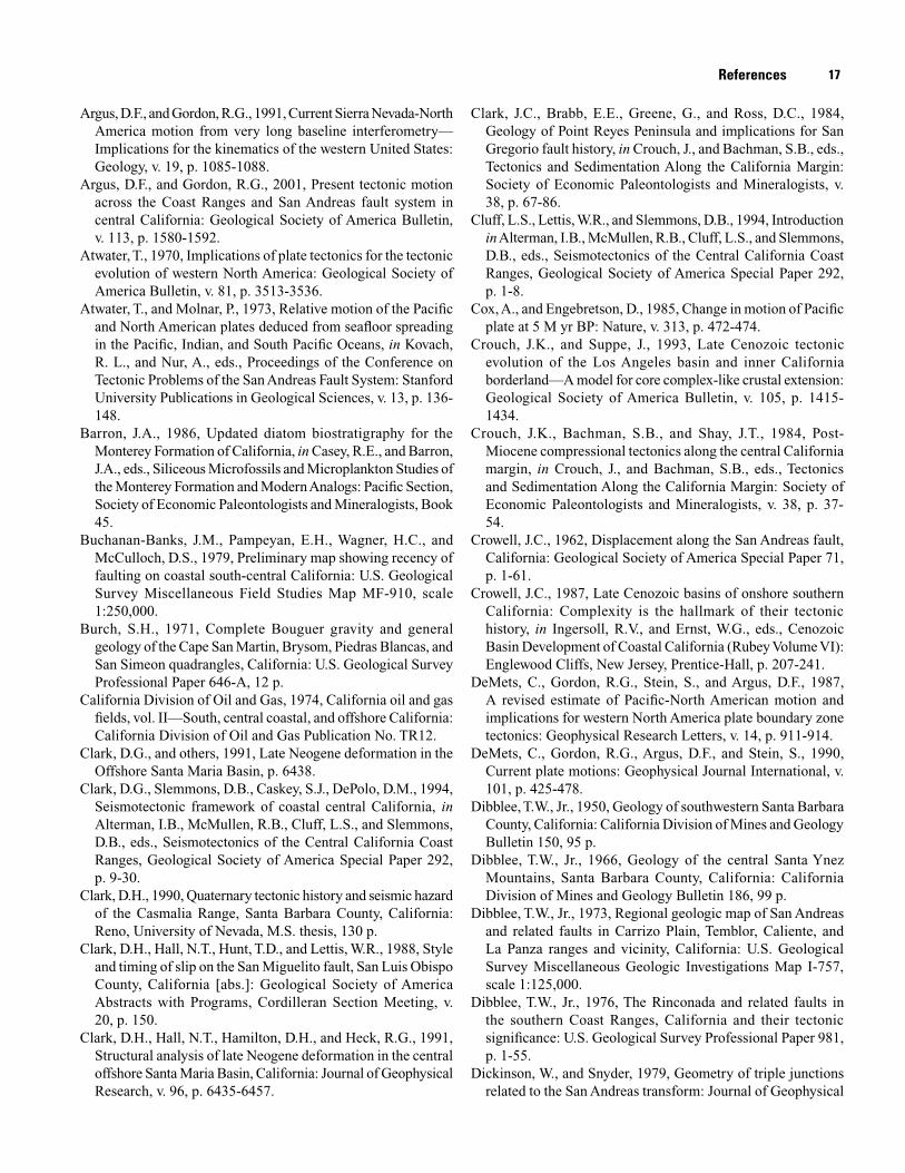
17
Argus, D.F., and Gordon, R.G., 1991, Current Sierra Nevada-North America motion from very long baseline interferometry—Implications for the kinematics of the western United States: Geology, v. 19, p. 1085-1088.
Argus, D.F., and Gordon, R.G., 2001, Present tectonic motion across the Coast Ranges and San Andreas fault system in central California: Geological Society of America Bulletin, v. 113, p. 1580-1592.
Atwater, T., 1970, Implications of plate tectonics for the tectonic evolution of western North America: Geological Society of America Bulletin, v. 81, p. 3513-3536.
Atwater, T., and Molnar, P., 1973, Relative motion of the Pacific and North American plates deduced from seafloor spreading in the Pacific, Indian, and South Pacific Oceans, in Kovach, R. L., and Nur, A., eds., Proceedings of the Conference on Tectonic Problems of the San Andreas Fault System: Stanford University Publications in Geological Sciences, v. 13, p. 136-148.
Barron, J.A., 1986, Updated diatom biostratigraphy for the Monterey Formation of California, in Casey, R.E., and Barron, J.A., eds., Siliceous Microfossils and Microplankton Studies of the Monterey Formation and Modern Analogs: Pacific Section, Society of Economic Paleontologists and Mineralogists, Book 45.
Buchanan-Banks, J.M., Pampeyan, E.H., Wagner, H.C., and McCulloch, D.S., 1979, Preliminary map showing recency of faulting on coastal south-central California: U.S. Geological Survey Miscellaneous Field Studies Map MF-910, scale 1:250,000.
Burch, S.H., 1971, Complete Bouguer gravity and general geology of the Cape San Martin, Brysom, Piedras Blancas, and San Simeon quadrangles, California: U.S. Geological Survey Professional Paper 646-A, 12 p.
California Division of Oil and Gas, 1974, California oil and gas fields, vol. II—South, central coastal, and offshore California: California Division of Oil and Gas Publication No. TR12.
Clark, D.G., and others, 1991, Late Neogene deformation in the Offshore Santa Maria Basin, p. 6438.
Clark, D.G., Slemmons, D.B., Caskey, S.J., DePolo, D.M., 1994, Seismotectonic framework of coastal central California, in Alterman, I.B., McMullen, R.B., Cluff, L.S., and Slemmons, D.B., eds., Seismotectonics of the Central California Coast Ranges, Geological Society of America Special Paper 292, p. 9-30.
Clark, D.H., 1990, Quaternary tectonic history and seismic hazard of the Casmalia Range, Santa Barbara County, California: Reno, University of Nevada, M.S. thesis, 130 p.
Clark, D.H., Hall, N.T., Hunt, T.D., and Lettis, W.R., 1988, Style and timing of slip on the San Miguelito fault, San Luis Obispo County, California [abs.]: Geological Society of America Abstracts with Programs, Cordilleran Section Meeting, v. 20, p. 150.
Clark, D.H., Hall, N.T., Hamilton, D.H., and Heck, R.G., 1991, Structural analysis of late Neogene deformation in the central offshore Santa Maria Basin, California: Journal of Geophysical Research, v. 96, p. 6435-6457.
Clark, J.C., Brabb, E.E., Greene, G., and Ross, D.C., 1984, Geology of Point Reyes Peninsula and implications for San Gregorio fault history, in Crouch, J., and Bachman, S.B., eds., Tectonics and Sedimentation Along the California Margin: Society of Economic Paleontologists and Mineralogists, v. 38, p. 67-86.
Cluff, L.S., Lettis, W.R., and Slemmons, D.B., 1994, Introduction in Alterman, I.B., McMullen, R.B., Cluff, L.S., and Slemmons, D.B., eds., Seismotectonics of the Central California Coast Ranges, Geological Society of America Special Paper 292, p. 1-8.
Cox, A., and Engebretson, D., 1985, Change in motion of Pacific plate at 5 M yr BP: Nature, v. 313, p. 472-474.
Crouch, J.K., and Suppe, J., 1993, Late Cenozoic tectonic evolution of the Los Angeles basin and inner California borderland—A model for core complex-like crustal extension: Geological Society of America Bulletin, v. 105, p. 1415-1434.
Crouch, J.K., Bachman, S.B., and Shay, J.T., 1984, Post-Miocene compressional tectonics along the central California margin, in Crouch, J., and Bachman, S.B., eds., Tectonics and Sedimentation Along the California Margin: Society of Economic Paleontologists and Mineralogists, v. 38, p. 37-54.
Crowell, J.C., 1962, Displacement along the San Andreas fault, California: Geological Society of America Special Paper 71, p. 1-61.
Crowell, J.C., 1987, Late Cenozoic basins of onshore southern California: Complexity is the hallmark of their tectonic history, in Ingersoll, R.V., and Ernst, W.G., eds., Cenozoic Basin Development of Coastal California (Rubey Volume VI): Englewood Cliffs, New Jersey, Prentice-Hall, p. 207-241.
DeMets, C., Gordon, R.G., Stein, S., and Argus, D.F., 1987, A revised estimate of Pacific-North American motion and implications for western North America plate boundary zone tectonics: Geophysical Research Letters, v. 14, p. 911-914.
DeMets, C., Gordon, R.G., Argus, D.F., and Stein, S., 1990, Current plate motions: Geophysical Journal International, v. 101, p. 425-478.
Dibblee, T.W., Jr., 1950, Geology of southwestern Santa Barbara County, California: California Division of Mines and Geology Bulletin 150, 95 p.
Dibblee, T.W., Jr., 1966, Geology of the central Santa Ynez Mountains, Santa Barbara County, California: California Division of Mines and Geology Bulletin 186, 99 p.
Dibblee, T.W., Jr., 1973, Regional geologic map of San Andreas and related faults in Carrizo Plain, Temblor, Caliente, and La Panza ranges and vicinity, California: U.S. Geological Survey Miscellaneous Geologic Investigations Map I-757, scale 1:125,000.
Dibblee, T.W., Jr., 1976, The Rinconada and related faults in the southern Coast Ranges, California and their tectonic significance: U.S. Geological Survey Professional Paper 981, p. 1-55.
Dickinson, W., and Snyder, 1979, Geometry of triple junctions related to the San Andreas transform: Journal of Geophysical
References
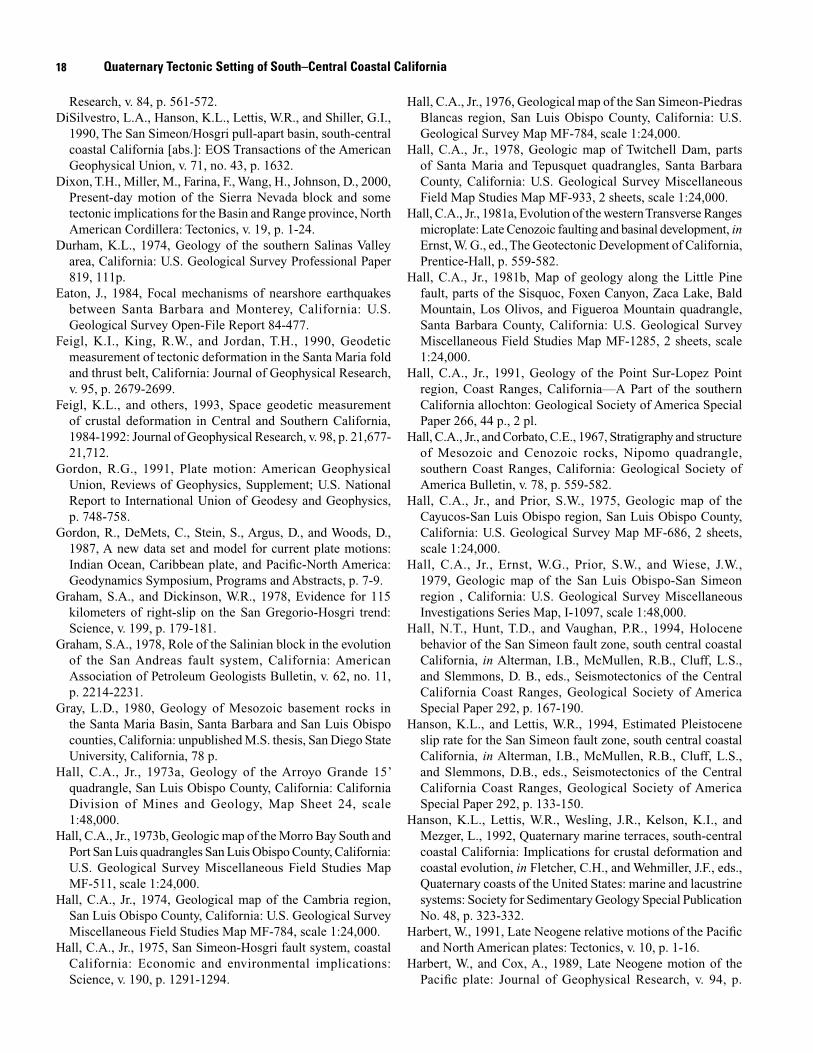
18 Quaternary Tectonic Setting of South–Central Coastal California
Research, v. 84, p. 561-572.DiSilvestro, L.A., Hanson, K.L., Lettis, W.R., and Shiller, G.I.,
1990, The San Simeon/Hosgri pull-apart basin, south-central coastal California [abs.]: EOS Transactions of the American Geophysical Union, v. 71, no. 43, p. 1632.
Dixon, T.H., Miller, M., Farina, F., Wang, H., Johnson, D., 2000, Present-day motion of the Sierra Nevada block and some tectonic implications for the Basin and Range province, North American Cordillera: Tectonics, v. 19, p. 1-24.
Durham, K.L., 1974, Geology of the southern Salinas Valley area, California: U.S. Geological Survey Professional Paper 819, 111p.
Eaton, J., 1984, Focal mechanisms of nearshore earthquakes between Santa Barbara and Monterey, California: U.S. Geological Survey Open-File Report 84-477.
Feigl, K.I., King, R.W., and Jordan, T.H., 1990, Geodetic measurement of tectonic deformation in the Santa Maria fold and thrust belt, California: Journal of Geophysical Research, v. 95, p. 2679-2699.
Feigl, K.L., and others, 1993, Space geodetic measurement of crustal deformation in Central and Southern California, 1984-1992: Journal of Geophysical Research, v. 98, p. 21,677-21,712.
Gordon, R.G., 1991, Plate motion: American Geophysical Union, Reviews of Geophysics, Supplement; U.S. National Report to International Union of Geodesy and Geophysics, p. 748-758.
Gordon, R., DeMets, C., Stein, S., Argus, D., and Woods, D., 1987, A new data set and model for current plate motions: Indian Ocean, Caribbean plate, and Pacific-North America: Geodynamics Symposium, Programs and Abstracts, p. 7-9.
Graham, S.A., and Dickinson, W.R., 1978, Evidence for 115 kilometers of right-slip on the San Gregorio-Hosgri trend: Science, v. 199, p. 179-181.
Graham, S.A., 1978, Role of the Salinian block in the evolution of the San Andreas fault system, California: American Association of Petroleum Geologists Bulletin, v. 62, no. 11, p. 2214-2231.
Gray, L.D., 1980, Geology of Mesozoic basement rocks in the Santa Maria Basin, Santa Barbara and San Luis Obispo counties, California: unpublished M.S. thesis, San Diego State University, California, 78 p.
Hall, C.A., Jr., 1973a, Geology of the Arroyo Grande 15’ quadrangle, San Luis Obispo County, California: California Division of Mines and Geology, Map Sheet 24, scale 1:48,000.
Hall, C.A., Jr., 1973b, Geologic map of the Morro Bay South and Port San Luis quadrangles San Luis Obispo County, California: U.S. Geological Survey Miscellaneous Field Studies Map MF-511, scale 1:24,000.
Hall, C.A., Jr., 1974, Geological map of the Cambria region, San Luis Obispo County, California: U.S. Geological Survey Miscellaneous Field Studies Map MF-784, scale 1:24,000.
Hall, C.A., Jr., 1975, San Simeon-Hosgri fault system, coastal California: Economic and environmental implications: Science, v. 190, p. 1291-1294.
Hall, C.A., Jr., 1976, Geological map of the San Simeon-Piedras Blancas region, San Luis Obispo County, California: U.S. Geological Survey Map MF-784, scale 1:24,000.
Hall, C.A., Jr., 1978, Geologic map of Twitchell Dam, parts of Santa Maria and Tepusquet quadrangles, Santa Barbara County, California: U.S. Geological Survey Miscellaneous Field Map Studies Map MF-933, 2 sheets, scale 1:24,000.
Hall, C.A., Jr., 1981a, Evolution of the western Transverse Ranges microplate: Late Cenozoic faulting and basinal development, in Ernst, W. G., ed., The Geotectonic Development of California, Prentice-Hall, p. 559-582.
Hall, C.A., Jr., 1981b, Map of geology along the Little Pine fault, parts of the Sisquoc, Foxen Canyon, Zaca Lake, Bald Mountain, Los Olivos, and Figueroa Mountain quadrangle, Santa Barbara County, California: U.S. Geological Survey Miscellaneous Field Studies Map MF-1285, 2 sheets, scale 1:24,000.
Hall, C.A., Jr., 1991, Geology of the Point Sur-Lopez Point region, Coast Ranges, California—A Part of the southern California allochton: Geological Society of America Special Paper 266, 44 p., 2 pl.
Hall, C.A., Jr., and Corbato, C.E., 1967, Stratigraphy and structure of Mesozoic and Cenozoic rocks, Nipomo quadrangle, southern Coast Ranges, California: Geological Society of America Bulletin, v. 78, p. 559-582.
Hall, C.A., Jr., and Prior, S.W., 1975, Geologic map of the Cayucos-San Luis Obispo region, San Luis Obispo County, California: U.S. Geological Survey Map MF-686, 2 sheets, scale 1:24,000.
Hall, C.A., Jr., Ernst, W.G., Prior, S.W., and Wiese, J.W., 1979, Geologic map of the San Luis Obispo-San Simeon region , California: U.S. Geological Survey Miscellaneous Investigations Series Map, I-1097, scale 1:48,000.
Hall, N.T., Hunt, T.D., and Vaughan, P.R., 1994, Holocene behavior of the San Simeon fault zone, south central coastal California, in Alterman, I.B., McMullen, R.B., Cluff, L.S., and Slemmons, D. B., eds., Seismotectonics of the Central California Coast Ranges, Geological Society of America Special Paper 292, p. 167-190.
Hanson, K.L., and Lettis, W.R., 1994, Estimated Pleistocene slip rate for the San Simeon fault zone, south central coastal California, in Alterman, I.B., McMullen, R.B., Cluff, L.S., and Slemmons, D.B., eds., Seismotectonics of the Central California Coast Ranges, Geological Society of America Special Paper 292, p. 133-150.
Hanson, K.L., Lettis, W.R., Wesling, J.R., Kelson, K.I., and Mezger, L., 1992, Quaternary marine terraces, south-central coastal California: Implications for crustal deformation and coastal evolution, in Fletcher, C.H., and Wehmiller, J.F., eds., Quaternary coasts of the United States: marine and lacustrine systems: Society for Sedimentary Geology Special Publication No. 48, p. 323-332.
Harbert, W., 1991, Late Neogene relative motions of the Pacific and North American plates: Tectonics, v. 10, p. 1-16.
Harbert, W., and Cox, A., 1989, Late Neogene motion of the Pacific plate: Journal of Geophysical Research, v. 94, p.
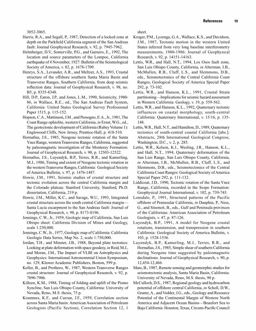
19
3052-3065.Harris, R.A., and Segall, P., 1987, Detection of a locked zone at
depth on the Parkfield California segment of the San Andreas fault: Journal Geophysical Research, v. 92, p. 7945-7962.
Helmberger, D.V., Somerville, P.G., and Garnero, E., 1992, The location and source parameters of the Lompoc, California earthquake of 4 November, 1927: Bulletin of the Seismological Society of America, v. 82, p. 1678-1709.
Henrys, S.A., Levander, A.R., and Meltzer, A.S., 1993, Crustal structure of the offshore southern Santa Maria Basin and Transverse Ranges, Southern California, from deep seismic reflection data: Journal of Geophysical Research, v. 98, no. B5, p. 8335-8348.
Hill, D.P., Eaton, J.P., and Jones, L.M., 1990, Seismicity, 1980-86, in Wallace, R.E., ed., The San Andreas Fault System, California: United States Geological Survey Professional Paper 1515, p. 115-152.
Hopson, C.A., Mattinson, J.M., and Pessogno, E.A., Jr., 1981, The Coast Range ophiolite, western California, in Ernst, W.G., ed., The geotectonic development of California (Rubey Volume 1): Englewood Cliffs, New Jersey, Prentice-Hall, p. 418-510.
Hornafius, J.S., 1985, Neogene tectonic rotation of the Santa Ynez Range, western Transverse Ranges, California, suggested by paleomagnetic investigation of the Monterey Formation: Journal of Geophysical Research, v. 90, p. 12503-12522.
Hornafius, J.S., Luyendyk, B.P., Terres, R.R., and Kamerling, M.J., 1986, Timing and extent of Neogene tectonic rotation in the western Transverse Ranges, California: Geological Society of America Bulletin, v. 97, p. 1476-1487.
Howie, J.M., 1991, Seismic studies of crustal structure and tectonic evolution across the central California margin and the Colorado plateau: Stanford University, Stanford, Ph.D. dissertation, California, 219 p.
Howie, J.M., Miller, K.C., and Savage, W.U., 1993, Integrated crustal structure across the south central California margin—Santa Lucia escarpment to the San Andreas fault: Journal of Geophysical Research, v. 98, p. 8173-8196.
Jennings, C.W., Jr., 1959, Geologic map of California, San Luis Obispo sheet: California Division of Mines and Geology, scale 1:250,000.
Jennings, C.W., Jr., 1977, Geologic map of California: California Geologic Data Series, Map No. 2, scale 1:750,000.
Jordan, T.H., and Minster, J.B., 1988, Beyond plate tectonics: Looking at plate deformation with space geodesy, in Reid, M.J., and Moran, J.M., The Impact of VLBI on Astrophysics and Geophysics: International Astronommial Union Symposium, no. 129, Kluwer Academic Publishers, Boston, 599 p.
Keller, B., and Prothero, W., 1987, Western Transverse Ranges crustal structure: Journal of Geophysical Research, v. 92, p. 7890-7906.
Killeen, K.M., 1988, Timing of folding and uplift of the Pismo Syncline, San Luis Obispo County, California: University of Nevada, Reno, M.S. thesis, 75 p.
Krammes, K.F., and Curran, J.F., 1959, Correlation section across Santa Maria basin: American Association of Petroleum Geologists (Pacific Section), Correlation Section 12, 1
sheet.Kroger, P.M., Lyzenga, G.A., Wallace, K.S., and Davidson,
J.M., 1987, Tectonic motion in the western United States inferred from very long baseline interferometry measurements, 1980-1986: Journal of Geophysical Research, v. 92, p. 14151-14163.
Lettis, W.R., and Hall, N.T., 1994, Los Osos fault zone, San Luis Obispo County, California, in Alterman, I.B., McMullen, R.B., Cluff, L.S., and Slemmons, D.B., eds., Seismotectonics of the Central California Coast Ranges, Geological Society of America Special Paper 292, p. 73-102.
Lettis, W.R., and Hanson, K.L., 1991, Crustal Strain partitioning—Implications for seismic hazard assessment in Western California: Geology, v. 19, p. 559-562.
Lettis, W.R., and Hanson, K.L., 1992, Quaternary tectonic influences on coastal morphology, south-central California: Quaternary International, v. 15/16, p. 135-148.
Lettis, W.R., Hall, N.T., and Hamilton, D., 1989, Quaternary tectonics of south-central coastal California [abs.]: Abstracts, 28th International Geological Congress, Washington, D.C., v. 2, p. 285.
Lettis, W.R., Kelson, K.I., Wesling, J.R., Hanson, K.L., and Hall, N.T., 1994, Quaternary deformation of the San Luis Range, San Luis Obispo County, California, in Alterman, I.B., McMullen, R.B., Cluff, L.S., and Slemmons, D.B., eds., Seismotectonics of the Central California Coast Ranges: Geological Society of America Special Paper 292, p. 111-132.
Liddicoat, J.D., 1990, Tectonic rotation of the Santa Ynez Range, California, recorded in the Sespe Formation: Geophysical Journal International, v. 102, p. 739-745.
Lonsdale, P., 1991, Structural patterns of the Pacific offshore of Peninsular California, in Dauphin, P., Ness, G., and Sinoneit, B., eds., Gulf and Peninsula provinces of the Californias: American Association of Petroleum Geologists, v. 47, p. 87-126.
Luyendyk, B.P., 1991, A model for Neogene crustal rotations, transtension, and transpression in southern California: Geological Society of America Bulletin, v. 103, p. 1528-1536.
Luyendyk, B.P., Kamerling, M.J., Terres, R.R., and Hornafius, J.S., 1985, Simple shear of southern California during Neogene time suggested by paleomagnetic declinations: Journal of Geophysical Research, v. 90, p. 12,454-12,466.
Matz, B., 1987, Remote sensing and geomorphic studies for seismotectonic analysis, Santa Maria Basin, California: University of Nevada, Reno, M.S. thesis, 90 p.
McCulloch, D.S., 1987, Regional geology and hydrocarbon potential of offshore central California, in Scholl, D.W., Grantz, A., and Vedder, J.G., eds., Geology and Resource Potential of the Continental Margin of Western North America and Adjacent Ocean Basins—Beaufort Sea to Baja California: Houston, Texas, Circum-Pacific Council
References
20 Quaternary Tectonic Setting of South–Central Coastal California
for Energy and Mineral Resources, Earth Science Series, v. 6, Texas, p. 353-401.
McCulloch, D.S., 1989, Geologic map of the south-central California continental margin, in Greene, H.G., and Kennedy, M.P., eds., California Continental Margin Geologic Map Series: California Division of Mines and Geology, Map No. 4a (Geology), scale 1:250,000.
McIntosh, K.D., Reed, D.L., and Silver, E.A., 1991, Deep structure and structural inversion along the central California continental margin from EDGE seismic profile RU-3: Journal of Geophysical Research, v. 96, p. 6459-6473.
McLaren, M.K., and Savage, W.U., 1987, Relocation of earthquakes offshore from Point Sal, California [abs.]: EOS, Transaction, American Geophysical Union, v. 68, no. 44, p. 1366.
McLaren, M.K., and Savage, W.U., 1993, Refined crustal velocity model and earthquake locations for south-central coastal California [abs.]: Seismological Research Letters, v. 64, no. 1, p. 52.
McLaren, M.K., and Savage, W.U., 2001, Seismicity of south-central California, October 1987 through January 1997: Bulletin of the Seismological Society of America, v. 91, p. 1629-1658.
McLean, H., 1991, Distribution and juxtaposition of Mesozoic lithotectonic elements in the basement of the Santa Maria Basin, California: U.S. Geological Bulletin, 1995-b, 12 p.
Meltzer, A.S., 1988, Crustal structure and tectonic evolution: Central California: Rice University, Houston, Texas, Ph.D. dissertation.
Meltzer, A.S., and Levander, A.R., 1991, Deep crustal reflection profiling offshore southern central California: Journal of Geophysical Research, v. 96, p. 6475-6491.
Michael, A.J., 1990, Energy constraints on kinematic models of oblique faulting—Loma Prieta versus Parkfield-Coalinga: Geophysical Research Letters, v. 17, p. 1453-1456.
Miller, K.C., 1991, Structure and tectonics of central California from seismic reflection data: Stanford University, Ph.D. dissertation, 218 p.
Miller, K.C., Howie, J.M., and Ruppert, S., 1992, Shortening within underplated oceanic crust beneath the central California margin: Journal of Geophysical Research, v. 97, p. 19961-19980.
Minster, J.B., and Jordan, T.H., 1978, Present-day plate motions: Journal of Geophysical Research, v. 83, p. 5331-5354.
Minster, J.B., and Jordan, T.H., 1984, Vector constraints on Quaternary deformation of the Western United States east and west of the San Andreas fault, in Crouch, J.K., and Bachman, S.B., eds., Tectonics and sedimentation along the California margin: Society for Sedimentary Geology, Publication 38, p. 1-16.
Minster, J.B., and Jordan, T.H., 1987, Vector constraints on western U.S. deformation from space geodesy, neotectonics, and plate motions: Journal of Geophysical Research, v. 92, p. 4798-4804.
Mount, V.S., and Suppe, J., 1987, State of stress near the San Andreas fault—implications for wrench tectonics: Geology,
v. 15, p. 1143-1146.Mount, V.S., and Suppe, J., 1992, Present-day stress orientations
adjacent to active strike-slip faults: California and Sumatra: Journal of Geophysical Research, v. 97, p. 11,995-12,013.
Namson, J.S., and Davis, T.L., 1988, Structural transect of the western Transverse Ranges, California: implications for lithospheric kinematics and seismic risk evaluation: Geology, v. 16, p. 675-679.
Namson, J.S., and Davis, T., 1990, Late Cenozoic fold and thrust belt of the southern Coast Ranges and Santa Maria Basin, California: American Association of Petroleum Geologists Bulletin, v. 74, p. 467-492.
Nicholson, C., Sorlien, C.C., Atwater, T., Crowell, J.C., and Luyendyk, B.P., 1994, Microplate capture, rotation of western Transverse Ranges, and initiation of the San Andreas transform as a low-angle fault system: Geology, v. 22, p. 491-495.
Nitchman, S.P., and Slemmons, D.B., 1994, The Wilmar Avenue fault—a late Quaternary reverse fault near Pismo Beach, California, in Alterman, I.B., McMullen, R.B., Cluff, L.S., and Slemmons, D.B., eds., Seismotectonics of the Central California Coast Ranges: Geological Society of America Special Paper 292.
Ogle, B.A., Wallis, W.S., Heck, R.G., and Edwards, F.B., 1987, Petroleum geology of the Monterey Formation in the offshore Santa Maria/Santa Barbara areas, in Ingersoll, R.V., and Ernst, W.G., eds., Cenozoic basin development of coastal California: Englewood Cliffs, New Jersey, Prentice-Hall, Inc., p. 382-406.
Pacific Gas and Electric Company, 1988, Final Report of the Diablo Canyon Long Term Seismic Program: U.S. Nuclear Regulatory Commission Docket Nos. 50-275 and 50-323 (also available at PG&E Geosciences Library).
Pacific Gas and Electric Company, 1990, Response to U.S. Nuclear Regulatory Commission Question GSC-1 Docket No. 50-323 (also available at PG&E Geosciences Library).
Page, B.M., 1981, The southern Coast Ranges, in Ernst, W. G., ed., The Geotectonic Development of California—Rubey Volume VI: Englewood Cliffs, New Jersey, Prentice-Hall, Inc., p. 330-417.
Page, B.M., and Brocher, T.M., 1993, Thrusting of the central California margin over the edge of the Pacific plate during the transform regime: Geology, v. 21, p. 635-638.
Page, B.M., and Engebretson, D.C., 1985, Correlation between the geologic record and computed plate motions for central California: Tectonics, v. 3, p. 133-155.
Putzig, N.E., 1988, Modeling wide-angle seismic data from the central California margin: Rice University, Houston, M.A. thesis.
Rockwell, T.K., 1988, Neotectonics of the San Cayetano fault, Transverse Ranges, California: Geological Society of America Bulletin, v. 100, p. 500-513.
Rockwell, T.K., Keller, E.A., and Dembroff, G.R., 1988, Quaternary rate of folding of the Ventura Avenue anticline, western Transverse Ranges, Southern California: Geological Society of America Bulletin, v. 100, p. 850-858.
Rockwell., T.K., Keller, E.A., Clark, M.N., and Johnson, D.L.,
21
1984, Chronology and rates of faulting of Ventura River terraces, California: Geological Society of America Bulletin, v. 95, p. 1466-1474.
Sataki, K., and Somerville, P.G., 1992, Location and size of the 1927 Lompoc, California earthquake from tsunami data: Bulletin of the Seismological Society of America, v. 82, p. 1710-1725.
Sauber, J., Lisowski, M., and Solomon, S.C., 1989, Geodetic measurement of deformation east of the San Andreas fault in central California, in Cohen, S. and Vanicek, P., eds., Slow deformation and transmission of stress in the earth: American Geophysical Union Geophysical Monograph Series, v. 49, p. 71-86.
Schweickert, R.A., 1989, Evidence for a concealed dextral strike-slip fault beneath Crater Flat, Nevada [abs.]: Geological Society of America 1989 Annual Meeting, Abstracts with Programs, v. 21, p. 90
Sedlock, R.L., and Hamilton, D.H., 1991, Late Cenozoic tectonic evolution of southwestern California: Journal of Geophysical Research, v. 96, p. 2325-2351.
Shen, Z.K., and Jackson, D.D., 1993, Global positioning system reoccupation of early triangulation sites—Tectonic deformation of the southern Coast Ranges: Journal of Geophysical Research, v. 98, p. 9931-9946.
Shih, R.C., and Levander, A.R., 1989, Pre-stack layer-stripping reverse-time migration [abs.]: EOS Transactions American Geophysical Union, v. 70, no. 43, p. 1222.
Sieh, K., and Jahns, R.H., 1984, Holocene activity of the San Andreas fault at Wallace Creek, California: Geological Society of America Bulletin, v. 95, p. 883-896.
Silver, E.A., 1978, The San Gregorio-Hosgri fault zone—An overview, in Silver, E.A., Ana Normark, W.R., eds., San Gregorio-Hosgri fault zone, California: California Division of Mines and Geology Special Report 137, p. 1-2.
Smith, D.L., and Angell, M.M., 1990, Neogene thrust kinematics in the San Luis Range, south-central California Coast Ranges—Balanced cross sections of basement involved thrust faults [abs.]: EOS Transactions, American Geophysical Union, v. 71, no. 43, p. 1224.
Sorlien, C.C., Kamerling, M.J., and Mayerson, D., 1999, Block rotation and termination of the Hosgri strike-slip fault, California, from three-dimensional map restoration: Geology, v. 27, p. 1039-1042.
Steritz, J.W., 1986, The southern termination of the Hosgri fault zone, offshore south-central California: University of California at Santa Barbara, M.S. thesis, 78 p.
Steritz, J.W., and Luyendyk, B.P., 1994, Hosgri fault zone offshore Santa Maria Basin, California, in Alterman, I.B., McMullen, R.B., Cluff, L.S., and Slemmons, D.B., eds., Seismotectonics of the central California Coast Ranges, Geological Society of America Special Paper 292, p. 191-210.
Sung, L.Y., and Jackson, D.D., 1988, Geodectic evidence of
the seismic potential at Parkfield, California: Geophysical Research Letters, v. 15, p. 820-823.
Sylvester, A.G., and Darrow, A.C., 1979, Structure and new tectonics of the western Santa Ynez fault system in southern California: Tectonophysics, v. 52, p. 389-405.
Trehu, A., 1991, Tracing the subducted oceanic crust beneath the central California continental margin—Results from ocean bottom seismometers deployed during the 1986 Pacific Gas and Electric EDGE experiment: Journal of Geophysical Research, v. 96, p. 6493-6506.
Up de Graff, J.E., and Luyendyk, B.P., 1989, Gravity study of the boundary between the western Transverse Ranges and Santa Maria Basin, California: Journal of Geophysical Research, v. 94, p. 1817-1825.
Vedder, J.G., 1987, Regional geology and petroleum potential of the southern California borderland, in Scholl, D.W., Grantz, A., and Vedder, J.G., eds., Geology and resource potential of the continental margin of western North America and adjacent ocean basins–Beaufort Sea to Baja California: Circum-Pacific Council for Energy and Mineral Resources, Earth Science Series, v. 6, p. 403-447.
Ward, S.N., 1990, Pacific-North America plate motions: New results from very-long baseline interferometry: Journal of Geophysical Research, v. 95, p. 21,965-21,981.
Weber, G.E., 1983, Geologic investigation of the marine terraces of the San Simeon region and Pleistocene activity of the San Simeon fault zone, San Luis Obispo County, California: United States Geological Survey Technical Report, 66 p.
Willingham, R., 2003, Written Communication, Seismic images of the Hosgri fault zone, offshore south-central coastal California.
Wilson, J.T., 1965, A new class of faults and their bearing on continental drift: Nature, v. 207, p. 343-345.
Woodring, W.P., and Bramlette, M.N., 1950, Geology and paleontology of the Santa Maria district, California: U.S. Geological Survey Professional Paper 222.
Worts, G.F., Jr., 1951, Geology and groundwater resources of the Santa Maria Valley area, California: U.S. Geological Survey Water-Supply Paper 1000, 165 p.
Wright, L., 1976, Late Cenozoic fault patterns and stress fields in the Great Basin and westward displacement of the Sierra Nevada block: Geology, v. 4, p. 489-494.
Yeats, R.S., 1981, Quaternary Plate tectonics of the California Transverse Ranges: Geology, v. 9, p. 16-20.
Yeats, R.S., 1983, Large-scale Quaternary detachments in Ventura Basin, Southern California: Journal of Geophysical Research, v. 88, p. 569-583.
Zoback, M.D., Zoback, M.L., Mount, V.S., Suppe, J., Eaton, J.P., Healy, J.H., Oppenheimer, D., Reasenberry, P., Jones, L., Raleigh C.B., Wong, I.G., Scotti, O., and Wentworth, C., 1987, New evidence on the state of stress of the San Andreas fault system: Science, v. 238, p. 1105-1111.
References