Embed Size (px)
Citation preview
Géographie physique et Quaternaire, 1997, vol. 51, n" 3, p. 337-346, 5 fig.
QUATERNARY RIVER DIVERSIONS IN THE LONDON BASIN AND THE EASTERN ENGLISH CHANNEL
D.R. BRIDGLAND* and P.L. GIBBARD, respectively, Department of Geography, University of Durham, South Road, Durham DH1 3LE, United Kingdom, and Quaternary Stratigraphie Group, Godwin Institute of Quaternary Research, Department of Geography, University of Cambridge, Downing Place, Cambridge CB2 3EN, United Kingdom.
ABSTRACT The principal river of the London basin, the Thames, has experienced a number of course changes during the Quaternary. Some, at least, of these are known to result directly from glaciation. In the early Quaternary the river flowed to the north of London across East Anglia to the north coast of Norfolk. By the early Middle Pleistocene it had changed its course to flow eastwards near the Suffolk - Essex border into the southern North Sea. The Thames valley to the north of London was blocked by ice during the Anglian/Elsterian glaciation, causing a series of glacial lakes to form. Overflow of these lakes brought the river into its modern valley through London. It is thought that this valley already existed by the Anglian in the form of a tributary of the north-flowing River Medway, which joined the old Thames valley near Clacton. Also during the Anglian/ Elsterian glaciation. British and continental ice masses are thought to have joined in the northern part of the North Sea basin, causing a large lake to form between the east coast of England and the Netherlands. It is widely believed that the overflow from this lake caused the first breach in the Weald-Artois Ridge, bringing about the formation of the Strait of Dover. Prior to the glaciation the Thames, in common with rivers from the continent (including the Rhine and Meuse), flowed into the North Sea Basin. It seems that, after the lake overflow, these rivers together drained southwards into the English Channel. Whether this southern drainage route was adopted during all later periods of low sea level remains to be determined, but it seems certain that this was the case during the last glacial.
RÉSUMÉ Les captures quaternaires des fleuves du bassin de Londres et de la Manche orientale De nombreuses captures ont modifé le cours de la Tamise et des autres fleuves du bassin de Londres au cours du Quaternaire. L'une d'entre elles au moins est le résultat direct des glaciations. Au Quaternaire inférieur. Ia Tamise coulait au nord de Londres à travers l'East Anglia, vers la côte nord du Norfolk. Au début du Pleistocene moyen, elle avait changé de cours pour se diriger vers l'est, à la frontière entre Essex et Suffolk, vers le sud de la mer du Nord. Au cours du maximum glaciaire de l'Anglien/ Elstérien, les glaces ont bloqué la vallée de la Tamise au nord de Londres, provoquant la formation de lacs. La vidange de ces lacs a provoqué le déversement de la rivière vers sa basse vallée actuelle. Celle-ci existait déjà, mais était alors parcourue par un affluent de la Medway qui coulait vers le nord, et rejoignait l'ancienne vallée de la Tamise aux environs de Clacton. Il semble que durant les glaciations de l'Anglien et de l'Elstérien, les calottes glaciaires britannique et continentale étaient coalescentes dans la partie septentrionale du bassin de la mer du Nord. Il en est résulté la formation d'un vaste lac entre les côtes de l'Angleterre orientale, du Danemark et des Pays-Bas. L'écoulement de ce lac s'est probablement fait par la Manche, entre le Weald et le massif de l'Artois, provoquant la formation du Pas de Calais. Avant la glaciation. Ia Tamise confluait avec les fleuves issus du continent, le Rhin et la Meuse, et se jetait dans la mer du Nord. Il semble que se soit seulement après le débordement du lac que ces fleuves se sont écoulés vers le sud en direction de la Manche. Il reste à déterminer si les fleuves ont conservé ce cours vers le sud durant chaque épisode de bas niveau marin. Quoi qu'il en soit, il est certain que c'était le cas durant la dernière glaciation.
ZUSAMMENFASSUNG Fluss-Ablenkungen im Quartàr im Londoner Becken und im ôstlichen Àrmelkanal. Der wichtigste Fluss des Londoner Beckens, die Themse, erlebte wâhrend des Quartàrs eine Reihe von Verlaufsànderungen. Mindestens einige davon sind ein direktes Résultat der Vereisung. Im frùhen Quarter floss der Fluss vom Norden Londons durch Ost-England zur Nordkùste von Norfolk. Zu Anfang des mittleren Pleistozàn hatte er seinen Lauf geândert, um ostwàrts nahe der Suffolk-Es-sex-Grenze in die sùdliche Nordsee zu fliessen. Das Themse-Tal nôrdlich Londons war wâhrend der Anglia-Elster-Vereisung durch Eis blockiert, was zur Bildung einer Reihe von glazialen Seen fùhrte. Der Ùberlauf dieser Seen brachte den Fluss in sein modernes TaI quer durch London. Man glaubt, dass dieses TaI schon im Anglium existierte in Form eines Zuflusses des nach Norden fliessenden Medwey-Flusses, der in das alte Themse-Tal bei Clacton eintrat. Genauso denkt man, dass wâhrend der An-glia-Elster-Vereisung britische und kontinentale Eismassen sich im nôrdlichen Teil des Nordsee-Beckens vereinigt haben und so zur Bildung eines grossen Sees zwischen der Ostkùste Englands und den Niederlanden gefùhrt haben. Man nimmt allgemein an, dass der Ùberlauf von diesem See die erste Bresche im Weald-Artois-Kamm verursachte und so zur Bildung der Meerenge von Dover fùhrte. Vor der Vereisung floss die Themse gemeinsam mit den vom Kontinent kommenden Flùssen (einschliesslich Rhein und Maas) in das Nordseebecken. Nach dem Ùberlauf des Sees scheint es, dass dièse Flùsse zusammen sùdwârts in den Àrmelkanal abflossen. Ob dièse Entwàsserungsroute nach Sùden in alien spâteren Perioden mit niedrigem Meeresspiegelniveau beibehalten wurde, bleibt zu erforschen. Doch scheint es sicher, dass dies der Fall in der letzten Eiszeit war.
Manuscrit reçu le 11 janvier 1996 ; manuscrit révisé accepté le 2 juin 1997 * E-mail address: [email protected]
338 D.R. BRIDGLAND and RL. GIBBARD
INTRODUCTION
The River Thames, in its middle and lower reaches, currently flows approximately along the axis of the London syncline, from the area of Reading to the estuary at South-end-on-Sea. This trend is continued upstream by the tributary River Kennet, which drains the London syncline west of Reading, whereas the various headwaters of the Upper Thames are located to the north-west of the London Basin. It has not always been so; in the Early Pleistocene the Thames flowed north-eastwards from the Beaconsfield area across what is now East Anglia, entering the North Sea basin via the present north coastal area of Norfolk (Hey, 1980). Despite a progressive south-eastward migration, perhaps accelerated by capture into a new valley through north-east Essex, the river's route across East Anglia persisted until the Anglian/ Elsterian glaciation, when the valley north of London was blocked by an ice sheet. This brought about diversion into the modern valley through London, which may well have been partly formed already as a tributary of the Darent-Medway system. Even after this diversion, the river still flowed to northeast Essex (the Clacton area), although now by way of the old Medway route close to the present Essex coast.
The immediate post-diversion route of the Thames-Medway from Southend to Clacton, although not apparent from modern-day geomorphology, can still be seen in the pattern of pre-Holocene drainage channels preserved beneath modern sediments in the area offshore from the Essex coast. Apart from this last-glacial (late Devensian) drainage pattern, the history of the Thames in the offshore area can only be reconstructed from the limited evidence that has been obtained to date. A diversionary event of very great significance, one that would have overshadowed the glacial diversion in the London area, is thought to have occurred in the southern North Sea during the Middle Pleistocene. This involved not just the Thames, but also the larger continental river, the Rhine. At times of low sea-level, the Thames and Rhine would have joined in the area between Britain and the Netherlands. During the Early Pleistocene, because of the Thames route across East Anglia, this confluence would have been located far to the north (Gibbard, 1988) and for much of the time the rivers would have flowed separately into a large Rhine-Thames delta, much as the Rhine, Meuse and Scheldt do at present. Lower Pleistocene and lower Middle Pleistocene deltaic sediments of the offshore Yarmouth Roads Formation provide a sedimentary record of this phase of development (Bowen et ai, 1986; Gibbard, 1988; Whiteman and Rose, 1992).
While the Rhine/Thames delta existed, it is clear that Thames and Rhine waters drained northwards into the North Sea. In contrast, the configuration of submarine channels beneath the southern North Sea, the Dover Strait and the eastern English Channel indicate that a large river, presumably the Rhine-Thames, drained southwards by this route during the last glacial, its waters combining with those of the Seine, the Solent and other continental and British rivers to flow into the Atlantic via the south-west approaches. The question of how and when the change occurred between Rhine-Thames drainage into the North Sea and into the English
Channel is one that remains open, although the most likely solution will be explored below.
EARLY PLEISTOCENE DIVERSION BETWEEN HIGH-LEVEL AND LOW-LEVEL KESGRAVE
COURSES; RIVER CAPTURE?
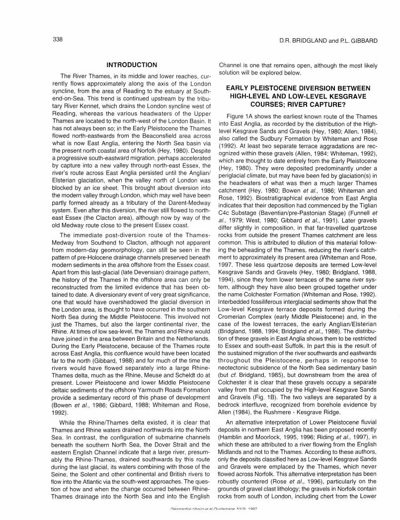
Figure 1A shows the earliest known route of the Thames into East Anglia, as recorded by the distribution of the High-level Kesgrave Sands and Gravels (Hey, 1980; Allen, 1984), also called the Sudbury Formation by Whiteman and Rose (1992). At least two separate terrace aggradations are recognized within these gravels (Allen, 1984; Whiteman, 1992), which are thought to date entirely from the Early Pleistocene (Hey, 1980). They were deposited predominantly under a periglacial climate, but may have been fed by glaciation(s) in the headwaters of what was then a much larger Thames catchment (Hey, 1980; Bowen et ai, 1986; Whiteman and Rose, 1992). Biostratigraphical evidence from East Anglia indicates that their deposition had commenced by the Tiglian C4c Substage (Baventian/pre-Pastonian Stage) (Funnell et ai, 1979; West, 1980; Gibbard et ai, 1991). Later gravels differ slightly in composition, in that far-travelled quartzose rocks from outside the present Thames catchment are less common. This is attributed to dilution of this material following the beheading of the Thames, reducing the river's catchment to approximately its present area (Whiteman and Rose, 1997. These less quartzose deposits are termed Low-level Kesgrave Sands and Gravels (Hey, 1980; Bridgland, 1988, 1994), since they form lower terraces of the same river system, although they have also been grouped together under the name Colchester Formation (Whiteman and Rose, 1992). Interbedded fossiliferous interglacial sediments show that the Low-level Kesgrave terrace deposits formed during the Cromerian Complex (early Middle Pleistocene) and, in the case of the lowest terraces, the early Anglian/Elsterian (Bridgland, 1988, 1994; Bridgland et ai, 1988). The distribution of these gravels in East Anglia shows them to be restricted to Essex and south-east Suffolk. In part this is the result of the sustained migration of the river southwards and eastwards throughout the Pleistocene, perhaps in response to neotectonic subsidence of the North Sea sedimentary basin (but cf. Bridgland, 1985), but downstream from the area of Colchester it is clear that these gravels occupy a separate valley from that occupied by the High-level Kesgrave Sands and Gravels (Fig. 1B). The two valleys are separated by a bedrock interfluve, recognized from borehole evidence by Allen (1984), the Rushmere - Kesgrave Ridge.
An alternative interpretation of Lower Pleistocene fluvial deposits in northern East Anglia has been proposed recently (Hamblin and Moorlock, 1995, 1996; Riding et ai, 1997), in which these are attributed to a river flowing from the English Midlands and not to the Thames. According to these authors, only the deposits classified here as Low-level Kesgrave Sands and Gravels were emplaced by the Thames, which never flowed across Norfolk. This alternative interpretation has been robustly countered (Rose et ai, 1996), particularly on the grounds of gravel clast lithology; the gravels in Norfolk contain rocks from south of London, including chert from the Lower
nônnranhia nhueiniio at Dnalornairo m i l l 1 QQ7
QUATERNARY RIVER DIVERSIONS 339
FIGURE 1. The Pleistocene evolution of the Lower Thames drainage basin (after Bridgland and D'Olier,1995). A- Early Pleistocene; B- Early Middle Pleistocene (Cromerian Complex); C- Early Anglian/ Elsterian; D- Anglian/Elsterian glacial maximum, showing initiation of the post-diversion Thames drainage system.
Greensand, which can only have been transported northwards by south-bank tributaries of the Thames and then the Thames itself. The alternative interpretation is thus rejected here. Instead, the Midlands river is seen as a tributary of the Early Pleistocene Thames, converging with it in southern Norfolk (Rose, 1994).
Clearly, a diversion event occurred in the region of Colchester at the end of the Early Pleistocene, resulting in the Thames adopting a new valley downstream from this area. This valley carried the Thames eastwards into the path of the early River Medway, which had flowed northwards across eastern Essex during the Early Pleistocene (Bridgland, 1988; Fig. 1A). Thus, for the first time, the Thames and Medway joined, the confluence being situated somewhere near the modern north-east Essex coast (Fig. 1 B). The mechanism for this diversion can only be the subject of speculation. The apparent synchrony with the beheading of the Thames (Whiteman and Rose, 1997) is of possible significance, suggesting some wide-reaching effect, such as a glaciation. The first large Quaternary glaciation would appear to have coin-
L'évolution du bassin de drainage de la basse Tamise au Pleistocene (d'après Bridgland et D'Olier, 1995). A- Pleistocene inférieur ; B- Début du Pleistocene moyen (complexe Cromérien) ; C- Anglien/ Elstérien inférieur ; D- Maximum glaciaire de lAnglien/Elstérien, montrant l'amorce de la déviation du système de drainage de la Tamise.
; cided with Stage 22 of the marine oxygen isotope record, ; which was towards the end of the Early Pleistocene (Funnel,
1995). However, no pre-Elsterian/Anglian glacial deposits ' have been identified in East Anglia. Indeed, it is likely that ; the new Thames route made use of a pre-existing left-bank
tributary of the Medway, so it is possible that river capture of the 'Davisian' type could have effected the diversion.
GLACIAL DIVERSION OF THE THAMES: THE > EVIDENCE FROM THE VALE OF ST ALBANS
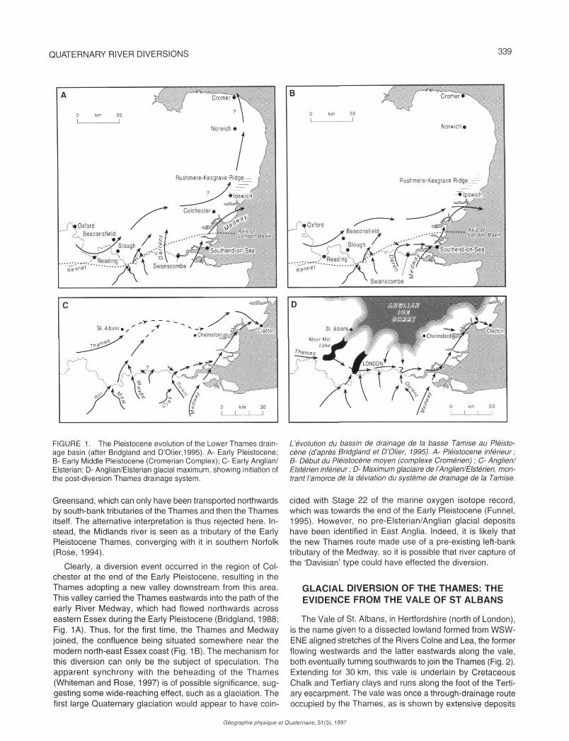
; The Vale of St. Albans, in Hertfordshire (north of London), f is the name given to a dissected lowland formed from WSW-} ENE aligned stretches of the Rivers Colne and Lea, the former r flowing westwards and the latter eastwards along the vale, > both eventually turning southwards to join the Thames (Fig. 2). > Extending for 30 km, this vale is underlain by Cretaceous
Chalk and Tertiary clays and runs along the foot of the Terti-* ary escarpment. The vale was once a through-drainage route
occupied by the Thames, as is shown by extensive deposits
Géographie physique el Quaternaire. 51(3). 1997
340 D.R. BRIDGLAND and PL. GIBBARD
left by that river before it abandoned this part of its course in favour of the modern valley through London (Gibbard, 1977; Cheshire, 1983; Bridgland and Cheshire, 1994). The sequence of events that led to this change of course is well understood, as a result of studies of the sedimentary sequence in the Vale of St Albans, which includes glacial and glacio-lacustrine deposits as well as the river gravels of the Thames and, after the diversion, the Colne and Lea.
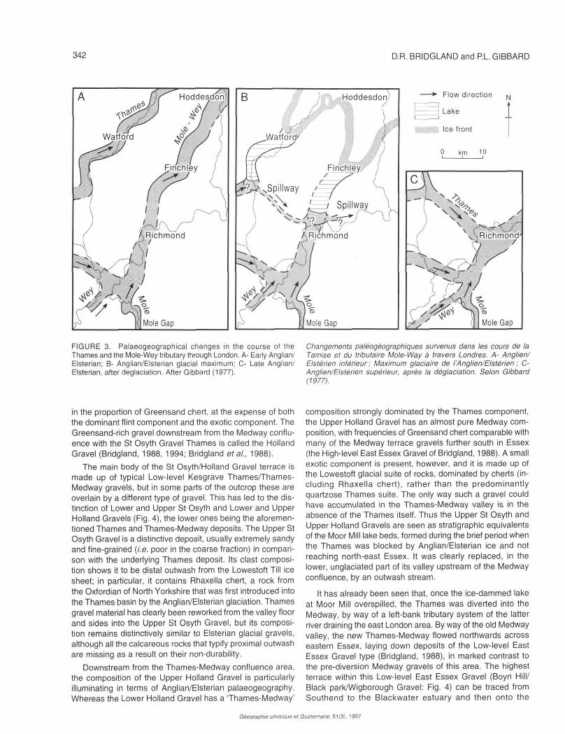
West of the Vale, in the Middle Thames valley, the most complete record of Thames evolution is preserved, there being a staircase of at least twelve terraces recognized in the Slough-Beaconsfield area. The highest of these extend along the alignment of the Vale of St Albans, whereas the lower, younger gravel terraces follow the modern river towards west London. A thick gravel deposit floors much of the Vale of St Albans, where it is termed Westmill Gravel (Gibbard, 1977, 1985; Fig. 2B/D). Upstream, this is continued as the Winter Hill Gravel of the Middle Thames, which forms the Winter Hill Terrace. In the Vale of St Albans the Winter Hill/Westmill Gravel interdigitates with glacial deposits ascribed to the Anglian/Elsterian glaciation of eastern England, showing that the Thames was flowing at the level of the Winter Hill Terrace when its valley was invaded by Anglian/Elsterian ice (Gibbard, 1977,1978; Bridgland, 1994; Bridgland and Cheshire, 1994). Intercalated in this gravel are two substantial till units of typical Lowestoft Formation lithology (Perrin et al., 1979), rich in chalk as well as clay and fossils of Jurassic origin, formed by ice of British provenance. The lower till (the Ware Till Member) was deposited by a glacier tongue from the north that only advanced a short distance into the eastern part of the Vale of St Albans, around Ware and Hertford. It certainly dammed the river locally, as shown by glacial lake sediments near Ware. It may also have advanced further southwards into the adjacent Mole-Wey valley in the Hoddesdon area (Fig. 2C). However, this advance probably failed to divert the river from its course through the vale and, following retreat, the course was re-established further towards the east (Fig. 2D). A subsequent ice advance from the north-east (represented by the Eastend Green Till Member) was more vigorous and overrode the entire Thames valley between The Vale of St Albans and Colchester (the 'Mid-Essex depression'). It continued upstream along the Vale to near St Albans in the south-west, where it temporarily halted and dammed the river to form a substantial glacial lake (Moor Mill lake - Fig. 2E). Like the earlier lake in the Hertford area, the Moor Mill lake is recorded in the sedimentary sequence by laminated glaciolacustrine sediments. Varve-counting has shown that the Moor Mill lake persisted for over 300 years and reached into the Middle Thames region (Fig. 1D), where the Thames built a delta into the lake (Gibbard, 1977,1985).
The overspilling of this lake, which is presumed to have initiated the new course of the River Thames through London (Figs 1D and 3B/C), seems to have coincided with a final maximal advance of the ice tongue (Gibbard, 1977, 1979, 1985; Ehlers and Gibbard, 1991). It appears that the rising water spilled over the interfluve between the Thames and the neighbouring Mole-Wey tributary valley, in which a comparable ice-lobe was also damming the river, in north London. An
identical situation seems to have also occurred in the next, parallel Thames south-bank-tributary valley, the River Wandle (Gibbard, 1994). Thus overspill of the Thames valley lake seems to have set off a 'chain-reaction' whereby lake water spilled from valley to valley until it reached one that was unglaciated. That seems to have been the Darent-Cray valley, east of London (see below), itself a tributary of the Essex Medway (Bridgland, 1988; Bridgland and D'Olier, 1995; Fig. 1C). The newly diverted Thames thus adopted the old Medway valley near Southend-on-Sea, from where it flowed north to rejoin the original Thames course near Clacton (Bridgland, 1988; 1994; Fig. 1D). Cheshire (1983; Bridgland and Cheshire, 1994; Allen, Cheshire and Whiteman, 1991) has proposed a slight variation on this model, in which he envisages the ponding of the Moor Mill lake and the ultimate diversion of the Thames to have been brought about by the first (Ware Till) ice advance. Whichever advance actually diverted the Thames, there is no doubt that this was the result of the Anglian/Elsterian glaciation. This has been established by the relations between the glacial sediments in the Vale of St Albans and (overlying) Hoxnian interglacial sediments at sites such as Hatfield (Gibbard, 1977, 1978; Fig. 2). Furthermore, glacially emplaced till, associated with the same ice sheets that diverted the Thames (Allen et al., 1991 ; Bridgland and Cheshire, 1994), underlies gravels of the 'high terrace' of the Lower Thames, east of London. The oldest sediments of this terrace date from the late Anglian, while Hoxnian deposits form part of the same terrace at Swanscombe (Bridgland, 1994; Gibbard, 1994).
THE EVIDENCE FROM NORTH-EAST ESSEX
The events in the Vale of St Albans, resulting in the glacial blockage and diversion of the Thames, had a profound effect on the valley further downstream, which remained unglaciated beyond Colchester. Again, the sequence of events is recorded in the depositional sequence, the glacial advance providing a very useful stratigraphie marker that can be recognized over a wide area.
Immediately prior to the glacial advance, the Thames flowed across Essex from Harlow, through Chelmsford to Colchester and Clacton (Bridgland, 1988). It was joined by the Medway between the last two of these places (Fig. 1C). This, the last pre-diversion course of the Thames is mapped out by the distribution of the St Osyth Gravel, the lowest in the Low-level Kesgrave terrace 'staircase' of the Tendring Peninsula, between the estuaries of the Essex Colne and the Blackwater. The location of the contemporary Thames-Medway confluence, in this and other terraces on the Tendring Peninsula, has been adduced from clast-lithological analysis. The Medway has carried rocks from the Weald northwards to the area, amongst them Greensand chert being by far the most common. Of more significance, the Medway gravels lack the far-travelled 'exotic' component that characterizes the gravels of the Thames. These exotic rocks include quartzite pebbles reworked from the Permo-Trias of the English Midlands and chert from the Carboniferous of the south Pennines and north-east Wales (Bridgland, 1986). The Thames Medway confluence is marked, on the Tendring Peninsula, by a boost
Géoaraphie ohvsiaue et Quaternaire. 51(3). 1997
QUATERNARY RIVER DIVERSIONS 341
D Westmill Upper Gravel \ V \ / J .
— Flow direct ion
Ice front
N
0 km 10
FIGURE 2. Palaeogeography of Vale of St Albans and Middle Paléogéographie du Vale St Albans et de la moyenne Tamise au Thames during the Elsterian (Anglian) Stage (after Gibbard, 1977). cours du stade de l'Elstérien (Anglien) (selon Gibbard, 1977).
Géographie physique et Quaternaire, 51(3). 1997
342 D. R. BRIDGLAND and RL GIBBARD
FIGURE 3. Palaeogeographical changes in the course of the Thames and the Mole-Wey tributary through London. A- Early Anglian/ Elsterian; B- Anglian/Elsterian glacial maximum; C- Late Anglian/ Elsterian, after déglaciation. After Gibbard (1977).
Changements paléogéographiques survenus dans les cours de la Tamise et du tributaire Mole-Way à travers Londres. A- Anglien/ Elstérien inférieur; Maximum glaciaire de l'Anglien/Elstérien ; C-Anglien/Elstérien supérieur, après la déglaciation. Selon Gibbard (1977).
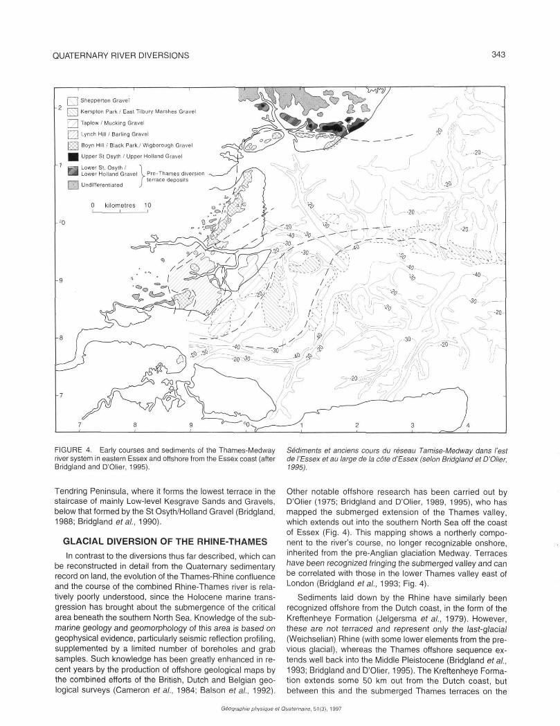
in the proportion of Greensand chert, at the expense of both the dominant flint component and the exotic component. The Greensand-rich gravel downstream from the Medway confluence with the St Osyth Gravel Thames is called the Holland Gravel (Bridgland, 1988, 1994; Bridgland era/., 1988).
The main body of the St Osyth/Holland Gravel terrace is made up of typical Low-level Kesgrave Thames/Thames-Medway gravels, but in some parts of the outcrop these are overlain by a different type of gravel. This has led to the distinction of Lower and Upper St Osyth and Lower and Upper Holland Gravels (Fig. 4), the lower ones being the aforementioned Thames and Thames-Medway deposits. The Upper St Osyth Gravel is a distinctive deposit, usually extremely sandy and fine-grained (i.e. poor in the coarse fraction) in comparison with the underlying Thames deposit. Its clast composition shows it to be distal outwash from the Lowestoft Till ice sheet; in particular, it contains Rhaxella chert, a rock from the Oxfordian of North Yorkshire that was first introduced into the Thames basin by the Anglian/Elsterian glaciation. Thames gravel material has clearly been reworked from the valley floor and sides into the Upper St Osyth Gravel, but its composition remains distinctively similar to Elsterian glacial gravels, although all the calcareous rocks that typify proximal outwash are missing as a result on their non-durability.
Downstream from the Thames-Medway confluence area, the composition of the Upper Holland Gravel is particularly illuminating in terms of Anglian/Elsterian palaeogeography. Whereas the Lower Holland Gravel has a Thames-Medway'
composition strongly dominated by the Thames component, the Upper Holland Gravel has an almost pure Medway composition, with frequencies of Greensand chert comparable with many of the Medway terrace gravels further south in Essex (the High-level East Essex Gravel of Bridgland, 1988). A small exotic component is present, however, and it is made up of the Lowestoft glacial suite of rocks, dominated by cherts (including Rhaxella chert), rather than the predominantly quartzose Thames suite. The only way such a gravel could have accumulated in the Thames-Medway valley is in the absence of the Thames itself. Thus the Upper St Osyth and Upper Holland Gravels are seen as stratigraphie equivalents of the Moor Mill lake beds, formed during the brief period when the Thames was blocked by Anglian/Elsterian ice and not reaching north-east Essex. It was clearly replaced, in the lower, unglaciated part of its valley upstream of the Medway confluence, by an outwash stream.
It has already been seen that, once the ice-dammed lake at Moor Mill overspilled, the Thames was diverted into the Medway, by way of a left-bank tributary system of the latter river draining the east London area. By way of the old Medway valley, the new Thames-Medway flowed northwards across eastern Essex, laying down deposits of the Low-level East Essex Gravel type (Bridgland, 1988), in marked contrast to the pre-diversion Medway gravels of this area. The highest terrace within this Low-level East Essex Gravel (Boyn Hill/ Black park/Wigborough Gravel: Fig. 4) can be traced from Southend to the Blackwater estuary and then onto the
Géoaraohie Dhvsiaue et Quaternaire. 51(31. 1997
QUATERNARY RIVER DIVERSIONS 343
FIGURE 4. Early courses and sediments of the Thames-Medway river system in eastern Essex and offshore from the Essex coast (after Bridgland and D'Olier, 1995).
Sédiments et anciens cours du réseau Tamise-Medway dans l'est de l'Essex et au large de la côte d'Essex (selon Bridgland et D'Olier, 1995).
Tendring Peninsula, where it forms the lowest terrace in the staircase of mainly Low-level Kesgrave Sands and Gravels, below that formed by the St Osyth/Holland Gravel (Bridgland, 1988; Bridgland et at, 1990).
GLACIAL DIVERSION OF THE RHINE-THAMES
In contrast to the diversions thus far described, which can be reconstructed in detail from the Quaternary sedimentary record on land, the evolution of the Thames-Rhine confluence and the course of the combined Rhine-Thames river is relatively poorly understood, since the Holocene marine transgression has brought about the submergence of the critical area beneath the southern North Sea. Knowledge of the submarine geology and geomorphology of this area is based on geophysical evidence, particularly seismic reflection profiling, supplemented by a limited number of boreholes and grab samples. Such knowledge has been greatly enhanced in recent years by the production of offshore geological maps by the combined efforts of the British, Dutch and Belgian geological surveys (Cameron et al., 1984; Balson étal., 1992).
Other notable offshore research has been carried out by D'Olier (1975; Bridgland and D'Olier, 1989, 1995), who has mapped the submerged extension of the Thames valley, which extends out into the southern North Sea off the coast of Essex (Fig. 4). This mapping shows a northerly component to the river's course, no longer recognizable onshore, inherited from the pre-Anglian glaciation Medway. Terraces have been recognized fringing the submerged valley and can be correlated with those in the lower Thames valley east of London (Bridgland et al., 1993; Fig. 4).
Sediments laid down by the Rhine have similarly been recognized offshore from the Dutch coast, in the form of the Kreftenheye Formation (Jelgersma et al., 1979). However, these are not terraced and represent only the last-glacial (Weichselian) Rhine (with some lower elements from the previous glacial), whereas the Thames offshore sequence extends well back into the Middle Pleistocene (Bridgland et al., 1993; Bridgland and D'Olier, 1995). The Kreftenheye Formation extends some 50 km out from the Dutch coast, but between this and the submerged Thames terraces on the
Géographie physique el Quaternaire, 51 (3), 1997
344 D. R . BRIDGLAND and RL. GIBBARD
ea coastline
not known
*>* 4 ^ P 51 î
Mam
"
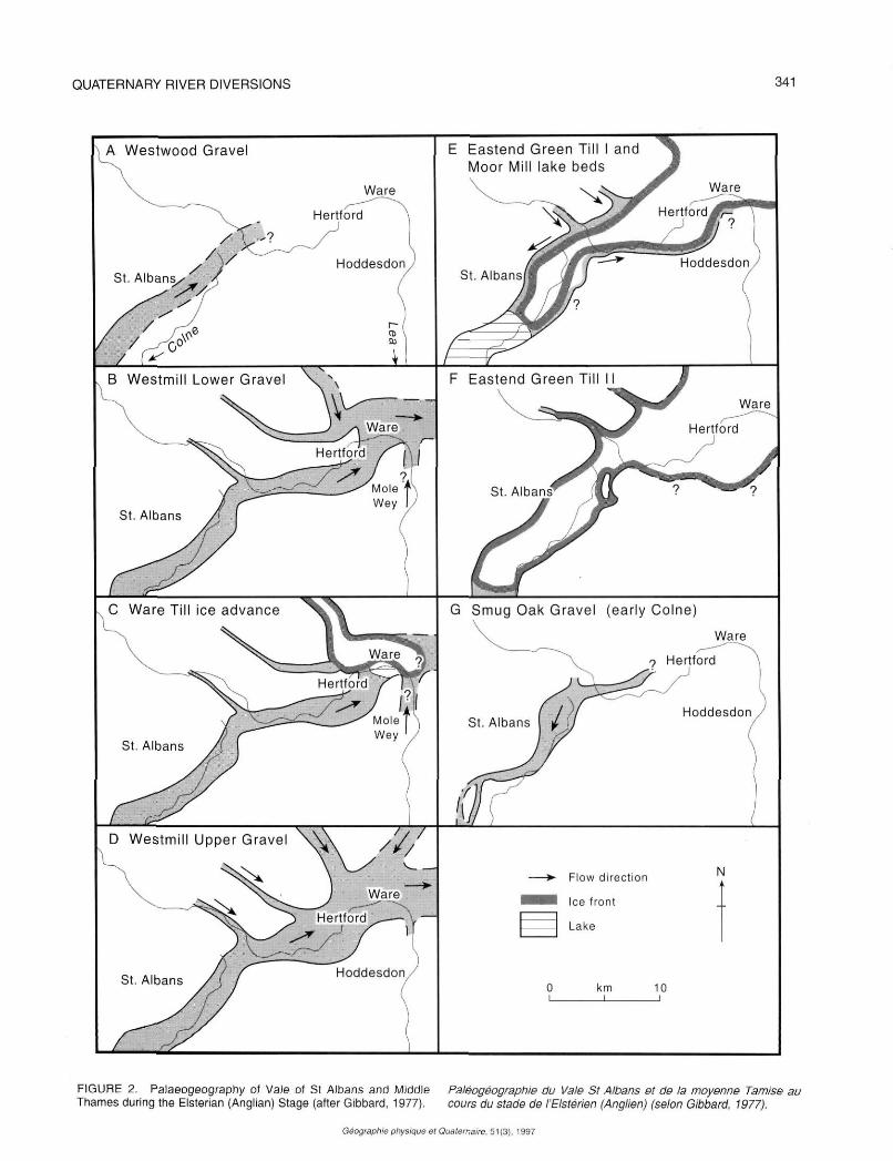
O9n
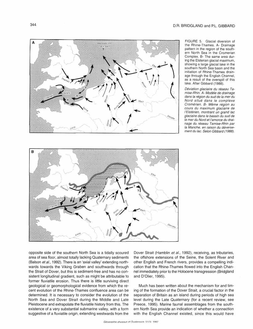
FIGURE 5. Glacial diversion of the Rhine-Thames. A- Drainage pattern in the region of the southern North Sea in the Cromerian Complex. B- The same area during the Elsterian glacial maximum, showing a large glacial lake in the southern North Sea basin and the initiation of Rhine-Thames drainage through the English Channel, as a result of the overspill of this lake. After Gibbard (1!
Déviation glaciaire du réseau Tamise-Rhin. A- Modèle de drainage dans la région du sud de la mer du Nord situé dans le complexe Cromérien. B- Même région au cours du maximum glaciaire de l'Elstérien. montrant un grand lac glaciaire dans le bassin du sud de la mer du Nord et l'amorce du drainage du réseau Tamise-Rhin par la Manche, en raison du déversement du lac. Selon Gibbard (1988).
opposite side of the southern North Sea is a tidally scoured area of sea floor, almost totally lacking Quaternary sediments (Balson et al., 1992). There is an 'axial valley' extending northwards towards the Viking Graben and southwards through the Strait of Dover, but this is sediment-free and has no consistent longitudinal gradient, such as might be attributable to former fluviatile erosion. Thus there is little surviving direct geological or geomorphological evidence from which the recent evolution of the Rhine-Thames confluence area can be determined. It is necessary to consider the evolution of the North Sea and Dover Strait during the Middle and Late Pleistocene and extrapolate the fluviatile history from this. The existence of a very substantial submarine valley, with a form suggestive of a fluviatile origin, extending westwards from the
Dover Strait (Hamblin et al., 1992), receiving, as tributaries, the offshore extensions of the Seine, the Solent River and other English and French rivers, provides a compelling indication that the Rhine-Thames flowed into the English Channel immediately prior to the Holocene transgression (Bridgland and D'Olier, 1995).
Much has been written about the mechanism for and timing of the formation of the Dover Strait, a crucial factor in the separation of Britain as an island during periods of high sea level during the Late Quaternary (for a recent review, see Preece, 1995). Marine faunal assemblages from the southern North Sea provide an indication of whether a connection with the English Channel existed, since this would have
Géoaraohie nhvsiaije et Oiiaterrnatœ S1(31 1997
QUATERNARY RIVER DIVERSIONS 345
allowed the immigration of more southern species (Meijer and Preece, 1995). Terrestrial interglacial faunas in Britain can also be compared with those on the continent, providing an indication of whether Britain was separated from Europe (this would have caused an impoverishment of the fauna). Recent reviews of such evidence have suggested that Britain became an island for the first time in the Middle Pleistocene (Meijer and Preece, 1995; Stuart, 1995). This implies that no deeply incised valley existed through the Weald-Artois anticline in the Early and early Middle Pleistocene and that the Rhine-Thames, at this time, flowed northwards. The huge accumulations of Lower Pleistocene and Lower Middle Pleistocene fluviatile and deltaic sediments beneath the southern North Sea, the IJmuiden, Winterton Shoal and Yarmouth Roads Formations (Cameron et al., 1984), show that the Rhine and Thames formerly emptied out into the North Sea Basin, until at least the Elsterian (Gibbard, 1988). In marked contrast, and perhaps significantly, there is little post-Elsterian terrigenous sediment in the southern North Sea, suggesting, it would seem, that it was carried elsewhere by the major rivers.
The evidence discussed above clearly points to a significant change in the offshore drainage regime of the Rhine-Thames system during the Middle Pleistocene, at about the time of the Elsterian glaciation. The equivalent Anglian glaciation has long been recognized as the most extensive in southern Britain; it has already been shown above that it effected the diversion of the Thames in its middle reaches. It has been suggested recently that Anglian/Elsterian ice sheets blocked the northern exit to the North Sea causing a huge glacial lake to form in the area between southern England and the Netherlands (Gibbard, 1988, 1995; Fig. 5). Deposits attributed to this lake have been recognized in northern Holland (the Peelo Formation) and in eastern Essex (Gibbard, 1995; Gibbard et ai, 1995, 1996). This led Gibbard (1988, 1995) to suggest that it was the overflow from this lake into the English Channel lowland that cut the Strait of Dover valley through the Weald-Artois anticline, modifying an idea previously put forward by Smith (1985), who had suggested this mechanism of formation but much later in the Quaternary. Whether the Rhine-Thames adopted the English Channel route immediately upon Anglian/Elsterian déglaciation and whether the route persisted during all subsequent low-sea-level episodes are topics discussed at length by Bridgland and D'Olier (1995), who concluded that there was insufficient evidence to provide firm indications. However, there is clearly a very substantial body of (mainly indirect) evidence suggesting that a very major glacial diversion of river courses took place in the southern North Sea during the Anglian/Elsterian, overshadowing that in the onshore area of Britain, which rerouted the Thames through London.
CONCLUSIONS
Two significant diversions have affected the Thames drainage system during the course of the Pleistocene, although these must be set against a background of progressive migration of the river south-eastwards with successive phases of incision and floodplain formation. These diversions effec
tively accelerated the migration in the areas affected. The first, at the beginning of the Middle Pleistocene, affected the river downstream from northern Essex and may have resulted from river capture, although the influence of an early glaciation cannot be ruled out. The second, coincident with the Anglian/ Elsterian glaciation, brought the river into its modern valley through London, although its route downstream from northern Essex was unaffected. In the area offshore a much more significant diversion seems also to have been brought about by the Anglian/Elsterian glaciation, this time affecting the Rhine as well as the Thames. This shifted the outlet of Rhine-Thames drainage into the North Atlantic from the North Sea Basin to the south-west approaches and may well have been instrumental in Britain becoming an island during subsequent interglacials.
REFERENCES
Allen, P., 1984. Field guide to the Gipping and Waveney valleys. Field Guide, Quaternary Research Association, Cambridge. 116 p.
Allen, P., Cheshire, D.A. and Whiteman, CA., 1991. The tills of southern East Anglia, p. 255-278. In J. Ehlers, J, P.L. Gibbard, P.L. and J. Rose, J., eds. Glacial deposits in Great Britain and Ireland. Balkema, Rotterdam.
Balson, P.S., Leban, C , Shuttenhelm, R.T.E., Paepe, R. and Baeteman, C , 1992. Quaternary Geology, Ostend Sheet 51° N - 02° E, British Geological Survey/Rijks Geologische Dienst/Belgische Geologische Dienst, 1: 250,000 offshore map series.
Bowen, D.Q., Rose, J., McCabe, A.M. and Suthetland, D.G., 1986. Correlation of Quaternary glaciations in England, Ireland, Scotland and Wales. Quaternary Science Reviews, 5: 299-340.
Bridgland, D.R.. 1985. Uniclinal shifting: A speculative reappraisal based on terrace distribution in the London Basin. Quaternary Newsletter, 47, 26-33.
-1986. The rudaceous components of the East Essex gravel; their characteristics and provenance. Quaternary Studies, 2: 34-44.
1988. The Pleistocene fluvial stratigraphy and palaeogeography of Essex. Proceedings of the Geologists' Association, 99: 291-314.
1994. Quaternary of the Thames. Chapman & Hall, London, 441 p.
Bridgland, D.R., Allen P., Currant, A.P., Gibbard. P.L., Lister, A.M., Preece, R.C., Robinson, J.E.. Stuart. A.J. and Sutcliffe, A.J., 1988. Report of the Geologists' Association Field Meeting in north-east Essex, May 22nd-24th, 1987. Proceedings of the Geologists' Association, 99: 315-333.
Bridgland, D.R. and Cheshire, D.A., 1994. Westmill Quarry, p.121-129. /nD.R. Bridgland, Quaternary of the Thames. Chapman & Hall, London, 441 p.
Bridgland, D.R. and D'Olier, B, 1989. A preliminary correlation of onshore and offshore courses of the Rivers Thames and Medway during the Middle and Upper Pleistocene, p. 161-172. In J.P. Henriet, J.P. and G. De Moor, Quaternary and Tertiary geology of the Southern Bight, North Sea. Belgian Ministry of Economic Affairs Geological Survey, 241 p.
1995. The Pleistocene evolution of the Thames and Rhine drainage systems in the southern North Sea Basin, p. 27-45. In R.C. Preece, éd., Island Britain: A Quaternary perspective. Geological Society Special Publication 96.
Bridgland, D.R., D'Olier, B.. Gibbard, P.L. and Roe, H.M., 1993. Correlation of Thames terrace deposits between the Lower Thames, eastern Essex and the submerged offshore continuation of the Thames-Medway valley. Proceedings of the Geologists' Association, 104: 51-57.
Bridgland, D.R., Gibbard, P.L. and Preece, R.C, 1990. The geology and significance of the interglacial sediments at Little Oakley, Essex. Philosophical Transactions of the Royal Society of London, B 328: 307-339.
Cameron, T.D.J., Laban. C. and Schuttenhelm, R.T.E., 1984. Quaternary Geology, Flemish Bight Sheet 52° N - 02° E. British Geological Survey/
ftonnranhio nhiisiniio ol Oiiatarnairo R1I1I 1 QQ7
346 D.R. BRIDGLAND and RL. GIBBARD
Rijks Geologische Dienst/Belgische Geologische Dienst, 1: 250,000 offshore map series.
Cheshire, D.A., 1983. Till lithology in Hertfordshire and West Essex, p. 50-59. In J. Rose, éd., Diversion of the Thames. Field Guide, Quaternary Research Association, London.
D'Olier, B., 1975. Some aspects of late Pleistocene - Holocene drainage of the River Thames in the eastern part of the London Basin. Philosophical Transactions of the Royal Society of London, A 279: 269-277.
Ehlers, J. and Gibbard, P.L., 1991. Anglian glacial deposits in Britain and the adjoining regions, p. 17-24. In J. Ehlers, P.L. Gibbard and J. Rose, eds. Glacial deposits in Great Britain and Ireland. Balkema. Rotterdam.
Funnel, B.M., 1995. Global sea-level and the (pen-)insularity of late Cenozoic Britain, p. 3-13. In R.C. Preece, éd., Island Britain: A Quaternary perspective. Geological Society of London Special Publication 96.
Funnell B.M., Norton, P.E.P. and West, R.G., 1979. The Crag at Bramerton. Philosophical Transactions of the Royal Society of London, B 287: 489-534,
Gibbard, P.L., 1977. Pleistocene history of the Vale of St.Albans. Philosophical Transactions of the Royal Society of London, B 280: 445-483.
1978. Quaternary geology and landform development in the Vale of St Albans, p. 9-29. In J. Rose and P.L. Gibbard, eds, Field Guide to the Vale of St Albans. Quaternaqry Research Association, London.
1979. Middle Pleistocene drainage in the Thames Valley. Geological Magazine, 116: 35-44.
1985. The Pleistocene history of the Middle Thames Valley. Cambridge University Press, 155 p.
1988. The history of the great northwest European rivers during the past three million years. Philosophical Transactions of the Royal Society of London, B 318: 559-602.
1994. Pleistocene History of the Lower Thames Valley. Cambridge University Press, 229 p.
1995. The formation of the Strait of Dover, p. 15-26. In R.C. Preece, éd., Island Britain: A Quaternary perspective. Geological Society of London Special Publication 96.
Gibbard, P.L., Boreham, S.. Burger. A, and Roe H.M., 1995. Curry farm. Bradwell, p. 283-296. In D.R. Bridgland, P. Allen and B.A. Haggart. Quaternary of the Lower Reaches of the Thames. Field Guide. Quaternary Research Association, Durham.
Gibbard, P.L., Boreham, S., Burger, A. and Roe H.M.. 1996. Middle Pleistocene lacustrine deposits in eastern Essex, England and their palaeogeographical implications. Journal of Quaternary Science 11, 281-298.
Gibbard, P.L., West, R.G., Zagwijn, W.H. Balson, P.S., Burger, A.W., Funnell, B.M., Jeffery, D.H., de Jong, J., van Kolfschoten, T., Lister, A.M., Meijer, T., Norton, P.E.P., Preece, R.C., Rose, J., Stuart, A.J., Whiteman, CA. and Zalasiewicz, J.A., 1991. Early and early Middle Pleistocene correlations in the southern North Sea basin. Quaternary Science Reviews, 10: 23-52.
Hamblin, R.J.O., Crosby, A.. Balson. P.S., Jones, S.M,, Chadwick. R.A., Penn, I.E. and Artur, M.J., 1992. The geology of the English Channel. British Geological Survey. HMSO, 106 p.
Hamblin, R.J.O. and Moorlock, B.S.P., 1995. The Kesgrave and Bytham Sands and Gravels of Eastern Suffolk. Quaternary Newsletter, 77: 17-31.
Hamblin, R.J.O. and Moorlock, B.S.P., 1996. The Kesgrave and Bytham Sands and Gravels of East Anglia. A reply to J. Rose, P. Allen, CP. Green, R.W. Hey, S.G. Lewis, J.M. Sinclair, and CA. Whiteman. Quaternary Newsletter. 79: 26-34.
Riding, J.B., Moorlock, B.S.P.. Jeffery, D.H. and Hamblin, R.J.O., 1997. Reworked and indigenous palynomorphs from the Norwich Crag Formation (Pleistocene) of eastern Suffolk: Implications for provenance, palaeogeography and climate. Proceedings of the Geologists' Association, 108: 25-38.
Hey, R.W., 1980. Equivalents of the Westland Green Gravels in Essex and East Anglia. Proceedings of the Geologists' Association, 91: 279-290.
Jelgersma, S., OeIe, E. and Wiggers, A.J., 1979. Depositional history and coastal development in the Netherlands and the adjacent North Sea since the Eemian. Acta Univsitatis Upsaliensis: Symposia Univitatis Upsaliensis Annum Quingentesimum Celebrantis, 2: 233-248.
Meijer.T. and Preece, R.C, 1995. Malacological evidence relating to the insularity of the British Isles during the Quaternary, p. 89-110. In R.C Preece, éd., Island Britain: A Quaternary perspective. Geological Society of London Special Publication 96.
Perrin, R.M.S., Rose, J. and Davies, H., 1979. The distribution, variation and origins of pre-Devensian tills in eastern England. Philosophical Transactions of the Royal Society of London. B 287: 535-570.
Preece, R.C, 1995. Introduction, Island Britain: A Quaternary perspective, p. 1-2. In R.C. Preece, éd., Island Britain: A Quaternary perspective. Geological Society of London Special Publication 96.
Rose. J., 1994. Major river systems of central and southern Britain during the Early and Middle Pleistocene. Terra Nova, 6: 435-443.
Rose, J., Allen, P., Green, CP., Hey, R.W., Lewis, S.G., Sinclair, J.M. and Whiteman, CA., 1996, The Kesgrave and Bytham Sands and Gravels of East Anglia. Quaternary Newsletter, 79: 10-25.
Smith. A.J., 1985. A catastrophic origin for the palaeovalley system of the eastern English Channel. Marine Geology, 64:65-75.
Stuart, A.J.. 1995. Insularity and Quaternary vertebrate faunas in Britain and Ireland, p. 111-125. In R.C. Preece, éd., Island Britain: A Quaternary perspective. Geological Society of London Special Publication 96.
West, R.G-, 1980. Pleistocene forest history in East Anglia. New Phytologist. 85: 571-622.
Whiteman, CA., 1992. The palaeogeography and correlation of pre-Anglian glaciation terraces of the River Thames in Essex and the London Basin. Proceedings of the Geologists' Association, 103: 37-56.
Whiteman, CA. and Rose, J., 1992. Thames river sediments of the British Early and Middle Pleistocene. Quaternary Science Reviews, 11: 363-375.
1997. Early-Middle Pleistocene beheading of the River Thames. Géographie physique et Quaternaire, 51 : 327-336.
Géographie physique el Quaternaire, 51(3), 1997