Embed Size (px)
Citation preview

Quality Assurance Project Plan
Project 14-008 Soil Moisture Characterization for Biogenic Emissions Modeling in
Texas
Elena McDonald-Buller Center for Energy & Environmental Resources
The University of Texas at Austin Austin, Texas 78758
[email protected] 512-471-2891
Rong Fu
The University of Texas at Austin
Summary of Project
QAPP Category Number: III Type of Project: Research or Development (Modeling)
QAPP Requirements: This QAPP includes descriptions of the project and objectives; organization and responsibilities; scientific approach; fire emissions and air quality modeling procedures; quality metrics; data analysis, interpretation, and management; reporting; and references.
QAPP Requirements:
Audits of Data Quality: 10% Required Report of QA Findings: Required in final report
May 29, 2014
2
DISTRIBUTION LIST
David Sullivan, Project Manager, Texas Air Quality Research Program Cyril Durrenberger, Quality Assurance Project Plan Officer, Texas Air Quality Research Program Barry Exum, Project Liaison, Texas Commission on Environmental Quality Chris Owen, Quality Assurance Project Plan Officer, Texas Commission on Environmental Quality Maria Stanzione, Program Manager, Texas Air Quality Research Program
3
APPROVALS QAPP was approved electronically on 4/15/2014 by David W. Sullivan, The University of Texas at Austin. _______________________________________________________ David Sullivan Project Manager, Texas Air Quality Research Program QAPP was approved electronically on 4/15/2014 by Cyril Durrenberger, The University of Texas at Austin. _______________________________________________________ Cyril Durrenberger Quality Assurance Project Plan Officer, Texas Air Quality Research Program QAPP was approved electronically on 4/14/2014 by Elena McDonald‐Buller, The University of Texas at Austin. _______________________________________________________ Elena McDonald-Buller Principal Investigator
6
1. PROJECT DESCRIPTION AND OBJECTIVES 1.1 Problem Statement The role of isoprene and other biogenic volatile organic compounds (BVOCs) in the formation of tropospheric ozone has been recognized as critical for air quality planning in Texas. In the southwestern United States, drought has become a recurring phenomenon and, in addition to other extreme weather events, can impose profound and complex effects on human populations and the environment. Understanding these effects on vegetation and biogenic emissions is important as Texas concurrently faces requirements to achieve and maintain attainment with the National Ambient Air Quality Standard (NAAQS) for ozone in several large metropolitan areas. Previous research has indicated that biogenic emissions estimates are influenced by potentially competing effects in model input parameters during drought and that uncertainties surrounding several key input parameters remain high. The primary objective of the project is to evaluate and inform improvements in the representation of one of these key input parameters, soil moisture, through the use of simulated and observational datasets. The Model of Emissions of Gases and Aerosols from Nature (MEGAN) will be used to explore the sensitivity of biogenic emission estimates to alternative soil moisture representations. 1.2 Project Objectives The primary objective of the project is to evaluate and inform improvements in the representation of soil moisture through the use of simulated and observational datasets. The Model of Emissions of Gases and Aerosols from Nature (MEGAN) will be used to explore the sensitivity of biogenic emission estimates to alternative soil moisture representations. 2. ORGANIZATION AND RESPONSIBILITIES
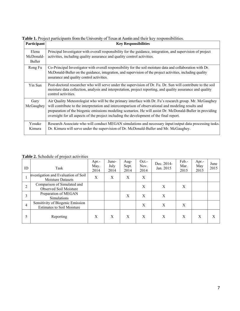
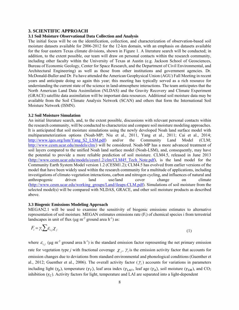
2.1 Personnel and Responsibilities This project is a collaborative effort between research teams at the Center for Energy and Environmental Resources and the Jackson School of Geosciences at the University of Texas at Austin. Dr. Elena McDonald-Buller, Research Associate Professor in Civil, Architectural, and Environmental Engineering and at the Center for Energy and Environmental Resources at the University of Texas at Austin, is the Principal Investigator for the project. Dr. Rong Fu, Professor in the Department of Geological Sciences of the University of Texas at Austin, is the Co-Principal Investigator. Project participants and their responsibilities are provided in Table 1 below. Dr. McDonald-Buller and Dr. Fu will have overall oversight of the quality assurance and quality control activities. 2.2 Schedule The schedule for specific tasks is listed in Table 2.
7
Table 1. Project participants from the University of Texas at Austin and their key responsibilities.
Participant Key Responsibilities
Elena McDonald-
Buller
Principal Investigator with overall responsibility for the guidance, integration, and supervision of project activities, including quality assurance and quality control activities.
Rong Fu
Co-Principal Investigator with overall responsibility for the soil moisture data and collaboration with Dr. McDonald-Buller on the guidance, integration, and supervision of the project activities, including quality assurance and quality control activities.
Yin Sun Post-doctoral researcher who will serve under the supervision of Dr. Fu. Dr. Sun will contribute to the soil moisture data collection, analysis and interpretation, project reporting, and quality assurance and quality control activities.
Gary McGaughey
Air Quality Meteorologist who will be the primary interface with Dr. Fu’s research group. Mr. McGaughey will contribute to the interpretation and intercomparison of observational and modeling results and preparation of the biogenic emissions modeling scenarios. He will assist Dr. McDonald-Buller in providing oversight for all aspects of the project including the development of the final report.
Yosuke Kimura
Research Associate who will conduct MEGAN simulations and necessary input/output data processing tasks.Dr. Kimura will serve under the supervision of Dr. McDonald-Buller and Mr. McGaughey.
Table 2. Schedule of project activities
ID
Task
Apr.-May. 2014
June-July 2014
Aug-Sept. 2014
Oct.-Nov. 2014
Dec. 2014- Jan. 2015
Feb.-Mar. 2015
Apr.-May 2015
June 2015
1 nvestigation and Evaluation of Soil
Moisture Datasets X X X X
2 Comparison of Simulated and
Observed Soil Moisture X X X
3 Preparation of MEGAN
Simulations X X X
4 Sensitivity of Biogenic Emission
Estimates to Soil Moisture X X X
5
Reporting
X X X X X X X X
8
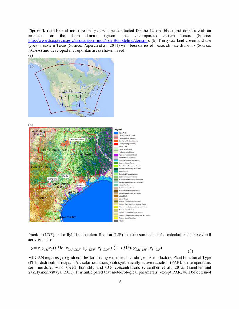
3. SCIENTIFIC APPROACH 3.1 Soil Moisture Observational Data Collection and Analysis The initial focus will be on the identification, collection, and characterization of observation-based soil moisture datasets available for 2006-2012 for the 12-km domain, with an emphasis on datasets available for the four eastern Texas climate divisions, shown in Figure 1. A literature search will be conducted; in addition, to the extent possible, our team will draw on personal contacts within the research community, including other faculty within the University of Texas at Austin (e.g. Jackson School of Geosciences, Bureau of Economic Geology, Center for Space Research, and the Department of Civil Environmental, and Architectural Engineering) as well as those from other institutions and government agencies. Dr. McDonald-Buller and Dr. Fu have attended the American Geophysical Union (AGU) Fall Meeting in recent years and anticipate doing so again this year; this meeting has typically served as a rich resource for understanding the current state of the science in land-atmosphere interactions. The team anticipates that the North American Land Data Assimilation (NLDAS) and the Gravity Recovery and Climate Experiment (GRACE) satellite data assimilation will be important data resources. Additional soil moisture data may be available from the Soil Climate Analysis Network (SCAN) and others that form the International Soil Moisture Network (ISMN). 3.2 Soil Moisture Simulation An initial literature search, and, to the extent possible, discussions with relevant personal contacts within the research community, will be conducted to characterize and compare soil moisture modeling approaches. It is anticipated that soil moisture simulations using the newly developed Noah land surface model with multiparameterization options (Noah-MP; Niu et al., 2011, Yang et al., 2011; Cai et al., 2014; http://www.iges.org/lsm/Yang_S2_LSM.pdf) and/or the Community Land Model (CLM; http://www.cesm.ucar.edu/models/clm/) will be considered. Noah-MP has a more advanced treatment of soil layers compared to the unified Noah land surface model (Noah-LSM), and, consequently, may have the potential to provide a more reliable prediction of soil moisture. CLM4.5, released in June 2013 (http://www.cesm.ucar.edu/models/cesm1.2/clm/CLM45_Tech_Note.pdf), is the land model for the Community Earth System Model version 1.2 (CESM1.2); CLM4.5 has evolved from earlier versions of the model that have been widely used within the research community for a multitude of applications, including investigations of climate-vegetation interactions, carbon and nitrogen cycling, and influences of natural and anthropogenic driven land use/land cover change on climate (http://www.cesm.ucar.edu/working_groups/Land/ileaps-CLM.pdf). Simulations of soil moisture from the selected model(s) will be compared with NLDAS, GRACE, and other soil moisture products as described above. 3.3 Biogenic Emissions Modeling Approach MEGAN2.1 will be used to examine the sensitivity of biogenic emissions estimates to alternative representation of soil moisture. MEGAN estimates emissions rate (Fi) of chemical species i from terrestrial landscapes in unit of flux (μg m-2 ground area h-1) as:
(1)
where (μg m-2 ground area h-1) is the standard emission factor representing the net primary emission
rate for vegetation type j with fractional coverage , is the emission activity factor that accounts for
emission changes due to deviations from standard environmental and phonological conditions (Guenther et al., 2012; Guenther et al., 2006). The overall activity factor ( ) accounts for variations in parameters
including light ( ), temperature ( , leaf area index ( ), leaf age ( , soil moisture ( ), and CO2 inhibition ( ). Activity factors for light, temperature and LAI are separated into a light-dependent
Fi i i, j j
i, j
j i
i
9
Figure 1. (a) The soil moisture analysis will be conducted for the 12-km (blue) grid domain with an emphasis on the 4-km domain (green) that encompasses eastern Texas (Source: http://www.tceq.texas.gov/airquality/airmod/rider8/modeling/domain). (b) Thirty-six land cover/land use types in eastern Texas (Source: Popescu et al., 2011) with boundaries of Texas climate divisions (Source: NOAA) and developed metropolitan areas shown in red. (a)
(b)
fraction (LDF) and a light-independent fraction (LIF) that are summed in the calculation of the overall activity factor:
(2)
MEGAN requires geo-gridded files for driving variables, including emission factors, Plant Functional Type (PFT) distribution maps, LAI, solar radiation/photosynthetically active radiation (PAR), air temperature, soil moisture, wind speed, humidity and CO2 concentrations (Guenther et al., 2012; Guenther and Sakulyanontvittaya, 2011). It is anticipated that meteorological parameters, except PAR, will be obtained
))1(( _____ LIFTLIFLAILDFTLDFPLDFLAICSMA LDFLDF

10
from the National Centers for Environmental Prediction (NCEP) North American Regional Reanalysis (NARR) products, as described by Huang et al. (2013). Hourly surface insolation from the Geostationary Operational Environmental Satellite (GOES), generated by University of Alabama in Huntsville) with a spatial resolution of 4-km will be re-gridded into a 1-km grid and converted to PAR based on a conversion factor of 0.45 (McNider, 2013; ENVIRON, 2011). The default version of MEGAN2.1 is configured to accept the 8-day composite LAI product (MCD15A2) from the Moderate Resolution Imaging Spectroradiometer (MODIS). For the study described by Huang et al. (2013), Dr. McDonald-Buller’s team modified MEGAN to accept the more recent MODIS 4-day composite LAI product (MCD15A3). In addition, land use/land cover data with 30-m resolution across the eastern half of the state from a recent Texas Commission on Environmental Quality (TCEQ)-sponsored effort (Popescu et al., 2011) have been mapped to MEGAN PFTs. Sensitivity studies will be conducted using alternative representations of soil moisture within MEGAN for selected periods with varying climatic conditions during 2006-2012. Analysis of biogenic emissions will focus primarily on isoprene and monoterpenes for the growing seasons (April-October) in the four climate regions in eastern Texas and comparisons within and between other states within the 12-km domain (Figure 1). 4. QUALITY METRICS The U.S. Environmental Protection Agency (EPA) has not specified specific data quality requirements for this work, nor is it expected that the EPA will evaluate this specific application. This work will investigate soil moisture observations derived from global, North American, or regional measurement networks. An objective is to obtain data from networks that have been in continuous operation since at least 2006 and are expected to continue to serve as a resource in the future. Soil moisture product quality should be assessed by calibration, quality assurance/quality control, and validation efforts as an integral part of network operation. To the extent possible, the sources, measurement techniques, and validation efforts for soil moisture data products selected for this project will be documented in the project final report. We expect to evaluate soil moisture data products in the context of mesoscale and in situ meteorological conditions, including air temperature and precipitation patterns, to assess reasonableness. The Noah-MP, CLM and previous generations of these models have been used extensively for investigations of land-atmosphere interactions. As part of the literature review, specific studies that have utilized these modeling systems for the prediction of soil moisture and have conducted comparisons with in situ or satellite derived observations of soil moisture will be highlighted. This work will result in multi-year simulations of soil moisture across the 12-km domain shown in Figure 1 that will be processed for input to MEGAN. Mapping of the magnitude and spatial distribution of soil moisture estimates from the selected model(s) will be an important step to assure processing consistency and reasonableness and to conduct comparisons with observation-based datasets. The team expects that maps will be created using Geographic Information System (GIS) or alternative visualization software available through the Texas Advanced Computing Center (TACC). Differences in soil moisture are anticipated between observational datasets and between simulated and observational datasets. For example, Dorigo et al. (2013) note the heterogeneity in measurement technique, measurement depth, spatial setup, and degree of automation among datasets from 35 networks comprising the ISMN. Intercomparisons through mapping, graphical analysis, and statistical metrics provide insights into the spatial and temporal variability and uncertainty associated with soil moisture data resources. MEGAN (Guenther et al., 2012) has been utilized widely for estimating biogenic emissions throughout the U.S. as well as globally. Emission estimates from MEGAN have been constrained with top-down estimates from aircraft and satellite observations. Guenther et al. (2012) describe three broad categories of uncertainty associated with emissions estimates for 150 compounds included in MEGAN: (1) isoprene, methanol, acetone, and acetalydehyde, for which top-down estimates of global concentration distributions indicate agreement within a factor of 2; (2) α-pinene, β-pinene, myrcene, sabinene, limonene, 3-carene, camphene,
11
ethane, propene, butane, methyl salicylate, t-β-ocimene, and 232-methyl butenol, for which agreement within a factor of 3 can be assumed based on above canopy fluxes, but not global assessments (Lamb et al., 1987); and (3) higher uncertainty for all other compounds. Although limitations have been identified, the model performs within reason relative to estimates for many anthropogenic source categories. A primary outcome of this work will be an assessment of the range of sensitivities in isoprene and monoterpene emissions estimates from MEGAN to alternative representations of soil moisture. A member of the research team who did not conduct the input data processing and model simulations with MEGAN will review at least 10% of the input data and model output for quality assurance purposes. 5. DATA ANALYSIS, INTERPRETATION, AND MANAGEMENT This project will result in a compilation of simulated and observed soil moisture products spanning 2006-2012, a time period that includes years with above average precipitation (2007) as well as extreme drought in Texas (e.g., 2011) and other areas of the 12-km domain (e.g., 2012). Analyses of individual datasets will focus on the following for the 12-km domain with an emphasis on eastern Texas:
Mapping of monthly average soil moisture by depth interval to examine the spatial variability within and between states and soil and land cover types.
Time series of average soil moisture by depth interval and by state, climate region, soil type, or land cover type to characterize monthly, seasonal, and annual variability.
Central and percentile (e.g. 5th, 25th, 75th, and 95th) metrics of soil moisture by depth interval, season, and year within states, eastern Texas climate regions, soil or land cover types to investigate the magnitude of variability.
Comparisons will be conducted between simulations and observations of soil moisture, recognizing uncertainties are associated with both data sources. Among the metrics that will be considered for the comparisons are daily paired (spatial and temporal) maximum differences (Mdiff), mean percent differences (Meandiff), and mean absolute percent differences (MeanABdiff), in soil moisture by depth interval, season, and year within states, eastern Texas climate regions, soil or land cover types:
, , for x = 1, 2, …N; t = 1, 2,…24
∑ ∑ , ,
, 100%
1 , ,
,100%
where , is the simulated or observed soil moisture at grid cell x at time t and N is the number of grid cells. Selected soil moisture datasets will be processed for use with MEGAN. The objectives will be to investigate temporal and spatial variations of emissions estimates using maps and graphics, such as time series or box and whisker plots, that show central and percentile (e.g. 5th, 25th, 75th, and 95th) metrics and to conduct targeted case studies of the response of soil moisture and biogenic emissions sensitivities to different climatic conditions within eastern Texas and the 12-km domain. The team members have developed algorithms for the post-processing of MEGAN output and have extensive experience with the use of visualization software for spatial mapping.
12
Key outcomes of the project will be to provide guidance to TCEQ regarding the availability and format of soil moisture data resources and insights on the influence of soil moisture variability on estimates of isoprene and monoterpene emissions. Archiving of observational and model simulated soil moisture products, MEGAN input and output files and scripts, post-processed analyses, and reports will be done at the TACC (https://www.tacc.utexas.edu). Dr. McDonald-Buller’s research team utilizes the TACC computational resources (e.g., the Lonestar Dell Linux Cluster: https://www.tacc.utexas.edu/user-services/user-guides/lonestar-user-guide) extensively for air quality simulations and has migrated all data resources to dedicated disk space on its storage system, which is accessible both from the Center for Energy and Environmental Resources computation nodes and via TACC. 6. REPORTING AND DELIVERABLES AQRP requires certain reports to be submitted on a timely basis and at regular intervals. A description of the specific reports to be submitted and their due dates are outlined below. One report per project will be submitted (collaborators will not submit separate reports), with the exception of the Financial Status Reports (FSRs). The lead PI will submit the reports, unless that responsibility is otherwise delegated with the approval of the Project Manager. Report templates found on the AQRP website at http://aqrp.ceer.utexas.edu/ will be followed; all reports will be written in the third person. The Technical, Draft Final, and Final Reports will follow the State of Texas accessibility requirements as set forth by the Texas State Department of Information Resources. Executive Summary At the beginning of the project, an Executive Summary will be submitted to the Project Manager for use on the AQRP website. The Executive Summary will provide a brief description of the planned project activities, and will be written for a non-technical audience. Due Date: Friday, May 30, 2014 Quarterly Reports The Quarterly Report will provide a summary of the project status for each reporting period. It will be submitted to the Project Manager as a Word doc file. It will not exceed 2 pages and will be text only. No cover page is required. This document will be inserted into an AQRP compiled report to the TCEQ. Due Dates:
Report Period Covered Due Date
Quarterly Report #1 March, April, May 2014 Friday, May 30, 2014
Quarterly Report #2 June, July, August 2014 Friday, August 30, 2014
Quarterly Report #3 September, October, November 2014 Monday, December 1, 2014
Quarterly Report #4 December 2015, January & February 2015 Friday, February 27, 2015
Quarterly Report #5 March, April, May 2015 Friday, May 29, 2015
Quarterly Report #6 June, July, August 2015 Monday, August 31, 2015
Quarterly Report #7 September, October, November 2015 Monday, November 30, 2015

13
Technical Reports Technical Reports will be submitted monthly to the Project Manager and TCEQ Liaison as a Word doc using the AQRP FY14-15 MTR Template found on the AQRP website. Due Dates:
Report Period Covered Due Date
Technical Report #1 Project Start - May 31 Monday, June 9, 2014
Technical Report #2 June 1 - 30, 2014 Tuesday, July 8, 2014
Technical Report #3 July 1 - 31, 2014 Friday, August 8, 2014
Technical Report #4 August 1 - 31, 2014 Monday, September 8, 2014
Technical Report #5 September 1 - 30, 2014 Wednesday, October 8, 2014
Technical Report #6 October 1 - 31, 2014 Monday, November 10, 2014
Technical Report #7 November 1 - 30 2014 Monday, December 8, 2014
Technical Report #8 December 1 - 31, 2014 Thursday, January 8, 2015
Technical Report #9 January 1 - 31, 2015 Monday, February 9, 2015
Technical Report #10 February 1 - 28, 2015 Monday, March 9, 2015
Technical Report #11 March 1 - 31, 2015 Wednesday, April 8, 2015
Technical Report #12 April 1 - 28, 2015 Friday, May 8, 2015
Technical Report #13 May 1 - 31, 2015 Monday, June 8, 2015 Financial Status Reports Financial Status Reports will be submitted monthly to the AQRP Grant Manager (Maria Stanzione) by each institution on the project using the AQRP FY14-15 FSR Template found on the AQRP website. Due Dates:
Report Period Covered Due Date
FSR #1 Project Start - May 31 Monday, June 16, 2014
FSR #2 June 1 - 30, 2014 Tuesday, July 15, 2014
FSR #3 July 1 - 31, 2014 Friday, August 15, 2014
FSR #4 August 1 - 31, 2014 Monday, September 15, 2014
FSR #5 September 1 - 30, 2014 Wednesday, October 15, 2014
FSR #6 October 1 - 31, 2014 Monday, November 17, 2014
FSR #7 November 1 - 30 2014 Monday, December 15, 2014
FSR #8 December 1 - 31, 2014 Thursday, January 15, 2015
FSR #9 January 1 - 31, 2015 Monday, February 16, 2015
FSR #10 February 1 - 28, 2015 Monday, March 16, 2015
FSR #11 March 1 - 31, 2015 Wednesday, April 15, 2015
FSR #12 April 1 - 28, 2015 Friday, May 15, 2015
FSR #13 May 1 - 31, 2015 Monday, June 15, 2015
FSR #14 June 1 - 30, 2015 Wednesday, July 15, 2015
FSR #15 Final FSR Wednesday, August 15, 2015
14
Draft Final Report A Draft Final Report will be submitted to the Project Manager and the TCEQ Liaison. It will include an Executive Summary. It will be written in third person and will follow the State of Texas accessibility requirements as set forth by the Texas State Department of Information Resources. Due Date: Monday, May 18, 2015 Final Report A Final Report incorporating comments from the AQRP and TCEQ review of the Draft Final Report will be submitted to the Project Manager and the TCEQ Liaison. It will be written in third person and will follow the State of Texas accessibility requirements as set forth by the Texas State Department of Information Resources. Due Date: Tuesday, June 30, 2015 Project Data All project data will be submitted to the AQRP Project Manager within 30 days of project completion. This archive for the project will include all observational soil moisture data, input/job scripts/output for the soil moisture modeling, input/job scripts/output for the biogenic emissions modeling with MEGAN, and software files associated with the analysis and presentation of results in the final report. The data will be submitted in a format that will allow AQRP or TCEQ or other outside parties to utilize the information. All data will be submitted for inclusion in the AQRP archive at the Texas Advanced Computing Center (TACC) and retained for seven years. AQRP Workshop A representative from the project will present at the AQRP Workshop in June 2015.

15
7. REFERENCES Cai, X., Yang, Z. L., David, C. H., Niu, G. Y., & Rodell, M. (2014). Hydrological evaluation of the Noah‐
MP land surface model for the Mississippi River Basin. Journal of Geophysical Research: Atmospheres, 119, doi:10.1002/2013JD020792.
Dorigo, W. A., A. Xaver, M. Vreugdenhil, A. Gruber, A. Hegyiova, A.D. Sanchis-Dufau, D. Zamojski, C. Cordes, W. Wagner, M. Drusch (2012). Globsl Automated Quality Control of In Situ Soil Moisture Data from the International Soil Moisture Network. Vadose Zone Journal, doi:10.2136/vzj2012.0097.
Guenther, A. B., Jiang, X., Heald, C. L., Sakulyanontvittaya, T., Duhl, T., Emmons, L. K., & Wang, X. (2012). The Model of Emissions of Gases and Aerosols from Nature version 2.1 (MEGAN2.1): an extended and updated framework for modeling biogenic emissions. Geoscientific Model Development, 5(6), 1471–1492. doi:10.5194/gmd-5-1471-2012.
Guenther, A., and Sakulyanontvittaya, T. (2011). Improved biogenic emission inventories across the West. Prepared for the Western Governors’ Association.
Guenther, A., Karl, T., Harley, P., Wiedinmyer, C., Palmer, P. I., & Geron, C. (2006). Estimates of global terrestrial isoprene emissions using MEGAN (Model of Emissions of Gases and Aerosols from Nature). Atmospheric Chemistry and Physics, 6(1), 107–173. doi:10.5194/acpd-6-107-2006.
Huang, Ling, E. McDonald-Buller, G. McGaughey, Y. Kimura, and D. T. Allen (2013). Annual variability in leaf area index and isoprene and monoterpene emissions during drought years in Texas, Atmospheric Environment, submitted.
McNider, R., personal communication, July 31, 2013. Niu, G.-Y., Z.-L. Yang, K. Mitchell, F. Chen, M. B. Elk, M. Barlage, A. Kumar, K. Manning, D. Niyogi,
E. Rosero, M. Tewari, and Y. Xia (2011). The community Noah land surface model with multiparameterization options (Noah-MP): 1. Model description and evaluation with local-scale measurements, Journal of Geophysical Research, 116, D12109, doi: 10.1029/2010JD015139.
Popescu, S. C., Stukey, J., Mutlu, M., Zhao, K., Sheridan, R., Ku, N.-W., & Harper, C. (2011). Expansion of Texas Land Use / Land Cover through Class Crosswalking and Lidar Parameterization of Arboreal Vegetation Secondary Investigators : Retrieved September 17, 2013. http://www.tceq.texas.gov/assets/public/implementation/air/am/contracts/reports/oth/5820564593FY0925-20110419-tamu-expension_tx_lulc_arboreal_vegetation.pdf.
Yang, Z.-L., G.Y. Niu, K. Mitchell, F. Chen, M. Elk, M. Barlage, L. Longuevergne, K. Manning, D. Niyogi, M. Tewari, Y. Xia (2011). The community Noah land surface model with multiparameterization options (Noah-MP): 1. Evaluation over global river basins, Journal of Geophysical Research, 116, D12109, doi: 10.1029/2010JD015139.