Embed Size (px)
Citation preview
_______________________________________ Introduction
For those researchers who plan to collect qualitative data, the notion ofusing a GIS as a part of the research process may be somewhat daunting.
Qualitative ResearchMethods and GIS
Chapter Description
This chapter offers a discussion of how GIS can be integrated withvarious forms of qualitative research. Some of the specific forms of qual-itative research that are addressed include Grounded theory, participantobservation, ethnography and oral histories. This chapter provides aconcrete discussion of sociospatial grounded theory research, includingseven specific steps for the integration of GIS into one’s research. Codingand analysis of spatial qualitative data are also discussed.
Chapter Objectives
• Introduce methods for the integration of social science theory andresearch methods into a GIS-based analysis approach.
• Present an example of how GIS can be integrated into a publicparticipation planning approach.
After reading this chapter, you should be able to perform the followingtasks:
• Select data collection methods and approaches that facilitateintegration of data into a GIS.
• Differentiate between an inductive, grounded theory and deduc-tive, scientific method approaches to data collection and analysis.
• Develop an approach to using GIS in a public meeting or focus groupto enhance the end result or decision arrived at through an analysis.
77
5
05-4714-Steinberg.qxd 5/11/2005 7:20 PM Page 77
Have no fear, however, because a GIS can be just as useful to the researcherwho collects qualitative data as it is to the scientist who collects quantitativedata. In fact, a GIS provides an excellent opportunity to integrate both typesof data into one comprehensive database.
Grounded Theory: GISUsing an Inductive Approach _________________________
As a researcher, you also have the option of employing an inductive modelin your research design. This type of approach begins with a different seriesof steps than those traditionally followed when using a deductive approach.An inductive approach begins with the data and proceeds to glean an under-standing of themes and patterns. From this information, theory is then gen-erated, thus the term grounded theory. It is called grounded because of itsstrong connection to the reality represented by the data. This inductiveresearch approach is qualitative in nature. Grounded theory is a very appro-priate research method that can be used to assess case studies, transcripts,oral histories, and archival data.
Grounded Theory and GIS____________________________
The key to determining whether or not you will use grounded theory isto consider the purpose of your research. Grounded theory is an inductiveresearch approach that is characterized by its sequencing: data collection fol-lowed by theory generation. Glaser and Strauss (1967) first coined the termgrounded theory in the late 1960s in their seminal book titled The Discoveryof Grounded Theory: Strategies for Qualitative Research. Since that time,many other qualitative researchers have adopted and written aboutgrounded theory. Grounded theory has become a popular approach that hasbeen embraced by a variety of disciplines, including public health, business,and criminology, just to name a few.
One of the primary attractions of grounded theory is that it providesthe opportunity to “generate theory that will be relevant to [scientists’]research” (Glaser & Strauss, 1967, p. vii), unlike verifying theory, which oneuses when following the traditional scientific method, which is a deductiveapproach. Grounded theory is a good approach to employ when you areinterested in the discovery phase of gathering information because it moreappropriate for researchers whose goal is to generate information, themes,and patterns, not to prove theory.
The main premise of grounded theory is that theory emerges froman examination of the data. Rather than the researcher dictating themesand ideas that will be investigated, the data dictate what is relevant andimportant to study further. “Grounded Theory is based on the systematic
78 GEOGRAPHIC INFORMATION SYSTEMS FOR THE SOCIAL SCIENCES
05-4714-Steinberg.qxd 5/11/2005 7:20 PM Page 78
generating of theory from data that itself is systematically obtained fromsocial research” (Glaser, 1978, p. 2). Thus, the grounded theory approachviews research methods as a part of the theory-generating process. Theprocess is very iterative; the researcher is constantly conducting analyses,looking for themes, and then conducting more analyses. It is a very hands-on approach to sorting through one’s data.
The core of grounded theory is in the analysis and search for patterns inthe data. In the analysis, the researcher attempts to reach a point of “theo-retical saturation” (Dey, 1999). This means that there are no additionalthemes or concepts, categories or relationships that emerge from the data.This can only be achieved after the researcher has made a series of run-throughs with the data: identifying themes and looking for data that supportthe themes. This process is continually repeated until no new themes emerge.When this occurs, one is said to have achieved theoretical saturation.
Bernard (2000, p. 443) summarizes how grounded theory can be accom-plished using the following series of steps:
1. Begin with a set of information (e.g., interviews, transcripts, news-paper articles).
2. Identify potential themes in the data.
3. Pull data together as categories emerge.
4. Think about links between categories.
5. Construct theoretical models based on the links.
6. Present the results using exemplars.
Following these steps, you begin with whatever set of data or informationyou want to analyze. This information will most likely be of a qualitativenature. Identifying potential themes in your data can be done by hand orwith the help of a qualitative computer data-analysis program. As you siftthrough the data, certain words or phrases begin to emerge consistently. Youcan then use the themes that you identify to develop a coding scheme (seeStrauss & Corbin, 1998) to complete the analysis of the themes. Step 3 callsfor grouping, or categorizing, your information. In essence, you look forsimilarities, differences, and repetitions that occur in what has been stated.This is an iterative process that evolves as you analyze the data using yourown specific coding process (see Dey, 1999, for more specifics on codingyour data).
Step 4 calls for thinking about the links between the grouped categoriesthat you have seen emerge. In essence, it is akin to developing a conceptualframework or model, as described in Chapter 4 (see “Stages of SociospatialResearch,” Step 5). This leads to the next natural step, which is to constructa theoretical model based on the links that you observed. This is your bestmodel of the relationships that you saw emerge between themes that you
Qualitative Research Methods and GIS 79
05-4714-Steinberg.qxd 5/11/2005 7:20 PM Page 79
identified in the data. Finally, in Step 6, you present the data using exem-plars. These are nothing more than quotes or snippets from the data thatillustrate the themes, concepts, and relationships that you are discussing.One can think of exemplars as examples (shared words, quotes, etc.) of con-cepts or themes that emerge from the data analysis process.
Sociospatial Grounded Theory Using GIS _______________
To date, a GIS has rarely been incorporated into analyses that explicitly usegrounded theory. We believe that the spatial information provided by GIScan provide an important additional component to research that adopts aninductive approach. The visual patterns that are often visible in spatial datacan provide a powerful indicator when exploring emergent themes drawnfrom existing data to develop theory. We’ve developed a series of steps thatyou could follow when using GIS as part of this approach to social research:
1. Determine a topic of interest.
2. Determine a geographic location of interest.
3. Collect the data (qualitative, spatially linked social data).
4. Geocode the data.
5. Ground truth the data.
6. Analyze the data and look for spatial and social patterns.
7. Generate theory (spatial and social).
Determine a Topic of Interest
This step is almost exactly the same step that was mentioned in Chapter 4,which explains the 10 steps in the deductive research process. The same basicadvice applies here. In choosing your topic, you want to make sure that youpick one that you find interesting. That way you will enjoy the process moreand actually be more energetic throughout the research process. In consider-ing your topic, you should also consider what might be a feasible area ofstudy, considering time, money, and interest. Having a lot of time, money, orresources substantially influences your research method selection—for exam-ple, you might select detailed interviews. If you have less time, money, orresources, then you may need to rely more heavily on available data.
Determine a Geographic Location of Interest
Determining the geographic location of interest means that you identify astudy location that is associated with your topic. This could be a neighborhood
80 GEOGRAPHIC INFORMATION SYSTEMS FOR THE SOCIAL SCIENCES
05-4714-Steinberg.qxd 5/11/2005 7:20 PM Page 80
or county or something less defined, such as former residents of a commu-nity that no longer exists. In New Mexico there was one such communitycalled Santa Rita. It was located next to an open pit mine, and when themine expanded, the town site became part of a giant hole that was the min-ing pit. Many of the town’s homes were moved to other surrounding towns,and ex–Santa Rita residents moved into them. A study today of these resi-dents’ perceptions of the town would be conducted about a place (the townof Santa Rita) that no loner physically exists.
Assuming you can track down the former residents of this town, you couldconduct your interviews with these individuals regarding their perceptionsof the town. You would also want to note where these individuals now live.Why? Because the geographic locations where former Santa Rita residentscurrently reside may be a factor that corresponds to their individual percep-tions about the former town. For instance, questions you might ask would be,“Do residents who live within 5 to 10 miles of the old mining pit (Santa Ritatown site) share different perceptions of the community than individuals whomoved farther away from the town? Or do all residents, regardless of currentgeographic location, share the same perceptions of the town?” The point thatwe want to make is that the physical location of a place can play an impor-tant role in the analytical process when using grounded theory.
Collect the Data
When you collect your data, even when using a grounded theoryapproach, you can simultaneously collect information about the spatial sur-roundings. Why do we advocate this? Our reason for collecting both typesof data comes from a philosophical belief that the social and physical envi-ronments interact with and affect one another. The degree to which aresearcher employs a dual data collection process will be determined only bythe researcher and her or his preferences.
It makes sense when employing a grounded theory approach to collectinformation on the geographic location and the natural environment relatedto your data. Why? The inclusion of this type of information could greatlyenhance the emergence of themes, ideas, and relationships that exist in yourmodel. In fact, it may lead to the inclusion of physical, social, and environ-mental features into your theoretical model, features you had not previouslyconsidered. That is where grounded theory and GIS are quite compatible.Grounded theory is flexible enough to allow for the inclusion and identifi-cation of a variety of different data types, including geographic information.
Geocode the Data
When you spatially code the data, you are assigning a code that reflectsthe geographic location of your data. For example, let’s say you are
Qualitative Research Methods and GIS 81
05-4714-Steinberg.qxd 5/11/2005 7:20 PM Page 81
interested in analyzing different newspapers’ coverage of the issue ofimmigration. In your content analysis, you choose to analyze newspaperarticles from various locations around the country. As a part of yourgrounded theory analysis, you could code the location of each newspaper,note other attributes about the community in which it is published, and seewhat kinds of patterns emerge in your data analysis. This would enable youto determine if the physical environment and population are related to per-ceptions of immigrants. If you fail to collect this information and treat all ofthe newspapers the same, you may be missing a key explanatory element foryour theoretical model. In conducting your analysis, it would be interestingto observe if differences in attitude toward immigration emerged betweenvarious newspapers’ coverage of these issues. A content analysis of the datamentioned would reveal some themes and patterns that could then be craftedinto a theoretical model.
Ground Truth the Data
What do we mean by ground truth? Ground truthing involves checkingto ensure that the computerized data that you have are representative ofwhat exists on the ground. How do you ground truth data? Most often,ground truthing is accomplished by physically visiting the location understudy and field checking a subset of the data. In cases where this is not pos-sible (inaccessible or unsafe location, historic data), alternative sources maybe used as surrogate ground truth (e.g., phone books, property tax listings,historic records, aerial photography). Ground truthing data is perhaps oneof the most important steps of integrating GIS into social science research.Why? Anytime you are dealing with GIS data, although it may be tempting,you must not accept data at face value. You should check (at least a sampleof the data, if not all of the data) to ensure that the data are without majorerrors and represent the information required and to the level of detail nec-essary for your analysis. Most problematic are data sets that are not currentor that were originally collected for a different purpose. For example, youmight have a data set from several years ago detailing the location of soupkitchens in a city. It would be wise to visit these locations to ensure they arestill active or, if this isn’t possible, to check the locations in a current phonebook. Errors may also arise when data from multiple sources, scales, or pro-jections are combined in your data analysis. Successfully employinggrounded theory requires that the data informing the theory are free ofmajor errors because reliance on flawed observations or data can produce atheory that does not accurately fit the situation under study. If your obser-vations do not reflect reality as defined for your specific analysis, you riska serious problem, especially when it comes to geographical data (e.g., thelocation of something).
82 GEOGRAPHIC INFORMATION SYSTEMS FOR THE SOCIAL SCIENCES
05-4714-Steinberg.qxd 5/11/2005 7:20 PM Page 82
Analyze the Data and Look for Spatial and Social Patterns
As mentioned earlier, a major part of the grounded theory approach isthe search for patterns in your data. Ideally, if you want to integrate a GISinto your information-gathering process, you connect each piece of data orinformation with its geographic location.
For example, let’s say that you have a collection of historic diaries from the1940s. As a researcher, you might be interested in understanding how WorldWar II influenced people from that time period. You could employ groundedtheory in your analysis of the diaries and simultaneously develop a codingsystem that notes the geographic locations of where the diaries were recorded.For instance, individuals living in different parts of the United States mayhave had very different experiences during the war, depending on a myriadof factors. For example, were military bases located nearby? Did the diaries’authors live in a region populated by particular ethnic groups from parts ofthe world viewed either positively or negatively because of the war?
Keeping track of the geographic information as you conduct your quali-tative data analysis may reveal geographic patterns in the data indicatingthat location plays a role in the attitudes expressed by people in their diaries.Certain geographic areas may have been harder hit by rationing, may havehad a greater number of local men and women who went off to war, and soon. None of this would be obvious at the outset of a grounded theory analy-sis. However, if you keep track geographically of where the diaries wererecorded, your analysis could produce some interesting results.
One might ask the logical question: How do you know when you havesufficiently analyzed the data? Dey (1999) provided a clear summary of theanalysis process using grounded theory. He noted that researchers shouldconclude their research when they reach theoretical saturation, identify acore category or main story line, integrate the analysis around the main storyline, and then use the coded information to modify the results, stopping theprocess with the emergence of a useful theoretical model (Dey, 1999).
Generate Theory (Spatial and Social)
This is the most creative part of the grounded theory approach. At thisstage, you get to generate a theoretical model that reflects the patterns youobserved in your data. As mentioned in the previous step, the geography—or, rather, spatial location—associated with of a piece of data may factorsignificantly into the theoretical model that you generate. In any of theexamples provided in this section, the variable geography could potentiallyplay an important role in the analysis. When you construct your model, youshould indicate whether the physical, social, or environmental context, or allthree, factored into the grounded theory that was generated through theresearch process. Figure 5.1 is an example of a model that does just that. The
Qualitative Research Methods and GIS 83
05-4714-Steinberg.qxd 5/11/2005 7:20 PM Page 83
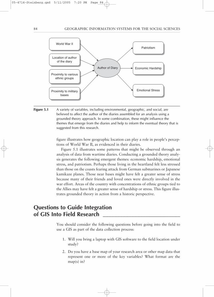
figure illustrates how geographic location can play a role in people’s percep-tions of World War II, as evidenced in their diaries.
Figure 5.1 illustrates some patterns that might be observed through ananalysis of data from wartime diaries. Conducting a grounded theory analy-sis generates the following emergent themes: economic hardship, emotionalstress, and patriotism. Perhaps those living in the heartland felt less stressedthan those on the coasts fearing attack from German submarines or Japanesekamikaze planes. Those near bases might have felt a greater sense of stressbecause many of their friends and loved ones were directly involved in thewar effort. Areas of the country with concentrations of ethnic groups tied tothe Allies may have felt a greater sense of hardship or stress. This figure illus-trates grounded theory in action from a historic perspective.
Questions to Guide Integrationof GIS Into Field Research ___________________________
You should consider the following questions before going into the field touse a GIS as part of the data collection process:
1. Will you bring a laptop with GIS software to the field location understudy?
2. Do you have a base map of your research area or other map data thatrepresent one or more of the key variables? What format are themap(s) in?
84 GEOGRAPHIC INFORMATION SYSTEMS FOR THE SOCIAL SCIENCES
Patriotism
Economic Hardship
Emotional Stress
Author of Diary
World War II
Location of authorof the diary
Proximity to variousethnic groups
Proximity to militarybases
Figure 5.1 A variety of variables, including environmental, geographic, and social, arebelieved to affect the author of the diaries assembled for an analysis using agrounded theory approach. In some combination, these might influence thethemes that emerge from the diaries and help to inform the eventual theory that issuggested from this research.
05-4714-Steinberg.qxd 5/11/2005 7:20 PM Page 84
3. Have you verified or ground truthed the source map(s)?
4. What are the cultural perceptions of technology (including computers)at your study site?
5. What will happen to the results of your study once you are finished?Who will have access to this information?
6. Are there any written sources of local, traditional knowledge andinformation?
The following sections provide detailed answers to these questions to helpexplain how to incorporate a GIS into various types of qualitative research.
GIS Software in the Field
Although it can sometimes be convenient to enter data directly into thecomputer, it is not always the best choice. Consider factors such as the cli-mate and conditions where you will be conducting your research. If it isgoing to be rainy and damp all of the time, it may not be advisable to bringa computer to your site, especially if your lodging accommodations are prim-itive. Will you have access to power the computer or recharge the batteries?Can you reliably store and back up your data while you are in the field?What would you do if your hard drive crashed? Will your computer besecure? If you have a safe place to store your computer and a power source,it might be worthwhile to bring a GIS to the field.
You may also want to consider the process of recording data directly intoyour computer. If you will be interviewing respondents, will you be able totype responses at an adequate pace to keep up? Will the computer distractthem? Would it help to have the GIS map available for respondents to markinformation on and to interact with and assist in data collection? In manysituations, it may be preferable to gather data using some other means (e.g.,a tape recorder, a camera, or even paper and pencil) and then transfer thisdata to the computer later. When you transcribe interview data, it is espe-cially useful to transcribe the interviews as soon as possible after completingthem and while it is fresh in the your mind. Any of these alternative meth-ods can always be incorporated into a GIS at a later time.
Maps of Your Research Area
Obtaining a base map of your study site could be easy or extremely diffi-cult depending on the location and whether or not it has been previously orrecently mapped. Even in locations where you would expect maps to beavailable, they may not be up-to-date enough to be useful for your study.There is also no guarantee that the maps will be available in digital form.
Qualitative Research Methods and GIS 85
05-4714-Steinberg.qxd 5/11/2005 7:20 PM Page 85
You can work with a hard-copy map (hard-copy meaning a map that existsin a physical form). Most often maps are available on paper, although mapsmay be made of other materials, from stone to papyrus (if you are doingresearch on ancient societies) to photographic paper, microfilm, plastic,acetate, and other materials.
Chances are that a map of your research site exists in some form.However, this map may not be in the level of detail that you require for yourstudy. If that is the case, we advise starting with the best map that you canfind. You can then add additional detail as you visit the field and gain moreinformation on the region.
As with any other data collection process, it may be safer to mark all ofyour data points or features on a hard-copy map. This information can thenbe transferred into a GIS at a later date. Computers do occasionally havetechnical problems, get dropped, or run out of power. Paper and pencil doa much better job of surviving a fall than the average laptop computer, notto mention your pencil is unlikely to run out of batteries and need to berecharged. Sometimes a low-tech data collection methodology is better forfieldwork; that way if a glitch happens with the technology, you are safe-guarded against data loss.
Ground Truth of Map Data
If you are planning to conduct fieldwork, you may not always have theability to ground truth some features of the map until you are physically onsite. You might find that the map you have is several years old, but what maybe less apparent is how much things have, or have not, changed since thetime the map was made. An old map is not necessarily bad; sometimes littlehas changed and the data are perfectly appropriate.
Regardless of the age of your map sources, it is a good idea to engage insome amount of verification or ground truthing. If you have access to thesite, you might do spot checks of the map, especially if you have a sense offeatures that might be new or different since the map’s creation. If you areunable to visit the site in person, you can compare the map to an alternativesource. Often there are more recent aerial images from an airplane or satel-lite that can be used as a comparison; this is sometimes referred to as surro-gate ground truth because the photo acts as a surrogate for an actual fieldvisit. Furthermore, imagery can provide additional detail necessary to locatesites in the field that are not depicted on standard maps. For example, a mapmight not show each individual house, barn, or shed, but these features maybe clearly visible in an aerial photograph of the same location.
To use surrogate ground truth, you do not have to go physically in thefield, but you need to get a sense of appropriate indicator variables that arevisible in the alternative data sources used. An indicator variable is some-thing that can substitute for the real variable of interest. For example, usingthe imagery you might be able to infer particular land uses observed in
86 GEOGRAPHIC INFORMATION SYSTEMS FOR THE SOCIAL SCIENCES
05-4714-Steinberg.qxd 5/11/2005 7:20 PM Page 86
aerial photos. In an American agricultural region, one might observe largeexpanses of crops, often organized in regular geometric patterns with a fewbuildings and roads intermixed, showing a low population density. Thislooks very different from a rural region dominated by other industries, suchas forestry or mining, and certainly has very little in common with the landuse for a large urban area.
Therefore, one could infer by observing aerial photos of various regionswhich particular communities might be termed agricultural communities,based on the observable land use. Similarly, aerial photographs of an urbanarea with high population density that indicate the presence of many facto-ries might indicate the presence of an industrialized or manufacturing-basedcommunity. In both examples, the aerial photographs assisted in helping todetermine the classification of these communities based on land use. Theindicator variable for these two conditions is land use. Although it is notdirectly related to ground truth per se, it is worthwhile to note that this sameprocess might be useful in selecting sampling locations when designing yourstudy.
If you want to ground truth a map that illustrates different populationdistributions by ethnicity, an image may not serve you well. You may be ableto see houses, but you cannot see the ethnicity of the people who live there!Instead, you might opt to ground truth the data against other sources of datafor population, such as the U.S. Census. The goal of ground truthing is todetermine if the data you are using for your study are reasonably current,accurate, and appropriate to your goals.
Of course, you need not rely solely on existing data; you can gain invalu-able ground truth by eliciting help of some local experts—people who arefamiliar with the lay of the land and local social and geographic features.This is part of the notion of public participation and GIS, which is discussedlater in this chapter. Of course, you want to be clear about your plans toconduct research in the area prior to soliciting the help of local people. Aclear communication of your stated research objectives should occur earlyin the data-gathering process. This is to ensure that locals are aware thatthe ultimate goal of your presence at the site is to collect data about theircommunity. There may be some cases where the research method beingemployed precludes total openness about your purpose in being on-site (e.g.,participant observation), but as in any research it is important to followprotocols appropriate to the study.
Cultural Perceptions of Technology
Prior to collecting data of any sort or using any technology (even a taperecorder), it is a good idea to investigate how that technology is viewed bypeople living in the local area. Does it make them uncomfortable? Are theyafraid of it? Do they embrace it? For example, if researchers where to con-duct a field study of the Amish, researchers would need to realize that the
Qualitative Research Methods and GIS 87
05-4714-Steinberg.qxd 5/11/2005 7:20 PM Page 87
Amish religion forbids them from having their picture taken because apicture is considered a graven image. Any researcher who goes into the areato “study” the Amish needs to be aware of this and use alternative methods.It is no wonder, with the significant presence of tourists and researchers, thatAmish children are taught to run when they see a car slowing down neartheir fields! If you are conducting a study in a part of the world that is largelyunfamiliar with modern technology, it may be better to avoid using suchtools than to risk your study by assuming the technology will be embracedby those you are studying.
Access to Results
When you begin a study, it is important to consider who will have accessto the data when you are through with your study. This is an importantquestion to consider because the answer could affect the type of data thatyou will collect. For example, if you are going to collect data on individualsparticipating in some type of illegal or socially unpopular behavior, you needto be particularly careful about the data you collect and how you collect it.Divulging such information could get your respondents in trouble with thelaw and could put you in danger for simply trying to collect it. Always con-sider the need to protect both yourself and your study subjects to the degreethat is possible and appropriate.
When researchers conduct their research, they are aware of their ownproximate purposes for the data. Wherever you collect data, it is very impor-tant to consider who else might at some point read your report or see yourdata. It is essential that whenever you conduct a research project that youcarefully select the information to include in the final report and realize thatonce information is out of your hands others may have access to it. Ofcourse, you should also consider how data will be kept secure and confi-dential during the course of the study, especially when that data may con-tain additional details that are not planned for public distribution in the finalreport.
Local Sources of Data _______________________________
For the social researcher, local knowledge is always an important datasource. Sometimes, local groups preserve their knowledge about featuresimportant to their group, such as oral histories. Other communities commitsuch information to written form. Local sources of data might appear in theform of stories, dances, rituals, and ceremonies, none of which may be offi-cially recorded, except for in the heads of community members or in somecases specific community members (community elders, healers, religiousleaders, or others, depending on the culture). An exciting part of your
88 GEOGRAPHIC INFORMATION SYSTEMS FOR THE SOCIAL SCIENCES
05-4714-Steinberg.qxd 5/11/2005 7:20 PM Page 88
research might be to try to record this information in a form that is accessi-ble to researchers as well as to other members of the community or futuregenerations or simply for the preservation of knowledge.
The advantage of finding any form of data, especially if it is not recordedin a form that is already accessible, is that it can then be incorporated intoyour study. For instance, let’s say that you are interested in documenting thegeographic location and relevant social information concerning the sacredsites of an indigenous group of people in Latin America. The maps that youhave access to may be rough, but they give a good working picture of yourstudy site. Sacred sites important to the local indigenous people—places thatthe local people consider to be important—are probably missing from thesemaps. When you are in the field collecting data, a GIS could be useful formatching your field notes with geographic locations of these sites. As men-tioned earlier, your starting point would be a base map of your area.
_____________________________ Oral History Interviews
Oral histories are an important way to collect data from people who don’tnecessarily conceptualize their lives as data. The stories that people tell aboutsignificant events in their lives can be very informative to a researcher whowishes to gain an understanding of a particular time and place. Oral histo-ries can be collected in a written form, where the researcher conducts aninterview and takes copious notes. They could also be recorded on tape ordigitally as long as the person being interviewed does not object. Using acombination of both written and recorded interviews offers an opportunityto capture the story as told by the respondent. Digital recordings can bestored on the computer as part of the GIS database and linked to the loca-tion the respondent is being interviewed about. Written notes and transcrip-tions of the recording are also useful in conducting qualitative analysis andfor linking the interview information in the GIS database using key words orconcepts.
GIS and Oral History
How would a GIS be integrated into the oral history method? There areseveral ways. First, the GIS can be used as a data organization and visual-ization tool. Imagine you are conducting oral histories about how peopleperceive the Mississippi River. You plan to interview people who live at dif-ferent locations along the river. A main goal of your study is to determineif people’s location on the river affects their perceptions of the river. Forinstance, people living close to a busy commercial port might have a differ-ent view of the river than those who live in peaceful, remote locations alongthe river.
Qualitative Research Methods and GIS 89
05-4714-Steinberg.qxd 5/11/2005 7:20 PM Page 89
As you collect your data, you can incorporate contextual factors aboutthe environment, such as the number of people who live in the communitywhere the informant was surveyed, the number and locations of ports andindustry, the presence or absence of oil spills in the region, and the presenceor absence of nature preserves along the river. You could then create files forthe different geographic locations on the map and attach coded data regard-ing the environmental and social contexts that are important to your study.This would help you find patterns in potential factors affecting people’s per-ceptions of the Mississippi River.
The second way to incorporate a GIS as part of the data collection processfor oral histories is to use maps portrayed with the GIS to display informa-tion about particular issues or problems for research subjects. The oral his-tory method is useful for studying the social and environmental context. Forinstance, you might be interested in researching the social and physical trans-formation of a particular neighborhood over time. You could use the GIS inthe course of interviewing longtime residents of the community to interac-tively gather an environmental and social history of the neighborhood understudy. Respondents could be shown various historical maps of the neigh-borhood and could point out relevant and important features or buildings(e.g., local town square, parks, neighborhood gathering spots where peopleinteracted or gossiped), which could then be marked on the GIS map. In thisway, the GIS becomes an interactive data recorder as well as a technology toassist people in relating their oral histories, remembering stories and impor-tant events from a time gone by.
The GIS is perfect for both the portrayal and recording of historic infor-mation. Such information may exist in people’s heads or on old maps andhistoric photographs. This information could be integrated into a workingGIS that then interactively produces stories, photographs, or historic docu-ments related to locations on the map and that can be viewed by others inthe research process.
Most social scientists are familiar with a data analysis method called con-tent analysis. A GIS could be used as part of environmental and social his-tory content analyses over time. One could conduct a geographic contentanalysis of particular variables in a spatial context. For example, you mightidentify patterns of particular variables and attributes across the study space:Do they cluster or are they dispersed? Do certain variables seem to relate toparticular locations or physical or environmental features on the map? Suchpatterns can be assessed as part of the GIS analysis.
Participant Observation ______________________________
Participant observation is a research method in which researchers activelyparticipate in whatever issue or topic they are studying. Researchers makeobservations of the group they are participating with. At the same time,
90 GEOGRAPHIC INFORMATION SYSTEMS FOR THE SOCIAL SCIENCES
05-4714-Steinberg.qxd 5/11/2005 7:20 PM Page 90
researchers record their own experiences in a field journal. This journalreflects social and environmental observations about the group being inter-acted with as well as some of the researchers’ sentiments about participatingin the group. So how could GIS become a part of this process?
An example of participant observation might be as follows. Say that youare interested in recreational activities of people of different social classes.Your hypothesis is that people of different social classes engage in differentforms of recreation. Participant observation would necessitate you goinginto the field and participating in recreational activities with the people inthese groups and interacting with these people. To integrate into a group ofhigher social class individuals, you might temporarily join the local countryclub and participate in activities such as golfing and tennis. Because the elitesometimes maintain barriers to unknown individuals participating in theircircles, perhaps you would take a job as a waiter or waitress at a countryclub. In both cases, the goal is for you to place yourself in a role where youhave an opportunity to observe the recreational activities of the elite.Similarly, if you were seeking to participate in the recreational activities ofthe middle class, you might spend your time in the city park, observing whois playing basketball or throwing horseshoes, or you might observe peopleworking out at a public gym.
So where does GIS fit into the study? You can integrate GIS by geo-graphically locating these different recreational activity sites into a GIS andcoding them by social class. It would be interesting to see if the higher andmiddle-class people recreate in different sorts of geographic locales and howthese locations relate to where they live and work. Is there any overlapbetween classes and if so at which sorts of recreational facilities do theseinteractions occur?
As a part of maintaining your detailed field journal, you could activelyrecord observations about the context of these recreational locations and thepeople who frequent them, using the following questions: What types offacilities are present? Are there tennis or basketball courts? What about agolf course or swimming pool? What are the conditions of the facilities?Where are these facilities located relative to where the people live? Do thesefacilities charge a fee for use and if so how much? Are these facilities limitedaccess, member’s only facilities or are they open to the public? What ameni-ties are located near the facility? Are they secure and well lit? Do the facili-ties exist in natural or man-made environments? All of the data would thenbe combined with base maps of sociodemographic data and other relevantinformation for the analysis.
___________________________ News as a Source of Data
News is an excellent source of data. In addition to being a good source ofbackground data for your research, the news may actually be the data you
Qualitative Research Methods and GIS 91
05-4714-Steinberg.qxd 5/11/2005 7:20 PM Page 91
are studying. Some researchers may choose to investigate a research questionthat involves the news as a data source. The news has a lot of informationthat could be useful to a researcher who is interested in conducting contentanalyses within a GIS. Almost all articles in a newspaper list the location ofthe story in the opening line. This alone can be the basis for linking storiesto geographic locations. It might also be important to know the locationassociated with the newspaper or the author of the article. Similar spatialinformation is included in some form in magazine, television, and onlinenews formats.
News analysis might be done using a content analysis approach as oneapproach. In this approach, a researcher would search through the news sto-ries in an attempt to find patterns related to a particular topic or subject.Let’s say for instance that you are interested in conducting a content analy-sis of newspaper articles related to immigrants. To incorporate a GIS intoyour study, you could note the location where the newspaper is producedand see if that relates to the type of immigrants being discussed. For instance,would the articles referring to immigrants from Canada be published fromlocations in the northern United States? Or would the articles that focus onLatino immigrants occur in newspapers located on the West Coast? Toextend this analysis further, using a GIS you could investigate if there wasa difference in focus on immigrants between rural and urban areas? Forinstance, do newspapers located in rural areas present a more negative por-trayal of immigrants than newspapers located in more urban areas, wherethere are more diverse populations and higher percentages of immigrants?
Another example of using a news source and integrating a GIS is identi-fying patterns of car chases for a transportation agency or the highwaypatrol. Over the last few years, car chases have become a regularly reportedevent in the media. You could integrate the GIS to help identify patterns inyour analysis. For example, you might be interested in determining whetherthere are differences based on the police jurisdiction in which the chasesoccur. Let’s say in your analysis you were going to go back through a reviewof TV news segments over the last 10 years for various parts of the country.You could find the date that the car chase occurred, the time that it occurred,what type of road it occurred on (freeway or city street), this street’s geo-graphic location, and whether the drivers were charged with another crimein addition to the car chase. The GIS would be an important part of theprocess of identifying patterns of car chases. Ideally, identifying thesepatterns would provide information to the authorities about how to betterintercept and prevent such chases from occurring in the future.
Ethnography and GIS ________________________________
If researchers are interested in conducting an ethnographic study, they areinterested in providing a detailed description of their problem or issue, rather
92 GEOGRAPHIC INFORMATION SYSTEMS FOR THE SOCIAL SCIENCES
05-4714-Steinberg.qxd 5/11/2005 7:20 PM Page 92
than attempting to provide an explanation. Earl Babbie (2003) notes that animportant part of conducting an ethnography is telling people’s stories theway the people want the stories told. This does not involve the researchercoming in and critiquing or changing what people have told you but ratherrecording what they said and the exact way that they said it.
A GIS could be integrated into this type of research by having peoplecontextualize or environmentally situate their stories for you over time. Forinstance, let’s say that you are studying the homeless population of SanFrancisco, and you want to engage in an ethnographic approach. Part ofyour study might involve collecting the perceptions and stories from home-less people about what it’s like to be homeless. You may interview homelesspeople who have been on the street for at least 20 years and record their sto-ries about being homeless over time. For example, you might map locationsdescribed as having been good for sleeping, getting meals, or panhandling atdifferent times, perhaps 20 and 10 years ago as well as at the present time.Key elements or variables that arise from these stories could then be exam-ined in the context of where current homeless shelters are. Such a studymight elicit support for the location of new or relocated services for thehomeless to better meet their needs.
_______________________________ Case Studies and GIS
In a case study, a researcher seeks to record in great detail a multitude of fac-tors related to a specific geographic or social location. A sociological exam-ple of a case study could focus on a particular organizational situation orplace, or both. The researcher spends time in the community gaining anunderstanding of the people, places, and interactions that occur there. A casestudy is an excellent method when using the grounded theory approach. Acase study may occur in a single location or in conjunction with other com-munities (in such a case, it would be a comparative case study).
Case studies are useful when you have an idea about a particular place orevent that could potentially serve as a model for other, similar places. Youas the researcher can conduct a case study with the idea that a particularcommunity is a model example of a successful community because it has athriving economy, local residents appear happy, and health is a major focusfor residents. To prove or disprove this hypothesis, you could carry out acase study. The information that you discover in the process of conductingyour case study may or may not confirm your initial ideas.
So what role would a GIS play? Let’s say that you are interested in con-ducting a case study not of a particular place but of a particular organiza-tion: a local senior citizens’ center. The center has a good reputation ofproviding food to seniors who are shut-ins in a city. To conduct a case studyof this particular organization, you would need to gather as much informa-tion as you could about its outreach programs: Where do the older adults
Qualitative Research Methods and GIS 93
05-4714-Steinberg.qxd 5/11/2005 7:20 PM Page 93
served by the center live? How does the center organize its food distributionefforts? Does the senior center get food donations from these older residents’home communities? Are there times of day when the traffic is congested onthe streets near the seniors’ homes? How does the senior center avoid that?Obviously, the senior center has been successful in keeping its constituentshappy and has found a way to accomplish this on a limited budget.
Using a GIS to help document and tell the success story of this organiza-tion within its particular spatial context could be very helpful to organiza-tions that have similar goals and to other types of social service outreachorganizations. Case studies provide extensive information about successes(and possibly failures) to others so that they do not need to reinvent thewheel or attempt numerous different approaches before finding one thatworks.
A GIS is useful to those who use grounded theory. In using a groundedtheory approach, researchers doe not go into the field with a traditionalhypothesis or idea about what they are going to find. Instead, they allow theconcepts or ideas to arise from the fieldwork itself. In the previous example,researchers would begin the investigation with no preconceived notionsabout what it is that makes the center successful, but rather they wouldsimply collect the data and see what patterns emerge.
Public Participation and GIS __________________________
Public participation is often a major part of the planning process. As GIStechnology becomes more prevalent in the field of planning so too has itsincorporation into the public participation process, so much so that thereis an entire developing subdiscipline known as public participation GIS(PPGIS). What does this mean? Public participation in the planning processmeans that local people’s ideas, thoughts, and actions are solicited to be apart of the process. Public participation is something that has been mandatedby many state and federal agencies to become a permanent component of theplanning process.
One form of public participation is to hold community meetings or tostage hearings to solicit community input about what is going to happen in aparticular situation. Whichever agency has jurisdiction over the issue in ques-tion is the agency responsible for soliciting the input. Other important formsof public participation in the planning process include focus groups, surveys,key-informant interviews, and needs assessments, just to name a few.
When soliciting public input, a GIS can play an important role. As differ-ent methods of soliciting public input have evolved along with the recogni-tion that this is an important and valuable thing to do, GIS has become partof the process. One drawback of having GIS as a part of the public partici-pation process is that not all members of the general public have an under-standing of GIS. However, this can be solved by having trained staff familiar
94 GEOGRAPHIC INFORMATION SYSTEMS FOR THE SOCIAL SCIENCES
05-4714-Steinberg.qxd 5/11/2005 7:20 PM Page 94
with both GIS and the issue under discussion available to assist with thetechnological aspects of using a GIS in an interactive fashion with the gen-eral public.
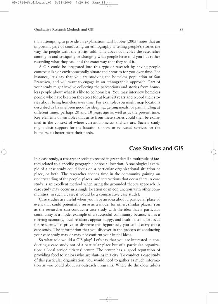
For example, participants at a public comment session could be asked forquestions about their vision for the local community, and GIS professionalscould chart different development scenarios using the GIS software. With theproper software, it is even possible to generate a three-dimensional modelof how different scenarios look, portraying different options on a screen orusing printed maps that are further marked up with comments or input fromthe community. Figure 5.2 provides an example of a three-dimensional visu-alization generated in a GIS.
The main advantage of using GIS as a part of participatory planning isthat it allows people to visually see the data and its physical, environmental,or social context as it is now and perhaps could be in the future. Forinstance, what if you were interested in soliciting input about what shouldhappen to a local bay located in a seaside community? Different proposedscenarios might call for further industrial development of the bay, moretourist development, and more recreational opportunities for local people in
Qualitative Research Methods and GIS 95
Figure 5.2 An example of a three-dimensional visualization for community planning, usingESRI ArcGIS® with CommunityViz Scenario 360® software. The GIS is used to establish the basedata, including a terrain model, a high resolution aerial photograph, and ground-basedphotographs of key features, including building facades. Prospective alterations to the city can beplaced into the model to assist community members in visualizing how these changes wouldappear when complete. In the lower left of the image, the red lines show the point of viewselected in generating the view of the right. After all of the data have been prepared, it is possibleto actually move through the data in a fly-through mode, allowing a variety of perspectives on theproposed project.
05-4714-Steinberg.qxd 5/11/2005 7:20 PM Page 95
and around the bay. Using a GIS as a part of the public participation processallows for management professionals to portray different scenarios immedi-ately so that an interested public can actually see the suggestions put forthas part of the planning process. Having the ability to see options in a realis-tic way provides a very powerful experience and lets members of a localcommunity know that their suggestions are being heard (Figure 5.2).
Similarly, using the GIS as a means of idea portrayal can also give localplanners an idea of what the public desires from a planning perspective. Itshould be stated here that use of the GIS is not for everybody. There aresome people who don’t like technology and computers and who might rejectthe use of a GIS because they feel it’s too technologically oriented and com-plex for the layperson. This is a field that is evolving even as we write thisbook. We look forward to seeing the new developments that arise in thisarea as GIS become a more commonly used part of planning efforts at local,state, national, and international levels.
Relevant Web Sites __________________________________
CommunityViz: This is the Web site for CommunityViz, a program ofThe Orton Family Foundation, the Vermont-based, nonprofit operatingfoundation dedicated to helping communities make better, more respon-sible land use planning decisions. http://www.communityviz.com/
The Grounded Theory Institute: This entire Web site is devoted to themethodology of grounded theory. www.groundedtheory.com
“Grounded Theory: A Thumbnail Sketch”: This site provides a nice over-view of grounded theory from the Resource Papers in Action ResearchWeb site. www.scu.edu.au/schools/gcm/ar/arp/grounded.html
Oral History Association: The Oral History Association, established in1966, seeks to bring together all persons interested in oral history as a wayof collecting human memories. http://omega.dickinson.edu/organizations/oha/
Oral History Society: The Oral History Society is a national and interna-tional organization dedicated to the collection and preservation of oralhistory. http://www.oralhistory.org.uk/
PPgis.net: The site is the electronic forum on participatory use of geospa-tial information systems and technologies. http://ppgis.iapad.org/
“Public Participation GIS (PPGIS) Guiding Principles”: This site con-tains an article about PPGIS by Doug Aberley and Renee Sieber. http://www.urisa.org/PPGIS/2003/papers/PPGIS%20Principles2.pdf
96 GEOGRAPHIC INFORMATION SYSTEMS FOR THE SOCIAL SCIENCES
05-4714-Steinberg.qxd 5/11/2005 7:20 PM Page 96