Embed Size (px)
Citation preview
Qualification Handbook DAO Level 3 Diploma in Engineering Survey (Military Engineering)
QN: 601/8678/1
2
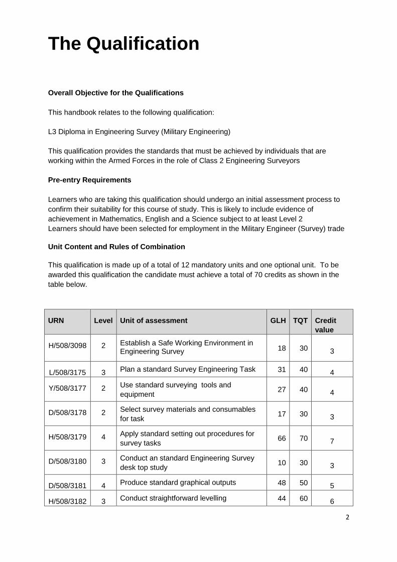
The Qualification
Overall Objective for the Qualifications
This handbook relates to the following qualification:
L3 Diploma in Engineering Survey (Military Engineering)
This qualification provides the standards that must be achieved by individuals that are
working within the Armed Forces in the role of Class 2 Engineering Surveyors
Pre-entry Requirements
Learners who are taking this qualification should undergo an initial assessment process to
confirm their suitability for this course of study. This is likely to include evidence of
achievement in Mathematics, English and a Science subject to at least Level 2
Learners should have been selected for employment in the Military Engineer (Survey) trade
Unit Content and Rules of Combination
This qualification is made up of a total of 12 mandatory units and one optional unit. To be
awarded this qualification the candidate must achieve a total of 70 credits as shown in the
table below.
URN Level Unit of assessment GLH TQT Credit
value
H/508/3098 2 Establish a Safe Working Environment in Engineering Survey 18 30 3
L/508/3175 3 Plan a standard Survey Engineering Task 31 40 4
Y/508/3177 2 Use standard surveying tools and
equipment 27 40 4
D/508/3178 2 Select survey materials and consumables
for task 17 30 3
H/508/3179 4 Apply standard setting out procedures for
survey tasks 66 70 7
D/508/3180 3 Conduct an standard Engineering Survey
desk top study 10 30 3
D/508/3181 4 Produce standard graphical outputs 48 50 5
H/508/3182 3 Conduct straightforward levelling 44 60 6
3
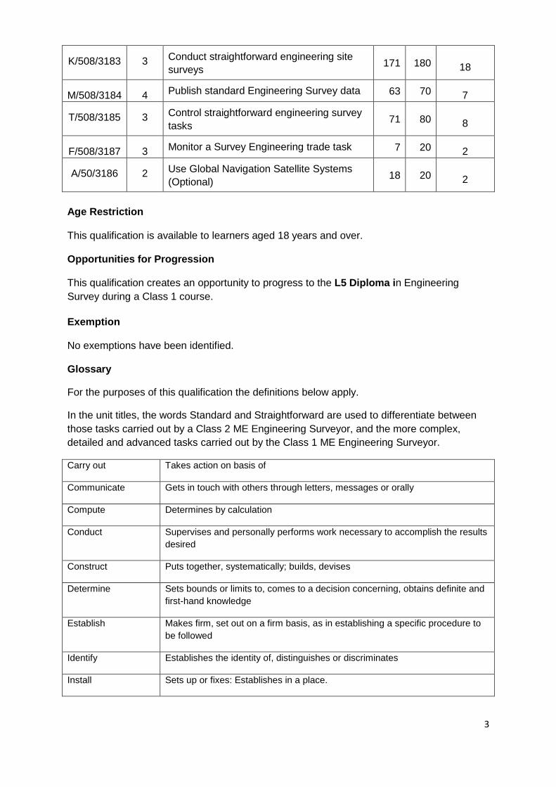
K/508/3183 3 Conduct straightforward engineering site
surveys 171 180 18
M/508/3184 4 Publish standard Engineering Survey data 63 70 7
T/508/3185 3 Control straightforward engineering survey
tasks 71 80 8
F/508/3187 3 Monitor a Survey Engineering trade task 7 20 2
A/50/3186 2 Use Global Navigation Satellite Systems
(Optional) 18 20 2
Age Restriction This qualification is available to learners aged 18 years and over. Opportunities for Progression This qualification creates an opportunity to progress to the L5 Diploma in Engineering
Survey during a Class 1 course.
Exemption No exemptions have been identified. Glossary
For the purposes of this qualification the definitions below apply.
In the unit titles, the words Standard and Straightforward are used to differentiate between
those tasks carried out by a Class 2 ME Engineering Surveyor, and the more complex,
detailed and advanced tasks carried out by the Class 1 ME Engineering Surveyor.
Carry out Takes action on basis of
Communicate Gets in touch with others through letters, messages or orally
Compute Determines by calculation
Conduct Supervises and personally performs work necessary to accomplish the results
desired
Construct Puts together, systematically; builds, devises
Determine Sets bounds or limits to, comes to a decision concerning, obtains definite and
first-hand knowledge
Establish Makes firm, set out on a firm basis, as in establishing a specific procedure to
be followed
Identify Establishes the identity of, distinguishes or discriminates
Install Sets up or fixes: Establishes in a place.

4
Interpret Make out or bring out the meaning of:
Manufacture Makes by hand, machinery or other agency. Manufactures a product
Prepare Make ready or get ready for
Procure Obtains, secures, gets, purchases through appropriate channels
Produce Bring into existence
Select Takes by preference from among others: Picks out from
State Say or express, fully or clearly, in speech or writing
Use Employ, partakes of; exploits
5
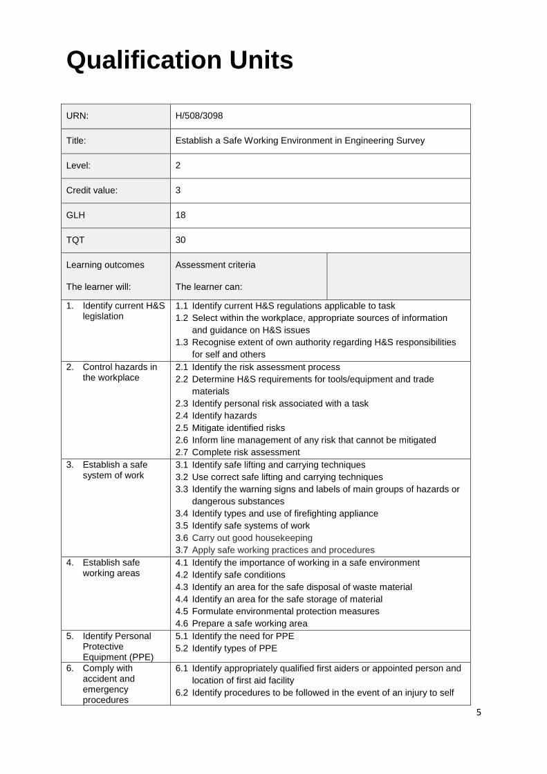
Qualification Units URN: H/508/3098
Title: Establish a Safe Working Environment in Engineering Survey
Level: 2
Credit value: 3
GLH 18
TQT 30
Learning outcomes
The learner will:
Assessment criteria
The learner can:
1. Identify current H&S legislation
1.1 Identify current H&S regulations applicable to task
1.2 Select within the workplace, appropriate sources of information
and guidance on H&S issues
1.3 Recognise extent of own authority regarding H&S responsibilities
for self and others
2. Control hazards in the workplace
2.1 Identify the risk assessment process
2.2 Determine H&S requirements for tools/equipment and trade
materials
2.3 Identify personal risk associated with a task
2.4 Identify hazards
2.5 Mitigate identified risks
2.6 Inform line management of any risk that cannot be mitigated
2.7 Complete risk assessment
3. Establish a safe system of work
3.1 Identify safe lifting and carrying techniques
3.2 Use correct safe lifting and carrying techniques
3.3 Identify the warning signs and labels of main groups of hazards or
dangerous substances
3.4 Identify types and use of firefighting appliance
3.5 Identify safe systems of work
3.6 Carry out good housekeeping
3.7 Apply safe working practices and procedures
4. Establish safe working areas
4.1 Identify the importance of working in a safe environment
4.2 Identify safe conditions
4.3 Identify an area for the safe disposal of waste material
4.4 Identify an area for the safe storage of material
4.5 Formulate environmental protection measures
4.6 Prepare a safe working area
5. Identify Personal Protective Equipment (PPE)
5.1 Identify the need for PPE
5.2 Identify types of PPE
6. Comply with accident and emergency procedures
6.1 Identify appropriately qualified first aiders or appointed person and
location of first aid facility
6.2 Identify procedures to be followed in the event of an injury to self
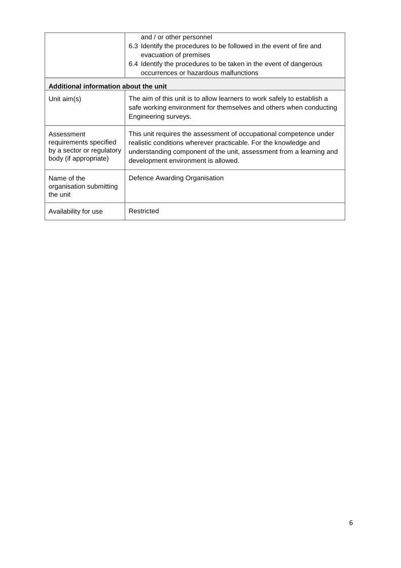
6
and / or other personnel
6.3 Identify the procedures to be followed in the event of fire and
evacuation of premises
6.4 Identify the procedures to be taken in the event of dangerous
occurrences or hazardous malfunctions
Additional information about the unit
Unit aim(s) The aim of this unit is to allow learners to work safely to establish a
safe working environment for themselves and others when conducting
Engineering surveys.
Assessment
requirements specified
by a sector or regulatory
body (if appropriate)
This unit requires the assessment of occupational competence under
realistic conditions wherever practicable. For the knowledge and
understanding component of the unit, assessment from a learning and
development environment is allowed.
Name of the
organisation submitting
the unit
Defence Awarding Organisation
Availability for use Restricted
7
URN: L/508/3175
Title: Plan a standard Survey Engineering Task
Level: 3
Credit value: 4
GLH 31
TQT 40
Learning outcomes
The learner will:
Assessment criteria
The learner can:
1. Identify task requirements from a briefing
1.1 Identify task deadlines from a
briefing
1.2 Identify tasking authority from a
briefing
1.3 Identify technical support
structure from a briefing
1.4 Identify the task details from a
briefing
1.5 Identify task outputs from a
briefing
2. Interpret construction engineering drawings, sketches and specifications
2.1 Identify the difference between
drawing sheets
2.2 Identify the different projection
types
2.3 Identify the difference between
1st angle and 3rd angle
orthographic projection
2.4 Identify how to interpret
graphical output
2.5 Identify information contained
within drawings, sketches and
diagrams
2.6 Interpret graphical information
from working drawings
2.7 Extract information from
drawings
3. Produce working sketches of the task
3.1 Identify the drawing
instruments required to
produce sketched drawings
3.2 Identify how to produce free-
hand sketches
3.3 Identify sketch requirements to
support a task
3.4 Produce a working sketch to
support a task
3.5 Communicate specifications to
assist in the production of
8
construction drawings
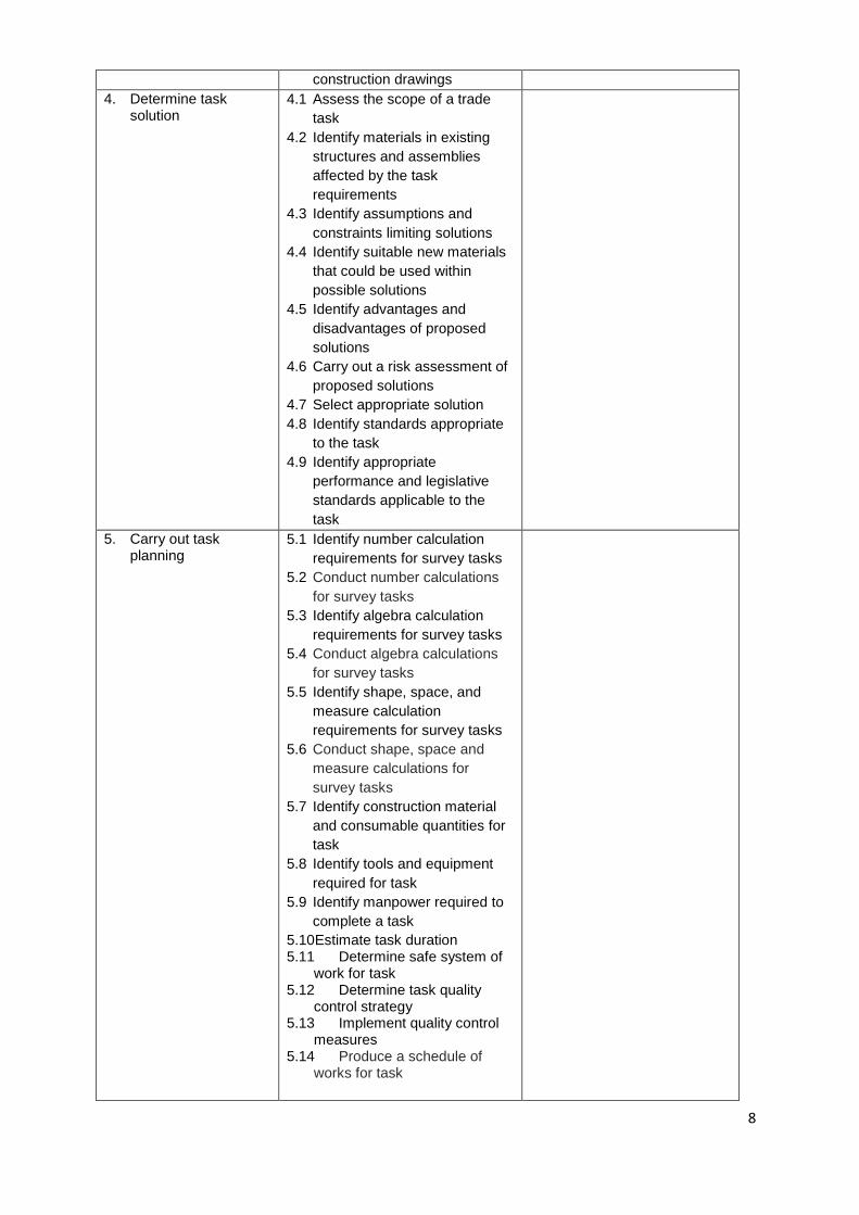
4. Determine task solution
4.1 Assess the scope of a trade
task
4.2 Identify materials in existing
structures and assemblies
affected by the task
requirements
4.3 Identify assumptions and
constraints limiting solutions
4.4 Identify suitable new materials
that could be used within
possible solutions
4.5 Identify advantages and
disadvantages of proposed
solutions
4.6 Carry out a risk assessment of
proposed solutions
4.7 Select appropriate solution
4.8 Identify standards appropriate
to the task
4.9 Identify appropriate
performance and legislative
standards applicable to the
task
5. Carry out task planning
5.1 Identify number calculation
requirements for survey tasks
5.2 Conduct number calculations
for survey tasks
5.3 Identify algebra calculation
requirements for survey tasks
5.4 Conduct algebra calculations
for survey tasks
5.5 Identify shape, space, and
measure calculation
requirements for survey tasks
5.6 Conduct shape, space and
measure calculations for
survey tasks
5.7 Identify construction material
and consumable quantities for
task
5.8 Identify tools and equipment
required for task
5.9 Identify manpower required to
complete a task
5.10Estimate task duration 5.11 Determine safe system of
work for task 5.12 Determine task quality
control strategy 5.13 Implement quality control
measures 5.14 Produce a schedule of
works for task
9
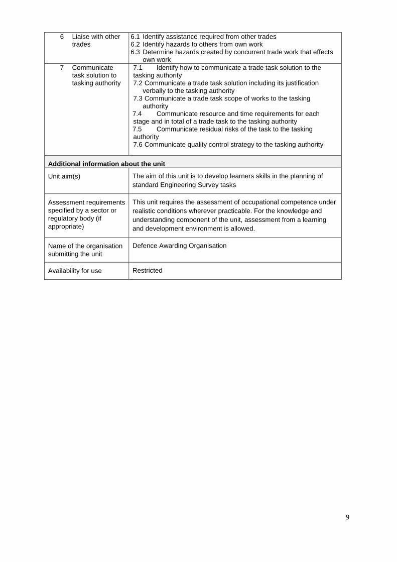
6 Liaise with other trades
6.1 Identify assistance required from other trades 6.2 Identify hazards to others from own work
6.3 Determine hazards created by concurrent trade work that effects own work
7 Communicate task solution to tasking authority
7.1 Identify how to communicate a trade task solution to the tasking authority 7.2 Communicate a trade task solution including its justification
verbally to the tasking authority 7.3 Communicate a trade task scope of works to the tasking
authority 7.4 Communicate resource and time requirements for each stage and in total of a trade task to the tasking authority 7.5 Communicate residual risks of the task to the tasking authority 7.6 Communicate quality control strategy to the tasking authority
Additional information about the unit
Unit aim(s) The aim of this unit is to develop learners skills in the planning of
standard Engineering Survey tasks
Assessment requirements
specified by a sector or
regulatory body (if
appropriate)
This unit requires the assessment of occupational competence under
realistic conditions wherever practicable. For the knowledge and
understanding component of the unit, assessment from a learning
and development environment is allowed.
Name of the organisation
submitting the unit
Defence Awarding Organisation
Availability for use Restricted
10
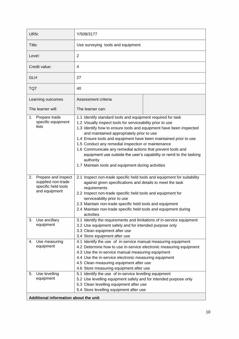
URN: Y/508/3177
Title: Use surveying tools and equipment
Level: 2
Credit value: 4
GLH 27
TQT 40
Learning outcomes
The learner will:
Assessment criteria
The learner can:
1. Prepare trade specific equipment lists
1.1 Identify standard tools and equipment required for task
1.2 Visually inspect tools for serviceability prior to use
1.3 Identify how to ensure tools and equipment have been inspected
and maintained appropriately prior to use
1.4 Ensure tools and equipment have been maintained prior to use
1.5 Conduct any remedial inspection or maintenance
1.6 Communicate any remedial actions that prevent tools and
equipment use outside the user’s capability or remit to the tasking
authority
1.7 Maintain tools and equipment during activities
2. Prepare and inspect supplied non-trade specific held tools and equipment
2.1 Inspect non-trade specific held tools and equipment for suitability
against given specifications and details to meet the task
requirements
2.2 Inspect non-trade specific held tools and equipment for
serviceability prior to use
2.3 Maintain non-trade specific held tools and equipment
2.4 Maintain non-trade specific held tools and equipment during
activities
3. Use ancillary equipment
3.1 Identify the requirements and limitations of in-service equipment
3.2 Use equipment safely and for intended purpose only
3.3 Clean equipment after use
3.4 Store equipment after use
4. Use measuring equipment
4.1 Identify the use of in-service manual measuring equipment
4.2 Determine how to use in-service electronic measuring equipment
4.3 Use the in-service manual measuring equipment
4.4 Use the in-service electronic measuring equipment
4.5 Clean measuring equipment after use
4.6 Store measuring equipment after use
5. Use levelling equipment
5.1 Identify the use of in-service levelling equipment
5.2 Use levelling equipment safely and for intended purpose only
5.3 Clean levelling equipment after use
5.4 Store levelling equipment after use
Additional information about the unit

11
Unit aim(s) The aim of this unit is for learners to use different surveying tools and
equipment to allow them to carry out a site survey
Assessment
requirements specified
by a sector or regulatory
body (if appropriate)
This unit requires the assessment of occupational competence under
realistic conditions wherever practicable. For the knowledge and
understanding component of the unit, assessment from a learning and
development environment is allowed.
Name of the
organisation submitting
the unit
Defence Awarding Organisation
12
URN: D/508/3178
Title: Select survey materials and consumables for task
Level: 2
Credit value: 3
GLH 17
TQT 30
Learning outcomes
The learner will:
Assessment criteria
The learner can:
1. Identify materials and consumables
1.1 Identify materials and consumables required to complete the task
2. Procures materials and consumables required for a task
2.1 Identify point of contact (POC) from which to procure appropriate
resources
3. Store material and consumables
3.1 Identify the requirements when storing materials and consumables
3.2 Separate materials and consumables
3.3 Stores materials and sundry items to prevent damage to them or
other works
3.4 Protect the environment when moving, using or storing material
and consumables
4. Dispose of waste material and consumables
4.1 Identify the environmental responsibilities when disposing of waste
material and consumables
Additional information about the unit
Unit aim(s) The aim of this unit is to allow learners to select appropriate materials
and consumables for an Engineering Survey task
Assessment
requirements specified
by a sector or regulatory
body (if appropriate)
This unit requires the workplace assessment of occupational
competence wherever practicable. For the knowledge and
understanding component of the unit, assessment from a learning and
development environment is allowed.
Name of the
organisation submitting
the unit
Defence Awarding Organisation
13
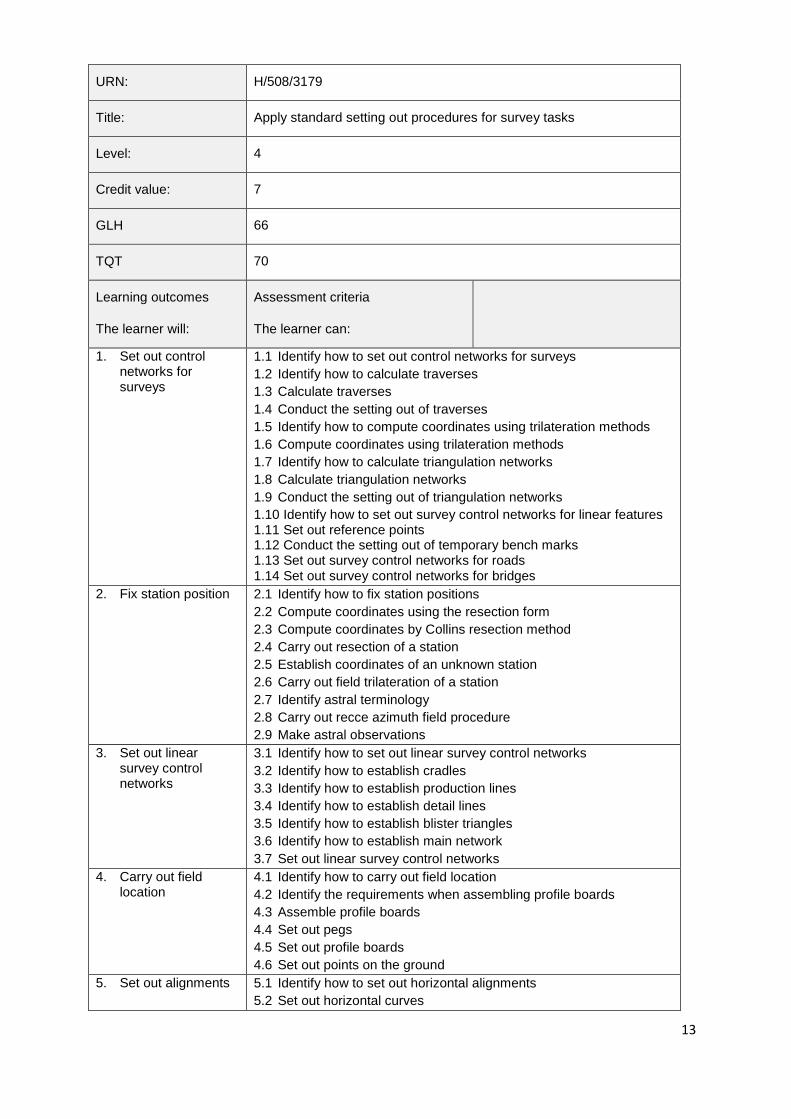
URN: H/508/3179
Title: Apply standard setting out procedures for survey tasks
Level: 4
Credit value: 7
GLH 66
TQT 70
Learning outcomes
The learner will:
Assessment criteria
The learner can:
1. Set out control networks for surveys
1.1 Identify how to set out control networks for surveys
1.2 Identify how to calculate traverses
1.3 Calculate traverses
1.4 Conduct the setting out of traverses
1.5 Identify how to compute coordinates using trilateration methods
1.6 Compute coordinates using trilateration methods
1.7 Identify how to calculate triangulation networks
1.8 Calculate triangulation networks
1.9 Conduct the setting out of triangulation networks
1.10 Identify how to set out survey control networks for linear features 1.11 Set out reference points 1.12 Conduct the setting out of temporary bench marks 1.13 Set out survey control networks for roads 1.14 Set out survey control networks for bridges
2. Fix station position 2.1 Identify how to fix station positions
2.2 Compute coordinates using the resection form
2.3 Compute coordinates by Collins resection method
2.4 Carry out resection of a station
2.5 Establish coordinates of an unknown station
2.6 Carry out field trilateration of a station
2.7 Identify astral terminology
2.8 Carry out recce azimuth field procedure
2.9 Make astral observations
3. Set out linear survey control networks
3.1 Identify how to set out linear survey control networks
3.2 Identify how to establish cradles
3.3 Identify how to establish production lines
3.4 Identify how to establish detail lines
3.5 Identify how to establish blister triangles
3.6 Identify how to establish main network
3.7 Set out linear survey control networks
4. Carry out field location
4.1 Identify how to carry out field location
4.2 Identify the requirements when assembling profile boards
4.3 Assemble profile boards
4.4 Set out pegs
4.5 Set out profile boards
4.6 Set out points on the ground
5. Set out alignments 5.1 Identify how to set out horizontal alignments
5.2 Set out horizontal curves
14
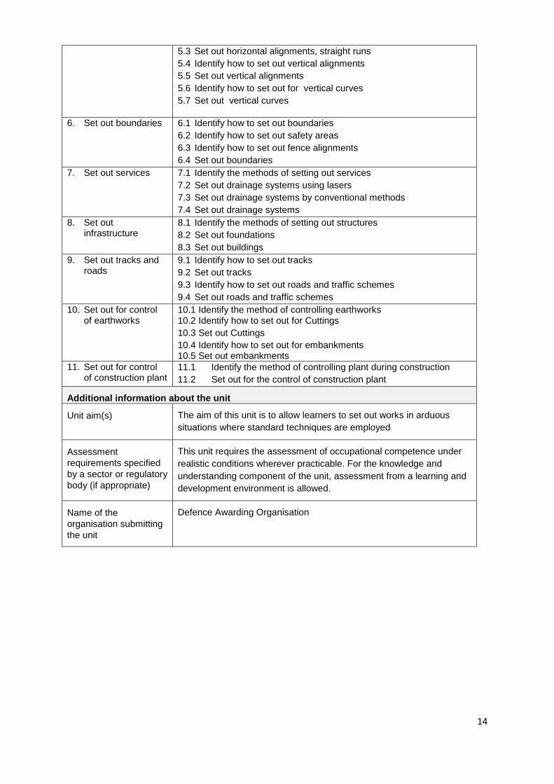
5.3 Set out horizontal alignments, straight runs
5.4 Identify how to set out vertical alignments
5.5 Set out vertical alignments
5.6 Identify how to set out for vertical curves
5.7 Set out vertical curves
6. Set out boundaries 6.1 Identify how to set out boundaries
6.2 Identify how to set out safety areas
6.3 Identify how to set out fence alignments
6.4 Set out boundaries
7. Set out services 7.1 Identify the methods of setting out services
7.2 Set out drainage systems using lasers
7.3 Set out drainage systems by conventional methods
7.4 Set out drainage systems
8. Set out infrastructure
8.1 Identify the methods of setting out structures
8.2 Set out foundations
8.3 Set out buildings
9. Set out tracks and roads
9.1 Identify how to set out tracks
9.2 Set out tracks
9.3 Identify how to set out roads and traffic schemes
9.4 Set out roads and traffic schemes
10. Set out for control of earthworks
10.1 Identify the method of controlling earthworks 10.2 Identify how to set out for Cuttings
10.3 Set out Cuttings
10.4 Identify how to set out for embankments 10.5 Set out embankments
11. Set out for control of construction plant
11.1 Identify the method of controlling plant during construction
11.2 Set out for the control of construction plant
Additional information about the unit
Unit aim(s) The aim of this unit is to allow learners to set out works in arduous
situations where standard techniques are employed
Assessment
requirements specified
by a sector or regulatory
body (if appropriate)
This unit requires the assessment of occupational competence under
realistic conditions wherever practicable. For the knowledge and
understanding component of the unit, assessment from a learning and
development environment is allowed.
Name of the
organisation submitting
the unit
Defence Awarding Organisation
15
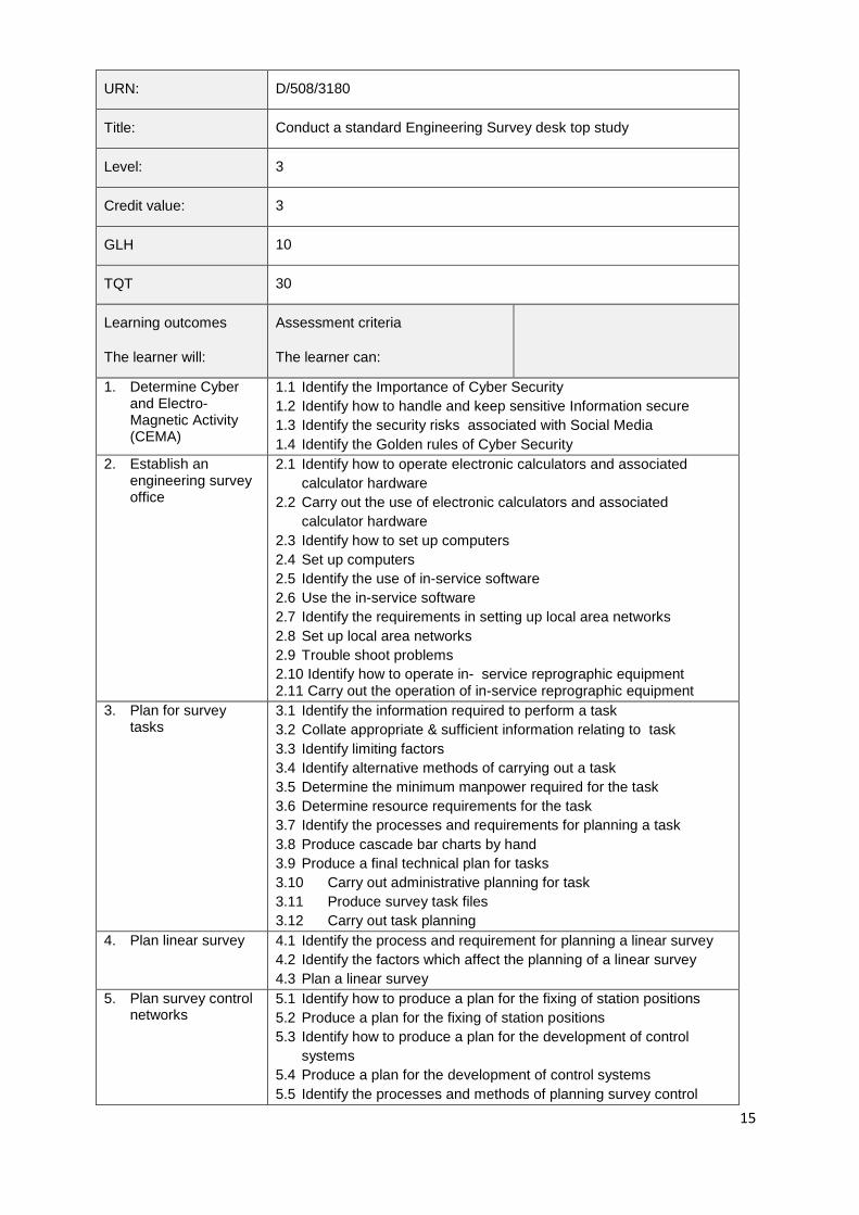
URN: D/508/3180
Title: Conduct a standard Engineering Survey desk top study
Level: 3
Credit value: 3
GLH 10
TQT 30
Learning outcomes
The learner will:
Assessment criteria
The learner can:
1. Determine Cyber and Electro-Magnetic Activity (CEMA)
1.1 Identify the Importance of Cyber Security
1.2 Identify how to handle and keep sensitive Information secure
1.3 Identify the security risks associated with Social Media
1.4 Identify the Golden rules of Cyber Security
2. Establish an engineering survey office
2.1 Identify how to operate electronic calculators and associated
calculator hardware
2.2 Carry out the use of electronic calculators and associated
calculator hardware
2.3 Identify how to set up computers
2.4 Set up computers
2.5 Identify the use of in-service software
2.6 Use the in-service software
2.7 Identify the requirements in setting up local area networks
2.8 Set up local area networks
2.9 Trouble shoot problems
2.10 Identify how to operate in- service reprographic equipment 2.11 Carry out the operation of in-service reprographic equipment
3. Plan for survey tasks
3.1 Identify the information required to perform a task
3.2 Collate appropriate & sufficient information relating to task
3.3 Identify limiting factors
3.4 Identify alternative methods of carrying out a task
3.5 Determine the minimum manpower required for the task
3.6 Determine resource requirements for the task
3.7 Identify the processes and requirements for planning a task
3.8 Produce cascade bar charts by hand
3.9 Produce a final technical plan for tasks
3.10 Carry out administrative planning for task
3.11 Produce survey task files
3.12 Carry out task planning
4. Plan linear survey 4.1 Identify the process and requirement for planning a linear survey
4.2 Identify the factors which affect the planning of a linear survey
4.3 Plan a linear survey
5. Plan survey control networks
5.1 Identify how to produce a plan for the fixing of station positions
5.2 Produce a plan for the fixing of station positions
5.3 Identify how to produce a plan for the development of control
systems
5.4 Produce a plan for the development of control systems
5.5 Identify the processes and methods of planning survey control
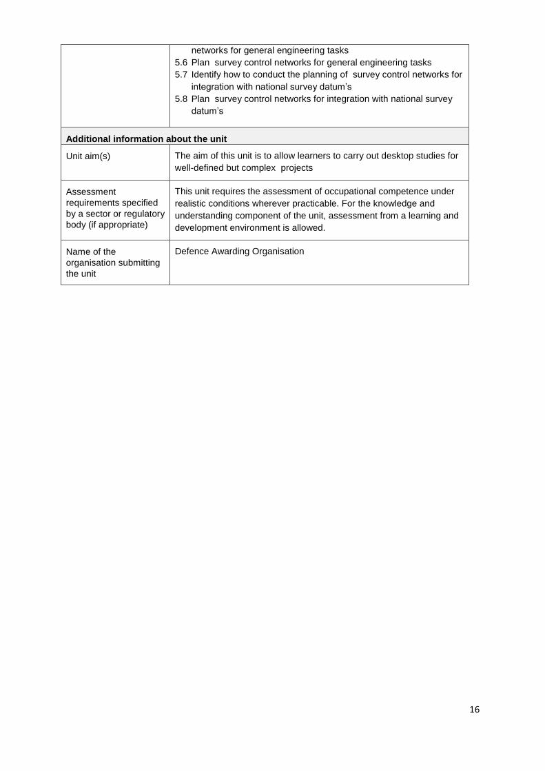
16
networks for general engineering tasks
5.6 Plan survey control networks for general engineering tasks
5.7 Identify how to conduct the planning of survey control networks for
integration with national survey datum’s
5.8 Plan survey control networks for integration with national survey
datum’s
Additional information about the unit
Unit aim(s) The aim of this unit is to allow learners to carry out desktop studies for
well-defined but complex projects
Assessment
requirements specified
by a sector or regulatory
body (if appropriate)
This unit requires the assessment of occupational competence under
realistic conditions wherever practicable. For the knowledge and
understanding component of the unit, assessment from a learning and
development environment is allowed.
Name of the
organisation submitting
the unit
Defence Awarding Organisation
17
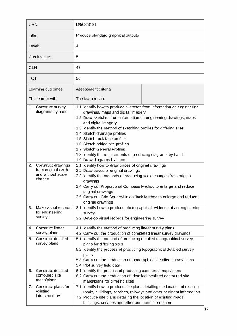
URN: D/508/3181
Title: Produce standard graphical outputs
Level: 4
Credit value: 5
GLH 48
TQT 50
Learning outcomes
The learner will:
Assessment criteria
The learner can:
1. Construct survey diagrams by hand
1.1 Identify how to produce sketches from information on engineering
drawings, maps and digital imagery
1.2 Draw sketches from information on engineering drawings, maps
and digital imagery
1.3 Identify the method of sketching profiles for differing sites
1.4 Sketch drainage profiles
1.5 Sketch rock face profiles
1.6 Sketch bridge site profiles
1.7 Sketch General Profiles
1.8 Identify the requirements of producing diagrams by hand
1.9 Draw diagrams by hand
2. Construct drawings from originals with and without scale change
2.1 Identify how to draw traces of original drawings
2.2 Draw traces of original drawings
2.3 Identify the methods of producing scale changes from original
drawings
2.4 Carry out Proportional Compass Method to enlarge and reduce
original drawings
2.5 Carry out Grid Square/Union Jack Method to enlarge and reduce
original drawings
3. Make visual records for engineering surveys
3.1 Identify how to produce photographical evidence of an engineering
survey
3.2 Develop visual records for engineering survey
4. Construct linear survey plans
4.1 Identify the method of producing linear survey plans
4.2 Carry out the production of completed linear survey drawings
5. Construct detailed survey plans
5.1 Identify the method of producing detailed topographical survey
plans for differing sites
5.2 Identify the process of producing topographical detailed survey
plans
5.3 Carry out the production of topographical detailed survey plans
5.4 Plot survey field data
6. Construct detailed contoured site maps/plans
6.1 Identify the process of producing contoured maps/plans
6.2 Carry out the production of detailed localised contoured site
maps/plans for differing sites
7. Construct plans for existing infrastructures
7.1 Identify how to produce site plans detailing the location of existing
roads, buildings, services, railways and other pertinent information
7.2 Produce site plans detailing the location of existing roads,
buildings, services and other pertinent information
18
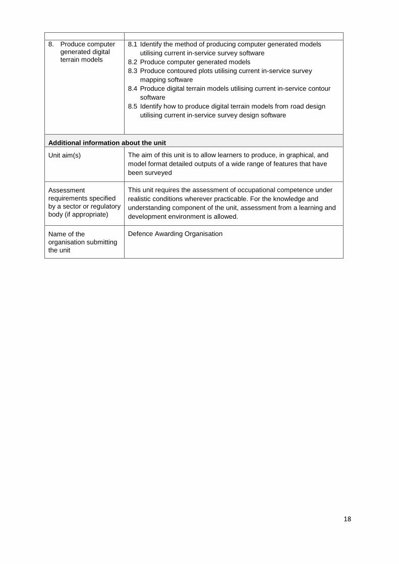
8. Produce computer generated digital terrain models
8.1 Identify the method of producing computer generated models
utilising current in-service survey software
8.2 Produce computer generated models
8.3 Produce contoured plots utilising current in-service survey
mapping software
8.4 Produce digital terrain models utilising current in-service contour
software
8.5 Identify how to produce digital terrain models from road design
utilising current in-service survey design software
Additional information about the unit
Unit aim(s) The aim of this unit is to allow learners to produce, in graphical, and
model format detailed outputs of a wide range of features that have
been surveyed
Assessment
requirements specified
by a sector or regulatory
body (if appropriate)
This unit requires the assessment of occupational competence under
realistic conditions wherever practicable. For the knowledge and
understanding component of the unit, assessment from a learning and
development environment is allowed.
Name of the
organisation submitting
the unit
Defence Awarding Organisation
19
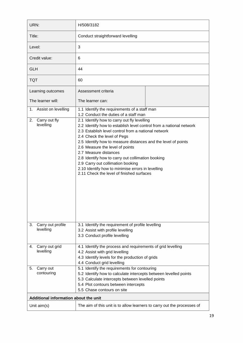
URN: H/508/3182
Title: Conduct straightforward levelling
Level: 3
Credit value: 6
GLH 44
TQT 60
Learning outcomes
The learner will:
Assessment criteria
The learner can:
1. Assist on levelling 1.1 Identify the requirements of a staff man
1.2 Conduct the duties of a staff man
2. Carry out fly levelling
2.1 Identify how to carry out fly levelling
2.2 Identify how to establish level control from a national network
2.3 Establish level control from a national network
2.4 Check the level of Pegs
2.5 Identify how to measure distances and the level of points
2.6 Measure the level of points
2.7 Measure distances
2.8 Identify how to carry out collimation booking
2.9 Carry out collimation booking
2.10 Identify how to minimise errors in levelling 2.11 Check the level of finished surfaces
3. Carry out profile levelling
3.1 Identify the requirement of profile levelling
3.2 Assist with profile levelling
3.3 Conduct profile levelling
4. Carry out grid levelling
4.1 Identify the process and requirements of grid levelling
4.2 Assist with grid levelling
4.3 Identify levels for the production of grids
4.4 Conduct grid levelling
5. Carry out contouring
5.1 Identify the requirements for contouring
5.2 Identify how to calculate intercepts between levelled points
5.3 Calculate intercepts between levelled points
5.4 Plot contours between intercepts
5.5 Chase contours on site
Additional information about the unit
Unit aim(s) The aim of this unit is to allow learners to carry out the processes of

20
levelling and contouring
Assessment
requirements specified
by a sector or regulatory
body (if appropriate)
This unit requires the assessment of occupational competence under
realistic conditions wherever practicable. For the knowledge and
understanding component of the unit, assessment from a learning and
development environment is allowed.
Name of the
organisation submitting
the unit
Defence Awarding Organisation
21
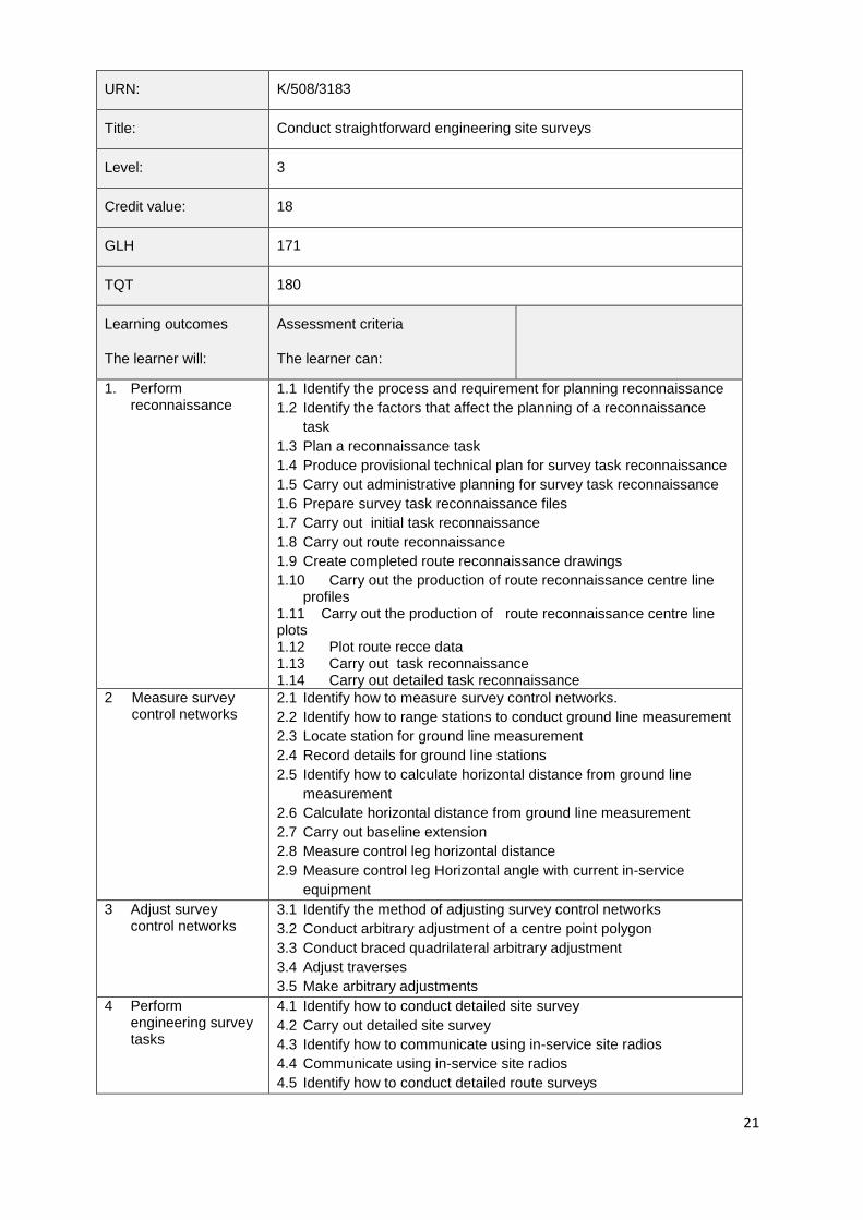
URN: K/508/3183
Title: Conduct straightforward engineering site surveys
Level: 3
Credit value: 18
GLH 171
TQT 180
Learning outcomes
The learner will:
Assessment criteria
The learner can:
1. Perform reconnaissance
1.1 Identify the process and requirement for planning reconnaissance
1.2 Identify the factors that affect the planning of a reconnaissance
task
1.3 Plan a reconnaissance task
1.4 Produce provisional technical plan for survey task reconnaissance
1.5 Carry out administrative planning for survey task reconnaissance
1.6 Prepare survey task reconnaissance files
1.7 Carry out initial task reconnaissance
1.8 Carry out route reconnaissance
1.9 Create completed route reconnaissance drawings
1.10 Carry out the production of route reconnaissance centre line profiles
1.11 Carry out the production of route reconnaissance centre line plots 1.12 Plot route recce data 1.13 Carry out task reconnaissance
1.14 Carry out detailed task reconnaissance
2 Measure survey control networks
2.1 Identify how to measure survey control networks.
2.2 Identify how to range stations to conduct ground line measurement
2.3 Locate station for ground line measurement
2.4 Record details for ground line stations
2.5 Identify how to calculate horizontal distance from ground line
measurement
2.6 Calculate horizontal distance from ground line measurement
2.7 Carry out baseline extension
2.8 Measure control leg horizontal distance
2.9 Measure control leg Horizontal angle with current in-service
equipment
3 Adjust survey control networks
3.1 Identify the method of adjusting survey control networks
3.2 Conduct arbitrary adjustment of a centre point polygon
3.3 Conduct braced quadrilateral arbitrary adjustment
3.4 Adjust traverses
3.5 Make arbitrary adjustments
4 Perform engineering survey tasks
4.1 Identify how to conduct detailed site survey
4.2 Carry out detailed site survey
4.3 Identify how to communicate using in-service site radios
4.4 Communicate using in-service site radios
4.5 Identify how to conduct detailed route surveys
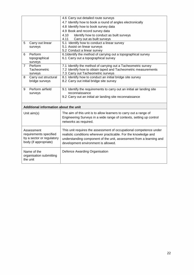
22
4.6 Carry out detailed route surveys
4.7 Identify how to book a round of angles electronically
4.8 Identify how to book survey data
4.9 Book and record survey data
4.10 Identify how to conduct as built surveys 4.11 Carry out as built surveys
5 Carry out linear surveys
5.1 Identify how to conduct a linear survey 5.1 Assist on linear surveys 5.2 Conduct a linear survey
6 Perform topographical surveys
6.1Identify the method of carrying out a topographical survey 6.1 Carry out a topographical survey
7 Perform Tacheometric surveys
7.1 Identify the method of carrying out a Tacheometric survey 7.2 Identify how to obtain taped and Tacheometric measurements 7.3 Carry out Tacheometric surveys
8 Carry out structural bridge surveys
8.1 Identify how to conduct an initial bridge site survey 8.2 Carry out initial bridge site survey
9 Perform airfield surveys
9.1 Identify the requirements to carry out an initial air landing site reconnaissance
9.2 Carry out an initial air landing site reconnaissance
Additional information about the unit
Unit aim(s) The aim of this unit is to allow learners to carry out a range of
Engineering Surveys in a wide range of contexts, setting up control
networks as required.
Assessment
requirements specified
by a sector or regulatory
body (if appropriate)
This unit requires the assessment of occupational competence under
realistic conditions wherever practicable. For the knowledge and
understanding component of the unit, assessment from a learning and
development environment is allowed.
Name of the
organisation submitting
the unit
Defence Awarding Organisation
23
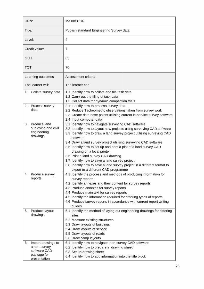
URN: M/508/3184
Title: Publish standard Engineering Survey data
Level: 4
Credit value: 7
GLH 63
TQT 70
Learning outcomes
The learner will:
Assessment criteria
The learner can:
1. Collate survey data 1.1 Identify how to collate and file task data
1.2 Carry out the filing of task data
1.3 Collect data for dynamic compaction trials
2. Process survey data
2.1 Identify how to process survey data
2.2 Reduce Tacheometric observations taken from survey work
2.3 Create data base points utilising current in-service survey software
2.4 Input computer data
3. Produce land surveying and civil engineering drawings
3.1 Identify how to navigate surveying CAD software
3.2 Identify how to layout new projects using surveying CAD software
3.3 Identify how to draw a land survey project utilising surveying CAD
software
3.4 Draw a land survey project utilising surveying CAD software
3.5 Identify how to set up and print a plot of a land survey CAD
drawing on a local printer
3.6 Print a land survey CAD drawing
3.7 Identify how to save a land survey project
3.8 Identify how to save a land survey project in a different format to
export to a different CAD programme
4. Produce survey reports
4.1 Identify the process and methods of producing information for
survey reports
4.2 Identify annexes and their content for survey reports
4.3 Produce annexes for survey reports
4.4 Produce main text for survey reports
4.5 Identify the information required for differing types of reports
4.6 Produce survey reports in accordance with current report writing
guides
5. Produce layout drawings
5.1 Identify the method of laying out engineering drawings for differing
sites
5.2 Measure existing structures
5.3 Draw layouts of buildings
5.4 Draw layouts of service
5.5 Draw layouts of roads
5.6 Draw camp layouts
6. Import drawings to a non-survey software CAD package for presentation
6.1 Identify how to navigate non-survey CAD software
6.2 Identify how to prepare a drawing sheet
6.3 Set up drawing sheet
6.4 Identify how to add information into the title block
24
purposes 6.5 Add the drawing related information to the title block
6.6 Identify how to import drawings from a non-survey CAD package
6.7 Import drawings from a non-survey CAD package
6.8 Identify how to keep imported drawings to scale
6.9 Identify how to manipulate data ready for presentation
6.10 Manipulate data ready for presentation 6.11 Identify how to prepare a drawing for plotting
6.12 Print a plot of an imported land survey drawing for presentation purposes
7. Compute data for setting out to line and level from geometric designs
7.1 Identify how to compute data for setting out to line and level. 7.2 Compute relevant data for setting out 7.3 Compute line and level data
8. Produce survey diagrams
8.1 Identify how to prepare for the publication of profile diagrams 8.2 Carry out the production of profile diagrams 8.3 Identify how to publish detailed survey diagrams
8.4 Carry out the production of detailed survey diagrams
Additional information about the unit
Unit aim(s) The aim of this unit is to allow learners to produce, in a variety of
formats diagrams and maps for others to use, using a range of source
material.
Assessment
requirements specified
by a sector or regulatory
body (if appropriate)
This unit requires the assessment of occupational competence under
realistic conditions wherever practicable. For the knowledge and
understanding component of the unit, assessment from a learning and
development environment is allowed.
Name of the
organisation submitting
the unit
Defence Awarding Organisation
25
URN: T/508/3185
Title: Control straightforward engineering survey tasks
Level: 3
Credit value: 8
GLH 71
TQT 80
Learning outcomes
The learner will:
Assessment criteria
The learner can:
1. Control line and level of alignments
1.1 Identify how to control line and level of horizontal & vertical
alignments
1.2 Carry out the control of line and level of horizontal & vertical
alignments
2. Control line and level of earthworks
2.1 Identify how to control line and level of earthworks
2.2 Control line and level of earthmoving operations
2.3 Control line and level of earthworks
3. Control line and level of engineering construction tasks
3.1 Identify how to control line and level during the construction of
linear features
3.2 Control line and level during the construction of linear features
3.3 Identify how to control line and level of roads and tracks
3.4 Control line and level during the construction of roads and tracks
3.5 Identify how to control line and level during construction
3.6 Control the line and level during the construction of buildings and
structures
3.7 Control line and level of foundations
3.8 Identify how to control line and level
3.9 Control line and level of paving operations
3.10 Control line and level of piling operations
4. Control line and level of construction plant
4.1 Identify how to control line and level of construction plant
4.2 Control line and level of construction plant
4.3 Control line and level of piling operations
Additional information about the unit
Unit aim(s) This unit will allow learners to control the line and level of features
under construction
Assessment
requirements specified
by a sector or regulatory
body (if appropriate)
This unit requires the assessment of occupational competence under
realistic conditions wherever practicable. For the knowledge and
understanding component of the unit, assessment from a learning and
development environment is allowed.
Name of the
organisation submitting
the unit
Defence Awarding Organisation
26
URN: A/508/3186
Title: Use Global Navigation Satellite Systems
Level: 2
Credit value: 2
GLH 18
TQT 20
Learning outcomes
The learner will:
Assessment criteria
The learner can:
1. Operate in-service Global Navigation Satellite Systems (GNSS)
1.1 Identify satellite positioning principles
1.2 Identify the difference between GNSS and GPS
1.3 Identify the definitions of the spheroid and the geoid, and their
relationship to the physical shape of the earth's surface.
1.4 Determine how the World Geodetic System is used for navigation
datums
1.5 Identify the components of the Global Navigation Satellite
Systems (GNSS)
1.6 Identify the operating requirements of the in-service Global
Navigation Satellite Systems
1.7 Obtain data from the in-service Global Navigation Satellite
Systems
2. Use in-service Global Navigation Satellite Systems (GNSS) for survey tasks
2.1 Identify error sources when using GNSS
2.2 Carry out Tacheometric surveys utilising GNSS
2.3 Carry out site surveys utilising GNSS
Additional information about the unit
Unit aim(s) This unit will allow learners to use GNSS systems for engineering
survey tasks.
Assessment
requirements specified
by a sector or regulatory
body (if appropriate)
This unit requires the assessment of occupational competence under
realistic conditions wherever practicable. For the knowledge and
understanding component of the unit, assessment from a learning and
development environment is allowed.
Name of the
organisation submitting
the unit
Defence Awarding Organisation
27
URN: F/508/3187
Title: Monitor a Survey Engineering trade task
Level: 3
Credit value: 2
GLH 7
TQT 20
Learning outcomes
The learner will:
Assessment criteria
The learner can:
1. Monitor Surveyor Engineer tasks
1.1 Ensure task standards are maintained and complied with
1.2 Ensure compliance with core values and standards
1.3 Identify workmanship faults
1.4 Identify faults not caused by poor workmanship
1.5 Identify whether the faults caused through poor workmanship can
be rectified within limits of responsibility
1.6 Implement safe working procedures for a surveyor engineer task
1.7 Evaluate the execution of a surveyor engineer task
1.8 Provide feedback
2. Implement quality control measures
2.1 Ensure correct materials are used for the task
2.2 Ensure the correct quantity of material is used for the task
2.3 Ensure the correct tools and equipment are used for the task
2.4 Ensure H&S requirements for the task are adhered to
Additional information about the unit
Unit aim(s) This unit will allow learners to apply quality control to an engineering
survey task
Name of the
organisation submitting
the unit
Defence Awarding Organisation