Embed Size (px)
Citation preview
QGIS Developers GuideRelease 3.4
QGIS Project
Apr 07, 2019

Contents
1 QGIS Coding Standards 3
2 GIT Access 15
3 Unit Testing 23
4 Getting up and running with QtCreator and QGIS 33
5 HIG (Human Interface Guidelines) 41
6 OGC Conformance Testing 43
i

ii
QGIS Developers Guide, Release 3.4
Welcome to the QGIS Development pages. Here you’ll find rules, tools and steps to easily and efficiently con-tribute to QGIS code.
Contents 1
QGIS Developers Guide, Release 3.4
2 Contents
CHAPTER 1
QGIS Coding Standards
• Classes
– Names
– Members
– Accessor Functions
– Functions
– Function Arguments
– Function Return Values
• API Documentation
– Methods
– Members Variables
• Qt Designer
– Generated Classes
– Dialogs
• C++ Files
– Names
– Standard Header and License
• Variable Names
• Enumerated Types
• Global Constants & Macros
• Qt Signals and Slots
• Editing
– Tabs
– Indentation
3
QGIS Developers Guide, Release 3.4
– Braces
• API Compatibility
• SIP Bindings
– Header pre-processing
– Generating the SIP file
– Improving sipify script
• Coding Style
– Where-ever Possible Generalize Code
– Prefer Having Constants First in Predicates
– Whitespace Can Be Your Friend
– Put commands on separate lines
– Indent access modifiers
– Book recommendations
• Credits for contributions
These standards should be followed by all QGIS developers.
1.1 Classes
1.1.1 Names
Class in QGIS begin with Qgs and are formed using camel case.
Examples:
• QgsPoint
• QgsMapCanvas
• QgsRasterLayer
1.1.2 Members
Class member names begin with a lower case m and are formed using mixed case.
• mMapCanvas
• mCurrentExtent
All class members should be private. Public class members are STRONGLY discouraged. Protected membersshould be avoided when the member may need to be accessed from Python subclasses, since protected memberscannot be used from the Python bindings.
Mutable static class member names should begin with a lower case s, but constant static class member namesshould be all caps:
• sRefCounter
• DEFAULT_QUEUE_SIZE
4 Chapter 1. QGIS Coding Standards
QGIS Developers Guide, Release 3.4
1.1.3 Accessor Functions
Class member values should be obtained through accesssor functions. The function should be named without aget prefix. Accessor functions for the two private members above would be:
• mapCanvas()
• currentExtent()
Ensure that accessors are correctly marked with const. Where appropriate, this may require that cached valuetype member variables are marked with mutable.
1.1.4 Functions
Function names begin with a lowercase letter and are formed using mixed case. The function name should conveysomething about the purpose of the function.
• updateMapExtent()
• setUserOptions()
For consistency with the existing QGIS API and with the Qt API, abbreviations should be avoided. E.g.setDestinationSize instead of setDestSize, setMaximumValue instead of setMaxVal.
Acronyms should also be camel cased for consistency. E.g. setXml instead of setXML.
1.1.5 Function Arguments
Function arguments should use descriptive names. Do not use single letter arguments (e.g. setColor( constQColor& color ) instead of setColor( const QColor& c )).
Pay careful attention to when arguments should be passed by reference. Unless argument objects are small andtrivially copied (such as QPoint objects), they should be passed by const reference. For consistency with theQt API, even implicitly shared objects are passed by const reference (e.g. setTitle( const QString&title ) instead of setTitle( QString title ).
1.1.6 Function Return Values
Return small and trivially copied objects as values. Larger objects should be returned by const reference. The oneexception to this is implicitly shared objects, which are always returned by value. Return QObject or subclassedobjects as pointers.
• int maximumValue() const
• const LayerSet& layers() const
• QString title() const (QString is implicitly shared)
• QList< QgsMapLayer* > layers() const (QList is implicitly shared)
• QgsVectorLayer *layer() const; (QgsVectorLayer inherits QObject)
• QgsAbstractGeometry *geometry() const; (QgsAbstractGeometry is abstract and willprobably need to be casted)
1.2 API Documentation
It is required to write API documentation for every class, method, enum and other code that is available in thepublic API.
1.2. API Documentation 5
QGIS Developers Guide, Release 3.4
QGIS uses Doxygen for documentation. Write descriptive and meaningful comments that give a reader informa-tion about what to expect, what happens in edge cases and give hints about other interfaces he could be lookingfor, best best practice and code samples.
1.2.1 Methods
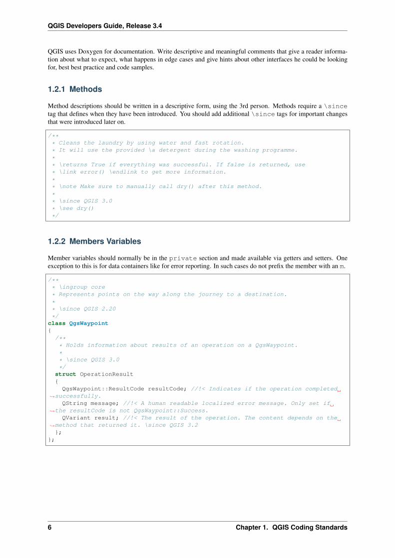
Method descriptions should be written in a descriptive form, using the 3rd person. Methods require a \sincetag that defines when they have been introduced. You should add additional \since tags for important changesthat were introduced later on.
/*** Cleans the laundry by using water and fast rotation.
* It will use the provided \a detergent during the washing programme.
** \returns True if everything was successful. If false is returned, use
* \link error() \endlink to get more information.
** \note Make sure to manually call dry() after this method.
** \since QGIS 3.0
* \see dry()
*/
1.2.2 Members Variables
Member variables should normally be in the private section and made available via getters and setters. Oneexception to this is for data containers like for error reporting. In such cases do not prefix the member with an m.
/*** \ingroup core
* Represents points on the way along the journey to a destination.
** \since QGIS 2.20
*/class QgsWaypoint{
/*** Holds information about results of an operation on a QgsWaypoint.
** \since QGIS 3.0
*/struct OperationResult{QgsWaypoint::ResultCode resultCode; //!< Indicates if the operation completed
→˓successfully.QString message; //!< A human readable localized error message. Only set if
→˓the resultCode is not QgsWaypoint::Success.QVariant result; //!< The result of the operation. The content depends on the
→˓method that returned it. \since QGIS 3.2};
};
6 Chapter 1. QGIS Coding Standards
QGIS Developers Guide, Release 3.4
1.3 Qt Designer
1.3.1 Generated Classes
QGIS classes that are generated from Qt Designer (ui) files should have a Base suffix. This identifies the class asa generated base class.
Examples:
• QgsPluginManagerBase
• QgsUserOptionsBase
1.3.2 Dialogs
All dialogs should implement tooltip help for all toolbar icons and other relevant widgets. Tooltips add greatly tofeature discoverability for both new and experienced users.
Ensure that the tab order for widgets is updated whenever the layout of a dialog changes.
1.4 C++ Files
1.4.1 Names
C++ implementation and header files should have a .cpp and .h extension respectively. Filename should be alllowercase and, in the case of classes, match the class name.
Example: Class QgsFeatureAttribute source files are qgsfeatureattribute.cpp andqgsfeatureattribute.h
Note: In case it is not clear from the statement above, for a filename to match a class name it implicitly meansthat each class should be declared and implemented in its own file. This makes it much easier for newcomers toidentify where the code is relating to specific class.
1.4.2 Standard Header and License
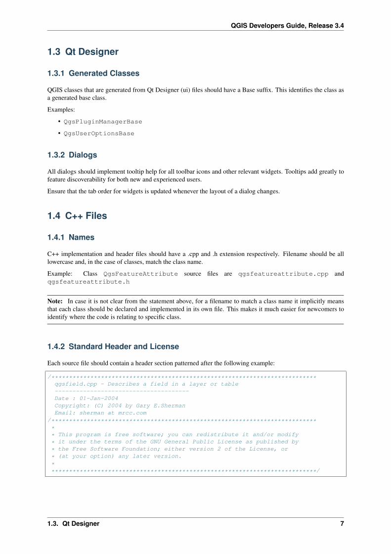
Each source file should contain a header section patterned after the following example:
/***************************************************************************qgsfield.cpp - Describes a field in a layer or table--------------------------------------Date : 01-Jan-2004Copyright: (C) 2004 by Gary E.ShermanEmail: sherman at mrcc.com
/***************************************************************************** This program is free software; you can redistribute it and/or modify
* it under the terms of the GNU General Public License as published by
* the Free Software Foundation; either version 2 of the License, or
* (at your option) any later version.
****************************************************************************/
1.3. Qt Designer 7
QGIS Developers Guide, Release 3.4
Note: There is a template for Qt Creator in git. To use it, copy it from doc/qt_creator_license_template to a local location, adjust the mail address and - if required - thename and configure QtCreator to use it: Tools → Options → C++ → File Naming.
1.5 Variable Names
Local variable names begin with a lower case letter and are formed using mixed case. Do not use prefixes like myor the.
Examples:
• mapCanvas
• currentExtent
1.6 Enumerated Types
Enumerated types should be named in CamelCase with a leading capital e.g.:
enum UnitType{
Meters,Feet,Degrees,UnknownUnit
};
Do not use generic type names that will conflict with other types. e.g. use UnkownUnit rather than Unknown
1.7 Global Constants & Macros
Global constants and macros should be written in upper case underscore separated e.g.:
const long GEOCRS_ID = 3344;
1.8 Qt Signals and Slots
All signal/slot connects should be made using the “new style” connects available in Qt5. Futher information onthis requirement is available in QEP #77.
Avoid use of Qt auto connect slots (i.e. those named void on_mSpinBox_valueChanged). Auto connectslots are fragile and prone to breakage without warning if dialogs are refactored.
1.9 Editing
Any text editor/IDE can be used to edit QGIS code, providing the following requirements are met.
8 Chapter 1. QGIS Coding Standards
QGIS Developers Guide, Release 3.4
1.9.1 Tabs
Set your editor to emulate tabs with spaces. Tab spacing should be set to 2 spaces.
Note: In vim this is done with set expandtab ts=2
1.9.2 Indentation
Source code should be indented to improve readability. There is a scripts/prepare-commit.sh that looksup the changed files and reindents them using astyle. This should be run before committing. You can also usescripts/astyle.sh to indent individual files.
As newer versions of astyle indent differently than the version used to do a complete reindentation of the source,the script uses an old astyle version, that we include in our repository (enable WITH_ASTYLE in cmake to includeit in the build).
1.9.3 Braces
Braces should start on the line following the expression:
if(foo == 1){
// do stuff...
}else{
// do something else...
}
1.10 API Compatibility
There is API documentation for C++.
We try to keep the API stable and backwards compatible. Cleanups to the API should be done in a manner similarto the Qt sourcecode e.g.
class Foo{
public:/*** This method will be deprecated, you are encouraged to use
* doSomethingBetter() rather.
* \deprecated doSomethingBetter()
*/Q_DECL_DEPRECATED bool doSomething();
/*** Does something a better way.
* \note added in 1.1
*/bool doSomethingBetter();
signals:/**
1.10. API Compatibility 9
QGIS Developers Guide, Release 3.4
* This signal will is deprecated, you are encouraged to
* connect to somethingHappenedBetter() rather.
* \deprecated use somethingHappenedBetter()
*/#ifndef Q_MOC_RUN
Q_DECL_DEPRECATED#endif
bool somethingHappened();
/*** Something happened
* \note added in 1.1
*/bool somethingHappenedBetter();
}
1.11 SIP Bindings
Some of the SIP files are automatically generated using a dedicated script.
1.11.1 Header pre-processing
All the information to properly build the SIP file must be found in the C++ header file. Some macros are availablefor such definition:
• Use #ifdef SIP_RUN to generate code only in SIP files or #ifndef SIP_RUN for C++ code only.#else statements are handled in both cases.
• Use SIP_SKIP to discard a line
• The following annotations are handled:
– SIP_FACTORY: /Factory/
– SIP_OUT: /Out/
– SIP_INOUT: /In,Out/
– SIP_TRANSFER: /Transfer/
– SIP_PYNAME(name): /PyName=name/
– SIP_KEEPREFERENCE: /KeepReference/
– SIP_TRANSFERTHIS: /TransferThis/
– SIP_TRANSFERBACK: /TransferBack/
• private sections are not displayed, except if you use a #ifdef SIP_RUN statement in this block.
• SIP_PYDEFAULTVALUE(value) can be used to define an alternative default value of the pythonmethod. If the default value contains a comma ,, the value should be surrounded by single quotes '
• SIP_PYTYPE(type) can be used to define an alternative type for an argument of the python method. Ifthe type contains a comma ,, the type should be surrounded by single quotes '
A demo file can be found in tests/scripts/sipifyheader.h.
1.11.2 Generating the SIP file
The SIP file can be generated using a dedicated script. For instance:
10 Chapter 1. QGIS Coding Standards
QGIS Developers Guide, Release 3.4
scripts/sipify.pl src/core/qgsvectorlayer.h > python/core/qgsvectorlayer.sip
As soon as a SIP file is added to one of the source file (python/core/core.sip, python/gui/gui.sipor python/analysis/analysis.sip), it will be considered as generated automatically. A test on Traviswill ensure that this file is up to date with its corresponding header.
Older files for which the automatic creation is not enabled yet are listed in python/auto_sip.blacklist.
1.11.3 Improving sipify script
If some improvements are required for sipify script, please add the missing bits to the demo file tests/scripts/sipifyheader.h and create the expected header tests/scripts/sipifyheader.expected.si. This will also be automatically tested on Travis as a unit test of the script itself.
1.12 Coding Style
Here are described some programming hints and tips that will hopefully reduce errors, development time andmaintenance.
1.12.1 Where-ever Possible Generalize Code
If you are cut-n-pasting code, or otherwise writing the same thing more than once, consider consolidating the codeinto a single function.
This will:
• allow changes to be made in one location instead of in multiple places
• help prevent code bloat
• make it more difficult for multiple copies to evolve differences over time, thus making it harder to understandand maintain for others
1.12.2 Prefer Having Constants First in Predicates
Prefer to put constants first in predicates.
0 == value instead of value == 0
This will help prevent programmers from accidentally using = when they meant to use ==, which can introducevery subtle logic bugs. The compiler will generate an error if you accidentally use = instead of == for comparisonssince constants inherently cannot be assigned values.
1.12.3 Whitespace Can Be Your Friend
Adding spaces between operators, statements, and functions makes it easier for humans to parse code.
Which is easier to read, this:
if (!a&&b)
or this:
if ( ! a && b )
1.12. Coding Style 11
QGIS Developers Guide, Release 3.4
Note: scripts/prepare-commit.sh will take care of this.
1.12.4 Put commands on separate lines
When reading code it’s easy to miss commands, if they are not at the beginning of the line. When quickly readingthrough code, it’s common to skip lines if they don’t look like what you are looking for in the first few characters.It’s also common to expect a command after a conditional like if.
Consider:
if (foo) bar();
baz(); bar();
It’s very easy to miss part of what the flow of control. Instead use
if (foo)bar();
baz();bar();
1.12.5 Indent access modifiers
Access modifiers structure a class into sections of public API, protected API and private API. Access modifiersthemselves group the code into this structure. Indent the access modifier and declarations.
class QgsStructure{
public:/*** Constructor
*/explicit QgsStructure();
}
1.12.6 Book recommendations
• Effective Modern C++, Scott Meyers
• More Effective C++, Scott Meyers
• Effective STL, Scott Meyers
• Design Patterns, GoF
You should also really read this article from Qt Quarterly on designing Qt style (APIs)
1.13 Credits for contributions
Contributors of new functions are encouraged to let people know about their contribution by:
• adding a note to the changelog for the first version where the code has been incorporated, of the type:
This feature was funded by: Olmiomland https://olmiomland.olThis feature was developed by: Chuck Norris https://chucknorris.kr
12 Chapter 1. QGIS Coding Standards
QGIS Developers Guide, Release 3.4
• writing an article about the new feature on a blog, and add it to the QGIS planet https://plugins.qgis.org/planet/
• adding their name to:
– https://github.com/qgis/QGIS/blob/master/doc/CONTRIBUTORS
– https://github.com/qgis/QGIS/blob/master/doc/AUTHORS
– https://github.com/qgis/QGIS/blob/master/doc/contributors.json
1.13. Credits for contributions 13
QGIS Developers Guide, Release 3.4
14 Chapter 1. QGIS Coding Standards
CHAPTER 2
GIT Access
• Installation
– Install git for GNU/Linux
– Install git for Windows
– Install git for OSX
• Accessing the Repository
• Check out a branch
• QGIS documentation sources
• QGIS website sources
• GIT Documentation
• Development in branches
– Purpose
– Procedure
– Testing before merging back to master
• Submitting Patches and Pull Requests
– Pull Requests
* Best practice for creating a pull request
* Special labels to notify documentors
* For merging a pull request
• Patch file naming
• Create your patch in the top level QGIS source dir
– Getting your patch noticed
– Due Diligence
• Obtaining GIT Write Access
15
QGIS Developers Guide, Release 3.4
This section describes how to get started using the QGIS GIT repository. Before you can do this, you need to firsthave a git client installed on your system.
2.1 Installation
2.1.1 Install git for GNU/Linux
Debian based distro users can do:
sudo apt-get install git
2.1.2 Install git for Windows
Windows users can obtain msys git or use git distributed with cygwin.
2.1.3 Install git for OSX
The git project has a downloadable build of git. Make sure to get the package matching your processor (x86_64most likely, only the first Intel Macs need the i386 package).
Once downloaded open the disk image and run the installer.
PPC/source note
The git site does not offer PPC builds. If you need a PPC build, or you just want a little more control over theinstallation, you need to compile it yourself.
Download the source from https://git-scm.com/. Unzip it, and in a Terminal cd to the source folder, then:
make prefix=/usr/localsudo make prefix=/usr/local install
If you don’t need any of the extras, Perl, Python or TclTk (GUI), you can disable them before running make with:
export NO_PERL=export NO_TCLTK=export NO_PYTHON=
2.2 Accessing the Repository
To clone QGIS master:
git clone git://github.com/qgis/QGIS.git
2.3 Check out a branch
To check out a branch, for example the release 2.6.1 branch do:
cd QGISgit fetchgit branch --track origin release-2_6_1git checkout release-2_6_1
16 Chapter 2. GIT Access
QGIS Developers Guide, Release 3.4
To check out the master branch:
cd QGISgit checkout master
Note: In QGIS we keep our most stable code in the current release branch. Master contains code for the socalled ‘unstable’ release series. Periodically we will branch a release off master, and then continue stabilisationand selective incorporation of new features into master.
See the INSTALL file in the source tree for specific instructions on building development versions.
2.4 QGIS documentation sources
If you’re interested in checking out QGIS documentation sources:
git clone [email protected]:qgis/QGIS-Documentation.git
You can also take a look at the readme included with the documentation repo for more information.
2.5 QGIS website sources
If you’re interested in checking out QGIS website sources:
git clone [email protected]:qgis/QGIS-Website.git
You can also take a look at the readme included with the website repo for more information.
2.6 GIT Documentation
See the following sites for information on becoming a GIT master.
• https://services.github.com/
• https://progit.org
• http://gitready.com
2.7 Development in branches
2.7.1 Purpose
The complexity of the QGIS source code has increased considerably during the last years. Therefore it is hardto anticipate the side effects that the addition of a feature will have. In the past, the QGIS project had very longrelease cycles because it was a lot of work to reetablish the stability of the software system after new featureswere added. To overcome these problems, QGIS switched to a development model where new features are codedin GIT branches first and merged to master (the main branch) when they are finished and stable. This sectiondescribes the procedure for branching and merging in the QGIS project.
2.4. QGIS documentation sources 17
QGIS Developers Guide, Release 3.4
2.7.2 Procedure
• Initial announcement on mailing list: Before starting, make an announcement on the developer mailinglist to see if another developer is already working on the same feature. Also contact the technicaladvisor of the project steering committee (PSC). If the new feature requires any changes to the QGISarchitecture, a request for comment (RFC) is needed.
Create a branch: Create a new GIT branch for the development of the new feature.
git checkout -b newfeature
Now you can start developing. If you plan to do extensive on that branch, would like to share the work with otherdevelopers, and have write access to the upstream repo, you can push your repo up to the QGIS official repo bydoing:
git push origin newfeature
Note: If the branch already exists your changes will be pushed into it.
Rebase to master regularly: It is recommended to rebase to incorporate the changes in master to the branch ona regular basis. This makes it easier to merge the branch back to master later. After a rebase you need to gitpush -f to your forked repo.
Note: Never git push -f to the origin repository! Only use this for your working branch.
git rebase master
2.7.3 Testing before merging back to master
When you are finished with the new feature and happy with the stability, make an announcement on the developerlist. Before merging back, the changes will be tested by developers and users.
2.8 Submitting Patches and Pull Requests
There are a few guidelines that will help you to get your patches and pull requests into QGIS easily, and help usdeal with the patches that are sent to use easily.
2.8.1 Pull Requests
In general it is easier for developers if you submit GitHub pull requests. We do not describe Pull Requests here,but rather refer you to the GitHub pull request documentation.
If you make a pull request we ask that you please merge master to your PR branch regularly so that your PR isalways mergable to the upstream master branch.
If you are a developer and wish to evaluate the pull request queue, there is a very nice tool that lets you do thisfrom the command line
Please see the section below on ‘getting your patch noticed’. In general when you submit a PR you should takethe responsibility to follow it through to completion - respond to queries posted by other developers, seek out a‘champion’ for your feature and give them a gentle reminder occasionally if you see that your PR is not beingacted on. Please bear in mind that the QGIS project is driven by volunteer effort and people may not be able toattend to your PR instantaneously. If you feel the PR is not receiving the attention it deserves your options toaccelerate it should be (in order of priority):
18 Chapter 2. GIT Access
QGIS Developers Guide, Release 3.4
• Send a message to the mailing list ‘marketing’ your PR and how wonderful it will be to have it included inthe code base.
• Send a message to the person your PR has been assigned to in the PR queue.
• Send a message to Marco Hugentobler (who manages the PR queue).
• Send a message to the project steering committee asking them to help see your PR incorporated into thecode base.
Best practice for creating a pull request
• Always start a feature branch from current master.
• If you are coding a feature branch, don’t “merge” anything into that branch, rather rebase as described inthe next point to keep your history clean.
• Before you create a pull request do git fetch origin and git rebase origin/master (givenorigin is the remote for upstream and not your own remote, check your .git/config or do gitremote -v | grep github.com/qgis).
• You may do a git rebase like in the last line repeatedly without doing any damage (as long as the onlypurpose of your branch is to get merged into master).
• Attention: After a rebase you need to git push -f to your forked repo. CORE DEVS: DO NOT DOTHIS ON THE QGIS PUBLIC REPOSITORY!
Special labels to notify documentors
Besides common tags you can add to classify your PR, there are special ones you can use to automatically generateissue reports in QGIS-Documentation repository as soon as your pull request is merged:
• [needs-docs] to instruct doc writers to please add some extra documentation after a fix or addition toan already existing functionality.
• [feature] in case of new functionnality. Filling a good description in your PR will be a good start.
Please devs use these labels (case insensitive) so doc writers have issues to work on and have an overview of thingsto do. BUT please also take time to add some text: either in the commit OR in the docs itself.
For merging a pull request
Option A:
• click the merge button (Creates a non-fast-forward merge)
Option B:
• Checkout the pull request
• Test (Also required for option A, obviously)
• checkout master, git merge pr/1234
• Optional: git pull --rebase: Creates a fast-forward, no “merge commit” is made. Cleaner history,but it is harder to revert the merge.
• git push (NEVER EVER use the -f option here)
2.8. Submitting Patches and Pull Requests 19
QGIS Developers Guide, Release 3.4
2.9 Patch file naming
If the patch is a fix for a specific bug, please name the file with the bug number in it e.g. bug777fix.patch, andattach it to the original bug report in trac.
If the bug is an enhancement or new feature, its usually a good idea to create a ticket in trac first and then attachyour patch.
2.10 Create your patch in the top level QGIS source dir
This makes it easier for us to apply the patches since we don’t need to navigate to a specific place in the sourcetree to apply the patch. Also when I receive patches I usually evaluate them using merge, and having the patchfrom the top level dir makes this much easier. Below is an example of how you can include multiple changed filesinto your patch from the top level directory:
cd QGISgit checkout mastergit pull origin mastergit checkout newfeaturegit format-patch master --stdout > bug777fix.patch
This will make sure your master branch is in sync with the upstream repository, and then generate a patch whichcontains the delta between your feature branch and what is in the master branch.
2.10.1 Getting your patch noticed
QGIS developers are busy folk. We do scan the incoming patches on bug reports but sometimes we miss things.Don’t be offended or alarmed. Try to identify a developer to help you - using the Technical Resources and contactthem asking them if they can look at your patch. If you don’t get any response, you can escalate your query to oneof the Project Steering Committee members (contact details also available in the Technical Resources).
2.10.2 Due Diligence
QGIS is licensed under the GPL. You should make every effort to ensure you only submit patches which areunencumbered by conflicting intellectual property rights. Also do not submit code that you are not happy to havemade available under the GPL.
2.11 Obtaining GIT Write Access
Write access to QGIS source tree is by invitation. Typically when a person submits several (there is no fixednumber here) substantial patches that demonstrate basic competence and understanding of C++ and QGIS codingconventions, one of the PSC members or other existing developers can nominate that person to the PSC forgranting of write access. The nominator should give a basic promotional paragraph of why they think that personshould gain write access. In some cases we will grant write access to non C++ developers e.g. for translatorsand documentors. In these cases, the person should still have demonstrated ability to submit patches and shouldideally have submitted several substantial patches that demonstrate their understanding of modifying the code basewithout breaking things, etc.
Note: Since moving to GIT, we are less likely to grant write access to new developers since it is trivial to sharecode within github by forking QGIS and then issuing pull requests.
20 Chapter 2. GIT Access
QGIS Developers Guide, Release 3.4
Always check that everything compiles before making any commits / pull requests. Try to be aware of possiblebreakages your commits may cause for people building on other platforms and with older / newer versions oflibraries.
When making a commit, your editor (as defined in $EDITOR environment variable) will appear and you shouldmake a comment at the top of the file (above the area that says ‘don’t change this’). Put a descriptive commentand rather do several small commits if the changes across a number of files are unrelated. Conversely we preferyou to group related changes into a single commit.
2.11. Obtaining GIT Write Access 21
QGIS Developers Guide, Release 3.4
22 Chapter 2. GIT Access
CHAPTER 3
Unit Testing
• The QGIS testing framework - an overview
– Creating a unit test
• Comparing images for rendering tests
• Adding your unit test to CMakeLists.txt
• The ADD_QGIS_TEST macro explained
• Building your unit test
• Run your tests
– Debugging unit tests
– Have fun
As of November 2007 we require all new features going into master to be accompanied with a unit test. Initiallywe have limited this requirement to qgis_core, and we will extend this requirement to other parts of the code baseonce people are familiar with the procedures for unit testing explained in the sections that follow.
3.1 The QGIS testing framework - an overview
Unit testing is carried out using a combination of QTestLib (the Qt testing library) and CTest (a framework forcompiling and running tests as part of the CMake build process). Lets take an overview of the process before Idelve into the details:
• There is some code you want to test, e.g. a class or function. Extreme programming advocates suggest thatthe code should not even be written yet when you start building your tests, and then as you implement yourcode you can immediately validate each new functional part you add with your test. In practive you willprobably need to write tests for pre-existing code in QGIS since we are starting with a testing frameworkwell after much application logic has already been implemented.
• You create a unit test. This happens under <QGIS Source Dir>/tests/src/core in the case ofthe core lib. The test is basically a client that creates an instance of a class and calls some methods on thatclass. It will check the return from each method to make sure it matches the expected value. If any one ofthe calls fails, the unit will fail.
23
QGIS Developers Guide, Release 3.4
• You include QtTestLib macros in your test class. This macro is processed by the Qt meta object compiler(moc) and expands your test class into a runnable application.
• You add a section to the CMakeLists.txt in your tests directory that will build your test.
• You ensure you have ENABLE_TESTING enabled in ccmake / cmakesetup. This will ensure your testsactually get compiled when you type make.
• You optionally add test data to <QGIS Source Dir>/tests/testdata if your test is data driven(e.g. needs to load a shapefile). These test data should be as small as possible and wherever possible youshould use the existing datasets already there. Your tests should never modify this data in situ, but rathermay a temporary copy somewhere if needed.
• You compile your sources and install. Do this using normal make && (sudo) make install pro-cedure.
• You run your tests. This is normally done simply by doing make test after the make install step,though I will explain other aproaches that offer more fine grained control over running tests.
Right with that overview in mind, I will delve into a bit of detail. I’ve already done much of the configuration foryou in CMake and other places in the source tree so all you need to do are the easy bits - writing unit tests!
3.1.1 Creating a unit test
Creating a unit test is easy - typically you will do this by just creating a single .cpp file (not .h file is used) andimplement all your test methods as public methods that return void. I’ll use a simple test class for QgsRasterLayerthroughout the section that follows to illustrate. By convention we will name our test with the same name as theclass they are testing but prefixed with ‘Test’. So our test implementation goes in a file called testqgsrasterlayer.cppand the class itself will be TestQgsRasterLayer. First we add our standard copyright banner:
/***************************************************************************testqgsvectorfilewriter.cpp--------------------------------------Date : Friday, Jan 27, 2015Copyright: (C) 2015 by Tim SuttonEmail: [email protected]
***************************************************************************** This program is free software; you can redistribute it and/or modify
* it under the terms of the GNU General Public License as published by
* the Free Software Foundation; either version 2 of the License, or
* (at your option) any later version.
****************************************************************************/
Next we use start our includes needed for the tests we plan to run. There is one special include all tests shouldhave:
#include <QtTest/QtTest>
Beyond that you just continue implementing your class as per normal, pulling in whatever headers you may need:
//Qt includes...#include <QObject>#include <QString>#include <QObject>#include <QApplication>#include <QFileInfo>#include <QDir>
//qgis includes...#include <qgsrasterlayer.h>
24 Chapter 3. Unit Testing
QGIS Developers Guide, Release 3.4
#include <qgsrasterbandstats.h>#include <qgsapplication.h>
Since we are combining both class declaration and implementation in a single file the class declaration comes next.We start with our doxygen documentation. Every test case should be properly documented. We use the doxygeningroup directive so that all the UnitTests appear as a module in the generated Doxygen documentation. After thatcomes a short description of the unit test and the class must inherit from QObject and include the Q_OBJECTmacro.
/** \ingroup UnitTests
* This is a unit test for the QgsRasterLayer class.
*/
class TestQgsRasterLayer: public QObject{
Q_OBJECT
All our test methods are implemented as private slots. The QtTest framework will sequentially call each privateslot method in the test class. There are four ‘special’ methods which if implemented will be called at the start ofthe unit test (initTestCase), at the end of the unit test (cleanupTestCase). Before each test method is called, theinit() method will be called and after each test method is called the cleanup() method is called. These methodsare handy in that they allow you to allocate and cleanup resources prior to running each test, and the test unit as awhole.
private slots:// will be called before the first testfunction is executed.void initTestCase();// will be called after the last testfunction was executed.void cleanupTestCase(){};// will be called before each testfunction is executed.void init(){};// will be called after every testfunction.void cleanup();
Then come your test methods, all of which should take no parameters and should return void. The methods willbe called in order of declaration. I am implementing two methods here which illustrates two types of testing.In the first case I want to generally test the various parts of the class are working, I can use a functional testingapproach. Once again, extreme programmers would advocate writing these tests before implementing the class.Then as you work your way through your class implementation you iteratively run your unit tests. More and moretest functions should complete sucessfully as your class implementation work progresses, and when the wholeunit test passes, your new class is done and is now complete with a repeatable way to validate it.
Typically your unit tests would only cover the public API of your class, and normally you do not need to writetests for accessors and mutators. If it should happen that an acccessor or mutator is not working as expected youwould normally implement a regression test to check for this (see lower down).
//// Functional Testing//
/** Check if a raster is valid. */void isValid();
// more functional tests here ...
Next we implement our regression tests. Regression tests should be implemented to replicate the conditions ofa particular bug. For example I recently received a report by email that the cell count by rasters was off by 1,throwing off all the statistics for the raster bands. I opened a bug (ticket #832) and then created a regression testthat replicated the bug using a small test dataset (a 10x10 raster). Then I ran the test and ran it, verifying thatit did indeed fail (the cell count was 99 instead of 100). Then I went to fix the bug and reran the unit test andthe regression test passed. I committed the regression test along with the bug fix. Now if anybody breakes this
3.1. The QGIS testing framework - an overview 25
QGIS Developers Guide, Release 3.4
in the source code again in the future, we can immediatly identify that the code has regressed. Better yet beforecommitting any changes in the future, running our tests will ensure our changes don’t have unexpected side effects- like breaking existing functionality.
There is one more benefit to regression tests - they can save you time. If you ever fixed a bug that involved makingchanges to the source, and then running the application and performing a series of convoluted steps to replicatethe issue, it will be immediately apparent that simply implementing your regression test before fixing the bug willlet you automate the testing for bug resolution in an efficient manner.
To implement your regression test, you should follow the naming convention of regression<TicketID> for yourtest functions. If no redmine ticket exists for the regression, you should create one first. Using this approachallows the person running a failed regression test easily go and find out more information.
//// Regression Testing//
/** This is our second test case...to check if a raster
* reports its dimensions properly. It is a regression test
* for ticket #832 which was fixed with change r7650.
*/void regression832();
// more regression tests go here ...
Finally in our test class declaration you can declare privately any data members and helper methods your unit testmay need. In our case I will declare a QgsRasterLayer * which can be used by any of our test methods. The rasterlayer will be created in the initTestCase() function which is run before any other tests, and then destroyed usingcleanupTestCase() which is run after all tests. By declaring helper methods (which may be called by various testfunctions) privately, you can ensure that they wont be automatically run by the QTest executable that is createdwhen we compile our test.
private:// Here we have any data structures that may need to// be used in many test cases.QgsRasterLayer * mpLayer;
};
That ends our class declaration. The implementation is simply inlined in the same file lower down. First our initand cleanup functions:
void TestQgsRasterLayer::initTestCase(){
// init QGIS's paths - true means that all path will be inited from prefixQString qgisPath = QCoreApplication::applicationDirPath ();QgsApplication::setPrefixPath(qgisPath, TRUE);
#ifdef Q_OS_LINUXQgsApplication::setPkgDataPath(qgisPath + "/../share/qgis");
#endif//create some objects that will be used in all tests...
std::cout << "PrefixPATH: " << QgsApplication::prefixPath().toLocal8Bit().data()→˓<< std::endl;std::cout << "PluginPATH: " << QgsApplication::pluginPath().toLocal8Bit().data()
→˓<< std::endl;std::cout << "PkgData PATH: " << QgsApplication::pkgDataPath().toLocal8Bit().
→˓data() << std::endl;std::cout << "User DB PATH: " << QgsApplication::qgisUserDbFilePath().
→˓toLocal8Bit().data() << std::endl;
//create a raster layer that will be used in all tests...QString myFileName (TEST_DATA_DIR); //defined in CmakeLists.txtmyFileName = myFileName + QDir::separator() + "tenbytenraster.asc";
26 Chapter 3. Unit Testing
QGIS Developers Guide, Release 3.4
QFileInfo myRasterFileInfo ( myFileName );mpLayer = new QgsRasterLayer ( myRasterFileInfo.filePath(),myRasterFileInfo.completeBaseName() );
}
void TestQgsRasterLayer::cleanupTestCase(){
delete mpLayer;}
The above init function illustrates a couple of interesting things.
1. I needed to manually set the QGIS application data path so that resources such as srs.db can be foundproperly.
2. Secondly, this is a data driven test so we needed to provide a way to generically locate thetenbytenraster.asc file. This was achieved by using the compiler define TEST_DATA_PATH. Thedefine is created in the CMakeLists.txt configuration file under <QGIS Source Root>/tests/CMakeLists.txt and is available to all QGIS unit tests. If you need test data for your test, commit itunder <QGIS Source Root>/tests/testdata. You should only commit very small datasets here.If your test needs to modify the test data, it should make a copy of it first.
Qt also provides some other interesting mechanisms for data driven testing, so if you are interested to know moreon the topic, consult the Qt documentation.
Next lets look at our functional test. The isValid() test simply checks the raster layer was correctly loaded in theinitTestCase. QVERIFY is a Qt macro that you can use to evaluate a test condition. There are a few other usemacros Qt provide for use in your tests including:
• QCOMPARE ( actual, expected )
• QEXPECT_FAIL ( dataIndex, comment, mode )
• QFAIL ( message )
• QFETCH ( type, name )
• QSKIP ( description, mode )
• QTEST ( actual, testElement )
• QTEST_APPLESS_MAIN ( TestClass )
• QTEST_MAIN ( TestClass )
• QTEST_NOOP_MAIN ()
• QVERIFY2 ( condition, message )
• QVERIFY ( condition )
• QWARN ( message )
Some of these macros are useful only when using the Qt framework for data driven testing (see the Qt docs formore detail).
void TestQgsRasterLayer::isValid(){
QVERIFY ( mpLayer->isValid() );}
Normally your functional tests would cover all the range of functionality of your classes public API where feasible.With our functional tests out the way, we can look at our regression test example.
Since the issue in bug #832 is a misreported cell count, writing our test is simply a matter of using QVERIFY tocheck that the cell count meets the expected value:
3.1. The QGIS testing framework - an overview 27
QGIS Developers Guide, Release 3.4
void TestQgsRasterLayer::regression832(){
QVERIFY ( mpLayer->getRasterXDim() == 10 );QVERIFY ( mpLayer->getRasterYDim() == 10 );// regression check for ticket #832// note getRasterBandStats call is base 1QVERIFY ( mpLayer->getRasterBandStats(1).elementCountInt == 100 );
}
With all the unit test functions implemented, there one final thing we need to add to our test class:
QTEST_MAIN(TestQgsRasterLayer)#include "testqgsrasterlayer.moc"
The purpose of these two lines is to signal to Qt’s moc that his is a QtTest (it will generate a main method thatin turn calls each test funtion.The last line is the include for the MOC generated sources. You should replace‘testqgsrasterlayer’ with the name of your class in lower case.
3.2 Comparing images for rendering tests
Rendering images on different environments can produce subtle differences due to platform-specific implementa-tions (e.g. different font rendering and antialiasing algorithms), to the fonts available on the system and for otherobscure reasons.
When a rendering test runs on Travis and fails, look for the dash link at the very bottom of the Travis log. Thislink will take you to a cdash page where you can see the rendered vs expected images, along with a “difference”image which highlights in red any pixels which did not match the reference image.
The QGIS unit test system has support for adding “mask” images, which are used to indicate when a renderedimage may differ from the reference image. A mask image is an image (with the same name as the referenceimage, but including a “_mask.png” suffix), and should be the same dimensions as the reference image. In a maskimage the pixel values indicate how much that individual pixel can differ from the reference image, so a blackpixel indicates that the pixel in the rendered image must exactly match the same pixel in the reference image. Apixel with RGB 2, 2, 2 means that the rendered image can vary by up to 2 in its RGB values from the referenceimage, and a fully white pixel (255, 255, 255) means that the pixel is effectively ignored when comparing thereference and rendered images.
A utility script to generate mask images is available as scripts/generate_test_mask_image.py.This script is used by passing it the path of a reference image (e.g. tests/testdata/control_images/annotations/expected_annotation_fillstyle/expected_annotation_fillstyle.png) and the path to your rendered image.
E.g.
scripts/generate_test_mask_image.py tests/testdata/control_images/annotations/→˓expected_annotation_fillstyle/expected_annotation_fillstyle.png /tmp/path_to_→˓rendered_image.png
You can shortcut the path to the reference image by passing a partial part of the test name instead, e.g.
scripts/generate_test_mask_image.py annotation_fillstyle /tmp/path_to_rendered_→˓image.png
(This shortcut only works if a single matching reference image is found. If multiple matches are found you willneed to provide the full path to the reference image.)
The script also accepts http urls for the rendered image, so you can directly copy a rendered image url from thecdash results page and pass it to the script.
28 Chapter 3. Unit Testing
QGIS Developers Guide, Release 3.4
Be careful when generating mask images - you should always view the generated mask image and review anywhite areas in the image. Since these pixels are ignored, make sure that these white images do not cover anyimportant portions of the reference image – otherwise your unit test will be meaningless!
Similarly, you can manually “white out” portions of the mask if you deliberately want to exclude them from thetest. This can be useful e.g. for tests which mix symbol and text rendering (such as legend tests), where theunit test is not designed to test the rendered text and you don’t want the test to be subject to cross-platform textrendering differences.
To compare images in QGIS unit tests you should use the class QgsMultiRenderChecker or one of itssubclasses.
To improve tests robustness here are few tips:
1. Disable antialiasing if you can, as this minimizes cross-platform rendering differences.
2. Make sure your reference images are “chunky”. . . i.e. don’t have 1 px wide lines or other fine features, anduse large, bold fonts (14 points or more is recommended).
3. Sometimes tests generate slightly different sized images (e.g. legend rendering tests, where the image size isdependent on font rendering size - which is subject to cross-platform differences). To account for this, useQgsMultiRenderChecker::setSizeTolerance() and specify the maximum number of pixelsthat the rendered image width and height differ from the reference image.
4. Don’t use transparent backgrounds in reference images (CDash does not support them). Instead, useQgsMultiRenderChecker::drawBackground() to draw a checkboard pattern for the referenceimage background.
5. When fonts are required, use the font specified in QgsFontUtils::standardTestFontFamily()(“QGIS Vera Sans”).
3.3 Adding your unit test to CMakeLists.txt
Adding your unit test to the build system is simply a matter of editing the CMakeLists.txt in the test directory,cloning one of the existing test blocks, and then replacing your test class name into it. For example:
# QgsRasterLayer testADD_QGIS_TEST(rasterlayertest testqgsrasterlayer.cpp)
3.4 The ADD_QGIS_TEST macro explained
I’ll run through these lines briefly to explain what they do, but if you are not interested, just do the step explainedin the above section and section.
MACRO (ADD_QGIS_TEST testname testsrc)SET(qgis_${testname}_SRCS ${testsrc} ${util_SRCS})SET(qgis_${testname}_MOC_CPPS ${testsrc})QT4_WRAP_CPP(qgis_${testname}_MOC_SRCS ${qgis_${testname}_MOC_CPPS})ADD_CUSTOM_TARGET(qgis_${testname}moc ALL DEPENDS ${qgis_${testname}_MOC_SRCS})ADD_EXECUTABLE(qgis_${testname} ${qgis_${testname}_SRCS})ADD_DEPENDENCIES(qgis_${testname} qgis_${testname}moc)TARGET_LINK_LIBRARIES(qgis_${testname} ${QT_LIBRARIES} qgis_core)SET_TARGET_PROPERTIES(qgis_${testname}PROPERTIES# skip the full RPATH for the build treeSKIP_BUILD_RPATHTRUE# when building, use the install RPATH already# (so it doesn't need to relink when installing)BUILD_WITH_INSTALL_RPATH TRUE# the RPATH to be used when installing
3.3. Adding your unit test to CMakeLists.txt 29
QGIS Developers Guide, Release 3.4
INSTALL_RPATH ${QGIS_LIB_DIR}# add the automatically determined parts of the RPATH# which point to directories outside the build tree to the install RPATHINSTALL_RPATH_USE_LINK_PATH true)IF (APPLE)# For Mac OS X, the executable must be at the root of the bundle's executable→˓folderINSTALL(TARGETS qgis_${testname} RUNTIME DESTINATION ${CMAKE_INSTALL_PREFIX})ADD_TEST(qgis_${testname} ${CMAKE_INSTALL_PREFIX}/qgis_${testname})ELSE (APPLE)INSTALL(TARGETS qgis_${testname} RUNTIME DESTINATION ${CMAKE_INSTALL_PREFIX}/bin)ADD_TEST(qgis_${testname} ${CMAKE_INSTALL_PREFIX}/bin/qgis_${testname})ENDIF (APPLE)ENDMACRO (ADD_QGIS_TEST)
Lets look a little more in detail at the individual lines. First we define the list of sources for our test. Since wehave only one source file (following the methodology I described above where class declaration and definition arein the same file) its a simple statement:
SET(qgis_${testname}_SRCS ${testsrc} ${util_SRCS})
Since our test class needs to be run through the Qt meta object compiler (moc) we need to provide a couple oflines to make that happen too:
SET(qgis_${testname}_MOC_CPPS ${testsrc})QT4_WRAP_CPP(qgis_${testname}_MOC_SRCS ${qgis_${testname}_MOC_CPPS})ADD_CUSTOM_TARGET(qgis_${testname}moc ALL DEPENDS ${qgis_${testname}_MOC_SRCS})
Next we tell cmake that it must make an executable from the test class. Remember in the previous section onthe last line of the class implementation I included the moc outputs directly into our test class, so that will give it(among other things) a main method so the class can be compiled as an executable:
ADD_EXECUTABLE(qgis_${testname} ${qgis_${testname}_SRCS})ADD_DEPENDENCIES(qgis_${testname} qgis_${testname}moc)
Next we need to specify any library dependencies. At the moment, classes have been implemented with a catch-allQT_LIBRARIES dependency, but I will be working to replace that with the specific Qt libraries that each classneeds only. Of course you also need to link to the relevant qgis libraries as required by your unit test.
TARGET_LINK_LIBRARIES(qgis_${testname} ${QT_LIBRARIES} qgis_core)
Next I tell cmake to install the tests to the same place as the qgis binaries itself. This is something I plan to removein the future so that the tests can run directly from inside the source tree.
SET_TARGET_PROPERTIES(qgis_${testname}PROPERTIES# skip the full RPATH for the build treeSKIP_BUILD_RPATHTRUE# when building, use the install RPATH already# (so it doesn't need to relink when installing)BUILD_WITH_INSTALL_RPATH TRUE# the RPATH to be used when installingINSTALL_RPATH ${QGIS_LIB_DIR}# add the automatically determined parts of the RPATH# which point to directories outside the build tree to the install RPATHINSTALL_RPATH_USE_LINK_PATH true)IF (APPLE)# For Mac OS X, the executable must be at the root of the bundle's executable→˓folderINSTALL(TARGETS qgis_${testname} RUNTIME DESTINATION ${CMAKE_INSTALL_PREFIX})ADD_TEST(qgis_${testname} ${CMAKE_INSTALL_PREFIX}/qgis_${testname})ELSE (APPLE)
30 Chapter 3. Unit Testing
QGIS Developers Guide, Release 3.4
INSTALL(TARGETS qgis_${testname} RUNTIME DESTINATION ${CMAKE_INSTALL_PREFIX}/bin)ADD_TEST(qgis_${testname} ${CMAKE_INSTALL_PREFIX}/bin/qgis_${testname})ENDIF (APPLE)
Finally the above uses ADD_TEST to register the test with cmake / ctest. Here is where the best magic happens -we register the class with ctest. If you recall in the overview I gave in the beginning of this section, we are usingboth QtTest and CTest together. To recap, QtTest adds a main method to your test unit and handles calling yourtest methods within the class. It also provides some macros like QVERIFY that you can use as to test for failureof the tests using conditions. The output from a QtTest unit test is an executable which you can run from thecommand line. However when you have a suite of tests and you want to run each executable in turn, and betteryet integrate running tests into the build process, the CTest is what we use.
3.5 Building your unit test
To build the unit test you need only to make sure that ENABLE_TESTS=true in the cmake configuration. Thereare two ways to do this:
1. Run ccmake .. ( or cmakesetup .. under windows) and interactively set the ENABLE_TESTS flagto ON.
2. Add a command line flag to cmake e.g. cmake -DENABLE_TESTS=true ..
Other than that, just build QGIS as per normal and the tests should build too.
3.6 Run your tests
The simplest way to run the tests is as part of your normal build process:
make && make install && make test
The make test command will invoke CTest which will run each test that was registered using the ADD_TESTCMake directive described above. Typical output from make test will look like this:
Running tests...Start processing testsTest project /Users/tim/dev/cpp/qgis/build## 13 Testing qgis_applicationtest***Exception: Other## 23 Testing qgis_filewritertest *** Passed## 33 Testing qgis_rasterlayertest*** Passed
## 0 tests passed, 3 tests failed out of 3
The following tests FAILED:## 1- qgis_applicationtest (OTHER_FAULT)Errors while running CTestmake: *** [test] Error 8
If a test fails, you can use the ctest command to examine more closely why it failed. Use the -R option to specifya regex for which tests you want to run and -V to get verbose output:
$ ctest -R appl -V
Start processing testsTest project /Users/tim/dev/cpp/qgis/buildConstructing a list of testsDone constructing a list of testsChanging directory into /Users/tim/dev/cpp/qgis/build/tests/src/core## 13 Testing qgis_applicationtest
3.5. Building your unit test 31
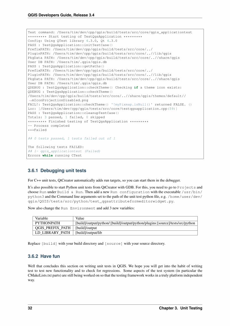
QGIS Developers Guide, Release 3.4
Test command: /Users/tim/dev/cpp/qgis/build/tests/src/core/qgis_applicationtest
********* Start testing of TestQgsApplication *********Config: Using QTest library 4.3.0, Qt 4.3.0PASS : TestQgsApplication::initTestCase()PrefixPATH: /Users/tim/dev/cpp/qgis/build/tests/src/core/../PluginPATH: /Users/tim/dev/cpp/qgis/build/tests/src/core/..//lib/qgisPkgData PATH: /Users/tim/dev/cpp/qgis/build/tests/src/core/..//share/qgisUser DB PATH: /Users/tim/.qgis/qgis.dbPASS : TestQgsApplication::getPaths()PrefixPATH: /Users/tim/dev/cpp/qgis/build/tests/src/core/../PluginPATH: /Users/tim/dev/cpp/qgis/build/tests/src/core/..//lib/qgisPkgData PATH: /Users/tim/dev/cpp/qgis/build/tests/src/core/..//share/qgisUser DB PATH: /Users/tim/.qgis/qgis.dbQDEBUG : TestQgsApplication::checkTheme() Checking if a theme icon exists:QDEBUG : TestQgsApplication::checkTheme()/Users/tim/dev/cpp/qgis/build/tests/src/core/..//share/qgis/themes/default//→˓mIconProjectionDisabled.pngFAIL!: TestQgsApplication::checkTheme() '!myPixmap.isNull()' returned FALSE. ()Loc: [/Users/tim/dev/cpp/qgis/tests/src/core/testqgsapplication.cpp(59)]PASS : TestQgsApplication::cleanupTestCase()Totals: 3 passed, 1 failed, 0 skipped
********* Finished testing of TestQgsApplication *********-- Process completed
***Failed
## 0 tests passed, 1 tests failed out of 1
The following tests FAILED:## 1- qgis_applicationtest (Failed)Errors while running CTest
3.6.1 Debugging unit tests
For C++ unit tests, QtCreator automatically adds run targets, so you can start them in the debugger.
It’s also possible to start Python unit tests from QtCreator with GDB. For this, you need to go to Projects andchoose Run under Build & Run. Then add a new Run configuration with the executable /usr/bin/python3 and the Command line arguments set to the path of the unit test python file, e.g. /home/user/dev/qgis/QGIS/tests/src/python/test_qgsattributeformeditorwidget.py.
Now also change the Run Environment and add 3 new variables:
Variable ValuePYTHONPATH [build]/output/python/:[build]/output/python/plugins:[source]/tests/src/pythonQGIS_PREFIX_PATH [build]/outputLD_LIBRARY_PATH [build]/output/lib
Replace [build] with your build directory and [source] with your source directory.
3.6.2 Have fun
Well that concludes this section on writing unit tests in QGIS. We hope you will get into the habit of writingtest to test new functionality and to check for regressions. Some aspects of the test system (in particular theCMakeLists.txt parts) are still being worked on so that the testing framework works in a truly platform independentway.
32 Chapter 3. Unit Testing
CHAPTER 4
Getting up and running with QtCreator and QGIS
• Installing QtCreator
• Setting up your project
• Setting up your build environment
• Setting your run environment
• Running and debugging
QtCreator is a newish IDE from the makers of the Qt library. With QtCreator you can build any C++ project,but it’s really optimised for people working on Qt(4) based applications (including mobile apps). Everything Idescribe below assumes you are running Ubuntu 11.04 ‘Natty’.
4.1 Installing QtCreator
This part is easy:
sudo apt-get install qtcreator qtcreator-doc
After installing you should find it in your gnome menu.
4.2 Setting up your project
I’m assuming you have already got a local QGIS clone containing the source code, and have installed all neededbuild dependencies etc. There are detailed instructions for git access and dependency installation.
On my system I have checked out the code into $HOME/dev/cpp/QGIS and the rest of the article is writtenassuming that, you should update these paths as appropriate for your local system.
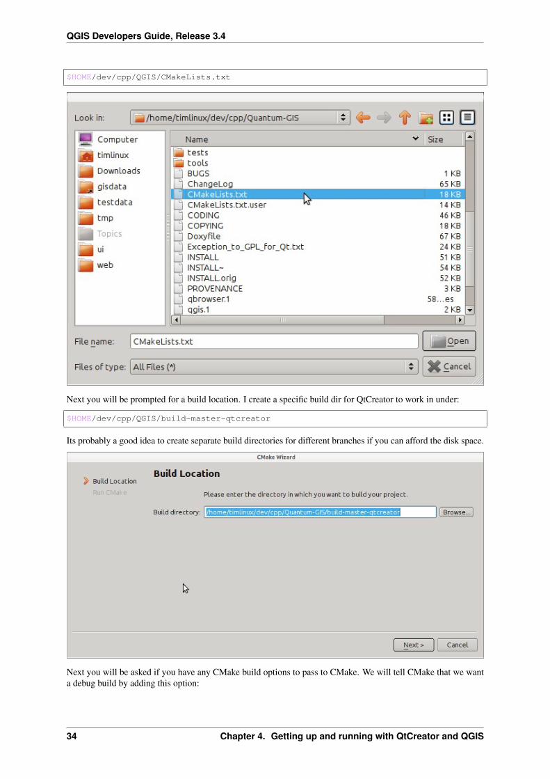
On launching QtCreator do:
File -> Open File or Project
Then use the resulting file selection dialog to browse to and open this file:
33
QGIS Developers Guide, Release 3.4
$HOME/dev/cpp/QGIS/CMakeLists.txt
Next you will be prompted for a build location. I create a specific build dir for QtCreator to work in under:
$HOME/dev/cpp/QGIS/build-master-qtcreator
Its probably a good idea to create separate build directories for different branches if you can afford the disk space.
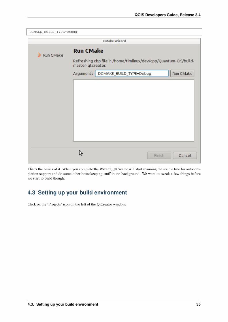
Next you will be asked if you have any CMake build options to pass to CMake. We will tell CMake that we wanta debug build by adding this option:
34 Chapter 4. Getting up and running with QtCreator and QGIS
QGIS Developers Guide, Release 3.4
-DCMAKE_BUILD_TYPE=Debug
That’s the basics of it. When you complete the Wizard, QtCreator will start scanning the source tree for autocom-pletion support and do some other housekeeping stuff in the background. We want to tweak a few things beforewe start to build though.
4.3 Setting up your build environment
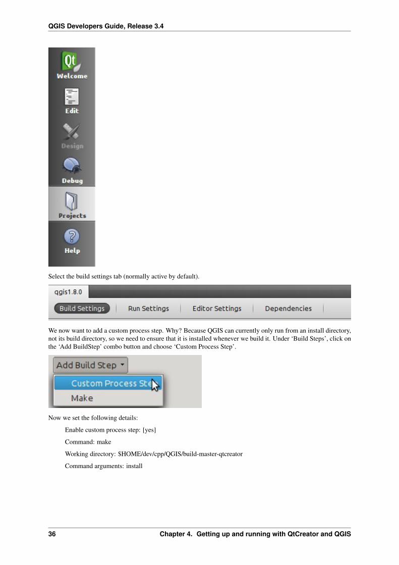
Click on the ‘Projects’ icon on the left of the QtCreator window.
4.3. Setting up your build environment 35
QGIS Developers Guide, Release 3.4
Select the build settings tab (normally active by default).
We now want to add a custom process step. Why? Because QGIS can currently only run from an install directory,not its build directory, so we need to ensure that it is installed whenever we build it. Under ‘Build Steps’, click onthe ‘Add BuildStep’ combo button and choose ‘Custom Process Step’.
Now we set the following details:
Enable custom process step: [yes]
Command: make
Working directory: $HOME/dev/cpp/QGIS/build-master-qtcreator
Command arguments: install
36 Chapter 4. Getting up and running with QtCreator and QGIS
QGIS Developers Guide, Release 3.4
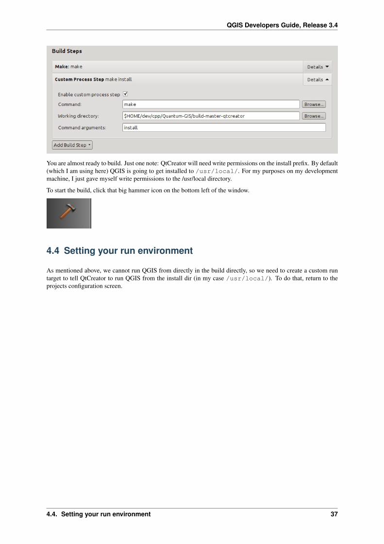
You are almost ready to build. Just one note: QtCreator will need write permissions on the install prefix. By default(which I am using here) QGIS is going to get installed to /usr/local/. For my purposes on my developmentmachine, I just gave myself write permissions to the /usr/local directory.
To start the build, click that big hammer icon on the bottom left of the window.
4.4 Setting your run environment
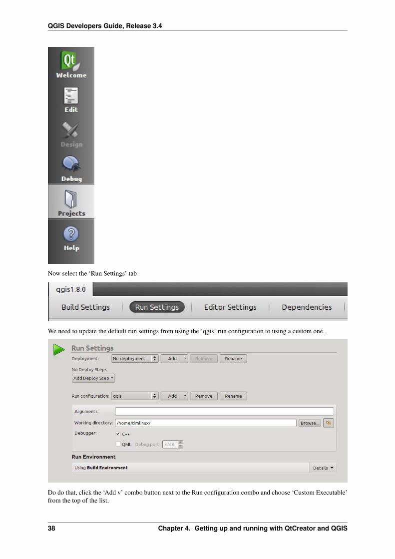
As mentioned above, we cannot run QGIS from directly in the build directly, so we need to create a custom runtarget to tell QtCreator to run QGIS from the install dir (in my case /usr/local/). To do that, return to theprojects configuration screen.
4.4. Setting your run environment 37
QGIS Developers Guide, Release 3.4
Now select the ‘Run Settings’ tab
We need to update the default run settings from using the ‘qgis’ run configuration to using a custom one.
Do do that, click the ‘Add v’ combo button next to the Run configuration combo and choose ‘Custom Executable’from the top of the list.
38 Chapter 4. Getting up and running with QtCreator and QGIS
QGIS Developers Guide, Release 3.4
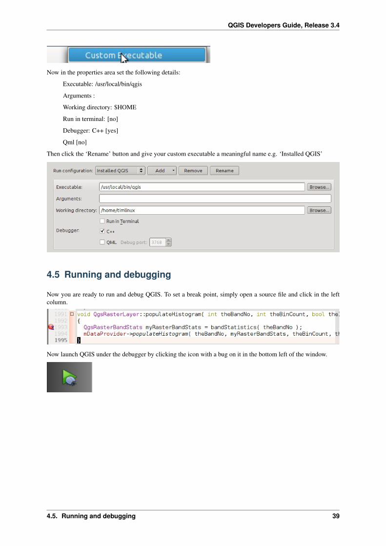
Now in the properties area set the following details:
Executable: /usr/local/bin/qgis
Arguments :
Working directory: $HOME
Run in terminal: [no]
Debugger: C++ [yes]
Qml [no]
Then click the ‘Rename’ button and give your custom executable a meaningful name e.g. ‘Installed QGIS’
4.5 Running and debugging
Now you are ready to run and debug QGIS. To set a break point, simply open a source file and click in the leftcolumn.
Now launch QGIS under the debugger by clicking the icon with a bug on it in the bottom left of the window.
4.5. Running and debugging 39
QGIS Developers Guide, Release 3.4
40 Chapter 4. Getting up and running with QtCreator and QGIS
CHAPTER 5
HIG (Human Interface Guidelines)
In order for all graphical user interface elements to appear consistent and to all the user to instinctively use dialogs,it is important that the following guidelines are followed in layout and design of GUIs.
1. Group related elements using group boxes: Try to identify elements that can be grouped together and thenuse group boxes with a label to identify the topic of that group. Avoid using group boxes with only a singlewidget / item inside.
2. Capitalise first letter only in labels, tool tips, descriptive text, and other non-heading or title text: Theseshould be written as a phrase with leading capital letter, and all remaining words written with lower casefirst letters, unless they are nouns
3. Capitalize all words in Titles (group box, tab, list view columns, and so on), Functions (menu items, but-tons), and other selectable items (combobox items, listbox items, tree list items, and so on): Capitalize allwords, except prepositions that are shorter than five letters (for example, ‘with’ but ‘Without’), conjunctions(for example, and, or, but), and articles (a, an, the). However, always capitalize the first and last word.
4. Do not end labels for widgets or group boxes with a colon: Adding a colon causes visual noise and does notimpart additional meaning, so don’t use them. An exception to this rule is when you have two labels next toeach other e.g.: Label1 Plugin (Path:) Label2 [/path/to/plugins]
5. Keep harmful actions away from harmless ones: If you have actions for ‘delete’, ‘remove’ etc, try to im-pose adequate space between the harmful action and innocuous actions so that the users is less likely toinadvertently click on the harmful action.
6. Always use a QButtonBox for ‘OK’, ‘Cancel’ etc buttons: Using a button box will ensure that the order of‘OK’ and ‘Cancel’ etc, buttons is consistent with the operating system / locale / desktop environment thatthe user is using.
7. Tabs should not be nested. If you use tabs, follow the style of the tabs used in QgsVectorLayerProperties /QgsProjectProperties etc. i.e. tabs at top with icons at 22x22.
8. Widget stacks should be avoided if at all possible. They cause problems with layouts and inexplicable (tothe user) resizing of dialogs to accommodate widgets that are not visible.
9. Try to avoid technical terms and rather use a laymans equivalent e.g. use the word ‘Opacity’ rather than‘Alpha Channel’ (contrived example), ‘Text’ instead of ‘String’ and so on.
10. Use consistent iconography. If you need an icon or icon elements, please contact Robert Szczepanek on themailing list for assistance.
11. Place long lists of widgets into scroll boxes. No dialog should exceed 580 pixels in height and 1000 pixelsin width.
41
QGIS Developers Guide, Release 3.4
12. Separate advanced options from basic ones. Novice users should be able to quickly access the items neededfor basic activities without needing to concern themselves with complexity of advanced features. Advancedfeatures should either be located below a dividing line, or placed onto a separate tab.
13. Don’t add options for the sake of having lots of options. Strive to keep the user interface minimalistic anduse sensible defaults.
14. If clicking a button will spawn a new dialog, an ellipsis char (. . . ) should be suffixed to the button text.Note, make sure to use the U+2026 Horizontal Ellipsis char instead of three periods.
5.1 Authors
• Tim Sutton (author and editor)
• Gary Sherman
• Marco Hugentobler
• Matthias Kuhn
42 Chapter 5. HIG (Human Interface Guidelines)
CHAPTER 6
OGC Conformance Testing
• Setup of WMS 1.3 and WMS 1.1.1 conformance tests
• Test project
• Running the WMS 1.3.0 test
• Running the WMS 1.1.1 test
The Open Geospatial Consortium (OGC) provides tests which can be run free of charge to make sure a server iscompliant with a certain specification. This chapter provides a quick tutorial to setup the WMS tests on an Ubuntusystem. A detailed documentation can be found at the OGC website.
6.1 Setup of WMS 1.3 and WMS 1.1.1 conformance tests
sudo apt-get install openjdk-8-jdk mavencd ~/srcgit clone https://github.com/opengeospatial/teamengine.gitcd teamenginemvn installmkdir ~/TE_BASEexport TE_BASE=~/TE_BASEunzip -o ./teamengine-console/target/teamengine-console-4.11-SNAPSHOT-base.zip -d→˓$TE_BASEmkdir ~/te-installunzip -o ./teamengine-console/target/teamengine-console-4.11-SNAPSHOT-bin.zip -d ~/→˓te-install
Download and install WMS 1.3.0 test
cd ~/srcgit clone https://github.com/opengeospatial/ets-wms13.gitcd ets-wms13mvn install
Download and install WMS 1.1.1 test
43
QGIS Developers Guide, Release 3.4
cd ~/srcgit clone https://github.com/opengeospatial/ets-wms11.gitcd ets-wms11mvn install
6.2 Test project
For the WMS tests, data can be downloaded and loaded into a QGIS project:
wget https://cite.opengeospatial.org/teamengine/about/wms/1.3.0/site/data-wms-1.3.→˓0.zipunzip data-wms-1.3.0.zip
Then create a QGIS project according to the description in https://cite.opengeospatial.org/teamengine/about/wms/1.3.0/site/. To run the tests, we need to provide the GetCapabilities URL of the service later.
6.3 Running the WMS 1.3.0 test
export PATH=/usr/lib/jvm/java-8-openjdk-amd64/bin:$PATHexport TE_BASE=$HOME/TE_BASEexport JAVA_HOME=/usr/lib/jvm/java-8-openjdk-amd64cd ~/te-install./bin/unix/test.sh -source=$HOME/src/ets-wms13/src/main/scripts/ctl/main.xml
6.4 Running the WMS 1.1.1 test
export PATH=/usr/lib/jvm/java-8-openjdk-amd64/bin:$PATHexport TE_BASE=$HOME/TE_BASEexport ETS_SRC=$HOME/ets-resourcesexport JAVA_HOME=/usr/lib/jvm/java-8-openjdk-amd64cd ~/te-install./bin/unix/test.sh -source=$HOME/src/ets-wms11/src/main/scripts/ctl/wms.xml
44 Chapter 6. OGC Conformance Testing

Index
OGC Conformance Testing, 42
45