Embed Size (px)
Citation preview

4 LANAI ;Q KAHOOLAWE
U.S. Army Engineer District Pacific Ocean Division Fort Shafter, Hawaii

SITE SURVEY SUMMARY SHEET FOR
DEW - EUDS SITE NO. H09HI011900 HEEIA COMBAT TRAINING AREA
HEEIA KEA AND KAHALUU, ISLAND OF O A W , HAWAII 2 APRIL 1993
SITE NAME(S): Heeia Combat Training Area, also known as Heeia Regimental Combat Training Area, Heeia Training Camp and Areas, Heeia Training Camp, and Heeia Range.
LOCATION: Heeia Kea and Kahaluu (Waihee and Kaalaea Valleys), District of Koolaupoko, Island of Oahu, Hawaii. TMKs 4-6-016: 032; 4-7, various plats and parcels.
SITE HISTORY: Heeia Combat Training Area consisted of two parcels comprising approximately 2,458.047 acres acquired in 1943 by lease or license with the Bernice Pauahi Bishop Estate, Sing Chong Company, Ltd., and numerous other smaller private land owners. An encampment supporting as much as 4,500 enlisted personnel and officers of the 98th Regimental Combat Team was constructed at the Heeia Kea parcel in October 1943. Site improvements included barracks, roads, a mess hall, an open air theater, a motor pool, ammunition storage facilities, pistol and rifle firing ranges, hand grenade ranges, and obstacle and bayonet courses. The Kahaluu parcel was utilized as manuever and impact areas for jungle and assault training. Following the end of World War 11, the camp was dismantled, the impact area was cleared of ordnance, and land leases were terminated by the Army after October 1945. The Heeia Kea parcel is presently vacant but is slated for development by the current landowner. Sing Chong Company, Ltd. divested ownership of its property in Kahaluu shortly after World War 11. Residential dwellings, agricultural lots, and community support facilities occupy the Kahaluu parcels. In 1989, several M9A1 practice rifle grenades and M7A1 bazooka rounds were discovered at the Heeia Kea parcel during an archaeological survey and ordnance investigation of the site.
SITE VISIT: A site visit of the Heeia Kea parcel was conducted on 15 July 1991 by Helene Takemoto, Charles Streck, Jr., and Randall Kurashige (CEPOD-ED-ME), explosive ordnance specialist Byron Donaldson (Donaldson Enterprises, Inc.), and Wil Chee, Ivan Tilgenkamp, and Derek Yasaka (Wil Chee - Planning). Observed remnants of the former combat training area included concrete block foundations and enclosures, and bridge spans. Although OEW was not observed during this site visit, it may still exist particularly in areas where vegetation is dense and difficult to traverse.
On 2 December 1992, Messrs. Donaldson and Yasaka conducted a site visit of Waihee and Kaalaea Valleys in Kahaluu approximately 2.5 miles northwest of the Heeia Kea parcel. Both valleys consist of a mix of residential dwellings and agricultural lots. They were met by Joaquin Mello, a longtime resident of Kaalaea Valley. He recounted the Army's use of the valley's roads and their designations (e.g., "A-Road" and "B-Road"). Both he and members of his family have discovered spent .30 and -50 caliber cartridges and projectiles to the rear of the valley as well as mortar rounds which were discarded in Kaalaea Stream. The team discovered numerous .30 and S O caliber machine gun projectiles and cartridges. No mortar rounds were observed, although shrapnel purportedly from a rifle grenade and a time fuse from an 8 1 mm illumination mortar round were discovered at a target site in Kaalaea Valley. Spent .30 caliber cartridges also exist on property belonging to Robert Rehkemper southeast of the target. The abundance of spent cartridges at the Rehkemper property suggests it to be a firing point. Other observed remnants on the Rehkemper property include foxholes and an unpaved road.
CATEGORY OF HAZARD: OEW.

SITE SURWY SUMMARY SHEiET FOR
DERP - FWDS SITE NO. H09HI011900 HEEIA COMBAT TRAINING AREA
HEEIA KlEA AND K A W U U , ISLAND OF OAHU, 2 APRIL 1993 (continuation)
PROJECT DESCRIPTION: There is one potential project at this site.
a. OEW. Heeia Combat Training Area was an Amy encampment, jungle and assault training site, and live fire range during World War 11. OEW has been discovered by landowners, area residents, and an explosive ordnance specialist. It may require investigation beyond the scope of this preliminary assessment.
AVAILABLE STUDIES AND REPORTS: "Field Investigation of the Heeia Kai Parcel, July 15, 22, 23, 29, 1989" dated 17 August 1989 by Byron L. Donaldson, Donaldson Enterprises, Inc. Explosive Ordnance Services. The report describes the findings of an investigation conducted by an explosive ordnance specialist at Heeia Kea on behalf of the landowner. Discovered during the investigation were two M7A 1 bazooka rounds, two M7A 1 bazboka round center cores, and an M9A1 rifle grenade shroud. Also noted in the report was the discovery of two Mark I1 hand grenades at the site by an area resident several years earlier.
PA POC: Helene Takernoto, CEPOD-ED-ME, (808) 438-693 1.

0 2 4 6 8 Miles
Prepared for:
U.S. Army Engineer District Pacific Ocean Division Fort Shafter, Hawaii
Prepared by:
Wil Chee - Planning
I DEW-FUDS Inventory Project Report
Heeia Combat Training Area Heeia Kea and Kahaluu, Island of Oahu,
Hawaii
I Site No. H09HI011900
I Figure 1

Prepared for: DERP - FUDS Inventory Project Report
U.S. Army Engineer District PROJECT
Heeia Combat Training Area Pacific Ocean Division Heeia Kea and Kahaluu, Fort Shafter, Hawaii Island of Oahu, Hawaii
Prepared by: Site No. H09HI011900
OAHU Wil Chee - Planning Figure 2

DEFENSE m ~ ~ ~ A . L RESTORATION PROGRAM FOR
FORMERLY USED DEFENSE SITES m I N G S AND DETERMINATION OF ELIGIBILITY
HEEIA COMBAT TRMMNG AREA -1A KEA AND KA.HA.LW, ISLAND OF OAHU, HAWAII
SI'IE NO. HOgHIO 1 1900
1. Heeia Combat Training Area consisted of a total of 2,458.047 acres, more or less, located on rwo separate parcels, one in Heeia Kea and the other in neighboring Kahaluu (in Waihee and Kaalaea Valleys).llJ4 Both parcels are situated within the district of Koolaupoko, island of Oahu, Hawaii, On or about October 1943, the Depamnent of the Army acquired the Heeia Kea parcel from the Bernice Pauahi Bishop Estate (203.825 acres) and the Kafialuu parcel from Sing Chong Company, Ltd. and other private land owners (2,254.222 acres).l.5.7.11.14 Documents could not be located evidencing acquisition of the two parcels for use by U.S. Armed Forces. A former director of Sing Chong Company stated that the Army was allowed usage of the company's property without execuhon of a f o d agreement.7
2. An encampment supporting as many as 4,500 enlisted personnel and officers comprising up to four infantry battalions with attached units of the 98th Regimental Combat Team was constructed in October 1943 on the Heeia Kea parcel.~J*Jl It included temporary bmcks, a mess hall, an open air theater, a motor pool, and an ammunition storage sheds Training facilities established at Heeia Combat Training Area included a 12-target (1,000-inch) machine gun range; an 11-target pistol range; a 20-target (100-200-300 yard) known distance rifle range; two obstacle courses; a bayonet course; dummy hand grenade courts; a live hand grenade range; an infiltration course; a shipside platfom and a maneuver areall Waihee and Kiidaea Valleys were utilized as maneuver and impact areas for jungle and assault training with the remainder of training facilities being situated at Heeia Kea1l-l4 The impact area purportedly was established for the firing of field artillery pieces, mortar, bazooka, and other assault weapons using live and practice rounds.14 Structures and training facilities at both parcels were dismantled and no longer exist. OEW has been discovered at both the Heeia Kea and Kahduu parcels despite an Amy clearance effort prior to 2 July 1948398,9J3J4 Foxholes and trenches still exist within Waihee and Kaalaea Valleys of the Kahaluu parcel.3.8.9
3. With the cessation of hostilities on 2 September 1945, training areas and facilities on Oahu were studied to determine their disposition. In action taken on 8 October 1945, G-3 Headquarters ordered the release of Heeia Combat Training Camp.11 Documents could not be found evidencing disposal of the prop-. The Bernice Pauahi Bishop Estate subsequently sold its Heeia Kea parcel which is presently slated for development by the current landowner.4.13 Sing Chong Company, Ltd. also divested ownership of its property shortly after World War I1 to numerous ~arties.5.6~7.8.11 Residential dwellings, agricultud lots, and community support facilities presently occupy Waihee and Kaalaea Valleys in Kahaluu.
Based on the foregoing findings of fact, the si Department of Defense. It is therefore eligible - Formerly Used Defense Sites estaablished under 10 US
Date /W/Q 3 Commanding

PROECT SUMMARY SHEET FOR
DERP - FUDS OEW PROJECT NO. H09HI011901 HEEIA COMBAT TRAINING AREA
HEEIA KJ3A AND KAHALUU, ISLAND OF OAHU, HAWAII SI'IE NO. HO9HIO 1 1900
2 APRIL 1993
PROJECT DESCRIPTION: The approximately 2,458.047-acre site is a former World War I1 Army encampment, jungle and assault training ground, and live fire range occupied and used by the 98th Regimental Combat Team. It consists of two parcels, one of which is located in Heeia Kea and the other which is located in Kahaluu (Waihee and Kaalaea Valleys). An ordnance clearance effort was performed by the Army prior to July 1948. On 2 July 1948, Oahu residents were warned to exercise caution when hiking or picnicking at the "Heeia range", i.e, the Kahaluu parcel, as duds may appear due to erosion. OEW discovered by area residents, an archaeologist, and an explosive ordnance specialist at the Heeia Kea parcel include M7A1 practice bazooka rounds, M9A1 practice rifle grenades, and Mark I1 hand grenades. At the Kahaluu parcel, .30 and S O caliber projectiles and cartridges, and a portion of a powder train time fuse likely from an 81 mm illumination mortar round were discovered during the course of this preliminary assessment. At least one Kaalaea Valley landowner reports soil erosion continually unearths live and expended small arms on his property.
PROJECT ELIGIBILITY: Anecdotal information from former and present landowners, official Army treatises, and physical evidence indicates the project site was used as an encampment, training area, and practice and live ammunition f i g range. The parcels reportedly were returned to its owners after October 1945. In 1989, practice rifle grenades and bazooka rounds were discovered at the Heeia Kea parcel. The items were turned over to the 1st Marine Brigade EOD Team at Marine Corps Air Station, Kaneohe Bay. Physical evidence at the Kahaluu parcel (i.e., Kaalaea Valley) also indicates the continued presence of 0EW there.
POLICY CONSIDERATIONS: Though vacant, the Heeia Kea parcel is slated for development by its landowner. Numerous residential dwellings, agricultural operations, and ancillary community support facilities occupy the Kahaluu parcel. Rare, threatened, or endangered biological species as well as archaeologically significant remants may be exist on both parcels, particularly portions which border or are within forest reserves and protected watersheds.
PROPOSED A(TI'IVITIES: Proposed project activities include an OEW survey and removal effort over both parcels. Initially, transects would be developed and plotted on a map. Following established transects, a sweep and search team comprised of explosive ordnance specialists would clear the area of surface shrapnel followed by an OEW search utilizing ferromagnetic locators, metal detectors, or ground penetrating radar. An access and recovery team would follow to remove or detonate in place discovered OEW. Adequate coverage and clearance would be confinned by a QNQC team. Landowners and developers would also be apprised of the OEW hazard, and instructed on ordnance recognition and notification protocol upon OEW discovery.
RAC: Attached herewith.
PA POC: Helene Takemoto, CEPOD-ED-ME, (808) 438-693 1.

10 Feb 93 Previous editions obsolete
RISK ASSESSMENT PROCEDURES FOR ORDNANCE AND EXPLOSIVE? WASTE (OEW) SITES
Site Name: Heeia Combat Training Area Rater's Name: Byron Donaldson Site Location: Heeia Kea and Kahaluu, Oahu, Hawaii Phone No.: (808) 235-2662 DEW Project #: HO9HI011900 Organization: Donaldson Enterprises Inc. Date Completed: 2 Apr 93 RAC Score: 5
OEW RISK ASSESSMENT:
This risk assessment procedure was developed in accordance with MIL-STD 882B and AR 385-10. The RAC score will be used by CEHND to prioritize the remedial action at this site. The OEW risk assessment should be based upon best available information resulting from records searches, reports of Explosive Ordnance Disposal (EOD) detachment actions, and field observations, interviews, and measurements. This information is used to assess the risk involved based upon the potential OEW hazards identified at the site. The risk assessment is composed of two factors, hazard severity and hazard probability. Personnel involved in visits to potential OEW sites should view the CEHND videotape entitled "A Life Threatening Encounter: OEW."
Part I. Hazard Severity. Hazard severity categories are defined to provide a qualitative measure of the worst credible mishap resulting from personnel exposure to various types and quantities of unexploded ordnance items.
TYPE OF ORDNANCE (Circle all values that apply)
A. Conventional Ordnance and Ammunition
Mediunzn;lrge Caliber (20 mrn and larger) 10
Bombs, Explosive
Grenades, Hand and Rifle, Explosive
Landmines, Explosive 10
Rockets, Guided Missiles, Explosive 10
Detonators, Blasting Caps, Fuzes, Boosters, Bursters 6
Bombs, Practice (w/ spotting charges)
Grenades, Practice (w/ spotting charges)
Landmines, Practice (wl spotting charges)
Small Arms (.22 cal. - -50 cal)
Conventional Ordnance and Ammunition Value (Select the largest single value)
What evidence do you have regarding conventional OEW? Types of conventional OEW have either been identified during an independent dud ordnance survey in 1989 and during the course of this ureliminary assessment. or are sus_pected given the nature of site o~erations.
B . Pyrotechnics (For munitions not described above)
VALUE
Munition (Container) Containing White Phosphorus or Other Pyrophoric Material (i.e., Spontaneously Flammable)
Munition Containing a Flame or Incendiary Material (i.e,, Napalm, Triethylaluminum Metal Incendiaries)
Flares, Signals, Simulators
Pyrotechnics Value (Select the largest single value) - 4
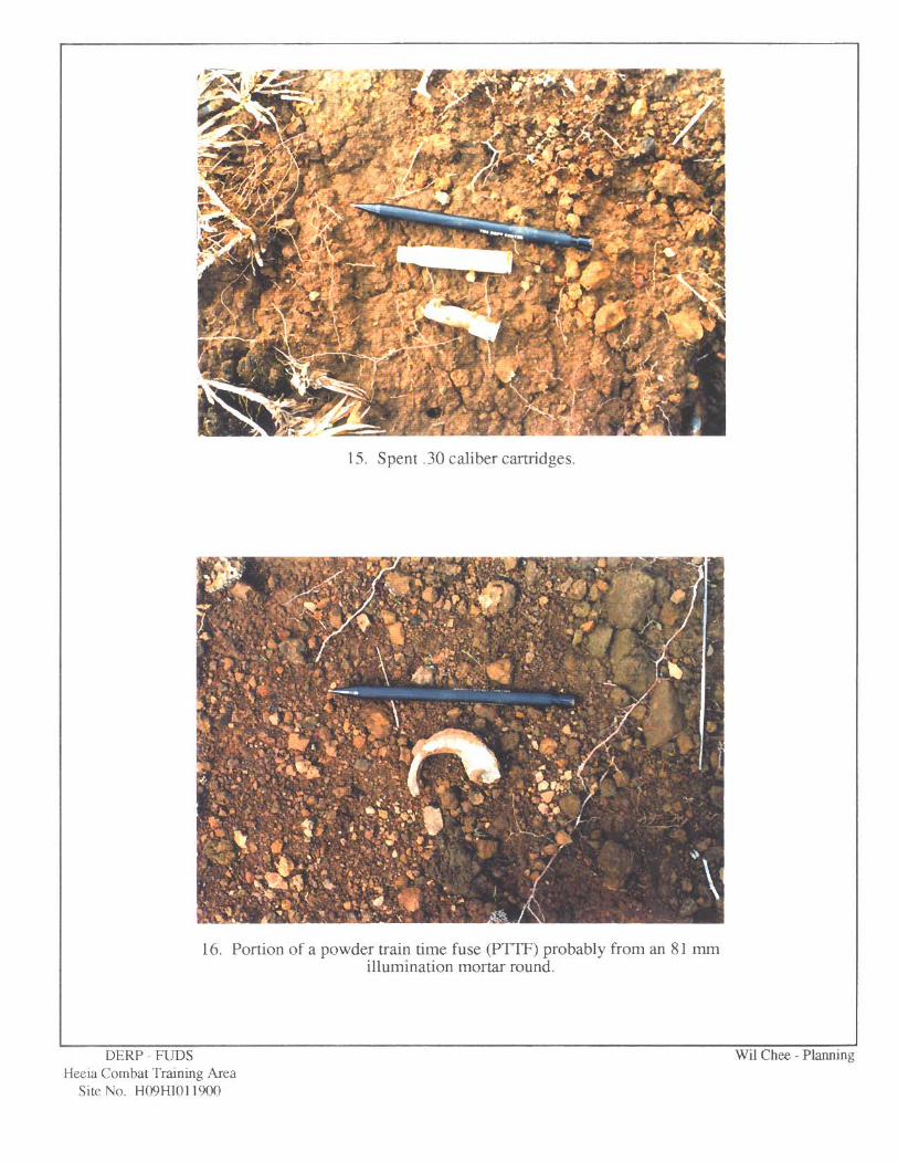
What evidence do you have regarding pyrotechnics? A portion of an illumination round was identified during. the course of this preliminarv assessment.
C. Bulk High Explosives (Not an integral part of conventional ordnance; uncontainerized)
Primary or Initiating Explosives (Lead Styphnate, Lead Azide, Nitroglycerin, Mercury Azide, Mercury Fulminate, Tetracene, etc.)
Demolition Charges 10
Secondary Explosives 8 (PETN, Compositions A, By C, Tetryl, TNT, RDX, EMX, HBX, Black Powder, etc.)
Military Dynamite 6
Less Sensitive Explosives 3 (Ammonium Nitrate, Explosive D, etc.)
Bulk High Explosives Value (Select the largest single value) t!
What evidence do you have regarding bulk explosives?
D. Bulk Propellants (Not an integral part of rockets, guided missiles, or other conventional ordnance; uncontainerized)
VALUE
Solid or Liquid Propellants 6
Propellants Value Q
What evidence do you have regarding bulk propellants?
RAC Worksheet - Page 2

E . Radiological/Chemical AgenWeapons
VALUE
Toxic Chemical Agents 25 (Choking, Nerve, Blood, Blister)
War Gas Identification Sets 20
Radiological 15
Riot Control and Miscellaneous 5 (Vomiting, Tear, Incendiary and Smoke)
Radiological/Chemical Agent (Select the largest single value) 11
'What evidence do you have of chemical/radiological OEW?
Description Category Value
CATASmOPHIC
CRITIC&
MARGINAL
NEGLIGIBLE
**NONE
I
0 111
Iv
* Apply Hazard Severity Category to Table 3.
** If Hazard Severity Value is 0, you do not need to complete Part II. Proceed to Part 111 and use a RAC Score of 5 to determine your appropriate action.
RAC Worksheet - Page 3

Part 11, Hazard Probabilitv. The probability that a hazard has been or will be created due to the presence and other rated factors of unexploded ordnance or explosive materials on a formerly used DOD site.
AREA, EXTENT, ACCESSIBILITY OF OEW HAZARD (Circle all values that apply)
A. Locations of Contamination
VALUE
o n the surface O Within Tanks, Pipes, Vessels or Other Confined Locations.
Inside Walls, Ceilings, or Other Parts of Buildings or Structures
Subsurface 0 Location (Select the single largest value) 5.
What evidence do you have regarding the location of OEW? An OEW survev cou~led with the areal m l o m - indicate items to be on the surface or within 3 feet below made.
I3 . Distance to nearest inhabited locations or structures likely to be at risk from OEW site (roads, parks, playgrounds, and buildings).
VALUE
Less than 1250 feet 0 1250 feet to 0.5 mile 4
0.5 mile to 1.0 mile 3
1.0 mile to 2.0 miles 2
Over 2 miles 1
Distance (Select the single largest value) 5.
What are the nearest inhabited structures? Single- and multi-farnilv residential dwellings. parks, ulavm-ounds. - and roads.
RAC Worksheet - Page 4

C. Number of buildings within a 2-mile radius measured from the OEW hazard area, not the installation boundary.
VALUE
26 and over
Number of Buildings (Select the single largest value) 5
Narrative. Established residential communities at Heeia Kea, Temple Valley. Ahuimanu. Waihee Vallev. Kaalaea Valley. and Waiahole Valley are located within a 2-mile radius of the hazard area. Portions of urban Kaneohe are also within the prescribed radius.
D. Types of Buildings (within a 2-mile radius)
VALUE
Educational, Child Care, Residential, Hospitals, Hotels, Commercial, Shopping Centers
Industrial Warehouse, etc. 4
Agricultural, Forestry, etc. 3
Detention, Correctional 2
No Buildings 0
Types of Buildings (Select the single largest value) 5
Describe types of buildings in the area. Single- and multi-familv residential dwellings, schools. commercial centers, shopping centers. restaurants. agricultural warehouses. parks. and ~lavmounds.
RAC Worksheet - Page 5

E. Accessibility to site refers to access by humans to ordnance and explosive wastes. Use the following guidance:
VALUE
No barrier or security system
Barrier is incomplete (e.g., in disrepair or does not completely surround the site). Barrier is intended to deny egress from the site, as for a barbed wire fence for grazing.
A barrier (any kind of fence in good repair) but no separate means to control entry. Barrier is intended to deny access to the site.
Security guard, but no barrier
Isolated site
A 24-hour surveillance system (e.g., television monitoring or surveillance by guards or facility personnel) which continuously monitors and controls entry onto the facilitv; or An artificial o; natural barrier (e.g., a fence combined with a cliff) which completely surrounds the facility; and a means to control entry at all times through the gates or other entrances to the facility (e.g., an attendant, television monitors, locked entrances, or controlled roadway access to the facility).
Accessibility (Select the single largest value)
Describe the site accessibility. Although an uninhabited area of the Heeia Kea parcel is fenced along Kamehameha Highwav to denv entry. the fence is in a state of disrepair. Undeveloped areas on both parcels are. bv and large, unbarricaded though "no tresuassing" s i p s may be posted identifying private property or watersheds/forest reserves. At least one landowner within the Kahaluu parcel has installed an electronic gate across a private road to control entry onto his DroDertv. Routes of entry elsewhere remain accessible despite topographic features and vegetation which mav pose as impediments.
F. Site Dynamics - This deals with site conditions that are subject to change in the future, but may be stable at the present. Examples would be excessive soil erosion by beaches or streams, increasing land development that could reduce distances from the site to inhabited areas or otherwise increase accessibility.
Expected
None Anticipated 0
Site Dynamics (Select largest value) 5
Describe the site dynamics. Residential development of uninhabited areas has been planned.
RAC Worksheet - Page 6

Total Hazard Probability Value (Sum of Largest Values for A through F - Maximum of 30)
Apply this value to Hazard Probability Table 2 to determine Hazard Probability Level.
W A R D PROBABLITY
Description Level Value
FREQUENT
PROBABLE
OCCASIONAL
REMOTE
IMPROBABLE
* Apply Hazard Probability Level to Table 3.
RAC Worksheet - Page 7

Part ID[. Risk Assessment. The risk assessment value for this site is detemined using the following Table 3. Enter with the results of the hazard probability and hazard severity values.
TABLE 3
Probability FREQUENT PROBABLE OCCASIONAL REMOTE IMPROBABLE Level A B C D E
Severity Category:
CATASTROPHIC I 1 1
CIUTICAL I[ 0 2
MARGINAL DI 2 3
NEGLIGIBLE nr 3 4
RISK ASSESSMENT CODE (RAC)
RAC 1 Imminent Hazard - Expedite INPR - Immediately call CEHND-ED-SY commercial 205-955-4968 or DSN 645-4968.
RAC 2 High priority on completion of INPR - Recommend further action by CEHND.
RAC 3 Complete INPR - Recommend further action by CEHND.
RAC 4 Complete LNPR - Recommend further action by CEHND.
RAC 5 Recommend no further action. Submit NOFA and RAC to CEHND.
Part IV. Narrative. Summarize the documented evidence that supports this risk assessment. If no documented evidence was available, explain all the assumptions that you made.
M9A 1 practice rifle grenades, M7A 1 practice bazooka rounds, Mark 1 1 hand grenades, and .30 and S O caliber projectiles and cartridges have been discovered at the site by area residents, during an archaeological survey, during an independent dud ordnance survey performed in July 1989 by an explosive ordnance specialist on behalf of the landowner, and during the course of this preliminary assessment. OEW discovered in 1989 were removed by the 1st Marine Brigade EOD Team stationed at Marine Corps Air Station, Kaneohe Bay.
RAC Worksheet - Page 8

TRIP REPORT
DEFENSE ENVIRONMENTAL RESTORATION PROGRAM FOR
FORMERLY USED DEFENSE SITES HEEIA COMBAT TRAINING AREA
HEEIA KEA AND KAHALUU, ISLAND OF OAHU, HAWAII SITE NO. HO9HI011900
DATES OF SITE VISIT: 15 JULY 199 1 AND 2 DECEMBER 1992
Individuals participating in the 15 July 199 1 site visit of Heeia Combat Training Area included Helene Takemoto, Charles Streck, Jr., and Randall Kurashige (CEPOD-ED-ME), explosive ordnance specialist Byron Donaldson (Donaldson Enterprises, Inc.), and Wil Chee, Ivan Tilgenkamp, and Derek Yasaka (Wil Chee - Planning). The site visited is one of two non- contiguous parcels comprising the former combat training area located in Heeia Kea, district of Koolaupoko, island of Oahu near Heeia Kea Boat Harbor. This hour glass shaped parcel is bounded by Kamehameha Highway to the east, Kahekili Highway to the west, and undeveloped vacant land to the north and south.
The team entered the site from an unpaved driveway and clearing at the southeast end of the project site containing a temporary field office belonging to the landowner. They proceeded in a northwesterly direction upslope toward Puu Maelieli traversing through the dense vegetation consisting of banyan and haole koa trees with an understory of various tall grasses, weeds, and vines. Reportedly a former junk yard, the site is littered with derelict automobiles and automobile parts, many of which have been obscured by the areal vegetation.
Structural remnants of the former training area observed by the team include a concrete floor slab supported on a CMU brick and mortar base. A three-inch diameter steel pipe protruding from the base of the structure suggests that it may have been a water distribution system. Adjacent to this structure is another concrete floor slab and timber beams enveloped by the roots of a banyan tree. The floor slab and beams are likely the remains of a latrine as porceIain segments from a toilet were observed nearby.
Other observed training area remnants include several CMU block and mortar structures of unknown use, an upright wooden utility pole, and bridge spans. A deep shaft of undetermined depth, but approximately four feet long and three feet wide also was discovered. Surmised to be a latrine cesspool, the shaft is located off existing trails or paths and is recognizable, albeit partially obscured by vegetation, thus precluding the need for mitigation under DERP-FUDS.
The bare, eroded slope of a small hill purportedly used as a target area revealed numerous spent 9 mm luger, .22 caliber, -38 caliber, and shotgun shell cartridges. According to Mr. Donaldson, the shell casings are of post World War II origin and not attributable to site use as a training area.
Selected areas traversed by the team were toned by Mr. Donaldson for the presence of subsurface OEW using a Schonstedt Instrument Company Model GA-52C magnetic locator. No OEW was detected during the site visit.
The Temple Valley residential community now occupies the section of the parcel located along the west face of Puu Maelieli. It presently consists of single- and multi-family dwellings, a shopping center, and appurtenant infrastructure.
On 2 December 1992, Messrs. Donaldson and Yasaka conducted a site visit of the second of two parcels comprising the subject training area. This parcel encompasses Kaalaea and Waihee Valleys approximately 2.5 miles northwest of the first parcel visited. Both valleys consist of a mix of residential dwellings and agricultural lots. To the east are the mouths of the valley lowlands and Kamehameha Highway, while the Waiahole forest reserve borders the parcel to the west. Waiahole Valley and Ahuimanu border the parcel to the north and south, respectively.
The team was met by Joaquin Mello, a 40-year resident and proprietor of the defunct Seaview Dairy at the rear of Kaalaea Valley. Mr. Mello informed the team that though he purchased his 20- acre parcel in 1952, his father would go hunting in the valley while military training was ongoing, setting out early in the morning then departing the area before troop maneuvers and range firing commenced that day. He recounted the Army's use of Pulama Road as a thoroughfare into and out

TRIP REPORT
DEFENSE ENVIRONMENTAL RESTORATION PROGRAM FOR
FORMERLY USED DEFENSE SITES HEEIA COMBAT TRAINING AREA
HEEL4 KEA AND KAHALUU, ISLAND OF OAHU, HAWAII SITE NO. HO9HI01 1900
DATES OF SITE VISIT: 15 JULY 1991 AND 2 DECEMBER 1992 (continuation)
of the valley. Ahilama Road, which serves both Waihee and Kaalaea Valleys, was known as "A- Road" while a short, unpaved road leading off Ahilama Road near its existing intersection with Kamakoi Road was known as "B-Road". Both he and his children have discovered spent small arms cartridges and projectiles along the valley's upper slopes beyond his property as well as mortar rounds that were summarily discarded in Kaalaea Stream which flows across his property from west to east. There were no incidents or injury or death to humans or livestock resulting from OEW detonation in the area. Mr. Mello also suspects the Army fired rifle grenades in the valley in addition to the complement of small caliber rounds. The area was used primarily for jungle and assault training.
Mr. Mello then granted the team permission to traverse his property to access the rear of Kaalaea Valley. The team commenced in a southwesterly direction near the end of the former B- Road following a feeder to Kaalaea Streamdong its south bank. The site is characterized by a dense canopy of a variety of tall trees with a lush understory. Site features were unremarkable with no observed evidence of OEW present either on the path being followed, along the stream bank, or in the Kaalaea Stream feeder.
The team crossed the feeder upstream near its confluence with another feeder, following a trail between the stream bank and a bluff to the north to a sloped clearing of ankle high grasses and ferns. Escalating the slope, the team arrived at a rise devoid of vegetation. Descending it to the east, then ascending again gave way to the barren face of another rise, albeit at a lower elevation. Discovered at this face was a corroded steel target support still in the ground but bent near its base so that it no longer stands erect. Strewn throughout the area are numerous .30 and S O caliber machine gun projectiles and cartridges. Cartridge markings indicate the items were of military issue and expended during the site's use as a training area. A powder train time fuse (P?TF) likely from an 8 1 mm illumination mortar round was also discovered. A visual scan of the valley from this rise suggests that firing points were stationed at one, possibly two plateaus estimated to be one to two hundred yards away to the northeast and southeast which are presently occupied by single- family residential dwellings. Anomalous features along a slope to the north of the rise and generally in line with the firing points resemble mortar ricochet marks or misses. The steepness of that slope precluded reconnaissance by the team.
Returning to the first rise, the team ascended to another rise and small plateau to the west. Despite the lack of any target remnants, more .30 caliber projectiles and cartridges were discovered along the barren east face of the rise. The eroded remnant of at least one foxhole is discernable on the plateau though obscured by a dense grass mat. Trenches reportedly located on the plateau could not be located by the team.
A visit to the property belonging to Robert Rehkemper southeast of the three rises revealed several patches of ground approximately four square feet and devoid of vegetation containing numerous spent military issue .30 caliber cartridges confirming this location as once being used as a firing point. Mr. Rehkemper pointed out several eroded foxholes which he is utilizing as tree planters. Portions of an unpaved road constructed by the Army are visible along his property line to the north. According to Mr. Rehkemper, a spring near the road terminus is reported to have been constructed by the Army. The potable spring water is presently being tapped by Mr. Rehkemper for consumption and household use.

TRLP REPORT
DEFENSE ENVIRONMENTAL RESTORATION PROGRAM FOR
FORMERLY USED DEFENSE SITES HEEL4 COMBAT TRAINING AREA
HEEIA KEA AND KAHALUU, ISLAND OF OAHU, I-LAWAII SITE NO. H09HI011900
DATES OF SITE VISIT: 15 SOLY 1991 AND 2 DEClEMBER 1992 (con tinuation)
Except for the spent shell casings and foxholes, Mr. Rehkemper informed the team that he has not discovered any other forms of ordnance nor other evidence of Army training in Kaalaea Valley. He explained that anomalous unvegetated sections of the valley walls are natural landslides caused by recent heavy rains, not former impact zones.
Due to the close proximity of human habitation, OEW discovered in the recent past, and visual observations during this preliminary site assessment, it is recommended that additional investigation and/or remediation be performed throughout the former training area in accordance with RAC requirements.


DONALDSON ENTERPRISES,INC. EOD SERVICES
45-645 PUA ALOWALO STREET Kaneohe, Hawaii 96744 Tele/Fax (808)235-BOMB
31 July 1991
WIL CHEE PLANNING 1585 ~apiolani Blvd. Suite 818 Honolulu, Hawaii 96813 ATTN: D. Yasaka
RE: TRIP REPORT FOR HEEIA COMBAT TRAINING AREA(HEE1A PARCEL).
On 7-15-91 a site visit was conducted at the site of the former Heeia Combat Training Area (Heeia Parcel) located mountainside of the Heeia State Pier. The site is currently unhabitated and overgrown with trees and
vegetation. The site had been occupied by various owners until 1989 with no known reports of uxo items. Access to the site was by foot and trails were cut by machetes. As a matter of record, I had performed a uxo survey for the owner
in July 1989 and conducted a surface/subsurface remediation in November/December 1989 at the only site where oew/uxo had been observed and located(See DEI Report DTD JAN 90). It appears by the types of uxo recovered during this operation that only practice ordnance was utilized at this site and that live fire was conducted at the Heeia Combat Training Area (Kahaluu Parcel) . From a 1945 photo of the site it appears there was a rifle range
at the site, which was surveyed for rifle grenades with negative . resylts. this range was also utilized by residents and guests as evidenced by the amount later date' civilian rifle/pistol ammunition observed at the site. The site may still contain oew/uxo in limited quantities which
were probably discarded or buried by departing U.S. Army troops (a common problem even at the present). These incidents of uxo discoveries should be dealt with as they occur.
BYRON L DONALDSON VICE PRESIDENT
DONALDSON ENTERPRISES,INC. EOD Services
45-645 Pua AloWalo Street Kaneohe, Hawaii 96744 Tele/Fax(808) 235-BOMB
WIL CHEE-Planning Ala Moana Pacific Center, Suite 818 1585 Kapiolani Boulevard Honolulu, Hawaii 96814
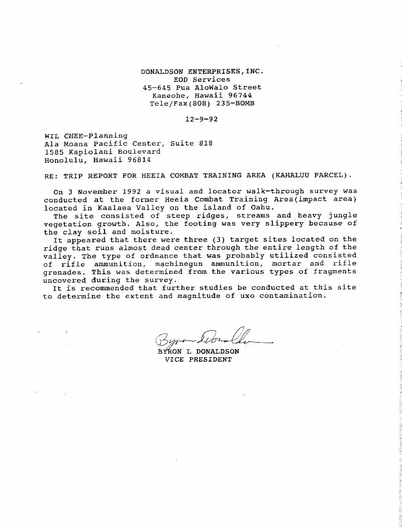
RE: TRIP REPORT FOR HEEIA COMBAT TRAINING AREA (KAHALUU PARCEL).
On 3 November 1992 a visual and locator walk-through survey was conducted at the former Heeia Combat Training Areatimpact area) located in Kaalaea Valley on the island of Oahu. The site consisted of steep ridges, streams and heavy jungle
vegetation growth. Also, the footing was very slippery because of the clay soil and moisture. It appeared that there were three (3) target sites located on the
ridge that runs almost dead center through the entire length of the valley. The type of ordnance that was probably utilized consisted of rifle ammunition, machinegun ammunition, mortar and rifle grenades. This was determined from the various types of fragments uncovered during the survey. It is recommended that further studies be conducted at this site
to determine the extent and magnitude of uxo contamination.
BY%ON L DONALDSON VICE PRESIDENT


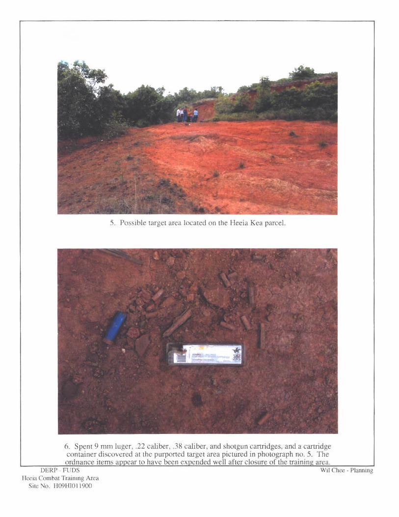
5. Possible target area located on the Heeia Kea parcel.
6. Spent 9 mm luger, .22 cahber, -38 caliber, and shotgun cartridges, and a cartridge container discovered at the purported target area pictured in photograph no. 5. The ordnance items appear to have been expended well afrer closure of the train in^ area.
DEW - FUDS Wil Chee - Planning leeia Cornha1 Trainmg Area
S b No. HWH1Qll9OO
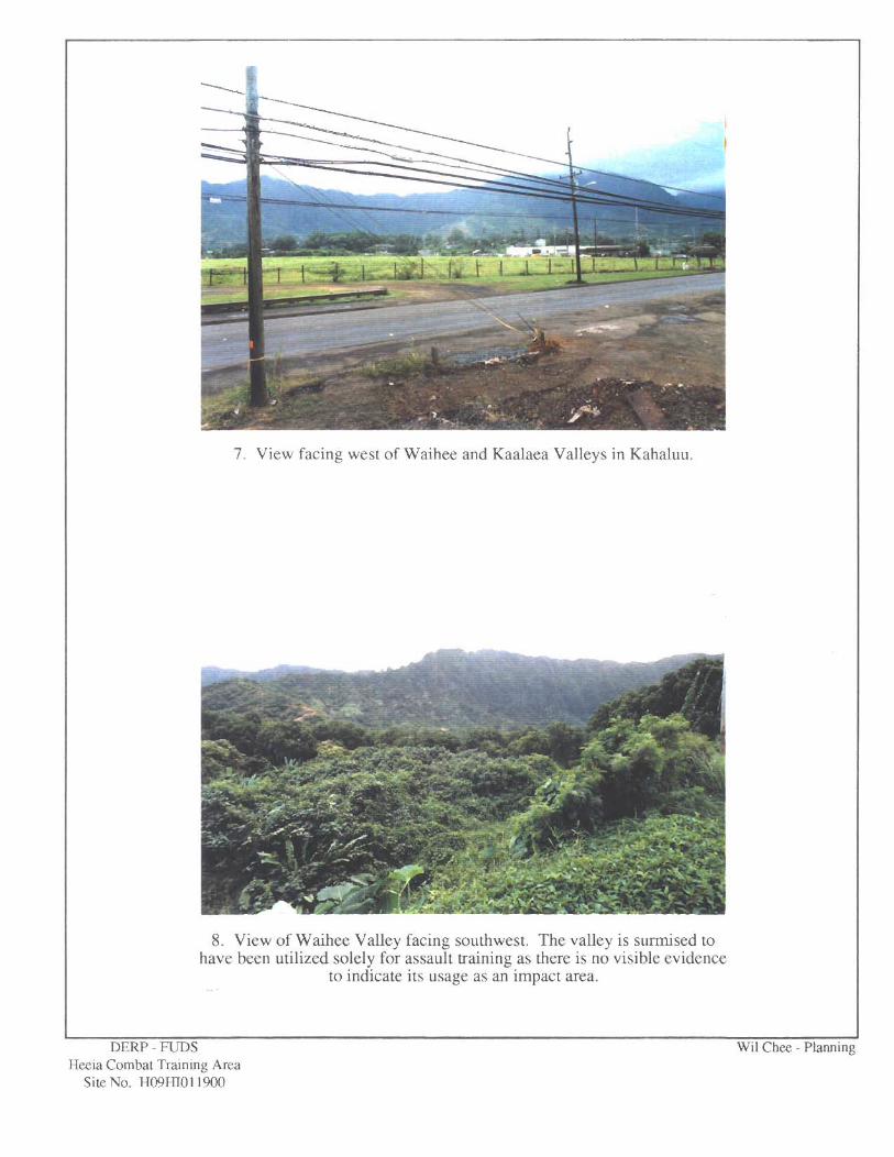
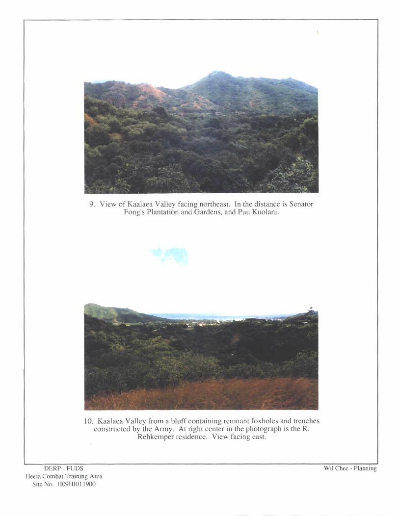
9. View of Kaalaea Valley facing northeast. In the distance is Senator Fong's Plantation and Gardens, and Puu Kuolani.
10. Kaalaea Valley from a bluff containing remnant foxholes and trenches constructed by the b y . At right center in the photograph is the R.
Rehkemper residence. View facing east.

13. .30 caliber projectiles.
14. S O caliber M-2 machine gun projectile.
Hmia Cornbar Training Area Site No. H09H1011900

17. Anomalous scarring north of the impact area surmised to have been caused by misses or ricocheting.
18. View of the Rehkemper residence facing southeast from the impacr area. The parcel was formerly utilized as a firing point.
Sire No. H1)9H1011900

19, At center in the photograph are numerous spent .30 caliber cartridges located at the Rehkemper residence.
20. Close-up of spent .30 caliber cartridges located at the Rehkemper residence.


F I E L D I N V E S T I G A T I O N
O F T H E
H E E I A K A I P A R C E L
J U L Y 1 5 , 2 2 , 2 3 , 2 9 , 1 9 8 9
BRYAN L . DONALDSON
DONALDSON E N T E R P R I S E S , I N C . EXPLOSIVE ORDNANCE SERVICES P. 0. B o x 4 5 0 9
,: K a n e o h e , H a w a i i 9 6 7 4 4 Ph: ( 8 0 8 ) 2 4 7 - 6 7 8 0 F a x : ( 8 0 8 ) 2 4 7 - 6 4 7 3
A u g u s t 1 7 , 1 9 8 9

This consultant was engaged to survey the Heeia Kai
parcel (Tax Map Keys 4-6-06:1, 7, 9, 11, 13, 15, 17-44, 48-
51; and 4-6-16:32) to determine: (a) the type ordnance used
on the property; (b) the possible existence of subsurface
ordnance; (c) the extent of surface contamination; (d)
possible target sites; and (e) ordnance clearance
requirements, if any.
BACKGROUND
It was reported to this consultant that on June 22,
1989, ordnance was discovered on the property by an
archaeologist, Dr. Alan Haun, Ph. D.
As a result of this finding, the U.S. Marine Corps
was notified, and on June 23, 1989 an Explosive Ordnance
Disposal (EOD) team from Kaneohe Marine Corps Air Station
visited the site of Dr. Haunfs finding. This EOD team
reported having found on June 23, 1989, and removed from the
property, a total of nine (9) practice ordnance rounds: (a)
two (2) M9A1 practice rifle grenades, and seven (7) M7A1
practice bazooka rounds.
Two (2) of the M7A1 bazooka rounds were located at
the property on the mauka (backside) of a hill overlooking
Kaneohe Bay. Five (5) of the M7A1 bazooka rounds and the two
(2) M 9 A 1 rifle grenades were found on the makai face of the

Same hill facing Kaneohe Bay. All of these rounds were found
partially buried in the ground. All of the rounds were in
very poor condition and badly rusted. As a result of the
heavy foliage and dense undergrowth, the EOD team was unable
to determine whether additional ordnance was present in the
area.
The subject property, and areas within the
adjoining Iolekaa Valley, were used by the United States Army
starting in late 1943 as a jungle training area-l It is
apparent, from a view atop the Heeia Kai Ridge line, that
both of these adjoining valleys lend themselves to
coordinated usage as military training areas.
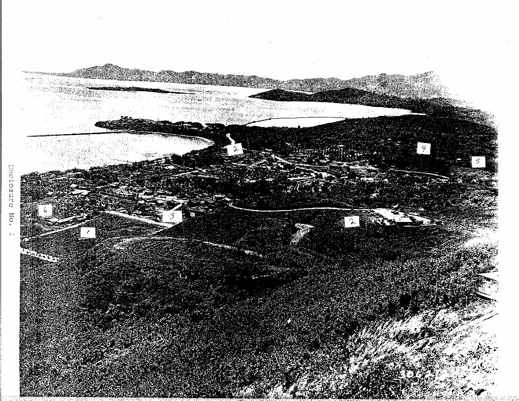
This consultant has reviewed a black and white
photograph taken on the property at several hundred feet
elevation, probably between late 1943 to shortly after World
War 11. This photograph, attached as Enclosure No, 1, taken
toward Coconut Island and the South end of Kaneohe Bay,
depicts a substantial portion of the lower southern end of
the subject property. The photograph depicts a well
developed U.S. Army training area. The billeting quarters
shown in this photograph would house approximately twenty-
five hundred (2,500) officers and men. As indicated on
Enclosure No. 1, this area included, among other things: (a)
a well developed unpaved road system, (b) messing facilities,
(c) an open air theater, (d) two (2) motor pools, (e)
Hawaii's War Years, 1941-1945, Gwenfread Allen, 1950, University of Hawaii Press, page 228.

ammunition storage sheds, (f) a small arms firing range, and
(g) an obstacle course.
Around 1985, this consultant reviewed an EOD
newsletter, published by the U.S. Marine Corps, which
reported that during the construction of Kahekili Highway,
which runs through both Iolekaa and the adjoining Haiku
Valleys, explosive dud ordnance2 was recovered.
F I E L D SURVEY AND F I N D I N G S
From this consultant's initial view of the
property, looking mauka from Kamehameha Highway and Heeia Kea
Pier, four (4) areas were noted, at the 2 0 0 ' - 3 0 0 ' elevation,
which are essentially barren of vegetation and steeply
sloped. Each of these areas is surrounded by dense
undergrowth. (See Enclosure No. 2) The characteristics of
these areas are quite similar to military target sites upon
which live ordnance has been used. This consultant has
observed and been involved in the ordnance clearing and
disposal of such target areas with similar characteristics in
Northern Okinawa; in Waikane Valley on Oahu; at Camp
Pendleton, California; and on Luzon Island in the
Philippines. Attached as Enclosure No. 3 to this report are
two photographs taken of similar live target areas at Waikane
on Oahu. Because of their characteristics, these four (4)
Live ordnance which has been fired but failed to detonante upon impact.

a r e a s w e r e i n i t i a l l y cons idered a s p o s s i b l e t a r g e t a r e a s on
t h e p r o p e r t y . These a r e a s a r e des igna t ed , f o r purposes of
t h i s r e p o r t , a s S i t e s Nos. 1, 2 , 3 and 4 , a s viewed from
Kamehameha Highway, r e s p e c t i v e l y from l e f t t o r i g h t ( sou th t o
n o r t h ) . They a r e a s approximately l o c a t e d on t h e c h a r t
a t t a c h e d a s Enc losure No. 4 , and shown on t h e composite
photograph (Enclosure No. 2 ) . On J u l y 2 2 , 1 9 8 9 , t e lephone c o n t a c t was made with
D r . Alan Haun t o confirm h i s r e p o r t e d f i n d i n g of ordnance on
t h e p r o p e r t y , and t o p inpo in t t h e l o c a t i o n of h i s ordnance
f i n d i n g s of June 2 2 , 1989. D r . Haun confirmed t h e r epo r t ed
ordnance f i n d i n g s desc r ibed i n t h e NBackgroundt' s e c t i o n of
t h i s r e p o r t . H e de sc r ibed t h e l o c a t i o n of h i s ordnance
f i n d i n g a s s e v e r a l hundred f e e t mauka of a c l u s t e r of l a r g e
monkey-pod tress, and i n a l a r g e eroded N g ~ l ~ h N a r e a on t h e
s o u t h s i d e o f and n e a r t h e bottom of a mauka-makai fence
l i n e . H i s d e s c r i p t i o n of t h e l o c a t i o n of h i s ordnance f i n d
e x a c t l y f i t s S i t e No. 1.
SITE NO. 1
T h i s s i t e was in spec t ed f o r t h e b e t t e r p a r t of J u l y
2 2 , 1989, and a h a l f day on J u l y 29, 1 9 8 9 . On J u l y 22, 1989,
a s ea rch of t h a t p a r t of t h e s i t e which was ba r r en of
v e g e t a t i o n d i s c l o s e d no apparen t ordnance. J u s t below and on
t h e sou th s i d e of t h e barren; 'par t of t h e s i t e , a smal l
communications p o l e (of a World War I1 m i l i t a r y t ype ) was

noted still standing vertically. Just below the barren
portion and on the north (Kahuku) side of the site in dense
vegetation, this consultant found an old concrete
foundation, approximately 10' x 12', next to a large banyan
tree. Approximately twenty feet (20') from this foundation,
and connected to it by a large steel pipe, was noted an
abandoned septic tank. It was noted that an unpaved road,
running mauka-makai, at one time had gone up the south
(Kaneohe) side of Site No. 1. This road turned right (north-
south) above Site No. 1, and ran approximately parallel to
Kamehameha Highway.
On the July 29, 1989 inspection of Site No. 1, this
consultant found: (a) two (2) M7A1 practice bazooka rounds;
(b) two (2) center cores of M7A1 practice bazooka rounds; and
(c) one (1) shroud from an M9A1 rifle grenade, the latter of
which could have been either practice or live. All of these
items are heavily rusted.
The two practice bazooka rounds, (a), were found
lying on the ground in dense vegetation, approximately 20'
Kahuku side of the mauka-makai fence which borders the Kahuku
side of Site No. 1, and on the side of the hill facing
Kaneohe Bay. The two (2) center cores of the M7A1 practice
bazooka rounds were found lying on the ground in dense
vegetation on the Kaneohe side of Site No. 1, approximately
2Or Kahuku side of the mauka-makai road bordering Site No. 1. I
These center cores were alsdon the hillside of Site No. 1
facing Kaneohe Bay. The shroud from an M9A1 rifle grenade

was found in dense foliage on the backside of the hill,
approximately 15'-20' down from the crest of the hill, facing
mauka . Each of the above ordnance pieces found on July 29,
1989 were removed from the property and are in the
consultant's possession. Photographs of these ordnance items
are attached to this report as Enclosure No. 5.
On August 4, 1989 this consultant spoke with Gordon
~ndretti, who was born on Heeia Kai in 1941 and lived there
until 1989. Mr. Andretti told this consultant that while
living on the property, he found two (2) hand grenades at
Site No. 1, and removed them to his home in Heeia Kai. Mr.
Andretti explained that he had lost one of the two grenades,
but produced the second one for this consultant's inspection.
This was a Mark I1 ("Pineapplef') grenade, used by the U.S.
Army during World War 11. It was not a practice grenade. It
had originally been manufactured with an M-10 fuse, which had
been removed prior to this consultant's inspection. Also
removed from the grenade at the time of inspection was the
filler screw (located at the base of the grenade) and the
explosive filler. Without an inspection of the M-10 fuse, it
is not possible to tell whether an attempt had previously
been made to detonate the grenade, either by launching from a
rifle or by manually pulling the safety pin and throwing by
hand. Mr. Andretti advised this consultant that the second
grenade he found at Site No. 1 was identical to the grenade
this consultant inspected on August 4, 1989. He further

indicated that he had seen additional grenades of the same
type at Site No. 1. The inspected grenade was pitted, but in
fairly good shape. It was apparent that someone had cleaned
surface rust from the grenade before this consultant's
inspection. Enclosure No. 6 are photographs of the hand
grenade inspected by this consultant on August 4, 1989.
SITE NO. 2
This site was inspected on July 15, 1989 and again
on July 29, 1989. On the July 15th visit, the bare surface
areas and adjacent areas were swept for signs of ordnance
usage. No practice or live ordnance was found at this site.
Other than the general characteristics of the site (which
initially suggested this site as a possible target area) no
evidence was found in these inspections to indicate that live
ordnance was ever fired at the site or may be presently on
the site.
SITE NO. 3
This site was visually searched on July 15, 1989
and again on July 23, 1989. No evidence of any ordnance
above the size of small-arms munitions was found. It should
be noted that a considerable mix of both civilian and
military small-arms munitions (i.e., 9mm, -45 cal., .38 cal.,
and -30 cal. ammunition) were located. After viewing their
condition, this consultant is of the opinion that they were

not fired during the 1940ts, or 1950'~~ but substantially
thereafter.
SITE NO. 4
This site is probably the target end of the rifle
range dpicted on the black and white photograph (Enclosure
No. 1) to this report. This site was visually searched on
July 23, 1989. Nothing was found at the site to indicate or
suggest that explosive ordnance had ever been fired at this
site. Futhermore, it is considered highly improbable that
during the property's use by the U.S. Army, explosive
ordnance would have been fired at this target site. Doing so
would have: (1) involved risk of damage to the rifle targets,
and (2) contaminated the site with serious risk of exposure
to dud ordnance to U.S. Army personnel who would man the
target area during its use as a rifle range.
CONCLUSIONS
1. The subject property was used by the U.S. Army during
parts of World War 11, and possibly shortly thereafter as
a jungle warfare training area.
2. Jungle warfare training of both the U.S. Army and U.S.
Marine Caorps during and after World War I1
characteristically involved troop use of both live and

p r a c t i c e ordnance. D i r e c t evidence has been found t o
e s t a b l i s h t h a t t h e U.S, Army f i r e d p r a c t i c e bazooka
rounds ( M 7 A 1 ) and p r a c t i c e r i f l e g renades (M9A1) on S i t e
No. 1 of t h e p r ~ p e r t y . ~ I f t h e U.S. Army, du r ing its
u s e o f t h e p rope r ty , f i r e d on ly p r a c t i c e and no l i v e
ordnance on S i t e No. 1, it w i l l be t h e f i r s t range which
t h i s c o n s u l t a n t has e v e r s e e n , heard o f , o r r ead about i n
h i s twen ty (20) p l u s y e a r s o f exp los ive ordnance
expe r i ence . The f i n d i n g o f M r . Gordon A n d r e t t i of a t
l e a s t one confirmed l i v e grenade a t S i t e No. 1 is f u r t h e r
i n d i c i a t i o n of t h e U . S . Army's use of l i v e ordnance i n
t h i s a r e a .
3 . c o n s i d e r i n g t h e c h a r a c t e r i s t i c s of l i v e o r p r a c t i c e
bazooka and r i f l e g renades i n u s e d u r i n g World War 11,4
used on S i t e No. 1, it is improbable t h a t e i t h e r p r a c t i c e
o r unexploded (dud) l i v e rounds would have b u r i e d
themse lves complete ly i n t h e h i l l on impact a t S i t e No.
1. The obvious c o n s i d e r a b l e e r o s i o n a t t h i s s i t e i n t h e
f o r t y ( 4 0 ) p l u s y e a r s s i n c e t h e U.S. Army's u s e of t h e
D r . Haunts f i n d i n g of June 2 2 , 1989 and t h e U.S. Marine EOD team's f i n d i n g of June 2 2 , 1983 and removal of two ( 2 ) p r a c t i c e r i f l e g renades and seven ( 7 ) p r a c t i c e bazooka rounds; a s w e l l a s t h i s c o n s u l t a n t ' s f i n d i n g on J u l y 2 9 , 1989 of p r a c t i c e bazooka rounds and t h e shroud r i f l e grenade (which could have been from a l i v e o r p r a c t i c e g renade ) .
* Weight, shape and ranges o f v e l o c i t y on impact .

property probably completely covered with soil both live
and practice bazooka and rifle grenades at and below the
base of both sides of the hill at Site No. 1.
4. It is considered improbable that the U.S. Army fired live
ordnance on certain substantial parts of the property.
For instance, that part of the property on the southern
end depicted in the black and white photo, Enclosure No.
1, was most probably not fired upon with live ammunition.
Doing so would have produced an obvious and serious risk
of danger to the U.S. troops themselves. Furthermore,
this consultant's inspection of the property disclosed no
evidence which indicated that the U.S. Army ever fired
live or practice ordnance at elevations on the property
above Sites Nos. 1-4, and up to the ridge line of the
property.
5. It is considered quite doubtful that the U.S. Army today
has reliable records to show what ordnance, live or
practice, was fired upon the property during and shortly
after World War 11. Based, however, on actual
experience, it is statistically reasonable to assume that
approximately ten percent (10%) of live bazooka rounds
and live grenades used on the property failed to detonate
and became duds. It is also reasonable to assume, based
upon this consultant's first-hand experience, that some
unknown percentage of these duds, either on or below the

surface, remain live and life threatening today,
notwithstanding exposure to the elements for between 40-
50 years.
RECOMMENDATIONS
That site No. 1 be marked off and posted immediately to
exclude all personnel from wandering through the site
until a decision is made as to who, how and when it will
be cleared. This consultant feels that this marking and
posting can be completed in eight (8) to ten (10) hours.
That the search for U.S. Army records showing the use of
the property continue,
That a prompt effort be made to have Mr. Gordon Andretti
accompany this consultant to the property: (a) to
pinpoint the location of his finding of two (2) grenades;
and (b) to seek to locate additional grenades.
That Site No. 1 and the surrounding area (a total area of
approximately six (6) acres) be stripped of ground-cover
vegetation (exclusing mature trees) and the entire area
be swept, both surface and subsurface, in an effort to
ensure that no live or practice ordnance remains. The
subsurface clearance operation would not entail
physically digging up the entire site, but rather be
probed utilizing a ferro.us ordnance locator and/or metal
detector.

5 , That any live ordnance located at the site be disposed of
by a qualified ordnance disposal expert.
6. That personnel entering the property be briefed that
ordnance has been previously discovered and any sightings
should be reported to the project manager immediately.
They should be cautioned not to touch any ordnance, but
to mark it and note the location to facilitate finding it
later.
7. That assistance from the military be requested to sweep
the parcel. It will probably take an inordinate period
of time to get any assistance from the military, which
probably will not clear or certify it to the extent you
will probably desire.
. BRYAN L. DONALDSON


E ~ ~ e l o s u r e No. 3
Live Ordnance target Areas, Waikane, Oahu

" H e e i a K a i P r o j e c t "
E n c l o s u r e N o . 4


E n c l o s u r e No. 5
P a r t s o f o n e o f t w o M7A1 p r a c t i c e b a z o o k a r o u n d s f o u n d a t S i t e N o . 1 by c o n s u l t a n t o n 7 / 2 9 / 8 9

E n c l o s u r e No. 5
Two ( M7A1 foun No.
center t r ac t i ce by Cons on 7 / 2 9
' cor , Baz ulat / 8 9
a und Sit-

Enclosure No. 5
Shrou found No. 1
d of M 9 A 1 rifle grena by consultant at Sit on 7/29/89

Enclosure No. 5
Parts of one of two M7A1 practice Bazooka rounds found at Site No. 1 by Consul.tant on 7/29/89

E n c l o s u r e No. 6
Hand Grenade inspected on 8/14/89

E n c l o s u r e
f
No. 6

E n c l o s u r e No. 6