Embed Size (px)
DESCRIPTION
Python Arcobjects
Citation preview

Using ArcObjects in Using ArcObjects in PythonPython
Mark CederholmMark CederholmUniSource Energy ServicesUniSource Energy Services

Why Python?Why Python?
ArcGIS VBA support ends after 10.0ArcGIS VBA support ends after 10.0At 10.0, ArcMap and ArcCatalog include an At 10.0, ArcMap and ArcCatalog include an integrated Python shellintegrated Python shellPython scripting objects provided by ESRI Python scripting objects provided by ESRI IDLE is a decent development and IDLE is a decent development and debugging environmentdebugging environmentPython scripts can use ArcObjects!Python scripts can use ArcObjects!

Geoprocessing objectsGeoprocessing objectsReadyReady--toto--use geoprocessing objects are use geoprocessing objects are available for Python through available for Python through arcgisscripting (9.3) and arcpy (10.0)arcgisscripting (9.3) and arcpy (10.0)At 9.3: additional functionality includes At 9.3: additional functionality includes data access objects such as cursorsdata access objects such as cursorsAt 10.0: additional functionality includes At 10.0: additional functionality includes some map document automationsome map document automationNonetheless, a great deal of functionality Nonetheless, a great deal of functionality is only available through ArcObjectsis only available through ArcObjects

COM interop: relative speedCOM interop: relative speed
Benchmark = 500+K ShapeCopy operationsBenchmark = 500+K ShapeCopy operations(ArcGIS 9.3.1 with VS2008)(ArcGIS 9.3.1 with VS2008)
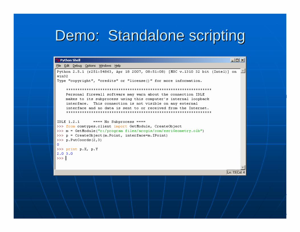
Demo: Standalone scriptingDemo: Standalone scripting
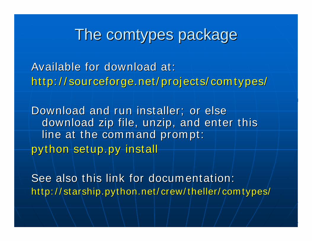
The comtypes packageThe comtypes package
Available for download at:Available for download at:http://sourceforge.net/projects/comtypes/http://sourceforge.net/projects/comtypes/
Download and run installer; or else Download and run installer; or else download zip file, unzip, and enter this download zip file, unzip, and enter this line at the command prompt:line at the command prompt:
python setup.py installpython setup.py install
See also this link for documentation:See also this link for documentation:http://starship.python.net/crew/theller/comtypes/http://starship.python.net/crew/theller/comtypes/
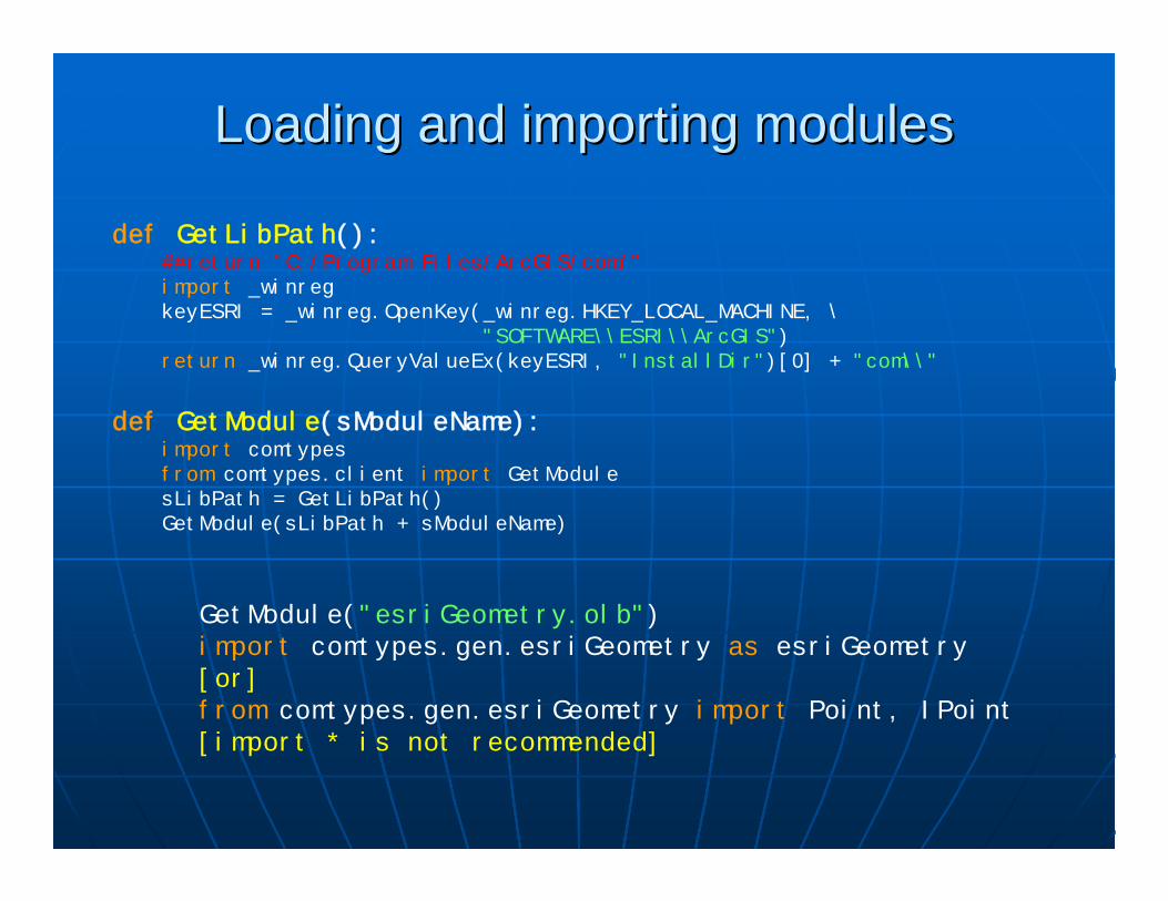
Loading and importing modulesLoading and importing modules
def GetLibPath():##return "C:/Program Files/ArcGIS/com/"import _winregkeyESRI = _winreg.OpenKey(_winreg.HKEY_LOCAL_MACHINE, \
"SOFTWARE\\ESRI\\ArcGIS")return _winreg.QueryValueEx(keyESRI, "InstallDir")[0] + "com\\"
def GetModule(sModuleName):import comtypesfrom comtypes.client import GetModulesLibPath = GetLibPath()GetModule(sLibPath + sModuleName)
GetModule("esriGeometry.olb")import comtypes.gen.esriGeometry as esriGeometry[or]from comtypes.gen.esriGeometry import Point, IPoint[import * is not recommended]

Creating and casting objectsCreating and casting objects
def NewObj(MyClass, MyInterface):from comtypes.client import CreateObjecttry:
ptr = CreateObject(MyClass, interface=MyInterface)return ptr
except:return None
def CType(obj, interface):try:
newobj = obj.QueryInterface(interface)return newobj
except:return None
def CLSID(MyClass):return str(MyClass._reg_clsid_)

Standalone licensingStandalone licensing
pInit = NewObj(esriSystem.AoInitialize, \esriSystem.IAoInitialize)
eProduct = esriSystem.esriLicenseProductCodeArcEditorlicenseStatus = pInit.IsProductCodeAvailable(eProduct)if licenseStatus == esriSystem.esriLicenseAvailable:
licenseStatus = pInit.Initialize(eProduct)return (licenseStatus == esriSystem.esriLicenseCheckedOut)
TIP: Use the geoprocessing object instead
import arcgisscriptinggp = arcgisscripting.create(9.3)gp.setproduct("ArcEditor")

Demo: Manipulating an existing Demo: Manipulating an existing ArcMap or ArcCatalog sessionArcMap or ArcCatalog session
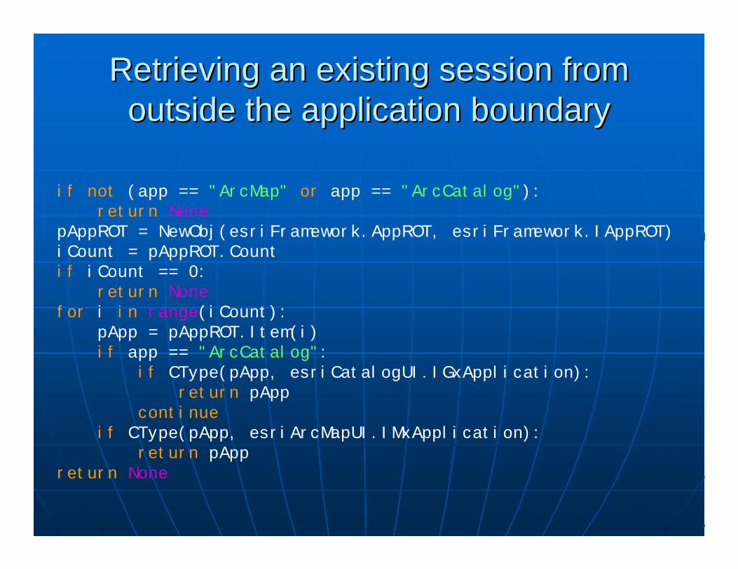
Retrieving an existing session from Retrieving an existing session from outside the application boundaryoutside the application boundary
if not (app == "ArcMap" or app == "ArcCatalog"):return None
pAppROT = NewObj(esriFramework.AppROT, esriFramework.IAppROT)iCount = pAppROT.Countif iCount == 0:
return Nonefor i in range(iCount):
pApp = pAppROT.Item(i)if app == "ArcCatalog":
if CType(pApp, esriCatalogUI.IGxApplication):return pApp
continueif CType(pApp, esriArcMapUI.IMxApplication):
return pAppreturn None

Getting a selected featureGetting a selected feature
pApp = GetApp(). . .pDoc = pApp.DocumentpMxDoc = CType(pDoc, esriArcMapUI.IMxDocument)pMap = pMxDoc.FocusMappFeatSel = pMap.FeatureSelectionpEnumFeat = CType(pFeatSel, esriGeoDatabase.IEnumFeature)pEnumFeat.Reset()pFeat = pEnumFeat.Next()if not pFeat:
print "No selection found."return
pShape = pFeat.ShapeCopyeType = pShape.GeometryTypeif eType == esriGeometry.esriGeometryPoint:
print "Geometry type = Point". . .

Creating session objects with Creating session objects with IObjectFactoryIObjectFactory
pApp = GetApp()pFact = CType(pApp, esriFramework.IObjectFactory)pUnk = pFact.Create(CLSID(esriCarto.TextElement))pTextElement = CType(pUnk, esriCarto.ITextElement)
TIP: At 10.0, you can run a script within the session's Python shelland create objects normally; use AppRef to get the app handle
If manipulating a session from outside the application boundary,use IObjectFactory to create new session objects:
pApp = NewObj(esriFramework.AppRef, esriFramework.IApplication)

UIDs and EnumerationsUIDs and EnumerationspApp = GetApp(). . .pID = NewObj(esriSystem.UID, esriSystem.IUID)pID.Value = CLSID(esriEditor.Editor)pExt = pApp.FindExtensionByCLSID(pID)pEditor = CType(pExt, esriEditor.IEditor)if pEditor.EditState == esriEditor.esriStateEditing:
pWS = pEditor.EditWorkspacepDS = CType(pWS, esriGeoDatabase.IDataset)print "Workspace name: " + pDS.BrowseNameprint "Workspace category: " + pDS.Category
Multiple Return ValuesMultiple Return ValuesiEdgeEID, bReverse, oWeight = pForwardStar.QueryAdjacentEdge(i)

Nothing, IsNull, and NoneNothing, IsNull, and None
iOpt = esriCarto.esriViewGraphics + \esriCarto.esriViewGraphicSelection
pActiveView.PartialRefresh(iOpt, None, None)
pCursor = pTab.Search(pQF, True)pRow = pCursor.NextRow()if not pRow:
print "Query returned no rows"return
Val = pRow.Value(pTab.FindField(sFieldName))if Val is None:
print "Null value"
Supply Supply NoneNone as an argument representing as an argument representing Nothing:Nothing:
Use boolean testing to check for a null pointer, Use boolean testing to check for a null pointer, and and isis NoneNone to check for a null DB value:to check for a null DB value:

WriteOnly and indexed propertiesWriteOnly and indexed properties
pNewField = NewObj(esriGeoDatabase.Field, \esriGeoDatabase.IField)
pFieldEdit = CType(pNewField, esriGeoDatabase.IFieldEdit)pFieldEdit._Name = "LUMBERJACK"pFieldEdit._Type = esriGeoDatabase.esriFieldTypeStringpFieldEdit._Length = 50pFieldsEdit._Field[1] = pNewFieldpOutTable = pFWS.CreateTable(sTableName, pOutFields, \
None, None, "")iField = pOutTable.FindField("LUMBERJACK")print "'LUMBERJACK' field index = ", iFieldpRow = pOutTable.CreateRow()pRow.Value[iField] = "I sleep all night and I work all day"pRow.Store()
TIP: Use geoprocessing tools to create tables and add fields

Demo: Extending ArcGIS DesktopDemo: Extending ArcGIS Desktop

1.1. Create an IDL file defining the object and its Create an IDL file defining the object and its interfacesinterfaces
2.2. Compile with the MIDL compiler (part of the Compile with the MIDL compiler (part of the Windows SDK download) to produce a TLB file: Windows SDK download) to produce a TLB file: midl DemoTool.idlmidl DemoTool.idl
3.3. Implement the class and category registration in Implement the class and category registration in a Python modulea Python module
4.4. Register the com object:Register the com object:python DemoTool.py python DemoTool.py ––regserverregserver
Creating a COM objectCreating a COM object
WARNING: The file/module name in step 4 is case sensitive!

Some final tips:Some final tips:
When in doubt, check the wrapper code:When in doubt, check the wrapper code:Python25/Lib/sitePython25/Lib/site--packages/comtypes/genpackages/comtypes/genAvoid intensive use of fineAvoid intensive use of fine--grained ArcObjects in grained ArcObjects in PythonPythonFor best performance, use C++ to create coarseFor best performance, use C++ to create coarse--grained COM objectsgrained COM objectsUse geoprocessing objects and tools to simplify Use geoprocessing objects and tools to simplify supported tasks supported tasks –– watch for performance, thoughwatch for performance, thoughRead the desktop help to check out available Read the desktop help to check out available functionality in arcgisscripting (and arcpy at functionality in arcgisscripting (and arcpy at 10.0)10.0)

Questions?Questions?
Mark CederholmMark [email protected]@uesaz.comThis presentation and sample code This presentation and sample code may be downloaded at:may be downloaded at:
http://www.pierssen.com/arcgis/misc.htmhttp://www.pierssen.com/arcgis/misc.htm