Embed Size (px)
Citation preview

October 2016 1
Technical Memorandum
Pasadena Non-Potable Water Project - Phase I Options
Subject: Assessment of Phase I Options for CEQA Compliance
Prepared for: Roumiana Voutchkova, City of Pasadena
Prepared by: Sally Johnson and Alexis Cahalin
Reviewed by: Rosalyn Prickett
Date: October 27, 2016
Reference: 0129-005.03
Table of Contents
Section 1 Project Overview ............................................................................................ 2 1.1 Background .................................................................................................... 2 1.2 Phase 1 Project .............................................................................................. 3 1.3 Project Description – Phase I Options ............................................................ 4 1.5 Project Purpose and Objectives ..................................................................... 7 1.6 Construction Considerations .......................................................................... 7 Section 2 Environmental Commitments ......................................................................... 8 Section 3 CEQA Assessment ...................................................................................... 10 3.1 Aesthetics .................................................................................................... 19 3.2 Air Quality .................................................................................................... 19 3.3 Biological Resources .................................................................................... 25 3.4 Cultural Resources ....................................................................................... 29 3.5 Geology and Soils ........................................................................................ 31 3.6 Greenhouse Gas Emissions ........................................................................ 34 3.7 Hazards and Hazardous Materials ............................................................... 37 3.8 Hydrology and Water Quality ....................................................................... 40 3.9 Land Use and Planning ................................................................................ 43 3.10 Noise ............................................................................................................ 44 3.11 Population and Housing ............................................................................... 46 3.12 Public Services ............................................................................................. 47 3.13 Recreation .................................................................................................... 48 3.14 Traffic and Transportation ............................................................................ 49 3.15 Utilities and Service Systems ....................................................................... 54 3.16 Environmental Justice .................................................................................. 56 3.17 Mandatory Findings of Significance ............................................................. 57 Section 4 Summary ...................................................................................................... 58 Section 5 References ................................................................................................... 58

Pasadena Non-Potable Water Project Phase I Options
October 2016 2
Appendix A, Mitigation Monitoring and Reporting Program for the Pasadena Non-Potable Water Project
Appendix B, Biological Resources Assessment Addendum
Appendix C, Cultural Resources Assessment Addendum
Appendix D, EnviroStor and Geotracker Databases for the Phase I Options
Appendix E, Traffic and Recreation Survey for Phase I Options
Section 1 Project Overview
This Technical Memorandum (TM) assesses two options for modified alignments for Phase I of the Pasadena Non-Potable Water Project for California Environmental Quality Act (CEQA) coverage under the existing Environmental Impact Report (EIR) (PWP 2016). During the public comment period for the 2016 certified EIR, residents of Pasadena in the vicinity of the pipeline route expressed concerns about the impacts of proposed pipeline construction and suggested two modified alignments. This TM evaluates the potential environmental impacts should the City of Pasadena elect to move forward with the alignment options as the preferred route for the Phase I pipeline.
1.1 Background
The Pasadena Non-Potable Water Project (Project) is a six-phase project to construct a non-potable water distribution system for the City of Pasadena (City) and select customers immediately adjacent to the City. The purpose of the Project is to provide approximately 9% of Pasadena Water and Power’s (PWP) overall water needs from local, non-potable water sources. The project involves construction and operation of a new non-potable water distribution system to deliver water from three local non-potable water sources: (1) recycled water produced by the Los Angeles/Glendale Water Reclamation Plant (LAG), (2) tunnel water from two existing tunnels (Devils Gate and Richardson Springs), and (3) surface water from Arroyo Seco stream.
The Project includes six phases, eventually covering a large portion of PWP’s service area. Build-out of the Project would supply 3,060 AFY non-potable water to customers within the service areas of PWP, Lincoln Avenue Water Company, Foothill Municipal Water District, and California American Water Company for landscape irrigation, industrial cooling, and other non-potable uses. Tunnel water and Arroyo Seco stream water are subject to climatic conditions and may not be available for extended periods of time; when those two supplies are not available, the entire non-potable demand will be met with recycled water from LAG.
On February 22, 2016, the City of Pasadena’s City Council certified the Final EIR for the Pasadena Non-Potable Water Project and approved the project. In the 2016 certified EIR, the Phase I Project was analyzed at a project level, while the later phases were evaluated at a programmatic level. The City Council also directed PWP to evaluate the two alignment options bought forth by the public.

Pasadena Non-Potable Water Project Phase I Options
October 2016 3
1.2 Phase 1 Project
The Phase I Project is designed to convey recycled water from the LAG to recycled water customers at the Art Center College of Design, Brookside Golf Course, the Rose Bowl Stadium area, and Brookside Park. Phase I includes:
24,600 linear feet (LF) of non-potable water pipe – see paragraphs below
9,200 LF of power transmission and fiber optic cables co-located with pipelines
two non-potable water reservoirs – up to 1.25 MG potable or non-potable reservoir at Scholl Canyon Reservoir site in the City of Glendale, and up to 1.25 MG non-potable reservoir at Sheldon Reservoir site in the City of Pasadena
one pressure reducing station (PRS) – located near the intersection of Washington Boulevard and West Drive
a hydroelectric generation turbine facility – co-located with the PRS
three pumping units – one 600 HP pump added to the existing LAG Recycled Water Pump Station, and two 250 HP pumping units at existing Glendale Upper Scholl Pump Station
two new pump stations – Tunnel Water Pump Station and Irrigation Pump Station, both at Brookside Golf Course
Upon completion, the Phase I Project will serve 700 AFY non-potable water to customers. The Phase I Project is shown in Figure 1-1.
Phase I pipelines would consist of the following segments: (1) Scholl Canyon landfill; (2) undeveloped ridge adjacent to the Art Center College of Design; (3) Art Center College of Design (Art Center)/LA County Flood Control District access road; (4) Pasadena streets; and (5) Brookside Golf Course. Work at the Scholl Canyon Landfill would include construction of the Scholl Canyon Non-Potable Water Reservoir and upgrades to the water pump station at LAG and Upper Scholl Canyon Pump Station. For the undeveloped ridge segment, the pipeline would be installed along a previously disturbed, but undeveloped ridge. The Art Center/LA County Flood Control District access road segment would be installed in a less than 20 foot wide paved access road. The Pasadena streets segment would be installed within roadway rights-of-way (ROWs) owned by the City of Pasadena. The roads include Afton Street, Wellington Avenue, Linda Vista Avenue, Laurel Street, Parkview Avenue, Washington Boulevard, Arroyo Boulevard, Rose Bowl Drive, Rosemont Avenue, and an abandoned section of Del Monte Street (see Table 1-1). The pipeline in the Brookside Golf Course segment would be installed within the bounds of the Brookside Golf Course and would be routed to avoid trees and utilize maintenance roads and rough areas where possible to minimize disruption on fairway areas and greens.

Pasadena Non-Potable Water Project Phase I Options
October 2016 4
Table 1-1: Phase I Project Pipeline Alignments in City Streets
Roadway Segment
Afton Street Between the end of Afton Street at the Afton Debris Basin and
Linda Vista Avenue
Wellington Avenue Between two segments of Afton Street
Linda Vista Avenue Between Afton Street and Laurel Street
Laurel Street Between Linda Vista Avenue and Parkview Avenue
Parkview Avenue Between Laurel Street and Washington Boulevard
Washington Boulevard
Between Parkview Avenue and Rosemont Avenue
Arroyo Boulevard Between Selkirk Street and Zanja Street
Rose Bowl Drive Between Zanja Street and Rosemont Avenue
Rosemont Avenue Between Rose Bowl Drive and Seco Street and between
Washington Boulevard and 1,150 feet north of Washington Boulevard
Del Monte Street (Abandoned)
Between Rosemont Avenue and Arroyo Boulevard
PWP is studying several modifications to the Phase I Project. The Phase I Options include moving portions of the proposed pipeline to Salvia Canyon, West Drive, and Rosemont Avenue, in lieu of Linda Vista Avenue, Laurel Street, Parkview Avenue, Arroyo Boulevard and Rose Bowl Drive. These modifications are shown in Figure 1-1, and described below. For the purposes of this assessment, the following terms are used:
Phase I Project – the entire Phase I Project, as defined in the EIR
Phase I Alignment – the portions of the Phase I Project that would be replaced by the Phase I Options; the Phase I Alignment includes Linda Vista Avenue, Laurel Street, Parkview Avenue, and Rose Bowl Drive
Phase I Options – the two modified alignments described here; includes the Salvia Canyon West Route and the Rosemont Avenue East Route.
1.3 Project Description – Phase I Options
The proposed Phase I Options would avoid constructing the Phase I Alignment along portions of Linda Vista Avenue, Laurel Street, and Parkview Avenue, as well as avoid construction along Arroyo Boulevard and a portion of Rose Bowl Drive. In lieu of these streets as included in the Phase I Alignment, the Phase I Options include the Salvia Canyon West Route and the Rosemont Avenue East Route (see Figure 1-1).

!(!
!(<
!(E
!(<
§̈¦210
Connection toGWP System
20"
20"
20"
16"
Scholl CanyonNon-PotableWater Reservoir
Sheldon Non-PotableRservoir(s)1.25 MG 1050' HWL
PRS 1666/1050&
Brookside BoosterPump Station
(Phase I)
20"
WASHINGTOA
RR
OY
O
RO
SE
MO
NT
RO
SE
MO
NT
24"³±(!
")
Pump Station(350 gpm)
14,000 Gal Wet Well
12" TW TransmissionPipeline
12" Richardson Intake
Hydroelectric Turbine Facility(Phase I)
RW pipeline and parallel electrical/fiber optic conduit
Brookside Park
Brookside Golf Course
Art Center Collegeof Design
Rose Bowl Stadium
DALEDALE
WE
ST
AR
RO
YO
RO
SE
MO
NT
LIDA
FOR
ES
T
LIN
DA
VIS
TA
CANADA
GLENOAKS
SE
CO
WASHINGTON
FIGU
ER
OA
HOWARD
MONTANA
SAINT K
ATHERIN
E
INV
ER
NE
SS
CA
S
NE
WP
OR
T
KE
NN
ET
H
AR
MA
DA
DEL MONTE
PA
RK
VIE
W
BLA
KE
WYOMING
PR
OS
PE
CT
GLE
N O
AK
S
STANTON
RO
SE
BO
WL
HAMMOND
VIS
TA
DE
VO
N
RADIO LATERAL
AFTON
CONISTON
WESTGATE
NO
RM
AN
DY
EL MIRADOR
WICKS
SCENICYOCUM
TOOLEN
PALISADE
CLAREMONT
SAN AUGUSTIN
E
DRAGONFLY
PEGFAIR ESTATES
EDGEHILL
VALL
E V
ISTA
WALDORF
BRYANT
WIN
ON
A
SALVIA CANYON
PASAD
EN
A
WO
TK
YN
S
P
LINDA RIDGE
BANYAN
KAREN LYNN
EVERTS
PHEASANT
LAUREL
ERSTONE
BR
AE
MA
R
SO
LITA
MACDONALD
WE
ND
OV
ER
PUTNEY
DE
XT
ER
EY
LA C
RE
STA
WIERFIEL
CHARLESWABASH
LA MESA
MARENGO
MOUNTAIN
CHAMBERLAIN
AR
RO
YO
VIE
W
CYPR
ESS
LANCASHIRE
KNOLLWOOD
SELKIRK
BUC
KING
HAM
THORNWOOD
HEATHERSIDE
RIC
HLA
ND
RO
SE
WA
LK
DU
NS
ME
RE
RUTHERFORD
TY
RR
EL
L
SE
RR
AN
O
LOMAY
KA
RE
N S
UE
LMOON
RANCHEROS
ABETH
BENNETT
ANDERSON
SERVICE
HU
FF
ER
CHULA VISTA
CA
RN
AR
VO
N
ARM
AD
A
WABASH
AFTON
PALISADE
LIND
A V
ISTA
SO
LITA
CY
PR
ES
S
RO
SE
BO
WL
AFTON
FIGU
ER
OA
CHARLES
S13 T1N R13W S18 T1N R12W S17 T1N R12W
S19 T1N R12W S20 T1N R12W
S7 T1N R12WS8 T1N R12W
S14 T1N R13W
S12 T1N R13W
ARRO
YO S
ECO
Pasadena Non-Potable WaterProject
FigurePhase 1 Project
0 800 1,600400
Feet
Notes:GWP - Glendale Water and PowerPWP - Pasadena Water and PowerRW - Recycled WaterPRS - Pressure Reducing Station
³±(!
±
Potential Demand
!( > 0 afy
!(E > 10 afy
!(! > 25 afy
!(( > 50 afy
!(< > 100 afy
Proposed Facilities
Storage Reservoir
!³T
³ Pump Station
Phase 1
Other Features
Existing Glendale RW Pipes
Railroads
City Boundaries
Hydroelectric Turbine Facility
N:\P
rojec
ts\01
29 -
Pasa
dena
Wat
er an
d Po
wer\0
129-
003.0
5 PW
P RW
Pro
ject\0
9_GI
S\Sc
reen
chec
k_Pu
blic_
Draf
t\Fig
2 - 3
_Pha
se1 2
9Jul
y16.
mxd
PWP Customers PAS
Schools
Parks/Golf Courses
PWP Service Area
Township, Range, Section
Salvia Canyon Route
Rosemont Ave Route

Pasadena Non-Potable Water Project Phase I Options
October 2016 6
1.4.1 Salvia Canyon West Route The Salvia Canyon West Route, located west of the Arroyo Seco, would connect to the Phase I Alignment near the intersection of Linda Vista Avenue and Afton Road. From there, it would head generally eastward along Salvia Canyon Road to West Drive, then north along West Drive to the proposed PRS site near the intersection of Washington Boulevard and West Drive. The Salvia Canyon West Route would be approximately5,200 LF, replacing 2,860 LF of pipeline of the Phase I Alignment. The pipeline size and material would be consistent with that of the Phase I Alignment in the EIR: 20-inch mortar lined and coated steel pipe. It would be constructed using open trench methods, with pipelines located at a depth of 3 feet (ground surface to top of pipe), unless otherwise necessary to avoid existing utilities or obstacles. The PRS at Washington and West Drive included in the Phase I Project would be reconfigured to accommodate the Salvia Canyon West Route, but would remain at the currently approved location detailed in the EIR.
Along the Salvia Canyon West Route, the pipeline would be located within one travel lane of West Drive and within the roadway along Salvia Canyon Road. Construction would necessitate temporary closure of one lane of West Drive, and temporary closure of the one lane of Salvia Canyon Road. Other temporary closures may be required for utility crossings (sewer, water, electrical, gas, telephone, cable), but at least one travel lane will remain open at all times. Flagging may be used to alternate eastbound and westbound traffic and allow shared use of one travel lane by vehicles and bicycles during construction. The Rose Bowl Loop, the recreational track used by walkers and runners, along the northbound lane of West Drive would remain open during construction, with potential for a K-rail for safety. Construction activities and staging areas along the Salvia Canyon West Route would not infringe upon the equestrian trail along West Drive. The equestrian trail may be temporarily detoured at the Salvia Canyon Road crossing, but traffic controls will be required to ensure equestrian safety.
1.4.2 Rosemont Avenue East Route The Rosemont Avenue East Route, on the eastern side of the Arroyo Seco, would connect to the Phase I Project near the intersection of Del Monte Street and North Arroyo Boulevard. It would head generally westward along the abandoned portion of Del Monte Street to Rosemont Boulevard, then south along Rosemont Avenue to Rose Bowl Drive where it would join the Phase I Project near the intersection of Rosemont Avenue and Rose Bowl Drive. The Rosemont Avenue East Route would be approximately 5,300 LF, replacing 3,950 LF of the Phase I Alignment. The pipeline size and material would be consistent with that of the Phase I Alignment in the EIR: 20-inch mortar lined and coated steel pipe. It would be constructed using open trench methods, with pipelines located at a depth of 3 feet (ground surface to top of pipe), unless otherwise necessary to avoid existing utilities or obstacles.
Along the Rosemont Avenue East Route, the pipeline would be located within the abandoned section of Del Monte Street, where it would run parallel to the pipeline constructed for connection of the Phase I Project to Sheldon Reservoir. The entirety of the abandoned section of Del Monte Street would be closed during construction. Along Rosemont Avenue, the pipeline would be located within a travel lane, necessitating

Pasadena Non-Potable Water Project Phase I Options
October 2016 7
flagging to alternate eastbound and westbound traffic and for shared use of one travel lane by vehicles and bicycles. The Rose Bowl Loop between the golf course and the roadway would remain open, with the potential for K-rail temporary fencing for safety. The equestrian trail may be temporarily detoured along Del Monte Road and at the Rosemont Avenue crossing, but traffic controls will be required to ensure equestrian safety.
1.5 Project Purpose and Objectives
The proposed Phase I Options would have the same overall objectives of the Pasadena Non-Potable Water Project. As stated in the EIR, PWP faces water supply reliability issues due to persistent droughts, more stringent environmental and water quality regulations, climate changes, decreasing groundwater levels, and groundwater contamination in Raymond Basin. Approximately 60% of PWP’s water supplies are imported, with the remaining 40% groundwater. The Project would help to alleviate PWP’s long-term water supply challenges by providing local supply to meet non-potable demands, provides opportunities to maximize available local water sources, and diversifies PWP’s supply mix. Development of sustainable local water supplies is a priority for PWP, and the non-potable water delivered by the Project would offset demands for imported water, which is outside of PWP’s local control. The overall Project would meet approximately 9% of PWP’s water needs.
The objectives of the Pasadena Non-Potable Water Project are to:
1. Maximize the use of local water supplies and the use of PWP’s existing water rights;
2. Reduce reliance on imported water from Metropolitan Water District of Southern California (MWD);
3. Improve water supply reliability by providing a new local, dependable, environmentally sustainable water source that will be available even in droughts for irrigation and other non-potable uses; and
4. Develop a new water source that is cost-effective relative to other new water sources.
The proposed Phase I Options would contribute to these goals, but would relocate portions of the Phase I Alignment in an attempt to reduce potential inconveniences and nuisances to local residents.
1.6 Construction Considerations
The proposed Phase I Options would construct non-potable water pipelines using open cut construction, as described in the EIR. The Phase I Options pipelines would all be 20-inch mortar lined and coated steel pipe. The Salvia Canyon West Route would be approximately 5,200 LF, while the Rosemont Avenue East Route would be approximately 5,300 LF, for a total length of 10,500 LF. A summary of construction considerations is included here, and are identical to the 2016 certified EIR.

Pasadena Non-Potable Water Project Phase I Options
October 2016 8
1.6.1 Open Cut Construction Method Open cut construction would be used for installation of the proposed alignment options. Open cut requires excavating a trench along the new alignment, dewatering (discharged to the City of Pasadena’s sewer system), and installing the new pipe. The trench required for open cut would be 2- to 5-feet wide, and 4- to 10-feet deep, with pipelines installed at a depth of 3 feet, except in areas where the alignment would cross existing water and stormwater pipelines or where necessary to avoid roots at the direction of the City’s arborist. For every linear foot of pipe, between eight and 50 cubic feet of material would be excavated. The Phase I Options are anticipated to require a construction corridor less than 40 feet wide within the pavement, sidewalk/parkway, and shoulder areas. Open cut installation would occur at an average rate of 200 feet per day for the Phase I Project. Current estimates for the Phase I Options anticipate progress would be faster. For consistency with the 2016 certified EIR, and to be conservative, this assessment assumes 200 LF per day.
Pipeline trenches would be open for an average of 2 to 3 days at any given location. Trenches would be temporarily closed at the end of each day by covering with steel plates or backfilled. Following pipeline construction, the disturbed surface would be restored.
1.6.2 Construction Staging Construction staging areas would be required to store equipment, materials, and pipe. The 2016 certified EIR states that staging areas would be established along the route where space is available, such as vacant lots, roadway turnouts, and parking lots. Staging areas for the proposed Phase I Options would be located along the dirt area west of West Drive, between West Drive and the equestrian trail, and at the Sheldon Reservoir and PRS sties.
Section 2 Environmental Commitments
The 2016 certified EIR included a number of environmental commitments that are based on compliance with local ordinances, standards, and permits to which construction projects are expected to adhere. All environmental commitments relevant to the Phase I Project would be implemented regardless of whether the Phase I Alignment or the Phase I Options is selected as the preferred alignment. A summary of key environmental commitments from the 2016 certified EIR is provided in Table 2-1. In addition to the environmental commitments, the EIR also included a series of mitigation measures required to reduce environmental impacts. Mitigation measures applicable to the Phase I Project would also be implemented for the Phase I Options, as described in this TM. Mitigation measures are presented in full in Appendix A, Mitigation Monitoring and Reporting Program for the Pasadena Non-Potable Water Project.

Pasadena Non-Potable Water Project Phase I Options
October 2016 9
Table 2-1: Environmental Commitments of the 2016 certified EIR
Air Quality
2016 certified EIR Page 2-53 Soil stabilizing measures Air Quality Management District (AQMD) Rule 403 Best Available Control
Measures South Coast Air Quality Management District’s (SCAQMD) CEQA Air Quality
Handbook o Table 11-2: On-Road Mobile Source Emissions-Construction o Table 11-3: Off-Road Mobile Source Emissions-Construction o Table 11-4: PM10 Emissions – Construction
Stormwater
2016 certified EIR Page 2-53 Required methods of Los Angeles Regional Water Quality Control Board
(LARWQCB) and the State of California’s Construction General Permit o Stormwater Pollution Prevention Plan (SWPPP)
Tree Protection
2016 certified EIR Page 2-53 Tree Protection Plan
o Presence of City Arborist during applicable excavations
Noise
2016 certified EIR Page 3.12-6 City of Pasadena Municipal Code, Title 9, Chapter 36 Noise Restrictions
o Section 9.36.070, regulation of construction noise o Section 9.36.090, regulation of operation of any machinery, equipment,
or similar mechanical device o Section 9.36.170, exceptions to the above sections
PWP may choose to further limit times that construction may occur.

Pasadena Non-Potable Water Project Phase I Options
October 2016 10
Section 3 CEQA Assessment
PWP evaluated the proposed Phase I Options against the Phase I Project. Because only a portion of the Phase I Project would change under the Phase I Options, PWP only considered the impacts these changes would have compared to the original alignments that would be replaced by the modified options. For example, the PRS at West and Washington would not substantially change from that in the Phase I Project; therefore the PRS was not evaluated in the assessment of the Phase I Options. Table 3-1 summarizes the changes evaluated in this assessment.
Table 3-1: Summary of Phase I Project Changes under the Proposed Phase I Options
Project Alignment
Length Pipeline Material
Construction Method
Trench Depth
Construction Corridor
Phase I Alignment1
6,810 LF
20-inch mortar lined and coated steel pipe
Open Cut 4-10 feet Up to 40 feet
wide
Phase I Options
10,500 LF
20-inch mortar lined and coated steel pipe
Open Cut 4-10 feet Up to 40 feet
wide
1 Portions that would be replaced by the proposed Phase I Options
The proposed Phase I Options were assessed for their potential impacts to the environmental resources identified in Appendix G of the State CEQA Guidelines. Table 3-2, below, identifies the results of this assessment, and compares the modified alignments to the Phase I Project evaluated in the 2016 certified EIR. This table acts as the Environmental Checklist for the Phase I Options. Applicable mitigation measures from the 2016 certified EIR are also listed in the table. Mitigation measures are detailed in the Mitigation Monitoring and Reporting Program (MMRP) (Appendix A). Findings are described using the following abbreviations:
NI LTS LTS-M SU-M
No Impact Less-than-significant
Less-than-significant with mitigation
Significant and unavoidable with
mitigation

Pasadena Non-Potable Water Project Phase I Options
October 2016 11
In addition to the evaluation of potential impacts, Table 3-2 addresses key criteria per CEQA Guidelines §15162 for determining the appropriate CEQA document for approval of the alignment modifications. These criteria are:
Substantial changes in the project involving new significant or substantially more severe impacts
Substantial changes in the circumstances under which the project is being undertaken involving new significant or substantially more severe impacts
New information of substantial importance that shows the project would have new significant or substantially more severe impacts
New information of substantial importance shows that mitigation measures or alternatives are feasible and/or are capable of substantially reducing one or more significant effects of the project, but the project proponents decline to adopt the mitigation measure or alternative
Following Table 3-2 is a short discussion of the assessment results for each resource area. Where a finding of “no impact” for both the Phase I Project and the Phase I Options was made in Table 3-2, no additional discussion was required because the justification for the Phase I Project would also apply to the Phase I Options. The following two resource areas had no potential impacts, and are not included in the discussion below:
Agriculture and Forestry
Mineral
With exception of the two resource areas listed above, potential impacts to all of the resources areas resulting from the Phase I Options are discussed below.

Pasadena Non-Potable Water Project Phase I Options
October 2016 12
This page was left intentionally blank

Pasadena Non-Potable Water Project Phase I Options
October 2016 13
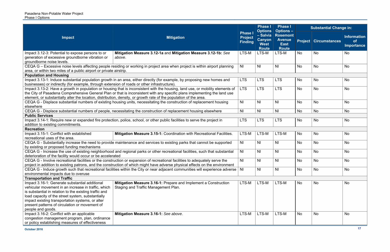
Table 3-2: Assessment of Potential Impacts of the Phase I Options and Evaluation of Substantial Changes to CEQA Findings
Impact Mitigation Phase I Project Finding
Phase I Options – Salvia Canyon
West Route
Phase I Options – Rosemont
Avenue East
Route
Substantial Change in:
Project CircumstancesInformation
of Importance
Aesthetics Impact 3.1-1 – Substantial adverse effect on Scenic Vista
Mitigation Measure 3.1-1: Vegetation Screening and Design Features to Reduce Visual Impacts. Mitigation Measure 3.5-2a: See below for full mitigation measure.
LTS-M LTS-M LTS-M No No No
Impact 3.1-1 – Substantial damage to scenic resources within a state scenic highway
LTS-M LTS-M LTS-M No No No
Impact 3.1-1 – Substantial degradation of the existing visual character or quality of site and surroundings
LTS-M LTS-M LTS-M No No No
Impact 3.1-2 – Creation of a new source of substantial light or glare which would adversely affect views in the area LTS LTS LTS No No No CEQA G – Fail to conform to adopted Design Guidelines or zoning requirements NI NI NI No No No Agriculture Resources CEQA G – Convert Prime Farmland, Unique Farmland, or Farmland of Statewide Importance (Farmland), as shown on the maps prepared pursuant to the Farmland Mapping and Monitoring Program of the California Resources Agency, to nonagricultural use
NI NI NI No No No
CEQA G – Conflict with existing zoning for agricultural use or Williamson Act contract NI NI NI No No No CEQA G - Conflict with existing zoning for, or cause rezoning of, forest land, timberland, or by timberland zoned Timberland Production
NI NI NI No No No
CEQA G - Result in the loss of forest land or conversion of forest land to non-forest use NI NI NI No No No CEQA G – Involve other changes in existing environment which could result in conversion of farmland to non-agricultural uses
NI NI NI No No No
Air Quality Impact 3.3-1 – Conflict with or obstruct applicable air quality plan LTS LTS LTS No No No Impact 3.3-2 – Violate any air quality standard or contribute to an air quality violation LTS LTS LTS No No No
Impact 3.3-3 – Result in cumulatively considerable net increase of any criteria pollutant for which the project region is non-attainment under an applicable ambient air quality standard.
LTS LTS LTS No No No
Impact 3.3-4 – Expose sensitive receptors to substantial pollutant concentrations LTS LTS LTS No No No
Impact 3.3-5 – Create objectionable odors affecting a substantial number of people LTS LTS LTS No No No Biological Resources Impact 3.4-1 – Substantial adverse effect on any candidate, sensitive, or special status species.
Mitigation Measure 3.4-1a: Pre-Construction Surveys for Sensitive Wildlife Species, Coast Horned Lizard (Phase I Project).
LTS-M
LTS-M LTS-M No No No
Impact 3.4-2 – Substantial adverse effect on riparian habitat or other sensitive natural community. LTS LTS LTS No No No Impact 3.4-3 – Substantial adverse effect on federally protected wetlands as defined by Section 404 of the CWA. LTS LTS LTS No No No Impact 3.4-4 – Interfere with movement of any native resident or migratory fish or wildlife species or with established native resident or migratory
Mitigation Measure 3.4-4: Avoid Migratory Bird Nesting Season or Complete Surveys Before Construction Activities.
LTS-M LTS-M LTS-M No No No

Pasadena Non-Potable Water Project Phase I Options
October 2016 14
Impact Mitigation Phase I Project Finding
Phase I Options – Salvia Canyon
West Route
Phase I Options – Rosemont
Avenue East
Route
Substantial Change in:
Project CircumstancesInformation
of Importance
wildlife corridors or impede use of native wildlife nursery sites Impact 3.4-5 – Conflict with any local policies or ordinances protecting biological resources such as a Tree Protection Policy or Ordinance.
LTS LTS LTS No No No
CEQA G - Conflict with the provisions of an adopted Habitat Conservation Plan, Natural Conservation Community Plan, or other approved local, regional, or state habitat conservation plan
NI NI NI No No No
Cultural Resources Impact 3.5-1: Substantial adverse change in the significance of a unique archeological resource or Native American burials.
Mitigation Measure 3.5-1a: Monitor and Report Construction Excavations for Archeological Resources in Less Elevated Areas. Mitigation Measure 3.5-1b: Cease Ground-Disturbing Activities and Report if Archaeological Resources are Encountered. Mitigation Measure 3.5-1c: Stop Construction and Report if Human Remains are Encountered.
LTS-M LTS-M LTS-M No No No
Impact 3.5-2: Substantial adverse change in the significance of a historical resource.
Mitigation Measure 3.5-2a: Comply with the Secretary of the Interior’s Standards for Rehabilitation for pressure reducing station and the Brookside booster pump station, the hydroelectric generation turbine, and the tunnel water pump station to be constructed within the National Register-listed Pasadena Arroyo Parks and Recreation District. Mitigation Measure 3.5-2b: Comply with the Secretary of the Interior’s Standards for Rehabilitation for the pipeline crossing of Arroyo Seco Flood Control Channel at Washington Boulevard.
LTS-M LTS-M LTS-M No No No
Impact 3.5-3: Potential to directly or indirectly destroy a unique paleontological resource or site or unique geologic feature.
Mitigation Measure 3.5-3a: Monitor and Report Construction Excavations for Paleontological Resources in Less Elevated Areas.
LTS-M LTS-M LTS-M No No No
Geology and Soils Impact 3.6-1: Expose people or structures to potential substantial adverse effects, including the risk of loss, injury, or death involving rupture of known earthquake fault, strong seismic ground shaking, seismic-related ground failure, including liquefaction, or landslides.
LTS LTS LTS No No No
Impact 3.6-2: Potential to result in substantial soil erosion or loss of topsoil.
LTS LTS LTS No No No
Impact 3.6-3: Project is located on a geologic unit or soil that is unstable, or that would become unstable as a result of the project, and potentially result in on- or off-site landslide, lateral spreading, subsidence, liquefaction or collapse.
LTS LTS LTS No No No
Impact 3.6-4: Project is located on expansive soil, creating substantial risks to life or property. LTS LTS LTS No No No
CEQA G - Have soils incapable of adequately supporting the use of septic tanks or alternative wastewater disposal systems where sewers are not available for the disposal of waste water
NI NI NI No No No

Pasadena Non-Potable Water Project Phase I Options
October 2016 15
Impact Mitigation Phase I Project Finding
Phase I Options – Salvia Canyon
West Route
Phase I Options – Rosemont
Avenue East
Route
Substantial Change in:
Project CircumstancesInformation
of Importance
Greenhouse Gas Emissions Impact 3.7-1: Potential to generate GHG emissions that may have a significant impact on the environment. LTS LTS LTS No No No Impact 3.7-2: Potential to conflict with an applicable plan, policy, or regulation adopted for the purposes of reducing GHG emissions.
LTS LTS LTS No No No
Impact 3.7-3: Preempt future energy development or future energy conservation. LTS LTS LTS No No No Hazards and Hazardous Materials Impact 3.8-1: Potential to create a significant hazard to the public or the environment through the routine transport, use, or disposal of hazardous materials.
LTS LTS LTS No No No
Impact 3.8-2: Potential to create a significant hazard to the public or the environment through reasonably foreseeable accident involving release of hazardous materials to the environment
Mitigation Measure 3.8-2a: Hazardous Materials Management and Spill Prevention and Control Plan. Mitigation Measure 3.8-2b: Contingency Plan for Contaminated Soil and/or Groundwater.
LTS-M LTS-M LTS-M No No No
Impact 3.8-3: Potential to emit hazardous emissions or handle hazardous or acutely hazardous materials, substances, or waste within one-quarter mile of an existing or proposed school.
Mitigation Measure 3.8-2a and Mitigation Measure 3.8-2b: See above.
LTS-M LTS-M LTS-M No No No
Impact 3.8-4: Be located on a site included on a list of hazardous materials sites compiled pursuant to Government Code Section 65962.5 and, as a result, create a significant hazard to the public or environment.
NI NI NI No No No
CEQA G – Result in a safety hazard for people working or residing within an airport land use plan, within two miles of a public or public use airport, or within the vicinity of a private airstrip.
NI NI NI No No No
Impact 3.8-5: Potential to impair implementation of or physically interfere with an adopted emergency response plan or emergency evacuation plan.
Mitigation Measure 3.8-5: Develop and Maintain Emergency Access Strategies
LTS-M LTS-M LTS-M No No No
Impact 3.8-6: Potential to expose people or structures to a significant risk of loss, injury, or death involving wildland fires, including where wildlands are adjacent to urbanized areas or where residences are intermixed with wildlands.
Mitigation Measure 3.8-6: Prevention of Fire Hazards.
LTS-M LTS-M LTS-M No No No
Hydrology and Water Quality Impact 3.9-1: Violate any water quality standards or waste discharge requirements
Mitigation Measure 3.8-2a and Mitigation Measure 3.8-2b: See above.
LTS-M LTS-M LTS-M No No No
Impact 3.9-2: Substantially deplete groundwater supplies or interfere substantially with groundwater recharge such that there would be a net deficit in aquifer volume or a lowering of the local groundwater table level.
LTS LTS LTS No No No

Pasadena Non-Potable Water Project Phase I Options
October 2016 16
Impact Mitigation Phase I Project Finding
Phase I Options – Salvia Canyon
West Route
Phase I Options – Rosemont
Avenue East
Route
Substantial Change in:
Project CircumstancesInformation
of Importance
Impact 3.9-3: Substantially alter the existing drainage pattern of the site or area, including through the alteration of the course of a stream or river, resulting in substantial erosion or siltation
LTS LTS LTS No No No
Impact 3.9-4: Alter the existing drainage pattern of the site or area, increasing the rate or amount of surface water runoff in a manner that could result in flooding on- or off-site.
LTS LTS LTS No No No
Impact 3.9-4: Create or contribute runoff water which would exceed the capacity of existing or planned stormwater drainage systems or provide substantial additional sources of polluted runoff
LTS LTS LTS No No No
CEQA G - Place housing or structures within a 100-year flood hazard area as mapped on a federal Flood Hazard Boundary or Flood Insurance Rate Map or other flood hazard delineation map
NI NI NI No No No
Impact 3.9-5: Expose people or structures to loss, injury, or death involving flooding, including flooding as a result of the failure of a levee or dam
LTS LTS LTS No No No
CEQA G - Expose people or property to inundation from seiche, tsunami, or mudflow NI NI NI No No No Impact 3.9-6: Potential for impacts on the Lower or Central Arroyo Stream Restoration Projects LTS LTS LTS No No No Impact 3.9-7: Potential to adversely affect the Arroyo Seco Golf Course. LTS LTS LTS No No No Land Use and Planning Impact 3.10-1: Physically divide an established community. LTS LTS LTS No No No Impact 3.10-2: Conflict with any applicable land use plan, policy, or regulation of an agency with jurisdiction over the project (including, but not limited to the general plan, specific plan, local program, or zoning ordinance) adopted for the purpose of avoiding or mitigating an environmental effect.
LTS LTS LTS No No No
CEQA G – Conflict with existing habitat conservation plan or natural community conservation plan NI NI NI No No No Mineral Resources CEQA G – Loss of availability of known mineral resources of value to region and residents of state NI NI NI No No No CEQA G – Loss of availability of locally important mineral resource recovery site delineated on local land use plan NI NI NI No No No Noise Impact 3.12-1: Potential to expose persons to or generate noise levels in excess of standards established in local general plan or noise ordinances or applicable standards of other agencies and the potential for a substantial temporary or periodic increase in ambient noise levels in the project vicinity above levels existing without the project.
Mitigation Measure 3.12-1a: Noise Control Measures to Reduce Construction Noise. Mitigation Measure 3.12-1b: Pre-Construction Notification.
LTS-M LTS-M LTS-M No No No
Impact 3.12-2: Potential for a substantial permanent increase in ambient noise levels in the project vicinity above levels existing without the project, in excess of standards established in local general plan or noise ordinances or applicable standards of other agencies
Mitigation Measure 3.12-2: Implement Noise Minimization Measures during Operation.
LTS-M LTS-M LTS-M No No No
Pasadena Non-Potable Water Project Phase I Options
October 2016 17
Impact Mitigation Phase I Project Finding
Phase I Options – Salvia Canyon
West Route
Phase I Options – Rosemont
Avenue East
Route
Substantial Change in:
Project CircumstancesInformation
of Importance
Impact 3.12-3: Potential to expose persons to or generation of excessive groundborne vibration or groundborne noise levels.
Mitigation Measure 3.12-1a and Mitigation Measure 3.12-1b: See above.
LTS-M LTS-M LTS-M No No No
CEQA G – Excessive noise levels affecting people residing or working in project area when project is within airport planning area, or within two miles of a public airport or private airstrip.
NI NI NI No No No
Population and Housing Impact 3.13-1: Induce substantial population growth in an area, either directly (for example, by proposing new homes and businesses) or indirectly (for example, through extension of roads or other infrastructure).
LTS
LTS LTS No No No
Impact 3.13-2: Have a growth in population or housing that is inconsistent with the housing, land use, or mobility elements of the City of Pasadena Comprehensive General Plan or that is inconsistent with any specific plans implementing the land use element, or substantially alter the location, distribution, density, or growth rate of the population of the area.
LTS LTS LTS No No No
CEQA G - Displace substantial numbers of existing housing units, necessitating the construction of replacement housing elsewhere
NI NI NI No No No
CEQA G - Displace substantial numbers of people, necessitating the construction of replacement housing elsewhere NI NI NI No No No Public Services Impact 3.14-1: Require new or expanded fire protection, police, school, or other public facilities to serve the project in addition to existing commitments.
LTS LTS LTS No No No
Recreation Impact 3.15-1: Conflict with established recreational uses of the area.
Mitigation Measure 3.15-1: Coordination with Recreational Facilities. LTS-M LTS-M LTS-M No No No
CEQA G - Substantially increase the need to provide maintenance and services to existing parks that cannot be supported by existing or proposed funding mechanisms
NI NI NI No No No
CEQA G - Increase the use of existing neighborhood and regional parks or other recreational facilities, such that substantial deterioration of the facility would occur or be accelerated
NI NI NI No No No
CEQA G - Involve recreational facilities or the construction or expansion of recreational facilities to adequately serve the project in addition to existing patrons, and the construction of which might have adverse physical effects on the environment
NI NI NI No No No
CEQA G - Induce growth such that recreational facilities within the City or near adjacent communities will experience adverse environmental impacts due to overuse
NI NI NI No No No
Transportation and Traffic Impact 3.16-1: Generate substantial additional vehicular movement in an increase in traffic, which is substantial in relation to the existing traffic and load capacity of the street system, substantially impact existing transportation systems, or alter present patterns of circulation or movement of people and goods.
Mitigation Measure 3.16-1: Prepare and Implement a Construction Staging and Traffic Management Plan.
LTS-M LTS-M LTS-M No No No
Impact 3.16-2: Conflict with an applicable congestion management program, plan, ordinance or policy establishing measures of effectiveness
Mitigation Measure 3.16-1: See above. LTS-M LTS-M LTS-M No No No

Pasadena Non-Potable Water Project Phase I Options
October 2016 18
Impact Mitigation Phase I Project Finding
Phase I Options – Salvia Canyon
West Route
Phase I Options – Rosemont
Avenue East
Route
Substantial Change in:
Project CircumstancesInformation
of Importance
for the performance of the circulation system, taking into account all modes of transportation including mass transit and non-motorized travel and relevant components of the circulation system, including but not limited to intersections, streets, highways and freeways, pedestrian and bicycle paths, and mass transit. CEQA G - Result in a change in air traffic patterns, including either an increase in traffic levels or a change in location that results in substantial safety risks
NI NI NI No No No
CEQA G - Cause alterations to waterborne or rail traffic NI NI NI No No No
Impact 3.16-3: Increase hazards (to motorists, bicyclists, or pedestrians) due to a design feature (e.g., sharp curves or dangerous intersection), other features, or incompatible uses.
Mitigation Measure 3.16-1: See above. LTS-M LTS-M LTS-M No No No
Impact 3.16-4: Result in inadequate emergency access.
Mitigation Measure 3.8-5 and Mitigation Measure 3.16-1: See above. LTS-M LTS-M LTS-M No No No
CEQA G - Affect existing parking facilities, or create a demand for new parking NI NI NI No No No Utilities and Service Systems Impact 3.17-1: Potential to exceed wastewater treatment requirements of the applicable Regional Water Quality Control Board
LTS LTS LTS No No No
Impact 3.17-1: Result in a determination by the wastewater treatment provider which serves or may serve the project that it has inadequate capacity to serve the project’s projected demand in addition to the provider’s existing commitments
LTS LTS LTS No No No
Impact 3.17-1: Require or result in the construction of new water or wastewater treatment facilities or expansion of existing facilities, the construction of which could cause significant environmental effects.
LTS LTS LTS No No No
Impact 3.17-2: Potential to result in the construction of new storm water drainage facilities or expansion of existing facilities, the construction of which could cause significant environmental effects.
LTS LTS LTS No No No
CEQA G - Have insufficient water supplies available to serve the project from existing entitlements and resources, thus requiring new or expanded entitlements
NI NI NI No No No
CEQA G - Be served by a landfill with insufficient permitted capacity to accommodate the project’s solid waste disposal needs
NI NI NI No No No
CEQA G - Not comply with federal, state, and local statutes and regulations related to solid waste NI NI NI No No No
Impact 3.17-3: Result in disruption of utilities. Mitigation Measure 3.17-3a: Coordinate relocation and interruptions of service with utility providers during construction.
Mitigation Measure 3.17-3b: Protect existing utilities.
LTS-M LTS-M LTS-M No No No
Environmental Justice Impact 3.18-1: Cause impacts to minority or low-income populations that are disproportionately high and adverse, either directly, indirectly, or cumulatively.
LTS LTS LTS No No No
Pasadena Non-Potable Water Project Phase I Options
October 2016 19
3.1 Aesthetics
3.1.1 Impact 3.1-1: Potential for substantial damage to scenic vista, scenic resources, and/or degradation of the existing visual character or quality of the site and its surroundings
Less than Significant with Mitigation
The 2016 certified EIR found that, due to the Phase I Project pipelines being located within roadway ROWs and buried, there would be no change to the character of the visual environment or permanent alteration to the visual character or quality of the sites and their surroundings. No significant visual impacts associated with the Phase I Project pipelines were found. The pipelines of the Phase I Options would remain within roadway ROWs and buried, and therefore, no impact would occur, consistent with the Phase I Project.
The 2016 certified EIR minimized visual quality impacts resulting from the Phase I Project aboveground components with Mitigation Measures 3.1-1 and 3.5-2a. The Phase I Options would not alter the visual characteristics or visible design components of the Phase I Project aboveground components and would therefore not change the degree of impacts from the 2016 certified EIR resulting from above ground facilities. There would be no substantial change to visual impact findings in the 2016 certified EIR.
3.1.2 Impact 3.1-2: Potential for creation of a new source of substantial light or glare which would adversely affect day or nighttime views in the area
Less than Significant
The 2016 certified EIR found that new outdoor lighting included in the Phase I Project aboveground facilities would comply with zoning codes regulating glare and outdoor lighting and found impacts to be less than significant. The Phase I Options would not change the lighting components of any of the aboveground facilities. There would be no change to the less than significant conclusion of the 2016 certified EIR for this impact.
3.2 Air Quality
The air quality analysis produced for the Phase I Project was updated for the Phase I Options due to the additional pipeline length and associated increase in excavation activities and duration of construction for the Phase I Options. The following tables include the updated projected emissions that are anticipated to result from the Phase I Options, and includes the entirety of the Phase I Project, as modified by the Phase I Options.
Table 3-3 presents an updated summary of the air quality emissions from construction and operation of the Phase I Project, should the Phase I Options be selected for construction, based on the model effort (using CalEEMod) from Table 3.3-5 of the 2016 certified EIR.

Pasadena Non-Potable Water Project Phase I Options
October 2016 20
Table 3-3: Criteria Pollutant Emissions Generated from the Phase I Project, including the Phase I Options
Components of the Phase I Project
Maximum Daily Emissions (lbs/day)
VOC NOx CO SO2 PM10 PM2.5
Construction Emissions
Pipelines and Conduits (including the Phase I Options)
6.27 59.57 28.94 - 5.71 3.19
Scholl Canyon Non-potable Water Reservoir
1.54 14.54 10.39 0.02 1.85 1.32
Sheldon Non-potable Water Reservoir(s)
1.74 16.34 12.68 0.02 2.07 1.41
Tunnel Water Pump Station 1.50 14.44 9.52 0.01 1.74 1.28
Pressure Reducing Station and Brookside Pump Station
1.50 14.44 9.65 0.01 1.74 1.28
Hydroelectric Generation Facility 1.50 14.44 9.62 0.01 1.77 1.29
Phase I Project (with Phase I Options) Maximum Construction Emissions1
9.55 90.46 52.01 0.04 9.62 5.92
Construction Emission Thresholds2 75 100 550 150 150 55
Significant Construction Emissions NO NO NO NO NO NO
Operational Emissions
Phase I Project (with Phase I Options)Total Local Operational Emissions
0.03 0.12 0.4 0 0.08 0.02
Operational Emission Thresholds2 55 55 550 150 150 55
Significant Operational Emissions NO NO NO NO NO NO 1. These emissions represent a “worst case scenario” for construction where three portions of the
Phase I Project are being constructed simultaneously, including one pipeline component and two additional facilities. As such, these emissions are representative of the maximum potential construction emissions from the Phase I Project.
2. Thresholds based on SCAQMD CEQA Handbook (SCAQMD 1993). Source: RMC using Roadway Construction Emissions Model (Version 7.1.5.1, 2013) and CalEEMod model (2013.2.2, 2013).
Table 3-4 presents an updated overview of emissions associated with the proposed Project (Phase I and Future Extensions), if the Phase I Options are selected, as they relate to compliance with the Federal General Conformity Rule from Table 3.3-7 of the 2016 certified EIR.

Pasadena Non-Potable Water Project Phase I Options
October 2016 21
Table 3-4: Project Compliance with Federal General Conformity Rule1, if the Phase I Options are Selected
Project Components
Annual Emission (Tons/Year)2,3
VOC NOx CO SO2 PM10 PM2.5
Phase I Project
Pipeline Construction (including Phase I Options)
0.60 5.23 2.73 - 0.50 0.30
Reservoirs Construction 0.22 2.06 1.40 0.00 0.19 0.15
Pump Stations Construction 0.18 1.65 1.09 0.00 0.15 0.12
Hydroelectric Generation 0.09 0.83 0.54 0.00 0.08 0.06
Phase I System Operation 0.00 0.36 0.05 0.02 0.01 0.00
Future Extensions
Pipeline Construction 0.40 3.15 3.05 - 0.45 0.2
Pump Stations Construction 0.11 0.99 1.36 0.00 0.10 0.07
Future System Operation 0.00 0.80 0.03 0.04 0.01 0.00
Maximum Construction Emissions from Phase I Project (with Phase I Options) and Future Extensions4
1.00 8.94 5.21 0.00 0.84 0.57
Maximum Operational Emissions from Phase I Project (with Phase I Options) and Future Extensions
0.00 1.16 0.08 0.06 0.02 0.00
Federal General Conformity Rule Thresholds
10 10 100 100 100 100
Significant Construction Emissions
NO NO NO NO NO NO
1. Thresholds applied by Federal General Conformity Rule [40 CFR 93.153(b)(1)]. 2. Calculations for construction were completed using Roadway Construction Emissions Model (Version
7.1.5.1, 2013) and CalEEMod model (2013.2.2, 2013) and are included in Attachment C. 3. Calculations for operations were completed using CalEEMod model (2013.2.2, 2013) and are included
in Attachment C. The emissions listed above are for total annual emission. Note: Operational traffic associated with the proposed Project would be minor and would not contribute further to LOS degradation on City roadways. Therefore, the SCAQMD threshold trigger level for estimating carbon monoxide for project operation would not be activated.
4. These emissions represent a “worst case scenario” for construction where three portions of the Phase I Project are being constructed simultaneously, including one pipeline component and two additional facilities. Given some projects last less than a year, additional project portions were considered in a highly compacted construction schedule. As such, these emissions are representative of the maximum potential construction emissions from the Phase I Project or Future Extensions.
Sources: SCAQMD 2009b; CARB 2007.

Pasadena Non-Potable Water Project Phase I Options
October 2016 22
Changes to the Air Quality emissions from the Phase I Project as analyzed in the 2016 certified EIR and the Phase I Project with the Phase I Options analyzed here are as follows:
Daily construction emissions would be slightly lower because the assumed start date for the project has been pushed back to accommodate the time needed to develop these modifications; the CalEEMod model assumes technological improvements over time that reduce emissions from equipment.
Annual construction emissions would increase slightly because the Phase I Options would involve additional construction and a longer construction schedule compared to the original Phase I Project.
Operational emissions would remain consistent with the original Phase I Project because there would be no change to the volume of water delivered or level of maintenance and service required.
In addition to considering the potential changes in emissions related to the Phase I Options as compared to the Phase I Alignments, the change in location of pipelines could affect different sensitive receptors (both air quality and noise, refer to Section 3.10). A review of sensitive receptors in the vicinity of the Phase I Options found that shifting the pipeline further from residences and closer to the Arroyo Seco Channel resulted in fewer sensitive receptors compared to the Phase I Alignments. Potential air quality impacts to sensitive receptors would be consistent with the 2016 certified EIR.
3.2.1 Impact 3.3-1: Potential to conflict with or obstruct implementation of the applicable air quality plan
Less than Significant
The 2016 certified EIR found that the construction and operation of the Phase I Project would not result in exceedance of any South Coast Air Quality Management District’s (SCAQMD) mass daily thresholds, as shown in Table 3.3-5 of that document. Additionally, mobile sources would be required to follow applicable SCAQMD regulations and utilize approved fuels. As a result, the Phase I Project would not conflict with the 2012 Air Quality Management Plan (AQMP), which established attainment dates for targeted constituents. The Study Area is also regulated by the State Implementation Plan (SIP) set forth by the California Air Resources Board (CARB). The Phase I Project was found not to conflict with local planning documents and therefore, would not obstruct implementation of the SIP, resulting in less than significant impacts.
Per the updated analysis, the Phase I Options would result in slightly lower maximum daily emissions for construction and the same level of operation emissions, as shown in Table 3-3. Consistent with the Phase I Project, the Phase I Options would also not conflict with local planning documents and would not conflict with implementation of the SIPs. Thus, potential conflict or obstruction of implementation of the applicable air quality plan would be less than significant. Findings would be consistent with the 2016 certified EIR.
Pasadena Non-Potable Water Project Phase I Options
October 2016 23
3.2.2 Impact 3.3-2: Potential to violate any air quality standard or contribute substantially to an existing or projected air quality violation
Less than Significant
The 2016 certified EIR found that construction and operation of the Phase I Project would not result in violation of SCAQMD thresholds pertaining to VOCs, NOx, CO, PM10, or PM2.5. Per the results of the 2016 certified EIR’s air quality analysis, as shown in the EIR’s Table 3.3-5, maximum construction emissions would be below the threshold for acute health concerns and are assumed to be under the federal threshold. Impacts were found to be less than significant.
As shown in Table 3-3, operational emissions associated with the Phase I Options would remain unchanged from the Phase I Project. With the exception of SO2, which would remain the same, maximum construction-related emissions would decrease slightly for the Phase I Options. Due to the slight decrease in maximum construction emissions resulting from the Phase I Options, impacts would be consistent with the findings in the 2016 certified EIR (less than significant).
3.2.3 Impact 3.3-3: Potential to result in a cumulatively considerable net increase of any criteria pollutant for which the project region is non-attainment under applicable ambient air quality standard
Less than Significant
The 2016 certified EIR found that construction and operation of the Phase I Project would not result in a cumulatively considerable net increase of any criteria pollutant for which the region is a nonattainment area. The South Coast Air Basin (SCAB) is currently designated as an extreme nonattainment area for O3. NOx is an ozone precursor which has a significance threshold of 100 lbs/day for construction emissions and 55 lbs/day for operational emissions. As shown in the 2016 certified EIR’s Table 3.3-5, NOx emissions resulting from the Phase I Project is anticipated to be below the significance thresholds for both construction and operation. Additionally, particulate matter emissions were found to be well below the SCAQMD threshold with implementation of BMPs. Thus, impacts were found to be less than significant.
Table 3-3 shows that construction-related NOx emissions resulting from the Phase I Options would be 90.46 lbs/day, slightly lower than emissions for the Phase I Project. Operational emissions would remain unchanged (0.12 lbs/day) and well below the significance threshold of 55 lbs/day. Thus, impacts would remain less than significant, consistent with the findings of the 2016 certified EIR.
3.2.4 Impact 3.3-4: Potential to expose sensitive receptors to substantial pollutant concentrations
Less than Significant
The 2016 certified EIR found that impacts to sensitive receptors resulting from Phase I Project construction would be less than significant. The primary hazardous air pollutant expected to be emitted during construction would be diesel particulate matter from large, heavy-duty diesel-powered equipment exhaust, which is described in terms of the amount

Pasadena Non-Potable Water Project Phase I Options
October 2016 24
of PM10 emitted. Health risks associated with PM10 is based on long-term and chronic expose. Construction of the Phase I Project would be temporary, thus, no long-term chronic impacts would occur. Additionally, due to the small size of PM10, the concentration of emissions would be diluted with distance from the emission source. Therefore, impacts to sensitive receptors within the vicinity of the Phase I Project would be much less than PM10 totals shown in Table 3.3-5. Operational emissions would be produced by electricity and would not emit localized emissions. Although the Phase I Project does not include sites with incompatible uses, the Project could expose sensitive receptors to NOx and particulate matter emissions due to the proximity of construction activities to residential neighborhoods. As shown above, emissions resulting from the Phase I Project would be well under relevant local, state, and federal standards relating to NOx and PM10.
Additionally, with implementation of BMPs during construction, including dust control measures, impacts to sensitive receptors were found to be less than significant.
Emissions associated with the Phase I Options would not substantially differ from those emitted from the Phase I Project. As shown in Table 3-3, total construction-related particulate matter and NOx emissions for the Phase I Options would be slightly less than emissions produced under the Phase I Project. Additionally, portions of the Phase I Options would be located further from adjacent residences. Due to this shift, the Phase I Options would result in fewer sensitive receptors within the vicinity of proposed construction activities. The increased distance would allow greater dilution of PM10
produced from large, heavy-duty diesel-powered equipment exhaust. Therefore, impacts would remain less than significant, consistent with the 2016 certified EIR.
3.2.5 Impact 3.3-5: Potential to create objectionable odors affecting a substantial number of people
Less than Significant
The 2016 certified EIR found that VOC emissions and diesel combustion are anticipated to be the highest odor-producing compounds associated with construction and operation of the Phase I Project. Due to compliance with SCAQMD Rule 113, which limits the amount of VOCs from architectural coatings and solvents to reduce emissions of odorous compounds, and the limited amounts of diesel-powered equipment that would need to operate simultaneously for construction and operation of the Phase I Project, VOC emissions would be well below the SCAQMD emissions thresholds. Thus, impacts were found to be less than significant.
Construction and operation activities associated with the Phase I Options would remain in compliance with SCAQMD Rule 113. Additionally, the Phase I Options would not require the use of additional diesel-powered equipment that would operate simultaneously. As shown in Table 3-3, VOC and particulate matter emissions, which are anticipated to be the highest-odor producing compounds resulting from the Phase I Options, would remain below the SCAQMD emissions thresholds. Thus, the Phase I Options would not substantially increase the findings of the 2016 certified EIR associated with the creation of objectionable odors affecting a substantial number of people. Impacts would remain less than significant, consistent with the 2016 certified EIR.

Pasadena Non-Potable Water Project Phase I Options
October 2016 25
3.3 Biological Resources
The Biological Resources Assessment for the Proposed Pasadena Non-Potable Water Project was updated to include assessment of the Phase I Options in the Biological Resources Assessment Addendum (Appendix B).
3.3.1 Impact 3.4-1: Have a substantial adverse effect, either directly or through habitat modifications, on any species identified as a candidate, sensitive, or special-status species in local or regional plans, policies, or regulations, or by the California Department of Fish and Wildlife or U.S. Fish and Wildlife Service
Less than Significant with Mitigation
The 2016 certified EIR found that two sensitive plant species were observed within the Phase I Project Study Area. These CRPR 4.2 species (Watch List) include Southern California black walnut and San Gabriel Mountains leather oak. Both of these species are protected under the City of Pasadena City Trees and Tree Protection Ordinance when their trunk measures 8 inches in diameter-at-breast-height. To protect trees during construction, a Tree Protection Plan would be put in place prior to construction. With implementation of the Tree Protection Plan and compliance with the City of Pasadena City Trees and Tree Protection Ordinance, impacts to sensitive plant species would be less than significant.
The Biological Resources Assessment Addendum concluded that Southern California black walnut and other regulated trees were observed within the Phase I Options Study Area. Although these regulated trees are located within the vicinity of the Phase I Options, construction activities would be limited to the existing paved roadways and disturbed ROWs. Additionally, no regulated tree species are proposed to be removed. Thus, implementation of the Tree Protection Plan and compliance with the City of Pasadena City Trees and Tree Protection Ordinance would reduce impacts to less than significant levels. The Phase I Options would not result in a substantial change to the analysis of the Phase I Project, and would therefore be consistent with the 2016 certified EIR findings.
The 2016 certified EIR found that, although some sensitive animal species could be present within the Study Area, limited suitable habitat is present. Based on project design and limited area of disturbance of the Phase I Project, the extent of impacts to habitat area would be limited and impacts to potential foraging species would be less than significant given that they would continue to forage in surrounding suitable habitat. Several Species of Special Concern could be present including the pallid bat, western mastiff bat, San Diego black-tailed jackrabbit, San Diego desert woodrat, big free-tailed bat, southern grasshopper mouse, and coast horned lizard. Due to limited impacts resulting from the Phase I Project to habitat area, any loss of individuals would not expect to reduce regional population numbers below sustainable population size. All of the Species of Special, with the exception of the coast horned lizard, are sufficiently mobile to escape construction activities resulting in less than significant impacts to these species. Mitigation Measure 3.4-1a would require implementation of measures to reduce impacts to the coast horned lizard to less than significant levels.

Pasadena Non-Potable Water Project Phase I Options
October 2016 26
No additional sensitive animal species were found within the Phase I Options Study Area. Thus, with implementation of Mitigation Measure 3.4-1a to reduce potential impacts to the coast horned lizard, the Phase I Options would remain less than significant with mitigation, consistent with the findings of the 2016 certified EIR.
3.3.2 Impact 3.4-2: Have a substantial adverse effect on any riparian habitat or other sensitive natural community identified in local or regional plans, policies, regulations or by the California Department of Fish and Wildlife or U.S. Fish and Wildlife Service
Less than Significant
The 2016 certified EIR found the Phase I Project area of disturbance does not support riparian habitat or any other sensitive natural communities, therefore no direct impacts are anticipated. The Phase I Project would cross the Arroyo Seco’s concrete channel just north of Washington Boulevard, which may impact jurisdictional areas. Although this crossing would not impact sensitive natural communities, the Phase I Project could have an indirect impact on the Central and Lower Restoration Projects due to the proposed diversion of tunnel water which currently discharges to the Arroyo Seco. Both the Central and Lower Restoration Projects contain sensitive natural communities. Due to these potential indirect impacts, a hydrologic analysis was conducted, and determined that there would be sufficient water to maintain the sensitive natural communities for the Lower and Central Restoration Projects throughout the year. Additionally, the proposed operation and monitoring (O&M) program includes implementation of the monitoring program as described in the 2016 certified EIR’s Biological Resources Assessment, which allows for adaptive management in the case that changes in the habitat areas are observed over time. The 2016 certified EIR found that with monitoring and restrictive flow diversions, impacts would be less than significant and no mitigation would be required.
The Phase I Options would not affect the crossing of the Arroyo Seco, nor change how the Project’s tunnel water diversion could have potential indirect impacts on the Central and Lower Restoration Projects that were addressed in the 2016 certified EIR. The Biological Resources Assessment Addendum found that, although nine sensitive natural communities occur within the area, the Phase I Options Study Area does not support any riparian habitat or other sensitive natural communities. Therefore, no impacts would occur and no mitigation would be required. Because the impacts associated with the Phase I Options would be less substantial than impacts resulting from the Phase I Project, the findings would fall within the less-than-significant finding of the 2016 certified EIR, and would therefore be consistent with the 2016 certified EIR.
3.3.3 Impact 3.4-3: Have a substantial adverse effect on federally protected wetlands as defined by Section 404 of the Clean Water Act (including, but not limited to, marsh, vernal pool, coastal, etc.) through direct removal, filling, hydrological interruption, or other means
Less than Significant
The 2016 certified EIR found that the Study Area does not support federally protected wetlands as defined by CWC Section 404, and therefore, no impacts are anticipated to

Pasadena Non-Potable Water Project Phase I Options
October 2016 27
occur with implementation of the Phase I Project. However, the 2016 certified EIR found that a portion of the Phase I Project crosses a section of the Arroyo Seco. Although the Arroyo Seco is channelized within the Study Area, it is considered a regulated water course under the jurisdiction of U.S. Army Corps of Engineers (USACE), Regional Water Quality Control Board, Los Angeles Region (LARWQCB), and California Department of Fish and Wildlife (CDFW). Thus a detailed jurisdictional delineation of the Arroyo Seco is required to be conducted. Additionally, the following permits from regulatory agencies must be obtained for impacts to a jurisdictional feature: CWA Section 404 Nationwide Permit from USACE, CWA Section 401 Water Quality Certification from LARWQCB, and CFGC Section 1602 Streambed Alteration Agreement from CDFW. Because the Arroyo Seco is channelized at the crossing location and does not support wetlands, riparian habitat, or any vegetation, and impacts would be temporary and the concrete channel would be restored to pre-construction conditions following pipeline installation, impacts would be less than significant and no mitigation would be required.
As with the Phase I Project, the Study Area of the Phase I Options does not support federally protected wetlands as defined by CWC Section 404, and therefore, no impacts are anticipated to occur. However, a portion of the Rosemont Avenue East Route of the Phase I Options located along the north side of Del Monte Street includes a concrete-lined drainage ditch, which is a potentially jurisdictional feature. Consistent with the 2016 certified EIR, prior to any ground disturbing activities, a detailed jurisdictional delineation of this feature would be conducted to determine the extent of jurisdiction that may be subject to regulations of the USACE, LARWQCB, and/or CDFW. If the concrete-lined ditch is determined to be jurisdictional, the following permits from regulatory agencies would be obtained: CWA Section 404 Nationwide Permit from USACE, CWA Section 401 Water Quality Certification from LARWQCB, and CFGC Section 1602 Streambed Alteration Agreement from CDFW. However, because the concrete-lined ditch does not support wetlands, riparian habitat, or vegetation, and impacts to the potentially jurisdictional feature would be temporary and returned to pre-construction conditions, impacts would be less than significant and no mitigation is required, consistent with the findings of the 2016 certified EIR.
3.3.4 Impact 3.4-4: Interfere substantially with the movement of any native resident or migratory fish or wildlife corridors, or impede the use of native wildlife nursery sites
Less than Significant with Mitigation
The 2016 certified EIR found that, although the Phase I Project Study Area is not likely to contain suitable habitat that would provide functionality to facilitate wildlife movement for wildlife species on a regional scale, the area does support potential habitat for species on a local scale. Movement on a local scale likely occurs with species adapted to urban environments due to the existing disturbance and high level of development within the Phase I Project area and immediate vicinity. Species adapted to urban areas would be expected to persist on-site following construction, therefore, any disturbance to local wildlife movement would be negligible and impacts would be less than significant.

Pasadena Non-Potable Water Project Phase I Options
October 2016 28
However, the Phase I Project area does support potential nesting habitat for song birds and raptors. Disturbing or destroying active nests is a violation of the Migratory Bird Treaty Act (MBTA). Implementation of Mitigation Measure 3.4-4 would require avoidance of vegetation removal during the nesting season (February 15 to August 31), or thorough surveys of all suitable nesting habitat conducted by a qualified biologist for the presence of nesting birds. Mitigation Measure 3.4-4 would reduce any potential impacts to less than significant.
The Phase I Options Study Area supports some habitat that could be utilized by species for wildlife movement on a local scale, though it provides little to no function to facilitate wildlife movement on a regional scale. Additionally, species located within the vicinity of the Phase I Options are likely to be adapted to urban environments due to the existing developed nature of the area. Therefore, impacts resulting from the Phase I Options would remain less than significant, consistent with the 2016 certified EIR.
Nesting song birds and raptors do have the potential to occur within the vicinity of the Phase I Options. Mitigation Measure 3.4-4 would be sufficient to avoid significant impacts to nesting birds protected by the MBTA. Therefore, there would be no change to the degree of impacts resulting from the Phase I Options, and impacts would remain less than significant with mitigation incorporated. Findings are consistent with the 2016 certified EIR.
3.3.5 Impact 3.4-5: Conflict with any local policies or ordinances protecting biological resources, such as a tree preservation policy or ordinance
Less than Significant
The 2016 certified EIR found that several trees are located within or immediately adjacent to the Phase I Project. Trees to be protected during construction were identified by an arborist and the boundary of the root zones were delineated to ensure impacts would be minimized. Additionally, PWP would prepare and implement a Tree Protection Plan and would comply with the Pasadena’s City Trees and Tree Protection Ordinance, which would minimize impacts to less than significant levels.
Numerous trees are located immediately adjacent to the footprint of the Phase I Options. A tree inventory consistent with the City Trees and Tree Protection Ordinance was conducted by an ISA-certified arborist to document all protected trees that could potentially be impacted (i.e., native, specimen, and landmark trees, as defined by the City of Pasadena). The Pasadena Non-Potable Water Project Arborist Report (Arborist Report) is available on the Project website. The Arborist Report contains detailed information on the number of trees with root zones potentially located within the proposed pipeline trench, the type of trees, exact location, and the overall health of each tree. The proposed Phase I Alignments have more trees with roots potentially extending into the trench zone than the Phase I Options. However, the pipeline will be installed at the edge of the tree canopy (and anticipated root zone), and tree roots within roadways are typically limited due to soil compaction, water and oxygen availability. It is expected that roots encountered within the alignments would be small, up to 2 inches in diameter, and would make up a very small portion of the trees’ total root mass. The Arborist Report provides recommendations for monitoring, trenching and excavation, equipment storage, and

Pasadena Non-Potable Water Project Phase I Options
October 2016 29
pruning to help prevent permanent damage to trees during construction. Implementation of the recommendations in the Arborist Report, which is a commitment in the 2016 certified EIR, would allow for impacts resulting from the Phase I Options to remain less than significant, consistent with the 2016 certified EIR.
3.4 Cultural Resources
The Cultural Resources Assessment for the Proposed Pasadena Non-Potable Water Project was updated to include assessment of the Phase I Options in the Cultural Resources Assessment Addendum (Appendix C).
3.4.1 Impact 3.5-1: Potential to cause a substantial adverse change in the significance of a unique archaeological resource, including Native American Burials, pursuant to §15064.5
Less than Significant with Mitigation
The 2016 certified EIR found that, according to records at the CHRIS-SCCIC, one archeological resource is located within the vicinity of the Phase I Project at the Sheldon Reservoir site. A subsurface survey completed in July 2011 revealed three soil anomalies. Based on the potential impact associated with construction within the vicinity of Target of Interest (TOI) 1 and Anomalies 1 and 2, the Sheldon Non-potable Water Reservoir was designed to avoid impacting these sensitive resources. Fencing would be constructed around the extent of the TOI and anomalies, and no construction activities would be conducted within the fence boundary. Construction of the Sheldon Non-potable Water Reservoir would be overseen by a certified archaeological monitor. Although no mitigation was recommended in the Cultural Resources Assessment due to design of Sheldon Non-potable Water Reservoir and fencing, Mitigation Measure 3.5-1a would be implemented to ensure impacts are minimized to the fullest extent. Additionally, archeological surveys of the Phase I Project identified multiple Native American village areas near the Arroyo Seco. Implementation of Mitigation Measures 3.5-1a, 3.5-1b, and 3.5-1c would include monitoring, reporting, and construction restrictions to reduce impacts associated with discovery of archeological resources. Impacts were found to be less than significant with mitigation incorporated.
According to the Cultural Resources Assessment Addendum, no additional archeological resources were identified within proximity to the Phase I Options. Mitigation Measures 3.5-1a, 3.5-1b, and 3.5-1c would reduce any potential impacts to the above mentioned archeological resources resulting from the Phase I Options to less than significant, and would therefore be consistent with the finding of the 2016 certified EIR.
3.4.2 Impact 3.5-2: Cause a substantial adverse change in the significance of a historical resource as defined in §15064.5
Less than Significant with Mitigation
The 2016 certified EIR found that the Phase I Project has the potential to impact two identified historical resources: the Arroyo Seco Flood Control Channel and the Pasadena Arroyo Parks and Recreation District. The Arroyo Seco Flood Control Channel, a National Register eligible property, would be impacted by pipeline crossing of the Arroyo Seco at

Pasadena Non-Potable Water Project Phase I Options
October 2016 30
Washington Boulevard. The installation of pipelines would require the use of open trench construction, which has the possibility to impair the concrete construction of the resource. Additionally, the Phase I Project would cause indirect impacts to the Pasadena Arroyo Parks and Recreation District, listed on the National Register, through the visual impacts associated with construction and operation of a pressure reducing station and tunnel water pump station both adjacent to the National Register-listed district. Mitigation Measure 3.5-2a would require conformance with the Secretary of the Interior’s Standards for Rehabilitation to ensure the Arroyo Seco Flood Control Channel is reconstructed to its preexisting conditions and that visual impacts associated with the construction of the PRS are and pump station are minimized. Implementation of Mitigation Measure 3.5-2a would make certain the Phase I Project would not detract from the integrity of the identified historic resources and that the significance of the resources would be retained following completion of the Phase I Project. With implementation of Mitigation Measure 3.5-2a, impacts would be less than significant.
The Phase I Options would be located primarily within the boundaries of the previously identified Pasadena Arroyo Parks and Recreation District, with the exception of the Salvia Canyon Route along Salvia Canyon Road and a small portion of the Rosemont Avenue Route north of the Washington Boulevard and Del Monte Street intersection. Two additional potential resources were identified adjacent to the Phase I Options in the Cultural Resources Assessment Addendum: PWP-Site-1 is a segment of a stone-lined wall located near the intersection of West Drive and Salvia Canyon Road and PWP-Site-2 is a cement-lined drainage ditch along the north edge of Del Monte Street. Both resources were identified as being located within the boundaries of the Arroyo Parks and Recreation District. Although the stone wall is not particularly mentioned as a contributing or non-contributing feature in the Department of Parks and Recreation (DPR) Site Form for the District, the wall still forms part of the landscape for the District. The stone wall would not be physically impacted by pipeline construction. The drainage ditch is not mentioned as a contributing feature to the District and does not appear to be associated with a larger landscape, significant person or event, or have distinctive characteristics. No further research or mitigation is necessary for the drainage ditch. Implementation of Mitigation Measure 3.5-2a would be sufficient to reduce potential visual impacts to identified historical resources resulting from the Phase I Options to less than significant with mitigation, and findings would therefore be consistent with the 2016 certified EIR.
3.4.3 Impact 3.5-3: Potential to directly or indirectly destroy a unique paleontological resource or site or unique geologic feature
Less than Significant with Mitigation
The 2016 certified EIR found that because fossils have been identified approximately 3.5 miles southwest of the Study Area in deposits at the surface, the Phase I Project would have the potential to impact paleontological resources during excavation activities. Due to the potential impacts to paleontological resources, Mitigation Measure 3.5-3a would be implemented to require monitoring and reporting if paleontological resources are discovered during construction of the Phase I Project. With incorporation of Mitigation Measure 3.5-3a, impacts would be reduced to less than significant.

Pasadena Non-Potable Water Project Phase I Options
October 2016 31
The Phase I Options would be within proximity to the previously discussed identification of fossils. Because the Phase I Options would be located in the same general area as the Phase I Project, the degree of impacts to paleontological resources would not change. Implementation of Mitigation Measure 3.5-3a would reduce impacts resulting from the Phase I Options to less than significant levels, consistent with the 2016 certified EIR.
3.5 Geology and Soils
3.5.1 Impact 3.6-1: Expose people or structures to potential substantial adverse effects, including the risk of loss, injury, or death involving rupture of known earthquake fault, strong seismic ground shaking, seismic-related ground failure, including liquefaction, or landslides
Less than Significant
The 2016 certified EIR found the Phase I Project would be constructed in a recognized seismic hazard zone and some components may be located within the Fault Hazard Management Zone. However, the Preliminary Geological Feasibility Study found that the Phase I Project was not within an area of recognized active faulting, that there were no Special Study Zones within the Pasadena Quadrangle, and there was no indication of active faulting during site reconnaissance (AMEC 2010). The 2016 certified EIR concluded that the Phase I Project would have a less than significant impact with regard to exposing people or structures to potential adverse effects relating to strong seismic ground shaking, or seismic-related ground failure (i.e., liquefaction, or landslides). Additionally, the 2016 certified EIR concluded that due to the proximity of the Study Area to active faults, there would be potential for the Phase I Project to experience strong ground motion and associated liquefaction and landslides resulting from a moderate to large earthquake. However, design of the Phase I Project would conform to the City of Pasadena Water Department Seismic Criteria Document, reducing seismic hazard and ground failure impacts to less than significant.
The Geotechnical Investigation Report for the Phase 1 Recycled Water Project, developed by AMEC in 2012, identified potential for liquefaction and seismically-induced settlement in the low-lying areas of the proposed Project activities. As shown in Figure 3-1, the Phase I Options would shift the proposed pipelines further into the liquefaction hazard zone, resulting in additional pipeline within the liquefaction hazard zone as compared to the Phase I Alignments. RMC and AMEC Foster Wheeler reviewed the alignments and concluded that the Phase I Options would require installation of approximately 8,600 LF of additional pipeline (4,300 LF along the Salvia Canyon West Route and 4,300 LF along the Rosemont Avenue East Route) in the areas identified as potentially liquefiable zones, which also has potential for seismically induced settlements compared to the Phase I Alignment. The Phase I Options would increase the portion of the alignment in the potentially liquefiable area from 17% to 60% of the alignment. Under current groundwater conditions, the 2012 report found liquefaction and seismically induced settlement potential is low, even in these areas, though future risks could increase if groundwater recharge north of Devils Gate Dam increases.

§̈¦210
WASHINGTON
ARROYO
ROSEMONT
ROSEMONT
Rosemont AvenueEast Route
Salvia CanyonWest Route
ProposedEast Route
ProposedWest Route
WEST
ARROYOROSEMONT
FOREST
LINDA
VIST
A
CANADA
SECO
WASHINGTON
ZANJA
HOWARD
MONTANAINVERNESS
CASIT
AS
KENN
ETH
ARMADA
DEL MONTE
PARKVIEW
WILL
IS
BLAK
E
WYOMING
PROS
PECT
STANTON
ROSE BOWL
PEPPER
HAMMONDDEVON
AFTON
CONISTON
WESTGATE
NORMANDY
EL MIRADOR
WICKS
YOCUM
TOOLEN
PALISADE
CLAREMONT
LAUN
BRYANT
WINONA
VERMONT
SALVIA CANYON
PASADENA
WOTKYNS
PARN
ELL
LINDA RIDGE
BANYAN
EVERTS
LAUREL
BRAEMAR
SOLIT
AMACDONALD
PUTNEY
DEXT
ER
LA CRESTA
CHARLESWABASH
LA MESA
MOUNTAIN
WEIMAR
CYPRESS
YUCCA
SELKIRK
HEATHERSIDE
RICHLAND
ROSE
WALK
LOMAY
RANCHEROS
BENNETT
ANDERS ON
SERVICE
HUFF
ER
CHULA VISTA
ARMADA
WABASH
AFTON
PALISADESO
LITA
CYPR
ESS
ROSE
BOWL
AFTON
CHARLES
ARRO
YO SE
CO
N:\Pro
jects\
0129 -
Pasad
ena W
ater a
nd Po
wer\0
129-00
5.03 P
WP RW
Adde
ndum
\04_G
raphic
s\01_G
IS\MX
D\Seis
mic H
azards
for P
hase
I Opti
onsv5
.mxd
Pasadena Non-Potable Water Project
Phase I Alignment andPhase I Options
Geologic Hazards Figure 3-1
0 800 1,600400Feet
±
Sources: California Geological Survey. 1999. Seismic Hazard Mapping Program. Pasadena Quandrangle.
Proposed AlignmentsPhase I AlignmentsRosemont Avenue East RouteSalvia Canyon West Route
Geologic HazardsLandslide PotentialLiquefaction Potential

Pasadena Non-Potable Water Project Phase I Options
October 2016 33
Design of the Phase I Options would also conform to the standards specified in the City of Pasadena Water Department Seismic Criteria Document, reducing potential liquefaction and seismic impacts. As a result of design standard compliance, impacts would remain less than significant, consistent with the finding for the Phase I Project.
3.5.2 Impact 3.6-2: Potential to result in substantial soil erosion or loss of topsoil
Less than Significant
The 2016 certified EIR found the Phase I Project would disturb at least 1.0 acre of soil, which requires compliance with the Construction General Permit. The Construction General Permit requires the development of a stormwater pollution prevention plan (SWPPP) which outlines BMPs to reduce erosion and top soil loss, resulting in less than significant impacts.
The Phase I Options would disturb a larger surface area than the original Phase I Project, and would also have to comply with the Construction General Permit, requiring development of a SWPPP to minimize erosion and top soil loss. There would be no change in the degree of impacts from the 2016 certified EIR. Impacts would remain less than significant for the Phase I Options.
3.5.3 Impact 3.6-3: Project is located on a geologic unit or soil that is unstable, or that would become unstable as a result of the project, and potentially result in on- or off-site landslide, lateral spreading, subsidence, liquefaction, or collapse
Less than Significant
The 2016 certified EIR found the Phase I Project would extend across an alluvial plain which has potential for liquefaction, collapse, and expansion. Additionally, Phase I Project components were found to be located near and cross the Arroyo Seco drainage channel, suggesting the facilities may be susceptible to the impacts of collapsible soils. The Phase I Project would adhere to the standards set forth within the City of Pasadena Water Department Seismic Criteria Document, which addresses specific design criteria related to potential landslide and ground failure areas, and provides guidelines to reduce potential impacts in these areas to a less than significant level. With adherence to the City of Pasadena’s seismic-related guidelines, impacts were found to be less than significant.
Similar to the Phase I Alignments, portions of the Phase I Options would be located within areas that are susceptible to liquefaction, landslides, or collapse (see Figure 3-1). The proposed Phase I Options would result in 8,600 LF of additional pipeline (4,300 LF along the Salvia Canyon West Route and 4,300 LF along the Rosemont Avenue East Route) within the liquefaction hazard zone because it would shift the alignment further into the hazard zone as compared to the Phase I Alignment. However, design of the Phase I Options would also comply with the City of Pasadena Water Department Seismic Criteria Document. This document provides engineering and design standards to protect infrastructure from the risks of geotechnical hazards, minimizing the potential for pipeline failure from unstable soils. Similar to the Phase I Alignments, design of the Phase I Options, if selected, would incorporate protective measures consistent with applicable design standards for unstable soils and in areas of potential liquefaction. As a result, there

Pasadena Non-Potable Water Project Phase I Options
October 2016 34
would be a less than significant impact resulting from unstable soils and potential ground failure, consistent with the conclusions of the 2016 certified EIR.
3.5.4 Impact 3.6-4: Project is located on expansive soil, potentially creating substantial risks to life or property
Less than Significant
The 2016 certified EIR found that, although potentially expansive soils are known to exist within the City of Pasadena, expansive soils are not anticipated to be encountered during construction of the Phase I Project. Pipelines would be constructed outside any expansive layers that are uncovered during excavation, resulting in less than significant impacts.
Similarly, expansive soils are not anticipated to be encountered during excavation for the Phase I Options. If expansive soils are encountered, Phase I Option pipelines would be constructed outside the expansive layers, resulting in no change to the less than significant impact found in the 2016 certified EIR.
3.6 Greenhouse Gas Emissions
The air quality analysis, which includes an analysis of GHG emissions, produced for the Phase I Project was updated for the Phase I Options. The analysis was updated due to the additional pipeline length and associated increase in duration of construction for the Phase I Options. The following tables include the updated projected GHG emissions that are anticipated to result from the Phase I Project should the Phase I Options be selected.
Table 3-5 provides an updated summary of projected GHG emissions for the Phase I Project from Table 3.7-1 of the 2016 certified EIR to reflect the anticipated GHG emissions should the Phase I Options be selected during construction of the Phase I Project. Table 3-6 provides the total emissions resulting from the Proposed Project, including the modified Phase I alignment, and the net GHG emissions resulting from operations of the Proposed Project, updated from Tables 3.7-3 and 3.7-5 of the 2016 certified EIR.

Pasadena Non-Potable Water Project Phase I Options
October 2016 35
Table 3-5: Projected GHG Emissions from Phase I Project including the Phase I Options
Phase I Project Components
Construction Emission
(MT CO2e/Year)
Amortized Construction
Emission1
(MT CO2e/Year)
Operation Emission -
Direct2
(MT CO2e/Year)
Operation Emission - Indirect3
(MT CO2e/Year)
Operation Emission -
Total
(MT CO2e/Year)
Pipeline (including Phase I Options)
575 19 - - -
Reservoirs 200 7 5 - 5
Pump Station and Pressure Reducing Stations
143 5 5 448 453
Hydro Electric Generation
72 2 2 - 2
Total GHG Emissions
990 33 12 448 460
Table 3-6: Total and Net Operation Proposed Project Emissions from Phase I Project, including Phase I Options, and Future Extensions
Proposed Project Components
Amortized Construction
Emission
(MT CO2e/Year)
Operation Emission -
Total
(MT CO2e/Year)
Total Emission
(MT CO2e/Year)
GHG Offset
(MT CO2e/Year)
Net Emission
(MT CO2e/Year)
Phase I Project (including Phase I Options)
33 460 493 580 -87
Future Extensions 14 1,039 1,053 1,943 -890
Total GHG Emissions
47 1,499 1,546 2,523 -977
Similar to the results of the air quality analysis for emissions associated with the modified Phase I Project alignment, annual construction emissions of GHGs would increase as a result of the increased duration of construction for Phase I and the additional excavation required for the longer pipelines in the Phase I Options.
1 Construction emissions are amortized for 30 years based on SCAQMD guideline. 2 Direct operational emission is mostly associated with vehicle exhaust gas emissions from O&M
activities. 3 Indirect operational emission is associated with energy consumption at pumping facilities and is
calculated based on worst-case EPA eGRID emissions factors for the CAMX subregion encompassing the majority of California (2014) as recommended by SCAQMD staff.

Pasadena Non-Potable Water Project Phase I Options
October 2016 36
3.6.1 Impact 3.7-1: Potential to generate GHG emissions that may have a significant impact on the environment
Less than Significant
The 2016 certified EIR found that the Phase I Project would not significantly impact the environment resulting from generation of GHGs. According to the CalEEMod model and the project non-potable water demands associated with the Phase I Project, GHG emissions resulting from both construction and operation are estimated to be 490 MTCO2e/year. SCAQMDs established threshold of significance for GHG emissions is 10,000 TCO2e/year, therefore, emissions resulting from the Phase I Project as analyzed in the 2016 certified EIR would be well below this threshold. Impacts were found to be less than significant.
As shown in Table 3-5, estimated GHG emissions for the Phase I Options would increase slightly to 493 MTCO2e/year (33 MTCO2e/year for construction and 460 MTCO2e/year for operations). Due to the insubstantial increase in estimated GHG emissions for the Phase I Options, emissions would remain below the 10,000 MTCO2e/year significance threshold and impacts would be less than significant. Thus, findings would be consistent with the 2016 certified EIR.
3.6.2 Impact 3.7-2: Potential to conflict with an applicable plan, policy, or regulation adopted for the purposes of reducing GHG emissions
Less than Significant
The 2016 certified EIR found that the Phase I Project would not conflict with applicable plans, policies, or regulations adopted for the purpose of reducing GHG emissions. Applicable adopted plans, policies, and regulations include CARB’s Recommended Approaches for Setting Interim Significance Thresholds for Greenhouse Gases under the California Environmental Quality Act, the City of Pasadena’s Green City Action Plan, and the City of Glendale’s Greener Glendale Plan for Community Activities. As analyzed in the 2016 certified EIR, estimated GHG emissions resulting from the Phase I Project would be well below the CARB’s adopted GHG threshold of 10,000 MTCO2e/year. Additionally, the City of Pasadena’s Green City Action Plan, and the City of Glendale’s Greener Glendale Plan for Community Activities both call for expansion of recycled water use and reduction of GHG emissions. Conveyance of imported water supplies to Southern California has an approximate energy intensity of 11,111 kWh/MG, whereas recycled water has an energy intensity of 2,100 kWh/MG, per information from the CAPCOA. Increasing recycled water infrastructure and use not only aligns with these plans, but also offsets the need for imported water supplies, thereby offsetting associated GHG emissions. Thus the Phase I Project would be in compliance with applicable plans, policies and regulations adopted to reduce GHG emissions. Impacts were found to be less than significant.
Table 3-5 shows that GHG emissions resulting from the Phase I Options would remain below established significance thresholds. The Phase I Options would not change the amount of recycled water produced by the Project, and would thus not change the offset of imported water or associated offset in GHG emissions. Therefore, the Phase I Options

Pasadena Non-Potable Water Project Phase I Options
October 2016 37
would not conflict with applicable plans, policies, or regulations and findings would be consistent with the 2016 certified EIR (less than significant).
3.6.3 Impact 3.7-3: Preempt future energy development or future energy conservation
Less than Significant
The 2016 certified EIR found that, although the Phase I Project would require energy during construction, operation, and maintenance, energy-requiring activities would not be wasteful, inefficient, or result in unnecessary consumption of energy. The Phase I Project would adhere to energy-reducing regulations such as Title 24, Part 6 of the California Code of Regulations, which contains building efficiency requirements to address regulations such as AB 32. Additionally, the energy used for production and distribution is less than the energy required to convey imported water to Southern California. The Phase I Project was found to not preempt future energy development or conservation resulting in less than significant impacts.
The Phase I Options would not substantially increase energy-requiring activities from activities associated with the Phase I Project. Energy-requiring activities associated with construction, operation, and maintenance of the Phase I Options would not be wasteful, inefficient, or result in unnecessary consumption of energy and would comply with all applicable regulations to reduce energy consumption. Thus, impacts would remain less than significant, consistent with the 2016 certified EIR.
3.7 Hazards and Hazardous Materials
3.7.1 Impact 3.8-1: Potential to create a significant hazard to the public or the environment through the routine transport, use, or disposal of hazardous materials
Less than Significant
The 2016 certified EIR found the Phase I Project would temporarily increase routine transport and use of hazardous materials for construction, as well as for operation of some Phase I components, including pump stations, the Sheldon Non-potable Water Reservoir’s chlorine contact basin, and the hydroelectric generation turbine.
Other than a minor modification to the PRS at Washington Avenue and West Drive to accommodate a different point of connection to the pipeline, the Phase I Options would not change the identified components’ operation. Construction of the Phase I Options would be longer than that of the Phase I Alignment, but would have similar level of temporary use of hazardous materials associated with construction. There would be no change in the degree of impact from the 2016 certified EIR (less than significant).

Pasadena Non-Potable Water Project Phase I Options
October 2016 38
3.7.2 Impact 3.8-2: Potential to create a significant hazard to the public or the environment through reasonably foreseeable upset and accident conditions involving the release of hazardous materials into the environment
Less than Significant with Mitigation
The 2016 certified EIR found only one hazardous site within the Phase I Project, the Scholl Canyon Landfill. Construction of the Phase I Project would involve the use of hazardous materials during, which could create a hazard through reasonably foreseeable upset and accident conditions involving the release of these materials. The Phase I Project would also involve excavation, which could encounter unknown contaminated soil or groundwater. Mitigation Measures 3.8-2a and 3.82b, requiring implementation of a Hazardous Materials Management Spill Prevention and Control Plan and a Contingency Plan for Contaminated Soil and/or Groundwater, respectively, would reduce potential impacts to less than significant.
As shown in Appendix D, review of the EnviroStor and Geotracker databases identified no known hazardous sites within the Phase I Options (DTSC, 2016 and SWRCB, 2016). Consistent with the Phase I Project, the Phase I Options would involve the use of hazardous materials during construction and excavation. Mitigation Measures 3.8-2a 3.82b would be sufficient to reduce potential impacts resulting from the Phase I Options to less than significant, consistent with the analysis of the Phase I Project in the 2016 certified EIR.
3.7.3 Impact 3.8-3: Potential to emit hazardous emissions or handle hazardous or acutely hazardous materials, substances, or waste within one-quarter mile of an existing or proposed school
Less than Significant with Mitigation
Seven schools were identified within one quarter mine of the Phase I Project. Of these schools, only two, Cleveland Elementary School and Chandler School, are within one quarter mile from the Rosemont Avenue East Route, and none are located within one quarter mile from the Salvia Canyon West Route.
Because the Phase I Options would shift the alignment closer to the Brookside Golf Course than the Phase I Alignment, the modifications are further from developed areas, and no additional schools beyond those already identified in the 2016 certified EIR are within the one-quarter mile radius of the Phase I Options. Mitigation Measures 3.8-2a and 3.8-2b would be implemented for the Phase I Options, consistent with the Phase I Project, and there would be no change to the less than significant with mitigation conclusion of the 2016 certified EIR for this impact.

Pasadena Non-Potable Water Project Phase I Options
October 2016 39
3.7.4 Impact 3.8-4: Be located on a site which is included on a list of hazardous materials sites compiled pursuant to Government Code Section 65962.5 and, as a result, would create a significant hazard to the public or the environment
No Impact
The 2016 certified EIR found that, because the Phase I Project does not occur on sites listed as hazardous materials sites compiled pursuant to Government Code Section 65962.5, no impacts would occur.
As stated above, a review of the EnviroStor and Geotracker databases found no known hazardous materials sites within the Phase I Options. There would be no impact for the Phase I Options related to known hazardous materials sites, consistent with the no impact conclusion for the Phase I Project.
3.7.5 Impact 3.8-5: Potential to impair implementation of or physically interfere with an adopted emergency response plan or emergency evacuation plan
Less than Significant with Mitigation
The Phase I Project would involve construction activities that would necessitate temporary lane and/or road and driveway closures. Fire Station 38 and the Rose Bowl were identified as providing emergency services whose access may be affected by the Phase I Project. The fire station would provide fire and public safety services, while the Rose Bowl is identified as a potential Disaster Medical Assistance Center during an emergency situation. Fire Station 38 is located on Linda Vista Avenue, but would not have construction on its stretch of Linda Vista Avenue under the Phase I Project. Potential access issues associated with the Phase I Project for Fire Station 38 would be indirect and associated with construction on Afton Street and the stretch of Linda Vista from Afton Street north to Laurel Street. Although construction activities associated with the Phase I Project would be located along roadways that provide access to the Rose Bowl, construction of pipelines along Rosemont Avenue/Rose Bowl Drive would not be anticipated to impact access to the Rose Bowl. West Drive, located along the west side of Brookside Golf Course, would remain open during construction of the Phase I Project, providing access to the Rose Bowl during an emergency.
The Phase I Options would avoid the use of Linda Vista Avenue, but would still include construction at the intersection of Afton Street and Linda Vista at Salvia Canyon Road that would require partial closure of the intersection. It would also require partial closure of Salvia Canyon Road and West Drive, which could affect access to emergencies along the Arroyo Seco. Because the Phase I Options would temporarily indirectly affect access for Fire Station 38, Mitigation Measure 3.8-5, requiring development of emergency access strategies and notification of emergency service providers of construction zones, would still apply, and would reduce impacts to less than significant, consistent with the 2016 certified EIR.
Construction activities along West Drive and Rosemont Avenue under the Phase I Options could affect access to the Rose Bowl due to temporary lane closures. Construction along the Phase I Option routes would not occur simultaneously, allowing West Drive to serve as an access route during construction on Rosemont Avenue and

Pasadena Non-Potable Water Project Phase I Options
October 2016 40
vice versa. Construction would require temporary lane closures along the roadways, but at least one lane of the road would remain open during construction. Suggested revisions to Mitigation Measure 3.16-1 requiring a Construction Staging and Traffic Management Plan (see Section 3.16) would further ensure that the construction contractor provides access to all traffic lanes along West Drive and Rosemont Avenue in case of an emergency. Access to Rose Bowl would therefore remain available, consistent with the analysis in the 2016 certified EIR, and impacts would be less than significant.
3.7.6 Impact 3.8-6: Potential to expose people or structures to a significant risk of loss, injury, or death involving wildland fires, including where wildlands are adjacent to urbanized areas or where residences are intermixed with wildlands
Less than Significant with Mitigation
The Phase I Project would primarily be located within roadway ROWs and immediately adjacent vacant and open space lands. The western portion of the Phase I Project was identified as being within a “Very High”, “High”, and “Moderate” fire hazard areas. Along the Salvia Canyon West Route, Salvia Canyon Road and the southern portion of West Drive are located within a “Very High” fire hazard zone, while no part of the Rosemont Avenue East Route is located within an identified fire hazard zone.
By shifting the alignment, the Phase I Options pose less risk of wildfire than the Phase I Alignments, though some risk would remain along the Salvia Canyon West Route. Mitigation Measure 3.8-6, requiring fire safety measures during construction, would reduce these risks to less than significant, consistent with the Phase I Project.
3.8 Hydrology and Water Quality
3.8.1 Impact 3.9-1: Violate any water quality standards or waste discharge requirements
Less than Significant with Mitigation
In the 2016 certified EIR, the Phase I Project was found to have the potential to violate water quality standards or waste discharge requirements only as a result of accidental release of hazardous materials used during construction or for operation of the project facilities. The SWPPP and compliance with the Construction General Permit would prevent construction pollutants entering storm water and keep products of erosion from moving offsite into receiving waters. The production, storage, and use of recycled water would be in compliance with all applicable regulations and its use has been communicated to the Raymond Basin Management Board (RBMB) for inclusion in the Salt and Nutrient Management Plan for the underlying groundwater basin.
The Phase I Options would not change how non-potable water is stored, conveyed, or used, and would remain in compliance with all applicable regulations, consistent with the Phase I Project. The Phase I Options would also utilize the same construction methods as the Phase I Alignments. Mitigation Measure 3.8-2a would remain applicable to the Phase I Options and impacts would be less than significant, consistent with the 2016 certified EIR.

Pasadena Non-Potable Water Project Phase I Options
October 2016 41
3.8.2 Impact 3.9-2: Substantially deplete groundwater supplies or interfere substantially with groundwater recharge such that there would be a net deficit in aquifer volume or a lowering of the local groundwater table level
Less than Significant
As described in the 2016 certified EIR, the Phase I Project would not affect groundwater levels or substantially interfere with groundwater recharge because it would not involve the use of groundwater. The only groundwater pumping that could occur under the Phase I Project is dewatering during construction, although no groundwater was encountered during test borings. The tunnel water that forms one source of non-potable water supply for the Phase I Project is groundwater that has surfaced, but would only be part of the non-potable system after it has surfaced. No part of the Phase I Project would interfere with groundwater recharge.
The Phase I Options would not add any groundwater related infrastructure. Consistent with excavation activities included in the Phase I Project, the Phase I Options could require dewatering during construction, which would be conveyed to the sewer system and treated to protect downstream water quality. Potential impacts to groundwater from the Phase I Options would be less than significant, consistent with the 2016 certified EIR.
3.8.3 Impact 3.9-3: Potential to substantially alter the existing drainage pattern of the site or area, including through the alteration of the course of a stream or river, resulting in substantial erosion or siltation
Less than significant
The Phase I Project was found to have a less than significant impact on the area’s drainage pattern that would result in substantial erosion or siltation. The preparation and implementation of the SWPPP and compliance with the State’s Construction General Permit would require erosion control BMPs to reduce water quality impacts from erosion or siltation to less than significant.
The proposed Phase I Options would remain subject to these and other applicable regulations and permits, and would therefore also have a less than significant impact to water quality from erosion or siltation. The Phase I Options would not change the grading necessary for the Phase I Project, though it would involve excavation for an additional 3,700 LF of pipeline. The surface would be restored to pre-project conditions following construction. The Phase I Options would not alter the drainage pattern of project area, and potential impacts would be less than significant, consistent with the findings of the 2016 certified EIR.

Pasadena Non-Potable Water Project Phase I Options
October 2016 42
3.8.4 Impact 3.9-4: Potential to alter the existing drainage pattern of the site or area, increasing the rate or amount of surface water runoff in a manner that could result in flooding on- or off-site; or
Create or contribute runoff water which would exceed the capacity of existing or planned stormwater drainage systems
Less than Significant
The 2016 certified EIR concluded the Phase I Project would have less than significant impacts related to altering the drainage pattern of the area that would result in flooding or creating or contributing runoff that would exceed the capacity of stormwater drainage systems. The Phase I Project would restore disturbed surfaces to pre-project conditions for the pipelines, and any runoff from aboveground facilities would be conveyed to the City of Pasadena or the County of Los Angeles’s curb and gutter storm drainage systems.
The Phase I Options would be located underground and its surface area restored to pre-project conditions. As a result, the Phase I Options would not change the existing drainage system, result in flooding, or create additional runoff that would exceed the capacity of the existing stormwater system. Impacts would be less than significant, consistent with the findings of the 2016 certified EIR.
3.8.5 Impact 3.9-5: Potential for exposure of people or structure to loss, injury, or death involving flooding
Less than Significant
No part of the Phase I Project is located within a FEMA-designated 100-year flood zone. The Devil’s Gate Dam is located in the vicinity of the Phase I Project, but most of the water from Devil’s Gate Reservoir that could be released in the event of a dam failure would be confined to the Arroyo Seco channel. The Phase I Project would not expose people to flood-related hazards as a result of the failure of a levee or dam. All storage reservoirs would be designed in accordance with the American Water Works Association (AWWA) and California Building Code (CBC) seismic design standards and would include required safety factors to prevent catastrophic failure.
The Phase I Options would not affect the design or construction of Phase I storage reservoirs, nor would it increase human activity within PWP’s service area. The modified alignments would shift pipeline locations closer to the Arroyo Seco channel, and within low lying ground downstream of Devil’s Gate Dam, but would not substantially increase any impacts related to flooding from the Phase I Project. Impacts would be less than significant, consistent with the findings of the 2016 certified EIR.
3.8.6 Impact 3.9-6: Potential for impacts on the Lower or Central Arroyo Stream Restoration Projects
Less than Significant
The Phase I EIR evaluated the Project’s potential for impacts on the Lower or Central Arroyo Stream Restoration Projects. Of the components included in the Project, only the diversion of tunnel water had the potential ability to affect streamflows in the Arroyo Seco channel. A water balance and flow assessment completed for the 2016 certified EIR found

Pasadena Non-Potable Water Project Phase I Options
October 2016 43
that even if tunnel water flows were zero, sufficient flows would exist to maintain the downstream restoration projects. As a result, the pipelines included in the Project, including the Phase I Project, would have no impact to the Lower or Central Arroyo Stream Restoration Projects. The PEIR found less than significant impacts from the Phase I Project to the Lower or Central Arroyo Stream Restoration Projects. Despite the less than significant finding, the 2016 certified EIR O&M program includes a monitoring program (CRAM Assessment and Monitoring Program) to allow for adaptive management of tunnel water diversions such that impacts to the Lower and Central Arroyo Stream Restoration Projects from the proposed project remain less than significant.
The Phase I Options would not affect the volume or timing of tunnel water diversions, nor would they alter the O&M program. As such, the Phase I Options would not result in a change to the significance level in the 2016 certified EIR. Impacts would be less than significant, consistent with the 2016 certified EIR.
3.8.7 Impact 3.9-7: Potential to adversely affect the Arroyo Seco Golf Course
Less than Significant
Potential impacts to Arroyo Seco Golf Course were evaluated in the 2016 certified EIR because the golf course uses water diverted from the Arroyo Seco Channel for irrigation part of the year. The Arroyo Seco Golf Course also receives municipal water from the City of South Pasadena, who has accounted for all of the golf course’s demands in its water planning, and would therefore be able to meet the golf course’s full irrigation demands in normal years. As a result, the Phase I Project was found to have a less than significant impact in the 2016 certified EIR.
The Phase I Options would not change the volume of water diverted from the Arroyo Seco Channel by the Phase I Project, and therefore would have the same level of potential impact on the Arroyo Seco Golf Course as the Phase I Project. Impacts would remain less than significant, consistent with the findings of the 2016 certified EIR.
3.9 Land Use and Planning
3.9.1 Impact 3.10-1: Physically divide an established community
Less than Significant
The Phase I Project was found to have less than significant impacts related to physically dividing an established community in the 2016 certified EIR. For the Phase I Project, no roadways, walls, barriers, or other obstructions would be constructed that would physically divide a neighborhood or community, nor would it permanently interfere with pedestrian, bicycled, or vehicle transit within the project area. The 2016 certified EIR acknowledged the Phase I Project would require temporary impacts to roadways along the pipeline alignment, but that these pipelines would be underground and posed no long-term impact to roadways.
The Phase I Options would also be buried pipelines, and despite temporary roadway impacts during construction (including potential lane closures), at least one lane would remain open at all times. There would be no long term impacts from the Phase I Options

Pasadena Non-Potable Water Project Phase I Options
October 2016 44
associated with dividing a community. Impacts from the Phase I Options would be less than significant, consistent with the findings of the 2016 certified EIR.
3.9.2 Impact 3.10-2: Conflict with any applicable land use plan, policy, or regulation of an agency with jurisdiction over the project (including, but not limited to the general plan, specific plan, local coastal program, or zoning ordinance) adopted for the purpose of avoiding or mitigating an environmental effect
Less than Significant
The 2016 certified EIR concluded that the Phase I project would have less than significant impacts to land use, and that the Phase I Project would not conflict with any applicable land use plans, policies, or regulations adopted for the purpose of avoiding or mitigating an environmental effect. The Phase I Project would construct recycled water infrastructure consistent with the plans and planning goals of the applicable jurisdictions. Further, because it would largely be constructed within existing ROWs and vacant land, the Phase I Project would not conflict with land use plans.
The Phase I Options only include additional pipelines, and would not include any new aboveground facilities, nor would it relocate aboveground facilities already included in the Phase I Project. The Phase I Options would construct the same type of infrastructure, and would construct the modified pipelines within the existing ROWs, consistent with the Phase I Project. Therefore, the Phase I Options would have a less than significant impact to land use plans, policies, or regulations and impacts would remain less than significant, consistent with the 2016 certified EIR.
3.10 Noise
3.10.1 Impact 3.12-1: Potential for a substantial temporary or periodic increase in ambient noise levels in the project vicinity above levels existing without the project, in excess of standards established in local general plan or noise ordinances or applicable standards of other agencies
Less than Significant with Mitigation
The 2016 certified EIR found that construction of the Phase I Project would generate temporary and intermittent noise at and within the immediate vicinity of the various facility components. Certain construction activities, such as roadway trenching, generate impulsive noise, which can be perceived as a nuisance. Construction-related material haul trips would raise ambient noise levels along haul routes depending on the number of haul trips and the types of vehicles used. As shown in Table 3.12-1 of the 2016 certified EIR, sensitive receptors within 50 feet of construction activities associated with the Phase I Project would be subjected to construction-related noise levels ranging from 76 dBA to 89 dBA; sensitive receptors within 100 feet of construction activities would be subjected to construction-related noise levels ranging from 65-84 dBA. Receptors in closer proximity than 50 feet, such as those in proximity to the Sheldon Non-potable Water Storage Reservoir(s), could experience even higher noise levels. With the implementation of Mitigation Measures 3.12-1a and 3.12-1b, which would ensure that construction-related

Pasadena Non-Potable Water Project Phase I Options
October 2016 45
measures consistent with Pasadena’s Noise Ordinance are in place and would require notification to residents located within 500 feet of construction activities, noise impacts related to short-term construction activities would be less than significant.
The Phase I Options would replace approximately 6,800 LF of pipeline in the vicinity of the Arroyo Seco with approximately 10,500 LF of pipeline (increasing the total pipeline length of the Phase I Project from 24,600 to 28,300 LF). Because the length of the Phase I Options would be approximately 3,700 LF longer than the original Phase I Alignment, there could be potential for exposure of additional sensitive receptors to construction related noise. A review of sensitive receptors in the vicinity of the Phase I Options found fewer sensitive receptors adjacent to the Phase I Options than adjacent to the Phase I Alignment because the pipeline would be further from residences. All receptors along the Salvia Canyon West Route would be located at least 50 feet from the Proposed West Route. No receptors within this 50 foot zone would be closer to the Rosemont Avenue East Route than they would be to the Proposed East Route. Additionally, the alignments would be down a steep hillside from the residential properties for both Phase I Options. The distance added by the slope between the alignments and the receptors would further attenuate construction-related noise. Therefore, the increased pipeline length would not increase the potential noise impacts to sensitive receptors from that of the Phase I Project. With the distance of receptors located at least 50 feet from the Phase I Options and the added distance due to the sloping hillsides, Mitigation Measures 3.12-1a and 3.12-1b would reduce noise-related impacts to less than significant levels, consistent with the findings of the 2016 certified EIR.
3.10.2 Impact 3.12-2: Potential for a substantial permanent increase in ambient noise levels in the project vicinity above levels existing without the project, in excess of standards established in local general plan or noise ordinances or applicable standards of other agencies
Less than Significant with Mitigation
The 2016 certified EIR found that the above-ground components of the Phase I Project could produce noise during operational activities that would permanently increase ambient noise. Despite this potential, no above-ground components were anticipated to significantly increase ambient noise because of design-related noise reduction features and distance to nearby receptors. However, predicting noise during design of facilities is difficult, and although not anticipated, noise levels could potentially exceed ambient levels by greater than City of Pasadena regulations permit. Mitigation Measure 3.12-2 would include noise dampening features to reduce impacts resulting from potential permanent increases in ambient noise to less than significant levels.
The Phase I Options would not change noise levels produced by any above-ground components, nor would it change the location, type, or number of aboveground components. The only design change to aboveground components that would occur under the Phase I Options would be a minor adjustment to the PRS to accommodate the change in connection point to the pipeline. There would be no change in the degree of impact from the 2016 certified EIR, which would remain less than significant with mitigation.
Pasadena Non-Potable Water Project Phase I Options
October 2016 46
3.10.3 Impact 3.12-3: Potential to expose persons to or generation of excessive ground-borne vibration or ground-borne noise levels
Less than Significant with Mitigation
The 2016 certified EIR found that construction activities associated with the Phase I Project could result in ground-borne vibration impacts to sensitive receptors or cause damage to buildings or structures. Vibration from construction activities is typically below the threshold of perception when the activity is more than about 50 feet from the receiver. Construction activities located less than 50-feet from construction could exceed the 0.04 inch/second peak particle velocity (PPV) for annoyance. As a result, construction of Phase I Project facilities has the potential to expose nearby sensitive receptors to vibrations. Mitigation Measures 3.12-1a and 3.12-1b would ensure that measures will be taken to ensure that noise-related vibration does not impact receptors or structures within 50 feet of construction activities. The 2016 certified EIR found impacts resulting from ground-borne vibrations to be less than significant after mitigation.
Shifting the pipeline from the Phase I Alignment to the Phase I Options would reduce the number of receptors located within the 50 foot zone. Some structures and buildings would be located approximately 50 feet from the roadway where pipeline construction would occur and may have the potential to be located within 50 feet of construction activities. The location of the Phase I Options would be at a greater distance from buildings and sensitive receptors, thus resulting in a lesser degree of overall impacts. With implementation of Mitigation Measures 3.12-1a and 3.12-1b, there would not be a substantial change in the degree of impacts from the 2016 certified EIR. Impacts resulting from ground-borne vibrations due to construction of the Phase I Options would remain less than significant with mitigation.
3.11 Population and Housing
3.11.1 Impact 3.13-1: Induce substantial population growth in an area, either directly (by proposing new homes and businesses) or indirectly (through extension of roads or other infrastructure)
Less than Significant
The 2016 certified EIR concluded that the Phase I Project would have a less than significant impact to population growth. The Phase I Project would not directly induce growth because it would not provide additional housing, jobs, infrastructure to support such growth, or otherwise serve development. The 2016 certified EIR considered the Phase I Project’s indirect contribution to population growth, primarily as a result of offsetting potable demands such that the offset potable water may otherwise be used. However, the intent of the Project is to secure reliable water supplies because imported supplies face potential curtailments in the future. The 2016 certified EIR found that using offset potable supplies to support unplanned growth would be inconsistent with the intent of the Project.
The Phase I Options would not change the goals and objectives of the Phase I Project, nor would it construct infrastructure that would support uses beyond that of the goals of the Phase I Project. The Phase I Options would not directly induce growth because it

Pasadena Non-Potable Water Project Phase I Options
October 2016 47
would not construct housing, create job opportunities that would lead to growth, or build infrastructure to support growth. Impacts would remain less than significant, consistent with the Phase I Project.
3.11.2 Impact 3.13-2: Have a growth in population or housing that is inconsistent with the housing, land use, or mobility elements of the City of Pasadena Comprehensive General Plan or that is inconsistent with any specific plans implementing the land use element, or
Substantially alter the location, distribution, density, or growth rate of the population of the area
Less than Significant
As described in the 2016 certified EIR, the Phase I Project would not result in population or housing growth inconsistent with relevant plans. Short-term employment from the Phase I Project would be from construction, which would not alter the City’s job/housing balance in a manner that would require additional housing. Long-term employment from the Phase I Project would be limited to O&M, which could be accommodated by PWP’s current staffing levels.
The Phase I Options would extend the construction schedule by approximately 19 days (assuming 200 LF per day, and the 3,700 LF increase in total pipeline length), which would not affect the City’s job/housing balance. The Phase I Options would not alter required O&M beyond adding 3,700 LF of pipeline for inspection and maintenance. This additional pipeline (a 15% increase over the Phase I Project as presented in the 2016 certified EIR) does not represent substantial additional O&M effort because pipeline O&M is minimal compared to that of other Phase I Project components. This O&M would be accommodated under PWP’s current staffing plan. Impacts would be less than significant, consistent with the 2016 certified EIR.
3.12 Public Services
3.12.1 Impact 3.14-1: Require new or expanded fire protection or police facilities to serve the project in addition to existing commitments
Less than Significant
The 2016 certified EIR found the Phase I Project would not directly or indirectly induce population growth requiring new or expanded fire protection, police services, or other local public service providers. Construction of the Phase I Project could result in accidents in work areas or along hauling routes, temporarily increasing demand for emergency services. Any increase in demand for public services would be temporary and would be accommodated by existing service providers within the Study Area, resulting in less than significant impacts.
Consistent with the Phase I Project analyzed in the 2016 certified EIR, the Phase I Options would not directly or indirectly induce population growth requiring the need for additional fire protection, police services, or other local public service providers. It may temporarily, but not significantly, increase the demand for emergency services in the

Pasadena Non-Potable Water Project Phase I Options
October 2016 48
event of an unforeseen accident. There would be no change to the less than significant conclusion of the 2016 certified EIR for this impact.
3.13 Recreation
Due to the Phase I Options location along the Rose Bowl Loop and its access roads, coupled with high recreational use of the area, a recreation survey was conducted on September 1, 2016. Counts were taken at two locations, along the Salvia Canyon West Route on West Drive, and along the Rosemont Avenue East Route along Rosemont Avenue. Table 3-8 provides a summary of the recreation counts recorded on September 1. A full description of the traffic and recreation counts are located in Appendix E.
Table 3-8: Recreation Counts along the Phase I Options
Phase I Options Recreation Counts
Salvia Canyon West Route Rosemont Avenue East Route Date: 9/1/16 Time: 4:30-5:30 PM Date: 9/1/16 Time: 6:00-7:00 PM
Bicycle Peloton
Walk/Jog
Skate/ Scooter
Bicycle Peloton Walk/ Jog
Skate/ Scooter
Northbound 73 17 65 1 18 0 156 2 Southbound 2 0 43 0 120 38 163 5 Total 75 17 107 1 138 38 319 7
3.13.1 Impact 3.15-1: Conflict with established recreational uses of the area
Less than Significant with Mitigation
The 2016 certified EIR found that, due to the close proximity of Phase I Project construction activities to Brookside Park, Rose Bowl Stadium, Brookside Golf Course, and Scholl Canyon Golf Course, impacts to recreational uses of the area could be potentially significant. However, all pipelines would be buried following construction and would not impact adjacent recreational uses in the long term. Temporary lane and road closures could impede access to these recreational facilities, though the facilities would remain open for public use. Due to increases in traffic congestion during Rose Bowl displacement events, construction of the Phase I Project would be scheduled around these events to avoid further traffic impacts and access to the recreational facilities. Given that construction of the pipeline alignment would occur at a rate of approximately 200 feet per day, impacts to any specific area would insignificant. Construction of the Phase I Project would involve construction of PRS facilities adjacent to the Rose Bowl Loop, an existing 3.3 mile paved recreational loop that wraps around Brookside Golf Course and extends south of the Rose Bowl, which may require detours of the trail for approximately 4 to 12 months. The disruption of the trail would require a short detour of recreational users around the construction zone during construction activities, allowing for continued use of the trail during Phase I Project construction. In addition to coordination of construction schedules and events and the trail detour, Mitigation Measure 3.15-1 would be implemented to minimize any additional disruptions to recreational uses within the Study Area. Impacts were found to be less than significant with mitigation.

Pasadena Non-Potable Water Project Phase I Options
October 2016 49
The Phase I Options would be located within roadway ROWs adjacent to Brookside Park, Rose Bowl Stadium, and Brookside Golf Course, along portions of the Rose Bowl Loop on West Drive and Rosemont Avenue. Construction of the Phase I Options would require lane closures, with flagging to alternate northbound and southbound traffic, thus impacting recreational uses of the trail and impeding access to recreational facilities. Lane closures along the Phase I Options would impact bicyclists in the area because they would have to share travel lanes with vehicles and stop for traffic control measures (flagging) in the areas under construction. The Rose Bowl area is a popular location for group bike rides, categorized in counts as “pelotons”, that involve riding laps around the Rose Bowl Loop. Such lap-riding could be interrupted each time bicyclists entered the construction area. Pedestrians and other users of the Rose Bowl Loop would be able to continue using the loop unimpeded because of proposed concrete K-rail to protect the pedestrian track. Construction activities and staging areas for the Phase I Options would not infringe upon Arroyo Seco Trail (the equestrian trail on the slope above the Rose Bowl Loop), though a temporary detour may be required at roadway crossings on Salvia Canyon Road, Del Monte Road, and Rosemont Avenue. With coordination of construction schedules for the Phase I Options, detours provided for recreational users, and Mitigation Measure 3.15-1, impacts to recreational uses of the area would not substantially change from impacts associated with the Phase I Project. Suggested revisions to Mitigation Measure 3.16-1 requiring a Construction Staging and Traffic Management Plan (see Section 3.16) would further ensure that the construction contractor provides safe access and traffic controls for pedestrians, bicyclists, and equestrians along the Phase I Options. Therefore, impacts would be less than significant with mitigation, consistent with the 2016 certified EIR.
3.14 Traffic and Transportation
Due to the location of the Phase I Options along roadways which provide access to high use recreational facilities, including the Brookside Golf Course and the Rose Bowl, and which provide access to surrounding residential areas, a traffic survey was conducted. Counts were taken on September 1, 2016 at two locations, along the Salvia Canyon West Route on West Drive and along the Rosemont Avenue East Route along Rosemont Avenue. Table 3-9 provides a summary of the traffic recorded along the Phase I Options on September 1, 2016. A full description of the traffic and recreation counts are located in Appendix E.
Table 3-9: Traffic Counts along the Phase I Options
Phase I Options Traffic Counts
Salvia Canyon West Route Rosemont Avenue East Route
Date: 9/1/16 Time: 4:30-5:30 PM Date: 9/1/16 Time: 6:00-7:00 PM Car Truck Car Truck Northbound 33 0 75 1 Southbound 37 0 60 1 Total 70 0 135 2

Pasadena Non-Potable Water Project Phase I Options
October 2016 50
3.14.1 Impact 3.16-1: Generate substantial increase in traffic, which is substantial in relation to the existing traffic and load capacity of the street system, substantially impact existing transportation systems, or alter present patterns of circulation or movement of people and goods
Less than Significant with Mitigation
The 2016 certified EIR found that, while the Phase I Project would not result in significant long-term traffic impacts, increases in construction-related traffic could result in temporary, significant impacts. Construction of the Phase I Project would include a peak of 30 round trips per day, consisting of 20 round trips associated with worker travel to and from the construction sites, and up to 10 delivery/soil export trips per day. Although construction-related impacts would be temporary, the majority of worker trips would occur during AM and PM peak hours, potentially causing a significant increase in peak hour traffic. Additionally, construction-related truck trips would lessen the capacities of access streets and haul routes due to the slower movement and larger turning radii of construction trucks compared to passenger vehicles, although impacts would not be considered substantial because they would be scattered throughout the day and geographically throughout the Study Area.
Lane closures would occur along certain streets during construction of the Phase I Project. During construction-related activities associated with alignments installed within roadway ROWs, at least one lane is anticipated to remain open for traffic for most ROW segments. A limited number of local residential streets would be entirely closed for short durations of time. Segments of the Phase I Project are located within proximity to the Rose Bowl, which is subject to large amounts of traffic during displacement events.
Due to the potential significant impacts associated with increases in construction-related traffic and potential lane and street closures, Mitigation Measure 3.16-1 would require development and implementation of a Construction Staging and Traffic Management Plan (CSTMP). Implementation of the CSTMP would ensure safety measures and traffic detours are in place to decrease potential impacts associated with increased traffic and potential lane or street closures. Additionally, to minimize traffic congestion near the Rose Bowl, the CSTMP would require coordination of timing of proposed Project construction and limits on construction during displacement events.
The Phase I Options would not increase the number of assumed construction-related trips per day, or impacts associated with daily worker and truck trips. The number of overall construction-related truck trips would increase due to the increased duration of construction resulting from the additional pipeline length of the Phase I Options. As with the Phase I Project, temporary lane or street closures may occur during construction of the Phase I Options. Due to the proximity of the Phase I Options to the Rose Bowl, potential impacts could occur, particularly during displacement or emergency events. As described in Sections 3.7 and 3.13, the degree of potential impact associated with the Phase I Options is higher due to lane closures during emergency events and shared use of travel lanes by vehicles and bicyclists. Several suggested modifications to Mitigation Measure 3.16-1, shown below in underline, would ensure that the CSTMP manages 1) traffic on alternative routes in event of an emergency, 2) equestrian crossings of the

Pasadena Non-Potable Water Project Phase I Options
October 2016 51
alternative pipelines, and 3) combined car/bike traffic within shared lanes. With implementation of Mitigation Measure 3.16-1, including the proposed additions below, impacts would remain less than significant, consistent with findings of the 2016 certified EIR.
Mitigation Measure 3.16-1: Prepare and Implement a Construction Staging and Traffic Management Plan in Coordination with Responsible Agencies. Prior to construction, PWP’s contractor will submit a Construction Staging and Traffic Management Plan (“CSTMP”) to the City of Pasadena’s Department of Public Works for review and approval. The contractor will also work with the neighboring jurisdictions within the Study Area that are responsible agencies (City of Glendale, City of La Cañada Flintridge, City of San Marino, and the community of Altadena) to ensure that the jurisdictions concur with the CSTMP.
The CSTMP will show the impact of various construction stages on the public right-of-way, including work in public right-of-way such as lane closures, detours, staging areas, entry and exit points for staging areas, routes of construction vehicles entering and exiting the construction site(s), as well as parking for construction vehicles, equipment, and workers. The plan will also describe traffic control measures that would be implemented to manage traffic and reduce potential traffic impacts in accordance with stipulations of the Manual of Uniform Traffic Control Devices (“MUTCD”). Traffic control measures may include, but are not limited to: flag persons, warning signs, lights, barricades and cones to provide safe passage of vehicular (including public transportation vehicles such as buses), bicycle (children and adults), and pedestrian traffic (both adults and children), and access by emergency responders. In addition, the plan will demonstrate the location of bus stops and bus and bicycle routes that would be temporarily impacted by construction activities and will recommend places to temporarily relocate bus stops and bus and bicycle routes. The CSTMP will include detours for equestrians to safely cross the construction alignment on impacted roadways.
The Plan will also identify anticipated timing and duration of lane and/or street closures, the number of lanes to be closed along each street, proposed detours and the anticipated number of vehicles that will use each detour. Both automobile and recreational (pedestrian, bike, equestrian) lane closures and detours will be addressed and traffic controls will be provided if it’s necessary to combine automobiles and bicyclists in shared travel lanes. The CSTMP will include plans for managing traffic on all routes in the event of an emergency, including full use of travel lanes for access to the Rose Bowl for emergency services. It will also include a plan to manage traffic during Rose Bowl events.
The CSTMP will include project contact information to be circulated with appropriate neighborhood notices of construction and provided to appropriate neighborhood associations. The project contact(s) will be available for calls during construction hours, and an emergency contact available at all times during the proposed Project. Project contact(s) will be the point of contact for stakeholders over any non-emergency situation that may arise related to construction of the proposed Project to ensure enforcement of the CSTMP. Construction traffic will be limited to streets and roadways

Pasadena Non-Potable Water Project Phase I Options
October 2016 52
designated in the CSTMP, and notifications will be provided to neighbors and neighborhood associations for potential upcoming lane and road closures prior to such closures. To the extent practicable, safe, quiet, and “clean” trucks and equipment will be used during project construction, and dust and clean-up measures will be implemented including, but not limited to, power street sweeping and hand brooming along vehicular access drives to the work site(s) and adjacent parking areas. Other site cleaning activities will be required as necessary, and trucks transporting earthwork, debris, or other dust-generating materials will cover their loads with tarps.
A Utility Excavation permit will be obtained from the City of Pasadena’s Department of Public Works for use of other public right-of-ways. Lane closures will be done in accordance with the latest edition of the MUTCD. If the public right-of-way occupation requires a diagram that is not included based on the MUTCD, a separate traffic control plan must be submitted as part of the CSTMP to the City of Pasadena’s Department of Public Works for approval and will also be submitted to the City of Glendale, City of La Cañada Flintridge, City of San Marino, and the community of Altadena) to ensure that all jurisdictions concur with the plan.
3.14.2 Impact 3.16-2: Conflict with an applicable congestion management program, plan, ordinance, or policy establishing measures of effectiveness for the performance of the circulation system, taking into account all modes of transportation including mass transit and non-motorized travel and relevant components of the circulation system, including but not limited to intersections, streets, highways and freeways, pedestrian and bicycle paths, and mass transit
Less than Significant with Mitigation
The 2016 certified EIR found that the Phase I Project would not conflict with adopted policies plans, or programs regarding public transit, bicycle, or pedestrian facilities on a long-term basis. Construction of the Phase I Project could potentially result in a temporary conflict with applicable policies, plans, or programs regarding public transit, bicycle, or pedestrian facilities. The Phase I Project would result in approximately 30 additional trips per day and would thus not conflict with the Los Angeles County Congestion Management Plan threshold of creating an increase of 50 or more peak hour trips on freeway on- or off-ramp, or addition of 150 or more trips, in either direction, on the mainline of a freeway during a weekday peak hour. Mitigation Measure 3.16-1 would reduce any potential construction impacts resulting from temporary lane and street closures to less-than-significant levels by specifying the temporary relocation of bus stops and bus and bicycle routes.
The Phase I Options also do not conflict with adopted policies plans, or programs regarding public transit, bicycle, or pedestrian facilities on a long-term basis, as all roadways would be returned to pre-construction conditions upon completion of the Project. Construction of the Phase I Options would require temporary lane closures, and could potentially result in a temporary conflict with applicable plans or policies. Due to the increase in duration of construction resulting from the increased pipeline length of the Phase I Options, the degree of impacts would be slightly greater than that of the Phase I

Pasadena Non-Potable Water Project Phase I Options
October 2016 53
Project. However, implementation of Mitigation Measure 3.16-1, would be sufficient to reduce impacts to less than significant levels. Thus, findings would be consistent with the 2016 certified EIR.
3.14.3 Impact 3.16-3: Increase hazards (to motorists, bicyclists, or pedestrians) due to a design feature (e.g., sharp curves or dangerous intersection), other features, or incompatible uses
Less than Significant with Mitigation
The 2016 certified EIR found that, following construction, the Phase I Project would not increase safety hazards for the public. Construction of the Phase I Project has the potential to temporarily change the configuration of intersections and roadways within the Study Area. During installation of roadway ROW pipeline segments, lane or street closures may be required. Construction along roadways would occur at a rate of approximately 200 feet per day which would limit lane or street closures for each segment. Although limited, lane or street closures could increase conflicts between vehicles, bicyclists, and pedestrians. Mitigation Measure 3.16-1 would require a Construction Staging and Traffic Management Plan, which would minimize construction-related increases in hazards to vehicles, bicyclists, and pedestrians.
Construction of the Phase I Options would also require lane closures along roadway ROWs near the Rose Bowl. The Rose Bowl Loop, along West Drive and Rosemont Avenue, is used heavily by pedestrians and bicyclists. Additionally, these roadways are used heavily by vehicles during Rose Bowl displacement events. West Drive and Rosemont Avenue would likely be limited to one travel lane with a flagging operation to alternate eastbound and westbound traffic. A K-rail barrier protecting the recreational track from the construction zone would be used and bicycles would share the single traffic lane with vehicles and be subject to flagging. The Phase I Options would also have slightly greater impacts to the Arroyo Seco Trail, the equestrian trail on the slope above the Rose Bowl Loop. Lane closures during construction of the Phase I Options have the potential to impact vehicles, bicyclists and pedestrians. As with the Phase I Project, installation of pipeline within ROWs would occur at a rate of approximately 200 feet per day. Mitigation Measure 3.16-1 would require implementation of safety measures and detour routes during construction of the Phase I Options. Several suggested modifications to Mitigation Measure 3.16-1, above, would ensure that the CSTMP manages 1) traffic on alternative routes in event of an emergency, 2) equestrian crossings of the alternative pipelines, and 3) combined car/bike traffic within shared lanes. With Mitigation Measure 3.16-1 potential impacts would be reduced to less than significant, consistent with the 2016 certified EIR.
3.14.4 Impact 3.16-4: Result in inadequate emergency access
Less than Significant with Mitigation
The 2016 certified EIR found that construction of the Phase I Project would have temporary impacts on traffic flow and lane configurations at specific intersections and roadways, thus potentially impacting emergency access within the Study Area. Implementation of Mitigation Measure 3.16-1 would ensure that access for emergency

Pasadena Non-Potable Water Project Phase I Options
October 2016 54
vehicles is maintained in accordance with applicable traffic and safety standards. Additionally, the Construction Staging and Traffic Management Plan would be prepared in conjunction with Mitigation Measure 3.8-5, which requires preparation of emergency access strategies. Within implementation of Mitigation Measure 3.16-1 and Mitigation Measure 3.8-5, adequate emergency access would be maintained during construction of the Phase I Project.
Lane closures would also be required during construction of the Phase I Options, though flagging would be utilized to allow alternating northbound and southbound traffic during construction. Although lengths of the Phase I Options are slightly greater than the Phase I Project, and would thus add additional construction time, implementation of Mitigation Measure 3.16-1 and Mitigation Measure 3.8-5 would ensure adequate emergency access is maintained during construction of the Phase I Options. The Rose Bowl may be used during emergency situations as a Disaster Medical Assistance Center (e.g., evacuation point, temporary shelter, or staging area for emergency operations and/or personnel). Proposed additions to Mitigation Measure 3.16-1, above, address emergency use of the Rose Bowl and require that construction be immediately halted and full access to all travel lanes be restored by temporary backfilling or covering of open trenches. As such, the use of the Rose Bowl in this manner is not anticipated to be impeded by proposed construction activities. With implementation of these mitigation measures, there would be no substantial change to emergency access during construction of the Phase I Options and impacts would be less than significant with mitigation. Findings would be consistent with the 2016 certified EIR.
3.15 Utilities and Service Systems
3.15.1 Impact 3.17-1: Potential to exceed wastewater treatment requirements of the applicable Regional Water Quality Control Board;
Result in a determination by the wastewater treatment provider which serves or may serve the project that it has inadequate capacity to serve the project’s projected demand in addition to the provider’s existing commitments; or
Require or result in the construction of new water or wastewater treatment facilities or expansion of existing facilities, the construction of which could cause significant environmental effects
Less than Significant
The 2016 certified EIR found the Phase I Project would comply with Title 22 of the California Code of Regulations, Division 4, Chapter 3, standards for disinfected tertiary recycled water. Additionally, PWP would obtain a permit from the SWRCB and the LARWQCB for compliance with the State permitting requirements governing the use of recycled water in California. The SWRCB permit would ensure the reasonable protection of surface water and groundwater within the Study Area. With Title 22 compliance and all required permits in place, the Phase I Project would not violate wastewater treatment requirements of the LARWQCB and impacts were found to be less than significant.

Pasadena Non-Potable Water Project Phase I Options
October 2016 55
The Phase I Options would not change compliance with Title 22 regulations or all required permitting with the SWRCB and the LARWQCB, resulting in less than significant impacts. There would be no change to the conclusions of the 2016 certified EIR.
The 2016 certified EIR found the LAG would have sufficient capacity to serve the proposed Project, including the Phase I Project. Recycled water produced at LAG is currently used for plant operations and supplies in the cities of Los Angeles and Glendale, and any excess recycled water that is not beneficially reused is discharged to the Los Angeles River. The City of Pasadena has rights to use water from LAG but is currently not exercising this right due to a lack of non-potable water infrastructure.
The Phase I Options would not change the volume of recycled water that would be delivered through implementation of the proposed Project; therefore capacity requirement of the wastewater treatment facility would not change. Impacts would remain less than significant, consistent with the 2016 certified EIR conclusions.
3.15.2 Impact 3.17-2: Potential to result in the construction of new storm water drainage facilities or expansion of existing facilities, the construction of which could cause significant environmental effects
Less than Significant
Following construction, the ground surface would be returned to pre-construction conditions. As a result, the 2016 certified EIR found that the Phase I Project pipelines would not impact storm water drainage within the Study Area. The Phase I Project’s above-ground facilities would have the potential to affect storm water drainage on a long-term basis, though impacts would be less than significant with the construction of storm drainage facilities to direct flows away from the sites.
The Phase I Options primarily consist of pipeline alignments which would be located underground. Consistent with the Phase I Project as analyzed in the 2016 certified EIR, pipeline ground surface would be returned to pre-construction conditions following completion of construction activities. Phase I Options impacts would remain less than significant, consistent with the conclusions of the 2016 certified EIR.
3.15.3 Impact 3.17-3: Result in disruption of utilities
Less than Significant with Mitigation
The 2016 certified EIR found that construction of the Phase I Project pipelines could conflict with existing utilities, particularly underground utility lines in roadways and possibly overhead lines. Construction of the pipeline alignments could result in temporary interruption of utility services or the need to relocate utility infrastructure. Mitigation Measures 3.17-3a and 3.17-3b would require coordinating relocation and interruptions of service with utility providers, ensuring impacts would be less than significant.
The construction of the Phase I Options pipelines would also have the potential to impact utility services because of the excavation work involved. In addition, a known water line and stormwater pipeline are located in the vicinity of the Salvia Canyon West Route, and a few crossings of the stormwater pipeline are anticipated. These facilities will be identified on the design drawings for the Phase I Options, and are being accommodated

Pasadena Non-Potable Water Project Phase I Options
October 2016 56
in the design of the modified alignments (e.g., design to place the Phase I Options deeper during a crossing to go under the existing utility). There would be no change to the degree of impacts to utility services, thus Mitigation Measures 3.17-3a and 3.17-3b would sufficient to reduce impacts to less than significant levels, consistent with findings in the 2016 certified EIR.
3.16 Environmental Justice
As evaluated in the 2016 certified EIR, environmental justice impacts would be significant if the Project would cause impacts to minority or low-income populations that are disproportionately high and adverse, either directly, indirectly, or cumulatively. The 2016 certified EIR used 2013 American Community Survey (ACS) data to determine income status, while minority populations were identified based on 2010 Census data.
Since certification of the 2016 certified EIR, updated ACS data has become available. This assessment of the Phase I Options re-analyzed the presence of low-income and minority populations using 2010-2014 ACS data, which is the most recently available data.
3.16.1 Impact 3.18-1: Cause impacts to minority or low-income populations that are disproportionately high and adverse, either directly, indirectly, or cumulatively
Less than Significant
The 2016 certified EIR found that the Phase I Project would include construction in several communities with a large minority population. Figure 3.18-1 of the 2016 certified EIR showed minority populations north and east of Washington Boulevard and the Arroyo Seco Channel, and east of Rosemont Avenue. It also found that operation of pipelines would not generate significant air quality, traffic, noise, or aesthetic impacts in any one place because they would be buried, and incremental long-term impacts on adjacent lands uses from the pipelines would be low-level risk of accidental pipe breakage and necessary maintenance activities.
In the Phase I Options, only the location of segments of pipelines would change in the Phase I Project. Only the segment of the Rosemont Avenue East Route that runs along the abandoned length of Del Monte Street to connect to the Phase I Pipeline at Arroyo Avenue would be located within a minority population area. No low-income communities would be located within the Phase I Project or within the Phase I Options. The Phase I Options would not increase the length of pipeline within an environmental justice community from the Phase I Project, and would have less than significant impacts during operation. As with the Phase I Project, construction of the Phase I Options would not have a disproportionate impact on environmental justice communities because construction impacts would be temporary, intermittent, and distributed along the entirety of the pipeline routes, including non-environmental justice communities. Impacts would be less than significant, consistent with the Phase I Project.
Pasadena Non-Potable Water Project Phase I Options
October 2016 57
3.17 Mandatory Findings of Significance
Less than Significant with Mitigation
The 2016 certified EIR found that the Phase I Project would not degrade the quality of the environment, or adversely affect any habitat, wildlife population or plant communities, and would not eliminate important examples of major periods of California’s history or prehistory. Biological and cultural impacts resulting from the Phase I Projects are discussed in Sections 3.3 and 3.4, respectively. As described in these sections, the Phase I Project was found to have the potential to impact a special status species, nesting birds and raptors, previously undiscovered cultural resources, and identified historical resources. With implementation of mitigation measures identified in the EIR, potential biological and cultural impacts would be minimized to less than significant levels.
As discussed in Sections 3.3 and 3.4 above, impacts resulting from the Phase I Options would not change as compared to impacts resulting from the Phase I Project. Although the degree of biological and cultural impacts may be slightly greater due to the increase length of the modified alignment, mitigation measures incorporated into the 2016 certified EIR would be sufficient to reduce any potential impacts to less than significant. Findings relating to biological and cultural resources would be consistent with that of the 2016 certified EIR.
The 2016 certified EIR found that, per the environmental analysis as a whole, potentially significant environmental effects associated with the Phase I Project would be temporary and primarily related to construction activities as opposed to long-term operation. Additionally, all potentially significant impacts that would result from the Phase I Project would be mitigated by the design of the facilities and by the mitigations measures included in the EIR. Cumulatively considerable impacts of the Phase I Project were analyzed per CEQA Guidelines Section 15130(b)(1)(a), based on a list of past, present, and probable future projects producing related or cumulative impacts. The 2016 certified EIR found that any potential cumulatively considerable impact would be reduced with implementation of mitigation measures, and would therefore, not significantly contribute to any cumulatively considerable impacts.
As discussed throughout Sections 3.1 – 3.17, although the degree of impacts resulting from the Phase I Options may slightly increase or decrease, the level of significance of all potential impacts would remain less than significant, with or without mitigation. Because the significance level of potential impacts would not change compared to the impacts of the Phase I Project, the Phase I Options would not result in cumulatively considerable impacts for any resource area. The Phase I Options contribution to cumulatively considerable impacts would be less than significant, consistent with the 2016 certified EIR.
The 2016 certified EIR found that, as discussed in Sections 3.1 – 3.17, construction activities associated with the Phase I Project would have the potential to result in impacts on aesthetics, biological resources, cultural resources, hazards and hazardous materials, hydrology and water quality, noise, recreation, transportation and traffic, and utilities and service systems that could affect human beings. However, with implementation of the

Pasadena Non-Potable Water Project Phase I Options
October 2016 58
identified mitigation measures, all potentially significant impacts resulting from the Phase I Project would be less than significant.
As discussed in Sections 3.1 – 3.17, the level of significance of all potential impacts would remain less than significant with implementation of identified mitigation measures. Because the significance level of potential impacts would not change compared to the impacts of the Phase I Project, the Phase I Options would also have the potential to result in impacts on aesthetics, biological resources, cultural resources, hazards and hazardous materials, hydrology and water quality, noise, recreation, transportation and traffic, and utilities and service systems that could affect human beings. Implementation of mitigation measures would reduce all potentially significant impacts to human beings to less than significant, consistent with the 2016 certified EIR.
Section 4 Summary
PWP staff reviewed the 2016 certified EIR and its MMRP, along with the Phase I Options details to 1) determine whether any of the criteria requiring further environmental review have been met, 2) identify which mitigation measures in the 2016 certified EIR and MMRP were applicable to the Phase I Options, and 3) consider if any topics required additional consideration. The analysis found no substantial changes to the Project that would result in the need for new mitigation measures. CEQA Guidelines §15162 and §15168(c) would not be triggered by the Phase I Options. Any potential impacts could be mitigated to less than significant levels with the existing mitigation measures in the 2016 certified EIR.
Several suggested modifications to Mitigation Measure 3.16-1 (see Section 3.16) would ensure that the CSTMP manages 1) traffic on alternative routes in event of an emergency, 2) equestrian crossings of the alternative pipelines, and 3) combined car/bike traffic within shared lanes. Note that although additions are proposed to Mitigation Measure 3.16-1, the condition in CEQA Guidelines §15162 regarding “Mitigation measures or alternatives which are considerably different from those analyzed in the previous EIR” has not been met. The 2016 certified EIR thoroughly addressed traffic controls; the proposed additions simply provide additional clarifications based on the Phase I Options unique conditions.
Section 5 References
Pasadena Water and Power (PWP). 2015. Pasadena Non-Potable Water Project Final Environmental Impact Report. December. Adopted February 2016.
CalFire. 2011. Very High Fire Hazard Severity Zones in LRA as Recommended by Cal FIRE. September.
California Department of Toxic Substances Control (DTSC). 2016. EnviroStor: Pasadena, CA. Accessed 10 August 2016.
State Water Resources Control Board (SWRCB). 2016. Geotracker: Pasadena, Ca. Accessed 10 August 2016.

Appendix A - Mitigation Monitoring and Reporting Program for the Pasadena Non-Potable Water Project

Page intentionally blank.

EXHIBIT B
Mitigation Monitoring and Reporting Program
Mitigation Monitoring and Reporting Program
for the
Pasadena Non-Potable Water Project
Environmental Impact Report
SCH#: 2014081091
Prepared for:
Pasadena Water and Power Roumiana Voutchkova
150 S. Los Robles Ave., Suite 200 Pasadena, CA 91101
626-744-4486
Prepared by:
January 2016

Pasadena Water and Power Pasadena Non-Potable Water Project
Mitigation Monitoring and Reporting Program
January 2016 2
Chapter 1 Mitigation Monitoring and Reporting Program
Mitigation measures have been identified in the Environmental Impact Report (“EIR”) for Pasadena Non-Potable Water Project (Proposed Project) to reduce the environmental impacts of the Proposed Project to less than significant levels where possible. Pasadena Water and Power (“PWP”) and their contractors are required to implement the adopted mitigation measures for the Proposed Project in accordance with the EIR. This Mitigation Monitoring and Reporting Program (“MMRP”) contains a checklist and description of all adopted mitigation measures, including, the responsible parties for monitoring and reporting, the implementation schedule, the monitoring actions, the completion criteria, and the effectiveness of the mitigations.
1.1 Program Administration
The MMRP will be administered by PWP. Mitigation measures will be incorporated into design and construction contracts, as appropriate, to ensure full implementation. Certifications of compliance from other relevant agencies will be obtained as needed. No authorization to commence any activity on site shall be granted prior to receipt of certifications.
1.2 Project Description
The Pasadena Non-Potable Water Project involves the construction and operation of a new non-potable water distribution system to deliver water from three local water sources to customers within the service areas of PWP, Foothill Municipal Water District and their member agencies (including Lincoln Avenue Water Company, Valley Water Company, Las Flores Water Company, and Rubio Canyon Land and Water Association), and California American Water Company for landscape irrigation, cooling, and other non-potable uses:
(1) recycled water produced by the Los Angeles/Glendale (LAG) Water Reclamation Plant,
(2) tunnel water from Devils Gate and Richardson Springs, and
(3) surface water from Arroyo Seco stream.
The three water supplies included within the proposed Project (recycled water, tunnel water, and surface water) are collectively referred to as “non-potable water supplies”.
Build-out of the proposed Project would supply over 3,000 acre-feet per year (AFY) of non-potable water from the three supply sources to 51 customers. Tunnel water and Arroyo Seco stream water are subject to climatic conditions and may not be available for extended periods of time; when those two supplies are not available, the entire non-potable demand will be met with recycled water from LAG.
Pasadena Water and Power Pasadena Non-Potable Water Project
Mitigation Monitoring and Reporting Program
January 2016 3
The proposed Project includes phased construction of a new non-potable water infrastructure including pipelines, storage reservoirs, pressure reducing stations, and pump stations, and consists of the following six phases:
Phase I Project
Phase II - Southern Extension I
Phase III - Southern Extension II
Phase IV - Annandale Extension
Phase V - Northwestern Extension
Phase VI - Northeastern Extension
1.3 Mitigation Monitoring Requirements
A mitigation monitoring checklist has been developed for the Proposed Project, and is intended for use by PWP as lead agency and designated monitoring entity for the multiple components of the Proposed Project. The checklist, presented as Table 1, summarizes the mitigation requirements for the Proposed Project, and identifies the timing and responsible parties for ensuring implementation of each mitigation measure. These mitigation measures are presented using the naming conventions and categories in the EIR.

Pasadena Water and Power Pasadena Non-Potable Water Project
Mitigation Monitoring and Reporting Program
January 2016 4
Table 1: Mitigation Monitoring and Reporting Program for the Pasadena Non-Potable Water Project
Impact Statement Mitigation Measure
Party Responsible for Implementation and Reporting
Review and Approval
by: Monitoring and
Reporting Actions Implementation
Schedule
Verification: Status/ Date Completed/
Initials Effectiveness
Aesthetics
Impact 3.1-1: Potential for substantial damage to scenic vista, scenic resources, and/or degradation of the existing visual character or quality of the site and its surroundings.
MM 3.1-1: Vegetation Screening and Design Features to Reduce Visual Impacts. Prior to construction, PWP’s contractor will submit design plans to the City of Pasadena’s Department of Public Works for review and approval. The contractor will also work with any other potentially affected jurisdictions within the Study Area (City of Glendale, City of La Cañada Flintridge, City of San Marino, and the community of Altadena) to ensure that the jurisdictions concur with the conclusions of the design plans. Relevant adopted design guidelines and municipal codes will be used in preparing the design plans to determine vegetation type, spacing, and height.
The design plans will stipulate vegetation screening and design features that will be implemented to ensure that the post-construction visual setting of the Study Area is not substantially impacted beyond existing conditions. Landscaping specified in the design plans will include re-vegetation of disturbed areas to minimize contrasts with the existing vegetation and to screen facilities from surrounding neighborhoods. In addition, proposed facilities will be painted low-glare earth-tone colors that blend with the surrounding terrain, consistent with the colors of the existing reservoirs.
PWP:
Phase I Project
Annandale Extension
Northwestern Extension
PWP, in collaboration with City of Glendale, City of La Cañada Flintridge, City of San Marino, and the community of Altadena
1. Confirm that visual and screening measures are incorporated into design plans.
2. Submit design plans to Pasadena’s Department of Public Works for review and approval and documentation of coordination with other potentially affected jurisdictions.
3. Verify that visual and screening measures were implemented.
4. Document restoration to pre-construction conditions.
1. Design
2. Design
3. Post-construction
4. Post-construction
1.________ 2.________ 3.________ 4.________
Biological Resources Impact 3.4-1: Have a substantial adverse effect, either directly or through habitat modifications, on any species identified as a candidate, sensitive, or special-status species in local or regional plans, policies, or regulations, or by the California Department
Mitigation Measure 3.4-1a: Pre-Construction Surveys for Sensitive Wildlife Species, Coast Horned Lizard (Phase I Project). PWP will conduct pre-construction special-status reptile surveys for presence of coast horned lizard in areas where suitable native habitat occurs no more than 30 days prior to the commencement of project construction. Habitat types suitable for the coast horned lizard include chaparral, scrub, woodlands, and grasslands with open areas for sunning, bushes for cover, patches of loose soil for burial, and abundant supply of ants and other insects. These areas generally occur along the Phase I alignment west of Afton Street and the Art Center College of Design. If any of these animals are detected, they will be relocated to undeveloped
PWP: Phase I
Project
PWP 1. Confirm that pre-construction surveys are included in contract documents.
2. Confirm completion of pre-construction surveys.
2. Confirm that if coast horned lizard are found, they are relocated and
1. Pre-construction
2. Pre-construction
3. Pre-construction
1.________ 2.________ 3.________
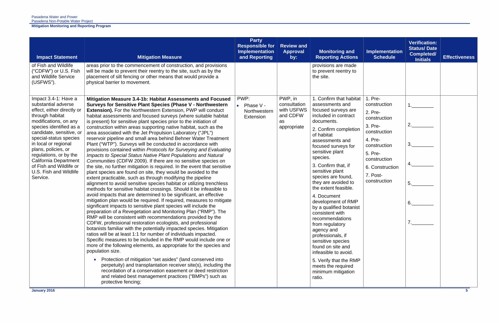
Pasadena Water and Power Pasadena Non-Potable Water Project
Mitigation Monitoring and Reporting Program
January 2016 5
Impact Statement Mitigation Measure
Party Responsible for Implementation and Reporting
Review and Approval
by: Monitoring and
Reporting Actions Implementation
Schedule
Verification: Status/ Date Completed/
Initials Effectiveness
of Fish and Wildlife (“CDFW”) or U.S. Fish and Wildlife Service (USFWS”).
areas prior to the commencement of construction, and provisions will be made to prevent their reentry to the site, such as by the placement of silt fencing or other means that would provide a physical barrier to movement.
provisions are made to prevent reentry to the site.
Impact 3.4-1: Have a substantial adverse effect, either directly or through habitat modifications, on any species identified as a candidate, sensitive, or special-status species in local or regional plans, policies, or regulations, or by the California Department of Fish and Wildlife or U.S. Fish and Wildlife Service.
Mitigation Measure 3.4-1b: Habitat Assessments and Focused Surveys for Sensitive Plant Species (Phase V - Northwestern Extension). For the Northwestern Extension, PWP will conduct habitat assessments and focused surveys (where suitable habitat is present) for sensitive plant species prior to the initiation of construction within areas supporting native habitat, such as the area associated with the Jet Propulsion Laboratory (“JPL”) reservoir pipeline and small area behind Behner Water Treatment Plant (“WTP”). Surveys will be conducted in accordance with provisions contained within Protocols for Surveying and Evaluating Impacts to Special Status Native Plant Populations and Natural Communities (CDFW 2009). If there are no sensitive species on the site, no further mitigation is required. In the event that sensitive plant species are found on site, they would be avoided to the extent practicable, such as through modifying the pipeline alignment to avoid sensitive species habitat or utilizing trenchless methods for sensitive habitat crossings. Should it be infeasible to avoid impacts that are determined to be significant, an effective mitigation plan would be required. If required, measures to mitigate significant impacts to sensitive plant species will include the preparation of a Revegetation and Monitoring Plan (“RMP”). The RMP will be consistent with recommendations provided by the CDFW, professional restoration ecologists, and professional botanists familiar with the potentially impacted species. Mitigation ratios will be at least 1:1 for number of individuals impacted. Specific measures to be included in the RMP would include one or more of the following elements, as appropriate for the species and population size.
Protection of mitigation “set asides” (land conserved into perpetuity) and transplantation receiver site(s), including the recordation of a conservation easement or deed restriction and related best management practices (“BMPs”) such as protective fencing;
PWP: Phase V -
Northwestern Extension
PWP, in consultation with USFWS and CDFW as appropriate
1. Confirm that habitat assessments and focused surveys are included in contract documents.
2. Confirm completion of habitat assessments and focused surveys for sensitive plant species.
3. Confirm that, if sensitive plant species are found, they are avoided to the extent feasible.
4. Document development of RMP by a qualified botanist consistent with recommendations from regulatory agency and professionals, if sensitive species found on site and infeasible to avoid.
5. Verify that the RMP meets the required minimum mitigation ratio.
1. Pre-construction
2. Pre-construction
3. Pre-construction
4. Pre-construction
5. Pre-construction
6. Construction
7. Post-construction
1.________ 2.________ 3.________ 4.________ 5.________ 6.________ 7.________

Pasadena Water and Power Pasadena Non-Potable Water Project
Mitigation Monitoring and Reporting Program
January 2016 6
Impact Statement Mitigation Measure
Party Responsible for Implementation and Reporting
Review and Approval
by: Monitoring and
Reporting Actions Implementation
Schedule
Verification: Status/ Date Completed/
Initials Effectiveness
The selection of a transplantation receiver site or sites. These sites will be chosen with an emphasis placed on both ecological suitability to allow for maximum survival rate of transplants as well as the minimization of impacts to existing quality habitat;
Collection of seed, cuttings, or entire plants from Study Area; and
Propagation of species from seed or cutting by an approved nursery or botanical garden (e.g., Rancho Santa Ana Botanic Garden) for future transplantation to receiver sites.
The RMP will contain mapping of plant species locations at the project site; monitoring requirements for assessing mitigation success; and performance metrics to measure mitigation success.
6. Document implementation of RMP during construction.
7. Monitor success of mitigation, as directed in RMP.
Impact 3.4-1: Have a substantial adverse effect, either directly or through habitat modifications, on any species identified as a candidate, sensitive, or special-status species in local or regional plans, policies, or regulations, or by the California Department of Fish and Wildlife or U.S. Fish and Wildlife Service.
Mitigation Measure 3.4-1c: Assessments and Focused Surveys for Sensitive Wildlife Species. For the Northwestern Extension, PWP will conduct habitat assessments and focused surveys (where suitable habitat is present) for sensitive wildlife species (specifically the coastal California gnatcatcher) prior to the initiation of construction within areas supporting native habitat, such as the area associated with the JPL reservoir pipeline and small area behind Behner WTP. Habitat types suitable for the California gnatcatcher include coastal sage scrub, while suitable habitat for other sensitive wildlife species generally include native chaparral, scrub, woodlands, and grasslands. These surveys will be conducted by a qualified biologist in accordance with appropriate USFWS or CDFW provisions. In the event that sensitive wildlife species are found on-site, if it is infeasible to avoid impacts and impacts are determined to be significant, mitigation will be required by the lead agency.
If present, mitigation for coastal California gnatcatcher will include on- and/or off-site creation, restoration, enhancement, and/or preservation of coastal California gnatcatcher habitat at a ratio no less than 3:1 for permanent impacts. Mitigation for potential impacts to federally-listed species (i.e., the coastal California gnatcatcher) would require a Section 7 Consultation (if a federal nexus is established from an “agency action”). Since PWP is applying for federal funding from the United States Bureau of
PWP:
Phase V - Northwestern Extension
PWP, in consultation with USFWS and CDFW as appropriate
1. Confirm that habitat assessments and focused surveys are included in contract documents.
2. Confirm completion of habitat assessments and focused surveys for sensitive wildlife species.
3. If sensitive wildlife species are impacted, confirm that appropriate USFWS and/or CDFW consultation was completed.
4. If sensitive wildlife species are impacted, verify that a mitigation plan was developed and implemented.
1. Pre-construction
2. Pre-construction
3. Pre-construction
4. Pre-construction and Construction
5. Construction
6. Construction
1.________ 2.________ 3.________ 4.________ 5.________ 6.________

Pasadena Water and Power Pasadena Non-Potable Water Project
Mitigation Monitoring and Reporting Program
January 2016 7
Impact Statement Mitigation Measure
Party Responsible for Implementation and Reporting
Review and Approval
by: Monitoring and
Reporting Actions Implementation
Schedule
Verification: Status/ Date Completed/
Initials Effectiveness
Reclamation (“USBR”), a Section 7 Consultation would be required. The Section 7 process requires a Biological Assessment and consultation with the USFWS, which will issue a Biological Opinion.
To avoid the direct loss of special-status bat species that could result from disturbance to maternity roost habitat (e.g., trees, structures, tunnels), disturbance will be scheduled between October 1 and February 28, outside of the maternity roosting season. If disturbances are to occur during maternity season from March 1 to September 30, at least one night emergence survey must be performed by a qualified biologist a minimum of three days prior to the commencement of project construction to determine bat presence/absence. Any maternity roosts within the development footprint and a 200-foot buffer will be left in place and undisturbed until the end of the maternity season.
Prior to issuing a permit to clear vegetation, the City of Pasadena will verify that any necessary surveys for wildlife species have been conducted and an effective mitigation plan has been prepared if sensitive wildlife species are found during the focused surveys. An effective mitigation plan would include provisions for avoidance, on- and/or off-site habitat creation, restoration, enhancement, and/or preservation at a ratio no less than 3:1 for permanent impacts. Mitigation for potential impacts to federally-listed species will be in accordance with the Federal Endangered Species Act. In the event the surveys determine the absence of sensitive species from the site, no further mitigation is warranted.
5. Confirm that construction activities occurred outside of the maternity roosting season or avoided active roosts.
6. Monitor construction activities to verify that wildlife protection measures are implemented during construction.
Impact 3.4-2: Have a substantial adverse effect on any riparian habitat or other sensitive natural community identified in local or regional plans, policies, regulations or by the California Department of Fish and Wildlife or U.S. Fish and Wildlife Service.
Mitigation Measure 3.4-2: Field Assessment and Mapping of the Native Habitats. A field assessment following the methodology in Protocols for Surveying and Evaluating Impacts to Special Status Native Plant Populations and Natural Communities (CDFW 2009), and mapping of the native habitats within the Northwestern Extension alignment will be conducted by a qualified biologist to determine the presence/absence of sensitive plant communities. If sensitive plant communities are present and impacts to sensitive plant communities cannot be avoided, a Revegtation and Monitoring Plan (“RMP”) will be prepared prior to initiation of construction to offset impacts to those sensitive plant communities. The RMP will focus on the creation of equivalent habitats within disturbed habitat areas of the project site and/or off-site. In
PWP:
Phase V - Northwestern Extension
PWP, in consultation with USFWS and CDFW as appropriate
1. Confirm completion of field assessment and mapping of native habitats.
2. Confirm completion of RMP, if needed.
3. Verify that the RMP meets the required minimum mitigation ratio.
4. Document implementation of
1. Pre-construction
2. Pre-construction
3. Pre-construction
4. Construction
5. Post-construction
1.________ 2.________ 3.________ 4.________

Pasadena Water and Power Pasadena Non-Potable Water Project
Mitigation Monitoring and Reporting Program
January 2016 8
Impact Statement Mitigation Measure
Party Responsible for Implementation and Reporting
Review and Approval
by: Monitoring and
Reporting Actions Implementation
Schedule
Verification: Status/ Date Completed/
Initials Effectiveness
addition, the plan will provide details as to the implementation of the plan, maintenance, and future monitoring. Mitigation for impacts would be offset by on- or off-site replacement, restoration, or enhancement of each respective sensitive plant community at a mitigation ratio of no less than 1:1 in one or more of the following ways:
Transplantation of the plant community species,
Seeding of the plant community species,
Planting of container plants of the plant community species, and/or
Salvage of duff and seed bank and subsequent dispersal.
The preferred restoration method is seeding of the plant community species, which will be pursued as a first resort whenever practicable. The RMP will contain monitoring requirements for assessing mitigation success, and performance metrics to measure mitigation success.
RMP during construction.
5. Monitor success of mitigation, as directed in RMP.
5.________
Impact 3.4-3: Have a substantial adverse effect on federally protected wetlands as defined by Section 404 of the Clean Water Act (“CWA”) (including, but not limited to, marsh, vernal pool, coastal, etc.) through direct removal, filling, hydrological interruption, or other means.
Mitigation Measure 3.4-3: Complete Jurisdictional Delineation and Necessary Mitigation Where the Annandale and Northwestern Extensions Cross Arroyo Seco Channel. A jurisdictional delineation will be conducted prior to any ground disturbing activities in both the Annandale and Northwestern Extensions where the proposed pipelines cross sections of the Arroyo Seco channel. The Annandale and Northwestern Extensions propose to avoid impacts to jurisdictional waters by jack-and-bore or horizontal directional drilling outside of United States Army Corp of Engineers (“USACE”)/Los Angeles Regional Water Quality Control Board (“LARWQCB”)/CDFW jurisdiction to install the pipeline. Although no impacts to jurisdictional waters are anticipated, there is a slight potential for frac-out1 release to occur. Thus, as a contingency measure, the following measure would be implemented to minimize any potential impacts to jurisdictional features:
PWP:
Phase IV - Annandale Extension
Phase V- Northwestern Extension
PWP, in consultation with USACE, LARWQCB, and/or CDFW as appropriate
1. Confirm completion of jurisdictional delineation.
2. If trenchless technology is used – Confirm completion of frac-out contingency plan and provisions to avoid/contain pollutants.
3. If trenchless technology is used – Verify that frac-out contingency plan was implemented during construction.
1. Design
2. Pre-construction
3. Construction
4. Pre-construction
5. Construction
1.________ 2.________ 3.________ 4.________ 5.________
1 Frac out is an inadvertent release of drilling/tunneling fluid or sediment laden groundwater into a wetland or watercourse.
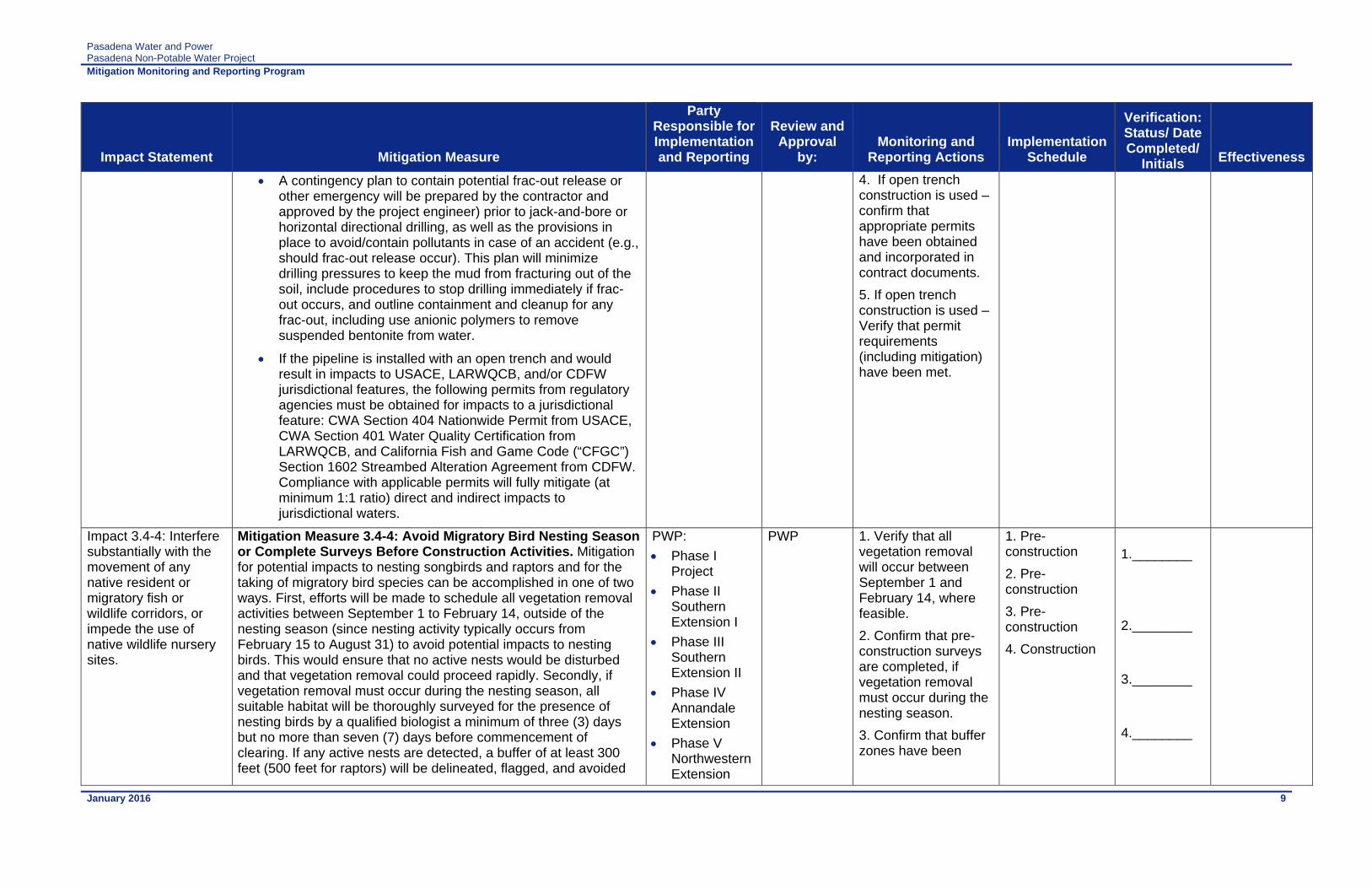
Pasadena Water and Power Pasadena Non-Potable Water Project
Mitigation Monitoring and Reporting Program
January 2016 9
Impact Statement Mitigation Measure
Party Responsible for Implementation and Reporting
Review and Approval
by: Monitoring and
Reporting Actions Implementation
Schedule
Verification: Status/ Date Completed/
Initials Effectiveness
A contingency plan to contain potential frac-out release or other emergency will be prepared by the contractor and approved by the project engineer) prior to jack-and-bore or horizontal directional drilling, as well as the provisions in place to avoid/contain pollutants in case of an accident (e.g., should frac-out release occur). This plan will minimize drilling pressures to keep the mud from fracturing out of the soil, include procedures to stop drilling immediately if frac-out occurs, and outline containment and cleanup for any frac-out, including use anionic polymers to remove suspended bentonite from water.
If the pipeline is installed with an open trench and would result in impacts to USACE, LARWQCB, and/or CDFW jurisdictional features, the following permits from regulatory agencies must be obtained for impacts to a jurisdictional feature: CWA Section 404 Nationwide Permit from USACE, CWA Section 401 Water Quality Certification from LARWQCB, and California Fish and Game Code (“CFGC”) Section 1602 Streambed Alteration Agreement from CDFW. Compliance with applicable permits will fully mitigate (at minimum 1:1 ratio) direct and indirect impacts to jurisdictional waters.
4. If open trench construction is used – confirm that appropriate permits have been obtained and incorporated in contract documents.
5. If open trench construction is used – Verify that permit requirements (including mitigation) have been met.
Impact 3.4-4: Interfere substantially with the movement of any native resident or migratory fish or wildlife corridors, or impede the use of native wildlife nursery sites.
Mitigation Measure 3.4-4: Avoid Migratory Bird Nesting Season or Complete Surveys Before Construction Activities. Mitigation for potential impacts to nesting songbirds and raptors and for the taking of migratory bird species can be accomplished in one of two ways. First, efforts will be made to schedule all vegetation removal activities between September 1 to February 14, outside of the nesting season (since nesting activity typically occurs from February 15 to August 31) to avoid potential impacts to nesting birds. This would ensure that no active nests would be disturbed and that vegetation removal could proceed rapidly. Secondly, if vegetation removal must occur during the nesting season, all suitable habitat will be thoroughly surveyed for the presence of nesting birds by a qualified biologist a minimum of three (3) days but no more than seven (7) days before commencement of clearing. If any active nests are detected, a buffer of at least 300 feet (500 feet for raptors) will be delineated, flagged, and avoided
PWP:
Phase I Project
Phase II Southern Extension I
Phase III Southern Extension II
Phase IV Annandale Extension
Phase V Northwestern Extension
PWP 1. Verify that all vegetation removal will occur between September 1 and February 14, where feasible.
2. Confirm that pre-construction surveys are completed, if vegetation removal must occur during the nesting season.
3. Confirm that buffer zones have been
1. Pre-construction
2. Pre-construction
3. Pre-construction
4. Construction
1.________ 2.________ 3.________ 4.________

Pasadena Water and Power Pasadena Non-Potable Water Project
Mitigation Monitoring and Reporting Program
January 2016 10
Impact Statement Mitigation Measure
Party Responsible for Implementation and Reporting
Review and Approval
by: Monitoring and
Reporting Actions Implementation
Schedule
Verification: Status/ Date Completed/
Initials Effectiveness
until the nesting cycle is complete as determined by the biological monitor to minimize impacts.
Phase VI Northeastern Extension
established, if applicable.
4. Verify that monitoring of construction activities occurs until the nesting cycle is complete, if needed.
Cultural Resources Impact 3.5-1: Potential to cause a substantial adverse change in the significance of a unique archaeological resource, including Native American Burials, pursuant to §15064.5
Mitigation Measure 3.5-1a: Monitor and Report Construction Excavations for Archeological Resources in Less Elevated Areas. PWP will retain a qualified archaeological monitor to be present during construction excavations such as grading, trenching, grubbing, or any other construction excavation activity associated with the proposed Project. A “qualified” archaeological monitor is one who possesses appropriate and applicable credentials and/or training to identify and/or assess the cultural resources that can reasonably be anticipated as the most likely type of cultural resource to be found, if any are encountered, based on the results of the cultural resources assessment completed for the proposed Project. These credentials include a bachelor’s degree in archaeology, anthropology, geology, or closely related field and at least one year of archaeological fieldwork or laboratory experience in California. At least two years of fieldwork experience can substitute for a degree. The monitor who conducts the monitoring at the Sheldon Reservoir Site shall have additional qualifications that include the completion of a Human Osteology (or similar) course, or the completion of training in identifying human remains, or has conducted at least one month of fieldwork or laboratory work involving human remains and/or associated grave goods.
The monitor will observe all excavations in the less elevated areas of the Study Area. These areas include the portions of the Study Area that traverse these Pasadena streets and/or areas: Rose Bowl Drive, N. Arroyo Blvd., Washington Blvd., Parkview Ave., Laurel St., Linda Vista Ave., segments of Afton St, and Brookside Golf Course. These areas also include the grading for the proposed Sheldon Non-Potable Water Reservoir and pressure-
PWP: Phase I
Project
Phase V- Northwestern Extension
PWP
1. Confirm that archeological monitor is included in contract documents.
2. Verify that archeological monitoring of excavation activities occurs, as outlined.
3. Confirm that that buffer zones have been established at Sheldon Non-potable Water Reservoir site.
4. Confirm that archeological monitor has filed the final report to applicable agencies.
1. Pre-construction
2. Construction
3. Construction
4. Post-construction
1.________ 2.________ 3.________ 4.________

Pasadena Water and Power Pasadena Non-Potable Water Project
Mitigation Monitoring and Reporting Program
January 2016 11
Impact Statement Mitigation Measure
Party Responsible for Implementation and Reporting
Review and Approval
by: Monitoring and
Reporting Actions Implementation
Schedule
Verification: Status/ Date Completed/
Initials Effectiveness
reducing station, the Brookside booster pump station, the hydroelectric generation turbine facility, and the tunnel water pump station and wet well facilities. The more elevated areas of the Study Area (i.e., the areas within the San Rafael Hills to the west and the San Gabriel Mountains to the north) will not be monitored because these areas consist of igneous and metamorphic rocks that are not conducive to retaining archaeological resources. These areas include the portions of the Study Area that traverse these Phase I Project segments: Scholl Canyon Landfill Site Access Roads, Undeveloped Ridge, and Art Center College of Design (Art Center)/LA County Flood Control District Access Road. The frequency of monitoring will be based on the rate of excavation and grading activities, proximity to known archaeological resources, the materials being excavated (native versus fill soils), and the depth of excavation, and if found, the abundance and type of archaeological resources encountered. Full-time monitoring can be reduced to part-time inspections if determined adequate by the archaeological monitor.
Specifically, due to the potential location of buried cultural resources on the southwest portion of the Sheldon Non-potable Water Reservoir site, the construction contractors will protect the area from disturbance with a 4-foot tall fence around the extent of each potential cultural resource site (TOI 1, Anomaly 1, and Anomaly 2), including a 10-foot buffer all around the edge of each potential site. Construction will be outside of the ten foot buffer. The fence and buffer limits will be shown on the final design plans for the Sheldon Non-potable Water Reservoir in Phase I and the pressure reducing station in Northwestern Extension.
The archaeological monitor will prepare a final report at the conclusion of archaeological monitoring to be reviewed and accepted by PWP. The archaeological monitor will file the report with the PWP, the City of Pasadena, and the South Central Coastal Information Center. The report will include a description of resources unearthed, if any, treatment of the resources, and evaluation of the resources with respect to the California Register of Historical Resources and the National Register of Historic Places.

Pasadena Water and Power Pasadena Non-Potable Water Project
Mitigation Monitoring and Reporting Program
January 2016 12
Impact Statement Mitigation Measure
Party Responsible for Implementation and Reporting
Review and Approval
by: Monitoring and
Reporting Actions Implementation
Schedule
Verification: Status/ Date Completed/
Initials Effectiveness
Impact 3.5-1: Potential to cause a substantial adverse change in the significance of a unique archaeological resource, including Native American Burials, pursuant to §15064.5
Mitigation Measure 3.5-1b: Cease Ground-Disturbing Activities and Report if Archaeological Resources are Encountered. If archaeological resources (historic or prehistoric) are encountered during implementation of the proposed Project, ground-disturbing activities will temporarily be redirected from the vicinity of the find. A buffer area of at least 25 feet will be established around the find where construction activities will not be allowed to continue. Work will be allowed to continue outside of the buffer area. PWP will immediately notify the United States Bureau of Reclamation (“USBR”) of the find. The USBR will then comply with procedures outlined in 36 CFR 800.13. The USBR will coordinate with PWP as to the immediate treatment of the find until a proper site visit and evaluation is made by the USBR. The USBR may request the assistance of a qualified archaeological consultant to assist in compliance with 36 CFR 800.13.
The USBR will prepare a final report about the find to be filed with the Project Sponsor and the South Central Coastal Information Center. The report will include documentation and interpretation of resources recovered. Interpretation will include full evaluation of the eligibility with respect to the California Register of Historical Resources and the National Register of Historic Places. PWP, in consultation with the USBR and the landowner, will designate repositories in the event that resources are recovered.
Any delays will be minimized to the extent practicable while adequately and appropriately handling any potential archaeological resources.
PWP:
Phase I Project
PWP, in collaboration with USBR
1. Confirm measure is included in contract documents.
2. Verify that work in the vicinity of an archeological find is stopped and a minimum 25 feet buffer zone is established.
3. Immediately notify USBR for the find and coordinate with USBR the procedures as outlined.
4. Document implementation of immediate treatment recommended by archaeologist.
5. Confirm completion and filing of the final report on the archeological find by USBR.
6. Document designation of repositories for potential recovered resources.
1. Pre-construction
2. Construction
3. Construction
4. Construction
5. Post-construction
6. Post-construction
1.________ 2.________ 3.________ 4.________ 5.________ 6.________
Impact 3.5-1: Potential to cause a substantial adverse change in the significance of a unique archaeological resource, including Native American
Mitigation Measure 3.5-1c: Cease Ground-Disturbing Activities and Report if Human Remains are Encountered. If human remains are encountered unexpectedly during implementation of the proposed Project, State Health and Safety Code Section 7050.5 requires that no further disturbance will occur until the County Coroner has made the necessary findings as to origin and disposition pursuant to Public Resources Code Section 5097.98. If
PWP:
Phase I Project
PWP, in collaboration with County Coroner and NAHC
1. Confirm measure is included in contract documents.
2. Verify that work in the vicinity of human remains is stopped
1. Pre-construction
2. Construction
3. Construction
1.________ 2.________

Pasadena Water and Power Pasadena Non-Potable Water Project
Mitigation Monitoring and Reporting Program
January 2016 13
Impact Statement Mitigation Measure
Party Responsible for Implementation and Reporting
Review and Approval
by: Monitoring and
Reporting Actions Implementation
Schedule
Verification: Status/ Date Completed/
Initials Effectiveness
Burials, pursuant to §15064.5
the remains are determined to be of Native American descent, the coroner has 24 hours to notify the Native American Heritage Commission (“NAHC”). The NAHC will then identify the person(s) thought to be the Most Likely Descendent (“MLD”). The MLD may, with the permission of the land owner, or his or her authorized representative, inspect the site of the discovery of the Native American remains and may recommend to the owner or the person responsible for the excavation work means for treating or disposing, with appropriate dignity, the human remains and any associated grave goods. The descendants will complete their inspection and make their recommendation within 48 hours of being granted access by the land owner to inspect the discovery. The recommendation may include the scientific removal and nondestructive analysis of human remains and items associated with Native American burials. Upon the discovery of the Native American remains, the landowner will ensure that the immediate vicinity, according to generally accepted cultural or archaeological standards or practices, where the Native American human remains are located, is not damaged or disturbed by further development activity until the landowner has discussed and conferred, as prescribed in this Mitigation Measure, with the MLD regarding their recommendations, if applicable, taking into account the possibility of multiple human remains. The landowner will discuss and confer with the descendants all reasonable options regarding the descendants' preferences for treatment.
Whenever the NAHC is unable to identify a MLD, or the MLD identified fails to make a recommendation, or the landowner or his or her authorized representative rejects the recommendation of the descendants and the mediation provided for in Subdivision (k) of Section 5097.94, if invoked, fails to provide measures acceptable to the landowner, the landowner or his or her authorized representative will inter the human remains and items associated with Native American human remains with appropriate dignity on the property in a location not subject to further and future subsurface disturbance.
Any delays will be minimized to the extent practicable while adequately and appropriately handling any human remains that may be discovered during the course of the proposed Project.
and appropriate measures are taken.
3. Confirm appropriate notifications (County Coroner and/or NAHC) have occurred if human remains are encountered.
4. Document that human remains have been accorded appropriate treatment.
4. Post-construction
3.________ 4.________

Pasadena Water and Power Pasadena Non-Potable Water Project
Mitigation Monitoring and Reporting Program
January 2016 14
Impact Statement Mitigation Measure
Party Responsible for Implementation and Reporting
Review and Approval
by: Monitoring and
Reporting Actions Implementation
Schedule
Verification: Status/ Date Completed/
Initials Effectiveness
Impact 3.5-1: Potential to cause a substantial adverse change in the significance of a unique archaeological resource, including Native American Burials, pursuant to §15064.5
Mitigation Measure 3.5-1d: Conduct Phase I Archaeological Resources Assessment for Future Extensions. PWP will conduct a Phase I Archaeological Resources Assessment of the Future Extensions to identify any archaeological resources within the area of a proposed Project. The Phase I assessment will include cultural resources records searches through the South Central Coastal Information Center (as needed), a Sacred Lands File search through the Native American Heritage Commission and follow-up Native American consultation, and a pedestrian survey of the Study area (Note: surveys may not be required in areas that do not have the native ground surface exposed such as paved streets). Upon completion of any report on findings, the U.S. Bureau of Reclamation (“USBR”) and State Historic Preservation Officer (“SHPO”) will be consulted to allow for review and concurrence with the study findings. If resources are identified during the Phase I assessment, then a Phase II assessment will be required, as described in Mitigation Measure 3.5-1e. If no resources are identified as part of the assessment, then archaeological monitoring may be implemented as detailed in Mitigation Measures 3.5-1a, 3.5-1b, and 3.5-1c.
PWP:
Phase II Southern Extension I
Phase III Southern Extension II
Phase IV Annandale Extension
Phase V Northwestern Extension
Phase VI Northeastern Extension
PWP, in consultation with USBR and SHPO
1. Confirm completion of Phase I assessment.
2. Confirm consultation with USBR and SHPO for review and concurrence.
1. Design
2. Design
1.________ 2.________ 3.________
Impact 3.5-1: Potential to cause a substantial adverse change in the significance of a unique archaeological resource, including Native American Burials, pursuant to §15064.5
Mitigation Measure 3.5-1e: Conduct Phase II Archaeological Resources Assessment for Future Extensions, if Warranted. If resources are identified during the Phase I assessment undertaken in Mitigation Measure 3.5-1d, a Phase II Archaeological Resources Assessment may be warranted if improvements or new public access is proposed in the vicinity of such resource, or if an alternate alignment is not selected. The Phase II assessment will evaluate the resource(s) for listing in the California Register of Historical Resources (per California Environmental Quality Act [“CEQA”]) and the National Register of Historic Places (per Section 106). If enough data is obtained from the Phase I assessment to conduct a proper evaluation, a Phase II assessment may not be necessary. The need for a Phase II assessment will be determined by PWP, USBR, and SHPO. Methodologies for evaluating a resource can include, but are not limited to: subsurface archaeological excavations, additional background research, and coordination with interested individuals in the community.
PWP:
Phase II Southern Extension I
Phase III Southern Extension II
Phase IV Annandale Extension
Phase V Northwestern Extension
Phase VI Northeastern Extension
PWP, in consultation with USBR and SHPO
1. Confirm completion of Phase II assessment, if needed.
2. Confirm consultation with USBR and SHPO for review and concurrence.
1. Design
2. Design
1.________ 2.________

Pasadena Water and Power Pasadena Non-Potable Water Project
Mitigation Monitoring and Reporting Program
January 2016 15
Impact Statement Mitigation Measure
Party Responsible for Implementation and Reporting
Review and Approval
by: Monitoring and
Reporting Actions Implementation
Schedule
Verification: Status/ Date Completed/
Initials Effectiveness
Impact 3.5-1: Potential to cause a substantial adverse change in the significance of a unique archaeological resource, including Native American Burials, pursuant to §15064.5
Mitigation Measure 3.5-1f: Conduct Phase III Archaeological Resources Assessment for Future Extensions, if Warranted, and Develop Mitigation to Reduce Potential Impacts from Future Extensions. If, as a result of the Phase II assessment, resources are determined eligible for listing, potential impacts to the resources will be analyzed and if impacts are significant and cannot be avoided, mitigation measures will be developed and implemented to reduce impacts to the resources. If avoidance is not feasible, then Phase III Archaeological Resources Assessments will be implemented. Phase III assessments can include, but are not limited to: additional subsurface archaeological excavations (i.e., data recovery) and/or archaeological monitoring during ground-disturbing activities. Coordination and concurrence with the USBR and SHPO regarding treatment or mitigation will be required. Mitigation measures could include, but are not limited to, the mitigation described in Mitigation Measures 3.5-1a, 3.5-1b, and 3.5-1c. The performance standard for this mitigation measure is to reduce potential impacts to archaeological resources to a less than significant level, which would require that any archaeological resources encountered during implementation of the proposed Project be handled in a method approved by appropriate archaeological and cultural monitors where avoidance of such resources is infeasible.
PWP:
Phase II Southern Extension I
Phase III Southern Extension II
Phase IV Annandale Extension
Phase V Northwestern Extension
Phase VI Northeastern Extension
PWP, in consultation with USBR and SHPO
1. Confirm completion of Phase III assessment, if needed.
2. Confirm consultation with USBR and SHPO for review and concurrence.
3. Confirm incorporation of treatment and mitigation measures into contract documents.
4. Monitor construction activities to verify that mitigation measures are implemented.
1. Design and Construction
2. Design and Construction
3. Pre-construction
4. Construction
1.________ 2.________ 3.________ 4.________
Impact 3.1-1: Potential for substantial damage to scenic vista, scenic resources, and/or degradation of the existing visual character or quality of the site and its surroundings.
Impact 3.5-2: Cause a substantial adverse change in the significance of a historical resource as defined in §15064.5.
Mitigation Measure 3.5-2a: Comply with the Secretary of the Interior’s Standards for Rehabilitation for pressure reducing station and the Brookside booster pump station, the hydroelectric generation turbine, and the tunnel water pump station to be constructed within the National Register-listed Pasadena Arroyo Parks and Recreation District. The design of the new pressure reducing station and the Brookside booster pump station, the hydroelectric generation turbine, the tunnel water pump station and wet well facilities will comply with the Secretary of the Interior’s Standards for Rehabilitation to help maintain the existing aesthetics associated with historical resources in the surrounding area. The new facilities will be designed with materials, massing, scale, size, features, and design elements that blend with the surrounding environment in accordance to Standards 9 and 10. The facility will not dominate the viewshed; the structure will appear secondary, lower in height, and screened with shrubs, trees, or
PWP:
Phase I Project
PWP 1. Confirm that designs of listed components comply with the Standards for Rehabilitation.
2. Confirm that final plans have been reviewed and confirmed by a qualified preservation consultant, prior to the issuance of a building permit.
3. Confirm that design components have
1. Design
2. Design
3. Pre-construction
4. Post-construction
1.________ 2.________ 3.________ 4.________
Pasadena Water and Power Pasadena Non-Potable Water Project
Mitigation Monitoring and Reporting Program
January 2016 16
Impact Statement Mitigation Measure
Party Responsible for Implementation and Reporting
Review and Approval
by: Monitoring and
Reporting Actions Implementation
Schedule
Verification: Status/ Date Completed/
Initials Effectiveness
other suitable plantings and landscape elements that are compatible with the historic park setting.
If the facility is constructed in accordance with the Secretary of the Interior’s Standards, the Proposed Undertaking would not detract from the historic character and integrity of Pasadena Arroyo Parks and Recreation District, which would retain its overall historic and architectural significance. To protect the integrity of the National Register-listed Pasadena Parks and Recreation District, a qualified preservation consultant will review the final plans for conformance with Secretary of the Interior’s Standards and prepare a memorandum commenting on the final proposed Project prior to issuance of a building permit. With required mitigation incorporated as a condition of the proposed Project, the new facilities located within the National Register-listed Pasadena Arroyo Parks and Recreation District would have no adverse impacts to historic properties (per Section 106) or historical resources (per CEQA) situated within the Area of Potential Effect (“APE”)/Study Area.
been included in contract documents.
4. Verify that design components have been constructed according to specifications.
Impact 3.5-2: Cause a substantial adverse change in the significance of a historical resource as defined in §15064.5.
Mitigation Measure 3.5-2b: Comply with the Secretary of the Interior’s Standards for Rehabilitation for the pipeline crossing of Arroyo Seco Flood Control Channel at Washington Boulevard. The design and construction of the crossing of Arroyo Seco at Washington Boulevard will be undertaken in a manner that would limit damage to the concrete channel lining to the greatest extent feasible. Furthermore, reconstruction of the channel lining afterward will be conducted in accordance with the Secretary of the Interior’s Standards for Rehabilitation. A qualified preservation consultant will review the final construction plans for conformance with Secretary of the Interior’s Standards and prepare a memorandum commenting on the final Project prior to Lead Agency approval of project construction and issuance of a building permit. To protect the integrity of the historical resource, the final construction plans will detail how the section of the channel lining would be removed, what trenching method would be utilized, what protection measures would be implemented to avoid damage to the surrounding channel during construction, and how the channel lining would be repaired and replaced following installation of the pipeline. The preservation consultant will monitor the removal of the channel lining, and inspect the channel after substantial construction completion to ensure potential damage to the channel
PWP:
Phase I Project
PWP 1. Confirm that design of the channel lining complies with the Standards for Rehabilitation.
2. Confirm that final plans have been reviewed and confirmed by a qualified preservation consultant, prior to the issuance of a building permit.
3. Confirm that design components have been included in contract documents.
4. Verify that the preservation consultant monitors
1. Design
2. Design
3. Pre-construction
4. Construction
5. Post-construction
1.________ 2.________ 3.________ 4.________ 5.________

Pasadena Water and Power Pasadena Non-Potable Water Project
Mitigation Monitoring and Reporting Program
January 2016 17
Impact Statement Mitigation Measure
Party Responsible for Implementation and Reporting
Review and Approval
by: Monitoring and
Reporting Actions Implementation
Schedule
Verification: Status/ Date Completed/
Initials Effectiveness
is minimized and the concrete lining repair and replacement meets the Secretary of the Interior’s Standards for Rehabilitation. With required mitigation incorporated as a condition of the project, the pipeline crossing the National Register-eligible Arroyo Seco Floor Control Channel at Washington Boulevard would have no adverse impacts to historic properties (per Section 106) or historical resources (per CEQA) situated within the APE/Study Area.
the removal and replacement of channel lining.
5. Verify that design components have been constructed according to specifications.
Impact 3.5-2: Cause a substantial adverse change in the significance of a historical resource as defined in §15064.5.
Mitigation Measure 3.5-2c: Comply with the Secretary of the Interior’s Standards for Rehabilitation for pipes installed over the entrance to the Colorado Street Bridge. Adverse effects by Southern Extension I to the Colorado Street Bridge, listed on the National Register, will not be substantial since the pipeline will avoid physical alteration of the resource. The Pipe will be installed over the eastern on-ramp to the Colorado Street Bridge; the pipeline will be located in non-historic material (new asphalt, concrete, etc.) and the detailed project-level plans will be reviewed by a qualified preservation consultant prior to project approval to ensure that no physical alteration of the historic bridge will occur. Alteration of the historic bridge will be avoided, such as boring into the historic concrete of the bridge or attaching brackets or pipes to the bridge. Since the installation will be completed in accordance with the Secretary of the Interior’s Standards, which provides guidance on appropriate materials and methods to protect the cultural integrity of historic resources, the project would not detract from the architectural integrity of Colorado Street Bridge listed in the National Register and the historic resource would retain its overall historic and architectural significance.
PWP: Phase II
Southern Extension I
PWP 1. Require that no physical alteration of the historic bridge occur.
2. Confirm that design of pipeline crossing complies with the Standards for Rehabilitation.
3. Confirm that a qualified preservation consultant has reviewed the final construction plans for conformance with the Standards for Rehabilitation prior to building permit issuance.
1. Design
2. Design
3. Design
1.________ 2.________ 3.________

Pasadena Water and Power Pasadena Non-Potable Water Project
Mitigation Monitoring and Reporting Program
January 2016 18
Impact Statement Mitigation Measure
Party Responsible for Implementation and Reporting
Review and Approval
by: Monitoring and
Reporting Actions Implementation
Schedule
Verification: Status/ Date Completed/
Initials Effectiveness
Impact 3.5-2: Cause a substantial adverse change in the significance of a historical resource as defined in §15064.5.
Mitigation Measure 3.5-2d: Comply with the Secretary of the Interior’s Standards for Rehabilitation for the attachment of pipes to the Seco Street Bridge. Adverse effects by the Annandale Extension to the Seco Street Bridge, a character-defining feature of the National Register-eligible Arroyo Seco Flood Control Channel District, will be avoided. The pipeline will be attached along the outside edges of the deck amongst the other attached pipes or underneath the deck. There are other pipes attached to the south deck of the bridge and the new pipeline will be installed amongst the previous interventions, using the existing brackets. Attachment of new brackets to secure a new pipeline to the historic bridge will be avoided. Boring into the historic concrete of the bridge and/or channel will be avoided. If the pipeline is installed amongst the previous pipes, as described, the new pipeline will not be significantly visible from the public right-of-way. While the piping may be visible from the park, there are already other pipes attached to the bridge in this manner. If the installation is completed in accordance with the Secretary of the Interior’s Standards, which provides guidance for appropriate materials and methods to protect the cultural integrity of historic resources during construction or restoration activities, the project would not detract from the architectural integrity of the Arroyo Seco Flood Control Channel District and the contributing Seco Street Bridge would retain its overall historic and architectural significance.
PWP:
Phase IV Annandale Extension
PWP 1. Require that pipeline is attached along the outside edges of the deck amongst the other attached pipes or underneath the deck.
2. Confirm that design of pipeline crossing complies with the Standards for Rehabilitation.
1. Design
2. Design
1.________ 2.________
Impact 3.5-3: Potential to directly or indirectly destroy a unique paleontological resource or site or unique geologic feature.
Mitigation Measure 3.5-3a: Monitor and Report Construction Excavations for Paleontological Resources in Less Elevated Areas. A qualified paleontologist will be retained to monitor excavation activities into the fossiliferous older Quaternary Alluvium deposits. The minimum qualifications of the paleontological monitor shall be a bachelor’s degree in geology, paleontology, or closely related field and at least one year of paleontological fieldwork or laboratory experience in California. A minimum of two years of experience can substitute for a degree. The less elevated areas of the Study Area contain surficial deposits of older Quaternary alluvial fan deposits and therefore excavations into these deposits will be monitored. These areas include the portions of the Study Area that traverse through these Pasadena streets and areas: Rose Bowl Drive, N. Arroyo Blvd., Washington Blvd., Parkview Ave., Laurel St., Linda Vista Ave., segments of Afton St, and
PWP:
Phase I Project
PWP 1. Confirm measure included in contract documents.
2. Verify that a paleontologist has been retained to monitor excavation activities.
2. Verify that monitoring of construction excavation activities occurs as recommended by the
1. Pre-construction
2. Construction
3. Construction
4. Construction
5. Post-construction
1.________ 2.________ 3.________ 4.________

Pasadena Water and Power Pasadena Non-Potable Water Project
Mitigation Monitoring and Reporting Program
January 2016 19
Impact Statement Mitigation Measure
Party Responsible for Implementation and Reporting
Review and Approval
by: Monitoring and
Reporting Actions Implementation
Schedule
Verification: Status/ Date Completed/
Initials Effectiveness
Brookside Golf Course. These areas also include the grading for the proposed Sheldon Non-Potable Water Reservoir and the proposed pressure-reducing station, the Brookside booster pump station, the hydroelectric generation turbine, and the tunnel water pump station and wet well facilities. Monitoring will consist of visually inspecting fresh exposures of rock for larger fossil remains and, where appropriate, collecting wet or dry screened sediment samples of promising horizons for smaller fossil remains. The frequency of monitoring will be based on the rate of excavation and grading activities, proximity to known paleontological resources or fossiliferous geologic formations (i.e., older Quaternary Alluvium), the materials being excavated (native versus fill soils), and the depth of excavation, and if found, the abundance and type of paleontological resources encountered. Full-time monitoring can be reduced to part-time inspections if determined adequate by the paleontological monitor.
If a potential fossil is found, the paleontological monitor will be allowed to temporarily divert or redirect grading and excavation activities in the area of the exposed fossil to facilitate evaluation and, if necessary, salvage. At the paleontologist’s discretion and to reduce any construction delay, the grading and excavation contractor will assist in removing rock samples for initial processing.
Any fossils encountered and recovered will be prepared to the point of identification and catalogued before they are donated to their final repository. Any fossils collected will be donated to a public, non-profit institution with a research interest in the materials, such as the Natural History Museum of Los Angeles County or the San Bernardino County Museum. Accompanying notes, maps, and photographs will also be filed at the repository.
Upon completion of the above activities, the paleontologist will prepare a report summarizing the results of the monitoring and salvaging efforts, the methodology used in these efforts, as well as a description of the fossils collected and their significance. The report will be submitted to Pasadena Water and Power, the Natural History Museum of Los Angeles County, the San Bernardino County Museum, and representatives of other appropriate or
paleontological monitor.
3. Verify temporary cessation of grading and excavation in the vicinity of the fossil, if found.
4. Confirm fossils were recovered and donated to appropriate institution.
5. Confirm completion and filing of final paleontological monitoring report.
5.________

Pasadena Water and Power Pasadena Non-Potable Water Project
Mitigation Monitoring and Reporting Program
January 2016 20
Impact Statement Mitigation Measure
Party Responsible for Implementation and Reporting
Review and Approval
by: Monitoring and
Reporting Actions Implementation
Schedule
Verification: Status/ Date Completed/
Initials Effectiveness
concerned agencies to signify the satisfactory completion of the Project and required mitigation measures.
Impact 3.5-3: Potential to directly or indirectly destroy a unique paleontological resource or site or unique geologic feature.
Mitigation Measure 3.5-3b: Conduct Phase I Paleontological Assessment for Future Extensions. PWP will conduct a Phase I Paleontological Resources Assessment of the Future Extensions to identify any paleontological resources within the area of a proposed Project component. The Phase I assessment will include paleontological resources records searches through the Natural History Museum of Los Angeles County (as needed), geologic map and geotechnical report review, and a pedestrian survey of the Study Area (Note: surveys may not be required in areas that do not have the native ground surface exposed such as paved streets or in areas where metamorphic or igneous sediments/rock units are mapped). If resources are identified during the Phase I assessment, then a Phase II assessment will be required, as described in Mitigation Measure 3.5-3c. If no resources are identified as part of the assessment, then paleontological construction monitoring may be warranted as described in Mitigation Measure 3.5-3a.
PWP: Phase II
Southern Extension I
Phase III Southern Extension II
Phase IV Annandale Extension
Phase V Northwestern Extension
Phase VI Northeastern Extension
PWP, in consultation with USBR
1. Confirm completion of Phase I assessment.
2. Confirm consultation with USBR for review and concurrence.
1. Design
2. Design
1.________ 2.________
Impact 3.5-3: Potential to directly or indirectly destroy a unique paleontological resource or site or unique geologic feature.
Mitigation Measure 3.5-3c: Conduct Phase II Paleontological Resources Assessment for Future Extensions, if Warranted. If resources are identified during the Phase I assessment, a Phase II Paleontological Resources Assessment may be warranted if improvements or new public access is proposed in the vicinity of such resource, or if an alternate alignment is not selected. The Phase II assessment will evaluate the significance of the resource. If enough data is obtained from the Phase I assessment to conduct a proper evaluation, a Phase II assessment may not be necessary. The need for a Phase II assessment will be determined by PWP and USBR (as necessary for federal approvals). Methodologies for evaluating a resource can include, but are not limited to: subsurface paleontological excavations, additional background research, and coordination with interested individuals in the community.
PWP:
Phase II Southern Extension I
Phase III Southern Extension II
Phase IV Annadale Extension
Phase V Northwestern Extension
Phase VI Northeastern Extension
PWP, in consultation with USBR
1. Confirm completion of Phase II assessment, if needed.
2. Confirm consultation with USBR for review and concurrence.
1. Design
2. Design
1.________ 2.________

Pasadena Water and Power Pasadena Non-Potable Water Project
Mitigation Monitoring and Reporting Program
January 2016 21
Impact Statement Mitigation Measure
Party Responsible for Implementation and Reporting
Review and Approval
by: Monitoring and
Reporting Actions Implementation
Schedule
Verification: Status/ Date Completed/
Initials Effectiveness
Impact 3.5-3: Potential to directly or indirectly destroy a unique paleontological resource or site or unique geologic feature.
Mitigation Measure 3.5-3d: Develop Mitigation to Reduce Potential Impacts from Future Extensions. If, as a result of the Phase II assessment, resources are determined significant, potential impacts to the resources will be analyzed and if impacts are significant and cannot be avoided, mitigation measures will be developed and implemented to reduce impacts to the resources. If avoidance is not feasible, then Phase III Paleontological Resources Assessments will be implemented. Phase III assessments can include, but are not limited to: additional subsurface paleontological excavations (i.e., data recovery) and/or paleontological monitoring during ground-disturbing activities. Coordination and concurrence with PWP and USBR (as necessary for federal approvals) regarding treatment or mitigation will be required. The performance standard for this mitigation measure is to reduce potential impacts to paleontological resources to a less than significant level, which would be achieved through handling of potential paleontological resources in a manner deemed appropriate by a qualified paleontological monitor, and as described in Mitigation Measure 3.5-3a.
PWP:
Phase II Southern Extension I
Phase III Southern Extension II
Phase IV Annandale Extension
Phase V Northwestern Extension
Phase VI Northeastern Extension
PWP, in consultation with USBR
1. Confirm completion of Phase III assessment, if needed.
2. Confirm consultation with USBR for review and concurrence.
3. Confirm incorporation of treatment and mitigation measures into contract documents.
4. Monitor construction activities to verify that mitigation measures are implemented.
1. Design and Construction
2. Design and Construction
3. Pre-construction
4. Construction
1.________ 2.________ 3.________ 4.________
Geology, Soils, and Seismicity Impact 3.6-1: Expose people or structures to potential substantial adverse effects, including the risk of loss, injury, or death involving rupture of known earthquake fault, strong seismic ground shaking, seismic-related ground failure, including liquefaction, or landslides.
Impact 3.6-3: Project is located on a geologic unit or soil that is
Mitigation Measure 3.6-1: Prepare Geological Report for Potentially Affected Facilities. During the design phase for the Non-Potable Water Project Future Extensions, PWP will require preparation of a Geologic Report by a geologist registered in the State of California for facilities proposed for the proposed Project that have not been previously analyzed and could potentially be located within known seismic hazard zones shown on Figure 3.6-1.
The Geologic Report will include an engineering analysis of liquefaction and slope stability for the distribution pipelines, pump stations, storage facilities, and pressure reducing station within the PWP service area. This assessment will include a liquefaction assessment study in accordance with the California Geological Survey Special Publication 117 Guidelines, and the Southern California Earthquake Center’s procedures to implement Special Publication 117. If this report finds unstable soils would present potential risks associated with liquefaction or landslides, engineering recommendations for surface and subsurface drainage
PWP:
Phase II Southern Extension I
Phase III Southern Extension II
Phase V Northwestern Extension
PWP 1. Confirm preparation of a Geologic Report by a registered geologist.
2. Confirm that design plans and contract documents reflect Geologic Report recommendations.
1. Design
2. Design/Pre-construction
1.________ 2.________

Pasadena Water and Power Pasadena Non-Potable Water Project
Mitigation Monitoring and Reporting Program
January 2016 22
Impact Statement Mitigation Measure
Party Responsible for Implementation and Reporting
Review and Approval
by: Monitoring and
Reporting Actions Implementation
Schedule
Verification: Status/ Date Completed/
Initials Effectiveness
unstable, or that would become unstable as a result of the project, and potentially result in on- or off-site landslide, lateral spreading, subsidence, liquefaction, or collapse.
specifications and detailed design for fill placement and excavation will be provided and incorporated into design of the proposed Project.
Hazards and Hazardous Materials Impact 3.8-2: Potential to create a significant hazard to the public or the environment through reasonably foreseeable upset and accident conditions involving the release of hazardous materials into the environment.
Impact 3.8-3: Potential to emit hazardous emissions or handle hazardous or acutely hazardous materials, substances, or waste within one-quarter mile of an existing or proposed school.
Impact 3.9-1: Violate any water quality standards or waste discharge requirements.
Mitigation Measure 3.8-2a: Hazardous Materials Management and Spill Prevention and Control Plan. Before construction begins, PWP will require its construction contractor to prepare a Hazardous Materials Management Spill Prevention and Control Plan (“HazMat Spill Plan”) that includes a project-specific contingency plan for hazardous materials and waste operations. The Plan will be applicable to construction activities, and will establish policies and procedures according to applicable codes and regulations, including but not limited to the California Building and Fire Codes, and federal and California Occupational Safety and Health Administration (“OSHA”) regulations. Elements of the Plan will include, but not be limited to the following:
A discussion of hazardous materials management, including delineation of hazardous material storage areas, access and egress routes, waterways, emergency assembly areas, and temporary hazardous waste storage areas;
Notification and documentation of procedures; and
Spill control and countermeasures, including employee spill prevention/response training.
PWP: Phase I
Project
Phase II Southern Extension I
Phase III Southern Extension II
Phase IV Annandale Extension
Phase V Northwestern Extension
Phase VI Northeastern Extension
PWP 1. Confirm that a HazMat Spill Plan has been developed for construction.
2. Verify implementation of the HazMat Spill Plan.
1. Pre-Construction
2. Construction
1.________ 2.________

Pasadena Water and Power Pasadena Non-Potable Water Project
Mitigation Monitoring and Reporting Program
January 2016 23
Impact Statement Mitigation Measure
Party Responsible for Implementation and Reporting
Review and Approval
by: Monitoring and
Reporting Actions Implementation
Schedule
Verification: Status/ Date Completed/
Initials Effectiveness
Impact 3.8-2: Potential to create a significant hazard to the public or the environment through reasonably foreseeable upset and accident conditions involving the release of hazardous materials into the environment.
Impact 3.8-3: Potential to emit hazardous emissions or handle hazardous or acutely hazardous materials, substances, or waste within one-quarter mile of an existing or proposed school.
Impact 3.8-4: Be located on a site which is included on a list of hazardous materials sites compiled pursuant to Government Code Section 65962.5 and, as a result, would create a significant hazard to the public or the environment.
Mitigation Measure 3.8-2b: Contingency Plan for Contaminated Soil and/or Groundwater. While there are no known areas of contaminated soil within the proposed Project boundaries, if contaminated soil and/or groundwater are encountered, work will be halted in the area and the type and extent of the contamination will be evaluated. A contingency plan to dispose of contaminated soil or groundwater would be developed through consultation with appropriate regulatory agencies. If dewatering or hydrostatic testing of a pipeline is to occur during project construction, the water would be discharged to the local drainage system, which would require prior approval from the LARWQCB.
PWP:
Phase I Project
Phase II Southern Extension I
Phase III Southern Extension II
Phase IV Annandale Extension
Phase V Northwestern Extension
Phase VI Northeastern Extension
PWP 1. Confirm that contingency plan to dispose of contaminated soil and/or groundwater has been developed for construction.
2. Verify implementation of the contingency plan.
2. Confirm LARWQCB approval of discharge to the local drainage system, if needed.
1. Pre-construction
2. Construction
3. Pre-construction/ Construction
1.________ 2.________ 3.________
Impact 3.8-2: Potential to create a significant hazard to the public or the environment through reasonably foreseeable upset and accident conditions
Mitigation Measure 3.8-2c: Conduct Environmental Site Assessment in vicinity of Northwestern Extension and Southern Extension I. Before beginning construction, PWP will complete a Phase I Environmental Site Assessment (“ESA”) for soil and groundwater contamination in areas where proposed non-potable water pipelines are located in the vicinity of Northwestern Extension and Southern Extension I. The recommendations set
PWP:
Phase II Southern Extension I
PWP 1. Confirm completion of Phase I ESA for soil and groundwater contamination.
2. If needed, confirm completion of Phase II ESA and sampling to
1. Design
2. Design
3. Pre-construction
4. Construction
1.________ 2.________

Pasadena Water and Power Pasadena Non-Potable Water Project
Mitigation Monitoring and Reporting Program
January 2016 24
Impact Statement Mitigation Measure
Party Responsible for Implementation and Reporting
Review and Approval
by: Monitoring and
Reporting Actions Implementation
Schedule
Verification: Status/ Date Completed/
Initials Effectiveness
involving the release of hazardous materials into the environment.
Impact 3.8-3: Potential to emit hazardous emissions or handle hazardous or acutely hazardous materials, substances, or waste within one-quarter mile of an existing or proposed school.
Impact 3.8-4: Be located on a site which is included on a list of hazardous materials sites compiled pursuant to Government Code Section 65962.5 and, as a result, would create a significant hazard to the public or the environment;
forth in the Phase I ESA will be implemented to the satisfaction of applicable agencies before construction begins. If the Phase I ESA indicates the potential for contamination within the construction zone of the pipelines, Phase II studies will be completed and recommendations implemented before construction begins. Phase II studies will include soil and groundwater sampling and analysis for anticipated contaminants. The Phase II sampling is intended to identify how to dispose of potentially harmful material from excavations, and to determine if construction workers need specialized personal protective equipment while constructing the pipeline through the area. The recommendations of the Phase II analysis will be implemented prior to or during construction to ensure health hazards are reduced to levels deemed acceptable by the applicable regulators.
Phase V Northwestern Extension
determine protective measures for construction workers.
3. Confirm that recommendations of Phase II ESA are incorporated into contract documents.
4. Verify that recommendations of Phase II ESA are implemented.
3.________ 4.________
Impact 3.8-5: Potential to impair implementation of or physically interfere with an adopted emergency response plan or emergency evacuation plan.
Impact 3.16-5: Result in inadequate emergency access.
Mitigation Measure 3.8-5: Develop and Maintain Emergency Access Strategies. In conjunction with Mitigation Measure 3.16-1 (refer to Section 3.16 Traffic and Transportation), comprehensive strategies for maintaining emergency access will be developed. Strategies will include, but are not limited to, maintaining steel trench plates at the construction sites to restore access across open trenches and identification of alternate routing around construction zones. Also, police, fire, and other emergency service providers will be notified of the timing, location, and duration of the construction activities and the location of detours and lane closures.
PWP:
Phase I Project
Phase II Southern Extension I
Phase III Southern Extension II
Phase IV Annandale Extension
PWP 1. Confirm that contract documents require emergency access strategies.
2. Confirm development of emergency access strategies.
3. Confirm notification to police, fire, and other emergency service providers of timing, location, and
1. Pre-construction
2. Pre-construction
3. Pre-construction
4. Construction
1.________ 2.________ 3.________ 4.________

Pasadena Water and Power Pasadena Non-Potable Water Project
Mitigation Monitoring and Reporting Program
January 2016 25
Impact Statement Mitigation Measure
Party Responsible for Implementation and Reporting
Review and Approval
by: Monitoring and
Reporting Actions Implementation
Schedule
Verification: Status/ Date Completed/
Initials Effectiveness
Phase V Northwestern Extension
Phase VI Northeastern Extension
duration of construction activities and locations of detours.
4. Verify that emergency access strategies were implemented.
Impact 3.8-6: Potential to expose people or structures to a significant risk of loss, injury, or death involving wildland fires, including where wildlands are adjacent to urbanized areas or where residences are intermixed with wildlands.
Mitigation Measure 3.8-6: Prevention of Fire Hazards. During construction of the proposed Project in Fire Hazard Severity Zones, PWP will require staging areas, welding areas, or areas slated for construction to be cleared of dried vegetation or other material that could ignite. Construction equipment that includes a spark arrestor will be equipped in good working order. In addition, construction crews will have a spotter during welding activities to look out for potentially dangerous situations, such as accidental sparks. Other construction equipment, including those with hot vehicle catalytic converters, will be kept in good working order and used only within cleared construction zones. PWP will require the creation and maintenance of approved fire access to work areas, in accordance with local Fire regulations. During construction of the proposed Project, contractors will require vehicles and crews working at the project site to have access to functional fire extinguishers.
PWP: Phase I
Project
Phase II Southern Extension I
Phase III Southern Extension II
Phase IV Annandale Extension
Phase V Northwestern Extension
Phase VI Northeastern Extension
PWP 1. Confirm that contract documents require fire prevention strategies.
2. Confirm development of fire prevention strategies.
3. Verify that fire prevention strategies were implemented.
1. Pre-construction
2. Pre-construction
3. Construction
1.________ 2.________ 3.________
Noise Impact 3.12-1: Potential for a substantial temporary or periodic increase in ambient noise levels in the project vicinity above levels existing without the project, in excess of standards established in local
Mitigation Measure 3.12-1a: Noise Control Measures to Reduce Construction Noise. In order to comply with the affected jurisdiction’s Municipal Codes, the following measures will be implemented:
Limit Construction Hours: Construction hour would be limited to times authorized under the cities’ and the County’s Municipal Code. For the City of Pasadena, construction is allowed 7:00 a.m. to 7:00 p.m. Monday – Friday; 8:00 a.m. to 5:00 p.m. on Saturday, and prohibited on Sundays and holidays. For the City
PWP:
Phase I Project
Phase II Southern Extension I
PWP 1. Confirm contract documents require noise reduction measures.
2. Confirm development of noise reduction measures.
3. Verify that vibration monitoring occurs and
1. Pre-construction
2. Pre-construction
3. Construction
4. Construction
1.________ 2.________ 3.________

Pasadena Water and Power Pasadena Non-Potable Water Project
Mitigation Monitoring and Reporting Program
January 2016 26
Impact Statement Mitigation Measure
Party Responsible for Implementation and Reporting
Review and Approval
by: Monitoring and
Reporting Actions Implementation
Schedule
Verification: Status/ Date Completed/
Initials Effectiveness
general plan or noise ordinances or applicable standards of other agencies.
Impact 3.12-3: Potential to expose persons to or generation of excessive ground-borne vibration or ground-borne noise levels.
of Glendale, construction within residential areas or 500 feet of residential areas is allowed only from 7:00 a.m. to 7:00 p.m. Monday – Saturday and prohibited on Sundays and holidays. For the City of La Cañada Flintridge, construction is allowed from 7 a.m. to 6 p.m. Monday – Friday during standard time and 7 a.m. to 7 p.m. during daylight savings time (except holidays), and Saturday from 9 a.m. to 5 p.m., and prohibited on Sundays and holidays. For Los Angeles County, construction is allowed from 7 a.m. to 7 p.m. from Monday – Saturday and prohibited on Sundays and holidays.
Locate Staging Areas away from Sensitive Receptors: The contractor will select construction staging areas as far as feasibly possible from sensitive receptors. Prior to construction, the construction contractor will identify and receive approval of the construction staging areas from the City of Pasadena Public Works Department. Where applicable, the construction contractor will also identify and receive approval of the construction staging areas from other jurisdictions in the Study Area: City of Glendale, City of La Cañada Flintridge, and County of Los Angeles (Altadena).
Install and Maintain Mufflers on Construction Equipment in Excess of 85 dBA: Within the City of Pasadena, construction equipment that generates noise in excess of 85 dBA at 100 feet will be fitted with mufflers to reduce noise to less than 85 dBA when measured 100 feet from the equipment. PWP will require the contractor to maintain construction equipment with specified noise-muffling devices to achieve stated performance measures. Noise testing is required to demonstrate the equipment has been installed and is properly reducing noise levels.
Idling Prohibition and Enforcement: PWP will prohibit unnecessary idling of internal combustion engines. In practice, this would mean turning off equipment if it would not be used for five or more minutes.
Equipment Location and Shielding: PWP will require its contractors to locate stationary noise-generating construction equipment such as air compressors and generators as far as
Phase III Southern Extension II
Phase IV Annandale Extension
Phase V Northwestern Extension
Phase VI Northeastern Extension
results reported to City of Pasadena.
4. Confirm noise reduction measures were implemented during construction.
4.________

Pasadena Water and Power Pasadena Non-Potable Water Project
Mitigation Monitoring and Reporting Program
January 2016 27
Impact Statement Mitigation Measure
Party Responsible for Implementation and Reporting
Review and Approval
by: Monitoring and
Reporting Actions Implementation
Schedule
Verification: Status/ Date Completed/
Initials Effectiveness
possible from homes and businesses within the City of Pasadena. At the pressure reducing station at the Sheldon Non-potable Reservoir site, the contractor will install a temporary sound barrier along the north and east fence property lines during construction to mitigate elevated noise levels. The final selection of noise barriers will be reviewed and approved by PWP and the Planning Department.
Install Measures to Reduce Vibration: The contractor will conduct vibration monitoring at any residences or buildings located less than 50-feet from construction activities. Ground vibration level at the nearest residential structure to the construction site will be monitored using vibration sensor(s) or velocity transducer with adequate sensitivity capable of measuring peak particle velocity level in the frequency range of 1 Hz to 100 Hz. If the vibration level due to construction activities exceeds the project’s criteria of 0.2 inch/second, the contractor will make modifications/revisions to construction methods for approval by the City of Pasadena or other applicable jurisdiction. Measures may include features such as use of roller compactor in lieu of vibratory compactors to ensure that the PPV remains at less than the 0.2 inch/second threshold.
Impact 3.12-1: Potential for a substantial temporary or periodic increase in ambient noise levels in the project vicinity above levels existing without the project, in excess of standards established in local general plan or noise ordinances or applicable standards of other agencies.
Impact 3.12-3: Potential to expose
Mitigation Measure 3.12-1b: Pre-Construction Notification. Prior to construction, written notifications to residents within 500 feet of the proposed Project will be sent, identifying the type, duration, and frequency of construction activities. Notifications will also identify a mechanism for residents to complain to PWP for construction related noise.
PWP:
Phase I Project
Phase II Southern Extension I
Phase III Southern Extension II
Phase IV Annandale Extension
Phase V Northwestern Extension
PWP 1. Confirm contract documents include pre-construction notification measures.
2. Verify that notification materials were distributed to appropriate residents.
3. Document any construction-related noise complaints received through the designated mechanism.
1. Pre-construction
2. Pre-construction
3. Construction
1.________ 2.________ 3.________
Pasadena Water and Power Pasadena Non-Potable Water Project
Mitigation Monitoring and Reporting Program
January 2016 28
Impact Statement Mitigation Measure
Party Responsible for Implementation and Reporting
Review and Approval
by: Monitoring and
Reporting Actions Implementation
Schedule
Verification: Status/ Date Completed/
Initials Effectiveness
persons to or generation of excessive ground-borne vibration or ground-borne noise levels.
Phase VI Northeastern Extension
Impact 3.12-2: Potential for a substantial permanent increase in ambient noise levels in the project vicinity above levels existing without the project, in excess of standards established in local general plan or noise ordinances or applicable standards of other agencies.
Mitigation Measure 3.12-2: Implement Noise Minimization Measures during Operation. Design and construction of the proposed pumps and pressure reducing stations located within the City will comply to ensure operational noise levels at the property line do not exceed the City of Pasadena’s Noise Ordinance standards. PWP will implement the following noise minimization measures to the extent they are needed to reduce noise to a level that complies with the City of Pasadena’s Noise Ordinance standards.
Shielding and other specified measures as deemed appropriate and effective by the design engineer would be incorporated into the design to comply with performance standards minimize noise.
Project equipment will be outfitted and maintained with noise-reduction devices such as equipment closures, fan silencers, mufflers, acoustical louvers, noise barriers, and acoustical panels to minimize operational noise.
The orientation of acoustical exits, where necessary, will always be facing away from nearby sensitive receptors.
Dense landscaping will be incorporated, where appropriate, to absorb and/or redirect noise away from nearby sensitive receptors.
Noise testing will be conducted to demonstrate noise minimization measures have been properly installed, and that the noise levels have been reduced to levels specified are in compliance within the City of Pasadena Noise Ordinance. If the testing indicates noncompliance with the Noise Ordinance, additional measures (e.g., installation of sound proofing material inside the wall; installation of sound dampening material around the valves, etc.) will be taken
PWP: Phase I
Project
Phase V Northwestern Extension
PWP 1. Confirm design plans include noise and vibration minimization measures.
2. Verify that noise monitoring is conducted and reported.
4. Verify additional noise and vibration minimization measures are implemented if monitoring finds noncompliance with applicable noise ordinances.
1. Design
2. Construction
3. Construction
1.________ 2.________ 3.________

Pasadena Water and Power Pasadena Non-Potable Water Project
Mitigation Monitoring and Reporting Program
January 2016 29
Impact Statement Mitigation Measure
Party Responsible for Implementation and Reporting
Review and Approval
by: Monitoring and
Reporting Actions Implementation
Schedule
Verification: Status/ Date Completed/
Initials Effectiveness
until compliance with the 5 dB limitation in the Noise Ordinance can be demonstrated.
Recreation Impact 3.15-1: Conflict with established recreational uses of the area
Mitigation Measure 3.15-1: Coordination with Recreational Facilities. PWP will coordinate with the affected recreational facilities owners/operators prior to construction of the proposed facilities to determine the timing and details of construction. To the extent possible, PWP will minimize the duration of recreational facility disruptions/closures and provide detours where it is safe to do so. PWP will install signage informing the public of construction activities and estimated duration of work activities. PWP will restore all affected recreational facilities to pre-construction conditions to reestablish pre-construction uses and ensure no long-term impacts to recreational facilities would occur.
PWP:
Phase I Project
Phase V Northwestern Extension
PWP 1. Confirm coordination with the affected recreational facilities owners/operators.
2. Confirm installation of signage to inform the public of construction activities.
3. Verify that all affected recreational facilities are restored to pre-construction conditions.
1. Pre-construction
2. Pre-construction
3. Post-construction
1.________ 2.________ 3.________
Transportation and Traffic Impact 3.16-1: Generate substantial increase in traffic, which is substantial in relation to the existing traffic and load capacity of the street system, substantially impact existing transportation systems, or alter present patterns of circulation or movement of people and goods.
Impact 3.16-2: Conflict with an applicable congestion management program, plan, ordinance, or
Mitigation Measure 3.16-1: Prepare and Implement a Construction Staging and Traffic Management Plan in Coordination with Responsible Agencies. Prior to construction, PWP’s contractor will submit a Construction Staging and Traffic Management Plan (“CSTMP”) to the City of Pasadena’s Department of Public Works for review and approval. The contractor will also work with the neighboring jurisdictions within the Study Area that are responsible agencies (City of Glendale, City of La Cañada Flintridge, City of San Marino, and the community of Altadena) to ensure that the jurisdictions concur with the Construction Staging and Traffic Management Plan.
The Construction Staging and Traffic Management Plan will show the impact of various construction stages on the public right-of-way, including work in public right-of-way such as lane closures, detours, staging areas, entry and exit points for staging areas, routes of construction vehicles entering and exiting the construction site(s), as well as parking for construction vehicles, equipment, and workers. The plan will also describe traffic control measures that would be implemented to manage traffic and reduce potential traffic
PWP:
Phase I Project
Phase II Southern Extension I
Phase III Southern Extension II
Phase IV Annandale Extension
Phase V Northwestern Extension
PWP, in collaboration with affected jurisdictions
1. Confirm contract documents require development and implementation of a CSTMP.
2. Confirm CSTMP was developed in coordination with relevant emergency services providers, and affected recreational facilities.
3. Confirm submittal of CSTMP to affected jurisdictions, in compliance with permit requirements.
1. Pre-construction
2. Pre-construction
3. Pre-construction
4. Construction
1.________ 2.________ 3.________ 4.________

Pasadena Water and Power Pasadena Non-Potable Water Project
Mitigation Monitoring and Reporting Program
January 2016 30
Impact Statement Mitigation Measure
Party Responsible for Implementation and Reporting
Review and Approval
by: Monitoring and
Reporting Actions Implementation
Schedule
Verification: Status/ Date Completed/
Initials Effectiveness
policy establishing measures of effectiveness for the performance of the circulation system, taking into account all modes of transportation including mass transit and non-motorized travel and relevant components of the circulation system, including but not limited to intersections, streets, highways and freeways, pedestrian and bicycle paths, and mass transit.
Impact 3.16-3: Increase hazards (to motorists, bicyclists, or pedestrians) due to a design feature (e.g., sharp curves or dangerous intersection), other features, or incompatible uses.
Impact 3.16-5: Result in inadequate emergency access.
impacts in accordance with stipulations of the Manual of Uniform Traffic Control Devices (“MUTCD”). Traffic control measures may include, but are not limited to: flag persons, warning signs, lights, barricades and cones to provide safe passage of vehicular (including public transportation vehicles such as buses), bicycle (children and adults), and pedestrian traffic (both adults and children), and access by emergency responders. In addition, the plan will demonstrate the location of bus stops and bus and bicycle routes that would be temporarily impacted by construction activities and will recommend places to temporarily relocate bus stops and bus and bicycle routes. The Plan will also identify anticipated timing and duration of lane and/or street closures, the number of lanes to be closed along each street, proposed detours and the anticipated number of vehicles that will use each detour. It will also include a plan to manage traffic during Rose Bowl events.
The Construction Staging and Traffic Management Plan will include project contact information to be circulated with appropriate neighborhood notices of construction and provided to appropriate neighborhood associations. The project contact(s) will be available for calls during construction hours, and an emergency contact available at all times during the proposed Project. Project contact(s) will be the point of contact for stakeholders over any non-emergency situation that may arise related to construction of the proposed Project to ensure enforcement of the Construction Staging and Traffic Management Plan. Construction traffic will be limited to streets and roadways designated in the Construction Staging and Traffic Management Plan, and notifications will be provided to neighbors and neighborhood associations for potential upcoming lane and road closures prior to such closures. To the extent practicable, safe, quiet, and “clean” trucks and equipment will be used during project construction, and dust and clean-up measures will be implemented including, but not limited to, power street sweeping and hand brooming along vehicular access drives to the work site(s) and adjacent parking areas. Other site cleaning activities will be required as necessary, and trucks transporting earthwork, debris, or other dust-generating materials will cover their loads with tarps.
A Utility Excavation permit will be obtained from the City of Pasadena’s Department of Public Works for use of other public
Phase VI Northeastern Extension
4. Confirm that all traffic control measures were implemented during construction.

Pasadena Water and Power Pasadena Non-Potable Water Project
Mitigation Monitoring and Reporting Program
January 2016 31
Impact Statement Mitigation Measure
Party Responsible for Implementation and Reporting
Review and Approval
by: Monitoring and
Reporting Actions Implementation
Schedule
Verification: Status/ Date Completed/
Initials Effectiveness
right-of-ways. Lane closures will be done in accordance with the latest edition of the MUTCD. If the public right-of-way occupation requires a diagram that is not included based on the MUTCD, a separate traffic control plan must be submitted as part of the CSTMP to the City of Pasadena’s Department of Public Works for approval and will also be submitted to the City of Glendale, City of La Cañada Flintridge, City of San Marino, and the community of Altadena) to ensure that all jurisdictions concur with the plan.
Utilities Impact 3.17-3: Result in disruption of utilities.
Mitigation Measure 3.17-3a: Coordinate relocation and interruptions of service with utility providers during construction. The construction contractor will contact Underground Service Alert (800/642-2444) at least 48 hours before excavation begins to verify the nature and location of underground utilities. The contractor will notify and coordinate with public and private utility providers at least 48 hours before the start of work adjacent to any utility, unless the excavation permit specifies otherwise. The service provider will be notified in advance of service interruptions and will be given sufficient time to notify customers. The timing of interruptions will be coordinated with the service providers to minimize the frequency and duration of interruptions.
PWP:
Phase I Project
Phase II Southern Extension I
Phase III Southern Extension II
Phase IV Annandale Extension
Phase V Northwestern Extension
Phase VI Northeastern Extension
PWP 1. Confirm contract documents require Underground Service Alert.
2. Verify that utility providers were notified and coordinated.
1. Pre-construction
2. Pre-construction
1.________ 2.________
Impact 3.17-3: Result in disruption of utilities.
Mitigation Measure 3.17-3b: Protect existing utilities. The construction contractor will be responsible for protecting utility facilities. Exposed pipelines will be temporarily supported during construction, concrete cradles between existing and proposed pipelines will be installed when a minimum vertical clearance is not available, and a minimum separation distance of five feet from all existing utility lines will be maintained to the extent possible. Existing utility mapping obtained from the service providers will be utilized during final design in addition to potholing (temporarily exposing buried utilities to determine horizontal and/or vertical
PWP:
Phase I Project
Phase II Southern Extension I
PWP 1. Confirm contract documents require protection of existing utilities.
2. Verify that measures to protect existing utilities were implemented.
1. Pre-construction
2. Construction
1.________ 2.________

Pasadena Water and Power Pasadena Non-Potable Water Project
Mitigation Monitoring and Reporting Program
January 2016 32
Impact Statement Mitigation Measure
Party Responsible for Implementation and Reporting
Review and Approval
by: Monitoring and
Reporting Actions Implementation
Schedule
Verification: Status/ Date Completed/
Initials Effectiveness
location) during design and construction. Service providers and Underground Service Alert will also be contacted to mark lines prior to excavation.
Phase III Southern Extension II
Phase IV Annandale Extension
Phase V Northwestern Extension
Phase VI Northeastern Extension
Impact 5.3-2: Project has impacts that would be individually limited, but cumulatively considerable
Mitigation Measure CUM-1: The City and/or its Contractor shall coordinate with Los Angeles Flood Control District (LAFCD) and Los Angeles County Department of Public Works (LACDPW) and their contractor for the sediment removal and reservoir management activities to ensure that roadway impacts are minimized during proposed Project construction, either through the use of different haul routes or through timing of construction such that it does not occur during the reservoir management phase.
PWP:
Phase I Project
Phase V Northwestern Extension
PWP 1. Confirm that LAFCD and LACDPW have been contacted to coordinate haul routes and timing to minimize roadway disturbance.
2. Verify that agreed upon haul routes and timing were implemented.
1. Pre-construction
2. Construction
1.________ 2.________

Appendix B - Biological Resources Assessment Addendum

Page intentionally blank.

2121 Alton Parkway
Suite 100
Irvine, CA 92606
949.753.7001 phone
949.753.7002 fax
www.esassoc.com
September 16, 2016 Rosalyn Prickett RMC Water and Environment 10509 Vista Sorrento Pkwy, Suite 205 San Diego, CA 92121 Subject: Biological Resources Assessment Addendum for the Pasadena Non-Potable Water Project Phase I
Options, City of Pasadena, Los Angeles County, California Dear Mrs. Prickett: This report presents the findings of an updated literature review, field investigation, and biological resources assessment conducted by ESA PCR for the Pasadena Water and Power (PWP) Non-Potable Water Project Phase I Options along the Salvia Canyon West Route and the Rosemont Avenue East Route, and the alternative pressure reducing station (PRS) site at West and Salvia Canyon (Phase I Options Study Area) located within the City of Pasadena, Los Angeles County, California (Figure 1, Regional Map and Figure 2, Vicinity Map). The Phase I Options and PRS are analyzed as a possible project alternative to the Phase I Alignments project that was previously analyzed in the Certified Environmental Impact Report (EIR) (SCH #2014081091) dated December 2015.1
1.0 Background
The Pasadena Non-Potable Water Project – Phase I Alignment (Project) 90% design pipeline alignment (90% Alignment) includes segments of 20-inch diameter pipeline within residential areas along Linda Vista Avenue, Laurel Street, Parkview Avenue, and Arroyo Boulevard. The 90% Alignment was identified as the “Core Alignment” in the Phase I Recycled Water System Alignment Evaluation prepared by RMC in 2010 and is the shortest accessible route between the key Phase I facilities at Scholl Canyon on the west and the Sheldon Reservoir site on the east, and between the Sheldon Reservoir site and Brookside Park (the furthest Phase I customer). The project EIR identified only temporary construction-related impacts associated with noise, traffic, dust generation and temporary visual disturbance for the 90% Alignment within Pasadena streets. Since the alignment was the shortest route, no fatal flaws were identified, and no substantial environmental impacts were identified outside of short-term temporary construction impacts, other alignment alternatives were not considered further.
During the California Environmental Quality Act (CEQA) public review process, two alternative alignments were formally suggested during the public hearing. The 90% Alignment and the alternative alignments suggested during the public hearing are shown in Figure 3, Phase I Options in Relation to the Phase I Alignments. The two Phase I Options proposed during the public hearing were considered briefly when developing the 90% Alignment during the alignment evaluation phase, but were eliminated from consideration primarily because they are longer
1 RMC Water and Environment. 2015. Pasadena Non-Potable Water Project. Environmental Impact Report. Final. SCH
#2014081091. December 2015.

Mrs. Prickett September 16, 2016 Page 2
routes and no fatal flaws or environmental impacts outside of temporary construction-related impacts were identified for the 90% Alignment.
The Pasadena City Council certified the EIR for the Pasadena Non-Potable Water Project on February 22, 2016, but directed PWP staff to further evaluate the two Phase I Options bought forth during the public hearing. The results of the evaluation will be used by PWP and the City Council to determine how to move forward with the project design for Phase I.
The purpose of this Biological Resources Assessment Addendum is to evaluate the biological resources and potential impacts to those resources associated with the Phase I Options Study Area.
2.0 Alternative Alignment Descriptions
2.1 Alternative 1 – Salvia Canyon West Route
This Phase I Option design would begin at approximately Station 84+30 (Line B) on the 90% Alignment, head generally eastward along Salvia Canyon Road to West Drive, then head north along West Drive to the proposed PRS site (i.e., proposed as a part of the Phase I Alignment Project) near the intersection of Washington Boulevard and West Drive.
2.1.1 Salvia Canyon Road
Salvia Canyon Road is approximately 50-feet wide with two travel lanes in each direction, no street parking, and is lined with Arroyo stone “curb” and retaining walls on each side. Two major storm drains run generally parallel to each other along Salvia Canyon Road. These two storm drains intersect as they approach West Drive. The proposed 20-inch recycled water pipeline would be installed within the northbound lane of the street between the two storm drains for most of this segment. The alternative alignment would cross the street and continue within the southbound lane of the street before the crossing of the storm drains. It is anticipated that half the roadway could remain open to traffic during construction, with one travel lane open in each direction. There would be several utility crossings (sewer, water, electrical, gas, telephone, cable) within Linda Vista Avenue heading to Salvia Canyon Road, two crossings of the 42-inch storm drain, and one crossing of a 48-inch storm drain within Salvia Canyon Road. The storm drains are installed relatively shallow (less than 4 feet of cover in most locations), so it is anticipated that the 20-inch recycled water main would need to be installed beneath the storm drains.
2.1.2 West Drive
West Drive runs along the western edge of Brookside Golf Course. The pavement is approximately 42 feet wide with one travel lane in each direction, a paved and colored recreational track adjacent to the northbound lane, and no on-street parking. An Arroyo stone wall runs the length of the eastern side of the roadway adjacent to the golf course. Immediately west of the roadway is an open space/wooded area and an unpaved hiking/riding trail. There

Mrs. Prickett September 16, 2016 Page 3
are several oak trees and other mature trees along both sides of the roadway, with the slightly more trees located along the western side at the border of the Brookside Golf Course. There is one 48-inch diameter storm drain crossing near the intersection of Salvia Canyon Road and West Drive. The 48-inch pipe has approximately 2 to 4 feet of cover; therefore, the recycled water main would have to cross beneath the storm drain.
There is space to install the proposed 20-inch recycled water main within the roadway, but installation would have impacts on traffic and recreational use, although full road closure would not occur. Due to the location of the water main and regulatory separation requirements for recycled water pipelines, the pipeline would need to be installed in the northbound lane east of the water main, or at the western lane line west of the water main. If the pipeline is to be located in the northbound travel lane, it would be approximately 6 feet west of the lane line separating the travel lane from the recreational track. Installation west of the existing 8-inch water main would be closer to mature trees on the west side of the road. This alignment would require the track to be controlled during construction for safety, or require installation of K-rail with chain link fencing between the construction zone and the track to protect the public.
If the track is protected by K-rail, there would be approximately 15 feet of construction width available for the contractor’s operations and one lane (southbound) would remain open. The road is lightly travelled except during special events, and northbound traffic could either be re-routed to other streets or traffic could remain open in both directions with a flagging operation around the construction zone. The open area to the west of the road would be cut off from the construction zone if the southbound lane remains open. The area could be used for pipe and equipment storage after construction fencing is erected to protect native trees.
If the pipeline is installed within the road right-of-way west of the water main, it would be near the edge of the roadway, adjacent to unpaved area west of the road that could be used for storage of materials and equipment, once construction fencing is erected to protect native trees.
The configuration of the PRS site piping would need to be redesigned to accommodate the Salvia Canyon West Route, if it is selected. One advantage of the Salvia Canyon West Route is it would avoid construction on the steep slope between Parkview Drive and the PRS of the 90% Alignment.
Any staging areas (e.g., for storage of materials and/or equipment) would be limited to the currently disturbed areas devoid of vegetation to ensure no impacts to native vegetation occurs with the use of construction fencing to protect native trees.
2.1.3 Pressure Reducing Station Considerations
PWP has asked if the proposed PRS (i.e., proposed as a part of the Phase I Alignment Project) could be moved south near the intersection of Salvia Canyon Road and West Drive. There is open space in the area north of Salvia Canyon Road and west of West Drive, but the distance from the roadway to the toe of the hillside is approximately 66 feet compared to approximately 125 feet at the current proposed location near the intersection

Mrs. Prickett September 16, 2016 Page 4
of Washington Boulevard and West Drive. The PRS is currently set back approximately 40 feet from the roadway. Assuming a similar configuration off of the toe of the slope at the proposed new alternative location, the PRS would have to be constructed less than 10 feet off of the roadway. In addition, the PRS will need to have a dedicated pipeline to the Brookside Golf Course that is currently planned to connect to the golf course irrigation system off of Washington Boulevard at a location the golf course has previously agreed. Although the golf course could potentially allow a connection along West Drive, closer to Salvia Canyon Road, it is not certain their system could accommodate that connection point. The alternative location of the PRS has space limitations and the potential need for a much longer parallel pipeline to serve Brookside Golf Course.
If the PRS is moved south near the intersection of Salvia Canyon Road and West Drive, the area is primarily disturbed in its existing state; however, there is native habitat immediately adjacent to the west and on the adjacent slope. Protective fencing would be erected around the canopy of the existing native oak woodland vegetation to ensure no impacts will occur to native habitat.
2.2 Alternative 2 – Rosemont Avenue East Route
This alternative alignment would begin at approximately Station 187+25 (Line D) on the 90% Alignment and head generally westward along the abandoned portion of Del Monte Street to Rosemont Boulevard, then head south along Rosemont Avenue to Rose Bowl Drive where it would join the 90% Alignment at approximately Station 227+00.
2.2.1 Del Monte Street (Abandoned Section)
The abandoned portion of Del Monte Street is closed to vehicle traffic and remains open for recreational users. The proposed recycled water pipeline from the PRS (i.e., proposed as a part of the Phase I Alignment Project) to the Sheldon Tank (Line C) is designed to be installed within this road; therefore, this option would install a second parallel recycled water pipeline within this road. Identified buried utilities along this segment include electrical conduit, a 12-inch PWP water main, and 6-inch gas main. The road is approximately 26 feet wide, and is lined with Arroyo stone retaining walls on the east side for approximately 450 feet near Arroyo Boulevard. A storm drainage ditch north of Del Monte Street near Rosemont Avenue would need to be removed and reconstructed for installation of the two pipelines.
2.2.2 Rosemont Avenue
Rosemont Avenue runs along the eastern edge of Brookside Golf Course. The road is approximately 55 feet wide with one travel lane in each direction, a paved and colored recreational track adjacent to the southbound lane, and a shoulder/parking area adjacent to the northbound lane. Both sides of the road are bordered by Arroyo stone retaining walls for the majority of the alignment. Immediately east of the roadway is an open space/wooded area and horse trail. There are several protected oak trees and other mature trees along the both sides of the road. The asphalt pavement surface is in fair condition. Identified buried utilities within Rosemont Avenue include 39-inch

Mrs. Prickett September 16, 2016 Page 5
Foothill Municipal Water District (FMWD) feeder water transmission main, 16-inch PWP water main, and a 3-inch gas line near the Brookside Golf Course clubhouse.
There is space to install the 20-inch recycled water main within the roadway, but installation will impact traffic and recreational use. Installation east of the street is not recommended due to the limited space between the center line of the road and the 39-inch FMWD water main. It is recommended to install the 20-inch recycled water pipeline approximately 5 feet west of the centerline of street which would provide approximately 15 feet between the centerline of the street and the recreational track to install the 20-inch recycled water pipeline. Similar to the West Drive alignment, the recreational track would either be closed or protected with K-rail and fencing during construction. The road is lightly travelled (except during special events), and either southbound traffic could be re-routed or traffic could remain open in both directions with a flagging operation around the construction zone.
3.0 Methodology
3.1 Literature Review
ESA PCR conducted an updated review of available literature and data on sensitive habitats and special-status species distribution to determine those sensitive resources that have the potential to occur within the alternative alignments and alternative PRS location. The literature review included an updated review of the California Natural Diversity Database (CNDDB) and California Native Plant Society (CNPS) Online Inventory, which provide information regarding special-status species and habitats known to occur in the vicinity.2,3 The vicinity of the Alternative Alignment Study Area includes the nine-quadrangle region surrounding and including the project site: Sunland, Condor Peak, Chilao Flat, Burbank, Pasadena, Mount Wilson, Hollywood, Los Angeles, and El Monte topographic quadrangles.4 In addition, the U.S. Fish and Wildlife Service (USFWS) Information for Planning and Conservation (IPaC) online project planning tool5 was also queried for the Alternative Alignment Study Area.
3.2 Field Investigation
On July 27, 2016, ESA PCR biologists Daryl Koutnik, Greg Ainsworth, and Maile Tanaka attended a site meeting with City of Pasadena Water and Power and RMC Water and Environment representatives and conducted a general biological field investigation. A subsequent tree inventory was conducted by International
2 California Department of Fish and Wildlife. 2016. California Natural Diversity Database (available by subscription) and Rarefind.
CDFW: Sacramento, California. 3 California Native Plant Society. 2016. Inventory of Rare and Endangered Plants of California. California Native Plant Society.
Available online (http://cnps.web.aplus.net/cgi-bin/inv/inventory.cgi). 4 The CNDDB and CNPS Online Inventory were accessed on August 4, 2016. 5 United States Fish and Wildlife Service. 2016. Official Species List. Pasadena Water and Power Non-Potable Water Project
Alternative Alignments. Carlsbad Fish and Wildlife Office. Consultation Code: 08ECAR00-2016-SLI-0885. https://ecos.fws.gov/ipac/. August 25, 2016.

Mrs. Prickett September 16, 2016 Page 6
Society of Arboriculture (ISA)-certified arborist Greg Ainsworth on August 4, 5, and 9, 2016, which is detailed under separate cover.
During the field investigation, natural resources present within the Phase I Options Study Area were identified to determine the potential presence of any sensitive plant communities and/or the potential for habitats that could support sensitive, endangered, or threatened plant and wildlife species. An inventory of all plant and wildlife species observed or detected during the field survey was compiled. In addition, a vegetation map was prepared in the field with the use of a current aerial photograph to determine the presence and extent of each plant community within the Phase I Options Study Area. A 50-foot buffer was applied to the proposed alternative alignments to create the Phase I Options Study Area in order to characterize the biological resources within the immediate vicinity of the existing paved roads where the alternatives are proposed. At the conclusion of the field mapping, the plant communities was digitized using Geographic Information System (GIS) technology and the extent of each plant community was calculated.
4.0 Existing Conditions
4.1 Characteristics of the Phase I Options Study Area
The Phase I Options Study Area is primarily located within existing paved roads and disturbed right-of-ways. These roads are surrounded by a mix of developed areas, disturbance (i.e., generally devoid of vegetation), and vegetated communities, including mixed chaparral, oak woodland communities, and ornamental landscaping. Elevations range from approximately 840 to 995 feet (250 to 305 meters) above mean sea level (MSL). The alternative alignments are surrounded by residential development and the Brookside Golf Course.
4.2 Plant Communities
A vegetation map of plant communities was prepared for the Phase I Options Study Area. Figure 4, Plant Communities shows the location and extent of the plant communities. Acreages are summarized in Table 1, Plant Communities, and descriptions of plant communities observed are detailed below. Representative photographs are shown in Figure 5, Site Photographs.
4.2.1 Mixed Chaparral
Approximately 1.3 acres of mixed chaparral occurs within the Phase I Options Study Area (0.5 acre within Salvia Canyon West Route, 0.8 acre within Rosemont Avenue East Route). Dominant plant species include toyon (Heteromeles arbutifolia) and laurel sumac (Malosma laurina). Associated species observed within this community include native lemonadeberry (Rhus integrifolia), California buckwheat (Eriogonum fasciculatum), blue elderberry (Sambucus nigra ssp. caerulea), southern California black walnut (Juglans californica var. californica), California sagebrush (Artemisia californica), California dodder (Cuscuta californica), wild cucumber (Marah macrocarpa), and prickly pear (Opuntia littoralis), and non-native wild oat (Avena sp.), ripgut

Mrs. Prickett September 16, 2016 Page 7
brome (Bromus diandrus), common myrtle (Myrtus communis), castor bean (Ricinus communis), and Peruvian peppertree (Schinus molle).
TABLE 1
PLANT COMMUNITIES
Plant Community Acreage
Mixed Chaparral 1.3
Oak Woodland 1.2
Ornamental 4.4
Disturbed 3.4
Developed 13.1
Total 23.4
SOURCE: ESA PCR, 2016.
4.2.2 Oak Woodland
Oak woodland is dominated by coast live oak (Quercus agrifolia). Associated species observed include native blue elderberry, western sycamore (Platanus racemosa), mountain mahogany (Cercocarpus betuloides), purple sage (Salvia leucophylla), California encelia (Encelia californica), southern California black walnut, toyon, and poison oak (Toxicodendron diversilobum). Non-native species within this community include deodar cedar (Cedrus deodara), Aleppo pine (Pinus halepensis), jade plant (Crassula ovata), Cape plumbago (Plumbago auriculata), Catalina cherry (Prunus lyonii), English ivy (Hedera helix), century plant (Agave americana), and English walnut (Juglans regia). Approximately 1.2 acres of oak woodland occurs throughout the Phase I Options Study Area (0.8 acre within Salvia Canyon West Route, 0.4 acre within Rosemont Avenue East Route).
4.2.3 Ornamental
Ornamental vegetation on-site is comprised of planted landscaping associated with developed areas and the Brookside Golf Course. Species observed within this community include native coast live oak and non-native Peruvian peppertree, Mexican fan palm (Washingtonia robusta), and magnolia (Magnolia grandiflora). Approximately 4.4 acres of ornamental vegetation areas was mapped within the Phase I Options Study Area (1.1 acres within Salvia Canyon West Route, 3.3 acres within Rosemont Avenue East Route).
4.2.4 Disturbed
Disturbed areas consist of dirt trails or unvegetated areas with bare ground or little to no vegetation where there was evidence that previous disturbances had occurred (e.g., due to fuel modification or other activities).

Mrs. Prickett September 16, 2016 Page 8
Approximately 3.4 acres of disturbed areas (all within Alternative 1) were mapped within the Phase I Options Study Area.
4.2.5 Developed
Developed areas include paved roads and parking lots along the Phase I Options Study Area and encompass approximately 13.1 acres (5.6 acres within Salvia Canyon West Route, 7.5 acres within Rosemont Avenue East Route).
4.3 Preliminary Assessment of Jurisdiction
A preliminary jurisdictional assessment was conducted during the field investigation to delineate the extent of jurisdiction potentially regulated by the U.S. Army Corps of Engineers (USACE), Los Angeles Regional Water Quality Control Board (LARWQCB), and California Department of Fish and Wildlife (CDFW). A formal jurisdictional delineation was not conducted within the Phase I Options Study Area. As shown in Figure 6, Potentially Jurisdictional Feature, one potentially jurisdictional feature was identified within Rosemont Avenue East Route. Along the north side of Del Monte Street outside of the edge of the paved road, an approximately 25-inch diameter corrugated metal pipe inlet feeds a concrete-lined roadside ditch that conveys water from east to west. Representative photographs of this feature are shown in Figure 7, Photographs of Potentially Jurisdictional Feature.
5.0 Impact Analysis
5.1 Impacts to Sensitive Species
5.1.1 Impacts to Sensitive Plant Species
Several sensitive plant species were reported in the CNDDB and CNPS Online Inventory from the Pasadena quadrangle and surrounding vicinity (i.e., Sunland, Condor Peak, Chilao Flat, Burbank, Mount Wilson, Hollywood, Los Angeles, and El Monte topographic quadrangles). A summary of the sensitive plant species that occur within the vicinity, their protection status, habitat requirements, and an analysis for their potential to occur within the Phase I Options Study Area is included as Attachment A, Sensitive Plant Species Table. The potential for sensitive species to occur was determined based on previous surveys conducted for the Phase I Alignments and the presence of habitats within the Phase I Options Study Area that could potentially support sensitive plant species.
The following species are not expected to occur due to the lack of suitable habitat or because the Phase I Options Study Area is outside of the elevation or distribution range of the species: slender silver moss, Sonoran maiden fern, woolly mountain-parsley, western bristly scaleseed, southern tarplant, smooth tarplant, Los Angeles sunflower, Coulter’s goldfields, San Bernardino aster, Greata's aster, Nevin’s barberry, Gambel’s water cress, short-joint beavertail, marsh sandwort, Parish’s brittlescale, Davidson’s saltscale, Santa Barbara morning-glory,

Mrs. Prickett September 16, 2016 Page 9
Peruvian dodder, San Gabriel River dudleya, San Gabriel Mountains dudleya, many-stemmed dudleya, San Gabriel manzanita, Ventura marsh milk-vetch, coastal dunes milk-vetch, Peirson's lupine, San Gabriel oak, Parish's gooseberry, southern mountains skullcap, Davidson's bush-mallow, Mt. Gleason paintbrush, Rock Creek broomrape, San Gabriel linanthus, Orcutt’s linanthus, prostrate vernal pool navarretia, slender-horned spineflower, Robbins’ nemacladus, San Gabriel bedstraw, California sawgrass, slender mariposa lily, Palmer's mariposa lily, alkali mariposa lily, lemon lily, vernal barley, California satintail, and California muhly.
Southern California black walnut was observed within the native mixed chaparral and oak woodland communities along the Phase I Options Study Area. This species is a California Rare Plant Rank (CRPR) 4.2 species (Watch List) and thus has a lower priority for protection under CEQA (unless determined a locally important species by the lead agency). The native mixed chaparral and oak woodland habitats within the Alternative Alignment Study Area also have the potential to support white rabbit-tobacco, Brand’s star phacelia, Robinson’s pepper-grass, Braunton's milk-vetch, round-leaved filaree, Lewis' evening-primrose, San Fernando Valley spineflower, Parry’s spineflower, mesa horkelia, Plummer’s mariposa lily, and intermediate mariposa lily, as indicated in Attachment A. None of these species were observed during the site visit.
A sensitive plant survey was not conducted for the Phase I Options Study Area; however, southern California black walnuts, as well as other regulated trees, were inventoried during the tree inventory for the Phase I Options Study Area. Regardless, the alternative alignment project will be limited during construction to the existing paved roads and disturbed right-of-ways, and no southern California black walnuts are proposed to be removed. Furthermore, a Tree Protection Plan shall be approved by the City Arborist prior to the start of construction. The trees to be protected will be designated on design drawings and on the Tree Protection Plan and shall be avoided by the proposed facilities. Thus, no impacts to southern California black walnuts would occur and no mitigation is warranted. Although the Phase I Options Study Area has the potential to support white rabbit-tobacco, Brand’s star phacelia, Robinson’s pepper-grass, Braunton's milk-vetch, round-leaved filaree, Lewis' evening-primrose, San Fernando Valley spineflower, Parry’s spineflower, mesa horkelia, Plummer’s mariposa lily, and intermediate mariposa lily, since the Phase I Options will be limited to the existing paved roads and disturbed right-of-ways, no impacts to native habitat or sensitive plants are anticipated. As such, there would be no impacts to sensitive plant species and no mitigation is warranted.
It should be noted that if the PRS is located south near the intersection of Salvia Canyon Road and West Drive, there is native habitat immediately adjacent to the existing disturbance area mapped along the west side of West Drive. The PRS design at this location would be constructed less than 10 feet off of the roadway because of the limited open space area. Protective fencing would be erected around the canopy of the existing native oak woodland vegetation to ensure no impacts will occur to native habitat. As such, no impacts will occur to native habitat that could potentially support sensitive plant species, and no mitigation is required.

Mrs. Prickett September 16, 2016 Page 10
5.1.2 Impacts to Sensitive Wildlife Species
Several sensitive wildlife species were reported in the CNDDB from the Pasadena quadrangle and surrounding vicinity (i.e., Sunland, Condor Peak, Chilao Flat, Burbank, Mount Wilson, Hollywood, Los Angeles, and El Monte topographic quadrangles). A summary of the sensitive wildlife species that occur within the vicinity, their protection status, habitat requirements, and an analysis for their potential to occur within the Phase I Options Study Area is included as Attachment B, Sensitive Wildlife Species Table. The potential for sensitive wildlife species to occur was determined based on previous surveys conducted for the Phase I Alignments and the presence of habitats within the Phase I Options Study Area that could potentially support sensitive wildlife species. The Phase I Options Study Area is not located within any designated USFWS critical habitat for sensitive wildlife species.
The following species are not expected to occur due to the lack of suitable habitat or because the Phase I Options Study Area is outside of the range of the species: Santa Ana sucker, arroyo chub, Santa Ana speckled dace, Coast Range newt, arroyo toad, Sierra Madre yellow-legged frog, western pond turtle, silvery legless lizard, two-striped garter snake, western yellow-billed cuckoo, Swainson’s hawk, California condor, American peregrine falcon, black swift, burrowing owl, southwestern willow flycatcher, least Bell’s vireo, bank swallow, yellow-breasted chat, coastal California gnatcatcher, pocketed free-tailed bat, Townsend's big-eared bat, western red bat, western yellow bat, San Diego black-tailed jackrabbit, south coast marsh vole, southern grasshopper mouse, and American badger.
The native mixed chaparral and oak woodland habitats within the Phase I Options Study Area have the low potential to support coast horned lizard, coastal whiptail, and San Diego desert woodrat, and a very low potential to support western mastiff bat, big free-tailed bat, and pallid bat for foraging, as indicated in Attachment B.
No focused surveys were conducted for sensitive wildlife species and no sensitive wildlife species were observed during the site visit. However, the alternative alignment project will be limited to the existing paved roads and disturbed right-of-ways, and no native vegetation is proposed to be removed. As such, there would be no direct impacts to sensitive wildlife species or their habitat and no mitigation is warranted. In addition, the native habitat within the Phase I Options Study Area occurs adjacent to existing paved roads that are frequently used by pedestrians and vehicles. Thus, any wildlife living within the native habitat along these roads are already acclimated to some level of human disturbance and potential temporary indirect impacts from the proposed project (e.g., associated with noise from project construction) would be less than significant and no mitigation is warranted. In addition, Mitigation Measure 3.4-1a requires the pre-construction special-status reptile surveys for coast horned lizard within suitable habitat.
5.2 Impacts to Sensitive Plant Communities
Based on review of the CNDDB, nine sensitive natural communities occur within the area, including walnut forest, southern California arroyo chub/Santa Ana sucker stream, southern coast live oak riparian forest, southern

Mrs. Prickett September 16, 2016 Page 11
cottonwood willow riparian forest, southern mixed riparian forest, southern sycamore alder riparian woodland, Riversidian alluvial fan sage scrub, California walnut woodland, and open Engelmann oak woodland. However, the Phase I Options Study Area does not support any riparian habitat or other sensitive natural community identified in local or regional plans, policies, regulations, or by the USFWS or CDFW. Therefore, no impacts would occur and no mitigation measures would be required.
5.3 Impacts to Wetlands
The Phase I Options Study Area does not support federally protected wetlands as defined by CWA Section 404; therefore, no impacts are expected and no mitigation is required.
However, a portion of the Phase I Options Study Area supports a potentially jurisdictional feature within Rosemont Avenue East Route along the north side of Del Monte Street. Prior to any ground disturbing activities, a detailed jurisdictional delineation of this feature shall be conducted to determine the extent of jurisdiction that may be subject to the regulations of the USACE, LARWQCB, and/or CDFW. If it is determined that the concrete-lined roadside ditch along the north side of Del Monte Street is jurisdictional, and impacts may occur to this feature, the appropriate permits from regulatory agencies must be attained (i.e., Section 404 Nationwide Permit from USACE, Section 401 Water Quality Certification from LARWQCB, and Section 1602 Streambed Alteration Agreement from CDFW). This concrete-lined roadside ditch does not support wetlands, riparian habitat, or any vegetation. If impacts to this jurisdictional feature are temporary in nature and the concrete channel will be returned to pre-project conditions after installation of the pipeline, these temporary impacts are less than significant and no mitigation is warranted.
5.4 Impacts to Wildlife Movement and Migratory Species
5.4.1 Impacts to Wildlife Movement
Although the Phase I Options Study Area supports some potential live-in6 habitat along the road edges where native habitat occurs for species to utilize for movement on a local scale (i.e., some limited live-in and marginal movement habitat for reptile, bird, and small mammal species), it provides little to no function to facilitate wildlife movement on a regional scale, and is not identified as a regionally important dispersal or seasonal migration corridor. Movement on a local scale likely occurs with species adapted to urban environments due to the existing disturbance and high level of development within the Phase I Options Study Area and immediate vicinity. Work within the Phase I Options Study Area would remain within existing roadways within pavement, or within disturbed areas adjacent to existing roadways that do not support native habitat. As such, the proposed alternative alignment would not result in disturbances to local wildlife movement. Those species adapted to urban areas would be expected to persist with minimal disturbance. Thus, no impacts would occur and no mitigation measures would be required.
6 Habitat in which a species resides.

Mrs. Prickett September 16, 2016 Page 12
5.4.2 Impacts to Migratory Species
The Phase I Options Study Area supports potential nesting habitat for songbirds and raptors within the trees and shrubs. Nesting activity typically occurs from February 15 to August 31. Disturbing or destroying active nests is a violation of the Migratory Bird Treaty Act (MBTA). In addition, nests and eggs are protected under Fish and Game Code Section 3503. Construction activities should be conducted outside of the nesting season. However, if construction activities must occur during the nesting season, the removal of vegetation during the breeding season is considered a potentially significant impact absent mitigation. Existing Mitigation Measure 3.4-4 would be implemented to ensure impacts to nesting songbirds and raptors are avoided or minimized. With the implementation of Mitigation Measure 3.4-4, potential impacts would be reduced to less-than-significant levels.
5.5 Consistency with Local Policies and Ordinances
There are numerous trees are located immediately adjacent to the proposed project footprint. Under the City of Pasadena’s City Trees and Tree Protection Ordinance, certain “public”, “street”, “landmark”, “native”, and “specimen” trees within specified areas on private and public properties are protected. A “native” tree is a tree that is considered to be native to the Pasadena area, and is one of 13 tree species identified in the City Trees and Tree Protection Ordinance. Trees must be greater than 8 inches in diameter at 4.5 feet above natural grade to qualify for protection. A “specimen” tree is a tree of a particular size and species established on a list that was passed by resolution of the City Council. Protection zones include those areas found within the following areas:
Front yard - In single-family residential zones, native and specimen trees located in the area between the front property line and the principal structure. (This does not include projections such as chimneys, trellises, porches, patios, and bays.)
Corner yard - In single-family residential zones, native and specimen trees located in the area between the side property line and the principal structure.
Side or corner yard - In corner lots that lie within single-family residential zones, native and specimen are protected if they are located in the area that is typically 10% of the lot width; 5-feet minimum or 10-feet maximum.
Rear yard - In single-family residential zones, native and specimen trees located 0 to 25 feet from the back property line are protected. In multi-family (two or more on a lot) zones, native and specimen trees located 0 to 10 feet from the back property line are protected, if they meet the size and species requirements.
Public right-of-way - All trees located between the curb face and the property line are publicly maintained trees, and are protected by the City of Pasadena’s municipal code.
As previously mentioned, a tree inventory was conducted by an ISA-certified arborist, which is detailed under separate cover. The Phase I Options will avoid impact to trees that are protected by the City of Pasadena’s municipal code. The arborist’s report also includes recommendations on the preferred pipeline alignment and a
Mrs. Prickett September 16, 2016 Page 13
Tree Protection Plan to minimize impacts to trees, including their root zones. As such, the alternative alignments would have less than significant impacts on protected trees and no mitigation is required.
It should be noted that if the PRS is located south near the intersection of Salvia Canyon Road and West Drive, there is native habitat immediately adjacent to the existing disturbance area mapped along the west side of West Drive. The PRS design at this location would be constructed less than 10 feet off of the roadway because of the limited open space area. Protective fencing would be erected around the canopy of the existing native oak woodland vegetation to ensure no impacts will occur to native habitat. As such, no impacts will occur to protected trees, and no mitigation is required.
5.6 Consistency with Adopted Natural Community Conservation Plan
The proposed project is not located within any adopted Habitat Conservation Plan, Natural Community Conservation Plan, or other approved local, regional, or state habitat conservation plans; therefore, no impacts are expected.
In summary, the impacts to biological resources from the Phase I Options are comparable to those of the Phase I Alignments project design with the incorporation of protective fencing of native habitats during construction. Because the Alternative 2 – Rosemont Avenue Route along the north side of Del Monte Street supports a potentially jurisdictional feature, mitigation in obtaining the appropriate permits from regulatory agencies (i.e., Section 404 Nationwide Permit from USACE, Section 401 Water Quality Certification from LARWQCB, and Section 1602 Streambed Alteration Agreement from CDFW) must be attained prior to disturbance.
Sincerely, Maile Tanaka Daryl Koutnik Senior Biologist Principal, Biological and Environmental Compliance Attachments: Attachment A: Special-Status Plant Species Table Attachment B: Special-Status Wildlife Species Table Attachment C: CNDDB Data Attachment D: CNPS Data Attachment E: USFWS IPaC Data – Phase I Options Study Area
Attachment A Special-Status
Plant Species Table

ATTACHMENT A: SPECIAL-STATUS PLANT SPECIES TABLE
NONE = Species not expected to occur on-site due to the lack of suitable habitat or the project site’s location is outside of the species’ range; NOT OBSERVED = This species was not found during focused surveys; POTENTIAL =
This species has the potential to occur on-site; OBSERVED = Species was observed within the project site.
Pasadena Non-Potable Water Project – Phase I Options A-1 ESA PCR Biological Resources Assessment Addendum September 2016
Scientific Name Common Name Flowering Period Federal State
Local (CRPR/
Other) Preferred Habitat Potential to Occur within the Project Site
BRYOPHYTES (Mosses)
Bryaceae Moss Family
Anomobryum filiforme slender silver moss N/A None None 4.2 Broadleafed upland forest, lower montane coniferous forest, North Coast coniferous forest; damp rock and soil on outcrops, usually on roadcuts.
100-1000 meters.
NONE
This species does not occur within the current 2016 CNDDB or CNPS database searches, but was included in the June 2015 Biological Resources Assessment so has been included here.
PTERIDOPHYTES (Ferns)
ASPLENIACEAE Spleenwort Family
Thelypteridaceae Thelypteris Family
Thelypteris puberula var. sonorensis
Sonoran maiden fern Jan.-Sep. None None 2B.2 Meadows and seeps; grows along streambanks and within seeps
50-610 meters.
NONE
ANGIOSPERMS (EUDICOTS)
Apiaceae Carrot Family
Oreonana vestita
woolly mountain-parsley
Mar.-Sep. None None 1B.3 Lower montane coniferous forest, Subalpine coniferous forest, Upper montane coniferous forest/gravel or talus.
1615-3500 meters.
NONE
This species does not occur within the current 2016 CNDDB or CNPS database searches, but was included in the June 2015 Biological Resources Assessment so has been included here.

Attachment A: Sensitive Plant Species Table (Continued)
NONE = Species not expected to occur on-site due to the lack of suitable habitat or the project site’s location is outside of the species’ range; NOT OBSERVED = This species was not found during focused surveys; POTENTIAL =
This species has the potential to occur on-site; OBSERVED = Species was observed within the project site.
Pasadena Non-Potable Water Project – Phase I Options A-2 ESA PCR Biological Resources Assessment Addendum September 2016
Scientific Name Common Name Flowering Period Federal State
Local (CRPR/
Other) Preferred Habitat Potential to Occur within the Project Site
Spermolepis lateriflora western bristly scaleseed
Mar.-Jun. None None 2A Sonoran desert scrub. Rocky or sandy.
NONE
Asteraceae Sunflower Family
Centromadia parryi ssp. australis
southern tarplant May-Nov. None None 1B.1 Margins of marshes and swamps, valley and foothill grassland (vernally mesic), and vernal pools.
0-425 meters
NONE
Centromadia pungens ssp. laevis
smooth tarplant Apr.-Sep. None None 1B.1 Valley and foothill grasslands with poorly drained alkaline soil conditions at low elevations.
0-640 meters.
NONE
Helianthus nuttallii ssp. parishii
Los Angeles sunflower
Aug.-Oct. None None 1A Freshwater marsh, salt marsh.
10 - 1675 meters.
NONE
Lasthenia glabrata ssp. coulteri
Coulter’s goldfields Feb.-Jun. None None 1B.1 Salt-marsh, playas, vernal-pools, coastal; usually occurs in wetlands but occasionally in non-wetlands.
1-1220 meters.
NONE
Pseudognaphalium leucocephalum
white rabbit-tobacco Jul.-Dec. None None 2B.2 Sandy, gravelly, Chaparral, Cismontane woodland, Coastal scrub, Riparian woodland.
0 - 2100 meters.
POTENTIAL
Symphyotrichum defoliatum San Bernardino aster Jul.-Nov. None None 1B.2 Near ditches, springs, and streams; cismontane woodland, coastal scrub, lower montane coniferous forest, meadows and seeps, marshes and swamps, valley and foothill grassland (vernally mesic).
Between 2 and 2040 meters.
NONE

Attachment A: Sensitive Plant Species Table (Continued)
NONE = Species not expected to occur on-site due to the lack of suitable habitat or the project site’s location is outside of the species’ range; NOT OBSERVED = This species was not found during focused surveys; POTENTIAL =
This species has the potential to occur on-site; OBSERVED = Species was observed within the project site.
Pasadena Non-Potable Water Project – Phase I Options A-3 ESA PCR Biological Resources Assessment Addendum September 2016
Scientific Name Common Name Flowering Period Federal State
Local (CRPR/
Other) Preferred Habitat Potential to Occur within the Project Site
Symphyotrichum greatae Greata's aster
Jun.-Oct. None None 1B.3 Chaparral, cismontane woodland, broadleaved upland forest, lower montane coniferous forest, riparian woodland; often found within mesic canyons.
300-2010 meters.
NONE
Berberidaceae Barberry Family
Berberis nevinii Nevin’s barberry Mar.-June FE CE 1B.1 Sandy soils in low-gradient washes, alluvial terraces, and canyon bottoms, along gravelly wash margins, or on coarse soils on steep, generally north-facing slopes in alluvial scrub, cismontane (e.g., chamise) chaparral, coastal sage scrub, oak woodland, and/or riparian scrub or woodland.
274 - 825 meters.
NONE
Boraginaceae Borage Family
Phacelia stellaris Brand’s star phacelia Mar-Jun. FC None 1B.1 Open areas within coastal dunes and scrub habitats.
1-400 meters.
POTENTIAL
Brassicaceae Cabbage Family
Lepidium virginicum var. robinsonii
Robinson’s pepper-grass
Jan.-Jul. None None 4.3 Chaparral and coastal scrub.
1-885 meters.
POTENTIAL
This species has had its conservation ranking changed from 1B to 4.

Attachment A: Sensitive Plant Species Table (Continued)
NONE = Species not expected to occur on-site due to the lack of suitable habitat or the project site’s location is outside of the species’ range; NOT OBSERVED = This species was not found during focused surveys; POTENTIAL =
This species has the potential to occur on-site; OBSERVED = Species was observed within the project site.
Pasadena Non-Potable Water Project – Phase I Options A-4 ESA PCR Biological Resources Assessment Addendum September 2016
Scientific Name Common Name Flowering Period Federal State
Local (CRPR/
Other) Preferred Habitat Potential to Occur within the Project Site
Nasturtium gambelii Gambel’s water cress Apr.-Oct. FE CT 1B.1 Marshes or swamps.
5 - 330 meters.
NONE
Cactaceae Cactus Family
Opuntia basilaris var. brachyclada
short-joint beavertail
Apr.-Jun. (Aug.)
None None 1B.2 Chaparral, Joshua tree woodland, Mojavean desert scrub, Pinyon and juniper woodland; found in sandy soil or granitic loam.
425 to 1800 meters.
NONE
Caryophyllaceae
Pink Family
Arenaria paludicola
marsh sandwort
May-Aug. FE SE 1B.1 Marshes and swamps(freshwater or brackish)/sandy, openings.
3 - 170 meters.
NONE
Chenopodiaceae Goosefoot Family
Atriplex parishii Parish’s brittlescale Jun.-Oct. None None 1B.1 Shadscale scrub, alkali sinks, freshwater wetlands, wetland-riparian; playas, vernal pools.
25-1900 meters
NONE
Atriplex serenana var. davidsonii
Davidson’s saltscale Apr.-Oct. None None 1B.2 Coastal sage scrub, wetland-riparian; coastal.
NONE
Convolvulaceae Morning-glory Family
Calystegia sepium ssp. binghamiae
Santa Barbara morning-glory
Apr.-May None None 1B.1 Historically associated with wetland and marshy habitats, but possibly in drier situations as well, such as silty loam and alkaline; marshes and swamps (coastal), riparian scrub (alluvial).
NONE
This species does not occur within the current 2016 CNDDB or CNPS database searches, but was included in the June 2015 Biological Resources Assessment so has been included here.

Attachment A: Sensitive Plant Species Table (Continued)
NONE = Species not expected to occur on-site due to the lack of suitable habitat or the project site’s location is outside of the species’ range; NOT OBSERVED = This species was not found during focused surveys; POTENTIAL =
This species has the potential to occur on-site; OBSERVED = Species was observed within the project site.
Pasadena Non-Potable Water Project – Phase I Options A-5 ESA PCR Biological Resources Assessment Addendum September 2016
Scientific Name Common Name Flowering Period Federal State
Local (CRPR/
Other) Preferred Habitat Potential to Occur within the Project Site
Cuscuta obtusiflora var. glandulosa
Peruvian dodder
Jul.-Oct. None None 2B.2 Marshes and swamps (freshwater).
15-280 meters.
NONE
Crassulaceae Stonecrop Family
Dudleya cymosa ssp. crebrifolia
San Gabriel River dudleya
Apr.-Jul. None None 1B.2 Chaparral, coastal scrub; grows on granite cliffs and outcrops.
275-457 meters.
NOT OBSERVED
This species does not occur within the current 2016 CNDDB or CNPS database searches, but was included in the June 2015 Biological Resources Assessment so has been included here.
Dudleya densiflora
San Gabriel Mountains dudleya
Mar.-Jun. None None 1B.1 Chaparral, coastal scrub, cismontane woodland, lower montane coniferous forest, riparian forest; grows in crevices and on cliff walls composed of decomposed granite;
244-610 meters.
NOT OBSERVED
This species does not occur within the current 2016 CNDDB or CNPS database searches, but was included in the June 2015 Biological Resources Assessment so has been included here.
Dudleya multicaulis many-stemmed dudleya
Apr.-Jul. None None 1B.2 Chaparral, coastal scrub, valley and foothill grassland often on clay soils.
15-790 meters.
NONE
Ericaceae Heather Family
Arctostaphylos glandulosa ssp. gabrielensis
San Gabriel manzanita
Mar. None None 1B.2 Chaparral (rocky).
595-1500 meters.
NONE
Fabaceae Legume Family
Astragalus brauntonii
Braunton's milk-vetch
Jan.-Aug. FE None 1B.1 Chaparral, coastal scrub, valley and foothill grassland; recent burns or disturbed areas, usually sandstone with carbonate layers.
4-640 meters.
POTENTIAL

Attachment A: Sensitive Plant Species Table (Continued)
NONE = Species not expected to occur on-site due to the lack of suitable habitat or the project site’s location is outside of the species’ range; NOT OBSERVED = This species was not found during focused surveys; POTENTIAL =
This species has the potential to occur on-site; OBSERVED = Species was observed within the project site.
Pasadena Non-Potable Water Project – Phase I Options A-6 ESA PCR Biological Resources Assessment Addendum September 2016
Scientific Name Common Name Flowering Period Federal State
Local (CRPR/
Other) Preferred Habitat Potential to Occur within the Project Site
Astragalus pycnostachyus var. lanosissimus
Ventura marsh milk-vetch
Jun.-Oct. FE CE 1B.1 Coastal dunes, coastal scrub, marshes and swamps (edges, coastal salt or brackish).
1-35 meters.
NONE
Astragalus tener var. titi
coastal dunes milk-vetch
Mar.-May FE CE 1B.1 Coastal bluff scrub (sandy), coastal dunes, coastal prairie (mesic); often vernally mesic areas.
NONE
Lupinus peirsonii
Peirson's lupine
Apr.-Jun. None None 1B.3
Joshua tree woodland, pinyon-juniper woodland, lower montane coniferous forest, upper montane coniferous forest; grows on slopes and ridges with decomposed granite talus.
1000-2500 meters.
NONE
Fagaceae Oak Family
Quercus durata var. gabrielensis
San Gabriel oak Apr.-May None None 4.2 Chaparral, cismontane woodland.
450-1000 meters.
NONE
Geraniaceae Geranium Family
California macrophylla round-leaved filaree Mar.-May None None 1B.1 Cismontane woodland, valley and foothill grassland, clay soils.
15-1200 meters.
POTENTIAL
Grossulariaceae Gooseberry Family
Ribes divaricatum var. parishii
Parish's gooseberry
Feb.-Apr. None None 1A Riparian woodland
NONE
Juglandaceae Walnut Family
Juglans californica Southern California black walnut
Mar.-Aug. None None 4.2 Chaparral, cismontane woodland, coastal scrub, riparian woodland; alluvial.
OBSERVED
Lamiaceae Mint Family

Attachment A: Sensitive Plant Species Table (Continued)
NONE = Species not expected to occur on-site due to the lack of suitable habitat or the project site’s location is outside of the species’ range; NOT OBSERVED = This species was not found during focused surveys; POTENTIAL =
This species has the potential to occur on-site; OBSERVED = Species was observed within the project site.
Pasadena Non-Potable Water Project – Phase I Options A-7 ESA PCR Biological Resources Assessment Addendum September 2016
Scientific Name Common Name Flowering Period Federal State
Local (CRPR/
Other) Preferred Habitat Potential to Occur within the Project Site
Scutellaria bolanderi ssp. austromontana
southern mountains skullcap
Jun.-Aug. None None 1B.2 Chaparral, cismontane woodland, lower montane coniferous forest; typically grows in gravelly soil on moist embankments of montane creeks.
425-2000 meters.
NONE
Malvaceae Mallow Family
Malacothamnus davidsonii Davidson's bush-mallow
Jun.-Jan. None None 1B.2
Coastal scrub, riparian woodland, chaparral, cismontane woodland; commonly found within sandy washes.
185-855 meters.
NONE
Onagraceae Evening-primrose Family
Camissoniopsis lewisii Lewis' evening-primrose
Mar.-Jun. None None 3 Coastal bluff scrub; cismontane woodland, coastal dunes, coastal scrub; valley and foothill grassland; sandy or clay soils.
0-300 meters.
POTENTIAL
Orobanchaceae Broomrape Family
Castilleja gleasoni
Mt. Gleason paintbrush
May-Jun. None None 1B.2 Lower montane coniferous forest, chaparral, pinyon and juniper woodland; grows in granitic soil in the San Gabriel Mountains.
1160-2170 meters.
NONE
Orobanche valida ssp. valida
Rock Creek broomrape
May-Sep. None None 1B.2 Chaparral, pinyon and juniper woodland/granitic
NONE

Attachment A: Sensitive Plant Species Table (Continued)
NONE = Species not expected to occur on-site due to the lack of suitable habitat or the project site’s location is outside of the species’ range; NOT OBSERVED = This species was not found during focused surveys; POTENTIAL =
This species has the potential to occur on-site; OBSERVED = Species was observed within the project site.
Pasadena Non-Potable Water Project – Phase I Options A-8 ESA PCR Biological Resources Assessment Addendum September 2016
Scientific Name Common Name Flowering Period Federal State
Local (CRPR/
Other) Preferred Habitat Potential to Occur within the Project Site
Polemoniaceae Phlox Family
Linanthus concinnus
San Gabriel linanthus
Apr.-Jul. None None 1B.2 Chaparral, Lower montane coniferous forest, Upper montane coniferous forest/rocky, openings;
Typically grows in Jeffrey pine or canyon oak forests on dry rocky hillsides.
1575-2545 m.
NONE
Linanthus orcuttii
Orcutt’s linanthus
May-Jun. None None 1B.3 Chaparral, lower montane coniferous forest, pinyon and juniper woodland.
915-2145 m.
NONE
Navarretia prostrata prostrate vernal pool navarretia
Apr.-Jul. None None 1B.1 Coastal sage scrub, wetland-riparian; occurs almost always under natural conditions in wetlands.
15-1210 meters.
NONE
Polygonaceae Buckwheat Family
Chorizanthe parryi var. fernandina
San Fernando Valley spineflower
Apr.-Jul. FC FE 1B.1 Coastal scrub (sandy), valley and foothill grassland; Sandy soils.
150-1220 meters.
POTENTIAL
Chorizanthe parryi var. parryi
Parry’s spineflower Apr.-Jun. None None 1B.1 Openings/clearings in coastal or desert sage scrub, chaparral or interface; dry slopes or flat ground; sandy soils.
275-1220 meters.
POTENTIAL
Dodecahema leptoceras slender-horned spineflower
Apr.-Jun. FE SE 1B.1 Scrub and chaparral in sandy soils and alluvial fans.
NONE

Attachment A: Sensitive Plant Species Table (Continued)
NONE = Species not expected to occur on-site due to the lack of suitable habitat or the project site’s location is outside of the species’ range; NOT OBSERVED = This species was not found during focused surveys; POTENTIAL =
This species has the potential to occur on-site; OBSERVED = Species was observed within the project site.
Pasadena Non-Potable Water Project – Phase I Options A-9 ESA PCR Biological Resources Assessment Addendum September 2016
Scientific Name Common Name Flowering Period Federal State
Local (CRPR/
Other) Preferred Habitat Potential to Occur within the Project Site
Nemacaulis secundiflorus var. robbinsii
Robbins’ nemacladus Apr.-Jun. None None 1B.2 Chaparral, valley and foothill grassland; openings.
350-1700 meters.
NOT OBSERVED
This species does not occur within the current 2016 CNDDB or CNPS database searches, but was included in the June 2015 Biological Resources Assessment so has been included here.
Rosaceae Rose Family
Horkelia cuneata var. puberula
mesa horkelia Feb.-Jul. (uncommonly Sep.)
None None 1B.1 Chaparral (maritime), cismontane woodland, coastal scrub/sandy or gravelly.
70-810 meters.
POTENTIAL
Rubiaceae Coffee Family
Galium grande San Gabriel bedstraw Jan.-Jul. None None 1B.2 Cismontane woodland, chaparral, broadleafed upland forest, lower montane coniferous forest; grows on rocky slopes within open chaparral oak woodland.
425-1500 meters.
NONE
ANGIOSPERMS (MONOCOTS)
Cyperaceae Sedge Family
Cladium californicum California sawgrass Jun.-Sep. None None 2B.2 Meadows and seeps, marshes, swamps/alkaline or freshwater.
NONE

Attachment A: Sensitive Plant Species Table (Continued)
NONE = Species not expected to occur on-site due to the lack of suitable habitat or the project site’s location is outside of the species’ range; NOT OBSERVED = This species was not found during focused surveys; POTENTIAL =
This species has the potential to occur on-site; OBSERVED = Species was observed within the project site.
Pasadena Non-Potable Water Project – Phase I Options A-10 ESA PCR Biological Resources Assessment Addendum September 2016
Scientific Name Common Name Flowering Period Federal State
Local (CRPR/
Other) Preferred Habitat Potential to Occur within the Project Site
Liliaceae Lily Family
Calochortus clavatus var. gracilis
slender mariposa lily Mar.-Jun. None None 1B.2 Chaparral, coastal scrub, valley and foothill grassland; found on the valley floor within shaded canyons typically on grassy slopes.
320-1000 m.
NONE
Calochortus palmeri var. palmeri
Palmer's mariposa lily
Apr.-Jul. None None 1B.2 Chaparral, Lower montane coniferous forest, Meadows and seeps/mesic
NONE
Calochortus plummerae Plummer’s mariposa lily
May-Jul. None None 4.2 Chaparral (openings), cismontane woodland, coastal scrub, valley and foothill grassland, granitic/rocky.
100-1700 meters.
POTENTIAL
This species was included in the June 2015 Biological Resources Assessment since it was a CRPR 1B.2 species, but it has since been downgraded to a CRPR 4.2 species.
Calochortus striatus alkali mariposa lily Apr.-Jun. None None 1B.2 Chaparral, chenopod scrub, Mojavean desert scrub, meadows and seeps; alkaline, mesic.
70-1595 meters.
NONE
Calochortus weedii var. intermedius
intermediate mariposa lily
May-Jul. None None 1B.2 Coastal scrub, chaparral, valley and foothill grassland on rocky soil and rocky outcrops.
105-855 meters.
POTENTIAL
Lilium parryi lemon lily Jul.-Aug. None None 1B.2
Red fir forest, yellow pine forest, wetland-riparian; riparian meadows; usually occurs in wetlands, but occasionally found in non-wetlands.
NONE
This species does not occur within the current 2016 CNDDB or CNPS database searches, but was included in the June 2015 Biological Resources Assessment so has been included here.

Attachment A: Sensitive Plant Species Table (Continued)
NONE = Species not expected to occur on-site due to the lack of suitable habitat or the project site’s location is outside of the species’ range; NOT OBSERVED = This species was not found during focused surveys; POTENTIAL =
This species has the potential to occur on-site; OBSERVED = Species was observed within the project site.
Pasadena Non-Potable Water Project – Phase I Options A-11 ESA PCR Biological Resources Assessment Addendum September 2016
Scientific Name Common Name Flowering Period Federal State
Local (CRPR/
Other) Preferred Habitat Potential to Occur within the Project Site
Poaceae True Grass Family
Hordeum intercedens vernal barley Mar.-Jun. None None 3.2 Coastal dunes, coastal scrub, valley and foothill grassland (saline flats and depressions), vernal pools.
NONE
This species does not occur within the current 2016 CNDDB or CNPS database searches, but was included in the June 2015 Biological Resources Assessment so has been included here.
Imperata brevifolia California satintail Sep.-May None None 2.1 Chaparral, coastal sage scrub, Mojavean desert scrub, meadows and seeps (often alkali), riparian scrub/mesic.
0-1215 meters.
NONE
Muhlenbergia californica California muhly Jun.-Sep. None None 4.3 Chaparral, Yellow Pine Forest, Coastal Sage Scrub, wetland-riparian, streambanks, seeps, meadows.
100-2000 meters.
NONE
Key to Species Listing Status Codes
FE Federally Endangered SE State Listed as Endangered FT Federally Threatened ST State Listed as Threatened FC Federal Candidate SCE State Candidate for Endangered FPE Federally Proposed as Endangered SCT State Candidate for Threatened FPT Federally Proposed as Threatened SFP State Fully Protected FPD Federally Proposed for Delisting SSC California Species of Special Concern
Study Area Search includes the following USGS topographic quads: Burbank, Chilao Flat, Condor Peak, El Monte, Hollywood, Los Angeles, Mount Wilson, Pasadena, and Sunland
Source: PCR Services Corporation, 2016

Attachment B Special-Status
Wildlife Species Table

ATTACHMENT B: SPECIAL-STATUS WILDLIFE SPECIES TABLE
NONE = Species not expected to occur on-site due to the lack of suitable habitat or the study area’s location outside of the species’ range; NOT EXPECTED = Focused surveys were conducted and this species was not observed;
LOW = There is a low possibility for this species to occur on-site due to the small amount of habitat and/or poor quality of habitat and/or known range minimizes possibility for species’ presence within the study area; MODERATE =
There is a moderate possibility for this species to occur on-site; HIGH = There is a high probability for this species to occur on-site; F = For raptor and bat species: if present, would utilize the site for foraging only; N = For raptor and
bat species: if present, would utilize the site for nesting only; FN = For raptor and bat species: if present, would utilize the site for both foraging and nesting.
Pasadena Non-Potable Water Project – Phase I Options B-1 ESA PCR Biological Resources Assessment Addendum October 2016
Scientific Name Common Name Federal State Preferred Habitat Potential to Occur within the Project Site
FISH
Cyprinidae Ray-finned Fish
Catostomus santaanae
Santa Ana sucker
FT SSC Habitat generalists, but prefer sand-rubble-boulder bottoms, cool, clear water, & algae.
NONE
This species does not occur within the current 2016 CNDDB or CNPS database searches, but was included in the June 2015 Biological Resources Assessment so has been included here.
Gila orcuttii
arroyo chub
FT SSC Slow water stream sections with mud or sand bottoms. Feeds heavily on aquatic vegetation & associated invertebrates.
NONE
This species does not occur within the current 2016 CNDDB or CNPS database searches, but was included in the June 2015 Biological Resources Assessment so has been included here.
Rhinichthys osculus ssp. 3
Santa Ana speckled dace NONE SSC Aquatic and south coast flowing waters. Prefer stony habitat where there are hiding spaces between stones, washed by moderate current.
NONE
This species does not occur within the current 2016 CNDDB or CNPS database searches, but was included in the June 2015 Biological Resources Assessment so has been included here.
AMPHIBIANS
Salamandridae Newts
Taricha torosa Coast Range newt NONE SSC Terrestrial habitats and will migrate over 1 kilometer to breed in ponds, reservoirs and slow-moving
NONE
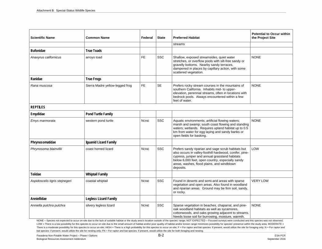
Attachment B: Special-Status Wildlife Species
NONE = Species not expected to occur on-site due to the lack of suitable habitat or the study area’s location outside of the species’ range; NOT EXPECTED = Focused surveys were conducted and this species was not observed;
LOW = There is a low possibility for this species to occur on-site due to the small amount of habitat and/or poor quality of habitat and/or known range minimizes possibility for species’ presence within the study area; MODERATE =
There is a moderate possibility for this species to occur on-site; HIGH = There is a high probability for this species to occur on-site; F = For raptor and bat species: if present, would utilize the site for foraging only; N = For raptor and
bat species: if present, would utilize the site for nesting only; FN = For raptor and bat species: if present, would utilize the site for both foraging and nesting.
Pasadena Non-Potable Water Project – Phase I Options B-2 ESA PCR Biological Resources Assessment Addendum September 2016
Scientific Name Common Name Federal State Preferred Habitat Potential to Occur within the Project Site
streams
Bufonidae True Toads
Anaxyrus californicus arroyo toad FE SSC Shallow, exposed streamsides, quiet water stretches, or overflow pools with silt-free sandy or gravelly bottoms. Nearby sandy terraces, dampened in places by capillary action, with some scattered vegetation.
NONE
Ranidae True Frogs
Rana muscosa Sierra Madre yellow-legged frog FE SE Prefers rocky stream courses in the mountains of southern California. Inhabits mid- to upper-elevation, perennial streams, often in locations with bedrock pools. Always encountered within a few feet of water.
NONE
REPTILES
Emydidae Pond Turtle Family
Emys marmorata
western pond turtle NONE SSC Aquatic environments; artificial flowing waters; marsh and swamp; south coast flowing and standing waters; wetlands. Requires upland habitat up to 0.5 km from water for egg laying and sandy banks or open fields for basking.
NONE
Phrynosomatidae Iguanid Lizard Family
Phrynosoma blainvillii coast horned lizard NONE SSC Prefers sandy riparian and sage scrub habitats but also occurs in valley-foothill hardwood, conifer, pine-cypress, juniper and annual grassland habitats below 6,000 feet, open country, especially sandy areas, washes, flood plains, and windblown deposits.
LOW
Teiidae Whiptail Family
Aspidoscelis tigris stejnegeri coastal whiptail NONE SSC Found in deserts and semi-arid areas with sparse vegetation and open areas. Also found in woodland and riparian areas. Ground may be firm soil, sandy, or rocky.
VERY LOW
Anniellidae Legless Lizard Family
Anniella pulchra pulchra silvery legless lizard NONE SSC Sparse vegetation in beaches, chaparral, and pine-oak woodland habitats as well as sycamores, cottonwoods, and oaks growing adjacent to streams. Needs loose soil for burrowing, moisture, warmth,
NONE

Attachment B: Special-Status Wildlife Species
NONE = Species not expected to occur on-site due to the lack of suitable habitat or the study area’s location outside of the species’ range; NOT EXPECTED = Focused surveys were conducted and this species was not observed;
LOW = There is a low possibility for this species to occur on-site due to the small amount of habitat and/or poor quality of habitat and/or known range minimizes possibility for species’ presence within the study area; MODERATE =
There is a moderate possibility for this species to occur on-site; HIGH = There is a high probability for this species to occur on-site; F = For raptor and bat species: if present, would utilize the site for foraging only; N = For raptor and
bat species: if present, would utilize the site for nesting only; FN = For raptor and bat species: if present, would utilize the site for both foraging and nesting.
Pasadena Non-Potable Water Project – Phase I Options B-3 ESA PCR Biological Resources Assessment Addendum September 2016
Scientific Name Common Name Federal State Preferred Habitat Potential to Occur within the Project Site
and plant cover. Requires moisture.
Colubridae Colubrid Snakes
Thamnophis hammondii two-striped garter snake NONE SSC Coastal California along watercourses with permanent fresh water, and near streams with rocky beds and riparian growth.
NONE
BIRDS
Cuculidae Cuckoos and Roadrunners
Coccyzus americanus occidentalis western yellow-billed cuckoo FC SE Southwestern cottonwood-willow riparian, mixed broadleaf riparian forest.
NONE
Accipitridae Hawks, Kites, Harriers and Eagle Family
Buteo swainsoni Swainson’s hawk NONE ST Breeds in grasslands with scattered trees, juniper-sage flats, riparian areas, savannahs, & agricultural or ranch lands with groves or lines of trees.
NONE
Cathartidae New World Vultures
Gymnogyps californianus California condor FE SE, SFP Nests in deep canyons containing clefts in rocky walls of mountain ranges of moderate altitude. Forages up to 100 miles from nest sites over vast expanses of open savanna, grasslands and foothill habitats.
NONE
Falconidae Falcons
Falco peregrinus anatum American peregrine falcon NONE SFP Found in a variety of habitats including mixed conifer, pinyon-juniper, sagebrush, riparian, grassland habitats, agricultural, and urban areas.
NONE
Apodidae Swifts
Cypseloides niger
black swift
NONE SSC Coastal region of Santa Cruz & Monterey Counties;
central & southern Sierra Nevada; San Bernardino & San Jacinto Mountains. Uses cliffs adjacent to waterfalls within canyons or bluffs above the ocean water. Can travel long distances for foraging.
NONE
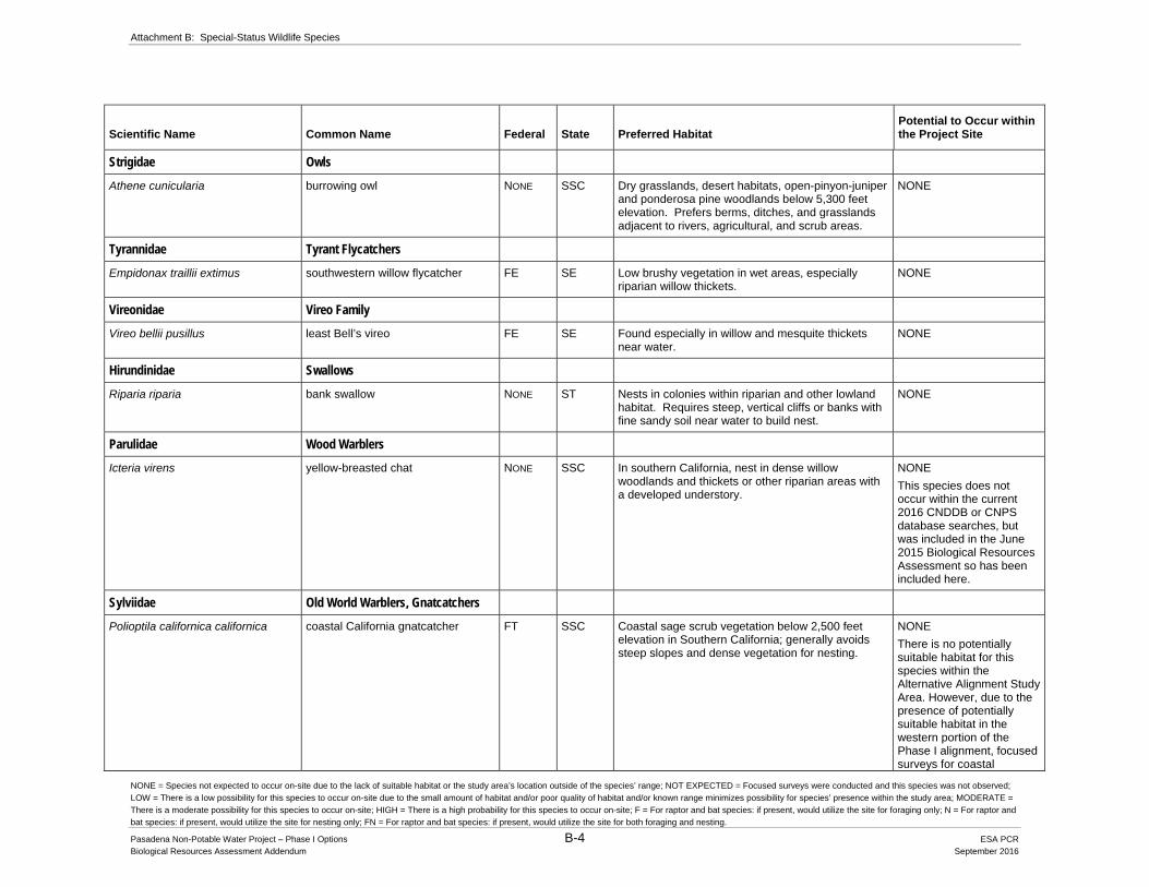
Attachment B: Special-Status Wildlife Species
NONE = Species not expected to occur on-site due to the lack of suitable habitat or the study area’s location outside of the species’ range; NOT EXPECTED = Focused surveys were conducted and this species was not observed;
LOW = There is a low possibility for this species to occur on-site due to the small amount of habitat and/or poor quality of habitat and/or known range minimizes possibility for species’ presence within the study area; MODERATE =
There is a moderate possibility for this species to occur on-site; HIGH = There is a high probability for this species to occur on-site; F = For raptor and bat species: if present, would utilize the site for foraging only; N = For raptor and
bat species: if present, would utilize the site for nesting only; FN = For raptor and bat species: if present, would utilize the site for both foraging and nesting.
Pasadena Non-Potable Water Project – Phase I Options B-4 ESA PCR Biological Resources Assessment Addendum September 2016
Scientific Name Common Name Federal State Preferred Habitat Potential to Occur within the Project Site
Strigidae Owls
Athene cunicularia burrowing owl NONE SSC Dry grasslands, desert habitats, open-pinyon-juniper and ponderosa pine woodlands below 5,300 feet elevation. Prefers berms, ditches, and grasslands adjacent to rivers, agricultural, and scrub areas.
NONE
Tyrannidae Tyrant Flycatchers
Empidonax traillii extimus southwestern willow flycatcher FE SE Low brushy vegetation in wet areas, especially riparian willow thickets.
NONE
Vireonidae Vireo Family
Vireo bellii pusillus least Bell’s vireo FE SE Found especially in willow and mesquite thickets near water.
NONE
Hirundinidae Swallows
Riparia riparia
bank swallow
NONE ST Nests in colonies within riparian and other lowland habitat. Requires steep, vertical cliffs or banks with fine sandy soil near water to build nest.
NONE
Parulidae Wood Warblers
Icteria virens yellow-breasted chat NONE SSC In southern California, nest in dense willow woodlands and thickets or other riparian areas with a developed understory.
NONE
This species does not occur within the current 2016 CNDDB or CNPS database searches, but was included in the June 2015 Biological Resources Assessment so has been included here.
Sylviidae Old World Warblers, Gnatcatchers
Polioptila californica californica coastal California gnatcatcher FT SSC Coastal sage scrub vegetation below 2,500 feet elevation in Southern California; generally avoids steep slopes and dense vegetation for nesting.
NONE
There is no potentially suitable habitat for this species within the Alternative Alignment Study Area. However, due to the presence of potentially suitable habitat in the western portion of the Phase I alignment, focused surveys for coastal

Attachment B: Special-Status Wildlife Species
NONE = Species not expected to occur on-site due to the lack of suitable habitat or the study area’s location outside of the species’ range; NOT EXPECTED = Focused surveys were conducted and this species was not observed;
LOW = There is a low possibility for this species to occur on-site due to the small amount of habitat and/or poor quality of habitat and/or known range minimizes possibility for species’ presence within the study area; MODERATE =
There is a moderate possibility for this species to occur on-site; HIGH = There is a high probability for this species to occur on-site; F = For raptor and bat species: if present, would utilize the site for foraging only; N = For raptor and
bat species: if present, would utilize the site for nesting only; FN = For raptor and bat species: if present, would utilize the site for both foraging and nesting.
Pasadena Non-Potable Water Project – Phase I Options B-5 ESA PCR Biological Resources Assessment Addendum September 2016
Scientific Name Common Name Federal State Preferred Habitat Potential to Occur within the Project Site
California gnatcatcher were conducted in 2010 and 2016. This species was not observed during surveys.
MAMMALS
Molossidae Free-tailed Bats
Eumops perotis californicus western mastiff bat NONE SSC Chaparral; cismontane woodland; coastal scrub; valley and foothill grassland; mainly within arid open habitats. Preferred roosting habitat consists of crevices within rock outcrops and tall buildings, although this species has been known to use trees and tunnels for roost sites. Feeds on flying insects.
NONE (N), VERY LOW (F)
Nyctinomops femorosaccus pocketed free-tailed bat NONE SSC Joshua tree woodland; pinyon and juniper woodland; desert scrub, palm oasis, desert wash, and desert riparian; Sonoran desert scrub. Typically roost in caves and rocky outcrops; prefers cliffs in order to obtain flight speed. Feeds on insects flying, over bodies of water or arid desert habitats to capture prey.
NONE
This species does not occur within the current 2016 CNDDB or CNPS database searches, but was included in the June 2015 Biological Resources Assessment so has been included here.
Nyctinomops macrotis big free-tailed bat NONE SSC Low-lying arid areas in Southern California. Need high cliffs or rocky outcrops for roosting sites. Feeds principally on large moths.
NONE (N), VERY LOW (F)
Vespertilionidae Evening Bats
Antrozous pallidus pallid bat NONE SSC Chaparral, coastal scrub, desert wash, Great Basin grassland, Great Basin scrub, Mojavean desert scrub, riparian woodland, Sonoran desert scrub, upper montane coniferous forest, and valley and foothill grassland; prefers arid, open areas for foraging and adjacent rock outcrops for roosting. This species is also known to use mines, crevices in buildings, and hollow trees as roosting sites. Very sensitive to disturbance of roosting sites. Forages on a variety of insects and arachnids by gleaning within open habitats.
NONE (N), VERY LOW (F)
Corynorhinus townsendii Townsend's big-eared bat NONE SCT, SSC
Throughout California in a wide variety of habitats (e.g., broadleaved upland forest, chaparral, chenopod scrub, Great Basin grassland, Great
NONE

Attachment B: Special-Status Wildlife Species
NONE = Species not expected to occur on-site due to the lack of suitable habitat or the study area’s location outside of the species’ range; NOT EXPECTED = Focused surveys were conducted and this species was not observed;
LOW = There is a low possibility for this species to occur on-site due to the small amount of habitat and/or poor quality of habitat and/or known range minimizes possibility for species’ presence within the study area; MODERATE =
There is a moderate possibility for this species to occur on-site; HIGH = There is a high probability for this species to occur on-site; F = For raptor and bat species: if present, would utilize the site for foraging only; N = For raptor and
bat species: if present, would utilize the site for nesting only; FN = For raptor and bat species: if present, would utilize the site for both foraging and nesting.
Pasadena Non-Potable Water Project – Phase I Options B-6 ESA PCR Biological Resources Assessment Addendum September 2016
Scientific Name Common Name Federal State Preferred Habitat Potential to Occur within the Project Site
Basin scrub, Joshua tree woodland, lower montane coniferous forest, meadow & seep, Mojavean desert scrub, riparian forest, riparian woodland, Sonoran desert scrub, Sonoran thorn woodland, upper montane coniferous forest, valley & foothill grassland). Most common in mesic sites. Roosts in the open, hanging from walls and ceilings. Roosting sites limiting. Extremely sensitive to human disturbance.
Lasiurus blossevillii western red bat NONE SSC Cismontane woodland, lower montane coniferous forest, riparian forest, riparian woodland. Roost primarily in trees, 2-40 ft above ground, from sea level up through mixed conifer forests. Prefers habitat edges and mosaics with trees that are protected from above and open below with open areas for foraging.
NONE
Lasiurus xanthinus western yellow bat NONE SSC Desert wash. Known to occur in palm oases. NONE
Leporidae Hares and Rabbit Family
Lepus californicus bennettii San Diego black-tailed jackrabbit NONE SSC Open brushlands and scrub habitats between sea level and 4,000 feet elevation.
NONE
Muridae Mice, Rats, and Vole Family
Microtus californicus stephensi south coast marsh vole NONE SSC Tidal marshes in Los Angeles, Orange and southern Ventura counties.
NONE
Neotoma lepida intermedia San Diego desert woodrat NONE SSC Coastal scrub and chaparral. Prefer areas with moderate to dense canopy cover. Frequently found in areas with rock outcrops and cliffs.
LOW
Onychomys torridus ramona southern grasshopper mouse NONE SSC Prefers alkali desert scrub and desert scrub habitats, although also found in succulent shrub, wash, riparian, coastal scrub, mixed chaparral, sagebrush, low sage, and bitterbrush habitats. Friable soil for digging burrows within habitats with low to moderate shrub cover is preferred. Food source is arthropods, especially scorpions and grasshoppers.
NONE
Mustelidae Weasels, Skunks, and Otters Family
Taxidea taxus American badger NONE SSC Drier, open stages of shrubland, forest, and herbaceous habitats with friable soils.
NONE
FE Federally Listed as Endangered SE State Listed as Endangered FT Federally Listed as Threatened ST State Listed as Threatened

Attachment B: Special-Status Wildlife Species
NONE = Species not expected to occur on-site due to the lack of suitable habitat or the study area’s location outside of the species’ range; NOT EXPECTED = Focused surveys were conducted and this species was not observed;
LOW = There is a low possibility for this species to occur on-site due to the small amount of habitat and/or poor quality of habitat and/or known range minimizes possibility for species’ presence within the study area; MODERATE =
There is a moderate possibility for this species to occur on-site; HIGH = There is a high probability for this species to occur on-site; F = For raptor and bat species: if present, would utilize the site for foraging only; N = For raptor and
bat species: if present, would utilize the site for nesting only; FN = For raptor and bat species: if present, would utilize the site for both foraging and nesting.
Pasadena Non-Potable Water Project – Phase I Options B-7 ESA PCR Biological Resources Assessment Addendum September 2016
Scientific Name Common Name Federal State Preferred Habitat Potential to Occur within the Project Site
FPE Federally Proposed as Endangered SCE State Candidate for Endangered FPT Federally Proposed as Threatened SCT State Candidate for Threatened FPD Federally Proposed for Delisting SFP State Fully Protected SSC California Species of Special Concern Study Area Search includes the following USGS topographic quads: Burbank, Chilao Flat, Condor Peak, El Monte, Hollywood, Los Angeles, Mount Wilson, Pasadena, and Sunland
Source: PCR Services Corporation, 2016

Attachment C CNDDB Data
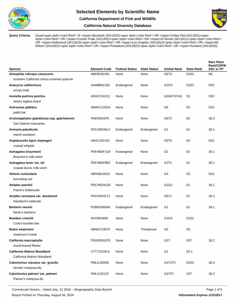
Species Element Code Federal Status State Status Global Rank State Rank
Rare Plant Rank/CDFW SSC or FP
Aimophila ruficeps canescens
southern California rufous-crowned sparrow
ABPBX91091 None None G5T3 S2S3 WL
Anaxyrus californicus
arroyo toad
AAABB01230 Endangered None G2G3 S2S3 SSC
Anniella pulchra pulchra
silvery legless lizard
ARACC01012 None None G3G4T3T4Q S3 SSC
Antrozous pallidus
pallid bat
AMACC10010 None None G5 S3 SSC
Arctostaphylos glandulosa ssp. gabrielensis
San Gabriel manzanita
PDERI042P0 None None G5T2 S2 1B.2
Arenaria paludicola
marsh sandwort
PDCAR040L0 Endangered Endangered G1 S1 1B.1
Aspidoscelis tigris stejnegeri
coastal whiptail
ARACJ02143 None None G5T5 S3 SSC
Astragalus brauntonii
Braunton's milk-vetch
PDFAB0F1G0 Endangered None G2 S2 1B.1
Astragalus tener var. titi
coastal dunes milk-vetch
PDFAB0F8R2 Endangered Endangered G2T1 S1 1B.1
Athene cunicularia
burrowing owl
ABNSB10010 None None G4 S3 SSC
Atriplex parishii
Parish's brittlescale
PDCHE041D0 None None G1G2 S1 1B.1
Atriplex serenana var. davidsonii
Davidson's saltscale
PDCHE041T1 None None G5T1 S1 1B.2
Berberis nevinii
Nevin's barberry
PDBER060A0 Endangered Endangered G1 S1 1B.1
Bombus crotchii
Crotch bumble bee
IIHYM24480 None None G3G4 S1S2
Buteo swainsoni
Swainson's hawk
ABNKC19070 None Threatened G5 S3
California macrophylla
round-leaved filaree
PDGER01070 None None G3? S3? 1B.2
California Walnut Woodland
California Walnut Woodland
CTT71210CA None None G2 S2.1
Calochortus clavatus var. gracilis
slender mariposa-lily
PMLIL0D096 None None G4T2T3 S2S3 1B.2
Calochortus palmeri var. palmeri
Palmer's mariposa-lily
PMLIL0D122 None None G3T3? S3? 1B.2
Quad<span style='color:Red'> IS </span>(Burbank (3411823)<span style='color:Red'> OR </span>Chilao Flat (3411831)<span style='color:Red'> OR </span>Condor Peak (3411832)<span style='color:Red'> OR </span>El Monte (3411811)<span style='color:Red'> OR </span>Hollywood (3411813)<span style='color:Red'> OR </span>Los Angeles (3411812)<span style='color:Red'> OR </span>Mt. Wilson (3411821)<span style='color:Red'> OR </span>Pasadena (3411822)<span style='color:Red'> OR </span>Sunland (3411833))
Query Criteria:
Report Printed on Thursday, August 04, 2016
Page 1 of 5Commercial Version -- Dated July, 31 2016 -- Biogeographic Data Branch
Information Expires 1/31/2017
Selected Elements by Scientific NameCalifornia Department of Fish and Wildlife
California Natural Diversity Database
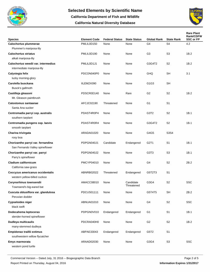
Species Element Code Federal Status State Status Global Rank State Rank
Rare Plant Rank/CDFW SSC or FP
Calochortus plummerae
Plummer's mariposa-lily
PMLIL0D150 None None G4 S4 4.2
Calochortus striatus
alkali mariposa-lily
PMLIL0D190 None None G3 S3 1B.2
Calochortus weedii var. intermedius
intermediate mariposa-lily
PMLIL0D1J1 None None G3G4T2 S2 1B.2
Calystegia felix
lucky morning-glory
PDCON040P0 None None GHQ SH 3.1
Carolella busckana
Busck's gallmoth
IILEM2X090 None None G1G3 SH
Castilleja gleasoni
Mt. Gleason paintbrush
PDSCR0D140 None Rare G2 S2 1B.2
Catostomus santaanae
Santa Ana sucker
AFCJC02190 Threatened None G1 S1
Centromadia parryi ssp. australis
southern tarplant
PDAST4R0P4 None None G3T2 S2 1B.1
Centromadia pungens ssp. laevis
smooth tarplant
PDAST4R0R4 None None G3G4T2 S2 1B.1
Charina trivirgata
rosy boa
ARADA01020 None None G4G5 S3S4
Chorizanthe parryi var. fernandina
San Fernando Valley spineflower
PDPGN040J1 Candidate Endangered G2T1 S1 1B.1
Chorizanthe parryi var. parryi
Parry's spineflower
PDPGN040J2 None None G3T3 S3 1B.1
Cladium californicum
California saw-grass
PMCYP04010 None None G4 S2 2B.2
Coccyzus americanus occidentalis
western yellow-billed cuckoo
ABNRB02022 Threatened Endangered G5T2T3 S1
Corynorhinus townsendii
Townsend's big-eared bat
AMACC08010 None Candidate Threatened
G3G4 S2 SSC
Cuscuta obtusiflora var. glandulosa
Peruvian dodder
PDCUS01111 None None G5T4T5 SH 2B.2
Cypseloides niger
black swift
ABNUA01010 None None G4 S2 SSC
Dodecahema leptoceras
slender-horned spineflower
PDPGN0V010 Endangered Endangered G1 S1 1B.1
Dudleya multicaulis
many-stemmed dudleya
PDCRA040H0 None None G2 S2 1B.2
Empidonax traillii extimus
southwestern willow flycatcher
ABPAE33043 Endangered Endangered G5T2 S1
Emys marmorata
western pond turtle
ARAAD02030 None None G3G4 S3 SSC
Report Printed on Thursday, August 04, 2016
Page 2 of 5Commercial Version -- Dated July, 31 2016 -- Biogeographic Data Branch
Information Expires 1/31/2017
Selected Elements by Scientific NameCalifornia Department of Fish and Wildlife
California Natural Diversity Database

Species Element Code Federal Status State Status Global Rank State Rank
Rare Plant Rank/CDFW SSC or FP
Eumops perotis californicus
western mastiff bat
AMACD02011 None None G5T4 S3S4 SSC
Falco peregrinus anatum
American peregrine falcon
ABNKD06071 Delisted Delisted G4T4 S3S4 FP
Galium grande
San Gabriel bedstraw
PDRUB0N0V0 None None G2 S2 1B.2
Gila orcuttii
arroyo chub
AFCJB13120 None None G2 S2 SSC
Helianthus nuttallii ssp. parishii
Los Angeles sunflower
PDAST4N102 None None G5TH SH 1A
Horkelia cuneata var. puberula
mesa horkelia
PDROS0W045 None None G4T1 S1 1B.1
Imperata brevifolia
California satintail
PMPOA3D020 None None G3 S3 2B.1
Lasionycteris noctivagans
silver-haired bat
AMACC02010 None None G5 S3S4
Lasiurus blossevillii
western red bat
AMACC05060 None None G5 S3 SSC
Lasiurus cinereus
hoary bat
AMACC05030 None None G5 S4
Lasiurus xanthinus
western yellow bat
AMACC05070 None None G5 S3 SSC
Lasthenia glabrata ssp. coulteri
Coulter's goldfields
PDAST5L0A1 None None G4T2 S2 1B.1
Lepidium virginicum var. robinsonii
Robinson's pepper-grass
PDBRA1M114 None None G5T3 S3 4.3
Lepus californicus bennettii
San Diego black-tailed jackrabbit
AMAEB03051 None None G5T3T4 S3S4 SSC
Linanthus concinnus
San Gabriel linanthus
PDPLM090D0 None None G3 S3 1B.2
Malacothamnus davidsonii
Davidson's bush-mallow
PDMAL0Q040 None None G2 S2 1B.2
Microtus californicus stephensi
south coast marsh vole
AMAFF11035 None None G5T1T2 S1S2 SSC
Muhlenbergia californica
California muhly
PMPOA480A0 None None G4 S4 4.3
Nasturtium gambelii
Gambel's water cress
PDBRA270V0 Endangered Threatened G1 S1 1B.1
Navarretia prostrata
prostrate vernal pool navarretia
PDPLM0C0Q0 None None G2 S2 1B.1
Neotoma lepida intermedia
San Diego desert woodrat
AMAFF08041 None None G5T3T4 S3S4 SSC
Report Printed on Thursday, August 04, 2016
Page 3 of 5Commercial Version -- Dated July, 31 2016 -- Biogeographic Data Branch
Information Expires 1/31/2017
Selected Elements by Scientific NameCalifornia Department of Fish and Wildlife
California Natural Diversity Database

Species Element Code Federal Status State Status Global Rank State Rank
Rare Plant Rank/CDFW SSC or FP
Nyctinomops macrotis
big free-tailed bat
AMACD04020 None None G5 S3 SSC
Onychomys torridus ramona
southern grasshopper mouse
AMAFF06022 None None G5T3 S3 SSC
Open Engelmann Oak Woodland
Open Engelmann Oak Woodland
CTT71181CA None None G2 S2.2
Opuntia basilaris var. brachyclada
short-joint beavertail
PDCAC0D053 None None G5T3 S3 1B.2
Orobanche valida ssp. valida
Rock Creek broomrape
PDORO040G2 None None G4T2 S2 1B.2
Phacelia stellaris
Brand's star phacelia
PDHYD0C510 None None G1 S1 1B.1
Phrynosoma blainvillii
coast horned lizard
ARACF12100 None None G3G4 S3S4 SSC
Polioptila californica californica
coastal California gnatcatcher
ABPBJ08081 Threatened None G4G5T2Q S2 SSC
Pseudognaphalium leucocephalum
white rabbit-tobacco
PDAST440C0 None None G4 S2 2B.2
Rana muscosa
southern mountain yellow-legged frog
AAABH01330 Endangered Endangered G1 S1 WL
Rhinichthys osculus ssp. 3
Santa Ana speckled dace
AFCJB3705K None None G5T1 S1 SSC
Ribes divaricatum var. parishii
Parish's gooseberry
PDGRO020F3 None None G4TH SH 1A
Riparia riparia
bank swallow
ABPAU08010 None Threatened G5 S2
Riversidian Alluvial Fan Sage Scrub
Riversidian Alluvial Fan Sage Scrub
CTT32720CA None None G1 S1.1
Scutellaria bolanderi ssp. austromontana
southern mountains skullcap
PDLAM1U0A1 None None G4T3 S3 1B.2
Southern California Arroyo Chub/Santa Ana Sucker Stream
Southern California Arroyo Chub/Santa Ana Sucker Stream
CARE2330CA None None GNR SNR
Southern Coast Live Oak Riparian Forest
Southern Coast Live Oak Riparian Forest
CTT61310CA None None G4 S4
Southern Cottonwood Willow Riparian Forest
Southern Cottonwood Willow Riparian Forest
CTT61330CA None None G3 S3.2
Southern Mixed Riparian Forest
Southern Mixed Riparian Forest
CTT61340CA None None G2 S2.1
Southern Sycamore Alder Riparian Woodland
Southern Sycamore Alder Riparian Woodland
CTT62400CA None None G4 S4
Symphyotrichum defoliatum
San Bernardino aster
PDASTE80C0 None None G2 S2 1B.2
Report Printed on Thursday, August 04, 2016
Page 4 of 5Commercial Version -- Dated July, 31 2016 -- Biogeographic Data Branch
Information Expires 1/31/2017
Selected Elements by Scientific NameCalifornia Department of Fish and Wildlife
California Natural Diversity Database

Species Element Code Federal Status State Status Global Rank State Rank
Rare Plant Rank/CDFW SSC or FP
Symphyotrichum greatae
Greata's aster
PDASTE80U0 None None G2 S2 1B.3
Taricha torosa
Coast Range newt
AAAAF02032 None None G4 S4 SSC
Taxidea taxus
American badger
AMAJF04010 None None G5 S3 SSC
Thamnophis hammondii
two-striped gartersnake
ARADB36160 None None G4 S3S4 SSC
Thelypteris puberula var. sonorensis
Sonoran maiden fern
PPTHE05192 None None G5T3 S2 2B.2
Vireo bellii pusillus
least Bell's vireo
ABPBW01114 Endangered Endangered G5T2 S2
Walnut Forest
Walnut Forest
CTT81600CA None None G1 S1.1
Record Count: 89
Report Printed on Thursday, August 04, 2016
Page 5 of 5Commercial Version -- Dated July, 31 2016 -- Biogeographic Data Branch
Information Expires 1/31/2017
Selected Elements by Scientific NameCalifornia Department of Fish and Wildlife
California Natural Diversity Database

Attachment D CNPS Data


Attachment E USFWS IPaC Data

United States Department of the Interior
FISH AND WILDLIFE SERVICECarlsbad Fish and Wildlife Office
2177 SALK AVENUE - SUITE 250CARLSBAD, CA 92008
PHONE: (760)431-9440 FAX: (760)431-5901URL: www.fws.gov/carlsbad/
Consultation Code: 08ECAR00-2016-SLI-0885 August 25, 2016Event Code: 08ECAR00-2016-E-01438Project Name: Pasadena Water and Power Non-Potable Water Project Alternative Alignments
Subject: List of threatened and endangered species that may occur in your proposed projectlocation, and/or may be affected by your proposed project
To Whom It May Concern:
The enclosed species list identifies threatened, endangered, and proposed species, designatedcritical habitat, and candidate species that may occur within the boundary of your proposedproject and/or may be affected by your proposed project. The species list fulfills therequirements of the U.S. Fish and Wildlife Service (Service) under section 7(c) of theEndangered Species Act (Act) of 1973, as amended (16 U.S.C. 1531 ).et seq.
New information based on updated surveys, changes in the abundance and distribution ofspecies, changed habitat conditions, or other factors could change this list. Please feel free tocontact us if you need more current information or assistance regarding the potential impacts tofederally proposed, listed, and candidate species and federally designated and proposed criticalhabitat. Please note that under 50 CFR 402.12(e) of the regulations implementing section 7 ofthe Act, the accuracy of this species list should be verified after 90 days. This verification canbe completed formally or informally as desired. The Service recommends that verification becompleted by visiting the ECOS-IPaC website at regular intervals during project planning andimplementation for updates to species lists and information. An updated list may be requestedthrough the ECOS-IPaC system by completing the same process used to receive the enclosedlist.
The purpose of the Act is to provide a means whereby threatened and endangered species andthe ecosystems upon which they depend may be conserved. Under sections 7(a)(1) and 7(a)(2)of the Act and its implementing regulations (50 CFR 402 ), Federal agencies are requiredet seq.to utilize their authorities to carry out programs for the conservation of threatened andendangered species and to determine whether projects may affect threatened and endangeredspecies and/or designated critical habitat.

A Biological Assessment is required for construction projects (or other undertakings havingsimilar physical impacts) that are major Federal actions significantly affecting the quality of thehuman environment as defined in the National Environmental Policy Act (42 U.S.C. 4332(2)(c)). For projects other than major construction activities, the Service suggests that a biologicalevaluation similar to a Biological Assessment be prepared to determine whether the project mayaffect listed or proposed species and/or designated or proposed critical habitat. Recommendedcontents of a Biological Assessment are described at 50 CFR 402.12.
If a Federal agency determines, based on the Biological Assessment or biological evaluation,that listed species and/or designated critical habitat may be affected by the proposed project, theagency is required to consult with the Service pursuant to 50 CFR 402. In addition, the Servicerecommends that candidate species, proposed species and proposed critical habitat be addressedwithin the consultation. More information on the regulations and procedures for section 7consultation, including the role of permit or license applicants, can be found in the "EndangeredSpecies Consultation Handbook" at:
http://www.fws.gov/endangered/esa-library/pdf/TOC-GLOS.PDF
Please be aware that bald and golden eagles are protected under the Bald and Golden EagleProtection Act (16 U.S.C. 668 ), and projects affecting these species may requireet seq.development of an eagle conservation plan(http://www.fws.gov/windenergy/eagle_guidance.html). Additionally, wind energy projectsshould follow the wind energy guidelines (http://www.fws.gov/windenergy/) for minimizingimpacts to migratory birds and bats.
Guidance for minimizing impacts to migratory birds for projects including communicationstowers (e.g., cellular, digital television, radio, and emergency broadcast) can be found at:http://www.fws.gov/migratorybirds/CurrentBirdIssues/Hazards/towers/towers.htm;http://www.towerkill.com; andhttp://www.fws.gov/migratorybirds/CurrentBirdIssues/Hazards/towers/comtow.html.
We appreciate your concern for threatened and endangered species. The Service encouragesFederal agencies to include conservation of threatened and endangered species into their projectplanning to further the purposes of the Act. Please include the Consultation Tracking Number inthe header of this letter with any request for consultation or correspondence about your projectthat you submit to our office.
Attachment
2

http://ecos.fws.gov/ipac, 08/25/2016 04:43 PM 1
Official Species List
Provided by: Carlsbad Fish and Wildlife Office
2177 SALK AVENUE - SUITE 250
CARLSBAD, CA 92008
(760) 431-9440
http://www.fws.gov/carlsbad/ Consultation Code: 08ECAR00-2016-SLI-0885Event Code: 08ECAR00-2016-E-01438 Project Type: WATER SUPPLY / DELIVERY Project Name: Pasadena Water and Power Non-Potable Water Project Alternative AlignmentsProject Description: Pasadena Water and Power is proposing the approximately 23-mile PasadenaNon-Potable Water Project located in the City of Pasadena, Los Angeles County, California for theconstruction and operation of a new non-potable water distribution system to deliver recycled water.Alternative alignments include alignments along the Salvia Canyon Route and the RosemontAvenue Route, and the alternative pressure reducing station (PRS) site at West and Salvia Canyon. Please Note: The FWS office may have modified the Project Name and/or Project Description, so itmay be different from what was submitted in your previous request. If the Consultation Codematches, the FWS considers this to be the same project. Contact the office in the 'Provided by'section of your previous Official Species list if you have any questions or concerns.
United States Department of InteriorFish and Wildlife Service
Project name: Pasadena Water and Power Non-Potable Water Project Alternative Alignments

http://ecos.fws.gov/ipac, 08/25/2016 04:43 PM 2
Project Location Map:
Project Coordinates: The coordinates are too numerous to display here. Project Counties: Los Angeles, CA
United States Department of InteriorFish and Wildlife Service
Project name: Pasadena Water and Power Non-Potable Water Project Alternative Alignments

http://ecos.fws.gov/ipac, 08/25/2016 04:43 PM 3
Endangered Species Act Species List
There are a total of 4 threatened or endangered species on your species list. Species on this list should be considered in
an effects analysis for your project and could include species that exist in another geographic area. For example, certain
fish may appear on the species list because a project could affect downstream species. Critical habitats listed under the
Has Critical Habitat column may or may not lie within your project area. See the Critical habitats within your
project area section further below for critical habitat that lies within your project. Please contact the designated FWS
office if you have questions.
Birds Status Has Critical Habitat Condition(s)
California condor (Gymnogyps
californianus)
Population: Entire, except where listed as an
experimental population
Endangered Final designated
Least Bell's vireo (Vireo bellii
pusillus)
Population: Entire
Endangered Final designated
Flowering Plants
Braunton's milk-vetch (Astragalus
brauntonii)
Endangered Final designated
Nevin's barberry (Berberis nevinii) Endangered Final designated
United States Department of InteriorFish and Wildlife Service
Project name: Pasadena Water and Power Non-Potable Water Project Alternative Alignments

http://ecos.fws.gov/ipac, 08/25/2016 04:43 PM 4
Critical habitats that lie within your project areaThere are no critical habitats within your project area.
United States Department of InteriorFish and Wildlife Service
Project name: Pasadena Water and Power Non-Potable Water Project Alternative Alignments

Appendix C - Cultural Resources Assessment Addendum

Page intentionally blank.

2121 Alton Parkway
Suite 100
Irvine, CA 92606
949.753.7001 phone
949.753.7002 fax
www.pcrnet.com
October 27, 2016
Mrs. Rosalyn Prickett, Senior Water Resources Planner RMC Water and Environment 10509 Vista Sorrento Pkwy, Suite 205 San Diego, CA 92121
Subject: Cultural Resources Assessment Addendum for the Proposed Pasadena Non-Potable Water Project Phase I Options, City of Pasadena, Los Angeles County, California
Dear Mrs. Prickett:
ESA PCR (formerly PCR Services Corporation) conducted a cultural resources assessment addendum for the above-referenced project. This letter presents our methods, results, and recommendations from the assessment.
1.0 Project Description and Scope of Study Pasadena Water and Power (PWP) is proposing to construct the Pasadena Non-Potable Water Project (“Project”), a six-phase project within the City of Pasadena (the “City”) for the purpose of providing approximately 10% of PWP’s overall water needs from local, non-potable water sources. The Project would involve the construction and operation of a new non-potable water distribution system to deliver water from three local non-potable water sources: (1) recycled water produced by the Los Angeles/Glendale Water Reclamation Plant (LAG), (2) tunnel water from two existing tunnels (Devils Gate and Richardson Springs), and (3) surface water from Arroyo Seco stream. On February 22, 2016, the Pasadena City Council certified the Environmental Impact Report (EIR) for the Phase I Alignments project. The Phase I Alignments were analyzed at a project level, while the later phases were evaluated at a programmatic level and require additional environmental review prior to implementation.
Per City Council’s request, PWP is currently evaluating two pipeline alignments as options to the proposed Phase I Alignments project (the Salvia Canyon West Route and the Rosemont East Route) and an alternative location for a pressure reducing station near the intersection of West Drive and Salvia Canyon Road (Figure 1, Regional Map; and Figure 2, Vicinity Map, attached). In July and August 2016 and at the request of RMC Water and Environment, Inc. (RMC), ESA PCR conducted a cultural resources assessment of the Phase I Options that serves as an addendum to the previous cultural resources assessment for the Phase I Alignments project. The assessment was conducted to demonstrate compliance with the regulations implementing Section 106 of the National Historic Preservation Act, the National

Mrs. Rosalyn Prickett, Senior Water Resources Planner RMC Water and Environment October 27, 2016 October 27, 2016 - Page 2
Environmental Policy Act, and the California Environmental Quality Act. The scope of work for this assessment included a cultural resources records search through the California Historical Resources Information System-South Central Coastal Information Center (CHRIS-SCCIC), consultations with local historical societies, a Sacred Lands File (SLF) search through the California Native American Heritage Commission (NAHC) and follow-up Native American consultation, and a pedestrian survey of the alignments.
2.0 APE Description In compliance with Section 106, an Area of Potential Effect (APE) must be established for the Proposed Project or “undertaking.” As defined in the Section 106 regulations (36 CFR § 800.16(d)), an APE “is the geographic area or areas within which an undertaking may directly or indirectly cause changes in the character or use of historic properties, if such properties exist. The boundary of the area of potential effect is influenced by the scale and nature of the undertaking and may be different for different kinds of effects caused by the undertaking.” In determining the APE for the Phase I Options, ESA PCR utilized similar APE parameters that were previously established in consultation with the United States Bureau of Reclamation (Mr. Douglas McPherson and Mr. James Kangas) for the Phase I Alignments project. The APE parameters are discussed in detail in the following section.
2.1 Horizontal APE
As shown in Figure 3, Aerial Photograph, the horizontal APE varies throughout project area. For instance, a small portion of the APE (near the intersection of West Washington Boulevard and West Drive and within the Salvia Canyon West Route) will be approximately 60-foot wide by 80-foot long to accommodate a proposed Phase I Pressure Reducing Station (PRS). Following south from the proposed PRS and along West Drive (Salvia Canyon West Route), the APE will consist of a 30-foot wide construction corridor to include the pavement of the road. A small portion of the APE located just west of West Drive and immediately north of the intersection with Salvia Canyon Road (Salvia Canyon West Route), there is an open area proposed for an alternative PRS location which would measure approximately 60-feet wide by 150-feet long. From this point, the road bends north along Salvia Canyon Road and ends at the intersection with Linda Vista Avenue. The APE in this section will consist of a 60-foot wide construction corridor to include the road pavement (Salvia Canyon West Route). The APE along the Rosemont East Route will consist of a 36- to 44-foot wide corridor to include the pavement of the road. A small portion of the APE (at the intersection of Rosemont Avenue, West Washington Boulevard and the abandoned Del Monte Street) will include a 190-foot wide corridor to encompass the pavement of the road. The APE along the abandoned portion of Del

Mrs. Rosalyn Prickett, Senior Water Resources Planner RMC Water and Environment October 27, 2016 October 27, 2016 - Page 3
Monte Street will be approximately 20 to 30 foot-wide to include the pavement of the road and a cement-lined drainage ditch along the edge of the road. The cement-lined drainage ditch would need to be removed and reconstructed for installation of two pipelines (see Figure 3, attached).
2.2 Vertical APE
The vertical extent of the APE will vary throughout the project. The trenches for the pipelines will be approximately 2 to 5 feet wide and 4 to 10 feet deep. The excavations for the PRS facilities will reach depths from the surface to a maximum depth of 8 feet below the surface. Therefore, the maximum extent of the vertical APE in regards to below-grade impacts would be approximately 10 feet below the surface. The PRS facilities will be built above-grade and will reach maximum heights between 10 and 16 feet above grade when built. Therefore, the maximum extent of the vertical APE in regards to above-grade impacts (to account for visual impacts) would be approximately 16 feet above grade.
2.0 Methods
2.1 Cultural Resources Records Search
On July 28, 2016, ESA PCR conducted a cultural resource records search for the APE through the CHRIS-SCCIC at the California State University, Fullerton. The records search included a review of all recorded cultural resources within the APE and a one-half mile radius and associated cultural resource reports and historic topographic maps on file. In addition, ESA PCR reviewed the California Points of Historical Interest (CPHI), the California Historical Landmarks (CHL), the California Register, the National Register, and the California State Historic Resources Inventory (HRI) listings. The purpose of the record search is to determine whether or not there are any new recorded archaeological or historical resources within the APE that require inclusion in the current analysis. The results also provide a basis for assessing the sensitivity of the APE in regards to the potential for surface and subsurface cultural resources to exist.
2.2 Consultation with Local Historical Societies
On August 9, 2016, ESA PCR conducted consultation with two local historical societies (Pasadena Museum of History and Pasadena Heritage). Specifically, each of the historical societies was sent a project notification letter and map via email and were asked if they had

Mrs. Rosalyn Prickett, Senior Water Resources Planner RMC Water and Environment October 27, 2016 October 27, 2016 - Page 4
any concerns about built environmental historical resources in the APE. The letter included a brief description of the proposed development and a map showing the location of the APE.
2.3 Sacred Lands File Search and Native American Consultation
On August 2, 2016, ESA PCR commissioned an updated SLF search of the APE through the NAHC who identified seven Native American individuals or organizations with affiliations with the project vicinity. ESA PCR sent a project notification letter and map to each Native American individual or organization on the NAHC contact list on August 5, 2016, and was asked for their concerns and/or provide knowledge regarding prehistoric or Native American resources (archaeological sites, sacred lands, or artifacts) located within the APE or surrounding vicinity. The letter included the APE location and a brief description of the proposed project. Results of the SLF search and follow-up consultation provide information pertaining to the nature and location of additional prehistoric or Native American resources that may not be available at the CHRIS-SCCIC.
2.4 Pedestrian Survey
On July 27, 2016, ESA PCR archaeologist, Mrs. Fatima Clark, conducted a pedestrian and windshield survey of the APE. ESA PCR surveyed undeveloped areas of the APE in pedestrian transect intervals spaced at 10 to 15 meters apart while ESA PCR conducted a windshield survey of the areas within the APE that were covered with pavement. 100 percent of the APE was surveyed by ESA PCR. A Trimble® GeoXT™ sub-meter Global Positioning System (GPS) unit was used for navigation and documenting distribution of the APE conditions. Detailed notes and digital photographs were also taken of the APE and surrounding vicinity.
3.0 Results
3.1 Cultural Resources Records Search
The cultural resources records search revealed that a total of 34 cultural resource studies have been conducted within a one-half mile radius of the APE from 1952 to 2013 that encompass approximately 25 percent of the one-half mile search radius around the APE. No new resources were identified beyond the original CRA.
Mrs. Rosalyn Prickett, Senior Water Resources Planner RMC Water and Environment October 27, 2016 October 27, 2016 - Page 5
3.1.1 Archaeological Resources
The records search at the CHRIS-SCCIC revealed the existence of one known prehistoric archaeological resource (CA-LAN-26) within the one-half mile radius of the APE. Specifically, CA-LAN-26 (or “Walker’s Sheldon Reservoir Site”) is located within 620 feet of the Rosemont East Route and is described as a Native American cemetery that contained 53 burials and two cremations. CA-LAN-26 had been identified previously during the cultural resources assessment for the EIR of the Phase I Alignments project. No known historic or prehistoric archaeological resources have been recorded within or immediately adjacent to the APE.
3.1.2 Built Environment Historical Resources
The records search at the CHRIS-SCCIC indicated that a total of 21 built environment historical resources have been recorded within a one-half mile radius of the APE. Of the 21 resources, only one resource known as the Pasadena Arroyo Parks and Recreation District (National Register District, Primary Number 19-0364), has been recorded within the APE. The resource is described in detail below:
Pasadena Arroyo Parks and Recreation District (P-19-0364)
The Pasadena Arroyo Parks and Recreation District (P-19-0364) is listed in the Cultural Landscape category under National Register Criterion A and California Register Criterion 1 for its strong historical association with the context of parks and recreation at the local level. The period of significance for the Pasadena Arroyo Parks and Recreation District begins in 1909 when the City of Pasadena first started to acquire land in the Arroyo to create a public park and ends in 1939. The Pasadena Arroyo Parks and Recreation District possesses a significant concentration of man-made linkages including trails, roads, and retaining walls, which are all united by the natural features shaped by the Arroyo Seco. The District is comprised of a variety of elements including twenty-seven contributing and fifty-seven non-contributing features. The boundaries of the District are shown on Figure 3, attached.
3.2 Consultation with Local Historical Societies On August 9, 2016, ESA PCR received an email reply from the Pasadena Museum of History indicating that ESA PCR should reach out to the Pasadena Heritage (Appendix A). On the same day, ESA PCR replied to the Pasadena Museum of History and mentioned that the Pasadena Heritage had already been contacted. Consultation is on-going and may result in additional comment letters which will be appended in a future draft.

Mrs. Rosalyn Prickett, Senior Water Resources Planner RMC Water and Environment October 27, 2016 October 27, 2016 - Page 6
3.3 Sacred Lands File Search and Native American Consultation
The NAHC SLF records search results (received August 4, 2016) revealed that there are no known Native American cultural resources in the SLF database within or in a one-half mile of the APE (Appendix B). Follow-up correspondence was conducted with all seven individuals and groups indicated by the NAHC as having affiliation with the APE in order to solicit information on Native American cultural resources in the vicinity of the APE. Contact letters were sent via certified mail on August 5, 2016. The letters described the Project and included a map depicting the location of the APE. Recipients were requested to reply with any information concerning Native American cultural resources that might be affected by the Project. Follow-up phone calls were conducted on August 16, 2016. To date, three responses have been received (Table 1).
TABLE 1
NATIVE AMERICAN OUTREACH
Contact/Affiliation
Date
Letter
Mailed
Date of
Follow-
up
Contact Response
Mr. Rudy Ortega, President Fernandeno Tataviam of Mission Indians
08/05/16 08/16/16 Left VM. No response to date.
Mr. Robert F. Dorame, ChairpersonGabrieleno Tongva Indians Of California Tribal Council
08/05/16 08/16/16 ESA spoke with Mr. Dorame at 1:30 PM. Mr. Dorame reported that his grandmother lived and was buried approximately 1-mile from the Sheldon Reservoir Site and as such he has a cultural identity in the area on his grandmother's side of the family. He also notes that there are many waterways, including the Arroyo and springs which contribute to archaeological sensitivity of the (APE). He stated that due to the proximity of his family to the APE, he has

Mrs. Rosalyn Prickett, Senior Water Resources Planner RMC Water and Environment October 27, 2016 October 27, 2016 - Page 7
Contact/Affiliation
Date
Letter
Mailed
Date of
Follow-
up
Contact Response
a great interest in the area and should be a participant in monitoring for the project.
Mr. Andrew Salas, Chairperson Gabrieleno Band Of Mission of Indians Kizh Nation
08/05/16 08/16/16 ESA spoke with Mr. Salas at 2:30 PM. Mr. Salas indicated that he would like to participate in monitoring for the project and would follow up with a letter response. Mr. Salas also provided historic information regarding a historic Zanja that was reported to run through the Sheldon Reservoir portion of the project APE. See Appendix B for letter.
Mr. Anthony Morales, Chairperson Gabrieleno/Tongva San Gabriel Band of Mission Indians
08/05/16 08/16/16 ESA spoke with Mr. Morales at 11:56 am. Mr. Morales indicated that the area is a hot spot for cultural sensitivity with a known string of villages running through the Rosebowl up to the JPL area. He said that the project should have Native and archaeological monitors. He doesn’t want to lose this project as it is in his backyard and wants to have input and be involved during the process. Mr. Morales also indicated that he has an existing relationship with Rose La Bianca at the City of Pasadena and as such an existing relationship with the City of Pasadena. He indicated that he would follow up with his son Adrian Morales regarding additional recommendations for the project. Adrian Morales followed up with an email on 8/19/2016. See Appendix B for email. Mr. Anthony

Mrs. Rosalyn Prickett, Senior Water Resources Planner RMC Water and Environment October 27, 2016 October 27, 2016 - Page 8
Contact/Affiliation
Date
Letter
Mailed
Date of
Follow-
up
Contact Response
Morales then followed up on 8/19/2016 at 3:00 pm by phone regarding his son's email. ESA confirmed receipt of email and that comments would be incorporated into the update memo.
Ms. Linda Candelaria, Co-Chairperson Gabrieleno-Tongva Tribe
08/05/16 08/16/16 Left VM. No response to date.
Sandonne Goad, Chairperson Gabrieleno/Tongva Nation
08/05/16 08/16/16 Sandone said she would check her mail and forward the package on to Sam Dunlap who would respond. No response to date.
Mr. John Valenzuela, Co-Chairperson San Fernando Band of Mission Indians
08/05/16 08/16/16 ESA spoke with the individual who answered the phone (no name given) who indicated that John was ill and could not consult and to please refer to another tribe.
As consultation is on-going, additional comment letters may be received and will be appended in a future draft. Documentation pertaining to Native American contact is attached as Appendix B.
3.4 Pedestrian Survey
No archaeological resources were identified during ESA PCR’s pedestrian and windshield survey of the APE. However, one segment of a linear built environment historical resource (PWP-Site-1) and a cement-lined drainage ditch (PWP-Site-2) was identified within portions of the APE. Below is a description of the pedestrian survey by route, including the resources

Mrs. Rosalyn Prickett, Senior Water Resources Planner RMC Water and Environment October 27, 2016 October 27, 2016 - Page 9
PWP-Site-1 and PWP-Site-2. As shown on Figures 4 and 5, APE Photographs, ground surface visibility within the paved areas of the APE were poor (zero percent), while the ground surface visibility within the undeveloped portions varied from fair to good (50 to 100 percent).
3.4.1 Salvia Canyon West Route
This route follows along West Drive and Salvia Canyon Road. West Drive is bounded on the east by a golf course and on the west by an equestrian and hiking trail.
Resource PWP-Site-1
Resource PWP-Site-1, a segment of a stone-lined wall, was identified within the APE near the intersection of West Drive and Salvia Canyon Road (see Figure 3, Aerial Photograph, and
Figure 4, APE Photographs). The stone-lined wall segment measures approximately three feet in height by 150 feet long and falls within the boundaries of a previously recorded National Register-eligible resource - the Pasadena Arroyo Parks and Recreation District (P-19-0364). Although this rock wall segment is not particularly mentioned as a contributing or non-contributing feature in the Department of Parks and Recreation (DPR) Site Form for the District, the rock wall still forms part of the landscape for the District. Also, only a small portion of this rock wall (about 75 feet) falls within the APE for the Project. The stone-lined wall continues south and then northwest along the east side of Salvia Canyon Road for approximately 1,500 feet; however, these segments of the resource fall outside the APE and the District. The stone-lined wall will be temporarily designated as resource PWP-Site-1. ESA PCR has prepared a DPR Site Form for the resources which is provided in Appendix C of this report.
No additional resources were encountered within the APE during the pedestrian survey.
3.4.2 Rosemont East Route
This route starts at the intersection of Rosemont Avenue and Rose Bowl Drive and continues north (for about 4,200 feet) along Rosemont Avenue along paved roads. From there, the route continues east near the intersection with Washington Boulevard along an abandoned portion of Del Monte Street, and subsequently stops before reaching North Arroyo Boulevard.
Resource PWP-Site-2
Resource PWP-Site-2, a cement-lined drainage ditch, was identified within the APE along the north edge of Del Monte Street (see Figure 3, Aerial Photograph, and Figure 5, APE

Mrs. Rosalyn Prickett, Senior Water Resources Planner RMC Water and Environment October 27, 2016 October 27, 2016 - Page 10
Photographs). The cement-lined drainage ditch measures approximately four feet in width by 300 feet in length and falls within the boundaries of a previously recorded National Register-eligible resource - the Pasadena Arroyo Parks and Recreation District (P-19-0364). The resource will be temporarily designated as resource PWP-Site-2. ESA PCR has prepared a DPR Site Form for the resource which is provided in Appendix C of this report.
4.0 Impact Analysis The results of ESA PCR’s assessment revealed the presence of three known cultural resources within the APE. These resources include the Pasadena Arroyo Parks and Recreation District, PWP-Site-1 and PWP-Site-2. The impacts to these resources are discussed below.
4.1 Archaeological Resources
The cultural resources record search results revealed that one prehistoric archaeological site (CA-LAN-26) was mapped within 620 feet of the APE. CA-LAN-26 was encountered in 1938 during excavations for the existing above-ground Sheldon Reservoir. It is described as a Native American cemetery that was excavated by the Southwest Museum shortly after its discovery by the Pasadena Water Department (now PWP). The identification of four “Indian Villages” on Kirkman’s 1937 map1 near the Arroyo Seco in the vicinity of the APE confirms the APE and surrounding vicinity were occupied by Native American in the past. The identification of CA-LAN-26 further supports this claim and it is possible that CA-LAN-26 may account for one of the villages on Kirkman’s map. Therefore, despite the heavy urbanization of the APE that may have displaced archaeological resources on the surface, it is possible that intact archaeological resources will be encountered at depth during excavation activities associated with the Project. As a result, recommended mitigation measures CULT-1, -2, and -3 of the adopted Mitigation Monitoring and Reporting Program (MMRP) for archaeological construction monitoring are provided to reduce potentially significant impacts to archaeological resources that are accidentally discovered during implementation of the Project to a less than significant level.
1 Kirkman, George W. (1937), Pictorial and Historical Map of Old Los Angeles County

Mrs. Rosalyn Prickett, Senior Water Resources Planner RMC Water and Environment October 27, 2016 October 27, 2016 - Page 11
4.2 Built Environment Historical Resources
4.2.1 Pasadena Arroyo Parks and Recreation District
The two proposed locations for the PRS facilities are within the boundaries of National Register-eligible resource – the Pasadena Arroyo Parks and Recreation District. Construction of either pressure reducing station would occur within the boundary of the District, and would therefore potentially have an adverse indirect impact to the District by introduction of a new non-contributing feature (a visual impact). This new pressure reducing station is adjacent to the character-defining Brookside Golf Club and could materially impair the significance of the Brookside Gold Course by detracting from the aesthetic character of the golf course.
The potential significance of this impact caused by the construction of the pressure reducing station would be reduced to a less than significant level through implementation of Mitigation Measure CULT-4 of the adopted Mitigation Monitoring and Reporting Program (MMRP), which requires compliance with the Secretary of Interior Standards 9 and 10 which pertain to new construction adjacent to a historical resource. In particular, the new construction shall be compatible with the historic materials, features, size, scale, proportion, and massing of the Brookside Gold Course and Pasadena Arroyo Parks and Recreation District. These Standards would require the new pressure reducing station to be designed in a manner that would not dominate the viewshed and would suppress audible noise to background levels (between 60 and 70 dBA). Mitigation Measure CULT-4 would therefore ensure the Phase I Options project would not detract from the integrity of Pasadena Arroyo Parks and Recreation District’s cultural landscape. Impacts are considered less than significant after the incorporation of mitigation.
4.2.2 PWP-Site-1
Resource PWP-Site-1, a segment of a stone-lined wall, was identified within the APE during the pedestrian survey. The stone-lined wall segment measures approximately three feet in height by 150 feet long and falls within the boundaries of a previously recorded National Register-eligible resource - the Pasadena Arroyo Parks and Recreation District (P-19-0364). Although this rock wall segment is not particularly mentioned as a contributing or non-contributing feature in the Department of Parks and Recreation (DPR) Site Form for the District and its construction date is currently unknown, the rock wall still forms part of the landscape for the District. According to plans provided to ESA PCR from RMC, the footprint of the proposed PRS facility will be immediately adjacent to the rock wall and; therefore, the construction of the PRS facility would not cause a direct physical impact to the resource and

Mrs. Rosalyn Prickett, Senior Water Resources Planner RMC Water and Environment October 27, 2016 October 27, 2016 - Page 12
therefore no mitigation measures are warranted. Any potential visual impacts would be mitigated through the implementation of Mitigation Measure CULT-4 of the adopted MMRP.
4.2.3 PWP-Site-2
Resource PWP-Site-2, a cement-lined drainage ditch, was identified within the APE during the pedestrian survey. The cement-lined storm drainage ditch measures approximately four feet in width by 300 feet in length by 1-foot deep. The resource is located within the boundaries of the Pasadena Arroyo Parks and Recreation District; however, it is not mentioned as a contributing feature to the District and does not appear to be associated with a larger landscape or an alternative district resource. Moreover, the ditch is characteristic of a typical flood control feature and does not appear to be associated with a significant event or person nor does it embody distinctive characteristics of a type, period, or method of construction. Lastly, recordation of the resource on a DPR Site Form exhaust its research potential and it does not yield or have the potential to yield information that is important to the history of the area. As such, the resource is recommended as not eligible for listing in the California Register of Historical Resources and the National Register of Historic Places and no further work or mitigation is warranted.
5.0 Conclusions and Recommended Mitigation Measures Archaeological resources mapped within 620 feet of the APE as well as the location of named villages which occur in the vicinity of the APE confirm the possibility of intact archaeological resources which could be encountered during excavation activities for the project. However, impacts to these resources from the proposed project would be reduced to a less than significant level through implementation of CULT-1, -2, and -3 of the adopted MMRP.
ESA PCR identified two resources (Pasadena Parks and Recreation District and PWP-Site-1) within the APE that are eligible for listing in the California Register of Historical Resources and the National Register of Historic Places. However, impacts to these resources from the proposed project would be reduced to a less than significant level through implementation of Mitigation Measure CULT-4 of the adopted MMRP, which requires compliance with the Secretary of Interior Standards 9 and 10 which pertain to new construction adjacent to a historical resource. In particular, the new construction shall be compatible with the historic materials, features, size, scale, proportion, and massing of the Brookside Gold Course and Pasadena Arroyo Parks and Recreation District.

Mrs. Rosalyn Prickett, Senior Water Resources Planner RMC Water and Environment October 27, 2016 October 27, 2016 - Page 13
Please contact us if you have any questions regarding the results or recommendations presented in this report.
Sincerely,
ESA PCR
Fatima Clark Kyle Garcia Archaeologist Senior Archaeologist I
Attachments:
Figure 1 – Regional Map
Figure 2 – Vicinity Map
Figure 3 – Aerial Photograph
Figure 4 – APE Photos
Figure 5 – APE Photos
Appendix A – Consultation with Local Historical Societies
Appendix B – Native American Consultation Documentation
Appendix C –DPR Site Forms (PWP-Site-1 and PWP-Site-2)

Rosemont East RouteSalvia Canyon West Route
Pasadena Water and Power Non-Potable Water Project Phase I OptionsFigure 1
Regional MapSOURCE: ESRI Street Map.
APE0 2
Miles

Rosemont East Route
Salvia Canyon West Route
Pasadena Water and Power Non-Potable Water Project Phase I OptionsFigure 2
Vicinity MapSOURCE: USGS Topographic Series (Pasadena, CA).
APE0 2,000
Feet
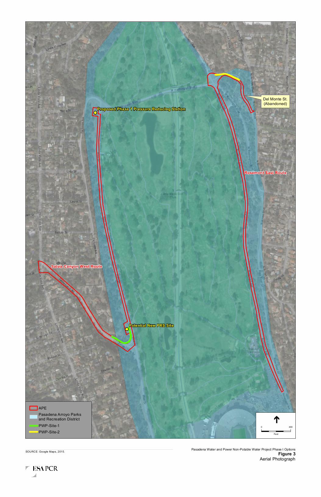
Del Monte St.(Abandoned)
Rosemont East Route
Salvia Canyon West Route
Potential New PRS Site
Proposed Phase 1 Pressure Reducing Station
Pasadena Water and Power Non-Potable Water Project Phase I OptionsFigure 3
Aerial PhotographSOURCE: Google Maps, 2015.
0 400
Feet
APEPasadena Arroyo Parksand Recreation DistrictPWP-Site-1PWP-Site-2
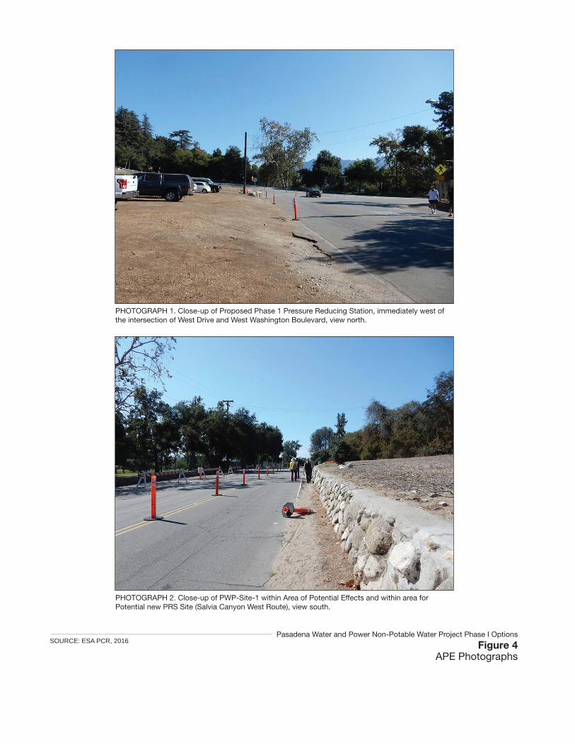
PHOTOGRAPH 1. Close-up of Proposed Phase 1 Pressure Reducing Station, immediately west of the intersection of West Drive and West Washington Boulevard, view north.
PHOTOGRAPH 2. Close-up of PWP-Site-1 within Area of Potential Effects and within area for Potential new PRS Site (Salvia Canyon West Route), view south.
Figure 4APE Photographs
Pasadena Water and Power Non-Potable Water Project Phase I OptionsSOURCE: ESA PCR, 2016

Figure 5APE Photographs
SOURCE: ESA PCR, 2016
PHOTOGRAPH 3. Overview of Area of Potential Effects along West Drive (Salvia Canyon West Route), view south.
PHOTOGRAPH 5. Overview of Area of Potential Effects along abandoned road, view north west.
PHOTOGRAPH 6. Close-up of PWP-Site-2 within Area of Potential Effects (Rosemont East Route), view northeast.
PHOTOGRAPH 4. Overview of Area of Potential Effects along Rosemont Avenue (Rosemont East Route), view south.
Pasadena Water and Power Non-Potable Water Project Phase I Options

Appendix A – Consultation with Local Historical Societies

201 Santa Monica Boulevard
Suite 500
Santa Monica, CA 90401
310.451.4488 phone
310.451.5279 fax
www.esassoc.com
August 9, 2016 Pasadena Heritage 51 South Saint John Avenue Pasadena, California 91105-2913 Attention: Sue Mossman Submitted Via Email: [email protected] Subject: Historical Preservation Consultation: Pasadena Non-Potable Water Project, City of Pasadena,
California Dear Ms. Mossman: ESA PCR is preparing environmental documentation for the Pasadena Non-Potable Water Project (“Project”) which consists of a six-phase project to construct a non-potable water distribution system within the City of Pasadena (“City”) and select customers immediately adjacent to the City. Please kindly notify us if your organization has any concerns about historical resources in the Project Area. The Project involves construction and operation of a new non-potable water distribution system to deliver water from three local non-potable water sources: (1) recycled water produced by the Los Angeles/Glendale Water Reclamation Plant (LAG), (2) tunnel water from two existing tunnels (Devils Gate and Richardson Springs), and (3) surface water from Arroyo Seco stream. On February 22, 2016, the Pasadena City Council certified the Environmental Impact Report (“EIR”) for the Project. Phase I was analyzed at a project level, while the later phases were evaluated at a programmatic level and require additional environmental review prior to implementation. Phase I (as shown in Figure 1, Phase 1 Project and Refinements) is designed to supply 700 AFY of recycled water from LAG to four customers in Pasadena (Art Center College of Design, Brookside Golf Course, Rose Bowl Stadium, and Brookside Park) and includes the following:
• 24,600 linear feet (“LF”) of non-potable water pipe
• 9,200 LF of power transmission and fiber optic cables along the pipe
• Two non-potable water reservoirs – one up to 1.25 million gallons (“MG”) reservoir at Scholl Canyon in the City of Glendale (“Glendale”), and one up to 1.25 MG reservoir at Sheldon Reservoir site in the City of Pasadena
• One pressure reducing station (“PRS”) and a hydroelectric generation turbine facility in Pasadena, near the intersection of Washington Boulevard and West Drive.
Per City Council’s request, PWP is currently evaluating two refinements (the Salvia Canyon Route depicted in orange and the Rosemont Avenue Route depicted in pink in Figure 1) to the proposed Phase I pipeline.
In the Cultural Resources Assessment we prepared in May 2015, we identified the following previously recorded historical resources within the Phase I Project area: the Pasadena Arroyo Parks and Recreation District (National Register District, Primary Number 19-0364); the Arroyo Seco Flood Control Channel (National Register Eligible District, Primary Number 19-186859); and the Art Center College of Design (City of Pasadena Historic

Sue Mossman August 9, 2016 Page 2
Monument). In regards to the future programmatic extensions, we identified the following potential resources that maybe impacted directly or indirectly:
Southern Extension I
• Prospect District (Number 1186), 1005 to 1126 Armada Drive (both sides of street), National Register District, Listed on April 7, 1953.
• Ross Grove Landmark District, 250 to 280 Orange Grove Boulevard (even side of street), City of Pasadena Landmark District, Listed on October 13, 2003.
• South Marengo, 455 to 569 Marengo and 462 to 540 Marengo, City of Pasadena Landmark District, Listed on June 2, 1982.
• Marengo/Pico Landmark District, 181 Pico Street, Constructed 1927, City of Pasadena Landmark District, Listed on August 11, 2008.
• Colorado Street Bridge (81000156), Individual Resource Listed on National Register, Listed on February 21, 1981.
Southern Extension II
• Mentor Court (N1891), 937 E California, National Register, Listed on National Register, November 15, 1994
• Tournament Fields Landmark District, 907 to 995 Cornell Road, City of Pasadena Landmark District, Listed on October 23, 2006
Annandale Extension
• The Pasadena Arroyo Parks and Recreation District (P-33-5711), National Register District
• The Arroyo Seco Flood Control Channel (P-19-186859), National Register Eligible
Northwestern Extension
• Jet Propulsion Laboratory (NASA) is a grouping of individually designated historic buildings including the National Historic Landmarks, “Space Flight Operations Facility,” and the “Twenty-Five-Foot Space Simulator.”
Northeastern Extension
• The Northeastern Extension does not appear to pass through or adjacent to any identified historic resources.
The historic properties that may be impacted by the Phase I Project and Future Extensions areas shown on Figure 5, Resources Map.

Sue Mossman August 9, 2016 Page 3
As indicated in Table 1, the project area is located on the Pasadena, California United States Geologic Survey 7.5’ topographic quadrangle map.
TABLE 1 LOCATIONAL DATA FOR PROJECT AREA
Quadrangle Section Township and Range
Pasadena 8 T1N R12W
Pasadena 13 T1N R13W
Pasadena 14 T1N R13W
Pasadena 17 T1N R12W
Pasadena 18 T1N R12W
Pasadena 20 T1N R12W
Thank you for your assistance with our efforts to address possible historical resource concerns that may be affected by the proposed project. Please kindly notify us if your organization has any concerns about historical resources in the Project Area. This is not a request for research; it is solely a request for public input for any concerns that your organization may have. Please contact me via email at [email protected] or via phone at 310-451-4488. We look forward to hearing from you and appreciate your time to review this request.
Sincerely,
Margarita Jerabek, Ph.D. Director of Historic Resources
Enclosures:
Figure 1, Phase 1 Project and Refinements
Figure 5, Resources Map

!(!
!(<
!(E
!(<
!(
§̈¦210
Connection toGWP System
Avery Dennison
Pacific Oaks College
20"
20"
20"
16"
16"
8"
6"
6"
6"
6"6"
Scholl CanyonNon-PotableWater Reservoir
Sheldon Non-PotableRservoir(s)1.25 MG 1050' HWL
PRS 1666/1050&
Brookside BoosterPump Station
(Phase I)
20"
WASHINGTON
AR
RO
YO
RO
SE
MO
NT
RO
SE
MO
NT
LA CANADA FLINTRIDGELA CANADA FLINTRIDGE
24"
Caltrans 2095 Arroyo
³±(!")
Pump Station(350 gpm)
14,000 Gal Wet Well
12" TW TransmissionPipeline
12" Richardson Intake
Hydroelectric Turbine Facility(Phase I)
RW pipeline and parallel electrical/fiber optic conduit
Rosemont Ave. Route
Salvia Canyon Route
Brookside Park
Brookside Golf Course
Art Center Collegeof Design
Rose Bowl Stadium
GLENDALEGLENDALE
WE
ST
AR
RO
YO
RO
SE
MO
NT
LIDA
FOR
ES
T
LIN
DA
VIS
TA
CANADA
GLENOAKS
SE
CO
WASHINGTON
ZANJA
FIGU
ER
OA
HOWARD
MONTANA
WOODBURY
SAINT K
ATHERIN
E
INV
ER
NE
SS
CA
SIT
AS
NE
WP
OR
T
KE
NN
ET
H
AR
MA
DA
DEL MONTE
PA
RK
VIE
W
WIL
LIS
BLA
KE
WYOMING
PR
OS
PE
CT
GLE
N O
AK
S
STANTON
RO
SE
BO
WL
PEPPER
HAMMOND
VIS
TA
DE
VO
N
RADIO LATERAL
AFTON
CONISTON
WESTGATE
LEN
OR
E NO
RM
AN
DY
EL MIRADOR
WICKS
SCENIC
KIRKHAM
YOCUM
TOOLEN
PALISADE
CLAREMONT
SAN AUGUSTIN
E
DRAGONFLY
PEGFAIR ESTATES
EDGEHILL
VALL
E V
ISTA
WALDORF
HAMPSTEAD
LAUN
BRYANT
WIN
ON
A
MONARCH
VERMONT
SALVIA CANYON
PASAD
EN
A
WO
TK
YN
S
EMERALD ISLE
PA
RN
ELL
LINDA RIDGE
BANYAN
KAREN LYNN
EVERTS
PHEASANT
LAUREL
PALMERSTONE
BR
AE
MA
R
SO
LITA
MACDONALD
WE
ND
OV
ER
PUTNEY
DE
XT
ER
SA
INT
GR
EG
OR
Y
BR
AM
LEY
LA C
RE
STA
WIERFIELD
CHARLESWABASH
LA MESA
MARENGO
AS
HIN
GTO
N
HOLLYWELL
REGENT PARK
MOUNTAIN
CHAMBERLAIN
WEIM
AR
AR
RO
YO
VIE
W
CYPR
ESS
LANCASHIRE
KNOLLWOOD
YU
CC
A
SELKIRK
BUC
KING
HAM
THORNWOOD
HEATHERSIDE
RIC
HLA
ND
BE
RW
ICK
RO
SE
WA
LK
DU
NS
ME
RE
RUTHERFORD
TY
RR
EL
L
SE
RR
AN
O
CORNW
ALL
LOMAY
KA
RE
N S
UE
FULLMOON
RANCHEROS
EUSTON
SAINT ELIZABETH
SH
ER
WO
OD
BENNETT
ANDERSON
CO
VE
NT
RY
SERVICE
HU
FF
ER
CHULA VISTA
SUSSEX
CA
RN
AR
VO
N
PINE OAK
CH
AR
ING
CR
OS
S
FU
LLB
RO
OK
SHAN
NO
N
CORNWALL
ARM
AD
A
WABASH
AFTON
PALISADE
LIND
A V
ISTA
SO
LITA
CY
PR
ES
S
INVERNESS
RO
SE
BO
WL
AFTON
LIN
DA
VIS
TA
FIGU
ER
OA
CHARLES
S13 T1N R13W S18 T1N R12W S17 T1N R12W
S19 T1N R12W S20 T1N R12W
S7 T1N R12W S8 T1N R12W
S14 T1N R13W
S12 T1N R13W
ARRO
YO SE
CO
Pasadena Non-Potable Water ProjectFigure 1
Phase 1 Project and Refinements
0 800 1,600400
Feet
Notes:GWP - Glendale Water and PowerPWP - Pasadena Water and PowerRW - Recycled WaterPRS - Pressure Reducing Station
³±(!
±
Potential Demand!( > 0 afy
!(E > 10 afy
!(! > 25 afy
!(( > 50 afy
!(< > 100 afy
Proposed FacilitiesStorage Reservoir
!³T
³ Pump Station
Phase 1
Other FeaturesExisting Glendale RW Pipes
Railroads
City Boundaries
Hydroelectric Turbine Facility
N:\Pro
jects\0
129 - P
asaden
a Wate
r and
Powe
r\0129
-003.0
5 PWP
RW Pr
oject\0
9_GIS\
Scree
ncheck
_Pub
lic_Dra
ft\Fig 2
- 3_P
hase1
29July
16.mx
d PWP Customers PAS
Schools
Parks/Golf Courses
PWP Service Area
Township, Range, Section
Salvia Canyon Route
Rosemont Ave Route

1
23
45
4
6
7
8
F
F
Source: Esri, DigitalGlobe, GeoEye, Earthstar Geographics, CNES/Airbus DS, USDA, USGS, AEX,Getmapping, Aerogrid, IGN, IGP, swisstopo, and the GIS User Community
Phase I Project APE
Northwestern Extension
Northeastern Extension
Annandale Extension
Southern Extension I
Southern Extension II
Landmark Districts(ApproximateBoundaries)
Marengo-Pico
Ross Grove
Tournament Fields
National Register Historic Districts(Approximate Boundaries)
Arroyo Terrace District
Lower Arroyo Seco
Marguerita Lane
Mentor Court
Pasadena Arroyo Parks and Recreation
Prospect
South Marengo
FIGURE
5o 0 2,500 5,000 FeetResources Map
Source: Microsoft, 2010 (Aerial); PCR Services Corporation, 2015.Pasadena Water and Power Recycled Water Project
1 - Jet Propulsion Laboratory2 - Washington Boulevard Bridge3 - Pressure Reducing Station, Brookside Booster Pump Station, and the Hydroelectric Generation Facility4 - Arroyo Seco Flood Control Channel5 - Pasadena Art Center College of Design6 - Seco Street Bridge7 - Colorado Street Bridge8 - Rose Bowl

August 9, 2016
Pasadena Museum of History
470 W. Walnut Street
Pasadena, California 91103
Submitted Via Email: [email protected], [email protected]
Subject: Historical Preservation Consultation: Pasadena Non-Potable Water Project, City of Pasadena,
California
To Whom It May Concern:
ESA PCR is preparing environmental documentation for the Pasadena Non-Potable Water Project (“Project”)
which consists of a six-phase project to construct a non-potable water distribution system within the City of
Pasadena (“City”) and select customers immediately adjacent to the City. Please kindly notify us if your
organization has any concerns about historical resources in the Project Area. The Project involves construction
and operation of a new non-potable water distribution system to deliver water from three local non-potable water
sources: (1) recycled water produced by the Los Angeles/Glendale Water Reclamation Plant (LAG), (2) tunnel
water from two existing tunnels (Devils Gate and Richardson Springs), and (3) surface water from Arroyo Seco
stream. On February 22, 2016, the Pasadena City Council certified the Environmental Impact Report (“EIR”) for
the Project. Phase I was analyzed at a project level, while the later phases were evaluated at a programmatic level
and require additional environmental review prior to implementation. Phase I (as shown in Figure 1, Phase 1
Project and Refinements) is designed to supply 700 AFY of recycled water from LAG to four customers in
Pasadena (Art Center College of Design, Brookside Golf Course, Rose Bowl Stadium, and Brookside Park) and
includes the following:
24,600 linear feet (“LF”) of non-potable water pipe
9,200 LF of power transmission and fiber optic cables along the pipe
Two non-potable water reservoirs – one up to 1.25 million gallons (“MG”) reservoir at Scholl Canyon in
the City of Glendale (“Glendale”), and one up to 1.25 MG reservoir at Sheldon Reservoir site in the City
of Pasadena
One pressure reducing station (“PRS”) and a hydroelectric generation turbine facility in Pasadena, near
the intersection of Washington Boulevard and West Drive.
Per City Council’s request, PWP is currently evaluating two refinements (the Salvia Canyon Route depicted in
orange and the Rosemont Avenue Route depicted in pink in Figure 1) to the proposed Phase I pipeline.
In the Cultural Resources Assessment we prepared in May 2015, we identified the following previously recorded
historical resources within the Phase I Project area: the Pasadena Arroyo Parks and Recreation District (National
Register District, Primary Number 19-0364); the Arroyo Seco Flood Control Channel (National Register Eligible
District, Primary Number 19-186859); and the Art Center College of Design (City of Pasadena Historic
Monument). In regards to the future programmatic extensions, we identified the following potential resources
that maybe impacted directly or indirectly:

Pasadena Museum of History
August 9, 2016 Page 2
Southern Extension I
Prospect District (Number 1186), 1005 to 1126 Armada Drive (both sides of street), National Register
District, Listed on April 7, 1953.
Ross Grove Landmark District, 250 to 280 Orange Grove Boulevard (even side of street), City of Pasadena
Landmark District, Listed on October 13, 2003.
South Marengo, 455 to 569 Marengo and 462 to 540 Marengo, City of Pasadena Landmark District, Listed on
June 2, 1982.
Marengo/Pico Landmark District, 181 Pico Street, Constructed 1927, City of Pasadena Landmark District,
Listed on August 11, 2008.
Colorado Street Bridge (81000156), Individual Resource Listed on National Register, Listed on February 21,
1981.
Southern Extension II
Mentor Court (N1891), 937 E California, National Register, Listed on National Register, November 15, 1994
Tournament Fields Landmark District, 907 to 995 Cornell Road, City of Pasadena Landmark District, Listed
on October 23, 2006
Annandale Extension
The Pasadena Arroyo Parks and Recreation District (P-33-5711), National Register District
The Arroyo Seco Flood Control Channel (P-19-186859), National Register Eligible
Northwestern Extension
Jet Propulsion Laboratory (NASA) is a grouping of individually designated historic buildings including the
National Historic Landmarks, “Space Flight Operations Facility,” and the “Twenty-Five-Foot Space
Simulator.”
Northeastern Extension
The Northeastern Extension does not appear to pass through or adjacent to any identified historic resources.
The historic properties that may be impacted by the Phase I Project and Future Extensions areas shown on
Figure 5, Resources Map.
As indicated in Table 1, the project area is located on the Pasadena, California United States Geologic
Survey 7.5’ topographic quadrangle map.

Pasadena Museum of History
August 9, 2016 Page 3
TABLE 1 LOCATIONAL DATA FOR PROJECT AREA
Quadrangle Section Township and Range
Pasadena 8 T1N R12W
Pasadena 13 T1N R13W
Pasadena 14 T1N R13W
Pasadena 17 T1N R12W
Pasadena 18 T1N R12W
Pasadena 20 T1N R12W
Thank you for your assistance with our efforts to address possible historical resource concerns that may be
affected by the proposed project. Please kindly notify us if your organization has any concerns about historical
resources in the Project Area. This is not a request for research; it is solely a request for public input for any
concerns that your organization may have. Please contact me via email at [email protected] or via phone at
310-451-4488. We look forward to hearing from you and appreciate your time to review this request.
Sincerely,
Margarita Jerabek, Ph.D.
Director of Historic Resources
Enclosures:
Figure 1, Phase 1 Project and Refinements
Figure 5, Resources Map

!(!
!(<
!(E
!(<
!(
§̈¦210
Connection toGWP System
Avery Dennison
Pacific Oaks College
20"
20"
20"
16"
16"
8"
6"
6"
6"
6"6"
Scholl CanyonNon-PotableWater Reservoir
Sheldon Non-PotableRservoir(s)1.25 MG 1050' HWL
PRS 1666/1050&
Brookside BoosterPump Station
(Phase I)
20"
WASHINGTON
AR
RO
YO
RO
SE
MO
NT
RO
SE
MO
NT
LA CANADA FLINTRIDGELA CANADA FLINTRIDGE
24"
Caltrans 2095 Arroyo
³±(!")
Pump Station(350 gpm)
14,000 Gal Wet Well
12" TW TransmissionPipeline
12" Richardson Intake
Hydroelectric Turbine Facility(Phase I)
RW pipeline and parallel electrical/fiber optic conduit
Rosemont Ave. Route
Salvia Canyon Route
Brookside Park
Brookside Golf Course
Art Center Collegeof Design
Rose Bowl Stadium
GLENDALEGLENDALE
WE
ST
AR
RO
YO
RO
SE
MO
NT
LIDA
FOR
ES
T
LIN
DA
VIS
TA
CANADA
GLENOAKS
SE
CO
WASHINGTON
ZANJA
FIGU
ER
OA
HOWARD
MONTANA
WOODBURY
SAINT K
ATHERIN
E
INV
ER
NE
SS
CA
SIT
AS
NE
WP
OR
T
KE
NN
ET
H
AR
MA
DA
DEL MONTE
PA
RK
VIE
W
WIL
LIS
BLA
KE
WYOMING
PR
OS
PE
CT
GLE
N O
AK
S
STANTON
RO
SE
BO
WL
PEPPER
HAMMOND
VIS
TA
DE
VO
N
RADIO LATERAL
AFTON
CONISTON
WESTGATE
LEN
OR
E NO
RM
AN
DY
EL MIRADOR
WICKS
SCENIC
KIRKHAM
YOCUM
TOOLEN
PALISADE
CLAREMONT
SAN AUGUSTIN
E
DRAGONFLY
PEGFAIR ESTATES
EDGEHILL
VALL
E V
ISTA
WALDORF
HAMPSTEAD
LAUN
BRYANT
WIN
ON
A
MONARCH
VERMONT
SALVIA CANYON
PASAD
EN
A
WO
TK
YN
S
EMERALD ISLE
PA
RN
ELL
LINDA RIDGE
BANYAN
KAREN LYNN
EVERTS
PHEASANT
LAUREL
PALMERSTONE
BR
AE
MA
R
SO
LITA
MACDONALD
WE
ND
OV
ER
PUTNEY
DE
XT
ER
SA
INT
GR
EG
OR
Y
BR
AM
LEY
LA C
RE
STA
WIERFIELD
CHARLESWABASH
LA MESA
MARENGO
AS
HIN
GTO
N
HOLLYWELL
REGENT PARK
MOUNTAIN
CHAMBERLAIN
WEIM
AR
AR
RO
YO
VIE
W
CYPR
ESS
LANCASHIRE
KNOLLWOOD
YU
CC
A
SELKIRK
BUC
KING
HAM
THORNWOOD
HEATHERSIDE
RIC
HLA
ND
BE
RW
ICK
RO
SE
WA
LK
DU
NS
ME
RE
RUTHERFORD
TY
RR
EL
L
SE
RR
AN
O
CORNW
ALL
LOMAY
KA
RE
N S
UE
FULLMOON
RANCHEROS
EUSTON
SAINT ELIZABETH
SH
ER
WO
OD
BENNETT
ANDERSON
CO
VE
NT
RY
SERVICE
HU
FF
ER
CHULA VISTA
SUSSEX
CA
RN
AR
VO
N
PINE OAK
CH
AR
ING
CR
OS
S
FU
LLB
RO
OK
SHAN
NO
N
CORNWALL
ARM
AD
A
WABASH
AFTON
PALISADE
LIND
A V
ISTA
SO
LITA
CY
PR
ES
S
INVERNESS
RO
SE
BO
WL
AFTON
LIN
DA
VIS
TA
FIGU
ER
OA
CHARLES
S13 T1N R13W S18 T1N R12W S17 T1N R12W
S19 T1N R12W S20 T1N R12W
S7 T1N R12W S8 T1N R12W
S14 T1N R13W
S12 T1N R13W
ARRO
YO SE
CO
Pasadena Non-Potable Water ProjectFigure 1
Phase 1 Project and Refinements
0 800 1,600400
Feet
Notes:GWP - Glendale Water and PowerPWP - Pasadena Water and PowerRW - Recycled WaterPRS - Pressure Reducing Station
³±(!
±
Potential Demand!( > 0 afy
!(E > 10 afy
!(! > 25 afy
!(( > 50 afy
!(< > 100 afy
Proposed FacilitiesStorage Reservoir
!³T
³ Pump Station
Phase 1
Other FeaturesExisting Glendale RW Pipes
Railroads
City Boundaries
Hydroelectric Turbine Facility
N:\Pro
jects\0
129 - P
asaden
a Wate
r and
Powe
r\0129
-003.0
5 PWP
RW Pr
oject\0
9_GIS\
Scree
ncheck
_Pub
lic_Dra
ft\Fig 2
- 3_P
hase1
29July
16.mx
d PWP Customers PAS
Schools
Parks/Golf Courses
PWP Service Area
Township, Range, Section
Salvia Canyon Route
Rosemont Ave Route

1
23
45
4
6
7
8
F
F
Source: Esri, DigitalGlobe, GeoEye, Earthstar Geographics, CNES/Airbus DS, USDA, USGS, AEX,Getmapping, Aerogrid, IGN, IGP, swisstopo, and the GIS User Community
Phase I Project APE
Northwestern Extension
Northeastern Extension
Annandale Extension
Southern Extension I
Southern Extension II
Landmark Districts(ApproximateBoundaries)
Marengo-Pico
Ross Grove
Tournament Fields
National Register Historic Districts(Approximate Boundaries)
Arroyo Terrace District
Lower Arroyo Seco
Marguerita Lane
Mentor Court
Pasadena Arroyo Parks and Recreation
Prospect
South Marengo
FIGURE
5o 0 2,500 5,000 FeetResources Map
Source: Microsoft, 2010 (Aerial); PCR Services Corporation, 2015.Pasadena Water and Power Recycled Water Project
1 - Jet Propulsion Laboratory2 - Washington Boulevard Bridge3 - Pressure Reducing Station, Brookside Booster Pump Station, and the Hydroelectric Generation Facility4 - Arroyo Seco Flood Control Channel5 - Pasadena Art Center College of Design6 - Seco Street Bridge7 - Colorado Street Bridge8 - Rose Bowl
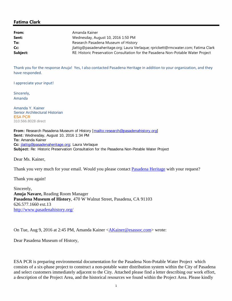
1
Fatima Clark
From: Amanda KainerSent: Wednesday, August 10, 2016 1:50 PMTo: Research Pasadena Museum of HistoryCc: [email protected]; Laura Verlaque; [email protected]; Fatima ClarkSubject: RE: Historic Preservation Consultation for the Pasadena Non-Potable Water Project
Thank you for the response Anuja! Yes, I also contacted Pasadena Heritage in addition to your organization, and they have responded. I appreciate your input! Sincerely, Amanda Amanda Y. Kainer Senior Architectural Historian ESA PCR 310.566.8028 direct From: Research Pasadena Museum of History [mailto:[email protected]] Sent: Wednesday, August 10, 2016 1:34 PM To: Amanda Kainer Cc: [email protected]; Laura Verlaque Subject: Re: Historic Preservation Consultation for the Pasadena Non-Potable Water Project Dear Ms. Kainer,
Thank you very much for your email. Would you please contact Pasadena Heritage with your request?
Thank you again!
Sincerely, Anuja Navare, Reading Room Manager Pasadena Museum of History, 470 W Walnut Street, Pasadena, CA 91103 626.577.1660 ext.13 http://www.pasadenahistory.org/
On Tue, Aug 9, 2016 at 2:45 PM, Amanda Kainer <[email protected]> wrote:
Dear Pasadena Museum of History,
ESA PCR is preparing environmental documentation for the Pasadena Non-Potable Water Project which consists of a six-phase project to construct a non-potable water distribution system within the City of Pasadena and select customers immediately adjacent to the City. Attached please find a letter describing our work effort, a description of the Project Area, and the historical resources we found within the Project Area. Please kindly

2
notify us if your organization has any concerns about historical resources in the Project Area. We look forward to hearing from you and appreciate your time to review this request.
Sincerely,
Amanda Y. Kainer
Senior Architectural Historian
ESA PCR
201 Santa Monica Boulevard, Suite 500
Santa Monica, CA 90401
310.451.4488 main | 310.451.5279 fax
310.566.8028 direct
[email protected] | www.esassoc.com
We’re becoming ESA! Please note the new email address.
--

1
Fatima Clark
From: Amanda KainerSent: Wednesday, August 10, 2016 10:39 AMTo: Sue MossmanCc: Jesse Lattig; Ethan Lipsig; Dale Brown; [email protected]; Margarita Jerabek;
Fatima Clark; Sara DietlerSubject: RE: Historic Presrvation Consultation for the Pasadena Non-Potable Water Project
Hi Sue, Thank you so much for your quick and enthusiastic response! Please use this link to download the final Cultural Resources Assessment for the Proposed Pasadena Non‐Potable Water Project: https://private.filesanywhere.com/pcr2014/fs/v.aspx?v=896e6a8ea2a0adb0b2ab Password: esa2016 We are under a tight deadline and if possible we would love your input by Tuesday, August 16th. Let me know if you have any additional questions! Sincerely, Amanda Amanda Y. Kainer Senior Architectural Historian ESA PCR 310.566.8028 direct
From: Sue Mossman [mailto:[email protected]] Sent: Tuesday, August 09, 2016 2:57 PM To: Amanda Kainer Cc: Jesse Lattig; Ethan Lipsig; Dale Brown Subject: Re: Historic Presrvation Consultation for the Pasadena Non-Potable Water Project Dear Amanda, Thank you for reaching out to Pasadena Heritage about the Non-Potable Water Project and possible historic preservation concerns or impacts. Of course, we are very concerned about water resources and recapturing water for non-potable uses is a good thing that we support! The project outlined in your letter and attached maps does move through or adjacent to some important historic resources, and we’d like to take a bit of time to review this with care. It would also help us to know more about the nature of the various installations that would be required to implement the plan (what do things look like? above ground? below ground? etc.) I’d like to enlist some help and expertise in reviewing this material, and may have some additional questions for you. Please tell me when would you need our comments by? Thank you, Sue

2
Susan N. Mossman Executive Director
651 S. St. John Avenue | Pasadena, CA 91105 T. 626-441-6333 ext 14 | [email protected] website | email | facebook | twitter | flickr | join now
On Aug 9, 2016, at 2:39 PM, Amanda Kainer <[email protected]> wrote: <RMC Pasadena_Historic Preservation Consultation_Pasadena Heritage.pdf>

1
Fatima Clark
From: Amanda KainerSent: Tuesday, August 30, 2016 5:12 PMTo: Rosalyn PrickettCc: Sara Dietler; Fatima ClarkSubject: FW: Historic Presrvation Consultation for the Pasadena Non-Potable Water Project
Please see the response from Sue Mossman at Pasadena Heritage below. They will try to get us comments back tomorrow. Thanks, Amanda
From: Sue Mossman [mailto:[email protected]] Sent: Tuesday, August 30, 2016 4:49 PM To: Amanda Kainer Subject: Re: Historic Presrvation Consultation for the Pasadena Non-Potable Water Project Hi Amanda - sorry we’ve been slow - we’ve been short-staffed around here and I can’t get to everything as soon as I would like. I’ve asked Jesse Lattig to take a look and hopefully we can get any response to you by tomorrow - if not, that’s our fault. Susan N. Mossman Executive Director
651 S. St. John Avenue | Pasadena, CA 91105 T. 626-441-6333 ext 14 | [email protected] website | email | facebook | twitter | flickr | join now
On Aug 30, 2016, at 11:43 AM, Amanda Kainer <[email protected]> wrote: Hi Sue, Sorry to bother you, but if you have any comments on our study would it be possible to get them by tomorrow (8/31)? We are under a tight deadline to turn around the response to comments. Thanks for your help! Sincerely,

2
Amanda
Amanda Y. Kainer Senior Architectural Historian ESA PCR 310.566.8028 direct We’ve Moved! Please note the new mailing and email addresses
From: Amanda Kainer Sent: Monday, August 29, 2016 10:06 AM To: 'Sue Mossman' Subject: RE: Historic Presrvation Consultation for the Pasadena Non-Potable Water Project Hi Sue, Just checking in, how is your review coming along? Thanks! Amanda
From: Sue Mossman [mailto:[email protected]] Sent: Wednesday, August 10, 2016 10:42 AM To: Amanda Kainer Subject: Re: Historic Presrvation Consultation for the Pasadena Non-Potable Water Project Thanks, Amanda - I’ll do my best but have an awful lot on my plate. Susan N. Mossman Executive Director <image001.jpg>
651 S. St. John Avenue | Pasadena, CA 91105 T. 626-441-6333 ext 14 | [email protected] website | email | facebook | twitter | flickr | join now
On Aug 10, 2016, at 10:39 AM, Amanda Kainer <[email protected]> wrote: Hi Sue, Thank you so much for your quick and enthusiastic response! Please use this link to download the final Cultural Resources Assessment for the Proposed Pasadena Non‐Potable Water Project: https://private.filesanywhere.com/pcr2014/fs/v.aspx?v=896e6a8ea2a0adb0b2ab Password: esa2016

3
We are under a tight deadline and if possible we would love your input by Tuesday, August 16th. Let me know if you have any additional questions! Sincerely, Amanda Amanda Y. Kainer Senior Architectural Historian ESA PCR 310.566.8028 direct
From: Sue Mossman [mailto:[email protected]] Sent: Tuesday, August 09, 2016 2:57 PM To: Amanda Kainer Cc: Jesse Lattig; Ethan Lipsig; Dale Brown Subject: Re: Historic Presrvation Consultation for the Pasadena Non-Potable Water Project Dear Amanda, Thank you for reaching out to Pasadena Heritage about the Non-Potable Water Project and possible historic preservation concerns or impacts. Of course, we are very concerned about water resources and recapturing water for non-potable uses is a good thing that we support! The project outlined in your letter and attached maps does move through or adjacent to some important historic resources, and we’d like to take a bit of time to review this with care. It would also help us to know more about the nature of the various installations that would be required to implement the plan (what do things look like? above ground? below ground? etc.) I’d like to enlist some help and expertise in reviewing this material, and may have some additional questions for you. Please tell me when would you need our comments by? Thank you, Sue Susan N. Mossman Executive Director <image001.jpg>
651 S. St. John Avenue | Pasadena, CA 91105 T. 626-441-6333 ext 14 | [email protected] website | email | facebook | twitter | flickr | join now
On Aug 9, 2016, at 2:39 PM, Amanda Kainer <[email protected]> wrote:

4
<RMC Pasadena_Historic Preservation Consultation_Pasadena Heritage.pdf>

Appendix B – Native American Consultation Documentation
2121 Alton Parkway
Suite 100
Irvine, CA 92606
949.753.7001 phone
949.753.7002 fax
www.pcrnet.com
August 2, 2016 Native American Heritage Commission 1550 Harbor Blvd., Suite 100 West Sacramento, CA 95691 Attention : Gayle Totton Submitted Via Email: [email protected] Subject: Sacred Lands File Search and Native American Contact List Request: Pasadena Non-Potable Water
Project, City of Pasadena, California. Dear Ms. Totton: ESA PCR is preparing environmental documentation for the Pasadena Non-Potable Water Project (“Project”) which consists of a six-phase project to construct a non-potable water distribution system within the City of Pasadena (“City”) and select customers immediately adjacent to the City. The Project involves construction and operation of a new non-potable water distribution system to deliver water from three local non-potable water sources: (1) recycled water produced by the Los Angeles/Glendale Water Reclamation Plant (LAG), (2) tunnel water from two existing tunnels (Devils Gate and Richardson Springs), and (3) surface water from Arroyo Seco stream. On February 22, 2016, the Pasadena City Council certified the Environmental Impact Report (“EIR”) for the Project. Phase I was analyzed at a project level, while the later phases were evaluated at a programmatic level and require additional environmental review prior to implementation. Phase I (as shown in Figure 1) is designed to supply 700 AFY of recycled water from LAG to four customers in Pasadena (Art Center College of Design, Brookside Golf Course, Rose Bowl Stadium, and Brookside Park) and includes the following:
• 24,600 linear feet (“LF”) of non-potable water pipe • 9,200 LF of power transmission and fiber optic cables along the pipe • Two non-potable water reservoirs – one up to 1.25 million gallons (“MG”) reservoir at Scholl Canyon in
the City of Glendale (“Glendale”), and one up to 1.25 MG reservoir at Sheldon Reservoir site in the City of Pasadena
• One pressure reducing station (“PRS”) and a hydroelectric generation turbine facility in Pasadena, near the intersection of Washington Boulevard and West Drive.
Per City Council’s request, PWP is currently evaluating two refinements (the Salvia Canyon Route depicted in orange and the Rosemont Avenue Route depicted in pink in Figure 1) to the proposed Phase I pipeline. To ensure that any areas containing previously recorded cultural resources and sacred lands are identified and considered, ESA PCR is requesting a Sacred Lands File search for the Project and a Native American Contact List. As indicated in Table 1, the project area is located on the Pasadena, California United States Geologic Survey 7.5’ topographic quadrangle map.

Table 1. Locational Data for Project Area
Quadrangle Section Township and Range
Pasadena 8 T1N R12W
Pasadena 13 T1N R13W
Pasadena 14 T1N R13W
Pasadena 17 T1N R12W
Pasadena 18 T1N R12W
Pasadena 20 T1N R12W Thank you for your assistance with our efforts to address possible Native American concerns that may be affected by the proposed project. Please email the results of this search, along with the contact information for any Native American tribes or individuals who may have additional knowledge of religious and/or culturally significant locations within or in the vicinity of the project area, to me via email at [email protected]. Please feel free to reach out to me with any questions at 213-542-6053.
Sincerely,
Sara Dietler Senior Cultural Resources Specialist
Enclosures: study area map

!(!
!(<
!(E
!(<
!(
§̈¦210
Connection toGWP System
Avery Dennison
Pacific Oaks College
20"
20"
20"
16"
16"
8"
6"
6"
6"
6"6"
Scholl CanyonNon-PotableWater Reservoir
Sheldon Non-PotableRservoir(s)1.25 MG 1050' HWL
PRS 1666/1050&
Brookside BoosterPump Station
(Phase I)
20"
WASHINGTON
AR
RO
YO
RO
SE
MO
NT
RO
SE
MO
NT
LA CANADA FLINTRIDGELA CANADA FLINTRIDGE
24"
Caltrans 2095 Arroyo
³±(!")
Pump Station(350 gpm)
14,000 Gal Wet Well
12" TW TransmissionPipeline
12" Richardson Intake
Hydroelectric Turbine Facility(Phase I)
RW pipeline and parallel electrical/fiber optic conduit
Rosemont Ave. Route
Salvia Canyon Route
Brookside Park
Brookside Golf Course
Art Center Collegeof Design
Rose Bowl Stadium
GLENDALEGLENDALE
WE
ST
AR
RO
YO
RO
SE
MO
NT
LIDA
FOR
ES
T
LIN
DA
VIS
TA
CANADA
GLENOAKS
SE
CO
WASHINGTON
ZANJA
FIGU
ER
OA
HOWARD
MONTANA
WOODBURY
SAINT K
ATHERIN
E
INV
ER
NE
SS
CA
SIT
AS
NE
WP
OR
T
KE
NN
ET
H
AR
MA
DA
DEL MONTE
PA
RK
VIE
W
WIL
LIS
BLA
KE
WYOMING
PR
OS
PE
CT
GLE
N O
AK
S
STANTON
RO
SE
BO
WL
PEPPER
HAMMOND
VIS
TA
DE
VO
N
RADIO LATERAL
AFTON
CONISTON
WESTGATE
LEN
OR
E NO
RM
AN
DY
EL MIRADOR
WICKS
SCENIC
KIRKHAM
YOCUM
TOOLEN
PALISADE
CLAREMONT
SAN AUGUSTIN
E
DRAGONFLY
PEGFAIR ESTATES
EDGEHILL
VALL
E V
ISTA
WALDORF
HAMPSTEAD
LAUN
BRYANT
WIN
ON
A
MONARCH
VERMONT
SALVIA CANYON
PASAD
EN
A
WO
TK
YN
S
EMERALD ISLE
PA
RN
ELL
LINDA RIDGE
BANYAN
KAREN LYNN
EVERTS
PHEASANT
LAUREL
PALMERSTONE
BR
AE
MA
R
SO
LITA
MACDONALD
WE
ND
OV
ER
PUTNEY
DE
XT
ER
SA
INT
GR
EG
OR
Y
BR
AM
LEY
LA C
RE
STA
WIERFIELD
CHARLESWABASH
LA MESA
MARENGO
AS
HIN
GTO
N
HOLLYWELL
REGENT PARK
MOUNTAIN
CHAMBERLAIN
WEIM
AR
AR
RO
YO
VIE
W
CYPR
ESS
LANCASHIRE
KNOLLWOOD
YU
CC
A
SELKIRK
BUC
KING
HAM
THORNWOOD
HEATHERSIDE
RIC
HLA
ND
BE
RW
ICK
RO
SE
WA
LK
DU
NS
ME
RE
RUTHERFORD
TY
RR
EL
L
SE
RR
AN
O
CORNW
ALL
LOMAY
KA
RE
N S
UE
FULLMOON
RANCHEROS
EUSTON
SAINT ELIZABETH
SH
ER
WO
OD
BENNETT
ANDERSON
CO
VE
NT
RY
SERVICE
HU
FF
ER
CHULA VISTA
SUSSEX
CA
RN
AR
VO
N
PINE OAK
CH
AR
ING
CR
OS
S
FU
LLB
RO
OK
SHAN
NO
N
CORNWALL
ARM
AD
A
WABASH
AFTON
PALISADE
LIND
A V
ISTA
SO
LITA
CY
PR
ES
S
INVERNESS
RO
SE
BO
WL
AFTON
LIN
DA
VIS
TA
FIGU
ER
OA
CHARLES
S13 T1N R13W S18 T1N R12W S17 T1N R12W
S19 T1N R12W S20 T1N R12W
S7 T1N R12W S8 T1N R12W
S14 T1N R13W
S12 T1N R13W
ARRO
YO SE
CO
Pasadena Non-Potable Water ProjectFigure 1
Phase 1 Project and Refinements
0 800 1,600400
Feet
Notes:GWP - Glendale Water and PowerPWP - Pasadena Water and PowerRW - Recycled WaterPRS - Pressure Reducing Station
³±(!
±
Potential Demand!( > 0 afy
!(E > 10 afy
!(! > 25 afy
!(( > 50 afy
!(< > 100 afy
Proposed FacilitiesStorage Reservoir
!³T
³ Pump Station
Phase 1
Other FeaturesExisting Glendale RW Pipes
Railroads
City Boundaries
Hydroelectric Turbine Facility
N:\Pro
jects\0
129 - P
asaden
a Wate
r and
Powe
r\0129
-003.0
5 PWP
RW Pr
oject\0
9_GIS\
Scree
ncheck
_Pub
lic_Dra
ft\Fig 2
- 3_P
hase1
29July
16.mx
d PWP Customers PAS
Schools
Parks/Golf Courses
PWP Service Area
Township, Range, Section
Salvia Canyon Route
Rosemont Ave Route


2121 Alton Parkway
Suite 100
Irvine, CA 92606
949.753.7001 phone
949.753.7002 fax
www.pcrnet.com
August 5, 2016
Sandonne Goad, Chairperson GABRIELENO/TONGVA NATION 106-1/2 Judge John Aiso Street #231 Los Angeles, CA 90012
Subject: Pasadena Non-Potable Water Project, City of Pasadena, California.
Dear Sandonne Goad:
ESA PCR is providing cultural resources consulting services for the Pasadena Non-Potable Water Project (“Project”) which would deliver non-potable water to customers within the City of Pasadena (“City”) and customers immediately adjacent to the City. The Project involves construction and operation of a new non-potable water distribution system to capture water from three local non-potable water sources: (1) recycled water produced by the Los Angeles/Glendale Water Reclamation Plant (“LAG”), (2) tunnel water from two existing tunnels (Devils Gate and Richardson Springs), and (3) surface water from Arroyo Seco stream. The Environmental Impact Report (“EIR”) for the Project (Figure 1) was certified in February 2016. The City is currently evaluating two alternative pipeline alignments (depicted in orange and pink in Figure 1) to the proposed Phase I pipeline.
As indicated in Figure 1, the project area is located on the Pasadena, California United States Geologic Survey 7.5’ topographic quadrangle map.
On August 4, 2016, the Native American Heritage Commission performed a Sacred Lands File (“SLF”) search for this Project. The SLF search failed to indicate the presence of Native American cultural resources within the vicinity of the Project area. However, you were identified in the letter as a person who may have knowledge of cultural resources within the Project area. We would appreciate your comments identifying any sensitive sites in or near the Project area that you may be aware of, any concerns or issues pertinent to this Project, or the names of others who may be interested in this Project.
During research for the Phase I Cultural Resources study of the project area it was determined that a portion of the Project is within the vicinity of the known archaeological site CA-LAN-26. CA-LAN-26 was discovered in 1938 during the excavation for the City’s existing semi-buried Sheldon potable water reservoir. Phase 1 of the Project includes construction of a new semi-buried Sheldon non-potable water reservoir approximately 80 feet to the north of the potable reservoir.
A testing plan (attached) has been prepared for this area. The plan is to conduct controlled mechanical excavation to confirm the absence of cultural resources within the footprint of the proposed Sheldon non-potable reservoir and pipeline. The implementation of the testing plan would also serve to comply with Section 106 of the NHPA, and more specifically, to constitute a “good faith effort” to identify resources pursuant to §800.4(b).
The testing plan is scheduled to be implemented during the week of August 22, 2016. Please review the attached plan and let me know at your earliest convenience if you wish to be present during the excavations.
Thank you for your assistance with our efforts to address possible Native American concerns that may be affected by the proposed project and testing plan. Please contact me at 213-542-6053 or via email at [email protected] to provide any comments or questions you may have.
Sincerely,
Sara Dietler Senior Cultural Resources Specialist Enclosures: study area map

!(!
!(<
!(E
!(<
!(
§̈¦210
Connection toGWP System
Avery Dennison
Pacific Oaks College
20"
20"
20"
16"
16"
8"
6"
6"
6"
6"6"
Scholl CanyonNon-PotableWater Reservoir
Sheldon Non-PotableRservoir(s)1.25 MG 1050' HWL
PRS 1666/1050&
Brookside BoosterPump Station
(Phase I)
20"
WASHINGTON
AR
RO
YO
RO
SE
MO
NT
RO
SE
MO
NT
LA CANADA FLINTRIDGELA CANADA FLINTRIDGE
24"
Caltrans 2095 Arroyo
³±(!")
Pump Station(350 gpm)
14,000 Gal Wet Well
12" TW TransmissionPipeline
12" Richardson Intake
Hydroelectric Turbine Facility(Phase I)
RW pipeline and parallel electrical/fiber optic conduit
Rosemont Ave. Route
Salvia Canyon Route
Brookside Park
Brookside Golf Course
Art Center Collegeof Design
Rose Bowl Stadium
GLENDALEGLENDALE
WE
ST
AR
RO
YO
RO
SE
MO
NT
LIDA
FOR
ES
T
LIN
DA
VIS
TA
CANADA
GLENOAKS
SE
CO
WASHINGTON
ZANJA
FIGU
ER
OA
HOWARD
MONTANA
WOODBURY
SAINT K
ATHERIN
E
INV
ER
NE
SS
CA
SIT
AS
NE
WP
OR
T
KE
NN
ET
H
AR
MA
DA
DEL MONTE
PA
RK
VIE
W
WIL
LIS
BLA
KE
WYOMING
PR
OS
PE
CT
GLE
N O
AK
S
STANTON
RO
SE
BO
WL
PEPPER
HAMMOND
VIS
TA
DE
VO
N
RADIO LATERAL
AFTON
CONISTON
WESTGATE
LEN
OR
E NO
RM
AN
DY
EL MIRADOR
WICKS
SCENIC
KIRKHAM
YOCUM
TOOLEN
PALISADE
CLAREMONT
SAN AUGUSTIN
E
DRAGONFLY
PEGFAIR ESTATES
EDGEHILL
VALL
E V
ISTA
WALDORF
HAMPSTEAD
LAUN
BRYANT
WIN
ON
A
MONARCH
VERMONT
SALVIA CANYON
PASAD
EN
A
WO
TK
YN
S
EMERALD ISLE
PA
RN
ELL
LINDA RIDGE
BANYAN
KAREN LYNN
EVERTS
PHEASANT
LAUREL
PALMERSTONE
BR
AE
MA
R
SO
LITA
MACDONALD
WE
ND
OV
ER
PUTNEY
DE
XT
ER
SA
INT
GR
EG
OR
Y
BR
AM
LEY
LA C
RE
STA
WIERFIELD
CHARLESWABASH
LA MESA
MARENGO
AS
HIN
GTO
N
HOLLYWELL
REGENT PARK
MOUNTAIN
CHAMBERLAIN
WEIM
AR
AR
RO
YO
VIE
W
CYPR
ESS
LANCASHIRE
KNOLLWOOD
YU
CC
A
SELKIRK
BUC
KING
HAM
THORNWOOD
HEATHERSIDE
RIC
HLA
ND
BE
RW
ICK
RO
SE
WA
LK
DU
NS
ME
RE
RUTHERFORD
TY
RR
EL
L
SE
RR
AN
O
CORNW
ALL
LOMAY
KA
RE
N S
UE
FULLMOON
RANCHEROS
EUSTON
SAINT ELIZABETH
SH
ER
WO
OD
BENNETT
ANDERSON
CO
VE
NT
RY
SERVICE
HU
FF
ER
CHULA VISTA
SUSSEX
CA
RN
AR
VO
N
PINE OAK
CH
AR
ING
CR
OS
S
FU
LLB
RO
OK
SHAN
NO
N
CORNWALL
ARM
AD
A
WABASH
AFTON
PALISADE
LIND
A V
ISTA
SO
LITA
CY
PR
ES
S
INVERNESS
RO
SE
BO
WL
AFTON
LIN
DA
VIS
TA
FIGU
ER
OA
CHARLES
S13 T1N R13W S18 T1N R12W S17 T1N R12W
S19 T1N R12W S20 T1N R12W
S7 T1N R12W S8 T1N R12W
S14 T1N R13W
S12 T1N R13W
ARRO
YO SE
CO
Pasadena Non-Potable Water ProjectFigure 1
Phase 1 Project and Refinements
0 800 1,600400
Feet
Notes:GWP - Glendale Water and PowerPWP - Pasadena Water and PowerRW - Recycled WaterPRS - Pressure Reducing Station
³±(!
±
Potential Demand!( > 0 afy
!(E > 10 afy
!(! > 25 afy
!(( > 50 afy
!(< > 100 afy
Proposed FacilitiesStorage Reservoir
!³T
³ Pump Station
Phase 1
Other FeaturesExisting Glendale RW Pipes
Railroads
City Boundaries
Hydroelectric Turbine Facility
N:\Pro
jects\0
129 - P
asaden
a Wate
r and
Powe
r\0129
-003.0
5 PWP
RW Pr
oject\0
9_GIS\
Scree
ncheck
_Pub
lic_Dra
ft\Fig 2
- 3_P
hase1
29July
16.mx
d PWP Customers PAS
Schools
Parks/Golf Courses
PWP Service Area
Township, Range, Section
Salvia Canyon Route
Rosemont Ave Route

2121 Alton Parkway
Suite 100
Irvine, CA 92606
949.753.7001 phone
949.753.7002 fax
www.pcrnet.com
August 5, 2016
Ms. Linda Candelaria, Co-Chairperson GABRIELENO-TONGVA TRIBE 1999 Avenue of the Stars, Suite 1100 Los Angeles, CA 90067
Subject: Pasadena Non-Potable Water Project, City of Pasadena, California.
Dear Ms. Candelaria:
ESA PCR is providing cultural resources consulting services for the Pasadena Non-Potable Water Project (“Project”) which would deliver non-potable water to customers within the City of Pasadena (“City”) and customers immediately adjacent to the City. The Project involves construction and operation of a new non-potable water distribution system to capture water from three local non-potable water sources: (1) recycled water produced by the Los Angeles/Glendale Water Reclamation Plant (“LAG”), (2) tunnel water from two existing tunnels (Devils Gate and Richardson Springs), and (3) surface water from Arroyo Seco stream. The Environmental Impact Report (“EIR”) for the Project (Figure 1) was certified in February 2016. The City is currently evaluating two alternative pipeline alignments (depicted in orange and pink in Figure 1) to the proposed Phase I pipeline.
As indicated in Figure 1, the project area is located on the Pasadena, California United States Geologic Survey 7.5’ topographic quadrangle map.
On August 4, 2016, the Native American Heritage Commission performed a Sacred Lands File (“SLF”) search for this Project. The SLF search failed to indicate the presence of Native American cultural resources within the vicinity of the Project area. However, you were identified in the letter as a person who may have knowledge of cultural resources within the Project area. We would appreciate your comments identifying any sensitive sites in or near the Project area that you may be aware of, any concerns or issues pertinent to this Project, or the names of others who may be interested in this Project.
During research for the Phase I Cultural Resources study of the project area it was determined that a portion of the Project is within the vicinity of the known archaeological site CA-LAN-26. CA-LAN-26 was discovered in 1938 during the excavation for the City’s existing semi-buried Sheldon potable water reservoir. Phase 1 of the Project includes construction of a new semi-buried Sheldon non-potable water reservoir approximately 80 feet to the north of the potable reservoir.
A testing plan (attached) has been prepared for this area. The plan is to conduct controlled mechanical excavation to confirm the absence of cultural resources within the footprint of the proposed Sheldon non-potable reservoir and pipeline. The implementation of the testing plan would also serve to comply with Section 106 of the NHPA, and more specifically, to constitute a “good faith effort” to identify resources pursuant to §800.4(b).

The testing plan is scheduled to be implemented during the week of August 22, 2016. Please review the attached plan and let me know at your earliest convenience if you wish to be present during the excavations.
Thank you for your assistance with our efforts to address possible Native American concerns that may be affected by the proposed project and testing plan. Please contact me at 213-542-6053 or via email at [email protected] to provide any comments or questions you may have.
Sincerely,
Sara Dietler Senior Cultural Resources Specialist Enclosures: study area map

!(!
!(<
!(E
!(<
!(
§̈¦210
Connection toGWP System
Avery Dennison
Pacific Oaks College
20"
20"
20"
16"
16"
8"
6"
6"
6"
6"6"
Scholl CanyonNon-PotableWater Reservoir
Sheldon Non-PotableRservoir(s)1.25 MG 1050' HWL
PRS 1666/1050&
Brookside BoosterPump Station
(Phase I)
20"
WASHINGTON
AR
RO
YO
RO
SE
MO
NT
RO
SE
MO
NT
LA CANADA FLINTRIDGELA CANADA FLINTRIDGE
24"
Caltrans 2095 Arroyo
³±(!")
Pump Station(350 gpm)
14,000 Gal Wet Well
12" TW TransmissionPipeline
12" Richardson Intake
Hydroelectric Turbine Facility(Phase I)
RW pipeline and parallel electrical/fiber optic conduit
Rosemont Ave. Route
Salvia Canyon Route
Brookside Park
Brookside Golf Course
Art Center Collegeof Design
Rose Bowl Stadium
GLENDALEGLENDALE
WE
ST
AR
RO
YO
RO
SE
MO
NT
LIDA
FOR
ES
T
LIN
DA
VIS
TA
CANADA
GLENOAKS
SE
CO
WASHINGTON
ZANJA
FIGU
ER
OA
HOWARD
MONTANA
WOODBURY
SAINT K
ATHERIN
E
INV
ER
NE
SS
CA
SIT
AS
NE
WP
OR
T
KE
NN
ET
H
AR
MA
DA
DEL MONTE
PA
RK
VIE
W
WIL
LIS
BLA
KE
WYOMING
PR
OS
PE
CT
GLE
N O
AK
S
STANTON
RO
SE
BO
WL
PEPPER
HAMMOND
VIS
TA
DE
VO
N
RADIO LATERAL
AFTON
CONISTON
WESTGATE
LEN
OR
E NO
RM
AN
DY
EL MIRADOR
WICKS
SCENIC
KIRKHAM
YOCUM
TOOLEN
PALISADE
CLAREMONT
SAN AUGUSTIN
E
DRAGONFLY
PEGFAIR ESTATES
EDGEHILL
VALL
E V
ISTA
WALDORF
HAMPSTEAD
LAUN
BRYANT
WIN
ON
A
MONARCH
VERMONT
SALVIA CANYON
PASAD
EN
A
WO
TK
YN
S
EMERALD ISLE
PA
RN
ELL
LINDA RIDGE
BANYAN
KAREN LYNN
EVERTS
PHEASANT
LAUREL
PALMERSTONE
BR
AE
MA
R
SO
LITA
MACDONALD
WE
ND
OV
ER
PUTNEY
DE
XT
ER
SA
INT
GR
EG
OR
Y
BR
AM
LEY
LA C
RE
STA
WIERFIELD
CHARLESWABASH
LA MESA
MARENGO
AS
HIN
GTO
N
HOLLYWELL
REGENT PARK
MOUNTAIN
CHAMBERLAIN
WEIM
AR
AR
RO
YO
VIE
W
CYPR
ESS
LANCASHIRE
KNOLLWOOD
YU
CC
A
SELKIRK
BUC
KING
HAM
THORNWOOD
HEATHERSIDE
RIC
HLA
ND
BE
RW
ICK
RO
SE
WA
LK
DU
NS
ME
RE
RUTHERFORD
TY
RR
EL
L
SE
RR
AN
O
CORNW
ALL
LOMAY
KA
RE
N S
UE
FULLMOON
RANCHEROS
EUSTON
SAINT ELIZABETH
SH
ER
WO
OD
BENNETT
ANDERSON
CO
VE
NT
RY
SERVICE
HU
FF
ER
CHULA VISTA
SUSSEX
CA
RN
AR
VO
N
PINE OAK
CH
AR
ING
CR
OS
S
FU
LLB
RO
OK
SHAN
NO
N
CORNWALL
ARM
AD
A
WABASH
AFTON
PALISADE
LIND
A V
ISTA
SO
LITA
CY
PR
ES
S
INVERNESS
RO
SE
BO
WL
AFTON
LIN
DA
VIS
TA
FIGU
ER
OA
CHARLES
S13 T1N R13W S18 T1N R12W S17 T1N R12W
S19 T1N R12W S20 T1N R12W
S7 T1N R12W S8 T1N R12W
S14 T1N R13W
S12 T1N R13W
ARRO
YO SE
CO
Pasadena Non-Potable Water ProjectFigure 1
Phase 1 Project and Refinements
0 800 1,600400
Feet
Notes:GWP - Glendale Water and PowerPWP - Pasadena Water and PowerRW - Recycled WaterPRS - Pressure Reducing Station
³±(!
±
Potential Demand!( > 0 afy
!(E > 10 afy
!(! > 25 afy
!(( > 50 afy
!(< > 100 afy
Proposed FacilitiesStorage Reservoir
!³T
³ Pump Station
Phase 1
Other FeaturesExisting Glendale RW Pipes
Railroads
City Boundaries
Hydroelectric Turbine Facility
N:\Pro
jects\0
129 - P
asaden
a Wate
r and
Powe
r\0129
-003.0
5 PWP
RW Pr
oject\0
9_GIS\
Scree
ncheck
_Pub
lic_Dra
ft\Fig 2
- 3_P
hase1
29July
16.mx
d PWP Customers PAS
Schools
Parks/Golf Courses
PWP Service Area
Township, Range, Section
Salvia Canyon Route
Rosemont Ave Route

2121 Alton Parkway
Suite 100
Irvine, CA 92606
949.753.7001 phone
949.753.7002 fax
www.pcrnet.com
August 5, 2016
Mr. Anthony Morales, Chairperson GABRIELENO/TONGVA SAN GABRIEL BAND OF MISSION INDIANS PO Box 693 San Gabriel, CA 91778
Subject: Pasadena Non-Potable Water Project, City of Pasadena, California.
Dear Mr. Morales:
ESA PCR is providing cultural resources consulting services for the Pasadena Non-Potable Water Project (“Project”) which would deliver non-potable water to customers within the City of Pasadena (“City”) and customers immediately adjacent to the City. The Project involves construction and operation of a new non-potable water distribution system to capture water from three local non-potable water sources: (1) recycled water produced by the Los Angeles/Glendale Water Reclamation Plant (“LAG”), (2) tunnel water from two existing tunnels (Devils Gate and Richardson Springs), and (3) surface water from Arroyo Seco stream. The Environmental Impact Report (“EIR”) for the Project (Figure 1) was certified in February 2016. The City is currently evaluating two alternative pipeline alignments (depicted in orange and pink in Figure 1) to the proposed Phase I pipeline.
As indicated in Figure 1, the project area is located on the Pasadena, California United States Geologic Survey 7.5’ topographic quadrangle map.
On August 4, 2016, the Native American Heritage Commission performed a Sacred Lands File (“SLF”) search for this Project. The SLF search failed to indicate the presence of Native American cultural resources within the vicinity of the Project area. However, you were identified in the letter as a person who may have knowledge of cultural resources within the Project area. We would appreciate your comments identifying any sensitive sites in or near the Project area that you may be aware of, any concerns or issues pertinent to this Project, or the names of others who may be interested in this Project.
During research for the Phase I Cultural Resources study of the project area it was determined that a portion of the Project is within the vicinity of the known archaeological site CA-LAN-26. CA-LAN-26 was discovered in 1938 during the excavation for the City’s existing semi-buried Sheldon potable water reservoir. Phase 1 of the Project includes construction of a new semi-buried Sheldon non-potable water reservoir approximately 80 feet to the north of the potable reservoir.
A testing plan (attached) has been prepared for this area. The plan is to conduct controlled mechanical excavation to confirm the absence of cultural resources within the footprint of the proposed Sheldon non-potable reservoir and pipeline. The implementation of the testing plan would also serve to comply with Section 106 of the NHPA, and more specifically, to constitute a “good faith effort” to identify resources pursuant to §800.4(b).

The testing plan is scheduled to be implemented during the week of August 22, 2016. Please review the attached plan and let me know at your earliest convenience if you wish to be present during the excavations.
Thank you for your assistance with our efforts to address possible Native American concerns that may be affected by the proposed project and testing plan. Please contact me at 213-542-6053 or via email at [email protected] to provide any comments or questions you may have.
Sincerely,
Sara Dietler Senior Cultural Resources Specialist Enclosures: study area map
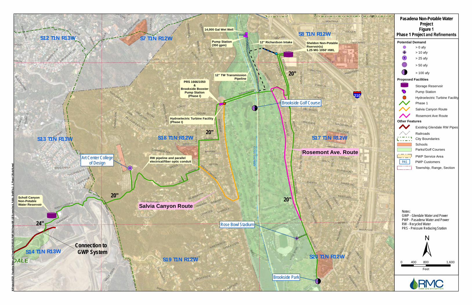
!(!
!(<
!(E
!(<
!(
§̈¦210
Connection toGWP System
Avery Dennison
Pacific Oaks College
20"
20"
20"
16"
16"
8"
6"
6"
6"
6"6"
Scholl CanyonNon-PotableWater Reservoir
Sheldon Non-PotableRservoir(s)1.25 MG 1050' HWL
PRS 1666/1050&
Brookside BoosterPump Station
(Phase I)
20"
WASHINGTON
AR
RO
YO
RO
SE
MO
NT
RO
SE
MO
NT
LA CANADA FLINTRIDGELA CANADA FLINTRIDGE
24"
Caltrans 2095 Arroyo
³±(!")
Pump Station(350 gpm)
14,000 Gal Wet Well
12" TW TransmissionPipeline
12" Richardson Intake
Hydroelectric Turbine Facility(Phase I)
RW pipeline and parallel electrical/fiber optic conduit
Rosemont Ave. Route
Salvia Canyon Route
Brookside Park
Brookside Golf Course
Art Center Collegeof Design
Rose Bowl Stadium
GLENDALEGLENDALE
WE
ST
AR
RO
YO
RO
SE
MO
NT
LIDA
FOR
ES
T
LIN
DA
VIS
TA
CANADA
GLENOAKS
SE
CO
WASHINGTON
ZANJA
FIGU
ER
OA
HOWARD
MONTANA
WOODBURY
SAINT K
ATHERIN
E
INV
ER
NE
SS
CA
SIT
AS
NE
WP
OR
T
KE
NN
ET
H
AR
MA
DA
DEL MONTE
PA
RK
VIE
W
WIL
LIS
BLA
KE
WYOMING
PR
OS
PE
CT
GLE
N O
AK
S
STANTON
RO
SE
BO
WL
PEPPER
HAMMOND
VIS
TA
DE
VO
N
RADIO LATERAL
AFTON
CONISTON
WESTGATE
LEN
OR
E NO
RM
AN
DY
EL MIRADOR
WICKS
SCENIC
KIRKHAM
YOCUM
TOOLEN
PALISADE
CLAREMONT
SAN AUGUSTIN
E
DRAGONFLY
PEGFAIR ESTATES
EDGEHILL
VALL
E V
ISTA
WALDORF
HAMPSTEAD
LAUN
BRYANT
WIN
ON
A
MONARCH
VERMONT
SALVIA CANYON
PASAD
EN
A
WO
TK
YN
S
EMERALD ISLE
PA
RN
ELL
LINDA RIDGE
BANYAN
KAREN LYNN
EVERTS
PHEASANT
LAUREL
PALMERSTONE
BR
AE
MA
R
SO
LITA
MACDONALD
WE
ND
OV
ER
PUTNEY
DE
XT
ER
SA
INT
GR
EG
OR
Y
BR
AM
LEY
LA C
RE
STA
WIERFIELD
CHARLESWABASH
LA MESA
MARENGO
AS
HIN
GTO
N
HOLLYWELL
REGENT PARK
MOUNTAIN
CHAMBERLAIN
WEIM
AR
AR
RO
YO
VIE
W
CYPR
ESS
LANCASHIRE
KNOLLWOOD
YU
CC
A
SELKIRK
BUC
KING
HAM
THORNWOOD
HEATHERSIDE
RIC
HLA
ND
BE
RW
ICK
RO
SE
WA
LK
DU
NS
ME
RE
RUTHERFORD
TY
RR
EL
L
SE
RR
AN
O
CORNW
ALL
LOMAY
KA
RE
N S
UE
FULLMOON
RANCHEROS
EUSTON
SAINT ELIZABETH
SH
ER
WO
OD
BENNETT
ANDERSON
CO
VE
NT
RY
SERVICE
HU
FF
ER
CHULA VISTA
SUSSEX
CA
RN
AR
VO
N
PINE OAK
CH
AR
ING
CR
OS
S
FU
LLB
RO
OK
SHAN
NO
N
CORNWALL
ARM
AD
A
WABASH
AFTON
PALISADE
LIND
A V
ISTA
SO
LITA
CY
PR
ES
S
INVERNESS
RO
SE
BO
WL
AFTON
LIN
DA
VIS
TA
FIGU
ER
OA
CHARLES
S13 T1N R13W S18 T1N R12W S17 T1N R12W
S19 T1N R12W S20 T1N R12W
S7 T1N R12W S8 T1N R12W
S14 T1N R13W
S12 T1N R13W
ARRO
YO SE
CO
Pasadena Non-Potable Water ProjectFigure 1
Phase 1 Project and Refinements
0 800 1,600400
Feet
Notes:GWP - Glendale Water and PowerPWP - Pasadena Water and PowerRW - Recycled WaterPRS - Pressure Reducing Station
³±(!
±
Potential Demand!( > 0 afy
!(E > 10 afy
!(! > 25 afy
!(( > 50 afy
!(< > 100 afy
Proposed FacilitiesStorage Reservoir
!³T
³ Pump Station
Phase 1
Other FeaturesExisting Glendale RW Pipes
Railroads
City Boundaries
Hydroelectric Turbine Facility
N:\Pro
jects\0
129 - P
asaden
a Wate
r and
Powe
r\0129
-003.0
5 PWP
RW Pr
oject\0
9_GIS\
Scree
ncheck
_Pub
lic_Dra
ft\Fig 2
- 3_P
hase1
29July
16.mx
d PWP Customers PAS
Schools
Parks/Golf Courses
PWP Service Area
Township, Range, Section
Salvia Canyon Route
Rosemont Ave Route

2121 Alton Parkway
Suite 100
Irvine, CA 92606
949.753.7001 phone
949.753.7002 fax
www.pcrnet.com
August 5, 2016
Mr. Andrew Salas, Chairperson GABRIELENO BAND OF MISSION INDIANS KIZH NATION P.O. Box 393 Covina, CA 91723
Subject: Pasadena Non-Potable Water Project, City of Pasadena, California.
Dear Mr. Salas:
ESA PCR is providing cultural resources consulting services for the Pasadena Non-Potable Water Project (“Project”) which would deliver non-potable water to customers within the City of Pasadena (“City”) and customers immediately adjacent to the City. The Project involves construction and operation of a new non-potable water distribution system to capture water from three local non-potable water sources: (1) recycled water produced by the Los Angeles/Glendale Water Reclamation Plant (“LAG”), (2) tunnel water from two existing tunnels (Devils Gate and Richardson Springs), and (3) surface water from Arroyo Seco stream. The Environmental Impact Report (“EIR”) for the Project (Figure 1) was certified in February 2016. The City is currently evaluating two alternative pipeline alignments (depicted in orange and pink in Figure 1) to the proposed Phase I pipeline.
As indicated in Figure 1, the project area is located on the Pasadena, California United States Geologic Survey 7.5’ topographic quadrangle map.
On August 4, 2016, the Native American Heritage Commission performed a Sacred Lands File (“SLF”) search for this Project. The SLF search failed to indicate the presence of Native American cultural resources within the vicinity of the Project area. However, you were identified in the letter as a person who may have knowledge of cultural resources within the Project area. We would appreciate your comments identifying any sensitive sites in or near the Project area that you may be aware of, any concerns or issues pertinent to this Project, or the names of others who may be interested in this Project.
During research for the Phase I Cultural Resources study of the project area it was determined that a portion of the Project is within the vicinity of the known archaeological site CA-LAN-26. CA-LAN-26 was discovered in 1938 during the excavation for the City’s existing semi-buried Sheldon potable water reservoir. Phase 1 of the Project includes construction of a new semi-buried Sheldon non-potable water reservoir approximately 80 feet to the north of the potable reservoir.
A testing plan (attached) has been prepared for this area. The plan is to conduct controlled mechanical excavation to confirm the absence of cultural resources within the footprint of the proposed Sheldon non-potable reservoir and pipeline. The implementation of the testing plan would also serve to comply with Section 106 of the NHPA, and more specifically, to constitute a “good faith effort” to identify resources pursuant to §800.4(b).

The testing plan is scheduled to be implemented during the week of August 22, 2016. Please review the attached plan and let me know at your earliest convenience if you wish to be present during the excavations.
Thank you for your assistance with our efforts to address possible Native American concerns that may be affected by the proposed project and testing plan. Please contact me at 213-542-6053 or via email at [email protected] to provide any comments or questions you may have.
Sincerely,
Sara Dietler Senior Cultural Resources Specialist Enclosures: study area map

!(!
!(<
!(E
!(<
!(
§̈¦210
Connection toGWP System
Avery Dennison
Pacific Oaks College
20"
20"
20"
16"
16"
8"
6"
6"
6"
6"6"
Scholl CanyonNon-PotableWater Reservoir
Sheldon Non-PotableRservoir(s)1.25 MG 1050' HWL
PRS 1666/1050&
Brookside BoosterPump Station
(Phase I)
20"
WASHINGTON
AR
RO
YO
RO
SE
MO
NT
RO
SE
MO
NT
LA CANADA FLINTRIDGELA CANADA FLINTRIDGE
24"
Caltrans 2095 Arroyo
³±(!")
Pump Station(350 gpm)
14,000 Gal Wet Well
12" TW TransmissionPipeline
12" Richardson Intake
Hydroelectric Turbine Facility(Phase I)
RW pipeline and parallel electrical/fiber optic conduit
Rosemont Ave. Route
Salvia Canyon Route
Brookside Park
Brookside Golf Course
Art Center Collegeof Design
Rose Bowl Stadium
GLENDALEGLENDALE
WE
ST
AR
RO
YO
RO
SE
MO
NT
LIDA
FOR
ES
T
LIN
DA
VIS
TA
CANADA
GLENOAKS
SE
CO
WASHINGTON
ZANJA
FIGU
ER
OA
HOWARD
MONTANA
WOODBURY
SAINT K
ATHERIN
E
INV
ER
NE
SS
CA
SIT
AS
NE
WP
OR
T
KE
NN
ET
H
AR
MA
DA
DEL MONTE
PA
RK
VIE
W
WIL
LIS
BLA
KE
WYOMING
PR
OS
PE
CT
GLE
N O
AK
S
STANTON
RO
SE
BO
WL
PEPPER
HAMMOND
VIS
TA
DE
VO
N
RADIO LATERAL
AFTON
CONISTON
WESTGATE
LEN
OR
E NO
RM
AN
DY
EL MIRADOR
WICKS
SCENIC
KIRKHAM
YOCUM
TOOLEN
PALISADE
CLAREMONT
SAN AUGUSTIN
E
DRAGONFLY
PEGFAIR ESTATES
EDGEHILL
VALL
E V
ISTA
WALDORF
HAMPSTEAD
LAUN
BRYANT
WIN
ON
A
MONARCH
VERMONT
SALVIA CANYON
PASAD
EN
A
WO
TK
YN
S
EMERALD ISLE
PA
RN
ELL
LINDA RIDGE
BANYAN
KAREN LYNN
EVERTS
PHEASANT
LAUREL
PALMERSTONE
BR
AE
MA
R
SO
LITA
MACDONALD
WE
ND
OV
ER
PUTNEY
DE
XT
ER
SA
INT
GR
EG
OR
Y
BR
AM
LEY
LA C
RE
STA
WIERFIELD
CHARLESWABASH
LA MESA
MARENGO
AS
HIN
GTO
N
HOLLYWELL
REGENT PARK
MOUNTAIN
CHAMBERLAIN
WEIM
AR
AR
RO
YO
VIE
W
CYPR
ESS
LANCASHIRE
KNOLLWOOD
YU
CC
A
SELKIRK
BUC
KING
HAM
THORNWOOD
HEATHERSIDE
RIC
HLA
ND
BE
RW
ICK
RO
SE
WA
LK
DU
NS
ME
RE
RUTHERFORD
TY
RR
EL
L
SE
RR
AN
O
CORNW
ALL
LOMAY
KA
RE
N S
UE
FULLMOON
RANCHEROS
EUSTON
SAINT ELIZABETH
SH
ER
WO
OD
BENNETT
ANDERSON
CO
VE
NT
RY
SERVICE
HU
FF
ER
CHULA VISTA
SUSSEX
CA
RN
AR
VO
N
PINE OAK
CH
AR
ING
CR
OS
S
FU
LLB
RO
OK
SHAN
NO
N
CORNWALL
ARM
AD
A
WABASH
AFTON
PALISADE
LIND
A V
ISTA
SO
LITA
CY
PR
ES
S
INVERNESS
RO
SE
BO
WL
AFTON
LIN
DA
VIS
TA
FIGU
ER
OA
CHARLES
S13 T1N R13W S18 T1N R12W S17 T1N R12W
S19 T1N R12W S20 T1N R12W
S7 T1N R12W S8 T1N R12W
S14 T1N R13W
S12 T1N R13W
ARRO
YO SE
CO
Pasadena Non-Potable Water ProjectFigure 1
Phase 1 Project and Refinements
0 800 1,600400
Feet
Notes:GWP - Glendale Water and PowerPWP - Pasadena Water and PowerRW - Recycled WaterPRS - Pressure Reducing Station
³±(!
±
Potential Demand!( > 0 afy
!(E > 10 afy
!(! > 25 afy
!(( > 50 afy
!(< > 100 afy
Proposed FacilitiesStorage Reservoir
!³T
³ Pump Station
Phase 1
Other FeaturesExisting Glendale RW Pipes
Railroads
City Boundaries
Hydroelectric Turbine Facility
N:\Pro
jects\0
129 - P
asaden
a Wate
r and
Powe
r\0129
-003.0
5 PWP
RW Pr
oject\0
9_GIS\
Scree
ncheck
_Pub
lic_Dra
ft\Fig 2
- 3_P
hase1
29July
16.mx
d PWP Customers PAS
Schools
Parks/Golf Courses
PWP Service Area
Township, Range, Section
Salvia Canyon Route
Rosemont Ave Route

2121 Alton Parkway
Suite 100
Irvine, CA 92606
949.753.7001 phone
949.753.7002 fax
www.pcrnet.com
August 5, 2016
Mr. Robert F. Dorame, Chairperson GABRIELENO TONGVA INDIANS OF CALIFORNIA TRIBAL COUNCIL PO Box 490 Bellflower, CA 90707
Subject: Pasadena Non-Potable Water Project, City of Pasadena, California.
Dear Mr. Dorame:
ESA PCR is providing cultural resources consulting services for the Pasadena Non-Potable Water Project (“Project”) which would deliver non-potable water to customers within the City of Pasadena (“City”) and customers immediately adjacent to the City. The Project involves construction and operation of a new non-potable water distribution system to capture water from three local non-potable water sources: (1) recycled water produced by the Los Angeles/Glendale Water Reclamation Plant (“LAG”), (2) tunnel water from two existing tunnels (Devils Gate and Richardson Springs), and (3) surface water from Arroyo Seco stream. The Environmental Impact Report (“EIR”) for the Project (Figure 1) was certified in February 2016. The City is currently evaluating two alternative pipeline alignments (depicted in orange and pink in Figure 1) to the proposed Phase I pipeline.
As indicated in Figure 1, the project area is located on the Pasadena, California United States Geologic Survey 7.5’ topographic quadrangle map.
On August 4, 2016, the Native American Heritage Commission performed a Sacred Lands File (“SLF”) search for this Project. The SLF search failed to indicate the presence of Native American cultural resources within the vicinity of the Project area. However, you were identified in the letter as a person who may have knowledge of cultural resources within the Project area. We would appreciate your comments identifying any sensitive sites in or near the Project area that you may be aware of, any concerns or issues pertinent to this Project, or the names of others who may be interested in this Project.
During research for the Phase I Cultural Resources study of the project area it was determined that a portion of the Project is within the vicinity of the known archaeological site CA-LAN-26. CA-LAN-26 was discovered in 1938 during the excavation for the City’s existing semi-buried Sheldon potable water reservoir. Phase 1 of the Project includes construction of a new semi-buried Sheldon non-potable water reservoir approximately 80 feet to the north of the potable reservoir.
A testing plan (attached) has been prepared for this area. The plan is to conduct controlled mechanical excavation to confirm the absence of cultural resources within the footprint of the proposed Sheldon non-potable reservoir and pipeline. The implementation of the testing plan would also serve to comply with Section 106 of the NHPA, and more specifically, to constitute a “good faith effort” to identify resources pursuant to §800.4(b).

The testing plan is scheduled to be implemented during the week of August 22, 2016. Please review the attached plan and let me know at your earliest convenience if you wish to be present during the excavations.
Thank you for your assistance with our efforts to address possible Native American concerns that may be affected by the proposed project and testing plan. Please contact me at 213-542-6053 or via email at [email protected] to provide any comments or questions you may have.
Sincerely,
Sara Dietler Senior Cultural Resources Specialist Enclosures: study area map

!(!
!(<
!(E
!(<
!(
§̈¦210
Connection toGWP System
Avery Dennison
Pacific Oaks College
20"
20"
20"
16"
16"
8"
6"
6"
6"
6"6"
Scholl CanyonNon-PotableWater Reservoir
Sheldon Non-PotableRservoir(s)1.25 MG 1050' HWL
PRS 1666/1050&
Brookside BoosterPump Station
(Phase I)
20"
WASHINGTON
AR
RO
YO
RO
SE
MO
NT
RO
SE
MO
NT
LA CANADA FLINTRIDGELA CANADA FLINTRIDGE
24"
Caltrans 2095 Arroyo
³±(!")
Pump Station(350 gpm)
14,000 Gal Wet Well
12" TW TransmissionPipeline
12" Richardson Intake
Hydroelectric Turbine Facility(Phase I)
RW pipeline and parallel electrical/fiber optic conduit
Rosemont Ave. Route
Salvia Canyon Route
Brookside Park
Brookside Golf Course
Art Center Collegeof Design
Rose Bowl Stadium
GLENDALEGLENDALE
WE
ST
AR
RO
YO
RO
SE
MO
NT
LIDA
FOR
ES
T
LIN
DA
VIS
TA
CANADA
GLENOAKS
SE
CO
WASHINGTON
ZANJA
FIGU
ER
OA
HOWARD
MONTANA
WOODBURY
SAINT K
ATHERIN
E
INV
ER
NE
SS
CA
SIT
AS
NE
WP
OR
T
KE
NN
ET
H
AR
MA
DA
DEL MONTE
PA
RK
VIE
W
WIL
LIS
BLA
KE
WYOMING
PR
OS
PE
CT
GLE
N O
AK
S
STANTON
RO
SE
BO
WL
PEPPER
HAMMOND
VIS
TA
DE
VO
N
RADIO LATERAL
AFTON
CONISTON
WESTGATE
LEN
OR
E NO
RM
AN
DY
EL MIRADOR
WICKS
SCENIC
KIRKHAM
YOCUM
TOOLEN
PALISADE
CLAREMONT
SAN AUGUSTIN
E
DRAGONFLY
PEGFAIR ESTATES
EDGEHILL
VALL
E V
ISTA
WALDORF
HAMPSTEAD
LAUN
BRYANT
WIN
ON
A
MONARCH
VERMONT
SALVIA CANYON
PASAD
EN
A
WO
TK
YN
S
EMERALD ISLE
PA
RN
ELL
LINDA RIDGE
BANYAN
KAREN LYNN
EVERTS
PHEASANT
LAUREL
PALMERSTONE
BR
AE
MA
R
SO
LITA
MACDONALD
WE
ND
OV
ER
PUTNEY
DE
XT
ER
SA
INT
GR
EG
OR
Y
BR
AM
LEY
LA C
RE
STA
WIERFIELD
CHARLESWABASH
LA MESA
MARENGO
AS
HIN
GTO
N
HOLLYWELL
REGENT PARK
MOUNTAIN
CHAMBERLAIN
WEIM
AR
AR
RO
YO
VIE
W
CYPR
ESS
LANCASHIRE
KNOLLWOOD
YU
CC
A
SELKIRK
BUC
KING
HAM
THORNWOOD
HEATHERSIDE
RIC
HLA
ND
BE
RW
ICK
RO
SE
WA
LK
DU
NS
ME
RE
RUTHERFORD
TY
RR
EL
L
SE
RR
AN
O
CORNW
ALL
LOMAY
KA
RE
N S
UE
FULLMOON
RANCHEROS
EUSTON
SAINT ELIZABETH
SH
ER
WO
OD
BENNETT
ANDERSON
CO
VE
NT
RY
SERVICE
HU
FF
ER
CHULA VISTA
SUSSEX
CA
RN
AR
VO
N
PINE OAK
CH
AR
ING
CR
OS
S
FU
LLB
RO
OK
SHAN
NO
N
CORNWALL
ARM
AD
A
WABASH
AFTON
PALISADE
LIND
A V
ISTA
SO
LITA
CY
PR
ES
S
INVERNESS
RO
SE
BO
WL
AFTON
LIN
DA
VIS
TA
FIGU
ER
OA
CHARLES
S13 T1N R13W S18 T1N R12W S17 T1N R12W
S19 T1N R12W S20 T1N R12W
S7 T1N R12W S8 T1N R12W
S14 T1N R13W
S12 T1N R13W
ARRO
YO SE
CO
Pasadena Non-Potable Water ProjectFigure 1
Phase 1 Project and Refinements
0 800 1,600400
Feet
Notes:GWP - Glendale Water and PowerPWP - Pasadena Water and PowerRW - Recycled WaterPRS - Pressure Reducing Station
³±(!
±
Potential Demand!( > 0 afy
!(E > 10 afy
!(! > 25 afy
!(( > 50 afy
!(< > 100 afy
Proposed FacilitiesStorage Reservoir
!³T
³ Pump Station
Phase 1
Other FeaturesExisting Glendale RW Pipes
Railroads
City Boundaries
Hydroelectric Turbine Facility
N:\Pro
jects\0
129 - P
asaden
a Wate
r and
Powe
r\0129
-003.0
5 PWP
RW Pr
oject\0
9_GIS\
Scree
ncheck
_Pub
lic_Dra
ft\Fig 2
- 3_P
hase1
29July
16.mx
d PWP Customers PAS
Schools
Parks/Golf Courses
PWP Service Area
Township, Range, Section
Salvia Canyon Route
Rosemont Ave Route
2121 Alton Parkway
Suite 100
Irvine, CA 92606
949.753.7001 phone
949.753.7002 fax
www.pcrnet.com
August 5, 2016
Mr. Rudy Ortega, President FERNANDENO TATAVIAM OF MISSION INDIANS 1019 2nd Street San Fernando, CA 91340
Subject: Pasadena Non-Potable Water Project, City of Pasadena, California.
Dear Mr. Ortega:
ESA PCR is providing cultural resources consulting services for the Pasadena Non-Potable Water Project (“Project”) which would deliver non-potable water to customers within the City of Pasadena (“City”) and customers immediately adjacent to the City. The Project involves construction and operation of a new non-potable water distribution system to capture water from three local non-potable water sources: (1) recycled water produced by the Los Angeles/Glendale Water Reclamation Plant (“LAG”), (2) tunnel water from two existing tunnels (Devils Gate and Richardson Springs), and (3) surface water from Arroyo Seco stream. The Environmental Impact Report (“EIR”) for the Project (Figure 1) was certified in February 2016. The City is currently evaluating two alternative pipeline alignments (depicted in orange and pink in Figure 1) to the proposed Phase I pipeline.
As indicated in Figure 1, the project area is located on the Pasadena, California United States Geologic Survey 7.5’ topographic quadrangle map.
On August 4, 2016, the Native American Heritage Commission performed a Sacred Lands File (“SLF”) search for this Project. The SLF search failed to indicate the presence of Native American cultural resources within the vicinity of the Project area. However, you were identified in the letter as a person who may have knowledge of cultural resources within the Project area. We would appreciate your comments identifying any sensitive sites in or near the Project area that you may be aware of, any concerns or issues pertinent to this Project, or the names of others who may be interested in this Project.
During research for the Phase I Cultural Resources study of the project area it was determined that a portion of the Project is within the vicinity of the known archaeological site CA-LAN-26. CA-LAN-26 was discovered in 1938 during the excavation for the City’s existing semi-buried Sheldon potable water reservoir. Phase 1 of the Project includes construction of a new semi-buried Sheldon non-potable water reservoir approximately 80 feet to the north of the potable reservoir.
A testing plan (attached) has been prepared for this area. The plan is to conduct controlled mechanical excavation to confirm the absence of cultural resources within the footprint of the proposed Sheldon non-potable reservoir and pipeline. The implementation of the testing plan would also serve to comply with Section 106 of the NHPA, and more specifically, to constitute a “good faith effort” to identify resources pursuant to §800.4(b).

The testing plan is scheduled to be implemented during the week of August 22, 2016. Please review the attached plan and let me know at your earliest convenience if you wish to be present during the excavations.
Thank you for your assistance with our efforts to address possible Native American concerns that may be affected by the proposed project and testing plan. Please contact me at 213-542-6053 or via email at [email protected] to provide any comments or questions you may have.
Sincerely,
Sara Dietler Senior Cultural Resources Specialist Enclosures: study area map

!(!
!(<
!(E
!(<
!(
§̈¦210
Connection toGWP System
Avery Dennison
Pacific Oaks College
20"
20"
20"
16"
16"
8"
6"
6"
6"
6"6"
Scholl CanyonNon-PotableWater Reservoir
Sheldon Non-PotableRservoir(s)1.25 MG 1050' HWL
PRS 1666/1050&
Brookside BoosterPump Station
(Phase I)
20"
WASHINGTON
AR
RO
YO
RO
SE
MO
NT
RO
SE
MO
NT
LA CANADA FLINTRIDGELA CANADA FLINTRIDGE
24"
Caltrans 2095 Arroyo
³±(!")
Pump Station(350 gpm)
14,000 Gal Wet Well
12" TW TransmissionPipeline
12" Richardson Intake
Hydroelectric Turbine Facility(Phase I)
RW pipeline and parallel electrical/fiber optic conduit
Rosemont Ave. Route
Salvia Canyon Route
Brookside Park
Brookside Golf Course
Art Center Collegeof Design
Rose Bowl Stadium
GLENDALEGLENDALE
WE
ST
AR
RO
YO
RO
SE
MO
NT
LIDA
FOR
ES
T
LIN
DA
VIS
TA
CANADA
GLENOAKS
SE
CO
WASHINGTON
ZANJA
FIGU
ER
OA
HOWARD
MONTANA
WOODBURY
SAINT K
ATHERIN
E
INV
ER
NE
SS
CA
SIT
AS
NE
WP
OR
T
KE
NN
ET
H
AR
MA
DA
DEL MONTE
PA
RK
VIE
W
WIL
LIS
BLA
KE
WYOMING
PR
OS
PE
CT
GLE
N O
AK
S
STANTON
RO
SE
BO
WL
PEPPER
HAMMOND
VIS
TA
DE
VO
N
RADIO LATERAL
AFTON
CONISTON
WESTGATE
LEN
OR
E NO
RM
AN
DY
EL MIRADOR
WICKS
SCENIC
KIRKHAM
YOCUM
TOOLEN
PALISADE
CLAREMONT
SAN AUGUSTIN
E
DRAGONFLY
PEGFAIR ESTATES
EDGEHILL
VALL
E V
ISTA
WALDORF
HAMPSTEAD
LAUN
BRYANT
WIN
ON
A
MONARCH
VERMONT
SALVIA CANYON
PASAD
EN
A
WO
TK
YN
S
EMERALD ISLE
PA
RN
ELL
LINDA RIDGE
BANYAN
KAREN LYNN
EVERTS
PHEASANT
LAUREL
PALMERSTONE
BR
AE
MA
R
SO
LITA
MACDONALD
WE
ND
OV
ER
PUTNEY
DE
XT
ER
SA
INT
GR
EG
OR
Y
BR
AM
LEY
LA C
RE
STA
WIERFIELD
CHARLESWABASH
LA MESA
MARENGO
AS
HIN
GTO
N
HOLLYWELL
REGENT PARK
MOUNTAIN
CHAMBERLAIN
WEIM
AR
AR
RO
YO
VIE
W
CYPR
ESS
LANCASHIRE
KNOLLWOOD
YU
CC
A
SELKIRK
BUC
KING
HAM
THORNWOOD
HEATHERSIDE
RIC
HLA
ND
BE
RW
ICK
RO
SE
WA
LK
DU
NS
ME
RE
RUTHERFORD
TY
RR
EL
L
SE
RR
AN
O
CORNW
ALL
LOMAY
KA
RE
N S
UE
FULLMOON
RANCHEROS
EUSTON
SAINT ELIZABETH
SH
ER
WO
OD
BENNETT
ANDERSON
CO
VE
NT
RY
SERVICE
HU
FF
ER
CHULA VISTA
SUSSEX
CA
RN
AR
VO
N
PINE OAK
CH
AR
ING
CR
OS
S
FU
LLB
RO
OK
SHAN
NO
N
CORNWALL
ARM
AD
A
WABASH
AFTON
PALISADE
LIND
A V
ISTA
SO
LITA
CY
PR
ES
S
INVERNESS
RO
SE
BO
WL
AFTON
LIN
DA
VIS
TA
FIGU
ER
OA
CHARLES
S13 T1N R13W S18 T1N R12W S17 T1N R12W
S19 T1N R12W S20 T1N R12W
S7 T1N R12W S8 T1N R12W
S14 T1N R13W
S12 T1N R13W
ARRO
YO SE
CO
Pasadena Non-Potable Water ProjectFigure 1
Phase 1 Project and Refinements
0 800 1,600400
Feet
Notes:GWP - Glendale Water and PowerPWP - Pasadena Water and PowerRW - Recycled WaterPRS - Pressure Reducing Station
³±(!
±
Potential Demand!( > 0 afy
!(E > 10 afy
!(! > 25 afy
!(( > 50 afy
!(< > 100 afy
Proposed FacilitiesStorage Reservoir
!³T
³ Pump Station
Phase 1
Other FeaturesExisting Glendale RW Pipes
Railroads
City Boundaries
Hydroelectric Turbine Facility
N:\Pro
jects\0
129 - P
asaden
a Wate
r and
Powe
r\0129
-003.0
5 PWP
RW Pr
oject\0
9_GIS\
Scree
ncheck
_Pub
lic_Dra
ft\Fig 2
- 3_P
hase1
29July
16.mx
d PWP Customers PAS
Schools
Parks/Golf Courses
PWP Service Area
Township, Range, Section
Salvia Canyon Route
Rosemont Ave Route
2121 Alton Parkway
Suite 100
Irvine, CA 92606
949.753.7001 phone
949.753.7002 fax
www.pcrnet.com
August 5, 2016
Mr. John Valenzuela, Co-Chairperson SAN FERNANDO BAND OF MISSION INDIANS PO Box 221838 Newhall, CA 91322
Subject: Pasadena Non-Potable Water Project, City of Pasadena, California.
Dear Ms. Valenzuela:
ESA PCR is providing cultural resources consulting services for the Pasadena Non-Potable Water Project (“Project”) which would deliver non-potable water to customers within the City of Pasadena (“City”) and customers immediately adjacent to the City. The Project involves construction and operation of a new non-potable water distribution system to capture water from three local non-potable water sources: (1) recycled water produced by the Los Angeles/Glendale Water Reclamation Plant (“LAG”), (2) tunnel water from two existing tunnels (Devils Gate and Richardson Springs), and (3) surface water from Arroyo Seco stream. The Environmental Impact Report (“EIR”) for the Project (Figure 1) was certified in February 2016. The City is currently evaluating two alternative pipeline alignments (depicted in orange and pink in Figure 1) to the proposed Phase I pipeline.
As indicated in Figure 1, the project area is located on the Pasadena, California United States Geologic Survey 7.5’ topographic quadrangle map.
On August 4, 2016, the Native American Heritage Commission performed a Sacred Lands File (“SLF”) search for this Project. The SLF search failed to indicate the presence of Native American cultural resources within the vicinity of the Project area. However, you were identified in the letter as a person who may have knowledge of cultural resources within the Project area. We would appreciate your comments identifying any sensitive sites in or near the Project area that you may be aware of, any concerns or issues pertinent to this Project, or the names of others who may be interested in this Project.
During research for the Phase I Cultural Resources study of the project area it was determined that a portion of the Project is within the vicinity of the known archaeological site CA-LAN-26. CA-LAN-26 was discovered in 1938 during the excavation for the City’s existing semi-buried Sheldon potable water reservoir. Phase 1 of the Project includes construction of a new semi-buried Sheldon non-potable water reservoir approximately 80 feet to the north of the potable reservoir.
A testing plan (attached) has been prepared for this area. The plan is to conduct controlled mechanical excavation to confirm the absence of cultural resources within the footprint of the proposed Sheldon non-potable reservoir and pipeline. The implementation of the testing plan would also serve to comply with Section 106 of the NHPA, and more specifically, to constitute a “good faith effort” to identify resources pursuant to §800.4(b).

The testing plan is scheduled to be implemented during the week of August 22, 2016. Please review the attached plan and let me know at your earliest convenience if you wish to be present during the excavations.
Thank you for your assistance with our efforts to address possible Native American concerns that may be affected by the proposed project and testing plan. Please contact me at 213-542-6053 or via email at [email protected] to provide any comments or questions you may have.
Sincerely,
Sara Dietler Senior Cultural Resources Specialist Enclosures: study area map

!(!
!(<
!(E
!(<
!(
§̈¦210
Connection toGWP System
Avery Dennison
Pacific Oaks College
20"
20"
20"
16"
16"
8"
6"
6"
6"
6"6"
Scholl CanyonNon-PotableWater Reservoir
Sheldon Non-PotableRservoir(s)1.25 MG 1050' HWL
PRS 1666/1050&
Brookside BoosterPump Station
(Phase I)
20"
WASHINGTON
AR
RO
YO
RO
SE
MO
NT
RO
SE
MO
NT
LA CANADA FLINTRIDGELA CANADA FLINTRIDGE
24"
Caltrans 2095 Arroyo
³±(!")
Pump Station(350 gpm)
14,000 Gal Wet Well
12" TW TransmissionPipeline
12" Richardson Intake
Hydroelectric Turbine Facility(Phase I)
RW pipeline and parallel electrical/fiber optic conduit
Rosemont Ave. Route
Salvia Canyon Route
Brookside Park
Brookside Golf Course
Art Center Collegeof Design
Rose Bowl Stadium
GLENDALEGLENDALE
WE
ST
AR
RO
YO
RO
SE
MO
NT
LIDA
FOR
ES
T
LIN
DA
VIS
TA
CANADA
GLENOAKS
SE
CO
WASHINGTON
ZANJA
FIGU
ER
OA
HOWARD
MONTANA
WOODBURY
SAINT K
ATHERIN
E
INV
ER
NE
SS
CA
SIT
AS
NE
WP
OR
T
KE
NN
ET
H
AR
MA
DA
DEL MONTE
PA
RK
VIE
W
WIL
LIS
BLA
KE
WYOMING
PR
OS
PE
CT
GLE
N O
AK
S
STANTON
RO
SE
BO
WL
PEPPER
HAMMOND
VIS
TA
DE
VO
N
RADIO LATERAL
AFTON
CONISTON
WESTGATE
LEN
OR
E NO
RM
AN
DY
EL MIRADOR
WICKS
SCENIC
KIRKHAM
YOCUM
TOOLEN
PALISADE
CLAREMONT
SAN AUGUSTIN
E
DRAGONFLY
PEGFAIR ESTATES
EDGEHILL
VALL
E V
ISTA
WALDORF
HAMPSTEAD
LAUN
BRYANT
WIN
ON
A
MONARCH
VERMONT
SALVIA CANYON
PASAD
EN
A
WO
TK
YN
S
EMERALD ISLE
PA
RN
ELL
LINDA RIDGE
BANYAN
KAREN LYNN
EVERTS
PHEASANT
LAUREL
PALMERSTONE
BR
AE
MA
R
SO
LITA
MACDONALD
WE
ND
OV
ER
PUTNEY
DE
XT
ER
SA
INT
GR
EG
OR
Y
BR
AM
LEY
LA C
RE
STA
WIERFIELD
CHARLESWABASH
LA MESA
MARENGO
AS
HIN
GTO
N
HOLLYWELL
REGENT PARK
MOUNTAIN
CHAMBERLAIN
WEIM
AR
AR
RO
YO
VIE
W
CYPR
ESS
LANCASHIRE
KNOLLWOOD
YU
CC
A
SELKIRK
BUC
KING
HAM
THORNWOOD
HEATHERSIDE
RIC
HLA
ND
BE
RW
ICK
RO
SE
WA
LK
DU
NS
ME
RE
RUTHERFORD
TY
RR
EL
L
SE
RR
AN
O
CORNW
ALL
LOMAY
KA
RE
N S
UE
FULLMOON
RANCHEROS
EUSTON
SAINT ELIZABETH
SH
ER
WO
OD
BENNETT
ANDERSON
CO
VE
NT
RY
SERVICE
HU
FF
ER
CHULA VISTA
SUSSEX
CA
RN
AR
VO
N
PINE OAK
CH
AR
ING
CR
OS
S
FU
LLB
RO
OK
SHAN
NO
N
CORNWALL
ARM
AD
A
WABASH
AFTON
PALISADE
LIND
A V
ISTA
SO
LITA
CY
PR
ES
S
INVERNESS
RO
SE
BO
WL
AFTON
LIN
DA
VIS
TA
FIGU
ER
OA
CHARLES
S13 T1N R13W S18 T1N R12W S17 T1N R12W
S19 T1N R12W S20 T1N R12W
S7 T1N R12W S8 T1N R12W
S14 T1N R13W
S12 T1N R13W
ARRO
YO SE
CO
Pasadena Non-Potable Water ProjectFigure 1
Phase 1 Project and Refinements
0 800 1,600400
Feet
Notes:GWP - Glendale Water and PowerPWP - Pasadena Water and PowerRW - Recycled WaterPRS - Pressure Reducing Station
³±(!
±
Potential Demand!( > 0 afy
!(E > 10 afy
!(! > 25 afy
!(( > 50 afy
!(< > 100 afy
Proposed FacilitiesStorage Reservoir
!³T
³ Pump Station
Phase 1
Other FeaturesExisting Glendale RW Pipes
Railroads
City Boundaries
Hydroelectric Turbine Facility
N:\Pro
jects\0
129 - P
asaden
a Wate
r and
Powe
r\0129
-003.0
5 PWP
RW Pr
oject\0
9_GIS\
Scree
ncheck
_Pub
lic_Dra
ft\Fig 2
- 3_P
hase1
29July
16.mx
d PWP Customers PAS
Schools
Parks/Golf Courses
PWP Service Area
Township, Range, Section
Salvia Canyon Route
Rosemont Ave Route
Andrew Salas, Chairman Nadine Salas, Vice‐Chairman Christina Swindall Martinez, secretary
Albert Perez, treasurer I Martha Gonzalez Lemos, treasurer II Richard Gradias, Chairman of the council of Elders
PO Box 393 Covina, CA 91723 [email protected] [email protected]
GABRIELENO BAND OF MISSION INDIANS – KIZH NATION Historically known as The San Gabriel Band of Mission Indians
Recognized by the State of California as the aboriginal tribe of the Los Angeles basin Dear Sara Dietler Archeologist Subject: Pasadena Non- Potable Water Project, Los Angeles County, California “The project locale Pasadena Ca, formally known as ( Punitavjat) lies in an area where the Ancestral & traditional territories of the Kizh(Kitc) Gabrieleño Prominent villages Such as Hahaamonga & Sonaanga , adjoined and overlapped with each other, at least during the Late Prehistoric and Protohistoric Periods. The homeland of the Kizh (Kitc) Gabrieleños , probably the most influential Native American group in aboriginal southern California (Bean and Smith 1978a:538), was centered in the Los Angeles Basin, and reached as far east as the San Bernardino-Riverside area. The homeland of the Serranos was primarily the San Bernardino Mountains, including the slopes and lowlands on the north and south flanks. Whatever the linguistic affiliation, Native Americans in and around the project area exhibited similar organization and resource procurement strategies. Villages were based on clan or lineage groups. Their home/ base sites are marked by midden deposits, often with bedrock mortars. During their seasonal rounds to exploit plant resources, small groups would migrate within their traditional territory in search of specific plants and animals. Their gathering strategies often left behind signs of special use sites, usually grinding slicks on bedrock boulders, at the locations of the resources. Therefore, in order to protect our resources we're requesting one of our experienced & certified Native American monitors As well as a Archeo- Monitor to be on site during any & all ground disturbances (this includes but is not limited to pavement removal, pot-holing or auguring, boring, grading, excavation and trenching). In all cases, when the NAHC states there are “No" records of sacred sites” in the subject area; they always refer the contractors back to the Native American Tribes whose tribal territory the project area is in. This is due to the fact, that the NAHC is only aware of general information on each California NA Tribe they are "NOT " the “experts” on our Tribe. Our Elder Committee & Tribal Historians are the experts and is the reason why the NAHC will always refer contractors to the local tribes. In addition, we are also often told that an area has been previously developed or disturbed and thus there are no concerns for cultural resources and thus minimal impacts would be expected. I have two major recent examples of how similar statements on other projects were proven very inadequate. An archaeological study claimed there would be no impacts to an area adjacent to the Plaza Church at Olvera Street, the original Spanish settlement of Los Angeles, now in downtown Los Angeles. In fact, this site was the Gabrieleno village of Yangna long before it became what it is now today. The new development wrongfully began their construction and they, in the process, dug up and desecrated 118 burials. The area that was dismissed as culturally sensitive was in fact the First Cemetery of Los Angeles where it had been well documented at the Huntington Library that 400 of our Tribe's ancestors were buried there along with the founding families of Los Angeles (Pico’s, Sepulveda’s, and Alvarado’s to name a few). In addition, there was another inappropriate study for the development of a new sports complex at Fedde Middle School in the City of Hawaiian Gardens could commence. Again, a village and burial site were desecrated despite their mitigation measures. Thankfully, we were able to work alongside the school district to quickly and respectfully mitigate a mutually beneficial resolution.
Given all the above, the proper thing to do for your project would be for our Tribe to monitor ground disturbing construction work. Native
American monitors and/or consultant can see that cultural resources are treated appropriately from the Native American point of view. Because we are the lineal descendants of the vast area of Los Angeles and Orange Counties, we hold sacred the ability to protect what little of our culture remains. We thank you for taking seriously your role and responsibility in assisting us in preserving our culture.
With respect,
Please contact our office regarding this project to coordinate a Native American Monitor to be present. Thank You
Andrew Salas, Chairman

Andrew Salas, Chairman Nadine Salas, Vice‐Chairman Christina Swindall Martinez, secretary
Albert Perez, treasurer I Martha Gonzalez Lemos, treasurer II Richard Gradias, Chairman of the council of Elders
PO Box 393 Covina, CA 91723 [email protected] [email protected]
Cell (626) 926-4131 Addendum: clarification regarding some confusions regarding consultation under AB52: AB52 clearly states that consultation must occur with tribes that claim traditional and cultural affiliation with a project site. Unfortunately, this statement has been left open to interpretation so much that neighboring tribes are claiming affiliation with projects well outside their traditional tribal territory. The territories of our surrounding Native American tribes such as the Luiseno, Chumash, and Cahuilla tribal entities. Each of our tribal territories has been well defined by historians, ethnographers, archaeologists, and ethnographers – a list of resources we can provide upon request. Often, each Tribe as well educates the public on their very own website as to the definition of their tribal boundaries. You may have received a consultation request from another Tribe. However we are responding because your project site lies within our Ancestral tribal territory, which, again, has been well documented. What does Ancestrally or Ancestral mean? The people who were in your family in past times, Of, belonging to, inherited from, or denoting an ancestor or ancestors http://www.thefreedictionary.com/ancestral. . If you have questions regarding the validity of the “traditional and cultural affiliation” of another Tribe, we urge you to contact the Native American Heritage Commission directly. Section 5 section 21080.3.1 (c) states “…the Native American Heritage Commission shall assist the lead agency in identifying the California Native American tribes that are traditionally and culturally affiliated with the project area.” In addition, please see the map below. CC: NAHC
From: [email protected]: Sara DietlerSubject: Pasadena Non - Portable Water Project, City of Pasadena, CADate: Friday, August 19, 2016 9:00:57 AM
Greetings Sara,In response to your notification letter regarding consultation, and a recent telephone conversation with Tribalchairman Anthony Morales regarding the above mentioned project's evaluations ( Test Trenches site CA-LAN-26 )to fullfill Section 106, Our tribal entity( Gabrieleno Tongva San Gabriel Band of Mission Indians ) would like to beinclusive of the Native American Monitoring scope of work when this occurs. Can you please verify.Thank you.Sincerely,Adrian Morales Tribal Cultural Resource Management ConsultationGabrieleno Tongva San Gabriel Band of Mission Indians
Sent from my Verizon 4G LTE Smartphone

Appendix C – DPR Site Form (Resource PWP-Site-1)

State of California — The Resources Agency Primary #
DEPARTMENT OF PARKS AND RECREATION HRI #
PRIMARY RECORD Trinomial NRHP Status Code
Other Listings Review Code Reviewer Date Page 1 of 3 Resource Name or #: (Assigned by recorder) PWP-Site-1
P1. Other Identifier: PWP-Site-1 P2. Location: [X] Not for Publication [ ] Unrestricted a. County Los Angeles
and (P2b and P2c or P2d. Attach location map as necessary.) b USGS 7.5’ Quad Pasadena Date 1966(photo-revised 1988)T1N; R12W; Unsectioned
c. Address N/A City Pasadena Zip N/A d. UTM: (Give more than one for large and/or linear resources) Zone 11S, 391914mE/3781126mN e. Other Locational Data (e.g., parcel #, directions to resource, elevation, etc., as appropriate): Resource is located
immediately north of the intersection of Salvia Canyon Route and West Drive. P3a. Description (Describe resource and its major elements. Include design, materials, condition, alterations, size, setting, and boundaries): PWP-Site-
1 consists of a rock wall segment that is approximately 3.5 feet tall by 150 feet long and falls within the boundaries of the National Register-eligible Pasadena Arroyo Parks and Recreation District (P-19-0364). Although, this rock wall segment is not particularly mentioned as a contributing or non-contributing feature in the Department of Parks and Recreation Form for the District, the rock wall still forms part of the landscape for the District. Also, only a small portion of this rock wall (about 75 feet) falls within the Area of Potential Effects for the Proposed Pasadena Non-Potable Water Project. See Clark and Garcia (2016) for additional information
P3b. Resource Attributes: (List attributes and codes) HP46 (rock wall) P4. Resources Present: [ ] Building [X] Structure [ ] Object [ ] Site [ ] District [ ] Element of District
P5a. Photo or Drawing (Photograph required for buildings, structures, and objects)
P5b. Description of Photo: (View, date,
accession #) Close-up of resource, view south, July 27, 2016. P6. Date Constructed/Age: and
Sources: [X] Historic [ ] Prehistoric [ ] Both
P7. Owner and Address: Unknown
P8. Recorded by (Name, affiliation, and
address): Fatima Clark ESA PCR 2121 Alton Parkway, Suite 100, Irvine, CA P9. Date Recorded: July 27, 2016
P10. Type of Survey: (Describe)
Pedestrian survey
P11. Report Citation (Provide full citation or enter "none."): Clark and Garcia (2016); Cultural Resources Assessment Addendum for the Proposed Pasadena Non-Potable Water Project Alternatives Alignments, City of Pasadena, Los Angeles County, California.
Attachments: [ ] NONE [X] Location Map [X] Sketch Map [ ] Continuation Sheet [ ] Building, Structure, and Object Record [ ] Archaeological Record [ ] District Record [ ] Linear Feature Record [ ] Milling Station Record [ ] Rock Art Record [ ] Artifact Record [ ] Photograph Record [ ] Other (List): DPR 523A (1/95)

State of California — The Resources Agency Primary # DEPARTMENT OF PARKS AND RECREATION HRI#
LOCATION MAP Trinomial
Page 2 of 3 Resource Name or #: PWP-Site-1
Map Name: USGS 7.5’Pasadena Scale: 1:2,000 ft Date of Map:
2016
DPR 523J (1/95)
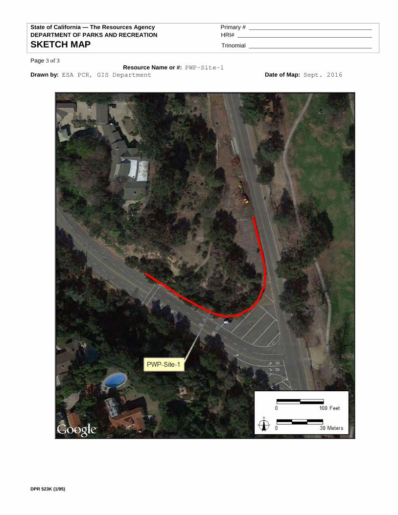
State of California — The Resources Agency Primary # DEPARTMENT OF PARKS AND RECREATION HRI#
SKETCH MAP Trinomial
Page 3 of 3 Resource Name or #: PWP-Site-1
Drawn by: ESA PCR, GIS Department Date of Map: Sept. 2016
DPR 523K (1/95)

State of California — The Resources Agency Primary #
DEPARTMENT OF PARKS AND RECREATION HRI #
PRIMARY RECORD Trinomial NRHP Status Code
Other Listings
Review Code Reviewer Date Page 1 of 3 Resource Name or #: (Assigned by recorder) PWP-Site-2
P1. Other Identifier: PWP-Site-2 P2. Location: [X] Not for Publication [ ] Unrestricted a. County Los Angeles
and (P2b and P2c or P2d. Attach location map as necessary.) b USGS 7.5’ Quad Pasadena Date 1966 (photo-revised 1988)T1N; R12W; Unsectioned
c. Address N/A City Pasadena Zip N/A d. UTM: (Give more than one for large and/or linear resources) Zone 11, 392325mE/3782193mN e. Other Locational Data (e.g., parcel #, directions to resource, elevation, etc., as appropriate): PWP-Site-2 is located
immediately north of an abandoned road (Del Monte Street)located north of the intersection of Rosemont Avenue and Washington Boulevard.
P3a. Description (Describe resource and its major elements. Include design, materials, condition, alterations, size, setting, and boundaries): PWP-Site-
2 consists of a cement-lined storm drainage ditch located immediately north and adjacent to an abandoned road (Del Monte Street). The ditch is shallow and measures approximately four feet in width by 300 feet in length. PWP-Site-2 falls within the boundaries of the National Register-eligible Pasadena Arroyo Parks and Recreation District (P-19-0364). Although, this storm drainage ditch is not particularly mentioned as a contributing or non-contributing feature in the Department of Parks and Recreation Form for the District, the storm drainage ditch still forms part of the landscape for the District.
P3b. Resource Attributes: (List attributes and codes) HP20 (Ditch) P4. Resources Present: [ ] Building [X] Structure [ ] Object [ ] Site [ ] District [ ] Element of District
P5a. Photo or Drawing (Photograph required for buildings, structures, and objects)
P5b. Description of Photo: (View,
date, accession #) XX P6. Date Constructed/Age: and
Sources: [X] Historic [ ] Prehistoric [ ] Both
P7. Owner and Address: Unknown P8. Recorded by (Name, affiliation, and
address): Fatima Clark ESA PCR 2121 Alton Parkway,Suite 100, Irvine, CA P9. Date Recorded: July 27, 2016
P10. Type of Survey: (Describe)
Pedestrian survey
P11. Report Citation (Provide full citation or enter "none."): Clark and Garcia (2016); Cultural Resources Assessment Addendum for the Proposed Pasadena Non-Potable Water Project Alternatives Alignments, City of Pasadena, Los Angeles County, California.
Attachments: [ ] NONE [X] Location Map [X] Sketch Map [ ] Continuation Sheet [ ] Building, Structure, and Object Record [ ] Archaeological Record [ ] District Record [ ] Linear Feature Record [ ] Milling Station Record [ ] Rock Art Record [ ] Artifact Record [ ] Photograph Record [ ] Other (List): DPR 523A (1/95)

State of California — The Resources Agency Primary # DEPARTMENT OF PARKS AND RECREATION HRI#
LOCATION MAP Trinomial
Page 2 of 3 Resource Name or #: PWP-Site-2
Map Name: USGS 7.5’ Pasadena Scale: 1:2,000 Date of Map: 2016
DPR 523J (1/95)

State of California — The Resources Agency Primary # DEPARTMENT OF PARKS AND RECREATION HRI#
SKETCH MAP Trinomial
Page 3 of 3 Resource Name or #: PWP-Site-2
Drawn by: ESA PCR, GIS Department Date of Map: 2016
DPR 523K (1/95)

Appendix D - EnviroStor and Geotracker Databases for the Phase I Options

Page intentionally blank.
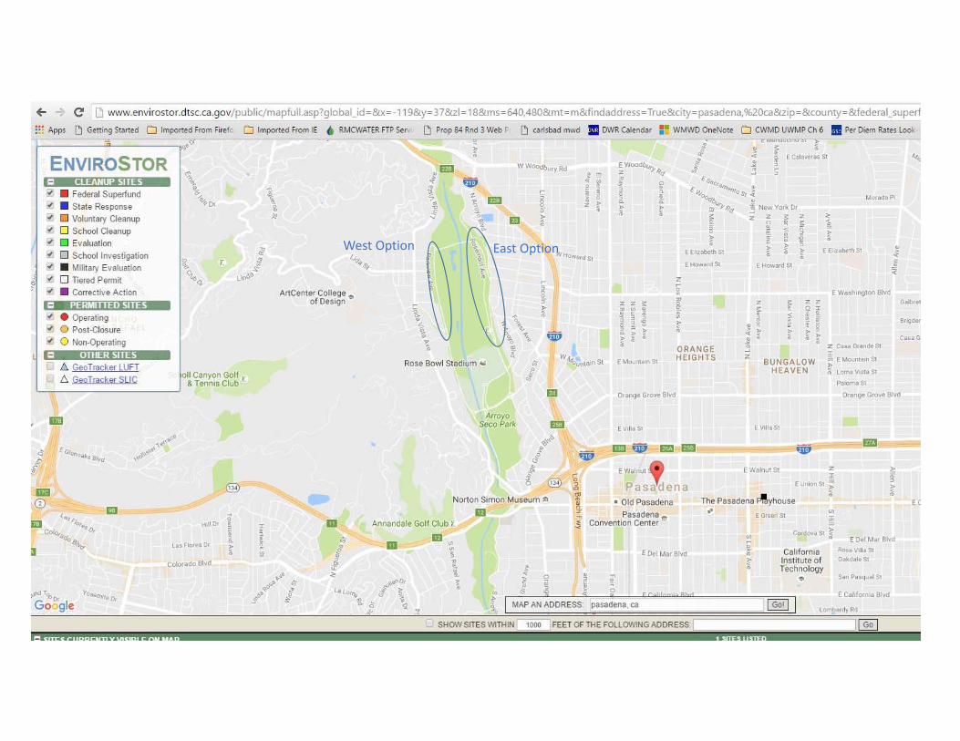
West Option East Option

West OptionEast Option

Appendix E - Traffic and Recreation Survey for Phase I Options

Page intentionally blank.

Technical Memorandum
Pasadena Non-Potable Water Project - Phase I Options
Subject: Traffic and Recreation Survey for Phase I Options
Prepared For: Roumiana Voutchkova, City of Pasadena
Prepared by: Sally Johnson and Alexis Cahalin
Reviewed by: Rosalyn Prickett
Date: September 21, 2016
Reference: 0129-005.03
This Technical Memorandum (TM) documents the updated traffic and recreation survey for the two modified sections of the Phase I Alignment of the Pasadena Non-Potable Water Project. The information provided by the survey will be used for California Environmental Quality Act (CEQA) analysis of the Phase I Options.
1.1 Overview
The Pasadena Non-Potable Water Project (Project) is a six-phase project to construct a non-potable water distribution system within the City of Pasadena (City) and select customers immediately adjacent to the City. The Phase I Project is designed to convey recycled water from the Los Angeles/Glendale Water Reclamation Plant (LAG) to recycled water customers at the Art Center College of Design, Brookside Golf Course, the Rose Bowl Stadium area, and Brookside Park. An Environmental Impact Report (EIR) for the Project was certified by the City on February 22, 2016.
The proposed Phase I Options would modify the Phase I Alignment in the 2016 EIR to avoid construction along Linda Vista Avenue, Laurel Street, and Parkview Avenue, as well as to avoid construction along portions of Arroyo Boulevard and Rose Bowl Drive. The Phase I Options would include the Salvia Canyon West Route (along Salvia Canyon and West Drive) and the Rosemont Avenue East Route (along Rosemont Avenue), shown in Figure 1. The portions of the Phase I Options located along West Drive and Rosemont Avenue run alongside the Rose Bowl Loop. The Rose Bowl Loop is a 3.3 mile paved recreational loop that wraps around Brookside Golf Course and the Rose Bowl. The trail is used heavily by walkers, jogger, and bicyclists. The roadways are used to access the golf course, Rose Bowl, and other recreational facilities.
The Phase I Options have the potential to increase traffic and recreational impacts due to their location along the Rose Bowl Loop, compared to the potential impacts of the proposed Phase I Alignments in the 2016 EIR. Due to this potential change in impacts, traffic and recreation counts were conducted to determine whether a full traffic analysis is necessary. Previous traffic and recreation surveys were conducted in 2008 (Crain and Associates, 2008). To ensure these counts are still appropriate to use for the Phase I Options analysis, traffic and recreation counts were conducted on September 1, 2016 at

two locations (Figure 1). The Rosemont Avenue East Route survey location was on Rosemont Avenue, which runs along the east side of Brookside Golf Course, approximately 0.25 mile north of the intersection of Rosemont Avenue and Rose Bowl Drive. The Salvia Canyon West Route survey location was on West Drive, approximately 0.20 miles north of the intersection of West Drive and Salvia Canyon Road.
1.2 Traffic and Recreation Survey Methodology and Results
To conduct the traffic and recreation survey for the Phase I Options, two locations were chosen, one along each of the Phase I Option routes, as shown in Figure 1.
Figure 1: Traffic and Recreation Survey Locations
Counts were taken in 15 minute blocks for northbound and southbound traffic and recreation use for a one-hour period at each location. Categories of traffic and recreation use included car, truck, bicycle, peloton, walk/jog, and skate/scooter. Trucks were defined as motor vehicles with six or more axles. Motorcycles were counted as cars. A peloton
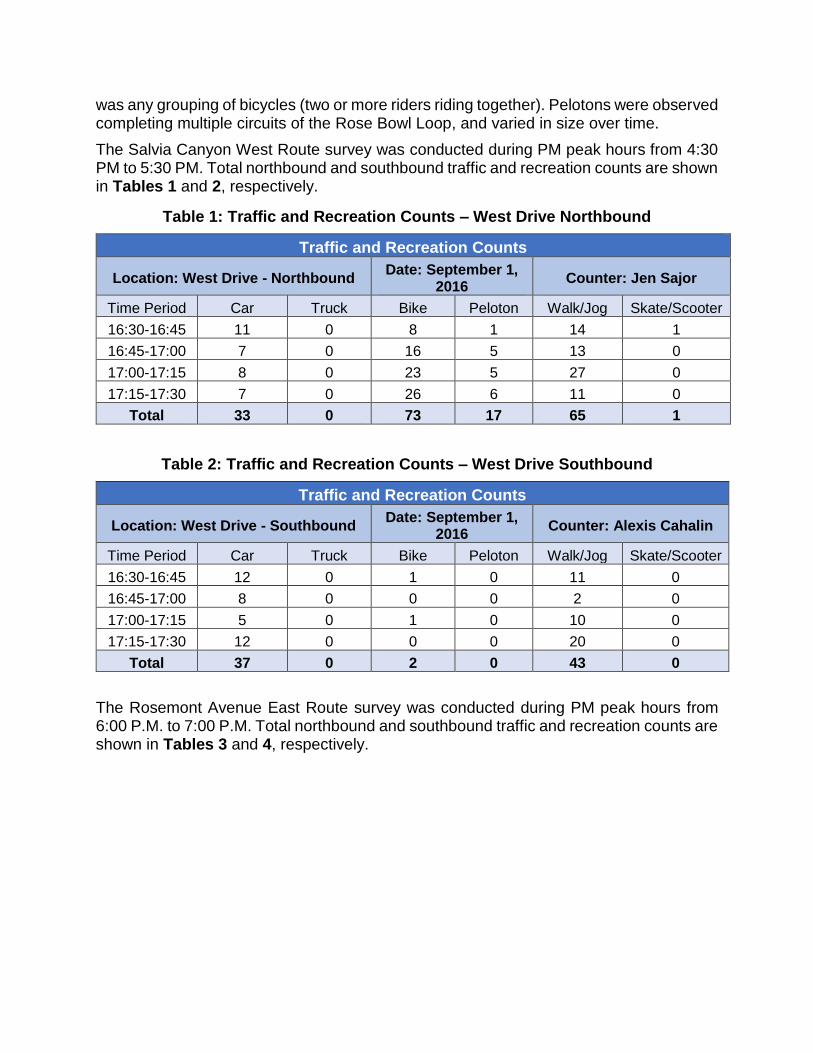
was any grouping of bicycles (two or more riders riding together). Pelotons were observed completing multiple circuits of the Rose Bowl Loop, and varied in size over time.
The Salvia Canyon West Route survey was conducted during PM peak hours from 4:30 PM to 5:30 PM. Total northbound and southbound traffic and recreation counts are shown in Tables 1 and 2, respectively.
Table 1: Traffic and Recreation Counts – West Drive Northbound
Traffic and Recreation Counts
Location: West Drive - Northbound Date: September 1,
2016 Counter: Jen Sajor
Time Period Car Truck Bike Peloton Walk/Jog Skate/Scooter
16:30-16:45 11 0 8 1 14 1
16:45-17:00 7 0 16 5 13 0
17:00-17:15 8 0 23 5 27 0
17:15-17:30 7 0 26 6 11 0
Total 33 0 73 17 65 1
Table 2: Traffic and Recreation Counts – West Drive Southbound
Traffic and Recreation Counts
Location: West Drive - Southbound Date: September 1,
2016 Counter: Alexis Cahalin
Time Period Car Truck Bike Peloton Walk/Jog Skate/Scooter
16:30-16:45 12 0 1 0 11 0
16:45-17:00 8 0 0 0 2 0
17:00-17:15 5 0 1 0 10 0
17:15-17:30 12 0 0 0 20 0
Total 37 0 2 0 43 0
The Rosemont Avenue East Route survey was conducted during PM peak hours from 6:00 P.M. to 7:00 P.M. Total northbound and southbound traffic and recreation counts are shown in Tables 3 and 4, respectively.

Table 3: Traffic and Recreation Counts – Rosemont Avenue Northbound
Traffic and Recreation Counts
Location: Rosemont Avenue - Northbound
Date: September 1, 2016
Counter: Jen Sajor
Time Period Car Truck Bike Peloton Walk/Jog Skate/Scooter
18:00-18:15 21 0 3 0 18 0
18:15-18:30 17 0 5 0 39 1
18:30-18:45 14 0 6 0 35 0
18:45-19:00 23 1 4 0 64 1
Total 75 1 18 0 156 2
Table 4: Traffic and Recreation Counts – Rosemont Avenue Southbound
Traffic and Recreation Counts
Location: Rosemont Avenue - Southbound
Date: September 1, 2016
Counter: Alexis Cahalin
Time Period Car Truck Bike Peloton Walk/Jog Skate/Scooter
18:00-18:15 17 0 22 6 19 1
18:15-18:30 17 0 37 5 39 1
18:30-18:45 15 0 36 11 36 1
18:45-19:00 11 1 25 16 69 2
Total 60 1 120 38 163 5
1.3 Conclusion
Traffic and recreational use of both West Drive and Rosemont Avenue was substantially lower than that shown in the counts taken in September 2008. The volume of traffic and recreational use as shown by the updated survey does not demonstrate a significant increase to the 2008 counts, therefore the previous traffic analysis is considered conservative for CEQA purposes.