Embed Size (px)
Citation preview

Appendix E Pump Test Report
GROUND-WATER EXPLORATION PROGRAM LEGACY RIDGE, TOWN OF WOODBURY, NEW YORK
Prepared For:
Legacy Ridge
August 2007
Prepared By:
LEGGETTE, BRASHEARS & GRAHAM, INC. Professional Ground-Water and Environmental Engineering Services
4 Research Drive, Suite 301 Shelton, CT 06484
TABLE OF CONTENTS
Page INTRODUCTION ...........................................................................................................................1 DRILLING EXPLORATION PROGRAM.....................................................................................1
Bedrock Aquifer...................................................................................................................2 Sand and Gravel Aquifer......................................................................................................2
TW-A ...............................................................................................................................................3 PW-1 ................................................................................................................................................3 INSTALLATION OF PIEZOMETER ............................................................................................3 INSTALLATION OF PRESSURE TRANSDUCERS....................................................................4 24+ HOUR PUMPING TEST .........................................................................................................4 WELL MONITORING PROGRAM...............................................................................................5 Long-Term Yield of PW-1...................................................................................................6 WATER QUALITY.........................................................................................................................6 CONCLUSIONS..............................................................................................................................6
GROUND-WATER EXPLORATION PROGRAM LEGACY RIDGE, TOWN OF WOODBURY, NEW YORK
INTRODUCTION
Leggette, Brashears & Graham, Inc (LBG) conducted an additional groundwater
exploration program, aquifer testing program, and groundwater quality assessment on the Legacy
Ridge parcel in the Town of Woodbury, NY. The objective of the groundwater exploration
program was to locate, install test wells and perform aquifer performance test to demonstrate
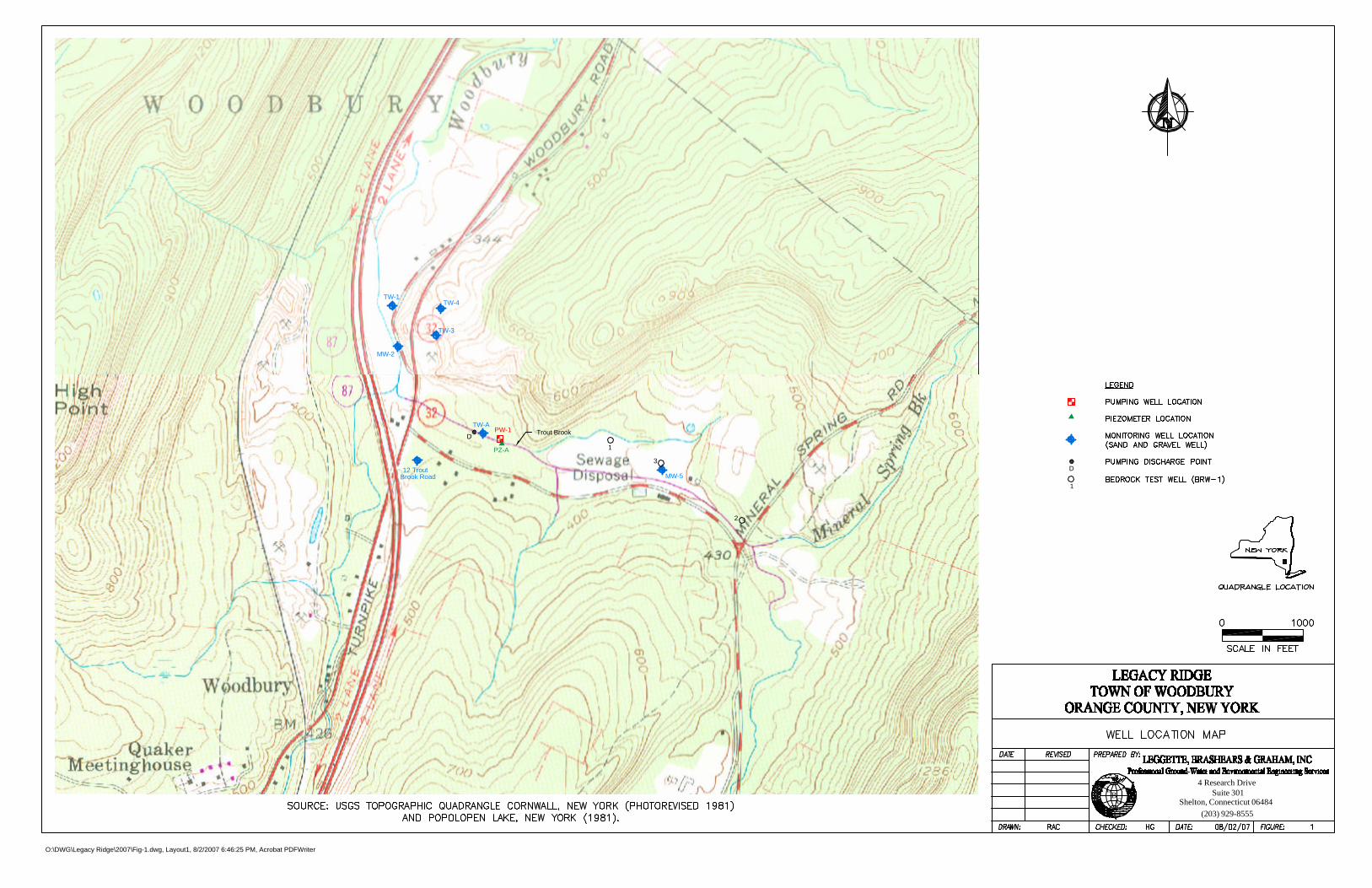
sufficient yield to augment the existing water-supply sources. Figure 1 shows the location of the
site in the Town of Woodbury, Orange County, New York along with the existing production
wells, test wells, monitoring wells, and piezometers used during the aquifer performance test.
DRILLING EXPLORATION PROGRAM
The additional exploration program conducted by LBG included test well drilling
completed in both the bedrock and sand and gravel aquifers from March to June 2007. To date,
three bedrock test wells and two sand and gravel test wells have been completed. The following
is a discussion of the preliminary yield estimate of the test wells from the bedrock and sand and
gravel aquifers, including data from a 24+ hour pumping test event conducted on a successful
high-yield sand and gravel well (PW-1).
A previous ground-water exploration program conducted by HDR Engineering, Inc.
(HDR) in 2005 on the study parcel developed three successful sand and gravel production wells
identified as TW-1, TW-2 and TW-4; with respective yields of 290, 120 and 34 gpm. The wells
are shown on figure 1.
Details of the well completion reports of the existing water supply wells and monitoring
wells completed under the supervision of HDR are provided in the report “Groundwater
Exploration and Hydrogeologic Report, Town of Woodbury, Orange County, NY by HDR, Inc.,
January 2006”.
-2- Bedrock Aquifer
The bedrock geologic map from the Orange County New York, Ground-Water Resources
Study (LBG, May 1995) shows complex bedrock geology on the study parcel. The initial
bedrock well drilling program considered an area north of Trout Brook Road and west of Route 9
(Mineral Spring Road). A prominent northeast to southwest trending trust fault bisects this
portion of the study parcel, separating a granitic gneiss bedrock unit on the north of the fault; and
Undifferentiated Lower Devonian and Silurian Rocks consisting of sandstone, shale and
conglomerate rock units on the southern side of the fault.
Fracture-trace maps were interpreted with additional layers of topography; bedrock
geology; underling faults; geologic contacts; wells inventoried; sand and gravel deposits; and
State and Federal wetlands to locate favorable locations to target high-yielding bedrock well.
Locations which exhibit more than one of the above features are considered to be promising for
drilling high-yielding bedrock well and the sites initially considered on the study parcel for
drilling test wells exhibited a number of these favorable features.
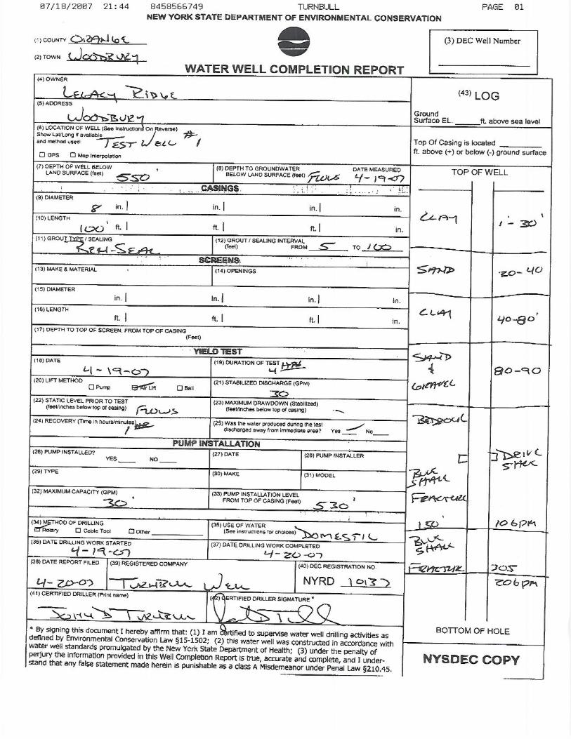
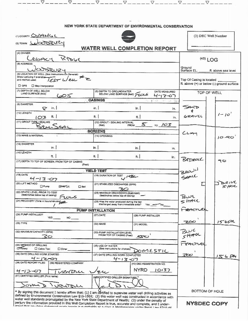
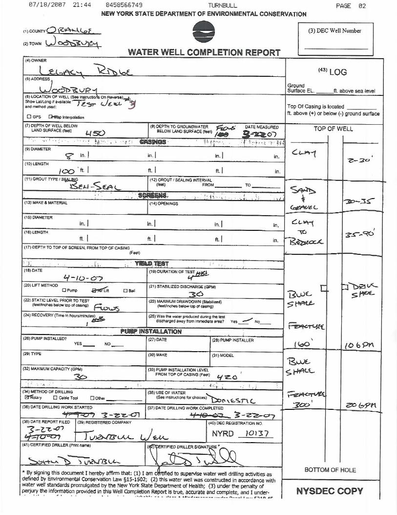
Three bedrock test wells were drilled by Turnbull Well Drilling, Inc. from March to April
of 2007 under the supervision of LBG. Bedrock test wells 1, 2 and 3 (BRW-1, 2, and 3) are
shown on Figure 1. The well completion reports are presented in Appendix I. All three bedrock
test wells yielded about 30 gpm at termination of drilling. The project team decided to terminate
the bedrock test well drilling at completion of BRW-3, considering the well yields were
considered marginal for the development of public water-supply sources.
Sand and Gravel Aquifer
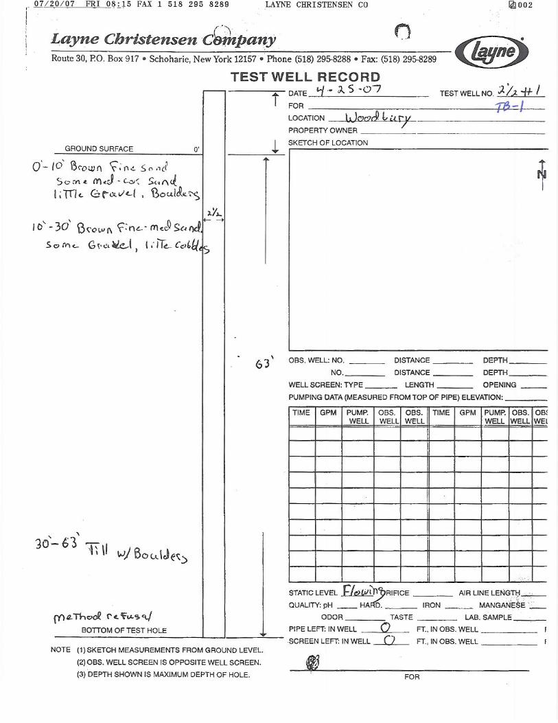
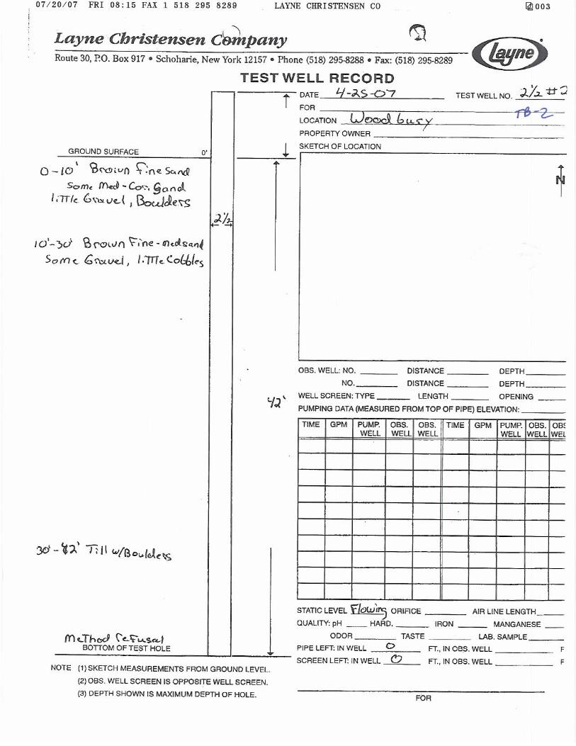
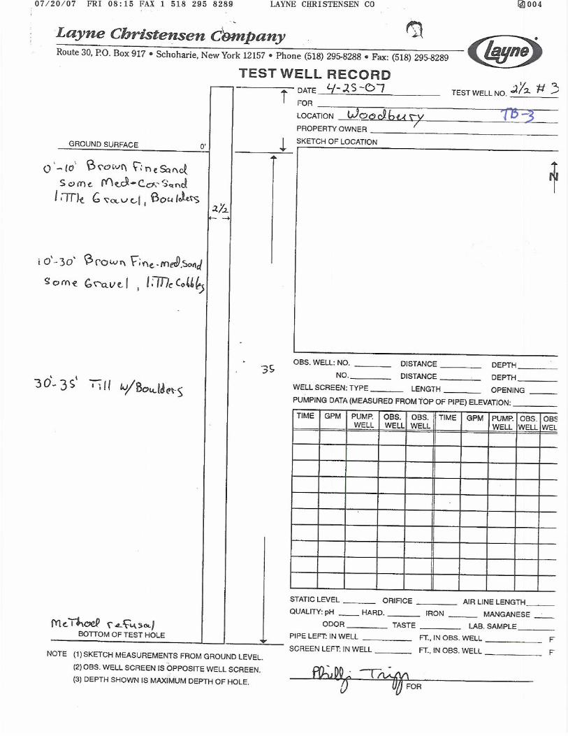
Layne Christensen Company (Layne) was contracted in April of 2007 to drill test well
locations in the sand and gravel aquifer, north of Trout Brook on the study parcel. The initial
drilling program completed three test borings (TB-1, 2 and 3) in the vicinity of BRW-1. Sand
and gravel aquifer material was encountered in this area during drilling; however, the material
was determined to not be suitable for the development of a high-yielding well. The test boring
reports for TB-1, 2 and 3 are presented in Appendix II.
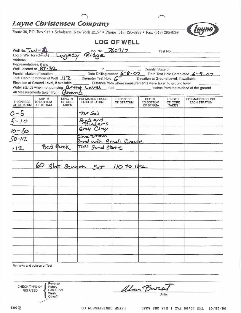
LBG supervised the drilling of the two additional test borings and test wells drilled by
Layne in June of 2007. The two six inch diameter test wells were completed as TW-A and PW-1
-3- (figure 1). The test boring reports and well construction diagrams for TW-A and PW-1 are
located in Appendix II.
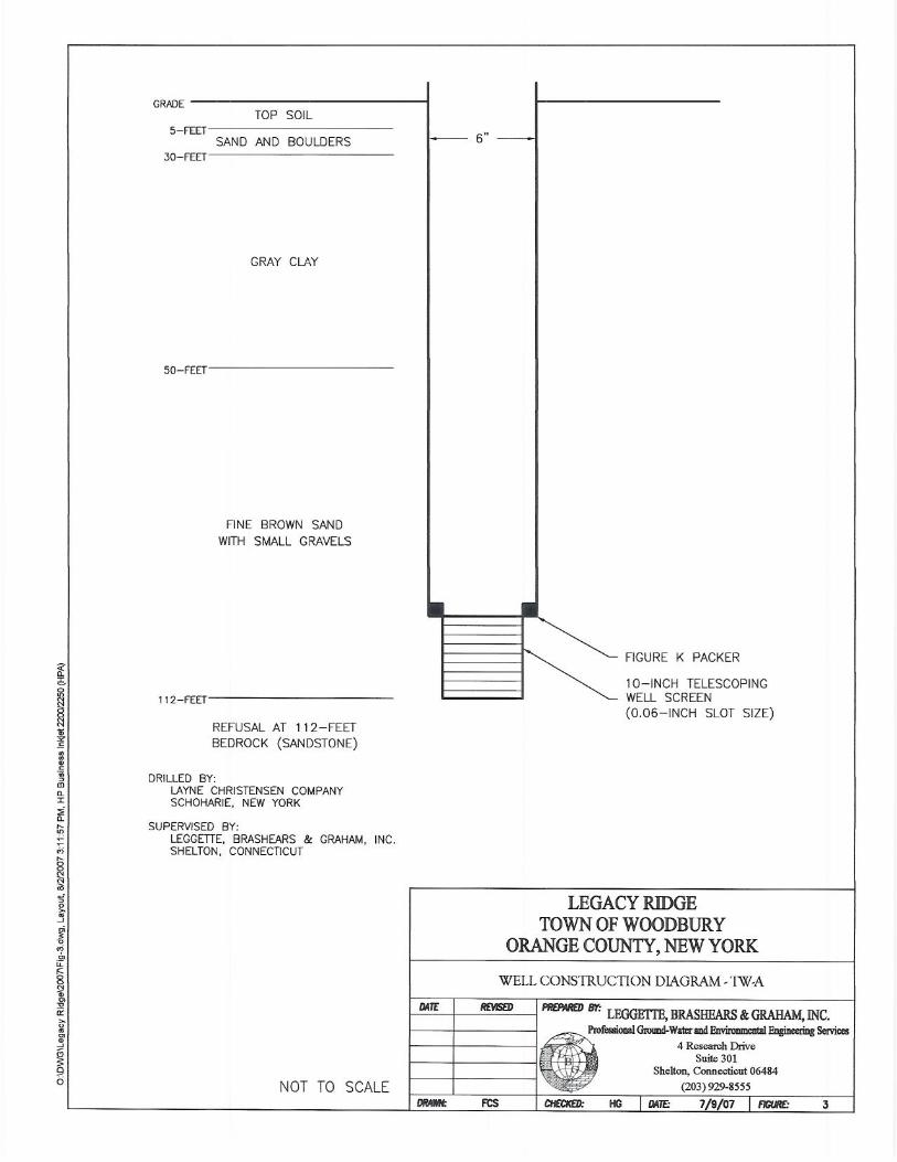
TW-A
TW-A was completed at a depth of 112 feet below land surface (bls). The well was
screened from 102 to 110 feet bls with a 60-slot stainless steel screen. The well was screened in
suitable sand and gravel aquifer material. A dense gray clay layer about 40-feet in thickness was
encountered at a depth of 10 to 50 feet bls. The underlying bedrock was encountered at 112 feet
bls and was composed of sandstone. The well was developed with repeated surging and
pumping.
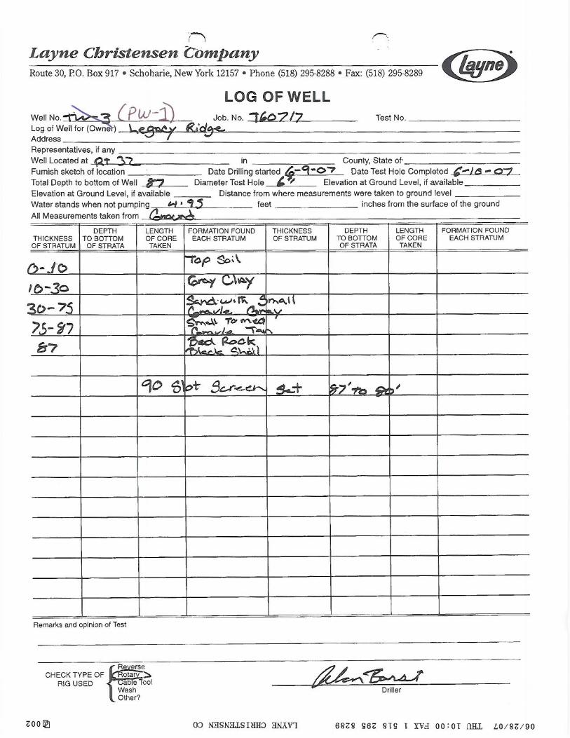
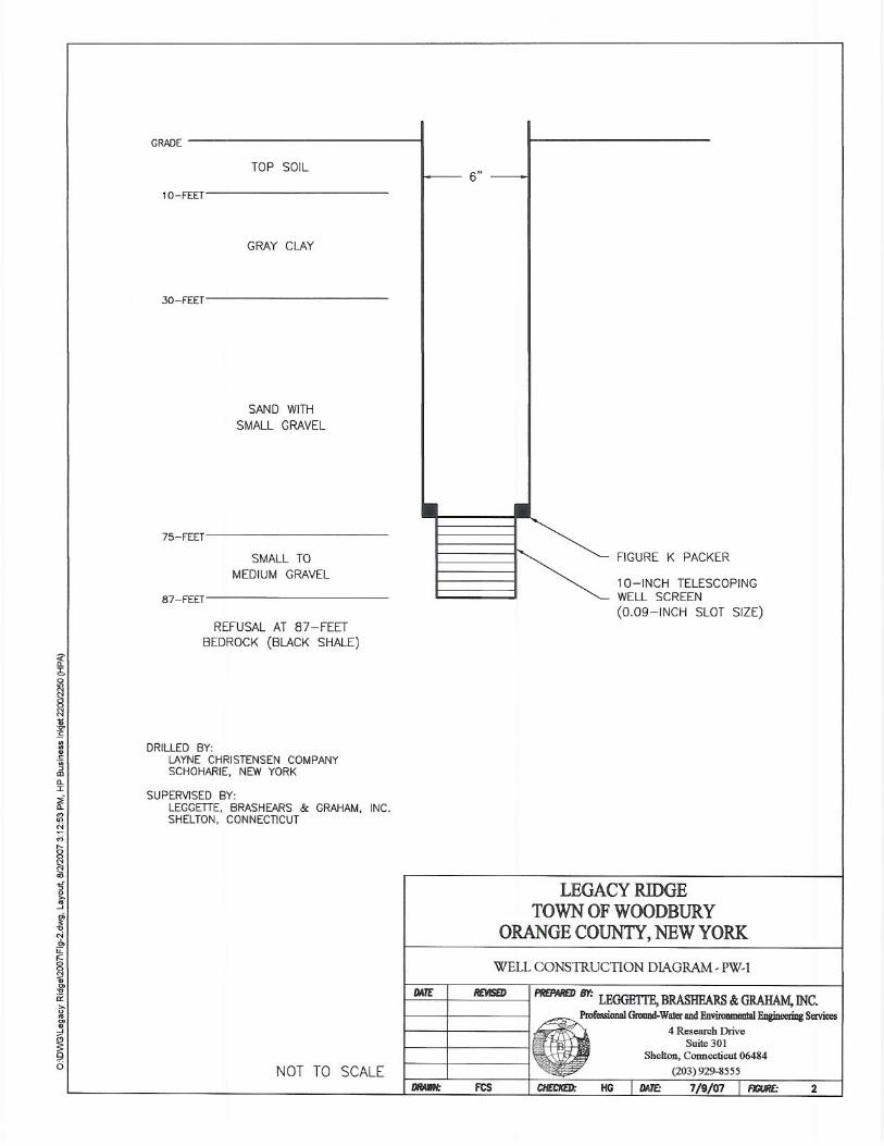
PW-1
PW-1 was completed at a depth of 87 feet bls. The well screen was set at 80 to 87 feet
bls with a 90-slot stainless steel screen. The well was screened in suitable sand and gravel
aquifer material. Similarly a dense gray clay layer about 20-feet in thickness was encountered at
a depth of 10 to 30 feet bls. The bedrock was encountered at 90 feet bls and was composed of
black shale. The well was developed with repeated surging and pumping. The initial pumping
conducted during development indicated PW-1 had the higher yield potential, therefore, a short-
term 24-hour pumping test was recommended on this well to determine the yield potential of a
larger diameter production well.
INSTALLATION OF PIEZOMETER
A 1.25-inch diameter piezometer (PZ-A) was installed in the middle of the Trout Brook
at a distance of about 60 feet from the test well (PW-1). A 12- inch length stainless steel screen
(with drive point and coupled steel pipe) was driven into the bottom of the stream sediments to a
depth of 3.73 feet. The piezometer was developed by repeated well surging. The location of
PZ-A is shown of figure 1.
-4-
INSTALLATION OF PRESSURE TRANSDUCERS
Prior to the aquifer performance test, pressure transducers (mini-trolls from Insitu, Inc.)
were installed on June 25, 2007 in existing production wells (TW-1, TW-3, and TW-4);
monitoring wells (MW-2, MW-5, BRW-1), and in 12 Trout Brook Rd. (offsite homeowner well);
TW-A, and inside and outside of the piezometer, PZ-A. These pressure transducers provided
background water levels prior to, during and after the pumping tests at 1-minute intervals.
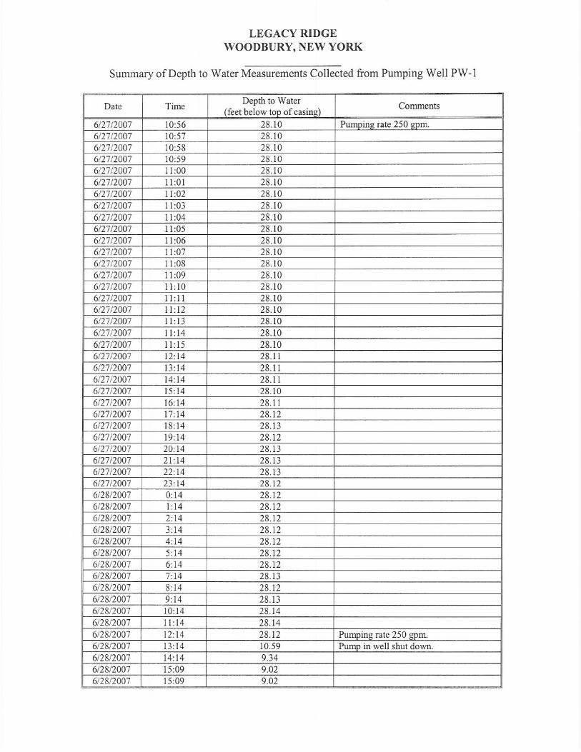
24+ HOUR PUMPING TEST
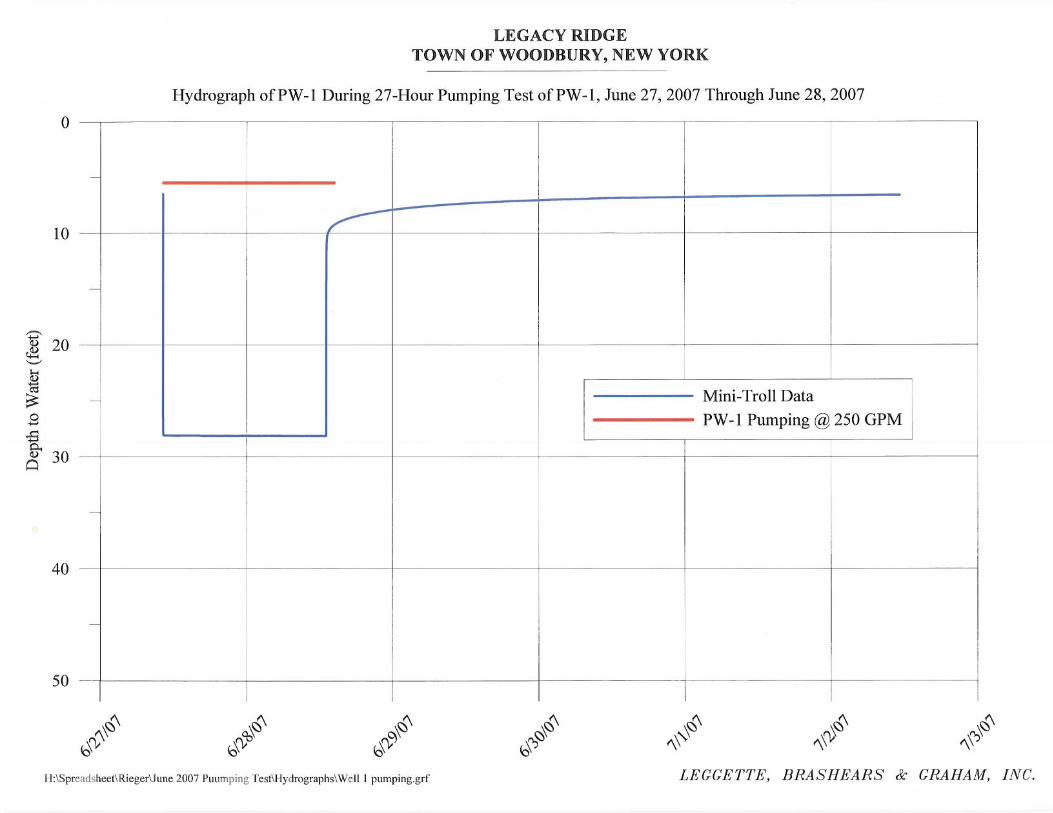
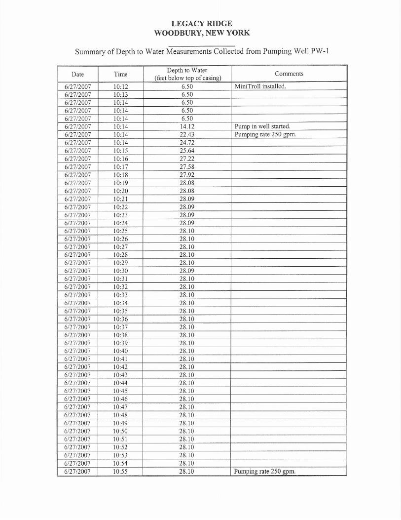
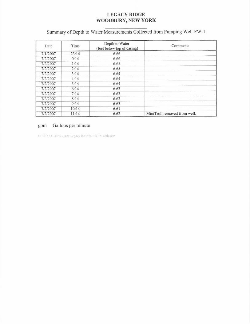
On June 27, 2007 at 10:14 hours the pumping test event on PW-1 began at a rate at
250 gallons per minute (gpm). The static water level just before pumping the well was 6.5 feet
below top of casing (TOC) and the pump was set at a depth of 79 feet TOC. The casing stickup
was 1.67 feet above the grade. The water was discharged 300-feet downstream of the PW-1 in
the Trout Brook (figure 1). The flow rate for the well were measured with pipe orifice weir at
15-minute intervals during the first hour of the test, and hourly for the balance of the test. The
flow rate was constant through out the test at 250 gpm. At the 250 gpm pumping rate, the
stabilized water level just prior to shutdown of the test (June 28, 2007 at 13:09 hours) was
reported to be 28.13 feet. It should be noted that the test was extended an additional three hours
for a total pumping duration of about 27 hours. The total drawdown at the end of the 27-hour
pumping test was 21.6 feet. At about 1400 hours on June 27, 2007, a slight rain (drizzle)
occurred at the site for 30-minutes, however, the rain did not affect the water- level data for PW-
1, monitoring wells and piezometer. Water- level data measured during the pumping test and
hydrograph for PW-1 are given in Appendix III.
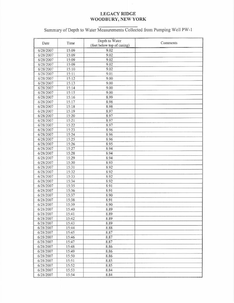
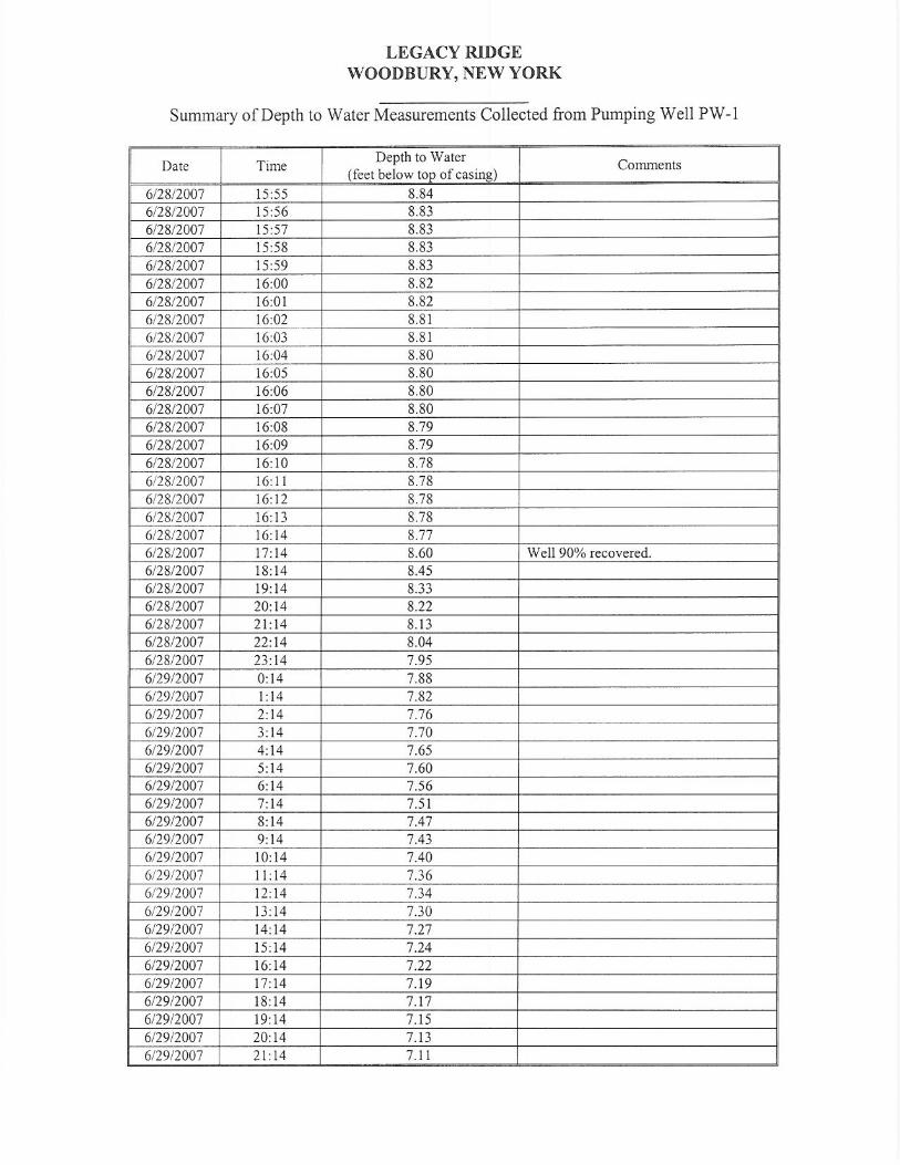
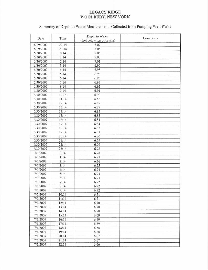
After the pumping test was terminated (June 28, 2007 at 13:09 hours), recovery
measurements were collected in PW-1 for a period of approximately 94-hours. During the
recovery period, a rain event occurred overnight on June 28, 2007, which is evident on the
hydrograph for PZ-OUT (stream stage) in the Trout Brook. Based on the rain gage at West
Point, New York (which is 15 miles east of the site), there was only 0.14 inches of rain on June
28, 2007. The rain did not have a discernible recharge effect on the recovery of the ground-
water level. The hydrographs provided in Appendix III show the water level in PW-1 recovered
-5- from a final pumping water level of 28.12 feet to 7.3 feet (which is 96.3% of pre-pumping
condition) within 24-hours. Considering a slight region water- level decline was observed in the
monitoring wells prior to the start of the test, which likely continued during the testing period
and following shutdown, the well is assumed to be fully recovered at about 24 hours from
shutdown of the test.
WELL MONITORING PROGRAM
During the pumping test program conducted on PW-1 an onsite and offsite well
monitoring program was conducted. The purpose of the monitoring program was to determine if
the pumping of PW-1 for 24+ hours at a rate of 250 gpm would significantly affect water- level
and/or yields of existing onsite production well (TW-1, TW-3 and TW-4) and neighboring offsite
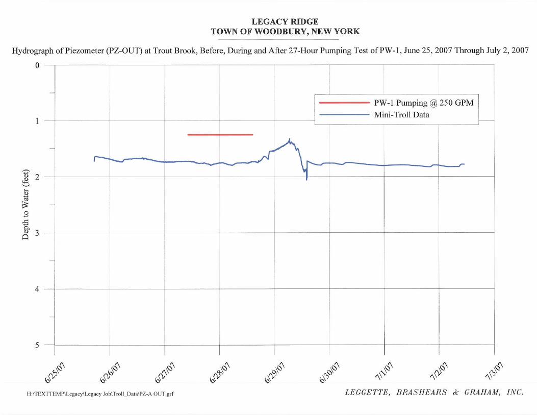
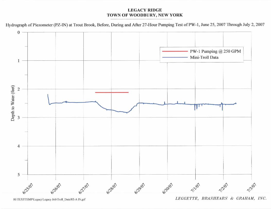
wells. LBG also installed PZ-A in Trout Brook to determine any hydraulic connection with the
sand and gravel aquifer and stream under pumping conditions. The hydrographs for the
monitoring wells and piezometer are located in Appendix IV. A majority of the monitoring
wells indicated a regional declining water-level trend prior to, during and following completion
of the test on PW-1.
The piezometer (PZ-IN) installed in the Trout Brook, showed about 0.4 feet of drawdown
during the pump test, however, there was no discernible change in the stream stage (PZ-OUT)
due to the pumping effect. Though there was minor drawdown in the piezometer, the stage in
the Trout Brook was not impacted and this indicates that there is no significant effective
groundwater and surface water interaction as a result of ground-water withdrawals from PW-1.
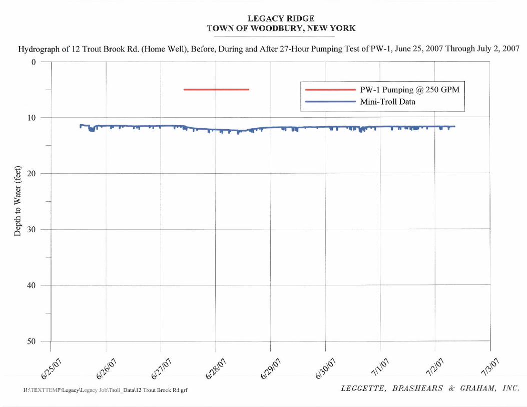
The hydrograph for 12 Trout Brook Road (offsite homeowner well), located
approximately 1000 feet southwest from the pumping well (PW-1), indicated about 0.75 feet of
drawdown during the test, as a result of ground-water withdrawal from PW-1. Monitoring well
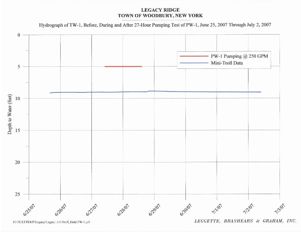
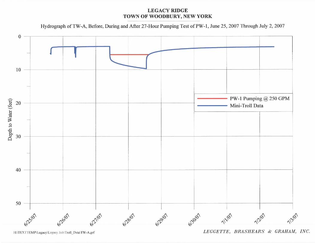
TW-A located at a distance of only 220 feet northwest of the pumping well PW-1 showed
approximately 9.5 feet of drawdown during the test.
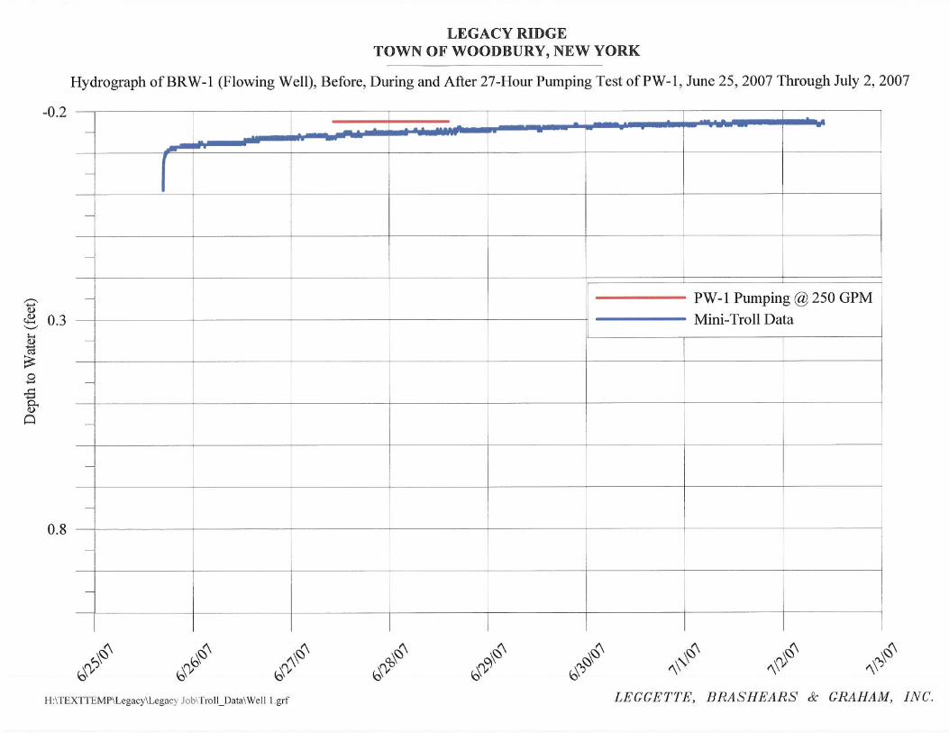
BRW-1 which is a flowing well completed in bedrock, located 1250 feet southeast of
PW-1, showed no discernible impact during the test. This indicates no hydraulic connection
between the sand and gravel aquifer and bedrock aquifer, as expected.
-6-
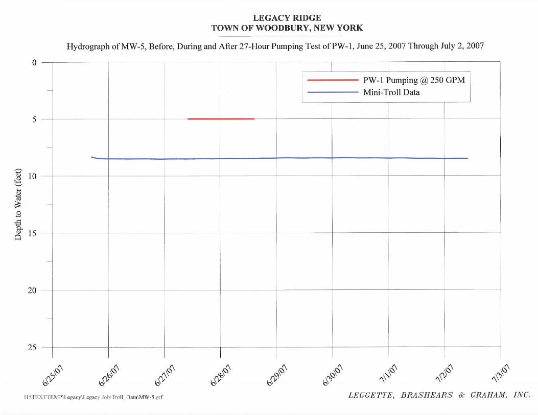
MW-5, a sand and gravel monitoring well, located 1875 feet southeast of PW-1, showed
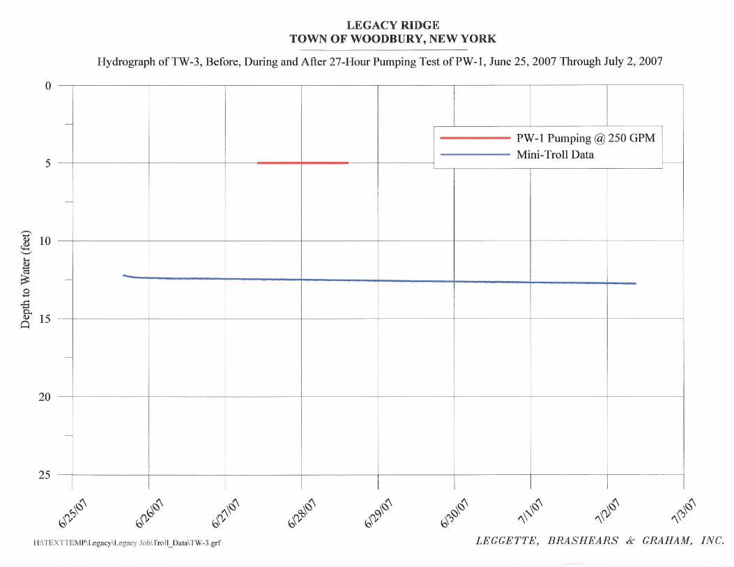
no discernible impacts form the pumping of PW-1. TW-1, a 14- inch diameter production well
located 1950 feet northwest of PW-1 shows no discernible water level drawdown due to
pumping PW-1. TW-3 is a 14-inch diameter production well located 1400 feet northwest of
PW-1, also showed no discernible change in the water level due to pumping from PW-1.
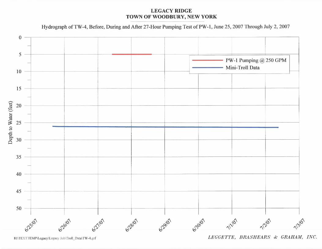
Similarly, TW-4, a 14- inch diameter production well located 1630 feet northwest of PW-1,
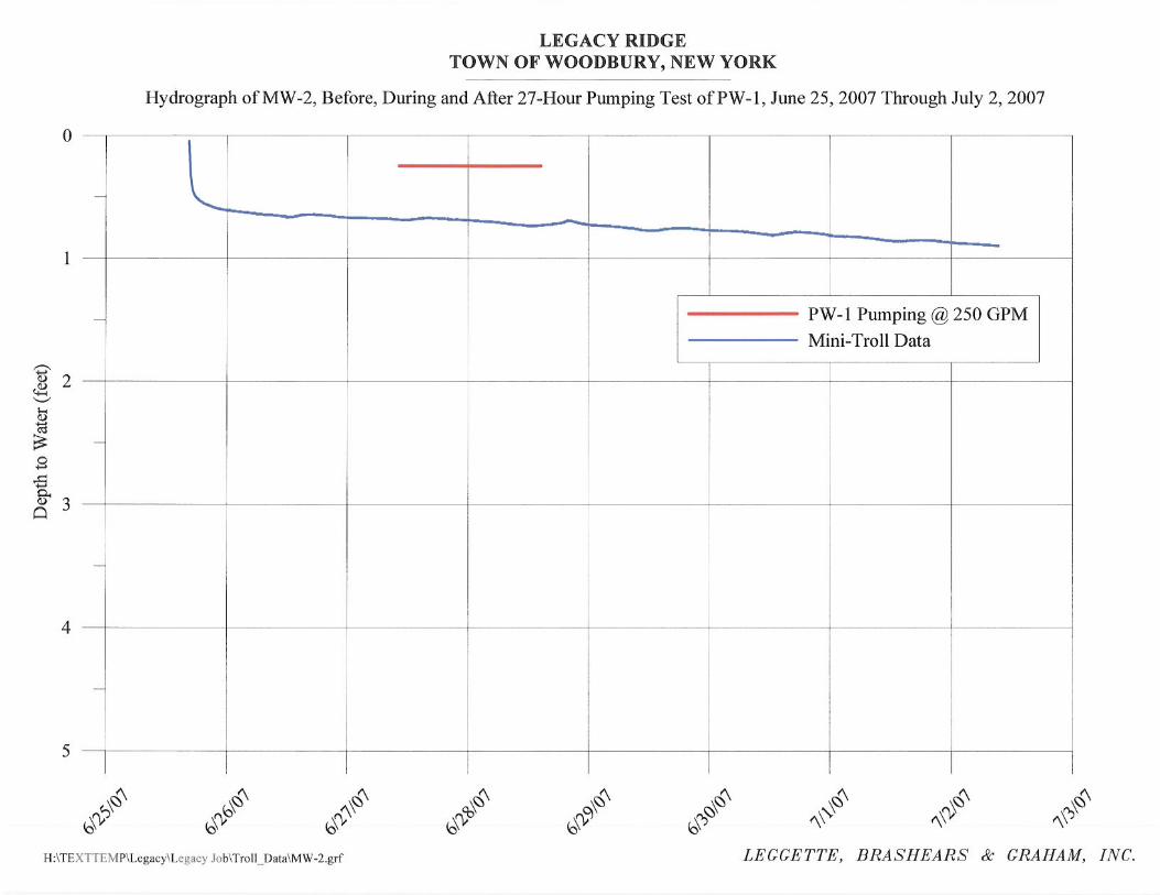
showed no discernible impact due to the pumping at PW-1. MW-2 is a monitoring well located
1565 feet northwest of PW-1 and the hydrograph showed no discernible impact from the
pumping of PW-1.
Long-Term Yield of PW-1
The specific capacity of the PW-1 after 27-hour of pumping was 11.6 gpm/ft. The
maximum safe yield estimate (assuming drawdown to be five feet above the top of the screen) is
812 gpm. Therefore based on the maximum safe yield calculation, PW-1 can safely maintain a
pumping rate of 250 gpm even during extended drought conditions.
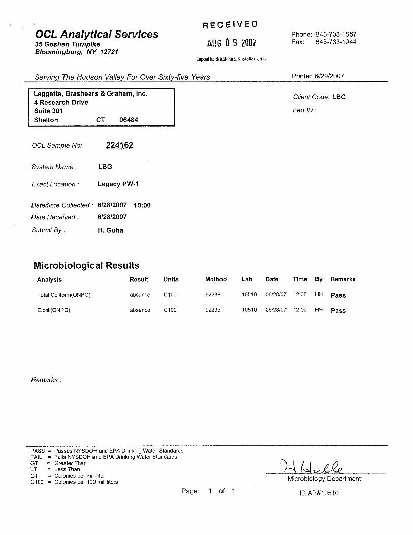
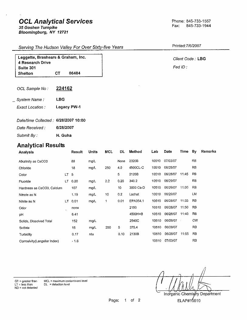
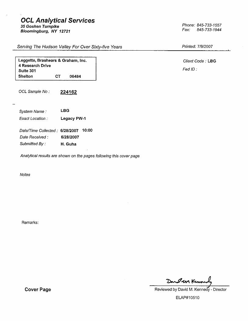
WATER QUALITY
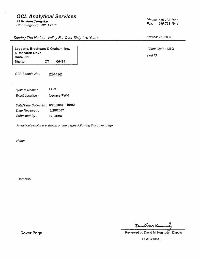
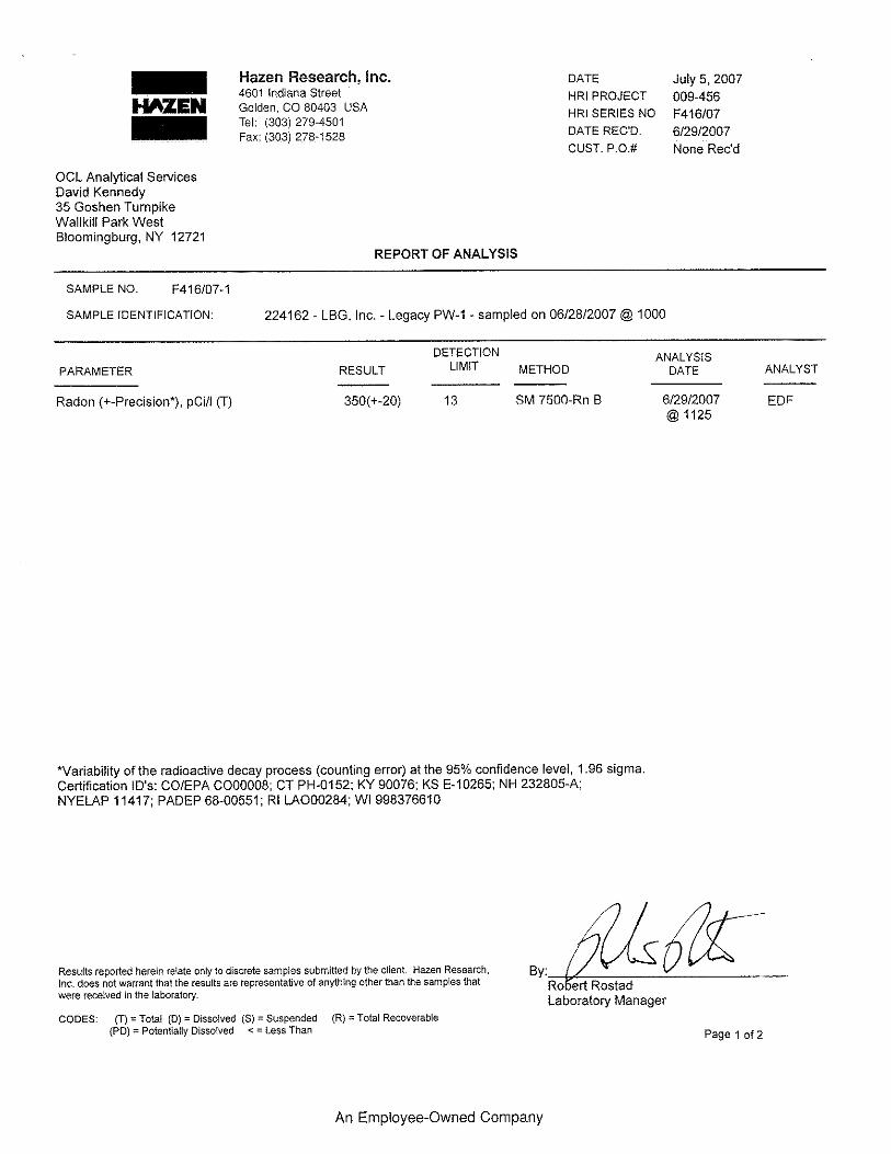
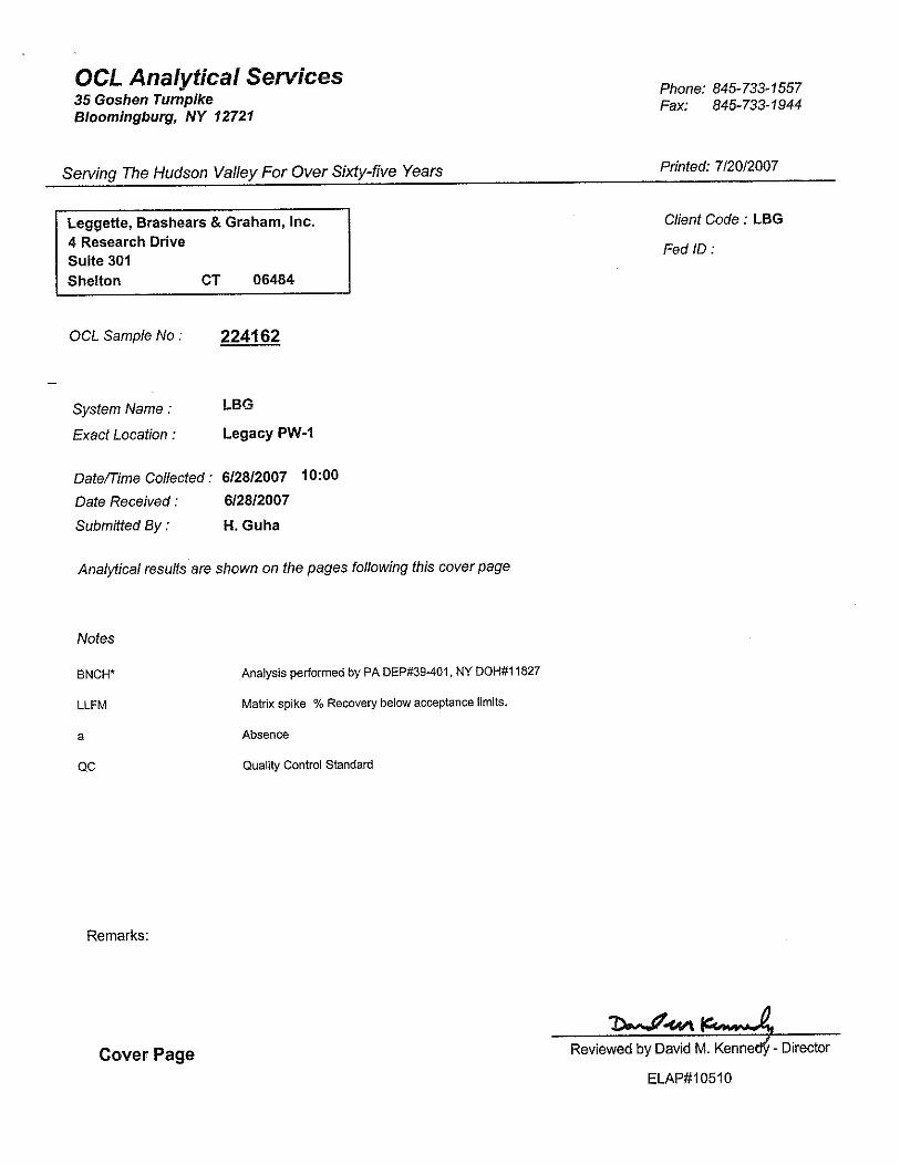
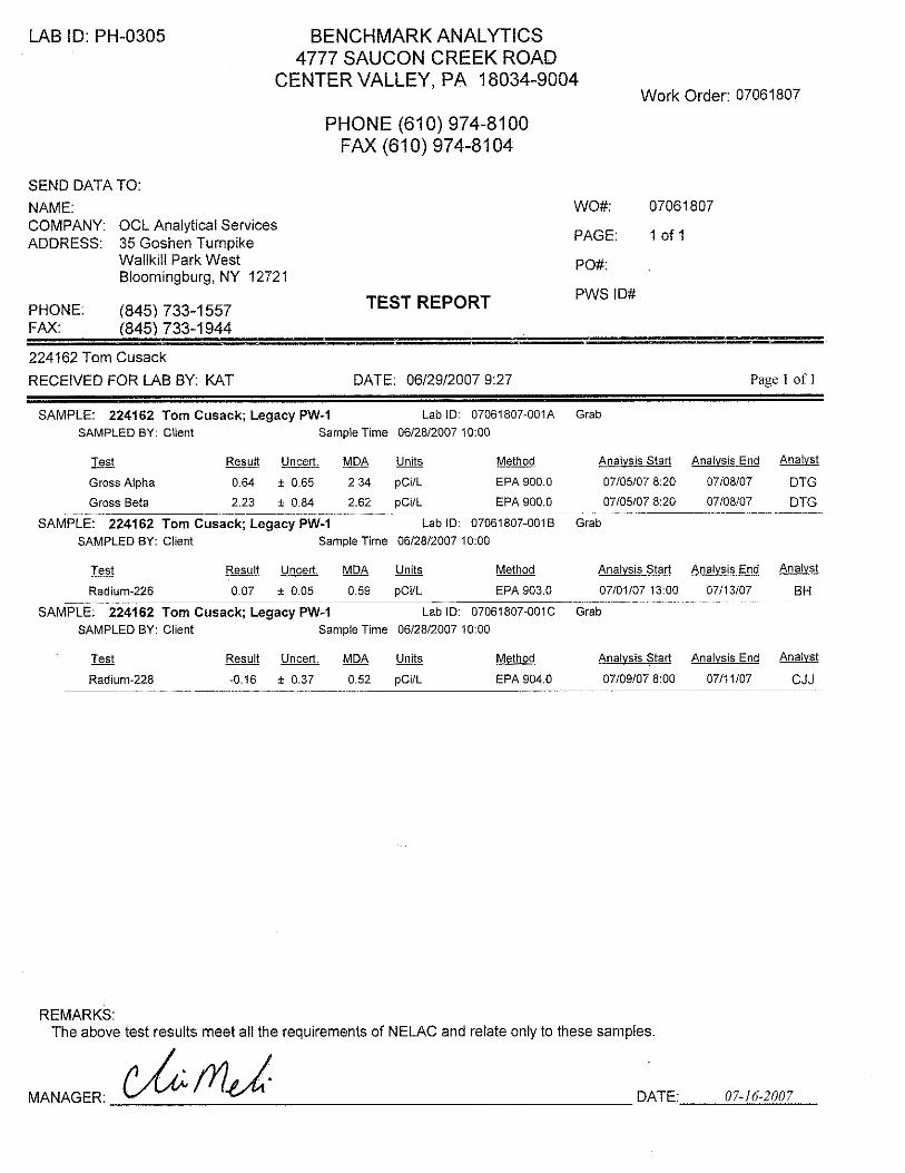
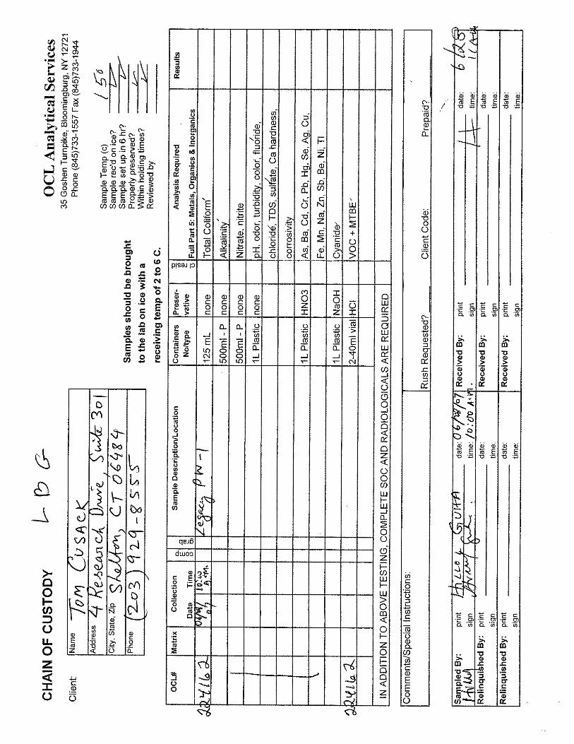
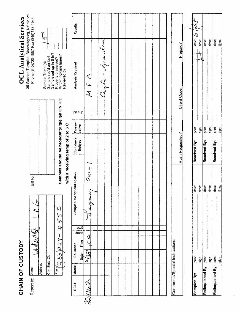
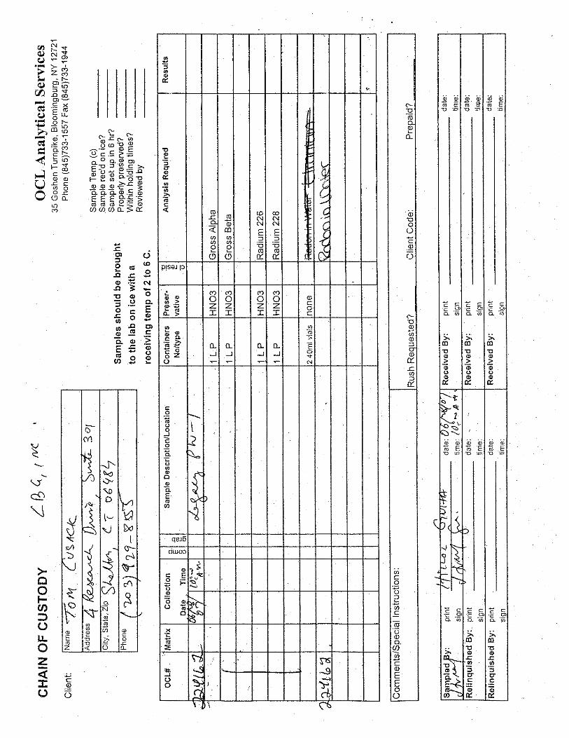
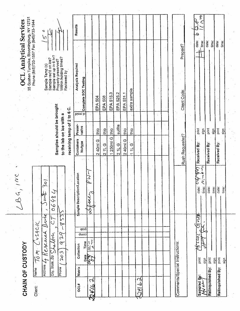
On June 28, 2007 at about10 hours water quality samples were collected from PW-1 and
were delivered to Orange County Laboratory Analytical Services (OCL) at 11:30 hours on June
28, 2007 for all parameters required by the New York State Sanitary Code Part 5, Subpart 5-1.
In addition, because PW-1 is located 60 feet from a surface-water body (Trout Brook), the
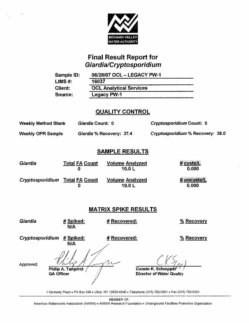
analysis included microparticulate analysis (MPA) and Cryptosporadium & Giardia to determine
if the well is under the direct influences of surface-water bodies. The Surface Water Treatment
Rule is applied to any well under direct influence of surface-water bodies. The water-quality
report will be available within two weeks of the date of this report.
CONCLUSIONS
Based on the result of the 27-hour pumping test conducted on PW-1, the well can sustain
a yield of 250 gpm. The data indicated no discernible impact to the stream flow (stage) on Trout
-7- Brook. In addition, ground-water withdrawals from PW-1 during the test event indicated no
discernible impacts on the existing production wells (TW-1, TW-3 and TW-4). The data indicate
PW-1 can be pumped simultaneously with any of the existing production well (TW-1, TW-3 and
TW-4).
The hydrograph for the offsite homeowner well located at 12 Trout Brook Road indicated
minor water- level interference drawdown effects of about 0.75 feet from the pumping of PW-1.
The noted impacts will not impair the yield of this well. No significant offsite water- level
interference effects are expected from ground-water withdrawal from PW-1 up to 250 gpm in the
study region.
Following completion of a larger diameter production well in the vicinity of PW-1,
additional long-term testing (72-hour duration) will be conducted to confirm the yield of the well
at rates equal to (250 gpm) or higher than tested for PW-1. Additional monitoring will be
conducted to include onsite and offsite wells, including piezometers in Trout Brook to reaffirm
above conclusions related to potential impacts.
LEGGETTE, BRASHEARS & GRAHAM, INC.
Hillol Guha, Ph.D., P.G., P.HGW Senior Hydrogeologist/Modeler
Reviewed by:
Thomas P. Cusack, CPG Principal
nv August 2, 2007 H:\Legacy Ridge\WELL COMPLETION REPORT.doc

FIGURE
O:\DWG\Legacy Ridge\2007\Fig-1.dwg, Layout1, 8/2/2007 6:46:25 PM, Acrobat PDFWriter
PW-1
PZ-A
MW-5
TW-A
12 Trout Brook Road
TW-3
TW-4TW-1
MW-2
DTrout Brook
1
3
2
BL
GSuite 301
(203) 929-8555Shelton, Connecticut 06484
4 Research Drive
D
1

APPENDIX I

APPENDIX II

APPENDIX III

APPENDIX IV
CONNECTICUT • OHIO • ILLINOIS • SOUTH DAKOTA • PENNSYLVANIA • FLORIDA • NEW JERSEY • MINNESOTA • TEXAS WISCONSIN • NEW YORK • MISSOURI • VERMONT • MICHIGAN
LEGGETTE, BRASHEARS & GRAHAM, INC.
PROFESSIONAL GROUND-WATER AND ENVIRONMENTAL ENGINEERING SERVICES
-------------------------------- 4 RESEARCH DRIVE, SUITE 301
SHELTON, CT 06484 (203) 929-8555
FAX (203) 926-9140 www.lbgweb.com
August 20, 2007
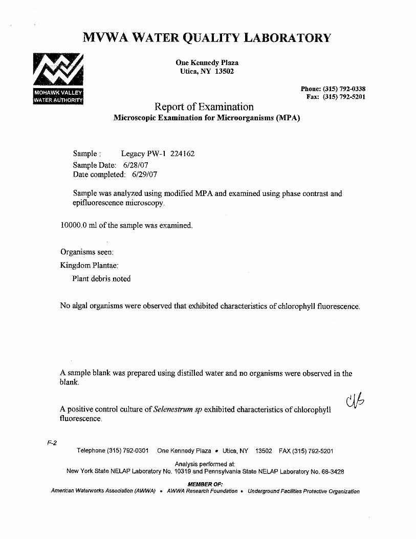
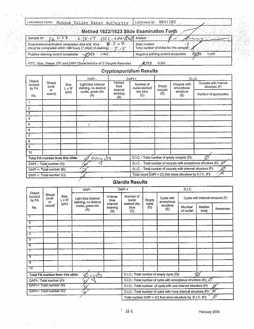
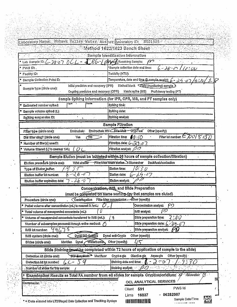
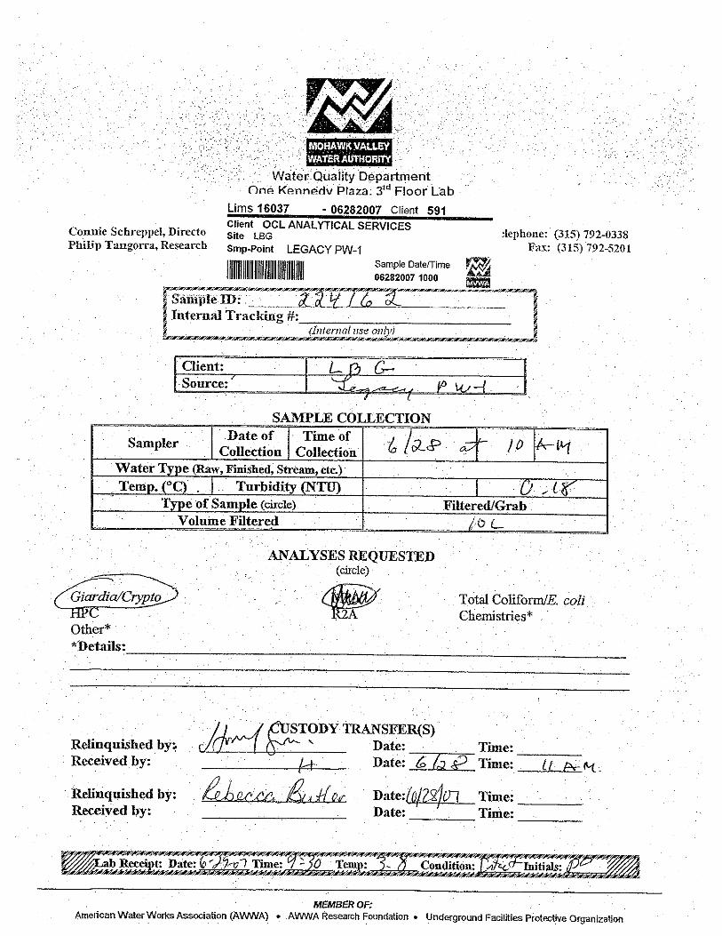
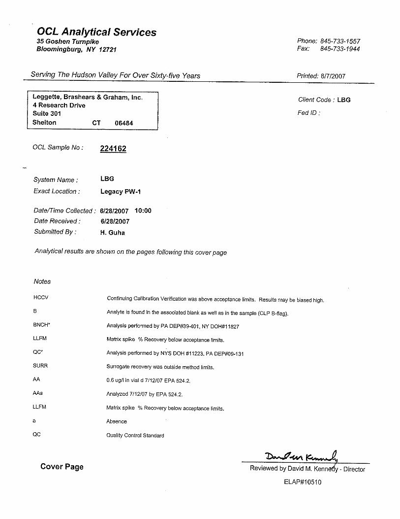
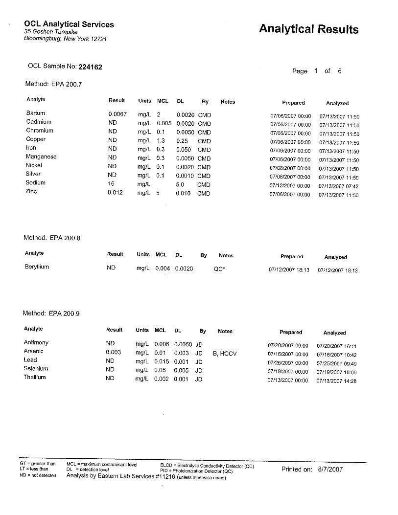
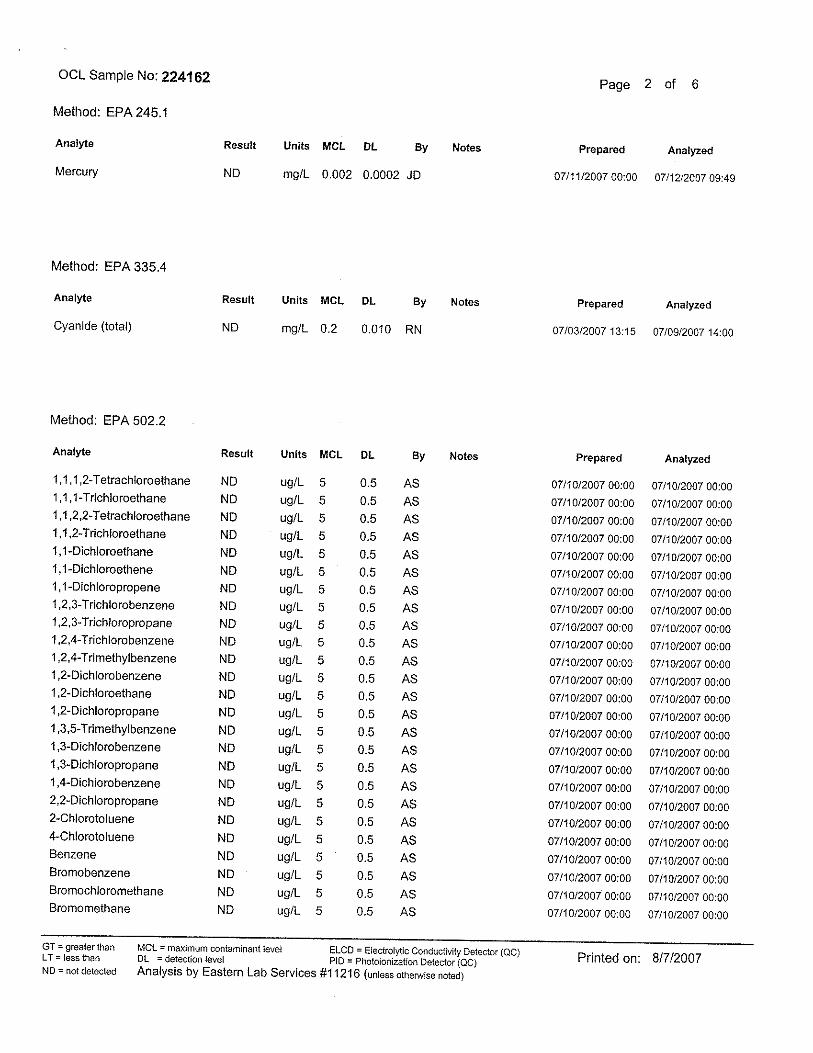
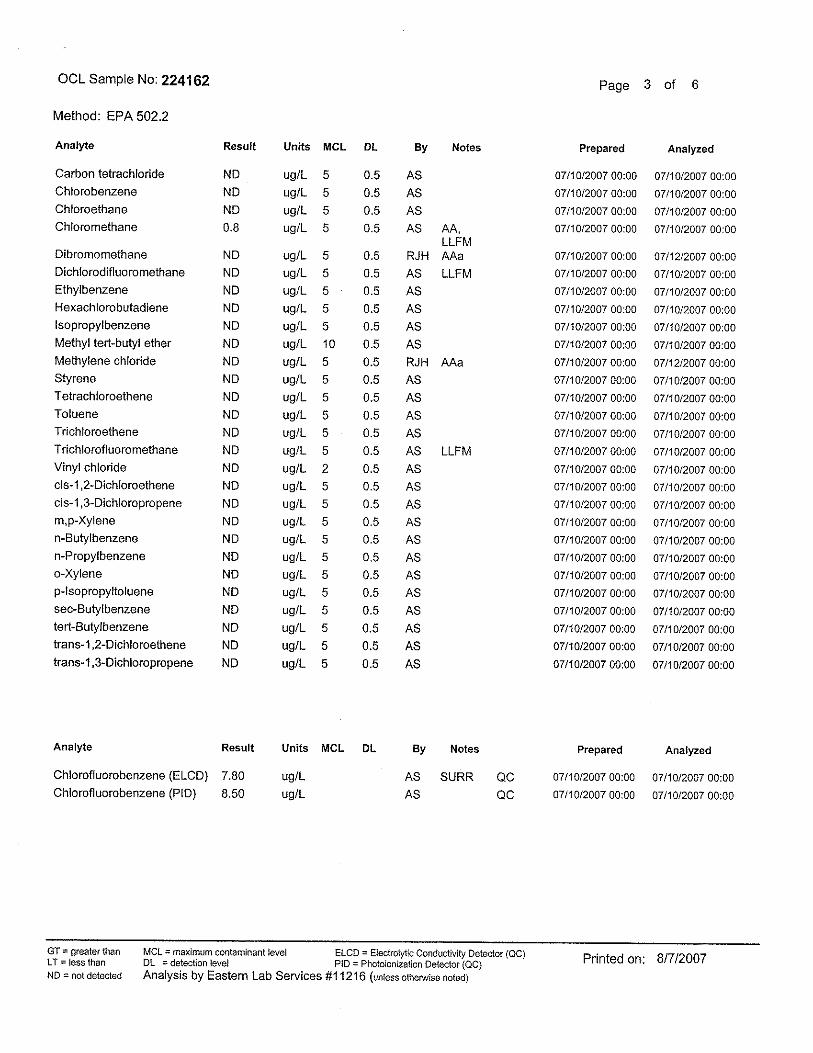
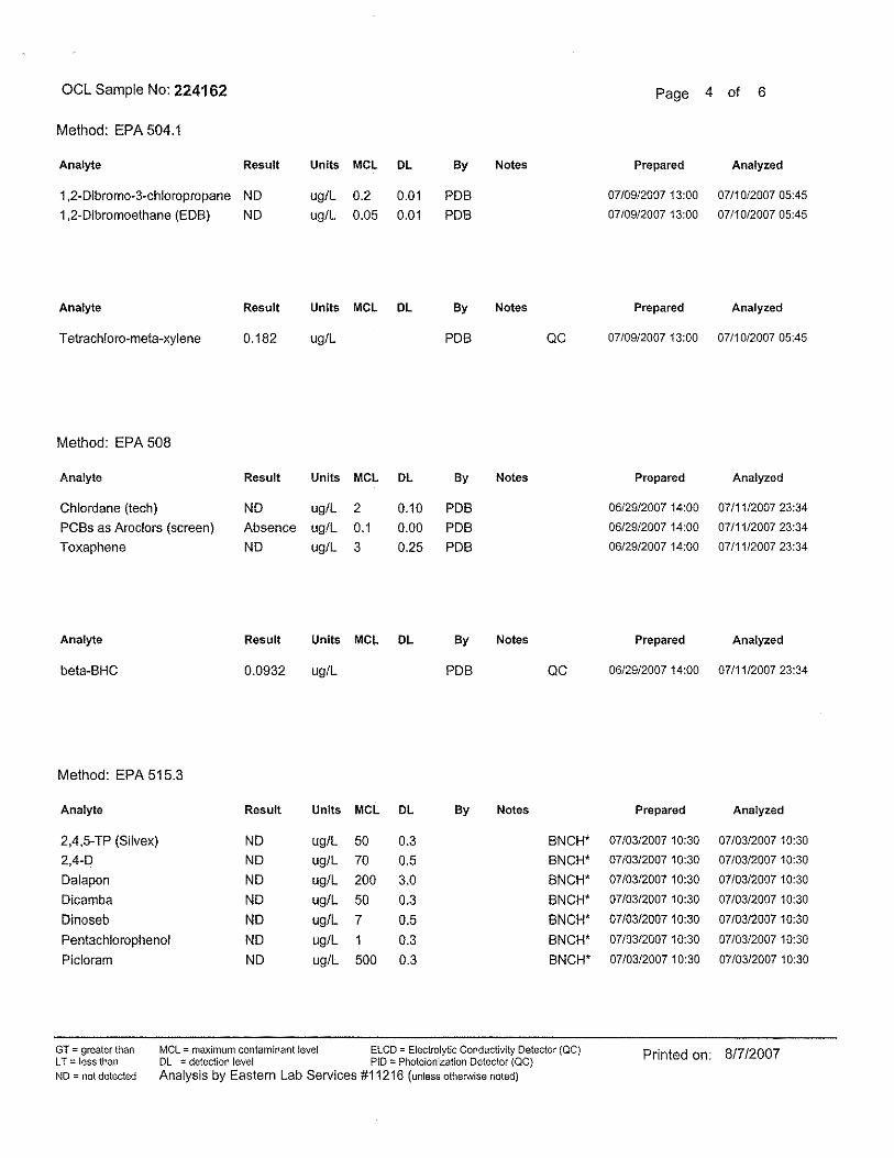
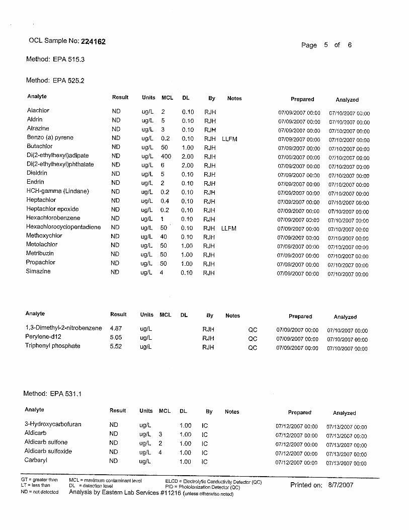
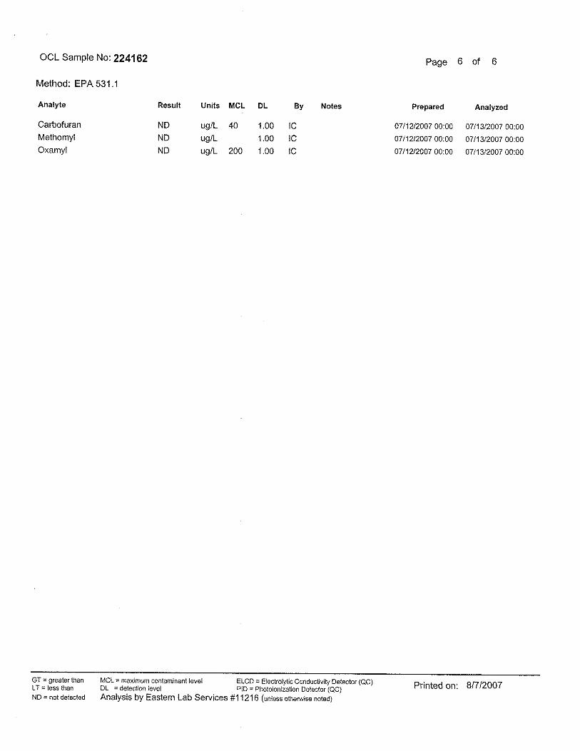
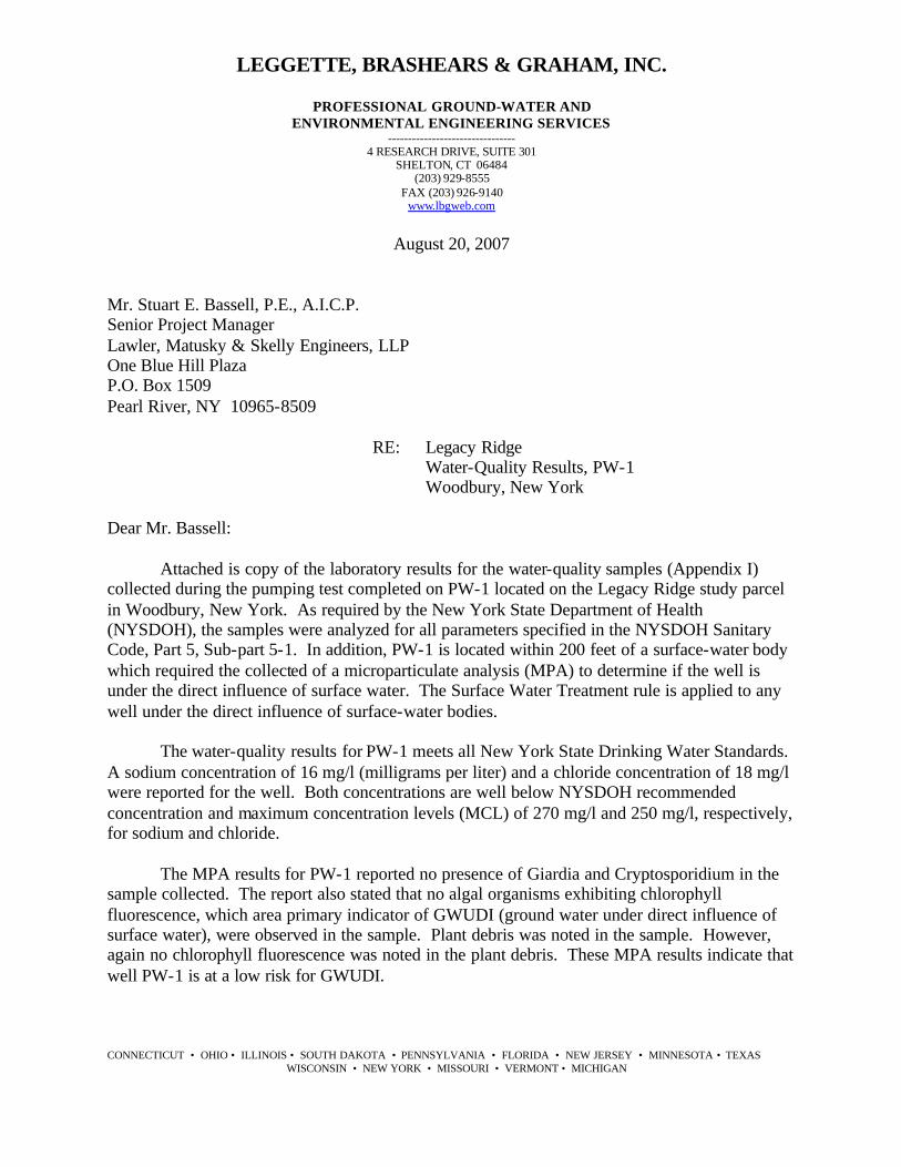
Mr. Stuart E. Bassell, P.E., A.I.C.P. Senior Project Manager Lawler, Matusky & Skelly Engineers, LLP One Blue Hill Plaza P.O. Box 1509 Pearl River, NY 10965-8509 RE: Legacy Ridge Water-Quality Results, PW-1 Woodbury, New York Dear Mr. Bassell: Attached is copy of the laboratory results for the water-quality samples (Appendix I) collected during the pumping test completed on PW-1 located on the Legacy Ridge study parcel in Woodbury, New York. As required by the New York State Department of Health (NYSDOH), the samples were analyzed for all parameters specified in the NYSDOH Sanitary Code, Part 5, Sub-part 5-1. In addition, PW-1 is located within 200 feet of a surface-water body which required the collected of a microparticulate analysis (MPA) to determine if the well is under the direct influence of surface water. The Surface Water Treatment rule is applied to any well under the direct influence of surface-water bodies. The water-quality results for PW-1 meets all New York State Drinking Water Standards. A sodium concentration of 16 mg/l (milligrams per liter) and a chloride concentration of 18 mg/l were reported for the well. Both concentrations are well below NYSDOH recommended concentration and maximum concentration levels (MCL) of 270 mg/l and 250 mg/l, respectively, for sodium and chloride. The MPA results for PW-1 reported no presence of Giardia and Cryptosporidium in the sample collected. The report also stated that no algal organisms exhibiting chlorophyll fluorescence, which area primary indicator of GWUDI (ground water under direct influence of surface water), were observed in the sample. Plant debris was noted in the sample. However, again no chlorophyll fluorescence was noted in the plant debris. These MPA results indicate that well PW-1 is at a low risk for GWUDI.
Mr. Stuart E. Bassell -2- August 20, 2007
If you have any questions, please feel free to contact me at 203-929-8555. Very truly yours, LEGGETTE, BRASHEARS & GRAHAM, INC. Stacy Stieber Hydrogeologist II SS:cmm Enclosures cc: M. Rosenzweig H:\Legacy Ridge\water-quality cover ltr.doc