Embed Size (px)
DESCRIPTION
Greatest mystery ever?
Citation preview

6/29/13 Pumapunku - Wikipedia, the free encyclopedia
en.wikipedia.org/wiki/Pumapunku 1/6
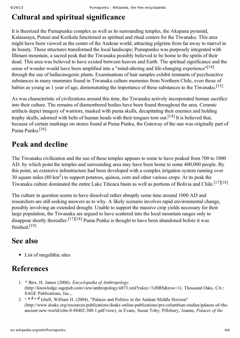
An example of highprecisionsmall holes
Stone block with a set of blindholes of complex shape
Stone blocks at Pumapunku
PumapunkuFrom Wikipedia, the free encyclopedia
Pumapunku also called "Puma Pumku" or "Puma Puncu", is part ofa large temple complex or monument group that is part of theTiwanaku Site near Tiwanaku, Bolivia. Tiwanaku is significant inIncan traditions because it is believed to be the site where the worldwas created.[1] In Aymara, Puma Punku's name means "The Door ofthe Puma". The Pumapunku complex consists of an unwalledwestern court, a central unwalled esplanade, a terraced platformmound that is faced with megalithic stone, and a walled easterncourt.[2][3][4] The Pumapunku is a terraced earthen mound that isfaced with megalithic blocks. It is 167.36 meters wide along its northsouth axis and 116.7 meters long along its eastwest axis. On thenortheast and southeast corners of the Pumapunku it has 20meterwide projections that extend 27.6 meters north and south from therectangular mound. The eastern edge of the Pumapunku is occupiedby what is called the "Plataforma Lítica." The Plataforma Líticaconsists of a stone terrace that is 6.75 by 38.72 meters in dimension.This terrace is paved with multiple enormous stone blocks. ThePlataforma Lítica contains the largest stone slab found in both thePumapunku and Tiwanaku Site. This stone slab is 7.81 meters long,5.17 meters wide and averages 1.07 meters thick. Based upon thespecific gravity of the red sandstone from which it was carved, thisstone slab has been estimated to weigh 131 metric tons.[5] The otherstonework and facing of the Pumapunku consists of a mixture ofandesite and red sandstone. The core of the Pumapunku consistsof clay. The fill underlying selected parts of the edge of thePumapunku consists of river sand and cobbles instead of clay.Excavations at the Pumapunku have documented “three majorbuilding epochs, in addition to small repairs andremodeling.”[2][3][4][5][6]
At its peak, Pumapunku is thought to have been "unimaginablywondrous",[3] adorned with polished metal plaques, brightlycolored ceramic and fabric ornamentation, trafficked by costumedcitizens, elaborately dressed priests and elites decked in exoticjewelry. Current understanding of this complex is limited due to itsage, the lack of a written record, the current deteriorated state of the structures due to treasure hunting,looting, stone mining for building stone and railroad ballast, and natural weathering.[2][3][5]
The area within the kilometer separating the Pumapunku and Kalasasaya complexes has been surveyedusing groundpenetrating radar, magnetometry, induced electrical conductivity, and magneticsusceptibility. The geophysical data collected from these surveys and excavations have revealed in the areabetween the Pumapunku and Kalasasaya complexes the presence of numerous manmade structures.These structures include the wall foundations of buildings and compounds, water conduits, poollikefeatures, revetments, terraces, residential compounds, and widespread gravel pavements all of which nowlie buried and hidden beneath the modern ground’s surface.[7][8]
Coordinates: 16°33′42″S 68°40′48″W

6/29/13 Pumapunku - Wikipedia, the free encyclopedia
en.wikipedia.org/wiki/Pumapunku 2/6
Contents
1 Age2 Engineering3 Architecture4 Cultural and spiritual significance5 Peak and decline6 See also7 References8 External links
Age
Determining the age of the Pumapunku complex has been a focus of researchers since the discovery of theTiwanaku site. As noted by Andean specialist, Binghamton University Anthropology professor W. H.Isbell,[2] a radiocarbon date was obtained by Vranich[3] from organic material from lowermost and oldestlayer of moundfill forming the Pumapunku. This layer was deposited during the first of three constructionepochs and dates the initial construction of the Pumapunku to AD 536–600 (1510 ±25 B.P. C14,calibrated date). Since the radiocarbon date came from the lowermost and oldest layer of moundfillunderlying the andesite and sandstone stonework, the stonework must have been constructed sometimeafter AD 536–600. The excavation trenches of Vranich show that the clay, sand, and gravel fill of thePumapunku complex lie directly on the sterile middle Pleistocene sediments. These excavation trenchesalso demonstrated the lack of any preAndean Middle Horizon cultural deposits within the area of theTiwanaku Site adjacent to the Pumapunku complex.[3]
Engineering
The largest of these stone blocks is 7.81 meters long, 5.17 meters wide, averages 1.07 meters thick, and isestimated to weigh about 131 metric tons (288,805lb). The second largest stone block found within thePumapunka is 7.90 meters long, 2.50 meters wide, and averages 1.86 meters thick. Its weight has beenestimated to be 85.21 metric tons. Both of these stone blocks are part of the Plataforma Lítica andcomposed of red sandstone.[5] Based upon detailed petrographic and chemical analyses of samples fromboth individual stones and known quarry sites, archaeologists concluded that these and other red sandstoneblocks were transported up a steep incline from a quarry near Lake Titicaca roughly 10 km away. Smallerandesite blocks that were used for stone facing and carvings came from quarries within the CopacabanaPeninsula about 90 km away from and across Lake Titicaca from the Pumapunka and the rest of theTiwanaku Site.[3][5]
Archaeologists argue that the transport of these stones was accomplished by the large labor force of ancientTiwanaku. Several theories have been proposed as to how this labor force transported the stones althoughthese theories remain speculative. Two of the more common proposals involve the use of llama skin ropesand the use of ramps and inclined planes.[9]

6/29/13 Pumapunku - Wikipedia, the free encyclopedia
en.wikipedia.org/wiki/Pumapunku 3/6
Detail of stone with precisely cutstraight line and tooled holeswithin the line
Demonstration of the buildingblock technique
Demonstration of the buildingblock technique
In assembling the walls of Pumapunku, each stone was finely cut tointerlock with the surrounding stones and the blocks fit together like apuzzle, forming loadbearing joints without the use of mortar. Onecommon engineering technique involves cutting the top of the lowerstone at a certain angle, and placing another stone on top of it whichwas cut at the same angle.[4] The precision with which these angleshave been utilized to create flush joints is indicative of a highlysophisticated knowledge of stonecutting and a thoroughunderstanding of descriptive geometry.[6] Many of the joints are soprecise that not even a razor blade will fit between the stones.[10]Much of the masonry is characterized by accurately cut rectilinearblocks of such uniformity that they could be interchanged for oneanother while maintaining a level surface and even joints. The blockswere so precisely cut as to suggest the possibility of prefabricationand mass production, technologies far in advance of the Tiwanaku’sIncan successors hundreds of years later.[9] Tiwanaku engineers werealso adept at developing a civic infrastructure at this complex,constructing functional irrigation systems, hydraulic mechanisms, andwaterproof sewage lines.
Architecture
Puma Punku was a large earthenplatform mound with three levelsof stone retaining walls.[11] Itslayout is thought to haveresembled a square.[11] Tosustain the weight of thesemassive structures, Tiwanakuarchitects were meticulous in
creating foundations, often fitting stones directly to bedrock ordigging precise trenches and carefully filling them with layeredsedimentary stones to support large stone blocks.[9] Modern dayengineers argue that the base of the Pumapunku temple was constructed using a technique called layeringand depositing. By alternating layers of sand from the interior and layers of composite from the exterior,the fills would overlap each other at the joints, essentially grading the contact points to create a sturdybase.[4][9]
Notable features at Pumapunku are Ishaped architectural cramps, which are composed of a uniquecopperarsenicnickel bronze alloy. These Ishaped cramps were also used on a section of canal found atthe base of the Akapana pyramid at Tiwanaku. These cramps were used to hold the blocks comprising thewalls and bottom of stonelined canals that drain sunken courts. Icramps of unknown composition wereused to hold together the massive slabs that formed Pumapunku's four large platforms. In the south canal ofthe Pumapunku, the Ishaped cramps were cast in place. In sharp contrast, the cramps used at the Akapanacanal were fashioned by the cold hammering of copperarsenicnickel bronze ingots.[9][12] The uniquecopperarsenicnickel bronze alloy is also found in metal artifacts within the region between Tiwanaku andSan Pedro de Atacama during the late Middle Horizon around 600–900.[13]
6/29/13 Pumapunku - Wikipedia, the free encyclopedia
en.wikipedia.org/wiki/Pumapunku 4/6
Cultural and spiritual significance
It is theorized the Pumapunku complex as well as its surrounding temples, the Akapana pyramid,Kalasasaya, Putuni and Kerikala functioned as spiritual and ritual centers for the Tiwanaku. This areamight have been viewed as the center of the Andean world, attracting pilgrims from far away to marvel inits beauty. These structures transformed the local landscape; Pumapunku was purposely integrated withIllimani mountain, a sacred peak that the Tiwanaku possibly believed to be home to the spirits of theirdead. This area was believed to have existed between heaven and Earth. The spiritual significance and thesense of wonder would have been amplified into a "mindaltering and lifechanging experience"[14]through the use of hallucinogenic plants. Examinations of hair samples exhibit remnants of psychoactivesubstances in many mummies found in Tiwanaku culture mummies from Northern Chile, even those ofbabies as young as 1 year of age, demonstrating the importance of these substances to the Tiwanaku.[15]
As was characteristic of civilizations around this time, the Tiwanaku actively incorporated human sacrificeinto their culture. The remains of dismembered bodies have been found throughout the area. Ceramicartifacts depict imagery of warriors, masked with puma skulls, decapitating their enemies and holdingtrophy skulls, adorned with belts of human heads with their tongues torn out.[14] It is believed that,because of certain markings on stones found at Puma Punku, the Gateway of the sun was originally part ofPuma Punku.[16]
Peak and decline
The Tiwanaku civilization and the use of these temples appears to some to have peaked from 700 to 1000AD. by which point the temples and surrounding area may have been home to some 400,000 people. Bythis point, an extensive infrastructure had been developed with a complex irrigation system running over30 square miles (80 km2) to support potatoes, quinoa, corn and other various crops. At its peak theTiwanaku culture dominated the entire Lake Titicaca basin as well as portions of Bolivia and Chile.[17][18]
The culture in question seems to have dissolved rather abruptly some time around 1000 AD andresearchers are still seeking answers as to why. A likely scenario involves rapid environmental change,possibly involving an extended drought. Unable to support the massive crop yields necessary for theirlarge population, the Tiwanaku are argued to have scattered into the local mountain ranges only todisappear shortly thereafter.[17][18] Puma Punku is thought to have been abandoned before it wasfinished.[19]
See also
List of megalithic sites
References
1. ^ Birx, H. James (2006). Encyclopedia of Anthropology.(http://knowledge.sagepub.com/view/anthropology/n873.xml?rskey=7cf0RS&row=1). Thousand Oaks, CA::SAGE Publications, Inc.,.
2. ^ a b c d Isbell, William H. (2004), "Palaces and Politics in the Andean Middle Horizon"(http://www.doaks.org/resources/publications/doaksonlinepublications/precolumbianstudies/palacesoftheancientnewworld/isbn0884023001.pdf/view), in Evans, Susan Toby; Pillsbury, Joanne, Palaces of the

6/29/13 Pumapunku - Wikipedia, the free encyclopedia
en.wikipedia.org/wiki/Pumapunku 5/6
Ancient New World, Washington, D.C.: Dumbarton Oaks Research Library and Collection, pp. 191–246,ISBN 0884023001, retrieved 20100426
3. ^ a b c d e f g Vranich, A., 1999, Interpreting the Meaning of Ritual Spaces: The Temple Complex ofPumapunku, Tiwanaku, Bolivia. (http://repository.upenn.edu/dissertations/AAI9926211/) Doct→oralDissertation, The University of Pennsylvania.
4. ^ a b c d Vranich, A., 2006, The Construction and Reconstruction of Ritual Space at Tiwanaku, Bolivia: A.D.5001000. Journal of Field Archaeology 31(2): 121–136.
5. ^ a b c d e Ponce Sanginés, C. and G. M. Terrazas, 1970, Acerca De La Procedencia Del Material Lítico DeLos Monumentos De Tiwanaku. Publication no. 21. Academia Nacional de Ciencias de Bolivia
6. ^ a b Protzen, J.P., and S.E.. Nair, 2000, On Reconstructing Tiwanaku Architecture: The Journal of theSociety of Architectural Historians. vol. 59, no. 3, pp. 358371.
7. ^ Ernenweini, E. G., and M. L. Konns, 2007, Subsurface Imaging in Tiwanaku’s Monumental Core.Technology and Archaeology Workshop. Dumbarton Oaks Research Library and Collection Washington, D.C.
8. ^ Williams, P. R., N. C. Couture and D. Blom, 2007 Urban Structure at Tiwanaku: GeophysicalInvestigations in the Andean Altiplano. In J. Wiseman and F. ElBaz, eds., pp. 423441. Remote Sensing inArchaeology. Springer , New York.
9. ^ a b c d e Protzen, JeanPierre; Stella Nair, 1997, Who Taught the Inca Stonemasons Their Skills? AComparison of Tiahuanaco and Inca CutStone Masonry: The Journal of the Society of ArchitecturalHistorians. vol. 56, no. 2, pp. 146167
10. ^ Robinson, Eugene (1990). In Bolivia, Great Excavations; Tiwanaku Digs Unearthing New History of theNew World, The Washington Post. Dec 11, 1990: d.01.
11. ^ a b YoungSánchez, Margaret (2004). . Tiwanaku: Ancestors of the Inca. Denver, CO: Denver Art Museum.12. ^ Lechtman, H.N., 1998, Architectural cramps at Tiwanaku: copperarsenicnickel bronze. In Metallurgica
Andina: In Honour of HansGert Bachmann and Robert Maddin, Deutsches, edited by T. Rehren, A.Hauptmann, and J. D. Muhly, pp. 7792. BergbauMuseum, Bochum, Germany.
13. ^ Lechtman, H.N., 1997, El bronce arsenical y el Horizonte Medio. En Arqueología, antropología e historiaen los Andes. in Homenaje a María Rostworowski, edited by R. Varón and J. Flores, pp. 153186. Instituto deEstudios Peruanos, Lima.
14. ^ a b Morell, Virginia (2002). Empires Across the Andes National Geographic. Vol. 201, Iss. 6: 10615. ^ Choi, Charles Q. Drugs Found in Hair of Ancient Andean Mummies
(http://news.nationalgeographic.com/news/2008/10/081022drugmummies.html) National Geographic News.Oct. 22, 2008. Accessed Nov. 4, 2011.
16. ^ YoungSanchez, Margaret (2004). . Tiwanaku: Ancestors of the Inca(http://westminster.worldcat.org/title/tiwanakuancestorsoftheinca/oclc/55679655&referer=brief_results).Denver, CO: Denver Art Museum.
17. ^ a b Kolata, A.L. (1993) The Tiwanaku: Portrait of an Andean Civilization. WileyBlackwell, New York,New York. 256 pp. ISBN 9781557861832
18. ^ a b Janusek, J.W. (2008) Ancient Tiwanaku Cambridge University Press. Cambridge, United Kingdom. 362pp. ISBN 9780521016629
19. ^ YoungSánchez, Margaret (2004). Tiwanaku: Ancestors of the Inca. Denver, CO: Denver Art Museum.
External links
Interactive Archaeological Investigation at Pumapunku Temple(http://www.archaeology.org/interactive/tiwanaku/project/pumapunku1.html)
Retrieved from "http://en.wikipedia.org/w/index.php?title=Pumapunku&oldid=556107207"Categories: Ruins in Bolivia Archaeological sites in Bolivia Megalithic monumentsIndigenous topics of the Andes

6/29/13 Pumapunku - Wikipedia, the free encyclopedia
en.wikipedia.org/wiki/Pumapunku 6/6
This page was last modified on 21 May 2013 at 14:03.Text is available under the Creative Commons AttributionShareAlike License; additional terms mayapply. By using this site, you agree to the Terms of Use and Privacy Policy. Wikipedia® is a registered trademark of the Wikimedia Foundation, Inc., a nonprofit organization.