Embed Size (px)
Citation preview
Puget Sound Tidal Energy In-Water Testing and Development Project Final Technical Report DOE Award Number: DE-FG36-08GO18169 Project Period: September 15, 2009 – September 30, 2012 Date of Report: October 4, 2012 Principal Investigator: Craig Collar Senior Manager, Energy Resource Development 425-783-1825 [email protected] Recipient Organization: Public Utility District No. 1 of Snohomish County
2320 California St. Everett, WA 98206
Project Partners: Dr. Brian Polagye
Northwest National Marine Renewable Energy Center at the University of Washington [email protected] Dr. Jim Thomson University of Washington Applied Physics Laboratory [email protected] Dr. Andrea Copping Pacific Northwest National Laboratory [email protected] Darren Hayes, Project Manager OpenHydro Ltd. [email protected] Larry Armbruster, Project Manager Sound & Sea Technology [email protected] Devin Malkin, Environmental Services Manager HDR/DTA [email protected]
Cost Sharing Partners: Snohomish County PUD
EPRI
DE-FG36-08GO18169 Final Report
Puget Sound Tidal Energy In-Water Testing and Development
Snohomish County PUD No. 1
Page 2 of 39
Acknowledgement and Disclaimer This report is based upon work supported by the United States Department of Energy under award number DE-FG36-08GO18169. Any findings, opinions, and conclusions or recommendations expressed in this report are those of the author(s) and do not necessarily reflect the views of the Department of Energy.
DE-FG36-08GO18169 Final Report
Puget Sound Tidal Energy In-Water Testing and Development
Snohomish County PUD No. 1
Page 3 of 39
Executive Summary Tidal energy represents potential for the generation of renewable, emission free, environmentally benign, and cost effective energy from tidal flows. A successful tidal energy demonstration project in Puget Sound, Washington may enable significant commercial development resulting in important benefits for the northwest region and the nation. This project promoted the United States Department of Energy’s Wind and Hydropower Technologies Program’s goals of advancing the commercial viability, cost-competitiveness, and market acceptance of marine hydrokinetic systems. The objective of the Puget Sound Tidal Energy Demonstration Project is to conduct in-water testing and evaluation of tidal energy technology as a first step toward potential construction of a commercial-scale tidal energy power plant. The specific goal of the project phase covered by this award was to conduct all activities necessary to complete engineering design and obtain construction approvals for a pilot demonstration plant in the Admiralty Inlet region of the Puget Sound.
Public Utility District No. 1 of Snohomish County (The District) accomplished the objectives of this award through four tasks: Detailed Admiralty Inlet Site Studies, Plant Design and Construction Planning, Environmental and Regulatory Activities, and Management and Reporting. Pre-Installation studies completed under this award provided invaluable data used for site selection, environmental evaluation and permitting, plant design, and construction planning. However, these data gathering efforts are not only important to the Admiralty Inlet pilot project. Lessons learned, in particular environmental data gathering methods, can be applied to future tidal energy projects in the United States and other parts of the world. The District collaborated extensively with project stakeholders to complete the tasks for this award. This included Federal, State, and local government agencies, tribal governments, environmental groups, and others. All required permit and license applications were completed and submitted under this award, including a Final License Application for a pilot hydrokinetic license from the Federal Energy Regulatory Commission. The tasks described above have brought the project through all necessary requirements to construct a tidal pilot project in Admiralty Inlet with the exception of final permit and license approvals, and the selection of a general contractor to perform project construction.
DE-FG36-08GO18169 Final Report
Puget Sound Tidal Energy In-Water Testing and Development
Snohomish County PUD No. 1
Page 4 of 39
Table of Contents 1. Introduction ............................................................................................................. 6
1.1 Project Overview .............................................................................................. 6 1.2 Tasks ................................................................................................................. 7
2. Results and Accomplishments ............................................................................. 8 2.1 Task 1 – Detailed Admiralty Inlet Site Studies ............................................... 8 2.2 Task 2 – Plant Design and Construction Planning ...................................... 27 2.3 Task 3 – Environmental and Regulatory Activities ...................................... 32 2.4 Task 4 – Management and Reporting ........................................................... 35
3. Conclusions .......................................................................................................... 35 4. Products and Reports .......................................................................................... 36
4.1 Reports Developed ......................................................................................... 36 4.2 License Applications ...................................................................................... 36 4.3 Permit Applications ........................................................................................ 36
5. References ............................................................................................................ 38 List of Figures Figure 1 – Map of Puget Sound ...................................................................................... 7Figure 2 – Trackline Map from Fugro Survey ................................................................ 10Figure 3 – Fugro Seafloor Slope Map ........................................................................... 11Figure 4 - BioSonics Aquatic Species Study Results (overall fish density and depth distribution) .................................................................................................................... 12Figure 5 – Water quality cast data. Blue: April 2009; red: May 2009; black: August 2009; magenta: November 2009; green: February 2010. ....................................................... 14Figure 6 – University of Washington Sea Spider, first generation (left) and latest generation. .................................................................................................................... 16Figure 7 – Sea Spider deployment locations in Admiralty Inlet. .................................... 17Figure 8 - Ship traffic recorded at Admiralty Inlet on December 1st, 2009. ................... 19Figure 9 – Number of marine mammal sightings during study period (SMRU, 2010) ... 21Figure 10 - Seaeye Cougar- XT ROV being launched from a stationary vessel at the turbine site. .................................................................................................................... 24Figure 11 – Habitat map from 2010 ROV survey .......................................................... 25Figure 12 – OpenHydro 10m Turbine and foundation ................................................... 28Figure 13 – Original proposed turbine location off Admiralty Head, and cable route to shore ............................................................................................................................. 29Figure 14 – Cable route and shore landing location, east of the Coupeville ferry terminal. ........................................................................................................................ 31 List of Tables Table 1 – List of vendors conducting pre-installation studies .......................................... 9Table 2 – Marine mammal sightings and number of days sighted during study period . 20Table 3 – Tidal Design Team ........................................................................................ 30Table 4 – Permit applications ........................................................................................ 37

DE-FG36-08GO18169 Final Report
Puget Sound Tidal Energy In-Water Testing and Development
Snohomish County PUD No. 1
Page 5 of 39
DE-FG36-08GO18169 Final Report
Puget Sound Tidal Energy In-Water Testing and Development
Snohomish County PUD No. 1
Page 6 of 39
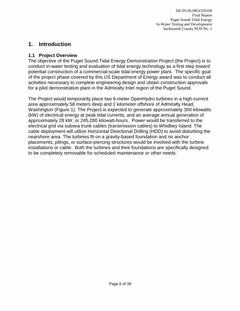
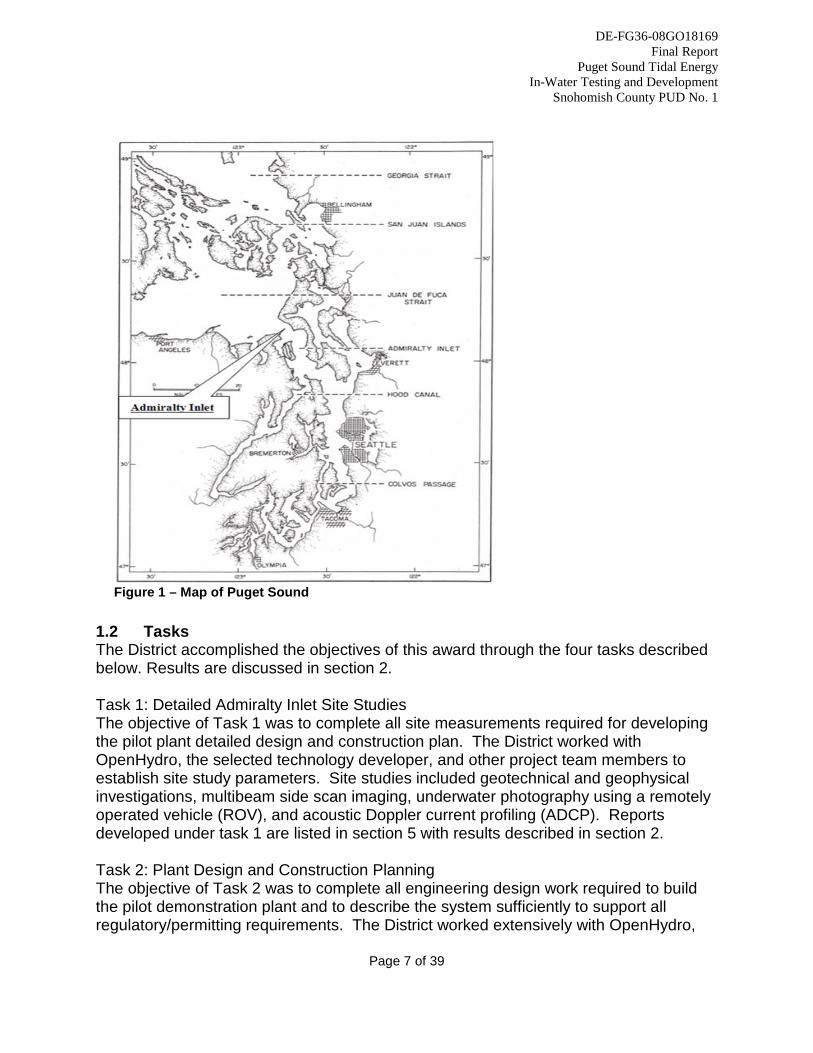
1. Introduction 1.1 Project Overview The objective of the Puget Sound Tidal Energy Demonstration Project (the Project) is to conduct in-water testing and evaluation of tidal energy technology as a first step toward potential construction of a commercial-scale tidal energy power plant. The specific goal of the project phase covered by this US Department of Energy award was to conduct all activities necessary to complete engineering design and obtain construction approvals for a pilot demonstration plant in the Admiralty Inlet region of the Puget Sound. The Project would temporarily place two 6-meter OpenHydro turbines in a high-current area approximately 58 meters deep and 1 kilometer offshore of Admiralty Head, Washington (Figure 1). The Project is expected to generate approximately 300 kilowatts (kW) of electrical energy at peak tidal currents, and an average annual generation of approximately 28 kW, or 245,280 kilowatt-hours. Power would be transferred to the electrical grid via subsea trunk cables (transmission cables) to Whidbey Island. The cable deployment will utilize Horizontal Directional Drilling (HDD) to avoid disturbing the nearshore area. The turbines fit on a gravity-based foundation and no anchor placements, pilings, or surface-piercing structures would be involved with the turbine installations or cable. Both the turbines and their foundations are specifically designed to be completely removable for scheduled maintenance or other needs.
DE-FG36-08GO18169 Final Report
Puget Sound Tidal Energy In-Water Testing and Development
Snohomish County PUD No. 1
Page 7 of 39
Figure 1 – Map of Puget Sound
1.2 Tasks The District accomplished the objectives of this award through the four tasks described below. Results are discussed in section 2. Task 1: Detailed Admiralty Inlet Site Studies The objective of Task 1 was to complete all site measurements required for developing the pilot plant detailed design and construction plan. The District worked with OpenHydro, the selected technology developer, and other project team members to establish site study parameters. Site studies included geotechnical and geophysical investigations, multibeam side scan imaging, underwater photography using a remotely operated vehicle (ROV), and acoustic Doppler current profiling (ADCP). Reports developed under task 1 are listed in section 5 with results described in section 2. Task 2: Plant Design and Construction Planning The objective of Task 2 was to complete all engineering design work required to build the pilot demonstration plant and to describe the system sufficiently to support all regulatory/permitting requirements. The District worked extensively with OpenHydro,
DE-FG36-08GO18169 Final Report
Puget Sound Tidal Energy In-Water Testing and Development
Snohomish County PUD No. 1
Page 8 of 39
Sound and Sea Technology, University of Washington, and other project team members to develop specific plans for:
• Plant location and layout; • Grid interconnection plans; • Construction specifications and drawings; • Construction budget and timeline development; • Device deployment logistics; and • Request for proposals to select the construction general contractor.
The final product of Task 2 was to be an engineering package of sufficient detail to enable construction of the pilot tidal energy plant. While the District made significant progress on this task under the subject award, design refinements will continue until a construction general contractor is selected. Task 3: Environmental and Regulatory Activities The objective of Task 3 was to complete all necessary study plans and applications to obtain required permits and authorizations for project construction. The District conducted extensive outreach and consultation with the following Federal, State, and local agencies:
• NOAA National Marine Fisheries Service • US Fish and Wildlife Service • US Army Corps of Engineers • Washington Department of Ecology • Washington Department of Natural Resources • Washington Department of Fish and Wildlife • Island County (project location) • Tribal governments including the Tulalip Tribes, Sauk-Suiattle Tribe, Swinomish
Tribe, and Skagit River Cooperative • Numerous local interest groups
The final product of Task 3 was the completion and execution of the pre-installation study plan, development of the monitoring study plans, and the preparation and submission of all necessary permit applications including the Final License Application (FLA) to the Federal Energy Regulatory Commission (FERC). Task 4: Management and Reporting The objective of Task 4 was to complete all required Department of Energy reporting by providing timely updates, full project documentation, and required progress reports. 2. Results and Accomplishments 2.1 Task 1 – Detailed Admiralty Inlet Site Studies
DE-FG36-08GO18169 Final Report
Puget Sound Tidal Energy In-Water Testing and Development
Snohomish County PUD No. 1
Page 9 of 39
The District worked extensively with HDR/DTA, University of Washington, Pacific Northwest National Laboratory (PNNL), other project partners and stakeholders during 2009 to develop pre-installation study plans for marine mammals, aquatic species, bathymetry, geotechnical and geophysical data, oceanographic and water quality measurements, and underwater noise. The study plans provided the basis for site studies and monitoring plans that supported permit and federal license applications. The District selected the following vendors to conduct the consultation and studies: Vendor Name Project Roles Dates of
work Fugro Bathymetric and geophysical measurements 2009 BioSonics Hydroacoustic survey 2009 Sound & Sea Technology (SST)
Marine engineering, bathymetric analysis, HDD plan, plant design, federal license support
2009-2012
UW-NNMREC and APL Noise, oceanographic/water quality measurements, ADCP data acquisition, tidal resource characterization, environmental monitoring plans, federal license support
2009-2012
Global Diving, Inc. Remotely Operated Vehicle (ROV) Survey of turbine locations
2010
Golder Associates Geophysical investigation 2010 CapRock Geology Benthic habitat characterization 2010 SMRU/Whale Museum Marine mammal field studies, monitoring plan 2009-
2011 HDR/DTA Pre-Installation Study Plans, monitoring plans,
permitting, federal license support 2009-2011
PNNL Study plan, environmental monitoring, federal license support
2009-2012
Northwest Underwater Constructors (subcontractor to SST)
ROV survey of updated turbine locations and cable route
2012
Wetland Resources Biological site assessment and wetland reconnaissance (terrestrial portion of site)
2012
Table 1 – List of vendors conducting pre-installation studies 2.1.1 Bathymetric and Geophysical Survey Fugro Seafloor Surveys, Inc. (Fugro) conducted an oceanographic survey of the potential project site during June, 2009 (Figure 2). The Fugro survey included high-resolution bathymetry, magnetometer, side scan sonar, sub-bottom and bottom sampling. The District used data from the Fugro report to help inform site selection, preferred cable route selection, environmental analysis, and early plant design.
DE-FG36-08GO18169 Final Report
Puget Sound Tidal Energy In-Water Testing and Development
Snohomish County PUD No. 1
Page 10 of 39
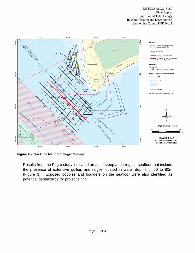
Figure 2 – Trackline Map from Fugro Survey Results from the Fugro study indicated areas of steep and irregular seafloor that include the presence of extensive gullies and ridges located in water depths of 50 to 80m (Figure 3). Exposed cobbles and boulders on the seafloor were also identified as potential geohazards for project siting.
DE-FG36-08GO18169 Final Report
Puget Sound Tidal Energy In-Water Testing and Development
Snohomish County PUD No. 1
Page 11 of 39
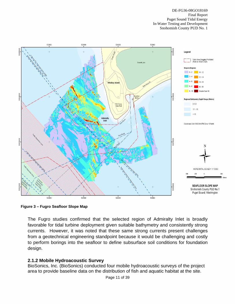
Figure 3 – Fugro Seafloor Slope Map The Fugro studies confirmed that the selected region of Admiralty Inlet is broadly favorable for tidal turbine deployment given suitable bathymetry and consistently strong currents. However, it was noted that these same strong currents present challenges from a geotechnical engineering standpoint because it would be challenging and costly to perform borings into the seafloor to define subsurface soil conditions for foundation design. 2.1.2 Mobile Hydroacoustic Survey BioSonics, Inc. (BioSonics) conducted four mobile hydroacoustic surveys of the project area to provide baseline data on the distribution of fish and aquatic habitat at the site.
DE-FG36-08GO18169 Final Report
Puget Sound Tidal Energy In-Water Testing and Development
Snohomish County PUD No. 1
Page 12 of 39
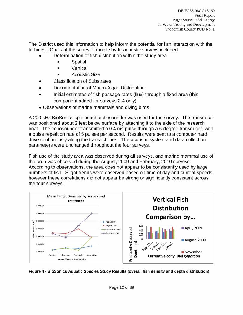
The District used this information to help inform the potential for fish interaction with the turbines. Goals of the series of mobile hydroacoustic surveys included:
• Determination of fish distribution within the study area Spatial Vertical Acoustic Size
• Classification of Substrates • Documentation of Macro-Algae Distribution • Initial estimates of fish passage rates (flux) through a fixed-area (this
component added for surveys 2-4 only) • Observations of marine mammals and diving birds
A 200 kHz BioSonics split beach echosounder was used for the survey. The transducer was positioned about 2 feet below surface by attaching it to the side of the research boat. The echosounder transmitted a 0.4 ms pulse through a 6-degree transducer, with a pulse repetition rate of 5 pulses per second. Results were sent to a computer hard drive continuously along the transect lines. The acoustic system and data collection parameters were unchanged throughout the four surveys. Fish use of the study area was observed during all surveys, and marine mammal use of the area was observed during the August, 2009 and February, 2010 surveys. According to observations, the area does not appear to be consistently used by large numbers of fish. Slight trends were observed based on time of day and current speeds, however these correlations did not appear be strong or significantly consistent across the four surveys.
Figure 4 - BioSonics Aquatic Species Study Results (overall fish density and depth distribution)
0 20 40 60
t Fre
quen
tly
Obs
erve
d D
epth
(m)
Current Velocity, Diel Condition
Vertical Fish Distribution
Comparison by … April, 2009
August, 2009
November, 2009
DE-FG36-08GO18169 Final Report
Puget Sound Tidal Energy In-Water Testing and Development
Snohomish County PUD No. 1
Page 13 of 39
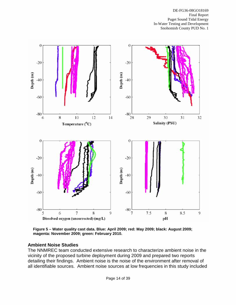
2.1.3 Acoustic and Oceanographic Measurements University of Washington’s Northwest National Marine Renewable Energy Center (NNMREC) and Applied Physics Lab (APL) conducted operations to characterize the physical and biological environment in the project area. Drs. Brian Polagye and Jim Thomson from NNMREC and the APL led the efforts, with collaboration from research assistants hired with funding from this award. Water Quality Survey The University of Washington team conducted a water quality survey during 2009 to gain background data on oceanographic measurements in Admiralty Inlet. Water quality in the project area was assessed through shipboard surveys and seabed instrumentation (Polagye, 2010). Figure 5 shows the vertical profiles for temperature, salinity, dissolved oxygen, and pH collected during all surveys. Profiles indicate both cast-to-cast and seasonal variability. As expected, the degree of stratification depends on the season, with casts from April and May considerably more stratified than casts from November and February. Seasonal patterns in temperature and salinity are representative of typical estuarine circulation and show the effects of varying levels of freshwater input to the system and solar radiation; water is less salty and warmer in the summer than in the late spring and fall.
DE-FG36-08GO18169 Final Report
Puget Sound Tidal Energy In-Water Testing and Development
Snohomish County PUD No. 1
Page 14 of 39
Figure 5 – Water quality cast data. Blue: April 2009; red: May 2009; black: August 2009; magenta: November 2009; green: February 2010.
Ambient Noise Studies The NNMREC team conducted extensive research to characterize ambient noise in the vicinity of the proposed turbine deployment during 2009 and prepared two reports detailing their findings. Ambient noise is the noise of the environment after removal of all identifiable sources. Ambient noise sources at low frequencies in this study included
DE-FG36-08GO18169 Final Report
Puget Sound Tidal Energy In-Water Testing and Development
Snohomish County PUD No. 1
Page 15 of 39
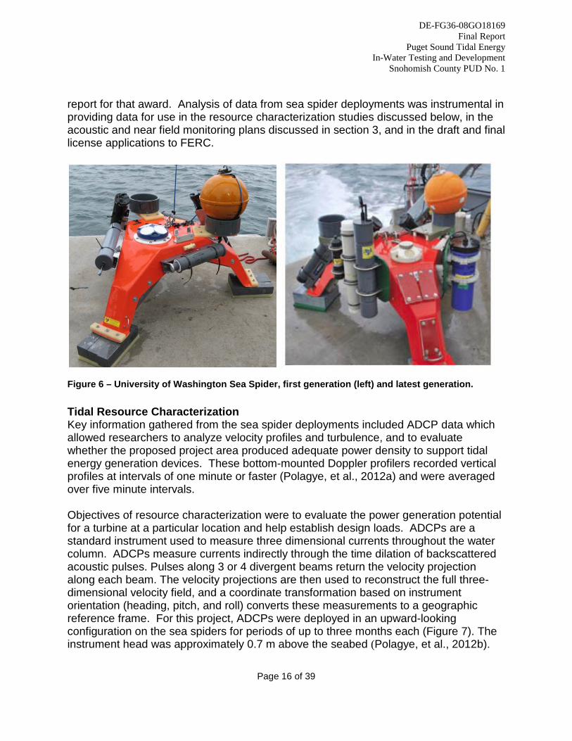
maritime traffic ranging from shipping vessels, recreational boats and ferry traffic (Bassett, et al., 2009a). The results are presented in the form of pressure spectral densities (PSD), spectrograms, sound pressure levels (SPL), and scatter plots, providing quantitative information about the acoustics environment at the location of the proposed pilot tidal project. Pressure spectral densities are reported in units of decibels with respect to 1 μPa2/Hz. Sound pressure levels are reported in units of decibels with respect to 1 μPa (Bassett et al., 2009b). The experimental data for acoustical analysis of the site come from two different systems: A recording hydrophone mounted near the seabed and a mobile hydrophone deployed from a research vessel. The recording hydrophone is to remain on the seafloor near the site throughout the period of the deployment and provides long-term acoustical information about the site. The recording hydrophone, a Loggerhead Instruments DSG long-term acoustic recorder equipped with a High Tech Instruments hydrophone, was mounted on a sea spider foundation (discussed below). The mobile hydrophone was used during research cruises to obtain spatial acoustic information. For these studies, the research team used a Cetacean Instruments cylindrical omni-directional hydrophone. The mobile hydrophone was deployed from a research vessel by a 50m cable and allowed to drift freely while the vessel’s engines and other mechanical noise sources were shut down. Data collected throughout the course of two deployments of the Loggerhead DSG system shows that sound pressure levels at the project site are strongly influenced by anthropogenic sources, primarily marine traffic, as well as tidal currents. Permanent noise levels at the site ranged from 99.3 to 138.9 decibels (dB) re 1μPa depending on the strength and direction of the tidal currents. Often, anthropogenic noise sources such as marine traffic were masked by the tidal currents. Total sound pressure levels at the site rarely dropped below 100 dB re 1μPa and rarely exceeded 140 dB re 1μPa. Analysis of the mobile hydrophone data showed sound pressure levels consistent with those measured by the Loggerhead DSG system and showed no dependence on depth or distance from the site. Sea Spider Instrumentation Packages NNMREC and APL built and deployed “sea spider” instrumentation packages (Figure 6) in the project area consisting of an acoustic Doppler current profiler (ADCP), recording hydrophone for background noise, temperature, salinity, and dissolved oxygen monitoring gauges, fish tag receiver, and monitors for porpoise, dolphin, and orca echolocation detection. The instrumentation packages were recovered, upgraded, and redeployed successfully approximately once per quarter from early 2009 through mid-, 2010. Sea spider efforts through 2011 were further supported by DOE award DE-EE0002654, “Acoustic Effects of Hydrokinetic Tidal Turbines in Admiralty Inlet,” completed in December, 2011, and comprehensive results are presented in the final
DE-FG36-08GO18169 Final Report
Puget Sound Tidal Energy In-Water Testing and Development
Snohomish County PUD No. 1
Page 16 of 39
report for that award. Analysis of data from sea spider deployments was instrumental in providing data for use in the resource characterization studies discussed below, in the acoustic and near field monitoring plans discussed in section 3, and in the draft and final license applications to FERC.
Figure 6 – University of Washington Sea Spider, first generation (left) and latest generation. Tidal Resource Characterization Key information gathered from the sea spider deployments included ADCP data which allowed researchers to analyze velocity profiles and turbulence, and to evaluate whether the proposed project area produced adequate power density to support tidal energy generation devices. These bottom-mounted Doppler profilers recorded vertical profiles at intervals of one minute or faster (Polagye, et al., 2012a) and were averaged over five minute intervals. Objectives of resource characterization were to evaluate the power generation potential for a turbine at a particular location and help establish design loads. ADCPs are a standard instrument used to measure three dimensional currents throughout the water column. ADCPs measure currents indirectly through the time dilation of backscattered acoustic pulses. Pulses along 3 or 4 divergent beams return the velocity projection along each beam. The velocity projections are then used to reconstruct the full three-dimensional velocity field, and a coordinate transformation based on instrument orientation (heading, pitch, and roll) converts these measurements to a geographic reference frame. For this project, ADCPs were deployed in an upward-looking configuration on the sea spiders for periods of up to three months each (Figure 7). The instrument head was approximately 0.7 m above the seabed (Polagye, et al., 2012b).
DE-FG36-08GO18169 Final Report
Puget Sound Tidal Energy In-Water Testing and Development
Snohomish County PUD No. 1
Page 17 of 39
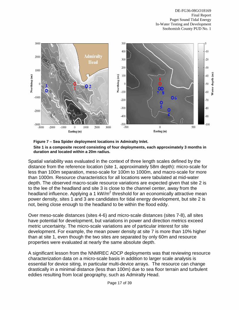
Figure 7 – Sea Spider deployment locations in Admiralty Inlet. Site 1 is a composite record consisting of four deployments, each approximately 3 months in duration and located within a 20m radius.
Spatial variability was evaluated in the context of three length scales defined by the distance from the reference location (site 1, approximately 58m depth): micro-scale for less than 100m separation, meso-scale for 100m to 1000m, and macro-scale for more than 1000m. Resource characteristics for all locations were tabulated at mid-water depth. The observed macro-scale resource variations are expected given that site 2 is to the lee of the headland and site 3 is close to the channel center, away from the headland influence. Applying a 1 kW/m2 threshold for an economically attractive mean power density, sites 1 and 3 are candidates for tidal energy development, but site 2 is not, being close enough to the headland to be within the flood eddy. Over meso-scale distances (sites 4-6) and micro-scale distances (sites 7-8), all sites have potential for development, but variations in power and direction metrics exceed metric uncertainty. The micro-scale variations are of particular interest for site development. For example, the mean power density at site 7 is more than 10% higher than at site 1, even though the two sites are separated by only 60m and resource properties were evaluated at nearly the same absolute depth. A significant lesson from the NNMREC ADCP deployments was that reviewing resource characterization data on a micro-scale basis in addition to larger scale analysis is essential for device siting, in particular multi-device arrays. The resource can change drastically in a minimal distance (less than 100m) due to sea floor terrain and turbulent eddies resulting from local geography, such as Admiralty Head.
DE-FG36-08GO18169 Final Report
Puget Sound Tidal Energy In-Water Testing and Development
Snohomish County PUD No. 1
Page 18 of 39
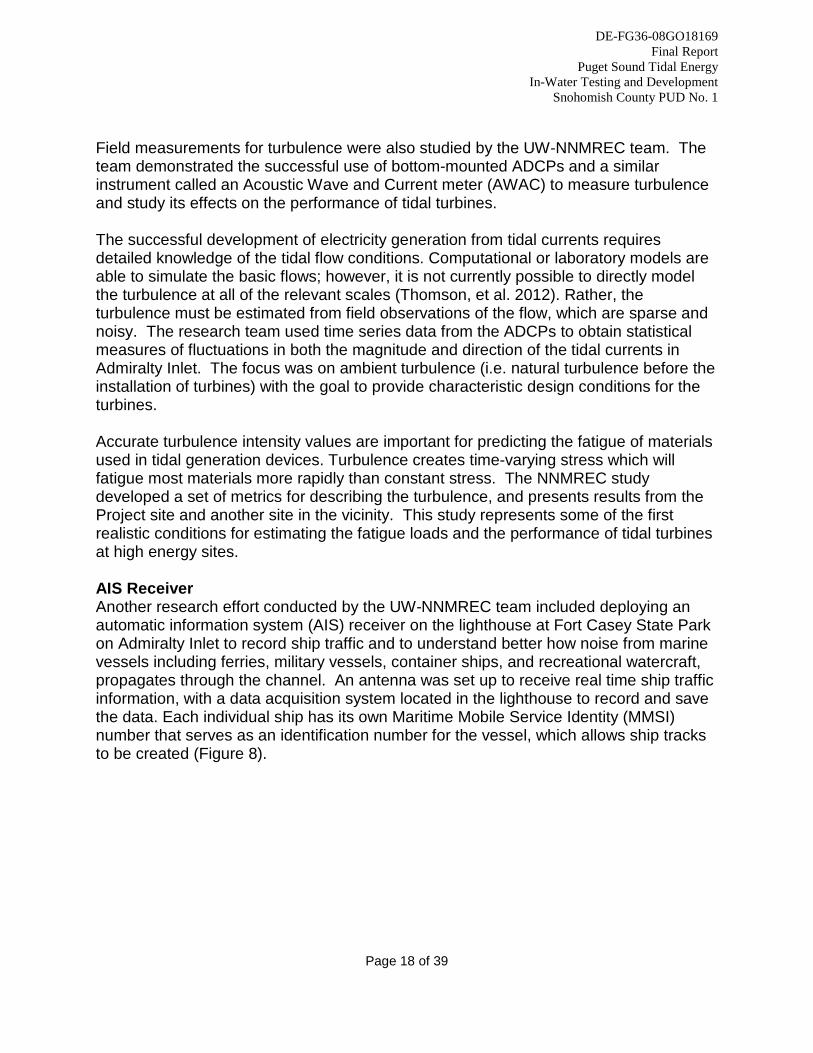
Field measurements for turbulence were also studied by the UW-NNMREC team. The team demonstrated the successful use of bottom-mounted ADCPs and a similar instrument called an Acoustic Wave and Current meter (AWAC) to measure turbulence and study its effects on the performance of tidal turbines. The successful development of electricity generation from tidal currents requires detailed knowledge of the tidal flow conditions. Computational or laboratory models are able to simulate the basic flows; however, it is not currently possible to directly model the turbulence at all of the relevant scales (Thomson, et al. 2012). Rather, the turbulence must be estimated from field observations of the flow, which are sparse and noisy. The research team used time series data from the ADCPs to obtain statistical measures of fluctuations in both the magnitude and direction of the tidal currents in Admiralty Inlet. The focus was on ambient turbulence (i.e. natural turbulence before the installation of turbines) with the goal to provide characteristic design conditions for the turbines. Accurate turbulence intensity values are important for predicting the fatigue of materials used in tidal generation devices. Turbulence creates time-varying stress which will fatigue most materials more rapidly than constant stress. The NNMREC study developed a set of metrics for describing the turbulence, and presents results from the Project site and another site in the vicinity. This study represents some of the first realistic conditions for estimating the fatigue loads and the performance of tidal turbines at high energy sites. AIS Receiver Another research effort conducted by the UW-NNMREC team included deploying an automatic information system (AIS) receiver on the lighthouse at Fort Casey State Park on Admiralty Inlet to record ship traffic and to understand better how noise from marine vessels including ferries, military vessels, container ships, and recreational watercraft, propagates through the channel. An antenna was set up to receive real time ship traffic information, with a data acquisition system located in the lighthouse to record and save the data. Each individual ship has its own Maritime Mobile Service Identity (MMSI) number that serves as an identification number for the vessel, which allows ship tracks to be created (Figure 8).
DE-FG36-08GO18169 Final Report
Puget Sound Tidal Energy In-Water Testing and Development
Snohomish County PUD No. 1
Page 19 of 39
Figure 8 - Ship traffic recorded at Admiralty Inlet on December 1st, 2009. The blue lines represent the Keystone-Port Townsend ferry crossings. All other recorded ship traffic is represented by white lines. The coordinates for the sea spider deployments are marked by yellow circles (Bassett et al., 2009b). Ambient Light Measurements During 2010, the University of Washington deployed a photosynthetically active radiation (PAR) sensor in Admiralty Inlet to characterize ambient light at the proposed turbine depth (58 meters). Very little ambient light is available at this depth, which will necessitate the use of strobe lighting on the environmental monitoring equipment packages deployed with the turbines. 2.1.4 Marine Mammal Study Sea Mammal Research Unit, Limited (SMRU) in coordination with the Whale Museum, Beam Reach, and Orca Network, conducted extensive research on marine mammal presence and behavior in the project area (Tollit, et.al, 2010). The study focused particularly on southern resident killer whales (SRKW) A portion of this work was also supported by DOE award DE-EE0002654, “Acoustic Effects of Hydrokinetic Tidal
DE-FG36-08GO18169 Final Report
Puget Sound Tidal Energy In-Water Testing and Development
Snohomish County PUD No. 1
Page 20 of 39
Turbines in Admiralty Inlet,” completed in December, 2011. Objectives of the study were:
• Describe current SRKW transit patterns through the study area using land and sea observations, and incorporating a review of Port Townsend hydrophone passive acoustic monitoring (PAM) data.
• Describe current study area habitat use by individual pods during key seasons, and whether foraging occurs in the Project area.
• Describe vertical depth distribution of observed SRKW using a vertical hydrophone array.
• Observe presence of other marine mammal species in the Project area. • Observe presence of marbled murrelet in the Project area.
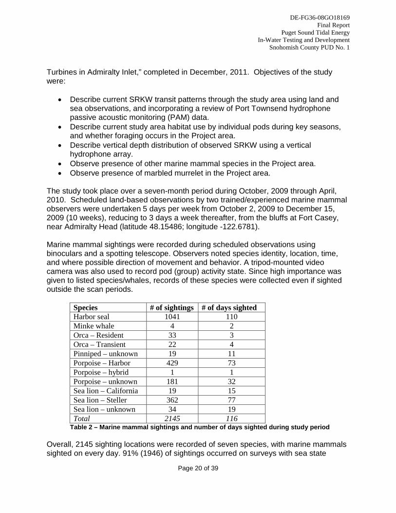
The study took place over a seven-month period during October, 2009 through April, 2010. Scheduled land-based observations by two trained/experienced marine mammal observers were undertaken 5 days per week from October 2, 2009 to December 15, 2009 (10 weeks), reducing to 3 days a week thereafter, from the bluffs at Fort Casey, near Admiralty Head (latitude 48.15486; longitude -122.6781). Marine mammal sightings were recorded during scheduled observations using binoculars and a spotting telescope. Observers noted species identity, location, time, and where possible direction of movement and behavior. A tripod-mounted video camera was also used to record pod (group) activity state. Since high importance was given to listed species/whales, records of these species were collected even if sighted outside the scan periods.
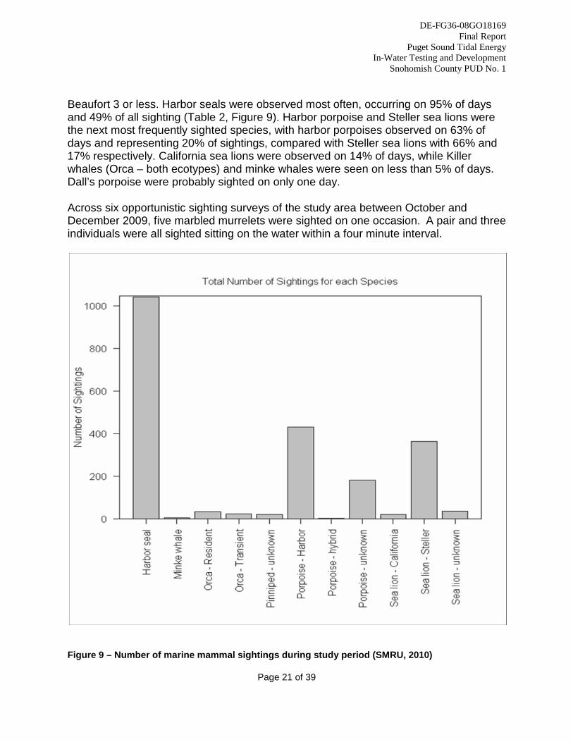
Species # of sightings # of days sighted Harbor seal 1041 110 Minke whale 4 2 Orca – Resident 33 3 Orca – Transient 22 4 Pinniped – unknown 19 11 Porpoise – Harbor 429 73 Porpoise – hybrid 1 1 Porpoise – unknown 181 32 Sea lion – California 19 15 Sea lion – Steller 362 77 Sea lion – unknown 34 19 Total 2145 116
Table 2 – Marine mammal sightings and number of days sighted during study period Overall, 2145 sighting locations were recorded of seven species, with marine mammals sighted on every day. 91% (1946) of sightings occurred on surveys with sea state
DE-FG36-08GO18169 Final Report
Puget Sound Tidal Energy In-Water Testing and Development
Snohomish County PUD No. 1
Page 21 of 39
Beaufort 3 or less. Harbor seals were observed most often, occurring on 95% of days and 49% of all sighting (Table 2, Figure 9). Harbor porpoise and Steller sea lions were the next most frequently sighted species, with harbor porpoises observed on 63% of days and representing 20% of sightings, compared with Steller sea lions with 66% and 17% respectively. California sea lions were observed on 14% of days, while Killer whales (Orca – both ecotypes) and minke whales were seen on less than 5% of days. Dall’s porpoise were probably sighted on only one day. Across six opportunistic sighting surveys of the study area between October and December 2009, five marbled murrelets were sighted on one occasion. A pair and three individuals were all sighted sitting on the water within a four minute interval.
Figure 9 – Number of marine mammal sightings during study period (SMRU, 2010)
DE-FG36-08GO18169 Final Report
Puget Sound Tidal Energy In-Water Testing and Development
Snohomish County PUD No. 1
Page 22 of 39
In addition to the marine mammal research described above, SMRU also prepared the Orca Monitoring, Operations and Protection Plan (MOPP) in consultation with HDR/DTA, PNNL, National Marine Fisheries Service (NMFS), and University of Washington. The goal of the MOPP was to detect SRKWs in the vicinity of the Project using a combination of passive acoustic monitoring (PAM) technology and visual observations by a locally enhanced observer sightings network (coordinated by Orca Network) and to utilize measures to avoid injury or mortality as a direct result of interaction with the turbines. The District also received assistance from Pacific Northwest National Laboratory and Sandia National Laboratory in determining the potential severity of an encounter between Southern Resident killer whales and a moving turbine rotor. This work was not funded under the subject award, but helped inform areas of the project applicable to this award. The District and the various stakeholders ultimately concluded that, given the size of the project, its location and depth, and the ability for marine mammals to avoid objects in their environment, the risk of an encounter was low. However, the unanswered question was the potential injury severity should the unlikely event of an encounter occur. This question is important given the status of SRKW under the Endangered Species Act. The National Labs carried out an analysis of the severity of blade encounter from the OpenHydro turbine with a SRKW. The analysis, described in a report entitled “Assessment of Strike of Adult Killer Whales by an OpenHydro Turbine Blade,” (PNNL, 2012) and included in the Final License Application as Appendix K, developed a scenario that represented the greatest risk to SRKW’s. After calculating the forces (stress and strain) that would be encountered, the National Labs concluded that the forces are such that the skin would not likely be torn by the impact, that bones would not be broken, and that a SRKW is not likely to be severely or mortally injured. Through discussions with Project stakeholders, NOAA Fisheries, and the National Labs, and after a thorough review of the analysis conducted by the National Labs, the District has concluded that the focus of Project efforts with respect to SRKWs should be focused on monitoring for direct and indirect impacts, rather than mitigating for a small potential for an encounter that is not likely to harm the whale. As a result, the District is no longer proposing a SRKW Monitoring, Operation, and Protection Plan (MOPP). Instead, the District is taking the monitoring components of the MOPP and adding them to the Marine Mammal Monitoring Plan, discussed in section 3 and in the District’s FLA, Volume III, Appendix A. 2.1.5 Geophysical Investigation
DE-FG36-08GO18169 Final Report
Puget Sound Tidal Energy In-Water Testing and Development
Snohomish County PUD No. 1
Page 23 of 39
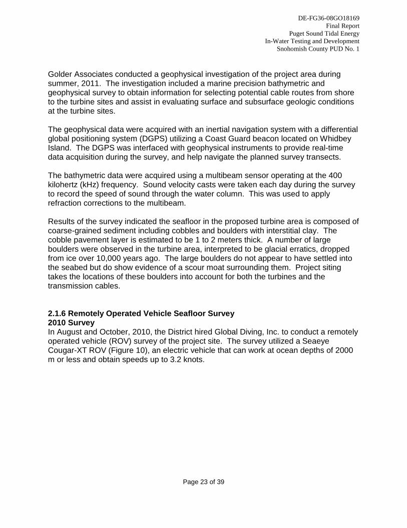
Golder Associates conducted a geophysical investigation of the project area during summer, 2011. The investigation included a marine precision bathymetric and geophysical survey to obtain information for selecting potential cable routes from shore to the turbine sites and assist in evaluating surface and subsurface geologic conditions at the turbine sites. The geophysical data were acquired with an inertial navigation system with a differential global positioning system (DGPS) utilizing a Coast Guard beacon located on Whidbey Island. The DGPS was interfaced with geophysical instruments to provide real-time data acquisition during the survey, and help navigate the planned survey transects. The bathymetric data were acquired using a multibeam sensor operating at the 400 kilohertz (kHz) frequency. Sound velocity casts were taken each day during the survey to record the speed of sound through the water column. This was used to apply refraction corrections to the multibeam. Results of the survey indicated the seafloor in the proposed turbine area is composed of coarse-grained sediment including cobbles and boulders with interstitial clay. The cobble pavement layer is estimated to be 1 to 2 meters thick. A number of large boulders were observed in the turbine area, interpreted to be glacial erratics, dropped from ice over 10,000 years ago. The large boulders do not appear to have settled into the seabed but do show evidence of a scour moat surrounding them. Project siting takes the locations of these boulders into account for both the turbines and the transmission cables. 2.1.6 Remotely Operated Vehicle Seafloor Survey 2010 Survey In August and October, 2010, the District hired Global Diving, Inc. to conduct a remotely operated vehicle (ROV) survey of the project site. The survey utilized a Seaeye Cougar-XT ROV (Figure 10), an electric vehicle that can work at ocean depths of 2000 m or less and obtain speeds up to 3.2 knots.
DE-FG36-08GO18169 Final Report
Puget Sound Tidal Energy In-Water Testing and Development
Snohomish County PUD No. 1
Page 24 of 39
Figure 10 - Seaeye Cougar- XT ROV being launched from a stationary vessel at the turbine site. The purpose of the ROV survey was to gather information about the sea floor substrate in the vicinity of the project area and electric transmission cable route. Data was also collected on sea floor geology, bathymetry, benthic habitat types, and presence of fish and other marine species. Dr. Gary Greene of CapRock, Geology, Inc. prepared a Habitat Characterization report summarizing the results of the survey. Results of the survey confirmed a flat, cobbled seabed with some presence of primarily sponges, barnacles, and algae. Several types of fish were seen during the survey, primarily ratfish and sculpin. No unexpected features were noted, and none that should prove problematic for turbine deployment. The cable route however revealed the presence of boulders of sufficient size and number that the viability of the route for deploying was questioned. Snohomish and SST began evaluating other options, including alternate cable routes and extended horizontal directional drilling under the boulder field.
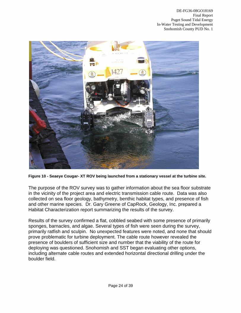
Figure 11 – Habitat map from 2010 ROV survey
DE-FG36-08GO18169 Final Technical Report
Puget Sound Tidal Energy In-Water Testing and Development
Snohomish County PUD No. 1
2012 Survey In July, 2012, the Northwest Underwater Constructors (NUC, as a subcontractor to Sound and Sea Technology), conducted an additional ROV survey to review the seafloor conditions in the area of the updated turbine locations and revised cable route. NUC set-up and launched the ROV system during live boat operations on the M/V Salvager to conduct a general bottom survey and document visually observed conditions of the proposed turbine site using a DVD-recordable underwater video system for subsequent viewing by the project ROV Supervisor. The survey crew noted several large boulders larger than 1 meter diameter. Very little bottom sediment was observed. Seafloor conditions are consistent with previous reviews during the 2010 ROV inspection and the sea spider deployments described earlier. Within Admiralty Bay, the sea floor sediment of the eastern (shallow) half of the cable route appears to be predominantly coral- and algae-covered pebbles and cobblestones. Visibility in the inner Admiralty Bay section was hampered by abundant presence of organic debris in the water. The easternmost end of the cable route, in water depths from about 17 to 25 meters, is heavily vegetated by short, feathery algae (SST, 2012). 2.1.7 Biological Site Assessment As part of the permitting process, the District applied for environmental and land use permits from Island County. Portions of the project will be located in a designated shoreline area (200 feet from the ordinary high water mark), including the turbines and transmission cables. The power control building on land will be located outside the designated shoreline area. Island County Code (ICC 17.02.050(C)(2)) requires preparation of a Biological Site Assessment (BSA) “when a development proposal is located on lands which may contain, based upon maps and other information maintained by the Department, a habitat for a Protected Species, other than Bald Eagle nesting territories, or when the applicant proposes to alter, decrease, or average the standard buffer….” The District selected Wetland Resources, Inc. to prepare the BSA in accordance with Island County requirements. The BSA identified Fish and Wildlife Habitat Conservation Areas (FWHCAs), habitat for protected species, and analyzed impacts to protected species or habitat as a result of the proposal. The action area of the proposed project contains two FWHCAs. First, Admiralty Bay and Admiralty Inlet are known to provide habitat for numerous endangered, threatened, and sensitive species, thereby meeting the FWHCA designation provided in Island County Code (ICC) 17.02.050(C)(1)(a). The following endangered, threatened, and sensitive species are known to have a primary association with this project area: 1.) Hood Canal Summer-run Chum Salmon 2.) Puget Sound Steelhead 3.) Bull Trout 4.) Green Sturgeon

DE-FG36-08GO18169 Final Report
Puget Sound Tidal Energy In-Water Testing and Development
Snohomish County PUD No. 1
Page 27 of 39
5.) Bocaccio 6.) Canary Rockfish 7.) Yelloweye Rockfish 8.) Eulachon 9.) Southern Resident Killer Whale 10.) North Pacific Humpback Whale 11.) Steller Sea Lion 12.) Marbled Murrelet 13.) Golden Paintbrush The second FWHCA in the project area is Crockett Lake, a coastal lagoon to the north of the project on Whidbey Island. According to Island County, Crockett Lake has been designated as a Habitat of Local Importance, thereby meeting the FWHCA designation provided in ICC 17.02.050(C)(1)(h). A thorough analysis of the project and a comprehensive discussion of its potential effect on endangered, threatened, and sensitive species is provided in the Draft Biological Assessment, presented in Volume IV, Appendix G of the District’s FLA document. The conclusion of this analysis is that the project is Not likely to Adversely Affect the species listed above. No impacts are proposed to Crockett Lake or its 200-foot buffer.
2.2 Task 2 – Plant Design and Construction Planning
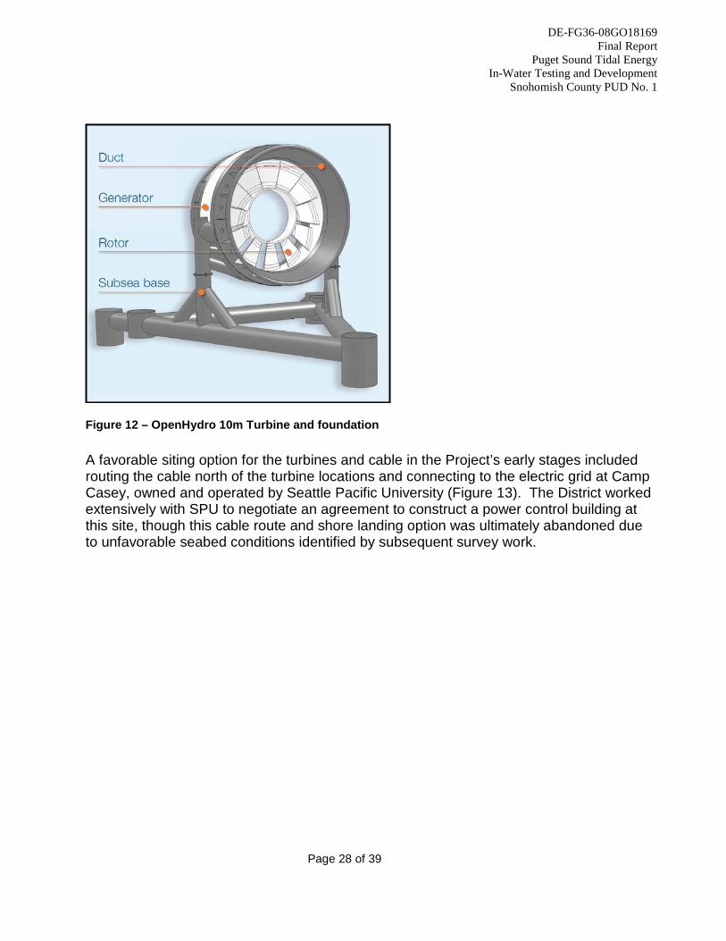
2.2.1 Plant Design Background Early stages of plant design were conducted under the first phase of this award. In early 2009, the District selected OpenHydro as the technology provider for the Project, and negotiated a contract for OpenHydro to provide plant design, device characterization, and environmental data necessary to support a federal license application. OpenHydro initially proposed a 10-meter diameter turbine for the site, similar to the device being installed in the Bay of Fundy, Canada (Figure 12). Data from pre-installation studies including acoustic Doppler current profiling, tidal resource characterization (including turbulent effects), bathymetric, and geophysical measurements were used to help inform turbine size, siting, and proposed electric transmission cable route to shore.
DE-FG36-08GO18169 Final Report
Puget Sound Tidal Energy In-Water Testing and Development
Snohomish County PUD No. 1
Page 28 of 39
Figure 12 – OpenHydro 10m Turbine and foundation
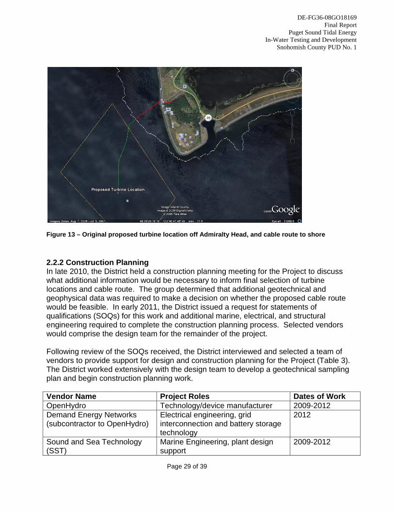
A favorable siting option for the turbines and cable in the Project’s early stages included routing the cable north of the turbine locations and connecting to the electric grid at Camp Casey, owned and operated by Seattle Pacific University (Figure 13). The District worked extensively with SPU to negotiate an agreement to construct a power control building at this site, though this cable route and shore landing option was ultimately abandoned due to unfavorable seabed conditions identified by subsequent survey work.
DE-FG36-08GO18169 Final Report
Puget Sound Tidal Energy In-Water Testing and Development
Snohomish County PUD No. 1
Page 29 of 39
Figure 13 – Original proposed turbine location off Admiralty Head, and cable route to shore 2.2.2 Construction Planning In late 2010, the District held a construction planning meeting for the Project to discuss what additional information would be necessary to inform final selection of turbine locations and cable route. The group determined that additional geotechnical and geophysical data was required to make a decision on whether the proposed cable route would be feasible. In early 2011, the District issued a request for statements of qualifications (SOQs) for this work and additional marine, electrical, and structural engineering required to complete the construction planning process. Selected vendors would comprise the design team for the remainder of the project. Following review of the SOQs received, the District interviewed and selected a team of vendors to provide support for design and construction planning for the Project (Table 3). The District worked extensively with the design team to develop a geotechnical sampling plan and begin construction planning work. Vendor Name Project Roles Dates of Work OpenHydro Technology/device manufacturer 2009-2012 Demand Energy Networks (subcontractor to OpenHydro)
Electrical engineering, grid interconnection and battery storage technology
2012
Sound and Sea Technology (SST)
Marine Engineering, plant design support
2009-2012
DE-FG36-08GO18169 Final Report
Puget Sound Tidal Energy In-Water Testing and Development
Snohomish County PUD No. 1
Page 30 of 39
Lawhead Architects (not funded by this award)
Power control building design, permitting assistance
2011-2012
Hultz BHU (subcontractor to Lawhead)
Power control building electrical and HVAC design
2011-2012
CF Malm & Associates (subcontractor to Lawhead)
Electrical grid connection consulting 2011-2012
PCS Structural Solutions (subcontractor to Lawhead)
Structural engineering for power control building
2011-2012
Golder Associates Geophysical/Geotechnical analysis 2011-2012 Landau Associates (subcontractor to SST)
Geotechnical analysis 2011-2012
Northwest Underwater Constructors (subcontractor to SST)
Remotely operated vehicle survey 2012
Center Marine Marine Electrical Engineering 2011-2012 3U Technology Marine Cable Engineering 2011-2012 Harmsen Associates Land Survey 2010-2012
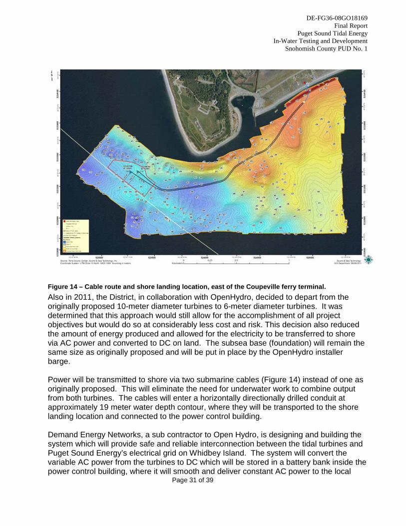
Table 3 – Tidal Design Team 2.2.3 Planned Turbine, Cable, and Interconnection Design During early 2011, the District initiated preliminary discussions to evaluate and explore the feasibility of alternate shore landing locations including private properties south and east of the originally selected location, Camp Casey. These discussions resulted from review of the ROV survey of Admiralty Inlet conducted during late 2010, which indicated potential geohazards such as gravel waves and large boulders along the proposed cable route. During mid-2011, the District made the decision to move the cable shore landing location to a private property east of the Coupeville ferry terminal (Figure 14). This change will result in a longer submarine cable route, but installation is anticipated to be easier due to less turbulent water, less chance for cable damage from gravel waves or suspension on boulders, and a much shorter and less costly horizontal directional drilling requirement.
DE-FG36-08GO18169 Final Report
Puget Sound Tidal Energy In-Water Testing and Development
Snohomish County PUD No. 1
Page 31 of 39
Figure 14 – Cable route and shore landing location, east of the Coupeville ferry terminal. Also in 2011, the District, in collaboration with OpenHydro, decided to depart from the originally proposed 10-meter diameter turbines to 6-meter diameter turbines. It was determined that this approach would still allow for the accomplishment of all project objectives but would do so at considerably less cost and risk. This decision also reduced the amount of energy produced and allowed for the electricity to be transferred to shore via AC power and converted to DC on land. The subsea base (foundation) will remain the same size as originally proposed and will be put in place by the OpenHydro installer barge. Power will be transmitted to shore via two submarine cables (Figure 14) instead of one as originally proposed. This will eliminate the need for underwater work to combine output from both turbines. The cables will enter a horizontally directionally drilled conduit at approximately 19 meter water depth contour, where they will be transported to the shore landing location and connected to the power control building. Demand Energy Networks, a sub contractor to Open Hydro, is designing and building the system which will provide safe and reliable interconnection between the tidal turbines and Puget Sound Energy’s electrical grid on Whidbey Island. The system will convert the variable AC power from the turbines to DC which will be stored in a battery bank inside the power control building, where it will smooth and deliver constant AC power to the local
DE-FG36-08GO18169 Final Report
Puget Sound Tidal Energy In-Water Testing and Development
Snohomish County PUD No. 1
Page 32 of 39
electric grid through a motor-generator set. OpenHydro will be working with Demand Energy to finalize design of the system during late 2012. The District submitted a Small Generator Interconnection Application to Puget Sound Energy (PSE) for the Project. This application will allow PSE to develop a System Impact Study which examines the impact to their grid from the Project, and recommends system protection equipment and relays. The District does not anticipate any issues with this process moving forward.
2.3 Task 3 – Environmental and Regulatory Activities 2.3.1 Stakeholder Consultation The District consulted extensively with stakeholders (agencies, tribal governments, non-governmental organizations, and members of the public) to discuss the Project, pre-installation studies, potential mechanisms for harm, post-installation studies and monitoring, protection, mitigation, and enhancement measures. These discussions can be broken into two categories. The first category of consultations can be characterized as general presentations and discussions of the Project as a whole or of large aspects of the Project. These discussions were held with all stakeholders, including many conducted at town halls and other local forums to solicit feedback from members of the public most likely to be impacted by the Project. The majority of these discussions were documented in the District’s biannual preliminary permit progress reports submitted to the FERC. The second category of consultations was discussions focused on a specific species or potential impact. These discussions were primarily held with agencies and tribal governments, and ultimately identified all of the potential Project impacts, the likelihood of significant harm from those impacts, and the need for measures to mitigate or monitor species’ interaction with the turbines or other Project facilities. The District primarily worked with these agencies and tribal governments in formulating pre-installation study plans and reporting on the results of those investigations. To assist in resolving disputes between the District and some stakeholders, the group utilized a professional facilitator for discussions during 2010. As the FERC’s non-federal representative for informal consultation under Section 7 of the Endangered Species Act and Section 106 of the National Historic Preservation Act, the District informally consulted with the appropriate agencies and tribal governments as part of the various consultations described herein during implementation of pre-installation study plans and the reporting of results. A summary of the consultation efforts leading up to the filing of the Final License Application is contained in the FLA Exhibit E, section 1.4.
DE-FG36-08GO18169 Final Report
Puget Sound Tidal Energy In-Water Testing and Development
Snohomish County PUD No. 1
Page 33 of 39
The primary written comments received by the District are contained in the District’s June 24, 2011, response to the FERC’s August 2010 request for additional information. The District received written stakeholder comments in response to the Draft License Application. The District received the following letters commenting on the Draft License Application, all of which were filed in the official FERC docket:
• Sauk-Suiattle Indian Tribe, February 24, 2010 • Swinomish Indian Tribal Community, February 24, 2010 • USFWS, February 25, 2010 • Admiralty Inlet Pilot Tidal Project – FERC No. 12690 • Stakeholder Consultation – February 29, 2012 • NMFS, February 26, 2010 • National Park Service, February 24, 2010 • Suquamish Tribe, February 26, 2010 • Tulalip Tribes, March 1, 2010
The comments on the Draft License Application questioned (1) whether the Project was appropriate for the Commission’s pilot plant license process, and (2) whether the pre-installation and proposed monitoring plans were adequate to support environmental analysis. These comments prompted FERC to hold a technical meeting on April 12, 2010, to discuss information and monitoring needs for the license application. The technical meeting focused on addressing information gaps to ensure that sufficient information exists to make a determination whether the Project meets criteria for a pilot project. Following the April 12, 2010, technical conference, the District and several agencies and tribal governments engaged a professional facilitator to participate in regular meetings and conference calls throughout 2010. Meetings continued during 2011, but the pace moderated as the District began preparing documents in response to FERC’s August 2010 request for additional information. During early 2011, the District finalized draft responses, including revised monitoring plans, and shared those with stakeholders. The District received written comments on many aspects of its response to FERC’s additional information request. Those comments, and the District’s written responses to them, are attached to the District’s June 24, 2011, response filed with FERC. These extensive consultation efforts led to the formation of the Marine Aquatic Resources Committee (MARC). The MARC will be utilized to consult on technical issues arising from monitoring plan implementation, and any proposed changes to monitoring plans as a result of findings throughout the project.
DE-FG36-08GO18169 Final Report
Puget Sound Tidal Energy In-Water Testing and Development
Snohomish County PUD No. 1
Page 34 of 39
2.3.2 Monitoring Plan Preparation Much of the stakeholder consultation described above directly related to preparation of monitoring plans to be included with the FLA. In particular, the District and project partners University of Washington and PNNL collaborated extensively with the National Marine Fisheries Service to focus on monitoring plans for near-turbine observations and marine mammal interactions. Monitoring plans prepared for the project include:
• Acoustic Plan: this plan is intended to (1) characterize received levels of sound in the project vicinity to establish the relation between power generation state and noise emitted using drifting hydrophones; and (2) to monitor for long-term shifts in the sound generated by the turbines using hydrophones installed on the turbine foundations.
• Near-Turbine Plan: the objective of this plan is to characterize the species present in the immediate turbine vicinity and whether they are interacting directly with the turbine rotor. This plan will utilize stereo imaging video systems installed on both turbines. The need to periodically maintain these cameras is the driver for the development of a recoverable instrumentation package to be attached to the turbine foundations.
• Marine Mammal Plan: the objective of this plan is to improve the understanding of how marine mammals (primarily southern resident killer whale and harbor porpoise) interact with operating tidal turbines. Primary considerations are attraction, avoidance, or change in activity state as a result of exposure to noise or aggregation of prey in the turbine area. A variety of monitoring tools will be utilized for this plan including human observers, click detectors, and hydrophones.
• Benthic Habitat Plan: The goal of this plan is to detect and describe observed effects of the Project on benthic habitats. This plan’s objectives will be coordinated with the District’s use of an ROV to periodically inspect project components.
• Water Quality Plan: this plan is intended to support the District’s applications for aquatic resource permits and authorizations, including a 401 Water Quality Certification from the Washington Department of Ecology. The plan outlines all in-water activities associated with the project, their potential effects to water quality, and how the District proposes to measure or address the potential effects.
• Derelict Gear Plan: the plan goal is to detect and remove any abandoned fishing gear (primarily nets) that becomes snared or collected on any Project structure. To accomplish this, the District will examine all Project structures during periodic ROV deployments and remove any derelict gear located on Project structures.
• Horizontal Directional Drilling Plan establishes general procedures that the District will use to install the required submarine cable conduits for the Project, including the required support services for HDD operations such as diving, surveying, and vessel support. A more specific plan will be completed when the District selects its general contractor to oversee the installation work.
DE-FG36-08GO18169 Final Report
Puget Sound Tidal Energy In-Water Testing and Development
Snohomish County PUD No. 1
Page 35 of 39
2.3.3 Permit and Federal License Planning and Submittal
Permitting and licensing for aquatic energy generation projects requires extensive planning with a variety of agencies. Permit applications for the Project are listed in section 4.3. The District consulted with the following agencies regarding permitting, authorizations, and licensing for the Project:
• Island County • Washington Department of Fish and Wildlife • Washington Department of Ecology • Washington Department of Natural Resources • Washington Department of Archaeology and Historic Preservation • Washington Department of Transportation • Washington Tribal Governments • Army Corps of Engineers • US Fish and Wildlife Service • US National Park Service • US Coast Guard • US Navy • NOAA National Marine Fisheries Service • Federal Energy Regulatory Commission
The District is lead agency for evaluation under the Washington State Environmental Policy Act (SEPA) for the Project. The District plans to conduct this process in concurrence with the National Environmental Policy Act (NEPA) review conducted by FERC for the federal license. 2.4 Task 4 – Management and Reporting The District has accomplished this task by continued outreach with DOE and project partners. 3. Conclusions
With strong support from the US Department of Energy, the District successfully completed all objectives of the “Puget Sound Tidal Energy In-Water Testing and Development” award for Admiralty Inlet, Washington. The District’s purpose in developing the Admiralty Inlet Pilot Tidal Project is to explore the feasibility of tidal energy generation. The District is striving to offset the impacts of intense developmental pressure in the Puget Sound region, specifically by providing a renewable source of energy to meet the growing energy demand. A strong case can be made that the accelerated development of
DE-FG36-08GO18169 Final Report
Puget Sound Tidal Energy In-Water Testing and Development
Snohomish County PUD No. 1
Page 36 of 39
renewable energy projects in Washington State and in the U.S. will result in decreased emissions of greenhouse gases and consequently, in environmental benefits to marine resources in Puget Sound. In addition, economic stimulus will result from Project construction and post-deployment operations, maintenance, and monitoring efforts during the proposed license term. 4. Products and Reports 4.1 Reports Developed The following is a list of reports developed under funding from this award:
BioSonics: Mobile Hydroacoustic Survey, April 2009 CapRock Geology: Habitat Characterization, June 1, 2011. Fugro Seafloor Surveys: Bathymetric and Geophysical Site Characterization, September, 2009. Golder Associates: Geophysical Investigation, September 2011 OpenHydro: Preliminary Design Report, April, 2012 SMRU, Whale Museum, Beam Reach Marine Science and Sustainability School:
Admiralty Inlet Marine Mammal Pre-Installation Studies, July, 2010. Sound and Sea Technology: Horizontal Directional Drilling Plan, 2011 University of Washington NNMREC:
Ambient Noise Study, 2009 Admiralty Inlet Water Quality Survey Report, May 29, 2010
Wetland Resources, Inc.: Biological Site Assessment, April, 2012 Post-Installation Monitoring Plans: Acoustic Plan Near-Turbine Plan Marine Mammal Plan Benthic Habitat Plan Water Quality Plan Derelict Gear Plan Horizontal Directional Drilling Plan (Sound & Sea Technology, 2011) 4.2 License Applications The District worked with project partners, primarily HDR/DTA and the University of Washington NNMREC to develop FERC license applications for the Project under funding from this award. The following license applications were submitted: Draft License Application – December 28, 2009 Final License Application – March 1, 2012 4.3 Permit Applications
DE-FG36-08GO18169 Final Report
Puget Sound Tidal Energy In-Water Testing and Development
Snohomish County PUD No. 1
Page 37 of 39
The following permit applications were completed and submitted during the course of this award. Permit Name Agency Application Method Status Hydraulic Project Approval (HPA)
Washington Dept. of Fish and Wildlife
JARPA Submitted 2/7/12
Section 401 Water Quality Certification
WA Dept. of Ecology JARPA Submitted 2/7/12
Section 404, Clean Water Act
US Army Corps of Engineers
JARPA Submitted 2/7/12
Coastal Zone Management Act (CZMA) Consistency
WA Dept. of Ecology CZMA Certification Form
Submitted 3/26/12
Shoreline Conditional Use Permit
Island County Island County Application form
Submitted 4/12/12
Building Permit Island County Island County Application Form
Submitted 7/31/12
Table 4 – Permit applications
DE-FG36-08GO18169 Final Report
Puget Sound Tidal Energy In-Water Testing and Development
Snohomish County PUD No. 1
Page 38 of 39
5. References Bassett, C., Thomson, J., Polagye, B., 2009a. Underwater Ambient Noise in Admiralty Inlet: Spectral Levels, Sound Pressure Levels and Permanent Noise. Northwest National Marine Renewable Energy Center, University of Washington. September 8, 2009. Bassett, C., Thomson, J., Polagye, B., 2009b. Underwater Ambient Noise in Admiralty Inlet: Spectral Levels, Sound Pressure Levels and Permanent Noise. Northwest National Marine Renewable Energy Center, University of Washington. Report #2, December 15, 2009. Fugro, 2009. Bathymetric and Geophysical Survey Site Characterization, Admiralty Inlet Pilot Tidal Project, Survey Period June 25 to 30, 2009. Fugro Seafloor Surveys, Inc. August 27, 2009. Golder, 2012. Geophysical Investigation for Admiralty Inlet Turbine Project. September, 2011. Northwest Underwater Construction, LLC (NUC), 2012. Tidal Energy Project: ROV Inspection Report. July 25, 2012. PNNL, 2012. Assessment of Strike of Adult Killer Whales by an OpenHydro Tidal Turbine Blade. Pacific Northwest National Laboratory and Sandia National Laboratories. Prepared for the U.S. Department of Energy. February 28, 2012. Polagye, B. and J. Thomsen, 2010. Admiralty Inlet Water Quality Survey Report: April 2009 – February 2010. Northwest National Marine Renewable Energy Center, University of Washington, Seattle, Washington. May 29, 2010. Polagye B., J. Thomson, and M. Palodichuk, 2012a. Multi-scale tidal resource characterisation: A case study of Admiralty Inlet, Puget Sound, WA (USA), International Conference on Ocean Energy, Dublin, Ireland. Polagye, B. and J. Thomson, 2012b (in revision). Tidal energy resource characterization: methodology and field study in Admiralty Inlet, Puget Sound, US. Sound and Sea Technology (SST), 2012. Memo Re: Northwest Underwater Construction, LLC ROV Survey. September 26, 2012. Tollit, D.J., Wood, J.D., Veirs, S., Berta, S. and Garret, H. 2010. Admiralty Inlet Pilot Project Marine Mammal Pre-installation Field Studies. Prepared for Snohomish PUD. July 7, 2010.
DE-FG36-08GO18169 Final Report
Puget Sound Tidal Energy In-Water Testing and Development
Snohomish County PUD No. 1
Page 39 of 39
Thomson, J., B. Polagye, V. Durgesh, and M. Richmond (2012), Measurements of Turbulence at Two Tidal Energy Sites in Puget Sound, WA, IEEE J. Ocean. Eng., 37(3). July 3, 2012. Wetland Resources, 2012. Biological Site Assessment for Admiralty Inlet Pilot Tidal Project. April 11, 2012. Wood J.D., Tollit D.J., Berta, S. and Garret, H., 2009. Review of historical information and site specific synthesis – Southern Resident Killer Whales. Prepared for Snohomish PUD. October 2009.