Embed Size (px)
Citation preview

April 2012 - March 2013
Public Rights of Wayand Access Annual Report
www.kent.gov.uk/countrysideaccessPart of Regulatory Services

Introduction
Public Rights of Way and Access Annual Report
The work of the Regulatory Services group is hugely diverse and, rather misleadingly, not particularly regulatory. It is made up of key statutory services dealing with large numbers of the public and also provides highly popular discretionary services. The aim of the group is to protect the rights of Kent’s citizens, support and advise Kent’s businesses and help make Kent a great place to live and work.
Our services range from protecting and maintaining Kent’s vast and popular public rights of way network to promoting and supporting health and well being and Kent tourism through the enormously popular and innovative ‘Explore Kent’. We protect the consumer, ensure food safety, support and advise business and control farm animal welfare and disease. We also provide countryside management services to other organisations, such as district councils, and environmental education to schools through very successful partnerships and use of volunteers. If this is not broad enough we are also responsible for the Coroners Service and Kent Scientific Services.
2012-13 was a very significant and challenging year as it was the first year all these services came together. We completed a major re-structure to better align and integrate them, creating a strategic, entrepreneurial and more effective intelligence led group of services.
The Public Rights of Way & Access Service is one of five services within the group. It has absorbed significant reductions in budget over the past three years, yet it continues to deliver high quality and well thought of services. This is reflected in the 244 compliments it received in 2012-13, some of which are dotted around the report with a few more on page 14. This report gives a flavour of the work of this service and its continuing and many accomplishments in a difficult and unsettling year for staff.
Mike Overbeke Group Head - Regulatory Services
22

Contents
Highlights 4
What we do 5
Bold Steps for Kent 6
Theme 1: Well-maintained countryside access 8
Theme 2: Growth and development 9
Theme 3: A more sensible network 10
Theme 4: Knowing what’s out there 11
Theme 5: Improving safety 13
Theme 6: Education and respect for the countryside 14
Theme 7: Working smarter and improving customer service 15
A highly valued service 16
Looking Ahead 17
Contacts 19
Public Rights of Way and Access Annual Report
33

Highlights
Financial and operational highlights for the financial year 2012/13
Public Rights of Way and Access Annual Report
Income generated
£367,000Income received through successful bids to support delivery of projects.
Fly tipping
206 reports logged and resolved An increase of 25% on last year.
Number of fault reports processed
7,918 An increase of nearly 2000 on last year.
Public compliments
244 Received from people praising the work of the Service. Please see page 16 for a sample.
Number of volunteers
265Wardens now working to help keep the PRoW network open.
Number of stiles removed
371A much reduced number on the previous year. There are now 9335 stiles reported on the network compared to 12,725 reported in the initial Countryside Access Improvement Plan in 2007.
Approved capital programme delivered
£750,000All schemes delivered on time and to budget.
Explore Kent website visits
373,021A 15% increase on last years figures. The Explore Kent pages are one of the most used sections of Kent County Council’s website.
Public Rights of Way and Access website page views
67,146 Items searched include content on village greens, design standards, and the Definitive Map
Planning applications
307Large and small scale applications have been commented on where PRoW are affected or where improvements to the network and green space have been sought.
44

Kent’s Public Rights of Way (PRoW) network - 42% of the highways network (4,400 miles / 7,100km)
Manage and maintain the PRoW network, working closely with landowners and using Kent based contractors and volunteers to make sure it is open and available for use.
The legal Definitive Map and Statement of Public Rights of Way
Keep the Definitive Map up to date, deal with applications from residents, businesses and landowners to add new routes or change their alignment and resolve any errors.
192 Open Access Sites
Manage and ensure access to over 2,000 hectares of public open green space, shown as Access Land on Ordnance Survey maps.
1,451 miles / 2,335.5km of high profile promoted walks and rides
Manage and promote the North Downs Way National Trail and other high profile routes to support Kent’s tourism industry.
Explore Kent
Lead a countywide partnership of public, private and third sector partners working together to promote free outdoor leisure activities. Manage and continuously develop Explore Kent, Kent’s leading brand for high quality information and resources for outdoor experiences. It directly supports public health, local businesses and the tourism economy as well as helping to make Kent a better place to live, work and visit.
309 Commons and Village Greens
Manage the Common Land and Village Greens service by dealing with land searches, leading on a national project to ensure Common Land in Kent is correctly recorded and resolving applications from people across the county to apply to register land important to local communities, as village greens.
England Coast Path
Work with Natural England to deliver one of the first stretches of the new England Coast Path which will eventually circumnavigate around the entire English coastline.
What we do
55
Public Rights of Way and Access Annual Report
“Just wanted to say thank you for the huge improvement in the footpaths in our area over the last year or so. Nearly all the footpaths are well marked across fields now - no more guesswork as to where they go…so a big round of applause from the surgery walking groups (part of the East Kent Health Walks) and my own walking group to everyone at PROW. This has all made such a difference to us.”

66
The medium term plan for Kent County Council was published in December 2010. It sets out three clear aims:
1 To help the Kent economy to grow2 To put the citizen in control3. To tackle disadvantage
The Public Rights of Way and Access Service helps to deliver these aims in the following ways:
Helping the Kent economy grow
• Support Kent’s £2.5billion tourism industry by keeping the PRoW network open and promoted - £1.5b of this income is directly attributed to visitors exploring the countryside and coast
• Manage and develop the PRoW network to meet modern demands for sustainable transport and for creating a healthy workforce
• Support Kent’s thriving £100million equine industry by managing 700 miles of safe off-road horse riding routes and developing new routes where appropriate
• Support developers and facilitate the planning process by resolving PRoW and Village Green issues to help accelerate economic development
• Improve the accuracy and accessibility of our electronic mapping to help the land based sector manage their businesses more effectively
• Continue to facilitate and promote walking and cycling - investment in these activities provides an average economic benefit to cost ratio of 13:1. (Department for Health report 2010)
• Capitalise on the 5.1 million visitors that visit Kent every year for its cycling offer. (2011 Visit Kent Conversion Research).
“It really was a great pleasure being on your bike ride. The pace, variety and sites you showed us was perfect. We feel really enthused now to go on more of the Explore Kent guided rides…Thank you once again for inspiring us to explore the countryside.”
Putting the citizen in control
• Bring together under the Explore Kent Partnership all information about walking, riding and cycling and all Kent’s parks to inspire residents to explore and enjoy the countryside and coast
• Empower, train and equip 519 volunteers to carry out low-level maintenance and improvements on PRoW, local nature reserves, Sites of Special Scientific Interest and historic sites
• Support capacity building activity in voluntary groups - for example for health/guided walks and ‘Friends of’ groups
• Administer the Kent Countryside Access Forum, a statutory but independent forum whose purpose is to advise KCC and other access providers on PRoW and access management.
“Thanks very much indeed for your excellent service in clearing footpath NS157 in Shorne…If KCC wants a healthy population then footpaths are fundamental to achieving this.”
Tackling disadvantage
• Provide opportunities across the county for disadvantaged communities and groups to improve their mental, physical and social wellbeing using their local countryside and green space
• Negotiate with landowners to remove a minimum 200 stiles from PRoW every year and carry out other improvements to help the elderly and less mobile access the countryside and coast
• Work with head teachers to identify and improve walking and cycling routes to schools.
Bold Steps for Kent
Public Rights of Way and Access Annual Report
77
Public Rights of Way and Access Annual Report
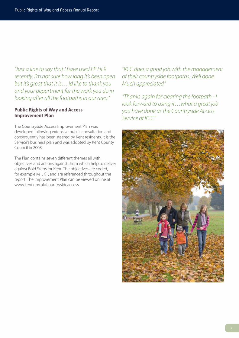
“Just a line to say that I have used FP HL9 recently. I’m not sure how long it’s been open but it’s great that it is… Id like to thank you and your department for the work you do in looking after all the footpaths in our area.”
Public Rights of Way and Access Improvement Plan
The Countryside Access Improvement Plan was developed following extensive public consultation and consequently has been steered by Kent residents. It is the Service’s business plan and was adopted by Kent County Council in 2008.
The Plan contains seven different themes all with objectives and actions against them which help to deliver against Bold Steps for Kent. The objectives are coded, for example M1, K1, and are referenced throughout the report. The Improvement Plan can be viewed online at www.kent.gov.uk/countrysideaccess.
“KCC does a good job with the management of their countryside footpaths. Well done. Much appreciated.”
“Thanks again for clearing the footpath - I look forward to using it…what a great job you have done as the Countryside Access Service of KCC.”

Well-maintained countryside access (Objectives M1 to M10)
Aim: To significantly improve the maintenance level, quality and accessibility of the Public Rights of Way (PRoW) network.
Destination signs Parish Councils can install destination signs on the network giving the public better information about where routes lead and how far away destinations are. Sheldwich Parish Council installed 14 new signs to enhance the local network for their community. Many are visible from the busy A251. M2
North Downs Way National Trail This flagship promoted walking route in Kent has an estimated 230,000 users each year.
A large surface improvement project on a Byway between Holly Hill and Great Buckland was completed this year.
A small off-road section of trail used to avoid a difficult road crossing has also been fully cleared and resurfaced ensuring a safer and more accessible journey. M2
Byways Working Group We have continued to improve access for byway users at Holly Hill. We have implemented an experimental traffic regulation order allowing usage by motor vehicles by permit to protect surface conditions and the local environment and enhance enjoyment and access for all other users. M4
Bridge maintenance 361 bridges have been installed / repaired across the whole county. M5
Stile removal We have exceeded our planned target of 200 removals with 371 removed this year from key promoted or local routes. They have been replaced with a gap or gate to make the network more accessible for a wide range of users. Over 3,000 stiles have now been removed since the Improvement Plan was published, tackling disadvantage within local communities. M6
Fault reports The Service received 7,918 service requests from the public representing an increase of nearly 2000 on last year. 67% of the faults reported this year have been resolved. Faults include problems with overgrown vegetation, broken stiles, damaged signposts, through to temporary or permanent obstructions. M2, M3, M5, M7, M9
“I should like to thank you for your effort you put in to stop the abuse of the tow path along Anchor Sluice at Yalding with the installation of bollards at quick notice. I would also like to thank you for your help generally in keeping our many footpaths maintained.”
Capital schemesThe Service has successfully delivered over a million pounds worth of capital works to enhance the PRoW network. Projects have focused on improving path surfaces on key local community and promoted routes and those in need of repair. M3, M5, M8
Highlighted projectImproving amenity land in Rusthall
Footpath WB58 in Rusthall has been much improved following a joint project with High Weald Countryside Partnership and Town and Country Housing Association. The project has transformed the general environment of an amenity area in an area of Rusthall that has a population of 4,976. Works to the footpath included resurfacing and re-profiling to remove a severe cross camber and adding a handrail to make the route accessible for all. Planting and clearance have transformed the area from being neglected and untidy to a pleasant environment to link two areas of the community.
“Thank you so much for all the wonderful work that you are doing on Swan Steps….you deserve a huge amount of praise for your determination to get it done against all the budget cuts… Thank you so much again on behalf of the parish and the many walkers...”
Theme 1
Public Rights of Way and Access Annual Report
88

Growth and development (Objectives DI to D5)
Aim: To ensure that PRoW and open green space is protected and enhanced when industrial, residential and area development takes place, especially in the Thames Gateway, Ashford, and East Kent.
Planning policyThe Service has responded to approximately 300 planning applications this year ranging from large scale sites in the growth areas of Ashford and Thames Gateway to smaller applications that affect individual routes. D4
Planning applicationsThe Service has responded to approximately 300 planning applications this year ranging from large scale sites in the growth areas of Ashford and Thames Gateway to smaller applications that affect individual routes. D4
Development proposalsThe County Council has entered into Service Level Agreements with four District Councils to process Town and Country Planning Act Applications on their behalf. This has involved providing advice to applicants, processing the application in accordance with the statutory requirements and certifying the new route(s) on completion of the works. The County Council will look to expand this role over the coming year and is already in discussions with other District Councils. D2
Growth areasTechnical advice has been provided for numerous large scale development proposals across Ashford, Thames Gateway, Dover and other parts of East Kent. A new cycling link is being constructed between the village of Whitfield and Dover Town. In Ashford a series of shared footways / cycleways have been constructed within new developments, and a new link is being constructed between “Park Farm” and Ashford. D3
“Thanks for your response. We’ve achieved the main objective. Well done: I believe that KCC are the first County Council to successfully enforce the CROW Act.”
Highlighted Project Willsborough Dykes Greenway
Ashford Borough Council has used some of their own developer contributions and a grant fund from Sustrans, the sustainable transport charity, to secure a vital new walking and cycling link.
The scheme will see the creation of a 1.6km link between Park Farm and the town centre which will open in the summer of 2013. The new route will go through the Willsborough Dykes, allowing the public to enjoy the wildlife habitat on their journey and making it easier and safer for people to access the train station or town centre by foot or bicycle.
The initial phase of construction is now complete between the Asda supermarket in Kimberley Way to Bad Munstereifel Road. The route will benefit 2,000 existing homes, 8000 residents and a further 750 homes under construction. D3
Theme 2
Public Rights of Way and Access Annual Report
99

A more sensible network (Objectives N1 to N3)
Aim: To create a PRoW network which satisfies modern needs and demands, in particular for sustainable transport, off-road leisure cycling and horse riding.
Sheppey cycling initiative The two new promoted routes at Leysdown and Sheerness are proving very popular with further requests for routes being investigated. Sustrans have produced a feasibility study to look into connections between Eastchurch and Leysdown.
Canterbury City linksWork has been completed to upgrade a number of links in and around Canterbury. Two routes have been re-surfaced as all-weather paths, one between Richmond Gardens and Neal’s Place Road. We worked with the University of Kent, attended by 19,275 students, to re-surface the cycle route between the campus and city centre. Finally, we worked with Canterbury City Council to create a new route between Westgate Gardens and Toddlers Cove. This final link provides an additional traffic-free section of the Great Stour Way between Canterbury and Chartham. This route is an important recreational and transport facility for a large number of local residents as they take regular exercise along it, travel sustainably to/from Chartham and interact with nature.
“I have been cycling the Canterbury to Chartham cycle track since we discovered it…... The variety of users is amazing from pensioners equipped with walking aids out for a group walk to young mums clad in running gear as well as many cyclists. I have never come across such a splendid cycle route and KCC is to be congratulated on seeing this through.”
Thames linksTwo new connections have been created in partnership with Dartford Borough Council and Sustrans. Improvements have been made to a link between Temple Hill and Joyce Green Lane. A new “access for all” link has been created between “The Bridge” development, that will see 1,500 new residential homes and a Science and Technology Park created, and the Thames to allow access to views and wider walks along the river.
City to seaWork continues on the regionally important Thames Cycle Path that will link the growth area along the Thames from Dartford to Swale. Background work is on-going with the project team looking to secure external funding to deliver this highly desirable and much needed route.
“I would like to convey my thanks to the people who have designed this route exceptionally awesome and the pain they took to get the detail accurate - Hats off to them and KCC.”
Highlighted ProjectViking Coastal Trail
In collaboration with Sustrans, the PRoW and Access Service has delivered a new cycle route connecting St Nicholas at Wade and Reculver Towers. The new route forms part of a wider “Connect 2” project which has seen two new, largely traffic-free links created. This new connection finally completes the Viking Coastal Trail as a circular route. Research consistently tells us that people prefer circular routes and this link will increase the number of users of the route and boost economic income from tourism for the area.
Part of the same project saw a second scheme focus on connecting the “Oyster Bay Trail” and “Crab and Winkle” route through Whitstable. It is now possible to follow the coastal route, almost completely traffic-free, from Whitstable to Margate.
Theme 3
Public Rights of Way and Access Annual Report
1010

1111
Knowing what’s out there (Objectives KI to K8)
Aim: To maintain the legal record of Public Rights of Way, Village Greens and Common Land, and to increase public awareness and use of Kent’s countryside and coast.
Village GreensThere are now 200 recorded Village Greens (869 acres) and 109 areas of Common Land (1939 acres) across Kent. Last year, we registered 8 new Village Greens as a result of successful applications and the backlog of outstanding applications has been greatly reduced. Each application is thoroughly researched and investigated and often results in a legally complex Public Inquiry. KI
“Following the meeting in Hythe Town Hall, we would like to thank you and the other KCC Officers for the handling the Fisherman’s Beach application for TVG so considerately and professionally.”
Explore KentThe Explore Kent website had 373,012 page views this year. The parks pages on the Explore Kent website have been significantly improved and now provide a definitive list of parks and open spaces in Kent making it easy for customers to find their nearest park or open space.
“A great website and we have used it for a number of weekends to go on walks that a) we didn’t know about before and b) have been most interesting. Thanks for a very useful resource.”
Good links with Kent’s media and high profile magazine editors, such as Kent Life and Kent Profile, has seen over 30 articles including circular walks and bike rides published in local media at no cost to KCC. This is an
Advertising Value Equivalent (AVE) of £30,000. It also raises the profile of Explore Kent, encourages healthier lifestyles and supports the local rural economy.
Explore Kent attended the Outdoors Show at London Excel again this year. The show was attended by 37,000 people, 1,536 people visited
our stand and over 2000 publications were handed out. A partnership project with Visit Kent to promote outdoor activities along Kent’s coast saw Nicholas Crane from the popular BBC Coast series and British Sailing Champion, Sam Brearey, launch Kent’s Active Coast Campaign at the show. K2, K3, K6, K7
Promoted routesEvery promoted route (1,464 miles/ 2,356 km in total) is checked each year by volunteers to ensure it is in good order and clearly waymarked.
“The Greensand Way - One of the best promoted paths which I have walked; consistently beautiful & inspiring - Britain at its best.”
With the development of new walks, we focussed on community partnership projcts to benefit local communities and enable citizens to develop their own local walks. Walks were produced with Chestfield Parish Council, Boughton Monchelsea Scout Group and Kent High Weald Countryside Partnership at Cranbrook. K4, K7
With the increased popularity of cycling Explore Kent produced new online cycle guides for all promoted cycling routes in Kent. K4, K5
The cycling pages of the Explore Kent website received 171,091 page views; an increase of 46% on the previous year.
Theme 4
Public Rights of Way and Access Annual Report

Public Rights of Way and Access Annual Report
1212
This guide is available in other formats and can be explained in other languages. To obtain a copy please call: 08458 247600. Text phone users, please call: 08458 247905.
Mapping: FourPoint Mapping. Photos: Explore Kent
Download the Explore Kent app on iPhone and Android phones for free.
Although an area of intense regeneration, Kent Thameside boasts a rich variety of landscapes, as well as many parks and natural green spaces for everyone to enjoy. Situated between the River Thames and the North Downs this is a fantastic area to explore on foot, by bike or on a horse. As a result of significant investment and regeneration Kent Thameside has benefitted from fantastic new facilities including Cyclopark, located just to the south of Gravesend. This exciting new facility, opened in May 2012 and brings first class cycling, running and extreme sports facilities to north Kent and is one of the leading multi-sport centres in the south of England (www.cyclopark.com).
Kent Thameside has excellent links to the wider Cycle Network in Kent with National Cycle Routes 1 and 177 running through it. These are multi-user routes so can be enjoyed by walkers, joggers, dog walkers, skateboarders and cyclists. Other routes shown on the map include footpaths, bridleways and byways (please note cyclists are not permitted on footpaths).
Useful contacts:For walks, guided walks, cycle routes, horse riding routes and parks and open spaces in Kent: Explore Kent www.kent.gov.uk/explorekent Tel: 08458 247 600Sustrans www.sustrans.org.uk Tel: 0845 113 00 65Ramblers’ Association www.ramblers.org.uk Tel: 020 7339 8500Cyclopark www.cyclopark.com Tel: 01474 567145Visit Kent www.visitkent.co.uk
DOVER ROAD
NORFOLK ROAD
CANAL ROAD
THAMES
WAY
THAMES WAY
WRO
THAM
ROAD
WRO
THA M
ROAD
WRO
THAM
ROAD
WROT HAM
ROAD
OVERCLIFFE
HARM
ERSTBA
THST
CROOKED LANE
MILTON ROADPAR
ROCK
ST
ROCHESTER ROAD
WRO
THAM
ROAD
ROCHESTER ROAD
WATLING STREET
WATLING STREET
FERRYROAD
A226
A226
A226
A226
A2260
A226
A226
A226
A226
A226
A226
A227
A226
A226
A226
A226
A1089
A2
A2
A2
A2
A227
A227
A227
A2
A2
A2
A227
A2
A2260
A2
A226
A226
STATION ROAD
SPRI
NGH
EAD
ROAD
STATION ROAD
OLD RO AD WE ST
OLD ROAD EAST
OLD ROADEAST
LONDON ROADLONDON ROAD
STUARTROAD
HIGH
STREET
HIGH STREET
B262
B2175
B2175
B2175
B2175
B261
B261
B261
B261B261
B262
B262
B262
B262
WES
TWOO
DRO
AD
PARK CORNERROAD
DALEROAD
WARREN ROAD
RED STREET
HOOK GREEN ROAD
AD
SWANSCOMBESTREET
HIGH
STREET
SOUTHFLEET ROAD
STANHOPE ROAD
NEW
BAR
NRO
AD
NEWBAR N
ROAD
NEWBARN
ROAD
BROAD DITCH ROAD
DOWNS ROAD
NEW
BA RNROAD
UPPE
RAVENUE
ISTEAD RISE
ARCADIA ROAD
DOWNS ROAD
DOWNS
ROA
D
HEN
HURS
TROA
D
CHURCH ROAD
CHURCHROAD
HENHU
RST
ROAD
CHUR
CH
ROAD
HALF
PENC
E LAN
E
THO
NGL A
NE
SHORNE IFIELDROAD
SHORNE IF IELD ROAD
THONGLANE
VIGILANT WAY
LEAN
DERD
RIVE
VALLEY DRIVE
HEVER COURT ROAD
HEVER COURTROAD
COLDHARBOUR RD
DOW
NSRO
AD
SINGLEWELLROAD
VALL
EYDR
IVE
VALL
EYDR
IVE
WHITEHILL ROAD
WHITEHILL LANE
CROSS LANE EASTWIN
DMILL
STRE
ET
CROSS LANE WEST
DASHW
OODROAD
SING
LEW
ELLR
OAD
HALL ROAD
PELHAM ROA D SOUTH
EARL ROAD
COLDHARBOURROAD
COLDHARBOURROAD
VALEROAD
DOVER ROAD
VALE ROAD
OLD
PERR
Y ST
PELHAM
ROAD
LENNOXROAD
ROSHERVILLEW
AY
CR E TE HALLRO
AD
CLIFTONMARINEPARADE
SPRI
NGHE
ADRO
AD
DOVERROAD
ROSH
ERVI
LLE
WAY
DARN
LEY
ROAD
WIN
DMILL STREET
THAM
ES
WAY
PELHAM
ROAD
THAME S WAY
PARROCK STREET
WEL
LINGT
ONST
REET
ORDNANCE RDPARROCK ROADW
INDM
ILL S
T
LOWER HIGHAM ROAD
LOWER HIGHAM ROAD
LOWER HIGHAM ROAD
CHUR
CHLA
NE
CHALK ROAD
CAST
LELA
NE
CHURCHLANE
THON
G LANE
THON
GLA
NE
FORT
ROAD
STANLEYROAD
GASSON RD
EGLI
NTON
ROAD
CHURCHROAD
SUN
ROAD
VERNON ROAD
MUN
FORDDRIVE
SWEY
NERD
AMES ROAD
ALMA RD
THE GROVE
MANOR
WAY
ROAD GROV
E ROADTAUNTON
STATION RD
FACT
ORY R
D
COLL
EGE R
OAD
SOUT
HKE
NTAV
E
HUNTLEY AVEUNE
CRETE HALL ROAD
LABURNUM GROVE
SHEPHERD STYORK RD
GORD
ONRO
AD
RURA
L VAL
E
MAR
ITIM
E GAT
E
ROBINIAAVENUE
PLAN
E AVENUE
BURC
HRO
AD
PIERROAD
WEST
MILL
FOUNTAIN WALK
BEAUMONT DRIVE
ST MARK'S AVENUE
GRANGE ROAD
CAM
PBELL ROAD
STJAMES'S ROADLENNOX AVENUE
CLIFTON RD
BERE
SFOR
DRD
BEAUMONT DRLVE
THEA
VENU
E
L E NNOX ROAD EAST
GRANVILLE RDHAVELOCK ROAD
COU LTONAVENUE
PARK AVENUEGOUGE AVENUEFIRST AVENUE
PARK AVENUE
PRESTON ROAD
WATERDALES
MITCHELL AVENUE
COLYER ROADC
OVESFIEL
D
ALLSAINT S' ROAD
BROOKROAD
ROSEB
ANK GDNS
VICTORIAROAD
MAY
AVENU
E
STAN
BROO
KRO
AD TRAFALGAR ROAD
ESSEX ROAD
KENT ROAD
COBHAM STREET
RATHMORE RO AD
BRAN
DON
STRE
ET
ARTHUR ST
CECI
L ROA
D
CHURCHILL RD
NORTHCOTE RD
SALISBURY RD
BEDF
ORDRO
AD
NAPIER RDSEYMOUR RD
MILROY AVENUE
BEATRICE GDNS
NELSON ROAD
SNEL
LING
AVEN
UE
THEC
RESCENT
COOPER' S RD
BARTLETT RD
LYNTON RD SOUTH
TROSLEYAVENUE
WOODFIEL D
A V E N U E
PORTLANDROAD
WINGFIELD RD CLA RENCE PLACEROUGE LANE
PARROCK AVENUE
PEAC
OCK
STRE
ET
THE
GROV
E
EDW
INST
TRINITY ROADSHEPPY
PL
DARNLEY STREET
SPENCER ST
PRINCE S
ST
ROYAL PI ERROAD
MILT
ONPL
ACE
WES
TCRE
SCEN
T RD
QUEE
NST
EAST
CRES
CENT
RD
GORD
ONPROMENADE EA ST
WHARF ROAD
RAPHAEL ROAD
PROSPECTGROV E
CHUR
CHW
ALK
WATERTON AVENUE
ALEXANDRA ROAD
LOWER RANGE RD
MAR
KLANE
DERINGW
AY
HAVENGORE AVENUE
INGO
LDSB
Y ROA
D
DICK
ENS
ROAD
ABBE
Y ROA
D
THISTLE ROAD
NORFOLK ROAD
ALBI
ONRO
AD
PROS
PECT
PL
SUFFOLKROAD
SHAMROCK ROAD
ELLI
OTT S
T
MILT
ONHA
LLRO
AD
ALAN
BRO
OKE
ARMOURY D R
BRON T E VIEW
ARM
OURY
DR
ARTI LL ERY R OW
PARK
AVEN
UE
MILT
ONAV
ENUE
BELLMAN AVENUE
DERI
NGW
AY
MARSH VIEW
FENNE
R S MARSH
GERALDRD
ROEH
AMPT
ONCL
PINE
AVENU
E
WILLIAM ST
SPRINGGROVE
SHRUBBERY R
D
SOUTH HILLROAD
DEVONSHIRERD
PARK RD
THOMAS DRIVE
HILLSIDE AVENUELAMORNA
AVE
ARNOLDROAD
HOLLYBUSH ROADLAUREL AVENUE THESA
NDPI
PERS
THECURLEWS
THE
TURN
S TON
ES
TAUNTONVALE
DORCHESTER RD
TRUROROAD
WY
EROAD
COOMBE RD
WINCHES
T ER CRES
STALB
AN' S
EXETERRD
C L
STPA
TRIC
K'S
GARD
ENS
PORTLAND AVENUE
FERNDALE ROAD
MALVINA AVENUE
SMARTS ROA D
NORTHRIDGE ROADSUN
LANE
FERNDALE RD
GATWICK
R D
CENTRAL AVENUE
RIDGEWAY AVENUE
SINGLEW
ELL ROAD
WINDSOR
ROAD
KINGS DRIVE KITC
HENE
RAV
ENUE
CENTRAL AVENUE
ASCOT ROAD
THE FAIRWAY
HILLINGDON ROAD
DENNIS ROAD
AIN T REE
CLS
LI NGFIELD ROAD
ALFRED
ROAD
KINGS DRIVE
JELLICOE AVENUE
QUEENS ROAD
YORK ROAD
GLOUCESTER ROAD
SUN LAN E
SHARLAND
ROAD
PRIN
CES
ROAD
OAK
ROAD
ASH ROAD
CEDARAVENUE
POPL
A RAV
ENUE
CHRI
STIA
NFIE
LDS
FERG
USON
NANS
ENRO
AD
PA LMER
AVENUE
HAWKINS AVENUE
DUNKIRK CLOSE
CH
RISTIAN FIELDS AVE
MUNGO PARK R D
WILBERFORCEW
AY
CHALKY BANK
HARMAN AVENUE
BRENCHLEY AVENUE
IVY CLO SE
THE WARREN
THE
RISE
FR EEMAN ROAD
BARR ROAD
BOURNE ROAD
MEDHURST
CRESCENT
CRUD
ENRO
AD
CERVIA WAYMED H URST
GDNS
ME D HURSTGDNS
FORG
E LANEHAMPTON CRESCENT
ST G REGORY'S CRESCENT
JUBI
LEEC
RESC
ENT
AVEN
UE
LORTONCL
STBE
NEDIC
T'S
HAM
PTON
CRES
CENT
STCHAD'SDRIVE
ST MARGA RE T' SC
RESC
ENT
STHI
LDA'
SW
AY
ST AIDAN
'SWAY
STDU
NSTA
N'S
DRIV
E
ST HILDA'S WAY
S T G
EORG
E'SCR
ESCE
NT
ST DAVID'S
CRE S
THE DRIV
E
BELT
ANA
DRIV
E CAMBRIACRESCENT
CLIPPER CRESCEN T
CERN
E ROAD
DORS
ETCR
ES
CA MBR
IACR
ESCE
NT
WIN DHOVER
WAYSTFRANCIS AVENUE
WHINFELL WAY
IMPERIAL DRIVE
BRITANNIADRIVE
S IRDARSTRAND
MARLIN
G WAY
ASTRA DRIVEHO
PEW
ELL D
R
MIC
HAEL
GARD
ENS
MARLI N
G WAY
CAL
DERWOOD
CIRR
USCR
ESCENT
DOBSONROAD
READW
AY
FR
O B ISHER W AY
ASTRA DRIVE
IMPERIAL DRIVE
WAYVOLANTE
CHURCH ROAD
RUFF ET S WOO
D
GO
O
DWOOD CRES
ORCHARD AVENUE
WATLING STREET
IFIELD WAY
MA
CKE N ZIE WAY
COBSDENE
MACKEN
ZIE
WAY
FRANKLINROAD
DAVY'SPLACE
LIVI
NGST
ONE
ROAD
STANLEY CRES
SCOTT R OAD
WILBERFORCE W A Y
CODR
INGT
ONCRES
WILBERFORCEW
AY
WROTHA
MROAD
CHALLENGE CL
GWYNNROAD
COLYER R OAD
FLEET ROADVIKING ROAD
PEPP
ERHILL
TENNYSON WALK
ASPDINROAD
MAR
C ON
I ROA
D
PAIN
TERS
ASH
LAN E
PEPPER HILL
SAXO
NC
L
PICKW
ICKGDNS
MASEFIELD ROAD
CHAU
CER RD
DENE HOLM ROAD
DENE HOLM ROAD
REMBRANDT DRIVE
LANDSEER AVENUE
HOGLANE
HO
G
LA NE
CONSTABLEROA
D
HILLARY AVE DURNDALELANE
TE NSINGAV
EDENE HOLM ROAD
GAIN
SBORO
UGHDR
IVE
MULBERRY ROAD
MULBERRY ROAD
HENLEY DEANE
CHER
RYW
OOD
DRIVE
LADYFIELDS
OAKLAND S ROAD
BOUCHERDRIVE
GRIEVES
ROAD
PACK
HAM
ROAD
LANE
SAV
ENUE
DURNDALE
LANE
MAR K S SQUARE
PACKHAMROAD
HAYNES ROAD
WHITE AVENUE
RIVERSDALE
SNE
LLIN GAVENUE
HARDENROAD
NEW HOUSE LANEBUC K S CROSS RD
GRE ENH ILL ROAD
HARDY AVE NUE
NEWT
ONAB
BOT
ROAD
COLY
ERRO
AD
T HE HEDG
EROW
S
FARMC ROFT
THE
DOWNA
GE
NORTH U M
B E R L A N DR D
BROOKSIDE
ROAD
FAIRVIEW ROAD
FLOWERHILL WAY BIDDENDENWAY
CROCKENHALL
LEWIS
ROADLESLEY
CL
ELWILL WAY
CASTLEFIELDS
LYNDHURST W
AY
THE DROVE
THE KNOLE
HILL CLOSE
WORCESTER
H A V ENC
LOSE
EDGEH ILLG
DNS
LONGWALK
CLOSE
WAY
WEALD CL
THED
RO VE WAY
THE DROVE WAY
FLOWERHILLWA Y
BRACONDALE
AVE
B RAKEFIELDROAD
REC T ORY ME
AD
OW
SE DLEY
STUDLEY
CRES
HART
SHAW
SOUTHFLEET AVENUE
DENE DRIVE
DENE
DRIV
EORCH
ARD
CLOS
E
LONGFIELD AVE
BIRCH CLOSE F OXWOOD WAY
VICA
RAGE
L ANE
MIL
LER
ROAD
OSNE
YW
AY ORLIC
KRO
AD
NICKL
EBY ROAD
HAVISHAM ROAD
DARENTH DR
FILBOR
OUGH
WAY
DRIVEHIBERNIA
STCOLUMBA'S
CLOSE
FORT ROAD
AVEN
UE
AVEN
UE
TilburyNess
Gravesend Reach
Rosherville
Denton
Milton
Chalk
GRAVESEND
PerryStreet
WombwellPark
NewHouse
Southfleet
Red Street
NorthfleetGreen
Betsham
Istead Rise
ParrockFarm
KingsFarm
Westcourt
Eastcourt Marshes
Great Clane LaneMarshes
Singlewell
UpperIfield
Thong
Henhurst
BotanyMarshes
TILBURY
MadamWood
CourtWood
Thirty AcreShaw
WalnutWood
ClaylaneWood
Brummelhill Wood
Ashenbank Wood
Chambers Hill Wood
Shorne WoodCountry Park
RandallHeath
RecGrd
HuntondownWood
CricketGrd
RecGrd
RandallWood
FootballGrd
FootballGrd
RecGrd
RecGrd Rec
Grd
RecGrd
RecGrd
CricketGrd
RecGrd
RecGrd
RecGrd
RecGrd
Park
RecGrd
RecGrd
RecGrd
RecGrd
RecGrd
RecGrd
RecGrd
ecrd
RecGrd
RecGrd
Jeskyns
Works
Mill
Works
Warehouses
Superstore
Gravesend Reach
LeisureCentre
EnterprisePark
Super-store
RecyclingCentre
Super-store
LeisureCentre
PowerStation
Bill Meroy Creek
RI
VE
R
TH
A M E S
TilburyDocks
Ferry
Gravesend - Tilbury
BREWER
SROAD
29 30
31
32
33
34
35
36
37
38
39
40
41
42
43
44
45
46
47
48
49
50
51
52
53
54
55
56
57
5859
60
6162
63
To Dartford
To Longfield
To Cobham
To CobhamTo Cobham
To Shorne
To Stroudand
Rochester
To Highamand Cliffe
To Strood
To Higham
Dartford & Gravesham
Explore
www.kent.gov.uk/explorekent
walking and cycling map
PowerStation
Meroy Creek
31
32
33
34
35
36
37
38
39
40
41
42
43
44
45
46
47
48
49
50
51
52
53
54
55
56
57
58
59
60
61
62
63
Cycle to schoolMiles
Kilometres 0.50
1
0.5
Cyclopark
Cycle parking
Bus stop
Traffic-free - SurfacedIncludes Bridleways, Restricted Byways andByways Open to All Traffic.
Traffic-free - UnsurfacedIncludes Bridleways, Restricted Byways andByways Open to All Traffic.
Useful routeRoutes are not signed buthave been deemed assuitable for cycling
Footpath
Take extra care
Pelican / Toucan crossing
National Cycle Networkroute number
SchoolNamed and numbered
Hospital
Library
Museum
Promoted traffic-free - SurfacedIncludes Bridleways, Restricted Byways andByways Open to All Traffic.
Promoted traffic-free - UnsurfacedIncludes Bridleways, Restricted Byways andByways Open to All Traffic.
Promoted on-road cycle route
1
Railway with Station / Level crossing
Signed on-road cycle route
One way
© Crown copyright and database rights 2013 Ordnance Survey 100019238
Key
Thameside.indd 2 18/03/2013 13:03
Highlighted ProjectTown Walking and Cycling Maps
The Service has continued to lead on the production of walking and cycling maps for the more densely populated towns across the County in partnership with Kent Highways and local tourism partners. The purpose of the leaflets is to showcase routes and make residents and visitors aware how easy it is to get around by sustainable means. They encourage more active lifestyles and now feature bus stop locations to promote public transport. Schools, tourist attractions, other places of interest and accommodation are referenced.
40,000 maps were distributed through Visitor Information Centres and Gateways.
The series now includes maps for; Ashford, Thanet and the Viking Coastal trail, Canterbury, Maidstone and Kent Thameside. New maps for Dover and Tonbridge are planned for 2013.
The production of these maps and guides have been funded by the Department for Transport’s Local Sustainable Transport Fund. K2
This guide is available in other formats and can be explained in other languages. To obtain a copy please call: 08458 247600. Text phone users, please call: 08458 247905.
Mapping: FourPoint Mapping. Photos: Explore Kent
Download the Explore Kent app on iPhone and Android phones for free.
Although an area of intense regeneration, Kent Thameside boasts a rich variety of landscapes, as well as many parks and natural green spaces for everyone to enjoy. Situated between the River Thames and the North Downs this is a fantastic area to explore on foot, by bike or on a horse. As a result of significant investment and regeneration Kent Thameside has benefitted from fantastic new facilities including Cyclopark, located just to the south of Gravesend. This exciting new facility, opened in May 2012 and brings first class cycling, running and extreme sports facilities to north Kent and is one of the leading multi-sport centres in the south of England (www.cyclopark.com).
Kent Thameside has excellent links to the wider Cycle Network in Kent with National Cycle Routes 1 and 177 running through it. These are multi-user routes so can be enjoyed by walkers, joggers, dog walkers, skateboarders and cyclists. Other routes shown on the map include footpaths, bridleways and byways (please note cyclists are not permitted on footpaths).
Useful contacts:For walks, guided walks, cycle routes, horse riding routes and parks and open spaces in Kent: Explore Kent www.kent.gov.uk/explorekent Tel: 08458 247 600Sustrans www.sustrans.org.uk Tel: 0845 113 00 65Ramblers’ Association www.ramblers.org.uk Tel: 020 7339 8500Cyclopark www.cyclopark.com Tel: 01474 567145Visit Kent www.visitkent.co.uk
DOVERROAD
NORFOLKROAD
CANA
LROA
D
THAM
ESW
AY
THAMESWAY
WROTHAM
ROAD
WROTHAM
ROAD
WROTHAM
ROAD
WRO
THAM
ROAD
OVERCLIFFE
HARMER
ST BATHST
CROOKEDLANE
MILTONROAD P
ARROCKST
ROCHESTERROAD
WROTHAM
ROAD
ROCHESTERROAD
WATLINGSTREET
WATLINGSTREET
FERR
YRO
AD
A226
A226
A226
A226
A2260
A226
A226
A226
A226
A226
A226
A227
A226
A226
A226
A226
A108
9
A2
A2
A2
A2
A227A227
A227
A2
A2
A2
A227
A2
A226
0
A2
A226
A226
STATIONROAD
SPRINGH
EAD
ROAD
STATIONROAD
OLDROADWEST
OLDROADEAST
OLDROADEAST
LONDONROADLONDONROAD
STUA
RTRO
AD
HIGH
STREET
HIGHSTREET
B262
B2175
B2175
B2175
B2175
B261
B261
B261
B261B261
B262
B262
B262
B262
WESTW
OODROAD
PARKCORNERROAD
DALE
ROAD
WARRENROAD
REDSTREET
HOOKGREENROAD
AD
SWANSCOMBESTREET
HIG
HST
REET
SOUT
HFLE
ETRO
AD
STAN
HOPE
ROAD
NEWB
ARNROAD
NEW
BARN
ROAD
NEW
BARN
ROAD
BROADDITCHROAD
DOWNSROAD
NEW
BARN
ROAD
UPPERAVENUE
ISTEADRISE
ARCADIAROAD
DOWNSROAD
DOW
NSR
OAD
HENHURST ROAD
CHURCHROAD
CHUR
CHRO
AD
HENHURSTRO
AD
CHURCHROAD
HALFPENCELANE
THONG
LANE
SHORNEIFIELDROAD
SHORNEIFIELDROAD
THON
GLA
NE
VIGILANTWAY
LEANDERDRIVE
VALL
EYDR
IVE
HEVERCOURTROAD
HEVERCOURTROAD
COLDHARBOURRD
DOWNS
ROAD
SING
LEW
ELLR
OAD
VALLEYDRIVE
VALLEYDRIVE
WHI
TEHI
LLRO
AD
WHI
TEHI
LLLA
NE
CROSSLANEEAST WINDM
ILLSTREET
CROSSLANEWEST
DAS
HWOO
DRO
AD
SINGLEWELLROAD
HALLROAD
PELHAMROADSOUTH
EARLROAD
COLD
HARB
OURR
OAD
COLDHA
RBOU
RRO
AD
VALE
ROAD
DOVERROAD
VALE
ROAD
OLDPERRYST
PELHAMROAD
LENN
OXRO
AD
ROSH
ERVI
LLE
WAY
CRETEHALLROAD
CLIFTONMARINEPARA
DE
SPRINGHEADROAD
DOVE
RROAD
ROSHERVILLEW
AY
DARNLEYROAD
WIN
DMIL
LSTR
EET
THAMES
WAY
PELHAM
ROAD
THAMESWAY
PARR
OCKST
REET
WELLINGTON
STREET
ORDNANCERD
PARROCKROAD WINDM
ILLST
LOWERHIGHAMROAD
LOWERHIGHAMROAD
LOWERHIGHAMROAD
CHURCHLANE
CHALKROAD
CASTLELAN
E
CHURCHLA
NE
THONGLANE
THONGLANE
FORTROAD
STAN
LEYR
OAD
GASSONRD
EGLINTONROAD
CHUR
CHRO
AD
SUNROAD VERNONROAD
MUNF ORDDRIVE
SWEYNE
RD
AMESROAD
ALMARD
THEGROVE
MAN
ORW
AYRO
ADGROVEROAD TAUN
TON
STATIONRD
FACTORYRD
COLLEGEROAD
SOUTHKENT
AVE
HUNTLEY
AVEUNE
CRETEHALLROAD
LABURNUMGROVE
SHEP
HERD
ST YORKRD
GORDONROAD
RURALVALE
MARITIM
EGATE
ROBI
NIAAV
ENUEPLANEAVENUE
BURCHROAD
PIER
ROAD
WES
TM
ILL
FOUNTAINWALK
BEAUMONTDRIVE
STMARK'SAVENUE
GRANGEROAD
CAMPBELLROAD
STJAMES'SROADLENNOXAVENUE
CLIFTONRD
BERESFORDRD
BEAUMONTDRLVE
THEAVENUE
LENNOXROADEAST
GRANVILLERD HAVELOCKROAD
COULT
ONAVEN
UE
PARKAVENUE GOUGEAVENUE FIR
STAV
ENUE
PARKAVENUE
PRESTONROAD
WATERDALES
MITCHEL
LAVENUE
COLYERROAD
COV
ESFI
EL
D
ALLS
AIN
TS'R
OAD
BROO
KRO
AD
ROSE
B
ANKGDNS
VICT
ORIA
ROAD
MA Y
AVEN
UE
STANBROOKROAD
TRAFALGARROAD
ESSEXROAD
KENTROAD
COBHAMSTREET
RATHMOREROAD
BRANDONSTREET
ARTHURST
CECILROAD
CHURCHILLRD
NORTHCOTERD
SALISBURYRD
BEDFORDROAD
NAPIERRD SEYMOURRD
MILROYAVENUE
BEATRICEGDNS
NELSONROAD
SNELLINGAVENUE
THECRESCENT
COOPER'SRD
BARTLETTRD
LYNTONRDSOUTH
TROS
LEY
AVEN
UE
WOO
DFIE
LDAV
ENUE
PORTLANDROAD
WINGFIELDRDCLARENCEPLACE ROUGELANE
PARROCKAVENUE
PEACOCKSTREET
THEGROVE
EDWIN
ST
TRINITYROAD
SHEP
PYPL
DARNLEYSTREET
SPENCERST
PRIN
CES
S T
ROYALPIERROAD
MILTON
PLACE
WESTCRESCENTRD
QUEENST
EASTCRESCENTR
D
GORDONPROMENADEEAST
WHARFROAD
RAPHAELROAD
PROSPECTGROVE
CHURCHW
ALK
WATERTONAVENUE
ALEXANDRAROAD
LOWERRANGERD
MARKLANE
DERI
NGW
AY HAVENGOREAVENUE
INGOLDSBYROAD
DICKENSROAD
ABBEYROAD
THISTLEROAD
NORFOLKROAD
ALBIONROAD
PROSPECTPL
SUFFOLKROA
D
SHAMROCKROAD
ELLIOTTST
MILTON
HALLROAD
ALANBROOKE
ARMOURYDR
BRONTEVIEW
ARMOURYDR
ARTI
LLERYROW
PARKAVENUE
MILTON
A VENUEBELLMANAVENUE
DERINGW
AY
MARSHVIEW
FENNE
RSMARSH
GERALDRD
ROEHAMPTON
CL
PINEAVENUE
WILLIAMST
SPRI
N GGR
OVE
SHRUBBERYRD
SOUTHHILLROAD
DEVO
NSHI
RERD
PARKRD
THOMASDRIVE
HILLSIDEAVENUE LAM
ORNA
AVE
ARNO
LDRO
AD
HOLLYBUSHROAD LAURELAVENUETHESANDPIPERS
THECUR
L EWS
THETURNSTONES
TAUN
TON
VALE
DORCHESTERRD
TRUR
OROAD
WY
EROA
D
COOMBERD
WIN
CHES
TERCRES
STA
LBAN'S
EXET
ERRD
CL
STPATRICK'SGARDENS
PORTLANDAVENUE
FERNDALEROAD
MALVINAAVENUE
SMARTSROAD
NORT
HRID
GERO
ADSU
NL A
NE
FERNDALERD
GATW
ICK
RD
CENT
RALA
VENU
E
RIDGEWAYAVENUE
SING
L EW
ELLR
OAD
WIN
DSOR
ROAD
KINGSDRIVEKITCHENERAVENUE
CENT
RALA
VENU
E
ASCOTROAD
THEFAIRWAY
HILLINGDONROAD
DENNISROAD
AINTREE
CLS
LINGFIELDROAD
ALFR
ED
ROAD
KINGSDRIVE
JELLICOEAVENUE
QUEENSROAD
YORKROAD
GLOUCESTERROAD
SUNLANE
SHARLAND
ROAD
PRINCESROAD
OAK
ROAD
ASHROAD
CEDA
RAV
ENUEPOPLAR
AVE NUE
CHRISTIANFIELDS
FERGUSON
NANSENROAD
PALM
ERAV
ENUE
HAWKINSAVENUE
DUNKIRKCLOSE
CHRISTIANFIELDSAVE
MUNGOPARKRD
WILB
ERFO
RCEW
AY
CHAL
KYBANK
HARMANAVENUE
BRENCHLEYAVENUE
IVYCLOSE
THEWARREN
THERISE
FREEMANROAD
BARRROAD
BOURNEROAD
MEDHURSTCRESCENT
CRUDENRO
AD
CERVIAWAYMEDHURSTGDNS
MEDHURSTGDNS
FORGELANE HAMPTONCRESCENT
STGREGORY'SCRESCENT
JUBILEECRESCENT
AVENUE
LORTONCL
STBENEDICT'S
HAMPTON
CRESCENT
STCH
AD'S
DRIV
E
STMARGARET'SC
R E SCENT
STHILDA'SW
AY
STAIDAN'SWAYSTDUNSTAN'S
DRIVE
STHILDA'SWAY
STG
EORGE'S
CRESCENT
STDAVID'SCRES
THEDRIVE
BELTANADRIVECAMBRIACRESCENT
CLIPPERCRESCENT
CERNEROAD
DORSETCRES
CAMBRIA
CRESCENT
WIN
DHOV
ERW
AY STFRANCISAVENUE
WHINFELLWAY
IMPERIALDRIVE
BRITANNIADRIVE
SIRD
ARST
RAND MARLINGWAY
ASTRADRIVE
HO PEWELLDR
MICHAELGARDENS
MAR
LIN
GWAY
C AL
DERW
OOD
CIRRUS CRESCENT
DOBS
ONRO
AD
READ
WAY
FR
OBISHERWAY
ASTRADRIVE
IMPERIA
LDRIVE
WAYVOLANTE
CHURCHROAD
RUFFETSWOOD
GO
O
DWOODCRES
ORCHARDAVENUE
WATLINGSTREET
IFIELDWAY
MA
CKE
NZIEWAY
COBS
DENE
MAC
KEN
ZIE
WAY
FR
ANKLINRO
AD
DAVY'S P
LACE
LIVINGSTONEROADST
ANLE
YCRE
S
SCOTTROAD
WILBERFORCEWAY
CODRINGTONCRES
WILB
ERFO
RCEW
AY
WRO
THA
MROAD
CHALLENGECL
GWYN
NROA
D
COLYERROAD
FLEETROADVIKINGROAD
PEPPERHILL
TENNYSONWALK
ASPDINROAD
MARCON
IROAD
PAINTERSA
SHLANE
PEPPERHILL
SAXONC
L
PICKWICKGDNS
MASEFIELDROAD
CHAUCERRD
DENEHOLMROAD
DENEHOLMROAD
REMBRANDTDRIVE
LANDSEERAVENUE
HOG
LANE
HO
G
LANE
CONS
TABL
ERO
AD
HILLARYAVEDURNDALELA
NE
TENS
ING
AVE DENEHOLMROAD
GA INSBOROUGHDRIVE
MUL
BERR
YROAD
MULBERRYROAD
HENLEYDEANE
CHERRYW
OODDRIVE
LADYFIELDS
OAKL
ANDSROAD
BOUC
HER
DRIV
EG
RIEVE
SRO
AD
PACKHAMROAD
LANESAVENUE
DURNDALELANE
MARKSSQUARE
PACKHAMROAD
HAYNESROAD
WHITEAVENUE
RIVERSDALE
SNE
LLIN
GAVENUE
HARDENROAD
NEWHOUSELANE
BUCKSCROSSRD
GREE
NHILLROAD
HARD
YAVENUE
NE WTONABBOT
ROAD
COLYERROAD
THEHEDGEROW
S
FARMCROFT
THE
DOWNA
GE
NOR
THUM
BERL
AND
RD
BRO
OKSI
DERO
AD
FAIRVIEWROAD
FLOWERHILLWAYBID
DENDEN
WAY
CROCKENHALL
LEW
ISRO
ADLE
SLE Y
CL
ELWILLWAY
CAST
LEFIE
LDS
LYNDHURSTW
AY
THEDROVE
THEKNOLE
HILLCLOSE
WOR
CEST
ER
HAVE
NC
LOSE
EDGEHILLGDNS
LONGWALK
CLOS
E
WAY
WEA
LDCL
THE
DROVEWAY
THEDROVEWAY
FLOWERHILLWA
Y
BR ACONDALEAV
E
BRAK
EFIE
LDRO
AD
RECTORYME
AD
OW
SEDLE
Y
STUDLE
Y
CRES
HA RTSHAW
SOUTHFLEETAVENUE
DENEDRIVE
DENEDRIVE ORCHARDCLOSE
LONGFIELDAVE
BIRCHCLOSEFOXWOODWAY
VICARAGELANE
MILLER
ROAD
OSNEYW
AY
ORLICKROA
D
NICKLEBYROAD
HAVISHAMROAD
DARENTHDR
FILBOROUGHWAY
DRIVEHIBERNIA
STCO
LUM
BA'S
CLOS
E
FORTROAD
AVENUE
AVENUE
TilburyNess
Gravesend Reach
Rosherville
Denton
Milton
Chalk
GRAVESEND
PerryStreet
WombwellPark
NewHouse
Southfleet
Red Street
NorthfleetGreen
Betsham
Istead Rise
ParrockFarm
KingsFarm
Westcourt
Eastcourt Marshes
Great Clane LaneMarshes
Singlewell
UpperIfield
Thong
Henhurst
BotanyMarshes
TILBURY
MadamWood
CourtWood
Thirty AcreShaw
WalnutWood
ClaylaneWood
Brummelhill Wood
Ashenbank Wood
Chambers Hill Wood
Shorne WoodCountry Park
RandallHeath
RecGrd
HuntondownWood
CricketGrd
RecGrd
RandallWood
FootballGrd
FootballGrd
RecGrd
RecGrdRec
Grd
RecGrd
RecGrd
CricketGrd
RecGrd
RecGrd
RecGrd
RecGrd
Park
RecGrd
RecGrd
RecGrd
RecGrd
RecGrd
RecGrd
RecGrd
ecrd
RecGrd
RecGrd
Jeskyns
Works
Mill
Works
Warehouses
Superstore
Gravesend Reach
LeisureCentre
EnterprisePark
Super-store
RecyclingCentre
Super-store
LeisureCentre
PowerStation
Bill M
eroy C
reek
RI
VE
R
TH
AMES
TilburyDocks
Ferr
y
Gra
vese
nd -
Tilb
ury
BREWERSROAD
2930
31
32
33
34
35
36
37
38
39
40
41
42
43
44
45
46
47
48
49
50
51
52
53
54
55
56
57
5859
60
6162
63
To Dartford
To Longfield
To Cobham
To CobhamTo Cobham
To Shorne
To Stroudand
Rochester
To Highamand Cliffe
To Strood
To Higham
Dartford & Gravesham
Explore
www.kent.gov.uk/explorekent
walking and cycling map
PowerStation
Mer
oy Cre
ek
31
32
33
34
35
36
37
38
39
40
41
42
43
44
45
46
47
48
49
50
51
52
53
54
55
56
57
58
59
60
61
62
63
Cycle to schoolMiles
Kilometres0.50
1
0.5
Cyclopark
Cycle parking
Bus stop
Traffic-free - SurfacedIncludes Bridleways, Restricted Byways andByways Open to All Traffic.
Traffic-free - UnsurfacedIncludes Bridleways, Restricted Byways andByways Open to All Traffic.
Useful routeRoutes are not signed buthave been deemed assuitable for cycling
Footpath
Take extra care
Pelican / Toucan crossing
National Cycle Networkroute number
SchoolNamed and numbered
Hospital
Library
Museum
Promoted traffic-free - SurfacedIncludes Bridleways, Restricted Byways andByways Open to All Traffic.
Promoted traffic-free - UnsurfacedIncludes Bridleways, Restricted Byways andByways Open to All Traffic.
Promoted on-road cycle route
1
Railway with Station / Level crossing
Signed on-road cycle route
One way
Cyclopark
Cycle parking
Bus stop
Traffic-free - SurfacedIncludes Bridleways, Restricted Byways andByways Open to All Traffic.
Traffic-free - UnsurfacedIncludes Bridleways, Restricted Byways andByways Open to All Traffic.
Useful routeRoutes are not signed buthave been deemed assuitable for cycling
Footpath
Take extra care
Pelican / Toucan crossing
National Cycle Networkroute number
SchoolNamed and numbered
Hospital
Library
Museum
Promoted traffic-free - SurfacedIncludes Bridleways, Restricted Byways andByways Open to All Traffic.
Promoted traffic-free - UnsurfacedIncludes Bridleways, Restricted Byways andByways Open to All Traffic.
Promoted on-road cycle route
1
Railway with Station / Level crossing
Signed on-road cycle route
One way
Cyclopark
Cycle parking
Bus stop
Traffic-free - SurfacedIncludes Bridleways, Restricted Byways andByways Open to All Traffic.
Traffic-free - UnsurfacedIncludes Bridleways, Restricted Byways andByways Open to All Traffic.
Useful routeRoutes are not signed buthave been deemed assuitable for cycling
Footpath
Take extra care
Pelican / Toucan crossing
National Cycle Networkroute number
SchoolNamed and numbered
Hospital
Library
Museum
Promoted traffic-free - SurfacedIncludes Bridleways, Restricted Byways andByways Open to All Traffic.
Promoted traffic-free - UnsurfacedIncludes Bridleways, Restricted Byways andByways Open to All Traffic.
Promoted on-road cycle route
1
Railway with Station / Level crossing
Signed on-road cycle route
One way
Cyclopark
Cycle parking
Bus stop
Traffic-free - SurfacedIncludes Bridleways, Restricted Byways andByways Open to All Traffic.
Traffic-free - UnsurfacedIncludes Bridleways, Restricted Byways andByways Open to All Traffic.
Useful routeRoutes are not signed buthave been deemed assuitable for cycling
Footpath
Take extra care
Pelican / Toucan crossing
National Cycle Networkroute number
SchoolNamed and numbered
Hospital
Library
Museum
Promoted traffic-free - SurfacedIncludes Bridleways, Restricted Byways andByways Open to All Traffic.
Promoted traffic-free - UnsurfacedIncludes Bridleways, Restricted Byways andByways Open to All Traffic.
Promoted on-road cycle route
1
Railway with Station / Level crossing
Signed on-road cycle route
One way
© Crown copyright and database rights 2013 Ordnance Survey 100019238
Key
Thameside.indd 218/03/2013 13:03
DOVERSTREET
MARLOWEAVENUE
BEERCARTLANE
WATLIN
GSTREET
MANDEVILLEROAD
BEVERLEYROAD
MANDEVILLEROAD
HANOVER
PLAC E
ROPERROAD
SHEPHERDS
COPPERGATE
KIRBY'SLANE
THESPIRES
STSTEPHEN'SCLOSE
STSTEPHEN'SCOURT
LONGACRECLOSE
PINETREEAVENUE
PINETREEAVE
ROSEACRECLOSE
ORCHARDSTREET
CROSSSTREET
MEADWAY
WHITEHALLGARDENS
POUNDLANE
LINDENGROVE
WHITEHALLROAD
WHITEHALLROAD
WHITEHALL
BLACKGRIFFINLANE
STPETER'SGROVE
TOWERWAY
STPETER'SLANE
THEFRIARS
KINGSTREET
KINGSTREET
STALPHEGELANEPALACESTREET
TURNAGAIN ORANGEST
BESTLANE
MI LL
LANE
STON
EBRIDGEROAD
NEWTOWNSTREET
STARLECL
OSE
STARLECLOSE
CLEMENTCLOSE
TEDDINGTON HONEYWOOD
CLOSE
MILITARYROAD
NOTLEY
STREET
CLYDESTREE
T
NEWRUTTINGTONLANE
OLDRUTTINGTON
LANE
STGREGORY'SROADEDGARROAD
COLLEGEROADSTMARTIN'SROAD
HAVELOCKSTREET
MON
ASTE
RYST
REET
LOVELANELONGPORT
MONASTERY
STREET
CHURCHST
STPAULS
IVYLANE
BURGATELINKLA
BURGATELANE
STGEO
RGE'SST
STGEORGESLANE
ROSELANE
HAWK'SLANE
WATLINGSTREET
STJOHN'SLANE STMARY'SSTREET
HOSPITALLANE
STOURSTREET
STEDMUNDSRD
STOURSTREET
WHITEHORSE
CASTLESTREET
ROSEMARYLA
GASSTREETCASTLESTREETCASTLEROW
OLD
WATLINGSTREET
DUCKLA
STJOHN'S
PL
ARTILLERYSTREET
UNIONSTREET VICTORIAROW
ALBIONPLACE
CRADDOCKROAD
CRADDOCKRD
CRADDOCKRD
CHAUCERROAD
MILITARYROAD
CLEMEN
T
CLOSE
NORTHHOLMESROAD
ALBERTROAD
EDWARDRD
VERNONPLACE
OATENHILL
COSSINGTONROAD
ERSHAMROAD
LANSDOWNRD
RHODAUSCLOSE
STATIONROADEAST
STANDREWSCL
GORDONROAD SIMMONDSROAD
BINGLEYCOURT
CHURCHLA
STAUGUSTINE'SROAD
TUDORROAD
ORIENT
SALISBURYRD
LADY
GREEN
NORTHGATE
BROADSTREET
POUNDLANE
KNOTT'SLAN
E
BOROUGH
STRADIGUNDSST
THE
CAUS
EWAY
NORTHLANE
NORTHGATE
UNIONPL VICTORIA
OLD
DOVERROAD
UPPERCHANTRYLANE
OATENHILL
GUILDHALLSTREET
STPETER'SSTREET
STMARGARET'SSTREETBUTCHERYLA
LONGMARKET
HIGHSTREETPARADE
MERCERYLA
SUN
STRE
ET
ALLSAINTS
IRON
ROW
CLOSE
PLACE
WOOTTON'S
BARLA
PLACE
GATE
LANE
LANE
FORTYACRESROAD
TERRACE
CLOSE
LANE
CANTERBURYLANE
CREINE M
ILL
LANE
NOR
TH
DRYINGSHED
LANE
BACK
LA
TANNERYWAY NORTH
GRAVEL
W
ALK
MARLOWE
ARCADE
UPPERBRIDGESTREET
STGEORGE'SPLACE
NEWDOVERROAD
LONGPORT LOWER
BRIDGESTREET
BROA
DST
REET
MILITARYROAD
TOURTELROAD
PINHILL
RHEI
MS
WAY
WINCHEAP
RHODAUSTOWN
STPETER'SPLACE
RHEIMSWAY
STDUNSTAN'SST
LOWER
CHANTRYLANE
STURRYROAD KINGSMEADROAD
STSTEPHEN'S
ROAD
KINGSMEADROAD STA
TION
ROAD
WES
T
STATIONROAD
WEST
+
+Great Stour
Great Stour
Great StourGreat Stour
LeisureCentre
RecreationGround
PoliceStation
1
36
8
59
1217
4
7
16
14
19
15
11
6
87
10
9
2
2018
13
© Crown copyright and database rights 2012 Ordnance Survey 100019238
Travelling by foot is always a good way to explore the city. Walking trails or guided walks will help you make the most of your time here and to enjoy the winding lanes and streets, all with their own unique identity.
Cycling is often the fastest, always the healthiest and, apart from walking, the most environmentally sustainable form of transport. It has many benefits for both the individual and society as a whole. For journeys up to 3 miles cycling is usually the fastest way of getting from A to B. Canterbury is very well served by numerous cycling routes, of which a large proportion are traffic free.
Walking and cycling aren’t just rewarding and fun ways to get around town; leaving the car at home for some trips will save you money and reduce emissions. It also allows you to be active as part of your daily routine, helping you to stay fit and healthy.
Take a close look at the map and see how easy it is to walk or cycle from your home to the station, school, or city centre.
Canterbury is also well served by two mainline train stations and bus routes, including the “Breeze” to Thanet and the ”Triangle”, a circular route serving Herne Bay and Whitstable running every 10 minutes during peak time.
For information on taking bikes on public transport, please visit the following websites;For trains; www.southeasternrailway.co.uk, for buses; www.stagecoachbus.com
Crab & Winkle WayGreat Stour Way
Canterbury city centre
Getting around
Leisure walking & cycling Places to visit Cycle shops & hire
Canterbury’s skyline is dominated by the stunning Cathedral, the oldest in England. But the cathedral is only part of the story; the ancient ruins of St Augustine’s Abbey and St Martin’s Church form Canterbury’s UNESCO World Heritage Site while other ancient ruins such as the Castle are reminders of the city’s history, heritage and culture. Although Canterbury is a place steeped in tradition it is also a modern and vibrant city with much to see and do.
Cycle parking around a Canterbury is located in a number of town centre locations, including both train stations. There is also cycle parking available at Sturry and Chartham Stations. Parking facilities are marked on the map.
Canterbury has some excellent recreational walking and cycling routes and arguably some of the best traffic free, family friendly routes in the region.
The city itself is a great place to explore by foot, either wandering around the city walls and through narrow cobbled streets, or following the riverside paths. More adventurous walkers can pick up the North Downs Way or Stour Valley Walk in either direction to the pretty villages surrounding the city.
Both walkers and cyclists can follow National Cycle Network, routes 1 and 18 out of the city.
If you’d like help getting to know Canterbury and finding your way around, help is at hand. Visit www.kentgreeters.co.uk for a free personal introduction to the area from local people who are passionate about the area they live in. Alternatively you could join a guided walk via www.kent.gov.uk/explorekent
For the definitive guide to walking and cycling in Kent, visit Explore Kent at www.kent.gov.uk/explorekent
Canterbury and the surrounding countryside has accommodation to suit everyone’s taste and budget, ranging from 4 Star Hotels to Hostels. To find a place to stay go to www.canterbury.co.uk
With 7.5miles (12km) of almost traffic-free cycling, the Crab and Winkle Way between Canterbury and Whitstable explores a delightful slice of east Kent, packed with history and nostalgia. The path, which caters for riders of
all abilities, takes its name from the pioneering railway line which ran between
Canterbury and Whitstable from the early part of the 19th century. It was one of the first to be built in Great Britain.
On the way to Whitstable, the path passes through the Blean, with its 13th century Church of St Cosmus and St Damian, and Blean Woods, a delightful RSPB nature reserve covering more than 11 square miles.
The journey also takes you through the conifer-dominated woodland of Clowes Wood, one of the best places in the country to hear the remarkable song of the nightjar.
The route does feature some hills, with a 61m (200ft) climb out of Canterbury and an undulating middle section. However, there are fine views over Whitstable from the highest point of the ride.
The route ends at Whitstable station, but is signed right through to the harbour of this lovely seaside town which is still a commercial port. Enjoy its weatherboard cottages, stroll down Squeeze Gut Alley and sample the local seafood for which the railway was nicknamed. If you don’t feel up to the ride back, you can get the train from Whitstable to Canterbury East station, you just need to change at Faversham.
The Great Stour Way is a very popular 3mile (4.8km) surfaced shared use path between Canterbury and Chartham running alongside the river. The path is part of the National Cycle Network, route 18, and is a gateway to the Stour Valley and
to Kent Downs Area of Outstanding Natural Beauty.
A number of seats have been installed along the path to allow walkers and cyclists to take a rest and enjoy the tranquil surroundings. The route also features an impressive picnic table with carved river wildlife by the old Elham Valley Railway embankment.
Because livestock is present along the path there are a number of cattle grids and wooden kissing gates. The cattle grids allow cyclists to pass over whilst the kissing gates have been designed for large mobility vehicles.
More adventurous cyclists can pick up the “Pilgrims Cycle Trail” following National Cycle Route’s 18 and 17 all the way to Rochester Cathedral. This route is really only suitable for mountain bikes and you can expect a lot of hills! If you don’t fancy doing the whole 47 miles (75km) in one go, you can break the Trail into bite size pieces, catching the train back to Canterbury from numerous locations along the way.
Full details of the featured routes can be found at www.kent.gov.uk/explorekent
Introduction
This guide is available in other formats and can be explained in other languages. To obtain a copy please call: 08458 247600. Text phone users, please call: 08458 247905.
Mapping: © CycleCity Guides. Photos: Explore Kent
CanterburyExplore
www.kent.gov.uk/explorekent
walking and cycling map
Download the Explore Kent app on iPhone and Android phones for free.
Kent County CouncilInvicta House, Maidstone, Kent, ME14 1XX
www.kent.gov.uk/explorekentEmail: [email protected]
Canterbury Visitor CentreThe Beaney18 High Street,Canterbury, Kent, CT1 2RA
www.canterbury.co.ukEmail: [email protected]
Cycle to school
Blean Primary School
The Archbishops School
St Stephens Junior School
St Stephens Infant School
Parkside Community Primary School
Kingsmead Primary School
St Thomas Catholic Primary School
Diocesan & Payne Smith CEP School
St Peters Methodist Primary School
Barton Court Grammar School
Chaucer Technology School
Pilgrims Way County Primary
Simon Langton Girls Grammar School
St Anselms Catholic School, Canterbury
Simon Langton Grammar School for Boys
St Nicholas School
The Orchard School
Wincheap Foundation Primary School
East Kent Health Needs Education Service
Beauherne Primary School
The Canterbury High School
EastKentCycle
Campaign
Canterbury Audio Tours F6
Canterbury Castle E4
Canterbury Cathedral F5
Canterbury Ghost Tour E4
Canterbury Heritage Museum and Information Centre E5
Canterbury Historic River Tours E5
Dane John Gardens E5
Eastbridge Hospital E5
Greyfriars Chapel E5
Kent County Cricket Club F3
Kingsmead Leisure Centre F5
Punting Company E4
River Navigation Company E5
Roman Museum E5
St Augustine’s Abbey F5
St Martin’s Church F4
The Canterbury Tales E4
Westgate Towers E5
Walking Tours E5
Westgate Gardens E5
Places to visit are marked on the map. Grid references relate to the map overleaf
Signed on -road cycle route
Footpath
SchoolNamed and numbered
Library
Toucan crossing
Pelican crossing
Cycle parking
National Cycle Networkroute number
Visitor Information
Pedestrianised roadsCycling permitted outside the hours of 10.30-16:00
Useful routeRoutes not signed but have been deemed assuitable for cycling
Bus Station
Promoted route – on-road
Promoted route off-road – surfaced
Place of interestNamed and numbered
Bus stop
Traffic-free - SurfacedIncludes Bridleways, Restricted Byways andByways Open to All Traffic.
Toilets
Bike shop
1
Key
Cycle parking
Art on the Crab & Winkle Way
Cyclists on the Crab & Winkle Way
Hotels and accommodation
Cyclelife 19-23 Lower Bridge Street, Canterbury CT1 2LG Tel: 01227 786430
Cycles UK St George Lane, Canterbury CT1 2SY Tel: 01227 457956
Downland Cycles The Malthouse, St Stephens Road, Canterbury CT2 7JA Tel: 01227 479643
Halfords Unit 3, Maybrook Retail Park, Vauxhall Road, Canterbury CT1 1YU Tel: 01227 477800
Tibbs Cycle Store 22 Stour Street, Canterbury CT1 2NZ Tel: 01227 787880
Whitstable & Canterbury Cycle Hire Contact Bernard WrightTel: 01227 388058www.wcch.co.uk Drop off and collect bikes at various places in Canterbury, Whitstable and Herne Bay.
Canterbury.indd 222/10/2012 10:17
DOVER STREET
MARL OWE AVENUE
BEER CART LANEWATLIN
G STREET
MAN
DEVI
LLE RO
AD
BEVERLEY ROAD
MAN
DEVI
LLE R
OAD
HANO VER
PLA
CE
ROPE
RRO
AD
SHEPHERDS
COPPERGATE
KIRB
Y'SLA
NE
THE SP
IRES
ST STEPHEN'S CL OSE
ST STEPH
EN'SCOURT
LONG AC
RECL
OSE
PINE TREE AVENUE
PINE TREE AVE
ROSEA C RECLOSE
ORCHARD STREE
T
CROSS STREE
T
MEAD WAY
WHI
TEHALL
GARD
ENS
POUND LANE
LINDE
NGR
OVE
WHITE
HALLRO
AD
WHITEHALL R
OAD
WHITEHALL
BLACK
GRIFFIN
LANE
ST PETER
'SGRO
VE
TOWER WAY
STPET
ER'S
LANE
THE FRIARS
KING ST
REET
KING
STRE
ET
ST ALPHEGE LAN E PALA
CEST
REET
TURN AGAINORANGE ST
BEST
LANE
MILL
LANE
STON
E B RI DGE ROAD
NEWTOWN STREET
STARLECLOSE
STA
RLE CLOSE
CLEMENT CLOSE
TEDDINGTONHONEYWO O
DCLO
SE
MILITARY ROAD
NOTLEY STREET
CLYDESTREET
NEW RUTTINGTON LANE
OLD RUTTINGTON
LANE
ST GREGORY'S
ROADED
GAR ROAD
COLLEG
E ROADST MARTIN
'SROAD
HAVELOCK STREET
MONASTER YSTREET
LOVE
LANE
LONGPORT
MON
ASTE
RYST
REET
CHURCH ST
STPA
ULS
IVY LANE
BURGATELINK LA
BURG
ATE LA
NE
ST GEO RGE'S ST
ST GEORGES LANE
ROSE LANE
HAWK'S LANE
WATLING STREET
ST JOHN'S LANEST MARY'S STREET
HOSPITAL LANE
STOUR STR
EET
ST EDMUND SRD
STOUR
S TREE
T
WHITE
HORSE
CASTLESTREET
ROSEMARY LA
GAS STREET CAST
LEST
REET
CASTLE RO
W
OLD
WAT LINGSTRE ET
DUCK LA
ST JOHN'S PL
ARTILLERY STREET
UNION STREETVICTORIA
ROW
ALBION PLACE
CRADDOCK ROAD
CRADDOCK RD
CRADDOCK RD
CHAUCER ROAD
MILI TARY ROAD
CLEMENT
CLOSE
NORTH HOLMES ROAD
ALB ER
T ROA
D
EDWARD RD
VERNON PLACE
OATEN HILL
COSSINGTON ROAD
ERSHAMROAD
LANSDOWN RD
RHOD AUS CLOSE
STATION ROAD EAS T
ST ANDREWS CL
GORDON ROADSIMMONDS ROAD
BINGLEY COURT
CHURCHLA
ST AUGUSTINE'S
ROAD
TUDOR ROAD
ORIENT
SALISBURY RD
LADY
GREEN
NORTHGATE
BROAD STREET
POUND LANE
KNOT
T'S
LAN
E
BOROUGH
ST RADIGUNDS ST
THECAUSEW
AY
NORTH LANE
NORTHGATE
UNION PLVICTORIA
OLD DOVER ROAD
UPPER CHANTR
YLANE
OATEN HILL
GUILDHAL
L STRE
ET
ST PETER'S STREET
ST MARGARET'SSTR
EET BUTCHER
Y LA
LONG MARKET
HIGH STREETPARADE
MER
CERY
LA
SUNSTREET
ALLSAIN
TS
IRON
ROW
CLOSE
PLACE
WOOTTON'S
BAR LA
PLACE
GATE
LANE
LANE
FORT
Y ACRE
S ROAD
TERR
ACE
CLOSE
LANE
CANTERB
URY LANE
CREINEMILL
LANE
NOR TH
DRYING SHED
LANE
BACK
LA
TANNERY
WAY NORTH
GRAVEL
W
ALK
MARLOWEARCADE
UPPER BRIDGE STREETST GEORGE'S PLACE
NEWDOVER ROAD
LON GPORTLOW
ERBR
IDGE
STRE
ET
BROADSTREET
MILITARY ROAD
TOURTEL ROAD
PIN HIL L
RHEIMS
WAY
WINCHEAP
RHODAUS TOWN
STPE
TER'S
PLACE
RHEIMS WAY
ST DUNSTAN'S ST
LOW
ERCHANTR
Y L ANE
STURRY ROADKINGSMEAD ROAD
STST
EPHE
N'S
ROAD
KINGSMEAD ROADSTATIONROAD
WEST
STAT
ION
ROAD
WES
T
+
+Gre
at S
tour
Gre
at S
tour
Great Stour
Great
Sto
ur
LeisureCentre
RecreationGround
PoliceStation
1
36
8
59
1217
4
7
16
14
19
15
11
6
8 7
10
9
2
2018
13
© Crown copyright and database rights 2012 Ordnance Survey 100019238
Travelling by foot is always a good way to explore the city. Walking trails or guided walks will help you make the most of your time here and to enjoy the winding lanes and streets, all with their own unique identity.
Cycling is often the fastest, always the healthiest and, apart from walking, the most environmentally sustainable form of transport. It has many benefits for both the individual and society as a whole. For journeys up to 3 miles cycling is usually the fastest way of getting from A to B. Canterbury is very well served by numerous cycling routes, of which a large proportion are traffic free.
Walking and cycling aren’t just rewarding and fun ways to get around town; leaving the car at home for some trips will save you money and reduce emissions. It also allows you to be active as part of your daily routine, helping you to stay fit and healthy.
Take a close look at the map and see how easy it is to walk or cycle from your home to the station, school, or city centre.
Canterbury is also well served by two mainline train stations and bus routes, including the “Breeze” to Thanet and the ”Triangle”, a circular route serving Herne Bay and Whitstable running every 10 minutes during peak time.
For information on taking bikes on public transport, please visit the following websites;For trains; www.southeasternrailway.co.uk, for buses; www.stagecoachbus.com
Crab & Winkle Way Great Stour Way
Canterbury city centre
Getting around
Leisure walking & cyclingPlaces to visitCycle shops & hire
Canterbury’s skyline is dominated by the stunning Cathedral, the oldest in England. But the cathedral is only part of the story; the ancient ruins of St Augustine’s Abbey and St Martin’s Church form Canterbury’s UNESCO World Heritage Site while other ancient ruins such as the Castle are reminders of the city’s history, heritage and culture. Although Canterbury is a place steeped in tradition it is also a modern and vibrant city with much to see and do.
Cycle parking around a Canterbury is located in a number of town centre locations, including both train stations. There is also cycle parking available at Sturry and Chartham Stations. Parking facilities are marked on the map.
Canterbury has some excellent recreational walking and cycling routes and arguably some of the best traffic free, family friendly routes in the region.
The city itself is a great place to explore by foot, either wandering around the city walls and through narrow cobbled streets, or following the riverside paths. More adventurous walkers can pick up the North Downs Way or Stour Valley Walk in either direction to the pretty villages surrounding the city.
Both walkers and cyclists can follow National Cycle Network, routes 1 and 18 out of the city.
If you’d like help getting to know Canterbury and finding your way around, help is at hand. Visit www.kentgreeters.co.uk for a free personal introduction to the area from local people who are passionate about the area they live in. Alternatively you could join a guided walk via www.kent.gov.uk/explorekent
For the definitive guide to walking and cycling in Kent, visit Explore Kent at www.kent.gov.uk/explorekent
Canterbury and the surrounding countryside has accommodation to suit everyone’s taste and budget, ranging from 4 Star Hotels to Hostels. To find a place to stay go to www.canterbury.co.uk
With 7.5miles (12km) of almost traffic-free cycling, the Crab and Winkle Way between Canterbury and Whitstable explores a delightful slice of east Kent, packed with history and nostalgia. The path, which caters for riders of
all abilities, takes its name from the pioneering railway line which ran between
Canterbury and Whitstable from the early part of the 19th century. It was one of the first to be built in Great Britain.
On the way to Whitstable, the path passes through the Blean, with its 13th century Church of St Cosmus and St Damian, and Blean Woods, a delightful RSPB nature reserve covering more than 11 square miles.
The journey also takes you through the conifer-dominated woodland of Clowes Wood, one of the best places in the country to hear the remarkable song of the nightjar.
The route does feature some hills, with a 61m (200ft) climb out of Canterbury and an undulating middle section. However, there are fine views over Whitstable from the highest point of the ride.
The route ends at Whitstable station, but is signed right through to the harbour of this lovely seaside town which is still a commercial port. Enjoy its weatherboard cottages, stroll down Squeeze Gut Alley and sample the local seafood for which the railway was nicknamed. If you don’t feel up to the ride back, you can get the train from Whitstable to Canterbury East station, you just need to change at Faversham.
The Great Stour Way is a very popular 3mile (4.8km) surfaced shared use path between Canterbury and Chartham running alongside the river. The path is part of the National Cycle Network, route 18, and is a gateway to the Stour Valley and
to Kent Downs Area of Outstanding Natural Beauty.
A number of seats have been installed along the path to allow walkers and cyclists to take a rest and enjoy the tranquil surroundings. The route also features an impressive picnic table with carved river wildlife by the old Elham Valley Railway embankment.
Because livestock is present along the path there are a number of cattle grids and wooden kissing gates. The cattle grids allow cyclists to pass over whilst the kissing gates have been designed for large mobility vehicles.
More adventurous cyclists can pick up the “Pilgrims Cycle Trail” following National Cycle Route’s 18 and 17 all the way to Rochester Cathedral. This route is really only suitable for mountain bikes and you can expect a lot of hills! If you don’t fancy doing the whole 47 miles (75km) in one go, you can break the Trail into bite size pieces, catching the train back to Canterbury from numerous locations along the way.
Full details of the featured routes can be found at www.kent.gov.uk/explorekent
Introduction
This guide is available in other formats and can be explained in other languages. To obtain a copy please call: 08458 247600. Text phone users, please call: 08458 247905.
Mapping: © CycleCity Guides. Photos: Explore Kent
CanterburyExplore
www.kent.gov.uk/explorekent
walking and cycling map
Download the Explore Kent app on iPhone and Android phones for free.
Kent County CouncilInvicta House, Maidstone, Kent, ME14 1XX
www.kent.gov.uk/explorekentEmail: [email protected]
Canterbury Visitor CentreThe Beaney18 High Street,Canterbury, Kent, CT1 2RA
www.canterbury.co.ukEmail: [email protected]
Cycle to school
Blean Primary School
The Archbishops School
St Stephens Junior School
St Stephens Infant School
Parkside Community Primary School
Kingsmead Primary School
St Thomas Catholic Primary School
Diocesan & Payne Smith CEP School
St Peters Methodist Primary School
Barton Court Grammar School
Chaucer Technology School
Pilgrims Way County Primary
Simon Langton Girls Grammar School
St Anselms Catholic School, Canterbury
Simon Langton Grammar School for Boys
St Nicholas School
The Orchard School
Wincheap Foundation Primary School
East Kent Health Needs Education Service
Beauherne Primary School
The Canterbury High School
East KentCycle
Campaign
Canterbury Audio Tours F6
Canterbury Castle E4
Canterbury Cathedral F5
Canterbury Ghost Tour E4
Canterbury Heritage Museum and Information Centre E5
Canterbury Historic River Tours E5
Dane John Gardens E5
Eastbridge Hospital E5
Greyfriars Chapel E5
Kent County Cricket Club F3
Kingsmead Leisure Centre F5
Punting Company E4
River Navigation Company E5
Roman Museum E5
St Augustine’s Abbey F5
St Martin’s Church F4
The Canterbury Tales E4
Westgate Towers E5
Walking Tours E5
Westgate Gardens E5
Places to visit are marked on the map. Grid references relate to the map overleaf
Signed on -road cycle route
Footpath
SchoolNamed and numbered
Library
Toucan crossing
Pelican crossing
Cycle parking
National Cycle Networkroute number
Visitor Information
Pedestrianised roadsCycling permitted outside the hours of 10.30-16:00
Useful routeRoutes not signed but have been deemed assuitable for cycling
Bus Station
Promoted route – on-road
Promoted route off-road – surfaced
Place of interestNamed and numbered
Bus stop
Traffic-free - SurfacedIncludes Bridleways, Restricted Byways andByways Open to All Traffic.
Toilets
Bike shop
1
Key
Cycle parking
Art on the Crab & Winkle Way
Cyclists on the Crab & Winkle Way
Hotels and accommodation
Cyclelife 19-23 Lower Bridge Street, Canterbury CT1 2LG Tel: 01227 786430
Cycles UK St George Lane, Canterbury CT1 2SY Tel: 01227 457956
Downland Cycles The Malthouse, St Stephens Road, Canterbury CT2 7JA Tel: 01227 479643
Halfords Unit 3, Maybrook Retail Park, Vauxhall Road, Canterbury CT1 1YU Tel: 01227 477800
Tibbs Cycle Store 22 Stour Street, Canterbury CT1 2NZ Tel: 01227 787880
Whitstable & Canterbury Cycle Hire Contact Bernard WrightTel: 01227 388058www.wcch.co.uk Drop off and collect bikes at various places in Canterbury, Whitstable and Herne Bay.
Canterbury.indd 2 22/10/2012 10:17
Cycling is the often the fastest, always the healthiest and, apart from walking, the most environmentally sustainable form of transport. Cycling has many bene� ts for both the individual cyclist and society as a whole. As an example, for journeys up to 3 miles, particularly in towns like Maidstone, cycling is usually the fastest way of getting from A to B. The current cycle network
in Maidstone links many urban areas to the town centre. This includes National Cycle Route 17, extending from the town centre north to the Medway towns, and Regional Route 12, which links the town centre to the urban areas west along London Road.
Take a close look at your map and see how easy it is to get from your home to the station, school, or town centre.
Walking and Cycling aren’t just a rewarding and fun way to get around town - switching from using the car for some trips will reduce climate change emissions and saves you a lot of money, it also allows you to integrate some healthy activity into your daily routine, helping you lose weight and get � tter.
For information on taking bikes on buses or trains, please visit the following websites; for trains; www.southeasternrailway.co.uk/your-journey/bicycle-policy, for buses; www.arrivabus.co.uk/faqs.
If you would like to make comments or suggestions on cycling issues in Maidstone, email Maidstone Borough Council at [email protected]
Riv
erM
edw
ay
River Medw
ay
WHEELER
STREE
A20
REGINALD ROAD
FLORENCE ROAD
PROSPECT PLACE
MOTE AVENUE
MEADOW WALK
ELM GROVE
BIRCH TREE WAY
GREENSIDE
BLYTHE ROAD
KINGSLEYROAD
BRUNSWICK STREETFOSTER STREET
CAMPBELL ROAD
PAD'
SHI
LL
WYKE M
ANORRD
CHURCHSTR
KING STREETKING STREET
QUEE
NAN
NE
ROAD
WYATT STREET
TUFTON STRE ET
BREWER STREET
EARL STREET
MEDWAY STREET
PUDDINGLANE
COUNTY ROAD
HEDL
EYST
REET
FOLE
Y STRE
ET
ST LUKE'S ROAD
ALLEN STREET
ALBA
NYST
HEAT
HORN
ST
STLU
KE'S
AVEN
UE
PRIN
CEST
QUARRYSQ
WHE
ELER
STRE
ET
LUCERNE ST
JEFFREYST
UNION STREET
CROM
WEL
L RD
UNION STREET
CHANCERYLN
MELVILLE ROAD
GEORGE STREET
WATERLOOSTREET
MARSHAM ST
CHURCH ST
BUCKLANDROAD
BUCKLANDROAD
VICTORIA STREET
BOWER
PLACEBOW
ERLANE
CORNWALLIS RD
WARW
ICKPL ACE
BOWER
STREETBOW
ERSTREET
ST ANNECOURT
DODDINGTONCRT
SANDLINGROAD
JAMES STREET
WILL
OWW
AY
LOWERROAD
SQUAREHIL
VINTERS R OAD
SNOWDON AVENUE
CLAREMONT ROAD
ARDE
NLEEDRIVE
MAR
STON
DRI
CONSO RTCL
OS
SPOR TSFIELD
CLIFTON CL
VICTORIASTREET
WHITCHU RC H CLOSEBOWERCLOSE
T ROAD
ROWLAND
CLOSE
HAR
TSTR
EET
BARKER R OA
D
HART STREET
KINGFISHERM
EAD
HUNTSMAN
LANE
ST FAITH'SSTREET
GOUDHURST CL
BEDFORD PL
STAT
ION
ROAD
LESLEY PL
STGEORG
E'SSQR
MUIR
GREENHITHEDOUGLAS ROAD
SQUA
REHI
LLRO
AD
BUCKLAND HILL
STPETER'S
STREET
BOXLEY
ROAD
HASTINGSROAD
ROMNEY PL PADSOLELN
BUCKLAND HILL
BOWER M OUNT ROAD
R FANT ROAD
CHARLESSTREET
MARKET BDG
ROSE YARD
GABRIEL'S HILL
WEEK
STREET
HIGH STREET
STACEY S STREET
LO NDON ROAD ROCKY HILL
TONBRIDGE ROAD
LONDONROAD
BISHOPS WAY
FAIRM
EAD
OW
FAIRMEADOW
MILL
STREET PALACE AVENUE
KNIGHTRIDER STREET MOTE ROAD
WAT
TYLE
RW
AY
ASHFORD RD
ASHFORD ROA
UPPERSTON
ESTREE
LOWER
STONE
S
BROADWAY
HAYLERO
AD
COL L
EGE
ROAD
MILL STREET
SITT
INGB
OURN
ERO
AD
LOWER BOXLEY ROAD
LOWER BOXLEY ROAD
HOLLAND ROAD
COLLEGE ROAD
TONBRIDGE ROAD
ALBI
ONPL
ACE
MOTE ROAD
ANDREW BROUGHTO N WAY
WHE
ELER
STRE
ET
19
20
18
24
25
16
15
34
Signed on-road cycle route
Footpath
SchoolNamed and numbered
Library
Traffic-free cycle pathIncludes bridleways, restricted byways andbyways open to all traffic. Not all routes aresurfaced and may only be suitable formountain bikes.
Advisory cycle route
Pedestrian roadsWalking only
One way
Railway with station
Place of interestNamed and numbered
Visitor Information
Bus stop
Promoted walking route
Bus terminal
1
Toucan crossing
Pelican crossing
Cycle parking
National Cycle Networkroute number
© Crown copyright and database rights 2012 Ordnance Survey 100019238
KeyMaidstone town centre
Maidstone Visitor Information
Archbishop’s Palace
Maidstone Museum and Bentlif Art Gallery
Tyrwhitt-Drake Museum of Carriages
All Saints Church
Mote Park
Maidstone Leisure Centre
Whatman Park
Brenchley Gardens
Hazlitt Arts Centre
Fremlin Walk
Royal Star Arcade Shopping Centre
The Mall Shopping Centre
Lockmeadow Entertainment Complex
Maidstone Millennium River Park
Kent Life Museum
River Boat Trips
Football Club
Best Western Russell Hotel 136 Boxley Road, Maidstone Tel: 01622 692221www.therussellhotel.com
Hilton Maidstone Bearsted Road, Weavering, Maidstone Tel: 08712 659738www.hilton.co.uk/maidstone
Oakwood House Hotel Oakwood Park, Tonbridge Road, Maidstone Tel: 08712 659710www.oakwoodhousehotel.co.uk
Tudor Park, a Marriott Hotel and Country Club Ashford Road, Bearsted, Maidstone Tel: 08712 659725www.marriotttudorpark.co.uk
Village Hotel & Leisure Centre Castle View, Forstal Road, Maidstone Tel: 08712 659730www.village-hotels.co.uk
Getting aroundLeisure walking & cyclingNational Cycle Route 17 and the Pilgrims Cycle Trail
Parking
Hotels and accommodation Places to visit
Maidstone, the County Town of Kent, is situated in the heart of the “Garden of England” almost halfway between London and Dover. Despite many changes through the centuries, the ambience of an earlier Maidstone can still be captured when walking or cycling through the town’s old streets.
The wonderful cluster of 14th Century buildings including All Saints Church, Archbishop’s Palace, the College of Priests, and the Archbishops’ Stables are reminders of the town’s long history as a centre of religion and government.
Maidstone also boasts an active retail centre and extensive leisure and entertainment opportunities, all set in a gentle landscape of beautiful and charming villages, some of which are easily accessible by bike from the town centre.
In a matter of minutes, you can walk or cycle from Maidstone town centre to Mote Park, Maidstone’s largest park, set in 450 acres of historic parkland. If you are feeling more adventurous, you can cycle north east to meet the Pilgrim’s Cycle Trail, a long distance leisure route that o� ers spectacular views of the Kent Downs. The Pilgrims Cycle Trail also follows sections of the North Downs Way National Trail, Kent’s premier long distance walking route. Walkers of this trail enjoy spectacular views from the North Downs as well as the breathtaking scenery that makes up the Kent Downs Area of Outstanding Natural Beauty. It also passes through White Horse Wood, a spectacular and historic site located at Detling, just to the north east of Maidstone.
Whatman Park is also conveniently situated close to the town centre. Here you can enjoy the woodland, wild� ower meadow and nature reserve areas or take a walk along the River Medway, following part of the 10km Millennium River Park route. Or why not make a day of it and walk further along the river following the Medway Valley Path?
This new cycle route connects Rochester Cathedral to Canterbury Cathedral and can be picked up from various locations in and around Maidstone. Heading east the route goes through the villages of Boxley, Harrietsham, Hollingbourne, Charing and Westwell, all of which are nestled in picturesque settings along the Downs. At
Ashford the Trail connects with National Route 18 to take you on to Canterbury, alternatively a direct train connects Ashford International to Maidstone East. Lining the route are interpretation boards explaining the landscape and history, spectacular views and quaint historical inns where you can relax and quench your thirst. The route is only really suitable for mountain bikes, and as it follows the Downs, expect hills!
Heading north, route 17 (Pilgrims Cycle Trail) climbs Blue Bell Hill before cutting across the countryside to arrive in Rochester by the River Medway and Cathedral. Both routes follow a mixture of quiet lanes and tra� c-free sections.
All public rights of way are shown on the map. Walkers can use all the routes and cyclists are permitted to use bridleways, restricted byways and byways, although not all are suitable for cycling.
For the de� nitive guide to walking and cycling in Kent, visit Explore Kent at www.kent.gov.uk/explorekent
Cycle parking in Maidstone is located in a number of town centre locations, including all train stations, parks and a number of visitor attractions. Cycle lockers can be found at Maidstone East train station for those wishing to commute to the station by bike before boarding the train to London or Ashford. All parking facilities are marked onthe map.
Introduction
This guide is available in other formats and can be explained in other languages. To obtain a copy please call: 08458 247600. Text phone users, please call: 08458 247905.
Mapping: CycleCity Guides. Photos: Explore Kent
MaidstoneExplore
Oak Trees Community School
Maidstone Grammar School
East Borough Primary School
Invicta Grammar School
Valley Park Community School
Green� elds Community Primary School
Molehill Copse Primary School
Bell Wood Community Primary School
Holy Family RCP School
Senacre Wood Primary School
St Johns CEP School
Roseacre Junior School
Thurnham CEI School
Madginford Park Junior School
Madginford Park Infant School
East Farleigh Primary School
Aylesford School - Sports College
Aylesford Primary School
Ditton CEJ School
Ditton Infant School
Allington Primary School
Palace Wood Primary School
Barming Primary School
Bower Grove School
Gatland Education Unit
West Borough Primary School
St Francis Catholic School
St Simon Stock Catholic School
The Astor of Hever Community School
Oakwood Park Grammar School
St Michaels CEI School
St Michaels CEJ School
The Cedars
Brunswick House Primary School
The Maplesden Noakes School
Maidstone Grammar School for Girls
Sandling Primary School
St Pauls Infant School
North Borough Junior School
Maidstone & Malling Alternative Curriculum
Archbishop Courtenay Primary School
South Borough Primary School
Park Way Primary School
Loose Infant School
Loose Junior School
Five Acre Wood School
New Line Learning Academy
2
3
4
5
6
1
2
3
4
5
6
1
2
3
4
5
6
1
2
3
4
5
6
1
2
3
4
5
6
1
Millennium Park
Maidstone Museum
www.kent.gov.uk/explorekent
walking and cycling map
From the shopping centres to relaxing riversideretreats and country parks. The county town of Kent o� ers variety that all will enjoy.
Download the Explore Kent app on iPhone and Android phones for free.
Kent County CouncilInvicta House, Maidstone, Kent, ME14 1XX
www.kent.gov.uk/explorekentEmail: [email protected]
Maidstone Borough CouncilKing Street,Maidstone, Kent, ME15 6JQ
www.maidstone.gov.ukEmail: [email protected]
Cycle to school
Archbishop’s Palace
All Saints Church
Riverside walk
Mote Park
Cycling is the often the fastest, always the healthiest and, apart from walking, the most environmentally sustainable form of transport. Cycling has many bene� ts for both the individual cyclist and society as a whole. As an example, for journeys up to 3 miles, particularly in towns like Maidstone, cycling is usually the fastest way of getting from A to B. The current cycle network
in Maidstone links many urban areas to the town centre. This includes National Cycle Route 17, extending from the town centre north to the Medway towns, and Regional Route 12, which links the town centre to the urban areas west along London Road.
Take a close look at your map and see how easy it is to get from your home to the station, school, or town centre.
Walking and Cycling aren’t just a rewarding and fun way to get around town - switching from using the car for some trips will reduce climate change emissions and saves you a lot of money, it also allows you to integrate some healthy activity into your daily routine, helping you lose weight and get � tter.
For information on taking bikes on buses or trains, please visit the following websites; for trains; www.southeasternrailway.co.uk/your-journey/bicycle-policy, for buses; www.arrivabus.co.uk/faqs.
If you would like to make comments or suggestions on cycling issues in Maidstone, email Maidstone Borough Council at [email protected]
RiverM
edway
RiverM
edw
ay
WHE
ELER
STRE
E
A20
REGINALDROAD
FLORENCEROAD
PROSPECTPLACE
MOTEAVENUE
MEADOWWALK
ELMGROVE
BIRCHTREEWAY
GREE
NSID
E
BLYTHEROAD
KING
SLEY
ROAD
BRUNSWICKSTREET FOSTERSTREET
CAMPBELLROAD
PAD'SHILL
WYK
EMAN
ORRD
CHUR
CHST
R
KINGSTREETKINGSTREET
QUEENANNEROAD
WYA
TTST
REET
TUFTONSTREET
BREWERSTREET
EARLSTREET
MEDWAYSTREET
PUDD
ING
LANE
COUNTYROAD
HEDLEYSTREET
FOLEYSTREET
STLUKE'SROAD
ALLENSTREET
ALBANYST
HEATHORNST
STLUKE'SAVENUE
PRINCEST
QUARRYSQ
WHEELERSTREET
LUCERNEST
JEFFREYST
UNIONSTREET
CROMW
ELLRD
UNIONSTREET
CHAN
CERY
LN
MEL
VILL
EROA
D
GEORGESTREET
WATERLOOSTREET
MARSHAMST
CHURCHST
BUCK
LAND
ROAD
BUCK
LAND
ROAD
VICTORIASTREET
BOWERPLACE BO
WER
LANE
CORNWALLISRD
WAR
WIC
KPL
ACE
BOW
ERST
REET
BOW
ERST
REET
STANNECOUR
T
DODD
INGT
ONCR
T
SANDLINGRO
AD
JAMESSTREET
WIL LOW
WAY
LOWERROAD
SQUA
REHI
L
VINTERSROAD
SNOWDONAVENUE
CLAREMONTROAD
ARDENLEEDRIVE
MARSTON
DRI
CONSORTCLOS
SPORTSFIELD
CLIFTONCL
VICT
ORIA
STRE
ET
WHITCHURCHCLOSEBOWERCLOSE
TROAD
ROWLA
NDCL
OSE
HART STREET
BARKERROA
D
HARTSTREET
KINGFIS
HER
MEA
D
HUNTSMANLANE
STFAITH'SSTREET
GOUDHURST
CL
BEDFORDPL
STATION
ROAD
LESL
EYPL
STGE
ORG
E'S
SQR
MUI
R
GREENHITHEDOUGLASROAD
SQUAREHILLROAD
BUCKLANDHILL
STPE
TER'
SST
REET
BOXLEYROAD
HAST
INGS
ROAD
ROMNEYPLPADSOLELN
BUCKLANDHILL
BOWERMOUNTROAD
RFANTROAD
CHAR
LES
STRE
ET
MAR
KETBDG
ROSE
YARD
GABR
IEL'S
HILL
WEE
KST
REET
HIGHSTREET
STACEYSSTREET
LONDONROADROCKYHILL
TONBRIDGEROAD
LONDON
ROAD
BISHOPSWAY
FAIR
MEA
DOW
FAIR
MEA
DOW
MIL
LST
REET
PALACEAVENUE
KNIGHTRIDERSTREETMOTEROAD
WAT
TYLERW
AY
ASHFORDRD
ASHFORDROA
UPPE
RST
ONE
STRE
E
LOW
ERST
ONE
S
BROADWAY
HAYL
ERO
AD
COLLE G
EROAD
MILLSTREET
SITTINGBOURNEROAD
LOWERBOXLEYROADLO
WER
BOXLEYROAD
HOLLANDROAD
COLLEGEROAD
TONBRIDGEROAD
ALBIONPLACE
MOTEROAD
ANDREWBROUGHTONWAY
WHEELER
STREET
19
20
18
24
25
16
15
34
Signed on-road cycle route
Footpath
SchoolNamed and numbered
Library
Traffic-free cycle pathIncludes bridleways, restricted byways andbyways open to all traffic. Not all routes aresurfaced and may only be suitable formountain bikes.
Advisory cycle route
Pedestrian roadsWalking only
One way
Railway with station
Place of interestNamed and numbered
Visitor Information
Bus stop
Promoted walking route
Bus terminal
1
Toucan crossing
Pelican crossing
Cycle parking
National Cycle Networkroute number
© Crown copyright and database rights 2012 Ordnance Survey 100019238
Key Maidstone town centre
Maidstone Visitor Information
Archbishop’s Palace
Maidstone Museum and Bentlif Art Gallery
Tyrwhitt-Drake Museum of Carriages
All Saints Church
Mote Park
Maidstone Leisure Centre
Whatman Park
Brenchley Gardens
Hazlitt Arts Centre
Fremlin Walk
Royal Star Arcade Shopping Centre
The Mall Shopping Centre
Lockmeadow Entertainment Complex
Maidstone Millennium River Park
Kent Life Museum
River Boat Trips
Football Club
Best Western Russell Hotel 136 Boxley Road, Maidstone Tel: 01622 692221www.therussellhotel.com
Hilton Maidstone Bearsted Road, Weavering, Maidstone Tel: 08712 659738www.hilton.co.uk/maidstone
Oakwood House Hotel Oakwood Park, Tonbridge Road, Maidstone Tel: 08712 659710www.oakwoodhousehotel.co.uk
Tudor Park, a Marriott Hotel and Country Club Ashford Road, Bearsted, Maidstone Tel: 08712 659725www.marriotttudorpark.co.uk
Village Hotel & Leisure Centre Castle View, Forstal Road, Maidstone Tel: 08712 659730www.village-hotels.co.uk
Getting around Leisure walking & cyclingNational Cycle Route 17 and the Pilgrims Cycle Trail
Parking
Hotels and accommodationPlaces to visit
Maidstone, the County Town of Kent, is situated in the heart of the “Garden of England” almost halfway between London and Dover. Despite many changes through the centuries, the ambience of an earlier Maidstone can still be captured when walking or cycling through the town’s old streets.
The wonderful cluster of 14th Century buildings including All Saints Church, Archbishop’s Palace, the College of Priests, and the Archbishops’ Stables are reminders of the town’s long history as a centre of religion and government.
Maidstone also boasts an active retail centre and extensive leisure and entertainment opportunities, all set in a gentle landscape of beautiful and charming villages, some of which are easily accessible by bike from the town centre.
In a matter of minutes, you can walk or cycle from Maidstone town centre to Mote Park, Maidstone’s largest park, set in 450 acres of historic parkland. If you are feeling more adventurous, you can cycle north east to meet the Pilgrim’s Cycle Trail, a long distance leisure route that o� ers spectacular views of the Kent Downs. The Pilgrims Cycle Trail also follows sections of the North Downs Way National Trail, Kent’s premier long distance walking route. Walkers of this trail enjoy spectacular views from the North Downs as well as the breathtaking scenery that makes up the Kent Downs Area of Outstanding Natural Beauty. It also passes through White Horse Wood, a spectacular and historic site located at Detling, just to the north east of Maidstone.
Whatman Park is also conveniently situated close to the town centre. Here you can enjoy the woodland, wild� ower meadow and nature reserve areas or take a walk along the River Medway, following part of the 10km Millennium River Park route. Or why not make a day of it and walk further along the river following the Medway Valley Path?
This new cycle route connects Rochester Cathedral to Canterbury Cathedral and can be picked up from various locations in and around Maidstone. Heading east the route goes through the villages of Boxley, Harrietsham, Hollingbourne, Charing and Westwell, all of which are nestled in picturesque settings along the Downs. At
Ashford the Trail connects with National Route 18 to take you on to Canterbury, alternatively a direct train connects Ashford International to Maidstone East. Lining the route are interpretation boards explaining the landscape and history, spectacular views and quaint historical inns where you can relax and quench your thirst. The route is only really suitable for mountain bikes, and as it follows the Downs, expect hills!
Heading north, route 17 (Pilgrims Cycle Trail) climbs Blue Bell Hill before cutting across the countryside to arrive in Rochester by the River Medway and Cathedral. Both routes follow a mixture of quiet lanes and tra� c-free sections.
All public rights of way are shown on the map. Walkers can use all the routes and cyclists are permitted to use bridleways, restricted byways and byways, although not all are suitable for cycling.
For the de� nitive guide to walking and cycling in Kent, visit Explore Kent at www.kent.gov.uk/explorekent
Cycle parking in Maidstone is located in a number of town centre locations, including all train stations, parks and a number of visitor attractions. Cycle lockers can be found at Maidstone East train station for those wishing to commute to the station by bike before boarding the train to London or Ashford. All parking facilities are marked onthe map.
Introduction
This guide is available in other formats and can be explained in other languages. To obtain a copy please call: 08458 247600. Text phone users, please call: 08458 247905.
Mapping: CycleCity Guides. Photos: Explore Kent
MaidstoneExplore
Oak Trees Community School
Maidstone Grammar School
East Borough Primary School
Invicta Grammar School
Valley Park Community School
Green� elds Community Primary School
Molehill Copse Primary School
Bell Wood Community Primary School
Holy Family RCP School
Senacre Wood Primary School
St Johns CEP School
Roseacre Junior School
Thurnham CEI School
Madginford Park Junior School
Madginford Park Infant School
East Farleigh Primary School
Aylesford School - Sports College
Aylesford Primary School
Ditton CEJ School
Ditton Infant School
Allington Primary School
Palace Wood Primary School
Barming Primary School
Bower Grove School
Gatland Education Unit
West Borough Primary School
St Francis Catholic School
St Simon Stock Catholic School
The Astor of Hever Community School
Oakwood Park Grammar School
St Michaels CEI School
St Michaels CEJ School
The Cedars
Brunswick House Primary School
The Maplesden Noakes School
Maidstone Grammar School for Girls
Sandling Primary School
St Pauls Infant School
North Borough Junior School
Maidstone & Malling Alternative Curriculum
Archbishop Courtenay Primary School
South Borough Primary School
Park Way Primary School
Loose Infant School
Loose Junior School
Five Acre Wood School
New Line Learning Academy
2
3
4
5
6
1
2
3
4
5
6
1
2
3
4
5
6
1
2
3
4
5
6
1
2
3
4
5
6
1
Millennium Park
Maidstone Museum
www.kent.gov.uk/explorekent
walking and cycling map
From the shopping centres to relaxing riversideretreats and country parks. The county town of Kent o� ers variety that all will enjoy.
Download the Explore Kent app on iPhone and Android phones for free.
Kent County CouncilInvicta House, Maidstone, Kent, ME14 1XX
www.kent.gov.uk/explorekentEmail: [email protected]
Maidstone Borough CouncilKing Street,Maidstone, Kent, ME15 6JQ
www.maidstone.gov.ukEmail: [email protected]
Cycle to school
Archbishop’s Palace
All Saints Church
Riverside walk
Mote Park
Cycling is the often the fastest, always the healthiest and, apart from walking, the most environmentally sustainable form of transport. Cycling has many bene� ts for both the individual cyclist and society as a whole. As an example, for journeys up to 3 miles, particularly in towns like Maidstone, cycling is usually the fastest way of getting from A to B. The current cycle network
in Maidstone links many urban areas to the town centre. This includes National Cycle Route 17, extending from the town centre north to the Medway towns, and Regional Route 12, which links the town centre to the urban areas west along London Road.
Take a close look at your map and see how easy it is to get from your home to the station, school, or town centre.
Walking and Cycling aren’t just a rewarding and fun way to get around town - switching from using the car for some trips will reduce climate change emissions and saves you a lot of money, it also allows you to integrate some healthy activity into your daily routine, helping you lose weight and get � tter.
For information on taking bikes on buses or trains, please visit the following websites; for trains; www.southeasternrailway.co.uk/your-journey/bicycle-policy, for buses; www.arrivabus.co.uk/faqs.
If you would like to make comments or suggestions on cycling issues in Maidstone, email Maidstone Borough Council at [email protected]
Riv
erM
edw
ay
River Medw
ay
WHEELER
STREE
A20
REGINALD ROAD
FLORENCE ROAD
PROSPECT PLACE
MOTE AVENUE
MEADOW WALK
ELM GROVE
BIRCH TREE WAY
GREENSIDE
BLYTHE ROAD
KINGSLEYROAD
BRUNSWICK STREETFOSTER STREET
CAMPBELL ROAD
PAD'
SHI
LL
WYKE M
ANORRD
CHURCHSTR
KING STREETKING STREET
QUEE
NAN
NE
ROAD
WYATT STREET
TUFTON STRE ET
BREWER STREET
EARL STREET
MEDWAY STREET
PUDDINGLANE
COUNTY ROAD
HEDL
EYST
REET
FOLE
Y STRE
ET
ST LUKE'S ROAD
ALLEN STREET
ALBA
NYST
HEAT
HORN
ST
STLU
KE'S
AVEN
UE
PRIN
CEST
QUARRYSQ
WHE
ELER
STRE
ET
LUCERNE ST
JEFFREYST
UNION STREET
CROM
WEL
L RD
UNION STREET
CHANCERYLN
MELVILLE ROAD
GEORGE STREET
WATERLOOSTREET
MARSHAM ST
CHURCH ST
BUCKLANDROAD
BUCKLANDROAD
VICTORIA STREET
BOWER
PLACEBOW
ERLANE
CORNWALLIS RD
WARW
ICKPL ACE
BOWER
STREETBOW
ERSTREET
ST ANNECOURT
DODDINGTONCRT
SANDLINGROAD
JAMES STREET
WILL
OWW
AY
LOWERROAD
SQUAREHIL
VINTERS R OAD
SNOWDON AVENUE
CLAREMONT ROAD
ARDE
NLEEDRIVE
MAR
STON
DRI
CONSO RTCL
OS
SPOR TSFIELD
CLIFTON CL
VICTORIASTREET
WHITCHU RC H CLOSEBOWERCLOSE
T ROAD
ROWLAND
CLOSE
HAR
TSTR
EET
BARKER R OA
D
HART STREET
KINGFISHERM
EAD
HUNTSMAN
LANE
ST FAITH'SSTREET
GOUDHURST CL
BEDFORD PL
STAT
ION
ROAD
LESLEY PL
STGEORG
E'SSQR
MUIR
GREENHITHEDOUGLAS ROAD
SQUA
REHI
LLRO
AD
BUCKLAND HILL
STPETER'S
STREET
BOXLEY
ROAD
HASTINGSROAD
ROMNEY PL PADSOLELN
BUCKLAND HILL
BOWER M OUNT ROAD
R FANT ROAD
CHARLESSTREET
MARKET BDG
ROSE YARD
GABRIEL'S HILL
WEEK
STREET
HIGH STREET
STACEY S STREET
LO NDON ROAD ROCKY HILL
TONBRIDGE ROAD
LONDONROAD
BISHOPS WAY
FAIRM
EAD
OW
FAIRMEADOW
MILL
STREET PALACE AVENUE
KNIGHTRIDER STREET MOTE ROAD
WAT
TYLE
RW
AY
ASHFORD RD
ASHFORD ROA
UPPERSTON
ESTREE
LOWER
STONE
S
BROADWAY
HAYLERO
AD
COL L
EGE
ROAD
MILL STREET
SITT
INGB
OURN
ERO
AD
LOWER BOXLEY ROAD
LOWER BOXLEY ROAD
HOLLAND ROAD
COLLEGE ROAD
TONBRIDGE ROAD
ALBI
ONPL
ACE
MOTE ROAD
ANDREW BROUGHTO N WAY
WHE
ELER
STRE
ET
19
20
18
24
25
16
15
34
Signed on-road cycle route
Footpath
SchoolNamed and numbered
Library
Traffic-free cycle pathIncludes bridleways, restricted byways andbyways open to all traffic. Not all routes aresurfaced and may only be suitable formountain bikes.
Advisory cycle route
Pedestrian roadsWalking only
One way
Railway with station
Place of interestNamed and numbered
Visitor Information
Bus stop
Promoted walking route
Bus terminal
1
Toucan crossing
Pelican crossing
Cycle parking
National Cycle Networkroute number
© Crown copyright and database rights 2012 Ordnance Survey 100019238
KeyMaidstone town centre
Maidstone Visitor Information
Archbishop’s Palace
Maidstone Museum and Bentlif Art Gallery
Tyrwhitt-Drake Museum of Carriages
All Saints Church
Mote Park
Maidstone Leisure Centre
Whatman Park
Brenchley Gardens
Hazlitt Arts Centre
Fremlin Walk
Royal Star Arcade Shopping Centre
The Mall Shopping Centre
Lockmeadow Entertainment Complex
Maidstone Millennium River Park
Kent Life Museum
River Boat Trips
Football Club
Best Western Russell Hotel 136 Boxley Road, Maidstone Tel: 01622 692221www.therussellhotel.com
Hilton Maidstone Bearsted Road, Weavering, Maidstone Tel: 08712 659738www.hilton.co.uk/maidstone
Oakwood House Hotel Oakwood Park, Tonbridge Road, Maidstone Tel: 08712 659710www.oakwoodhousehotel.co.uk
Tudor Park, a Marriott Hotel and Country Club Ashford Road, Bearsted, Maidstone Tel: 08712 659725www.marriotttudorpark.co.uk
Village Hotel & Leisure Centre Castle View, Forstal Road, Maidstone Tel: 08712 659730www.village-hotels.co.uk
Getting aroundLeisure walking & cyclingNational Cycle Route 17 and the Pilgrims Cycle Trail
Parking
Hotels and accommodation Places to visit
Maidstone, the County Town of Kent, is situated in the heart of the “Garden of England” almost halfway between London and Dover. Despite many changes through the centuries, the ambience of an earlier Maidstone can still be captured when walking or cycling through the town’s old streets.
The wonderful cluster of 14th Century buildings including All Saints Church, Archbishop’s Palace, the College of Priests, and the Archbishops’ Stables are reminders of the town’s long history as a centre of religion and government.
Maidstone also boasts an active retail centre and extensive leisure and entertainment opportunities, all set in a gentle landscape of beautiful and charming villages, some of which are easily accessible by bike from the town centre.
In a matter of minutes, you can walk or cycle from Maidstone town centre to Mote Park, Maidstone’s largest park, set in 450 acres of historic parkland. If you are feeling more adventurous, you can cycle north east to meet the Pilgrim’s Cycle Trail, a long distance leisure route that o� ers spectacular views of the Kent Downs. The Pilgrims Cycle Trail also follows sections of the North Downs Way National Trail, Kent’s premier long distance walking route. Walkers of this trail enjoy spectacular views from the North Downs as well as the breathtaking scenery that makes up the Kent Downs Area of Outstanding Natural Beauty. It also passes through White Horse Wood, a spectacular and historic site located at Detling, just to the north east of Maidstone.
Whatman Park is also conveniently situated close to the town centre. Here you can enjoy the woodland, wild� ower meadow and nature reserve areas or take a walk along the River Medway, following part of the 10km Millennium River Park route. Or why not make a day of it and walk further along the river following the Medway Valley Path?
This new cycle route connects Rochester Cathedral to Canterbury Cathedral and can be picked up from various locations in and around Maidstone. Heading east the route goes through the villages of Boxley, Harrietsham, Hollingbourne, Charing and Westwell, all of which are nestled in picturesque settings along the Downs. At
Ashford the Trail connects with National Route 18 to take you on to Canterbury, alternatively a direct train connects Ashford International to Maidstone East. Lining the route are interpretation boards explaining the landscape and history, spectacular views and quaint historical inns where you can relax and quench your thirst. The route is only really suitable for mountain bikes, and as it follows the Downs, expect hills!
Heading north, route 17 (Pilgrims Cycle Trail) climbs Blue Bell Hill before cutting across the countryside to arrive in Rochester by the River Medway and Cathedral. Both routes follow a mixture of quiet lanes and tra� c-free sections.
All public rights of way are shown on the map. Walkers can use all the routes and cyclists are permitted to use bridleways, restricted byways and byways, although not all are suitable for cycling.
For the de� nitive guide to walking and cycling in Kent, visit Explore Kent at www.kent.gov.uk/explorekent
Cycle parking in Maidstone is located in a number of town centre locations, including all train stations, parks and a number of visitor attractions. Cycle lockers can be found at Maidstone East train station for those wishing to commute to the station by bike before boarding the train to London or Ashford. All parking facilities are marked onthe map.
Introduction
This guide is available in other formats and can be explained in other languages. To obtain a copy please call: 08458 247600. Text phone users, please call: 08458 247905.
Mapping: CycleCity Guides. Photos: Explore Kent
MaidstoneExplore
Oak Trees Community School
Maidstone Grammar School
East Borough Primary School
Invicta Grammar School
Valley Park Community School
Green� elds Community Primary School
Molehill Copse Primary School
Bell Wood Community Primary School
Holy Family RCP School
Senacre Wood Primary School
St Johns CEP School
Roseacre Junior School
Thurnham CEI School
Madginford Park Junior School
Madginford Park Infant School
East Farleigh Primary School
Aylesford School - Sports College
Aylesford Primary School
Ditton CEJ School
Ditton Infant School
Allington Primary School
Palace Wood Primary School
Barming Primary School
Bower Grove School
Gatland Education Unit
West Borough Primary School
St Francis Catholic School
St Simon Stock Catholic School
The Astor of Hever Community School
Oakwood Park Grammar School
St Michaels CEI School
St Michaels CEJ School
The Cedars
Brunswick House Primary School
The Maplesden Noakes School
Maidstone Grammar School for Girls
Sandling Primary School
St Pauls Infant School
North Borough Junior School
Maidstone & Malling Alternative Curriculum
Archbishop Courtenay Primary School
South Borough Primary School
Park Way Primary School
Loose Infant School
Loose Junior School
Five Acre Wood School
New Line Learning Academy
2
3
4
5
6
1
2
3
4
5
6
1
2
3
4
5
6
1
2
3
4
5
6
1
2
3
4
5
6
1
Millennium Park
Maidstone Museum
www.kent.gov.uk/explorekent
walking and cycling map
From the shopping centres to relaxing riversideretreats and country parks. The county town of Kent o� ers variety that all will enjoy.
Download the Explore Kent app on iPhone and Android phones for free.
Kent County CouncilInvicta House, Maidstone, Kent, ME14 1XX
www.kent.gov.uk/explorekentEmail: [email protected]
Maidstone Borough CouncilKing Street,Maidstone, Kent, ME15 6JQ
www.maidstone.gov.ukEmail: [email protected]
Cycle to school
Archbishop’s Palace
All Saints Church
Riverside walk
Mote Park

Improving safety (Objectives ST1 to ST4)
Aim: To address known safety issues and concerns on the PRoW network and create new, safer routes where necessary.
Gating ordersThe Service works with Crime Reduction Partnerships and District Councils to assess if any particular measures may be necessary on routes to help prevent and reduce antisocial behaviour and crime. An order to enable the gating of a public footpath through St Mary’s Churchyard, Ashford was made following consideration by a Committee Member Panel. ST1
Safe Routes to SchoolsA walking route from Balmoral Road, Sutton at Hone has been much improved to provide a useful link to the local CE Primary School that has 304 pupils. ST3
“John has always responded to requests quickly and ensures that necessary work, particularly where it relates to safety of the public, including some routes regularly used by school children, are maintained in a safe condition.”
Guided Walks Database
The Explore Kent Guided Walk website was developed in partnership with the NHS Eastern & Coastal Kent Primary Care Trust. Explore Kent has continued to support guided walk providers across the county by promoting walks through the website and social media as well as highlighting training opportunities for walk leaders. ST4
The main aims of this project are to:
• Bring about a change in attitude to exercise
• Introduce a new audience to guided walks that results in mental and physical health benefits
• Increase participation in existing guided walk programmes throughout Kent
• Support rural economies.
Highlighted ProjectHunton - New route to Village Hall
A safe, “behind the hedge” footpath has been created in Hunton between the village, recreation ground and church. In response to a request from Hunton Parish Council, County Councillor Paulina Stockell used some of her Members Highway Fund to create the new all weather path. The PRoW and Access Service completed two permissive agreements with the affected landowners and worked with them throughout the scheme to ensure minimum disruption to their estate.
The route runs alongside the edge of an arable field directly connecting the residential area and school to the village hall, church and playgrounds. All facilities were previously only accessible by walking on a busy and hedged rural lane with no safe refuge. As a consequence vehicles were often used for the very short journey.
The project was completed in time for the summer fete where it was officially opened, to the delight of the community.
Theme 5
Public Rights of Way and Access Annual Report
1313

1414
Education and respect for the countryside (Objectives EI to E4)
Aim: To improve understanding and appreciation of the Kent countryside and coast as both a working environment and a fantastic leisure resource.
Working with landownersA focus on engaging with the landowning community has continued to build on positive relationships. Staff have continued to attend the East Kent Ploughing Match which is attended by 4,000 people to offer an advisory service and to disseminate supporting information such as the Countryside Access Design Standards. E1
Public awareness The service attended high profile events including the Kent County Show and the Outdoors Show in London.
These provide opportunities to engage with the wider public and promote walking, riding and cycling, parks and green space for the Explore Kent Partnership. Explore Kent also promotes activities and training days being organised by partners such as Kent Wildlife Trust to engage the public with the environment.
Staff from the Service regularly give talks to community and user groups and organisations to engage local communities and promote the work we do. E3
“Having lived in the area all my life, I was surprised by how much of the countryside I had not seen. It was really interesting and thoroughly enjoyable.” (T Wells Circular Walk)
“Your team obviously did a hard day’s work and they are to be congratulated. The path is much improved. You are making peoples lives happier. Thank you for a much improved walkway on an idyllic day.”
“I would like to report that the Canterbury Festival Walk from Stalisfield Green which I led today was very successful. I would like to thank you all especially John Pelham for responding so promptly to my reports. Much of the success of the walk I owe to the work of the Kent County PROW team.”
Theme 6
Public Rights of Way and Access Annual Report

1515
Working smarter and improving customer service (Objectives S1 to S8)
Aim: To ensure the most effective use of all available resources and working smarter to deliver an excellent front line service.
Explore Kent iPhone AppThe Explore Kent App, available for free, allows customers to download maps and guides to their smartphone and encourages them to explore the countryside and coast, towns and cities. Customers can also track their own routes and share them with other users of the Explore Kent App.
Over 35,000 guides have been downloaded and every review of the Android version of the App are rated as 5*..
“What a well thought out and designed app. A good selection of walks is included: I look forward to some more.” S2
Social mediaThe Service has continued to use web-based social media including Facebook, Flickr and Twitter to interact with customers. These channels are used to effectively promote events, guided walks and projects delivered across the Service. With over 6,945 followers, Explore Kent’s Twitter feed is more popular than other organisations such as Kent Wildlife Trust. S2
“I contacted you previously because I was very impressed with the work you have done to develop your website and also the mobile app. The quality and richness of the site is terrific.”
VolunteersVolunteers are playing an increasingly import role in the maintenance of Kent’s PRoW network. The fully trained
and equipped volunteers carry out work from minor vegetation clearance to waymarking routes.
123 volunteers inspected 6,257 paths and logged a total of 2,810 hrs of work. This is a contribution valued at £53,390 in volunteer time.
All promoted routes are allocated dedicated Wardens to inspect the route for waymarking and vegetation all year round. This ensures that customer expectations are met and exceeded when they choose a promoted walk or cycle route.
Volunteer Wardens have also been used to conduct a full survey of the North Downs Way National Trail on behalf on the North Downs Way Trail Partnership. The use of Volunteers saved the partnership £10,000, the cost if the work had been contracted. S4
Staff trainingInvestment in training this year has included updates on PRoW legislation, Definitive Map procedures and law. Staff were also informed about the updated Countryside Access Improvement Plan and have been trained to use the “Good Design Guide” when delivering capital projects. The guide includes a toolkit to ensure any projects provide the maximum benefit to users and are delivered with value, care and sensitivity to their setting. S6
External fundingThe Service successfully secured an additional £367,000 of funding to deliver projects. Successful bids were made to County Council Members for the Highway Fund, European lnterreg fund and Sustrans, including the nationally run, “Connect 2” scheme.
The Service has also been one of the first successful applicants in the country to be awarded a grant from Natural England’s “Paths for Communities” scheme. This funding will assist in the development of a largely traffic-free cycling route between Ashford and Canterbury, through the Stour valley.
Core activities, for example fees for property searches and Town and Country Planning Act amendments have also contributed to income. S7
Theme 7
Public Rights of Way and Access Annual Report

1616
Spending just 0.09% of KCC’s annual budget the PROW and Access Service provides unquestionable value to the residents of Kent, delivering services that people praise and continue to ask for. The Service received, 244 compliments this year- a 4% increase on last year. There were only 6 complaints received, which is very low for such an active, high profile frontline Service. Here is just a sample of the compliments received.
“Just returned from a stroll in the sun around the PRoW’s of Staplehurst. I’d like to thank you & the team for a magnificent job you’ve all done with the installation of the many new plank bridges & handrails. They look very professional & add significantly to the access of our local PRoW’s. Keep up the good work.” Resident from Staplehurst
“I just wanted to let you know that the new path to Godmersham is fabulous! My partner is able to cycle to Ashford safely and legally i.e. not using either the A28 or a foothpath. I can take the 3 children on it with their bikes - even with training wheels and I will be able to follow soon with a pushchair (4th baby imminent!). I have noticed lots of other people using it as well. Thanks again.” Resident
“I am writing on behalf of Chestfield Parish Council to thank you, your colleagues and **, Volunteer Countryside Access Warden.”
“Your assistance in getting Kent County Council to complete the re-grading and surfacing of Footpath CW67 alongside the
Whitstable Rugby Football Club games court is very much appreciated.” Parish Council
“I must say firstly how helpful I have found you and your department. Sadly something you rarely find these days!” Business customer
“I love the new interactive map (on the Explore Kent website). The best bit is being able to scale in to a really detailed map, better than the walkers 1:25K. I also like the print facilities.” Resident
“Thanks for all your effort on this one as I recall it did take a lot of research on your part. The locals do appreciate all your efforts in resolving this issue - thanks once again.”
“Thanks for dealing with the potholes in Scrubbs lane quickly and keeping me updated about the progress of the work. A very prompt and courteous response.”
“Thank you so much for your consideration of this matter and arranging the necessary in such a short space of time.” (Traffic Regulation Order)
“Just wanted to express my appreciation of the route from Canterbury to Chartham - really is a fantastic addition to the quality of life in Canterbury… I also wanted to express my support to the proposed AE663 Godmersham and Chilham route.”
A highly valued service
Public Rights of Way and Access Annual Report

1717
“Very pleased. Resolved quickly. Impressed with online reporting and emailed result. Thank you.”
“It was good to meet someone from the Council who is prepared to get off their **** and walk - to get things done.”
“We have been away for a few days and have just returned to find that footpath EE111 has been cut. In fact I don’t think I have ever seen it looking better! Much appreciated and I was able to use it today as a link to the bus route.”
“I am really writing to say that your contractors were very nice, polite and understanding chaps who did a neat and tidy job. I am sure people may be quick to complain and for once it is nice to be able to offer praise where it is due.”
“I wish to thank you in particular for having so diligently and promptly responded to my reports on the walks. All in all a good day out and a delightful way of enjoying the Canterbury Festival.”
“Thanks very much for your prompt attention in this matter. I do hope the PROW Team continue with their good work, in the face of spending cuts and employment uncertainties.”
“Finally can I say how well the PROW fault reporting system seems to work.”
Public Rights of Way and Access Annual Report

1818
Funding
With a further 12% coming out of the budget in 13/14, the savings the PROW Service has made in the past 3years amounts to 37%. The statutory services required from a PRoW, Access and Commons Registration Authority will continue to be delivered but at a reduced level. External funding opportunities will be pursued to support the delivery of the Countryside and Coastal Access Improvement Plan.
We will support Bold Steps for Kent in the following ways:
Helping the Kent economy grow
Deliver £730,000 of capital schemes and other targeted work, with Kent based contractors, to keep the PRoW network open and promoted to support sustainable transport and tourism.
Work in partnership with Natural England to implement the first phase of the England Coast Path, between Ramsgate and Folkestone and negotiate a route for phase 2, Folkestone to Camber.
Continue to develop and promote more multi user routes to connect local communities, encourage sustainable transport, support Kent’s equine industry, and encourage sustainable transport.
Support developers by resolving PRoW and Village Green issues as quickly as possible. Promote the Design Guide and further Technical Standards to assist with best practice for the creation and implementation of new routes and green space.
Tackling Disadvantage
Promote the work of the Service and engage with groups representing ethnic minorities, younger residents and disability.
Deliver intelligence-led, targeted campaigns and information to help residents and visitors explore and enjoy Kent’s countryside and coast.
Remove a further 300 stiles from the PRoW network to help the elderly and less mobile access the countryside.
Continue to work with local communities to improve local access to green space including a new cycle route to Maidstone Hospital.
Support the Countryside Management Partnerships to deliver a diverse range of projects to improve the environment and health and wellbeing of residents.
Putting the citizen in control
Modernise existing records (prepared in the 1970s) by preparing fresh editions of the Registers of Common Land and Village Greens and accompanying maps at 1:2500 scale on an up-to-date base map.
Release the reviewed Countryside and Coastal Access Improvement Plan following a full Public Consultation of the draft.
Continue to recruit and train Countryside Access Wardens to carry out low level maintenance and improvements to local Public Rights of Way and green space.
Looking Ahead
Public Rights of Way and Access Annual Report

1919
For further information about Public Rights of Way and Access visit www.kent.gov.uk/countrysideaccess
Email [email protected] For the best information on walking, horse riding, cycling and parks.Web: www.kent.gov.uk/explorekent Tel: 08458 247600 Email: [email protected] www.facebook.com/explorekent follow Explore Kent on Twitter @explorekent