Embed Size (px)
Citation preview

TS05H - Cadastre - Case Studies
Mohammad Azmi MOHD ZIN
PUBLIC PRIVATE PARTNERSHIPS IN INNOVATION: THE EXCITING DIMENSION OF LEAP-
FROGGING THE MALAYSIAN SURVEYING AND MAPPING INDUSTRY’S PROGRESS
FIG Working Week 2011
Bridging the Gap between Cultures
Marrakech, Morocco, 18-22 May 2011
1/27
Public-Private Partnerships in Innovation: The Exciting Dimension of
Leapfrogging the Malaysian Surveying and Mapping Industry’s Progress
Mohammad Azmi MOHD ZIN, Malaysia
Key words: technological advancement, public-private partnerships in innovation,
knowledge-based economy, technology policy, new paradigm, technologically-driven
industry, developmental role, participative mindset, enabling environment, systematic
innovation, collaboration vehicle, national development plans, technology footprints,
envisioned future, technology development, adoption of technology, strategic plan,
competitive advantage, lasting impact, entrepreneurship, ripple effect, relevance,
collaboration vision, alliances, smart-partnerships, collaboration strategy, innovation-driven
infrastructure, government delivery system, ‘3-A mindset’, collaboration strategy map,
foresight, collective global technology innovation, furthering ties
SUMMARY
The building of a technologically-advanced and globally competitive economy has been
earmarked as one of the three basic pillars of economic priority by the Malaysian
Government.
Against a backdrop of technology footprints that have been carved out over the years in the
name of technological progress, the 2006 initiative of the Government to foster public-private
sector interactions via the e-Cadastre Project was a collective effort that marked one of the
first Government-Private Sector collaboration undertaken at the national level. Licensed Land
Surveying practices were involved in the information-input of the Coordinated Cadastral
Survey (CCS), the industry’s major contribution to National Development.
These efforts have culminated in the recognition of the Government’s role in technology
policy and technology initiatives while Licensed Land Surveying firms should adopt a
participative mind-set in order to make the partnership work.
In advancing the public-private sector interaction, the Association of Authorized Licensed
Land Surveyors has identified Public-Private-Partnership (PPP) in Innovation as a
collaboration vehicle to contribute to National Development.
A Strategic Plan for the Industry was launched in March 2007, which was followed by the
launching of an Implementation Roadmap. Building on the focus on the Industry’s New
Growth Agenda, a PPP in Innovation collaboration proposal was submitted to the Department
of Surveying and Mapping Malaysia (DSMM). This proposal is punctuated with success-
driven elements like a Collaboration Vision, the DSMM-PEJUTA Collaboration Strategy and
Collaboration Strategy Map. With this, PEJUTA has also taken things to the next level with
the concept of ‘Bridging the Gaps of Systematic Innovation between working cultures within
the FIG’.

TS05H - Cadastre - Case Studies
Mohammad Azmi MOHD ZIN
PUBLIC PRIVATE PARTNERSHIPS IN INNOVATION: THE EXCITING DIMENSION OF LEAP-
FROGGING THE MALAYSIAN SURVEYING AND MAPPING INDUSTRY’S PROGRESS
FIG Working Week 2011
Bridging the Gap between Cultures
Marrakech, Morocco, 18-22 May 2011
2/27
Public-Private Partnerships in Innovation: The Exciting Dimension of
Leapfrogging the Malaysian Surveying and Mapping Industry’s Progress
Mohammad Azmi MOHD ZIN, Malaysia
1 INTRODUCTION: MALAYSIA’S TECHNOLOGICAL ADVANCEMENT
CONTEXT
MALAYSIA is a remarkable country that is blessed with a unique combination of economic
strength: natural resources, high gross national savings, negative debt-service ratio, low
unemployment rate, export-driven economy, vast geography, educated workforce, financial
stable environment and more importantly, the government's commitment towards industrial
development to promoting free trade and business incentives.
High on the country's economic priority list are three basic pillars: (a) the strengthening of
Malaysia's national identity through aggressive social cohesion and bonding within the
context of its multi-ethnic population; (b) the pursuit of developing high value-added,
knowledge-based economy (K-economy) driven by higher standards of education and
training; and (c) the building of a technologically-advanced and globally competitive
economy. Additionally, the advent of globalization has made also the move towards K-
economy rather compelling for Malaysia.
In Surveying and Mapping, we are looking at equating the significant contribution of the
industry to the economic priorities of the country from the aspect of National Development
and this is where the potentially successful implementation of Public-Private-Partnerships
(PPP) in Innovation and wealth creation (the result of successful entrepreneurship practices)
feature as promisingly influential catalysts to the future progress of the Industry.
TS05H - Cadastre - Case Studies
Mohammad Azmi MOHD ZIN
PUBLIC PRIVATE PARTNERSHIPS IN INNOVATION: THE EXCITING DIMENSION OF LEAP-
FROGGING THE MALAYSIAN SURVEYING AND MAPPING INDUSTRY’S PROGRESS
FIG Working Week 2011
Bridging the Gap between Cultures
Marrakech, Morocco, 18-22 May 2011
3/27
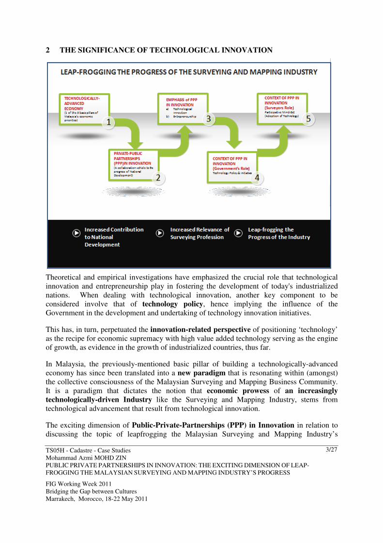
2 THE SIGNIFICANCE OF TECHNOLOGICAL INNOVATION
Theoretical and empirical investigations have emphasized the crucial role that technological
innovation and entrepreneurship play in fostering the development of today's industrialized
nations. When dealing with technological innovation, another key component to be
considered involve that of technology policy, hence implying the influence of the
Government in the development and undertaking of technology innovation initiatives.
This has, in turn, perpetuated the innovation-related perspective of positioning ‘technology’
as the recipe for economic supremacy with high value added technology serving as the engine
of growth, as evidence in the growth of industrialized countries, thus far.
In Malaysia, the previously-mentioned basic pillar of building a technologically-advanced
economy has since been translated into a new paradigm that is resonating within (amongst)
the collective consciousness of the Malaysian Surveying and Mapping Business Community.
It is a paradigm that dictates the notion that economic prowess of an increasingly
technologically-driven Industry like the Surveying and Mapping Industry, stems from
technological advancement that result from technological innovation.
The exciting dimension of Public-Private-Partnerships (PPP) in Innovation in relation to
discussing the topic of leapfrogging the Malaysian Surveying and Mapping Industry’s
TS05H - Cadastre - Case Studies
Mohammad Azmi MOHD ZIN
PUBLIC PRIVATE PARTNERSHIPS IN INNOVATION: THE EXCITING DIMENSION OF LEAP-
FROGGING THE MALAYSIAN SURVEYING AND MAPPING INDUSTRY’S PROGRESS
FIG Working Week 2011
Bridging the Gap between Cultures
Marrakech, Morocco, 18-22 May 2011
4/27
progress, is hinged on these two perspectives: (a) the developmental role of the Malaysian
Government (the role of the Department of Surveying and Mapping Malaysia, DSMM) in
technology policy and innovation-based initiatives and (b) the participative mind-set of
the entrepreneurial-spirited business community of Licensed Land Surveyors, especially in
the area of technology adoption.
Herein, the significance of technology innovation is further amplified in the developmental
role of the DSMM (Malaysian Government) that serves to (forms) lay the foundation for the
envisioned future of the Surveying and Mapping Industry, whilst (strategic) organizations like
the Association of Authorized Land Surveyors Malaysia (PEJUTA) continue to nurture the
enabling environment within which the participative mind-sets of the Licensed Land
Surveyors can survive and thrive.
3 DEFINITIONS: INNOVATION AND PUBLIC-PRIVATE PARTNERSHIPS
From the perspective of the developmental role of the Government on technological
innovation, the emphasis is on systematic innovation which is defined as 'the purposeful and
organized search for changes'. This involves focusing on the need for accelerated growth and
harnessing the abilities of citizens for technological innovation and entrepreneurship.
Additionally, since the Government is paving the way for technological advancement, another
aspect to be considered involves making the appropriate choices of technology.
From the aspect of the participative mind-set of the Licensed Land Surveyors, technology
innovation means a significant change within the organizations within the business
community in question or its line of services or products that (a) requires a substantial
adjustment in functions and/or structures, and (b) that are successfully introduced, decided
upon, and incorporated into the organization.
Public-Private Partnerships (PPPs) are widely recognized as vehicles structured to achieve
a range of public policy goals where PPP projects must be designed to deliver specific
performance improvements within a framework that shares key components between the
public and private sectors. PPPs are long-term partnerships between the public and private
sectors. The benefits of PPPs come in the form of the delivery of improved services and the
delivery of other significant benefits in terms of increased quality of services.
A key feature of Public-Private Partnerships in Innovation as a collaboration vehicle
involves the capitalization of technology innovation as the baseline for fostering smart
partnering relationships between the Government and the Private Sector.
4 MALAYSIA’S TECHNOLOGICAL PROGRESS THUS FAR…
The key technological developments that have been planned and undertaken by the
Government of Malaysia have not only brought about new work patterns across the
management and supporting staff of the Malaysian Government machinery but have also had
a major impact on the work paradigm of Malaysian Licensed Land Surveyors at a National

TS05H - Cadastre - Case Studies
Mohammad Azmi MOHD ZIN
PUBLIC PRIVATE PARTNERSHIPS IN INNOVATION: THE EXCITING DIMENSION OF LEAP-
FROGGING THE MALAYSIAN SURVEYING AND MAPPING INDUSTRY’S PROGRESS
FIG Working Week 2011
Bridging the Gap between Cultures
Marrakech, Morocco, 18-22 May 2011
5/27
Level.
4.1 Driving the Technological Momentum
The Government of Malaysia has been, and will continue to be the catalyst for driving the
wave-of-change in the area of technological advancements.
The Government’s launching of the National IT Agenda (NITA) December in 1996 by the
National IT Council (NITC), has provided the foundation and framework for the utilization of
Information and Communication technology (ICT) to transform Malaysia into a developed
nation in our own mould consistent with Vision 2020.
Part of the delivery of the NITA comprised the National IT Framework (NITF). It was a
strategic and synergistic combination of a number of key components, working in tandem.
Alongside the delivery of the National IT Framework, the rapid development of Information
and Communication Technologies (ICT) had also resulted in widespread reforms in the
surveying and mapping industry.
With the theme "Turning Ripples into Tidal Waves", NITA focused on the development of
people, infostructure and applications (3 levels) to create value, to provide equity and access
to all Malaysians, and to qualitatively transform our society into a values-based knowledge
society by the year 2020.
The enactment of the Licensed Land Surveyors Act 1958 had significantly complemented the
increased visibility of land surveying as a profession in the 1960s that continued to see rapid
progress and advancement in science and technology, communications and software
engineering, as well as airborne and space observation platforms and global positioning and
navigation technologies.
The significant technological progress of Malaysia’s Surveying and Mapping Industry has
since made its major impact at all 3 levels, spearheaded by key applications that were
developed around the Infostructure (information-based platforms) and content needed by
various constituents in the Land Surveying Community.
This emphasis on the development of appropriate and cost effective applications to fulfil the
requirements of National Development has been the key terms of reference for DSMM to
capitalise on this wave-of-change and the government’s commitment to the NITA, thus
resulting in the initiation of the Department’s computerization program since the early 1980’s.
4.2 Surveying and Mapping in Malaysia: Technological Footprints
The expanse and momentum of Surveying and Mapping-related technological initiatives
undertaken by DSMM have been significantly fuelled, in effect, by the Malaysian
Government’s efforts.

TS05H - Cadastre - Case Studies
Mohammad Azmi MOHD ZIN
PUBLIC PRIVATE PARTNERSHIPS IN INNOVATION: THE EXCITING DIMENSION OF LEAP-
FROGGING THE MALAYSIAN SURVEYING AND MAPPING INDUSTRY’S PROGRESS
FIG Working Week 2011
Bridging the Gap between Cultures
Marrakech, Morocco, 18-22 May 2011
6/27
The far-reaching initiative, on the part of the DSMM with its computerization program has, in
itself been the ‘ripple’ that eventually evolved into various ‘tidal waves’ of technological
advancements, that started with the Department’s undertaking of various steps to modernize
its field and office operations.
Over the course of the National Development Plans, DSMM’s ‘in-tandem’ response to driving
the technological advancements, has progressed to include the management of digital spatial
databases as well as the dissemination of geographical information in support of end-users,
especially the growing community of Licensed Land Surveyors.
Some of these technological advancements include:
- Moving from the 1960’s, the need for an effective land information system to assist
planning and development in Malaysia had been felt since the early 1970’s and the
first step towards initiating a Spatial Data Infrastructure was taken in 1992, when the
Malaysian National Infrastructure for Land Information Systems (NaLIS) Task
Force was assembled under the purview of the Ministry of Land and Cooperative
Development (MLCD) to study the possibility of establishing a national information
infrastructure.
Funding the development of NaLIS, which involved the development of standards,
policies, regulations and guidelines and the operations as well as the maintenance of
the NaLIS Clearinghouses including its applications. LRAs continued to fund their
respective programs to collect, produce and maintain Geospatial Information (GI)
under their respective jurisdictions. allocation of funds for the NaLIS was focused on
the implementation of NaLIS throughout the Country in four phases involving the
various states of Malaysia (2001-2004).
- The implementation of the Computerized Mapping System (CAMS), had also
expedited the production of digital and hard copy topographic map series, the creation
and maintenance of National Topographic and Cartographic Databases and the
dissemination of digital spatial information from these databases to all government
agencies including the military. The national coverage for digital topographic maps
were compiled at 1:25,000 and consisting of 1,048 map sheets was completed in 2006.
- a Fast Mapping System (FMS) was commissioned in 1995 to cater for the specific
mapping needs of the military. Besides maintaining an imagery and digital geographic
model database, the FMS was able to ingest non-conventional data from sources such
as satellite imageries to produce fast maps on demand. Interfacing with CAMS it was
also able to generate Digital Elevation Models (DEMS) and geographic data necessary
for aircraft navigation, flight simulation and for mission rehearsal purposes. All in all,
the introduction of FMS had placed the department in the forefront in the application
of new mapping technologies such as digital softcopy photogrammetry and satellite
mapping.

TS05H - Cadastre - Case Studies
Mohammad Azmi MOHD ZIN
PUBLIC PRIVATE PARTNERSHIPS IN INNOVATION: THE EXCITING DIMENSION OF LEAP-
FROGGING THE MALAYSIAN SURVEYING AND MAPPING INDUSTRY’S PROGRESS
FIG Working Week 2011
Bridging the Gap between Cultures
Marrakech, Morocco, 18-22 May 2011
7/27
- In 1995, DSMM embarked on a modernization program that saw the dramatic
computerization of both its office and field processes of its cadastral survey division.
The Digital Cadastral Database (DCDB), which was the crown jewel of the
department, was created by capturing the survey accurate information of all land
parcels. This was the starting point for the e-Cadastre Project
- The Plan was focused on shifting the growth strategy from being input-driven towards
one that is knowledge-driven. Focused on shifting the growth strategy from being
input-driven towards one that is knowledge-driven. Emphasis was given to improving
management and organizational techniques, upgrading R&D and science and
technology, as well as strengthening innovative capacity, thereby enhancing potential
output growth and accelerate structural transformation within the agriculture,
manufacturing and services sectors. The Surveying and Mapping was one of the
service sectors.
- A Utility Mapping Guideline was subsequently initiated by DSMM and was
formulated to provide direction and assistance to the utility agencies.
- In line with the Malaysian government’s efforts to enhance its public delivery system,
DSMM, through the use of real-time GNSS survey technology embarked on a
project aimed at providing centimeter accuracy real-time positioning service through
GNSS network throughout Malaysia.
5 THE BEGINNING OF GOVERNMENT-PRIVATE SECTOR INTERACTIONS
In order to move the NaLIS concept beyond the Government sector to the Private Sector,
there was a need to offer some incentives that would induce Licensed Land Surveying
organisations to participate either or both as a producer or a user of Geospatial Information
(GI).
To fulfill this aspiration, the Government approved the e-Cadastre Project in 2006, where the
primary objective of e-Cadastre was to expedite the delivery system for land title survey. This
entailed the creation of a survey accurate database at the national level and usage of the
Coordinated Cadastral Systems (CCS).
The main objective of CCS was to develop a homogeneous cadastral database based on the
geocentric datum with a spatial accuracy of better than 5 centimeter in urban area and better
than 10 centimeter in semi-urban and rural areas. In order to achieve this intention, a dense
cadastral control infrastructure grid of 0.5km spacing in urban area and 2.5km spacing in
semi-urban and rural areas was established.
The underlying technologies needed included GPS positioning based on GDM2000
geocentric datum, and least squares adjustment. Once the dense cadastral control
infrastructure was established the readjustment of the cadastral network was carried out and
the 2006-2007 adjustment of the National Digital Cadastral Database (NDCDB) was to

TS05H - Cadastre - Case Studies
Mohammad Azmi MOHD ZIN
PUBLIC PRIVATE PARTNERSHIPS IN INNOVATION: THE EXCITING DIMENSION OF LEAP-
FROGGING THE MALAYSIAN SURVEYING AND MAPPING INDUSTRY’S PROGRESS
FIG Working Week 2011
Bridging the Gap between Cultures
Marrakech, Morocco, 18-22 May 2011
8/27
form the base layer for all future title surveys.
The readjustment used least square methodology will distribute the residues homogeneously
in the large cadastral network. Under the e-Cadastre Project, DSMM had envisaged a
significant reduction of time taken in any cadastral survey process from the existing average
of 2 years to within 2 months.
The significant milestone that followed this initiation of e-Cadaster happened during the
period of 2000-2003 during which the development of an Implementation Plan of
Coordinated Cadastral System (CCS) for Peninsular Malaysia was undertaken. This (effort)
signified 2 major milestones for the progress of the Surveying and Mapping Industry.
A significant number of Licensed Land Surveying companies were involved in the CCS
initiative. This collective effort marked one of the first Government-Private Sector
collaboration undertaken at the national level and Licensed Land Surveying practices were
involved in the information-input of the Coordinated Cadastral Survey (CCS), the industry’s
major contribution to National Development.

TS05H - Cadastre - Case Studies
Mohammad Azmi MOHD ZIN
PUBLIC PRIVATE PARTNERSHIPS IN INNOVATION: THE EXCITING DIMENSION OF LEAP-
FROGGING THE MALAYSIAN SURVEYING AND MAPPING INDUSTRY’S PROGRESS
FIG Working Week 2011
Bridging the Gap between Cultures
Marrakech, Morocco, 18-22 May 2011
9/27
6 THE PRE-CURSOR TO THE ENVISIONED FUTURE
At the industry level, in terms of a relevant historical background to the articulation of the
Envisioned Future of the Surveying and Mapping Industry, the Association of Authorized
Land Surveyors Malaysia (PEJUTA) was established, in 1976, with the aim of expanding and
safeguarding the interest of the growing community Malaysian Licensed Land Surveyor
Members via the following key objectives:
a) To foster, preserve and enhance the status, prestige and integrity of the profession
of Land Surveying through the promotion and encouragement of ethical practices by
strict compliance with the code of professional conduct among Members of the
Association;
b) To create and increase awareness in the community of the role and contribution by
Authorised Land Surveyors in National Development;
c) To raise the levels of technical, professional and management expertise among
Members of the Association by promoting continual professional development, the

TS05H - Cadastre - Case Studies
Mohammad Azmi MOHD ZIN
PUBLIC PRIVATE PARTNERSHIPS IN INNOVATION: THE EXCITING DIMENSION OF LEAP-
FROGGING THE MALAYSIAN SURVEYING AND MAPPING INDUSTRY’S PROGRESS
FIG Working Week 2011
Bridging the Gap between Cultures
Marrakech, Morocco, 18-22 May 2011
10/27
upgrading and updating of skills, knowledge and instrumentation;
During the mid-to-latter part of 2006, earnest work began as the Consultative Panel and
PEJUTA's own Strategic Planning Committee became engaged in a series of brainstorming
sessions that were geared towards answering three (3) questions:
a) What does the Surveying and Mapping industry stand for?
b) What kind of industry / practice should the Surveying and Mapping industry seek to
be (over the long-term)?
c) What short-term, medium-term and long-term objectives will help PEJUTA fulfill its
role in the light of the interest of its Members?
The outcome of those meetings spearheaded the development of a Strategic Plan that
encompassed PEJUTA's Mission and Vision statements as well as a Grand Strategy to be
fulfilled via five (5) Strategic Thrusts to accomplish short-, medium- and long-term
objectives.
‘Competitive Advantage through Innovation” was the Strategic Thrust that was subsequently
established to fulfill the ‘Technological Leadership’ long-term objective of the Industry in
the Strategic Plan.
On the other hand, at the national level, Malaysia’s latest Development Plan, the Tenth
Malaysia Plan (2011-2015) was launched this year. The Plan is being implemented based on
strategic thrusts, programmes and allocations which are needed to realize Malaysia’s Vision
2020 and to advance the nation to high-income and developed nation status by 2020.
To achieve the aspirations of the Tenth Malaysia Plan, five key strategic thrusts were
identified. The Strategic Thrusts that are most relevant to the Surveying and Mapping
Industry involve the topic-relevant area of Strategic Thrust 2: ‘Creating a conducive
environment for unleashing economic growth’. This Thrust involves creating a Private
Sector-led Economy, Public-Private Partnerships [PPP], Building World-Class
Infrastructure and Cluster Development.
TS05H - Cadastre - Case Studies
Mohammad Azmi MOHD ZIN
PUBLIC PRIVATE PARTNERSHIPS IN INNOVATION: THE EXCITING DIMENSION OF LEAP-
FROGGING THE MALAYSIAN SURVEYING AND MAPPING INDUSTRY’S PROGRESS
FIG Working Week 2011
Bridging the Gap between Cultures
Marrakech, Morocco, 18-22 May 2011
11/27
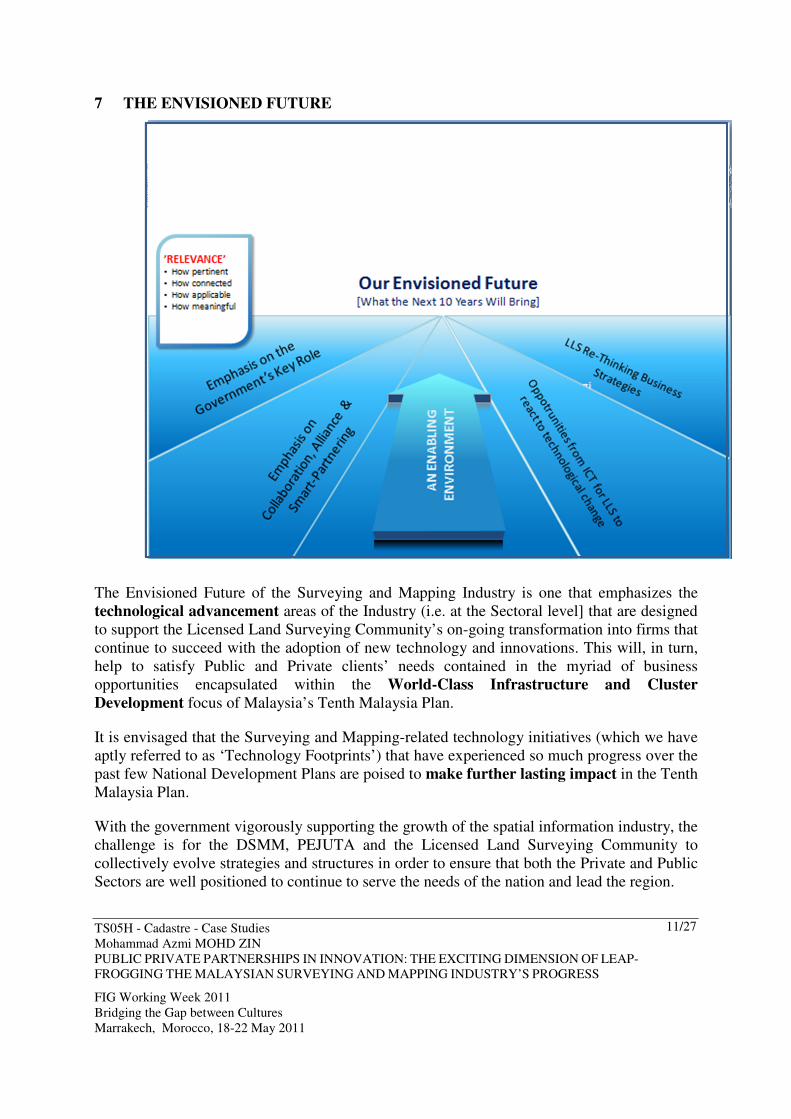
7 THE ENVISIONED FUTURE
The Envisioned Future of the Surveying and Mapping Industry is one that emphasizes the
technological advancement areas of the Industry (i.e. at the Sectoral level] that are designed
to support the Licensed Land Surveying Community’s on-going transformation into firms that
continue to succeed with the adoption of new technology and innovations. This will, in turn,
help to satisfy Public and Private clients’ needs contained in the myriad of business
opportunities encapsulated within the World-Class Infrastructure and Cluster
Development focus of Malaysia’s Tenth Malaysia Plan.
It is envisaged that the Surveying and Mapping-related technology initiatives (which we have
aptly referred to as ‘Technology Footprints’) that have experienced so much progress over the
past few National Development Plans are poised to make further lasting impact in the Tenth
Malaysia Plan.
With the government vigorously supporting the growth of the spatial information industry, the
challenge is for the DSMM, PEJUTA and the Licensed Land Surveying Community to
collectively evolve strategies and structures in order to ensure that both the Private and Public
Sectors are well positioned to continue to serve the needs of the nation and lead the region.

TS05H - Cadastre - Case Studies
Mohammad Azmi MOHD ZIN
PUBLIC PRIVATE PARTNERSHIPS IN INNOVATION: THE EXCITING DIMENSION OF LEAP-
FROGGING THE MALAYSIAN SURVEYING AND MAPPING INDUSTRY’S PROGRESS
FIG Working Week 2011
Bridging the Gap between Cultures
Marrakech, Morocco, 18-22 May 2011
12/27
8 RATIONALE BEHIND THE ENVISIONED FUTURE
Throughout the world, even in developed countries, it is evident that technology innovation
and knowledge creation have become keys to long-term growth and prosperity. These
countries see fundamental combination of technology policy and innovation-related
initiatives as a key strategy to re-invent their economies and to position their countries for
sustainable growth.
The Malaysian Surveying and Mapping industry holds a similar view point that has since
been translated into a recognized need to strengthen the nexus between technology
innovation and entrepreneurship (made possible via vehicles like PPP in Innovation
initiatives) as a key focus of our government. In this context, the emphasis is on
strengthening the technology innovation framework to derive greater economic value from
Public-Private-Partnerships.
8.1 At the Home Front: Challenges Faced by the Industry
Back in 2006, PEJUTA embarked on the development of a Strategic Plan, part of which
involved an initial 5-10 year foresight of issues, assumptions, opportunities and uncertainties
suggests critical choices about potential challenges that both PEJUTA and the Surveying and
Mapping industry might face.
From here, some key challenges were identified where amongst the most significant were:
- more clients seeking Total Solution Providers
- the Government’s aspirations for efficient delivery systems
- adopting available and new technology on the part of Licensed Land Surveyors and
- the high capital investment in technology
When expanded, we have the potentiality of PPP in Innovation initiatives between DSMM
and PEJUTA addressing all three challenges except that of ‘more clients seeking Total
Solution Providers which feature as an indirect challenge that will be addressed when success
milestones are achieved with the PPP in Innovation initiative proposed by PEJUTA to
DSMM). We have firstly, ‘the Government’s aspirations for efficient delivery systems’.
Alongside the delivery of the National IT Framework, the rapid development of Information
and Communication Technologies (ICT) had also resulted in widespread reforms in the
surveying and mapping industry. The significant technological progress of Malaysia’s
Surveying and Mapping Industry has since made its major impact at all 3 levels, spearheaded
by key applications that were developed around the Infostructure (information-based
platforms) and content needed by various constituents in the Land Surveying Community.
Expanding on the challenge related to ‘High Capital Investment in Technology’, the Industry
has been dealing with a scenario where the capital investment on technology related to
TS05H - Cadastre - Case Studies
Mohammad Azmi MOHD ZIN
PUBLIC PRIVATE PARTNERSHIPS IN INNOVATION: THE EXCITING DIMENSION OF LEAP-
FROGGING THE MALAYSIAN SURVEYING AND MAPPING INDUSTRY’S PROGRESS
FIG Working Week 2011
Bridging the Gap between Cultures
Marrakech, Morocco, 18-22 May 2011
13/27
Surveying and Mapping can be a significant burden to bear in the Surveying and Mapping
industry. Often times, Licensed Land Surveyors face mounting challenges in obtaining the
required funding to finance their projects, especially those that require advanced surveying
and mapping technologies.
The remaining challenge, that of the ‘adoption of available and new technology on the part of
Licensed Land Surveyors’, constitutes the fact that the Land Surveying profession, over the
years, have been facing multiple challenges, including an ever accelerating rate of
technological changes. Too often Licensed Land Surveyors found themselves having to focus
on crisis management instead of planning how we can strategically respond to present and
future challenges, especially those posed by technological developments.
All three ‘challenging scenarios’ has culminated in the critical need for both new and existing
Land Surveyors to create and maintain viable and sustainable businesses.
8.2 Global Trends
Global trends continue to emphasize ‘Technology Development’ as the major driving force in
the progressive evolution of the Survey and Mapping Industry.
In particular, we have the advent of GPS technologies, high resolution satellite imagery, GIS
technologies and not forgetting the World Wide Web and Internet that has been touted as the
potential major medium for viewing and access to spatial data.
Furthermore, we have been observing the global trends on the adoption of Continuous
Operating Reference Stations and in particular, a technology that we are familiar with - the
utilization of the Global Satellite Navigation Systems.
Additionally, there is the Spatial Data Infrastructure [SDI] where Governments worldwide are
creating policies and initiatives that emphasize partnerships between the public and private
sector in the creation of infrastructure or enabling platforms.
All this goes to highlight the importance of innovation as more than just technology
innovation activities that include continuous improvements in product or service design and
quality, changes in routines and modifications to production processes.

TS05H - Cadastre - Case Studies
Mohammad Azmi MOHD ZIN
PUBLIC PRIVATE PARTNERSHIPS IN INNOVATION: THE EXCITING DIMENSION OF LEAP-
FROGGING THE MALAYSIAN SURVEYING AND MAPPING INDUSTRY’S PROGRESS
FIG Working Week 2011
Bridging the Gap between Cultures
Marrakech, Morocco, 18-22 May 2011
14/27
9 SETTING THE STAGE FOR THE ‘RIPPLE’ EFFECT VIA PPP IN
INNOVATION
When PEJUTA and its stakeholders went into action to establish a compelling picture of the
Envisioned Future, one major viewpoint was discussed and deliberated many times. The word
‘Relevance’ seemed to hold the greatest meaning for the team.
The word ‘Relevance’ covers four (4) key areas - how pertinent [or how significant], how
connected, how applicable and how meaningful. Hence, when we set our sights on the next 10
years, we were focused on:
- How applicable our current business strategies will be
- How connected we will need to be in order that we can rally our collective strengths to
face the on-set of Liberalization in 2012.
- How significant or pertinent ICT will be, as an enabler in enhancing the efficient
delivery of our services, our competitive edge and our range of service offerings in
meeting the expectation of clients who are increasingly demanding not only quality
but efficiency and creative solutions.

TS05H - Cadastre - Case Studies
Mohammad Azmi MOHD ZIN
PUBLIC PRIVATE PARTNERSHIPS IN INNOVATION: THE EXCITING DIMENSION OF LEAP-
FROGGING THE MALAYSIAN SURVEYING AND MAPPING INDUSTRY’S PROGRESS
FIG Working Week 2011
Bridging the Gap between Cultures
Marrakech, Morocco, 18-22 May 2011
15/27
- What kind of meaningful relationships can we establish with our government agencies
and bodies where we can leverage each other’s strengths to better the environment for
our Licensed Land Surveying community.
All these four areas of ‘relevance’ have been the major influences on how PEJUTA
presents itself to the world and to its members under the overarching umbrella of the
Envisioned Future.
In this respect PEJUTA has been working on developing and nurturing an enabling
environment to ‘make things happen’ via the exploration of more meaningful relationships
that can be established with our Government. This effort, in effect, has contributed to the
exciting dimension of initiating Public-Private Partnerships in Innovation as the
significant vehicle to take things forward.
9.1 The Collaboration Vision
During the course of developing the Collaboration Vision for the PPP in Innovation with

TS05H - Cadastre - Case Studies
Mohammad Azmi MOHD ZIN
PUBLIC PRIVATE PARTNERSHIPS IN INNOVATION: THE EXCITING DIMENSION OF LEAP-
FROGGING THE MALAYSIAN SURVEYING AND MAPPING INDUSTRY’S PROGRESS
FIG Working Week 2011
Bridging the Gap between Cultures
Marrakech, Morocco, 18-22 May 2011
16/27
DSMM, the need to visualize what each scenario would be like for us in the Envisioned
Future was a priority because the clearer the picture, the sharper the focus of on our goals and
plans for the next 10 years.
Beginning with the notion that Innovation should be viewed as the identification and
application of new ideas, opportunities, technologies and partnerships, it is, in effect, a social
process shaped by all parties involved and the Collaboration equation of DSMM and
PEJUTA.
As such, increased collaboration, alliances and smart-partnerships amongst Licensed
Land Surveyors were target areas identified with the aim of addressing competitive
advantage factors like accelerated use of technology and high capital investment.
This has subsequently triggered increased attention and emphasis on the Government’s key
role in business environment enhancing policies, regulatory frameworks and more efficient
delivery systems.
Any major initiative needs to realize a compelling vision while being guided by a purposeful
mission. PEJUTA’s proposed Collaborative Vision is one that focuses on ‘Reinforced
Relevance of the LLS Profession and Surveying and Mapping Industry’.
This Vision is supported by fulfilling the shared mission of ‘Enhancing the Enabling
Environment for Licensed Land Surveyors through an Innovation-Driven collaboration.’
9.2 The DSMM-PEJUTA Collaboration Strategy
In exploring the Synergy Equation of this promising relationship between two single-minded
organizations, the collaboration areas will involve constantly enhancing an innovation-driven
infrastructure and helping our Licensed Land Surveyors to adapt into a future that
progressively emphasizes the importance of technology and innovation.
Pursuant to the dimension of ‘vision’, PEJUTA’s proposed collaboration strategy
encompasses PEJUTA’s sincere intention to inspire everyone into taking action along the
lines of the DSMM-PEJUTA-LLS Vision in terms of Partnership and Participation.

TS05H - Cadastre - Case Studies
Mohammad Azmi MOHD ZIN
PUBLIC PRIVATE PARTNERSHIPS IN INNOVATION: THE EXCITING DIMENSION OF LEAP-
FROGGING THE MALAYSIAN SURVEYING AND MAPPING INDUSTRY’S PROGRESS
FIG Working Week 2011
Bridging the Gap between Cultures
Marrakech, Morocco, 18-22 May 2011
17/27
9.3 Synergy of Visions
The complementary aspects of the Visions of DSMM, PEJUTA and the Collaborative Vision
help to emphasize the subject matter of ‘Relevance’.
The relevance of DSMM’s Vision to the Collaborative Vision comes in the form of DSMM’s
on-going role that emphasizes extending its geospatial data management system to Licensed
Land Surveyors, ie. an innovation-driven infrastructure.
The relevance of PEJUTA’s Vision to the Collaborative Vision involves the fact that its
Vision is one that is focused on Licensed Land Surveyors. It is the aspiration on which the
Collaborative Vision has been developed.
Here, the emphasis on the dynamic and agile community of professionals is on the
adaptability of Licensed Land Surveyors to the scenario of continuous technological
developments in Surveying and Mapping that have opened up opportunities in new types of
services like Utilities Mapping, GIS, maritime and hydrographical surveys.
The resulting Relevance of the Licensed Land Surveying Community, as a result of the
achieving success milestones in line with the two Visions, will in turn impact the quality of

TS05H - Cadastre - Case Studies
Mohammad Azmi MOHD ZIN
PUBLIC PRIVATE PARTNERSHIPS IN INNOVATION: THE EXCITING DIMENSION OF LEAP-
FROGGING THE MALAYSIAN SURVEYING AND MAPPING INDUSTRY’S PROGRESS
FIG Working Week 2011
Bridging the Gap between Cultures
Marrakech, Morocco, 18-22 May 2011
18/27
services delivered that benefit end users and national development on a wider scale, thus
complementing DSMM’s Vision of making DSMM a distinguished agency.
9.4 Synergy of Missions
PEJUTA’s endeavor to create and enhance the Enabling Environment to support Licensed
Land Surveyors, is in alignment with PEJUTA’s ongoing intention to ensure that its members
are given the best chances of success.
The evolution from Vendor-type services to Specialist-type Providers and eventually Total
Solution Providers and Game Changers require the grounding of innovation. This is where
Innovation and technological developments can offer the cutting-edge to Licensed Land
Surveyors to be more competitive and efficient.
The Survey and Mapping services and excellent geospatial data management system that
DSMM has always aspired to develop and improve, has seen the light of success in the
development of the Geospatial portal and other nation-wide initiatives like e-Cadaster.
Further collaboration in this area between DSMM and PEJUTA especially in the area of the
joint capability development of Licensed Land Surveyors and access to the technological

TS05H - Cadastre - Case Studies
Mohammad Azmi MOHD ZIN
PUBLIC PRIVATE PARTNERSHIPS IN INNOVATION: THE EXCITING DIMENSION OF LEAP-
FROGGING THE MALAYSIAN SURVEYING AND MAPPING INDUSTRY’S PROGRESS
FIG Working Week 2011
Bridging the Gap between Cultures
Marrakech, Morocco, 18-22 May 2011
19/27
advancement initiatives will be a big booster for the Community.
10 ATTAINING THE ENVISIONED FUTURE
It is envisaged that there are three key areas which will continue to propel the Malaysian
Surveying and Mapping Industry:
a) At the DSMM level, further enhancements of land related information systems in the
country in support of the government’s effort in enhancing our ‘Electronic
Government’ delivery systems which will bring us closer to our unified aspiration of
achieving a knowledge-based K-economy;
b) DSMM will continue on its innovation journey with the advancement and
enhancement of e-Cadaster, and the Geodetic Infrastructure [Global Positioning
System, MyRTKNet, Tidal Observation, Levelling Network, Gravity Survey and
Boundaries.
c) Driving momentum in capability and capacity building in acknowledgement that
growth will be led by the services and manufacturing sectors, adoption of ICT,
biotechnology and other relevant technologies.
In effect, Malaysia will be witnessing in the next few years, the leapfrogging endeavours of
DSMM working in tandem with the Surveying and Mapping Community to continue to
harness the advancements in ICT to implement its strategic modernisation plans.
In so doing, DSSM will be able to fulfil its mission of providing digital spatial data as well as
the geodetic referencing framework in support of the development of geographic and land
information systems in the country.

TS05H - Cadastre - Case Studies
Mohammad Azmi MOHD ZIN
PUBLIC PRIVATE PARTNERSHIPS IN INNOVATION: THE EXCITING DIMENSION OF LEAP-
FROGGING THE MALAYSIAN SURVEYING AND MAPPING INDUSTRY’S PROGRESS
FIG Working Week 2011
Bridging the Gap between Cultures
Marrakech, Morocco, 18-22 May 2011
20/27
10.1 Interplays for the Envisioned Future
PEJUTA’s proposed collaboration under the banner of ‘PPP in Innovation’ seeks to adopt a
participatory approach involving the Government (DSMM), PEJUTA and the Licensed Land
Surveying business community.
To set thing in motion, there are four key areas to potentially work on.
We call it the ‘3-A mind-set shift’ that is supported by Forward Planning tasks to consolidate
and to sustain the right partnership and participation culture for the common journey towards
the Envisioned Future.
Here, we have mapped in the 3 key areas of the Envisioned Future in the context of:
- Firstly, the need for DSMM and PEJUTA to be constantly ‘Apprehensive’, meaning
being alert and open to possibilities, about the potential and pervasive impact of ICT
and related surveying and mapping technology.
- Secondly, for DSMM and PEJUTA to be in an ‘Anticipative’ mould that places
priority in collaboration and working together to achieve mutually-beneficial success
in project undertakings and competitive advantage, especially when Liberalization will
TS05H - Cadastre - Case Studies
Mohammad Azmi MOHD ZIN
PUBLIC PRIVATE PARTNERSHIPS IN INNOVATION: THE EXCITING DIMENSION OF LEAP-
FROGGING THE MALAYSIAN SURVEYING AND MAPPING INDUSTRY’S PROGRESS
FIG Working Week 2011
Bridging the Gap between Cultures
Marrakech, Morocco, 18-22 May 2011
21/27
be hitting our shores by 1 Jan 2012.
- The next major mind-set shift will be for Licensed Land Surveyors to consider re-
thinking their business strategies (‘Adaptability’) to complement the joint initiatives of
DSMM and PEJUTA.
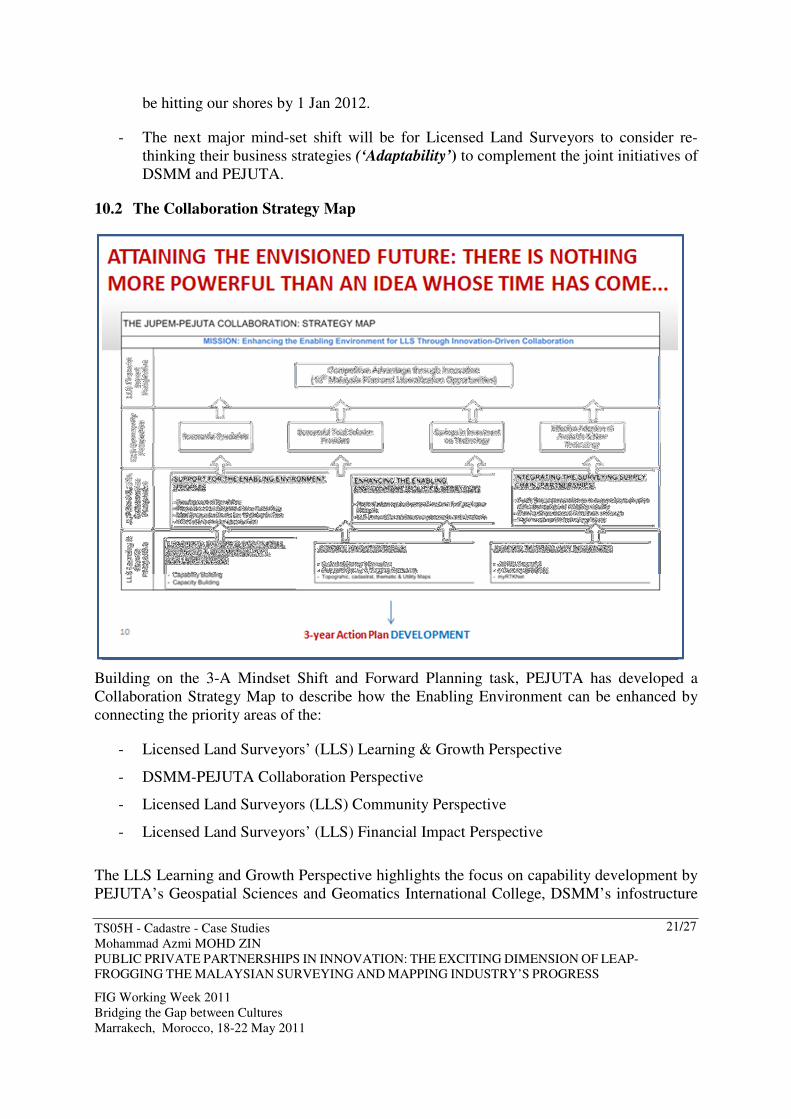
10.2 The Collaboration Strategy Map
Building on the 3-A Mindset Shift and Forward Planning task, PEJUTA has developed a
Collaboration Strategy Map to describe how the Enabling Environment can be enhanced by
connecting the priority areas of the:
- Licensed Land Surveyors’ (LLS) Learning & Growth Perspective
- DSMM-PEJUTA Collaboration Perspective
- Licensed Land Surveyors (LLS) Community Perspective
- Licensed Land Surveyors’ (LLS) Financial Impact Perspective
The LLS Learning and Growth Perspective highlights the focus on capability development by
PEJUTA’s Geospatial Sciences and Geomatics International College, DSMM’s infostructure
TS05H - Cadastre - Case Studies
Mohammad Azmi MOHD ZIN
PUBLIC PRIVATE PARTNERSHIPS IN INNOVATION: THE EXCITING DIMENSION OF LEAP-
FROGGING THE MALAYSIAN SURVEYING AND MAPPING INDUSTRY’S PROGRESS
FIG Working Week 2011
Bridging the Gap between Cultures
Marrakech, Morocco, 18-22 May 2011
22/27
[which comprises the delivery system of DSMM’s Geospatial Data management System] and
DSMM’s technology initiatives like the DSMM Geoportal, e-Cadaster and myRTKNet.
The Learning and Growth Perspective will feature the 3-year Acton Plan as its deliverable
under the Partnership umbrella of PEJUTA’s Industry Engagement Model.
The DSMM-PEJUTA Collaboration Perspective will feature the implementation of the 3-year
Action Plan developed under the LLS Learning and Growth Perspective.
Specific Key Results Areas (KRAs) have been mapped onto this alignment focus aspect of the
Collaboration Strategy Map. They have been drawn up in relation to:
- Support for the Enabling Environment
- Enhancing the Enabling Environment
- Integrating the Surveying Supply Chain
The alignment of all parties, within this framework will set its sight on fulfilling the Mission
and move towards realizing the Collaborative Vision.
11 THE ’END OF THE RAINBOW’ OF LEAPFROGGING: SIGNIFICANT
PROGRESS MILESTONES
So, what is it about our Envisioned Future that makes it so compelling and one that is set to
drive significant progress in the next three years? Firstly, the Envisioned Future offers an
interesting array of ‘distant’ scenarios that were the foundations upon which PEJUTA has
developed the impactful strategy for collaboration between DSMM and PEJUTA.
In terms of the scenarios, we will experience scenarios that represent the new business mind-
set of licensed land surveyors...
- Partnering aimed at enhancing competitive edge
- Vendor-type and Specialist-type of Land Surveyors changing the way they do business
and moving towards multi-disciplinary quality services.
- Emphasis on Total Solution Providers comprising competent land surveying teams
armed offering high-value consultancy and innovative solutions.
- The prominence of Mutual Recognition of professional qualification as the device for
facilitating the efficient mobility of surveyors, where Liberalization will be opening up
opportunities for the Land Surveying Community to venture abroad.
- In the ICT arena, we have the emergence of ICT-related challenges that encourage
renewed efforts in opportunity-seeking Research and Development.
- Coupled with that, we have a knowledge management support-system that supports

TS05H - Cadastre - Case Studies
Mohammad Azmi MOHD ZIN
PUBLIC PRIVATE PARTNERSHIPS IN INNOVATION: THE EXCITING DIMENSION OF LEAP-
FROGGING THE MALAYSIAN SURVEYING AND MAPPING INDUSTRY’S PROGRESS
FIG Working Week 2011
Bridging the Gap between Cultures
Marrakech, Morocco, 18-22 May 2011
23/27
new high-technology endeavours like utility mapping, space imagery, GIS-based
analysis, maritime and hydrographical surveys, e-Survey services and the on-going
operation of myRTKNet.
- We can expect increased collaboration, alliances and smart-partnerships amongst
Licensed Land Surveyors to address competitive advantage factors like accelerated
use of technology and high capital investment. This will trigger increased attention
and emphasis on the Government’s key role in business environment enhancing
policies, regulatory frameworks and more efficient delivery systems.
With the successful implementation of the Collaboration Strategy Map, the corresponding
success milestones will be experienced by the Licensed Land Surveying Community in four
areas:
- Successful Specialists
- Successful Total Solution Providers
- Savings in Investment on Technology
- Effective Adoption of Available and New Technology
The visibility of these milestones would mean that the DSMM-PEJUTA Collaboration has
been strategically relevant to the performance of the Licensed Land Surveying Community.
The success milestones achieved by the LLS Community will eventually impact the Licensed
Land Surveyors’ Financial Impact Perspective of the Collaboration Strategy Map.
The Financial Impact perspective offers the medium to long-term view of value and benefits
to the business sustainability of Licensed Land Surveyors’ professional practices.
Within this context, the Financial Impact Perspective emphasizes two scenarios, achieved
through the stages of realizing the deliverables of the 3-Year Action Plan developed under the
LLS Learning and Growth Perspective:
- Competitive Advantage through Innovation, and
- Significant revenue garnered from engagement and participation in business
opportunities from the 10th Malaysia Plan and Liberalization.
12 THE QUEST FOR FORESIGHT: BRIDGING THE GAPS BETWEEN
CULTURES
In taking the context of the DSMM-PEJUTA collaboration Strategy map ‘across geographical
borders’ within the FIG and to create this exciting collaborative future, requires a global
industry foresight.
Here, we would rather talk about foresight than vision. This global industry foresight should

TS05H - Cadastre - Case Studies
Mohammad Azmi MOHD ZIN
PUBLIC PRIVATE PARTNERSHIPS IN INNOVATION: THE EXCITING DIMENSION OF LEAP-
FROGGING THE MALAYSIAN SURVEYING AND MAPPING INDUSTRY’S PROGRESS
FIG Working Week 2011
Bridging the Gap between Cultures
Marrakech, Morocco, 18-22 May 2011
24/27
be based on deep and mutually-focused insights into trends in technology, regulations and
legislative frameworks which can be harnessed to rewrite industry rules and create new
‘collaborative space’.
The overall theme of the FIG Working Week is “Bridging the Gap between Cultures”. The
theme addresses the changes in current world and the importance of cultures and
understanding the differences in different parts of the world including professional
development, traditions and legislation at the same time when the world is more harmonised
with common standards and global markets. It is acknowledged that these issues are also
being faced by surveying profession in all its fields.
By lending a new dimension to Technology Innovation and to the FIG working theme,
PEJUTA is offering the concept of ‘Bridging the Gaps of Systematic Innovation between
working cultures within the FIG’ as a theme for future collaboration between FIG members.
For this reason, the global industry foresight will be a synthesis of many FIG organizations’
visions.
Given that technological change is inevitable, the real issue for FIG members is whether that
change will happen belatedly, in a crisis atmosphere, or with foresight, in a calm and
considered manner; whether transformation will be spasmodic and radical or continuous and
peaceful.
Hence, the appropriate perspective on nurturing the global industry foresight on systematic
innovation should emphasise the real objective of collaboration across borders as
revolutionary in result and evolutionary in execution. This notion further reinforces the view
about the future where it should be an ongoing initiative sustained by continuous discussions
amongst FIG members, not a massive one-time effort.

TS05H - Cadastre - Case Studies
Mohammad Azmi MOHD ZIN
PUBLIC PRIVATE PARTNERSHIPS IN INNOVATION: THE EXCITING DIMENSION OF LEAP-
FROGGING THE MALAYSIAN SURVEYING AND MAPPING INDUSTRY’S PROGRESS
FIG Working Week 2011
Bridging the Gap between Cultures
Marrakech, Morocco, 18-22 May 2011
25/27
Potentially, 3 Key Results Areas can be mapped into the expanded context of the DSMM-
PEJUTA PPP in Innovation Model (these are the same three Key Results Areas adopted under
the DSMM-PEJUTA Collaboration):
- Support for the Enabling Environment
- Enhancing the Enabling Environment
- Integrating the Surveying Supply Chain
12.1 The Potential Impact of Partnering for a Collective Global Technology Innovation
Creating the future of global technology transformation must be driven by a point of view
about the future of the global industry: How do we want this global industry to be shaped in
five or ten years?
What must we do to ensure that the global industry evolves in a way that is maximally
TS05H - Cadastre - Case Studies
Mohammad Azmi MOHD ZIN
PUBLIC PRIVATE PARTNERSHIPS IN INNOVATION: THE EXCITING DIMENSION OF LEAP-
FROGGING THE MALAYSIAN SURVEYING AND MAPPING INDUSTRY’S PROGRESS
FIG Working Week 2011
Bridging the Gap between Cultures
Marrakech, Morocco, 18-22 May 2011
26/27
advantageous for us, the members of FIG? What skills and capabilities must we begin
building now if we are to occupy the industry high ground in the future? How should we
organize for opportunities that may not fit neatly within the boundaries of current industries
and business?
As a series of multiple motives for an alliance amongst FIG members, PEJUTA seek to
recommend that it will be useful to group the rationale for collaboration into technological
and market motives to be discussed within the boundaries of the three Key Results Areas.
Technological reasons should include the cost, time and complexity of development. In the
current highly competitive business environment, the R&D function, and to examine critically
whether in-country development is the most efficient approach. Other potential areas include
deriving Quick Wins from the identification of PPP opportunities in our respective countries,
addressing issues related to high-capital investment in technology, and best practice sharing
and networking.
This potential scenario will subsequently result in discussions on an ‘Innovation-Driven
Partnering’ approach to advance industry and economic development, where the addition of
the element of Innovation into the partnership equation amongst FIG members, can become a
potent platform that could potentially leapfrog the progress of a global industry that has
become reliant on the advent of technology to progress further and perform better.
12.2 Furthering the Ties between FIG Members: Where It Matters
PEJUTA’s proposal on the initiation of Partnering for a Collective Global Technology
Innovation is meant to go beyond just getting to know better the cultural differences between
FIG Member countries, and to accept each other despite the differences.
We are talking about considering an exciting dimension of innovation-themed collaboration to
improve cooperation across all borders, a unifying model for each member country of the FIG
to make a success out of Liberalization instead of fearing its impact on our respective home
base, and synergistic relationships.
With this proposal, PEJUTA acknowledges the final ‘take away’ for the participants at the
FIG Working Week (from this Paper), will be a discussion on the promising scenario when
the context of the Collaboration Strategy Map is taken across geographical borders. We
envisage that the building blocks contained within the DSMM-PEJUTA Collaboration
Strategy Map will lend additional meaning to the Conference theme of “Bridging the Gaps
between Cultures”.
13 PPP IN INNOVATION: A TRULY EXCITING DIMENSION
British writer, T.S. Eliot, once said: “Only those who will risk going too far can possibly find
out how far one can go.” This is true of most developing and advanced nations of the world
who are all aiming far above the ground and gazing with colossal foresight.

TS05H - Cadastre - Case Studies
Mohammad Azmi MOHD ZIN
PUBLIC PRIVATE PARTNERSHIPS IN INNOVATION: THE EXCITING DIMENSION OF LEAP-
FROGGING THE MALAYSIAN SURVEYING AND MAPPING INDUSTRY’S PROGRESS
FIG Working Week 2011
Bridging the Gap between Cultures
Marrakech, Morocco, 18-22 May 2011
27/27
In the years to come, PEJUTA hopes that the World will witness significant milestones in
smart and effective partnerships between the Public and Private sectors amongst Malaysians
to spearhead the wave of continuous change that is felt by the survey and mapping profession
in the country.
In the years to come, it is PEJUTA’s sincere hopes to see FIG member countries embarking
on meaningful and impact partnerships in Technology Innovation that would have referenced
its Collaboration Strategy Map as a baseline for execution.
REFERENCES
PEJUTA Strategic Plan 2007 – 2017
PEJUTA Implementation Roadmap (March 2011)
CONTACTS
Title:
Mohammad Azmi MOHD ZIN
President
Institution:
Association of Authorized Land Surveyors Malaysia
Address:
2735A, Jalan Permata 4,
Taman Permata,
Ulu Kelang 53300
City
Kuala Lumpur
COUNTRY:
Malaysia
Tel. + 603 41088540
Fax + 603 41071140
Email: [email protected]
Web site: www.pejuta.com.my