Embed Size (px)
Citation preview
Thurrock - An ambitious and collaborative community which is proud of its heritage and excited by its diverse opportunities and future
Planning Committee
The meeting will be held at 7.00 pm on 10 January 2019
Council Chamber, Civic Offices, New Road, Grays, Essex, RM17 6SL
Membership:
Councillors Tom Kelly (Chair), Steve Liddiard (Vice-Chair), Colin Churchman, Graham Hamilton, Angela Lawrence, David Potter, Gerard Rice, Sue Sammons and Sue Shinnick
Steve Taylor, Campaign to Protect Rural England Representative
Substitutes:
Councillors Abbie Akinbohun, Clare Baldwin, Garry Hague, Victoria Holloway, Susan Little and Peter Smith
Agenda
Open to Public and Press
Page
1 Apologies for Absence
2 Minutes 5 - 20
To approve as a correct record the minutes of the Planning Committee meeting held on 22 November 2018
3 Item of Urgent Business
To receive additional items that the Chair is of the opinion should be considered as a matter of urgency, in accordance with Section 100B (4) (b) of the Local Government Act 1972.
4 Declaration of Interests
5 Declarations of receipt of correspondence and/or any
meetings/discussions held relevant to determination of any planning application or enforcement action to be resolved at this meeting
6 Planning Appeals 21 - 28
7 Public Address to Planning Committee
The Planning Committee may allow objectors and applicants/planning agents, and also owners of premises subject to enforcement action, or their agents to address the Committee. The rules for the conduct for addressing the Committee can be found on Thurrock Council’s website at https://www.thurrock.gov.uk/democracy/constitution Chapter 5, Part 3 (c).
8 18/01709/FUL - Thurrock Rugby Club, Long Lane, Stifford Clays, Grays Essex RM16 2QH
29 - 56
9 18/01228/FUL - 53 - 55 Third Avenue, Stanford Le Hope Essex 57 - 74
10 18/01442/FUL - Land At Bridge Court, Bridge Road, Grays Essex 75 - 84
11 18/01613/FUL - 55 Corringham Road, Stanford Le Hope Essex SS17 0NU
85 - 94
12 18/00540/FUL - Town Centre Car Park, King Street, Stanford Le Hope Essex
95 - 126
13 18/01508/TBC - Civic Amenity site, Buckingham Hill Road, Linford Essex
127 - 156
Queries regarding this Agenda or notification of apologies:
Please contact Tisha Sutcliffe, Democratic Services Officer by sending an email to [email protected]
Agenda published on: 2 January 2019

Information for members of the public and councillors
Access to Information and Meetings
Members of the public can attend all meetings of the council and its committees and have the right to see the agenda, which will be published no later than 5 working days before the meeting, and minutes once they are published.
Recording of meetings
This meeting may be recorded for transmission and publication on the Council's website. At the start of the meeting the Chair will confirm if all or part of the meeting is to be recorded.Members of the public not wishing any speech or address to be recorded for publication to the Internet should contact Democratic Services to discuss any concerns.If you have any queries regarding this, please contact Democratic Services at [email protected]
Guidelines on filming, photography, recording and use of social media at council and committee meetings
The council welcomes the filming, photography, recording and use of social media at council and committee meetings as a means of reporting on its proceedings because it helps to make the council more transparent and accountable to its local communities.If you wish to film or photograph the proceedings of a meeting and have any special requirements or are intending to bring in large equipment please contact the Communications Team at [email protected] before the meeting. The Chair of the meeting will then be consulted and their agreement sought to any specific request made.Where members of the public use a laptop, tablet device, smart phone or similar devices to use social media, make recordings or take photographs these devices must be set to ‘silent’ mode to avoid interrupting proceedings of the council or committee.The use of flash photography or additional lighting may be allowed provided it has been discussed prior to the meeting and agreement reached to ensure that it will not disrupt proceedings.The Chair of the meeting may terminate or suspend filming, photography, recording and use of social media if any of these activities, in their opinion, are disrupting proceedings at the meeting.
Page 1
Thurrock Council Wi-Fi
Wi-Fi is available throughout the Civic Offices. You can access Wi-Fi on your device by simply turning on the Wi-Fi on your laptop, Smartphone or tablet.
You should connect to TBC-CIVIC
Enter the password Thurrock to connect to/join the Wi-Fi network.
A Terms & Conditions page should appear and you have to accept these before you can begin using Wi-Fi. Some devices require you to access your browser to bring up the Terms & Conditions page, which you must accept.
The ICT department can offer support for council owned devices only.
Evacuation Procedures
In the case of an emergency, you should evacuate the building using the nearest available exit and congregate at the assembly point at Kings Walk.
How to view this agenda on a tablet device
You can view the agenda on your iPad, Android Device or Blackberry Playbook with the free modern.gov app.
Members of the Council should ensure that their device is sufficiently charged, although a limited number of charging points will be available in Members Services.
To view any “exempt” information that may be included on the agenda for this meeting, Councillors should:
Access the modern.gov app Enter your username and password
Page 2
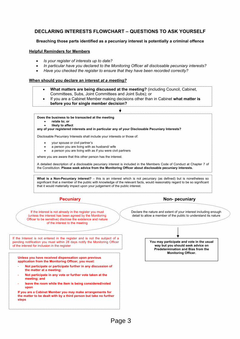
DECLARING INTERESTS FLOWCHART – QUESTIONS TO ASK YOURSELF
Breaching those parts identified as a pecuniary interest is potentially a criminal offence
Helpful Reminders for Members
Is your register of interests up to date? In particular have you declared to the Monitoring Officer all disclosable pecuniary interests? Have you checked the register to ensure that they have been recorded correctly?
When should you declare an interest at a meeting?
What matters are being discussed at the meeting? (including Council, Cabinet, Committees, Subs, Joint Committees and Joint Subs); or
If you are a Cabinet Member making decisions other than in Cabinet what matter is before you for single member decision?
Does the business to be transacted at the meeting relate to; or likely to affect
any of your registered interests and in particular any of your Disclosable Pecuniary Interests?
Disclosable Pecuniary Interests shall include your interests or those of:
your spouse or civil partner’s a person you are living with as husband/ wife a person you are living with as if you were civil partners
where you are aware that this other person has the interest.
A detailed description of a disclosable pecuniary interest is included in the Members Code of Conduct at Chapter 7 of the Constitution. Please seek advice from the Monitoring Officer about disclosable pecuniary interests.
What is a Non-Pecuniary interest? – this is an interest which is not pecuniary (as defined) but is nonetheless so significant that a member of the public with knowledge of the relevant facts, would reasonably regard to be so significant that it would materially impact upon your judgement of the public interest.
If the Interest is not entered in the register and is not the subject of a pending notification you must within 28 days notify the Monitoring Officer of the interest for inclusion in the register
Unless you have received dispensation upon previous application from the Monitoring Officer, you must:- Not participate or participate further in any discussion of
the matter at a meeting; - Not participate in any vote or further vote taken at the
meeting; and- leave the room while the item is being considered/voted
uponIf you are a Cabinet Member you may make arrangements for the matter to be dealt with by a third person but take no further steps
If the interest is not already in the register you must (unless the interest has been agreed by the Monitoring
Officer to be sensitive) disclose the existence and nature of the interest to the meeting
Declare the nature and extent of your interest including enough detail to allow a member of the public to understand its nature
Non- pecuniaryPecuniary
You may participate and vote in the usual way but you should seek advice on Predetermination and Bias from the
Monitoring Officer.
Page 3

Our Vision and Priorities for Thurrock
An ambitious and collaborative community which is proud of its heritage and excited by its diverse opportunities and future.
1. People – a borough where people of all ages are proud to work and play, live and stay
High quality, consistent and accessible public services which are right first time
Build on our partnerships with statutory, community, voluntary and faith groups to work together to improve health and wellbeing
Communities are empowered to make choices and be safer and stronger together
2. Place – a heritage-rich borough which is ambitious for its future
Roads, houses and public spaces that connect people and places
Clean environments that everyone has reason to take pride in
Fewer public buildings with better services
3. Prosperity – a borough which enables everyone to achieve their aspirations
Attractive opportunities for businesses and investors to enhance the local economy
Vocational and academic education, skills and job opportunities for all
Commercial, entrepreneurial and connected public services
Page 4
Minutes of the Meeting of the Planning Committee held on 22 November 2018 at 7.00 pm
Present: Councillors Tom Kelly (Chair), Steve Liddiard (Vice-Chair), Colin Churchman, Andrew Jefferies, Angela Lawrence, Terry Piccolo, Gerard Rice and Sue Shinnick
Steve Taylor, Campaign to Protect Rural England Representative
Apologies: Councillors Sue Sammons
In attendance:Andrew Millard, Assistant Director - Planning, Transport and Public ProtectionLeigh Nicholson, Strategic Lead - Development ServicesBob Capstick, Locum Solicitor Comfort Onipede, Trainee Solicitor Keith Andrews, Housing Development ManagerJulian Howes, Senior EngineerGenna Henry, Senior Planning Officer Chris Purvis, Principal Planner (Major Applications)Nadia Houghton, Principal plannerJonathan Keen, Principal PlannerTom Scriven, Principal Planner Tisha Sutcliffe, Democratic Service Officer
Before the start of the Meeting, all present were advised that the meeting may be filmed and was being recorded, with the audio recording to be made available on the Council’s website.
60. Minutes
The minutes of the Planning Committee meeting held on 18 October 2018were approved as a correct record, with a slight amendment on item 18/00887/FUL as Councillor Lawrence had been recorded as abstaining and voting for the application. The correct vote was noted as abstained.
61. Item of Urgent Business
There were no items of urgent business
62. Declaration of Interests
There were no interests declared.
Page 5
Agenda Item 2
63. Declarations of receipt of correspondence and/or any meetings/discussions held relevant to determination of any planning application or enforcement action to be resolved at this meeting
The Chair declared on behalf of all Committee Members that he received correspondence in regards to the following applications: 15/00234/FUL Land off and Adjacent to School, Manor Road (Deferred) and 18/00994/FUL Former Harrow Inn, Harrow Lane, Bulphan (Deferred). The correspondence was circulated in favour of the applications.
64. Planning Appeals
The report provided information regarding Planning appeal performance.
RESOLVED:
The Committee noted the report.
65. 18/00811/OUT - Land Adjacent Gunning Road, Newburgh Road and Globe Industrial Estate Towers Road, Grays Essex
The Chair explained to the Committee that as applications 15/00234/FUL, 18/00811/OUT and 18/01405/FUL were the most popular items on the agenda with the members of public these applications would be discussed first.
This application sought planning permission for 4 semi-detached 3 bedroom houses, detached garages, access route, associated hardstanding, improved sports pitch and play equipment. The site would be located in the Grays urban area outside of the designated town centre.
There had been 87 letters of objections received in relation to this application covering the main areas summarised below:
Overdevelopment of the estate Housing should be provided=d on more suitable brownfield sites. Existing houses on the estate are for sale Impact on neighbouring amenities Disturbance/traffic from the construction work Pedestrian safety Pollution/noise Traffic/parking spaces Damage to existing properties Ownership of land Restrictive covenants Residents pay towards upkeep of the park and there are funds
available to invest in new equipment Play area/Park is regularly used Park used for community events
Page 6
Area is maintained and is not in a state of disrepair Statements that park is underused is inaccurate Park would be unavailable to use for duration of work New developments elsewhere refused Impact upon SSSI and ecology TPO trees Impact on acoustic bank Comments submitted to management company not passed on Impact upon property value Impact upon neighbouring amenity Loss of view Appendixes not available Impact on sewers
The replacement of the play area would provide a larger number of different play equipment parts for the residents and the existing football goals would be changed with multi-sport goals.
There is a section 106 agreement in place on the land to protect the use of open space.
The Ward Councillor, Robert Gledhill, was invited to the Committee to present his statement of objection.
The Agent, Mr Kieran Lilley, was invited to the Committee to present his statement of support.
Councillor Piccolo sought clarification on the availability of industrial land in the Borough. The Assistant Director - Planning, Transport and Public Protection advised that there is adequate availability of employment land elsewhere in the Borough.
Councillor Rice expressed that he was happy to refuse this application as per the Officers recommendation.
The Chair added that as one of the Ward Councillors for this area he has visited on a number of occasions and said it was a lovely estate which is used regularly by the residents. The Chair underlined the number of complaints received from the residents against this application and it would be worrying that in years to come the equipment could fall in to disrepair.
The Chair agreed with the Officers recommendation for refusal on this application along with all the Committee Members.
For: (8) Councillors Tom Kelly (Chair), Steve Liddiard (Vice-Chair), Colin Churchman, Andrew Jefferies, Angela Lawrence, Terry Piccolo, Gerard Rice and Sue Shinnick.
Against: (0)
Page 7
Abstain: (0)
RESOLVED:
That the application be refused as per recommendations.
66. 15/00234/FUL - Land Off and Adjacent to School, Manor Road, Grays Essex (Deferred)
This application was originally considered at the Planning Committee on 12 July 2018 where it was deferred to allow the applicant time to resolve the design issues by taking the scheme through a CABE design review process and working closely with Officers. Since the Committee in July the applicant decided not to engage with the CABE design review, though they have worked positively with the Officers including the Council’s Urban Design Advisor to address the design issues.
The proposal is for the same number of dwellings although there was a slight change in the housing mix with the applicant offering 55 flats instead of 48 and 38 houses instead of 45. The access route onto the site would remain the same as the previous application but the layout would differ, with all the dwellings located on one side of the site.
The site is currently undeveloped and covered in vegetation including small trees and scrubs and located near to the site is a scrap metal business which will continue to operate. There had been no other applications for employment development on this site since its allocation in the “LDF Core Strategy”.
The Principal Planner (Major Applications) said there were significant improvements made to the proposed development since the application was brought to Committee in July and this is considered alongside the need for housing within the borough.
The Principal Planner (Major Applications) has made some minor amendments to some of the conditions within the report following legal advice. The Principal Planner (Major Applications) went through these changes with members.
The Chair wanted clarification on the restrictions, as when he made a visit to the site a yellow gate was restricting the public which raised slight concern. He also wanted confirmation as to whether the road surface would be re-laid as it was very uneven. The Principal Planner (Major Applications) explained that there is an ongoing enforcement investigation in relation to the fencing which could not be discussed but confirmed that the existing road surface would be upgraded as part of the proposals, if the application was approved.
The Chair asked if there was any landscaping on the road and if this could be explored. The Principal Planner (Major Applications) advised that if the road is to be tarmacked the scrap metal business on site would continue to use the
Page 8
access route to enter, as the roads were wide enough for lorries and other vehicles.
The Chair asked if the open space adjacent to the application site would be upgraded for the residents of the new dwellings. The Principal Planner (Major Applications) explained the route into the site and explained that future residents would have access to the existing park as well as the proposed public open space within the application site. In regards to the funding the independent Viability Assessment report identifies that there’s no additional contribution to be made for the park area.
Mr Steve Taylor, Campaign to Protect Rural England Representative said having read the report, he felt concerned with the drainage ditch on the eastern side of the site and queried if this was going to be rectified. The Principal Planner (Major Applications) confirmed, as part of the conditions, there would be boundaries including an ecology fence to prevent people accessing the ditch. The Chair asked for this to be monitored.
Councillor Lawrence questioned why the applicant failed to engage with the CABE design review. The Principal Planner (Major Applications) explained there were no specific reasons given as to why they did not engage with the CABE design review though they engaged positively with the Officers.
Councillor Lawrence felt concerned with the lack of engagement from the applicant with the CABE design review as it would give other developers an idea to not engage with the review. The Principal Planner (Major Applications) explained that this was always something that’s encouraged by the Officers although the applicants do not always use it. The revised design of the development has been designed in agreement with the applicant’s own urban designer and proposes a higher quality development.
The Assistant Director - Planning, Transport and Public Protection said it was very unusual for the applicant to not engage with a CABE design review but added that the cost of the Review is met by the applicant.
Councillor Lawrence had visited the site and felt it was extremely dangerous, and there would be a need for a new access route to the dwellings. She said although the borough is in need of new dwellings, new surface should be considered before approving this application.
Councillor Rice on the other hand was very pleased with the application and the improvement that the applicant had made and said the dwellings were exactly what the borough needs. He stated that it was positive to hear, the applicant had worked closely with the Officers to come up with a good design. Councillor Rice was happy to support this application as there are 8,000 people on the housing waiting list and the new dwellings would give them an opportunity to buy homes.
Page 9
Councillor Lawrence voiced that she would not be supporting this application as she felt the applicant was trying to make more money and the residents already living in the area were not in favour.
The Chair felt it was a positive application, and although there was a lot of substance to what Councillor Lawrence was expressing, highways had given their approval on the application. He stated he felt slightly torn with the decision as there were concerns with the site and positives with the new design.
It was proposed by Councillor Liddiard (Vice-Chair) and seconded by Councillor Rice that the application be approved, subject to conditions [as amended], as per the Officer’s recommendation.
For: (6) Councillors Tom Kelly (Chair), Steve Liddiard (Vice-Chair), Colin Churchman, Andrew Jefferies, Terry Piccolo, and Gerard Rice.
Against: (1) Councillor Angela Lawrence
Abstain: (1) Councillor Sue Shinnick
RESOLVED:
That the application be approved, subject to conditions and a s106 agreement
67. 18/00994/FUL - Former Harrow Inn, Harrow Lane, Bulphan Essex RM14 3RL (Deferred)
This application sought planning permission for the proposed ancillary Manager’s accommodation with a double garage and was presented at the Planning Committee in October for refusal based on the following reasons:
1. The proposal constitutes inappropriate development in the Green Belt which is harmful by definition. Further harm is also identified through the loss of openness due to the sitting and substantial increase in the scale of the buildings proposed on the site.
2. The proposal would have a detrimental impact to visual amenity and the openness and character of the flat, fenland area.
3. The information submitted did not demonstrate that the proposal would not result in flood risk.
The site is currently located within the Greenbelt and the PMD6 states that this will only be granted for development in Green Belt where it meets the requirements of the NPPF, and the specific restrictions within the PMD6 policy. The proposed development does not fall in any of the categories for acceptable development in the Green Belt and therefore is harmful by definition. Very special circumstances would need to be demonstrated which would need to clearly outweigh the harm caused prior to justifying an
Page 10
exception to local and national Green Belt policies. The very special circumstances put forward by the applicant had been fully re-considered and it has been concluded that no very special circumstances have been demonstrated and therefore the development should not be granted planning permission.
In the few days leading up to the Committee, the applicant confirmed the fencing had been reduced from 3 metres to 2 metres. Despite this, there were still concerns in relation to the harmful impact to the openness of the location and the impact to visual amenities and landscape in relation to the proposed dwelling.
The variations to the design details and layout of the Wellness Centre was approved at October’s Planning Committee, which would be a large enough building to facilitate a Manager’s private accommodation. The applicant advised that the insurance would not cover the Wellness Centre unless an extended property was built for a Manager to be onsite 24/7. However, the insurance letter submitted with the application did not state that a three bedroom dwelling would need to be provided as a separate property, and, therefore there was no insurance reasons provided that would prevent the accommodation being provided within the approved Wellness Centre.
The Principal Planner said, following the previous discussions around the flood risk zone of the dwelling, the Environment Agency had confirmed that the site for the dwelling was located primarily in flood risk zone 2, with the far eastern end of the rear garden being located in flood risk zone 1. As a consequence, the Environment Agency confirmed that the site should be assessed on the basis of it being located within flood zone 2.
The Chair felt the application was very unique and was in favour. Although the Officers had done extra work to explain the refusal of this application, the Chair highlighted that there continues to be a number of derelict pubs and buildings in Thurrock and this building would still be a derelict building if the applicant did not request the Wellness Centre.
The Chair moved a motion to approve the application against Officers recommendation, and this was seconded by Councillor Rice.
Mr Steve Taylor, Campaign to Protect Rural England Representative referred to the report on page 70 point 2.13. He agreed that a Manager would be needed onsite 24/7, however there would be no need for an external building.
Councillor Liddiard felt it was misleading for the applicant to say they are in need of another building on site for the Management, and he expressed the concerns this additional dwelling would have on the openness of the Green Belt.
Councillor Piccolo assumed the applicant would have included the additional dwelling in the original application, and it was concerning they later decided the need for this dwelling after the application for the Wellness Centre was
Page 11
approved. This has been submitted as an afterthought, continued Cllr Piccolo, stating that he was not happy with someone piggy-backing on to this previously approved scheme.
Councillor Rice pointed out that the applicant had gone a long way with this application, and felt it should be agreed by Members. He also recommended for a part of the conditions to specifically state that the dwelling would be tied to the use of the main centre.
Councillor Rice advised that all Committee Members received correspondence from the Environment Agency confirming that the development was in flood risk zone 1 and 2 and there were no objections. He felt positive about this application, and explained that without someone being on site 24/7 the insurance would not be valid and he wanted to witness this project succeed. Councillor Rice went on to state that the applicant said they need the development and should not have to keep reiterating it.
The Chair agreed that if the management were needed on site, it would be suitable for them to have a separate area. Referring to the flood risk zone the Chair explained the original application for the Wellness Centre was also located in flood risk zone 2, and he felt strongly about approving this application as it gives confidence and there were no objections received. All applications are decided on their own merits and he does not feel the building would impact on the openness.
Mr Taylor, Campaign to Protect Rural England Representative, praised the Officers for looking at the application, and explained that if the application was to be approved it would show acceptance in the Greenbelt which is a concern. The insurance for the Wellness Centre does not stipulate that there needs to be a separate building for management. He reinforced to the Committee Members the dangers that may be caused when a property is built within the Green Belt and that this proposal would set a precedent.
The Chair agreed there were risks for the dwelling, however he felt the applicant should be applauded for creating a business in a derelict building.
Councillor Piccolo did not approve of the application for the additional dwelling as the applicant would have known they was in need for a separate building for management when they originally put in their application for the Wellness Centre, and because of this he would not be in support of this application.
The Assistant Director - Planning, Transport and Public Protection referred to relevant part of the Council’s Constitution and advised Members of the Committee that if they were minded to approve the application then it would need to be referred to the Secretary of State because of the significant impact upon the openness of the Green Belt. He asked for clarification from the legal representative.
The Chair wanted confirmation as to why similar applications that are contrary to Officers’ recommendation, had not been referred to the Secretary of State.
Page 12
It was advised by Assistant Director - Planning, Transport and Public Protection that due to the uniqueness of the application it would need to be referred.
Councillor Rice asked if the original application for the Wellness Centre was referred to the Secretary of State. It was confirmed by the Principal Planner due to it being contrary to the development plan and affecting the Green Belt it was referred to the Secretary of State.
Councillor Rice stated the application went through the relevant tests and was agreed by the Government to go ahead, and every application is based on its own merits.
The Assistant Director - Planning, Transport and Public Protection stated that he always tries to remind the Committee that all applications are heard on their merits in accordance of the policy containing the development plan, and new dwellings are not acceptable although a Wellness Centre is unique in the borough, there are other businesses in the Green belt notably small farm buildings that the Planning Committee had turned down for residential accommodation.
The Legal representative stated that in relation to the analysis from the Planning Officer on the application it seems clear that this is both a departure from the development plan and the Green Belt policy. Members’ difficulties are by statutory law, they are required to have regards to the development plan and to any other material consideration, and the Green Belt policy is a material consideration. The Green Belt policy is tightly confined and is a code of what can be granted in the Green Belt. As the analysis shows it is very difficult to find any aspect of this scheme which passes the Greenbelt test, if Members were to approve this they would be acting contrary to the Green Belt policy and their own development plan. In relation to referring the application to the Secretary of State, the 2009 Direction is still valid and it would need to be referred for determination.
The Chair asked if there was an element of protection if what they are doing was increasingly dangerous. The Planning Inspectorate will consider that the Planning Committee are a democratically elected chamber and will support them, but if they look at the proposal and it is dangerous they will refuse it. The Chair stated that the Planning Committee are democratically elected to represent the residents, and asked if the views of Members are at risk, then Members should look at giving the decisions to officers and for the proposal not be brought to Committee. The applications are put in front of the Committee and Members are asked to make decisions on them. The Chair asked if there were any element of protection or issues for the Members of Planning Committee.
The Assistant Director - Planning, Transport and Public Protection explained the original application was referred to the Secretary of State and agreed it was unusual for this to happen, but it was a process point and the Legal
Page 13
Representative has also agreed on the application to be referred to the Secretary of State.
Councillor Rice stated he was happy with the legal advice given and agreed that if it was to be approved then it should be taken to the Secretary of State, just like the DP World application as it was within the Greenbelt and the application had been returned within 24 hours. He wanted Members to continue to vote on the item and a decision should then be made.
The Assistant Director - Planning, Transport and Public Protection advised, if Members vote to approve this application, it would be subject to conditions with agreement by the Chair. Once this has been completed the application would be referred to the Secretary of State. He quoted point 7 of the Council’s Constitution page 133 “Decisions contrary to Officers recommendations and/or the Development Plan” and reminded Members that it was a requirement to follow.
Councillor Rice requested for a condition to be added to ensure the additional dwelling is not sold separately and needs to be used by the Wellness Centre. He referred to a letter received from a Barrister in regards to this.
The Locum Lawyer pointed out that it would be very easy for a Barrister to give advice but it would need to reference the Manager and not staff members. Councillor Rice asked for it to be amended to explain this.
The Assistant Director - Planning, Transport and Public Protection explained there would need to be reasonable planning grounds before the conditions are amended. He asked for the Chair and Councillor Rice to share the planning grounds to the Committee for it to be noted.
The Chair asked for Councillor Rice to share the following:-
1. The flood risk zone, environment agency have stated the flood risk would not be a problem on this particular section of this site and they had no objections to the flood risk of development,
2. The original application went to the Secretary of State which was in Flood risk zone 2 and this was accepted.
3. A letter was received from Gallagher’s clearly stating that a manager should be on site and to be on site they would need accommodation for health and safety reasons.
4. If it went to the Secretary of State the openness of Green Belt has been blighted by the original building.
Councillor Piccolo also added that, if this application was to be approved, it would need to specifically state that the management needs to be on site not including regular staff members.
Page 14
The Assistant Director - Planning, Transport and Public Protection said this can be added into the conditions. He shared his concerns with the position the Committee had found itself.
The Chair said by voting for approval on this application it would be going against Officers recommendations which are a departure of Green Belt policy. He highlighted Councillor Rice’s earlier statement as there would not be a significant concern with the flood risk zone as the Secretary of State had accepted the Wellness Centre which is also located in flood risk zone 2. Although it would not be ideal for this application to be taken to the Secretary of State, it will give the developed site and the business the best chance to succeed. Therefore he would be happy to vote in favour of this application and if there were concerns with the Members decisions, the Council should look at removing the Planning Committee completely.
For: (5) Councillors Tom Kelly (Chair), Colin Churchman, Angela Lawrence, Gerard Rice and Sue Shinnick
Against: (3) Councillors Steve Liddiard (Vice-Chair), Andrew Jefferies and Terry Piccolo
Abstain: (0)
RESOLVED:
That the application be deferred to the National Planning Casework Unit as a Departure from the Local Plan
68. 18/01041/FUL - Dahlia Cottage Kirkham Shaw, Horndon On The Hill Essex SS17 8QE (Deferred)
This application sought the planning permission for the construction of a two bedroom bungalow with amenity space together with two hard surfaced parking spaces with access taken from Kirkham Shaw. The access to the site would be through a gated entrance located to the northern corner of the site.
This application was presented at the previous Planning Committee in October and was recommended for refusal due to the impact on the Greenbelt. This item was deferred to allow Members a chance to visit the site which took place in October.
The Chair said he, and a number of other Councillors, attended the site visit which he felt was a positive application and one which he would be in favour of. Councillor Lawrence said since visiting the site she agrees with Officers recommendations.
Mr Steve Taylor, Campaign to Protect Rural England Representative explained to the Members that the proposal would be a departure from the planning regulations on the Green Belt, and suggested for the Greenbelt policy to be followed.
Page 15
Councillor Piccolo shared his concerns as some of the other properties on the site were also owned by the applicant and he felt that if this application was approved it would allow the applicant to make further application to build on this land.
Councillor Rice said this type of application was a reason for a new Local Plan to be put in place as it leaves the Committee vulnerable. He would be happy to support Officers recommendations to refuse the application.
The Chair expressed his support on this application as he did not feel the new dwelling would impact on the Green Belt.
It was proposed by Councillor Piccolo and seconded by Councillor Liddiard to refuse the application, as per Officers recommendation.
For: 4) Councillors Steve Liddiard (Vice-Chair), Angela Lawrence, Terry Piccolo, Gerard Rice
Against: (3) Councillors Tom Kelly (Chair), Colin Churchman, Andrew Jefferies
Abstain: (1) Councillor Sue Shinnick
RESOLVED:
That the application be refused as per recommendation.
69. 18/00984/FUL - Land to North East of St Cleres Hall, Stanford Le Hope Essex (Deferred)
This application was considered at the Planning Committee in October and was deferred to enable a site visit to take place following the October Committee. This application sought planning permission for the erection of a terrace of four residential dwellings with associated hardstanding and landscaping following demolition of the existing building.
The Principal Planner highlighted a change to the wording of the third reason for refusal in order to align more closely with the wording of the NPPF.
Councillor Lawrence explained, when the site visit took place it was concerning to see the lack of care taken on St Cleres Hall by the applicant, and it did not give the Committee any confidence in the application. She also pointed out that the back gardens of the dwellings already built are extremely small.
Councillor Piccolo said he had concerns initially as not only is the applicant trying to build on land that should not be built on, the location was a concern as the end building would be 2-3 feet away from the pavement. He felt
Page 16
disappointed that the applicant did not make this request with the original application.
Mr Steve Taylor, Campaign to Protect Rural England Representative highlighted that he had visited the site on two separate occasions and originally the land was to be retained as open space, instead they are requesting to build houses.
The Chair agreed, the site was extremely close to the road side and said he would not be in favour of this application.
It was proposed by Councillor Liddiard (Vice-Chair) and seconded by Councillor Churchman to refuse the application, as per Officers recommendation.
For: (8) Councillors Tom Kelly (Chair), Steve Liddiard (Vice-Chair), Colin Churchman, Andrew Jefferies, Angela Lawrence, Terry Piccolo, Gerard Rice and Sue Shinnick.
Against: (0)
Abstain: (0)
RESOLVED:
That the application be refused as per recommendation.
70. 18/01302/HHA - The Lodge, Fen Lane, Bulphan Essex RM14 3RL
This application sought planning permission for a side and rear extension. The site is within the Green Belt and the recommendation was for refusal. The property had Permitted Development rights removed when the dwelling was rebuilt in 2003, which meant planning permission would be required for any extensions to the property.
Councillor Rice proposed a site visit as it was someone’s home on which the extension would be needed. It would not be unreasonable for a resident to request for an extension he stated. He considered that the property is hidden away behind an 8 foot wall with a garage.
Councillor Piccolo sought clarification on when the Permitted Development rights were removed. The Principal Planner explained, when the property was rebuilt in 2003 they used the entire allowance of extensions allowed under the then, Local Plan policy and permitted development rights were therefore removed.
Councillor Lawrence felt there was no reason for a site visit as it was not a manor house, the applicant just wanted to make their property bigger.
Page 17
The Chair said this application was similar to a previous one and it would need to be heard on its own merits although it was concerning that the Permitted Development rights had been removed.
Members voted on a site visit, which was proposed by Councillor Rice and seconded by Councillor Shinnick.
As the vote was equal, the Assistant Director - Planning, Transport and Public Protection wanted clarification from Democratic Services as to what the outcome would be on the vote.
Democratic Services agreed that the Chairs vote would have a second or casting vote and there would be no restriction on how the Chair chooses to exercise a casting vote. This was noted in the Council’s Constitution Chapter 5 Part 2 – page 125. The Chair voted against the site visit, accordingly the motion fell.
The Chair explained it was not that an excessive application, and although the Permitted Development rights were important it was something that should be reviewed through the new Local Plan process.
Councillor Rice advised that the Permitted Development rights were removed in 2003 and the applicant was requesting an extension he did not understand why this was being refused as it would not be affecting anyone, and additionally there was an 8 foot wall to outside the property. He did not see any great problem with this extension being proposed as it was a reasonable request, although the Green Belt needed to be protected, it also needs to be proactive and the Borough is in need for of larger properties.
Councillor Rice advised that he would be supporting this application as the Permitted Development rights were removed around 15 years ago.
The Chair sought clarification on the Local Plan and asked if this issue could be explored to protect the Green Belt. The Assistant Director - Planning, Transport and Public Protection wanted Members to be aware of the openness, as the property already had two reasonably sized rooms and the applicant was requesting for a significantly bigger extension with no very special circumstances. He referred back to the questions asked by the Chair and confirmed that all the policies would be reviewed within due course.
Mr Taylor, Campaign to Protect Rural England Representative stated that the property was in the Green Belt and the property will already have open space around. He was concerned that if this application was to be approved it would be difficult to refuse this or other applications in the future.
It was proposed by Councillor Liddiard (Vice-Chair) and seconded by Councillor Piccolo for the application to be refused, as per the Officers recommendations.
Page 18
For: (4) Councillors Tom Kelly (Chair), Steve Liddiard (Vice-Chair), Angela Lawrence and Terry Piccolo
Against: (3) Councillors Andrew Jefferies, Gerard Rice and Sue Shinnick.
Abstain: (0)
Councillor Churchman did not vote on this item.
RESOLVED:
That the application be refused as per recommendation.
71. 18/01405/FUL - VNV Stores and Post Office, 27 Corringham Road, Stanford Le Hope Essex SS17 0AQ
The application sought planning permission for the change of use from A1 shop to D1 Education and Training Centre with associated parking spaces. The Education and Training Centre would provide training for both adults and young people with literature; language; cultural learning; health and safety; life skills; business and finance and the applicant expects around 15-20 people visiting the centre every day.
The site is a detached building located within the central area of the local centre in Stanford Le Hope. The side access for parking is a very narrow access route to the back of the building and highways have shared their concerns and recommended for refusal. There have been 47 neighbour comments made raising concerns with this application.
Mr Michael Chilton, resident, was invited to the Committee to present his statement of objection.
The Committee had nothing to add to the debate although there were concerns raised with how narrow the access road would be for the parking spaces located at the back of the building.
It was proposed by Councillor Churchman and seconded by Councillor Jefferies that the application is refused, as per Officers recommendation.
For: (8) Councillors Tom Kelly (Chair), Steve Liddiard (Vice-Chair), Colin Churchman, Andrew Jefferies, Angela Lawrence, Terry Piccolo, Gerard Rice and Sue Shinnick.
Against: (0)
Abstain: (0)
RESOLVED:
That the application be refused as per recommendation.
Page 19
The meeting finished at 9.30 pm
Approved as a true and correct record
CHAIR
DATE
Any queries regarding these Minutes, please contactDemocratic Services at [email protected]
Page 20
10 January 2019 ITEM: 6
Planning Committee
Planning Appeals
Wards and communities affected:
All
Key Decision:
Not Applicable
Report of: Leigh Nicholson, Strategic Lead - Development Services
Accountable Assistant Director: Andy Millard, Assistant Director – Planning, Transportation and Public Protection.
Accountable Director: Steve Cox, Corporate Director – Place
Executive Summary This report provides Members with information with regard to planning appeal performance.
1.0 Recommendation(s) 1.1 To note the report 2.0 Introduction and Background 2.1 This report advises the Committee of the number of appeals that have been
lodged and the number of decisions that have been received in respect of planning appeals, together with dates of forthcoming inquiries and hearings.
3.0 Appeals Lodged:
3.1 Application No: 18/00601/FUL
Location: 45 Turnstone Close, East Tilbury Proposal: Realignment of 1.8 metre high timber fence on the
edge of the property (change of use of land)
Page 21
Agenda Item 6
3.2 Application No: 18/00625/FUL
Location: 14 Abbotts Drive, Stanford Le Hope
Proposal: New attached dwelling house, extension of dropped kerb and laying of hard standing.
3.3 Application No: 18/01066/HHA
Location: 97 Hogg Lane, Grays
Proposal: Single storey rear extension and loft conversion with front and rear dormers.
3.4 Application No: 18/00426/HHA
Location: Summerville, Fort William Road, Corringham Proposal: Retrospective - Erect a garden wall and gates at the
entrance to drive
3.5 Application No: 17/01368/FUL
Location: The Barn, Sir Henry Gurnett, Romford Road, Aveley Proposal: Conversion and extension of former storage barn to
form function space.
3.6 Application No: 17/01369/LBC
Location: The Barn, Sir Henry Gurnett, Romford Road, Aveley Proposal: Conversion and extension of former storage barn to
form function space.
3.7 Application No: 17/01446/FUL
Location: The Kings Head, The Green, West Tilbury Proposal: Change of use of a listed building formerly used as a
Public House (A4) to a single 4-bedroom residential dwelling (C3) , including the removal of the recent toilet block extension and redundant outbuildings/sheds and the creation of a new garage as well as associated
Page 22
changes to the hard and soft landscaping (refer to 17/01447/LBC)
3.8 Application No: 18/01136/HHA
Location: 2 Marie Close, Corringham Proposal: Retention of roof canopy to existing pool plant room.
3.9 Application No: 18/01059/HHA
Location: 56 Halt Drive, Linford Proposal: Two storey side extension and 1.8m high boundary
wall. 4.0 Appeals Decisions: The following appeal decisions have been received:
4.1 Application No: 17/01158/FUL
Location: 1 Alfred Road, Aveley Proposal: Subdivision of site and construction of attached two
bedroom house. Decision: Appeal Dismissed
4.1.1 The Inspector considered the main issues to be the impact of the proposed development on the character and appearance of the street scene, the impact of the proposed development on the living conditions of the occupiers of the existing building with particular regard to private amenity space and whether the proposal would make adequate provision for off-road parking and the effect of any lack of provision on highway safety and efficiency.
4.1.2 The Inspector took the view that the reduced rear private amenity space
would not be acceptable, that the proposed development would dominate the area and that it would harm the character and appearance of the street scene and wider area. Given that the shortfall of off-street parking was found to be one car only, the degree of harm to highways safety and efficiency was considered to be limited.
4.1.3 The full appeal decision can be found online.
Page 23

4.2 Application No: 18/00186/CV
Location: Hazelmere, Orsett Road, Horndon On The Hill Proposal: Application for the variation of condition no 8 (Removal
of Permitted Development Rights) of planning permission ref 17/00402/FUL (Demolition of existing garage and out building, construction of new dwelling)
Decision: Appeal Dismissed
4.2.1 The Inspector considered the main issue was whether the removal of
Classes A-E Permitted Development rights was reasonable and necessary in the interests of both safeguarding the character of the area, with particular regard to its Green Belt location, and protecting the living conditions of neighbouring occupiers.
4.2.2 The Inspector found that Condition 8 served a particular planning purpose
and that removing Classes A-E for both dwellings would allow for additional development potentially impacting on the Green Belt’s openness which would be in material conflict with Core Strategy Policies PMD1, PMD2 and PMD6.
4.2.3 The full appeal decision can be found online. 4.3 Application No: 18/00474/OUT
Location: Hill Cottages, Stifford Hill, North Stifford Proposal: Replace existing building with new single storey
bungalow to rear of plot to exact footprint and size of existing building. Sharing existing access and dividing wall to separate plots.
Decision: Appeal Dismissed
4.3.1 The Inspector considered the main issue to be whether the proposal would
be inappropriate development in the Green Belt and whether the proposal would result in any other harm and if so would it clearly be outweighed by other considerations so as to amount to the very special circumstances necessary to justify the development.
4.3.2 The matters put forward were considered, but even when taken together the
Inspector found that they did not constitute the very special circumstances needed to outweigh the harm from inappropriate development and the impact on the Green Belt’s openness.
Page 24
4.3.3 The full appeal decision can be found online. 4.4 Application No: 17/01594/FUL
Location: Costcutter, 43 - 47 St Johns Way, Corringham Proposal: Part change of use from A1 to A3 and A5 use Decision: Appeal Dismissed
4.4.1 The Inspector considered the main issue to be the effect of the proposal on
the vitality and viability of the town centre. The Inspector noted that the application was contrary to both ‘saved’ Policy SH10 of the 1997 Local Plan and Policies CSTP7 and CSTP8 of the Core Strategy (in respect of SH10 he noted the “age of the policy and the appellant’s concerns about its inflexibility” but considered it relevant and appropriate to the determination of the appeal).
4.4.2 The Inspector considered the appellant’s comments about a mixture of uses, the potential fall-back position, the changing nature of the shopping environment nationally and the (limited) marketing carried out by the appellant. On the basis of the appeal before him he found it had not been adequately demonstrated that there was no long-term demand for the appeal property as an A1 unit and he concluded that the proposed development would not maintain the vitality and viability of the town centre. The appeal was accordingly dismissed.
4.4.3 The full appeal decision can be found online.
4.5 Application No: 18/00005/FUL
Location: 3 Lenthall Avenue, Grays Proposal: Proposed Two-Bedroom House at the Land Adjacent
to 3 Lenthall Avenue. Decision: Appeal Dismissed
4.5.1 The Inspector considered main issues in this appeal to be:
1) The proposal’s effect on the character and appearance of the area; 2) The effect on the living conditions of neighbouring occupiers, with
particular regard to overshadowing; and 3) The effect on highway safety
4.5.2 In respect of 1, the Inspector found the recessed design would be
subordinate to the attached dwelling, but the substantial width countered the subordinate setback, that the substantial width mass and bulk would
Page 25
make the proposed dwelling appear noticeably at odds with the prevailing pattern of development and that the loss of the gap between the site and the adjacent site would be harmful to the character and appearance of the street scene contrary to Policies PMD1, PMD2 and CSTP22 of the Core Strategy.
4.5.3 Regarding matter 2, the Inspector did not find the proposal would be
harmful of neighbour amenity and relating to matter 3; the Inspector found the level of parking acceptable given the lack of restrictions on Lenthall Avenue and the spare capacity he observed at the time of his site visit. Nonetheless, in relation to character and appearance matters the Inspector found the proposal unacceptable.
4.5.4 The full appeal decision can be found online. 5.0 Forthcoming public inquiry and hearing dates:
5.1 Application No: 17/00390/CUSE - 17/00076/CLEUD
Location: Hovels Farm, Vange Park Road Proposal: Unauthorised use of the land. Dates: 18 June 2019
5.2 Application No: 18/00082/FUL
Location: Malgraves Meadow, Lower Dunton Road, Horndon On The Hill
Proposal: Retention of the existing single storey timber building
for use in association with agricultural enterprise at the farm. Removal of flue on roof, removal of biomass burner boiler and associated plumbing and modification of the building front elevation.
Dates: To be confirmed
5.3 Application No: 18/00034/BUNWKS Location: Police Station, Gordon Road, Corringham Proposal: Unauthorised works without the benefit of planning
permission. Dates: To be confirmed
Page 26
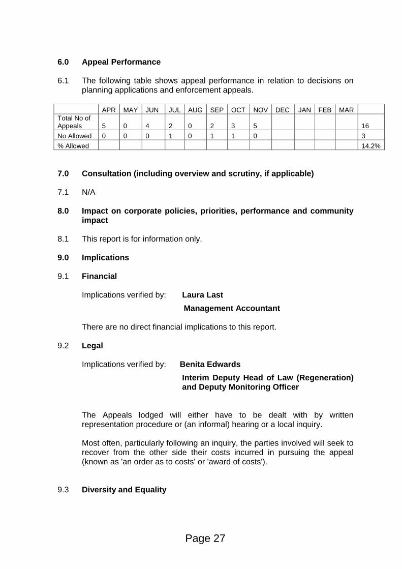
6.0 Appeal Performance 6.1 The following table shows appeal performance in relation to decisions on
planning applications and enforcement appeals.
APR MAY JUN JUL AUG SEP OCT NOV DEC JAN FEB MAR
Total No of Appeals 5 0 4 2 0 2 3 5 16
No Allowed 0 0 0 1 0 1 1 0 3
% Allowed 14.2%
7.0 Consultation (including overview and scrutiny, if applicable) 7.1 N/A
8.0 Impact on corporate policies, priorities, performance and community
impact 8.1 This report is for information only. 9.0 Implications 9.1 Financial
Implications verified by: Laura Last
Management Accountant
There are no direct financial implications to this report.
9.2 Legal Implications verified by: Benita Edwards
Interim Deputy Head of Law (Regeneration) and Deputy Monitoring Officer
The Appeals lodged will either have to be dealt with by written representation procedure or (an informal) hearing or a local inquiry.
Most often, particularly following an inquiry, the parties involved will seek to recover from the other side their costs incurred in pursuing the appeal (known as 'an order as to costs' or 'award of costs').
9.3 Diversity and Equality
Page 27
Implications verified by: Natalie Warren
Strategic Lead Community Development and Equalities
There are no direct diversity implications to this report.
9.4 Other implications (where significant) – i.e. Staff, Health, Sustainability,
Crime and Disorder)
None.
10. Background papers used in preparing the report (including their location
on the Council’s website or identification whether any are exempt or protected by copyright):
All background documents including application forms, drawings and other supporting documentation can be viewed online: www.thurrock.gov.uk/planning.The planning enforcement files are not public documents and should not be disclosed to the public.
11. Appendices to the report
None
Page 28
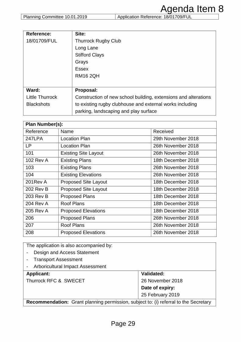
Planning Committee 10.01.2019 Application Reference: 18/01709/FUL
Reference:
18/01709/FUL
Site:
Thurrock Rugby Club
Long Lane
Stifford Clays
Grays
Essex
RM16 2QH
Ward:
Little Thurrock
Blackshots
Proposal:
Construction of new school building, extensions and alterations
to existing rugby clubhouse and external works including
parking, landscaping and play surface
Plan Number(s):
Reference Name Received
247LPA Location Plan 29th November 2018
LP Location Plan 26th November 2018
101 Existing Site Layout 26th November 2018
102 Rev A Existing Plans 18th December 2018
103 Existing Plans 26th November 2018
104 Existing Elevations 26th November 2018
201Rev A Proposed Site Layout 18th December 2018
202 Rev B Proposed Site Layout 18th December 2018
203 Rev B Proposed Plans 18th December 2018
204 Rev A Roof Plans 18th December 2018
205 Rev A Proposed Elevations 18th December 2018
206 Proposed Plans 26th November 2018
207 Roof Plans 26th November 2018
208 Proposed Elevations 26th November 2018
The application is also accompanied by:
- Design and Access Statement
- Transport Assessment
- Arboricultural Impact Assessment
Applicant:
Thurrock RFC & SWECET
Validated:
26 November 2018
Date of expiry:
25 February 2019
Recommendation: Grant planning permission, subject to: (i) referral to the Secretary
Page 29
Agenda Item 8
Planning Committee 10.01.2019 Application Reference: 18/01709/FUL
of State; and (ii) conditions.
This application is scheduled for determination by the Council’s Planning Committee as it is a major application for development in the Green Belt, which also represents a departure from the Core Strategy and NPPF. This is a joint application between the Thurrock Rugby Football Club (TRFC) and the South West Essex Community Education Trust (SWECET) – the William Edwards School.
1.0 DESCRIPTION OF PROPOSAL
1.1 The application seeks planning permission for a variety of works on the Thurrock Rugby Club site to facilitate the mixed use of the site to provide a temporary facility for the Orsett Heath Academy on the site, until a permanent school is built close to the site in the future. Once the new school has been built and is operational the current site will continue to be used by schools within the SWECT and the TRFC for education and sports provision in conjunction with the Orsett Heath Academy. It is the applicant’s vision to create a lasting legacy of education, sport and recreation uses at this site, referred to as a ‘Thurrock Institute of Sport’.
1.2 The new school would comprise a new two storey flat roofed building to the
northern end of the existing rugby club building. This building would be finished with a mixture of brickwork and cladding and would be linked to the rugby club building by a covered link. The building would run north to south in the site and would have main windows facing east and west. The new building would have a floor area of 577sq.m. per floor. The building would provide 120 secondary spaces for September 2019 and a further 120 spaces for September 2020.
1.3 In relation to the existing rugby club building, a new single storey flat roof store
building would be provided to the north of the new school building with a floor area of 75sq.m. .Parts of the existing building would be re-rendered and clad to match the new school building. A canopy would be provided, wrapping about the majority of the northern and eastern flanks of the building. This canopy would meet with the southern elevation of the new school building.
1.4 The existing car park would be extended to uplift parking from 100 spaces to 178
spaces, 9 disabled car parking spaces would be provided along with 96 cycle spaces and 7 motorcycle parking spaces.
1.5 To the west of the new building, closest to the entrance of the site would be a
porous asphalt playground/overflow car park which would be enclosed with 2m high fencing. Landscaping would be provided around the site.
2.0 SITE DESCRIPTION
2.1 The application site is approximately rectangular in shape and metres 1.12 hectares. The site is accessed from Long Lane.
Page 30
Planning Committee 10.01.2019 Application Reference: 18/01709/FUL 2.2 To the north, east and south of the site are open fields. To the west are residential
properties on Springfield Road, the Thurrock Harriers facilities and running track. 2.3 The majority of the site is laid roughly with hardstanding, a formally marked out
parking area is located to the south east. The main permanent buildings, which are part single and part two storeys, lie towards the eastern boundary of the site.
2.4 The site lies in the Metropolitan Green Belt.
3.0 RELEVANT HISTORY
3.1 The site has a long planning history; many applications are not directly relevant to
the current proposal. There is one notable recent application, which is detailed
below:
Application Reference
Description of Proposal Decision
10/50149/TTGFUL Two storey extension to provide enhanced changing facilities and gymnasium
Approved 9 June 2010. This application was not implemented; however the footprint of the approved extension was 348 sq.m, giving a total gross floor space for the two storey extension of 696sq.m.
4.0 CONSULTATIONS AND REPRESENTATIONS
4.1 Detailed below is a summary of the consultation responses received. The full
version of each consultation response can be viewed on the Council’s website via
public access at the following link: www.thurrock.gov.uk/planning
PUBLICITY:
4.2 This application has been advertised by way of individual neighbour notification
letters press advert and public site notices which have been displayed nearby. The
application has been advertised as a major development and as a departure from
the development plan.
4.3 At the time of writing 18 letters have been received in support of the application
- Creation of jobs;
- Lack of provision in the area;
- The school is much needed to support housing growth;
Page 31
Planning Committee 10.01.2019 Application Reference: 18/01709/FUL - The proposal will be an innovative project linking the trust and sports club;
- Education is a top priority;
- A new school will prevent children having to travel so far.
Three letters have been received objecting to the proposals on the following
grounds:
- The rugby club will be the main benefactors of the use;
- The building will only be used as a school for the short term;
- People in the neighbourhood live quietly;
- Concern that if the rugby club members don’t want the application it will still be
approved.
4.4 ENVIRONMENT AGENCY:
No objections.
4.5 SPORT ENGLAND:
No objections, subject to conditions.
4.6 EDUCATION:
No objection, support the proposals.
4.7 ENVIRONMENTAL HEALTH:
No objections, subject to conditions.
4.8 HIGHWAYS:
No objections, subject to conditions.
4.9 LANDSCAPE & ECOLOGY:
No objections subject to conditions.
5.0 POLICY CONTEXT
National Planning Policy Framework
5.1 The NPPF was published on 27 March 2012 and amended on 24 July 2018. Paragraph 10 of the Framework sets out a presumption in favour of sustainable
Page 32
Planning Committee 10.01.2019 Application Reference: 18/01709/FUL
development. Paragraph 2 of the Framework confirms the tests in s.38 (6) of the Planning and Compulsory Purchase Act 2004 and s.70 of the Town and Country Planning Act 1990 and that the Framework is a material consideration in planning decisions. Paragraph 11 states that in assessing and determining development proposals, local planning authorities should apply the presumption in favour of sustainable development. The following headings and content of the NPPF are relevant to the consideration of the current proposals: 2. Achieving sustainable development 14. Meeting the challenge of climate change, flooding and coastal change 16. Conserving and enhancing the historic environment
Planning Practice Guidance
5.2 In March 2014 the Department for Communities and Local Government (DCLG)
launched its planning practice guidance web-based resource. This was
accompanied by a Written Ministerial Statement which includes a list of the
previous planning policy guidance documents cancelled when the NPPF was
launched. PPG contains 42 subject areas, with each area containing several
subtopics. Those of particular relevance to the determination of this planning
application comprise:
Climate change;
Design;
Determining a planning application;
Flood risk and coastal change;
Health and wellbeing;
Natural environment;
Noise;
Open space, sports and recreation facilities, public rights of way and local
green space;
Travel Plans, Transport Assessments and Statements; and
Use of planning conditions
5.3 The ‘Policy statement – planning for schools development’ (2011) is also relevant to
this case.
Local Planning Policy
Thurrock Local Development Framework
5.4 The Council adopted the “Core Strategy and Policies for the Management of
Development Plan Document” (as amended) in 2015. The following Core Strategy
policies apply to the proposals:
Page 33
Planning Committee 10.01.2019 Application Reference: 18/01709/FUL
Spatial Policies:
CSSP3: Sustainable Infrastructure
CSSP4: Sustainable Green Belt and
Thematic Policies:
CSTP10: Community Facilities
CSTP12: Education and Learning
CSTP22: Thurrock Design
CSTP27: Management and Reduction of Flood Risk
Policies for the Management of Development:
PMD1: Minimising Pollution and Impacts on Amenity
PMD2: Design and Layout
PMD7: Biodiversity, Geological Conservation and Development
PMD8: Parking Standards
PMD9: Road Network Hierarchy
PMD10: Transport Assessments and Travel Plans and
PMD15: Flood Risk Assessment
[Footnote: 1New Policy inserted by the Focused Review of the LDF Core Strategy.
2Wording of LDF-
CS Policy and forward amended either in part or in full by the Focused Review of the LDF Core
Strategy. 3Wording of forward to LDF-CS Policy amended either in part or in full by the Focused
Review of the LDF Core Strategy].
Thurrock Local Plan
5.5 In February 2014 the Council embarked on the preparation of a new Local Plan for
the Borough. Between February and April 2016 the Council consulted formally on
an Issues and Options (Stage 1) document and simultaneously undertook a ‘Call
for Sites’ exercise. In December 2018 the Council began consultation on an Issues
and Options (Stage 2 Spatial Options and Sites) document.
Thurrock Design Strategy
5.6 In March 2017 the Council launched the Thurrock Design Strategy. The Design
Strategy sets out the main design principles to be used by applicants for all new
development in Thurrock. The Design Strategy is a supplementary planning
document (SPD) which supports policies in the adopted Core Strategy.
6.0 ASSESSMENT
Process
Page 34
Planning Committee 10.01.2019 Application Reference: 18/01709/FUL
With reference to procedure, this application has been advertised as a departure
from the Development Plan and as a major development. Any resolution to grant
planning permission would need to be referred to the Secretary of State under the
terms of the Town and Country Planning (Consultation) (England) Direction 2009
with reference to the ‘other development which, by reason of its scale or nature or
location, would have a significant impact on the openness of the Green Belt’. The
Direction allows the Secretary of State a period of 21 days (unless extended by
direction) within which to ‘call-in’ the application for determination via a public
inquiry. In reaching a decision as to whether to call-in an application, the Secretary
of State will be guided by the published policy for calling-in planning applications
and relevant planning policies. The Secretary of State will, in general, only
consider the use of his call-in powers if planning issues of more than local
importance are involved.
6.1 The planning issues to be considered in this case are:
I. Development Plan designation & principle of development
II. Site layout and design issues
III. Impact on amenity
IV. Highways & transportation
V. Flood risk
VI. Other Matters
I. DEVELOPMENT PLAN DESIGNATION & PRINCIPLE OF DEVELOPMENT:
6.2 The site lies in the Green Belt. Under this heading, it is necessary to refer to the following key questions:
1. Whether the proposals constitute inappropriate development in the Green
Belt; 2. The effect of the proposals on the open nature of the Green Belt and the
purposes of including land within it; and 3. Whether the harm to the Green Belt is clearly outweighed by other
considerations so as to amount to the very special circumstances necessary to justify inappropriate development.
1. Whether the proposals constitute inappropriate development in the Green Belt
6.3 The site is identified on the Core Strategy Proposals Map as being within the Green Belt where policies CSSP4 and PMD6 apply. Policy CSSP4 identifies that the Council will ‘maintain the purpose function and open character of the Green Belt in Thurrock’, and Policy PMD6 states that the Council will ‘maintain, protect and enhance the open character of the Green Belt in Thurrock’. These policies aim to prevent urban sprawl and maintain the essential characteristics of the openness and permanence of the Green Belt to accord with the requirements of the NPPF.
Page 35
Planning Committee 10.01.2019 Application Reference: 18/01709/FUL
6.4 Paragraph 79 within Chapter 9 of the NPPF states that the Government attaches
great importance to Green Belts and that the “fundamental aim of Green Belt policy is to prevent urban sprawl by keeping land permanently open; the essential characteristics of Green Belt are their openness and their permanence.” Paragraph 89 states that a local planning authority should regard the construction of new buildings as inappropriate in Green Belt. The NPPF sets out a limited number of exceptions to this, namely:
buildings for agriculture and forestry;
appropriate facilities for outdoor sport, recreation and cemeteries;
proportionate extensions or alterations to a building;
the replacement of a building;
limited infilling in villages; and the partial or complete redevelopment of previously developed sites whether
redundant or in continuing use (excluding temporary buildings), which would not have a greater impact on the openness of the Green Belt and the purpose of including land within it than the existing development.
6.5 Part of the site is considered to fall within the NPPF definition of Previously Developed Land (PDL). However, the proposed development is more extensive in terms of scale and mass, and spreads further across the site than the development that presently exists. Accordingly, the proposal would have a greater impact on the openness of the Green Belt and the purpose of including land within it than the existing development. Consequently, the proposals comprise inappropriate development with reference to the NPPF and policy PMD6.
2. The effect of the proposals on the open nature of the Green Belt and the purposes of including land within it
6.6 Having established that the proposals are inappropriate development, it is
necessary to consider the matter of harm. Inappropriate development is, by definition, harmful to the Green Belt, but it is also necessary to consider whether there is any other harm to the Green Belt and the purposes of including land therein.
6.7 Paragraph 134 of the NPPF sets out the five purposes which the Green Belt serves as follows:
a. to check the unrestricted sprawl of large built-up areas; b. to prevent neighbouring towns from merging into one another; c. to assist in safeguarding the countryside from encroachment; d. to preserve the setting and special character of historic towns; and e. to assist in urban regeneration, by encouraging the recycling of derelict and
other urban land.
6.8 In response to each of these five purposes: a. to check the unrestricted sprawl of large built-up areas
Page 36
Planning Committee 10.01.2019 Application Reference: 18/01709/FUL
6.9 The site is located to the easternmost point of the Blackshots area of Grays. The
new building and parking areas would be wholly within the area of land occupied by the rugby club and would not spread east or south of the existing developed extremities of the site. For the purposes of the NPPF, the site is considered to be immediately adjacent to a ‘large built up area’. It would not therefore result in the sprawl of an existing built up area.
b. to prevent neighbouring towns from merging into one another
6.10 The development would not conflict with this Green Belt purpose.
c. to assist in safeguarding the countryside from encroachment 6.11 With regard to the third Green Belt purpose, the proposal would involve built
development on land which is otherwise largely open. The proposal would not therefore safeguard the countryside from encroachment.
d. to preserve the setting and special character of historic towns 6.12 As there are no historic town in the immediate vicinity of the site, the proposals do
not conflict with this defined purpose of the Green Belt.
e. to assist in urban regeneration, by encouraging the recycling of derelict and other urban land
6.13 In general terms, the development could occur in the urban area and, in principle
there is no spatial imperative why Green Belt land is required to accommodate the proposals however it is recognised that the development would be linked to sports facilities which have been on the site for many years. To a limited extent, the proposal would conflict with this purpose.
6.14 In light of the above analysis, it is considered that the proposals would be contrary
to 2 of the 5 purposes of including land in the Green Belt. Substantial weight should be afforded to these factors. 3. Whether the harm to the Green Belt is clearly outweighed by other
considerations so as to amount to the very special circumstances necessary to justify inappropriate development
6.15 Neither the NPPF nor the Adopted Core Strategy provide guidance as to what can
comprise ‘very special circumstances’, either singly or in combination. However, some interpretation of very special circumstances has been provided by the Courts. The rarity or uniqueness of a factor may make it very special, but it has also been held that the aggregation of commonplace factors could combine to create very special circumstances (i.e. ‘very special’ is not necessarily to be interpreted as the converse of ‘commonplace’). However, the demonstration of very special circumstances is a ‘high’ test and the circumstances which are relied upon must be genuinely ‘very special’. In considering whether ‘very special circumstances’ exist, factors put forward by an applicant which are generic or capable of being easily
Page 37
Planning Committee 10.01.2019 Application Reference: 18/01709/FUL
replicated on other sites, could be used on different sites leading to a decrease in the openness of the Green Belt. The provisions of very special circumstances which are specific and not easily replicable may help to reduce the risk of such a precedent being created. Mitigation measures designed to reduce the impact of a proposal are generally not capable of being ‘very special circumstances’. Ultimately, whether any particular combination of factors amounts to very special circumstances will be a matter of planning judgment for the decision-taker.
6.16 With regard to the NPPF, paragraph 143 states that ‘inappropriate development is, by definition, harmful to the Green Belt and should not be approved except in very special circumstances’. Paragraph 144 goes on to state that, when considering any planning application, local planning authorities “should ensure that substantial weight is given to any harm to the Green Belt. Very special circumstances will not exist unless the potential harm to the Green Belt by reason of inappropriateness, and any other harm, is clearly outweighed by other considerations”.
6.17 The Design and Access Statement sets out the applicant’s Very Special Circumstances which are assessed below:
a. Lack of secondary education provision for September 2019
6.18 The applicant has referred to Thurrock’s Pupil Place Plan in support of the proposal; the Plan identifies a significant shortfall of secondary school places from September 2019 and highlights the need for 325 spaces. The proposal would allow at least 120 places to be provided in an OFSTEAD ‘Good’ school. If the school is not built and every secondary school in the Borough accepts their full Pupil Admission Number (PAN), the applicant warns that there will be a minimum of 244 children with no offer of a school place.
Consideration 6.19 The Council’s Education Team concur with the statement and support the
application on the basis that it would provide much needed accommodation to
address the shortfall in provision for the next academic year.
6.20 Policy CSSP3 (Sustainable Infrastructure) identifies a list of Key Strategic
Infrastructure Projects which are essential to the delivery of the Core Strategy,
including (under the heading of “Secondary Education”) “new build, refurbishment
and expansion of existing mainstream secondary schools”. This development plan
policy therefore identifies the general need for new build secondary schools as
items of key infrastructure. The Pupil Place Plan demonstrates a clear need for
additional secondary school places in the Borough.
6.21 Policy CSTP12 (Education and Learning) sets out a general approach which
includes:
Page 38
Planning Committee 10.01.2019 Application Reference: 18/01709/FUL
“I. the Council’s objective and priority to maximise the benefit of investment in
buildings, grounds and ICT, to achieve educational transformation;
II. the provision of pre-school, primary school, high school, further education and
special education facilities meets current and future needs”.
6.22 Under the heading of ‘Secondary Education” CSTP12 goes on to state that “To
meet the educational, training and community needs of young people and their
families for the period of this plan, the Council is committed to replace and improve
mainstream secondary school provision and will work with partners to identify
and/or confirm sites of an appropriate size and location for schools”.
6.23 Therefore, in general terms Core Strategy policies support the provision of
education facilities, including new build schools.
6.24 Under the heading of ‘Promoting healthy communities’ paragraph NPPF para 94 of
the NPPF states:
“The government attaches great importance to ensuring that a sufficient choice of
school places is available to meet the needs of existing and new communities.
Local planning authorities should take a proactive, positive and collaborative
approach to meeting this requirement, and to development that will widen choice in
education. They should:
• give great weight to the need to create, expand or alter schools
• work with schools promoters to identify and resolve key planning issues before
applications are submitted.”
6.25 Although not a part of either the NPPF or PPG, the national policy paper “Planning
for Schools Development” (2011) is relevant to this application. This paper sets out
a commitment to support the development and delivery of state-funded schools
through the planning system. Furthermore the policy paper refers to the
Government’s belief that the planning system should operate in a “positive manner”
when dealing with proposals for the creation, expansion and alteration of state-
funded schools. Finally, the policy paper sets out the following principles:
• There should be a presumption in favour of the development of state-funded
schools, as expressed in the National Planning Policy Framework;
• Local authorities should give full and thorough consideration to the importance
of enabling the development of state-funded schools in their planning decisions;
• Local authorities should make full use of their planning powers to support state-
funded schools applications;
• Local authorities should only impose conditions that clearly and demonstrably
meet the tests set out in Circular 11/95;
Page 39
Planning Committee 10.01.2019 Application Reference: 18/01709/FUL
• Local authorities should ensure that the process for submitting and determining
state-funded schools’ applications is as streamlined as possible;
• A refusal of any application for a state-funded school, or the imposition of
conditions, will have to be clearly justified by the local planning authority;
• Appeals against any refusals of planning permission for state-funded schools
should be treated as a priority;
• Where a local planning authority refuses planning permission for a state-funded
school, the Secretary of State will consider carefully whether to recover for his
own determination appeals against the refusal of planning permission.
6.26 The matter of providing high quality education facilities is a key Council objective. There are presently no schools in Borough that could provide the number of places that could be provide by this application and the number of places. The funding is available for the provision and development could commence in earnest if permission were to be granted and the decision is not called in. In conclusion under this heading, it is considered that this factor should be given very significant weight in the determination of the application as a very special circumstance.
b. The provision of high quality education
6.27 The applicant states that the volume of ‘Good’ secondary school places has
reduced recently, with 4 schools in the Borough graded Category 3 (Requires Improvement) and 4 (Serious Weaknesses/Inadequate). The proposal would allow provision of ‘outstanding’ education for potential students.
Consideration 6.28 The provision of high quality education is an important component of the Council’s
key aspirations. However, the planning system does not exist to either stifle of encourage competition between different providers. Accordingly, this matter should be afforded limited weight in the planning balance.
c. Social and Economic Considerations (Health benefits)
6.29 The applicant advises that TRFC and the SWECET have a strong relationship and
many of the Trust staff have played for and supported the Club and the Club have hosted many tournaments the Trust schools have participated in. The proposal provides the opportunity to utilise the links between the two organisations.
Consideration 6.30 Public health and outdoor sport are an important corporate priorities. The proximity
of the school and the rugby club would allow improved links between the two and would support wider objectives to increase public health and reduce obesity. Moderate weight should be attached to these health benefits.
Page 40
Planning Committee 10.01.2019 Application Reference: 18/01709/FUL d. Interim use – Shared facilities 6.31 The applicant states that the building has been designed so that it can function as
an interim school during the day and as a coaching and Rugby education facility in the evening and at weekends.
Consideration
6.32 The proposal would allow two improved facilities to exist on the site, sharing use of
buildings, parking and outdoor spaces. This makes best use of the land in the short term and limits the need to acquire other land or build on wider areas of the Green Belt. This mixed use is reflected in policy CSP12, which notes that “The integration of schools into multifunction hubs with linkages to key facilities such as sports and leisure facilities, health and social care”. Significant weight should therefore be attached to this matter.
e. Long term – Legacy use
6.33 The applicant states, that “[once the building ceases to be used as an interim
school site the facilities will be used for the development of a sports and performance analysis centre and provide specialist provision, creating a ‘Thurrock Institute of Sport’. The facility will be jointly managed by TRFC and SWECET…” The classrooms would be used to provide special Sports Science and performance analysis suites for use by both TRFC and SWECET. Various education provisions would take place including post 16 sports and PE in partnership with Palmers College, all GCSE teaching for Orsett Heath and William Edwards. Young players would be able to use the facilities and relationships will be built up between SWECET, TRFC and Thurrock Harriers.
Consideration
6.34 The proposed long term use of the site has the potential to provide a flagship
development for the Borough. It would ensure positive educational benefits and health benefits and provide aspirational opportunities for young people in the Borough. This matter should be afforded significant weight in the consideration of the application.
Summary of Very Special Circumstances
6.35 The table below provides a summary of the Very Special Circumstances and the
weight that is attributed to them in assessing the planning balance for the whether the principle of the development is acceptable
Summary of Green Belt Harm and Very Special Circumstances
Harm Weight Factors Promoted as Very
Special Circumstances
Weight
Page 41
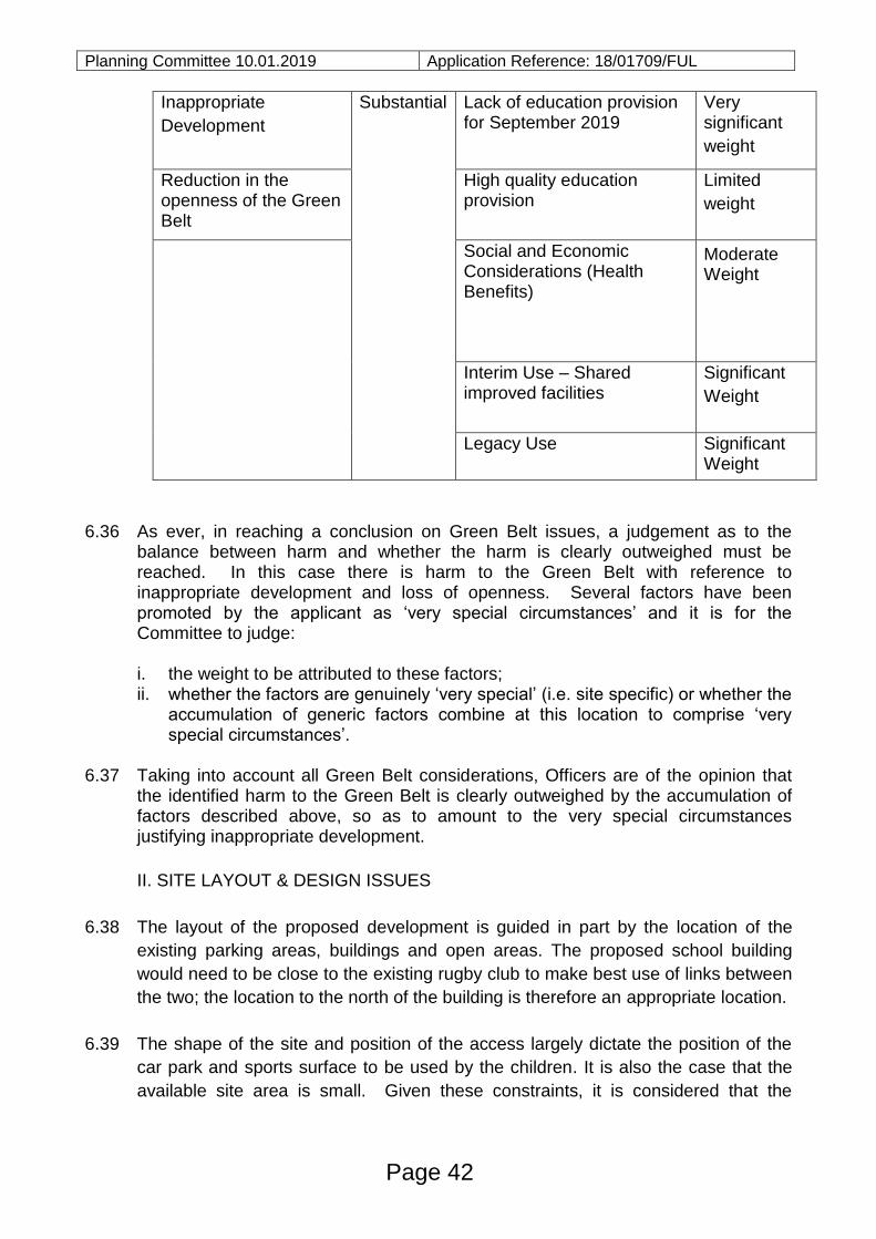
Planning Committee 10.01.2019 Application Reference: 18/01709/FUL
Inappropriate
Development
Substantial Lack of education provision for September 2019
Very significant
weight
Reduction in the openness of the Green Belt
High quality education provision
Limited
weight
Social and Economic Considerations (Health Benefits)
Moderate Weight
Interim Use – Shared improved facilities
Significant
Weight
Legacy Use Significant Weight
6.36 As ever, in reaching a conclusion on Green Belt issues, a judgement as to the
balance between harm and whether the harm is clearly outweighed must be reached. In this case there is harm to the Green Belt with reference to inappropriate development and loss of openness. Several factors have been promoted by the applicant as ‘very special circumstances’ and it is for the Committee to judge:
i. the weight to be attributed to these factors; ii. whether the factors are genuinely ‘very special’ (i.e. site specific) or whether the
accumulation of generic factors combine at this location to comprise ‘very special circumstances’.
6.37 Taking into account all Green Belt considerations, Officers are of the opinion that
the identified harm to the Green Belt is clearly outweighed by the accumulation of factors described above, so as to amount to the very special circumstances justifying inappropriate development.
II. SITE LAYOUT & DESIGN ISSUES
6.38 The layout of the proposed development is guided in part by the location of the
existing parking areas, buildings and open areas. The proposed school building
would need to be close to the existing rugby club to make best use of links between
the two; the location to the north of the building is therefore an appropriate location.
6.39 The shape of the site and position of the access largely dictate the position of the
car park and sports surface to be used by the children. It is also the case that the
available site area is small. Given these constraints, it is considered that the
Page 42
Planning Committee 10.01.2019 Application Reference: 18/01709/FUL
proposed arrangement of extended car parking on the southern part of the site and
to the front of the rugby club is acceptable. The proposed school building to the
north of the site and open space adjacent is logical and makes efficient use of the
available space.
6.40 With regard to the external appearance of the school buildings, the proposals
involve a flat roof design, similar to the current rugby club building with a simple
palette of materials, comprising render, brickwork and timber cladding. This
combination of materials reflects the recently refinished William Edwards School in
Whitmore Avenue, providing a cohesive appearance between schools within the
same Academy family. The proposed appearance of the new building, and the
refinished rugby club would embrace a modern design approach, which is
welcomed given the rather dated appearance of the existing buildings on site. The
provision of a flat roof design also helps to reduce the mass and bulk of the
proposed building, which is important given the location of the site in the Green
Belt.
6.41 The current proposals would provide a surfaced play area for pupils who would also
have access to the playing fields of the club. This is considered to be appropriate
for the time period during which the premises are to be used as a school.
6.42 Policy CSTP9 (Well-Being: Leisure and Sports) inter-alia supports the provision of
“high quality sports and leisure facilities” and “facilities for schools and other
institutions which can be linked and shared with the community”. Thematic policy
CSTP12 (Education and Learning) is also relevant and sets out the Council’s
general approach including “the integration of schools into multi-functional hubs
with linkages to key facilities such as sports and leisure facilities… facilities in
schools are fully integrated into community use where possible”.
6.43 The submitted documents indicate that the buildings and facilities would be shared
by the school and the rugby club and hence the local community. The proposals
are therefore considered to accord with Policies CSTP9 and CSTP12 in this regard.
6.44 In summary under this heading the proposed site layout is considered to be
acceptable, the scale, form mass and overall form is considered to be acceptable.
The design approach represents a modern form of school buildings and would
integrate with the existing rugby club building by refinishing the building; further the
use of materials would provide a visual link with other school buildings in the
Academy family. Accordingly the proposals are acceptable in design and layout
terms, complying with the relevant requirements of Policies PMD2 and CSTP22
and CSTP23 of the Core Strategy.
III. IMPACT ON AMENITY
Page 43
Planning Committee 10.01.2019 Application Reference: 18/01709/FUL
6.45 The closest ‘sensitive’ receptors to the site are residential occupiers along
Springfield Road to the west of the site.
6.46 Springfield Road comprises two terraces of six properties (of which nine back
directly onto the site) a further terrace of six properties which are alongside the
access road just north of the red line and a terrace of four properties to the
southern end of the site, which flank onto the site. The proposed teaching block
would be positioned in excess of 40m to the east of the closest point of the
adjoining rear gardens of properties in Springfield Road. Given this intervening
distance it is considered that there would be no identifiable impact from the bulk of
the building, or a loss of privacy or amenity.
6.47 The main new play area would be over 8m from the western boundary of the site;
between these boundaries are some existing trees and a service road along the
rear of Springfield Road. Accordingly, while the playing area represents a change
from the existing use, it is not considered that this would result in a significant
impact on nearby occupiers as a result of noise or disturbance. The submitted
plans show this area to be enclosed by a 2m high fence, but with no floodlighting
proposed this area could only reasonably be used, for the most part of the school
year, in daylight hours, times when there would be less expectation of a quieter
noise environment.
6.48 Any potential for disturbance from the extended car park would be mitigated by its
position c.11m from the neighbouring rear gardens, by the presence of planting and
by the limited use of the car park in connection with the school related to term times
and school hours. Accordingly, is it considered that the proposal would comply with
the relevant sections of Policy PMD1 in respect of neighbour amenity.
IV. HIGHWAYS & TRANSPORTATION
6.49 The planning application is supported by a Transport Assessment (TA).
6.50 The site would be served by an existing access onto Long Lane and the existing
car park would be extended to uplift parking from 100 spaces to 178 spaces; 9
disabled car parking spaces would be provided along with 96 cycle spaces and 7
motorcycle parking spaces. The Council’s Highways Officer considers that the level
of parking provision would be suitable for the proposed school use. Members will
note, as detailed earlier in the report that the rugby club would operate outside of
the hours that the school operates from the site.
6.51 Through the TA, the applicant has modelled the trip rates to the school, based on a
generation for 240 pupils. Their figures indicate that in the AM Peak hours only 25%
Page 44
Planning Committee 10.01.2019 Application Reference: 18/01709/FUL
of the trips to the site will be made by car and that the site has the potential for a
high level of sustainable modes of transport. The Council’s Highway Officer has
raised no objection to the details contained in the TA. In common with schools
across the Borough, it is recommended a condition be applied to ensure that the
school operate the STARS Modeshift Travel Plan. Subject to the parking
arrangements being completed before the first use and the Travel Plan condition,
the proposal complies with Policies PMD8 and PMD9 of the Core Strategy.
V. FLOOD RISK
6.52 The site is in Flood Risk Zone 1, but because the site is in excess of 1ha in area a
Flood Risk Assessment (FRA) is required. The submitted FRA identifies a low risk
of groundwater flooding to the site and a very low risk of flooding from other
sources such as surface water. A Drainage Strategy forms part of the FRA and
indicates that due to the soil type in the area permeable paving would be used to
drain the parking areas and access road and water from the roof will be drained to
a soakaway.
6.53 The Environment Agency has raised no objection to the scheme as put forward.
The Council’s Flood Risk Manager has no objection in principle, but has raised a
Holding Objection to the application as submitted in terms of detail. These matters
could be suitably covered by a condition, accordingly Policy PMD15 would be
satisfied in this regard.
VI. Other Matters
6.54 The site does not form part of any area of designated nature conservation
importance on either a statutory or non-statutory basis. The Council’s Landscape
and Ecology Advisor has not raised any concerns about ecological matters
pertaining to the proposals. He broadly agrees with the submitted landscaping
scheme, but recommends some further consideration should be given to tree
species on parts of the site to improve the quality of the landscaping scheme.
6.55 None of the trees on the site are covered by Tree Preservation Order (TPO). The
original plans and submitted Arboricultural Impact Assessment (AIA) indicate that 6
trees will be removed to facilitate the development. The AIA states of these, 2 are in
the “U” category due to their poor condition and, there will be low impact from the
loss of these trees. Three trees are in “C” category and have negligible amenity
value and therefore the loss of these trees would have a low impact. The last tree
which was to be removed was an Oak, which is larger and in better condition and
there was considered to be moderate impact from the loss of that tree. Since the
original AIA was submitted revised plans have been which show the Oak is to be
retained.
Page 45
Planning Committee 10.01.2019 Application Reference: 18/01709/FUL
6.56 The Council’s Landscape and Ecology Advisor does not object to the loss of the “U”
and “C” class trees. Subject to appropriate conditions, the proposal is considered to
comply with the requirements of Policy PMD7 in this regard.
7.0 CONCLUSIONS AND REASON(S) FOR APPROVAL
7.1 The application site is in the Green Belt and the proposal represents inappropriate
development. The applicant has put forward a strong case for Very Special
Circumstances to justify the development, the most significant being the clearly
identified provision for secondary school provision in September 2019 and the
sporting legacy that would be generated and remain between the school and the
rugby club in future years. These and the other matters put forward are considered
to clearly outweigh the harm the Green Belt, the test that is required by the NPPF to
allow inappropriate development.
7.2 In relation to design, appearance, layout and scale the proposal would be
acceptable and in terms of technical highways matters the level of activity and
parking provision would be acceptable. Other matters of detail are also considered
to be appropriate, subject to conditions.
7.3 Accordingly, the proposals are considered to comply with Policies OSDP1, CSSP3,
CSSP4, CSTP22, CSTP23 and Policies PMD1, PMD2, PMD6, PMD8, PMD9,
PMD10 and PMD15 of the Core Strategy.
8.0 RECOMMENDATION
8.1 Grant planning permission subject to:
A: Referral to the Secretary of State (Planning Casework Unit) under the terms
of the Town and Country Planning (Consultation) (England) Direction 2009,
and subject to the application not being ‘called-in’ for determination
And
B: Conditions
Time Limit:
1 The development hereby permitted shall be begun before the expiration of three
years from the date of this permission.
Reason: To comply with Section 91(1) of The Town & Country Planning Act 1990
as amended by Section 51 of the Planning and Compulsory Purchase Act 2004.
Page 46
Planning Committee 10.01.2019 Application Reference: 18/01709/FUL
Accordance with plans:
2 The development hereby permitted shall be carried out in accordance with the
following approved plans:
Plan Number(s):
Reference Name Received
247LPA Location Plan 29th November 2018
LP Location Plan 26th November 2018
101 Existing Site Layout 26th November 2018
102 Rev A Existing Plans 18th December 2018
103 Existing Plans 26th November 2018
104 Existing Elevations 26th November 2018
201Rev A Proposed Site Layout 18th December 2018
202 Rev B Proposed Site Layout 18th December 2018
203 Rev B Proposed Plans 18th December 2018
204 Rev A Roof Plans 18th December 2018
205 Rev A Proposed Elevations 18th December 2018
206 Proposed Plans 26th November 2018
207 Roof Plans 26th November 2018
208 Proposed Elevations 26th November 2018
Reason: For the avoidance of doubt and to ensure that the development is carried
out in accordance with the details as approved with regard to policies PMD1 and
PMD2 of the adopted Thurrock LDF Core Strategy and Policies for the
Management of Development (as amended 2015).
Materials in accordance with submitted details:
3 The development hereby permitted shall be carried out in accordance with the
details contained on the submitted planning application forms and in on the
approved plans, unless any variation has been previously agreed in writing by the
Local Planning Authority.
Reason: In the interests of visual amenity and to ensure that the proposed
development is integrated with its surroundings in accordance with policy PMD2 of
the adopted Thurrock LDF Core Strategy and Policies for the Management of
Development (as amended 2015).
Boundary treatments:
Page 47
Planning Committee 10.01.2019 Application Reference: 18/01709/FUL
4 Prior to the first use or operation of the development, details of the design,
materials and colour of the fences and other boundary treatments shown on
drawing no. 201A shall be submitted to and approved in writing by the local
planning authority. The fences and other boundary treatments as approved shall be
completed prior to the first use or operation of the development and shall be
retained and maintained as such thereafter.
Reason: In order to safeguard the amenities of neighbouring occupiers and in the
interests of the visual amenity of the area in accordance with policies PMD1 and
PMD2 of the adopted Thurrock LDF Core Strategy and Policies for the
Management of Development (as amended 2015).
External lighting:
5 Prior to the first use or operation of the development, details of the means of any
external lighting on the site, including any illumination of the outdoor play facilities,
shall be submitted to and agreed in writing with the local planning authority. The
details shall include the siting and design of lighting together with details of the
spread and intensity of the light sources and the level of luminance. The lighting
shall be installed in accordance with the agreed details prior to first use or operation
of the development and retained and maintained thereafter in the agreed form,
unless otherwise agreed in writing by the local planning authority.
Reason: In the interests of highway safety and residential amenity and to ensure
that the development can be integrated within its immediate surroundings in
accordance with Policies PMD1 and PMD2 of the adopted Thurrock LDF Core
Strategy and Policies for the Management of Development (as amended 2015).
Soft landscaping:
6. Within the first available planting season (October to March inclusive) following the
commencement of the development the soft landscaping works as shown on
drawing number OS 1741-16.2 ‘Soft Landscaping Plan’ shall be implemented (with
the exception of the matters detailed below). If within a period of five years from
the date of the planting of any tree or plant, or any tree or plant planted in
replacement for it, is removed, uprooted or destroyed or dies, or becomes, in the
opinion of the local planning authority, seriously damaged or defective, another tree
or plant of the same species and size as that originally planted shall be planted at
the same place, unless the local planning authority gives its written consent to any
variation. The scheme shall include:
The substitution of 5 No. Amelanchier trees shown on the landscape plan
Page 48
Planning Committee 10.01.2019 Application Reference: 18/01709/FUL
with larger growing species.
Reason: To secure appropriate landscaping of the site in the interests of ecology,
visual amenity and the character of the area in accordance with policies CSTP18,
PMD2 and PMD7 of the adopted Thurrock LDF Core Strategy and Policies for the
Management of Development (as amended 2015).
Car parking provision:
7. The development hereby permitted shall not be used or operated until such time as
the vehicle parking and turning areas shown on drawing number 2471/202B
‘Proposed Site Plan’ including any parking spaces for the mobility impaired, has
been hard surfaced, sealed and marked out as shown on this drawing. The vehicle
parking area, turning and coach drop-off areas shall be retained in this form at all
times thereafter and shall not be used for any purpose other than the parking and
manoeuvring of vehicles that are related to the use of the approved development.
Reason: In the interests of highway safety and to ensure that adequate car parking
provision is available in accordance with policies PMD8 and PMD9 of the adopted
Thurrock LDF Core Strategy and Policies for the Management of Development (as
amended 2015).
Cycle parking:
8. The development hereby permitted shall not be used or operated until such time as
the cycle shown on drawing number 2471/202B ‘Proposed Site Plan’ using the
‘Cambridge Symmetric Shelter as detailed in the application has been provided.
The cycle parking shall remain on site at any time at which the uses hereby
permitted are in operation.
Reason: To reduce reliance on the use of private cars, in the interests of
sustainability, highway safety and amenity in accordance with Policies PMD2 and
PMD8 of the adopted Thurrock LDF Core Strategy and Policies for the
Management of Development (as amended 2015).
Surface water drainage:
9. No development above ground level shall commence until an updated surface
water drainage strategy, responding to the planning application consultation
comments from Essex County Council (dated 28th November 2018), has been
submitted to and approved in writing by the local planning authority. Thereafter the
surface water drainage system(s) shall be constructed in accordance with the
approved strategy and maintained thereafter.
Page 49
Planning Committee 10.01.2019 Application Reference: 18/01709/FUL
Reason: To ensure the incorporation of an appropriate drainage scheme and to
avoid pollution of the water environment and to minimise flood risk in accordance
with policies PMD1 and PMD15 of the adopted Thurrock LDF Core Strategy and
Policies for the Management of Development (as amended 2015).
Unexpected Contamination
10. If, during development, contamination not previously identified is found to be
present at the site then no further development (unless otherwise agreed in writing
with the local planning authority) shall be carried out until the developer has
submitted a remediation strategy to the local planning authority detailing how this
unsuspected contamination shall be dealt with and obtained written approval from
the local planning authority. The remediation strategy shall be implemented as
approved.
Reason: To ensure that risks from land contamination to the future users of the
land and neighbouring land are minimised, together with those to controlled waters,
property and ecological systems, and to ensure that the development can be
carried out safely without unacceptable risks to workers, neighbours and other
offsite receptors in accordance with policy PMD1 of the adopted Thurrock Core
Strategy and Policies for the Management of Development (as amended 2015).
Construction methodology:
11. The construction phase of the development shall proceed in accordance with the
measures within the “Construction Traffic Management Plan” by encon associates
dated November 2018 accompanying the planning application, unless otherwise
agreed in writing by the local planning authority and the following details (with the
exception of the following matters in Conditions 16 and 17 below).
Reason: In order to minimise any adverse impacts arising from the construction of
the development in accordance with policy PMD1 of the adopted Thurrock LDF
Core Strategy and Policies for the Management of Development (as amended
2015).
Wheel Cleansing
12 Wheel cleansing facilities shall be provided on the site in close proximity to the
highway in accordance with details which shall previously have been submitted to
and agreed in writing by the Local Planning Authority. Such facilities, which shall
include for a barrier which stops all vehicles before they enter the highway to
ensure that all mud and other debris is removed from the undercarriage of the
Page 50
Planning Committee 10.01.2019 Application Reference: 18/01709/FUL
vehicle and all its wheels, shall be maintained and used at all times during the
construction (which shall include any demolition works) of the development hereby
permitted.
Reason: In order to minimise any adverse impacts arising from the construction of
the development in accordance with policy PMD1 of the adopted Thurrock LDF
Core Strategy and Policies for the Management of Development (as amended
2015).
Hours of construction
13 No demolition or construction works in connection with the development shall take
place on the site at any time on any Sunday or Bank / Public Holiday, nor on any
other day except between the following times:
Monday to Friday 0800 – 1800 hours
Saturdays 0800 – 1300 hours
Unless in association with an emergency or the prior written approval of the local
planning authority has been obtained. If impact piling is required, these operations
shall only take place between the hours of 0900 - 1800 hours on weekdays.
Reason: In order to minimise any adverse impacts arising from the construction of
the development in accordance with policy PMD1 of the adopted Thurrock LDF
Core Strategy and Policies for the Management of Development (as amended
2015).
Community use:
14. Prior to the first use or operation of the development a community use agreement
shall be submitted to and approved in writing by the local planning authority, in
consultation with Sport England. The agreement shall apply to the new surfaced
play area and new buildings which are not be used outside of normal school hours
and shall include details of pricing policy, hours of use, access by non-educational
establishment users, management responsibilities and a mechanism for review,
and anything else which the local planning authority. in consultation with Sport
England considers reasonably necessary in order to secure the effective
community use of the facilities. The development shall not be used at any time
other than in compliance with the approved agreement.
Reason: To secure well managed, safe community access to the sports and other
community facilities and to ensure sufficient benefit to the development in
accordance with policies CSTP9, CSTP10 and PMD5 of the adopted Thurrock LDF
Page 51
Planning Committee 10.01.2019 Application Reference: 18/01709/FUL
Core Strategy and Policies for the Management of Development (as amended
2015).
Travel Plan
15. Prior to the occupation of the development hereby approved, a Travel Plan shall be submitted to the Council, via the Mode Shift STARS online Travel Plan Monitoring, and regularly updated to promote initiative to improve sustainable travel choices for both pupils and staff members. This monitoring shall be regularly updated for the entire time the site is operated
Reason: To reduce reliance on the use of private cars, in the interests of sustainability, highway safety and amenity in accordance with Policy PMD10 of the adopted Thurrock LDF Core Strategy and Policies for the Management of Development [2015].
Temporary Construction Compound
16. No development shall commence until full details of:
(a) the works/contractors’ compound (including any buildings, moveable structures, works, plant, machinery, access and provision for the storage of vehicles, equipment and/or materials); and
(b) a scheme for the removal of the works/contractors' compound
are submitted to and approved in writing by the Local Planning Authority after consultation with Sport England. The works/contractors’ compound shall not be provided and used on the site other than in accordance with the approved details and shall be removed in accordance with the approved details before occupation of the development hereby approved.
Reason: To protect ancillary sports facilities from damage, loss or availability of use and to accord with Development Plan Policies CSTP10 and CSTP12 of the adopted Thurrock LDF Core Strategy and Policies for the Management of Development [2015]. Construction Programme and Schedule
17. No construction works shall commence until a Construction Programme and Schedule (CPS) has been submitted to and approved in writing by the Local Planning Authority in writing. The CPS should cover the timing and duration of the programme and the impact of the works on the existing operation of the rugby club because these details are not available at present.
Reason: To ensure the development does not prejudice the existing use of the site
for its purpose and that the proposal represents sustainable sporting and education uses to accord with Development Plan Policies CSTP10 and CSTP12 of the adopted Thurrock LDF Core Strategy and Policies for the Management of Development [2015].
Page 52
Planning Committee 10.01.2019 Application Reference: 18/01709/FUL Clubhouse Refurbishment 18. Within two months of commencement of construction, details of the clubhouse
refurbishments including the changing rooms together with an implementation programme shall be submitted to and approved in writing by the Local Planning Authority [after consultation with Sport England]. The clubhouse shall be refurbished in accordance with the approved details. Reason: To ensure the development does not prejudice the existing use of the site for its purpose and that the proposal represents sustainable sporting and education uses to accord with Development Plan Policies CSTP10 and CSTP12 of the adopted Thurrock LDF Core Strategy and Policies for the Management of Development [2015]. Shared Facilities Operational Details
19. Before the development is brought into use, details of the operation of the facilities (including the clubhouse, car park and playing pitches) that will be shared by Thurrock Rugby Football Club and SWECET including details of the facilities that will be made available for shared use, the hours of access and maintenance arrangements shall be submitted to and approved in writing by the Local Planning Authority after consultation with Sport England. The approved details shall be complied with in full, with effect from commencement of use of the development.
Reason: To ensure the development does not prejudice the existing use of the site
for its purpose and that the proposal represents sustainable sporting and education uses to accord with Development Plan Policies CSTP10 and CSTP12 of the adopted Thurrock LDF Core Strategy and Policies for the Management of Development [2015].
New School Building – Operation Details – Legacy Use (Sport England) 20. Within 18 months of commencement of construction, details of the operation of the
building hereby permitted including details of the facilities that will be made available for shared use by Thurrock Rugby Football Club and SWECET, tenure arrangements, facility modifications, hours of access and maintenance arrangements shall be submitted to and approved in writing by the Local Planning Authority after consultation with Sport England. The approved details shall be complied with in full.
Reason: To ensure the development does not prejudice the existing use of the site
for its purpose and that the proposal represents sustainable sporting and education uses to accord with Development Plan Policies CSTP10 and CSTP12 of the adopted Thurrock LDF Core Strategy and Policies for the Management of Development [2015]. Town and Country Planning (Development Management Procedure) (England)
Page 53
Planning Committee 10.01.2019 Application Reference: 18/01709/FUL
Order 2015 (as amended) - Positive and Proactive Statement:
The Local Planning Authority has acted positively and proactively in determining this application by assessing the proposal against all material considerations, including planning policies and any representations that may have been received and subsequently determining to grant planning permission in accordance with the presumption in favour of sustainable development, as set out within the National Planning Policy Framework.
Documents:
All background documents including application forms, drawings and other supporting documentation relating to this application can be viewed online: www.thurrock.gov.uk/planning
Page 54
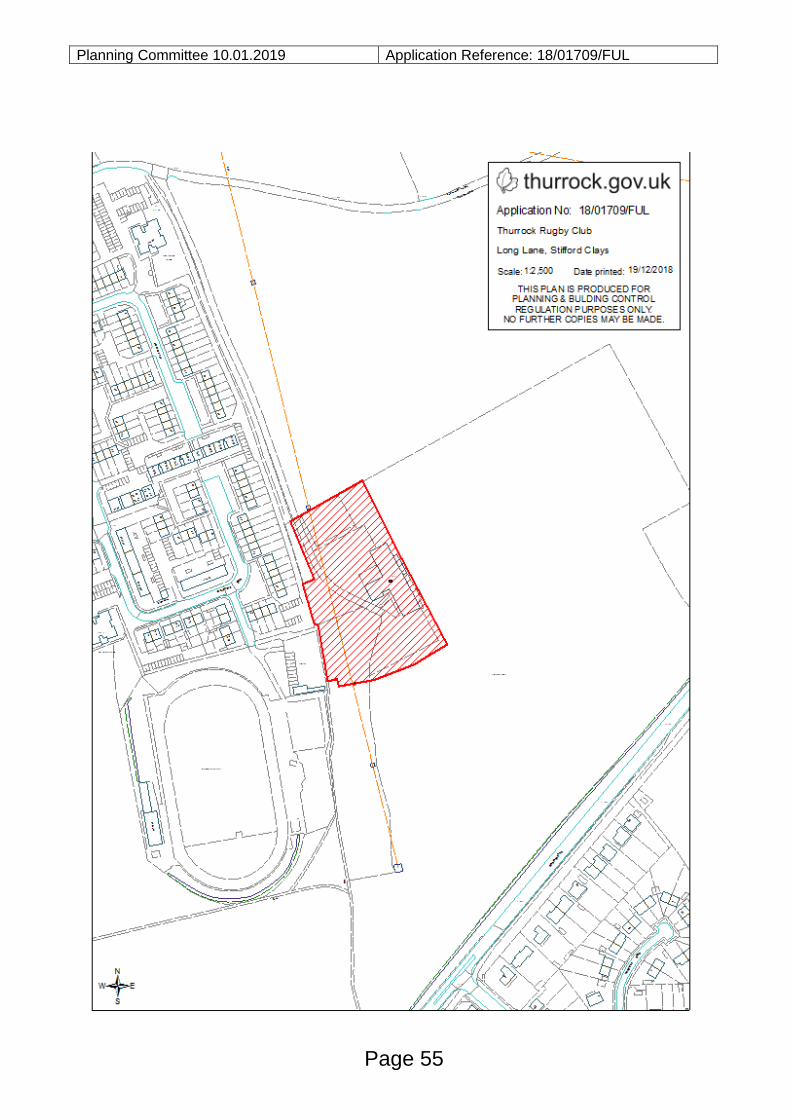
Planning Committee 10.01.2019 Application Reference: 18/01709/FUL
Page 55

This page is intentionally left blank
Planning Committee 10.01.2019 Application Reference: 18/01228/FUL
Reference:
18/01228/FUL
Site:
53 - 55 Third Avenue
Stanford Le Hope
Essex
Ward:
The Homesteads
Proposal:
Ten detached dwellings with associated access road, additional
access, hardstanding, landscaping and bike stores following the
demolition of two existing detached bungalows.
Plan Number(s):
Reference Name Received
P4A Proposed Plans 24th August 2018
P5A Proposed Plans 24th August 2018
P6 Proposed Plans 24th August 2018
P7A Proposed Plans 24th August 2018
P8B Proposed Plans 24th August 2018
P9A Proposed Plans 24th August 2018
P10 Proposed Plans 24th August 2018
P11A Proposed Plans 24th August 2018
P12A Proposed Plans 24th August 2018
P13 Proposed Plans 24th August 2018
P14 Other 24th August 2018
P15 Existing Site Layout 19th October 2018
P16 Existing Site Layout 19th October 2018
PSF Proposed Site Layout 26th November 2018
P1A Location Plan 4th September 2018
P2B Existing Site Layout 4th September 2018
The application is also accompanied by:
- Design & Access Statement
- Drainage Strategy
- Highways Note
- Tree Report
- Viability Appraisal
Applicant:
Mr D Darby
Validated:
24 August 2018
Date of expiry:
Page 57
Agenda Item 9
Planning Committee 10.01.2019 Application Reference: 18/01228/FUL
14 January 2019 (Extension of
time agreed with applicant)
Recommendation: Refuse
This application is scheduled for determination by the Council’s Planning Committee because it has been called in by Cllrs S Hebb, J Halden, D Huelin, A Watkins and B Johnson (in accordance with the Constitution Chapter 5, Part 3 (b), 2.1 (d) (ii)) to assess the impact of the proposal on the character of the area.
1.0 BACKGROUND AND DESCRIPTION OF PROPOSAL
1.1 The key elements of the proposals are set out in the table below:
Site Area
(Gross)
0.29 ha
Height 9m ridge height
Units (All)
Type 1-
bed
2-
bed
3-
bed
4-
bed
5-
bed
TOTAL
Houses 0 0 2 5 3 10
Car parking
Houses: 10
Total allocated: 20 spaces (Average of per unit – 2)
Total Visitor: 2 spaces (Average per unit – 0.2)
Total: 22
Amenity
Space
Minimum: 91 sq.m
Average: 104.9 sq.m
Maximum: 126 sq.m
Density 34.5 units per ha
1.2 This is an application for planning permission for ten detached dwellings with
associated access road, additional access point, hardstanding, landscaping and
bike stores following the demolition of two existing detached bungalows.
1.3 The proposal would be made up of 2 three bed units, 5 four bed units and 3 five
bed units. Three of the dwellings would be positioned in a similar area to the
existing bungalows facing onto Third Avenue. There would be an access road
Page 58
Planning Committee 10.01.2019 Application Reference: 18/01228/FUL
which would be located between Plots 2 and 3 which would provide access to the
remaining plots to the rear. Three dwellings would be located on either side of this
access road with the final four dwellings sited at the end of the access road towards
the rear of the site. Parking areas would be provided to the front or side of all the
units.
2.0 SITE DESCRIPTION
2.1 The application site relates to two separate plots of land both of which contain
detached bungalows with rooms in the roof. These dwellings are to the south west
side of Third Avenue which is within a residential area of Stanford-le-Hope. Both
existing dwellings benefit from large rear gardens which back onto a block of
garages located off Rose Valley Crescent. The site has a total area of 0.29
hectares and is surrounded to the side and rear by residential dwellings, garages
and gardens.
2.2 The site is within the Homesteads ward within Stanford-le-Hope. This is a
designated residential precinct which is identified as being an area where character
is a key issue. The Homsteads ward is identified as being intensively developed in
the past and therefore proposals for backland development must be very carefully
considered.
2.3 The site is approximately 800m from the central shopping area in Corringham and
1.7km from the centre of Stanford-le-Hope and 2km from the station. There are
protected (TPO) trees towards the front boundary of the site.
3.0 RELEVANT PLANNING HISTORY
3.1 There is no relevant planning history in relation to this proposal.
4.0 CONSULTATION AND REPRESENTATIONS
4.1 Detailed below is a summary of the consultation responses received. The full
version of each consultation response can be viewed on the Council’s website via
public access at the following link: www.thurrock.gov.uk/planning
4.2 PUBLICITY:
This application has been advertised by way of individual neighbour notification
letters and public site notice which has been displayed nearby. 34 letters of
objection were received in relation to this application. The issues raised can be
summarised as follows:
- Loss of light
Page 59
Planning Committee 10.01.2019 Application Reference: 18/01228/FUL
- Loss of privacy
- Loss of view
- Air/Light/Noise Pollution
- Noise from construction
- Traffic/parking from construction
- Damage to highway/drains
- Damage to nearby buildings
- Flood risk and surface water
- Impact on property value
- Parking
- Highway safety
- Refuse collection
- Impact upon drains
- Overdevelopment in the Homesteads area
- Impact upon the character of the area
- Contrary to policy
- Loss of green space
- Impact on community facilities
- Impact on drains
- Removal of trees
- Impact on TPO trees
- Impact on ecology
- Similar application in the area refused
- Lack of need for dwellings of this size
- Lack of affordable housing contribution
- Precedent for development
- Insufficient consultation
4.3 ANGLIAN WATER:
No objection subject to conditions and informatives.
4.4 EMERGENCY PLANNER:
No objection subject to conditions.
4.5 ENVIRONMENTAL HEALTH:
No objection subject to conditions.
4.6 ESSEX COUNTY COUNCIL ARCHAEOLOGY:
Page 60
Planning Committee 10.01.2019 Application Reference: 18/01228/FUL
No objection.
4.7 HIGHWAYS:
No objection subject to conditions.
4.8 HOUSING:
Additional information required. Requested an affordable housing statement or a
viability appraisal.
4.9 LANDSCAPE AND ECOLOGY ADVISOR:
Object due to impact on TPO trees.
5.0 POLICY CONTEXT
5.1 National Planning policy Framework
The NPPF was published on 27th March 2012 and amended on 24th July 2018.
Paragraph 10 of the Framework sets out a presumption in favour of sustainable
development. Paragraph 2 of the Framework confirms the tests in s.38 (6) of the
Planning and Compulsory Purchase Act 2004 and s.70 of the Town and Country
Planning Act 1990 and that the Framework is a material consideration in planning
decisions. Paragraph 11 states that in assessing and determining development
proposals, local planning authorities should apply the presumption in favour of
sustainable development. The following headings and content of the NPPF are
relevant to the consideration of the current proposals:
2. Achieving sustainable development
4. Decision-making
5. Delivering a sufficient supply of homes
11. Making effective use of land
12. Achieving well-designed places
14. Meeting the challenge of climate change, flooding and coastal change
5.2 Planning Policy Guidance
In March 2014 the Department for Communities and Local Government (DCLG)
launched its planning practice guidance web-based resource. This was
accompanied by a Written Ministerial Statement which includes a list of the
previous planning policy guidance documents cancelled when the NPPF was
launched. PPG contains a range of subject areas, with each area containing
Page 61
Planning Committee 10.01.2019 Application Reference: 18/01228/FUL
several subtopics. Those of particular relevance to the determination of this
planning application comprise:
- Design
- Determining a planning application
- Flood Risk and Coastal Change
- Hazardous Substances
- Land affected by contamination
- Planning obligations
- Transport evidence bases in plan making and decision taking
- Travel plans, transport assessments and statements in decision-taking
- Tree Preservation Orders and trees in conservation areas
- Use of Planning Conditions
- Viability
5.3 Local Planning Policy
5.4 Thurrock Local Development Framework (2015)
The Council adopted the “Core Strategy and Policies for the Management of
Development Plan Document” in (as amended) in January 2015. The following
Core Strategy policies apply to the proposals
OVERARCHING SUSTAINABLE DEVELOPMENT POLICY
- OSDP1 (Promotion of Sustainable Growth and Regeneration in Thurrock)1
SPATIAL POLICIES
- CSSP1 (Sustainable Housing and Locations)
THEMATIC POLICIES
- CSTP1 (Strategic Housing Provision)
- CSTP2 (The Provision Of Affordable Housing)
- CSTP22 (Thurrock Design)
- CSTP23 (Thurrock Character and Distinctiveness)2
POLICIES FOR MANAGEMENT OF DEVELOPMENT
- PMD1 (Minimising Pollution and Impacts on Amenity)2
- PMD2 (Design and Layout)2
- PMD8 (Parking Standards)3
- PMD9 (Road Network Hierarchy)
Page 62
Planning Committee 10.01.2019 Application Reference: 18/01228/FUL
- PMD10 (Transport Assessments and Travel Plans)2
- PMD15 (Flood Risk Assessment)2
- PMD16 (Developer Contributions)2
RETAINED POLICIES FROM LOCAL PLAN 1997
- H11 (Infill Development: Backland Development and Residential Precincts)
[Footnote: 1New Policy inserted by the Focused Review of the LDF Core Strategy.
2Wording of LDF-CS Policy and forward amended either in part or in full by the
Focused Review of the LDF Core Strategy. 3Wording of forward to LDF-CS Policy
amended either in part or in full by the Focused Review of the LDF Core Strategy].
Thurrock Local Plan
5.4 In February 2014 the Council embarked on the preparation of a new Local Plan for
the Borough. Between February and April 2016 the Council consulted formally on
an Issues and Options (Stage 1) document and simultaneously undertook a ‘Call
for Sites’ exercise. In December 2018 the Council began consultation on an Issues
and Options (Stage 2 Spatial Options and Sites) document.
Thurrock Design Strategy
5.5 In March 2017 the Council launched the Thurrock Design Strategy. The Design
Strategy sets out the main design principles to be used by applicants for all new
development in Thurrock. The Design Strategy is a supplementary planning
document (SPD) which supports policies in the adopted Core Strategy.
6.0 ASSESSMENT
6.1 The material considerations for this application are as follows:
I. Principle of the development
II. Design and Layout and Impact upon the Area
III. Traffic Impact, Access and Car Parking
IV. Flood Risk and Drainage
V. Effect on Neighbouring Properties
VI. Ecology and Landscaping
VII. Viability and Planning Obligations
VIII. Other Matters
I. PRINCIPLE OF THE DEVELOPMENT
Page 63
Planning Committee 10.01.2019 Application Reference: 18/01228/FUL 6.2 The site is identified in the Adopted Interim Proposals Map accompanying the LDF
Core Strategy (2011) and Focused Review (2015) as part of the Homesteads
Ward. Core Strategy Policy CSTP23 protects residential precincts such as The
Homesteads where the original spacious pattern of development has been eroded
by significant infilling and backland development.
6.3 Policy H11 of the Thurrock Borough Local Plan 1997 is not a saved policy but
provides a good background to the situation – that the Homesteads ward was the
subject of rapid house building in the 1960-1980s, which dramatically altered the
character of the area. Specifically, the Homesteads ward has suffered with
extensive infilling and subdivision of large private gardens.
6.4 The policy then refers to Annexe A9 which is saved and relevant as it links to Core
Strategy Policy CSTP23. The Annexe restricts development which would harm the
character of The Homesteads.
6.5 In accordance with the above, the Council has strived to protect the spacious plots
that characterise the Homesteads. The current plots are spacious with large rear
gardens which contribute towards the identified special character of the area. The
current proposal would result in 10 dwellings on the site including a significant
amount of backland development which would encroach into a large area of open
garden space to the rear of properties on Third Avenue and Rose Valley Crescent.
This leads to an in principle objection to development which would result in an
intensive backland development which would specifically conflict with the aims to
protect spacious plots within this area. Policies PMD2 and CSTP22 seek to protect
the character of an area and contribute to the positive sense of place through the
application of high quality design and the proposal would therefore be contrary to
these policies as well as CSTP23.
II. DESIGN AND LAYOUT AND IMPACT UPON THE AREA
6.6 The proposed dwellings would be of a relatively uniform traditional pitched roof
design. There is some variation in the appearance of the dwellings as a number
include front and rear gable ends and/or dormer windows in the roof. There is also
variation in the materials to be used with a mix of facing brick and weatherboarding
along with tiled roofs. The eaves and ridge height of the dwellings is uniform
across the proposed development with a maximum height of 9m. There is some
variation in the scale and bulk of the units due to the inclusion of front and rear
gable ends and dormer windows on some of the larger properties.
6.7 There are a mix of house types and designs in the area including detached, semi-
detached and terraced properties. These are generally of traditional design with
hipped or pitched roofs and follow a relatively uniform forward building line. The
proposal includes three detached dwellings located along the frontage with Third
Page 64
Planning Committee 10.01.2019 Application Reference: 18/01228/FUL
Avenue. These are located in closer proximity to the road than the existing
dwellings to either side of the site, particularly Plot 1 and 2 which are substantially
forward of the neighbour at No.51A. The proposed dwellings would also appear to
have a significantly greater bulk and mass than the nearby properties due to their
width and pitched roof design. The result of this siting and bulk would be a row of
properties which would appear overly dominant and incongruous in the street
scene resulting in significant harm to its character.
6.8 There would be a central access road between plots 2 and 3 which would provide
access to the seven dwellings located within what is currently garden space for the
existing dwellings. Three dwellings would be located alongside the access road
with a further four located at the end of this road towards the rear of the site. Whilst
these dwellings would not be immediately visible in the street scene they would
encroach into an area of land which is currently open and forms part of the general
open character to the rear of properties on this part of Third Avenue. The proposal
would introduce dwellings of significant scale and mass within a cramped layout
which aims to maximise the number of units that can be provided within the area
resulting in the overdevelopment of the site. The buildings would also be of a scale
and mass which is greater than the surrounding dwellings, particularly due to the
ridge height, pitched roof design and use of gable ends and dormer windows. The
requirement for access and parking would also exacerbate these issues resulting in
an area that is dominated by significant amounts of hardstanding around the
proposed buildings. Therefore, as a result of the siting, scale and design of the
proposed dwellings it is considered that they would result in the overdevelopment
of the site, appearing as overly dominant and incongruous features within an open
area which makes an important contribution to the character of the Homesteads
ward.
6.9 Given the above the proposal is considered to result in a significant adverse impact
upon the street scene and the general character of the area contrary to policies
PMD2, CSTP22 and CSTP23 and the National Planning Policy Framework 2018.
6.10 Each dwelling would be of a sufficient size to provide a suitable living environment
for future occupiers. However there are some issues with the internal layout of the
units and the potential for overlooking of private amenity space and habitable room
windows within the development. Plot 5 includes a bedroom with a side facing
window in order to avoid overlooking towards No.51A. The result of this is a
habitable room window facing the flank wall of Plot 6 resulting in inadequate light
and outlook to this room.
6.11 In terms of privacy there are concern regards in the overlooking of private amenity
space of a number of the plots. This is particularly the case with Plots 1, 3 and 5
which all include windows at first and second floor level which would overlook the
private amenity space of other plots within a relatively short distance. This is
Page 65
Planning Committee 10.01.2019 Application Reference: 18/01228/FUL
indicative of the cramped nature of the proposal and the overdevelopment of the
site resulting in an unacceptable living environment for future occupiers contrary to
Policy PMD1 of the Core Strategy.
III. TRAFFIC IMPACT, ACCESS AND CAR PARKING
6.12 The proposal would utilise three existing vehicular crossovers in order to provide
access to the parking areas of plots 1 and 3 and the access road which would be
created towards the centre of the site. An additional vehicular crossover would be
created to provide access to the parking area of Plot 2. The Council’s Highway
Officer was consulted on the acceptability of the increase in the intensity of the use
of the existing access points and the creation of a new access. They raised no
objection to the proposal subject to the imposition of a requirement for there to be a
no waiting restriction along this length of the highway to ensure that visibility was
adequate when exiting the access road to the rear properties. On this basis it is
considered that the proposed access points would be acceptable. It is not
considered that 10 additional dwellings would significantly impact upon the level of
traffic in the area. Therefore the proposal is considered to be acceptable with
regards to highway safety and capacity.
6.13 The proposal includes a total of 20 allocated parking spaces along with 2 visitor
spaces. The site is identified as being within an area of medium accessibility, as
set out in the Council’s Draft Parking Standards, due to its relative proximity to
Corringham Town Centre. In such locations there is a requirement for 1.5 to 2.0
spaces per dwelling with 0.25 spaces per dwelling provided as visitor or unallocated
spaces. The standards also state that for houses for 4 or more bedrooms an
additional parking space will be permitted which would take these houses up to 3
spaces although it is not indicated that this is a requirement.
6.14 The proposal would provide two allocated spaces per dwelling. Eight of the
dwellings would have 4 or more bedrooms which would trigger the allowance for an
additional parking space for each of these units. However, the guidance within the
parking standards only indicates that this would be permitted and not that it is a
specific requirement. With regards to the visitor/unallocated parking the proposal
would provide 2 parking spaces which equates to 0.2 spaces per unit which is
marginally below the requirement of 0.25 spaces. In isolation it is not considered
that the deficiency of one space would be sufficient to substantiate a refusal based
on a lack of visitor parking. The Council’s Highway Officer raised no objection to
this level of provision. Therefore whilst the concerns of residents regarding parking
are noted it is considered, in this instance that the level of parking provision would
be acceptable and therefore the proposal complies with the requirements of policy
PMD8.
Page 66
Planning Committee 10.01.2019 Application Reference: 18/01228/FUL 6.15 With regards to cycle and refuse storage there is adequate space indicated for
these to the side and rear of the proposed dwellings. Details of the cycle storage
have been provided with the application and it is considered that these would be
appropriate and provide the necessary level of storage for each dwelling.
6.16 Information was provided with the application in relation to refuse collection
including a swept path analysis which demonstrates that a refuse vehicle could
access the site. This would allow for refuse collection to be from the front of each
property which is considered to be appropriate.
IV. FLOOD RISK AND DRAINAGE
6.17 No objection has been raised to the proposal subject to a condition requiring the
submission of outstanding information in relation to the surface water drainage
strategy. On this basis it is considered that the principle of a suitable surface water
drainage strategy has been established and the final details of this scheme and its
implementation will ensure that there is no adverse impact upon surface water
drainage in the area.
V. EFFECT ON NEIGHBOURING PROPERTIES
6.18 Plots 1-3 would be in a relatively similar location to the existing properties on the
site. They would not breach the 60 or 45 degree angles to the nearest front or rear
facing habitable room windows of the neighbours. Whilst it is acknowledged that
there would be some additional views to the rear at a high level this is not unusual
in an urban residential environment and given the level of existing mutual
overlooking would not result in a significant loss of privacy from these dwellings.
These plots do include side facing windows at first and second floor level which
could overlook neighbouring properties. However, these windows serve non-
habitable rooms and could be conditioned to be obscure glazed in order to restrict
any overlooking.
6.19 Plot 4 would be sited approximately 1m from the north west boundary of the site
and would span the width of the rear boundary of No.1 Rose Valley Crescent. This
would present a two storey flank wall running the length of this boundary with a
ridge height of 9m where there is currently open garden land. Whilst it is
acknowledged that there is a reasonable separation distance between Plot 4 and
the rear of No.1 it is considered that the close proximity to the boundary along with
the scale and mass of the building would result in an overly dominant and
overbearing appearance harmful to the amenity of this neighbour contrary to Policy
PMD1 of the Core Strategy.
Page 67
Planning Committee 10.01.2019 Application Reference: 18/01228/FUL 6.20 Plots 5 and 6 would be sited towards the south east side of the site although they
would be set off this boundary by a minimum of 10m. Whilst they would be visible
from neighbouring properties, particularly number 51A Third Avenue, it is
considered that this retained separation distance is sufficient to ensure that there is
no significant loss of light or overbearing impact upon this neighbour. With regards
to privacy these plots only have one window at first floor level in the rear elevation
facing this neighbours garden. These serve non-habitable rooms and therefore
could be conditioned to be obscure glazed to ensure there is no significant
overlooking.
6.21 Plots 7 to 10 are located to the rear of the site a significant distance from the
neighbours on Third Avenue. Plot 10 is in close proximity to the boundary with
No.51A and presents a significant structure with a ridge height of 9m. It also
includes dormer windows and a front gable end which further increase its bulk
when viewed from the rear garden of this neighbour. Whilst the primary impact is
towards the rear of this neighbours garden it is considered that the considerable
mass and bulk of Plot 10 would be sufficient to result in an overly dominant and
overbearing impact upon this garden space harmful to the amenity of this
neighbour. Therefore the dwelling at Plot 10 would have an adverse impact upon
amenity contrary to Policy PMD1.
6.22 With regards to the impact of Plot 10 on privacy the proposal includes side facing
windows at first and second floor level which could be conditioned to be obscure
glazed and fixed shut. There would be some views from the front facing windows
of Plot 10 back towards No.51A, however given the angle and distance of these
views it is considered that this would not result in a significant loss of privacy.
6.23 In terms of Plot 7 this would be separated from the nearest neighbours on Rose
Valley Crescent by an access road and given the retained separation distance of
approximately 17m to the rear of this neighbour it is considered that there would not
be a significant loss of light or overbearing impact upon these neighbours. Plot 7
does include side facing windows facing these neighbours, however these could be
conditioned to be obscure glazed and fixed shut in order to ensure there is no
significant loss of privacy.
6.24 To the rear of the site is a block of garages and it is considered that given the
separation distance to the nearest properties beyond there would not be a
significant loss of light, overbearing impact or loss of privacy to neighbours to the
rear.
6.25 The proposal would result in an increase in vehicular movements to and within the
site. There would also be some additional disturbance due to the siting of
properties within a currently open area.
Page 68
Planning Committee 10.01.2019 Application Reference: 18/01228/FUL
VI. ECOLOGY AND LANDSCAPING
6.26 There are two trees which are subject to Tree Preservation Orders (TPO) located
within the front gardens of the existing properties. Both are mature Oaks; while it is
noted that the tree at No.53 is smaller and has been subject to works in the past
both significantly contribute to the amenity of the street scene. The Council’s
Landscape and Ecology Advisor was consulted on the application and noted that
the development of the site will move the forward building line closer to Third
Avenue than the existing dwellings. In addition the proposed access road would
require construction through the root protection area (RPA) of both trees. Whilst it
is acknowledged that the RPAs will have been altered by the previous development
of the site it is considered that the alteration to the forward building line and the
construction of the access road will significantly lessen the amount of undeveloped
ground around these trees.
6.27 In addition to the above the tree report submitted with the application recognises
that the canopy of the tree will require reduction to facilitate the development.
There would also be pressure post development to further reduce these trees or
even fell them due to the proximity to the front elevation of the proposed dwellings.
6.28 Given the concerns with regards to the encroachment into the RPA, the need to
reduce the canopies to facilitate development and the future pressure to reduce or
fell these trees it is considered that the proposal would have an unacceptable
impact upon these TPO trees. This would be harmful to their amenity value and
adversely impact upon the character of the area contrary to policies PMD1 and
PMD2 of the Core Strategy and the NPPF.
VII. VIABILITY AND AFFORDABLE HOUSING
6.29 Policy CSTP2 requires the provision of 35% affordable housing where viable on
sites accommodating 10 or more dwellings. Sites below this threshold are required
to make an equivalent financial contribution towards off site provision. The current
proposal is for 10 dwellings which triggers the requirement for on site provision.
The Council’s Housing team noted that the application does not propose any
affordable housing. Therefore they requested that either an affordable housing
statement be provided with policy compliant levels of affordable housing or a
viability assessment if no affordable housing is proposed. In this instance a viability
appraisal has been submitted with the application which demonstrates that the
proposal cannot support this level of affordable housing provision. This was
independently reviewed by the Council’s Viability Advisor who confirmed that the
viability appraisal was sufficient to demonstrate that the proposal could not support
the required affordable housing and that any contribution would render the scheme
Page 69
Planning Committee 10.01.2019 Application Reference: 18/01228/FUL
unviable. Therefore in this instance the lack of affordable housing is not considered
to be something that could objected to.
VIII. OTHER MATTERS
6.30 Concerns regarding the impact of construction works are noted. Whilst this would
not represent a reason for refusal it is considered that if planning permission were
to be granted it would be appropriate to impose a condition regarding a
Construction Environmental Management Plan in order to limit the level of
disturbance to neighbours during construction works.
6.31 Issues over the loss of a view, damage to the highway/drains/nearby buildings and
the impact upon property value are not material planning considerations.
6.32 The previous removal of unprotected trees, whilst regrettable would not have
required permission and cannot be taken into account in the determination of this
application.
6.33 Concerns have been raised regarding the setting of a precedent for development in
the area. Every application is considered on its own merits against relevant
planning policy and therefore the determination of this application does not set a
precedent. The development would however permanently erode two large plots
within the Homesteads, as discussed above.
6.34 Concern has been raised regarding the lack of consultation. The correct
consultation was carried out in accordance with the requirements of the
Development Management Procedure Order 2015.
6.35 Concerns has been raised regarding the impact upon drains, however Anglian
Water advise there is adequate capacity to accommodate the development.
6.36 Whilst comments regarding the impact upon community facilities and infrastructure
are noted it is considered that a scheme of this size is unlikely to have a significant
additional impact. In addition, given its size and the viability of the scheme, the
proposal would not be able to support a significant contribution towards
infrastructure even if this were to be sought.
6.37 Comments have been raised regarding the impact upon ecology on the site and the
impact that clearance works have had. Again whilst this clearance work may be
regrettable there is nothing in planning terms to prevent this being carried out prior
to an application being made. In addition the Council’s Landscape and Ecology
Advisor has raised no objection to the proposal on ecology grounds.
Page 70
Planning Committee 10.01.2019 Application Reference: 18/01228/FUL 7.0 CONCLUSIONS AND REASONS FOR REFUSAL
7.1 The proposed development would result in the intensive development of a site
within the Homesteads Ward. Policy CSTP23 protects the particular character and
overdevelopment of sites within such identified residential precinct particularly when
a proposal relates to backland development. The current plots are spacious with
large rear gardens which contribute towards the identified special character of the
area. The proposal would therefore encroach into a large area of open garden
space to the rear of properties on Third Avenue and Rose Valley Crescent. This
leads to an in principle objection to development of the site due to the adverse
impact it would have upon the special character of the Homesteads Ward contrary
to policy CSTP23.
7.2 In addition to the in principal objection to the intensive development of the
Homesteads Ward the proposal would also result in a significant adverse impact
upon the Third Avenue street scene, the general character of the area and
neighbouring amenity. The overdevelopment of the site would also result in an
unsuitable living environment for all future occupiers of the site and put pressure on
TPO trees harmful to their amenity. As a result the proposal would be contrary to
policies CSTP22, PMD1 and PMD2 of the Core Strategy and the NPPF.
8.0 RECOMMENDATION
8.1 Refuse, for the following reasons:
1) The proposed development, by reason of the subdivision and overdevelopment
of these existing generous residential plots in the Homesteads Ward, an area in
which spacious gardens are a particularly valuable character trait, would result
in a significant adverse impact upon this identified character area. The proposal
thereby conflicts with the aims and intentions of policies CSTP22, CSTP23 and
PMD2 of the Core Strategy 2015.
2) The proposed dwellings on Plots 1-3 would, by reason of their siting forward of
the building line, scale and design result in an overly dominant and incongruous
feature which would be harmful to the street scene and the general character of
the area. The proposal is therefore contrary to policies CSTP22 and PMD2 of
the Core Strategy 2015 and the National Planning Policy Framework 2018.
3) The proposed development would, by reason of the scale and mass of the
proposed dwellings, use of gable ends and dormer windows along with the extent of hardstanding, result in an overly dominant and incongruous form of development significantly adversely impacting upon the general character of the area. This is contrary to the requirements of policies CSTP22 and PMD2 of the Core Strategy 2015 and the National Planning Policy Framework 2018.
Page 71
Planning Committee 10.01.2019 Application Reference: 18/01228/FUL
4) The proposed development would, by reason of its cramped layout, use of flank habitable room windows and limited separation distance between windows of certain plots and the private amenity space of others, result in limited outlook and privacy for a number of the plots adversely impacting upon the amenity of future occupiers. The proposal would therefore fail to provide a suitable residential environment for all future occupiers contrary to Policy PMD1 of the Core Strategy 2015.
5) The proposed dwellings on Plots 4 and 10, would, by reason of their siting in
close proximity to the boundary with neighbouring properties along with their significant scale result in an overly dominant and overbearing impact upon the garden space of the neighbouring properties at No.51A Third Avenue and No.1 Rose Valley Crescent. This would cause significant harm to the amenity of these neighbours contrary to policies PMD1 of the Core Strategy 2015 and the National Planning Policy Framework 2018.
6) The proposed development, by reason of the encroachment into the RPA of two
TPO trees, the need to reduce the canopies of the trees to facilitate development and the future pressure to reduce or fell the trees would have an unacceptable impact upon these TPO trees. This would be harmful to their amenity value and adversely impact upon the character of the area contrary to policies PMD1 and PMD2 of the Core Strategy 2015 and the National Planning Policy Framework 2018.
Positive and Proactive Statement
The Local Planning Authority has acted positively and proactively in determining
this application by identifying matters of concern with the proposal and determining
the application within a timely manner, clearly setting out the reason(s) for refusal,
allowing the Applicant/Agent the opportunity to consider the harm caused and
whether or not it can be remedied by a revision to the proposal. The Local
Planning Authority is willing to liaise with the Applicant/Agent to discuss the best
course of action and is also willing to provide pre-application advice in respect of
any future application for a revised development.
Documents:
All background documents including application forms, drawings and other
supporting documentation relating to this application can be viewed online:
http://regs.thurrock.gov.uk/online-applications
Page 72
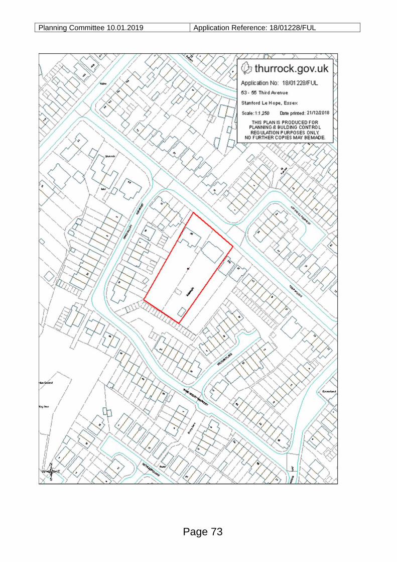
Planning Committee 10.01.2019 Application Reference: 18/01228/FUL
Page 73

This page is intentionally left blank
Planning Committee 10.01.2019 Application Reference: 18/01442/FUL
Reference:
18/01442/FUL
Site:
Land At
Bridge Court
Bridge Road
Grays
Essex
Ward:
Grays Riverside
Proposal:
Construction of 2 no. studio and 2 no. one bed residential units
over existing car parking
Plan Number(s):
Reference Name Received
1000 Rev B Site Location Plan 5 October 2018
1001 Rev B Existing Site Layout 5 October 2018
1005 Rev B Proposed Site Layout 5 October 2018
1009 Rev C Proposed Plans 16 November 2018
1010 Rev B Proposed First Floor Plans 5 October 2018
1011 Rev B Proposed Roof Plans 5 October 2018
1030 Rev B Proposed North and South Elevations 5 October 2018
1031 Rev B Proposed East and West Elevations 5 October 2018
1041 Rev B Proposed Floor Plans, Elevations and Sections -
Blocks 1 and 3 (Units 1 and 4)
5 October 2018
1042 Rev B Proposed Floor Plans, Elevations and Sections -
Block 2 and 3 (Units 2 and 3)
5 October 2018
The application is also accompanied by:
- Design and Planning Statement
Applicant: Ova Build
Validated:
5 October 2018
Date of expiry:
11 January 2018 (Extension of time agreed
with applicant)
Recommendation: Refuse
Page 75
Agenda Item 10
Planning Committee 10.01.2019 Application Reference: 18/01442/FUL
This application is scheduled for determination by the Council’s Planning Committee because the application was called in by Cllr. J. Pothecary, Cllr. M. Kerin, Cllr. M. Fletcher, Cllr. B. Okunade and Cllr. T. Fish to consider issues regarding loss of privacy, loss of light, parking, highways safety, design and character in accordance with Part 3 (b) 2.1 (c) of the Council’s constitution.
1.0 DESCRIPTION OF PROPOSAL
1.1 This application seeks planning permission for three two storey buildings containing
flats located on the car park to the rear of Bridge Court. The layout of the buildings
is for living accommodation at first floor level with parking at ground level. Blocks 1
and 3 would contain 2 x one bed flats whilst block 2 would contain 2 x studio flats.
The buildings would be positioned adjacent to the northern boundary of the site
which abuts 11 Bradbourne Road and Grays Pentecostal Church.
1.2 The buildings would be of mansard roof design and the two one bedroom units
would have a front facing roof terrace which would overlook the car park. The
properties would be accessed by external staircases between the buildings.
2.0 SITE DESCRIPTION
2.1 The site is an unmarked private car park which is leased by the residents in Bridge Court. The site is accessed from Bradbourne Road and is adjacent to Saxon Court.
3.0 RELEVANT HISTORY
3.1 None relevant. 4.0 CONSULTATIONS AND REPRESENTATIONS
4.1 Detailed below is a summary of the consultation responses received. The full
version of each consultation response can be viewed on the Council’s website via
public access at the following link: www.thurrock.gov.uk/planning
PUBLICITY:
4.2 This application has been advertised by way of individual neighbour notification
letters and public site notice which has been displayed nearby. At the time of writing
there have been 32 objections received. The issues raised can be summarised as
follows:
- Effect to existing parking
- No parking for proposed units
- Additional traffic
- Overlooking
- Out of Character
Page 76
Planning Committee 10.01.2019 Application Reference: 18/01442/FUL
- Noise
- Design
- Loss of Amenity
4.3 ENVIRONMENTAL HEALTH:
No objection, subject to conditions.
4.4 HIGHWAYS:
Recommend refusal.
5.0 POLICY CONTEXT
National Planning Guidance
National Planning Policy Framework (NPPF)
5.1 The NPPF was published on 27 March 2012 and amended on 24 July 2018.
Paragraph 10 of the Framework sets out a presumption in favour of sustainable
development. Paragraph 2 of the Framework confirms the tests in s.38 (6) of the
Planning and Compulsory Purchase Act 2004 and s.70 of the Town and Country
Planning Act 1990 and that the Framework is a material consideration in planning
decisions. Paragraph 11 states that in assessing and determining development
proposals, local planning authorities should apply the presumption in favour of
sustainable development. The following headings and content of the NPPF are
relevant to the consideration of the current proposals:
4. Decision-making
5. Delivering a sufficient supply of homes
11. Making effective use of land
12. Achieving well-designed places
Planning Policy Guidance
5.2 In March 2014 the Department for Communities and Local Government (DCLG)
launched its planning practice guidance web-based resource. This was
accompanied by a Written Ministerial Statement which includes a list of the
previous planning policy guidance documents cancelled when the NPPF was
launched. PPG contains a range of subject areas, with each area containing
several subtopics. Those of particular relevance to the determination of this
planning application comprise:
- Design
Page 77
Planning Committee 10.01.2019 Application Reference: 18/01442/FUL
- Determining a planning application
- Use of Planning Conditions
- Viability
Local Planning Policy
Thurrock Local Development Framework (as amended) 2015
5.3 The Council adopted the “Core Strategy and Policies for the Management of
Development Plan Document” in (as amended) in January 2015. The following
Core Strategy policies apply to the proposals:
Spatial Policies
• CSSP1 (Sustainable Housing and Locations)
Thematic Policies:
• CSTP1 (Strategic Housing Provision)
• CSTP22 (Thurrock Design)
• CSTP23 (Thurrock Character and Distinctiveness)2
Policies for the Management of Development:
• PMD1 (Minimising Pollution and Impacts on Amenity)2
• PMD2 (Design and Layout)2
• PMD8 (Parking Standards)3
• PMD9 (Road Network Hierarchy)
[Footnote: 1New Policy inserted by the Focused Review of the LDF Core Strategy.
2Wording of LDF-
CS Policy and forward amended either in part or in full by the Focused Review of the LDF Core
Strategy. 3Wording of forward to LDF-CS Policy amended either in part or in full by the Focused
Review of the LDF Core Strategy].
Thurrock Local Plan
5.4 In February 2014 the Council embarked on the preparation of a new Local Plan for
the Borough. Between February and April 2016 the Council consulted formally on
an Issues and Options (Stage 1) document and simultaneously undertook a ‘Call
for Sites’ exercise. In December 2018 the Council began consultation on an Issues
and Options (Stage 2 Spatial Options and Sites) document.
Thurrock Design Strategy
Page 78
Planning Committee 10.01.2019 Application Reference: 18/01442/FUL 5.5 In March 2017 the Council launched the Thurrock Design Strategy. The Design
Strategy sets out the main design principles to be used by applicants for all new
development in Thurrock. The Design Strategy is a supplementary planning
document (SPD) which supports policies in the adopted Core Strategy.
6.0 ASSESSMENT
6.1 The assessment below covers the following areas:
I. Principle of the Development II. Design and Layout
III. Traffic Impact, Access and Car Parking IV. Amenity
I. PRINCIPLE OF THE DEVELOPMENT
6.2 The site is within a residential area in Grays which has no specific designation
within the Core Strategy. The site presently comprises a private car park for the adjacent flats. Therefore, the principle of further residential use of this site is considered acceptable subject to other policy criteria being met.
II. DESIGN AND LAYOUT
6.3 The NPPF focuses on the importance of good design. Paragraph 130 of the NPPF
states that permission should be refused for development of poor design that fails
to take the opportunities available for improving the character and quality of an area
and the way it functions.
6.4 Policy PMD1 of the Core Strategy states that development will not be permitted
where it would have an unacceptable impact on the amenity of neighbouring
occupiers.
6.5 Policy PMD2 of the Core Strategy requires that all design proposals should respond
to the sensitivity of the site and its surroundings and must contribute positively to
the character of the area in which it is proposed and should seek to contribute
positively to local views, townscape, heritage assets and natural features and
contribute to the creation of a positive sense of place.
6.6 Policy CSTP22 of the Core Strategy indicates that development proposals must
demonstrate high quality design founded on a thorough understanding of, and
positive response to, the local context.
6.7 The applicant’s approach is based upon utilising relatively small open space within
the urban area; in this case, the proposal would occupy and be built over part of an
existing car park. Whilst the utilisation of windfall sites within the urban area is to
Page 79
Planning Committee 10.01.2019 Application Reference: 18/01442/FUL
be encouraged in line with policy CSSP1, in this instance the proposal would have
a particularly awkward relationship with surrounding buildings. Its layout would fail
to respect the existing urban form and would appear as a particularly cramped and
contrived form of development, out of character with the more uniform layout of
surrounding developments. Therefore it is considered that the siting and layout of
the proposal would result in an incongruous, cramped and contrived from of a
development which would appear significantly out of character for the area.
6.8 In terms of scale and design the units would be 6.1m in height to the roof ridge and
have a relatively simple modern appearance. The design and finish of the buildings is unusual within the context of the surrounding development and in combination with the layout would appear incongruous within this area. Therefore the design and appearance of the proposed units would appear significantly out of character in the street scene and the general character of the area.
6.9 The proposed studio flats would have an internal floorspace of approximately 35
square metres. This internal floorspace would fail to meet the nationally described space standards (39 sqm) or the standards for one bed units as set out in Annexe 2 of the Local Plan (45 sqm). As a result the accommodation would fail to provide a suitable internal living environment for future occupiers, harmful to their amenity. Again this is indicative of a cramped form of development and the overdevelopment of the site. The one bedroom units at approximately 83sqm would comply with the standards in Annexe 2 of the Local Plan. However, as a whole the proposal would fail to provide suitable amenity for future occupiers.
6.10 Annexe 2 of the Local Plan requires 25 square metres of amenity space per one
bedroom flat. The only amenity space which would be provided would be small (17 sqm) terraces for the one bed flats. Whilst the units would be located in relatively close proximity to Grays Town Centre and local services and facilities it is considered that the lack of amenity space, particularly for the studio flats is unacceptable in this location. As a result the proposal would fail to provide a suitable living environment for the future occupiers of the flats, again demonstrating the cramped nature of the proposal.
6.11 The proposal is considered out of character within the surroundings, with a design
and layout which are not acceptable. It would also fail to provide a suitable residential environment for future occupiers. The proposal is considered to contravene the NPPF and policies CSTP22, PMD1 and PMD2 of the Core Strategy.
III. TRAFFIC IMPACT, ACCESS AND CAR PARKING
6.12 Policy PMD2 of the Core Strategy indicates that all development should allow
safe and easy access while meeting appropriate standards.
6.13 Policy PMD8 of the Core Strategy requires all development to provide a sufficient
level of parking.
Page 80
Planning Committee 10.01.2019 Application Reference: 18/01442/FUL
6.14 Policy PMD9 of the Core Strategy requires all development to not adversely impact
existing access points.
6.15 The proposal is to build the units over the present car park located on the site. This would mean that some of the present spaces, which are on long term leases to residents within Bridge Court, have to be repositioned. This is a private civil matter and would need agreement of all the leaseholders. With regard to the planning implications of the moving of these car parking spaces, it is considered that the revised parking is not acceptable as it is unworkable. The two replacement spaces in the north-eastern corner of the site would very difficult to access. The Council’s Highway Officer has raised an objection on this basis.
6.16 In terms of numerical provision, the Council’s draft parking standards require 1 space per dwelling with an additional 0.25 spaces per dwelling for visitors in this location. The requirement for a four flat development would be five spaces and the current proposal would not provide any parking. The absence of parking alongside the unacceptable changes to the current parking arrangements would result in an inadequate level of parking provision for the future occupiers of the development and the existing residents at Bridge Court. This is likely to result in an increase in on street parking where there are already significant pressures. The Council’s Highway Officer has raised an objection on this basis also. The proposal is therefore in direct conflict with policy PMD8.
V. AMENITY
6.17 Policy PMD1 of the Core Strategy states that development will not be permitted
where it would have an unacceptable impact on the amenity of neighbouring occupiers.
6.18 The effect of the proposal upon 11 Bradbourne Road would be particularly
unacceptable. The proposed buildings would be 6.1 metres high and positioned in close proximity to the side boundary with this neighbour. They would project along the entire length of this boundary resulting in a significant impact upon both the rear facing windows and the private amenity space of this neighbour. Therefore it is considered that this neighbour would suffer from a significant overbearing impact and loss of light, harmful to their amenity.
6.19 Block 3 would be just 6 metres from the rear of Bridge Court. The flats at the
northern end of Bridge Court would be particularly affected as there would be a new building in close proximity to their windows which would appear overbearing and harm visual amenity.
6.20 The proposal would incorporate external roof terraces on blocks 1 and 3 which would provide some views towards the rear windows at Bridge Court and the side and rear of Saxton Close. There are also external staircases proposed to access the properties which would allow additional views to the front and rear of the building. These would have a particular impact upon the rear garden of 11 Bradbourne. Whilst it is acknowledged that there is already a degree of mutual overlooking in the area it is considered that the proposal would provide additional
Page 81
Planning Committee 10.01.2019 Application Reference: 18/01442/FUL
direct views towards windows and private amenity space of surrounding properties resulting in a loss of privacy, harmful to the amenity of these neighbours.
6.21 The proposal would have an unacceptable impact on the amenity of neighbouring occupiers as the new buildings would result in an overbearing impact, loss of light and loss of privacy. Therefore, the proposal would be contrary to policy PMD1 of the Core Strategy.
7.0 CONCLUSIONS AND REASON(S) FOR REFUSAL
7.1 The proposal is considered unacceptable as it would appear as an incongruous, cramped and contrived form of development, significantly out of character for the area. This is reflected in the inadequate internal and external space for future occupiers which would fail to provide a suitable living environment for these occupiers. The proposal would also result in a significant adverse impact upon the amenity of nearby properties by reason of loss of light, overbearing impact and loss of privacy. The proposed reconfiguration of the car park is not considered workable and the proposal offers no parking for the proposed units resulting in an unacceptable level of parking provision. The absence of car parking would create pressure on existing parking spaces and likely result in vehicles parking on street to the detriment of highway safety and efficiency. The proposal would make a small contribution towards housing in the Borough within the urban area but this benefit would not outweigh the harm identified.
8.0 RECOMMENDATION
8.1 Refuse for the following reasons:
1 The proposed development, by reason of its siting, scale and unsympathetic design would result in an incongruous, cramped and contrived form of development detrimental impact to the character and appearance of the street scene and surrounding area, contrary to the National Planning Policy Framework 2018 and Policies PMD1, PMD2, and CSTP22 of the Core Strategy 2015.
2 The proposed development, by reason of the inadequate internal size of the studio
flats and the lack of sufficient private amenity space would result in an unsuitable living environment which would be harmful to the amenity of future occupiers contrary to Annex 2 of the Borough Local Plan 1997 and policy PMD1 of the Core Strategy 2015.
3 The proposed development, by reason of its siting, scale and the position of
external terraces and stairways would result in a significant loss of light, overbearing impact and loss of privacy to the surrounding residential properties, harmful to the amenity of the occupiers of these properties. Therefore, the proposal is contrary to policy PMD1 of the Core Strategy 2015.
4 The proposed development, by reason of the changes to the existing parking layout
and the lack of additional spaces for the proposed flats would result in an
unacceptable level of parking provision for the existing occupiers of Bridge Court
Page 82
Planning Committee 10.01.2019 Application Reference: 18/01442/FUL
and future occupiers of the proposal. This would result in additional on street
parking pressure in an area that is already oversubscribed harmful to the amenity of
existing residents and highway safety. Therefore, the proposal contravenes
policies PMD2 and PMD8 of the Core Strategy 2015.
Informative Town and Country Planning (Development Management Procedure) (England) Order 2015 (as amended) - Positive and Proactive Statement: The Local Planning Authority has acted positively and proactively in determining this application by identifying matters of concern with the proposal and determining the application within a timely manner, clearly setting out the reason(s) for refusal. The Local Planning Authority is willing to liaise with the Applicant/Agent to discuss the best course of action and is also willing to provide pre-application advice in respect of any future application for a revised development.
Documents:
All background documents including application forms, drawings and other supporting documentation relating to this application can be viewed online: www.thurrock.gov.uk/planning
Page 83
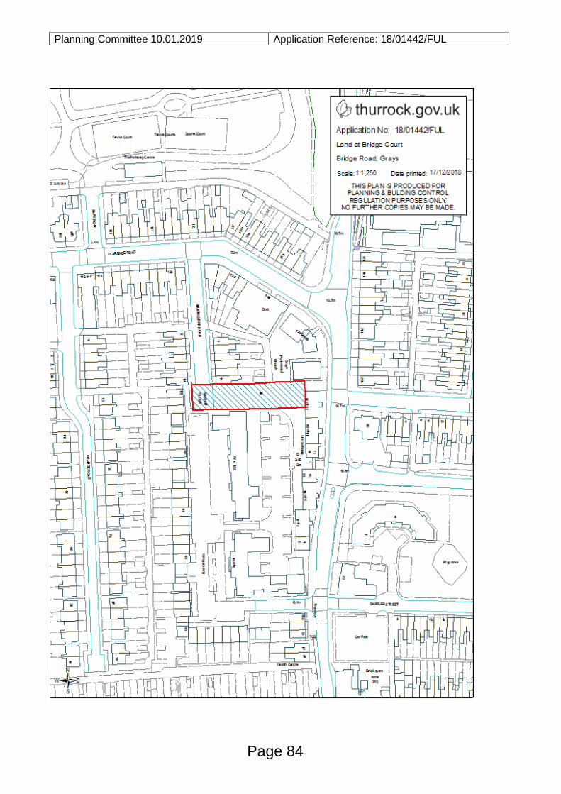
Planning Committee 10.01.2019 Application Reference: 18/01442/FUL
Page 84
Planning Committee 10.01.2019 Application Reference: 18/01613/FUL
Reference:
18/01613/FUL
Site:
55 Corringham Road
Stanford Le Hope
Essex
SS17 0NU
Ward:
Stanford Le Hope
West
Proposal:
Demolition of existing dwelling and construction of four storey
block of 7 apartments with undercroft car park
Plan Number(s):
Reference Name Received
01 Existing and Proposed Block Plans 8 November 2018
02 Proposed Parking, Bin Store and Cycle Store
Plans
8 November 2018
03 Proposed Ground Floor Plan 8 November 2018
04 Proposed First Floor Plan 8 November 2018
05 Proposed Second Floor Plan 8 November 2018
06 Proposed Elevations 5 December 2018
07 Site Location Plan 8 November 2018
1002 06 Existing Elevations 30 November 2018
1003 06 Existing Floor and Roof Plans 30 November 2018
The application is also accompanied by:
- N/A
Applicant:
D Martin
Validated:
8 November 2018
Date of expiry:
11 January 2019 (Extension of time agreed
with applicant)
Recommendation: Refuse
This application is scheduled for determination by the Council’s Planning Committee because the application was called in by Cllr. S. Hebb, Cllr. A. Jefferies, Cllr. G. Collins, Cllr. A. Anderson and Cllr. A. Watkins to consider issues regarding overdevelopment and neighbour amenity in accordance with Part 3 (b) 2.1 (c) of the Council’s constitution.
Page 85
Agenda Item 11
Planning Committee 10.01.2019 Application Reference: 18/01613/FUL
1.0 DESCRIPTION OF PROPOSAL
1.1 This application seeks planning permission to demolish the existing three bedroom
detached dwellinghouse at 55 Corringham Road and replace this with a four storey
building containing seven flats. The flats would consist of 5 x one bedroom units
and 2 x two bedroom units. There would be a parking area under the building at
ground level and to the rear with a total of seven parking spaces.
2.0 SITE DESCRIPTION
2.1 The site presently comprises a single dwellinghouse on a corner plot on the junction of Corringham Road and Manor Road. There is a private rear garden area and hardstanding to the Manor Road facing elevation for parking.
3.0 RELEVANT HISTORY
Application Reference
Description of Proposal Decision
17/01401/FUL Demolition of existing dwelling and erection of 5 x 1 bedroom flats
Refused
4.0 CONSULTATIONS AND REPRESENTATIONS
4.1 Detailed below is a summary of the consultation responses received. The full
version of each consultation response can be viewed on the Council’s website via
public access at the following link: www.thurrock.gov.uk/planning
PUBLICITY:
4.2 This application has been advertised by way of individual neighbour notification
letters and public site notice which has been displayed nearby. At the time of writing
this report there had been objections received from eight addresses, the matters
raised were:
- Overdevelopment of the site
- Create overlooking
- Noise
- Loss of light
- Lack of parking
- Deficient access
- Out of character
- Lack of schools and health facilities
4.3 ENVIRONMENTAL HEALTH:
Page 86
Planning Committee 10.01.2019 Application Reference: 18/01613/FUL No objection subject to conditions. 4.4 HIGHWAYS: Recommend refusal. 5.0 POLICY CONTEXT
National Planning Guidance
National Planning Policy Framework
5.1 The NPPF was published on 27 March 2012 and amended on 24 July 2018.
Paragraph 10 of the Framework sets out a presumption in favour of sustainable
development. Paragraph 2 of the Framework confirms the tests in s.38 (6) of the
Planning and Compulsory Purchase Act 2004 and s.70 of the Town and Country
Planning Act 1990 and that the Framework is a material consideration in planning
decisions. Paragraph 11 states that in assessing and determining development
proposals, local planning authorities should apply the presumption in favour of
sustainable development. The following headings and content of the NPPF are
relevant to the consideration of the current proposals:
4. Decision-making
5. Delivering a sufficient supply of homes
11. Making effective use of land
12. Achieving well-designed places
Planning Policy Guidance
5.2 In March 2014 the Department for Communities and Local Government (DCLG)
launched its planning practice guidance web-based resource. This was
accompanied by a Written Ministerial Statement which includes a list of the
previous planning policy guidance documents cancelled when the NPPF was
launched. PPG contains a range of subject areas, with each area containing
several subtopics. Those of particular relevance to the determination of this
planning application comprise:
- Design
- Determining a planning application
- Noise
- Planning obligations
- Use of Planning Conditions
Local Planning Policy
Page 87
Planning Committee 10.01.2019 Application Reference: 18/01613/FUL
Thurrock Local Development Framework (as amended) 2015
5.3 The Council adopted the “Core Strategy and Policies for the Management of
Development Plan Document” in (as amended) in January 2015. The following
Core Strategy policies apply to the proposals:
Spatial Policies
• CSSP1 (Sustainable Housing and Locations)
Thematic Policies:
• CSTP1 (Strategic Housing Provision)
• CSTP22 (Thurrock Design)
Policies for the Management of Development:
• PMD1 (Minimising Pollution and Impacts on Amenity)2
• PMD2 (Design and Layout)2
• PMD8 (Parking Standards)3
• PMD16 (Developer Contributions)2
[Footnote: 1New Policy inserted by the Focused Review of the LDF Core Strategy.
2Wording of
LDF-CS Policy and forward amended either in part or in full by the Focused Review of the LDF Core
Strategy. 3Wording of forward to LDF-CS Policy amended either in part or in full by the Focused
Review of the LDF Core Strategy].
Thurrock Local Plan
5.4 In February 2014 the Council embarked on the preparation of a new Local Plan for
the Borough. Between February and April 2016 the Council consulted formally on
an Issues and Options (Stage 1) document and simultaneously undertook a ‘Call
for Sites’ exercise. In December 2018 the Council began consultation on an Issues
and Options (Stage 2 Spatial Options and Sites) document.
Thurrock Design Strategy
5.5 In March 2017 the Council launched the Thurrock Design Strategy. The Design
Strategy sets out the main design principles to be used by applicants for all new
development in Thurrock. The Design Strategy is a supplementary planning
document (SPD) which supports policies in the adopted Core Strategy.
6.0 ASSESSMENT
Page 88
Planning Committee 10.01.2019 Application Reference: 18/01613/FUL
6.1 The assessment below covers the following areas:
I. Principle of the Development
II. Design and Relationship of Development with Surroundings III. Amenity Issues (Neighbours) IV. Living Standards V. Access and Parking
VI. Infrastructure Improvements and Affordable Housing
I. PRINCIPLE OF DEVELOPMENT
6.2 The site is within a residential area in Corringham which has no designation within the Core Strategy and presently comprises a single dwellinghouse. Therefore, the principle of further residential use of this site is considered acceptable subject to other policy criteria being met.
II. DESIGN AND RELATIONSHIP OF DEVELOPMENT WITH
SURROUNDINGS
6.3 The NPPF focuses on the importance of good design. Paragraph 130 of the NPPF
states that permission should be refused for development of poor design that fails
to take the opportunities available for improving the character and quality of an area
and the way it functions.
6.4 Policy PMD1 of the Core Strategy states that development will not be permitted
where it would have an unacceptable impact on the amenity of neighbouring
occupiers.
6.5 Policy PMD2 of the Core Strategy requires that all design proposals should respond
to the sensitivity of the site and its surroundings and must contribute positively to
the character of the area in which it is proposed and should seek to contribute
positively to local views, townscape, heritage assets and natural features and
contribute to the creation of a positive sense of place.
6.6 Policy CSTP22 of the Core Strategy indicates that development proposals must
demonstrate high quality design founded on a thorough understanding of, and
positive response to, the local context.
6.7 This application follows the refusal of an earlier scheme in 2017 (planning ref.
17/01401/FUL) which sought planning permission for five x 1 bedroom flats within a three storey building with the third floor contained within a dual pitched roof. The scheme was deemed unacceptable due to concerns over the design, bulk and scale and the quantum of development.
Despite the refusal in 2017, the current proposal seeks more units within a building which would have a greater depth, height and bulk than the earlier scheme.
Page 89
Planning Committee 10.01.2019 Application Reference: 18/01613/FUL
The design and scale of the proposed building would be at complete odds to the existing dwelling and others in the immediate location; the building would be overly bulky and devoid of architectural design quality. The mass and scale of the building would be exacerbated by the poor quality elevation treatment and awkward fenestration. The scheme does little to address the earlier reasons for refusal; indeed, the current scheme, in many respects is less favourable than the rejected 2017 scheme. If permitted, the development would result in the introduction of an incongruous and overly dominant and cramped feature in the street scene which would be harmful to the character of the immediate area and appearance of the street scene. The scale, bulk, form and design pay no regard to the character and appearance of the surrounding area. The scheme is in direct conflict with the NPPF and Policies PMD1, PMD2, and CSTP22 of the Core Strategy.
III. AMENITY ISSUES (NEIGHBOURS)
6.8 Policy PMD1 of the Core Strategy states that development will not be permitted
where it would have an unacceptable impact on the amenity of neighbouring
occupiers.
6.9 Part (v) of Annexe 2 of the Local Plan states that “where the property is situated
close to the common boundary with another dwelling, there shall be no overlooking
to the rear gardens of that neighbour from first floor kitchen/dining or main living
areas.
6.10 As described above, the proposal would result in a significant increase in bulk and
scale of the built form on the site. This would introduce additional windows which
would also be at a higher level than the existing building. As such the proposal
would be overbearing and lead to overlooking, especially to No.57 Corringham
Road and No.2 Manor Road. This would unacceptably affect the amenities of these
neighbouring properties.
6.11 The introduction an area of car parking in the location of the existing rear garden
would give rise to noise and vehicle movements alongside the rear boundary of
No.57 Corringham Road which would lead to significant disturbance to this
neighbour, harmful to their amenity. Accordingly, the proposed development is
considered to be contrary to Policy PMD1 of the Core Strategy and the relevant
criteria in the NPPF.
IV. LIVING STANDARDS
6.12 The proposed flats all meet the minimum internal floor standards of 45/55 square
metres of internal flood space required in Annexe 2 of the Local Plan. However, the
proposal fails to provide any amenity space.
Page 90
Planning Committee 10.01.2019 Application Reference: 18/01613/FUL
6.13 Annexe 2 of the Local Plan requires 25 square metres of amenity space per one bedroom flat and 50 square metres for a two bedroom flat. The proposal would need to provide 225 square metres of private or communal amenity space in order to comply with Council policy. The provision of zero amenity space is not acceptable and only further demonstrates the overdevelopment of the site. The proposal is considered to be contrary to Policy PMD2 for this reason.
IV. ACCESS AND PARKING
6.14 Policy PMD2 of the Core Strategy indicates that all development should allow
safe and easy access while meeting appropriate standards.
6.15 Policy PMD8 of the Core Strategy requires all development to provide a sufficient
level of parking.
6.16 The parking area would be underneath and to the rear of the property, providing
one parking space per unit with no visitor parking. The Council’s Highways Officer
advises the site is in an area of medium accessibility where the following standards
apply:
a) 1 to 1.25 car parking spaces per unit plus 0.25 spaces per unit (unallocated) for
visitors;
b) 1 secure and covered cycle parking space per unit plus one additional place for
visitors
This would equate to a requirement for total of 10 car parking spaces and 8 cycle
parking places for the 7 units proposed. The proposal shows a total of seven
parking spaces which would fall short of the minimum requirement in order to
comply with Council policy PMD8.
6.17 In addition to the numerical shortfall, the layout of the proposed parking is
unworkable and would not provide parking spaces which could be accessed with
ease or without awkward manoeuvrability. The Council’s Highway Officer has
recommended refusal on this basis.
6.18 A cycle parking area is indicated, however no details of the storage facility has been provided and the area would appear too small to provide secure and covered storage for the required eight cycles.
6.19 Turning to the matter of access, the proposed access into the car parking area is
considered unsafe, as it is too narrow for two vehicles to pass. With seven separate
units having access to the car parking area it is likely that vehicles entering the
parking area will encounter a vehicle coming out. This is likely to result in the
vehicle reversing back out onto the public highway which may lead to an encounter
with pedestrians and vehicles on Manor Road. The right angle turn into the main
Page 91
Planning Committee 10.01.2019 Application Reference: 18/01613/FUL
parking area from the access is exceptionally tight and unworkable in practice. In
view of the above, the proposal would conflict with Core Strategy policies PMD2
and PMD8 in this regard.
V. INFRASTRUCTURE IMPROVEMENTS AND AFFORDABLE HOUSING
6.20 Policy PMD16 of the Core Strategy indicates that where needs would arise as a
result of development; the Council will seek to secure planning obligations under
Section 106 of the Town and Country Planning Act 1990 and any other relevant
guidance. The proposal is for a small scale development and no infrastructure
requirements have been identified arising from this development at this time.
Accordingly, it is not considered necessary for an s.106 contribution or affordable
housing in this instance.
7.0 CONCLUSIONS AND REASON(S) FOR REFUSAL
7.1 The application site lies within a residential area with no formal allocation. Therefore the principle of residential development is considered to be acceptable.
7.2 However, it is considered that due to the incongruous design, impact upon amenity
of neighbouring properties, lack of amenity space and unacceptable parking and access, the proposal would represent an unacceptable form of development and is considered to constitute overdevelopment of the site.
8.0 RECOMMENDATION
Refuse for the following reasons:
1 The proposed development, by reason of its scale, bulk, form and unsympathetic design would result in an incongruous and overly dominant feature in a prominent corner location, which would have a detrimental impact upon the character and appearance of the street scene and surrounding area, contrary to the National Planning Policy Framework 2018 and policies PMD1, PMD2, and CSTP22 of the Core Strategy 2015.
2 The proposed development, by reason of its bulk and scale, and significant number
of high level windows would result in an overbearing impact and loss of privacy to
neighbouring properties. Furthermore, the introduction of car parking within the
existing rear garden would give rise to noise and vehicle movements alongside the
rear boundary of No 53 Corringham Road resulting in disturbance to this neighbour.
Therefore the proposal would result in an unacceptable impact upon neighbouring
amenity contrary to Policy PMD1 of the Core Strategy 2015 and the relevant criteria
in the National Planning Policy Framework 2018.
3 The proposed development, by reason of the lack of amenity space fails to provide
a suitable residential environment for future occupiers, harmful to the amenity of
Page 92
Planning Committee 10.01.2019 Application Reference: 18/01613/FUL
these residents. The proposal is therefore contrary to the minimum requirements of the saved Annex 2 of the Borough Local Plan 1997 and Policy PMD1 of the Core Strategy 2015.
4 The proposed development, by reason of the lack of sufficient vehicle and cycle
parking spaces and an inappropriate car parking layout which is unworkable, would
fail to provide a suitable level of parking provision for the development contrary to
the requirements of policies PMD2 and PMD8 of the Core Strategy 2015.
5. The proposed access, by reason of its insufficient width and lack of visibility would
result in the potential for conflict between vehicle entering and leaving the site
which could cause vehicles to have to reverse onto Manor Road, harmful to
highway safety. Therefore, the proposal would unacceptably impact upon highway
safety contrary to policies PMD2 and PMD8 of the Core Strategy 2015.
6 The proposed development, by reason of the its scale, bulk, lack of adequate
parking and cycle storage facilities, and lack of amenity space as stated in reasons 1 to 5 cumulatively demonstrate that the proposal would constitute the overdevelopment of the site, contrary to the National Planning Policy Framework 2018 and Policies PMD1, PMD2, and CSTP22 of the Core Strategy 2015 and saved Annex 2 of the Borough Local Plan 1997.
Informative Town and Country Planning (Development Management Procedure) (England) Order 2015 (as amended) - Positive and Proactive Statement: The Local Planning Authority has acted positively and proactively in determining this application by identifying matters of concern with the proposal and determining the application within a timely manner, clearly setting out the reason(s) for refusal. The Local Planning Authority is willing to liaise with the Applicant/Agent to discuss the best course of action and is also willing to provide pre-application advice in respect of any future application for a revised development.
Documents:
All background documents including application forms, drawings and other supporting documentation relating to this application can be viewed online: www.thurrock.gov.uk/planning
Page 93
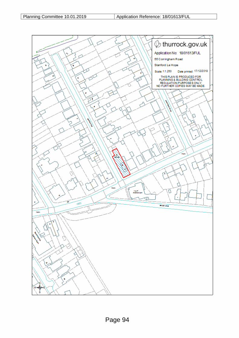
Planning Committee 10.01.2019 Application Reference: 18/01613/FUL
Page 94
Planning Committee 10.01.2019 Application Reference: 18/00540/FUL
Reference:
18/00540/FUL
Site:
Town Centre Car Park
King Street
Stanford Le Hope
Essex
Ward:
Stanford Le Hope
West
Proposal:
Construction of a mixed use development comprising 159sq.m
of retail/leisure/commercial units (within classes A1, A2, A3, A4,
A5 and D2) at ground floor level and 47 residential units on
upper floors together with an under croft and surface car park
(comprising 56 car parking spaces), access, landscaping and
associated works.
Plan Number(s):
Reference Name Received
1000F Proposed Site Layout 21st November 2018
1100E Proposed Plans 21st November 2018
1110E Proposed Plans 21st November 2018
1120E Proposed Plans 21st November 2018
1130E Proposed Plans 21st November 2018
1140E Proposed Plans 21st November 2018
1160E Roof Plans 21st November 2018
1200E Proposed Elevations 21st November 2018
1201D Proposed Elevations 21st November 2018
1210E Proposed Elevations 21st November 2018
1220D Proposed Elevations 21st November 2018
1230D Proposed Elevations 21st November 2018
1700E Other 21st November 2018
0200 Existing Elevations 21st November 2018
1710A Proposed Plans 21st November 2018
0001A Location Plan 21st November 2018
0010 Other 21st November 2018
0100A Existing Plans 21st November 2018
The application is also accompanied by:
Planning Statement
Daylight and Sunlight Report
Design and Access Statement
Page 95
Agenda Item 12
Planning Committee 10.01.2019 Application Reference: 18/00540/FUL
Drainage Technical Note
Aboricultural Assessment
Heritage Statement
Transport Assessment and draft Travel Plan
Verified Views Report
Applicant:
Capital Land Partners LLP
c/o RPS Planning and Development Ltd
Validated:
17 April 2018
Date of expiry:
15 January 2019 [Extension of
time agreed with applicant]
Recommendation: Approve, subject to planning conditions and obligations.
This application is scheduled for determination by the Council’s Planning Committee
because it represents a major development proposal in a town centre which has
significant strategic policy implications, in accordance with Chapter 5, Part 3 2.1 (a) of the
Council’s Constitution.
1.0 DESCRIPTION OF PROPOSAL
1.1 This application seeks full planning permission for the construction of a mixed use
development comprising of two retail/leisure/commercial units of 159sqm (within
classes A1, A2, A3, A4, A5 and D2) at ground floor level and 47 residential units on
the upper floors of the proposed building together with an under croft and surfaced
car park [comprising 53 car parking spaces], access, landscaping and associated
works.
1.2 The key elements of the proposals are set out in the table below:
Site Area
(Gross)
0.35ha
Height 26.72m over 5 storeys
Units (All)
Type
(ALL)
1-
bed
2-
bed
3-
bed
4-
bed
5-
bed
TOTAL
Houses
Flats 20 27 47
TOTAL 20 27 47
Ground Floor 1 flat [2 beds]
First Floor 14 flats [6 x 1 beds & 8 x 2 beds]
Second Floor 14 flats [6 x 1 beds & 8 x 2 beds]
Third Floor 13 flats [6 x 1 beds & 7 x 2 beds]
Page 96
Planning Committee 10.01.2019 Application Reference: 18/00540/FUL
Fourth Floor 5 flats [2 x 1 beds & 3 x 2 beds]
Affordable
Units
Type (ALL) 1-
bed
2-
bed
3-
bed
TOTAL
Houses
Flats 11 5
TOTAL 11 5 16
Commercial
Floorspace
2 Ground Floor Commercial Units totalling 159 sq.m
Unit 1 92 sq.m
Unit 2 67 sq.m
All units are proposed to fall in Use Classes A1 [retail], A2
[financial and professional services], A3 [restaurants and
cafes], A4 [drinking establishments], A5 [hot food take-
aways] and D2 [assembly and leisure]
Car Parking
Flats: 1 space per unit – 47 spaces including 2 disabled
spaces
Commercial Units: 3 spaces
Visitors: 3 spaces
Total: 53 spaces using part of the existing car park [24
spaces] and within the basement/ground level of the
development [29 spaces]
Total remaining public car parking spaces: 43 spaces
Cycle
Parking
54 spaces
Amenity
Space
Balconies 7sq.m in size on average with the exception of
two first floor units which have larger terraces
Density 134 units per ha for the whole site
Access
1.3 The development would be accessed via the existing car park from the High Street,
which forms a one way system through to King Street. From the one way system a
left turn would be created serving 43 remaining public car park spaces and 24 car
parking spaces allocated for occupiers of the flats and for their visitors, which would
be located in area secured by a barrier system. Within the lower ground/basement
area of the proposed development a right turn from the car park’s one way system
would provide access to a further 29 car parking spaces in an under croft car park
for occupiers of the flats and the commercial units. The existing car park exit onto
King Street would remain the same.
Page 97
Planning Committee 10.01.2019 Application Reference: 18/00540/FUL
Layout
1.4 The basement/ground floor level of the proposed building would mainly comprise of
the car park but also servicing arrangements, cycle storage, two commercial units
and one ground floor flat, which would be sited towards the north eastern corner of
the building. The first to fourth floor would comprise of flats on each level accessed
via internal stairways and lift systems. On the roof of the building there would be an
area allocated for photovoltaic solar panels.
Scale
1.5 The proposed building would be 26.7m high over five levels; the building would be
of a modern contemporary design featuring a palette of buff brickwork, glazing and
stonework along with balcony features and a parapet style roof.
Amenity and Landscaping
1.6 Each flat would have a balcony/terrace as a form of amenity space and planters
would be provided to the front elevation of the building fronting onto King Street.
The third floor of the building would incorporate a roof terrace on the corner of King
Street and the existing car park exit.
2.0 SITE DESCRIPTION
2.1 This application relates to an irregular shaped site measuring 0.35 hectares which
is located in the middle of Stanford-le-Hope centre. The site is currently occupied
by a derelict commercial premises on the corner of King Street/High Street which
would be demolished as part of the development. The remainder of the site is
currently used a town centre car park providing 76 spaces. The site is bounded by
the High Street, Church Hill and King Street.
2.2 In terms of location the site is located in the east of the borough of Thurrock and is
approximately 250 metres north-east of Stanford-le-Hope railway station.
2.3 The topography of the site is such that ground levels slope upwards towards the
junction of King Street/High Street. To the south of the site are two Listed Buildings,
the Church of St Margaret of Antioch [Grade I] and the ‘Inn on the Green’ public
house [Grade II]. Towards the northern boundary of the site there are two trees with
Tree Preservation Orders [TPO].
2.4 The site is within the commercial centre of Stanford Le Hope with shops and other
commercial properties fronting High Street and King Street, some with residential
units above. Buildings are generally 2 to 3 storey in height.
Page 98
Planning Committee 10.01.2019 Application Reference: 18/00540/FUL
2.5 The site is located approximately 200 metres north of Stanford-le-Hope railway
station, which provides regular services to London [Fenchurch Street] and
Southend. Stanford-le-Hope is also sufficiently served by bus services. The site is
in very close proximity to the Manorway and, therefore, provides direct access to
the Strategic Highway Network (A13), which subsequently feeds into the M25 and
A127.
3.0 RELEVANT PLANNING HISTORY
3.1 The following table provides the planning history:
Reference
Description Decision
12/50463/TTGFUL Construction of a mixed use
development, comprising retail store at
ground floor level and 22 residential
units at first, second and third floor levels
together with a surface and decked car
park (comprising 101 car parking
spaces), access, landscaping and
associated works
Approved
18.12.2012
Permission
valid for 3
years and
has now
expired
4.0 CONSULTATION AND REPRESENTATIONS
4.1 Detailed below is a summary of the consultation responses received. The full
version of each consultation response can be viewed on the Council’s website via
public access at the following link: www.thurrock.gov.uk/planning
4.2 PUBLICITY:
This application has been advertised by way of individual neighbour notification
letters, press advert and public site notice which has been displayed nearby.
At the time of writing, 35 letters of objection had been received raising the following
comments:
- Loss of Amenity;
- Out of character;
- Scale too much for this location and would have detrimental impact upon the
town centre;
- 5 storey building would be a complete eyesore;
- Town centre needs more parking to sustain shops and not this development;
- Will impact upon the viability of the town centre;
Page 99
Planning Committee 10.01.2019 Application Reference: 18/00540/FUL
- Additional traffic and congestion;
- Loss of parking will cause shops to close;
- Nowhere to park for the shops;
- Increased need for parking;
- Where is the permit parking going?
- Environmental pollution;
- Litter/smells;
- Possible excessive noise;
- Town is already overcrowded with no doctors, dentists and schools;
- Building will spoil the town;
- Access to site;
- Application needs to be refused and car park returned to community;
- Council should not have sold the car park;
- Current car park is now run down;
- Loss of jobs;
- Impact upon the church and the church car park;
- Spoiling view;
1 letter of support had also been received raising the following points:
- Proposal would create jobs
- Much needed improvements to the site
- Car park is an eyesore and magnet for antisocial behaviour
4.3 ANGLIAN WATER:
No objection subject to a planning condition requiring a surface water management
strategy.
4.4 EDUCATION:
A financial contribution of £95,511.90 is required towards nursery, primary and
secondary provision or towards an extension to existing primary school/s in the
Corringham and Stanford-le-Hope Primary School Planning Area [IRL reference
IRL0068].
4.5 ENVIRONMENT AGENCY:
No comments to make.
4.6 ENVIRONMENTAL HEALTH:
No objections subject to conditions requiring a Construction and Environmental
Page 100
Planning Committee 10.01.2019 Application Reference: 18/00540/FUL
Construction Management Plan [CEMP], construction hours, and a watching brief
for contamination. No implications for air quality.
4.7 ESSEX AND SUFFOLK WATER:
No objection.
4.8 ESSEX FIRE SERVICE:
No objections as fire safety will be required through the Building Regulations
4.9 ESSEX POLICE ARCHITECTURAL LIAISON OFFICER:
No response.
4.10 FLOOD RISK ADVISOR:
Holding objection as further information is required.
4.11 HIGHWAYS:
No objection as the reduced public parking which would still provide 43 public car
parking spaces and the proposed development would be provide acceptable
parking provision. A planning obligation is requested for a financial contribution of
£10,000 for replacement of the existing footway and kerbing around the entire
frontage of the site with King Street and High Street to improve the appearance of
the highway around the site and provide good pedestrian ramps across both the
vehicular accesses into the site.
4.12 HOUSING:
No objection subject to the development providing 35% affordable housing
provision to accord with LDF policy CSTP2 and the latest Strategic Housing Market
Assessment [SHMA].
4.13 LANDSCAPE AND ECOLOGY ADVISOR:
The proposal would result the loss of 2 trees subject of Tree Preservation Orders
[TPO’s] and other trees. No details provided of any landscape scheme therefore
planning conditions regarding replacement trees and landscaping is required.
4.14 LISTED BUILDINGS AND CONSERVATION ADVISOR:
Page 101
Planning Committee 10.01.2019 Application Reference: 18/00540/FUL
The harm caused to the Grade I listed Church of St Margaret of Antioch is
considered ‘less than substantial’ and therefore this harm must be balanced against
any public benefits which may arise as a result of the scheme (Paragraph 196 of
the NPPF).
4.15 NHS ENGLAND:
No contributions required.
4.16 PUBLIC FOOTPATH OFFICER:
Public Footpath 166 should not be obstructed and be kept open for use at all times
unless a request for a temporary closure is required whereby an alternative route
would be considered/agreed and a diversion route signed accordingly.
4.17 PUBLIC HEALTH OFFICER:
No objections subject to construction management, contributions to public realm,
healthcare, education and cycle routes
4.18 REGENERATION OFFICER:
Support the development subject to a condition that parking provided on site is to
serve existing commercial uses in the rest of the town centre
4.19 TRAVEL PLAN CO-ORDINATOR:
No objection subject to amendments to the applicant’s ‘Framework Travel Plan’.
4.20 URBAN DESIGN ADVISOR:
No objections as amendments to the scheme have improved the development.
Recommend conditions in relation to fenestration, balcony details, high quality
materiality and landscaping to include surface material and wayfinding through
appropriate signage.
5.0 POLICY CONTEXT
5.1 National Planning Policy Framework
The revised NPPF was published on 24 July 2018 and sets out the government’s
planning policies. Paragraph 14 of the Framework sets out a presumption in favour
of sustainable development. Paragraph 2 of the Framework confirms the tests in
Page 102
Planning Committee 10.01.2019 Application Reference: 18/00540/FUL
s.38 (6) of the Planning and Compulsory Purchase Act 2004 and s.70 of the Town
and Country Planning Act 1990 and that the Framework is a material consideration
in planning decisions. Paragraph 11 states that in assessing and determining
development proposals, local planning authorities should apply the presumption in
favour of sustainable development. The following headings and content of the
NPPF are relevant to the consideration of the current proposals:
- 2. Achieving sustainable development
- 4. Decision-making
- 5. Delivering a sufficient supply of homes
- 6. Building a strong, competitive economy
- 7. Ensuring the vitality of town centres
- 8. Promoting healthy and safe communities
- 9. Promoting sustainable transport
- 11. Making effective use of land
- 12. Achieving well-designed places
- 14. Meeting the challenge of climate change, flooding and coastal change
- 16. Conserving and enhancing the historic environment
5.2 Planning Policy Guidance
In March 2014 the Department for Communities and Local Government (DCLG)
launched its planning practice guidance web-based resource. This was
accompanied by a Written Ministerial Statement which includes a list of the
previous planning policy guidance documents cancelled when the NPPF was
launched. PPG contains a range of subject areas, with each area containing
several subtopics. Those of particular relevance to the determination of this
planning application comprise:
- Climate change
- Conserving and enhancing the historic environment
- Design
- Determining a planning application
- Ensuring the vitality of town centres
- Flood Risk and Coastal Change
- Health and wellbeing
- Housing and economic development needs assessments
- Housing and economic land availability assessment
- Noise
- Open space, sports and recreation facilities, public rights of way and local green
space
- Planning obligations
- Renewable and low carbon energy
Page 103
Planning Committee 10.01.2019 Application Reference: 18/00540/FUL
- Transport evidence bases in plan making and decision taking
- Travel plans, transport assessments and statements in decision-taking
- Tree Preservation Orders and trees in conservation areas
- Use of Planning Conditions
- Viability
5.3 Local Planning Policy Thurrock Local Development Framework (2015)
The “Core Strategy and Policies for Management of Development Focused Review:
Consistency with National Planning Policy Framework Focused Review” was
adopted by Council on the 28th February 2015. The following policies apply to the
proposals:
OVERARCHING SUSTAINABLE DEVELOPMENT POLICY
- OSDP1 (Promotion of Sustainable Growth and Regeneration in Thurrock)1
SPATIAL POLICIES
- CSSP1 (Sustainable Housing and Locations)
THEMATIC POLICIES
- CSTP1 (Strategic Housing Provision)
- CSTP2 (The Provision Of Affordable Housing)
- CSTP7 (Network of Centres)
- CSTP8 (Viability and Vitality of Existing Centres)2
- CSTP22 (Thurrock Design)
- CSTP23 (Thurrock Character and Distinctiveness)2
- CSTP24 (Heritage Assets and the Historic Environment)
POLICIES FOR MANAGEMENT OF DEVELOPMENT
- PMD1 (Minimising Pollution and Impacts on Amenity)2
- PMD2 (Design and Layout)2
- PMD3 (Tall Buildings)3
- PMD4 (Historic Environment)2
- PMD8 (Parking Standards)3
- PMD9 (Road Network Hierarchy)
- PMD10 (Transport Assessments and Travel Plans)2
- PMD12 (Sustainable Buildings)2
- PMD13 (Decentralised, Renewable and Low Carbon Energy Generation)
- PMD15 (Flood Risk Assessment)2
- PMD16 (Developer Contributions)2
Page 104
Planning Committee 10.01.2019 Application Reference: 18/00540/FUL
[Footnote: 1New Policy inserted by the Focused Review of the LDF Core Strategy.
2Wording of LDF-CS Policy and forward amended either in part or in full by the
Focused Review of the LDF Core Strategy. 3Wording of forward to LDF-CS Policy
amended either in part or in full by the Focused Review of the LDF Core Strategy].
5.4 Thurrock Local Plan
In February 2014 the Council embarked on the preparation of a new Local Plan for
the Borough. Between February and April 2016 the Council consulted formally on
an Issues and Options (Stage 1) document and simultaneously undertook a ‘Call
for Sites’ exercise. In December 2018 the Council began consultation on an Issues
and Options (Stage 2 Spatial Options and Sites) document.
5.5 Thurrock Design Strategy
In March 2017 the Council launched the Thurrock Design Strategy. The Design
Strategy sets out the main design principles to be used by applicants for all new
development in Thurrock. The Design Strategy is a supplementary planning
document (SPD) which supports policies in the adopted Core Strategy.
6.0 ASSESSMENT
6.1 The material considerations for this application are as follows:
I. Principle of the Development
II. Housing Land Supply, Need, Mix and Affordable Housing
III. Design and Layout and Impact upon the Area
IV. Impact upon Heritage Assets
V. Traffic Impact, Access and Car Parking
VI. Landscaping and Amenity Space
VII. Effect on Neighbouring Properties
VIII. Energy and Sustainable Buildings
IX. Viability and Planning Obligations
X. Sustainability
XI. Other Matters
I. PRINCIPLE OF THE DEVELOPMENT
6.2 The site is located in the Stanford town centre and within the ‘Shopping Areas’ as
defined on the LDF Proposals Map where policies CSTP7 (Network of Centres) and
CSTP8 (Vitality and Viability of Existing Centres) are applicable. Section 3 of policy
CSTP7 identifies Stanford as an ‘Existing Local Centre’ and encourages the
following development:
Page 105
Planning Committee 10.01.2019 Application Reference: 18/00540/FUL
i. Renewal, upgrading or remodelling of existing floorspace;
ii. Additional small scale retail floorspace space in suitable locations that will
strengthen the centres’ retail offer;
iii. Investigation into the potential of a new supermarket on an appropriate site
in Stanford-le-Hope to reduce convenience expenditure leakage from the
east of the Borough.
6.3 Policy CSTP8 seeks to ‘maintain and promote the retail function of existing centres.
Measures to improve the vitality and viability of the network of centres will be
encouraged in order to meet the needs of the Borough’s residents and act as a
focus for retail, leisure, cultural, business and residential uses’.
6.4 This application follows from an earlier scheme which obtained planning permission
in 2012 under planning reference 12/50463/TTGFUL. That scheme provision of a
retail store designed to be used as a supermarket to meet criteria iii from policy
CSTP7, however, the applicant’s supporting information for this application
demonstrates that no end user was interested in the supermarket and the planning
permission has since lapsed. For the current scheme, the applicant is reliant upon
criteria ii of policy CSTP7 as the development makes provision for two smaller
retail/commercial units to complement the existing retail/commercial offer in
Stanford town centre. The location of these ground floor commercial units would
help provide a link between King Street and the High Street joining the two main
shopping parades within the town which are currently separately by this site. The
development in this regard would enhance the vitality and viability of this town
centre in keeping with the requirements of paragraph 86 [d] of the NPPF.
6.5 Policy CSTP8 allows for residential uses in appropriate locations and paragraph 23
of the NPPF ‘recognises that residential development can play an important role in
the vitality of centres’ and requires local planning authorities to ‘set out policies to
encourage residential development on appropriate sites’. In addition to this,
paragraph 85 [f] of the NPPF recognises the importance of residential development
in ensuring the vitality of centres. In this town centre location, it is considered that
there are opportunities for further residential uses above ground floor level which
would support the vibrancy of the town.
6.6 In summary, there are no in principle objections to the re-development of the site
and the provision of retail/commercial uses at ground floor level.
II. HOUSING LAND SUPPLY, NEED, MIX AND AFFORDABLE HOUSING
6.7 The Council at present cannot demonstrate an up to date five-year housing land
supply to comply with the requirements of a paragraph 67 of the NPPF. The
relevant housing policies CSSP1 [Sustainable Housing and Locations] and CSTP1
[Strategic Housing Provision] should not be considered up to date, for housing
Page 106
Planning Committee 10.01.2019 Application Reference: 18/00540/FUL
need, if the Council cannot demonstrate a five-year housing land supply. The
proposal would contribute to the housing land supply providing the development
can be built within 5 years.
6.8 Policy CSTP1 requires the dwelling mix for new residential developments to be
provided in accordance with the latest [May 2016] Strategic Housing Marketing
Assessment [SHMA] and the update Addendum [May 2017]. The SHMA sets out
the housing need and mix requirements for the Borough but also the wider context
of South Essex. In terms of the housing need requirement, the SHMA identifies a
predominant need for 1 and 2 bedroom flats. The proposed development would
provide flatted development in compliance with the SHMA and therein assist in
meeting housing need and delivering a recognised dwelling mix requirement, in
accordance with the requirements of policy CSTP1.
6.9 With regard to affordable housing, policy CSTP2 seeks to achieve 35% of the
development to be allocated for affordable housing. The applicant is offering a
policy compliant level of 35% affordable housing for this development, which meets
the requirements of the Council’s Housing Officer and be secured through a
planning obligation to a future s106 legal agreement. The illustrative details to show
the location of the affordable housing units shows 11 x 1 bedroom units and 5 x 2
bedroom units.
III. DESIGN AND LAYOUT AND IMPACT UPON THE AREA
6.10 The Thurrock Design Strategy was adopted as a supplementary planning
document and endorsed as a material consideration in the determination of
planning applications in March 2017. Section 3 o f the Guide (‘Designing in
Context’) requires applicants to appraise a development site by taking the
following considerations into account:
understanding the place;
working with site features;
making connections; and
building in sustainability.
King Street and the High Street are characterised by terraces of two and three
storey buildings providing commercial uses on the ground floor and some
residential above. To the west of the site are two storey buildings with pitched roofs,
whilst opposite is a three storey terrace. The car park forms the only flat / levelled
open area in this location. One of the key buildings in Stanford town centre is the
church which can be seen from within the site and various vantage points around
the town centre. The church also forms a dominant feature on the skyline from
outside Stanford Le Hope.
Page 107
Planning Committee 10.01.2019 Application Reference: 18/00540/FUL
6.11 The principal elevation of the building would front King Street and would present
two floor commercial units at ground floor level. The return frontage onto the High
Street would not include any ground floor commercial units as the ground level
rises towards the High Street. The proposed layout would retain the car park at the
rear of the site which would be partly segregated for residential parking but would
also retain part of the existing public car park. The existing car park entrance and
exit for vehicular traffic would remain the same.
6.12 Since the submission of the application, the applicant’s architect has made various
changes to the scheme in response to concerns raised by Council Officers and
Consultees. No objections are raised to the internal layout of the upper levels of the
building or the overall layout/siting of the development with regard to policy PMD2.
6.13 Changes have been made to the scale of the development to address earlier height
concerns and the need to retain views towards the church. The proposed
development would range between five, four and three stories in height. At its
tallest, the development would project up to five storeys on the corner where King
Street meets the High Street. It is recognised that at this point, the building would
be taller than others in the immediate locality however given the space between
buildings, a set back from the edge of the High Street and the neighbouring three
storey development in the High Street this height could be successfully integrated
into townscape. The building would be well articulated through the use of feature
brickwork, large recessed window openings, modern balconies and recessed
sections. In this regard, the building would be of an appropriate architectural order
and acceptable for a modern town centre development.
6.14 It should be noted that through the approval of 12/50463/TTGFUL in 2012 the
Council accepted a taller building than currently proposed. While this consent has
lapsed it represents a benchmark against which the current scheme should be
assessed against. The Council’s Urban Design Advisor considers the building
height variations as ‘a more appropriate transition from the existing High Street
buildings’, and raises no objections. The scale of the development is considered
acceptable with regard to the requirements of policies PMD2 and PMD3.
6.15 Overall the proposed development is considered acceptable with regard to its
layout, scale and design and can be successfully integrated into this town centre
location, and achieve the requirements of high quality design as sought through
policies CSTP22, CSTP23, PMD2, PMD3 and the guidance contained in the NPPF.
IV. IMPACT UPON HERITAGE ASSETS
Page 108
Planning Committee 10.01.2019 Application Reference: 18/00540/FUL 6.16 The development would be within close proximity of the Church of St Margaret of
Antioch, which is a grade I listed building. Careful attention should be paid to the
potential impacts upon the setting and views of the heritage asset.
6.17 The Council’s Historic Buildings and Conservation Advisor originally raised
concerns over the scale and massing of the proposal and its impact upon the
setting of the listed church, however changes to the scheme have reduced the
potential for harm upon the setting of the listed church. The Council’s Advisor has
also raised concern to the potential for the development to interrupt views of the
church and affect the way that the church is experienced in the town centre.
6.18 In an attempt to address the concerns raised, the applicant has provided an
updated ‘Verified View Analysis’ which demonstrates that from a central position
along King Street (at the zebra crossing point adjacent to the car park), views of the
church will remain uninterrupted. Other views have also been provided at points
outside of the town centre, along Southend Road to the east and from the
Manorway roundabout junction. The architect has also amended the plans to allow
for a larger space between the proposed building and the neighbouring building to
the west to create a wider corridor of view from the zebra crossing in King Street.
6.19 Policy PMD4 states ‘the Council will follow the approach set out in the NPPF in the
determination of applications affecting Thurrock’s built or archaeological heritage
assets’. When assessing the impact upon a designated heritage asset the NPPF
advises on differing levels of assessment, these are ‘total loss of the heritage
asset’, ‘substantial harm’ and ‘less than substantial harm’.
6.20 The Council’s Historic Buildings and Conservation Advisor is concerned that the
development would affect ‘how the church is experienced and interpreted from a
number of significant high-value viewpoints as one progresses towards the church
from a long distance to those more intimate views’ but advises, in regard to the
NPPF tests, that the impact falls within the ‘less than substantial harm’ test. When
assessed against the criteria of the NPPF paragraph 196 states ‘where a
development proposal will lead to less than substantial harm to the significance of a
designated heritage asset, this harm should be weighed against the public benefits
of the proposal including, where appropriate, securing its optimum viable use’.
6.21 The assessment is a matter of judgement. The applicant has argued that the
development would be beneficial to the town centre because it would provide new
residential accommodation (including 35% affordable housing provision) in the
urban area, new commercial units, public realm improvements and the regeneration
of derelict buildings. On balance, it is considered that the benefits of the scheme
would outweigh the ‘less than substantial harm’ impact upon the listed church.
Page 109
Planning Committee 10.01.2019 Application Reference: 18/00540/FUL 6.22 A second heritage asset within close proximity of the site is the ‘Inn on the Green’
public house, which is a grade II listed building. This heritage asset is located at the
southern end of the High Street and with existing development in between the
proposal would not adversely impact upon the setting of this listed building.
V. TRAFFIC IMPACT, ACCESS AND CAR PARKING
6.23 The site is located in a town centre location and is therefore within close proximity
to retail, employment, education and commercial uses as well community support
services. The site’s location is within easy access of transport hubs including local
bus stops and the nearby railway station. The site is therefore considered to be a
sustainable location for residential and commercial uses.
6.24 The current one way car parking system accessed from a dedicated vehicle access
the northern end of the High Street and egressed from a dedicated vehicle access
onto King Street would remain. The access would allow for vehicle access to the
car parking spaces underneath the proposed building and the remaining public car
park and allocated residential parking spaces. The Council’s Highway Officer raises
no objections to the access arrangement which is acceptable with regard to policy
PMD9.
6.25 In terms of traffic impact the applicant’s Transport Assessment (TA) identifies that
the existing car park on average attracts 172 two daily vehicle movements and that
proposed development would result in 164 two way vehicle movements during the
day. A reduced public car park would result in less two daily vehicle movements. In
addition to the vehicle movements resulting from the proposed development the
applicant’s TA identifies that the development would have ‘minimal’ impact upon the
local highway network and ‘minimal’ impact upon the public transport network. In
this town centre location the proposed level of vehicle movements would be
acceptable in terms of the impact upon the local public highway and no objections
are raised by the Council’s Highway Officer.
6.26 With regard to parking the Council’s Highway Officer identifies this area as one
which has ‘high accessibility’ in terms of the draft Parking Standards, which for flats
requires up to one space per dwelling for vehicles, and one secure and covered
space per dwelling for cycles. For visitors the draft Parking Standards identify 0.25
spaces per dwelling and one secure and covered space per dwelling for cycles. For
the commercial uses the draft Parking Standards vary given the range of uses
proposed for these commercial units and based on the site’s ‘high accessibility’.
6.27 The existing car park currently provides 76 public car parking spaces. Information
provided in applicant’s TA identifies that the current car park attracts high demand
for short stay parking with an average of 83% of the total car parking spaces used
Page 110
Planning Committee 10.01.2019 Application Reference: 18/00540/FUL
throughout the day on a Saturday but less vehicle parking within the week,
although there is a high proportion of long stay car parking during the week where
rail commuters and local staff within the town centre area use the car park. Through
this proposal the level of public car parking would be reduced to 43 public car
parking spaces. The applicant’s TA identifies that the ‘main purpose for the car park
is to provide short stay parking for the town centre’ and that the applicant’s TA
anticipates that the long stay car parking would be displaced to the railway station
car park. The applicant’s TA also identifies that there is a ‘good supply of alternative
car parking provision in the locality of the site’. There is existing on-street parking in
King Street and the High Street for access to the commercial uses.
6.28 The proposed development would provide one car parking space per dwelling unit
three visitor spaces and three spaces for the two commercial units through an area
of under croft parking and through the allocated parking within the existing car park
area. There are 54 cycle parking spaces proposed which includes secure cycle
parking within the building for residents and external cycle parking hoops to the
front and side of the building for the commercial uses and visitors. The Council’s
Highway Officer raises no objections to the reduced public car park or to the level of
parking proposed to serve this new development. The parking provision is therefore
considered acceptable for this ‘high accessibility’ town centre location having
regard to the draft Parking Standards and policy PMD8.
6.29 The applicant’s draft ‘Framework Travel Plan’ raises no objections from the
Council’s Travel Plan Co-ordinator but requires some amendments to the text
within the document to allow for monitoring, which can be agreed through a revised
travel plan as a planning condition, which would accord with the requirements of
policy PMD10 and paragraph 111 of the NPPF.
6.30 Public Footpath 166 runs through the site between Church Hill and King Street. The
proposed site plan shows that the existing route of the public footpath will be
retained in its same position with improvements through surfacing materials. These
changes are considered to be a beneficial improvement to the public footpath. The
Council’s Footpath Officer has advised that the route should not be obstructed and
should be kept open for use at all times unless a request for a temporary closure is
required, whereby an alternative route would need to be considered/agreed and a
diversion route signed accordingly, which can be included as an informative to this
application as there is a separate process temporary closure/diversion of a public
footpath outside of the scope of this planning application.
6.31 The Council’s Highway Officer has identified a planning obligation for a financial
contribution of £10,000 for replacement of the existing footway and kerbing the
entire frontage of the site with King Street and the High Street to improve the
Page 111
Planning Committee 10.01.2019 Application Reference: 18/00540/FUL
appearance of the highway around the site and provide good pedestrian ramps
across both of the vehicular accesses with the site.
VI. LANDSCAPING AND AMENITY SPACE
6.32 The applicant’s Aboricultural Report identifies 24 trees within the site and these
include a line of leylandii trees on the eastern boundary street corner of the High
Street and a row trees along the eastern boundary of the car park, which includes a
sycamore tree and a birch tree protected by Tree Preservation Orders [TPO’s]. All
of these trees would be removed as the proposed building would occupy this part of
the site. This was considered acceptable with the previous permission and whilst it
is unfortunate to lose trees, the applicant’s Aboricultural Report recommends that at
least five trees are planted to compensate for the loss of the higher categorised
trees, which includes the TPO trees. Details of replacement trees and their location
shall need to be agreed through a planning condition along with details of the
proposed landscaping scheme, also through a planning condition. Trees identified
to the south of the proposed building within the car park area and along the site
boundaries are shown to be retained and will be subject to a planning condition for
their retention. Both conditions can therefore help compensate for the loss of trees
in consideration with the requirements of policy PMD2.
6.33 The plans show that each flat would have a balcony and two flats would have larger
balconies, in addition to a communal roof terrace area measuring 70sq.m. The
balconies are considered an acceptable form of amenity space for each flat in this
town centre location having regard to policy PDM2. The nearest public park, Hardie
Park, is located within an acceptable walking/cycling distance of the site, along with
the park to the south of Billet Lane, for further amenity usage.
VII. EFFECT ON NEIGHBOURING PROPERTIES
6.34 At ground floor level the majority of properties in King Street and the High Street
have commercial usage but at first floor level and above, for those properties which
are three storeys, there are flats above the ground floor uses.
6.35 The nearest buildings are 22/24 King Street which is located on the corner of King
Street and the exit of the car park and directly to the west of the site, and 29-33
High Street located across the existing car park access to the south side of the site.
For 22/24 King Street, which is in use as a taxi office, there are two windows on the
eastern flank elevation which face towards the site but given the distance between
the buildings across a public street these windows are not considered to be
adversely affected. On the western elevation of the proposed development there
are windows at first floor level which face towards the windows at 22/24 King Street
but the nearest window faces across a public street and is not the sole source of
Page 112

Planning Committee 10.01.2019 Application Reference: 18/00540/FUL
light or outlook for nearest proposed flat. The same layout is repeated for the
second floor with third floor identifying this area as a balcony area.
6.36 The previous permission ref [12/50463/TTGFUL] included a taller development and
would have projected closer to 22/24 King Street to the extent that it would have
had more impact, but the impact from that development was not considered
unacceptable with regard to the neighbouring property and policy PMD1.
6.37 For 29-33 High Street there are no windows in the northern flank elevation which
faces the site but there is an external staircase the serves amenity areas to the flats
at first floor level on the western elevation but this is located at an elevated position.
The nearest flats in the proposed development would have oblique views of this
amenity area but this is not considered to result in any adverse impact upon
neighbouring amenity.
6.38 The applicant’s Sunlight and Overshadowing Impact Assessment has considered
the potential impact of the development upon all surrounding windows in the
neighbouring/nearby existing buildings. This assessment has been undertaken in
accordance with the Building Research Establishment [BRE] guidelines and
demonstrates that there is no adverse daylight or sunlight implications for
neighbouring occupiers.
6.39 The proposed development and its end users are not likely to give rise to any
significant increase in noise and disturbance upon the surrounding area in terms of
amenity impacts. The existing access entrance and exit would remain and therefore
the noise climate in the area would be similar and no objections have been raised
by the Council’s Environmental Health Officer. It is considered necessary for future
hours of use and delivery hours to be agreed through a planning condition in the
interests of the upper levels of residential use.
6.40 In terms of the neighbouring amenity impact the proposal is considered acceptable
with regard to policy PMD1.
VIII. ENERGY AND SUSTAINABLE BUILDINGS
6.41 In terms of meeting the requirements of policies PMD12 [Sustainable Buildings] and
PMD13 [Decentralised, Renewable and Low Carbon Energy Generation] it is stated
in the applicant’s Design and Access Statement that the development incorporate
recycling facilities, the construction materials used would ensure the building is
energy efficient, low water usage fittings would be installed, surface water would be
attenuation and managed as part of a drainage strategy, and on the roof of the
development photovoltaic panels would be installed for renewable energy
provision. Details of these installations shall need to be agreed through a planning
Page 113
Planning Committee 10.01.2019 Application Reference: 18/00540/FUL
condition to ensure the installations do not project above the parapet of the roof to
be visible from ground level as this would impact upon the design of the building.
IX. VIABILITY AND PLANNING OBLIGATIONS
6.42 Policy PMD16 of the Core Strategy indicates that where needs would arise as a
result of development the Council will seek to secure planning obligations under
Section 106 of the Town and Country Planning Act 1990 and any other relevant
guidance. The policy states that the Council will seek to ensure that development
contribute to proposals to deliver strategic infrastructure to enable the cumulative
impact of development to be managed and to meet the reasonable cost of new
infrastructure made necessary by the proposal.
6.43 Certain LDF policies identify requirements for planning obligations and this
depends upon the type of development proposed and consultation responses from
the application process.
6.44 Following changes in legislation [Community Infrastructure Levy Regulations], in
April 2015 the Council produced its Infrastructure Requirement List [IRL] which
changed the way in which planning obligations through section 106 agreements
can be sought. The changes brought in pooling limitations to a maximum of 5
contributions towards a type or item of infrastructure. The IRL therefore provides an
up to date list of physical, social and green infrastructure to support new
development in Thurrock. This list is bi-annually reviewed to ensure it is up to date.
The IRL applies a number of different development scenarios.
6.45 Paragraph 56 of the NPPF identifies that planning obligations must only be sought
where they meet all of the following criteria:
a) necessary to make the development acceptable in planning terms;
b) directly related to the development; and
c) fairly and reasonably related in scale and kind to the development
6.46 Through the consultation process to this application and assessing the information
contained within the Council’s IRL the proposal would fall within the category H1
scenario for housing development [between 11-50 dwellings]. The following
planning obligations have been identified for this proposal:
Housing - For 35% of the proposed development to be provided for
affordable housing.
Education - A financial contribution of £95,511.90 is required towards
nursery, primary and secondary provision or towards an extension to existing
primary school/s in the Corringham and Stanford-le-Hope Primary School
Planning Area [IRL reference IRL0068].
Page 114
Planning Committee 10.01.2019 Application Reference: 18/00540/FUL
Highways - A financial contribution of £10,000 for replacement of the existing
footway and kerbing the entire frontage of the site with King Street and the
High Street to improve the appearance of the highway around the site and
provide good pedestrian ramps across both of the vehicular accesses with
the site.
6.47 The applicant has confirmed agreement to meeting the planning obligations.
X. SUSTAINABILITY
6.48 As part of the planning balance consideration has to be given to the Environmental,
Social and Economic roles as outlined in paragraph 8 of the NPPF with all three
needing to be satisfied for the ‘presumption in favour of sustainable development’
to apply.
6.49 For the economic role the proposal would create employment opportunities for the
construction phase. When the development is occupied new residents would
provide household spending within the local economy. The dwellings would provide
an opportunity for local people to live and work in this area. For the social role the
development would help create a new community at this site. For both the social
and economic role the development would provide dwellings for the area and
contribute towards the Council’s five year housing land supply. For the
environmental role the design of the proposed development and its impact upon the
surrounding area along is acceptable along with an acceptable highway access and
on-site parking provision.
XI. OTHER MATTERS
6.50 The site is located in a low risk flood zone [Flood Zone 1] so is acceptable for
development in flood risk terms. The Council’s Flood Risk Advisor has issued a
holding objection as further information is required, however, it is considered that as
this site is previously developed land in this town centre location details of surface
water management can be determined through a planning condition in this instance
and with regard to policy PMD15.
6.51 There are no records of contamination on site however the Council’s Environmental
Health Officer has requested a Watching Brief for contamination which can fall
within the criteria of a Construction Environmental Management Plan (CEMP)
planning condition if consent were to be granted.
6.52 The Council’s EHO has raised no air quality issues for this development.
Page 115
Planning Committee 10.01.2019 Application Reference: 18/00540/FUL 6.53 The applicant’s TA identifies that refuse and recycling collections and deliveries to
the site would take place at an allocated loading bay adjacent to the south elevation
of the building, which is acceptable and remove the refuse vehicle from the access
to the car park.
7.0 CONCLUSIONS AND REASONS FOR APPROVAL
7.1 Whilst the proposal would lead to the reduction in public car parking space from 76
spaces to 43 public car parking spaces it is considered that the proposed
development would assist in the regeneration of the town centre by creating new
residential accommodation, new commercial floorspace and the removal of derelict
buildings in accordance with policies CSTP7 and CSTP8 and the advice contained
within the paragraph 85 of the NPPF.
7.2 The proposal would contribute to the Council’s five-year housing land supply
position and provide a policy compliant level of affordable housing. The site is
located in a central town centre location, highly accessible by a range of transport
modes. The proposed development would provide a visually acceptable form of
development, which is well designed and in accordance with the core design aims
of the Thurrock Design Strategy. The development’s siting would maintain views
from King Street of the listed church in this town centre location.
7.3 The highway impact and the level of parking provision for the proposed
development is considered acceptable for this ‘high accessibility’ town centre
location having regard to the draft Parking Standards and policy PMD8.
7.4 All other material considerations are acceptable subject to planning conditions,
mitigation where necessary, and planning obligations.
8.0 RECOMMENDATION
8.1 Approve, subject to the following:
i) the completion and signing of an obligation under s.106 of the Town and
Country Planning Act 1990 relating to the following heads of terms:
- Housing - For 35% of the proposed development to be provided for
affordable housing
- Education - A financial contribution of £95,511.90 towards nursery,
primary and secondary provision or towards an extension to existing
primary school/s in the Corringham and Stanford-le-Hope Primary
School Planning Area [IRL reference IRL0068].
- Highways - A financial contribution of £10,000 for replacement of the
existing footway and kerbing the entire frontage of the site with King
Page 116
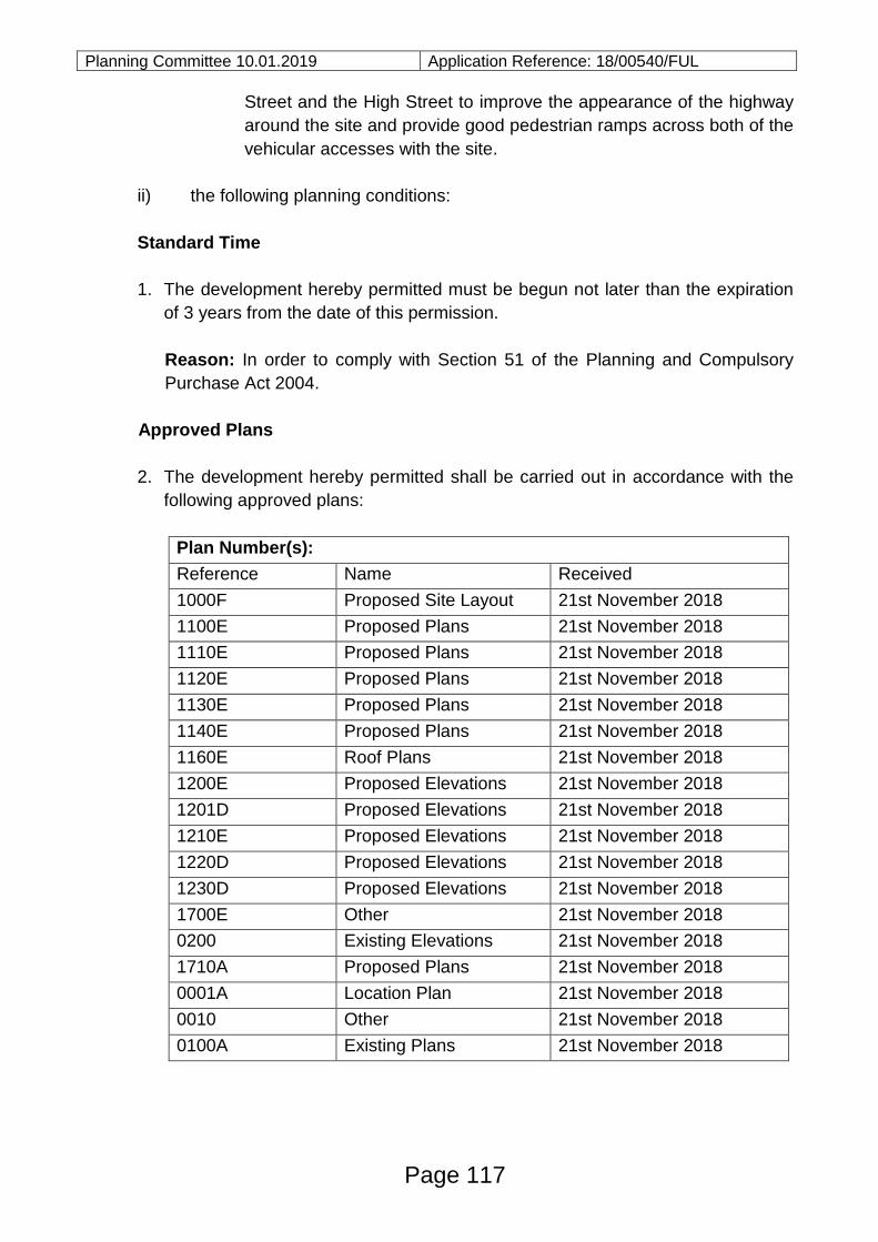
Planning Committee 10.01.2019 Application Reference: 18/00540/FUL
Street and the High Street to improve the appearance of the highway
around the site and provide good pedestrian ramps across both of the
vehicular accesses with the site.
ii) the following planning conditions:
Standard Time
1. The development hereby permitted must be begun not later than the expiration
of 3 years from the date of this permission.
Reason: In order to comply with Section 51 of the Planning and Compulsory
Purchase Act 2004.
Approved Plans
2. The development hereby permitted shall be carried out in accordance with the
following approved plans:
Plan Number(s):
Reference Name Received
1000F Proposed Site Layout 21st November 2018
1100E Proposed Plans 21st November 2018
1110E Proposed Plans 21st November 2018
1120E Proposed Plans 21st November 2018
1130E Proposed Plans 21st November 2018
1140E Proposed Plans 21st November 2018
1160E Roof Plans 21st November 2018
1200E Proposed Elevations 21st November 2018
1201D Proposed Elevations 21st November 2018
1210E Proposed Elevations 21st November 2018
1220D Proposed Elevations 21st November 2018
1230D Proposed Elevations 21st November 2018
1700E Other 21st November 2018
0200 Existing Elevations 21st November 2018
1710A Proposed Plans 21st November 2018
0001A Location Plan 21st November 2018
0010 Other 21st November 2018
0100A Existing Plans 21st November 2018
Page 117
Planning Committee 10.01.2019 Application Reference: 18/00540/FUL
Reason: For the avoidance of doubt and to ensure that the development is
carried out in accordance with the details as approved with regard to policies
PMD1 and PMD2 of the adopted Thurrock LDF Core Strategy and Policies for
the Management of Development [2015].
Use Classes Commercial Units
3. The ground floor commercial units shall only be used for uses falling with
Classes A1, A2, A3, A4, A5 and D2 of the Schedule to the Town & Country
Planning [Use Classes] Order 1987 [as amended] [or in any provision equivalent
to that Class in any statutory instrument revoking or re-enacting that Order with
or without modification].
Reason: In the interests of retaining commercial uses on the ground floor
having regard to ‘main town centre uses’ as identified in policy CSTP8 of the
adopted Thurrock LDF Core Strategy and Policies for the Management of
Development [2015].
Materials
4. No development, with the exception of demolition, shall take place until samples
of the materials to be used in the construction of the external surfaces of the
development hereby permitted have been submitted to and approved in writing
by the local planning authority. In addition, the details shall include all surface
materials, balcony detail, metering arrangements and fenestration details
[including reveals]. The development shall be carried out in strict accordance
with the approved details unless otherwise agreed in writing by the local
planning authority.
Reason: In the interests of visual amenity and to ensure that the proposed
development is satisfactorily integrated with its surroundings in accordance with
Policy PMD2 of the adopted Thurrock LDF Core Strategy and Policies for the
Management of Development DPD [2015].
Replacement tree planting details and implementation
5. Prior to first occupation of the development hereby permitted details of
replacement trees to be planted in the neighbouring area of the site, or at a site
suitably identified, shall be submitted to and approved in writing by the Local
planning authority. The tree details shall include the species, stock size,
proposed numbers/densities and details of the planting scheme’s
implementation, aftercare and maintenance programme, unless otherwise to be
maintained in agreement with the Council’s leisure and/or tree officers. The tree
Page 118
Planning Committee 10.01.2019 Application Reference: 18/00540/FUL
planting shall be carried out as approved within the first available planting
season (October to March inclusive)following the commencement of the
development, unless otherwise first agreed in writing by the local planning
authority. If within a period of five years from the date of the planting of any tree
is removed, uprooted, destroyed, dies, or becomes, in the opinion of the local
planning authority, seriously damaged or defective, another tree of the same
species and size as that originally planted shall be planted in the same place,
unless the local planning authority gives its written consent to any variation.
Reason: To compensate for the removal of the existing trees on or along the
boundary of the site and secure appropriate landscaping in the interests of
visual amenity and the character of the area in accordance with policies
CSTP18 and PMD2 of the adopted Thurrock LDF Core Strategy and Policies for
the Management of Development [2015].
Landscaping Scheme
6. Prior to first occupation of the development a detailed scheme of landscaping
shall be submitted to and approved in writing by the local planning authority.
The details shall include all hard surfacing details. The scheme of landscaping
shall be implemented as approved and all planting, seeding or turfing comprised
in the approved scheme shall be carried out in the first planting and seeding
season following commencement of the development and any trees or plants
which within a period of 5 years from the completion of the development die, are
removed or become seriously damaged or diseased shall be replaced in the
next planting season with others of similar size and species, unless the local
planning authority gives written consent to any variation.
Reason: To ensure that the proposed development is satisfactorily integrated
with its immediate surroundings and provides for landscaping as required by
policy PMD2 of the adopted Thurrock LDF Core Strategy and Policies for the
Management of Development DPD [2015].
Landscape Management Plan
7. Prior to first occupation of the development a landscape management plan,
including management responsibilities and maintenance schedules for the
upkeep of all landscaped areas has been submitted to and approved in writing
by the local planning authority. The landscape management plan shall be
implemented in accordance with the details as approved and retained
thereafter, unless otherwise agreed in writing with the local planning authority.
Reason: To secure appropriate landscaping of the site in the interests of visual
Page 119
Planning Committee 10.01.2019 Application Reference: 18/00540/FUL
amenity and the character of the area in accordance with policies CSTP18 and
PMD2 of the adopted Thurrock LDF Core Strategy and Policies for the
Management of Development [2015].
Parking Provision
8. The development hereby permitted shall not be first occupied until such time as
the vehicle parking area indicated on the approved plans has been hard
surfaced, sealed and marked out in parking bays. The vehicle parking area(s)
shall be retained in this form at all times. The vehicle parking area(s) shall not
be used for any purpose other than the parking of vehicles that are related to
the use of the approved development unless otherwise agreed with the Local
planning authority.
Reason: To ensure that on street parking of vehicles in the adjoining streets
does not occur in the interests of highway safety and that appropriate parking is
provided in accordance with policy PMD8 of the adopted Thurrock LDF Core
Strategy and Policies for the Management of Development DPD [2015].
Cycle Provision
9. Prior to first occupation of the development hereby permitted the cycle storage
areas as shown on the approved plans shall be made available for use in
accordance with the approved plans and shall be retained for bicycle storage
use thereafter.
Reason: To ensure appropriate parking facilities for bicycles/powered two
wheelers are provided in accordance with policy PMD8 of the adopted Thurrock
LDF Core Strategy and Policies for the Management of Development DPD
[2015].
Travel Plan
10. Notwithstanding the details stated in the ‘Framework Travel Plan’ dated 19 April
2018 prior to the first residential occupation of the dwellings and/or commercial
hereby permitted, a revised Travel Plan taking into account the comments from
the consultation response from the Council’s Travel Plan Co-ordinator shall be
submitted to and agreed in writing with the local planning authority. The
commitments explicitly stated in the Travel Plan shall be binding on the
applicants or their successors in title. The measures shall be implemented upon
the first occupation and shall be permanently kept in place unless otherwise
agreed in writing with the local planning authority. Upon written request, the
applicant or their successors in title shall provide the local planning authority
Page 120
Planning Committee 10.01.2019 Application Reference: 18/00540/FUL
with written details of how the measures contained in the Travel Plan are being
undertaken at any given time.
Reason: To reduce reliance on private cars in the interests of sustainability,
highway safety and amenity in accordance with Policy PMD10 of the adopted
Thurrock LDF Core Strategy and Policies for the Management of Development
[2015].
Hours of use and delivery hours
11. Prior to first use of the commercial units hereby approved details of the
proposed hours of use and hours of any deliveries shall be submitted to and
approved in writing by the local planning authority. The approved hours of use
shall be implemented in accordance with the approved details and retained in
such arrangement.
Reason: In the interests of amenity and to ensure that the development remains
integrated with its surroundings as required by policy PMD1 of the adopted
Thurrock LDF Core Strategy and Policies for the Management of Development
[2015].
Outside Storage
12. No goods, materials, packaging or other similar items shall be stored or kept
outside of the front elevation of the building which fronts onto King Street.
Reason: In the interests of visual amenity as required by policy PMD1 of the
adopted Thurrock LDF Core Strategy and Policies for the Management of
Development [2015].
Refuse and Recycling Provision
13. Prior to first occupation of the flats and/or commercial uses the refuse and
recycling storage facilities as shown on the approved plans shall be made
available for use in accordance with the approved plans and shall be retained
for such purposes at all times thereafter.
Reason: To ensure that refuse and recycling provision is provided in the
interests of visual amenity of the area in accordance with policies PMD1 and
PMD2 of the adopted Thurrock LDF Core Strategy and Policies for the
Management of Development [2015].
Surface Water Drainage Scheme
Page 121
Planning Committee 10.01.2019 Application Reference: 18/00540/FUL
14. No development, with the exception of demolition, shall commence until a
scheme for the provision and implementation of surface water drainage
incorporating sustainable urban drainage technique has been submitted to and
approved in writing by the local planning authority. The surface water drainage
scheme shall be constructed and completed in accordance with the details as
approved prior to the first occupation of the development hereby permitted.
Reason: To ensure the incorporation of an appropriate drainage scheme and to
avoid pollution of the water environment and to minimise flood risk in
accordance with policies PMD1 and PMD15 of the adopted Thurrock LDF Core
Strategy and Policies for the Management of Development [2015].
Surface Water Maintenance Plan
15. Prior to first occupation of the development hereby permitted a Maintenance
Plan detailing the maintenance arrangements including who is responsible for
different elements of the surface water drainage system and the maintenance
activities/frequencies, has been submitted to and agreed, in writing, by the local
planning authority. Should any part be maintainable by a maintenance
company, details of long term funding arrangements shall be provided and be
implemented for all times thereafter.
Reason: To ensure appropriate maintenance arrangements are put in place to
enable the surface water drainage system to function as intended to ensure
mitigation against flood risk in accordance with policy PMD15 of the adopted
Thurrock LDF Core Strategy and Policies for the Management of Development
[2015].
Solar Panels and Photovoltaic
16. Prior to first occupation of the development hereby permitted details of the roof
mounted solar or photovoltaic panels shall be submitted to and approved in
writing by the local planning authority. The details shall include siting and height
of the panels to ensure they do not project above the parapet. The roof mounted
solar or photovoltaic panels shall be installed in accordance with the details as
approved and retained for renewable energy provision thereafter.
Reason: To ensure that development takes place in an environmentally
sensitive way and in the interest of visual amenity in accordance with Policy
PMD13 of the adopted Thurrock LDF Core Strategy and Policies for the
Management of Development [2015].
Page 122
Planning Committee 10.01.2019 Application Reference: 18/00540/FUL
External lighting
17. Prior to the first occupation of the development hereby permitted details of the
means of external lighting shall be submitted to and agreed in writing with the
local planning authority, with the exception of domestic lighting within the
curtilage of the residential plots. The details shall include the siting and design
of lighting together with details of the spread and intensity of the light sources
and the level of luminance. The lighting shall be installed in accordance with the
agreed details prior to first occupation of the development and shall be retained
and maintained thereafter in the agreed form, unless otherwise agreed in writing
by the local planning authority.
Reason: In the interests of highway safety and residential amenity and to
ensure that the development can be integrated within its immediate
surroundings in accordance with Policies PMD1 and PMD2 of the adopted
Thurrock LDF Core Strategy and Policies for the Management of Development
[2015].
Communal TV/Satellite
18. Notwithstanding the provisions of the Town & Country Planning [General
Permitted Development] Order 2015 [or any order revoking or re-enacting that
Order with or without modification] no flat shall be occupied until details of the
number, size, external appearance and the positions of the communal satellite
dish(es) have been submitted to and agreed in writing by the local planning
authority prior to the installation of such systems. The agreed communal
satellite dish systems shall be installed prior to the residential occupation of the
flats and retained thereafter. Notwithstanding the provisions of the Town and
Country Planning [General Permitted Development] Order 2015 [or any Order
revoking or re-enacting that Order with or without modification] no additional
satellite dish(es) or aerials shall be fixed to the building without the prior written
approval of the local planning authority.
Reason: In the interests of visual amenity and to ensure that the development
can be integrated within its immediate surroundings in accordance with Policies
PMD1 and PMD2 of the adopted Thurrock LDF Core Strategy and Policies for
the Management of Development DPD [2015].
Construction Environmental Management Plan (CEMP)
19. No construction works shall commence until a Construction Environmental
Management Plan [CEMP] has been submitted to and approved in writing by
Page 123

Planning Committee 10.01.2019 Application Reference: 18/00540/FUL
the local planning authority in writing. The CEMP should contain or address the
following matters:
(a) Hours of use for the construction of the development
(b) Hours and duration of any piling operations,
(c) Vehicle haul routing in connection with construction, remediation and
engineering operations,
(d) Wheel washing and sheeting of vehicles transporting loose aggregates or
similar materials on or off site,
(e) Details of construction any access or temporary access, and details of
temporary parking requirements;
(f) Road condition surveys before demolition and after construction is
completed; with assurances that any degradation of existing surfaces will
be remediated as part of the development proposals. Extents of road
condition surveys to be agreed as part of this CEMP
(g) Location and size of on-site compounds [including the design layout of any
proposed temporary artificial lighting systems];
(h) Details of any temporary hardstandings;
(i) Details of temporary hoarding;
(j) Details of the method for the control of noise with reference to BS5228
together with a monitoring regime;
(k) Measures to reduce vibration and mitigate the impacts on sensitive
receptors together with a monitoring regime ;
(l) Measures to reduce dust with air quality mitigation and monitoring,
(m)Measures for water management including waste water and surface water
discharge;
(n) A method statement for the prevention of contamination of soil and
groundwater and air pollution, including the storage of fuel and chemicals;
(o) Details of a procedure to deal with any unforeseen contamination, should it
be encountered during development;
(p) A Site Waste Management Plan,
(q) Details of security lighting layout and design; and
(r) Contact details for site managers including information about community
liaison including a method for handling and monitoring complaints.
Works on site shall only take place in accordance with the approved CEMP.
Reason: In order to minimise any adverse impacts arising from the construction of
the development in accordance with policy PMD1 of the adopted Thurrock LDF
Core Strategy and Policies for the Management of Development [2015].
Informative
Public Right of Way Diversion
Page 124
Planning Committee 10.01.2019 Application Reference: 18/00540/FUL
1. No development shall be carried out which obstructs any part of the public
right of way [shown on the Definitive map], which shall be kept open for use
at all times, unless a temporary diversion has been first consented under the
provisions of the Town and Country Planning Act 1990 [as amended].
Unless an Order under Section 257 has been made and confirmed or the
right of way otherwise extinguished under an order of the Magistrates’ Court
it is a criminal offence to obstruct a public right of way. Planning permission
alone does not authorise obstruction.
2. The properties within this development will not be eligible for inclusion with
the Stanford-le-hope Resident's Permit Parking Scheme.
Positive and Proactive Statement
The Local Planning Authority has acted positively and proactively in determining
this application by identifying matters of concern within the application (as originally
submitted) and negotiating, with the Applicant/Agent, acceptable amendments to
the proposal to address those concerns. As a result, the Local Planning Authority
has been able to grant planning permission for an acceptable proposal, in
accordance with the presumption in favour of sustainable development, as set out
within the National Planning Policy Framework.
Documents:
All background documents including application forms, drawings and other
supporting documentation relating to this application can be viewed online:
http://regs.thurrock.gov.uk/online-applications
Page 125
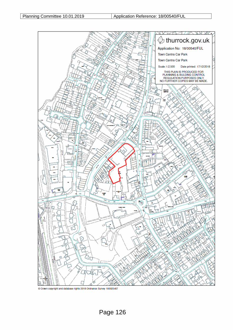
Planning Committee 10.01.2019 Application Reference: 18/00540/FUL
Page 126
Planning Committee 10.01.2019 Application Reference: 18/01508/TBC
Reference:
18/01508/TBC
Site:
Civic Amenity Site
Buckingham Hill Road
Linford
Essex
Ward:
Orsett
Proposal:
Extension and redevelopment of the Linford Household Waste
Recycling Centre (HWRC) comprising: Reconfiguration of site
layout; construction of new access onto Buckingham Hill Road;
construction of two storey office, welfare and store building;
canopy over recycling centre; fuel storage area; two
weighbridges; parking; wheel washing facilities; boundary
fencing; landscaping; substation and transformer; works to
boundary ditch; creation of surface water attenuation pond and
offsite improvements including planting/landscaping and ghost
right turn lane.
Plan Number(s):
Reference Name Received
001 Location Plan 23rd October 2018
001 Proposed Ghost Island Junction 23rd October 2018
001A Proposed Ghost Island Junction 23rd October 2018
001B Proposed Site Entry 23rd October 2018
001C Proposed Site Exit 23rd October 2018
002 Application Boundary Plan 23rd October 2018
003 Proposed Site Layout Ground Floor 23rd October 2018
004 Proposed Site Layout Roof Plans 23rd October 2018
005 Proposed Site Layout Site Sections 23rd October 2018
006 Office Welfare and Resale Layout Building
Floor Plans
23rd October 2018
007 Office Welfare and Resale Layout Building
Elevation
23rd October 2018
008 Proposed Site Layout and Vehicle
Tracking.
23rd October 2018
Page 127
Agenda Item 13
Planning Committee 10.01.2019 Application Reference: 18/01508/TBC
The application is also accompanied by:
- Design and Access Statement
- Landscape and Visual Appraisal
- Alternative Site Assessment
- Flood Risk Assessment
- Transport Assessment
- Construction Environmental Management Plan (CEMP)
- Land Quality Risk Assessment
Applicant:
Thurrock Council
Validated:
16 October 2018
Date of expiry:
15 January 2019
Recommendation: Grant planning permission, subject to: (i) referral to the Secretary
of State; and (ii) conditions.
This application is scheduled for determination by the Council’s Planning
Committee because the application has been submitted by the Council (in
accordance with Part 3 (b) Section 2 2.1 (b) of the Council’s constitution).
1.0 DESCRIPTION OF PROPOSAL
1.1 The application seeks planning permission for the extension and comprehensive redevelopment of the exiting Household Waste Recycling Centre (HWRC) on Buckingham Hill Road.
1.2 The application comprises the following components:
Extension of hardsurfaced area to the north of the existing site on land previously used for storage of waste containers and skips (see planning history 18/00878/CLEUD) to be used as a circulation and recycling area;
Formation of new site access at the northern end of the extended site
Proposed new internal vehicle access route within the site, to be one way in one way out for all vehicles;
Construction of a two storey building comprising store, offices, meeting room and welfare facilities;
Wheel washing facilities;
Weighbridge;
Reprofiling of existing southern part of site the to allow improved access to containers;
Provision of a ‘ghost island’ right tune lane into the new entrance;
Ancillary buildings comprising substation, cycle stand, smoking shelter; Refuelling station and refuelling bund.
Page 128
Planning Committee 10.01.2019 Application Reference: 18/01508/TBC 1.3 In terms of background, the applicant indicates that there are a number of
operational difficulties which must be addressed:
The HWRC at Linford is in need of expansion and updating as it is failing to meet increasing demand effectively. Whilst the HWRC was designed to accept 6,000 tonnes of household waste per annum (tpa), it currently receives more than double that tonnage per annum. In addition, the amount of household waste coming into the Site is expected to increase in line with an increase in the number of households from 65,490 at present, to 78,100 by 2030.
and
As well as the lack of operational capacity, the HWRC has a number of constraints which prevent the efficient operation of the Site:
The existing Site access leads to conflict between cars and the HGVs entering
and leaving the Site to service the recycling containers. The inefficient Site layout leads to long queues out onto the highway and long waiting times for Site users.
Within the Site, there is a significant potential risk of conflict between cars and pedestrians as people park their vehicles and then walk across the Site to access the waste containers. Safety within the Site is also an issue as the access to many recycling containers involves the public carrying waste up steps to drop items down into the waste containers.
the HWRC does not have a connection to a mains sewer or mains electricity. The electricity generator and cess pit are costly to maintain and the HWRC is restricted to opening during daylight hours as lighting the Site using the generator is not feasible or cost effective.
There is no surface water drainage system within the Site boundary or within Buckingham Hill Road. All existing surface water drainage currently discharges into a highways ditch along the southern edge of the Site within the Site boundary and into the local watercourse system.
1.4 The above operational issues have led to the submission of the current application
before Members. 2.0 SITE DESCRIPTION
2.1 This application relates to the Council’s Civic Amenity Site, found on the western side of Buckingham Hill Road. The site is irregular in shape and found in the Metropolitan Green Belt.
2.2 The southern part of the site is hard surfaced and open to the public, comprising
skips and bins for the collection of household waste and recycling. 2.3 The northern part of the site is not open to the public and comprises an area used
for the storage of skips and waste containers in connection with the public use of the site to the south.
Page 129
Planning Committee 10.01.2019 Application Reference: 18/01508/TBC
3.0 RELEVANT HISTORY
Application Reference
Description of Proposal Decision
99/00751/TBC The provision of a new access point to the civic amenity site.
Approved
18/00878/CLEUD
Certificate of lawfulness for storage of empty waste containers and skips
Deemed lawful
4.0 CONSULTATIONS AND REPRESENTATIONS
4.1 Detailed below is a summary of the consultation responses received. The full
version of each consultation response can be viewed on the Council’s website via
public access at the following link: www.thurrock.gov.uk/planning
PUBLICITY:
4.2 This application has been advertised by way of individual neighbour notification
letters, press advert and public site notices which have been displayed nearby. No
responses have been received.
4.3 ENVIRONMENT AGENCY:
No objections, subject to conditions.
4.4 ENVIRONMENTAL HEALTH:
No objections, subject to conditions.
4.5 FLOOD RISK MANAGER:
No objection subject to conditions.
4.6 HIGHWAYS:
No objections, subject to condition.
4.7 HSE
Do no advise against.
Page 130
Planning Committee 10.01.2019 Application Reference: 18/01508/TBC 5.0 POLICY CONTEXT
National Planning Policy Framework
5.1 The NPPF was published on 27 March 2012 and amended on 24 July 2018. Paragraph 10 of the Framework sets out a presumption in favour of sustainable development. Paragraph 2 of the Framework confirms the tests in s.38 (6) of the Planning and Compulsory Purchase Act 2004 and s.70 of the Town and Country Planning Act 1990 and that the Framework is a material consideration in planning decisions. Paragraph 11 states that in assessing and determining development proposals, local planning authorities should apply the presumption in favour of sustainable development. The following headings and content of the NPPF are relevant to the consideration of the current proposals: 2. Achieving sustainable development 14. Meeting the challenge of climate change, flooding and coastal change 16. Conserving and enhancing the historic environment
Planning Practice Guidance
5.2 In March 2014 the Department for Communities and Local Government (DCLG)
launched its planning practice guidance web-based resource. This was
accompanied by a Written Ministerial Statement which includes a list of the
previous planning policy guidance documents cancelled when the NPPF was
launched. The PPG contains 42 subject areas, with each area containing several
subtopics. Those of particular relevance to the determination of this planning
application comprise:
Design;
Determining a planning application;
Flood risk and coastal change;
Land affected by contamination;
Natural environment;
Noise;
Travel Plans, Transport Assessments and Statements; and
Use of planning conditions
Local Planning Policy
Thurrock Local Development Framework
5.3 The Council adopted the “Core Strategy and Policies for the Management of
Development Plan Document” (as amended) in 2015. The following Core Strategy
policies apply to the proposals:
Page 131
Planning Committee 10.01.2019 Application Reference: 18/01508/TBC
Spatial Policies:
CSSP4 (Sustainable Greenbelt) and
OSDP1 (Promotion of Sustainable Growth and Regeneration in Thurrock)
Thematic Policies:
CSTP22 (Thurrock Design)
CSTP27 (Management and Reduction of Flood Risk)
CSTP29 (Waste Management)
Policies for the Management of Development:
PMD1 (Minimising Pollution and Impacts on Amenity)
PMD2 (Design and Layout)
PMD8 (Parking Standards)
PMD9 (Road Network Hierarchy)
PMD10 (Transport Assessments and Travel Plans) and
PMD15 (Flood Risk Assessment)
[Footnote: 1New Policy inserted by the Focused Review of the LDF Core Strategy.
2Wording of LDF-
CS Policy and forward amended either in part or in full by the Focused Review of the LDF Core
Strategy. 3Wording of forward to LDF-CS Policy amended either in part or in full by the Focused
Review of the LDF Core Strategy].
Thurrock Local Plan
In February 2014 the Council embarked on the preparation of a new Local Plan for
the Borough. Between February and April 2016 the Council consulted formally on
an Issues and Options (Stage 1) document and simultaneously undertook a ‘Call
for Sites’ exercise. In December 2018 the Council began consultation on an Issues
and Options (Stage 2 Spatial Options and Sites) document.
6.0 ASSESSMENT
Process
With reference to procedure, this application has been advertised as a departure
from the Development Plan. Any resolution to grant planning permission would
need to be referred to the Secretary of State under the terms of the Town and
Country Planning (Consultation) (England) Direction 2009 with reference to the
‘other development which, by reason of its scale or nature or location, would have a
significant impact on the openness of the Green Belt’. The Direction allows the
Page 132
Planning Committee 10.01.2019 Application Reference: 18/01508/TBC
Secretary of State a period of 21 days (unless extended by direction) within which
to ‘call-in’ the application for determination via a public inquiry. In reaching a
decision as to whether to call-in an application, the Secretary of State will be guided
by the published policy for calling-in planning applications and relevant planning
policies. The Secretary of State will, in general, only consider the use of his call-in
powers if planning issues of more than local importance are involved.
The planning issues to be considered in this case are:
I. Development Plan designation & principle of development
II. Site layout and design
III. Impact on amenity
IV. Highways & transportation
V. Flood risk
VI. Ground conditions
I. DEVELOPMENT PLAN DESIGNATION & PRINCIPLE OF DEVELOPMENT
6.1 Under this heading, it is necessary to refer to the following key questions:
1. Whether the proposals constitute inappropriate development in the Green Belt; 2. The effect of the proposals on the open nature of the Green Belt and the
purposes of including land within it; and 3. Whether the harm to the Green Belt is clearly outweighed by other
considerations so as to amount to the very special circumstances necessary to justify inappropriate development.
1. Whether the proposals constitute inappropriate development in the Green Belt
6.2 The site is identified on the Core Strategy Proposals Map as being within the Green Belt where policies CSSP4 and PMD6 apply. Policy CSSP4 identifies that the Council will ‘maintain the purpose function and open character of the Green Belt in Thurrock’, and Policy PMD6 states that the Council will ‘maintain, protect and enhance the open character of the Green Belt in Thurrock’. These policies aim to prevent urban sprawl and maintain the essential characteristics of the openness and permanence of the Green Belt to accord with the requirements of the NPPF.
6.3 Paragraph 79 within Chapter 9 of the NPPF states that the Government attaches great importance to Green Belts and that the “fundamental aim of Green Belt policy is to prevent urban sprawl by keeping land permanently open; the essential characteristics of Green Belt are their openness and their permanence.” Paragraph 89 states that a local planning authority should regard the construction of new buildings as inappropriate in Green Belt. The NPPF sets out a limited number of exceptions to this, namely:
buildings for agriculture and forestry;
appropriate facilities for outdoor sport, recreation and cemeteries;
Page 133
Planning Committee 10.01.2019 Application Reference: 18/01508/TBC
proportionate extensions or alterations to a building;
the replacement of a building;
limited infilling in villages; and the partial or complete redevelopment of previously developed sites whether
redundant or in continuing use (excluding temporary buildings), which would not have a greater impact on the openness of the Green Belt and the purpose of including land within it than the existing development.
6.4 The site, due to is planning history, is considered to fall within the NPPF definition of Previously Developed Land (PDL). However, the proposed development would result in an increased built form which would also be spread across a wider area than the current use of the site.
6.5 Accordingly the proposal would have a greater impact on the openness of the
Green Belt and the purpose of including land within it than the existing development. Consequently, the proposals comprise inappropriate development with reference to the NPPF and policy PMD6.
2. The effect of the proposals on the open nature of the Green Belt and the purposes of including land within it
6.6 Having established that the proposals are inappropriate development, it is
necessary to consider the matter of harm. Inappropriate development is, by definition, harmful to the Green Belt, but it is also necessary to consider whether there is any other harm to the Green Belt and the purposes of including land therein.
6.7 Paragraph 134 of the NPPF sets out the five purposes which the Green Belt serves as follows:
A. to check the unrestricted sprawl of large built-up areas; B. to prevent neighbouring towns from merging into one another; C. to assist in safeguarding the countryside from encroachment; D. to preserve the setting and special character of historic towns; and E. to assist in urban regeneration, by encouraging the recycling of derelict and
other urban land.
6.8 In response to each of these five purposes: A. to check the unrestricted sprawl of large built-up areas
6.9 The NPPF does not provide a definition of the term ‘large built-up areas’ but given
the sites location it is located away from the large built-up areas of Grays, Tilbury, Stanford Le Hope and Corringham the site is located distant from any defined settlements. The proposal would not therefore result in sprawl.
B. to prevent neighbouring towns from merging into one another
6.10 The proposal would not result in towns merging into one another.
Page 134
Planning Committee 10.01.2019 Application Reference: 18/01508/TBC C. to assist in safeguarding the countryside from encroachment 6.11 The proposal would involve increased built development on this site which is
surrounded by the countryside to the north, east and south. It is considered that the proposal would constitute an encroachment of increased built development into the countryside at this location, causing some harm to the third purpose for including land in the Green Belt.
D. to preserve the setting and special character of historic towns 6.12 As there are no historic town in the immediate vicinity of the site, the proposals do
not conflict with this defined purpose of the Green Belt.
E. to assist in urban regeneration, by encouraging the recycling of derelict and other urban land
6.13 In general terms, the development could occur in the urban area and, in principle
there is no spatial imperative why Green Belt land is required to accommodate the proposals, however it is recognised that the site has performed the function of a Civic Amenity Site for many years. To a limited extent, the proposed development is inconsistent with this purpose of the Green Belt.
6.14 In light of the above analysis, it is considered that the proposals would be contrary
to 2 of the 5 purposes of including land in the Green Belt. Substantial weight should be afforded to these factors. 3. Whether the harm to the Green Belt is clearly outweighed by other
considerations so as to amount to the very special circumstances necessary to justify inappropriate development
6.15 Neither the NPPF nor the Adopted Core Strategy provide guidance as to what can
comprise ‘very special circumstances’, either singly or in combination. However, some interpretation of very special circumstances has been provided by the Courts. The rarity or uniqueness of a factor may make it very special, but it has also been held that the aggregation of commonplace factors could combine to create very special circumstances (i.e. ‘very special’ is not necessarily to be interpreted as the converse of ‘commonplace’). However, the demonstration of very special circumstances is a ‘high’ test and the circumstances which are relied upon must be genuinely ‘very special’. In considering whether ‘very special circumstances’ exist, factors put forward by an applicant which are generic or capable of being easily replicated on other sites, could be used on different sites leading to a decrease in the openness of the Green Belt. The provisions of very special circumstances which are specific and not easily replicable may help to reduce the risk of such a precedent being created. Mitigation measures designed to reduce the impact of a proposal are generally not capable of being ‘very special circumstances’. Ultimately, whether any particular combination of factors amounts to very special circumstances will be a matter of planning judgment for the decision-taker.
6.16 With regard to the NPPF, paragraph 143 states that ‘inappropriate development is, by definition, harmful to the Green Belt and should not be approved except in very
Page 135
Planning Committee 10.01.2019 Application Reference: 18/01508/TBC
special circumstances’. Paragraph 144 goes on to state that, when considering any planning application, local planning authorities “should ensure that substantial weight is given to any harm to the Green Belt. Very special circumstances will not exist unless the potential harm to the Green Belt by reason of inappropriateness, and any other harm, is clearly outweighed by other considerations”.
6.17 The submitted Planning Statement sets out the applicant’s reasons for the proposal coming forward.
a. The area to the north of the main site has been used for 10 years or more
6.18 The area to the north of the public area of the site is used for the storage of
containers and skips which are subsequently used on the site. These skips are stored there before being used on the site. A lawful development certificate has been deemed lawful for the use of the site for these purposes.
Consideration 6.19 It is accepted that the land to the northern part of the site could be used for the
storage of containers and skips in association with the use of the southern area of the site.
6.20 Significant weight can be attached to this linked lawful use (though it is noted that
the northern part of the site would be more intensively used under the current permission if approved).
b. Alternative Site Assessment demonstrates there are no alterative locations
6.21 The applicant advises that Council previously operated a second Civic Amenity Site
at West Thurrock. The site was subject to very low volumes of waste due to a combination of material acceptance policy and site location. The site was deemed not to be viable and was closed within a year of being opened leaving the Linford site as the only Civic Amenity site in the Borough. The applicant has carried out a detailed alterative site assessment which looked at other possible sites for a new HWRC using the following criteria:
- There should be suitable HGV access to enable vehicles moving the containers
to enter and exit the site safely; - The site should be separate from residential properties due to the noise, smells,
traffic and other nuisance that can be associated with such facilities; - The site should not be too isolated or difficult to reach so as not to prevent or
discourage some residents from using the facility; - The site should be at least equivalent in size to the existing Buckingham Hill site
(0.7ha) but ideally at least 1ha; - It should be able to accommodate a split-level operation which minimises the
need to users to have to climb steps to empty contents into containers, to improve safety and accessibility;
- The site should comprise predominately non-permeable hardstanding with adequate interceptors to prevent leachate run-off;
- The site should be connected to the mains sewer and have access to other
Page 136
Planning Committee 10.01.2019 Application Reference: 18/01508/TBC
utilities e.g. electricity and broadband; - The site should have good access to A13 to avoid HGVs having to pass through
residential areas. Also as there is only one site in the borough it should as central as possible and easy to reach by car;
- Ideally the site should be in council ownership as there is not sufficient resources currently available to enable the purchase of a new site.
6.22 The site assessment indicates that HWRCs are not suitable for residential areas
due to noise, smells and traffic, and in areas allocated for residential development the loss of land for housing would be unlikely to be supported. The assessment further considers that HWRCs are not ideal for industrial areas due to the HGV levels associated with those uses. Areas such as London Gateway and Thames Enterprise Park are deemed to be too remote for most Borough residents. A potential site in Botany Way Purfleet has been considered but was discounted due to it being inaccessible for residents from the east of the Borough.
6.23 Four sites met the criteria for detailed consideration and are discussed below as follows:
o Former Council Nursery, Bull Meadow, Little Thurrock:
Formally a plant nursery, 1.8 ha in size and partly surfaced with services in or close to the side, good links to A13.
Site in the Green Belt. Immediately adjacent to residential properties to the south and west,
resulting in creating noise, smells and traffic congestion to residents. Access off Dock Road/Marshfoot road is on a sharp bend which would not
provide suitable and safe highways access.
DISCOUNTED for highways and amenity issues.
o Land off Fort Road Tilbury: Presently used for grazing, 8ha in size Outside the Green Belt. Northern part of the site will be used for link to Tilbury 2 development, part
of the land is in a coastal grazing marsh, part of Tilbury Marshes Local Wildfire Site and approximately 120m north of Tilbury Fort SAM.
DISCOUNTED for impact on ecology, proximity to SAM and the site would
not be readily accessible to most residents in the Borough.
o Thurrock Park Way (TPW) To the west and north of TPW and Clipper Park, 3.5 ha in size, identified as
employment land. Outside the Green Belt. Access through adjacent commercial areas, much of the site would be
away from residential properties, though some would be close to properties on Churchill Road. Site is low level marsh land so could lead to leaching and a flood risk assessment would be needed.
DISCOUNTED due to high number of existing HGV movements, potential
Page 137
Planning Committee 10.01.2019 Application Reference: 18/01508/TBC
for more appropriate commercial use and application to west for residential development (15/00234/FUL – Manor Road) if approved would result in a number of residential properties nearby.
o Land adjacent to Stanford Road, Grays
Currently used for horse grazing, measuring 2.6ha in size. Site is in the Green Belt. Close to existing development so services would be available, located on a
straight road with good visibility. DISCOUNTED due to site being open and flat and difficult to screen,
proximity to residential areas to the south and west, and Treetops school to the south east, making it a bad neighbour use.
o Sites at Wharf Road, Billet Lane and Baker Street were also considered but
did not make the list of detailed assessment due to factors which made them immediately unsuitable for shortlisting.
Consideration 6.24 The criteria for determining what is required for a new/extended HWRC are
considered to be appropriate. The four sites that were taken forward for detailed assessment are considered to individually have some elements that would make them suitable for the proposed use, however taken as a whole it is considered that there are factors which make the discounting of each site justified.
6.25 Accordingly, it is considered at this time, that the proposed site is the only one
which could adequately accommodate the proposed extended site. Significant weight should be given the lack of suitable alternative sites.
c. The provision of a dedicated right turn lane (ghost lane)
6.26 The application it is advised, due to the increasing length of the site, would allow
space for the provision of a ghost tight turn lane into the site. The distance of 50m from the site entrance to the entrance to the lane would allow approximately 10 cars waiting to access to site to sit safely away from vehicles proceeding south along Buckingham Hill Road, preventing queues building up, as happens at present.
Consideration 6.27 At present the northern entrance to the site is an in-out access point for HGVs and
an exit for cars. This causes safety issues and conflict on the highway between vehicles accessing the site and causes vehicles to wait on Buckingham Hill Road causing highways safety issues. The new single entrance for HGVs and cars at the north served by the ghost lane would reduce conflict and allow vehicles to wait safely without causing queueing on Buckingham Hill Road.
6.28 The provision of the right turn lane would not occur without the development taking
place and it would provide wider benefits to other road users. As such this factor
Page 138
Planning Committee 10.01.2019 Application Reference: 18/01508/TBC
should be afforded moderate weight in the determination of the application.
d. Operational Issues Waste & Resources Action Programme (WRAP) / Staff welfare
6.29 The applicant has advised that the use of the site has grown over time, and it is
now operating over capacity and the layout results in a number of Health and Safety issues, which cannot be solved within the compact single level site. The applicant advises the following:
The current site layout and service provisions associated with the Linford HWRC do not meet the best practice guidance recommendations set down in the Household Waste Recycling Centre (HWRC) Guide published by WRAP - which was formed to assist Local Authorities concerning Waste and Recycling best practice and guidance. The guide incorporates a section on Health and Safety issues which could have an impact on customers, operatives and contractors. Amongst other things, the guide makes reference for the need to adopt traffic control measures and a safe layout in order to comply with the Health and Safety Workplace regulations. It also points out that in Northern Ireland in 2011 a worker was trapped and killed at a HWRC. This, quite rightly, should make the Council recognise the need for the best safe working practices at the HWRC. The Health and Safety Executive has also published guidance on how to avoid risks at HWRCs. It echoes the WRAP guidance and makes reference to safe layout and control measures. It uses a case study of site design by Cumbria County Council incorporates a split level design site. The site has similar features to that proposed for Linford. One key feature of modern HWRCs is that the site layout is designed to minimise the interaction between customers and traffic, this can be best achieved by using a “split-level” design where servicing the containers is in an area which is completely segregated from customers. In addition, to avoid slips trips and falls, the use of stairways can be minimised by using a split - level site where storage containers are located at a lower level to customers. A split level site therefore affords the opportunity to segregate service vehicles and avoid stairways at a stroke. In addition, the proposed redeveloped layout at Linford would further improve safety by avoiding the need for pedestrians to cross traffic lanes to deposit materials. Split level designs necessitate a ramp within the site to bring customers to a higher level (or service vehicles to a lower level). To accommodate a safer split level site and provide vehicle stacking means that a slightly larger footprint to accommodate these features would be required at the Linford site. It must be emphasised that these safety features cannot physically be provided at the site within the current authorised footprint.
6.30 The applicant also advises that with no permanent electricity supply the site cannot
be operated appropriately. They state that The site “currently relies on a diesel powered generator. This requires fuel storage (with inherent risks of theft, fire and pollution)….that [t]he generator is both noisy, requires servicing and produces air emissions and does not provide sufficient power to enable the site to have a combination of adequate lighting or CCTV. Such generators do interrupt operations with downtime…[which]would be unacceptable with a modern weigh-bridge. The current generator does not provide site lighting / security lighting and heat for modern site welfare offices or a weigh bridge office. A larger generator would be noisier and very expensive to hire and run and be easily accommodated within the cramped conditions at the site”.
Consideration
Page 139
Planning Committee 10.01.2019 Application Reference: 18/01508/TBC 6.31 The supporting information indicates that the site is presently severely deficient in
terms of both the working conditions for employees of the site and the health and safety of users of the site. The Council has a duty of care to its staff and customers, which are clearly not being served by the premises as it exists. The Council would not want to invest resources in development that was not absolutely necessary and it is considered therefore that the extension of the site area and associated to address the shortcomings of the site are reasonable. . Accordingly, significant weight can be attributed to these matters at this time.
e. Trade Waste / Greater Recycling / Third party reuse
6.32 The applicant advises that the site is operating over capacity, by approximately 8,000 tonnes per year, in part due to the large amount of illegal trade waste the site receives. The applicant advises the provision of the weighbridge would allow waste coming on the site to be monitored and this would allow an additional revenue stream. This combined with more clearly defined areas and easy to use site it is considered would also improve recycling through the site. It is also proposed that items brought to the site that could be effectively reused through third party charities could be collected on site and stored before being distributed.
Consideration
6.33 The improved recycling levels would be beneficial to the Council’s aspirations to improve recycling and would reduce the impact of landfill material. Policy CSPT29 seeks, amongst other things “the increased re-use/recycling and recovery of waste” as a central theme. The ability to improve recycling should be therefore given moderate weight. The provision of a dedicated area for commercial waste should reduce fly-tipping and could create revenue for the Council to reinvest in waste management activities. The option to allow third parties to reuse items rather than them being placed in landfill or broken down for recycling would have wider sustainability benefits.
6.34 Collectively these matters should be attributed moderate weight.
f. Potential for surface water run-off and drainage into watercourse and onto highway to be reduced
6.35 The applicant refers to the fact that the site presently does not have mains drainage, that there is no surface water drainage system within the site boundary and so accordingly surface water discharges into a highways ditch alongside the southern edge of the site, into the local watercourses and onto the public highway. The current drainage arrangements at incorporate a dilute and disperse system for surface water. It is likely that some areas of the site will lead to contamination of surface water. The proposed scheme would result in a full drainage system being installed within the site and would provide a water attenuation pond to the southern end of the site to deal with surface water.
Consideration
Page 140
Planning Committee 10.01.2019 Application Reference: 18/01508/TBC
6.36 The site presently accepts a variety of waste materials. Where these materials are stored outside they will be subject to the effect of rain.. A HWRC by its very nature will be dirty and surface water from the site draining into local watercourses will not be beneficial to the local environment. The proposal to introduce a sustainable drainage scheme will prevent pollution of the local watercourses.
6.37 In addition officers have received numerous complaints in recent years about mud and water on the highway on Buckingham Hill Road in the vicinity of this site. The unmade nature of the highways boundary in this part of the road will always result in some form of mud on the highway, however preventing surface water run-off from the site will clearly reduce this impact and improve highways safety. Accordingly these matters should be afforded moderate weight in the determination of the very special circumstances case.
g. Policy CSTP29: Waste Strategy
6.38 The applicant advises on the following wording of Policy CSTP29: New development for waste management will not be permitted in the Green Belt, unless part of a necessary restoration scheme and the proposals conform with Green Belt policy. The exception to this is the provision of small scale facilities which address an identified local need where no suitable sites outside the Green Belt have been shown to exist following an alternative assessment. They consider this supports their case.
Consideration
6.39 Policy CSTP29 states under sub-section 3 that the preferred approach is for 1or 2 strategic sites within broad locations and located within appropriate employment and industrial /port locations. The locations of these sites were supposed to come through the minerals and waste DPD. The strategic sites were intended to provide capacity to meet most of the equivalent of the Borough’s waste arisings for Household and C&I waste.
6.40 The policy continues that where strategic sites allocations are proven to be undeliverable or waste management capacity requirements cannot be met on allocated sites planning permission in non-strategic areas would be considered in
i. Existing waste management facilities; except landfill sites;
ii. Appropriate employment locations;
iii. Appropriate port locations and
iv. Where such proposal met the other relevant policies in the Core Strategy and the waste and minerals plan.
6.41 The last paragraph in subsection 3 states that “new development for waste management will not be permitted in the Green Belt, unless part of a necessary restoration scheme. The exception to this is the “provision of small scale facilities
Page 141
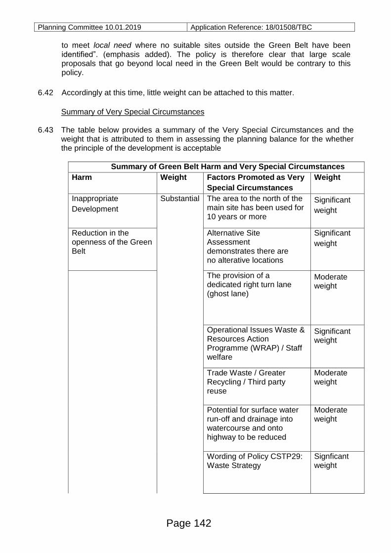
Planning Committee 10.01.2019 Application Reference: 18/01508/TBC
to meet local need where no suitable sites outside the Green Belt have been identified”. (emphasis added). The policy is therefore clear that large scale proposals that go beyond local need in the Green Belt would be contrary to this policy.
6.42 Accordingly at this time, little weight can be attached to this matter.
Summary of Very Special Circumstances
6.43 The table below provides a summary of the Very Special Circumstances and the
weight that is attributed to them in assessing the planning balance for the whether the principle of the development is acceptable
Summary of Green Belt Harm and Very Special Circumstances
Harm Weight Factors Promoted as Very
Special Circumstances
Weight
Inappropriate
Development
Substantial The area to the north of the main site has been used for 10 years or more
Significant
weight
Reduction in the openness of the Green Belt
Alternative Site Assessment demonstrates there are no alterative locations
Significant
weight
The provision of a dedicated right turn lane (ghost lane)
Moderate weight
Operational Issues Waste & Resources Action Programme (WRAP) / Staff welfare
Significant weight
Trade Waste / Greater Recycling / Third party reuse
Moderate weight
Potential for surface water run-off and drainage into watercourse and onto highway to be reduced
Moderate weight
Wording of Policy CSTP29: Waste Strategy
Signficant weight
Page 142
Planning Committee 10.01.2019 Application Reference: 18/01508/TBC
6.44 As ever, in reaching a conclusion on Green Belt issues, a judgement as to the
balance between harm and whether the harm is clearly outweighed must be reached. In this case there is harm to the Green Belt with reference to inappropriate development and loss of openness. However, this is not considered to be the full extent of the harm. Several factors have been considered by the applicant to be ‘very special circumstances’ and it is for the Committee to judge:
i. the weight to be attributed to these factors; ii. whether the factors are genuinely ‘very special’ (i.e. site specific) or whether the
accumulation of generic factors combine at this location to comprise ‘very special circumstances’.
6.45 Taking into account all Green Belt considerations, it is considered that the identified
harm to the Green Belt is clearly outweighed by the accumulation of factors described above, so as to amount to the very special circumstances justifying inappropriate development.
II. SITE LAYOUT & DESIGN
6.46 The site is irregular in shape and is constrained by Buckingham Hill Road to the
east and the levels of the land to the west. The sectional drawing submitted with the
application show that the land on the immediate western site boundary is
approximately 2.5m higher than the land on the east, which is at the same level as
Buckingham Hill Road. The effect of this would be to screen to some degree the
built form on the site from the west.
6.47 The public areas would be located primarily to the western side of the site, and the
servicing / staff and commercial areas to the centre and eastern side of the site.
This would provide separation between the different users to prevent conflict and
improve safety. This is considered to be a suitable layout in operational and design
terms.
6.48 The design of the site has been planned to take into account the slope and effect of
the level of the land to the western side. The two storey office / welfare building
would be sited towards the middle of the site, away from the back of the highway.
The roof of this building has been designed to pitch away from the highway to try
and reduce its visual impact from the main public vantage points. The location of
this building is considered to be appropriate in terms of, and to ensure, the
functionality of the site.
6.49 The proposed higher level ramped areas would be located around the western
periphery of the site; this arrangement is proposed due to operational issues, but
Page 143
Planning Committee 10.01.2019 Application Reference: 18/01508/TBC
this would allow some screening of the higher area by the land outside the site.
This is considered to be the most appropriate area for the higher land levels.
6.50 Smaller ancillary buildings such as the cycle store, smoking shelter, and substation
would be located close to the office building and the oil and fuels store would be
located within the HGV area to the southern part of the site. These locations are
considered to be appropriate.
6.51 By its very nature the overall appearance of the site will be functional, with large
concrete surfacing to ensure the site is easy to manage and to channel run off.
6.52 The design and appearance of the proposed office and welfare building is a product
of the function that it would perform; the building would be similar to other
commercial buildings in the Borough, with a brick finish to the ground floor and a
metal cladding to the first floor. A covered canopy to a small part of the recycling
area will also be provided. Given the context of the HWRC, this is considered to be
acceptable and subject to the use of appropriately coloured external finishes no
objection is raised to this element of the proposal.
6.53 Landscaping is proposed along the eastern boundary of the site where it adjoins
Buckingham Hill Road. Suitable landscaping would help soften the impact of the
development on the area and should form part of a condition on any consent
granted.
III. IMPACT ON AMENITY
6.54 The closest ‘sensitive’ receptor to the site is the residential property, Mayfield some
200m to the north east of the site. This property is considered to be suitably distant
from the site for there to be no significant impact on their outlook or amenity.
6.55 The application has been accompanied by a lighting scheme, a Construction
Environment Management Plan (CEMP) for the period of construction and details of
opening hours. The Council’s Environment Health team have raised no objections
and accordingly it is considered that the proposal would be acceptable in relation to
neighbour amenity issues.
IV. HIGHWAYS AND TRANSPORTATION
6.56 The application proposes changes within the site and on the public highway. The
present northern access is to be closed up and a new access will be formed in the
‘extension’ area of land, to the north.
Page 144
Planning Committee 10.01.2019 Application Reference: 18/01508/TBC 6.57 A ‘Ghost Island’ right turn lane will be formed on the public highway to prevent
vehicles travelling south along Buckingham Hill Road being held up by any vehicles
queuing to access the site.
6.58 In addition, the changes to the access and the internal circulation areas within the
site will allow a one entrance in, one exit out for all vehicles. At present HGVs enter
and exit from the northern access causing conflict with cars exiting the site.
6.59 The changes to the access and internal arrangements will have a positive impact
on highways safety, allowing vehicles to enter and exit the site more easily and will
minimise the impact of vehicles queuing on the highway. These are all considered
to be positive points in support of the proposals.
6.60 The application is supported by a Transport Assessment (TA). The TA confirmed
that when all trips to the site were considered (including operation trips, customer
trips and staff trips) there are an average of 784 two-way movements on an
average weekday and 1,166 on an average weekend.
6.61 The TA indicates that the proposed improvements to the site will have no
noticeable impact on the highways network and that it will not negatively impact on
the capacity of Buckingham Hill Road and its junction with the A1013.
6.62 The Highways Officer has reviewed the application and has raised no objection to
the proposals and recommends a single condition relating to sight splay provision
at the access points onto Buckingham Hill Road. Accordingly, the proposals are
considered to comply with the relevant criteria of Policies PMD8, PMD9 and
PMD10 of the Core Strategy.
V. FLOOD RISK
6.63 The application site lies within Flood Zone 1 (Low Risk) and no historic evidence of
flooding at the site has been found.
6.64 A Flood Risk Assessment (FRA) has been submitted with the application given the
changes proposed on the site, in particular in relation to drainage; this FRA found
that the only flooding from land from surface water was considered to be a risk and
this was in a localised part of the site, close to the existing site entrance.
6.65 The Environment Agency (EA) surface water flood map indicates that during an
event with a 1% AEP (or 1 in 100 year annual exceedance probability) of re-
occurrence, flood depths in the area immediately adjacent to the entrance to the
site would be less than 0.3m. The application has incorporated basic flood
resilience measures into the redesign of the HWRC, including elevating electrics at
Page 145
Planning Committee 10.01.2019 Application Reference: 18/01508/TBC
least 0.5m above the finished floor level (in line with Building Regulations) and
avoiding the use of porous surfacing at ground floor level despite the limited risks.
6.66 Neither the EA nor the Council’s Flood Risk Manager has raised any objections,
subject to conditions. Accordingly subject to suitable planning conditions, the
proposals comply with the relevant criteria of Policies CSTP27 PMD2 and PMD15.
VI. GROUND CONDITIONS
6.67 The land to the immediate west of the application site is a former landfill site
(THU0036). The Council’s Environmental Health Officer advises that landfill gas
from the site has been proved to be affecting the land to the western boundary.
Accordingly, he has recommended that a landfill gas monitoring programme be
carried out to ensure there are no gas issues arising and to determine whether any
protection measures are required. This could be covered by a condition.
6.68 The EA concur with the details submitted in the contaminated land assessment and
recommended similar conditions be applied. Subject conditions, no objections are
raised on the basis of ground conditions and contamination.
7.0 CONCLUSIONS AND REASON(S) FOR APPROVAL
7.1 The application site is in the Green Belt and as submitted, the proposal represents
inappropriate development. The applicant has put forward a strong case for Very
Special Circumstances to justify the development, the most significant being the
clear lack of alternative sites, either inside or outside the Green Belt and the
lawfulness of the use land to the immediate north of the public area of the site
These and the other matters put forward are considered to clearly outweigh the
harm the Green Belt, the test that is required by the NPPF to allow inappropriate
development.
7.2 In relation to design, appearance, layout and scale the proposal would be
acceptable and in terms of technical highways matters the level of activity would be
acceptable. Other matters of detail are also considered to be appropriate, subject to
conditions.
7.3 Accordingly, the proposals are considered to comply with Policies OSDP1, CSSP3,
CSSP4, CSTP22, CSTP23 and Policies PMD1, PMD2, PMD6, PMD8, PMD9,
PMD10 and PMD15 of the Core Strategy.
8.0 RECOMMENDATION
Grant planning permission subject to:
Page 146
Planning Committee 10.01.2019 Application Reference: 18/01508/TBC
A: Referral to the Secretary of State (Planning Casework Unit) under the terms of
the Town and Country Planning (Consultation) (England) Direction 2009, and
subject to the application not being ‘called-in’ for determination
And
B: Conditions
Time Limit:
1. The development hereby permitted shall be begun before the expiration of three
years from the date of this permission.
Reason: To comply with Section 91(1) of The Town & Country Planning Act 1990
as amended by Section 51 of the Planning and Compulsory Purchase Act 2004.
Accordance with plans:
2. The development hereby permitted shall be carried out in accordance with the
following approved plans:
Plan Number(s):
Reference Name Received
001 Location Plan 23rd October 2018
001 Proposed Ghost Island Junction 23rd October 2018
001A Proposed Ghost Island Junction 23rd October 2018
001B Proposed Site Entry 23rd October 2018
001C Proposed Site Exit 23rd October 2018
002 Application Boundary Plan 23rd October 2018
003 Proposed Site Layout Ground Floor 23rd October 2018
004 Proposed Site Layout Roof Plans 23rd October 2018
005 Proposed Site Layout Site Sections 23rd October 2018
006 Office Welfare and Resale Layout Building
Floor Plans
23rd October 2018
007 Office Welfare and Resale
Layout Building Elevation
23rd October 2018
008 Proposed Site Layout and Vehicle
Tracking.
23rd October 2018
Reason: For the avoidance of doubt and to ensure that the development is carried
Page 147
Planning Committee 10.01.2019 Application Reference: 18/01508/TBC
out in accordance with the details as approved with regard to policies PMD1 and
PMD2 of the adopted Thurrock LDF Core Strategy and Policies for the
Management of Development (as amended 2015).
Details of materials:
3. Notwithstanding the information on the approved plans, no development shall
commence above finished ground levels until written details or samples of all
materials to be used in the construction of the external surfaces of the development
hereby permitted have been submitted to and approved in writing by the local
planning authority. The development shall be carried out using the materials and
details as approved.
Reason: In the interests of visual amenity and to ensure that the proposed
development is integrated with its surroundings in accordance with policy PMD2 of
the adopted Thurrock LDF Core Strategy and Policies for the Management of
Development (as amended 2015).
Boundary treatments:
4. Prior to the first use or operation of the development, details of the design,
materials and colour of the fences and other boundary treatments shown on
drawing no. 003 Proposed Site Layout Ground Floor shall be submitted to and
approved in writing by the local planning authority. The fences and other boundary
treatments as approved shall be completed prior to the first use or operation of the
development and shall be retained and maintained as such thereafter.
Reason: In order to safeguard the amenities of neighbouring occupiers and in the
interests of the visual amenity of the area in accordance with policies PMD1 and
PMD2 of the adopted Thurrock LDF Core Strategy and Policies for the
Management of Development (as amended 2015).
External lighting:
5. The external lighting on the site shall be installed in accordance with the details
included in Appendix E of submitted Planning Statement, prior to first use or
operation of the development and retained and maintained thereafter in the agreed
form, unless otherwise agreed in writing by the local planning authority.
Reason: In the interests of highway safety and residential amenity and to ensure
that the development can be integrated within its immediate surroundings in
accordance with Policies PMD1 and PMD2 of the adopted Thurrock LDF Core
Strategy and Policies for the Management of Development (as amended 2015).
Page 148
Planning Committee 10.01.2019 Application Reference: 18/01508/TBC
Soft landscaping:
6. Within the first available planting season (October to March inclusive) following the
commencement of the development the soft landscaping works as shown on shown
on drawing no LC-06 Landscape Strategy of Appendix D Landscape and Visual
Appraisal shall be implemented. If within a period of five years from the date of the
planting of any tree or plant, or any tree or plant planted in replacement for it, is
removed, uprooted or destroyed or dies, or becomes, in the opinion of the local
planning authority, seriously damaged or defective, another tree or plant of the
same species and size as that originally planted shall be planted at the same place,
unless the local planning authority gives its written consent to any variation.
Reason: To secure appropriate landscaping of the site in the interests of ecology,
visual amenity and the character of the area in accordance with policies CSTP18,
PMD2 and PMD7 of the adopted Thurrock LDF Core Strategy and Policies for the
Management of Development (as amended 2015).
Surface Water Drainage:
7 Prior to the commencement of the development details of the surface water
drainage scheme to serve the development shall be submitted to and agreed in
writing by the local planning authority. The agreed scheme shall be implemented
prior to the first occupation of the development. The scheme shall ensure that for a
minimum:
• Run-off from the site is limited to greenfield rates for a storm event that has a
100% chance of occurring each year (1 in 1 year event).
• The development should be able to manage water on site for 1 in 100 year events
plus 40% climate change allowance. finished first floor levels set no lower than 6.20
metres above Ordnance Datum (AOD).
Reason: To ensure that adequate drainage measures to prevent surface water
runoff and for the safety of the site and for the safety of all users of the
development in accordance with policy PMD15 of the adopted Thurrock LDF Core
Strategy and Policies for the Management of Development (as amended 2015).
Sustainable Urban Drainage:
8 Prior to commencement of the development a detailed Sustainable Urban drainage
scheme as specified in the Essex Sustainable Drainage Systems Design Guide
2014 submitted to and approved in writing by the local planning authority
Page 149
Planning Committee 10.01.2019 Application Reference: 18/01508/TBC
Reason: To ensure that adequate drainage measures to prevent surface water
runoff and for the safety of the site and for the safety of all users of the
development in accordance with policy PMD15 of the adopted Thurrock LDF Core
Strategy and Policies for the Management of Development (as amended 2015).
Maintenance of Surface Water Drainage:
9 Prior to first occupation of the development a maintenance plan detailing the
maintenance arrangements including who is responsible for different elements of
the surface water drainage system and the maintenance activities/frequencies, has
been submitted to and agreed in writing, by the local planning authority.
Reason: To ensure that adequate drainage measures to prevent surface water
runoff and for the safety of the site and for the safety of all users of the
development in accordance with policy PMD15 of the adopted Thurrock LDF Core
Strategy and Policies for the Management of Development (as amended 2015).
Adherence to Flood Risk Assessment
10 The measures contained within the Flood Risk Assessment a copy of which was
submitted with the planning application (Appendix B) “Hydrology and Flood Risk”
and forms part of this permission, shall be fully implemented and in place prior to
the first occupation of the development and retained as such thereafter.
Reason: To ensure that adequate drainage measures to prevent surface water
runoff and for the safety of the site and for the safety of all users of the
development in accordance with policy PMD15 of the adopted Thurrock LDF Core
Strategy and Policies for the Management of Development (as amended 2015).
Contaminated land:
11 No development approved by this planning permission shall take place until a
scheme that includes the following components to deal with the risks associated
with contamination of the site has each be submitted to, and approved in writing by
the local planning authority:
1) A site investigation scheme, based on (1) to provide information for a detailed
assessment of the risk to all receptors that may be affected, including those off site.
2) The results of the site investigation and detailed risk assessment referred to in
(2) and, based on these, an options appraisal and remediation strategy giving full
details of the remediation measures required and how they are to be undertaken.
Page 150
Planning Committee 10.01.2019 Application Reference: 18/01508/TBC
3) A verification plan providing details of the data that will be collected in order to
demonstrate that the works set out in the remediation strategy in (2) are complete
and identifying any requirements for longer-term monitoring of pollutant linkages,
maintenance and arrangements for contingency action.
Any changes to these components require the express written consent of the local
planning authority. The scheme shall be implemented as approved.
Reason: To ensure that risks from land contamination to the future users of the site
and neighbouring land are minimised, together with those to controlled waters,
property and ecological systems, and to ensure that the development can be
carried out safely without unacceptable risks to workers, neighbours and other
offsite receptors in accordance with policy PMD1 of the adopted Thurrock Core
Strategy and Policies for the Management of Development (as amended 2015).
Land Drainage (Contaminated land)
12 No drainage systems for the infiltration of surface water drainage into the ground is
permitted other than with the express written consent of the Local Planning
Authority, which may be given for those parts of the site where it has been
demonstrated that there is no resultant unacceptable risk to controlled waters. The
development shall be carried out in accordance with the approved details
Reason: Infiltration through contaminated land has the potential to impact on
groundwater quality and to ensure that risks from land contamination to the future
users of the land and neighbouring land are minimised, together with those to
controlled waters, property and ecological systems, and to ensure that the
development can be carried out safely without unacceptable risks to workers,
neighbours and other offsite receptors in accordance with policy PMD1 of the
adopted Thurrock Core Strategy and Policies for the Management of Development
(as amended 2015).
Contamination (Watching Brief)
13 If, during development, contamination not previously identified is found to be
present at the site then no further development (unless otherwise agreed in writing
with the local planning authority) shall be carried out until the developer has
submitted a remediation strategy to the local planning authority detailing how this
unsuspected contamination shall be dealt with and obtained written approval from
the local planning authority. The remediation strategy shall be implemented as
approved.
Reason: To ensure that risks from land contamination to the future users of the
Page 151
Planning Committee 10.01.2019 Application Reference: 18/01508/TBC
land and neighbouring land are minimised, together with those to controlled waters,
property and ecological systems, and to ensure that the development can be
carried out safely without unacceptable risks to workers, neighbours and other
offsite receptors in accordance with policy PMD1 of the adopted Thurrock Core
Strategy and Policies for the Management of Development (as amended 2015).
Development in accordance with Construction Environmental Management
Plan (CEMP)
14 The development of the site shall be carried on strictly in accordance with the details of the submitted CEMP (ref: Appendix I -Construction Environmental Management Plan (CEMP).
Reason: In order to safeguard the amenities of nearby occupiers in accordance
with policies PMD1 and PMD2 of the adopted Thurrock LDF Core Strategy and
Policies for the Management of Development (as amended 2015).
Storage of Oils, Fuels or Chemicals
15 Any facilities for the storage oils, fuels and chemicals shall be sited on impervious
bases and surrounded by impervious bund walls. The volume of the bunded compound shall be at least equivalent to the capacity of the tank plus 10%. If there is multiple tankage, the compound should be at least equivalent to the capacity of the largest tank or the combined capacity of interconnected tanks plus 10%. All filling points, vents gauges and sight glasses must be located within the bund. The drainage system of the bund shall be sealed with no discharge to any water course, land or underground strata. Associated pipe work shall be located above ground and protected from accidental damage. All filling points and tank overflow outlets shall be discharged downwards into the bund.
Reason: In order to avoid the pollution of ground water in accordance with policy PMD1 of the adopted Thurrock LDF Core Strategy and Policies for the Management of Development [2015].
Submission of details – access and site splays 16 No development shall commence until details of the visibility splay[s] and accesses
have been submitted to and agreed in writing with the local planning authority. The details to be submitted shall include plans and sections indicating design, layout, levels, gradients, materials and method of construction. The visibility splays and / access arrangements shall be constructed in accordance with the agreed details. For the avoidance of doubt the visibility splays much be designed in accordance with the Design Manual for Roads & Bridges. Once approved, the sightlines shall be maintained with no obstruction above 600mm in height above ground level for the lifetime of the use of the access.
Page 152
Planning Committee 10.01.2019 Application Reference: 18/01508/TBC
Reason: In the interests of highway safety and amenity in accordance with policies PMD2 and PMD9 of the adopted Thurrock LDF Core Strategy and Policies for the Management of Development [2015].
Landfill Gas Assessment & Monitoring 17 The development hereby permitted shall not be commenced until a comprehensive
site survey has been undertaken to:
i. Determine the existence, depth, extent and character of any filled ground. ii. Determine the existence, extent and concentrations of any landfill gas with
potential to reach the application site. iii. A copy of the site survey findings together with a scheme to bring the site to a
suitable condition in that it represents an acceptable risk including detailing measures to contain, manage and/or monitor any landfill gas with a potential to reach the site shall be submitted to and agreed in writing with, the Local Planning Authority prior to, the commencement of development hereby permitted.
Formulation and implementation of the scheme shall be undertaken by competent persons. Such agreed measures shall be implemented and completed in accordance with the agreed scheme. No deviation shall be made from this scheme.
Should any ground conditions or the existence, extent and concentrations of any landfill gas be found that was not previously identified or not considered in the scheme agreed in writing with the Local Planning Authority, the site or part thereof shall be re-assessed in accordance with the above and a separate scheme to bring the site to a suitable condition in that it represents an acceptable risk shall be submitted to and agreed in writing with the Local Planning Authority. Such measures shall be implemented in accordance with the agreed scheme.
The developer shall give one month's advanced notice in writing to the Local Planning Authority of the impending completion of the agreed works. Within four weeks of completion of the agreed works a validation report undertaken by competent person or persons shall be submitted to the Local Planning Authority for written approval. There shall be no residential occupation of the site or the individual unit affected until the Local Planning Authority has approved the validation report in writing Reason: In the interests of the health and safety of users of the site.
Hours of Operation 18 The site shall only be open to visiting members of the public between the following
hours:
o Monday to Sunday: 08.00 to 17.00 from 1 March to 31 October; and o Monday to Sunday: 08.00 to 16.00 from 1 November to 28/29 February.
Staff members are permitted to be on site one hour before the site opens and one
Page 153
Planning Committee 10.01.2019 Application Reference: 18/01508/TBC
hour after the site closes, to visiting members of the public. The site shall not be lit outside of the hours of which it is occupied by staff, unless in the case of an emergency.
Reason: In the interests of amenity and to ensure that the development remains integrated with its surroundings and with regard to the site’s location within the Green Belt as required by policy PMD1[and PMD6 of the adopted Thurrock LDF Core Strategy and Policies for the Management of Development [2015].
Documents:
All background documents including application forms, drawings and other supporting documentation relating to this application can be viewed online: www.thurrock.gov.uk/planning
Page 154
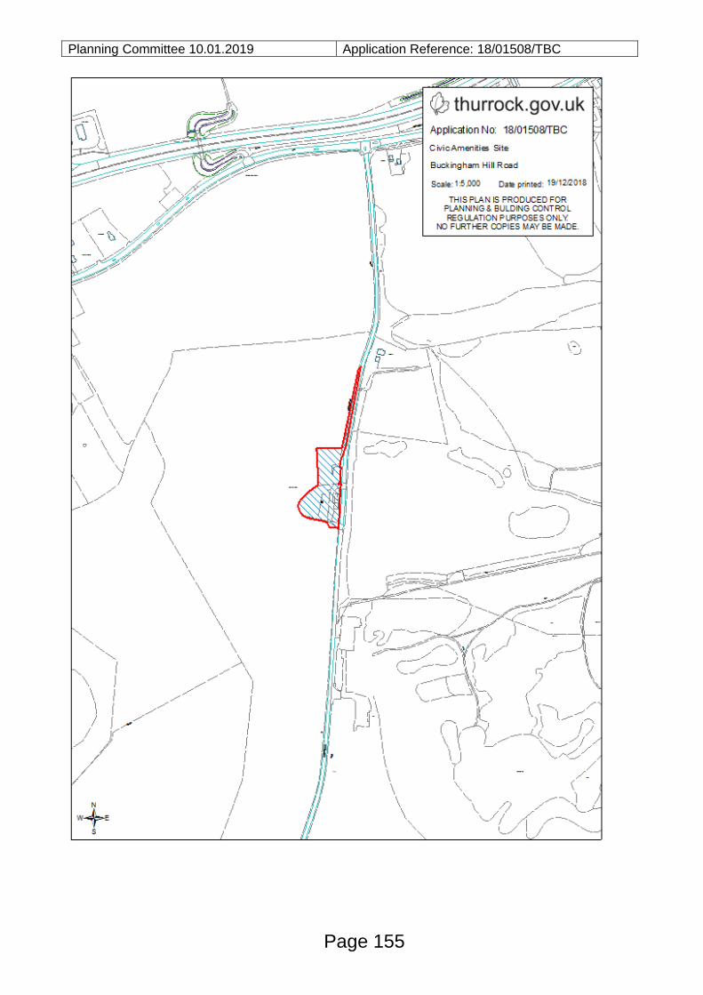
Planning Committee 10.01.2019 Application Reference: 18/01508/TBC
Page 155

This page is intentionally left blank


![Agenda and Reports Pack[1]](https://img.pdfslide.us/doc/110x75/577d24471a28ab4e1e9c10b8/agenda-and-reports-pack1.jpg)