Embed Size (px)
Citation preview
Cherwell District Council, Bodicote House, Bodicote, Banbury, Oxfordshire, OX15 4AA www.cherwell.gov.uk
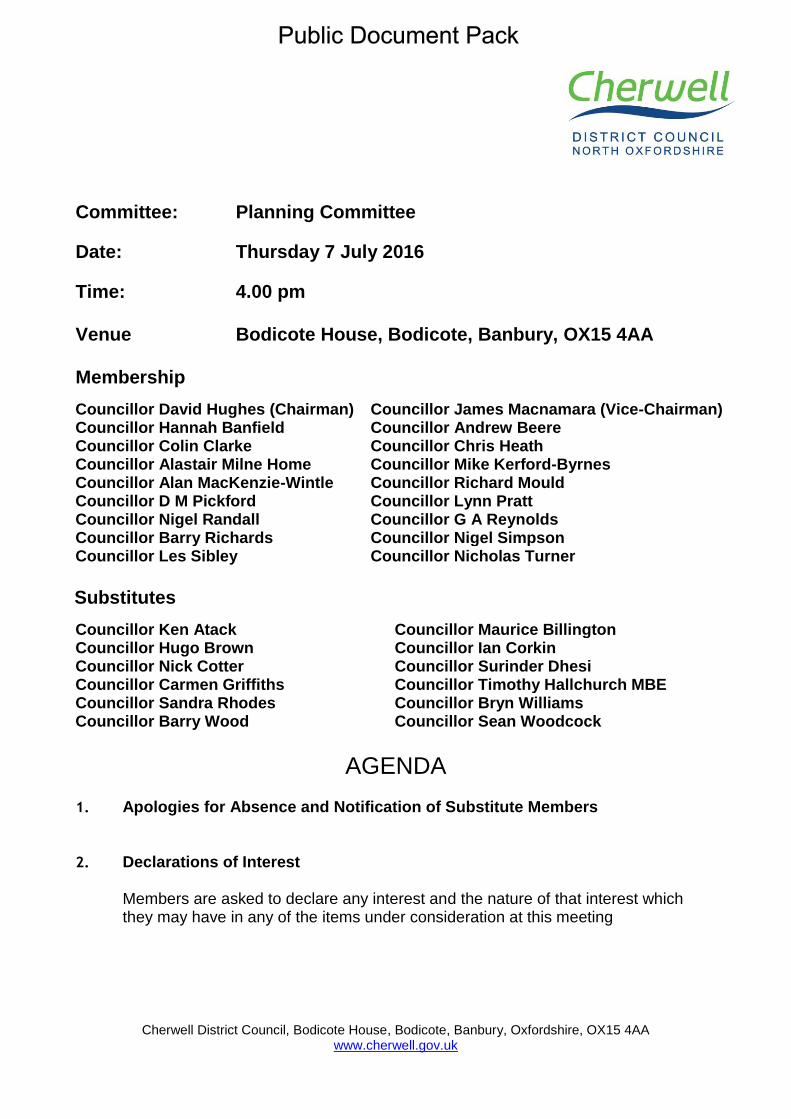
Committee: Planning Committee
Date: Thursday 7 July 2016
Time: 4.00 pm Venue Bodicote House, Bodicote, Banbury, OX15 4AA Membership
Councillor David Hughes (Chairman) Councillor James Macnamara (Vice-Chairman) Councillor Hannah Banfield Councillor Andrew Beere Councillor Colin Clarke Councillor Chris Heath Councillor Alastair Milne Home Councillor Mike Kerford-Byrnes Councillor Alan MacKenzie-Wintle Councillor Richard Mould Councillor D M Pickford Councillor Lynn Pratt Councillor Nigel Randall Councillor G A Reynolds Councillor Barry Richards Councillor Nigel Simpson Councillor Les Sibley Councillor Nicholas Turner
Substitutes
Councillor Ken Atack Councillor Maurice Billington Councillor Hugo Brown Councillor Ian Corkin Councillor Nick Cotter Councillor Surinder Dhesi Councillor Carmen Griffiths Councillor Timothy Hallchurch MBE Councillor Sandra Rhodes Councillor Bryn Williams Councillor Barry Wood Councillor Sean Woodcock
AGENDA
1. Apologies for Absence and Notification of Substitute Members
2. Declarations of Interest Members are asked to declare any interest and the nature of that interest which they may have in any of the items under consideration at this meeting
3. Requests to Address the Meeting The Chairman to report on any requests to address the meeting.
4. Urgent Business The Chairman to advise whether they have agreed to any item of urgent business being admitted to the agenda.
5. Minutes (Pages 1 - 17) To confirm as a correct record the Minutes of the meeting of the Committee held on
6. Chairman's Announcements To receive communications from the Chairman.
Planning Applications
7. Camping Site, Heyford Leys Farm, Heyford Leys, Upper Heyford, Bicester, OX25 5LU (Pages 20 - 39) 15/01446/F
8. Land North of Gaveston Gardens and Rear of Manor Farm, Banbury Road, Deddington (Pages 40 - 81) 16/00053/F
9. Christopher Rawlins Church of England Voluntary Aided Primary School, Aynho Road, Adderbury, OX17 3NH (Pages 82 - 99) 16/00601/F
10. Manor Cottage, Netting Street, Hook Norton, Banbury, OX15 5NP (Pages 100 - 109) 16/00866/F
11. Oceans House, Noral Way, Banbury (Pages 110 - 119) 16/00927/F
12. Norbar Torque Tools Ltd. Beaumont Road, Banbury (Pages 120 - 130) 16/00985/F
Review and Monitoring Reports
13. OS Parcel 0070 adjacent and north of A41 London Road, Bicester (Pages 131 - 133) 16/00861/HYBRID Report of Head of Development Management Purpose of report To notify members of the receipt of this application relating to the strategic allocation at SE Bicester and for Members to consider whether they wish to have a Formal Site Visit prior to the 4 August 2016 Planning Committee meeting. Recommendation The meeting is recommended to: 1.1 Consider whether Members would like to undertake a Formal Site Visit prior
to the Planning Committee Meeting on 4 August 2016 when the application will be before Members for determination.
14. Appeals Progress Report (Pages 134 - 141)
Report of Head of Development Management Summary This report aims to keep members informed upon applications which have been determined by the Council, where new appeals have been lodged. Public Inquiries/hearings scheduled or appeal results achieved. Recommendations The meeting is recommended: 1.1 To accept the position statement.
Councillors are requested to collect any post from their pigeon hole in the Members Room at the end of the meeting.
Information about this Agenda Apologies for Absence Apologies for absence should be notified to [email protected] or 01295 227956 prior to the start of the meeting. Declarations of Interest Members are asked to declare interests at item 2 on the agenda or if arriving after the start of the meeting, at the start of the relevant agenda item. Local Government and Finance Act 1992 – Budget Setting, Contracts & Supplementary Estimates Members are reminded that any member who is two months in arrears with Council Tax must declare the fact and may speak but not vote on any decision which involves budget setting, extending or agreeing contracts or incurring expenditure not provided for in the agreed budget for a given year and could affect calculations on the level of Council Tax. Evacuation Procedure When the continuous alarm sounds you must evacuate the building by the nearest available fire exit. Members and visitors should proceed to the car park as directed by Democratic Services staff and await further instructions. Access to Meetings If you have any special requirements (such as a large print version of these papers or special access facilities) please contact the officer named below, giving as much notice as possible before the meeting. Mobile Phones Please ensure that any device is switched to silent operation or switched off. Queries Regarding this Agenda Please contact Aaron Hetherington, Democratic and Elections [email protected], 01295 227956 Sue Smith Chief Executive Published on Wednesday 29 June 2016
Cherwell District Council
Planning Committee
Minutes of a meeting of the Planning Committee held at Bodicote House, Bodicote, Banbury, OX15 4AA, on 9 June 2016 at 4.00 pm Present: Councillor David Hughes (Chairman)
Councillor James Macnamara (Vice-Chairman)
Councillor Hannah Banfield Councillor Andrew Beere Councillor Colin Clarke Councillor Chris Heath Councillor Alastair Milne Home Councillor Mike Kerford-Byrnes Councillor Alan MacKenzie-Wintle Councillor Richard Mould Councillor D M Pickford Councillor Lynn Pratt Councillor Nigel Randall Councillor G A Reynolds Councillor Nigel Simpson Councillor Les Sibley Councillor Nicholas Turner
Substitute Members:
Councillor Surinder Dhesi (In place of Councillor Barry Richards)
Apologies for absence:
Councillor Barry Richards
Officers: Jon Westerman, Development Services Manager
Bob Duxbury, Development Control Team Leader Jenny Barker, Bicester Development Manager Alex Keen, Team Leader (Minors) Bob Neville, Senior Planning Officer Caroline Ford, Principal Planning Officer Nigel Bell, Team Leader - Planning / Deputy Monitoring Officer Amy Jones, Legal Assistant
17 Declarations of Interest 7. OS Parcel 4200 Adjoining And North East Of A4095 And Adjoining And South West Of Howes Lane, Bicester.
Planning Committee - 9 June 2016
Councillor D M Pickford, Non Statutory Interest, as a member of Bicester Town Council, which had been consulted on the application. Councillor Les Sibley, Declaration, as he had already spoken on the application as a public speaker when the application was previously taken at committee and therefore would leave the chamber for the duration of the debate and the vote. Councillor Lynn Pratt, Non Statutory Interest, as a member of Bicester Town Council, which had been consulted on the application. Councillor Richard Mould, Non Statutory Interest, as a member of Bicester Town Council, which had been consulted on the application. 9. Cherwell District Council, Former Offices, Old Place Yard, Bicester. Councillor Colin Clarke, Declaration, as a member of the Executive and would the Chamber for the duration of the item. Councillor D M Pickford, Declaration, as a member of the Executive and would leave the Chamber for the duration of the item. Councillor G A Reynolds, Declaration, as a member of the Executive and would the Chamber for the duration of the item. Councillor Les Sibley, Non Statutory Interest, as a member of Bicester Town Council, which had been consulted on the application. Councillor Lynn Pratt, Declaration, as a member of the Executive and would stay in the chamber for the duration of the item but would not take part in the debate or vote. Councillor Nicholas Turner, Declaration, as a member of the Executive and would the Chamber for the duration of the item. Councillor Richard Mould, Non Statutory Interest, as a member of Bicester Town Council which had been consulted on the application. Councillor Surinder Dhesi, Declaration, as a member of the Standbridge Friends Group and would leave the Chamber for the duration of the item. 10. Banbury Academy, Ruskin Road, Banbury, OX16 9HY. Councillor Alastair Milne Home, Non Statutory Interest, as a member of Banbury Town Council, which had been consulted on the application. Councillor Andrew Beere, Non Statutory Interest, as a member of Banbury Town Council, which had been consulted on the application. Councillor Colin Clarke, Declaration, as a member of Banbury Town Council and has been Chairman of the Standbridge House Friends Group and a number of residents are known to him and therefore would leave the chamber for the duration of the item.
Planning Committee - 9 June 2016
Councillor Hannah Banfield, Non Statutory Interest, as a member of Banbury Town Council, which had been consulted on the application. Councillor Nicholas Turner, Non Statutory Interest, as a member of Banbury Town Council, which had been consulted on the application. Councillor Nigel Randall, Declaration, as a member of the Build Board and would leave the chamber for the duration of the item. Councillor Surinder Dhesi, Non Statutory Interest, as a member of Banbury Town Council, which had been consulted on the application. 11. Thames Valley Police HQ. Oxford Road, Kidlington. Councillor Nigel Simpson, Non Statutory Interest, as a member of Kidlington Town Council which had been consulted on the application. 12. Land West Of Horn Hill Road, Adderbury. Councillor Nigel Randall, Declaration, as he had already commented on the application and therefore would leave the chamber for the duration of the item.
18 Requests to Address the Meeting The Chairman advised that requests to address the meeting would be dealt with at each item.
19 Urgent Business There were no items of urgent business.
20 Minutes The Minutes of the meeting held on 19 May 2016 were agreed as a correct record and signed by the Chairman.
21 Chairman's Announcements The Chairman made the following announcement: 1. Under the Openness of Local Government Bodies Regulations 2014,
members of the public were permitted to film, broadcast and report on the meeting, subject to the efficient running of the meeting not being affected.
22 OS Parcel 4200 Adjoining And North East Of A4095 And Adjoining And South West Of Howes Lane, Bicester The committee considered application 14/01675/OUT, an outline application for the erection of up to 53,000 sqm of floor space to be for B8 and B2 with
Planning Committee - 9 June 2016
ancillary B1 (use classes) employment provision within two employment zones covering an area of 9.45ha; parking and service areas to serve the employment zones; a new access off the Middleton Stoney Road (B4030); temporary access of Howes Lane pending the delivery of the realigned Howes Lane; 4.5ha of residential land; internal roads, paths and cycleways; landscaping including strategic green infrastructure (G1); provision of sustainable urban systems (suds) incorporating landscaped areas with balancing ponds and swales and associated utilities and infrastructure, at OS Parcel 4200 adjoining and north east of A4095 and adjoining and south west of Howes Lane, Bicester for Albion Land Ltd. Councillor Les Sibley (as a member of the public as the application fell outside of the boundary of the ward he represented) and Catherine Fulljames addressed the committee in objection to the application. Peter Frampton, agent for the applicant, addressed the committee in support to the application. Councillor Pratt proposed that application 14/01675/OUT be refused. Councillor Mould seconded the proposal. In reaching their decision, the committee considered the officers report, presentation, written update and the addresses of the public speakers. Resolved That application 14/01675/OUT be refused for the following reasons: 1. The proposed employment uses, at 70% B8 and 30% B2 floor space,
does not comply with Policy Bicester 1 of the Adopted Cherwell Local Plan 2011-2031 which states that the use classes sought across the North West Bicester site will be B1 with limited B2 and B8 uses. The proposed employment uses are not predominantly B1 and would provide lower employment levels than employment predominantly within Use Class B1. Additionally, the resulting scale, height and appearance of development from such a use class split, as established by the parameter plans submitted with the application, would be unacceptable in terms of the impact of the proposal upon the landscape, the visual amenities of the area and the amenity of neighbouring properties by virtue of being obtrusive and out of keeping with the predominantly residential character of the existing town and the development planned by the Masterplan for North West Bicester. The proposal is therefore not considered to be sustainable development and is contrary to Policies Bicester 1, SLE 1, ESD13 and ESD15 of the Cherwell Local Plan 2011-2031, Policies C28 and C30 of the Cherwell Local Plan 1996, the National Planning Policy Framework and the North West Bicester Supplementary Planning Document.
2. By reason of a lack of a satisfactory completed S106 legal agreement
to ensure that the development adequately mitigates its impact on community infrastructure, site wide infrastructure and secures the provision of affordable housing, the local planning authority cannot be
Planning Committee - 9 June 2016
satisfied that the impacts of the development in this respect can be made acceptable. In addition, the application provides insufficient information in respect of the detail relating to the Howes Lane temporary access, the provision of Green Infrastructure, the achievement of a net gain for biodiversity and an adequate Framework Travel Plan in order for an assessment to be made as to the acceptability of the proposal in relation to these specific matters. Consequently the proposals conflict with the requirements of Policies BSC3, BSC11, BSC12, INF1, Bicester 1, ESD10 and ESD17 of the Cherwell Local Plan 2011-2031, Policy H5 of the Cherwell Local Plan 1996, the National Planning Policy Framework and the North West Bicester Supplementary Planning Document.
23 Former Burgess Building, Canal Street, Banbury, OX16 5AX The Chairman advised the Committee that application 14/01685/F had been withdrawn from the planning process by the applicant.
24 Cherwell District Council, Former Offices, Old Place Yard, Bicester The committee considered application 16/00043/F for 11 self-contained flats for adults with physical disabilities, learning disabilities and autistic spectrum condition, the units to be single storey with shared landscaped gardens and associated parking areas and staff accommodation and communal areas to be included at Cherwell District Council, Former Offices, Old Place Yard, Bicester for Cherwell District Council. Bob Hessian, on behalf of Bicester Local History Society and others, addressed the committee in objection to the application. Councillor John Donaldson (as a member of the public as the application fell outside of the boundary of the ward he represented), addressed the committee in support of the application. In reaching their decision, the committee considered the officers report, presentation, written update and the address of the public speakers. Resolved That item 16/00043/F be approved subject to the re-consultation on the amended plans and additional documents raising no new material planning issues, and subject to the following conditions: 1. The development to which this permission relates shall be begun not
later than the expiration of three years beginning with the date of this permission.
2. Except where otherwise stipulated by condition, the development shall be carried out strictly in accordance with the following plans and documents: Application forms, Design and Access Statement, Tree Survey Report, Flood Risk Assessment, Ecological Appraisal and
Planning Committee - 9 June 2016
drawings numbered: Proposed site plan S2-P15, Building A Site Plan S2-P14, Building A Ground Floor Plan S2-P15, Building A Elevations (1 of 2) S2-P13, Building A Elevations (2 of 2) S2-P04, Building A Roof Plan S2-P06, Building A Site Section S2-P02, Existing Site Plan Building B S2-P01, Site Plan Building B S2-P13, Building B Ground Floor Plan S2-P11, Building B Elevations (1 of 2) S2-P11, Building B Elevations (2 of 2) S2-P11, Roof Plan Building B S2-P08, Site Sections Building B S2-P03, Building B proposed alternative Foundation Layout, Building B proposed alternative Foundation Sections, Proposed Alternative Building B Foul Water Drainage Layout, and Proposed Alternative Building B Surface Water Drainage Layout.
3. The development permitted by this planning permission shall only be
carried out in accordance with the approved FRA by Moson Engineering and the following mitigation measures detailed within the FRA: • Finished floor levels of Building B will be set no lower than 69.05m above Ordnance Datum (AOD).
The mitigation measures shall be fully implemented prior to occupation and subsequently in accordance with the timing / phasing arrangements embodied within the scheme, or within any other period as may subsequently be agreed, in writing, by the local planning authority.
SITE A ONLY (as shown on Drawing No: Site Plan Building A S2-P14) 4. Prior to any demolition and the commencement of the development on
Site A, a professional archaeological organisation acceptable to the Local Planning Authority shall prepare an Archaeological Written Scheme of Investigation, relating to the application site area, which shall be submitted to and approved in writing by the Local Planning Authority.
5. Following the approval of the Written Scheme of Investigation referred to in condition 4, and prior to any demolition on the site and the commencement of the development on Site A (other than in accordance with the agreed Written Scheme of Investigation), a staged programme of archaeological evaluation and mitigation shall be carried out by the commissioned archaeological organisation in accordance with the approved Written Scheme of Investigation. The programme of work shall include all processing, research and analysis necessary to produce an accessible and useable archive and a full report for publication which shall be submitted to the Local Planning Authority.
SITE B ONLY (as shown on Drawing No: Site Plan Building B S2-P13) 6. Prior to any demolition and the commencement of the development on
Site B, a professional archaeological organisation acceptable to the Local Planning Authority shall prepare an Archaeological Written Scheme of Investigation, relating to the application site area and including details of the piling methodology and foundation design,
Planning Committee - 9 June 2016
which shall be submitted to and approved in writing by the Local Planning Authority.
7. No development shall commence on Site B until the applicant or their
agents or their successors in title have secured the implementation of a programme of archaeological evaluation work in order to inform the Pile Location Plan in accordance with the Written Scheme of Investigation approved under condition 6.
8. Following the approval of the Written Scheme of Investigation referred
to in condition 6, and prior to any demolition on the site and the commencement of the development on Site B (other than in accordance with the agreed Written Scheme of Investigation), a staged programme of archaeological evaluation and mitigation shall be carried out by the commissioned archaeological organisation in accordance with the approved Written Scheme of Investigation. The programme of work shall include all processing, research and analysis necessary to produce an accessible and useable archive and a full report for publication which shall be submitted to the Local Planning Authority.
9. Prior to the commencement of the development hereby approved on
Site B, a plan showing full details of the finished floor levels for the proposed buildings in relation to existing ground levels on Site B shall be submitted to and approved in writing by the Local Planning Authority. Thereafter the development shall be carried out in accordance with the approved finished floor levels plan.
SITES A AND B (as shown on Drawing No: Proposed site plan S2-P15) 10. Prior to the construction of the development above slab level, a surface
water drainage scheme for the site, based on sustainable drainage principles and an assessment of the hydrological and hydro-geological context of the development, shall be submitted to and approved in writing by the local planning authority. The scheme shall subsequently be implemented in accordance with the approved details before the development is completed.
11. Prior to the construction of the development above slab level, a brick
sample panel, to demonstrate brick type, colour, texture, face bond and pointing (minimum 1m2 in size) shall be constructed on site, inspected and approved in writing by the Local Planning Authority. Thereafter, the external walls of the development shall be constructed in strict accordance with the approved brick sample panel.
12. Prior to the construction of the development above slab level, samples
of the tile to be used in the construction of the roof of the development shall be submitted to and approved in writing by the Local Planning Authority. Thereafter the development shall be carried out in accordance with the samples so approved.
13. Prior to the construction of the development above slab level, a render
sample panel, to demonstrate the colour and texture, (minimum 1m2
Planning Committee - 9 June 2016
in size) shall be constructed on site, inspected and approved in writing by the Local Planning Authority. Thereafter, the parts of the external walls of the development to be rendered (as shown on the approved plans) shall be rendered in strict accordance with the approved render sample panel.
14. Prior to the construction of the development above slab level, full
details of the doors and windows and their surrounds hereby approved, at a scale of 1:20 including a cross section, cill, lintel and recess detail and colour/finish, shall be submitted to and approved in writing by the Local Planning Authority. Thereafter the doors and windows and their surrounds shall be installed within the building in accordance with the approved details.
15. Prior to the construction of the development above slab level, full
design details (at a scale of 1:20) of the railings hereby approved along the eastern boundary of Site A, to include their height, colour/finish, and the junction with the Dovecote, shall be submitted to and approved in writing by the Local Planning Authority. Thereafter the railings shall be installed in accordance with the approved details.
16. Prior to the construction of the development above slab level, a
landscaping scheme shall be submitted to and approved in writing by the Local Planning Authority. The scheme for landscaping the site shall include:- (a) details of the proposed tree and shrub planting including their
species, number, sizes and positions, and the locations, specifications and construction methods for all tree pits, together with grass seeded/turfed areas,
(b) details of the hard surface areas, including pavements, pedestrian areas, reduced-dig areas, crossing points and steps,
(c) details of all boundary treatments and means of enclosure. Thereafter the development shall be carried out in accordance with the approved landscaping scheme.
17. All planting, seeding or turfing comprised in the approved details of
landscaping shall be carried out in accordance with BS 4428:1989 Code of Practice for general landscape operations (excluding hard surfaces), or the most up to date and current British Standard, in the first planting and seeding seasons following the occupation of the building(s) or on the completion of the development, whichever is the sooner. Any trees, herbaceous planting and shrubs which, within a period of five years from the completion of the development die, are removed or become seriously damaged or diseased shall be replaced in the current/next planting season with others of similar size and species.
18. Prior to the construction of the development above slab level, full
details of the external lighting shall be submitted to and approved in writing by the Local planning Authority. Thereafter, the external lighting shall be installed in accordance with the approved details.
Planning Committee - 9 June 2016
19. Prior to the construction of the development above slab level, full specification details (including construction, layout, surfacing and drainage) of the parking and manoeuvring areas shall be submitted to and approved in writing by the Local Planning Authority. Thereafter, and prior to the first occupation of the development, the parking and manoeuvring areas shall be provided on the site in accordance with the approved details and shall be retained unobstructed except for the parking and manoeuvring of vehicles at all times thereafter.
20. Prior to the construction of the development above slab level, and
notwithstanding the application details, full details of refuse, fire tender and pantechnicon turning within the site shall be submitted to and approved in writing by the Local Planning Authority. Thereafter, the development shall be carried out in accordance with the approved details.
21. Prior to the first use or occupation of the development hereby
permitted, covered cycle parking facilities shall be provided on the site in accordance with details which shall be firstly submitted to and approved in writing by the Local Planning Authority. Thereafter, the covered cycle parking facilities shall be permanently retained and maintained for the parking of cycles in connection with the development.
22. Prior to the occupation of any of the buildings hereby approved the bird
and invertebrate boxes shall be installed on the site in accordance with the details contained within the Ecological Appraisal submitted with the application and prepared by ELMAW Consulting dated August 2015.
23. Prior to the first occupation of the development hereby approved, a
scheme for the provision of refuse and recycling bins, including their number, size, type and arrangements for their storage and collection (including the location and compound enclosure details), shall be submitted to and approved in writing by the Local Planning Authority. Thereafter, and prior to the first occupation of any dwelling, refuse and recycling bins shall be provided in accordance with the approved scheme.
25 Banbury Academy, Ruskin Road, Banbury, OX16 9HY The Committee considered application 16/00363/F for the provision of an all-weather astro turf pitch and lighting, and alteration of the existing sports hall and changing facilities including the provision of an external climbing wall at Banbury Academy, Ruskin Road, Banbury, OX16 9HY for Mr M Gough. Edna Sparkes and Margaret Williams, local residents, addressed the committee in objection to the application. Louise Steele, agent for the application, addressed the committee in support of the application.
Planning Committee - 9 June 2016
In reaching their decision, the committee considered the officers’ report, presentation and written update and the addresses of the public speakers. Resolved That application 16/00363/F be approved, subject the following conditions: 1. The development to which this permission relates shall be begun not
later than the expiration of three years beginning with the date of this permission.
2. Except where otherwise stipulated by condition, the development shall be carried out strictly in accordance with the following plans and documents: Application forms, Design and Access Statement (April 2016), Framptons’ Construction Travel Management Plan, Halliday Lighting Impact Study, Ecological Consultancy letter from Aspect Ecology Ltd dated 29 April 2016, Transport Statement (May 2016), Arboricultural Impact Assessment (May 2016), Noise Impact Assessment dated 6th May 2016, Flood Risk Assessment (March 2016) and drawings labelled: 0300 Rev. C, 0312 Rev. 01, 0313 Rev. 00, 0314 Rev. B, 0315, 0316 Rev. A, 0317 Rev. A, 0321 Rev. B and GUK-MUK231-09.
3. Within 12 months of the date of this permission, a community use
agreement prepared in consultation with Sport England shall be submitted to and approved in writing by the Local Planning Authority, and a copy of the completed approved agreement has been provided to the Local Planning Authority. The agreement shall apply to the Artificial Grass pitch, Natural turf pitches and sports hall and include details of pricing policy, hours of use, access by non-educational establishment users, management responsibilities and a mechanism for review, and anything else which the Local Planning Authority in consultation with Sport England considers necessary in order to secure the effective community use of the facilities. The development shall not be used at any time other than in strict compliance with the approved agreement."
4. Before the Artificial Grass Pitch is brought into use, a Management and
Maintenance Scheme for the facility including management responsibilities, a maintenance schedule and a mechanism for review shall be submitted to and approved in writing by the Local Planning Authority [after consultation with Sport England]. This should include a sinking fund to ensure the replacement of the Artificial Grass Pitch within a specified period given by the manufacturers. The measures set out in the approved scheme shall be complied with in full, with effect from commencement of use of the Artificial Grass Pitch.
5. Prior to commencement of the development hereby approved, the SuDS design for the site shall be required to be submitted to and approved in writing by the Local Planning Authority. These details must demonstrate how the system shall be managed and maintained thereafter in accordance with the agreed management and maintenance plan.
Planning Committee - 9 June 2016
6. Prior to the first use of the development hereby approved, a
landscaping scheme shall be submitted to and approved in writing by the Local Planning Authority. The scheme for landscaping the site shall include:- (a) details of the proposed tree and shrub planting including their species, number, sizes and positions, together with grass seeded/turfed areas, (b) details of the existing trees and hedgerows to be retained as well as those to be felled, including existing and proposed soil levels at the base of each tree/hedgerow and the minimum distance between the base of the tree and the nearest edge of any excavation, (c) details of the hard surface areas, including pavements, pedestrian areas, reduced-dig areas, crossing points and steps.
7. That all planting, seeding or turfing comprised in the approved details of landscaping shall be carried out in the first planting and seeding seasons following the occupation of the building(s) or on the completion of the development, whichever is the sooner; and that any trees and shrubs which within a period of five years from the completion of the development die, are removed or become seriously damaged or diseased shall be replaced in the next planting season with others of similar size and species, unless the Local Planning Authority gives written consent for any variation.
8. The existing hedgerow along the north-eastern boundary of the site shall be retained and properly maintained at a height of not less than 3m metres, and if any hedgerow plant dies within five years from the completion of the development it shall be replaced and shall thereafter be properly maintained in accordance with this condition.
9. a) No retained tree shall be cut down, uprooted, damaged or
destroyed, nor shall any retained tree be pruned in any manner, be it branches, stems or roots, other than in accordance with the approved plans and particulars, without the prior written approval of the Local Planning Authority. All tree works shall be carried out in accordance with BS3998: Recommendations for Tree Works. b) If any retained tree is cut down, uprooted, destroyed or dies, another tree shall be planted in the same place in the next planting season following the removal of that tree, full details of which shall be firstly submitted to and approved in writing by the Local Planning Authority. In this condition a “retained tree” is an existing tree which shall be retained in accordance with the approved plans and particulars; and paragraphs (a) and (b) shall have effect until the expiration of five years from the date of the [insert].
10. That the areas all-weather Astro-Turf Pitch shall not be used between the hours of 21.00 and 08.00.
26 Thames Valley Police HQ. Oxford Road, Kidlington
Planning Committee - 9 June 2016
The Committee considered application 16/00525/F for the proposed demolition of `C` and `G` blocks to erect replacement office building, in addition to associated works at Thames Valley Police HQ. Oxford Road, Kidlington for Thames Valley Police. Tony Norris, a local resident, addressed the committee in objection to the application. In reaching their decision, the committee considered the officers report, presentation and the address of the public speaker. Resolved That application 16/00525/F be approved, subject to: 1. The development to which this permission relates shall be begun not
later than the expiration of three years beginning with the date of this permission.
2. Except where otherwise stipulated by condition, the development shall
be carried out strictly in accordance with the following plans and documents: Application forms Design and Access Statement; Transport Statement; Planning Statement; Ecological appraisal; Supplementary statement received 5 May 2016 and drawings numbered0007/PO1; 0002/PO1; 1210/PO1; 3100/PO1; 3101/PO1; 4100/PO1; 0009/PO1; 0005/PO2 013/PO2
3. Prior to the commencement of the development hereby approved, a detailed schedule of materials and finishes for the external walls and roof(s) of the development hereby approved in general accord with the information contained on the approved elevations shall be submitted to and approved in writing by the Local Planning Authority. Thereafter the development shall be carried out in accordance with the approved schedule.
4. Prior to the commencement of the development hereby approved, full details of any external lighting to be provided in the car parking area or on the building shall be submitted to and approved in writing by the Local planning Authority. Thereafter, the lighting shall be carried out and retained in accordance with the approved details.
5. Prior to the commencement of all other development hereby approved, the buildings and structures on the site at the date of this permission shall be demolished and the debris and materials removed from the site.
6. Prior to the commencement of the development hereby approved, full details of the new boundary wall formed from the partial demolition of G Block shall be submitted to and approved in writing by the Local Planning Authority. Thereafter and prior to the first occupation of the development, the new boundary treatment shall be erected, in accordance with the approved details, and retained and maintained in situ at all times.
Planning Committee - 9 June 2016
7. Prior to the commencement of the development hereby approved, a
landscaping scheme shall be submitted to and approved in writing by the Local Planning Authority. The scheme for landscaping the site shall include:- (a) details of the proposed tree and shrub planting including their species, number, sizes and positions, together with grass seeded/turfed areas, (b) details of the existing trees and hedgerows to be retained as well as those to be felled, including existing and proposed soil levels at the base of each tree/hedgerow and the minimum distance between the base of the tree and the nearest edge of any excavation, (c) details of the hard surface areas, including pavements, pedestrian areas, reduced-dig areas, crossing points and steps.
8. All planting, seeding or turfing comprised in the approved details of
landscaping shall be carried out in accordance with BS 4428:1989 Code of Practice for general landscape operations (excluding hard surfaces), or the most up to date and current British Standard, in the first planting and seeding seasons following the occupation of the building(s) or on the completion of the development, whichever is the sooner. Any trees, herbaceous planting and shrubs which, within a period of five years from the completion of the development die, are removed or become seriously damaged or diseased shall be replaced in the current/next planting season with others of similar size and species
9. Prior to the commencement of the development hereby approved,
details of the revised car parking provision shall be submitted to and approved in writing by the Local Planning Authority. Thereafter, and prior to the first occupation of the development, the parking spaces shall be laid out, surfaced, drained and completed in accordance with the approved details and shall be retained for the parking of vehicles at all times thereafter
10. Prior to the first use or occupation of the development hereby
permitted, covered cycle parking facilities shall be provided on the site in accordance with details which shall be firstly submitted to and approved in writing by the Local Planning Authority. Thereafter, the covered cycle parking facilities shall be permanently retained and maintained for the parking of cycles in connection with the development.
11. Prior to the first occupation of the development hereby approved, a
Travel Plan, prepared in accordance with the Department of Transport’s Best Practice Guidance Note “Using the Planning Process to Secure Travel Plans” and its subsequent amendments, shall be submitted to and approved in writing by the Local Planning Authority. Thereafter, the approved Travel Plan shall be implemented and operated in accordance with the approved details
12. Prior to the commencement of the development, a Construction
Environment Management Plan (CEMP), which shall include details of

Planning Committee - 9 June 2016
the measures to be taken to ensure construction works do not adversely affect residential properties on, adjacent to or surrounding the site together with details of the consultation and communication to be carried out with local residents shall be submitted to and approved in writing by the Local Planning Authority. Thereafter the development shall be carried out in accordance with approved CEMP.
13. No removal of hedgerows, trees or shrubs [nor works to, or demolition
of buildings or structures that may be used by breeding birds], shall take place between the 1st March and 31st August inclusive, unless the Local Planning Authority has confirmed in writing that such works can proceed, based on health and safety reasons in the case of a dangerous tree, or the submission of a recent survey (no older than one month) that has been undertaken by a competent ecologist to assess the nesting bird activity on site, together with details of measures to protect the nesting bird interest on the site.
14. Prior to the commencement of development , including any demolition
or site clearance a method statement for enhancing biodiversity on site shall be submitted to and approved by the Local Planning Authority. Thereafter the biodiversity enhancements shall be carried out and retained in accordance with the approved details
27 Land West Of Horn Hill Road, Adderbury The Committee considered application 16/00619/F for the residential development of a single dwelling with associated landscaping and land for an extension to the existing village burial ground for Land West of Horn Hill Road, Adderbury for Mr M Gough. The application was a resubmission of 15/01048/F. Nigel Wood, on behalf of Adderbury Conversation Action Group, addressed the committee in objection to the application. Ann Lyons, on behalf of Adderbury Parish Council and Jonathan Porter, the applicant’s agent addressed the committee in support of the application. In reaching their decision, the committee considered the officers’ report, presentation, written update and the addresses of the public speakers. Resolved That application 16/00619/F be refused for the following reasons:
1. The proposed dwelling constitutes sporadic development beyond the built up limits of the Adderbury and, in the absence of an appropriate justification, conflicts with saved Policy H18 of the Cherwell Local Plan 1996, and Government guidance contained within the National Planning Policy Framework. Furthermore by virtue of its siting, scale and design, the proposed dwelling would cause harm to the intrinsic value of the open countryside and rural character, by intrusion into such, which would fail to reflect or reinforce local distinctiveness and
Planning Committee - 9 June 2016
existing settlement pattern or preserve the natural environment at this location. The proposals would therefore be contrary to saved Policies H18, C8, C28 and C30 of the Cherwell Local Plan 1996, Policies Villages 1, ESD 13 and ESD 15 of the Cherwell Local Plan 2011-2031 Part 1 and Government guidance contained within the National Planning Policy Framework.
2. Insufficient information has been submitted in relation to the proposed
burial site in terms of land levels and ground conditions to clearly establish whether the land is suitable for use as a burial site or whether its use as such would likely cause a risk of groundwater pollution. The proposals would therefore be contrary to the provisions and aims of Policy ENV1 of the Cherwell Local Plan 1996, Policy ESD 8 of the Cherwell Local Plan 2011-2031 Part 1 and Government guidance contained within the National Planning Policy Framework.
28 Land To Rear of Utility Building, Glebe Court, Fringford The Committee considered application 16/00704/F for the erection of warden’s dwelling at Land to the Rear of Utility Building, Glebe Court, Fringford for Glebe Leisure, Mr R Herring. Angela Banks the applicant’s agent and Ann Herring the applicant, addressed the committee in support of the application. Councillor Turner proposed that application 16/00704/F be approved, subject to conditions with authority delegated to officers, in consultation with the Chairman, to agree the conditions. Councillor Milne Home seconded the proposal. In reaching their decision, the committee considered the officers’ report, presentation, written update and the addresses of the public speaker. Resolved That application 16/00704/F be approved, subject to the following conditions (with authority delegated to officers, in consultation with the Chairman, to agree the final wording of the conditions): 1. The development to which this permission relates shall be begun not later
than the expiration of three years beginning with the date of this permission.
2. Except where otherwise stipulated by conditions attached to this
permission, the development shall be carried out strictly in accordance with the following plans and documents: Application Form, Design and Access Statement, Site Location Plan, Block Plan, Elevations and Floor Plans all dated November 2015.
3. Prior to the commencement of the development hereby approved, a
schedule of materials and finishes for the external walls and roof(s) of the development hereby approved, including samples, shall be submitted to
Planning Committee - 9 June 2016
and approved in writing by the Local Planning Authority. Thereafter the development shall be carried out in accordance with the approved schedule.
4. Prior to the commencement of the development hereby approved, a plan
showing car parking provision for two spaces to be accommodated within the site to include layout, surface details, and drainage shall be submitted to and approved in writing by the Local Planning Authority. Thereafter, and prior to the first occupation of the development, the parking spaces shall be laid out, surfaced, drained and completed in accordance with the approved details and shall be retained for the parking of vehicles at all times thereafter.
5. The dwelling hereby approved shall be occupied only by a warden
engaged at Glebe Leisure Caravan Park at Fringford and their immediate family.
6. Notwithstanding the provisions of Classes A to F (inc.) of Part 1, Schedule
2 of the Town and Country Planning (General Permitted Development) Order 2015 and its subsequent amendments, the approved dwelling(s) shall not be extended, nor shall any structures be erected within the curtilage of the said dwelling(s), without the grant of further specific planning permission from the Local Planning Authority.
7. Notwithstanding the provisions of Class A of Part 2, Schedule 2 of the
Town and Country Planning (General Permitted Development) Order 2015 and its subsequent amendments, no gate, fence, wall or other means of enclosure shall be erected, constructed or placed on the site without the prior express planning consent of the Local Planning Authority.
8. Within 60 days from the date of this permission, the caravan used as
permanent residential accommodation within use class C3 as outlined in black on the attached plan and aerial photograph shall be removed from the Glebe Leisure Caravan Park and the land shall be restored to its former condition on or before that date.
9. Within 60 days of the date of this permission, the static caravan as
outlined in green on the attached plan and aerial photograph shall be removed from the Glebe Leisure Caravan Park and the land shall be restored to its former condition on or before that date.
29 Rosemary, Main Street, Fringford The Head of Development Management submitted a report to notify members of an issue relating to the conditions imposed in respect of on-going remedial works to a dwelling constructed on a plot of land in Fringford. Councillor Barry Wood, addressed the committee as Ward Member. Resolved
Planning Committee - 9 June 2016
(1) That the decision to allow the owners of the site to carry out the approved remedial works in accordance with approved plan P11/055/003 Rev F be noted.
30 Appeals Progress Report The Head of Development Management submitted a report which informed Members on applications which had been determined by the Council, where new appeals have been lodged, public Inquiries/hearings scheduled or appeal results achieved. Resolved (1) That the position statement be accepted.
The meeting ended at 9.00 pm Chairman:
Date:
CHERWELL DISTRICT COUNCIL
PLANNING COMMITTEE
7 July 2016
PLANNING APPLICATIONS INDEX
The Officer’s recommendations are given at the end of the report on each application.
Members should get in touch with staff as soon as possible after receiving this agenda if they wish to have any further information on the applications.
Any responses to consultations, or information which has been received after the application report was finalised, will be reported at the meeting.
The individual reports normally only refer to the main topic policies in the Cherwell
Local Plan that are appropriate to the proposal. However, there may be other policies in the Development Plan, or the Local Plan, or other national and local planning guidance that are material to the proposal but are not specifically referred to.
The reports also only include a summary of the planning issues received in consultee representations and statements submitted on an application. Full copies of the comments received are available for inspection by Members in advance of the meeting.
Legal, Health and Safety, Crime and Disorder, Sustainability and Equalities Implications
Any relevant matters pertaining to the specific applications are as set out in the individual reports.
Human Rights Implications
The recommendations in the reports may, if accepted, affect the human rights of individuals under Article 8 and Article 1 of the First Protocol of the European Convention on Human Rights. However, in all the circumstances relating to the development proposals, it is concluded that the recommendations are in accordance with the law and are necessary in a democratic society for the protection of the rights and freedom of others and are also necessary to control the use of property in the interest of the public.
Background Papers
For each of the applications listed are: the application form; the accompanying certificates and plans and any other information provided by the applicant/agent; representations made by bodies or persons consulted on the application; any submissions supporting or objecting to the application; any decision notices or letters containing previous planning decisions relating to the application site.
Site Application No.
Ward Recommendation Contact Officer
7
Camping Site, Heyford Leys Farm, Heyford Leys, Upper Heyford, Bicester, OX25 5LU
15/01446/F Fringford and Heyfords
Refusal Andrew Lewis
8
Land North of Gaveston Gardens and Rear of Manor Farm, Banbury Road, Deddington
16/00053/F Deddington Approval Linda Griffiths
9
Christopher Rawlins Church of England Voluntary Aided Primary School, Aynho Road, Adderbury, OX17 3NH
16/00601/F Adderbury, Bloxham and Bodicote
Approval Stuart Howden
10
Manor Cottage Netting Street Hook Norton Banbury OX15 5NP
16/00866/F Deddington Approval Matthew Chadwick
11 Oceans House Noral Way Banbury
16/00927/F Banbury Hardwick
Approval Matthew Chadwick
12 Norbar Torque Tools Ltd. Beaumont Road, Banbury
16/00985/F Banbury Cross and Neithrop
Approval Bob Duxbury
Caravan Site
Park
Path
El Sub Sta
Sewage Works
119.1m
27
53
25
50
ETL
LB
Posts
HART
WAL
K
Pond
Caravan
Heyford Leys Farm
944
6
12
16
5
42
20
49
29
43
24
2
28
14
10
19
38
3436
4647
4
1
48
ETL
27
© Crown Copyright and database right 2016. Ordnance Survey 1000185041:1,250Scale
15/01446/FCamping SiteHeyford Leys FarmHeyford LeysUpper HeyfordBicesterOX25 5LU
N
The Heath
Park
Sewage Works
Caravan Site
21
5
3
9
47
Footbridge
Sta
Free School
Letchmere Farm
3
© Crown Copyright and database right 2016. Ordnance Survey 1000185041:5,000Scale
15/01446/FCamping SiteHeyford Leys FarmHeyford LeysUpper HeyfordBicesterOX25 5LU
N
Camping Site
Heyford Leys Farm
Heyford Leys
Upper Heyford
Bicester
OX25 5LU
15/01446/F
Case Officer: Andrew Lewis Ward(s): Fringford And Heyfords
Applicant: Mr Liberty Durant
Ward Member(s): Cllr Ian Corkin , Cllr James Macnamara, Cllr Barry Wood
Proposal: Change of use for extension to mobile home park onto adjoining caravan
site (Heyford Leys Camping Park)
Committee Date: 7 July 2016 Recommendation: Refuse
Referral Reason Major Application
1. Application Site and Locality
1.1 The site of the application measures approximately 0.1 hectares and is currently used by touring caravans and for camping. It is largely open and grassed with a number of buildings including a former stone barn (permission granted in 2014 for conversion to 2 dwellings), prefabricated concrete and rendered buildings that serve as office, shop, storage and toilets for the existing use. The site has hedging and several attractive trees.
1.2 It is located to the east of the former RAF Upper Heyford base on the south side of Camp
Road. On its eastern boundary is the Duvall Mobile Home Park and it is the owner of this site that is seeking permission to expand. The main part of this site has a long standing use as a permanent residential park on which it is understood there were 48 homes although in 2014 its extension was approved for an additional 9 park homes on land within its curtilage but which had been used as open space by the residents.
1.3 To the south is the sewage treatment plant that serves the former base. Its shares access to
Camp Road with the residential park and application site. Surrounding the caravan/camping/application site, mobile home park and treatment plant are open fields which give it a degree of separation from the main settlement. Approximately 650 metres to the south is a public footpath (Route code 388/4/40; route number 4) which has a clear view of the application site across open countryside.
2. Description of Proposed Development
2.1 The application site has recently been modified and its boundary now relates to that
authorised for caravanning and camping. This reduces the number of homes proposed from 34 to 25. A stone building would be retained as an office but all other buildings demolished. Access would be the existing entrance to Camp Road but the new homes would be served from their own extended drive. The homes would be single storey and similar in appearance to the latest park homes on the adjacent site. They would be sited on a concrete hardstanding with a dedicated parking space. All appear to be two bedroomed from the information provided and the intention is they are occupied by residents of 55 years of age or older. It is understood the southern end of the site would be retained as communal open space.
2.2 The application has been supported by a considerable amount of documentation including:
Planning Statement
Environmental assessment
Ecological Statement
Flooding and Drainage assessment
Transport Statement
3. Relevant Planning History
App Ref Description Status
CHS/665/79X Residential caravan site for 47
caravans/mobile homes
PER
96/00094/F Change of use from agricultural land to
caravan/parking bays complete with electrical
hook-up points for 22 touring caravans.
Enlargement of access.
PER
95/00130/F Extended permission for existing
hardstanding area to situate 16 touring
caravans for accommodation to persons
working in the local area
PER
00/00176/F Non-compliance of Condition 1 of Planning
Permission 96/00094/F, to continue the use
of the land for the siting of 22 touring
caravans
PER
00/00177/F Use of land for siting 12 touring caravans (as
amended by Applicant's letter dated 12th July
2000 and Site Plan received 2nd May 2000)
PER
00/02332/F Use of land for siting 12 touring caravans
without compliance with condition 4 of
planning permission 00/00177/F relating to
provision of toilet / shower facilities
REF
01/01838/F Non compliance with Conditions 3 and 4 of
CHS.665/79X. To continue the use of the
land for residential mobile homes
PER
02/02290/F Relaxation of Condition 1 of 00/00176/F and
00/00177/F. To allow the use of the land for
the siting of touring caravans to be
permanent
PER
06/00551/F Revised site layout to achieve site license
compliance, an increase in caravan numbers
and enhanced landscaping (Variation of
condition 5 of CHS 665/79)(as amended by
WDN
plan received 05/05/06 with agents letter
dated 04/05/06)
07/00083/F Revised site layout to achieve site license
compliance, an increase in caravan numbers
and enhanced landscaping (Variation of
condition 5 of CHS 665/79). Resubmission of
06/00551/F
REF
14/00830/F Change of use of land for siting of mobile
homes
PER
14/00372/DISC Submission of details to comply with
conditions 3, 7, 11 and 12 of planning
permission 14/00830/F
PER
4. Response to Publicity
4.1 The application was publicised by way of neighbour notification letters and a notice displayed near to the site. The comments raised by third parties are summarised as follows:
45 Heyford Leys:
My concerns are, there are already over a 1000 houses being built here and the disruption dust and noise is horrific.
A mobile home park is meant to be a place of peace and tranquillity; we are losing this and with additional units will lose more.
Will dogs be allowed? There are no dogs allowed currently on this old site yet dogs are allowed on Mr Durant's new projects. The walls are thin and barking dogs would be another disruption.
How many units is Mr Durant proposing to site?
What about the local wild life and large mature trees? We are losing more and more because of Mr Durant's extensions and the Dorchester and Bovis groups. None of this has been mentioned and we have had no information on the extent of this proposal.
Duvall Park Resident
The landlord has a number of unresolved planning issues. This includes failing to address known flooding problems from the installation of the park homes adjacent to the main car park at the site entrance. This is known by the council to be a breach of his site license.
The landlord has made little attempt to discharge condition 3 of planning application 14/00372 even though he has completed the building works and is currently trying to fill the vacant plots.
Whilst the area does not fall within a floodplain, it is known by the residents to suffer from flooding problems. This is probably aggravated by the site owners’ refusal to provide adequate drainage for surface water as required by section 27 of his site license. I would suggest as a minimum the council should insist that the above issues are resolved as a condition of any future planning application (including this one if it is granted).
In my view for planning application 14/00372 the council did not give enough consideration to the differences between siting park homes and houses. Park homes are built on a concrete base, whilst steel jacks, support a steel frame. This makes them far more susceptible to damage (corrosion to the support frame) than a standard brick built building. The gap between the bottom of the
park home and the base is normally enclosed within a brick built frame, which could easily retain water increasing the likelihood of corrosion. Even minor flooding on a frequent basis could result in substantive structural damage to a park home within a few years.
I understand that several of the existing tenants suffer flooding problems in heavy storms. Building the concrete bases for this application as well as the bases for planning application 14/00372 would reduce drainage and consequentially raise this flooding level. This would affect any new tenants, existing tenants and adjacent land identified for “potential for additional development identified under policy villages 5”, unless suitable additional drainage is provided. Failing to give careful consideration to these problems, could leave the council facing a litigation case for damages if any of these problems are realised.
The new proposal does not provide enough additional visitors car parking space, especially to the south westerly end of the proposed plans.
There is no provision within the application for compliance with the 10% recreational area. I would presume that the suggestion of using the land to the north east of the site as recreational land would negate this requirement. However, this is private land owned by the Dorchester Group. I understand from their site office that whilst they have no immediate plans for this land, they have confirmed that it will not be used for recreational land open to the public. Since there is no suitable recreational facilities available provide for the public, then the plan should be amended to provide a 10% recreational area in accordance with section 30 of the site license.
The land in question does not fall within development land as defined by the councils “local plan”.
There is already an extensive area assigned within the “local Plan” for development. Given the scale and complexity of the development, the council will face considerable opposition in implementing these plans. Concerns include the impact on transport, infrastructure and the rural nature of surrounding villages, will be raised. Additional substantive development adjacent to a major development site will only antagonise the situation even further. This development could easily give any opposition grounds to challenge, amend or delay the implementation of the “local Plan” for the area.
The application is based on the premise of providing low cost housing primarily for the elderly. In view of this, if the council wish to consider this application, it should be tailored to suit this requirement. I would suggest that the council should give consideration to the following:
The application should be predominantly, or limited to, 2 bedroom properties. Most retirement properties are for one or two people only.
The selling price should be limited to a suitable price band to reflect the low cost housing requirement this application is aim at providing.
The site rent should be in line with the current site rental charges that are currently being charged for the rest of the site.
Solicitor on behalf of adjacent landowner: objects to lack of notification (by applicant)
Dorchester Group (Owners of former RAF Upper Heyford) Object:
Development of greenfield land
Outside the allocated development site (Policy Villages 5)
If it was appropriate for development the site would be allocated (in Policy Villages 5) so it is unacceptable in principle.
Council has 5 year housing land supply-this development is not necessary and should not be considered on its own merits (reference policy H18 of the CLP)
Adjacent to proposed development site but outside the defined limits of Upper Heyford
Development relies on extant policies being considered out of date.
Policy Village 5 requires a comprehensive integrated approach to development. A masterplan is under consideration. Development of this site would conflict with that sustainable approach to development and would not support appropriate infrastructure.
The masterplan led approach would be undermined by this development
The proposal does not consider the risks to wider environmental improvement strategies and future access arrangements.
There are some errors with the submission. The accompanying Environmental Statement fails to acknowledge the adjacent waste treatment plant. Notice has not been served on Dorchester who have an interest in the access road and other land within the red line application site boundary
5. Response to Consultation
5.1 Parish/ Town Council: The Upper Heyford Parish Council strongly objects to the change of
use for this site. A holiday camping and caravan site is an ideal use for this site, particularly as the community grows and the Heritage Centre and associated programmes are fully implemented. The addition of high density mobile homes is not needed and will further acerbate the potential traffic problems on Camp Road. The plans for the site also encroach on a right of way road not owned by the applicants and restricts both agricultural access and access to sewage works to the south of the site.
5.2 Cherwell District Council:
Waste/Recycling Officer: Happy with proposals
Public Protection: If this planning permission is granted the site owner will need to apply to the Public Protection team for an amendment to his current caravan site licence. The licence will be subject to compliance with licence conditions which are in line with those that apply to the existing site.
Landscape Architect: I have no objection in principle of the COU but am concerned about the retention of adequate tree and hedge screening to the mobile homes in respect of Heyford Park residencies to the to the northwest and west of the site. The sites western boundary structural vegetation is to be retained for this reason. However western (curvilinear) boundary near the substation requires a hedgerows and trees to ensure sufficient visual impact mitigation is achieved. It is important for the applicant to provide a comprehensive tree and hedgerow survey in accordance with BS5837. Trees and hedgerows within an influencing distance of the development i.e. the position of mobile homes on the south eastern boundary are too close to the hedgerow and trees, resulting in physical damage to canopy and root systems. Furthermore light reduction to windows and garden space along with shade problems, and physical encroachment of branches will cause residents to complain, resulting in the removal of sections of hedgerow and trees. The layout of the mobile homes should be revised to rectify this issue, and perhaps the number of units should be reduced to achieve this. A similar problem occurs on the western boundary; the units should be pulled back from hedgerow and trees. Root protection areas and the extent of the protective fencing is to be indicated. For the conditions hard and soft landscape proposals are required, along with hedgerow retention and minimum maintenance height restrictions (3m for the western hedgerow and 2 m for the interior hedgerow/eastern boundary).
Ecology Officer: The ecological report for the application is fine and I concur with its conclusions. There are no major ecological constraints and the proposed mitigation
and enhancements may well result in a net gain for biodiversity on site in the long term when the new hedgerow is mature. I would suggest conditioning the method statement within the report (however please note the figures they refer to are incorrect (should refer to figures 7 & 8 not 6 & 7) which includes a repeat bat survey if the works do not proceed by May 2016. Lighting on site should be as minimal as possible and directed away from all boundary vegetation to ensure the value of the installed bat boxes is maintained. There needs to be some idea of how the landscaping on site will be managed to maximise biodiversity benefit, maybe in a LEMS or this could be combined in any landscaping condition.
If permission is granted I would recommend the following conditions: o K19 Ecology: Compliance with submitted details o K11 Nesting Birds: No works between March and August
Tree Officer: No objections
Strategic Planning and the Economy: o Saved Policy H18 (Adopted Local Plan, 1996) restricts development beyond
the built up limits of settlements save for agricultural purposes and rural exception sites. The policy intention is to ensure countryside is protected from sporadic development. Policy Villages 2 on the new Local Plan does not provide for development in this location. Policy Villages 5 provides for a new settlement at Former RAF Upper Heyford within defined limits. A comprehensive integrated approach is required. The application site lies outside the defined area. Whilst there are existing and planned services and facilities at Heyford which could serve the proposed development, the proposal would effectively extend the allocated site and result in a more permanent form of development in an area of countryside.
o Key aims of the Local Plan include meeting housing needs of all sections of Cherwell’s communities, improving the affordability of housing and improving availability of housing to newly forming households in rural areas. This proposal would assist in achieving these aims, providing housing opportunities for new and existing residents.
o The applicant’s supporting statement indicates that there is a limited supply of park homes in the area and a high demand for this type of accommodation illustrated by many of the plots in the recently approved extension to the Park (14/00830/F) been already sold. The applicant also notes the potential contribution of park homes towards meeting local housing need in Cherwell given that park homes sell at a ‘substantial’ lower cost than similar ‘bricks and mortar’ properties in the same housing market area.
o However, there is no pressing need for additional housing land to be brought forward at this time. The five year land supply was comprehensively reviewed for the 2014 Annual Monitoring Report which was published on 31 March 2015. The AMR concluded that the district has a 5.1 year supply of deliverable sites for the five year period 2015-2020 (commencing on 1 April 2015). The five year land supply which includes a 5% buffer has been confirmed by a recent appeal decision at Kirtlington (Appeal ref: APP/C3105/W/14/3001612). The presumption in favour of sustainable development, as advised by the NPPF, will therefore need to be applied in this context.
o Neither the NPPF nor PPG presently include low cost market housing within the definition of affordable housing. However, the proposal should be considered in the context of its potential to contribute to aims of Local Plan Policy BSC4 subject to other policies in the Development Plan.
o It is noted that the site is already used as a caravan site. The detailed impact of the proposed development including the impact on the Conservation Area and on the on-going preparation of a Masterplan for the RAF Upper Heyford site will need to be considered.
o However, from a planning policy perspective, there is no current, pressing need to release additional land for a permanent form of housing contrary to Development Plan policy and resulting in the loss of an area of countryside. The extent of any harm, in this location, would nevertheless require detailed examination.
o Objection on policy grounds
Business Support Unit Manager Neutral. It is estimated that this development has the potential to attract New Homes Bonus of approximately £136,160.64 over 6 years under current arrangements for the Council, with an additional sum payable per affordable home.
5.3 Oxfordshire County Council: Key issues
The development proposal is unlikely to have a significant impact on the capacity of the immediately surrounding road network.
Contributions will be required towards the improvement of bus services and infrastructure.
A Travel Plan Statement will be required.
The road layout requires improvement and clarification. Transport Strategy The development site is outside of the Upper Heyford allocation in the Local Plan, and is not therefore constrained by the need to await the impending masterplan for that allocation. Transport Development Control The planning application is accompanied by a Transport Statement (TS). The TS refers to traffic impact thresholds in the Department for Transport Guidance on Transport Assessment in asserting that a Transport Assessment is not required. It should be noted that this guidance no longer prevails and has been replaced by Travel plans, transport assessments and statements in decision-taking as set out on the DfT website. The TS refers to a traffic survey that was carried out at the development, although no details of survey location or methodology are presented. The trip generation estimates for the development presented are very low, but do accord with those that would result if the national standard TRICS database category of “Retirement Flats” were to be used. However, if the TRICS database category of “Houses Privately Owned” then estimated trip generation increases to 18 vehicles in the AM peak hour and 19 vehicles in the PM peak hour. This is considered to be a worst case scenario which makes no adjustment for trip generation from the existing camp site use. Should this level of trip making prevail it would still be unlikely to have a significant impact on the capacity of the immediately surrounding road network. Public Transport Residents will require access to bus services to Oxford and to Bicester, to access various services (including employment, education, retail, medical and social) in these centres. Bus service 25A currently operates approximately once per hour between Bicester, Upper Heyford and Oxford. Bus service 25A is currently supported financially by the County Council, and is at risk of termination of contract in 2016. This route is currently listed as under threat by the current Council consultation into the potential withdrawal of operating subsidies. The contract for this service is currently linked to other local routes in the Bicester area, so it’s difficult to disaggregate the economics of the 25A service from the overall contract value.
However, a Section 106 agreement was agreed between the Heyford Park developer, Dorchester Group, and the County Council to sustain and make improvements to bus services from Upper Heyford. Arrangements will therefore be made to ensure continuation of bus services from Upper Heyford. The Council will endeavour to procure as good a service that can be obtained with the finance available. Developers along the 25A route, between Upper Heyford and Bicester and between Upper Heyford and Oxford, are required to make proportionate Section 106 payments on the basis of fairness and transparency between developers, also to add to the available Section 106 funding, and so secure the future bus service for additional years of future operation. The ultimate aim is that the bus service should operate in a fully commercial manner, without subsidy. However, it is expected that pump-priming payments to the operator will be required for a number of years. The nearby bus stops on Camp Road are not officially recognised since they do not appear in the national databases. It appears that two information cases have been affixed to a lamp post and a fence respectively. The developer will be required to rectify this situation by funding a pair of pole/flag/information case units. Travel Plans The development is of a size that will require a Travel Plan Statement to be submitted. This will need to be prepared using the Oxfordshire County Council Travel Plan Statement template. Road Agreements The proposal does not show appropriate turning heads at the ends of the main access roads. These need to be provided and tracked for safe manoeuvring for larger bin lorries. The runnable carriageway section within the square layout next to the office reception block needs to be clearly demarcated with a kerb line to avoid unauthorised parking obstructions. It is not clear whether the main access road is shared or segregated. This needs to be clarified. Drainage The Flooding and Drainage assessment states they may use Detection Basins if soak-aways aren’t viable. It is suspected that this is a typing error and should read “detention basins”. OCC will need to see the results of any site soil infiltration investigations and the method of surface water drainage being utilised as a result of those investigations. Until such time the surface water strategy cannot be confirmed so therefore must be conditioned. Recommendation No objection subject to conditions Legal agreement required to secure Section 106 contribution of £1,000 per additional residential dwelling unit towards the cost of procuring improved bus services between Upper Heyford and Bicester and between Upper Heyford and Oxford. Section 106 contribution of £2,000 towards the cost of establishing approved bus stops on Camp Road, in the vicinity of Heyford Leys Farm, to include the installation of two bus stop pole/flag/information units. Conditions D10 Estate Accesses, Driveways and Turning Areas D15 Parking and Manoeuvring Areas Retained D16 Details of Turning for Service Vehicles D19 Cycle Parking Provision
The developer to initiate the process for establishing the approved bus stops on Camp Road through arranging a Site Meeting with interested representatives. A Travel Plan Statement will be required in support of this application. This will need to be submitted for approval by the Travel Plan Team at Oxfordshire County Council before first occupation. A Travel Information Pack for all new residencies will also be required. This will be sent to the Travel Plan Team at Oxfordshire County Council for approval before first occupation Archaeology Key issues: The site is located in an area of archaeological potential 300m west of the prehistoric Aves Ditch and in an area where Anglo Saxon burials and Iron Age settlement has been recorded. A programme of archaeological investigation will need to be undertaken ahead of any development on the site. Detailed comments: The site is located in an area of archaeological potential 300m west of the line of Aves Ditch, a prehistoric tribal boundary. A number of Iron Age banjo enclosures have been recorded along the line of this boundary. Two further banjo enclosures have been recorded to the south of this proposed site. Other Prehistoric features have been identified from aerial photographs in the immediate vicinity. A Romano-British settlement site has been recorded to the north of this proposal and a series of cropmarks identified as a possible Iron Age or Roman settlement complex have been recorded to the east of the site. A number of burials have been recorded in the vicinity and a possible Anglo Saxon cemetery has been recorded within the area of the site. We would, therefore, recommend that, should planning permission be granted, the applicant should be responsible for ensuring the implementation of a staged programme of archaeological investigation to be maintained during the period of construction. This can be ensured through the attachment of a suitable negative condition as suggested above. Recommendation: No objection subject to conditions Conditions (if approved): 1. Prior to any demolition and the commencement of the development a professional archaeological organisation acceptable to the Local Planning Authority shall prepare an Archaeological Written Scheme of Investigation, relating to the application site area, which shall be submitted to and approved in writing by the Local Planning Authority. Reason - To safeguard the recording of archaeological matters within the site in accordance with the NPPF (2012). 2. Following the approval of the Written Scheme of Investigation referred to in condition 1, and prior to any demolition on the site and the commencement of the development (other than in accordance with the agreed Written Scheme of Investigation), a staged programme of archaeological evaluation and mitigation shall be carried out by the commissioned archaeological organisation in accordance with the approved Written Scheme of Investigation. The programme of work shall include all processing, research and analysis necessary to produce an accessible and useable archive and a full report for publication which shall be submitted to the Local Planning Authority. Reason – To safeguard the identification, recording, analysis and archiving of heritage assets before they are lost and to advance understanding of the heritage assets in their wider context through publication and dissemination of the evidence in accordance with the NPPF (2012).
Informatives: If the applicant makes contact with us at the above address, we shall be pleased to outline the procedures involved, provide a brief upon which a costed specification can be based, and provide a list of archaeological contractors working in the area.
Education
OCC would not seek s106 contribution towards additional school places provided any permission granted is subject to a condition that all occupants of any dwelling, including mobile homes, must be 55 years old or above. OCC reserves the right to seek a contribution if the condition is removed or amended. If this condition is removed, the following contributions would be required:
£135,046 Section 106 developer contributions towards the expansion of Heyford Park Free School, by a total of 11.66 pupil places. This is based on Department for Education (DfE) advice weighted for Oxfordshire, including an allowance for ICT and sprinklers at £11,582 per pupil place. This is index linked from 1st Quarter 2012 using PUBSEC Tender Price Index.
£141,477 Section 106 developer contributions towards the expansion of Heyford Park Free School by a total of 8.04 pupil places (including 1.02 sixth form places). This is based on Department for Education (DfE) advice for secondary school extension weighted for Oxfordshire and including an allowance for ICT and sprinklers at £17,455 per pupil place and £18,571 per Sixth Form pupil place. This is index linked to 1st Quarter 2012 using PUBSEC Tender Price Index.
Property Recommendation: No objection subject to conditions Key issues: The County Council considers that the impacts of the development proposal (if permitted) will place additional strain on its existing community infrastructure. Legal Agreement required to secure: Library book stock £850.00 Conditions: The County Council as Fire Authority has a duty to ensure that an adequate supply of water is available for fire-fighting purposes. There will probably be a requirement to affix fire hydrants within the development site. Exact numbers and locations cannot be given until detailed consultation plans are provided showing highway, water main layout and size. We would therefore ask you to add the requirement for provision of hydrants in accordance with the requirements of the Fire & Rescue Service as a condition to the grant of any planning permission Informatives: Fire & Rescue Service recommends that new dwellings should be constructed with sprinkler systems
Social & Health Care - Day Care Facilities This development is served by Bicester Day Centre and this development will place additional pressures on this adult day care facility. To meet the additional pressures on day care provision the County Council is looking to expand and improve the adult day care facility in Bicester Day Centre Contributions are based upon a new Day Care centre offering 40 places per day (optimum) and open 5 days per week; leading to an equivalent costing of £12,607 per
place at 4th Quarter 2014 price base (this in non-revenue). Based on current and predicted usage figures we estimate that 1% of the over 65 population use day care facilities. Therefore the cost per person aged 65 years or older is £126. The contribution for the provision of adult day care infrastructure in respect of this application would therefore be based on the following formula: £126 x 42.5 (the forecast number of new residents aged 65+) = £5,355.00 Minerals & Waste Recommendation: No objection Key issues: The proposed development would sterilise deposits of limestone within the application site and could affect deposits in adjoining land. It therefore needs to be considered against Oxfordshire Minerals and Waste Local Plan policy SD10. In view of the location of the site and the constraints on and uncertainty relating to the possible working of these mineral deposits, any additional mineral sterilisation that would result from the proposed development is not considered to be sufficiently significant to justify safeguarding the limestone deposits within the site against built development.
5.4 Other External Consultees:
Environment Agency: We have assessed this application as having a low environmental risk and we have no comments to make on the above proposal.
Thames water Utilities: Water Comments
o The existing water supply infrastructure has insufficient capacity to meet the additional demands for the proposed development. Thames Water therefore recommend the following condition be imposed: Development should not be commenced until: Impact studies of the existing water supply infrastructure have been submitted to, and approved in writing by, the local planning authority (in consultation with Thames Water). The studies should determine the magnitude of any new additional capacity required in the system and a suitable connection point. Reason: To ensure that the water supply infrastructure has sufficient capacity to cope with the/this additional demand.
Supplementary Comments o Based on the understanding the sewage from this site will drain to the private
Sewage Treatment Works, Thames Water have no concerns. However, if at any point this development will require connection to the public sewer we request further consultation is sought.
6. Relevant National and Local Planning Policy and Guidance 6.1 Development Plan Policies:
The Cherwell Local Plan 2011-2031 - Part 1 was formally adopted by Cherwell District Council on 20th July 2015 and provides the strategic planning policy framework for the District to 2031.The Local Plan 2011-2031 – Part 1 replaced a number of the ‘saved’ policies of the adopted Cherwell Local Plan 1996 though many of its policies are retained and remain part of the development plan. Planning law requires that applications for planning permission must be determined in accordance with the Development Plan unless material considerations indicate otherwise.
The relevant planning policies of Cherwell District’s statutory Development Plan are set out below:
Cherwell Local Plan 2011 - 2031 Part 1 PSD1 Sustainable development ESD15 The Character of the Built and Historic Environment ESD 13 Local Landscape Protection and Enhancement VIL1 Village Categorisation VIL2 Distributing Growth Across the Rural Areas VIL5 Former RAF Upper Heyford BSC 3 District wide Housing distribution BSC4 Housing Mix Cherwell Local Plan 1996 (Saved Policies) H18 New dwellings in the countryside TR7 Development attracting traffic on minor roads ENV1 Development likely to cause detrimental levels of pollution C8 Sporadic development in open countryside C28 Layout, design and external appearance of new development C30 Design of new residential development C31 Compatibility of proposals in residential areas C33 Maintain gaps to preserve character
Other Material Planning Considerations
National Planning Policy Framework (The Framework) (NPPF) The NPPF at paragraph 14 states ‘At the heart of the National Planning Policy Framework is a
presumption in favour of sustainable development, which should be seen as a golden thread running through both plan making and decision taking’….For decision taking this means:
Approving development proposals that accord with the development plan without delay; and
Where the development plan is absent, silent or relevant policies are out of date, granting permission unless;
Any adverse impact of doing so would significantly and demonstrably outweigh the benefits, when assessed against the policies in this Framework taken as a whole, or
Specific policies in this framework indicate development should be restricted
Planning Practice Guidance (NPPG)
7. Appraisal Officers’ consider the following matters to be relevant to the determination of this application:
Planning Policy and the Principle of Development
Five Year Housing Land Supply
Design, layout and Visual Impact
Ecology
Flooding and Drainage
Traffic and Transport
Heritage matters
Planning Obligation
Planning Policy and Principle of Development 7.1 The Development Plan for Cherwell District comprises the recently adopted Cherwell Local
Plan 2011-2031 and the saved policies in the Adopted Cherwell local Plan 1996. Section 70(2) of the Town and Country Planning Act 1990 provides that in dealing with applications for planning permission the Local Planning Authority shall have regard to the provisions of the development plan, so far as is material to the application, and to any other material considerations. Section 38(6) of the Planning and Compulsory Purchase Act 2004 requires that if regard is to be had to the development plan for the purposes of any determination to be made under the Planning Acts, the determination must be made in accordance with the development plan unless material considerations indicate otherwise.
7.2 The site in question is not allocated for development in any part of the development plan, and it falls outside of the built up area of Upper Heyford being clearly separated from the settlement by a field. Development at Heyford is covered by Policy Villages 5 and this site was not considered to be suitable for development. (The adjacent field comes within the land allocated for development by Policy Villages 5 and is currently subject to a masterplan exercise that is being undertaken for the whole of that policy area.) Quite clearly this proposal fails to comply with the Local Plan policy as the site does not lie within the built up limits of the settlement and in doing so conflicts with Policy ESD13 of the Local Plan that seeks to protect and enhance local landscapes.
7.3 The applicant has argued strongly that this proposal meets the criteria set out in the NPPF and the Local Plan to meet the housing needs of the elderly and low cost accommodation. They point out the elderly are the main occupants of Park Homes particularly as they enable residents to downsize and the accommodation is “affordable”. There is a limited supply of park homes in the area and a high demand for this type of accommodation is illustrated by many of the plots in the recently approved extension to the Park (14/00830/F) being already sold. The applicant also notes the potential contribution of park homes towards meeting local housing need in Cherwell given that park homes sell at a ‘substantial’ lower cost than similar ‘bricks and mortar’ properties in the same housing market area. Those Park Homes recently erected on the authorised site to the site were sold quickly and at low cost. It is a key aim of the Local Plan to meet housing needs of all sections of Cherwell’s communities, improving the affordability of housing and improving availability of housing to newly forming households in rural areas. It is accepted to some degree this proposal would assist in achieving these aims, providing housing opportunities for new and existing residents but neither the NPPF nor PPG presently include low cost market housing within the definition of affordable housing. However, the proposal should be considered in the context of its potential to contribute to aims of Local Plan Policy BSC4 subject to other policies in the Development Plan.
Five year land supply
7.4 The latest housing figures for Cherwell District Council have shown it has exceeded its five
year land supply and can robustly defend against speculative development. The annual monitoring report for 2014/ 2015 undertook a comprehensive review of housing land supply as at December 2015. The figures showed that over three consecutive years Cherwell has continued to exceed its five year land supply due to an increase in housing construction and can now demonstrate a 5.1 year supply for 2014-2019; a 5.3 year supply for 2015-2020 and a 5.6 year supply for 2016-2021.
7.5 The Cherwell Local Plan outlines the preferred sites for 22,840 homes and 200 hectares of
employment land between 2011-2031. Figures from the annual monitoring report showed 2,052 homes had been completed between 2011 and 2015, of which 946 were built during the 2014/2015. Of those completed over the past financial year, 44 per cent were built on previously developed land and 191 were marketed as affordable, including 22 self-build homes. It is expected that between 2015 and 2020, 9,034 new homes will be built and by 31
March 2021, 12,824 homes will have been built across the district over a ten year period. This equates to an approximate average of 1,282 homes per annum which exceeds the annual requirement of the adopted Local Plan 2011-2031 of 1,142 per annum.
7.6 Heyford is seen as a strategic development site by the Local Plan and was envisioned as a point of growth when the policy was drawn up. 1600 dwellings and 1500 jobs are proposed there under Policy Villages 5. This site is not allocated for development in the relevant policy nor is it seen as suitable for development being outside the built up area. By having the five year land supply means we can continue to protect villages and rural areas from overdevelopment by concentrating housing projects on the edge of existing towns and urban areas. Allowing this development would detract from this edge of countryside site and undermine the overall strategy of the Local Plan to direct housing to the most sustainable locations in the district.
7.7 Paragraph 14 of the NPPF makes it clear that there is a presumption in favour of sustainable development and that permission should be granted unless any adverse impact of doing so would significantly and demonstrably outweigh the benefits when assessed against policies in the Framework taken as a whole. There remains a need to undertake a balancing exercise to examine any adverse impacts of a development that would significantly and demonstrably outweigh the benefits of it and also the harm that would be caused by a particular scheme in order to see whether it can be justified. In carrying out the balancing exercise it is, therefore, necessary to take into account policies in the development plan as well as those in the Framework. It is also necessary to recognise that Section 38 of the Act continues to require decisions to be made in accordance with the development plan and the Framework highlights the importance of the plan led system as a whole.
Design, Layout and Visual Impact
7.8 The application proposes a regular, formal layout of park homes either side of a new access road on its own plot each with a dedicated parking space. As mentioned above the applicant has volunteered to reduce the size of the application site retaining the southern part as open space and reducing the number of homes proposed from 34 to 25. The homes are obviously prefabricated structures and will be brought to the site and fitted on to a concrete base. There appear to be two main designs of the homes. Internally they are similar and provide 2 bedroomed accommodation. Externally they are single storied with a shallow pitched tiled roof and rendered appearance.
7.9 The site has a current use for touring caravans and camping. The applicant argues this
makes the site brownfield and has submitted an appeal decision in support of this view. Obviously no two applications are the same and the appeal decision does not appear to be of a similar form and scale of development and it is in a different type of location so of little relevance. Although accepting the land could be used in a way different from what is normally construed to be “greenfield” Officers do not consider the site’s operation makes it “previously developed” as described in the NPPF to justify its use for residential purposes.
7.10 The site is seen as part of the open countryside and contributes to the rural character,
quality and amenity of the area. Its open character and extensive views over surrounding countryside also contributes to the amenity value and enjoyment of the public rights of way passing in close proximity to the site.
7.11 Saved Policy C7 of the Local Plan states that: Development will not normally be permitted if
it would cause demonstrable harm to the topography and character of the landscape. Similarly Policy C33 states that: the Council will seek to retain any undeveloped gap of land which is important in preserving a view or feature of recognised amenity or historical value. Policy ESD13 of the Local Plan 2011-2013 states that: development will be expected to respect and enhance local landscape character, and Policy ESD15 states that new
development should: Contribute positively to an area’s character and identity by creating or reinforcing local distinctiveness and respecting local topography and landscape features, including skylines, valley floors, significant trees, historic boundaries, landmarks, features or views.
7.12 The Council’s Landscape Officer has considered the visual Impact of the application on the
landscape character and amenity of the site and surrounding area, and concludes that: the proposals will result in harm to the landscape character and visual environment. on the grounds it would have a major adverse impact on the amenity value of the landscape and the enjoyment of the public rights of way network. The Parish Council have also raised objections on the grounds of landscape and visual impact. To overcome these objections substantial planting would be required. Whilst requesting more planting, the landscape officer also advises to do so would then result in conflict with the amenities of occupiers of the dwellings as they find themselves overshadowed and their look restricted.
7.13 Officers are of the opinion that the proposals would have a major adverse impact on the
character, quality and amenity of the area. The development would effectively infill a gap between the waste treatment plant and mobile homes fronting Camp Road detracting from its rural setting, and attractive views across the countryside from the public rights of way to the south. Therefore the proposal would detract from the rural character and setting of Heyford and the area as experienced by local residents, visitors and users of the public rights of way. Officers consider this to be a significant and demonstrable harm to be taken into account in the planning balance.
Ecology 7.14 The NPPF – Conserving and Enhancing the Natural Environment, requires at paragraph
109, that, ‘the planning system should contribute to and enhance the natural and local environment by minimising impacts on biodiversity and providing net gains in biodiversity where possible, contributing to the overall decline in biodiversity, including establishing coherent ecological works that are more resilient to current and future pressures.
7.15 Section 40 of the Natural Environment and Communities Act 2006 (NERC 2006) states that
every public authority must in exercising its functions, have regard to the purpose of conserving (including restoring/enhancing) biodiversity and: ‘local Planning Authorities must also have regard to the requirements of the EC Habitats Directive when determining an application where European Protected Species are affected, as prescribed in Regulation 9(5) of the Conservation Regulations 2010, which states that a ‘competent authority’ in exercising their functions, must have regard to the requirement of the Habitats Directive within the whole territory of the Member States to prohibit the deterioration or destruction of their breeding sites or resting places’.
7.16 Under Regulation 41 of the conservation Regulations 2010 it is a criminal offence to damage
or destroy a breeding site or resting place, but under Regulation 53 of the Conservation Regulations 2010, licenses from Natural England for certain purposes can be granted to allow otherwise unlawful activities to proceed when offences are likely to be committed, but only if 3 strict derogation tests are met:-
1. is the development needed for public health or public safety or other imperative reasons of overriding public interest including those of a social or economic nature (development)
2. there is a satisfactory alternative 3. is there adequate mitigation being provided to maintain the favourable
conservation status of the population of the species 7.17 Therefore where planning permission is required and protected species are likely to be found
present at the site, or surrounding area, Regulation 53 of the Conservation of Habitats and
Species Regulations 2010 provides that Local Planning Authorities must have regard to the requirements of the Habitats Directive as far as they may be affected by the exercise of those functions and also the derogation requirements might be met.
7.18 The application is accompanied by an Ecological Survey. Although newts exist in the vicinity
of the site none were found upon it. No bats were found in the latest survey in 2015 although in 2012 a single brown long eared bat was evident. If permission was granted further survey work would be required. The Council’s ecologist accepts the report’s findings and welcomes the mitigation package submitted as part of the application that would see provision of bird and bat boxes through the site.
Flooding and Drainage 7.19 It is noted that the Council have in the past received complaints from residents about
flooding and drainage on the existing Mobile Home Park. However, the site lies within Flood Zone 1 (low risk). A Flood risk assessment has nevertheless been undertaken by the applicants. As the site is in Zone 1 redevelopment of the site for residential development is not precluded. Surface water discharge from the site can be discharged to a new drainage system that can be suds compliant. OCC, the local flood risk authority, will need to see the results of any site soil infiltration investigations and the method of surface water drainage being utilised as a result of further investigations which would need to be conditioned. A separate foul drainage system is understood to be proposed if agreement cannot be agreed with the public utilities. Neither the Environment Agency nor TWU have any in principle objections.
Traffic and Transport 7.20 The highway authority has no objection to the use of the existing access or to the level of
parking proposed. They are concerned that some of the internal layout maybe inadequate for service vehicles and require a condition be imposed to test the tracking for such vehicles. A travel plan is also requested by condition, if permission is granted.
7.21 However, the site’s isolated rural location and the level of traffic likely to be generated are of
concern. A Transport assessment has been produced but the Highway Authority are aware from studies previously carried out to test development impact from implementation of Policy Villages 5 it is clear the capacity of the surrounding network will be impacted adversely by further residential development. Mitigation is required to improve capacity of nearby junctions and the highway infrastructure. Improvements are also required to the public transport network. It is felt mitigation can be achieved but contributions will be required towards the improvement of bus services and infrastructure. Details are highlighted in the County Council response and the applicant has been informed. He has agreed in principle to make the required contributions.
Heritage Issues 7.22 The site is in close proximity to the RAF Upper Heyford Conservation Area but sufficient
distance not to have a significant impact upon it. There are no above ground heritage assets. However, the site is located in an area of archaeological potential 300m west of the prehistoric Aves Ditch and in an area where Anglo Saxon burials and Iron Age settlement have been recorded. A programme of archaeological investigation will need to be undertaken ahead of any development on the site and if permission were granted a condition is recommended.
Planning Obligations 7.23 The proposal generates a need for infrastructure and other contributions to be secured
through a planning obligation to enable the development to proceed. The draft Supplementary Planning Document (SPD) relating to the requirements was considered by
the Council’s Executive in May 2011 and was approved as interim guidance for development control purposes.
7.24. New development often creates a need for additional infrastructure or improved community
services and facilities, without which there could be a detrimental effect on local amenity and the quality of the environment. National Planning Policy sets out the principle that applicants may reasonably be expected to provide, pay for, or contribute towards the cost of all or part of the additional infrastructure/services. Obligations are the mechanism used to secure these measures.
7.25 In respect of planning obligations, the NPPF advises at paragraph 204 that they should be
sought where they meet all of the following tests:
necessary to make development acceptable in planning terms
directly related to the development; and
fairly and reasonably related in kind and scale to the development 7.26 Having regard to the above, the Heads of Terms relating to the additional development
would include contributions towards infrastructure improvements and for bus service support/ bus stop, and improvement to social services and library provision. Significant education contributions were sought by the County Council but these would not be required if the applicant as part of any legal agreement restricted occupation of the dwellings to residents not less than 55years of age.
Engagement 7.27 With regard to the duty set out in paragraphs 186 and 187 of the Framework, no problems or
issues have arisen during the application. It is considered that the duty to be positive and proactive has been discharged through the efficient and timely determination of the application. It does need to be recorded that the applicant has followed our normal procedures and protocols and engaged in pre-application discussions. Unfortunately at that time CDC could not demonstrate a 5 year housing land supply. Since the receipt of the application, circumstances have changed and as set out above, the 5 year housing supply can now be demonstrated and the need for further dwellings or this form of Park Home scheme are no longer required. Furthermore, it would also seem that whilst the applicant submitted this application, the adjacent land to the west has now been allocated for residential development under Policy Villages 5. The application is also willing to meet, in principle, the financial contributions sought by the County Council and to agree to restrict occupation of residents to the age of 55 or older.
8 Conclusion 8.1 Paragraph 14 of the NPPF sets out a presumption in favour of sustainable development:
which should be seen as a golden thread running through both plan-making and decision-taking. Paragraph 7 of the NPPF states that there are three dimensions to sustainable development: economic, social and environmental. These dimensions should not be considered in isolation, but should be considered jointly and simultaneously, taking local circumstances into account. In practice this means that a planning balance exercise should be undertaken to determine if, taken as a whole, the adverse impacts of the proposal identified above are outweighed by the benefits such that it could still be considered sustainable development.
8.2 The proposed development would undoubtedly deliver social benefits in terms of meeting
housing need, including the provision of on-site low cost housing for the elderly. .There would be economic benefits arising from the contribution of future residents to the local economy, and environmental benefits arising from the proposed enhancements to
biodiversity. Nevertheless, it is clear that there would also be a number of significant and demonstrable adverse social, environmental impacts resulting from the development. In summary these are an expansion of new housing to Upper Heyford causing harm to the rural character and quality of the new settlement, erection of dwellings outside of the settlement confines, undermining a more balanced distribution of housing growth across the rural areas, and the effect on the countryside setting and harm to the rural landscape character of the area. Also, there is no signed completed legal agreement that would be acceptable to secure the necessary planning obligations to mitigate the anticipated infrastructure impacts of the development, and the provision of affordable housing.
8.3 In the context of the Council being able to demonstrate an up-to-date 5 year housing land
supply there is a not an overriding need for additional sites (such as the application site) to be released for housing now. Therefore the weight to be afforded to the benefits of delivering housing is reduced. In conclusion, when considering the economic, social and environmental impacts of the development as a whole, officers consider the limited benefits of the proposal are significantly and demonstrably outweighed by the adverse impacts such that planning permission should be refused for the reasons set out below.
9. Recommendation
Refuse, for the following reasons: 1 The proposed development would be outside the built up limits of RAF Upper
Heyford, a designated strategic site for development in the Cherwell Local Plan 2011-2031, and within the open countryside. Taking into account the amount of new housing development already planned to take place at Upper Heyford and the Council's ability to demonstrate that it has a current 5 year housing land supply, the development is considered to be unnecessary, undesirable and unsustainable new housing development that would harm the rural character and setting of Upper Heyford and would prejudice a more balanced distribution of the rural housing growth planned for in the Cherwell Submission Local Plan. Therefore the proposal is considered unacceptable in principle and conflicts with Policy Villages 5 of the Cherwell Local Plan Part 1, and Saved Policies H18 of the Cherwell Local Plan (1996), the NPPF in particular paragraphs 7, 8, 9, 10, 14 and 17 and the PPG.
2 The proposed development by virtue of its intrusion into the open countryside, loss of
open land, backland position, and the setting of the village and the enjoyment of views from the nearby rights of way. the proposed development is considered to cause considerable, unnecessary and unjustified harm to the setting of Upper Heyford and to the surrounding countryside.. There are no public benefits which would outweigh this harm. The proposed development would therefore be contrary to Policy Villages 5, Policy ESD13 and ESD15 of the Cherwell Local Plan Part 1, Saved Policy C28, C30 and C33 of the Cherwell Local Plan (1996) and advice in the NPPF in particularly particular paragraphs 7, 17, 75, chapter 7 and chapter 12.
3 By reason of the lack of a satisfactory completed s106 legal agreement to secure
contributions to the community services and infrastructure that would be directly affected by the development, the Local Planning Authority cannot be satisfied that the impacts of the development in these respects can be made acceptable. Therefore the proposal conflicts with Policies BSC3 and INF1 of the Cherwell Submission Local Plan, the NPPF in particular paragraphs 17, 203 and 204 and section 6 'Delivering a wide choice of high quality homes', and the PPG.
CONTACT OFFICER: Andrew Lewis TELEPHONE NO: 01295 221813
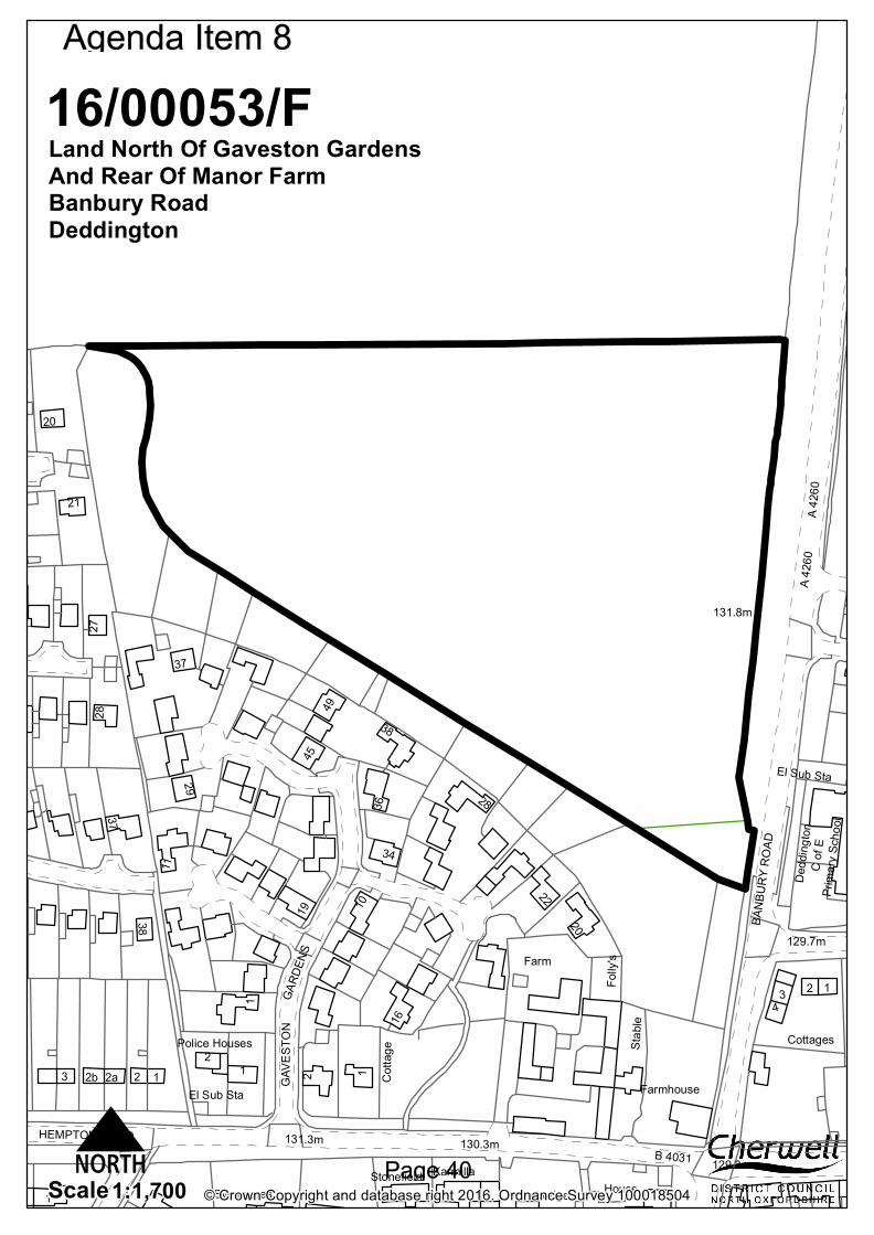
C of
EDe
dding
tonPr
imary
Scho
ol
B 4031131.3m 130.3m
129.3m
131.8m
129.7m
Cotta
ge
BANB
URY R
OAD
HEMPTON ROAD
A 426
0
Lodge
GAVE
STON
Stonefield
Folly
's
Cottages
GARD
ENS
Sycamores
Stable
House
Farmhouse
Farm
El Sub Sta
Karmilla
11
Police Houses
2
28
1
38
3
36
2a
27
22
37
20
16
34
21
29
4945
1019
2b
4
20
2
1
28
3
El Sub Sta
12
11
1
A 426
0
2
38
37
© Crown Copyright and database right 2016. Ordnance Survey 1000185041:1,700Scale
16/00053/FLand North Of Gaveston Gardens And Rear Of Manor FarmBanbury RoadDeddington
N
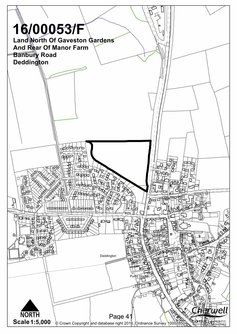
Deddington
C of
E
7
5
9
1
Pump House
© Crown Copyright and database right 2016. Ordnance Survey 1000185041:5,000Scale
16/00053/FLand North Of Gaveston Gardens And Rear Of Manor FarmBanbury RoadDeddington
N
Site Address: Land North of Gaveston Gardens and Rear of Manor Farm, Banbury Road, Deddington
16/00053/F
Case Officer: Linda Griffiths Ward: Deddington Ward Members: Councillors Hugo Brown; Mike Kerford-Byrnes; and Bryn Williams Committee Date: 7 July 2016
Recommendation: Approval Referral Reason: Major Application
Applicant: David Wilson Homes (Mercia) Application Description: Residential development of 99 dwellings (Use Class C3), together with parking, public open space, landscaping and associated infrastructure 1. Site Description and Proposed Development 1.1
The application site is located to the north of Deddington, to the west of the A4260 Banbury Road and just north of Gaveston Gardens, an existing residential estate. The site is currently in agricultural use and has an existing field gate access from the A4260. The site lies just outside the Deddington Conservation Area and the historic core of the village. There have been some legally protected species recorded within the vicinity and there is potential for the site to be contaminated, however, there are no other site constraints.
1.2
The application now seeks consent for the erection of 99 dwellings and associated infrastructure on the site although the original submission sought permission for 95 dwellings. Access to the site will be from a new vehicular access directly to the A4260 just north of the primary school which is located on the opposite side of the road.
1.3
The site is located on a plateau at the northern end of the village and comprises approximately 3.8 hectares. The site rises gently across the site from the south eastern corner to the north western corner by 2 metres. The site is bounded along the A4260 Banbury road frontage by an existing hedgerow and trees, and along its northern boundary with the open countryside, an existing hedgerow and row of trees. The trees along this northern boundary are protected by a Tree Preservation Order. The southern and western boundaries of the site abut the modern development of Gaveston Gardens and The Daedings.
2.
Application Publicity
2.1
The application has been advertised by way of neighbour letter, site notices and a notice in the local press. The application has been advertised on two occasions, when the application was first registered and following the receipt of the amended application. 29 letters of objection have been received in respect of the original submission and
are summarised as follows:
Increase in numbers is unreasonable and an abuse of the planning process. This is not a modest increase, but is 11% additional to the 85
Will compound traffic issues on the already busy A4260 and cause danger to
highway safety
Impact on drainage. Thames Water has identified a need for a significant upgrade to the drainage to support the development
Additional strain on village facilities, including the school and health centre
Proposed pedestrian access to Gaveston Gardens will mean residents seeking to avoid congestion at the vehicle access point to the estate will park in Gaveston Gardens
Contrary to the Deddington local plan
Gardens should back onto Gaveston Gardens not a road and frontages as shown
The existing landscape buffer to Gaveston Gardens is part of their gardens and as such is misrepresented in the proposal
Traffic pollution and increased noise and disturbance for residents in Gaveston Gardens
The site has rare wildlife (such as hedgehogs, green woodpecker and bats) the site survey regarding wildlife was insufficient and superficial
Natural stone should be grouped, not scattered
The repetitive design and cramped layout is not in keeping with Deddington village
The Neighbourhood Plan survey highlighted the wish of local residents to downsize, this estate does not allow for that, nor will it allow local people to get on the housing ladder. Only 3/19 of the 2 bed homes are open market and 43 houses are 4/5 bedroom
Plan shows very little on-street car parking and garages are too small
The junction which is designed as a single lane which will prevent the free flow of traffic joining the already busy A4260 at peak times. There are already long queues south bound caused by the traffic lights and pedestrian crossing
No information about how any foul drainage will be dealt with
Harm the fabric, character and appearance of the Conservation Area
Density is too high
No landscape barrier proposed between Gaveston Gardens and the site
The proposed footpath along the A4260 will be adjacent to deep gullies and the path does not extend the full distance
The ‘traditional’ houses do not even have chimneys, nor are enough built in stone. There are several brick built dwellings in the village already which stick out like a sore thumb
Essential that fibre fast broadband is provided for the development, this is important for young people and those who work at home
Design does not enhance the approach into the village, is uninteresting, non-descript and shows no local congestion
Estate roads are too narrow for parking and there is not enough provision for visitor parking. Parking is already an issue in Deddington
A landscape barrier must be included along the boundary with Gaveston Gardens
House designs are lazy and unimaginative, a stone frontage does not magically make them vernacular, it looks like an estate anywhere in the country, and cramped
Preponderance of larger houses will attract commuters and contribute further to congestion
All the affordable housing is crammed into one area of the estate
Layout and house design is dreadful. The house design is very urban and not at all suitable for an historic village in a conservation area
Landscaping is non-existent
Few jobs locally, so people will need to travel to work increasing the carbon footprint of the village
Security issues with pedestrian access through Gaveston Gardens
Poor quality design solutions
Some technical information is seriously deficient
Garages are too small to accommodate a standard car
The building materials proposed, ie stone and brick reinforces the split between private and social housing
The density at 31 dph is significantly higher than both Gaveston Gardens at 20dph and the Daedings at 15dph
Disappointed that no sec 106 money has been earmarked to improve car parking in the centre of Deddington
Transport connections and links are poorly considered, particularly to Bicester North railway station
The comments can be read in full on the application file Deddington Development Watch comment in summary as follows:
The site stands on the high point of the ridge on which Deddington stands. The proposal would therefore be in a prominent topographical location when viewed from the north
Layout is cramped and suburban in design typical of any new estate in the country. The proportion of stone is welcomed but even these ‘traditional’ designs lack any chimneys to reflect local character
Density is not comparable to adjacent developments, the SHLAA suggested 50 on this site
Fewer trees than within the approved reserve matters
Need for 2/3 bed properties in the village, the scheme is unresponsive to this
Foul drainage and water supply info is inadequate
Affordable housing delivery plan is not consistent with the location plans and the accommodation schedule
Affordable homes should be indistinguishable from the market housing and not concentrated together
Garages are too small to accommodate a standard car
The landscape and visual effects appraisal (6.3) states that there is no inter-visibility between the application site and any listed building so that the proposed development would not affect the setting of any listed building. This ignores the views of, and from, the tower of the parish church of St peter and St Paul, with its eye catching pinnacles and gilded vanes which is Grade II* Listed.
Play area should be given to the Parish Council with a commuted sum for maintenance, not a Management Company
No detailed plans for either vehicular or pedestrian access into the site
Concern about traffic on this already busy road
If the 30mph speed limit was maintained outside the site access, a larger, safer entrance would be required, but a 40mph buffer should be introduced to facilitate deceleration
Security concerns from residents in Gaveston Gardens regarding the link
TA is flawed in its assessments
This is grade 2 agricultural land
The area is not conducive to cycling The comments can be read in full on the application file. Update Following the revised submission relating to 99 dwellings, Deddington Development Watch comment further as follows:
Doubling the number of 2.5 storey houses from 12 (14%) to 25 (25%) is not a ‘modest increase’
Purporting to replicate the rooflines of the listed buildings in High street/New
Street, minus chimneys along the Banbury Road frontage will simply exacerbate an already obtrusive visual impact on the northern approach to Deddington
The applicant suggests that Local Plan Policy BSC2 contains an absolute requirement for a housing density of 30dph when this is not the case where ‘there are justifiable planning reasons for lower density development’. Paragraph B.102 explains that: ‘the density of housing development will be expected to reflect the character and appearance of individual localities and development principles that are appropriate to the individual circumstances of sites’.
Although the outline permission is for 85 houses, the proposed density is also contrary to saved Policy C30(i) that design control will be exercised to ensure ‘that new housing development is compatible with the appearance, character, layout, scale and density of existing dwellings in the vicinity’ (i.e the low density developments of detached houses in Gaveston Gardens and The Daedings, not High Street/New Street
Have the water supply concerns been resolved
Management company remains of concern
Applicant should be asked to confirm that all dwellings will have superfast broadband connections in conformity with Cherwell Local Plan Policy BSC9: ‘all new developments will be expected to include provision for connection to Superfast Broadband’. The small print on the applicant’s Adderbury Fields web site says: ‘Superfast broadband is available on selected plots only’
Following the revised submission relating to 99 dwellings and the further consultation that was carried out, a further 19 letters of objection have been received which raise similar concerns to the above. These can be read in full on the application file. 1 letter of support states that as a Deddingtonian who has had to move out of the village due to high house prices, this development would be a blessing for daughters who attend the primary school and are desperate to move back and be close to family who live in the village.
3.
Consultations
3.1
Deddington Parish Council: object on the following grounds, raised the following questions and made the following observations:
1. The site name selected, Deddington Grange is out of keeping with the nature of the site and proposed development. The Parish council would welcome the opportunity to be involved in deciding the site and road names
2. The housing mix is a further move away from the housing need identified by the emerging Neighbourhood Plan with far more 4 and 5 bedroom houses and fewer 2 and 3 bedroomed houses. This plan lacks appreciation of local needs
3. The community has a demonstrable for high specification, 2 large en-suite bedroom and reception room houses for older members of the community to down size to
4. There are no stated arrangements for on-going maintenance for the communal infrastructure including communal car parking areas, public areas or SUDS and balancing pond. These will become a burden to the wider community. Who will be responsible for maintaining these areas?
5. On the Thames Water ALS map there is a water pipe entering the site under the proposed pedestrian link to Gaveston Gardens. The pipe exits the site in the north-west corner under Plot 1. This seems to be detrimental to future maintenance requirements of both the eventual home owner and for the wider community.
6. Despite a reported letter to an individual the developer’s treatment of the pre-
existing buffer zone to Gaveston Gardens is not clear and intentions have been communicated to the detriment of the community. The greenery between the site and Gaveston Gardens falls entirely within the curtilage of the residents of Gaveston Gardens.
7. Some residents have concerns that in place new houses are not located ‘garden to garden’ and present overlooking issues as currently designed.
8. The location of the affordable housing into large groups rather than distributed throughout the development is discriminatory and not in keeping with the aspirations of the community
9. Site access details. There is currently no detailed design for either the pedestrian or vehicle access arrangements. The Transport Assessments refer to drawing JNY8344-01 rev D which relates to previous reserve matters application 14/02111/REM but does not confirm this design for both pedestrian and vehicular access. The details pertaining to the pedestrian access design are relatively vague and that the previously defined pedestrian footpath upgrade between the north-west corner of the A4260/B4031 junction and the site pedestrian entrance, as shown on drawing JNY-8344-01 rev D, seems to be lost. Point 4.6 in the Transport Assessment does mention utilising the existing footpath but the existing path is rather narrow and does not stretch as far as the proposed pedestrian entrance. This upgraded footpath which includes widening the existing footway and extending it to the site pedestrian entrance should a requirement for permission
10. The 30mph zone should be moved north before construction commences to reduce traffic hazards, and no plans are included to enforce this new speed limit.
11. The road works for the highways entrance (ghost junction and road widening) should also be built before construction starts
12. Foul water drainage. There is insufficient capacity in both foul and water supply infrastructure. Thames Water has requested a Grampian condition and we are very keen to understand how these matters are to be dealt with.
13. The nature of the measures to prevent vehicle access to Gaveston gardens is not clear
14. The applicant is making use of SUDS and a balancing pond. Will any fencing or safety equipment be required or provided?
15. Will the building work be phased and at what point must the affordable housing element be constructed?
16. Lack of chimneys fails to reflect traditional local character The comments can be read in full in the application file. Further to the above, additional comments have been received from Deddington Parish Council relating to Section 106 requirements and where the money might be spent within Deddington. These comments can be read in full on the application file. In respect of the revised submission for 99 dwellings, further additional points are raised and summarised as follows:
A condition should be imposed requiring the developer to commit to superfast broadband connectivity for all dwellings on the development
It is not acceptable to state that the affordable dwelling can be easily converted to the Lifetime Homes Standard. Al, affordable housing should meet the HCA’s design and quality standards
Not appropriate to deliver development that does not comply with OCC highway standards
Remain concerned that the development will be maintained by ‘Management Companies’, how they will be run and what the implications will be for residents
Absurd that garages are being provided which are below the required OCC standard
Errors in the Travel document in terms of the bus and rail information
Would like to be certain of the commitment by DWH to provide the footway upgrades
Do not agree with the claims by Turley that the development is compatible with the appearance, layout, scale and density of existing dwellings in the vicinity. The adjacent developments are all lower density developments of detached houses with chimneys
The revised proposals include a number of 2.5 and 3 storey houses, including along the Banbury Road frontage, whilst none of the modern developments off Hempton Road are higher than two floors. These will appear over what remains of the tree boundary and hedging and the supply of stone housing will not match the vernacular because of the lack of chimneys.
These comments can be read in full on the application file.
Cherwell District Council Consultees 3.2
Planning Policy Officer: A number of policies from the adopted Cherwell Local Plan 2011-2031, saved policies from the adopted Cherwell Local Plan 1996 and policies from the Non-Statutory Cherwell Local Plan 2011 are quoted and can be read within the consultation response on the application file. The main observations are:
Deddington is a Category A village, one of the more sustainable villages in the district (Policy Villages 1)
Policy Villages 2 of the adopted Cherwell Local Plan 2011-2031 provides that a total of 750 homes will be delivered at the category A villages on new sites of 10 or more dwellings (in addition to the rural allowance for small site ‘windfalls’ and planning permissions at 31 March 2014)
The 2015 AMR (January 2016) shows that there are 280 dwellings remaining to be identified of the 750 dwellings allocated for the rural areas
Policy villages 2 states that sites will be identified through the Local Plan Part 2, through the preparation of Neighbourhood Plans where applicable, and through the determination of applications for planning permission.
The proposal would assist in meeting overall policy villages 2 requirements
The site benefits from an extant planning permission for 85 dwellings. This proposal would result in an additional 10 dwellings
At this early stage in the Local Plan period the proposal would leave little scope for development to satisfy the housing needs of other settlements in the A Category, and would not achieve a balanced distribution of housing across the rural areas
The district has a 5.3 year housing land supply for the current period 2015-2020 and a 5.6 year supply for the next five year period (2016-2021) commencing on 1 April 2016. The permitted 85 dwellings are already included in the five year housing land supply. The additional 10 dwellings would also contribute to the housing land supply
There were 20 housing completions in Deddington between 2006 and 2011, and another 21 completions between 2011 and 2015.
No Planning Policy objection raised in principle. Although it is a sizeable development in the village, 85 dwellings have previously been approved on the site and this proposal would create 10 additional dwellings which will contribute to the Council’s five year housing land supply. Deddington is one of the more sustainable villages within the District. In addition, Deddington has experienced a modest record of housing completions since 2006 when comparing with other Category A villages such as Adderbury, Ambrosden, Arncott, Bloxham and Yarnton. Update
Following the revised submission relating to 99 dwellings, further additional/revised comments are made as follows:
Deddington village centre includes a range of services and facilities and the village has both a primary school and doctor’s surgery
The site benefits from an extant planning permission for 85 dwellings. The proposal will result in an additional 14 dwellings
A recent appeal decision for an application at Kirtlington (appeal ref: APP/C3105/W/15/3134944) confirmed that the district have a five year housing land supply (subject to detailed comments on the Council’s specific position). There is therefore no pressing housing need for additional release at this time
The proposed development would not result in an additional release of greenfield land within an area of countryside over and above the land that already benefits from planning permission. Policy BSC2 of the Local Plan requires the effective and efficient use of land.
No planning policy objection in principle. Although this is a sizeable development in the village, 85 dwellings have previously been approved on the site and this proposal would create 14 additional dwellings which will contribute to the Council’s five year housing land supply. No additional land release would be required.
3.3
Environmental Services Manager: No objection to the waste and recycling storage
3.4
Housing Officer: The applicant has detailed the correct amount of affordable units (33), which is 35% of the total dwellings. The tenure split is also correct. There are too many 1 bed properties in the mix, an alternative mix is suggested. Of the rented units 50% should be built to lifetime homes standard (12 units). The affordable units should be in clusters of no more than 15 units, one cluster is 20. All of the 2 and 3 bed dwellings should have a minimum of 2 parking spaces per unit. The 33 affordable properties would need to meet the HCA’s Design and Quality Standards including the necessary HQI requirements. The Registered Provider taking on the affordable housing units would need to be agreed with the Council. Update Following the revised submission, the Housing Officer’s additional/revised comments are as follows:
The 3 bed shared ownership property (plot 45) should be semi-detached as detached properties in this location are too expensive
Of the rented units 50% of these should be built to meet Building Regulations requirement M4(2) Category 2: Accessible and Adaptable Dwellings (12 units). The units that will be built to Lifetime homes Standards need to be indicated within the development
All of the 2 bed and 3 bed dwellings should have a minimum of 2 parking spaces per unit, only some of the 2 bed units currently have 2 spaces
3.5 3.6
Environmental Protection Officer: No objection in respect of noise and nuisance, but recommend a condition requiring a Construction Environmental Management Plan. In terms of contamination, the GeoRisk Management Phase 1 Desk Study hasn’t identified a significant risk from land contamination but has highlighted some uncertainties to clarify with site investigation. A number of conditions are recommended. Ecology Officer: No comments received
3.7
Landscape Officer: Considers the plans poor and comments as follows:
Where there is no space for trees some specimen shrubs should be used to
3.8
provide structure
Thin strips of grass should be avoided. There are too many to mention on this scheme. No-one wants to drag a mower to their front garden to mow a few square metres. Thin strips between haunching do not work and should be avoided. Grass areas that go to appoint will be trampled to mud and should be avoided
The shrub mixes are very poor. Little thought has been given to the compatibility of the species. Mix I had prunus Lusitanica 2.5m high and Euonymous which is a ground cover. Mix 2 Rosemary and Cistus are nowhere near the same size. Unless the plants are approximately the same height and vigour they will not grow well together. Shrub mixes should not be used everywhere. They are a lazy solution to a landscape design.
I would like to see a lot more hedges to provide structure
LAP/LEAP – the proposed location takes up most of the central green. The LAP/LEAP should be located on one corner to leave the largest grass area possible. The whole green needs fencing not just the equipped area.
Trees within 3m of hard surfaces need root barriers. Following the revised submission relating to 99 dwellings, the Landscape Officer comments that the development is becoming ever more dense. There is no room on this latest layout for any street trees on the lower section. There is very little landscape structure. Street Scene and landscape do not favour management companies. SUDS in particular needs specialist management which should be undertaken by experts. Management companies load additional costs onto residents which are unpopular. There is little detail on the submitted plan which limits the extent of my comments. Arboricultural Officer: these comments were received in respect of the amended proposal relating to the erection of 99 units. Whilst I have no objection to overhanging branches from G6 (the protected tree belt) being pruned back where required the extent of this pruning is considered excessive on the western end of the tree belt. This is an unacceptable incursion into the tree belt. There does not appear to be a tree protection plan with details of the fencing which is going to be used together with any areas of no-dig construction in the vicinity of the RPA’s of retained trees. There should be a mix of species planted throughout the site rather than planting a small number of the same trees. For example, on the main road it is proposed to plant 14 Carpinus betulus Frans Fontaine. For bio security reasons there should be a mix of species planted. Details do not seem to have been supplied of the trees to be planted around the LEAP. These should not be all the same species but a mix of different tree types. This is the same for the trees proposed around the Suds feature. At the moment 8 Alder trees are proposed around the suds feature. It would be better to plant a mix of species, to include for example River birch and/or Swamp cypress. Root barriers should be included in the planting pits within 3m of a hard surface.
Oxfordshire County Council Consultees 3.9
Highways Liaison Officer: Objection Access Arrangement – there is currently no detailed design of the site access arrangement for both vehicles and pedestrians/cyclists. Details agreed from the previous reserved matters application 14/02111/REM should be applied in this application and also to include comments made under paragraph 2 of the shared footway/cycleway section.
Layout – the layouts for the shared surfaces fronting plots 23-25 and 30-31 as well as the shared surfaces fronting plots 6-9 should be considered for redesigning if they are to be offered for adoption. These road sections have shown to have uneven carriageway widths. All visitor parking in lay-bys must have a minimum hard standing of 0.8m wide to allow drivers to step out of vehicles once parked. Numerous properties are shown to have direct pedestrian accesses from the front door to the carriageway which is not good practice. Footpaths from houses must first connect to a public footpath rather than straight onto the carriageway. This would also eliminate the need to drop kerbs and prevents obstruction to pedestrian access as a result of parked vehicles. In the interest of highway safety, a ramp to a junction table located within the proximity of a pedestrian crossing must require a bollard to be installed on approach to such a crossing point. Some of the roads are shown to be a shared use facility, and it is worth mentioning that the runnable shared carriageway width to be adopted must be at least 6m wide with 0.8m service strips. Secure cycle parking must be provided. OCC will require the proposal to proactively encourage walking and cycling, especially for local trips. Clarity is needed on communal cycle parking arrangements for apartments and all properties without garages should have secure sheds for cycle parking, and there should be some visitor/public cycle parking at the LEAP. A vehicle tracking analysis is required to be carried for a larger bin lorry for all internal roads, bends and turning areas. Shared footway/cycleway – is expected to link the development to Earls Lane as commented on in the original application. This should emerge from the development access running southwards then across Banbury Road (at the Toucan crossing) and continue down to terminate on Earls Lane. To offer a more inclusive array of connectivity to pedestrians wishing to access the community north of the site, a footway should be provided that runs along the northern end of the vehicular access out of the development across Banbury Road. This would link up with the existing footway east of Banbury Road by a facilitation of dropped kerbs a few metres north of the main vehicular access. Travel Plan – a residential travel plan will be required. Transport Strategy Oxfordshire County Council Policy – Paragraph 2.7 (page 7) still references OCC Third Local Transport Plan. In September 2015, Connecting Oxfordshire: Local Transport Plan 2015-2031 was adopted. The County Council Policy should be updated , paying particular attention to the following: Policy 34 OCC will require the layout and design of new developments to proactively encourage walking and cycling, especially for local trips, and allow developments to be served by frequent reliable and efficient public transport. To do this we will:
Secure transport improvements to mitigate the cumulative adverse transport impacts from new developments in the locality and/or wider area, through effective travel plans, financial contributions from developers or direct works carried out by developers
Identify the requirement for passenger transport services to serve the development, seek developer funding for these to be provided until they
become commercially viable and provide standing advice for developers on the level of Section 106 contributions towards public transport expected for different locations and scales of development
Ensure that developers promote cycling and walking for journeys associated with the new development, including through the provision of effective travel plans
Require that all infrastructure associated with the developments is provided to appropriate design standards and to appropriate timescales
Set local routeing agreements where appropriate to protect environmentally sensitive locations from traffic generated by new developments
Seek support towards the long-term operation and maintenance of facilities, services and selected highway infrastructure from appropriate developments, normally through the payment of commuted sums
Secure works to achieve suitable access to and mitigate against the impact of new developments in the area, generally through direct works carried out by the developer
CDC Planning Obligations Draft SPD (July 2011) Developer contributions are sought towards the strategic transport impact of this development. Development of a single dwelling, or any non-residential floorspace, or change of use needing planning permission will be regarded as having a general impact on transport and access infrastructure. A total transport contribution of £97,038 is required and will contribute towards the A4260/B4301 signalisation improvement. This figure has been increased to £98,174 following the increased number of units to 99. A4260/B4031 traffic signal junction – Paragraph 6.15 states that ‘the results indicate that the A4260/B4031 signalised junction would operate near to or at capacity in the AM and PM peaks in 2016 both with and without development, and slightly above capacity in 2021 in all scenarios. I would like to draw your attention particularly to Table 6.6:2021 PM Peak (17.00-18.00) A4260 High Street. There is a substantial increase in the degree of saturation with and without development – in the region of 12.2% (from 86.2% to 98.4%). Even though different years were assessed in the 2013 Transport Assessment (TA) from the application (13/00301/OUT), it can be interpreted that the increase in 10 homes with this current application pushes the High Street arm of this junction to very near capacity. In light of the A4260/B4031 traffic signal junction working at (and over capacity) by 2021; a contribution is sought towards future work and upgrade of this junction to improve capacity issues. Further, operation details of the toucan crossing to be provided by the developer must be linked with the signalised junction at the A4260/B4031 junction to avoid exacerbating delays, this linkage must be in place prior to opening. Update Following the submission of the revised proposal relating to 99 units additional/revised comments are summarised as follows: Cycling infrastructure Paragraph 3.24 of the TA points out that the area is conducive to cycling due to its relatively quiet nature and flat topography. The proposals of this application must capitalise on these factors to promote cycling as a mode of travel. OCC’s Residential Road Design Guide publication emphasises the need for cycle parking at both ends of the journey in a bid to encourage cycling mode which in this case should be demonstrably provided within the curtilage of the site.
Planning layout drawing 15-061/02 Rev F shows shelters within the garden space of dwellings without garages denoted by SH. The provision of cycle storage is welcomed but disappointment that garages have not been designed to have an internal dimension of 3m x 6m in accordance with the Council’s design guide to allow car and cycle storage. Traffic Impact Based on the information in the TA and having visited the site, it is my view that these additional units can be safely accommodated on the site and the adjoining transport network. I believe the additional movements will not have an unacceptable negative impact on congestion locally. Furthermore, with appropriate design the development may reduce vehicular speed on A4260 and benefit highway safety. Layout This amendment application has increased the number of dwellings which has resulted in an overcrowding of dwellings, particularly between plots 28-34. There should be unfettered access between parking and front doors. A 1.2m wide dedicated footway should be provided to the front door of Plot 31 to cater for users in wheelchairs and push chairs/prams as outlined in the Government’s publication, Approved Document M: Access to and use of buildings. Some of the estate roads are shared surfaces, and it is worth mentioning that the runnable shared carriageway width if these are to be adopted must be at least 5m wide with at least a 0.8m wide service strip provided. Access for Servicing The drawings have been tracked for a 9.01m refuse vehicle rather than a 10.5m refuse vehicle which is widely used within the district. The application should demonstrate manoeuvrability of such a vehicle across the site. Refuse vehicles should have suitable access and can get to within 5m of the kerbside collection points for all properties. Refuse vehicles should not be expected to reverse more than two complete vehicle lengths. The section 106 contribution amounts have been increased in accordance with the additional units. The above revised comments can be read in full on the application file.
3.10 3.11
Drainage Officer: There seem to be no information on the proposed drainage strategy for the site. We will have to see the FRA report with details of hydraulic calculations and any site investigation report so we can agree on the strategy the developer is proposing to manage post development storm water. Update Following the revised submission, no objections are raised and conditions are recommended requiring the development to be carried out in accordance with the submitted FRA and the agreement of the SuDS design for the site. Education: Planning permission to be dependent on a satisfactory agreement to secure the resources required for the necessary expansion of education provision. This is in order for OCC to meet its statutory duty to ensure sufficient pupil places for all children of statutory school age. Primary To meet the scale of housing and population growth currently expected across the Adderbury/Deddington area, it is currently estimated that an additional half-form of primary school capacity will be needed in the area. Both Deddington CE Primary
School and Christopher Rawlins CE Primary School (in Adderbury) are approaching capacity. Following local consultation, Christopher Rawlins CE Primary School has been approved to grow from its current 1 form entry size (30 children per year group, 210 pupils Reception – Year 6) to 1.5 form entry (45 children per year group, 315 total pupils Reception – Year 6). This will require additional accommodation to be built, and Section 106 developer contributions towards the expansion of Christopher Rawlins CE Primary School are required. Costs are based on the feasibility study of the preferred solution which is £2,250,000 (at 1Q16). This equates to £20,270 per place created. £689,383 Section 106 developer contributions towards the expansion of Christopher Rawlins CE Primary School, by a total of 34.01 pupil places. This figure has been revised to £684,923 based on the revised numbers and mix. Secondary This area feeds to the Warriner School, which is regularly oversubscribed, and effectively full. Expansion of secondary school capacity in the area would be necessary as a direct result of housing development. when the previous application for this site was approved on appeal, the Planning Inspector ruled that contributions towards secondary education were not necessary to make the development acceptable in planning terms, as children generated by the development could be accommodated at The Warriner School if Banbury children who have previously been able to attend The Warriner were in fact displaced to other Banbury schools. However, this decision did not take into account the fact that growth within Banbury requires significant growth in Banbury secondary school capacity, including expansions of North Oxfordshire Academy and Blessed George Napier School and a new school in the longer term. More, recently the Planning Inspector in the case of Appeal Ref: APP/C3105/A/13/2204000 (land to the south west of Tadmarton Road, Bloxham) ruled that secondary education contributions in this context meet the CIL tests. Paragraph 72 of the NPPF makes clear that the Government attaches great importance to ensuring that sufficient choice of school places is available to meet the needs of existing and new communities, and that great weight should be given to the need to expand schools to maintain, or widen choice in education. Without expansion of the Warriner School, housing development would adversely impact on the operation of parental preference and result in a loss of amenity to young people already living in the area, who would be less likely to secure a place at their first preference school as a direct result. As such it would go against the intention of the NPPF at paragraph 72 by reducing the choice of school places available to meet the needs of existing and new communities. If the Warriner School is not expanded, children who would otherwise have attended the school would be displaced to other schools in nearby Banbury. These schools currently have spare places, but these places will be filled as a result of the population growth which is already evident in the local primary schools. Secondary school capacity in Banbury will need to be expanded as these higher pupil numbers feed through and therefore should the schools be also required to accommodate growth as a result of housing development in this area, the scale of expansion would be greater as a consequence. The need for expansion of secondary school capacity in Banbury is recognised in the adopted Cherwell Local Plan. Expansion of secondary school capacity at both Warriner School and at schools in Banbury is therefore necessary to ensure the needs of the current and future populations can be met, and to ensure that council can meet its statutory duty to ensure sufficient school places. Contributions are sought towards the expansion of
3.12
Warriner school, where a capital project is being developed. £501,206 Section 106 developer contributions towards the expansion of The Warriner School by a total of 25.90 pupil places (including 3.89 6th Form places). This figure has been revised to £488,713 following the revised scheme and housing mix. Special A capital project at Frank Wise School, a special school in Banbury was recently completed. The project replaced temporary accommodation with permanent build and also expanded school, delivering 8 additional SEN places at a total cost of £1,800,000. Some of the cost was grant funded, with the cost to OCC being £837,000. Contributions are sought towards this, as well as further expansion of SEN capacity expected in the future. Across Oxfordshire 1.11% of pupils are taught in special schools. £23,340 Section 106 developer contributions towards Frank Wise School, based on projected pupil generation of 0.67 pupils. This figure has been revised to £26,779 following the revised submission and housing mix. Early Years Since September 2013, under the Local Authority (Duty to Secure Early years Provision Free of Charge) Regulations 2012 made under Section 7 of the Childcare act 2006 (as amended by Section 1 of the Education Act 2011), local authorities have been under statutory duty to secure sufficient nursery provision for eligible two year olds, where such eligibility is targeted at 40% of the age group. This is in addition to the statutory duty since September 2012 to secure sufficient nursery education provision for all three year olds. In Deddington, nursery education is provided through a partnership of two charities – Deddington Partnership Foundation Stage Unit, co-located on the Deddington CE Primary School, and Deddington Village Nursery Ltd, located on Hempton Road, Deddington, adjacent to the Windmill Community Centre. Since responding to the original application for this site, OCC has become aware that Deddington Village Nursery’s temporary building is in need of urgent replacement and the committee are seeking funding to provide a planned replacement subject to all the necessary consents. If the building is not replaced, and the nursery forced to close, OCC would not be able to meet its statutory sufficiency duty in this area. The replacement building would be larger, so that the needs generated by the proposed development are met. A proportionate contribution is therefore sought towards the capital cost of ensuring sufficient nursery education provision to meet the needs of this development. The development has been assessed as likely to generate 29.19, 0-4 year olds, that is, an average of 5.84 children per year of age across this five-year age band. Of these children, the following would be expected to be eligible for free nursery education:
Of the estimated 5.84 two-year olds, 40% would be eligible = 2.34 children
All of the estimated 5.84 three year olds = 5.84 children This brings the total need for nursery provision to 8.18 places and a contribution of £45,759 towards the provision of sufficient nursery provision. This figure has been revised to £45,687 following the revised submission and housing mix. Property A condition is recommended requiring the provision of fire hydrants on the site. Local Library
The development is served by Deddington Library. This provision is significantly under-size in relation to its catchment population and this development will therefore place additional pressures on the library service. Costs for improvements are based upon the costs of extending a library. The development proposal would also generate the need to increase the core book stock held by 2 volumes per additional resident. £27,014.20 contribution for the provision of library infrastructure and supplementary core book stock. This has been revised to £27,034.15 following the revised submission and housing mix. Due to CIL Regulations, OCC will not be seeking a contribution towards central library, waste management, museum resource centre or adult day care infrastructure for this proposal. The comments above can be read in full on the application file.
Other Consultees 3.13
Thames Water: comments as follows:- Waste Water: Following initial investigation, Thames Water has identified an inability of the existing waste water infrastructure to accommodate the needs of this application. A condition is recommended requiring the submission and approval of a drainage strategy Surface Water Drainage: it is the responsibility of the developer to make proper provision for drainage to ground, water courses or a suitable sewer. In respect of surface water it is recommended that the applicant should ensure that storm flows are attenuated or regulated into the receiving public network through on or off-site storage. When it is proposed to connect to a combined public sewer, the site drainage should be separate and combined at the final manhole nearest the boundary. Connections are not permitted for the removal of ground water. Where the developer proposes to discharge to a public sewer, prior approval from Thames Water is required. There are public sewers crossing or close to the development. In order to protect public sewers and to ensure that Thames Water can gain access to those sewers for future repair, approval should be sought from Thames Water where the erection of a building or an extension to a building or underpinning work would be over the line of, or would come within 3m of a public sewer. Thames Water will usually refuse such approval in the case of new buildings. Water Comments: The existing water supply infrastructure has insufficient capacity to meet the additional demands. A condition is therefore recommended requiring an ‘Impact Study’ to be submitted to and approved. The studies should determine the magnitude of any new additional capacity required in the system and a suitable connection point. Following the amended submission relating to 99 units, the above comments remain relevant.
3.14
Environment Agency: No longer comment on applications of this nature as they are dealt with by the Lead Flood Authority for the District, which is OCC.
4.
Relevant National and Local Policy and Guidance
4.1
Development Plan Policy
Adopted Cherwell Local Plan (Part 1) 2011-2031 The Cherwell Local Plan Part 1 2011-2031 was formally adopted by Cherwell District Council on 20th July 2015 and provides the strategic planning framework for the district to 2031. The Cherwell Local Plan Part 1 replaced a number of the saved policies of the adopted Cherwell Local Plan 1996 although many of its policies are retained and remain part of the Development Plan. Planning legislation requires planning decisions to be made in accordance with the Development Plan unless material considerations indicate otherwise. The relevant policies are as follows: Policy BSC1: District wide housing distribution Policy BSC2: The effective and efficient use of land Policy BSC3: Affordable housing Policy BSC4: Housing mix Policy BSC7; Meeting education needs Policy BSC8: Securing health and well-being Policy BSC9: Public services and utilities Policy BSC10: Open space, outdoor sport and recreation provision Policy BSC11: Local standards of provision – outdoor recreation Policy BSC12: Indoor sport, recreation and community facilities Policy ESD1: Mitigating and adapting to climate change Policy ESD2: Energy hierarchy and allowable solutions Policy ESD3: Sustainable construction Policy ESD5: Renewable energy Policy ESD7: Sustainable drainage systems Policy ESD10: Protection and enhancement of biodiversity and the natural environment Policy ESD15: The character of the built environment Policy Villages 1: Village categorisation Policy Villages 2: Distributing growth across rural areas Policy INF1: Infrastructure Adopted Cherwell Local Plan 1996 (Saved Policies) Policy H18: New dwellings in the countryside Policy C8: Sporadic development in the open countryside Policy C28: Layout, design and external appearance of new development Policy C30: Design of new residential development Policy C33: Protection of important gaps of undeveloped land Policy ENV12: Contaminated Land Policy TR1: Transportation funding
4.2
Other Material Policy and Guidance National Planning Policy Framework National Planning Policy Guidance CDC Planning Guidance/Documents
Building in Harmony with the Environment SPG
Countryside Design Guide Summary SPG
Planning Obligation Draft SPD 2011
Deddington Conservation Area Appraisal
5. Appraisal 5.1
The key issues for consideration in this application are:
Relevant Planning History
Principle of development
Design and Layout
Housing Mix
Transport and Highway Safety
Ecology
Flood Risk
Impact on heritage assets
Contaminated land
Landscape impact, open space and play provision
Planning obligation
Relevant Planning History 5.2 Outline planning permission was granted at appeal following the refusal of planning
permission for 85 dwellings on the site in December 2013 (13/00301/OUT) refers. Reserve Matters consent was subsequently granted in May 2015 (14/02111/REM) refers. That consent has been implemented by a start on site last month to create the new access into the site. A number of pre-commencement conditions attached to the original outline consent and reserved matters consent have been discharged, although a small number remain outstanding. There is therefore an extant planning permission for residential development on the site. Principle of Development
5.3
The Development Plan for Cherwell District comprises the saved policies in the adopted Cherwell Local Plan 1996 and the adopted Cherwell Local Plan 2011-2031. Section 70(2) of the Town and Country Planning Act 1990 provides that in dealing with applications for planning permission the local planning authority shall have regards to the provisions of the development plan so far as is material to the application and to any material considerations. Section 38 of the Planning and Compulsory Purchase Act 2004 also requires that if regard is to be had to the development plan for the purpose of any determination to be made under the plan unless material considerations indicate otherwise. This is also reflected in the National Planning Policy Framework (NPPF) at paragraph 11 which makes it clear that the starting point for decision making is the development plan.
5.4
The application site is outside the current built up limits of Deddington Village on the western side of the Banbury Road, in open countryside, and the proposal is for a large scale residential development of 99 new dwellings with associated infrastructure, including open space. The site is not allocated for development in any of the adopted Cherwell Local Plans comprising the Development Plan. The site however does benefit from outline planning permission for 85 new dwellings which was granted on appeal (13/00301/OUT), and subsequent reserve matters consent granted in May 2015 (14/02111/REM). This has established the principle of residential development on the site and is a material consideration. Adopted Cherwell Local Plan 2011-2031
5.5
The Cherwell Local Plan has been through Examination, has been considered by Full Council, is now adopted and is consistent with the NPPF. Policy Villages 1 and 2 are both relevant to this application and were considered by the Examination Inspector to be sound. Policy Villages 1 of the Plan relates to proposals for residential development within the built up limits of villages and designates Deddington as a Category A Village and therefore one of the more sustainable based on criteria such
as population, size, range of services and facilities and access to public transport. Deddington Village Centre includes a range of services and facilities and has both a primary school and doctor’s surgery. This policy allows for minor development, infilling and conversions. In assessing whether proposals constitute acceptable minor development, certain criteria are used as follows:
The size of the village and level of service provision
Site’s context within existing built environment
Whether it is in keeping with the character and form of the village
Careful consideration of the appropriate scale of development 5.6
The application proposal is not minor development, nor is it within the built up limits of the village of Deddington in relation to the western side of the A4260 Banbury Road. The proposal in principle therefore is not in accordance with Policy Villages 1. It should be noted however, that, this does not mean that development outside villages cannot take place, but regard must be had to Policy Villages 2 in that respect.
5.7
Policy Villages 2 of the Plan seeks to distribute the amount of growth that can be expected within villages, although how the numbers will be distributed is not specified, as precise allocations within each village will be set out in the Local Plan Part 2.
5.8
Policy Villages 2 provides for sites to be identified, both in the plan making process, that is, through the preparation of the Local Plan Part 2, including Neighbourhood Plans where applicable and through the determination of applications for planning permission. In identifying and considering sites, it states that regard should be had to the various criteria, including whether land has been previously developed or is of lesser environmental value, and, whether the development would contribute in enhancing the built environment. This policy states that a total of 750 homes will be delivered in Category A Villages. This is in addition to the rural allowance for small site ‘windfalls’ and planning permissions for 10 or more dwellings at 31 March 2014.
5.9
Considerable progress has been made to meeting the rural area allocation, the 2015 AMR (January 2016) shows that there are 280 dwellings to be identified of the 750 homes for the remaining plan period (up to 2031). As such there is a clear realistic prospect of the rural areas allocation being met in full, through approved developments and through allocations within the Development Plan. In the interest of proper planning and to ensure the most sustainable distribution of the remaining 280, there should not be a concentration of new buildings in just a few Category A Villages. It is also considered that not all the allocation should be used so early on in the Plan Period as this would leave the Plan unable to respond to future needs. There were 20 housing completions in Deddington between 2006 and 2011 and another 21 completions between 2011 and 2015.
5.10
It should also be noted that the Examination Inspector commented in respect of the adopted Cherwell Local Plan 2011-2031 that it ‘properly seeks to alter the local pattern of recent housing growth, as a disproportionate percentage (almost half) has taken place in smaller settlements, adding to commuting by car and congestion on the road network at peak hours’. He also commented that there is a ‘significant level of housing land supply already available in the rural areas’.
5.11
The principle of development on this site would conflict with Policy Villages 2 in that it would result in the loss of open agricultural land beyond the existing built up limits of the village along the western side of A4260, Banbury Road, and it is not previously developed land or land of a lesser value. The site however benefits from an extant planning permission which was granted on appeal for the erection of 85 dwellings on the site and the principle of residential development on this site is therefore clearly established and is an important material consideration. The proposal would therefore
5.12 5.13
assist in meeting the overall Policy Villages 2 requirements. National Planning Policy Framework The purpose of the planning system is to contribute to the achievement of sustainable development. The National Planning Policy Framework (NPPF) sets out the economic, social and environmental roles of planning in seeking to achieve sustainable development; contributing to building a strong, responsive and competitive economy; supporting strong, vibrant and healthy communities; and contributing to protecting and enhancing our natural, built and historic environment (paragraph 70). It also provides (paragraph 17) a set of core planning principles which, amongst other things require planning to:
Be genuinely plan led, empowering local people to shape their surroundings and to provide a practical framework within which decisions on planning applications can be made with a high degree of predictability and efficiency
Always seek to secure a high quality design and a good standard of amenity for all existing and future occupants of land and buildings
Proactively drive and support sustainable economic development
Support the transition to a low carbon future in a changing climate
Encourage the effective use of land by re-using land that has been previously developed
Promote mixed use developments
Conserve heritage assets in a manner appropriate to their significance
Actively manage patterns of growth to make the fullest possible use of public transport, walking and cycling and to focus significant developments in locations which are, or can be made sustainable
Deliver sufficient community and cultural facilities and services to meet local needs
The NPPF at paragraph 14 states ‘at the heart of the National Planning Policy Framework is a presumption in favour of sustainable development, which should be seen as a golden thread running through both planning and decision taking….. for decision taking this means:
Approving development proposals that accord with the development plan without delay; and
Where a development plan is absent, silent or relevant policies are out of date, granting permission unless;
Any adverse impact of doing so would significantly and demonstrably outweigh the benefits, when assessed against the policies in the Framework taken as a whole; or
Specific policies in this framework indicate development should be restricted
Five Year Housing Land Supply 5.14 The 2014 Annual Monitoring Report which was published on 31 March 2015
concluded that the District had a 5.1 year supply of deliverable sites for the five year period 2015-2020 (commencing on 1 April 2015). This was based on the housing requirement of the Submission Local Plan, now adopted Cherwell Local Plan 2011-2031, which is 22,840 homes for the period 2011-2031 and is in accordance with the objectively assessed need for the same period contained in the 2014 SHMA (1,140 homes per annum). This 5 year supply included a 5% buffer.
5.15
The new adopted Cherwell Local Plan 2011-2013 has been found sound by the Examination Inspector following considerable consultation and examination, furthermore, the Inspector endorsed the housing trajectory as ‘effective and up to date’ which includes a housing land supply for the next five years (paragraph 60 of his report). In approving trajectory, the Examination Inspector found the ‘modified new
housing total and revised housing trajectory represent a reasonable and realistic, deliverable and justified basis for meeting local needs over the plan period (paragraph 58).
5.16 5.17 5.18 5.19 5.20 5.21 5.22 5.23
The Inspector also found that the 2014 SHMA and the modifications arising from it now properly address the NPPF’s requirements for a significant boost to new housing supply and to meet the full objectively assessed need, including affordable housing as well as take account of the market signals (paragraph 54). The revised housing trajectory which included the 5% buffer was the main modification submitted to the Secretary of State on 21st October 2014 and considered by the Inspector in his Examination of the Plan when it reconvened in December 2014. The 5% approach was subsequently incorporated into the Council’s AMR which has been found sound by the Inspector’s endorsement of the modified housing trajectory. The District had a 5.3 year housing land supply for the period 2015-2020 and now has a 5.6 year supply for the current five year period (2016-2021) commencing on 1 April 2016. The permitted 85 dwellings are already included in the five year housing land supply, the additional 14 dwellings would also contribute to the housing land supply. Having regard to the above, it is clear that the Local Plan Inspector considered that the adopted Cherwell Local Plan 2011-2031 provides a significant boost to new housing land supply which exceeds demographic needs, provides choice and which is supported by a realistic trajectory, and will provide a rolling five year supply of sites in accordance with paragraph 47 of the NPPF. The District therefore currently can demonstrate that it has a five year supply of deliverable sites. The above view has recently been upheld by the Planning Inspectorate in respect of a number of recent appeals, the most recent in respect of an appeal relating to the erection of 75 dwellings at Kirtlington (14/02139/OUT refers). Design and Layout Section 7 of the NPPF – Requiring good design, attaches great importance to the design of the built environment and advises at paragraph 56 that ‘good design is a key aspect of sustainable development, is indivisible from good planning, and should contribute to making places better for people’. The NPPF also advises at paragraph 60 that developments should seek to achieve a strong sense of place and whilst particular tastes or styles should not be discouraged, it is proper to promote or reinforce local distinctiveness. Paragraph 61 also states ‘although visual appearance and the architecture of individual buildings are very important factors, securing high quality design goes beyond aesthetic considerations. Therefore planning policies and decisions should address the connections between people and places and the integration of new development into the natural, built and historic environment’. This site is located on the edge of the village of Deddington in what is currently an open field, close to the historic core and the Deddington Conservation Area. The development must also have regard to adjacent residential properties, both along Banbury and Hempton Roads in terms of integration. In order to successfully achieve successful integration with the existing village and development, new footpath/cycle links are proposed to the Banbury Road and through into Gaveston Gardens as part of the application submission. These were required by the Inspector in respect of the appeal proposal. In terms of proximity to the Deddington Conservation Area, the Planning Inspector in determining the appeal on this site, encouraged that the development should respond
5.24 5.25 5.26 5.27 5.28
to the more historic character of Deddington rather than the more modern 21st Century development. This is one of the key entry points into the village and it is therefore important that the proposed development provides an appropriate ‘gateway setting’, both in terms of the design, positioning of dwellings and choice of materials. Policy ESD 15 of the adopted Cherwell Local Plan 2011-2031 advises that design standards for new development, whether housing or commercial development are equally important, and seeks to provide a framework for considering the quality of the built development and to ensure that we achieve locally distinctive design which reflects and respects the urban or rural context within which it sits. The adopted Cherwell Local Plan 1996 contains saved Policies C28 and C30. Policy C28 states that ‘control will be exercised over all new development to ensure that the standard of layout, design and external appearance, including choice of materials are sympathetic to the character of the urban or rural context of the development’. Policy C30 requires new housing development to be compatible with the appearance, character, layout, scale and density of existing dwellings in the locality and to ensure appropriate standards of amenity. Policy ESD 15 also advises that the design of all new developments will need to be informed by an analysis of the context, together with an explanation and justification of the design principles that have informed the design rational. This should be demonstrated in the Design and Access Statement. The appearance of new development and its relationship with its surroundings and its natural and built environment can have a significant effect on the character and appearance of an area. Securing new development that can positively contribute to the character of its local environment is therefore of key importance. Cherwell District is divided into four distinct character areas, each one exhibiting its own specific characteristics. Deddington is located within the ‘Ironstone downs Character Area’ where typically two storey terraced and detached houses constructed of ironstone dominate the historic core, although larger scale dwellings are found along High Street and within Market Square. The Design and Access Statement submitted with the application states at 4.1 that ‘it is extremely important for the development to assimilate as comfortably as possible into its surroundings and that the intrinsic form and layout of the proposals needs to be appropriate to their local setting and the finished development should produce a strong identity and sense of place’, it went no further however in explain how this had been translated into the proposal. Further clarification and explanation of this was requested and an addendum to the original Design and Access Statement was received as part of the revised application. Dwellings of traditional vernacular in North Oxfordshire have narrow gable spans and steeply pitched roofs and a major contributor to the historic core of Deddington and the Conservation Area is the predominance of vernacular buildings constructed in local ironstone. Traditional local vernacular, because ironstone is quite a soft stone, also tends to be simple wide fronted units with minimal detailing. Natural slate is also a predominant roof material. Ironstone boundary wall are also an important feature of the Conservation Area. The Design and Access Statement which was submitted with the application included an assessment of a number of design features on existing properties within Deddington, but again, it was unclear how these had been translated into the proposed house types and street scenes generally. The submitted layout sought to follow the principles of the layout established for the site under the approved reserve matters consent (14/02111/REM refers) and therefore focussed on different house types and composition of buildings reflecting the house types by the applicant rather than those previously approved. The applicants were therefore requested to provide further explanation in this respect to enable an understanding of how the proposed house types and street scenes had evolved, seeking to reinforce local distinctiveness
5.29 5.30 5.31 5.32
and having regard to the historic form that had been identified in the Design and Access Statement. Following discussions with the applicant, the house types and street scenes have been amended. The Banbury Road is fronted by dwellings which have been designed to create a strong built frontage, constructed in natural stone, similar to the existing development found within the historic core with parking provided at the rear, accessed from within the development in a similar manner to properties along High Street. A three storey dwelling has been introduced into this frontage which is not considered acceptable, but the applicants have agreed by e-mail to remove this house type from the proposal, revised plans are awaited at the time of writing this report. The area around the Central Green and play space also seeks to create a strong built frontage overlooking it. The original submission did not accord with traditional local vernacular and failed to reflect local distinctiveness, a number of dwellings had overly wide gable spans and a mix of materials. The properties shown to be constructed in ironstone which were concentrated to the front of the site, had only ironstone to the front elevations, with the remainder in brick. This was not considered acceptable and the applicants were requested to reconsider this matter. The revised submission now indicates that 43 out of the 99 dwellings (43.4%) are now to be constructed in natural ironstone under a natural slate roof. The applicants have also agreed to construct a further two plots at the head of the main access route into the site in stone, increasing the number of stone properties to 45 (45.5%). This compares to 33% on the approved reserve matters scheme. Further revised plans showing this are still awaited at the time of writing the report. In terms of legibility through the site, the submission, in line with the approved reserve matters consent seeks to establish a ‘Landmark Building’ at the head of the main access route into the development, but the design and access statement failed to explain why the dwelling indicated was a landmark and how it had been designed having regard to local distinctiveness and the character of Deddington. It was also considered inappropriate for this location having regard to its scale, position of its double garage, roof lights to the front elevation and over-sized roof lights at the rear. The revised scheme now indicates a revised house type in this position which as identified in the addendum to the original design and access statement has taken its design cue from ‘The Hermitage’ in Market Square, although it is indicated to be constructed in render rather than stone. The applicants have been requested to consider constructing this plot and that adjacent in stone to frame the central open space and continue the rhythm of materials around it which are shown in natural stone. An e-mail received from the applicant’s agent has confirmed that this has been agreed, although amended plans are awaited at the time of writing this report. In terms of the layout, a large open parking court serving a block of affordable units at the south western end of the site was considered unacceptable, both in terms of its visual appearance within the street scene and poor relationship with the properties it was to serve. This area has subsequently been re-designed, and although the parking court remains large, its prominence within the street scene has been reduced by introducing stone walls and piers to the entrance. On balance this is now considered an acceptable solution. In terms of neighbour impact, a number of objections have been received from residents in Gaveston Gardens who have expressed concerns about possible overlooking from properties which front the landscape belt which was provided in conjunction with the Gaveston Gardens development to mitigate the visual impact of the development on the approach into Deddington from the north. Dwellings fronting towards Gaveston Gardens are set back approximately 15m off this boundary. This together with an overall depth of the landscape buffer of 15m gives a total distance of approximately 30m from the front of these properties to the rear gardens of the dwellings in Gaveston Gardens. It is considered therefore that due to the distances
5.33 5.34 5.35 5.36 5.37 5.38 5.39
involved from the front of these properties, across the landscape buffer to the rear of properties in Gaveston Gardens that overlooking and loss of privacy is not sufficient to justify refusal of this application. Having regard to the above comments and the revised plans which have now been received which have sought to address the majority of the concerns raised, it is considered that the scale, design and layout of the proposed development accords with the advice within the NPPF and is in accordance with the Policy ESD15 of the adopted Cherwell Local Plan 2011-2031 and saved Policies C28 and C30 of the adopted Cherwell Local Plan 1996. Housing Mix The revised application for 99 dwellings proposes 65 market houses and 34 affordable housing units with a mix as follows: Open Market Affordable 1x 2 bed Flat over garage unit 8 x 1 bed house (rent) 6 x 2 bed house 13 x 2 bed (rent) 19 x 3 bed house 3 x 3 bed house (rent) 29 x 4 bed house 9 x 2 bed house (shared ownership) 10 x 5 bed house 1 x 3 bed house (shared ownership) The affordable housing mix is agreed with Cherwell District Council. Policy BSC4 of the adopted Cherwell Local Plan (Part 1) 2011-2031 requires that the mix of housing is negotiated having regard to the Council’s most up to date evidence on housing need and available evidence from developers on local market conditions. In respect of the original submission for 95 units on the site, the accompanying planning statement in seeking to justify why an additional number of units was proposed, identified one of the benefits of the scheme as being the provision of a greater number of smaller units to help local people get on the housing ladder. This submission introduced 3 number 2 bed properties which were not included in the approved scheme (14/02111/REM refers), one of which was a flat over garage (FOG). Whilst the provision of some 2 bedroom properties was welcomed, the overall mix actually resulted in fewer 3 bed properties and a greater proportion of 4 and 5 bed detached properties. The applicants were advised that the proposal therefore did not provide any benefit over the approved scheme in terms of the housing mix and were asked to re-consider this element. The applicants have responded to the above, but that has resulted in the number of units across the site being increased to 99 units. The number of 4 and 5 bed detached has also been reduced, and the number of 2 bed and 3 bed properties has been increased. There are now 6 number 2 bed properties for market sale which will hopefully seek to address some of the need for smaller units within the village as identified by local residents. It is considered on balance, that although the number of units on the site has been increased, a greater mix of housing as required by Policy BSC 4 has been achieved which is of benefit to the village. Transport and Highway Safety A Transport Assessment (TA) has been submitted as part of this application and has been prepared by PFA Consulting on behalf of the applicants. Vehicular access to the site will be from the A4260 Banbury Road and will take the form of a ghost island priority junction as agreed in relation to the consented applications (13/00301/OUT and 14/02111/REM). The form of the junction approved as part of the reserve matters consent (drawing number JNY8344-01 Rev D) has been incorporated into the
5.40 5.41 5.42 5.43 5.44 5.45 5.46
proposed planning layout. The proposed site access will be located immediately north of the existing 30 mph speed limit into the village. The intention is to extend the 30 mph speed limit northwards following development. Pedestrian and cycle access will be provided from the south east end of the site and a new toucan signal controlled crossing of Banbury Road, suitable for pedestrians and cyclists will be provided immediately opposite Deddington CE Primary School providing a safe and direct route to Earls Lane, the school and the wider Deddington village. The operation of the Toucan crossing will be linked to the existing traffic signals at the A4260/B4031 signals to the south of the site. A pedestrian/cycle route is also indicated into Gaveston Gardens from the site in order to integrate this development with existing development and provide a more direct access to facilities along the Hempton road and Windmill Centre. The TA has been assessed by OCC as Highway Authority. In terms of traffic impact, the highway authority consider that the additional movements can be safely accommodated on the site and adjoining transport network and will not have an unacceptable negative impact on congestion locally. In terms of the site layout, an objection is raised by the highway authority on the grounds that it has not been fully designed to adoptable standards and that the tracking plans are inadequate in terms of the size of the refuse vehicle shown and refuse collection from properties. Revised plans have since been submitted which demonstrate that a 10.5m refuse vehicle can manoeuvre around the site. Concerns are also raised in respect of the proposed garages which should measure 3m x 6m to ensure that a car and cycle storage can be provided within it. Whilst the above objection is noted, the applicants state that they do not intend for the highway authority to adopt the roads and the layout has been adequately tracked to show that refuse and emergency vehicles can manoeuvre throughout the site. In terms of the size of the garage, the highway authority suggests a condition requiring garages to be constructed to those dimensions. It is considered however, that the imposition of this condition is unreasonable and may have other implications in terms of the layout. It is not considered that an objection and therefore a recommendation of refusal on these grounds alone can be justified. Ecology The application is accompanied by a preliminary ecological assessment dated October 2015 and prepared on behalf of the applicants by Middlemarch Environmental. To fulfil this brief, an ecological desk study and a walkover survey (in accordance with Phase 1 Habitat Survey methodology) were undertaken. The desk study exercise identified no European statutory sites within 5km of the survey area, no UK statutory sites within 2km and one non-statutory site within 1km. The survey area is within the SSSI impact risk zone of ‘Bestmoor SSSI’ which is located 3km south-east of the survey area. The site is not located within 10km of a statutory site designated for bats. The closest non-statutory site, Deddington Mill is located 860m north-west from the development site. The desk study also provided records of protected and notable species including badger, hedgehog, harvest mouse and birds. The walkover survey was undertaken on 22nd September 2015. At the time of the survey the site was dominated by improved grassland, surrounded by fences and hedgerows, with scattered scrub, scattered trees and a small area of plantation woodland. The key ecological features on site in relation to the works proposed are scattered trees, bats, badger, hedgehog, harvest mouse and birds. A number of recommendations are therefore made within the report in respect of these.
5.47 5.48 5.49 5.50 5.51 5.52 5.53 5.54 5.55
The NPPF ‘conserving and enhancing the natural environment’ at paragraph 109 states that ‘the planning system should contribute to and enhance the natural and local environment by minimising impacts on biodiversity and providing net gains in biodiversity wherever possible, contributing to the Government’s commitment to halt the overall decline in biodiversity, including establishing coherent ecological works that are more resilient to current and future pressures. Policy ESD10 of the adopted Cherwell Local Plan 2011-2031 requires the protection and enhancement of biodiversity and the natural environment. Section 40 of the Natural Environment and Communities Act 2006 (NERC 2006) states that ‘every public authority must in exercising its functions, have regard to the purpose of conserving (including restoring/enhancing) biodiversity’ Whilst the Council’s ecologist has not yet responded in respect of this application, the Ecology Survey Report includes a list of recommendations which it advises should be adhered to by the applicant when the development is carried out in order to ensure that it will not result in unacceptable or adverse impacts on protected species or wildlife habitats on the site. A number of conditions and informatives will therefore need to be included in any grant of planning permission to ensure that adequate protection, mitigation and enhancements are included as part of the development. Consequently it is considered that article 12(1) of the EC Habitats Directive has been duly considered in that the welfare of any protected species found to be present on the site will continue, and will be safeguarded notwithstanding the proposed development. The proposal therefore accords with the NPPF and Policy ESD10 of the adopted Cherwell Local Plan 2011-2031 in this respect. Flood Risk and Drainage The application is accompanied by a Flood Risk Assessment which includes a surface water drainage strategy for the site. This has been produced by PFA on behalf of the applicants and is dated April 2016. It is proposed to utilise infiltration drainage comprising an infiltration basin which will be located at the south eastern corner of the development site which is the lowest point of the development site. Policy ESD 7 of the adopted Cherwell Local Plan (Part 1) 2011-2031 sets out the Council’s approach to Sustainable Drainage Systems (SuDS) to ensure that new developments are better adapted to the predicted impacts of climate change in the South East, which include more intense rainfall events and in order to prevent surface water run-off from increasing flood risk. SuDS seek to manage surface water as close to its source as possible, in this case an attenuation basin is proposed on site. The submitted FRA has been assessed by OCC as Lead Flood Authority who raise no objection to the proposal but require the imposition of conditions on the planning consent requiring the development to be carried out in accordance with the FRA and details of the SuDS design to be submitted and agreed prior to the commencement of development. In terms of foul water drainage, it is intended that foul flows from the development would be discharged to the existing public foul sewers located in the vicinity of the site. Existing foul sewers are located to the south of the site in Gaveston Gardens, Earls Lane, High Street and Horsefair. The drainage information has been assessed by Thames Water who raise no objection to the proposal but request the imposition of conditions requiring the submission of a detailed drainage strategy and an impact study to be carried out in respect of the existing water supply.
5.56 5,57 5.58 5.59 5.60 5.61 5.62
Impact on Heritage Assets The application site is not within the Deddington Conservation Area, although the boundary lies just to the south of the site, and there are no listed buildings on the site. The application is not accompanied by a Heritage Statement although the submission does include an archaeological desk based assessment, produced on behalf of the applicants by CGMS Consulting. This assessment has established that there are no Scheduled Monuments, Registered Parks and Gardens, Registered Battlefields, Listed Buildings or Conservation Areas situated within or immediately adjacent to the site and therefore the development will not impact upon these heritage assets, although the assessment has established that the site has a low potential for significant archaeological remains to be present dating to all periods. No concerns or issues have been raised by OCC Archaeologist in this respect. Paragraph 132 of the NPPF states; ‘When considering the impact of a proposed development on the significance of a designated heritage asset, great weight should be given to the asset’s conservation. The more important the asset, the greater the weight should be. Significance can be harmed or lost through alteration or destruction of the heritage asset or development within its setting’. Policy ESD 13 of the adopted Cherwell Local Plan 2011-2031 states that proposals will not be permitted if they would ‘harm the setting of settlements, buildings, structure or other landmark features, or harm the historic value of the landscape’ and Policy ESD 15 of that plan states that proposals should ‘conserve, sustain and enhance designated and non-designated heritage assets…..including buildings, features, archaeology, conservation areas and their settings and to ensure new development is sensitively sited and integrated, including information on heritage assets sufficient to assess the potential impact of the proposal on their significance’. As previously stated, this site is not located within or immediately adjacent to the Deddington Conservation Area and there are no listed buildings on the site or immediately adjacent, although the Conservation Area boundary which includes a significant number of listed buildings within it, is located just to the south of the development site. The site already has planning consent for residential development on the site and having regard to the above, it is not considered that the development would have a detrimental impact on the setting of the Conservation area or its listed buildings and is unlikely to have any detrimental impact on archaeology and is therefore acceptable and in accordance with the Development Plan and advice within the NPPF in this respect. Contaminated Land The application is accompanied by a report which has been produced by Georisk Management on behalf of the applicants dated January 2016. The report presents the findings of the desk study research together with an initial conceptual model and assessment of potential geoenvironmental constraints that would need consideration for the proposed future development on the site. The Council’s constraints information has revealed that there is potentially contaminated land within 50m of the site and there is naturally occurring Arsenic Chronium nickel on the site. The Council’s Environmental Protection Officer has assessed the GeoRisk Management Phase 1 Desk Study which has not identified a significant risk from land contamination but has highlighted some uncertainties to clarify with site investigation. He advises that this is acceptable but would like to see some intrusive investigation works to confirm the findings of the conceptual model. A number of conditions are
5.63 5.64 5.65 5.66 5.67 5.68
therefore recommended. Landscape Impact, Open Space and Play Provision Policy ESD13 of the adopted Cherwell Local Plan 2011-2031 relates to local landscape protection and enhancement and therefore seeks to conserve and enhance the distinctive and highly valued local character of the entire District. The site in question was previously identified in the adopted Cherwell Local Plan 1996 as an Area of High Landscape Value, although formal designation relating to the Area of High Landscape Value has been removed, it does not mean that the quality of the landscape is any less important. Policy ESD13 states that; ‘development will be expected to respect and enhance local landscape character… and proposals will not be permitted if they would …….cause undue visual intrusion into the open countryside, cause undue harm to important natural landscape features and topography, be inconsistent with local character….harm the setting of settlements, buildings, structures or other landmark features, or, harm the historic value of the landscape’. Policy ESD 15 of the adopted Cherwell Local Plan 2011-2031 states that new development proposals, amongst other things should: ‘contribute positively to an area’s character and identity by creating or reinforcing local distinctiveness and respecting local topography and landscape features, including skylines, valley floors, significant trees, historic boundaries, landmark features or views, in particular within designated landscapes, within Cherwell Valley and within conservation areas and their setting; conserve, sustain and enhance designated and non-designated heritage assets (as defined by the NPPF), including buildings, features, archaeology, conservation areas and their settings, and ensure new development is sensitively designed and integrated in accordance with advice within the NPPF and NPPG. Paragraph 113 of the NPPF states that Local Planning Authorities should set criteria based policies against which proposals for any development on or affecting protected wildlife or geodiversity sites or landscaped areas should be judged. The NPPF also advises that the open countryside should be protected for its own sake. The application is accompanied by an ‘Appraisal of Landscape and Visual Effects’ which has been produced by Pegasus on behalf of the applicant. The report has been prepared by Chartered Members of the Landscape Institute and has been undertaken in accordance with best practice guidelines as set out in ‘Guidelines for landscape and Visual Impact Assessment’ (third edition April 2013). The assessment has compared the approved scheme with this new submission and uses viewpoints based on those previously agreed in respect of the appeal proposal and agreed with Cherwell District Council and considered the potential impacts on the landscape character and amenity of the site and surrounding area. The appraisal concludes that in terms of visual impact on the wider landscape character or on visual amenity, this submission will have negligible additional impact and that the proposal could be successfully accommodated on site and assimilated into the surrounding landscape with only very localised landscape and visual effects. It is accepted that the development proposed by virtue of its nature, being the development of agricultural land, which is quite clearly currently part of the open countryside, situated beyond the built up limits of the village will result in some localised harm around the immediate vicinity of the site. The introduction of housing and associated domestic paraphernalia onto the site would also have an urbanising effect on this currently rural approach, however it is accepted that provided the existing boundary vegetation is retained, that the development proposed is unlikely to appear so unduly prominent or obtrusive from the wider countryside, that the visual impact of the development would not be so significant to cause such demonstrable

5.69 5.70 5.71 5.72 5.73 5.74 5.75
harm as identified within the NPPF to justify refusal of the application in terms of its impact upon the wider countryside and landscape. Furthermore, the extant planning permission on this site is also a material consideration in determining the visual and landscape impact of this development. The application proposal is therefore acceptable in terms of landscape and visual impact and is considered to accord with Policies ESD13 and ESD15 of the adopted Cherwell Local Plan (Part 1) 2011-2031 and Government advice within the NPPF. The application proposal also includes information regarding landscaping proposals and open space within the site. It indicates the provision of a combined LAP/LEAP (children’s play space) centrally within the site and adjacent to the main access route into the development. This accords with the reserve matters approval and is considered acceptable. The applicants have been requested to keep the play equipment to one side of this green space to ensure a usable open area is also retained for more informal play and recreation use. In terms of the landscaping proposals within the site itself, the Council’s Landscape Officer has been critical of the layout, the number of trees proposed and the quality of the landscaping that can be provided within the development due to the amount of space available. The submitted layout plan and the landscape appraisal report proposes a number of specimen trees along the access road into the site and around the central green space with a number of smaller trees located to the front of residential properties. The existing boundary planting would be retained. A condition will be included which seeks the details of a landscaping scheme to be submitted and agreed. The existing tree belt along the northern boundary of the site is protected by a Tree Preservation Order (TPO 17/2015) refers. This will be retained as part of the development proposal. The Council’s arboriculturalist has expressed concern about the proximity of Plot 1 and its garage in respect of this group and therefore the extent of pruning that may be required. This issue was raised with the applicants but has not been addressed by the latest submission. It is therefore suggested that a condition be included to ensure that the trees are protected and that any pruning required is kept to a minimum. Planning Obligation Due to the scale and residential nature of the proposed development, it is considered that the proposal is likely to place additional demand on existing facilities and services and local infrastructure, including schools, community halls, public transport, sports provision, play provision and public open space. Affordable housing will also need to be secured as part of the development. Requests for contributions in respect of these have been made as part of the consideration of this application and would need to be secured via a section 106 agreement, to mitigate the impacts of the development in this respect. The Council’s legal team have been instructed and an agreement relating to CDC contributions has been drafted. Policy INF1 of the adopted Cherwell Local Plan 2011-2031 states that; ‘development proposals will be required to demonstrate that infrastructure requirements can be met including the provision of transport, education, health, social and community facilities. Contributions can be secured via a section 106 Agreement provided they meet the tests of Regulation 122 of the Community Infrastructure Regulations 2010. The Heads of Terms are as follows: CDC Obligations
35% affordable housing
Community Halls - £22,697.23 towards enhancement of the existing Windmill
centre, to provide a new toilet block and extend the existing lounge area
Community development - £22,988.79 towards community events and support for the new residents
Public open space maintenance at £12.54 per sqmetre
Balancing pond maintenance at £12.43 per sqm
Maintenance of existing hedgerows at £15.35 per sqm
Combined LAP/LEAP on site with £129,913.97 for maintenance
Offsite sports provision - £123.178.97 to increase the capacity of sports pitches in Deddington
OCC Obligations
Strategic transport contribution of £98,174 towards improvements to junction signalisation
Upgrade of bus services - £1000 per dwelling
Installation and maintenance bus stop flag pole and information cases on Banbury Road - £2,000
Section 278 agreement for off-site highway works, e.g pedestrian crossing, access and footway provision
Primary education - £684,923
Secondary education - £488,713
SEN - £26,779
Nursery education - £45,647
Deddington library - £27,034.15
Administration and monitoring - £6,400
Engagement 5.76 With regard to the duty set out in paragraphs 186 and 187 of the Framework, it is
considered that the duty to be positive and proactive has been discharged through working with the applicants to achieve an appropriate form of development and by the subsequent efficient and timely determination of the application.
Conclusion
5.77 Although this is a sizeable development within Deddington village, 85 dwellings have previously been approved on the site and this proposal would allow an additional 14 dwellings which will contribute towards the Council’s Five Year Housing Land Supply without the need to release any further green field land. Deddington is one of the most sustainable villages within the District and has only received a modest amount of development since 2006 compared to other Category A settlements. It is considered that there are no significant harmful effects from this proposal. The proposed development as identified above therefore is considered to be in accordance with the policies within the Development Plan and Government advice within the NPPF and is therefore acceptable.
6. Recommendation Approval, subject to: a) The applicants entering into an appropriate legal agreement to the satisfaction of
the District Council to secure financial contributions as outlined in paragraph 5.75 above,
b) the following conditions:
1) The development to which this permission relates shall be begun not later
than the expiration of three years beginning with the date of this permission.
Reason - To comply with the provisions of Section 91 of the Town and
Country Planning Act 1990, as amended by Section 51 of the Planning and Compulsory Purchase Act 2004.
2) Except where otherwise stipulated by condition, the application shall be
carried out strictly in accordance with the following plans and documents:
Application forms, Design and Access Statement] and (drawings numbers
need to be inserted)
Reason - For the avoidance of doubt, to ensure that the development is carried out only as approved by the Local Planning Authority and to comply with Government guidance contained within the National Planning Policy Framework.
3) Prior to the commencement of the development hereby approved, samples of
the materials to be used in the construction of the development shall be
submitted to and approved in writing by the Local Planning Authority.
Thereafter the development shall be carried out in accordance with the
samples so approved.
Reason - To ensure the satisfactory appearance of the completed development and to comply with Policy C28 of the adopted Cherwell Local Plan and Government guidance contained within the National Planning Policy Framework.
4) Prior to the commencement of the development hereby approved, a stone
sample panel (minimum 1m2 in size) shall be constructed on site in natural,
which shall be inspected and approved in writing by the Local Planning
Authority. Thereafter, the external walls of the development shall be laid,
dressed, coursed and pointed in strict accordance with the approved stone
sample panel.
Reason - To ensure that the development is constructed and finished in materials which are in harmony with the building materials used in the locality and to comply with Policy C28 of the adopted Cherwell Local Plan and Government guidance contained within the National Planning Policy Framework.
5) Prior to the commencement of the development hereby approved, a brick
sample panel, to demonstrate brick type, colour, texture, face bond and
pointing (minimum 1m2 in size) shall be constructed on site, which shall be
inspected and approved in writing by the Local Planning Authority. Thereafter,
the external walls of the development shall be constructed in strict accordance
with the approved brick sample panel.
Reason - To ensure that the development is constructed and finished in materials which are in harmony with the building materials used in the locality and to comply with Policy C28 of the adopted Cherwell Local Plan and Government guidance contained within the National Planning Policy Framework.
6) All windows shall be side hung flush fitting casements or sash windows which shall be of a sliding sash design
Reason- To ensure the satisfactory appearance of the completed development and to comply with Policy C18 of the adopted Cherwell Local Plan 1996, Policy ESD15 of the adopted Cherwell local plan 2011-2031 and
Government guidance within the National Planning Policy Framework.
7) Prior to the commencement of the development, full design details of the
joinery of the doors and windows, including bay windows and dormer windows
hereby approved, at a scale of 1:20 including elevations, vertical and
horizontal cross sections, cill, lintel and recess detail and colour/finish, shall be
submitted to an approved in writing by the Local Planning Authority.
Thereafter the doors and windows shall be installed within the building in
accordance with the approved details.
Reason - To ensure the satisfactory appearance of the completed development and to comply with Policy C28 of the adopted Cherwell Local Plan and Government guidance contained within the National Planning Policy Framework.
8) Prior to the commencement of the development hereby approved, full details
of the external lighting shall be submitted to and approved in writing by the
Local planning Authority. Thereafter, the lighting shall be carried out and
retained in accordance with the approved details.
Reason - To ensure the satisfactory appearance of the completed development and to comply with Policy C28 of the adopted Cherwell Local Plan and Government guidance contained within the National Planning Policy Framework.
9) Prior to the commencement of the development hereby approved, full details
of the new boundary walls to be constructed in the positions indicated on the
external finishes plan, drawing number 15-061/37 Rev D shall be submitted to
and approved in writing by the Local Planning Authority. Thereafter and prior
to the first occupation of the development, the new boundary treatment shall
be erected, in accordance with the approved details, and retained and
maintained in situ at all times.
Reason - To ensure the satisfactory appearance of the completed development, to safeguard the privacy of the occupants of the existing and proposed dwellings and to comply with Policies C28 and C30 of the adopted Cherwell Local Plan and Government guidance contained within the National Planning Policy Framework.
10) Prior to the first use of any new public footpath, the new footpath shall be
formed, constructed, surfaced, laid and marked out, drained and complete in
accordance with specification details which shall be firstly submitted to and
approved in writing by the Local Planning Authority.
Reason – In the interests of highway safety and public amenity and to comply with Government guidance contained within the National Planning Policy Framework.
11) Prior to the commencement of the development hereby approved, a plan
showing full details of the finished floor levels in relation to existing ground
levels on the site, including full written justification for any changes in levels,
together with full details of any necessary retaining structures for the proposed
development shall be submitted to and approved in writing by the Local
Planning Authority. Thereafter the development shall be carried out in
accordance with the approved finished floor levels plan and detailed retaining
structures.
Reason - To ensure that the proposed development is in scale and harmony with its neighbours and surroundings and to comply with Policy C28 of the adopted Cherwell Local Plan and Government guidance contained within the National Planning Policy Framework.
12) Prior to the first occupation of the development hereby approved, the
appropriate number of refuse bins required in relation to the dwellings shall be
provided and, other than on the day of refuse collection, the refuse bins shall
be stored at all times within the curtilages of the dwellings hereby approved.
Reason - To ensure the satisfactory appearance of the completed development and to comply with Policy C28 of the adopted Cherwell Local Plan and Government guidance contained within the National Planning Policy Framework.
13) Prior to the commencement of the development hereby approved, full details
of the fire hydrants to be provided or enhanced on the site shall be submitted
to and approved in writing by the Local Planning Authority. Thereafter and
prior to the first occupation of the development, the fire hydrants shall be
provided or enhanced in accordance with the approved details and retained as
such thereafter.
Reason - To ensure sufficient access to water in the event of fire in accordance with Government guidance contained within the National Planning Policy Framework.
14) Upon the commencement of the development hereby approved, full details of
the landscaping scheme shall be submitted to and approved in writing by the
Local Planning Authority. The scheme for landscaping the site shall include:-
(a) details of the proposed tree and shrub planting including their species, number, sizes and positions, together with grass seeded/turfed areas, (b) details of the existing trees and hedgerows to be retained as well as those to be felled, including existing and proposed soil levels at the base of each tree/hedgerow and the minimum distance between the base of the tree and the nearest edge of any excavation, (c) details of the hard surface areas, including pavements, pedestrian areas, reduced-dig areas, crossing points and steps. Reason - In the interests of the visual amenities of the area, to ensure the creation of a pleasant environment for the development and to comply with Policy C28 of the adopted Cherwell Local Plan and Government guidance contained within the National Planning Policy Framework.
15) All planting, seeding or turfing comprised in the approved details of
landscaping shall be carried out in accordance with BS 4428:1989 Code of
Practice for general landscape operations (excluding hard surfaces), or the
most up to date and current British Standard, in the first planting and seeding
seasons following the occupation of the building(s) or on the completion of the
development, whichever is the sooner. Any trees, herbaceous planting and
shrubs which, within a period of five years from the completion of the
development die, are removed or become seriously damaged or diseased
shall be replaced in the current/next planting season with others of similar size
and species.
Reason - In the interests of the visual amenities of the area, to ensure the creation of a pleasant environment for the development and to comply with Policy C28 of the adopted Cherwell Local Plan and Government guidance contained within the National Planning Policy Framework.
16) Prior to the commencement of the development hereby approved, an
Arboricultural Method Statement (AMS), undertaken in accordance with
BS:5837:2012 and all subsequent amendments and revisions, shall be
submitted to and approved in writing by the Local Planning Authority.
Thereafter, all works on site shall be carried out in accordance with the
approved AMS.
Reason – To ensure the continued health of retained trees/hedges and to ensure that they are not adversely affected by the construction works, in the interests of the visual amenity of the area, to ensure the integration of the development into the existing landscape and to comply with Policy C28 of the adopted Cherwell Local Plan and Government guidance contained within the National Planning Policy Framework.
17) Except to allow for the means of access and vision splays the existing
hedgerow along the western, Banbury Road boundary of the site shall be
retained and properly maintained at a height of not less than 2.5 metres, and
that any hedgerow which may die within five years from the completion of the
development shall be replaced and shall thereafter be properly maintained in
accordance with this condition.
Reason - In the interests of the visual amenities of the area, to provide an effective screen to the proposed development and to comply with Policy C28 of the adopted Cherwell Local Plan and Government guidance contained within the National Planning Policy Framework.
18) The existing hedgerow/trees along the northern boundary of the site shall be
retained and properly maintained at a height of not less than 2.5 metres, and
that any hedgerow/tree which may die within five years from the completion of
the development shall be replaced and shall thereafter be properly maintained
in accordance with this condition.
Reason - In the interests of the visual amenities of the area, to provide an effective screen to the proposed development and to comply with Policy C28 of the adopted Cherwell Local Plan and Government guidance contained within the National Planning Policy Framework.
19) Prior to the commencement of the development hereby approved, full details
of a scheme of supervision for the arboricultural protection measures, to
include the requirements set out in a) to e) below, and which is appropriate for
the scale and duration of the development works, shall be submitted to and
approved in writing by the Local Planning Authority. Thereafter, the
arboricultural protection measures shall be carried out in accordance with the
approved details.
a) Written confirmation of the contact details of the project arboriculturalist employed to undertake the supervisory role of relevant arboricultural issues. b) The relevant persons/contractors to be briefed by the project arboriculturalist on all on-site tree related matters c) The timing and methodology of scheduled site monitoring visits to be undertaken by the project arboriculturalist. d) The procedures for notifying and communicating with the Local Planning Authority when dealing with unforeseen variations to the agreed tree works and arboricultural incidents e) Details of appropriate supervision for the installation of load-bearing ‘structural cell’ planting pits and/or associated features such as irrigation systems, root barriers and surface requirements (eg: reduced dig systems, arboresin, tree grills) Reason – To ensure the continued health of retained trees/hedges and to ensure that they are not adversely affected by the construction works, in the interests of the visual amenity of the area, to ensure the integration of the development into the existing landscape and to comply with Policy C28 of the adopted Cherwell Local Plan and Government guidance contained within the National Planning Policy Framework.
20) Prior to the commencement of the development hereby approved, full details
of all service trenches, pipe runs or drains and any other excavation, earth
movement or mounding required in connection with the development,
including the identification and location of all existing and proposed trees,
shrubs and hedgerows within influencing distance of such services, shall be
submitted to and approved in writing by the Local Planning Authority.
Thereafter, the development shall be carried out in accordance with the
approved details.
Reason – To ensure the continued health of retained trees/hedges and to ensure that they are not adversely affected by the construction works, in the interests of the visual amenity of the area, to ensure the integration of the development into the existing landscape and to comply with Policy C28 of the adopted Cherwell Local Plan and Government guidance contained within the National Planning Policy Framework.
21) If any retained tree is identified as being or having the potential to be a
‘veteran tree’, it shall be the subject of a specific management plan devised by
a qualified and competent arboriculturalist. No work to the veteran tree, or
within its vicinity, which might compromise the environs of the tree shall be
carried out without the written approval of the Local Planning Authority.
Reason - To ensure the retention and protection of veteran trees which are important ecological habitats for a wide range of wildlife including Red Data Book species as identified in the UK Biodiversity Action Plan (BAP) and are of significant cultural value and to comply with the adopted Cherwell BAP and Government guidance contained within the National Planning Policy Framework.
22) Prior to the commencement of the development hereby approved, and
notwithstanding the submitted details, full details, locations, specifications and
construction methods for all purpose built tree pits and associated above
ground features, to include specifications for the installation of below ground,
load-bearing ‘cell structured’ root trenches, root barriers, irrigation systems
and a stated volume of a suitable growing medium to facilitate and promote
the healthy development of the proposed trees, shall be submitted to and
approved in writing by the Local Planning Authority. Thereafter, the
development shall be carried out in accordance with the approved details and
specifications.
Reason - In the interests of the visual amenities of the area, to ensure the creation of a pleasant environment for the development and to comply with Policy C28 of the adopted Cherwell Local Plan and Government guidance contained within the National Planning Policy Framework.
23) Prior to the commencement of any development on the site, full details of any
pruning works necessary to the TPO trees along the northern boundary of the
site shall be submitted to and approved in writing by the Local Planning
Authority. The development shall be implemented only in accordance with
those approved details.
Reason – In the interests of the visual amenities of the area and the protection of the TPO Trees and to comply with good arboricultural practice and Government Guidance contained within the National Planning Policy Framework.
24) The development permitted by this planning permission shall be carried out in
accordance with the approved Flood Risk Assessment (FRA) <25.4.2016 /
D200 Issue 2 /PFA Consulting and the following mitigation measures detailed
within the FRA:
Limiting the surface water run-off generated by the 1 in 100 year
critical storm so that it will not exceed the run-off from the undeveloped
site and not increase the risk of flooding off-site.
Infiltration pond and permeable paving (para 4.11 and 4.13)
The mitigation measures shall be fully implemented prior to occupation and subsequently in accordance with the timing / phasing arrangements embodied within the scheme, or within any other period as may subsequently be agreed, in writing, by the local planning authority.
Reason – To ensure satisfactory drainage of the site in the interests of public health, to avoid flooding of adjacent land and property and to comply with Policy ENV1 of the adopted Cherwell Local Plan and Government guidance within the National Planning Policy Framework.
25) Prior to commencement of the development hereby approved, the SuDS
design for the site shall be required to be submitted to and approved in writing
by the Local Planning Authority. These details must demonstrate how the
system shall be managed and maintained thereafter in accordance with the
agreed management and maintenance plan.
Reason – In the interests of sustainability, to ensure a satisfactory form of development and to comply with Government guidance contained within the National Planning Policy Framework.
26) Development shall not commence until a drainage strategy detailing any on
and/or off site drainage works, has been submitted to and approved by, the
local planning authority in consultation with the sewerage undertaker. No
discharge of foul or surface water from the site shall be accepted into the
public system until the drainage works referred to in the strategy have been
completed.
Reason - The development may lead to sewage flooding; to ensure that sufficient capacity is made available to cope with the new development; and in order to avoid adverse environmental impact upon the community.
27) Development should not be commenced until: Impact studies of the existing
water supply infrastructure have been submitted to, and approved in writing
by, the local planning authority (in consultation with Thames Water). The
studies should determine the magnitude of any new additional capacity
required in the system and a suitable connection point.
Reason: To ensure that the water supply infrastructure has sufficient capacity to cope with the/this additional demand.
28) Prior to the commencement of the development hereby approved,
specification details of the proposed means of access between the land and
the highway shall be formed, laid out and constructed strictly in accordance
with the details originally agreed upon in drawing no JNY8344-01 Rev C of
14/02111/REM. Further, operation details of the toucan crossing to be
provided by the developer must be linked with the signalised junction at the
A4260/B4031 junction to avoid exacerbating delays – this linkage must be in
place prior to opening.
Reason – In the interests of highway safety and to comply with Government guidance within the National Planning Policy Framework
29) Prior to the commencement of the development hereby approved, full
specification details (including construction, layout, surfacing and drainage) of
the estate roads, turning area and parking spaces within the curtilage of the
site, shall be submitted to and approved in writing by the Local Planning
Authority. Thereafter, and prior to the first occupation of the development, the
areas in question shall be constructed in accordance with the approved details
and shall be retained for the parking and manoeuvring of vehicles at all times
thereafter.
Reason – In the interests of highway safety and to comply with Government guidance within the National planning Policy Framework
30) Prior to the first use or occupation of the development hereby permitted,
covered cycle parking facilities shall be provided on the site in accordance
with details which shall be firstly submitted to and approved in writing by the
Local Planning Authority. Thereafter, the covered cycle parking facilities shall
be permanently retained and maintained for the parking of cycles in
connection with the development.
Reason – In the interests of sustainability and to ensure a satisfactory form of development and to comply with Government guidance contained within the national Planning Policy Framework.
31) Prior to the first occupation of the development hereby approved, a
Construction Traffic Management Plan, prepared in accordance with the
Department of Transport’s Best Practice Guidance Note “Using the Planning
Process to Secure Travel Plans”, shall be submitted to and approved in writing
by the Local Planning Authority. Thereafter, the approved Construction Traffic
Management Plan shall be implemented and operated in accordance with the
approved details.
Reason – In the interests of highway and to comply with Government guidance within the National planning Policy Framework
32) Prior to first occupation a Travel Information Pack shall be submitted to and
approved by the Local Planning Authority. The first residents of each dwelling
shall be provided with a copy of the approved Travel Information Pack.
Reason – In the interests of sustainability and to ensure a satisfactory form of development and to comply with government guidance within the National Planning Policy Framework
33) Prior to the commencement of the development hereby permitted, an intrusive
investigation in order to characterise the type, nature and extent of
contamination present, the risks to receptors and to inform the remediation
strategy proposals shall be documented as a report undertaken by a
competent person and in accordance with DEFRA and the Environment
Agency's ‘Model Procedures for the Management of Land Contamination,
CLR 11’ and submitted to and approved in writing by the Local Planning
Authority. No development shall take place unless the Local Planning
Authority has given its written approval that it is satisfied that the risk from
contamination has been adequately characterised as required by this
condition.
Reason - To ensure that risks from land contamination to the future users of the land and neighbouring land are minimised, together with those to controlled waters, property and ecological systems, and to ensure that the development can be carried out safely without unacceptable risks to workers, neighbours and other offsite receptors in accordance with Policy ENV12 of the adopted Cherwell Local Plan and Government guidance contained within the National Planning Policy Framework.
34) If contamination is found by undertaking the work carried out under condition
33, prior to the commencement of the development hereby permitted, a
scheme of remediation and/or monitoring to ensure the site is suitable for its
proposed use shall be prepared by a competent person and in accordance
with DEFRA and the Environment Agency's ‘Model Procedures for the
Management of Land Contamination, CLR 11’ and submitted to and approved
in writing by the Local Planning Authority. No development shall take place
until the Local Planning Authority has given its written approval of the scheme
of remediation and/or monitoring required by this condition.
Reason - To ensure that risks from land contamination to the future users of the land and neighbouring land are minimised, together with those to controlled waters, property and ecological systems, and to ensure that the development can be carried out safely without unacceptable risks to workers,
neighbours and other offsite receptors in accordance with Policy ENV12 of the adopted Cherwell Local Plan and Government guidance contained within the National Planning Policy Framework.
35) If remedial works have been identified in condition 34, the development shall
not be occupied until the remedial works have been carried out in accordance
with the scheme approved under condition 34. A verification report that
demonstrates the effectiveness of the remediation carried out must be
submitted to and approved in writing by the Local Planning Authority.
Reason - To ensure that risks from land contamination to the future users of the land and neighbouring land are minimised, together with those to controlled waters, property and ecological systems, and to ensure that the development can be carried out safely without unacceptable risks to workers, neighbours and other offsite receptors in accordance with Policy ENV12 of the adopted Cherwell Local Plan and Government guidance contained within the National Planning Policy Framework.
36) If, during development, contamination not previously identified is found to be
present at the site, no further development shall be carried out until full details
of a remediation strategy detailing how the unsuspected contamination shall
be dealt with has been submitted to and approved in writing by the Local
Planning Authority. Thereafter the remediation strategy shall be carried out in
accordance with the approved details.
Reason - To ensure that risks from land contamination to the future users of the land and neighbouring land are minimised, together with those to controlled waters, property and ecological systems, and to ensure that the development can be carried out safely without unacceptable risks to workers, neighbours and other offsite receptors in accordance with Policy ENV12 of the adopted Cherwell Local Plan and Government guidance contained within the National Planning Policy Framework.
37) No removal of hedgerows, trees shrubs or vegetation, that may be used by
breeding birds, shall take place between the 1st March and 31st August
inclusive, unless the Local Planning Authority has confirmed in writing that
such works can proceed, based on health and safety reasons in the case of a
dangerous tree, or the submission of a recent survey (no older than one
month) that has been undertaken by a competent ecologist to assess the
nesting bird activity on site, together with details of measures to protect the
nesting bird interest on the site.
Reason - To ensure that the development does not cause harm to any protected species or their habitats in accordance with Policy C2 of the adopted Cherwell Local Plan and Government guidance contained within the National Planning Policy Framework.
38) Prior to the commencement of the development hereby approved, a
Landscape and Ecology Management Plan (LEMP) shall be submitted to and
approved in writing by the Local Planning Authority. Thereafter, the LEMP
shall be carried out in accordance with the approved details.
Reason -To protect habitats of importance to biodiversity conservation from any loss or damage in accordance with Policy C2 of the adopted Cherwell Local Plan and Government guidance contained within the National Planning Policy Framework.
39) The development hereby approved shall be carried out strictly in accordance
with the details, mitigation strategy and recommendations set out in the
preliminary Ecological Assessment Report No: RT-NME-120802 dated
October 2015 Rev A December 2015 submitted with the application, which
was prepared by Middlemarch Environmental dated December 2015.
Reason -To protect habitats of importance to biodiversity conservation from any loss or damage in accordance with Policy C2 of the adopted Cherwell Local Plan and Government guidance contained within the National Planning Policy Framework.
40) Prior to the commencement of the development hereby approved, full details
of a scheme for the location of bat, bird, owl and invertebrate boxes shall be
submitted to and approved in writing by the Local Planning Authority.
Thereafter and prior to the first occupation of any dwelling, the bat, bird, owl
and invertebrate boxes shall be installed on the site in accordance with the
approved details.
Reason -To protect habitats of importance to biodiversity conservation from any loss or damage in accordance with Policy C2 of the adopted Cherwell Local Plan and Government guidance contained within the National Planning Policy Framework.
41) Notwithstanding the provisions of Class A of Part 2, Schedule 2 of the Town
and Country Planning (General Permitted Development) (Amendment) (No. 2)
(England) Order 1995 and its subsequent amendments, no gate, fence, wall
or other means of enclosure shall be erected, constructed or placed between
the dwelling(s) and the highway without the prior express planning consent of
the Local Planning Authority.
Reason – To retain the open character of the development and the area in accordance with Policy C28 of the adopted Cherwell Local Plan and Government guidance contained within the National Planning Policy Framework.
42) Notwithstanding the provisions of Classes A to E (inc.) of Part 1, Schedule 2
of the Town and Country Planning (General Permitted Development)
(Amendment) (No. 2) (England) Order 1995 and its subsequent amendments,
the approved dwelling(s) shall not be extended, nor shall any structures be
erected within the curtilage of the said dwelling(s), without the prior express
planning consent of the Local Planning Authority.
Reason - To enable the Local Planning Authority to retain planning control over the development of this site in order to safeguard the amenities of the occupants of the adjoining dwellings in accordance with Policies C28 and C30 of the adopted Cherwell Local Plan and Government guidance contained within the National Planning Policy Framework.
43) The garage(s) shown on the approved plans shall not be converted to provide
additional living accommodation without the prior express planning consent of
the Local Planning Authority.
Reason - To ensure that satisfactory provision is made for the parking of
vehicles on site and clear of the highway in accordance with Government guidance contained within the National Planning Policy Framework.
44) Prior to the occupation of each dwelling, that dwelling shall be provided with
the necessary services to enable the provision of high speed broadband (no
less than 100mbs).
Reason - To facilitate home-working and information delivery in accordance with Government guidance contained within the National Planning Policy Framework.
Planning Notes
1. Archaeology The County Archaeologist has indicated that the proposal does not appear to directly affect any presently known archaeological sites. However, the County Council's records do show the presence of known archaeological finds nearby and this should be borne in mind by the applicant. If archaeological finds do occur during development, the applicant is requested to notify the County Archaeologist in order that he may make a site visit or otherwise advise as necessary. Please contact : County Archaeologist, Historic and Natural Environment Team, Infrastructure Planning, Speedwell House, Speedwell Street, Oxford, OX1 1NE (Telephone 01865 328944).
2. Legal Agreement Attention is drawn to a Legal Agreement related to this development or land
which has been made pursuant to Section 106 of the Town and Country Planning Act 1990, Sections 111 and 139 of the Local Government Act 1972 and/or other enabling powers.
3. Third Party Interests Planning permission only means that in planning terms a proposal is
acceptable to the Local Planning Authority. Just because you have obtained
planning permission, this does not mean you always have the right to carry
out the development. Planning permission gives no additional rights to carry
out the work, where that work is on someone else's land, or the work will
affect someone else's rights in respect of the land. For example there may be
a leaseholder or tenant, or someone who has a right of way over the land, or
another owner. Their rights are still valid and you are therefore advised that
you should seek legal advice before carrying out the planning permission
where any other person's rights are involved.
4. Construction Sites The applicant’s and/or the developer’s attention is drawn to the requirements
of the Control of Pollution Act 1974, the Environmental Protection Act 1990
and the Clean Air Act 1993, which relate to the control of any nuisance arising
from construction sites. The applicant/developer is encouraged to undertake
the proposed building operations in such a manner as to avoid causing any
undue nuisance or disturbance to neighbouring residents. Under Section 61
of the Control of Pollution Act 1974, contractors may apply to the Council for
‘prior consent’ to carry out works, which would establish hours of operation,
noise levels and methods of working. Please contact the Council’s Anti-Social
Behaviour Manager on 01295 221623 for further advice on this matter.
5. Biodiversity/Protected Species
Your attention is drawn to the need to have regard to the requirements of UK
and European legislation relating to the protection of certain wild plants and
animals. Approval under that legislation will be required and a licence may be
necessary if protected species or habitats are affected by the development. If
protected species are discovered you must be aware that to proceed with the
development without seeking advice from Natural England could result in
prosecution. For further information or to obtain approval contact Natural
England on 01635 268881.
6. Bats Bats are a highly mobile species which move between a number of roosts
throughout the year. Therefore all works must proceed with caution and
should any bats be found during the course of works all activity in that area
must cease until a bat consultant has been contacted for advice on how to
proceed. Under the Wildlife & Countryside Act 1981 (as amended) and the
Habitat and Species Regulations 2010 it is illegal to intentionally or recklessly
disturb, harm or kill bats or destroy their resting places.
7. Nesting Birds Birds and their nests are fully protected under the Wildlife and Countryside Act
1981 (as amended), which makes it an offence to intentionally take, damage
or destroy the eggs, young or nest of a bird whilst it is being built or in use.
Disturbance to nesting birds can be avoided by carrying out vegetation
removal or building work outside the breeding season, which is March to
August inclusive.
STATEMENT OF ENGAGEMENT In accordance with the Town and Country Planning (Development Management Procedure) (England) (Amendment No 2) Order 2012 and paragraphs 186 and 187 of the National Planning Policy Framework (March 2012), this decision has been taken by the Council having worked with the applicant/agent in a positive and proactive way to achieve an acceptable form of development on the site.
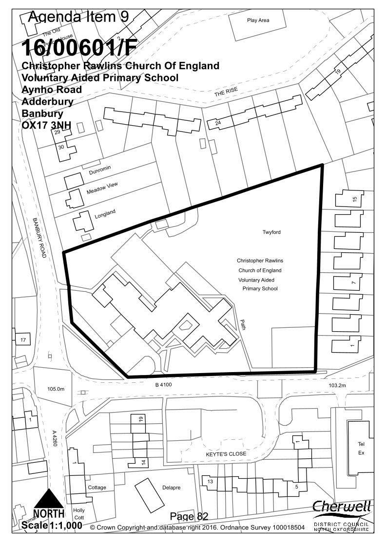
Twyford
Christopher Rawlins
Path
105.0m
Tel
Play Area
B 4100
Primary SchoolVoluntary AidedChurch of England
103.2m
Ex
BANBURY ROADA 4260
KEYTE'S CLOSE
THE RISE
Police House
Delapre
The Old
Tioman
Longland
Meadow ViewDunromin
CottHolly
Cottage
2
17
1
19
13
1430
29
715
24
5
1
1
1
1914
© Crown Copyright and database right 2016. Ordnance Survey 1000185041:1,000Scale
16/00601/FChristopher Rawlins Church Of England Voluntary Aided Primary SchoolAynho RoadAdderburyBanburyOX17 3NH
N
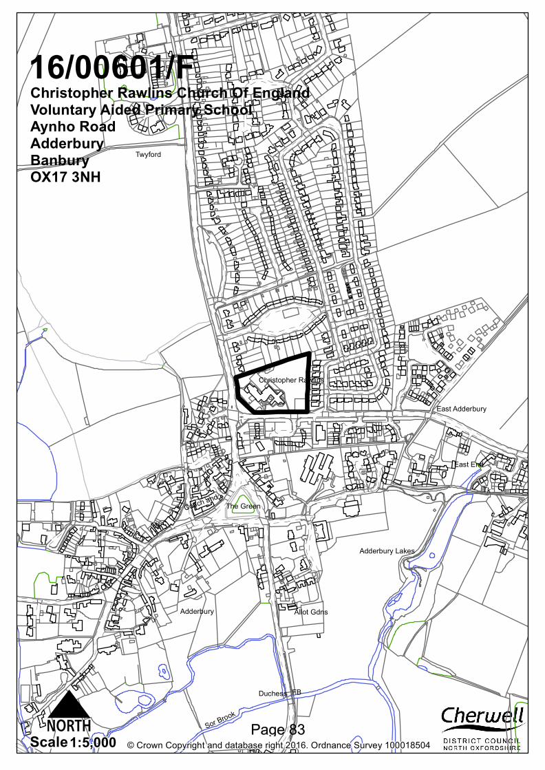
Adderbury
East Adderbury
Twyford
Ch
TkThe Green
FB
1
4
2
Allot Gdns
Coach and
Duchess
East End
Adderbury Lakes
Sor Brook
Christopher Rawlins
2
© Crown Copyright and database right 2016. Ordnance Survey 1000185041:5,000Scale
16/00601/FChristopher Rawlins Church Of England Voluntary Aided Primary SchoolAynho RoadAdderburyBanburyOX17 3NH
N
Christopher Rawlins Church of England Voluntary Aided Primary School, Aynho Road, Adderbury, OX17 3NH
16/00601/F
Ward: Adderbury, Bloxham and Bodicote Case Officer: Stuart Howden
District Councillor: Cllrs Bishop, Heath and Randall
Recommendation: Approval Applicant: Christopher Rawlins Church of England Voluntary Aided Primary School Application Description: Extension to foundation stage unit, extension to existing school hall, erection of two new key stage 2 classrooms, staffroom and supporting ancillary rooms. Demolition works and refurbishment to existing, internal alterations including new kitchen and external landscaping including new Multi-use games area (MUGA) Committee Referral: Major Application (site over 1ha) Committee Date: 07.07.2016 1. Site Description and Proposed Development 1.1
The site, which comprises Christopher Rawlins Church of England Voluntary Aided Primary School, is situated on a corner plot to the north of Aynho Road and to the east of Banbury Road in the village of Adderbury. To the north, east, south and south west of the site are residential properties, whilst to the north west of the site is open countryside.
1.2 1.3 1.4 1.5
The school currently has a roll of 233 pupils providing mixed gender teaching for age ranges 4-11. The school also has an integrated nursery providing 26 places for Full Time Equivalent half day sessional care. The school has split ownership, with the buildings and hard standing under the ownership of the Governors whilst the playing fields are under the ownership of Oxfordshire County Council. The existing school was constructed in the 1960s and has been extended since. The current main school building has a gross internal area of 1,188m2 and there are 8 classrooms (including a nursery) and school hall together with supporting, ancillary and administrative accommodation, including a staff room, information technology room, library and interview room. The single storey main school building is constructed from light coloured facing brickwork and light coloured render. The building has shallow pitch roofs with tiled roof coverings, together with areas of flat roofs. To the north of the main school building are a Greenhouse, P.E. store, and external classroom as well as a games court area constructed from hardstanding. To the east of the building are a playing field and a staff parking area. To the south is a visitor car parking area and bicycle shelters. To the west of the main school building is a shed building. There is a pedestrian access to the site from the west off Banbury Road, whilst there are two vehicular accesses to the site from the south off Aynho Road, with an access serving the visitor parking to the western end of the site and an access serving the staff parking to the eastern end of the site. Planning permission is sought for two extensions to the existing main school building in order to facilitate the expansion of the school from a single form entry to a 1.5 form
1.6 1.7 1.8 1.9 1.10 1.11 1.12
entry (315 pupils) school. The proposed additional floor space is approximately 437m2. The Design and Access Statement submitted alongside the application notes that this expansion is required in order to ensure there are sufficient primary school places to serve Adderbury and the surrounding areas. The largest proposed extension to the east of the main school building would roughly form an L-shape around the existing building. This extension is proposed to accommodate two Key Stage 2 classrooms, a new staff room and a disabled W.C. as well as provide an extension to the existing school hall building including a hall store room. The hall extension element and the additional staff room element would sit on the north west elevation of the school building and would have flat roofs, whilst the additional classrooms would be sited to the north east elevation of the building and have been designed in the form of two opposing mono-pitched blocks which have been pushed apart and staggered in plan and linked by a flat roof corridor element. The other extension to the main school building is proposed on the north west end of the main school building and would replace two existing covered areas which would accommodate a new reception room, toilets, a new nursery space and a glazed canopy accommodating an outdoor play area. The extension would essentially be located on both sides of the existing nursery element of the building and the canopy would link the extensions together. It is noted within the Design and Access Statement submitted with the application that the canopy element is a curriculum requirement to facilitate teaching and free flow play between indoor and outdoor spaces. The proposed roof of the extension elements to both sides of the existing nursery building would be mono-pitched sloping downwards in a south easterly direction. The pitched roof of the existing part of the building accommodating the nursery that would be attached to the extensions would be replaced with a flat roof. The extensions are both proposed to be single storey in height. The walls of the extensions would mainly be constructed from a plinth of brickwork and light coloured render. That said, a large section of the north-west wall of the nursery element of the building is proposed to be constructed from a mixture of vertical timber boarding and vertical rainscreen panels of varying widths. This panelling and boarding is also proposed on the staff room section of the larger extension. 10 larger rainscreen panels are proposed adjacent to a number of new openings. The roofs are proposed to be finished in metal, whilst the roof to the hall extension, staffroom and other linking sections of roof are flat using a single ply roof covering. A window is also proposed to replace a door in the south west elevation of the existing school building. A Multi-Use Games Area (MUGA) is proposed to provide the school with an all-weather sports pitch and play area. This is proposed to the west of the school building and adjacent to Aynho Road. 3 metre high weldmesh fencing would surround the MUGA which would measure 37m x 18.5m. It is proposed to expand the hard play areas and this is proposed to accommodate the loss of these existing spaces as a result of the extensions. New fencing and walling is proposed within the site. It is proposed to relocate the existing site pedestrian access from Banbury Road further to the north of Banbury Road in order to provide a larger soft play area for the nursery. The existing on-site parking arrangement is proposed to remain the same. The layby to the south of the site on Aynho Road is proposed to be extended by 12 metres as a result of the proposal. The site is situated to the north of the Banbury Conservation Area, but is not within close proximity to any listed buildings. The site has some ecological potential as the protected species of the Common Kestrel and Common Swift have been recorded
within the vicinity of the site. The site is on land that is potentially contaminated. 2. Application Publicity 2.1
The application has been advertised by way of neighbour letter, press notice and site notice. The final date for comment was the 6th June 2016. 1 letter of objection has been received from a neighbouring resident. The concerns raised are summarised below:
There is not the local demand to justify the expansion of the school and these extra places at the school will be filled by children from surrounding towns and villages;
The school has outgrown the site and the loss of outdoor space cannot be adequately replaced by the creation of a MUGA;
The extensions are unsightly;
Highway safety concerns: The Transport Plan is not an accurate assessment of the problems
created by parents dropping off/collecting their children; A single day of observing traffic does not make for a very accurate
assessment; Parking takes place on nearby residential streets and this results in
drives being blocked up; Parking happens close to the junction of The Rise; Cars parked on The Rise results in a danger for pedestrian safety; The issues raised above would be exacerbated if the expansion is to go
ahead. 3.
Consultations
3.1 3.2
Consultations were issued on 20 April 2016. The deadline for comments to be submitted was 11 May. The following comments were received: Adderbury Town Council: “Supports the above application, but due to the increase in pupil number, the PC has the following concerns about traffic/parking. The Parish Council notes the County Council’s suggestions for mitigating the impact of the potential problems from increased parking in the area and would request that these are included as conditions, if Cherwell District Council is minded to approve the application. However, the PC would also request that the County Council consider further measures for parking and traffic calming, which might be possible, for example a 20 mph zone by the school, at least when children are arriving and being collected. In addition, could measures be taken to prevent Twyford becoming even more of a rat run, if drivers try to avoid school traffic.”
Cherwell District Council Consultees 3.3
Arboricultural Officer: “It is proposed that a row of recently planted hornbeams will be removed and relocated; T7, a Turkey oak, T18, a Silver Maple and a group of Lawson Cypress will also be removed. I concur with the arboricultural consultant’s reasoning behind the removal of these trees and have no objections to the removal of the trees. It is proposed that T23, a beech tree and T24 a walnut tree will be retained. These trees should be protected in accordance with the tree protection plan whilst the new extension is being built. The tree protection will need to be removed to construct the new hard surface and the proposed paths after the main construction is complete. The
3.4 3.5 3.6 3.7 3.8 3.9
proposed footpaths should be constructed using no dig construction techniques and incorporate a 3 dimensional cellular confinement system. It is understood that the soil level will need to be dropped to the south east of the beech tree. This will need to be done by hand. A method statement will be needed for both the construction of the footpaths and for the installation of the hard surface to the south east of the beech tree. Although a method statement has been submitted for the construction of the footpaths no reference is made to the incorporation of a cellular confinement system.” Anti-Social Behaviour Officer: No comments received. Conservation Officer: No comments received. Environmental Protection Officer: No objections. Ecology Officer: No comments received. Planning Policy: No comments received. Recreation and Leisure: No comments received.
Oxfordshire County Council Consultees 3.10
3.11 3.12 3.13
Highways Liaison Officer: No objections subject to conditions requesting:
School travel plan incorporating details of the means of regulating the use of private cars for journeys to school in favour of other modes of transport and the means of implementation and methods of monitoring.
A plan showing the number, location and design of new cycle and scooter parking provision.
Also legal agreements to secure the following:
Section 106: £5,000 towards the advertising and implementation of double yellow lines on Aynho Road from A4260 as far as a point east of the junction with Long Wall Close;
Section 106: A fee of £1,240 will be needed to allow the monitoring of the travel plan for a period of 5 years; and
Section 278: The extension of the Aynho Road layby to accommodate additional drop off as shown on Glanville drawing number 8160177/6101.
Detailed comments from the Local Highways Authority are available on Public Access. The Local Highways Authority have highlighted that the key issues regarding this application are the following matters:
“Trip generation work is not robust, but it is accepted that any negative impact of additional vehicle movements on local traffic congestion will be small. Travel plan measures should help to reduce negative impact;
Potential for an increase in pavement parking for drop off/pick up on Aynho Road – double yellow lines needed;
Additional cycle and scooter parking needed;
Travel Plan does not meet the standards set out in the county council’s travel plans guidance document – revised plan needed before start of development.”
Drainage: No comments received. Archaeology: No comments received. Service Manager – Pupil Place Planning: “Expansion of Christopher Rawlins Primary
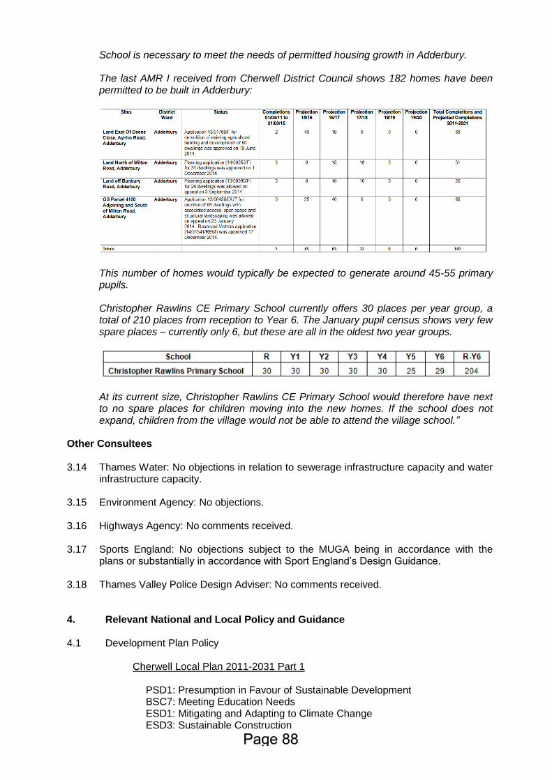
School is necessary to meet the needs of permitted housing growth in Adderbury. The last AMR I received from Cherwell District Council shows 182 homes have been permitted to be built in Adderbury:
This number of homes would typically be expected to generate around 45-55 primary pupils. Christopher Rawlins CE Primary School currently offers 30 places per year group, a total of 210 places from reception to Year 6. The January pupil census shows very few spare places – currently only 6, but these are all in the oldest two year groups.
At its current size, Christopher Rawlins CE Primary School would therefore have next to no spare places for children moving into the new homes. If the school does not expand, children from the village would not be able to attend the village school.”
Other Consultees 3.14 3.15 3.16 3.17 3.18
Thames Water: No objections in relation to sewerage infrastructure capacity and water infrastructure capacity. Environment Agency: No objections. Highways Agency: No comments received. Sports England: No objections subject to the MUGA being in accordance with the plans or substantially in accordance with Sport England’s Design Guidance. Thames Valley Police Design Adviser: No comments received.
4.
Relevant National and Local Policy and Guidance
4.1
Development Plan Policy
Cherwell Local Plan 2011-2031 Part 1
PSD1: Presumption in Favour of Sustainable Development BSC7: Meeting Education Needs ESD1: Mitigating and Adapting to Climate Change ESD3: Sustainable Construction
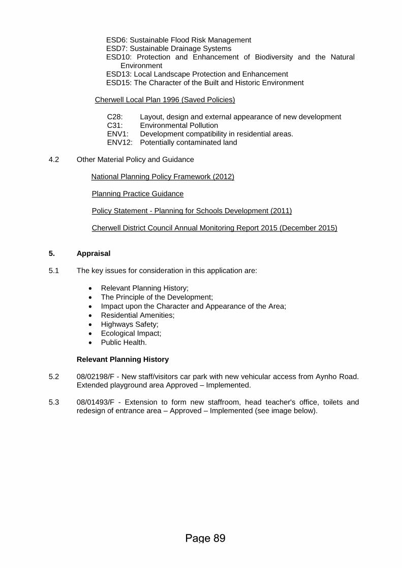
ESD6: Sustainable Flood Risk Management ESD7: Sustainable Drainage Systems ESD10: Protection and Enhancement of Biodiversity and the Natural
Environment ESD13: Local Landscape Protection and Enhancement ESD15: The Character of the Built and Historic Environment
Cherwell Local Plan 1996 (Saved Policies)
C28: Layout, design and external appearance of new development C31: ENV1: ENV12:
Environmental Pollution Development compatibility in residential areas. Potentially contaminated land
4.2
Other Material Policy and Guidance National Planning Policy Framework (2012)
Planning Practice Guidance Policy Statement - Planning for Schools Development (2011) Cherwell District Council Annual Monitoring Report 2015 (December 2015)
5.
Appraisal
5.1
The key issues for consideration in this application are:
Relevant Planning History;
The Principle of the Development;
Impact upon the Character and Appearance of the Area;
Residential Amenities;
Highways Safety;
Ecological Impact;
Public Health.
Relevant Planning History
5.2 5.3
08/02198/F - New staff/visitors car park with new vehicular access from Aynho Road. Extended playground area Approved – Implemented. 08/01493/F - Extension to form new staffroom, head teacher's office, toilets and redesign of entrance area – Approved – Implemented (see image below).
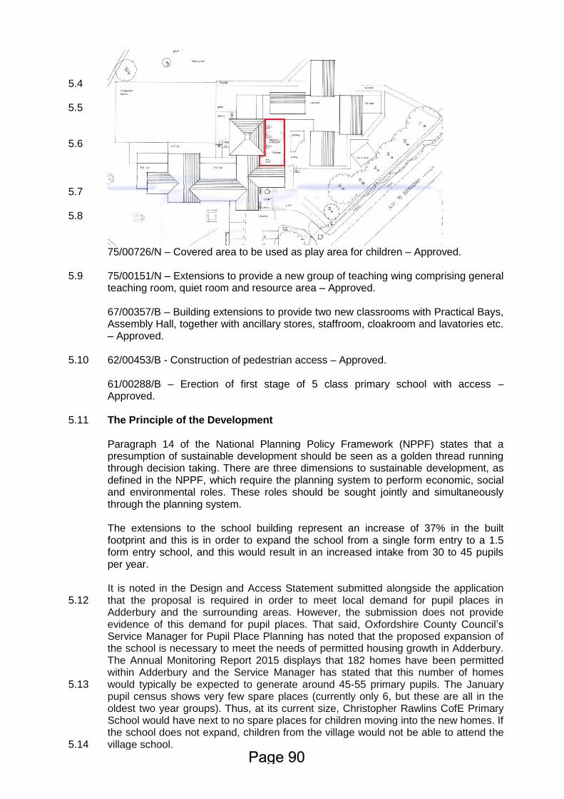
5.4 5.5 5.6 5.7 5.8 5.9 5.10 5.11 5.12 5.13 5.14
75/00726/N – Covered area to be used as play area for children – Approved. 75/00151/N – Extensions to provide a new group of teaching wing comprising general teaching room, quiet room and resource area – Approved. 67/00357/B – Building extensions to provide two new classrooms with Practical Bays, Assembly Hall, together with ancillary stores, staffroom, cloakroom and lavatories etc. – Approved. 62/00453/B - Construction of pedestrian access – Approved.
61/00288/B – Erection of first stage of 5 class primary school with access – Approved. The Principle of the Development Paragraph 14 of the National Planning Policy Framework (NPPF) states that a presumption of sustainable development should be seen as a golden thread running through decision taking. There are three dimensions to sustainable development, as defined in the NPPF, which require the planning system to perform economic, social and environmental roles. These roles should be sought jointly and simultaneously through the planning system. The extensions to the school building represent an increase of 37% in the built footprint and this is in order to expand the school from a single form entry to a 1.5 form entry school, and this would result in an increased intake from 30 to 45 pupils per year. It is noted in the Design and Access Statement submitted alongside the application that the proposal is required in order to meet local demand for pupil places in Adderbury and the surrounding areas. However, the submission does not provide evidence of this demand for pupil places. That said, Oxfordshire County Council’s Service Manager for Pupil Place Planning has noted that the proposed expansion of the school is necessary to meet the needs of permitted housing growth in Adderbury. The Annual Monitoring Report 2015 displays that 182 homes have been permitted within Adderbury and the Service Manager has stated that this number of homes would typically be expected to generate around 45-55 primary pupils. The January pupil census shows very few spare places (currently only 6, but these are all in the oldest two year groups). Thus, at its current size, Christopher Rawlins CofE Primary School would have next to no spare places for children moving into the new homes. If the school does not expand, children from the village would not be able to attend the village school.
5.15 5.16
Paragraph 72 of the NPPF states that the Government attaches great importance to ensuring that a sufficient choice of school places are available to meet the needs of existing and new communities. It goes on to state that Local Planning Authorities should take a proactive, positive and collaborative approach to meeting this requirement and to development that will widen choice in education. It advises great weight should be given to the need to create, expand or alter schools. Policy BSC7 of the Cherwell Local Plan Part 1 states that the Council will work with partners to ensure the adequate provision of pre-school and other educational needs. It goes onto state that new school buildings should be located in sustainable locations and co-location with other services should be considered to create community hubs. The Policy Statement for Schools Development, which is to be read alongside the NPPF, confirms the Government’s policy on new school development. It states that Local Authorities should give full and thorough consideration to the importance of enabling development at state funded schools in their planning decisions and that Local Planning Authorities should attach significant weight to the need to establish and develop schools. The PPG also notes that Local authorities need to consider whether children’s best interests are relevant to any planning issue under consideration. Given the strong policy support to ensure sufficient choice and availability in school places, it is considered that the benefits that extending the school would bring should be given significant weight in determining the application and the principle of expanding the school is acceptable in principle subject to other material considerations. These issues are discussed below.
5.17 5.18 5.19 5.20
Impact upon the Character and Appearance of the Area The site affects the setting of Adderbury Conservation Area, which is a designated heritage asset. Paragraph 132 of the NPPF states that: “When considering the impact of a proposed development on the significance of a designated heritage asset, great weight should be given to the asset’s conservation. Significance can be harmed or lost through alteration or destruction of the heritage asset or development within its setting. As heritage assets are irreplaceable, any harm or loss should require clear and convincing justification.” Paragraph 137 of the NPPF states that Local Planning Authorities should look for opportunities for new development within Conservation Areas to enhance or better reveal their significance. Government guidance contained within the NPPF requiring good design states that good design is a key aspect of sustainable development, is indivisible from good planning, and should contribute positively to making places better for people. Further, permission should be refused for development of poor design that fails to take the opportunities for improving the character and quality of an area and the way it functions. Policy ESD15 of the Cherwell Local Plan Part 1 states that: “New development will be expected to complement and enhance the character of its context through sensitive siting, layout and high quality design. All new development will be required to meet high design standards.” Furthermore, Policy ESD15 of the Cherwell Local Plan states that new development proposals should: “Conserve, sustain and enhance designated and non-designated ‘heritage assets’ (as defined in the NPPF) including buildings, features, archaeology, conservation areas and their settings, and ensure new development is sensitively sited and integrated in accordance with advice in the
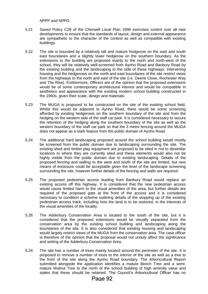
5.21 5.22 5.23 5.24 5.25 5.26 5.24
NPPF and NPPG. Saved Policy C28 of the Cherwell Local Plan 1996 exercises control over all new developments to ensure that the standards of layout, design and external appearance are sympathetic to the character of the context as well as compatible with existing buildings. The site is bounded by a relatively tall and mature hedgerow on the east and south east boundaries and a slightly lower hedgerow on the southern boundary. As the extensions to the building are proposed mainly to the north and north-west of the school, they will be relatively well-screened from Aynho Road and Banbury Road by the existing building and the landscaping to the side of these highways. Intervening housing and the hedgerows on the north and east boundaries of the site restrict views from the highways to the north and east of the site (i.e. Deene Close, Rochester Way and The Rise). Furthermore, Officers are of the opinion that the proposed extensions would be of some contemporary architectural interest and would be compatible in aesthetics and appearance with the existing modern school building constructed in the 1960s, given their scale, design and materials. The MUGA is proposed to be constructed on the site of the existing school field. Whilst this would be adjacent to Aynho Road, there would be some screening afforded by existing hedgerows on the southern boundary of the site and from the hedging on the western side of the staff car park. It is considered necessary to secure the retention of the hedging along the southern boundary of the site as well as the western boundary of the staff car park so that the 3 metre fencing around the MUGA does not appear as a stark feature from the public domain of Aynho Road. The additional hard landscaping proposed around the school building would mostly be screened from the public domain due to landscaping surrounding the site. The existing shed and timber play equipment are proposed to be sited in not to dissimilar locations to where they are currently sited and these elements would also not be highly visible from the public domain due to existing landscaping. Details of the proposed fencing and walling to the west and south of the site are limited, but new means of enclosure could be acceptable given the level of the landscape screening surrounding the site, however further details of the fencing and walls are required. The proposed pedestrian access leading from Banbury Road would replace an existing access off this highway. It is considered that the new pedestrian access would cause limited harm to the visual amenities of the area, but further details are required of the proposed gate at the front of the access and it is considered necessary to condition a scheme outlining details of the stopping up of the existing pedestrian access track, including how the land is to be restored, in the interests of the visual amenities of the locality. The Adderbury Conservation Area is located to the south of the site, but it is considered that the proposed extensions would be visually separated from the conservation area by the existing school building and landscaping along the boundaries of the site. It is also considered that existing housing and landscaping would largely restrict views of the MUGA from the conservation area. The case officer is therefore of the opinion that the proposal would not unduly affect the significance and setting of the Adderbury Conservation Area. The site has a number of trees mainly located around the perimeter of the site. It is proposed to remove a number of trees to the interior of the site as well as a tree to the front of the site along the Aynho Road boundary. The Arboricultural Report submitted alongside the application identifies a mature Beech Tree and a semi-mature Walnut Tree to the north of the school building of high amenity value and states that these should be retained. The Council’s Arboricultural Officer has no
5.25
objections to the removal of the trees within the site identified for removal, and agrees that the Walnut Tree and Beech Tree to the north of the building should be retained. The Council’s Arboricultural officer notes that these trees should be protected in accordance with the tree protection plan submitted alongside the application. However, the Arboricultural Officer has also noted that an Arboricultural Method Statement (AMS) will be required for the construction of the footpaths and the installation of hard surfacing to the south east of the Beech Tree. Whilst an AMS has been submitted, no reference has been made to the incorporation of a cellular confinement system. Therefore a condition requiring the submission and approval of a revised AMS is considered necessary. Thus, for the reasons above, officers consider that the proposal would preserve the character and appearance of the area, including the setting of the Conservation Area, subject to conditions.
5.26 5.27 5.28
Residential Amenities The extensions and MUGA would be sited so as to prevent undue harm to any neighbouring properties in terms of loss of light, overlooking or loss of privacy or the creation of an overbearing affect. In relation to noise and disturbance, the pupils attending the school are highly likely to increase as a result of the proposed development. Given that the site is used as a school at the moment and that schools generally operate between normal working hours, it is considered that the increase in pupils is unlikely to result in additional significant harm to neighbouring properties in terms of noise and disturbance. The MUGA would be set off the boundaries shared with residential properties and would be approximately 22 metres from the nearest residential properties on Deene Close. Mature landscaping along the north and east boundaries of the site will assist in mitigating the potential impacts on neighbours. The proposed MUGA would also be sited adjacent to Aynho Road and this MUGA is proposed in the existing grassed play area. Thus, due to the hours of operation of the school (normally 8am to 6pm) and intervening landscaping and given the existing recreational use of the land where the proposed MUGA would be sited, Officers consider that there would not be a significant increased impact upon neighbour amenity in terms of noise and disturbance than currently existing. Furthermore, no objections have been raised from any third party in relation to noise emanating from the site. Lighting in association with the MUGA is not proposed and external floodlighting is likely to require planning permission.
5.29 5.30 5.31
Highways Safety The Local Highways Authority has no objections to the proposal subject to conditions. The proposal is for an expansion of the school which will result in the increase in pupils attending the school (an eventual increase of 82 children) and an increase in the number of staff from 10 full time and 12 part time to 14 full time and 17 part time. However, no new car or cycle parking is proposed. It is proposed to extend by two cars’ length (approximately 12 metres) the layby on the Aynho Road next to the school that is currently used for school drop off and pick up and a Section 278 agreement would be required in order to secure this. The Transport Statement that accompanied the planning application tries to estimate the number of additional vehicle movements there will be on the network as a result of the school expansion. This is estimated as 34 two way trips in the morning peak and 10 two way trips in the evening peak. This is based on a sample of only 2 primary
5.32 5.33 5.34 5.35
school sites elsewhere in the UK and the Local Highways Authority are of the opinion that this is a very small sample to rely on. The Local Highways Authority state that a more robust way of estimating the likely traffic generation of the additional pupils would have been to use data about the current travel patterns of students and staff. Notwithstanding the above, the Local Highways Authority go on to state that the number of vehicle movements predicted in the Transport Statement appears to be reasonable given the current travel behaviour revealed by the survey work documented in the travel plan. The Local Highways Authority have stated that these additional vehicle movements will have a minimal negative impact on the operation of this part of the local highway network, even taking into account the congestion that is often present in the vicinity during peak hours. Officers see no reason to disagree with this assessment. That said, the Local Highways Authority has noted that there does appears to be scope to reduce the amount of driving to the school, particularly by parents/pupils, given that the vast majority of pupils live within Adderbury itself. The Local Highways Authority go on to state that an amended Travel Plan will be instrumental in helping to reduce driving to school and walking is undoubtedly a realistic option for more pupils. The Local Highways Authority note that this Travel Plan should be bold in setting targets for reducing the amount of driving to school and that these targets should be matched by measures and initiatives to help these targets to be met e.g. additional cycle parking. The Local Highways Authority has stated that the current Travel Plan submitted alongside the application does not appear to have been written in sufficiently close collaboration with the school therefore there are concerns that this current plan will not be necessarily effective in changing travel habits and therefore achieving modal shift away from the car as the main mode of travel to the site for staff and parents/pupils. Thus, Officers concur with the Local Highways Authority that it is necessary to attach a condition that prior to the occupation of the development, a revised travel plan in accordance with the County Council’s School Travel Guidance, is submitted to and approved by the Local Planning Authority. The Local Highways Authority has stated that a fee of £1,240 will be needed to allow the monitoring of the Travel Plan for a period of 5 years. The Transport Statement states that the 27 existing car parking spaces will be sufficient to accommodate the increased staffing as they are not fully used at the moment (no parking is provided for parents). However, as the Local Highways Authority note, there is no detail as to how much spare capacity there is at present and so it is impossible to know whether there really is enough parking. What could happen if there doesn’t turn out to be enough staff car parking is an increase in people needing to park off the site. The Local Highways Authority do not want to see parking and/or dropping off on Aynho Road or its footways as this will have a negative impact on traffic flow in this area. To address this problem, the Local Highways Authority is of the opinion that the School will need to pay for a Traffic Regulation Order to introduce double yellow line parking restrictions along Aynho Road from the junction with A4260 as far as a point east of Long Wall Close. The Local Highways Authority state that it is not felt that any displaced parking happening in nearby residential streets because of double yellow lines on Aynho Road will result in any unacceptably negative impacts on road safety, and by causing staff and parents to park further away from the school this may encourage some of them to walk. The Local Highways Authority has requested a sum of £5,000 towards the advertising and implementation of double yellow lines on Aynho Road. There is no increase proposed to the existing 20 spaces for parking bicycles despite the likely increase in pupil numbers, but there is no evidence as to the current usage and therefore the spare capacity. The Local Highways Authority has stated that unless strong evidence can be provided to the contrary, it will be expected that the school will provide space for an additional 10 bicycles and that it will be available for
5.36
use prior to the first new additional pupils attending the school. The Local Highways also go on to note that dedicated children’s scooter parking has been provided at primary schools elsewhere across the county and this is something that helps to encourage walking to school. Thus, the Local Highways Authority have requested space for parking at least 10 children’s scooters be provided by the school and also be available for use before the new additional pupils attend the school. Given the above and to encourage the reduction in usage of cars, the number, location and design of new cycle and scooter parking provision has been recommended as a condition. Given the above, Officers consider that the proposed development would not result in detrimental harm to the highway network.
5.37 5.38
Ecological Impact No comments have been received from the Ecology Officer during the consultation process, but given the nature and scale of the proposal and the location of the site within the built up limits of Adderbury, it is considered that the proposal is unlikely to result in significant ecological harm. Public Health The site is on potentially contaminated land but the Environmental Health Officer has raised no objections to the proposal. Engagement
5.39 Paragraphs 186 and 187 of the NPPF places a duty on the Local Authority to be positive in its decision taking. It is considered that the duty to be positive and proactive has been discharged through the efficient and timely determination of the application.
Conclusion
5.40 The principle of the development is considered to be acceptable. The proposal would not cause detrimental harm to the character and appearance of the area, residential amenity, ecology, public health or highways safety. The proposal is therefore compliant with the policies outlined in section 4 of this report. Overall, the proposal is considered to have no adverse impacts, therefore the application is recommended for approval and planning permission should be granted subject to appropriate conditions.
6. Recommendation Approval, subject to: a) The applicant entering into an appropriate s106 Legal Agreement to the
satisfaction of the District Council to secure financial contributions as outlined in paragraph 3.9 of the report.
b) The following conditions:
1. The development to which this permission relates shall be begun not later than the expiration of three years beginning with the date of this permission. Reason - To comply with the provisions of Section 91 of the Town and Country Planning Act 1990, as amended by Section 51 of the Planning and
Compulsory Purchase Act 2004.
2. Except where otherwise stipulated by condition, the development shall be carried out strictly in accordance with the following plans and documents:
Application Form submitted with the application;
Design and Access Statement (ref: 1428/2A) by Thinking Buildings dated 30th March 2016 submitted with the application;
Transport Statement (ref: TR8160177/BE002) by Glanville dated March 2016 submitted with the application;
Drawing Numbers: 01; 05 Revision B; 06 Revision D; 10 Revision D; and 11 Revision A submitted with the application; and
Drawing Number 110 Revision 01 received from the applicant’s agent by e-mail on 23rd June 2016.
Reason - For the avoidance of doubt, to ensure that the development is carried out only as approved by the Local Planning Authority and to comply with Government guidance contained within the National Planning Policy Framework.
3. Prior to the commencement of the development hereby permitted, samples of
the materials to be used in the construction of the walls and roofs of the development hereby permitted shall be submitted to and approved in writing by the Local Planning Authority. Thereafter, the walls and roofs of the development shall be carried out in accordance with the samples so approved. Reason - To ensure the satisfactory appearance of the completed development and to comply with Policy ESD15 of the Cherwell Local Plan Part 1, saved Policies C28 and C30 of the Cherwell Local Plan 1996 and Government guidance contained within the National Planning Policy Framework.
4. Prior to the occupation of the development hereby permitted, full specification details (including construction, layout, surfacing and drainage) of the extended layby on Aynho Road (shown on Drawing No: 05 Rev B), along with a timetable for the implementation of the works, shall be submitted to and approved in writing by the Local Planning Authority. Thereafter, the extended layby shall be provided and made available for use in accordance with the approved details and timetable. Reason - In the interests of highway safety, to ensure a satisfactory standard of construction and layout for the development and to comply with Policy ESD15 of the Cherwell Local Plan Part 1 Government guidance contained within the National Planning Policy Framework.
5. Prior to occupation of development hereby permitted, a school Travel Plan
shall be submitted to and approved by the Local Planning Authority. The Travel Plan shall incorporate (i) details of the means of regulating the use of private cars for journeys to school in favour of other modes of transport and (ii) the means of implementation and methods of monitoring the Travel Plan. Reason - In the interests of sustainability, to ensure a satisfactory form of development and in accordance with Policy ESD15 of the Cherwell Local Plan Part 1 and Government guidance contained within the National Planning Policy Framework.
6. Prior to commencement of the development hereby permitted, a plan
showing the number, location and design of new cycle and scooter parking for the school shall be submitted to and approved in writing by the Local Planning Authority. The new parking shown on the approved plan shall be provided prior to first occupation of the development. Thereafter, the parking shall be permanently retained and maintained for the parking of cycles and scooters in connection with the development. Reason - In the interests of sustainability, to ensure appropriate levels of cycle and scooter parking are available at all times to serve the development and to comply with Policy ESD15 of the Cherwell Local Plan Part 1 and Government guidance contained within the National Planning Policy Framework.
7. Prior to the commencement of the development hereby permitted, a hard
landscaping scheme including details of the layout, design, surfacing, and appearance of:
Pavements, pedestrian areas, reduced-dig areas, crossing points and steps;
Gates, fences, walls or any other means of enclosure;
Fencing surrounding the MUGA. Shall be submitted to and approved in writing by the Local Planning Authority. Thereafter the development shall be carried out in accordance with the approved landscape scheme. Reason - In the interests of the visual amenities of the area, to ensure the creation of a pleasant environment for the development and to comply with Policy ESD 15 of the Cherwell Local Plan Part 1, saved Policy C28 of the Cherwell Local Plan 1996 and Government guidance contained within the National Planning Policy Framework.
8. Prior to the commencement of the development hereby permitted, an Arboricultural Method Statement (AMS), undertaken in accordance with BS:5837:2012 and all subsequent amendments and revisions shall be submitted to and approved in writing by the Local Planning Authority. Thereafter, all works on site shall be carried out in accordance with the approved AMS. Reason – To ensure the continued health of retained trees/hedges and to ensure that they are not adversely affected by the construction works, in the interests of the visual amenity of the area, to ensure the integration of the development into the existing landscape and to comply with Policy ESD15 of the Cherwell Local Plan Part 1, saved Policy C28 of the Cherwell Local Plan 1996 and Government guidance contained within the National Planning Policy Framework.
9. That:
a) No retained tree shall be cut down, uprooted, damaged or destroyed, nor
shall any retained tree be pruned in any manner, be it branches, stems or roots, other than in accordance with the approved plans and particulars, without the prior written approval of the Local Planning Authority. All tree works shall be carried out in accordance with BS3998: Recommendations for Tree Works.
b) If any retained tree is cut down, uprooted, destroyed or dies, another tree shall be planted in the same place in the next planting season following the removal of that tree, full details of which shall be firstly submitted to
and approved in writing by the Local Planning Authority.
Reason - In the interests of the visual amenities of the area, to ensure the creation of a pleasant environment for the development and to comply with Policy ESD15 of the Cherwell Local Plan 1996, saved Policy C28 of the Cherwell Local Plan 1996 and Government guidance contained within the National Planning Policy Framework.
10. The existing hedgerow along the southern boundary of the site and the south western boundary of the staff car park (displayed on Drawing Number 05 Revision B submitted with the application) shall be retained and properly maintained at a height of not less than 2 metres, and if any hedgerow plant dies within five years from the completion of the MUGA it shall be replaced by a plant of the same or similar species and shall thereafter be properly maintained in accordance with this condition. Reason - In the interests of the visual amenities of the area, to provide an effective screen to the proposed development and to comply with Policy ESD15 of the Cherwell Local Plan Part 1, saved Policy C28 of the Cherwell Local Plan 1996 and Government guidance contained within the National Planning Policy Framework.
PLANNING NOTES 1. In relation to Condition 5, the Travel Plan should follow Oxfordshire County
Council’s School Travel Plan Guidance.
2. In condition 9 a “retained tree” is an existing tree which shall be retained in accordance with the approved plans and particulars; and paragraphs (a) and (b) shall have effect until the expiration of five years from the date of the occupation of the building.
3. With regard to condition 4, a Section 278 Agreement under the Highways Act
1980 is required in relation to the extension of the Aynho Road layby to accommodate additional drop off as shown on Glanville drawing number 8160177/6101 submitted with the application.
4. Planning permission only means that in planning terms a proposal is acceptable
to the Local Planning Authority. Just because you have obtained planning permission, this does not mean you always have the right to carry out the development. Planning permission gives no additional rights to carry out the work, where that work is on someone else's land, or the work will affect someone else's rights in respect of the land. For example there may be a leaseholder or tenant, or someone who has a right of way over the land, or another owner. Their rights are still valid and you are therefore advised that you should seek legal advice before carrying out the planning permission where any other person's rights are involved.
5. With regard to surface water drainage it is the responsibility of a developer to
make proper provision for drainage to ground, water courses or a suitable sewer. In respect of surface water it is recommended that the applicant should ensure that storm flows are attenuated or regulated into the receiving public network through on or off site storage. When it is proposed to connect to a combined public sewer, the site drainage should be separate and combined at the final manhole nearest the boundary. Connections are not permitted for the removal of groundwater. Where the developer proposes to discharge to a public sewer, prior approval from Thames Water Developer Services will be required. They can be contacted on 0800 009 3921. This is to ensure that the surface water discharge from the site shall not be detrimental to the existing sewerage system.
6. This consent does not grant planning permission for floodlighting in association
with the MUGA and such floodlighting would require planning permission in its own right.
STATEMENT OF ENGAGEMENT In accordance with the Town and Country Planning (Development Management Procedure) (England) Order 2015 and paragraphs 186 and 187 of the National Planning Policy Framework (March 2012), this decision has been taken by the Council having worked with the applicant/agent in a positive and proactive way as set out in the application report.
CASE OFFICER: Stuart Howden TELEPHONE: 01295 221815
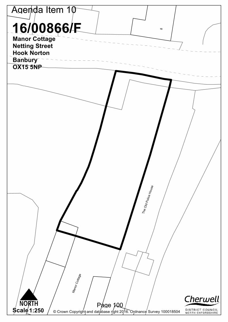
The O
ld Po
lice Ho
use
Mano
r Cott
age
8
© Crown Copyright and database right 2016. Ordnance Survey 1000185041:250Scale
16/00866/FManor CottageNetting StreetHook NortonBanburyOX15 5NP
N
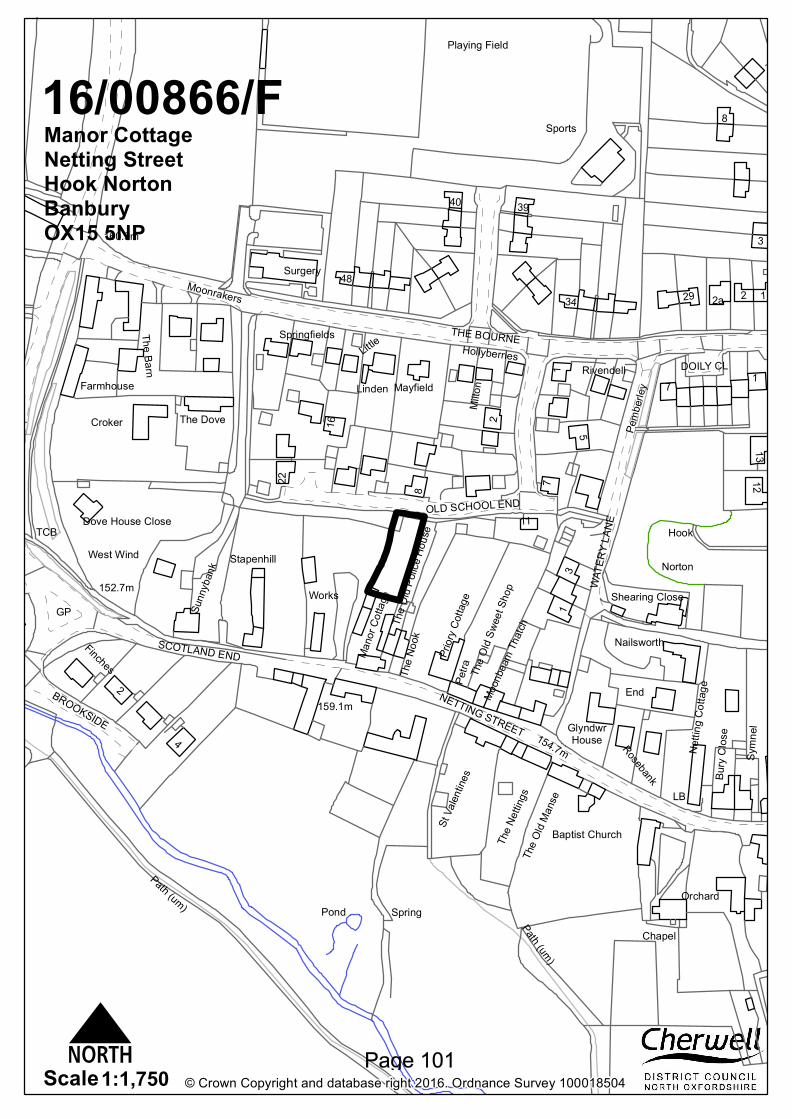
Norton
Hook
Playing Field
Sports
House
2a
The Dove
LB
Works
TCB
Glyndwr154.7m
160.9m
159.1m
152.7mGP
Pond Spring
Nailsworth
Surgery
Priory
Cotta
ge
Path (um)
DOILY CL
WATE
RY LA
NE
West Wind
BROOKSIDE
NETTING STREET
OLD SCHOOL ENDDove House Close
SCOTLAND ENDFinches
End
Rosebank
St Va
lentin
es Bury
Clos
e
Shearing Close
Croker
Farmhouse Linden
Chapel
THE BOURNE
The N
ook
Symn
el
The N
etting
s
Moon
beam
Thatc
hTh
e Old
Mans
e
Nettin
g Cott
agePe
tra
Orchard
Mayfield
Baptist Church
Moonrakers
Mano
r Cott
age
The Barn
Stapenhill
Sunn
yban
k
11
Little
Milto
n
Pemb
erley
The O
ld Po
lice Ho
use
The O
ld Sw
eet S
hop
HollyberriesSpringfields
13
8
2
22
4
39
1213
5
29
7
40
34
16
48
Rivendell 17
1
8
Path (um)
1
3
2
2
© Crown Copyright and database right 2016. Ordnance Survey 1000185041:1,750Scale
16/00866/FManor CottageNetting StreetHook NortonBanburyOX15 5NP
N
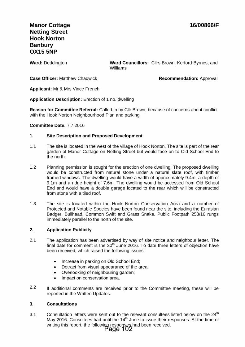
Manor Cottage Netting Street Hook Norton Banbury OX15 5NP
16/00866/F
Ward: Deddington Case Officer: Matthew Chadwick
Ward Councillors: Cllrs Brown, Kerford-Byrnes, and Williams Recommendation: Approval
Applicant: Mr & Mrs Vince French Application Description: Erection of 1 no. dwelling Reason for Committee Referral: Called-in by Cllr Brown, because of concerns about conflict with the Hook Norton Neighbourhood Plan and parking Committee Date: 7.7.2016 1. Site Description and Proposed Development 1.1 1.2 1.3
The site is located in the west of the village of Hook Norton. The site is part of the rear garden of Manor Cottage on Netting Street but would face on to Old School End to the north. Planning permission is sought for the erection of one dwelling. The proposed dwelling would be constructed from natural stone under a natural slate roof, with timber framed windows. The dwelling would have a width of approximately 9.4m, a depth of 9.1m and a ridge height of 7.6m. The dwelling would be accessed from Old School End and would have a double garage located to the rear which will be constructed from stone with a tiled roof. The site is located within the Hook Norton Conservation Area and a number of Protected and Notable Species have been found near the site, including the Eurasian Badger, Bullhead, Common Swift and Grass Snake. Public Footpath 253/16 rungs immediately parallel to the north of the site.
2. Application Publicity 2.1 2.2
The application has been advertised by way of site notice and neighbour letter. The final date for comment is the 30th June 2016. To date three letters of objection have been received, which raised the following issues:
Increase in parking on Old School End;
Detract from visual appearance of the area;
Overlooking of neighbouring garden;
Impact on conservation area. If additional comments are received prior to the Committee meeting, these will be reported in the Written Updates.
3.
Consultations
3.1
Consultation letters were sent out to the relevant consultees listed below on the 24th May 2016. Consultees had until the 14th June to issue their responses. At the time of writing this report, the following responses had been received.
3.2
Hook Norton Parish Council: Objects, on the following grounds:
Policy No. HN CC1 of the Hook Norton Neighbourhood Plan states that gardens are not considered previously developed land and that re-development of gardens to provide housing is inappropriate and not supported.
The proposed parking for 4 vehicles contravenes OCC’s parking standards.
Cherwell District Council Consultees 3.3 3.4 3.5 3.6 3.7 3.8
Arboriculture Officer: There are trees on and adjacent to the site, a tree survey is needed in addition to a tree protection plan in accordance with BS5837:2012. Building Control: No comments received. Conservation Officer: No comments received. Ecology Officer: No comments received. Environmental Protection Officer: No objections. Housing Standards: No comments received.
Oxfordshire County Council Consultees 3.9 3.10 3.11
Archaeological Officer: No objections. Highways Liaison Officer: No comments received. Rights of Way Officer: No comments received.
Other Consultees 3.12
None.
4. Relevant National and Local Policy and Guidance 4.1
Development Plan Policy
Cherwell Local Plan 2011-2031 Part 1:
PSD1: Presumption in Favour of Sustainable Development ESD10: Protection and Enhancement of Biodiversity and the Natural Environment ESD13: Local Landscape Protection and Enhancement ESD15: The Character of the Built and Historic Environment Villages 1: Village Categorisation
Cherwell Local Plan (Saved Policies) 1996:
C28: C30:
Layout, design and external appearance of new development Design Control
4.2 Other Material Policy and Guidance National Planning Policy Framework
Planning Practice Guidance Hook Norton Neighbourhood Plan 2015
5.
Appraisal
5.1
The key issues for consideration in this application are:
Principle of Development;
Visual Amenities including Conservation Area Impact;
Residential Amenity;
Highways Safety,
Arboriculture.
5.2 5.3 5.4 5.5 5.6 5.7
Principle of Development Paragraph 14 of the National Planning Policy Framework states that a presumption of sustainable development should be seen as a golden thread running through decision taking. There are three dimensions to sustainable development, as defined in the NPPF, which require the planning system to perform economic, social and environmental roles. These roles should be sought jointly and simultaneously through the planning system. Paragraph 12 of the NPPF notes that the development plan is the starting point of decision making. Proposed development that accords with an up-to-date Local Plan should be approved, and proposed development that conflicts should be refused unless other material considerations indicate otherwise. Cherwell District Council has an up-to-date Local Plan which was adopted on 20th July 2015. The Hook Norton Neighbourhood Plan adopted in October 2015 also forms part of the development plan and is a material consideration in this case. Cherwell District Council can demonstrate a five-year supply of deliverable housing sites, therefore the presumption in favour of sustainable development, as advised by the NPPF, will therefore need to be applied in this context. The principle of residential development in Hook Norton is assessed against Policy Villages 1 in the Cherwell Local Plan Part 1. Hook Norton is recognised as a Category A village in the Cherwell Local Plan 2011 – 2031 Part 1. Category A villages are considered the most sustainable settlements in the District’s rural areas and have physical characteristics and a range of services within them to enable them to accommodate some limited extra housing growth. Within Category A villages, residential development will be restricted to the conversion of non-residential buildings, infilling and minor development comprising small groups of dwellings on sites within the built up area of the settlement. The site is within the built limits of the village, and although it is doubtful the proposal can be considered infilling, it would constitute minor development. The Parish Council are concerned that the proposal would conflict with Policy HN-CC1 of the Hook Norton Neighbourhood Plan. Policy HN – CC 1 states that ‘development which makes use of previously developed land and buildings will generally be preferred to greenfield locations. Residential gardens are not considered previously developed land and redevelopment of residential gardens to provide inappropriate housing is specifically not supported where it would result in a cramped form of development or otherwise detract from the character of the village’. It is the case that the proposal is for a new dwelling on garden land, to the rear of the existing dwelling fronting onto Netting Street. However Policy HN – CC 1 does not impose a presumption against all proposals for development of residential gardens for new dwellings. Rather the policy states that development on residential gardens that
5.8 5.9
5.10 5.11 5.12 5.13 5.14
would provide inappropriate development will not be supported where it would result in a cramped form of development or detract from the character of the village. As such an assessment of the relative merits of a proposal must be made, having regard to the site’s context within the village and other Policies contained in the development plan. Under Policy Villages 1, in order to assess if development is considered to be appropriate minor development it must be assessed against the following criteria:
The size of the village and the level of service provision;
The site’s context within the existing built environment;
Whether it is in keeping with the character and form of the village;
Its local landscape setting;
Careful consideration of the appropriate scale of development, particularly in Category B villages.
The design merits of the proposal and its relationship to the existing pattern of development is considered in more detail below. In terms of the size of the village, Hook Norton is one of the larger Category A settlements, and is considered to be a sustainable location for minor residential development comprising one additional dwelling within its built up limits. The development on the application site may be acceptable in principle, but this is subject to the proposal not causing adverse harm to the character and appearance of the area, neighbour amenity and highways safety. These issues are discussed below. Visual Amenities including Conservation Area Impact Government guidance contained within the NPPF requiring good design states that good design is a key aspect of sustainable development, is indivisible from good planning, and should contribute positively to making places better for people. Further, permission should be refused for development of poor design that fails to take the opportunities for improving the character and quality of an area and the way it functions. Saved Policies C28 and C30 of the Cherwell Local Plan 1996 exercise control over all new developments to ensure that the standards of layout, design and external appearance are sympathetic to the character of the context as well as compatible with the existing dwelling. New housing development should be compatible with the appearance, character and scale of existing development in the vicinity. Policy ESD15 of the Cherwell Local Plan Part 1 states that: “New development will be expected to complement and enhance the character of its context through sensitive siting, layout and high quality design. All new development will be required to meet high design standards.” It also emphasises the importance of conserving and sustaining designated heritage assets, such as Conservation Areas, in line with the Policies and guidance contained at Section 12 of the NPPF. The proposed dwelling would be located on the edge of the Hook Norton Conservation Area, though would not be clearly visible from within the Conservation Area when viewed from Netting Street. Rather the dwelling would be accessed from Old School End and the design of the proposed dwelling reflects the character of development on Old School End, rather than Netting Street. The dwelling would be constructed from materials that would match those used elsewhere on the existing dwellings on Old School End and the form of the building would follow the form of a number of dwellings on the road, with an ‘L’ shaped design. The dwelling would be of a similar scale to the existing dwellings in the vicinity and would occupy a plot not dissimilar in size to other properties on Old School End. Parking would be located to the rear of the dwelling, and so would not dominate the frontage
5.15 5.16 5.17 5.18 5.19 5.20
with space for soft landscaping to the front. As such in terms of its form, layout and design the dwelling would clearly relate more to the modern development on Old School End as opposed to the historic development along Netting Street, and is not considered to be an inappropriate or cramped form of development. Currently, there is one dwelling on the south side of Old School End, Number 11. This proposed dwelling would be the first new dwelling on this side of the road. The proposed dwelling would be separated from 11 Old School End by a distance of approximately 30m. The dwellings would be separated by the rear gardens of The Old Police House and The Nook on Netting Street. Despite this distance, the proposed dwelling would not appear isolated due to the domestic landscaping on the south side of Old School End and the close relationship it would have with the dwellings on the north side of the road. It would also not appear as a prominent or harmful incursion into the more open and rural views that exist to the west of the site and which make a positive contribution to the character and appearance of the Conservation Area, as viewed from Old School End. The development is considered to be acceptable in its impact on the visual amenities of the locality with no undue harm to the character and appearance of the Conservation Area. Residential Amenity Policy ESD15 of the Cherwell Local Plan 2011 – 2031 Part 1 states that new development proposals should consider amenity of both existing and future development, including matters of privacy, outlook, natural lighting, ventilation and indoor and outdoor space. Concerns have been raised by neighbours regarding potential overlooking caused by the new dwelling. The dwelling would face out onto the blank elevation of 8 Old School End and thus it is considered that it would have no impact on the residential amenity of the properties of Old School End. The garden of The Old Police House would extend the length of the eastern boundary of the application site, but the proposed dwelling would be located approximately 40m from the rear wall of The Old Police House and thus would not have a detrimental impact in terms of loss of privacy, outlook or an overbearing impact on the occupiers of this dwelling. The dwelling would have a window in the eastern elevation which faces the garden of The Old Police House, though this serves a bathroom and so it can be conditioned that this window is obscurely glazed in order to prevent direct overlooking of this garden. There are windows on the first floor on the rear elevation and thus a small amount of overlooking may result on the garden of The Old School House, but given the distances involved and the length of the garden to The Old School House, this is considered to be a fairly typical relationship in a residential area and would not be a reason to refuse planning permission. Highways Safety The Highways Liaison Officer has not commented on this application. The proposed dwelling would have a double garage located to the rear, with a gravel drive and turning area created to the side and the rear of the house. Hook Norton Parish Council has objected, stating that the 4 parking spaces contravene OCC’s parking standards. These comments are noted, however it is considered that the parking and turning area supplied for the dwelling is suitable for the scale of development, with a double garage that would be located to the rear, which would not create a dominance of parking or hardstanding to the front. The proposals would not have an impact on highway safety or cause any access issues and therefore it is considered that the proposal would not have a detrimental impact on Highway Safety in accordance with Government guidance contained within the National Planning Policy Framework.

5.21
Arboriculture There are a number of existing trees located on the site which would be affected by the development. Cherwell District Council’s Arboricultural Officer has not objected to the development, but has asked for a tree survey and a tree protection plan to be submitted and it is considered that these can be dealt with via a planning condition. Although it is likely that some existing vegetation would be lost, this can be kept to a minimum and as previously noted the open, verdant and rural character of the land extending to the west of the application site would not be affected, with no undue harm to the Conservation Area. There is sufficient space for planting to the front of the dwelling, and new planting can be secured by way of a landscaping condition.
Engagement
5.22 With regard to the duty set out in paragraphs 186 and 187 of the Framework, no problems or issues have arisen during the application. It is considered that the duty to be positive and proactive has been discharged through the efficient and timely determination of the application.
Conclusion
5.23
The proposal for a single dwelling is considered acceptable in principle with the built up limits of a category A village. The dwelling is considered to be of a design, scale and style that is sympathetic to the context of the development. The proposal would also not have an adverse impact on the neighbour amenity or highway safety and is therefore compliant with the policies outlined in section 4 of this report. Overall the proposals would have no adverse impacts, therefore the application is recommended for approval and planning permission should be granted subject to appropriate conditions.
6. Recommendation Approval, subject to the following conditions: 1. The development to which this permission relates shall be begun not later than
the expiration of three years beginning with the date of this permission. Reason - To comply with the provisions of Section 91 of the Town and Country Planning Act 1990, as amended by Section 51 of the Planning and Compulsory Purchase Act 2004.
2. Except where otherwise stipulated by condition, the development shall be carried
out strictly in accordance with the following plans and documents: Application Forms and Drawing Numbers: FRE/16/01 A and FRE/16/02 A.
Reason - For the avoidance of doubt, to ensure that the development is carried out only as approved by the Local Planning Authority and to comply with Government guidance contained within the National Planning Policy Framework.
3. Prior to the commencement of the development hereby approved, a stone sample panel (minimum 1m2 in size) shall be constructed on site in Hornton stone, which shall be inspected and approved in writing by the Local Planning Authority. Thereafter, the external walls of the development shown on the approved plans to be constructed in stone shall be laid, dressed, coursed and pointed in strict accordance with the approved stone sample panel. Reason - To ensure the satisfactory appearance of the completed development
and to comply with Policy ESD 15 of the Cherwell Local Plan 2011 - 2031 Part 1, Saved Policy C28 of the Cherwell Local Plan 1996 and Government guidance contained within the National Planning Policy Framework.
4. Prior to the commencement of the development hereby approved, samples of the slate to be used in the construction of the roofs of the development shall be submitted to and approved in writing by the Local Planning Authority. Thereafter the development shall be carried out in accordance with the samples so approved. Reason - To ensure the satisfactory appearance of the completed development and to comply with Policy ESD 15 of the Cherwell Local Plan 2011 - 2031 Part 1, Saved Policy C28 of the Cherwell Local Plan 1996 and Government guidance contained within the National Planning Policy Framework.
5. Prior to the commencement of the development an arboricultural survey and method statement, undertaken in accordance with BS:5837:2012 and all subsequent amendments and revisions, shall be submitted to and approved in writing by the Local Planning Authority. Thereafter the development shall be carried out in accordance with the approved survey recommendations and method statement. Reason - In the interests of identifying and retaining important trees on the site in accordance with Policy ESD15 of the Cherwell Local Plan 2011 – 2031 Part 1, Saved Policy C28 of the Cherwell Local Plan 1996 and Government guidance contained within the National Planning Policy Framework.
6. Prior to the commencement of the development, full details of the doors and windows hereby approved, including a cross section, cill, lintel and recess detail and colour/finish, shall be submitted to an approved in writing by the Local Planning Authority. Thereafter the doors and windows and their surrounds shall be installed within the building in accordance with the approved details. Reason - To ensure the satisfactory appearance of the completed development and to comply with Policy ESD 15 of the Cherwell Local Plan 2011 - 2031 Part 1, Saved Policy C28 of the Cherwell Local Plan 1996 and Government guidance contained within the National Planning Policy Framework.
7. Prior to the commencement of the development hereby approved, a landscaping scheme shall be submitted to and approved in writing by the Local Planning Authority. The scheme for landscaping the site shall include:-
(a) details of the proposed tree and shrub planting including their species,
number, sizes and positions, together with grass seeded/turfed areas, (b) details of the existing trees and hedgerows to be retained as well as
those to be felled, including existing and proposed soil levels at the base of each tree/hedgerow and the minimum distance between the base of the tree and the nearest edge of any excavation,
(c) details of the hard surface areas, including pavements, pedestrian
areas, reduced-dig areas, crossing points and steps. (d) details of means of enclosure along the boundaries of and within the site.
Thereafter the development shall be carried out in accordance with the approved landscaping scheme.
Reason - In the interests of the visual amenities of the area, to ensure the creation of a pleasant environment for the development and to comply with Policy ESD15 of the Cherwell Local Plan 2011 – 2031 Part 1, Saved Policy C28 of the Cherwell Local Plan 1996 and Government guidance contained within the National Planning Policy Framework.
8. All planting, seeding or turfing comprised in the approved details of landscaping shall be carried out in accordance with BS 4428:1989 Code of Practice for general landscape operations (excluding hard surfaces), or the most up to date and current British Standard, in the first planting and seeding seasons following the occupation of the building(s) or on the completion of the development, whichever is the sooner. Any trees, herbaceous planting and shrubs which, within a period of five years from the completion of the development die, are removed or become seriously damaged or diseased shall be replaced in the current/next planting season with others of similar size and species. Reason - In the interests of the visual amenities of the area, to ensure the creation of a pleasant environment for the development and to comply with Policy ESD15 of the Cherwell Local Plan 2011 – 2031 Part 1, Saved Policy C28 of the Cherwell Local Plan 1996 and Government guidance contained within the National Planning Policy Framework.
9. Notwithstanding the provisions of Classes A to D (inc.) of Part 1, Schedule 2 of the Town and Country Planning (General Permitted Development) Order 2015 and its subsequent amendments, the approved dwelling shall not be enlarged or extended without the prior express planning consent of the Local Planning Authority. Reason - To enable the Local Planning Authority to retain planning control over the development of this site in order to safeguard the amenities of the occupants of the adjoining dwellings in accordance with Policy ESD15 of the Cherwell Local Plan 2011 – 2031 Part 1, Saved Policies C28 and C30 of the Cherwell Local Plan 1996 and Government guidance contained within the National Planning Policy Framework.
STATEMENT OF ENGAGEMENT In accordance with the Town and Country Planning (Development Management Procedure) (England) Order 2015 and paragraphs 186 and 187 of the National Planning Policy Framework (March 2012), this decision has been taken by the Council having worked with the applicant/agent in a positive and proactive way as set out in the application report.
Case Officer: Matthew Chadwick Telephone: 01295 223754
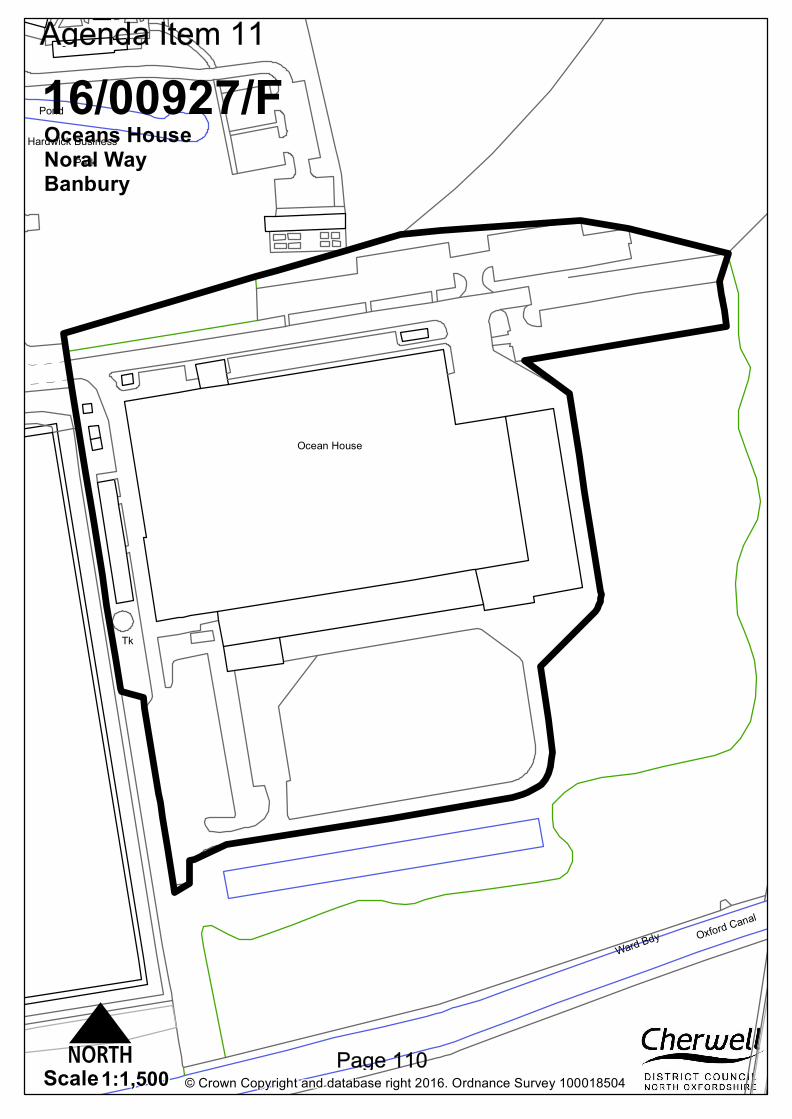
Park
Oxford Canal
Ocean House
Hardwick Business
Ward Bdy
Pond
Tk
© Crown Copyright and database right 2016. Ordnance Survey 1000185041:1,500Scale
16/00927/FOceans HouseNoral WayBanbury
N
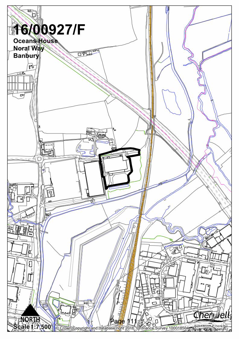
© Crown Copyright and database right 2016. Ordnance Survey 1000185041:7,500Scale
16/00927/FOceans HouseNoral WayBanbury
N
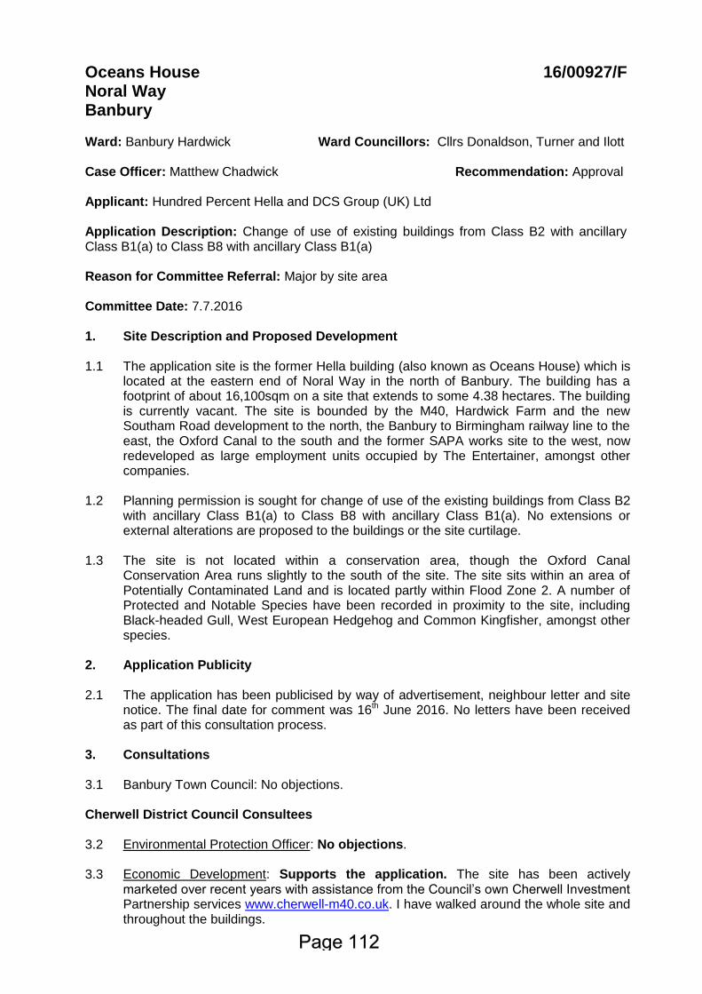
Oceans House Noral Way Banbury
16/00927/F
Ward: Banbury Hardwick Case Officer: Matthew Chadwick
Ward Councillors: Cllrs Donaldson, Turner and Ilott Recommendation: Approval
Applicant: Hundred Percent Hella and DCS Group (UK) Ltd Application Description: Change of use of existing buildings from Class B2 with ancillary Class B1(a) to Class B8 with ancillary Class B1(a) Reason for Committee Referral: Major by site area Committee Date: 7.7.2016 1. Site Description and Proposed Development 1.1
The application site is the former Hella building (also known as Oceans House) which is located at the eastern end of Noral Way in the north of Banbury. The building has a footprint of about 16,100sqm on a site that extends to some 4.38 hectares. The building is currently vacant. The site is bounded by the M40, Hardwick Farm and the new Southam Road development to the north, the Banbury to Birmingham railway line to the east, the Oxford Canal to the south and the former SAPA works site to the west, now redeveloped as large employment units occupied by The Entertainer, amongst other companies.
1.2 1.3
Planning permission is sought for change of use of the existing buildings from Class B2 with ancillary Class B1(a) to Class B8 with ancillary Class B1(a). No extensions or external alterations are proposed to the buildings or the site curtilage. The site is not located within a conservation area, though the Oxford Canal Conservation Area runs slightly to the south of the site. The site sits within an area of Potentially Contaminated Land and is located partly within Flood Zone 2. A number of Protected and Notable Species have been recorded in proximity to the site, including Black-headed Gull, West European Hedgehog and Common Kingfisher, amongst other species.
2. Application Publicity 2.1
The application has been publicised by way of advertisement, neighbour letter and site notice. The final date for comment was 16th June 2016. No letters have been received as part of this consultation process.
3.
Consultations
3.1
Banbury Town Council: No objections.
Cherwell District Council Consultees 3.2 3.3
Environmental Protection Officer: No objections. Economic Development: Supports the application. The site has been actively marketed over recent years with assistance from the Council’s own Cherwell Investment Partnership services www.cherwell-m40.co.uk. I have walked around the whole site and throughout the buildings.
3.4
I welcome this proposal and the only element that I would encourage the applicant to expand upon is to explain the occupations and skills provided by this change of use, illustrating the role that B8 logistics and supply chain management in the modern economy creates value beyond the traditional view of ‘warehousing’. The proposed re-use of this established industrial land and buildings for B-class employment uses is in accordance with the adopted Cherwell Economic Development Strategy. The Strategy seeks to create a resilient balance of employment opportunities in various sectors of activity to provide local residents with opportunities to work in the area. In particular, it seeks to enable the retention of viable employment sites for the provision of jobs. Whilst small to medium sized manufacturing companies in Banbury are seeking to expand, this particular site has proven to be too large for any one of them to occupy and no joint venture has arisen to date to accommodate shared needs. Concurrently, the logistics market in Banbury has seen higher demand in recent years but that has tended to be for purpose-built high-eaves warehouse units aimed at the investor – lessee market. By safeguarding this relatively modern building and offering it for freehold sale, the owners are to be applauded for having maintained an asset that is now readily able to accommodate the expansion needs of an owner-managed company from within the functional economic area of Banbury. DCS Ltd operates nationally from Stratford upon Avon and this relocation will enable it to move to a location and into a building that suits its current and growing needs whilst adding to Banbury’s economic vitality. DCS would be expected to not only retain many of its existing staff but also to employ others from the Banbury area in unison with the increasing number of new homes being built in the town. Planning Policy: No objections. Policy SLE1 sets out a number of policy criteria against which the application should be considered. In principle the application would comply with these criteria including making efficient use of previously developed land. The application of policies should be considered in the context of the planning history of the site (employment use) and that the application is effectively returning the building to its former use as a functioning employment site. Reflecting the National Planning Policy Framework (NPPF), the Local Plan seeks to facilitate economic growth and create jobs. The application proposals are fully consistent with the Local Plan and the NPPF in this regard. The site is in a relatively sustainable location within the built-up limits of Banbury close to existing and developing residential areas and other employment areas in the north of the town. A new B8 distribution centre (the Entertainer building) to the west has recently been constructed and is now occupied. This demonstrates that there is viable, commercial interest for employment generating development in this general location. The application proposals are on existing employment land as identified in the Local Plan 2011-2031. The principle of employment development in this location is therefore established and the site has an important role to play in the delivery of employment development to support the growth in housing at Banbury.
Oxfordshire County Council Consultees 3.5
Highways Officer: No objections. DCS Group Limited, have applied for permission to change the site use from B2 (general industrial) with ancillary B1 (office) to B8 (storage and distribution) with ancillary B1 (office). The Transport Statement submitted has shown that, due to the nature of DCS’s business and the longer working day that they will operate than the previous occupier, the number of trips in the morning and evening peak will be reduced. The applicant also states that the number of HGV trips will be reduced. Therefore, I am satisfied that this proposal will not place any extra burden on the local transport network. The applicant intends for all users to access the site at the eastern end of Noral Way. This is equipped to accommodate large commercial vehicles. There is also a 3m wide pedestrian facility on the southern side of Noral Way which leads on to the site. There is a more than sufficient amount of car parking spaces on site (the applicant states that 169 car parking spaces are required, but the site can accommodate 273 spaces). Paragraph 8.9 of the Transport Statement mentioned that the site has two covered cycle racks with space for 24 bicycles. The applicant describes these, but does not describe the changing facilities mentioned in the title to this section. Changing facilities will complement the secure cycle storage provided. This is particularly important, as Banbury town centre is within 5k of the site, and there is a reasonable cycle route from here to the site through Spiceball Park and along Southam Road. The site is located immediately south of a proposed residential development of 600 dwellings and a new primary school. The applicant needs to provide a pedestrian and cyclist link between this site and the other proposed development. This might attract new members of staff and further reduce the number of short-distance car journeys to work. Pedestrian and cycle links from the site southwards to Banbury town centre and Railway Station are reasonable. People can either travel through Spiceball Park on to the A361 Southam Road, which has a 3m wide pedestrian and cycleway on the west side and a 1.5m wide pedestrian facility on its eastern side. Pedestrians can also use the towpath that runs to the east of the canal, and can cross the canal on to the pedestrian facility on the western side of Southam Road. However, the applicant might wish to consider providing another crossing of the canal further eastwards closer to the south of the site. The site is not well served by public transport. The nearest bus stop is located on the A361 Southam Road, approximately 800m from the site. It is difficult to see how bus services to and from the site could be improved due to the cul-de-sac nature of it. However, I strongly advise the applicant provide a staff shuttle bus service from Stratford to the site if this is where the bulk of the initial workforce will come from. Our Travel Plan team look forward to reading more about this proposal in the travel plan mentioned above. As of July 2016, services 277 and 503 will no longer operate in the Banbury area. However, a large residential development immediately north of the site is due to come on stream in 2017. A new bus service will operate between this site and Banbury town centre. We would need an additional financial contribution to help meet the cost of operating one early morning trip and one late evening trip to ensure that employees working these shifts and needing to get from Banbury town centre and residential areas to the site can do so by public transport. Suggested conditions: Pedestrian and Cyclist Access from the North of the Development and a Workplace Travel-Plan. Suggested Legal Agreement to secure improvements to public transport, pedestrian and cycle links to the site.
Other Consultees 3.6
Environment Agency: No comments received.
4.
Relevant National and Local Policy and Guidance
4.1
Development Plan Policy
Cherwell Local Plan (2011-2031) Part 1
PSD1: SLE1: SLE4: ESD1: ESD6: ESD15: ESD16:
Presumption in Favour of Sustainable Development Employment Development Improved Transport and Connections Mitigating and Adapting to Climate Change Sustainable Flood Risk Management The Character of the Built and Historic Environment The Oxford Canal
Cherwell Local Plan 1996 (Saved Policies)
C28: C30: ENV12:
Layout, design and external appearance of new development Design Control Development on contaminated land
4.2 Other Material Policy and Guidance National Planning Policy Framework (2012)
Planning Practice Guidance (2014)
5. Appraisal 5.1
The key issues for consideration in this application are:
Relevant Planning History;
Principle of Development;
Effect on Visual Amenity;
Effect on Residential Amenity;
Transport and Highways Safety;
Flood Risk;
Planning Balance. 5.2 5.3 5.4 5.5
Relevant Planning History 95/01458/OUT – New production plant and offices for the manufacture of motor vehicle lighting and associated components – Approved. 96/00184/REM – New production plant, vehicle hall and offices for the manufacture of motor vehicle lighting and associated components. Construction of a new vehicular and pedestrian access. Temporary site access north of Hardwick Cottages – Approved. 09/00097/F – Change of use of existing buildings from class B2 and ancillary B1(A) to flexible uses: use class B2 and/or B8 and ancillary B1(a) – Approved. 11/01868/F – Refurbishment of premises to include changes to external appearance of the building, and new entrance and gatehouse totalling 175sqm. External changes involving new car parking, hard standing, landscaping, footpaths and amenity areas – Approved.
5.6 5.7 5.8 5.9 5.10 5.11 5.12 5.13
Principle of Development Paragraph 14 of the National Planning Policy Framework states that a presumption of sustainable development should be seen as a golden thread running through decision taking. There are three dimensions to sustainable development, as defined in the NPPF, which require the planning system to perform economic, social and environmental roles. These roles should be sought jointly and simultaneously through the planning system. The application site is located within an existing Strategic Employment Site as indicated on the Key Policies Map for Banbury in the Cherwell Local Plan 2011 – 2031 Part 1. Policy SLE1 of the Cherwell Local Plan 1996 states a number of criteria that employment proposals in Banbury, Bicester and Kidlington should meet. These include that proposals are within the built up limits of the settlement, make efficient use of existing and underused premises and sites, and have good access including by sustainable transport modes. This proposal would meet those criteria as it is located within the built-up limits of the town and would make efficient use of a previously developed employment site that is currently vacant. The application seeks to change the use of the site from Class B2 with ancillary Class B1(a) to Class B8 with ancillary Class B1(a). It is notable that this scheme is essentially a resubmission of a previously approved scheme from 2009 (ref: 09/00097/F), which sought for a change of use of existing buildings from class B2 and ancillary B1(A) to flexible uses: use class B2 and/or B8 and ancillary B1(a) and was approved by Planning Committee. The applicants are DCS Group. The company are currently based in Stratford-upon-Avon and employ 292 people on the site as of April 2016. DCS is the UK sales and distribution company for a number of major health, beauty and household brands, such as Gillette, Colgate and Unilever. The company also has a manufacturing arm, though this is to remain in Stratford-upon-Avon and is not covered by this application. The company plan to move to the site at Noral Way as this would give them more warehouse storage space, more space to park lorries and trailers which are vital for their distribution services and will also offer a significant amount of office space for the business. As previously stated, in April 2016 DCS Group employed 292 people. This total consisted of 4 Directors, 113 people working in administrative roles, 130 working in selling and distribution roles and 45 in production. The manufacturing arm makes up 63 of these jobs, bringing the total number of potential jobs to be brought into the District under this application to 229. The development would not only be policy compliant but would also deliver an economic benefit to Banbury by bringing back a currently vacant site into employment use and bringing a significant number of jobs into the town. The development is therefore considered to comply with Policies PSD1, SLE1 and SLE2 and Government guidance contained within the NPPF. Effect on Visual Amenity Government guidance contained within the NPPF requiring good design states that good design is a key aspect of sustainable development, is indivisible from good planning, and should contribute positively to making places better for people. Further, permission should be refused for development of poor design that fails to take the opportunities for improving the character and quality of an area and the way it functions. Policy ESD15 of the Cherwell Local Plan Part 1 states that: “New development will be expected to complement and enhance the character of its context through sensitive siting, layout and high quality design. All new development will be required to meet high
5.14 5.15 5.16 5.17 5.18 5.19 5.20 5.21
design standards.” No external changes are proposed to the building or its curtilage; this application is for a change of use only. Therefore, it is considered that the development would not detract from the visual amenities of the locality and would therefore comply with Policy ESD15 of the Cherwell Local Plan 2011 – 2031 Part 1, Saved Policies C28 and C30 of the Cherwell Local Plan 1996 and Government guidance contained within the NPPF. Effect on Residential Amenity Policy ESD15 of the Cherwell Local Plan 2011 – 2031 Part 1 states that new development proposals should consider amenity of both existing and future development, including matters of privacy, outlook, natural lighting, ventilation and indoor and outdoor space. The Environmental Protection Officer has offered no objections to the application. The Southam Road development, which is currently being constructed, is located to the north of the site at a minimum distance of approximately 120m and has been designed so as to take account of the relationship with the employment land to the south. The building is located within an existing industrial area and therefore it is considered that the proposed change of use would not have a detrimental impact on the residential amenity of neighbouring properties. The proposals would therefore comply with Policy ESD15 of the Cherwell Local Plan 2011 – 2031 Part 1, Saved Policies C30 and ENV1 of the Cherwell Local Plan 1996 and Government guidance contained within the National Planning Policy Framework. Transport and Highways Safety One of the criteria stated in Policy SLE1 is that employment proposals should have good access, including by public transport and other sustainable transport modes. The Transport Planner is satisfied that the proposal would not place any added burden on the local transport network and states that there is sufficient parking on the site as well. In this respect, the proposal is considered acceptable in highway safety and parking terms. The Transport Planner has requested a link between the application site and the Southam Road development to the north. This comment is noted, however the Southam Road development has a link to Noral Way currently planned but is separated from Noral Way by land that is not under the ownership of either the developer or the landowners of Ocean House. Furthermore it must be remembered that Ocean House is an existing employment building and what is proposed is a change of use of the existing building, not additional employment development. As such whilst it would be desirable for the creation of a link between the building and the new development, it would not be reasonable to insist on this as a condition of granting permission. The Transport Planner has also asked for a financial contribution to meet the cost of operating one early morning trip and one late evening trip of bus services to Banbury town centre. Once again, this would be desirable however it would not be reasonable to insist on this contribution as the proposal is not for a new building; it would be possible for a business to move in to the premises and operate a B2 use under the current permission. Therefore, with the Transport Planner’s comments that the development would have sufficient parking and would not detrimentally impact on the local transport network, and taking account of the existing employment use of the building, it is considered that the proposal would not have a detrimental impact on Highway Safety in accordance with Government guidance contained within the National Planning Policy Framework.
5.22 5.23
Flood Risk A small part of the site in the southwest corner is located within Flood Zones 2 and 3. The Environment Agency has been consulted, but has not commented on the application. The proposal would not involve any operational development and would not result in a more vulnerable use (in flood risk terms) than the current B2 use. Furthermore it should be noted that planning permission has previously been granted for a change of use to B8 on this site, and flood risk was considered acceptable at that time. It is therefore considered that the development would not present a detrimental risk in respect of flooding and would comply with Policy ESD6 and government guidance contained within the NPPF. Planning Balance Paragraph 7 of the NPPF identifies that there are three dimensions to sustainable development: economic, social and environmental. It is considered that the proposed change of use would offer considerable economic benefits to both Banbury and the wider Cherwell District, by bringing a vacant employment site back into use and providing circa 200 jobs within the town. The application site is located within an industrial area and is identified within the Cherwell Local Plan 2011 – 2031 Part 1 as an existing Strategic Employment Site. There are no significant social, economic or environmental impacts which would weigh against the scheme. Therefore, it is considered that the proposed change of use is sustainable development, in accordance with the NPPF and the Development Plan, and is considered to be acceptable.
5.24
Engagement With regard to the duty set out in paragraphs 186 and 187 of the Framework, where problems or issues have arisen during the application these have been discussed with the applicant’s agent. It is considered that the duty to be positive and proactive has been discharged through the efficient and timely determination of the application.
Conclusion
5.25 The application site is located within the built-up limits of Banbury and is an existing
vacant employment unit. It is considered that the proposed change of use would make efficient use of previously-developed land and would not have a detrimental impact on the visual amenities of the locality, residential amenity of neighbouring properties or on the local highway network. It is therefore considered that the development is acceptable, subject to the conditions set out below.
6.
Recommendation Approval, subject to the following conditions: 1. The development to which this permission relates shall be begun not later than
the expiration of three years beginning with the date of this permission.
Reason - To comply with the provisions of Section 91 of the Town and Country Planning Act 1990, as amended by Section 51 of the Planning and Compulsory Purchase Act 2004.
2. Except where otherwise stipulated by condition, the development shall be carried
out strictly in accordance with the following plans and documents: Application Forms, Transport Statement and Drawing Numbers: SL-P-05 submitted with the
application.
Reason - For the avoidance of doubt, to ensure that the development is carried out only as approved by the Local Planning Authority and to comply with Government guidance contained within the National Planning Policy Framework.
3. Prior to the first occupation of the site, a full workplace Travel Plan shall be
submitted to and approved in writing by the Local Planning Authority. Thereafter, the Travel Plan shall be implemented in accordance with the approved details. Reason - In the interests of sustainability, to ensure a satisfactory form of development and to comply with Policies SLE1, SLE4, and ESD1 of the Cherwell Local Plan 2011-2031 Part 1 and Government guidance contained within the National Planning Policy Framework.
4. No goods, materials, plant or machinery shall be stored, repaired, operated or displayed in the open without the prior submission of details and approval in writing by the Local Planning Authority. Reason – In order to safeguard the visual amenities of the area in accordance with Policy ESD15 of the Cherwell Local Plan 2011 – 2031 Part 1, Saved Policy C28 of the Cherwell Local Plan 1996 and Government guidance contained within the NPPF.
PLANNING NOTE
1. With regard to condition 3, the Travel Plan should include a timetable for monitoring the implementation of the Plan, including the submission of monitoring reports to Oxfordshire County Council’s Travel Plans Team. It should also include details of a Travel Information Pack to be issued to employees on the site. For further advice and guidance about the Travel Plan and Information Pack, please contact the Travel Plan Team at: [email protected].
STATEMENT OF ENGAGEMENT In accordance with the Town and Country Planning (Development Management Procedure) (England) Order 2015 and paragraphs 186 and 187 of the National Planning Policy Framework (March 2012), this decision has been taken by the Council having worked with the applicant/agent in a positive and proactive way. It is considered that the duty to be positive and proactive has been discharged through the efficient and timely determination of the application.
CASE OFFICER: Matthew Chadwick TELEPHONE: 01295 223754
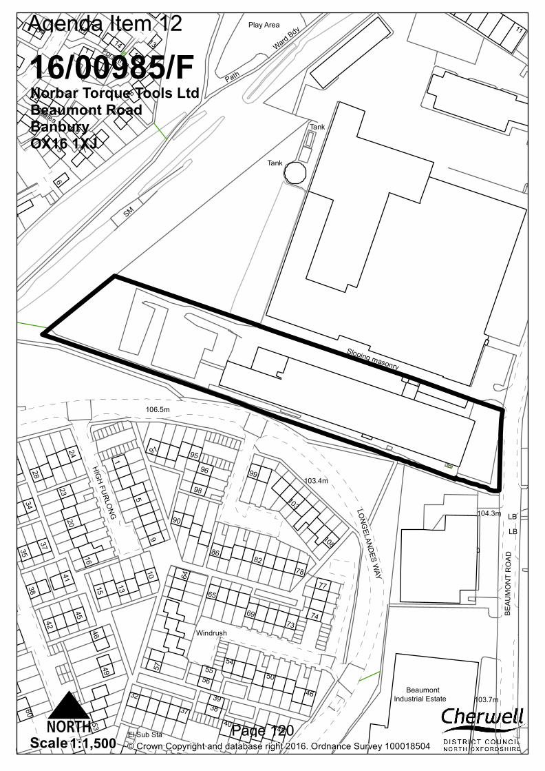
Windrush
BeaumontIndustrial Estate
103.4m
104.3m
103.7m
106.5m
HIGH FURLONG LONGELANDES WAY
BEAU
MONT
ROA
D
11
Azalea
Ward BdyPlay Area
Forsythia
Tank
1
9
46
54
5
91
7473
39
10
23103
108
8
3742
77
32
12
53
99
56
16
3438
2045 69
4124
6090
3
35
50
82
65
64
1314
49
17
98
15
57
28
86
55
9695
78
4
6
40
7
Sloping masonry
LB
El Sub Sta
Path
SM
LB
8
5
Tank
38
54
37
12
1
46
45
13
© Crown Copyright and database right 2016. Ordnance Survey 1000185041:1,500Scale
16/00985/FNorbar Torque Tools LtdBeaumont RoadBanburyOX16 1XJ
N
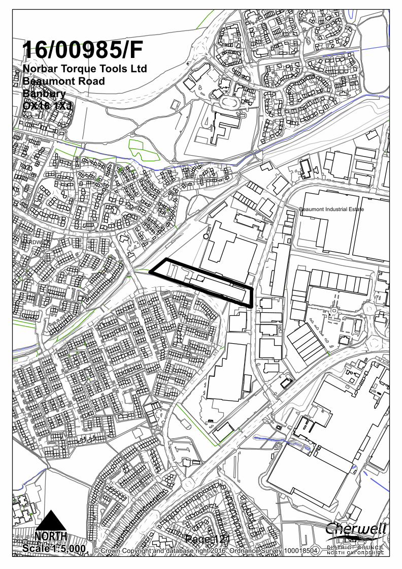
6
HARDWICK
Beaumont Industrial Estate
© Crown Copyright and database right 2016. Ordnance Survey 1000185041:5,000Scale
16/00985/FNorbar Torque Tools LtdBeaumont RoadBanburyOX16 1XJ
N
16/00985/F Site Address: Norbar Torque Tools Ltd. Beaumont Road, Banbury Ward: Banbury Cross and Neithrop District Councillor: Cllr Banfield; Cllr Dhesi; Cllr Milne Home Case Officer: Bob Duxbury Recommendation: Approval Applicant: Norbar Torque Tools Holding Ltd. Application Description: Proposed Change of use from B2 to B1, B2 and B8 Committee Referral : major application Committee Date: 7 July 2016
1. Site Description and Proposed Development 1.1 This application relates to the building currently occupied by Norbar Tools on
the western side of Beaumont Road about 250 metres from its junction with Ruscote Avenue. The proposal is to change the use of the building from its current use as an engineering factory with ancillary offices and storage, to a flexible B1, B2 and B8 use to allow ifs use by an incoming business proposing to use the building predominantly for the storage and distribution of flour.
1.2 The case officer has spoken with the incoming company, FWP Matthews of
Shipton under Wychwood, to ascertain their intentions. They are intending to retain their main milling use at Shipton and move their current storage and distribution activities from a site near Chipping Norton to Banbury. Initially this will be a B8 use, but they may in the future relocate some of their packaging activities to this site, hence the desire to retain a B1 and B2 use
1.3 They seek the ability to use the building from 5.00am to 9.00pm on all days, although it has been explained that their standard warehousing hours are currently 6.00am to 5.00pm Monday to Friday. This intended pattern of activity compares favourably to the existing Norbar use which is a 24 hour operation Monday-Thursday (albeit with downtime between 5.00pm and 9.00pm), and 7.00am to 7.00pm Friday to Sunday.
1.4 Part of the site has a boundary with the northern side of Longelandes Way, and hence there are some residential properties within about 40 metres of the site
2. Application Publicity
2.1 Individual letters were sent to residential properties fronting onto Longelandes Way and to adjacent commercial occupiers in Beaumont Road.
No comments have been received
3. Consultations 3.1 Town Council: No comments received
Cherwell District Council Consultees 3.2 Economic Growth Officer
The proposed extension of the use classes (from B1 to B1, B2 and B8) would in principle not conflict with the adopted Cherwell Economic Development Strategy. Retention of the site and premises for b-class employment uses is the important matter and the proposal would provide for the early occupation of the building to maintain its condition and employment opportunities at this location. The mention of 'storage of flour' and 'supporting a local business' deserves some elaboration, as I would imagine that the proposal could make a valuable contribution to a range of employment opportunities and support local supply-chains. This could be useful to illustrate as part of this application. Overall, I welcome the proposal to re-use the premises for business activity and would support the proposal.
Oxfordshire County Council Consultees
3.3 Transport
Objection – on the grounds of lack of information concerning trip generation, highway impacts, parking and turning areas for cars and HGVs, and waste collection arrangements. Key issues:
this proposal as one business.
of commercial waste. Trip Generation The applicant seeks permission for the change of use of an existing site from B1 usage, in the form of research and development to inform the design and manufacturing of tools, to B1, B2 and B8, in the form of flour distribution and storage. The applicant states that the number of trips and therefore the overall burden on the local highway network will be reduced, but has not provided any statistical evidence to support this statement. In particular, more evidence is needed as to the likely number of HGV trips the newly proposed use will generate. Local feedback and observations have informed Oxfordshire County
Council that HGV parking on Beaumont Road disrupts the flow of traffic and can create congestion. Because of the size of the site in square metres, the applicant will need to submit a full transport assessment. In particular, the applicant should submit a projection of the number of trips the newly used site will generate per day in the AM and PM peak. Although it is not the only statistical method used, many applicants use TRICS, an internationally recognised trip generation analysis tool. On-site Car, Van, and HGV Parking The applicant states that the site contains 69 parking spaces for 25 employees but does not say how many of these are for cars and how many for HGVs, where they are/will be, and does not give details of the existing access to be used and whether this can accommodate HGVs are large waste collection vehicles. The applicant must submit a plan, in A1 or A3 format with a scale, which displays the proposed access and gives the exact location of the parking spaces, for both cars and HGVs, and the loading bays for HGVs (these might be the same as the parking bays). This will help show that the applicant can minimise the risk of more HGVs parking on Beaumont Road and disrupting the flow of local traffic. Alongside the main site plan, the applicant should submit vehicle tracking analysis that describes the dimensions of the HGVs and commercial waste collection vehicles the site will have to accommodate, and will have to show that the turning head(s) and loading bays can accommodate these vehicles. On-site Cycle Parking The applicant will need to show that they have considered how they will encourage employees to travel to and from the site by sustainable modes of transport in their travel plan. The applicant should provide secure cycle parking spaces. Waste Disposal Arrangements The applicant is advised to submit a Design and Access Statement alongside their planning application. In this, they should state what the intended arrangement is regarding the collection of commercial waste..
4. Relevant National and Local Policy and Guidance 4.1 Development Plan Policy
Cherwell Local Plan 2011-2031 Part 1: The Cherwell Local Plan 2011-2031 - Part 1 was formally adopted by Cherwell District Council on 20th July 2015. The Plan was the subject of an independent examination conducted by an Inspector appointed by the Secretary of State. The Inspector’s report was published on 12th June 2015 and the recommended main modifications required to make the Plan sound have been included in the adopted plan. The Plan provides the strategic planning policy framework and sets out strategic site allocations for the District to 2031. Now adopted, the Plan forms
part of the statutory Development Plan and the basis for decisions on land use planning affecting Cherwell District. The Local Plan 2011-2031 – Part 1 replaces a number of the saved policies of the 1996 adopted Cherwell Local Plan. Those saved policies of the 1996 adopted Cherwell Local Plan which are retained remain part of the Development Plan. These are set out in Appendix 7 of the Local Plan 2011-2031. Planning law requires that applications for planning permission must be determined in accordance with the Development Plan unless material considerations indicate otherwise. The following policies are considered to be relevant:- Policy PSD1 Presumption in Favour of Sustainable Development Policy SLE1 Employment Development Policy SLE4 Improving Transport and connections Policy ESD10 Protection of Biodiversity Policy ESD15 The Character of the Built Environment
4.2 Other Material Policy and Guidance
National Planning Policy Framework
Planning Practice Guidance Non-Statutory Cherwell Local Plan 2011 Whilst some policies within the plan may remain to be material considerations, other strategic policies have in effect been superseded by those in the Submission Local Plan (October 2014). The main relevant policies to consider are as follows:- Policy EMP4 Existing employment sites
5. Appraisal 5.1 The key issues for consideration in this application are:
Planning Policy and the Principle of Development
Transport Assessment and Access
Car parking
Residential amenity
Planning Policy and Principle of Development 5.2 The Development Plan for Cherwell District comprises the recently adopted
Cherwell Local Plan 2011-2031 and the saved policies in the Adopted Cherwell local Plan 1996. Section 70(2) of the Town and Country Planning
Act 1990 provides that in dealing with applications for planning permission the Local Planning Authority shall have regard to the provisions of the development plan, so far as is material to the application, and to any other material considerations. Section 38(6) of the Planning and Compulsory Purchase Act 2004 requires that if regard is to be had to the development plan for the purposes of any determination to be made under the Planning Acts, the determination must be made in accordance with the development plan unless material considerations indicate otherwise.
5.2 The NPPF sets out the economic, social and environmental roles of planning
in seeking to achieve sustainable development: contributing to building a strong, responsive and competitive economy; supporting strong, vibrant and healthy communities; and contributing to protecting and enhancing our natural, built and historic environment (paragraph 7). It also provides (paragraph 17) a set of core planning principles which amongst other things require planning to:
Be genuinely plan led, empowering local people to shape their surroundings and to provide a practical framework within which decisions on planning applications can be made with a high degree of predictability and efficiency
Proactively drive and support sustainable economic development
Always seek to secure high quality design and a good standard of amenity for all existing and future occupants of land and buildings
Support the transition to a low carbon future in a changing climate
Encourage the effective use of land by re-using land that has been previously developed
Promote mixed use developments
Conserve heritage assets in a manner appropriate to their significance
Actively manage patterns of growth to make the fullest possible use of public transport, walking and cycling and focus significant developments in locations which are, or can be made sustainable
Deliver sufficient community and cultural facilities and services to meet local needs
5.3 The NPPF at paragraph 14 states ‘At the heart of the National Planning Policy
Framework is a presumption in favour of sustainable development, which should be seen as a golden thread running through both plan making and decision taking’….For decision taking this means:
Approving development proposals that accord with the development plan without delay; and
Where the development plan is absent, silent or relevant policies are out of date, granting permission unless;
Any adverse impact of doing so would significantly and demonstrably outweigh the benefits, when assessed against the policies in this Framework taken as a whole, or
Specific policies in this framework indicate development should be restricted
5.4 This site is an established employment site to which Policy SLE 1 of the adopted Local Plan applies. This policy supports existing businesses and indicates (in para B.38) that the Council will seek to ensure that operational activity is not compromised wherever possible. The policy includes the following section re the assessment of employment proposals in Banbury, Bicester and Kidlington
Employment proposals at Banbury, Bicester and Kidlington will be supported if they meet the following criteria:
Are within the built up limits of the settlement unless on an allocated site
They will be outside of the Green Belt, unless very special circumstances can be demonstrated
Make efficient use of previously-developed land wherever possible
Make efficient use of existing and underused sites and premises increasing the intensity of use on sites
Have good access, or can be made to have good access, by public transport and other sustainable modes
Meet high design standards, using sustainable construction, are of an appropriate scale and respect the character of its surroundings
Do not have an adverse effect on surrounding land uses, residents and the historic and natural environment.
This proposal meets all these criteria and is considered acceptable in policy terms
Transport assessment 5.5 It will be noted at 3.3 above that OCC object as highway authority. On trip
generation I am content that the Council has adequate information about possible HGV and car movements. It is estimated that 10-15 HGV movements would occur per day from this site, either of their own fleet or those of suppliers/hauliers. If packaging were moved across from Chipping Norton this could add a small number additional bulk tanker movements per week. This is not significantly different to the existing traffic flows.
In car terms there will be significantly fewer employees based on this site with the new use – only 25 warehouse staff
The applicants are content that by making use of one of the rear car parks for the turning of HGVs that all HGV movements will be able to enter and leave the site in forward gear, thereby eliminating the risk of reversing manoeuvring on the street
Car parking 5.6 The site has over 60 car parking spaces, some to the front of the building and
at two levels on the sloping land to the rear. Even with one car park utilised as HGV turning (as referred to above) adequate parking will remain
Residential Amenity
5.7 This site borders on its southern side to Longelandes Road, which has fifteen houses facing the site at 40-50 metres distance. The site has a good extent of boundary planting of trees and hedgerow shrubs, which at this time of year are an effective screen.
The storage use of the site is a relatively quiet use, with all loading and unloading taking place on the far side of the building from these houses. Activities in the building, such as the use of forklifts will be largely inaudible from off site, and would be quieter than the machining equipment etc currently used. Officers are content that this use will be less harmful than the current use.
Engagement 5.38 With regard to the duty set out in paragraphs 186 and 187 of the Framework,
no problems or issues have arisen during the application. It is considered that the duty to be positive and proactive has been discharged through the efficient and timely determination of the application.
6. Recommendation Approval, subject to:
a) the following conditions:
1. The development to which this permission relates shall be begun not later than the expiration of three years beginning with the date of this permission.
Reason - To comply with the provisions of Section 91 of the Town and
Country Planning Act 1990, as amended by Section 51 of the Planning and
Compulsory Purchase Act 2004
2. Except where otherwise stipulated by condition, the development shall be carried out strictly in accordance with the following plans and documents: Application forms and site plan
Reason - For the avoidance of doubt, to ensure that the development is carried out only as approved by the Local Planning Authority and to comply with Government guidance contained within the National Planning Policy Framework.
3. Prior to it’s installation, full details of any new external lighting to be provided in the car parking areas or on the building shall be submitted to and approved in writing by the Local planning Authority. Thereafter, the lighting shall be carried out and retained in accordance with the approved details. Reason - To ensure the satisfactory appearance of the completed development and to comply with Policy C28 of the Cherwell Local Plan and Government guidance contained within the National Planning Policy Framework
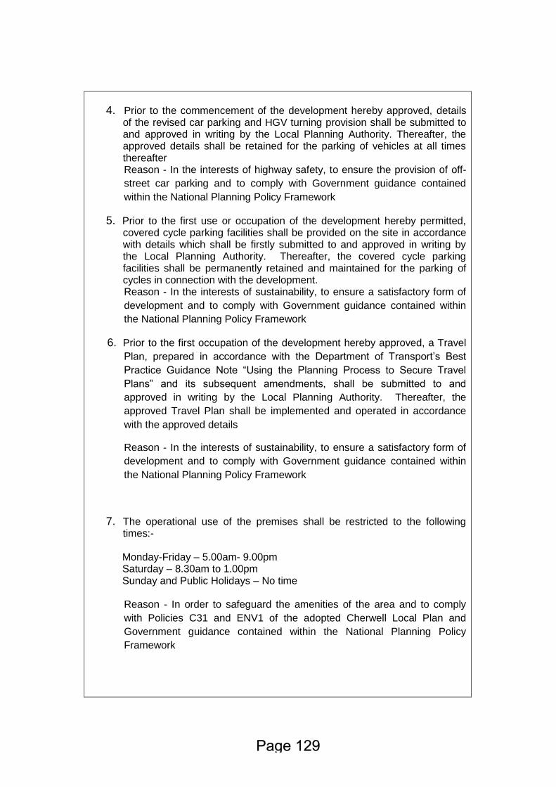
4. Prior to the commencement of the development hereby approved, details of the revised car parking and HGV turning provision shall be submitted to and approved in writing by the Local Planning Authority. Thereafter, the approved details shall be retained for the parking of vehicles at all times thereafter Reason - In the interests of highway safety, to ensure the provision of off-
street car parking and to comply with Government guidance contained
within the National Planning Policy Framework
5. Prior to the first use or occupation of the development hereby permitted, covered cycle parking facilities shall be provided on the site in accordance with details which shall be firstly submitted to and approved in writing by the Local Planning Authority. Thereafter, the covered cycle parking facilities shall be permanently retained and maintained for the parking of cycles in connection with the development. Reason - In the interests of sustainability, to ensure a satisfactory form of
development and to comply with Government guidance contained within
the National Planning Policy Framework
6. Prior to the first occupation of the development hereby approved, a Travel
Plan, prepared in accordance with the Department of Transport’s Best
Practice Guidance Note “Using the Planning Process to Secure Travel
Plans” and its subsequent amendments, shall be submitted to and
approved in writing by the Local Planning Authority. Thereafter, the
approved Travel Plan shall be implemented and operated in accordance
with the approved details
Reason - In the interests of sustainability, to ensure a satisfactory form of
development and to comply with Government guidance contained within
the National Planning Policy Framework
7. The operational use of the premises shall be restricted to the following times:-
Monday-Friday – 5.00am- 9.00pm Saturday – 8.30am to 1.00pm Sunday and Public Holidays – No time
Reason - In order to safeguard the amenities of the area and to comply
with Policies C31 and ENV1 of the adopted Cherwell Local Plan and
Government guidance contained within the National Planning Policy
Framework

Statement of Engagement
In accordance with the Town and Country Planning (Development Management
Procedure) (England) (Amendment No 2) Order 2012 and paragraphs 186 and 187
of the National Planning Policy Framework (March 2012), this decision has been
taken by the Council having worked with the applicant/agent in a positive and
proactive way as set out in the application report.
Cherwell District Council
Planning Committee
7 July 2016
OS Parcel 0070 adjacent and north of A41 London Road, Bicester
Application Number 16/00861/HYBRID
Report of Head of Development Management
This report is public
Purpose of report To notify members of the receipt of this application relating to the strategic allocation at SE Bicester and for Members to consider whether they wish to have a Formal Site Visit prior to 4 August Committee meeting.
1.0 Recommendations
The meeting is recommended to:
1.1 Consider whether Members would like to undertake a Formal Site Visit prior to the Planning Committee Meeting on 4 August 2016 when the application will be before Members for determination.
2.0 Report Details 2.1 A Hybrid application has been submitted for B8 purposes on land adjacent
to London Road, Bicester and is submitted with the following description of development: ‘Full planning permission for 20,067 sqm (216,000 sq ft) of logistics floorspace, within Class B8 of the Town and Country Planning Use Classes Order 1987, with ancillary class B1(a) offices, together with access from A41 Aylesbury Road, associated site infrastructure including lorry parking, landscaping, amenity open space and sustainable drainage and private sewage treatment plant; and, Outline planning permission for up to 44,965 sqm (484,000 sq ft) of logistics floorspace, within Class B8 of the Town and Country Planning Use Classes Order 1987, with ancillary Class B1(a) offices together with associated site
infrastructure including lorry parking, landscaping, amenity open space, sustainable drainage and private sewage treatment plant. Details of the means of access from A41 Aylesbury Road are included for approval’ Site Context
2.2 The application site extends to approximately 16.4 hectares (40.57 acres) and is located on the northern side of the A41 to the south east of Bicester. The site consists of three agricultural fields, predominantly used as grazing land. An existing agricultural building on the land is accessed directly from the A41. The fields are bound by well-defined hedgerows. The site is bounded by open countryside to its northern and eastern boundaries.
2.3 Bordering the western boundary of the site, but outside the site is a pair of small two storey cottages (Wretchwick Cottages). An existing public right of way extends northwards immediately along the western boundary.
2.4 The application site is divided into two zones, the eastern smaller part of the site (zone 1) is the part of the site for which full planning permission is sought for the erection of two B8 buildings. Outline planning permission only is sought for the remainder of the site (zone 2). The new vehicular access into the site from A41 is also included in the detailed application.
Policy Context
2.5 The application site forms part of the strategic land allocation under Policy Bicester 12 in the adopted Cherwell Local Plan (Part 1) 2011-2031 for mixed use development, including 1,500 homes and 40 hectares of employment land. Policy Bicester 12 in referring to the employment to be accommodated on the site identifies the site as being suitable for B1, B2 and B8 uses (primarily B8). The remainder of the Bicester 12 allocation is yet to come forward for development and to date no application has been received.
2.6 This is a major application on part of the strategic allocation under Policy Bicester 12 which has generated a significant amount of local interest. The applicants are eager to deliver the employment uses on the site in advance of the remainder of Bicester 12 coming forward and are anxious to avoid any delays in the determination of the application. Should Members consider therefore that a Formal Site Visit might be appropriate, you are invited to consider doing so prior to the Planning Committee Meeting on 4th August 2016.
3.0 Consultation 3.1 None

4.0 Alternative Options and Reasons for Rejection 4.1 The following alternative option have been identified and rejected for the
reasons as set out below: Option 1: To agree to the holding of a formal site visit before the next
planning committee Option 2: Not to have a formal site visit
5.0 Implications
Financial and Resource Implications 5.1 There are no additional financial implications arising for the Council from
this report. Comments checked by:
Kate Crussell, Principal Accountant, 01327 322188, [email protected] Legal Implications
5.2 There are no additional legal implications arising for the Council from this report.
Comments checked by:
Nigel Bell, Team Leader – Planning, 01295 221687, [email protected]
Risk Management 5.3 None Comments checked by:
Nigel Bell, Team Leader – Planning, 01295 221687, [email protected]
6.0 Decision Information
Wards Affected: Ambrosden and Chesterton
Document Information
Background Papers
None
Report Author Linda Griffiths – Principal Planning Officer
Contact Information
01295 227998, [email protected]
Cherwell District Council
Planning Committee
7 July 2016
Appeals Progress Report
Report of Head of Development Management
This report is public
Purpose of report This report aims to keep members informed upon applications which have been determined by the Council, where new appeals have been lodged. Public Inquiries/hearings scheduled or appeal results achieved.
1.0 Recommendations
The meeting is recommended: 1.1 To accept the position statement.
2.0 Report Details New Appeals
2.1 15/00758/F – Land Adjacent to Esso Station, Baynards Green, OX27 7SG. Appeal by McDonald's Restaurant Ltd against the refusal planning permission for freestanding single storey restaurant with associated drive-thru, car parking and landscaping; installation of customer order display and canopy.
15/01515/F – 172 Mill Street, Kidlington, OX5 2EE. Appeal by Mr Jamshidifard
against the refusal of planning permission for insertion of window (existing unauthorised).
15/01724/F – Bicester Furniture Studio, 24 Church Street, Bicester, OX26 6AZ.
Appeal by Papa John's (GB) Ltd against the refusal of planning permission for a change of use from a shop (Use Class A1) to a hot food takeaway (Use Class A5) with internal and external alterations.
15/02353/OUT – S and S Motors, Rear of 63 Ploughley Road, Arncott, Bicester, OX25 1NY. Appeal by Mr & Mrs Ivetic against the refusal of planning permission for redevelopment of site for the erection of nine new 2-storey open market dwellings, with associated parking spaces and upgraded access.
16/00205/LB – 2 Tithe Barn, Street Through Merton, Merton, Bicester, OX25
2NF. Appeal by Mr Stubbs against the refusal of listed building consent for replacement of all first floor windows.
16/00206/LB – 1 Tithe Barn, Street Through Merton, Merton, Bicester, OX25
2NF. Appeal by Dr Roy levers against the refusal of listed building consent for the replacement of 7 wooden windows with double glazed units.
16/00657/OUT – Jack Barn, West End, Launton, OX26 5DG. Appeal by Mr
Howson against the refusal of outline planning permission for the erection of 2 No. dwellings – re-submission of 15/02006/OUT.
2.2 Forthcoming Public Inquires and Hearings between 7th July and 4th August 2016. None. 2.3 Results
Inspectors appointed by the Secretary of State have: 1) Dismissed the appeal by Mr J Baguley against refusal of planning
permission for proposed second floor extension with associated internal and external works. 17 and 18 East Street, Banbury, OX16 3LL. 15/01425/F. (Delegated). Planning permission was sought for a ‘second floor extension with associated internal and external works’ for both properties 17 & 18 East Street in Banbury. The site is wholly within the Grimsbury Conservation Area, and the main issue was the effect of the proposed development on the character and appearance of the Grimsbury Conservation Area. The appeal was dismissed. The Inspector found that the proposal would significantly increase the mass of building above the existing eaves resulting in the loss of a significant gap in the roof line on this stretch of East Street and the loss of strong chimney forms. Although the Inspector found there would still be a small step in ridge heights between Nos. 18 and 19, the Inspector concluded that, ‘the characteristic varied and undulating historic roof form would be lost as the appeal properties are the only two storey dwellings in this section of otherwise three storey properties’. The Inspector stated that, ‘whilst increasing the height and changing the roof pitch in this case may appear minor, incremental changes can have a significant effect on the significance of a heritage asset’. The Inspector was not convinced matching materials could be found so as not to appear incongruous within the street scene.
The Inspector concluded at paragraph 11 that ‘the proposed development would detract from the historic representation of an important period in the history of Banbury. This would amount to less than substantial harm to the significance of the designated CA as a whole’, and that there were no material public benefits arising as a direct consequence of the development and therefore the harm identified was not outweighed by any identifiable overriding public benefit. As a point of interest, the appellants drew attention to something similar at 102 Causeway. The Inspector visited, noted that it did nothing to change his/her mind and concluded: “there are other similar circumstances in the CA where proposals to increase roof heights may come forward. Whilst each planning proposal and appeal must be considered on its own merits I consider the granting of permission in this case may well make it more difficult for the Council to resist similar proposals in the future further eroding the historic character and appearance of the CA”.
2) Dismissed the appeal by B A Property Management Ltd against the refusal of outline planning permission for development of No. 5 dwellings. The Tally Ho Inn, 45 Ploughley Road, Arncott, Bicester, OX25 1NY. 15/01454/OUT. (Delegated).
The site is located within the over flow car park of the Tally Ho Hotel. The development proposed was 5 dwellings each with 2 car parking spaces and the retention of and revised layout of parking ancillary to the Tally Ho Hotel. The appeal was dismissed. The main issues are: • The effect of the proposal on the character and appearance of the area; • Whether the proposal would provide satisfactory living conditions for future
occupiers of the development with respect to noise and disturbance, and; • The effect of the proposal on highway safety. • Housing need. In relation to the issues above the Inspector concluded the following: • The development in this area is of a linear form sandwiched between
Ploughley Road to the east and railway lines to the west. All the dwellings in the area have a frontage to Ploughley Road and the only development set back is the car repair garage and a block of rooms for the hotel. The proposal would project further to the rear than any part of the existing hotel. The dwellings would not have a frontage to the road and are therefore not infill and therefore constitute minor development. The Inspector found that the siting of the proposed dwellings would not respect its context and the character of the village. The re-use of this previously developed land was found not to outweigh the requirement for the proposal to respect its context. It is considered by the Inspector that the development would harm the character and appearance of the area and would fail to accord with Policy Villages 1 and in addition, policy ESD15 and saved Policies C28 and C30.
• The proposal is sited within what has previously been used as an overflow car park for the hotel. The proposed layout would involve a row of 13 parking spaces in front of four of the dwellings proposed. 6 of the spaces would be used by the dwellings but the remainder would be for hotel use. A further 14 spaces opposite the proposal dwellings would also be for hotel use, a total of 23 spaces for hotel use. The Inspector identified that the parking spaces would lead to noise and disturbance from cars arriving and leaving, car doors shutting, odour and glare from lights and noise from customers and such noise could take place late at night. The proximity to the proposed dwellings to the parking would be likely to result in an adverse effect on the living conditions of the future occupiers of the development and would be contrary to Policy ESD15 of the Cherwell Local Plan 2011 – 2031 Part 1 and saved Policies C30 and ENV1 of the Cherwell Local Plan 1996.
• The Inspector considered the parking spaces available across the site for the
proposed dwellings and the hotel was sufficient. As such, it is unlikely that the proposed development would result in parking on the public highway. The development would comply with ESD15.
• In terms of housing need, the Inspector recognised that the Council do have
in excess of a five year supply of housing. Moreover, the limited contribution the development would make to the Council’s supply of housing does not outweigh the harm that the proposal would cause.
3) Dismissed the appeals by Mr and Mrs Walters-James against the refusal of planning and listed building consent for the demolition of existing extensions and garage and formation of basement and erection of new replacement extension. White Horse Cottage, 37 Freehold Street, Lower Heyford, OX25 5NS. 15/01552/F + 15/01553/LB. (Delegated). The appeal relates to the proposed demolition of existing extensions and garage and replacement with a linear and perpendicular extension. The Inspector identified the main issues as whether the proposal would preserve the Grade II listed building and the extent to which it would preserve or enhance the character and appearance of the Rousham Conservation Area. The Inspector noted that the significance of the Conservation Area primarily related to its vernacular architecture, materials and the traditional layout of buildings. Notwithstanding the modern garage, the linear arrangement of the buildings within the plot indicates a clear functional relationship with the yard and the special interest of the building derives from its original linear from and traditional materials. The combined extensions would result in a footprint that would be approximately 170% of the area of the original cottage and would overly-dominate the original cottage. The stepped ridge heights would not mitigate the harm and the fenestration would be highly incongruous. Given the above, the appeal scheme was at odds with the prevailing character of the Conservation Area, with the harm being identified as less than substantial. The Inspector concluded that there would no public benefits relating to the scheme. The adverse impacts, through failing to preserve the special historic
interest of the Grade II listed building or Conservation Area, would significantly outweigh the benefits of the scheme. The Inspector also noted that a previous approval for a similar but smaller scheme was given limited weight when reaching the decision to dismiss the appeal.
4) Dismissed the appeal by Mr and Mrs Moss against the refusal of planning permission for the conversion and extension of outbuilding to form annexe. The Bungalow, 52A Mill Street, Kidlington, OX5 2EF. 15/01639/F. (Delegated).
The appeal related to the conversion and extension of an outbuilding to form an annexe to the main dwelling of 52A Mill Street in Kidlington. The Inspector identified the main issues as being the effect of the proposal on the character and appearance of the Kidlington Church Street Conservation Area and the effect on the setting of the Grade II listed building at Hazelwood. On the matter of the Conservation Area, the Inspector noted that “the increase in the size and height of the building would be a considerable visual intrusion into the open area in front of Nos. 50 and 52A and would appear prominently when viewed from the public footpath. Furthermore it would not be subordinate to the existing dwelling at No 52A and would appear as a distinct dwelling positioned forward of the existing houses. For these reasons the development would not reflect the open character of the immediate area and would appear strikingly incongruous in its context”. The design and the materials to be used on the building were considered to be acceptable, however the existing garage is also in keeping with the character of the Conservation Area in terms of its appearance and its removal and replacement by the proposed building would not be of aesthetic benefit to the area. On the matter of the impact on the nearby listed building, the Inspector noted that the proposed building would have an impact on the listed building to which it lies adjacent to, Hazelwood. The roof of the proposed building would project above the wall which divides 52A Mill Street and Hazelwood and the proposed building would be clearly visible in the context of the listed building, particularly when viewed from the public footpath. The proposed building would be a significant development in close proximity to, and forward of, the listed building and as a result it would adversely affect its setting. The Inspector concluded that the proposed building would cause less than substantial harm to significance of the Conservation Area, and that the public benefits would be limited and would not outweigh the harm caused to the character and appearance of the Conservation Area. The development was also considered to cause less than substantial harm to the setting of the listed building and again, the public benefit of the proposal would not outweigh the harm caused to the setting of the listed building. The proposal was considered to be contrary to Policies Villages 1 and ESD15 of the Cherwell Local Plan 2011 – 2031 Part 1 and saved Policies C28 and C33 of the Cherwell Local Plan 1996.
5) Allowed the appeal by Builders Ede Ltd against the refusal of prior approval for the conversion of existing office building into 8 x 1 bed residential units. Eden House, Lyne Road, Kidlington, OX5 1AD. 15/02100/O56. (Delegated). The applicant applied for prior approval for the conversion of an existing office building into 8 x 1 bedroom residential units under Schedule 2, Part 3, Class O of the General Permitted Development Order 2015.
At the time of the site visit, the case officer noted that the existing ground and first floor openings had been replaced, a ground floor door indicated on the plans for the proposed flats had been installed, a first floor opening had been inserted and cladding had been applied to the exterior of the building. Whilst the ground floor works constituted permitted development under Schedule 2, Part 7, Class F of the General Permitted Development Order 2015, it was considered that the first floor works were external alterations that required planning permission.
Schedule 2, Part 3, Class O of the General Permitted Development Order 2015 does not permit external alterations to the building and as such, prior approval for the works was refused.
Whilst the appeal was being considered, the applicant applied for and obtained retrospective planning permission for the external works.
The Inspector agreed that Class O does not provide scope for operational development in association with a change of use. However, as the external alterations were not considered fundamental to or solely related to residential use, they would not prevent the use of the building as an office, and as the change of use had not yet commenced (despite internal walls being under construction), the external works were held to be distinguishable from the proposed development.
The appeal was allowed and prior approval granted, with no conditions.
3.0 Consultation
None
4.0 Alternative Options and Reasons for Rejection 4.1 The following alternative options have been identified and rejected for the reasons
as set out below.
Option 1: To accept the position statement. Option 2: Not to accept the position statement. This is not recommended as the report is submitted for Members’ information only.
5.0 Implications Financial and Resource Implications 5.1 The cost of defending appeals can normally be met from within existing budgets.
Where this is not possible a separate report is made to the Executive to consider the need for a supplementary estimate.
Comments checked by:
Denise Taylor, Group Accountant, 01295 221982, [email protected]
Legal Implications
5.2 There are no additional legal implications arising for the Council from accepting this
recommendation as this is a monitoring report. Comments checked by:
Nigel Bell, Team Leader – Planning, Law and Governance, 01295 221687, [email protected]
Risk Management
5.3 This is a monitoring report where no additional action is proposed. As such there
are no risks arising from accepting the recommendation.
Comments checked by: Nigel Bell, Team Leader – Planning, Law and Governance, 01295 221687, [email protected]
6.0 Decision Information Wards Affected
All Links to Corporate Plan and Policy Framework
A district of opportunity
Lead Councillor
None
Document Information
Appendix No Title
None
Background Papers
All papers attached to the planning applications files referred to in this report
Report Author Tom Plant, Appeals Administrator, Development Directorate
Contact Information
01295 221811