Embed Size (px)
Citation preview
Page 1
AGENDA Meeting: Northern Area Planning Committee
Place: Council Chamber - Council Offices, Monkton Park, Chippenham
Date: Wednesday 28 October 2015
Time: 3.00 pm
Please direct any enquiries on this agenda to Fiona Rae, of Democratic Services, County Hall, Bythesea Road, Trowbridge, direct line 01225 712681 or email [email protected].
Press enquiries to Communications on direct lines (01225) 713114/713115.
This agenda and all the documents referred to within it are available on the Council’s website at www.wiltshire.gov.uk.
Membership:
Cllr Tony Trotman (Chairman)Cllr Peter Hutton (Vice Chairman)Cllr Christine CrispCllr Mollie GroomCllr Chris HurstCllr Mark Packard
Cllr Sheila ParkerCllr Toby SturgisCllr Chuck BerryCllr Terry ChiversCllr Ernie ClarkCllr Howard Greenman
Substitutes:
Cllr Philip WhalleyCllr Desna AllenCllr Glenis AnsellCllr Mary ChampionCllr Bill DouglasCllr Dennis Drewett
Cllr Jacqui LayCllr Linda PackardCllr Graham WrightCllr George JeansCllr Howard MarshallCllr Melody Thompson

Page 2
RECORDING AND BROADCASTING NOTIFICATION
Wiltshire Council may record this meeting for live and/or subsequent broadcast on the Council’s website at http://www.wiltshire.public-i.tv. At the start of the meeting, the Chairman will confirm if all or part of the meeting is being recorded. The images and sound recordings may also be used for training purposes within the Council.
By entering the meeting room you are consenting to being recorded and to the use of those images and recordings for broadcasting and/or training purposes.
The meeting may also be recorded by the press or members of the public. Any person or organisation choosing to film, record or broadcast any meeting of the Council, its Cabinet or committees is responsible for any claims or other liability resulting from them so doing and by choosing to film, record or broadcast proceedings they accept that they are required to indemnify the Council, its members and officers in relation to any such claims or liabilities.
Details of the Council’s Guidance on the Recording and Webcasting of Meetings is available on the Council’s website along with this agenda and available on request.
If you have any queries please contact Democratic Services using the contact details above.

Page 3
AGENDA1 Apologies
To receive any apologies or substitutions for the meeting.
2 Minutes of the Previous Meeting (Pages 5 - 16)
To approve and sign as a correct record the minutes of the meeting held on 7 October 2015.
3 Declarations of Interest
To receive any declarations of disclosable interests or dispensations granted by the Standards Committee.
4 Chairman's Announcements
To receive any announcements through the Chairman.
5 Public Participation and Councillors' Questions
The Council welcomes contributions from members of the public.
StatementsMembers of the public who wish to speak either in favour or against an application or any other item on this agenda are asked to register in person no later than 2:50pm on the day of the meeting.
The Chairman will allow up to 3 speakers in favour and up to 3 speakers against an application and up to 3 speakers on any other item on this agenda. Each speaker will be given up to 3 minutes and invited to speak immediately prior to the item being considered. The rules on public participation in respect of planning applications are detailed in the Council’s Planning Code of Good Practice.
Questions To receive any questions from members of the public or members of the Council received in accordance with the constitution which excludes, in particular, questions on non-determined planning applications. Those wishing to ask questions are required to give notice of any such questions in writing to the officer named on the front of this agenda no later than 5pm on Wednesday 21 October 2015. Please contact the officer named on the front of this agenda for further advice. Questions may be asked without notice if the Chairman decides that the matter is urgent.
Details of any questions received will be circulated to Committee members prior to the meeting and made available at the meeting and on the Council’s website.
6 Planning Applications
To consider and determine planning applications as detailed below.
Page 4
6a 15/07861/FUL - Meadowpark School, The Old School House, High Street, Cricklade, Wiltshire, SN6 6DD (Pages 17 - 30)
6b 15/08926/FUL - The Paddocks, Grittleton, Chippenham, Wiltshire, SN14 6AL (Pages 31 - 38)
6c 15/07510/FUL - Hullavington Garage, The High Street 29A, Hullavington, Chippenham, Wiltshire, SN14 6DP (Pages 39 - 48)
7 Urgent Items
Any other items of business which, in the opinion of the Chairman, should be taken as a matter of urgency.

NORTHERN AREA PLANNING COMMITTEE
DRAFT MINUTES OF THE NORTHERN AREA PLANNING COMMITTEE MEETING HELD ON 7 OCTOBER 2015 AT COUNCIL CHAMBER - COUNCIL OFFICES, MONKTON PARK, CHIPPENHAM.
Present:
Cllr Tony Trotman (Chairman), Cllr Peter Hutton (Vice Chairman), Cllr Christine Crisp, Cllr Chris Hurst, Cllr Mark Packard, Cllr Sheila Parker, Cllr Toby Sturgis, Cllr Chuck Berry, Cllr Howard Greenman and Cllr Jacqui Lay (Substitute)
Also Present:
Cllr Alan MacRae
103 Apologies
Apologies for absence were received from Cllr Christine Crisp who was substituted by Cllr Jacqui Lay.
104 Minutes of the Previous Meeting
The minutes of the meeting held on 16 September 2015 were presented.
Resolved:
To confirm as a true and correct record the minutes of the meeting held on 16 September 2015.
105 Declarations of Interest
There were no declarations of interest.
106 Chairman's Announcements
The Chairman announced that, following the full Council meeting on 29 September 2015, Cllr Ernie Clark was now a full member of the Committee and Cllr Howard Marshall was now a substitute member.
107 Public Participation and Councillors' Questions
The Committee noted the rules on public participation.
Page 5
Agenda Item 2

108 Planning Applications
109 15/07077/FUL - Former Garage Site, To The Rear of No's 41-45 Queens Avenue, Corsham, Wiltshire, SN13 0DX
Terri Penny spoke in support of the application.Colin Payne and Jeremy Du Toit spoke in opposition to the application.
The Planning Officer introduced the report which recommended that authority to grant planning permission be delegated to the Area Development Manager, subject to the signing of a Section 106 agreement and conditions. The application was for the erection of six semi-detached dwellings with associated garden, amenity space and parking, following the demolition of existing garages.
The Planning Officer drew attention to late items. Some of the concerns raised related to the ownership of the land. Following clarification with the applicant and the receipt of the title deeds, it was confirmed that the applicant did own the land.
It was explained that the existing garages had, until recently, provided rentable storage for local residents. The proposals were simple but well designed with detailing such as sills and lintels. The proposed materials were of a good quality and the application was to provide 30% affordable housing.
The Committee then had the opportunity to ask technical questions and it was confirmed that it was possible to add details of signage to Condition 4 of the officer recommendation. It was hoped that this would reduce some concern relating to the narrow street entrance. The Planning Officer clarified that any vehicle parking on the site would be at the discretion of the landowner and that any unauthorised parking would be a civil matter. It was explained that the parking provision for the site met Wiltshire Council standards.
Members of the public then addressed the Committee as detailed above.
The Planning Officer responded to comments from the public and confirmed that the Highways Authority had raised no objection to the circulation within the site. It was also confirmed that there were no objections from the Highways Safety Team and that local residents could submit an application for double yellow lines to prevent parking on the bend by approaching their local councillor or town council. It was explained that the Wiltshire Council parking requirements were met and that the applicant had provided evidence to show that a significant number of the rented garages were not in use. As the site was private land, there was no right to park and, as such, no displacement of vehicles in the area.
The Planning Officer also explained that concerns about refuse collection had been raised with the Waste Collection Team. It was noted that the refuse
Page 6

collection vehicles were not permitted to use the private road and that refuse should be collected from the front of the properties. It was highlighted that an area of hardstanding would be provided by the applicant fronting onto Queen’s Avenue for refuse collection and that the Waste Collection Team consider the suggested refuse collection point to be appropriate.
The local member, Cllr Alan MacRae, explained that he had been contacted by a number of local residents regarding the safety of the proposal. It was highlighted that the main access for the estate was located on the A4. This road was a main route to a primary school and the site of a recent road traffic collision. The local member also raised concerns that the provision of hardstanding on Queen’s Avenue was insufficient for the number of bins likely to be stored there.
In the debate that followed, the Committee considered issues of highway safety, the existing garages, and the response from the Highway Safety and Waste Collection Teams.
Resolved:
To DELEGATE authority to grant planning permission to the Area Development Manager, subject to the signing of a s106 agreement; and subject to planning conditions, including the addition to Condition 4, as set out below: 1. The development hereby permitted shall be begun before the
expiration of three years from the date of this permission.
REASON: To comply with the provisions of Section 91 of the Town and Country Planning Act 1990 as amended by the Planning and Compulsory Purchase Act 2004.
2. No dwelling shall be occupied until all the existing buildings on site have been permanently demolished and all of the demolition materials and debris resulting there from has been removed from the site.
REASON: In the interests of the character and appearance of the area.
3. No railings, fences, gates, walls, bollards and other means of enclosure shall be erected in connection with the development hereby permitted until details of their design, external appearance and height have been submitted to and approved in writing by the Local Planning Authority. Development shall be carried out in accordance with the approved details prior to the development being occupied.
REASON: In the interests of visual amenity and the character and appearance of the area.
Page 7

4. No development shall commence on site until a scheme of hard and soft landscaping has been submitted to and approved in writing by the Local Planning Authority, the details of which shall include:-
location and current canopy spread of all existing trees and hedgerows on the land;
full details of any to be retained, together with measures for their protection in the course of development;
a detailed planting specification showing all plant species, supply and planting sizes and planting densities;
all hard and soft surfacing materials; details of signage;
REASON: The application contained insufficient information to enable this matter to be considered prior to granting planning permission.
5. All soft landscaping comprised in the approved details of landscaping shall be carried out in the first planting and seeding season following the first occupation of the building(s) or the completion of the development whichever is the sooner; All shrubs, trees and hedge planting shall be maintained free from weeds and shall be protected from damage by vermin and stock. Any trees or plants which, within a period of five years, die, are removed, or become seriously damaged or diseased shall be replaced in the next planting season with others of a similar size and species, unless otherwise agreed in writing by the local planning authority. All hard landscaping shall also be carried out in accordance with the approved details prior to the occupation of any part of the development or in accordance with a programme to be agreed in writing with the Local Planning Authority.
REASON: To ensure a satisfactory landscaped setting for the development and the protection of existing important landscape features.
6. No development shall commence on site until details of the bricks & roof tiles to be used on the development have been submitted to and approved in writing by the Local Planning Authority. Development shall be carried out in accordance with the approved details.
REASON: The application contained insufficient information to enable this matter to be considered prior to granting planning permission and/or [DELETE as appropriate] the matter is required to be agreed with the Local Planning Authority before development commences in order that the development is undertaken in an acceptable manner, in
Page 8
the interests of visual amenity and the character and appearance of the area.
7. No part of the development hereby approved shall be occupied until the parking area shown on the approved plans has been consolidated, surfaced and laid out in accordance with the approved details. This area shall be maintained and remain available for this use at all times thereafter.
REASON: To ensure that adequate provision is made for parking within the site in the interests of highway safety.
8. No development shall commence on site until a scheme for the discharge of surface water from the site (including surface water from the access / driveway), incorporating sustainable drainage details together with permeability test results to BRE365, has been submitted to and approved in writing by the Local Planning Authority.
REASON: To ensure that the development can be adequately drained.
9. The development shall not be first occupied until surface water drainage has been constructed in accordance with the approved scheme.
REASON: To ensure that the development can be adequately drained.
10.The dwelling(s) hereby approved shall achieve Level 4 of the Code for Sustainable Homes. No dwelling shall be occupied until a final Code Certificate for it has been issued and submitted to, and approved in writing by, the local planning authority certifying that Code Level 4 has been achieved.
REASON: To ensure that the objectives of sustainable development set out Policy CP41 of the Wiltshire Core Strategy are achieved.
11.Notwithstanding the provisions of the Town and Country Planning (General Permitted Development) (England)Order 2015 (or any Order revoking or re-enacting or amending those Orders with or without modification), no development within Part 1, Classes A, B, C, D & E shall take place on the dwellinghouse(s) hereby permitted or within their curtilage.
REASON: In the interests of the amenity of the area and to enable the Local Planning Authority to consider individually whether planning permission should be granted for additions, extensions or enlargements.
Page 9

12.The development hereby permitted shall be carried out in accordance with the following approved plans:
5096 P01 Rev AP01P03P04P05Received 17 July 2015
REASON: For the avoidance of doubt and in the interests of proper planning.
13. INFORMATIVE TO APPLICANT: The applicant should note that the grant of planning permission does not include any separate permission which may be needed to erect a structure in the vicinity of a public sewer. Such permission should be sought direct from Thames Water Utilities Ltd / Wessex Water Services Ltd. Buildings are not normally allowed within 3.0 metres of a Public Sewer although this may vary depending on the size, depth, strategic importance, available access and the ground conditions appertaining to the sewer in question.
14. INFORMATIVE TO APPLICANT: The applicant is requested to note that this permission does not affect any private property rights and therefore does not authorise the carrying out of any work on land outside their control. If such works are required it will be necessary for the applicant to obtain the landowners consent before such works commence. If you intend carrying out works in the vicinity of the site boundary, you are also advised that it may be expedient to seek your own advice with regard to the requirements of the Party Wall Act 1996.
15. INFORMATIVE TO APPLICANT: Please note that Council offices do not have the facility to receive material samples. Please deliver material samples to site and inform the Planning Officer where they are to be found.
110 15/03266/FUL - Land off Shirehill Lane, West Kington, Chippenham, Wiltshire, SN14 7AR
David Pearce spoke in support of the application.Suzanne Holdem spoke in opposition to the application.Cllr David Kerr, Nettleton Parish Council, spoke in opposition to the application.
The Planning Officer introduced the report which recommended that planning permission be granted subject to conditions. The application was for the erection of a general purpose agricultural building. It was explained that the
Page 10
Committee had considered the application at the meeting on 5 August 2015 and that it had been deferred in order to obtain further information on highways movements, current and proposed agricultural works, and the cross-section of the bund and height of the building. This information had been provided to officers and there was no objection from Highways Officers at Wiltshire Council or South Gloucestershire Council.
Attention was drawn to the late items and it was also highlighted that the proposed access was considered appropriate by Highways and that there were no objections from the Cotswolds Conservation Board.
The Committee then had the opportunity to ask technical questions. It was noted that the applicant proposed to store grain on nearby land during the harvest period and the exact meaning of ‘nearby land’ was enquired. The Planning Officer explained that this reference was part of the applicant’s submission and was unable to confirm the exact meaning. However, it was clarified that the applicant had provided an idea of the loads and that no objection had been raised by Highways.
Members of the public then addressed the Committee as detailed above.
The Planning Officer responded to comments from the public and it was confirmed that the reference to ‘nearby land’ could be removed from the officer report. It was highlighted that the Highways Teams from Wiltshire and South Gloucestershire considered the site access to be suitable.
Cllr Toby Sturgis spoke on behalf of the local member, Cllr Baroness Scott of Bybrook OBE, and highlighted that there would be increased traffic in the area during the construction phase. It was suggested that the effect of this traffic could be minimised if the applicant were required to submit a construction method statement. It was also highlighted that local highways issues could also be processed through Area Boards and the Community Area Transport Groups (CATGs). Concern was also expressed regarding the potential planting of silver birch trees in the area as these were not natural to the area. It was suggested that, should the Committee be minded to approve the application, it should encourage a more native tree to be considered by the applicant.
In the debate that followed, the Committee considered the suitability of the road and relevant junctions for agricultural vehicles. An additional condition was proposed and seconded requiring the applicant to submit a Construction Method Statement to the Local Planning Authority. An additional informative was also proposed and seconded to ask the applicant to ensure all employees and contractors using the barn were made aware of the sensitivity of the area and their responsibility to respect local residents and users of the local highway network.
The Committee also addressed the planting proposed on the site and an amendment to Condition 4 was proposed and seconded to require some
Page 11

planting of native species and evergreen in the scheme of hard and soft landscaping.
Some members also drew attention to need to support the local farming community and hoped that the additional conditions and informatives would mitigate any negative impact on the landscape.
Resolved:
To DELEGATE authority to grant planning permission to the Area Development Manager, subject to the signing of a s106 agreement, and subject to the following conditions:
1. The development hereby permitted shall be begun before the expiration of three years from the date of this permission.
REASON: To comply with the provisions of Section 91 of the Town and Country Planning Act 1990 as amended by the Planning and Compulsory Purchase Act 2004.
2. No development shall commence on site until details and samples of the materials to be used for the external walls and roofs have been submitted to and approved in writing by the Local Planning Authority. Development shall be carried out in accordance with the approved details.
REASON: In the interests of visual amenity and the character and appearance of the area.
3. No external lighting shall be installed on site until plans showing the type of light appliance, the height and position of fitting, illumination levels and light spillage in accordance with the appropriate Environmental Zone standards set out by the Institute of Lighting Engineers in their publication “Guidance Notes for the Reduction of Obtrusive Light” (ILE, 2005)”, have been submitted to and approved in writing by the Local Planning Authority. The approved lighting shall be installed and shall be maintained in accordance with the approved details and no additional external lighting shall be installed.
REASON: In the interests of the amenities of the area and to minimise unnecessary light spillage above and outside the development site.
4. No development shall commence on site until a scheme of hard and soft landscaping has been submitted to and approved in writing by the Local Planning Authority, the details of which shall include:-
location and current canopy spread of all existing trees and hedgerows on the land;
Page 12

full details of any to be retained, together with measures for their protection in the course of development;
a detailed planting specification showing all plant species, supply and planting sizes and planting densities; Planting shall be native species typical of the area some of which shall be evergreen;
finished levels and contours; all hard and soft surfacing materials;
REASON: The application contained insufficient information to enable this matter to be considered prior to granting planning permission and the matter is required to be agreed with the Local Planning Authority before development commences in order that the development is undertaken in an acceptable manner, to ensure a satisfactory landscaped setting for the development and the protection of existing important landscape features.
5. All soft landscaping comprised in the approved details of landscaping shall be carried out in the first planting and seeding season following the first occupation of the building(s) or the completion of the development whichever is the sooner; All shrubs, trees and hedge planting shall be maintained free from weeds and shall be protected from damage by vermin and stock. Any trees or plants which, within a period of five years, die, are removed, or become seriously damaged or diseased shall be replaced in the next planting season with others of a similar size and species, unless otherwise agreed in writing by the local planning authority. All hard landscaping shall also be carried out in accordance with the approved details prior to the occupation of any part of the development or in accordance with a programme to be agreed in writing with the Local Planning Authority.
REASON: To ensure a satisfactory landscaped setting for the development and the protection of existing important landscape features.
6. No development shall commence on site until a landscape management plan, including long-term design objectives, management responsibilities and maintenance schedules for all landscape areas has been submitted to and approved in writing by the Local Planning Authority. The landscape management plan shall be carried out as approved in accordance with the approved details.
REASON: The application contained insufficient information to enable this matter to be considered prior to granting planning permission and the matter is required to be agreed with the Local Planning Authority before development commences in order that the development is undertaken in an acceptable manner, to ensure the proper management of the landscaped areas in the interests of visual amenity.
Page 13

7. The development hereby permitted shall not be first brought into use until the access measuring 5m in width for the first 15m, measured from the edge of the carriageway, has been consolidated and surfaced (not loose stone or gravel). Any gate will be required to be set back 15m and be made to open inwards. The access will be required to drain away from the highway and shall be maintained as such thereafter.
REASON: In the interests of highway safety.
8. No development shall commence on site until visibility splays have been provided between the edge of the carriageway and a line extending from a point 2.4 metres back from the edge of the carriageway, measured along the centre line of the access, to the points on the edge of the carriageway 43 metres to the West and 43 metres to the East from the centre of the access in accordance with the approved plans. Such splays shall thereafter be permanently maintained free from obstruction to vision above a height of 900mm above the level of the adjacent carriageway.
REASON: In the interests of highway safety.
9. The development hereby permitted shall be carried out in accordance with the following approved plans and documentation:
Application FormSupporting StatementLDC.1900_001 Location PlanLDC.1900_002 Site PlanLDC.1900_004 Proposed Building PlanLDC.1900_005 Proposed ElevationsReceived on 07/04/2015.
LDC.1900_003A Proposed Site PlanLDC.1900_006 Section AA & BBReceived on 19/08/2015
REASON: For the avoidance of doubt and in the interests of proper planning.
10.No development shall commence on site, until a Construction Method Statement, which shall include the following: (a) the parking of vehicles of site operatives and visitors; (b) loading and unloading of plant and materials; (c) wheel washing facilities; (d) Construction traffic and construction delivery vehicle and waste
removal route;
Page 14
has been submitted to, and approved in writing by, the Local Planning Authority. The approved Statement shall be complied with in full throughout the construction period. The development shall not be carried out otherwise than in accordance with the approved construction method statement.
REASON: The application contained insufficient information to enable this matter to be considered prior to granting planning permission and the matter is required to be agreed with the Local Planning Authority before development commences in order that the development is undertaken in an acceptable manner, to minimise detrimental effects to the neighbouring amenities, the amenities of the area in general, detriment to the natural environment through the risks of pollution and dangers to highway safety, during the construction phase.
11. INFORMATIVE TO APPLICANT: Any alterations to the approved plans, brought about by compliance with Building Regulations or any other reason must first be agreed in writing with the Local Planning Authority before commencement of work.
12. INFORMATIVE TO APPLICANT: The applicant is requested to note that this permission does not affect any private property rights and therefore does not authorise the carrying out of any work on land outside their control. If such works are required it will be necessary for the applicant to obtain the landowners consent before such works commence.
If you intend carrying out works in the vicinity of the site boundary, you are also advised that it may be expedient to seek your own advice with regard to the requirements of the Party Wall Act 1996.
13. INFORMATIVE TO APPLICANT: Please note that Council offices do not have the facility to receive material samples. Please deliver material samples to site and inform the Planning Officer where they are to be found.
14. INFORMATIVE TO APPLICANT: Please note that all active bird nests are protected under the Wildlife and Countryside Act (1981); this permission does not override that legal protection. If vegetation clearance is to be carried out during the breeding bird season (March – August inclusive) it is recommended that the area be carefully checked for active nests prior to commencement of works. In the event that an active nest is identified, vegetation removal should be suspended until such time as the breeding attempt is complete.
15. INFORMATIVE TO APPLICANT: The site owner should ensure that all employees and contractors using the barn are made aware of the
Page 15

sensitivity of the area and their responsibility to respect local residents and users of the local highway network.
111 Urgent Items
There were no urgent items.
(Duration of meeting: 3.00 - 4.15 pm)
The Officer who has produced these minutes is Fiona Rae, of Democratic Services, direct line 01225 712681, e-mail [email protected].
Press enquiries to Communications, direct line (01225) 713114/713115.
Page 16

REPORT OUTLINE FOR AREA PLANNING COMMITTEES
Date of Meeting 28 October 2015
Application Number 15/07861/FUL
Site Address Meadowpark School, The Old School House, High Street, Cricklade, Wiltshire, SN6 6DD
Proposal Erection of Building to Provide Two Classrooms
Applicant Education Plus Ltd
Town/Parish Council CRICKLADE
Electoral Division CRICKLADE AND LATTON – Cllr Bob Jones MBE
Grid Ref 410160 193958
Type of application Full Planning
Case Officer Alex Smith
Reason for the application being considered by Committee
The application has been called into planning committee by Cllr Bob Jones MBE on the following grounds
Scale of Development Visual Impact upon the Surrounding Area Relationship to Adjoining Properties Environmental or Highways Impact Car Parking
1. Purpose of Report
To consider the above application and to recommend that planning permission be REFUSED.
2. Report Summary
The application was advertised by site notice and neighbour consultation. This resulted in 162 consultation responses in objection and 41 in support. In addition Cricklade Town Council has also objected to the proposed development.
The main issues in the consideration of this application are as follows:
The principle of development; Impact on the character and appearance of the Conservation Area;
Page 17
Agenda Item 6a

Parking & highways issues Flood risk & drainage Impact on the residential amenity of the neighbouring occupiers. Impact to landscaping & trees within the site
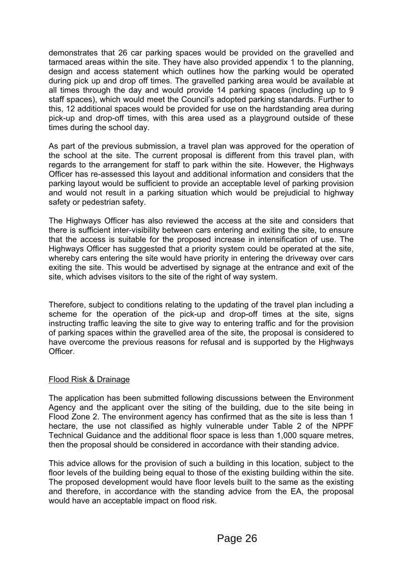
3. Site Description
The application relates to Meadowpark Junior School, located on the eastern side of High Street, Cricklade. The site is located towards the northern end of the High Street, adjacent the river Thames to north of the site. The proximity of the site to the River Thames means that the site falls under Flood Zone 2 & 3a.
Contained within the site is a main two storey building, which has Grade II Listed status and currently provides the teaching classrooms within the school. To the rear of the building is an area of hardstanding which provides hard play area for children but also doubles as visitor parking during pick up and drop off times and provides 12 spaces. To the rear of this is a gravelled area which provides another 14 parking spaces, giving a total of 26 within the site.
Access to the parking area is from a gravel driveway which provides shared access for the school and the residential dwelling to the south, No.71 High Street known as Knowle Cottage, which is also a Grade II Listed Building.
A detached single storey building has also been erected within the playing fields for the site, which is used as an area of the children to eat and a reading room. Since the previously refused application for a new school building in 2015 (application reference 14/10081/FUL), planning permission has been granted for the children’s play area to be moved to the woodland area to the rear of the site and this has been completed at the time of the site visit.
The school which operates at the site is a fee paying private school which was rated at Outstanding by Ofsted during their last inspection. The school is currently limited to 48 children being educated at the site due to condition 3 attached to planning permission reference N/09/02086/FUL, which granted consent for the school operate from the site. A travel plan was also approved as part of the same planning permission and this outlines the management of vehicular movements to and from the site, including the operation of a before and after school club, which operates from 7.30am to 6pm.
The site is located within the Conservation Area and framework boundary of Cricklade, as identified in the Polices of the Wiltshire Core Strategy.
4. Planning History
The application is a resubmission of application reference 14/10081/FUL for a new school block to provide 3 classrooms and ancillary facilities and relocation of play equipment, which was refused at north planning committee on 28th January 2015. The application was refused for the following reasons:
Page 18

1. It has not been demonstrated that adequate provision can be made on site for the parking of vehicles and for the setting down and picking up of pupils which will result in additional on street parking in an area where congestion is already caused by high parking demand. Therefore, the proposed development is considered contrary to Core Policy 60 of the emerging Wiltshire Core Strategy (submission Draft as proposed to be amended April 2014) and Policies C3 & T1 of the North Wiltshire Local Plan 2011.
2. The proposed development would result in an intensification of use of the single lane driveway into the site, which would result in circumstances prejudicial to pedestrian and highway safety from vehicles reserving into and out from the site or waiting in the public highway. Therefore, the proposed development is considered contrary to Core Policy 60 of the emerging Wiltshire Core Strategy (submission Draft as proposed to be amended April 2014) and Policies C3 & T1 of the North Wiltshire Local Plan 2011
3. The proposed development, by reason of the proliferation of the built form into the open areas of the site, size, materials and design, would result in significant harm to the character and appearance of the Cricklade Conservation Area, the setting of the adjacent Listed Buildings and the open landscape from the River Thames. Therefore, the proposal is contrary to Core Policies 57 & 58 of the emerging Wiltshire Core Strategy (submission Draft as proposed to be amended April 2014), Policies HE1, HE4 & TM4 of the North Wiltshire Local Plan 2011 and paragraphs 17(10), 131, 132, 134 and 137 of the National Planning Policy Framework.
There has been a number of other planning applications at the site. The relevant applications are listed below:
N/98/00100/FUL – Extension and Alterations – Approved with Conditions
N/09/02086/FUL – Change of use from Offices to provide flexible B1 / D1 use – Approved with Conditions
N/10/02085/FUL - Erection of Childrens Play Equipment and Gazebo in Garden – Approved with Conditions
N/11/01633/FUL - Erection of a Gazebo in Garden (Revision of 10.02085.FUL) – Approved with Conditions
15/01437/FUL – Relocation of Childrens Playing Equipment – Approved with Conditions
5. The Proposal
The application is a resubmission which seeks planning permission for the erection of a new school block to provide 2 x classrooms and a rest room. The applicant has advised during the site visit that th rest room is for children to rest in and not a toilet. No foul water drainage systems are required or being proposed as part of the development. The building would have a traditional pitched roof design with a
Page 19

maximum height of 5.4 metres and a height to the eaves of 2.85 metres. The building would have a rectangular footprint measuring 14.15 metres by 6.5 metres.
The proposal also seeks consent for the increase in the number of students educated at the school from 48 to 84.
During the course of the application process a revised design for the building was received. This included openings under the raised floor to allow flood water to pass beneath and this is discussed further elsewhere in the report.
6. Planning Policy
Wiltshire Core Strategy adopted January 2015Strategic Objective 4 – Helping to Building Resilient CommunitiesCore Policy 57 - Ensuring High Quality Design and Place ShapingCore Policy 58 - Ensuring the Conservation of the Historic EnvironmentCore Policy 60 - Sustainable TransportCore Policy 61 – Transport and DevelopmentCore Policy 67 – Flood Risk
Saved Policies of the North Wiltshire Local PlanNE18 – Noise and Pollution;TM4 – Thames Path National Trail
National Planning Policy FrameworkParagraph 7 – Three Dimensions of Sustainable DevelopmentParagraph 14 – Presumption in Favour of Sustainable DevelopmentParagraph 17 – Core Planning PrinciplesChapter 7 – Requiring Good Design.Chapter 12- Conserving and Enhancing the Historic Environment.
7. Consultations
Cricklade Town Council: Object on the grounds listed below:
Merits• Issues have been addressed over the use of materials and design related to a new build within the curtilage of a Grade 2 listed property which is within the conservation area. • The application makes consideration towards parking facilities for both staff and parents.
Demerits: • We have concerns about the capacity of the physical infrastructure in terms drainage and sewerage systems for an increase in numbers of pupils which need to be addressed. • Vehicle parking spaces only to be accessible at certain times of the day as the parking area is also a playground for pupils.
Page 20

• Highway Safety Officer should be consulted due to issues caused by access in the following areas: to the carpark/ playground, which is accessable via a single lane drive, shared with a neighbouring residential property. It has limited entrance and egress to the High Street. Increased traffic generation • General health and safety issues where children may be mingling with traffic. • Noise and disturbance resulting from increased and changed use of certain areas of the site. • In our view this proposed development is not in accordance with Wiltshire Core Strategy Policy 61.
Conservation Officer: The school building is a grade II listed stone building with slate roof, dating from 1870-80. It is set on the edge of the pavement adjacent to the river. The land behind this school is open and stretches back towards a small wooded area. The building is prominent in the street scene and as the area is flat and open the surrounding land can be seen from the High street and across the river.
Immediately adjacent to the school are a number of earlier buildings which are also grade II listed. The site is also in a conservation area.
The school has already had consent and constructed a rather large garden building that was meant to be used as an outdoor teaching space but now seems to be the refectory. The proposal is to build a new detached structure set further down the site from the parent building, beyond the existing detached garden building, but behind the neighbouring listed building. In this latest submission, the new building will provide two classrooms, one either side of a central a Restroom and entrance lobby/hallway. This building will be in the playing field area that is beyond the garden building, so it will be located beyond the historic building line of the area.
The footprint is very large and rectangular, being as wide as the main body of the listed building, and longer than either of the two end perpendicular extensions. Unlike the previous application, no drawings have been submitted showing the proposed building in view with the existing buildings. There are also no drawings of the existing buildings on their own so the impact of an additional building that is the height of a 2 storey building to the apex of the roof, cannot be clearly seen. The statement accompanying this application states that the latest building proposal would be modest and respects the linear burgage plot layout of the historic town (para 8.10). However, a burgage plot is 5.03 metres wide, whereas the proposed new building is over a metre wider (6.4 metres) and traditionally a burgage plot started at the road frontage. Building a new structure that is set well back from the road front, out of line with any other burgage strip and roughly 20% wider than a traditional plot, only hints at the historic built form in the area. Furthermore, a design that reflects an agricultural building in an area on the edge of town, adjacent to a river and associated with a Victorian school building is inappropriate and will harm the setting of the heritage assets.
The proposed new building is inappropriate for this location and will harm the setting of the heritage assets, which include the listed buildings and conservation area. The size, design and proportions of the new building will compete with the surrounding heritage assets and bear no relationship to the positions and proportions of the built
Page 21

form in this area. Whilst there may be some public benefit to the proposed new building, in that it would increase teaching space for the school, it is considered that the harm caused by a structure of this size and in this location would not outweigh this benefit. The development would be contrary to the NPPF paragraphs 17(10), 131, 132, 134 and 137. Furthermore, it would not preserve or enhance the character and setting of the heritage assets so it would be contrary to sections 16 (2) and 72(1) of the Planning (Listed Building and Conservation Area) Act 1990. Refusal is recommended.
Drainage Officer: Expressed reservations about this application regarding the drainage aspects. The latest application documents were reviewed and merged them with the existing Flood Risk mapping from the EA and the majority of the site is in flood zone 2. This will mean that infiltration drainage of any sort is unlikely to work including any soakaway within the land and car parking area, gullies etc because they are likely to be full of water just when they will be needed. This will also apply to any foul drainage unless it is completely sealed from the high ground water in that area.
Highways Officer: There have been discussions on the highway issues with the Agent following the previous refusal, including a detailed site visit when the school was not in operation. I am now satisfied that adequate parking provision can be made on site and that there is good inter-visibility between vehicles in the car park and vehicles entering to enable the proposed priority system to work. The provision of suitable signs can be covered by condition. The letter dated 20 February 2015 attached to the Design and Access Statement as Appendix 1 outlines the proposed method of operation and I am happy with this. The arrangements could be made the subject of a suitable condition if it is considered appropriate.
During my site visit I was able to observe the level of on-street parking taking place during the school holiday and this was high. With the revised on-site parking arrangements now submitted I consider that the effect on on-street parking will be minimal.
Environment Agency: Part of the proposed building footprint encroaches into flood zone 2. Therefore the LPA needs to apply the local flood risk standing advice to the application, which stipulates the required flood risk mitigation that must be designed into the building.
Please include the following condition and informatives in any permission granted.
CONDITIONThere shall be no ground raising within the area of the site delineated as flood zone 2 and 3 on the Environment Agency’s published flood map.
REASONTo prevent any loss of floodplain.
Page 22

Public Protection Officer: This application proposes 2 new classrooms and a lobby area in a separate building to be constructed. I note that unlike the previous application, it does not mention a kitchen will be built.
Therefore my main concern now would be to manage the potential for noise disturbance during the construction phase and the possibility of smoke nuisance. The site is in the High Street with businesses and dwellings in the vicinity. To manage noise during the construction phase, it would be prudent to adhere to an hours of construction condition.
Archaeology: No objection
8. Publicity
The application was advertised by site notice and neighbour consultation. This resulted in 162 consultation responses in objection and 41 in support.
The 162 consultation responses in objection can be summarised as follows:
i) Harm to highway / pedestrian safety (158 objections);ii) Harm to the setting of the Listed Building (145 objections);iii) Harm to character and appearance of the Conservation Area (146 objections);iv) Noise disturbance (38 objections);v) Flood Risk (17 objections);vi) Harm to Residential Amenity (13 objections)
The 41 consultations responses in support can be summarised as follows:
i) Additional educational facilities (40 responses)ii) Acceptable highways impacts (33 responses)iii) Acceptable impact to Conservation Area (14 responses)iv) No history of flooding at the site (7 responses)v) Provision of additional jobs (6 responses)vi) Economic benefits (2 responses)
It is noted during the course of the public consultation period that a number of responses have been received from people outside of the UK or in the format of a signed template. Each response has an individual name and address and are considered to meet the requirements to be an acceptable consultation response.
9. Planning Considerations
Principle of Development
Strategic Objective 4 of the WCS states as one of the key objectives that strategic growth will have been matched by the provision of new educational and healthcare facilities, where appropriate, and high quality education services will have assisted in providing the trained employees necessary to deliver economic growth.
Page 23

Paragraph 6.60 on delivering Strategic Objective 4 states that the core strategy will assist in facilitating educational opportunities by ensuring that new growth is supported by new school capacity.
Core Policy 19 relates to development within the Local Service Centre of Cricklade and development within this framework boundary has to be in accordance with the details of this policy. It is noted that the policy does not provide any context on the need for educational facilities within Cricklade, but does state that 113 dwellings need to be erected within the areas covered by the policy, excluding within Royal Wotton Bassett.
The proposed development would provide an enlarged educational facility which was rated excellent by Ofsted at the previous inspection. Whilst the extension is not attached to any specific growth within Cricklade, the provision of additional educational places is considered to be in accordance with Strategic Objective 4 of the WCS and is considered acceptable in principle.
Impact on the Character and Appearance of the Conservation Area and setting of the Listed Building
The previous application was refused due to the proposal resulting in the proliferation of the built form away from the front of the site and also the size, design and materials being used causing harm to the character and appearance of the Conservation Area and setting of the Listed Building.
In response to this the application has been amended from a modern design of glass and timber with two mono-pitched roofs to a more traditional agricultural style with stone walls, timber posts with glass screens and doors along the North West (front) elevation.
The statement accompanying this application states that the latest building proposal would be modest and respects the linear burgage plot layout of the historic town (para 8.10). However, the Conservation Officer has advised that a burgage plot is 5.03 metres wide, whereas the proposed new building is over a metre wider (6.4 metres) and traditionally a burgage plot started at the road frontage. They have also advised that building a new structure that is set well back from the road front, out of line with any other burgage strip and roughly 20% wider than a traditional plot, only hints at the historic built form in the area. Furthermore, a design that reflects an agricultural building in an area on the edge of town, adjacent to a river and associated with a Victorian school building is inappropriate and will harm the setting of the heritage assets.
The Conservation Officer has reviewed the proposal and considers that the proposed new building is inappropriate for this location and will harm the setting of the heritage assets, which include the listed buildings and conservation area. The size, design and proportions of the new building will compete with the surrounding heritage assets and have limited relationship to the positions and proportions of the built form in this area.
Page 24
The Conservation Officer has identified that the proposal would cause less than substantial harm to the heritage asset. Therefore, in accordance with Paragraph 134 of the framework, a balancing exercise needs to be undertaken of these harms against the public benefits and securing the optimum viable use for the building.
Whilst there would be some public benefit to the proposed new building, in that it would increase teaching space for the school, it is considered that the harm caused by a structure of this size and in this location would outweigh these benefits.
In accordance with advice provided from Historic England, the balancing exercise also requires consideration towards whether the public benefits could be provided in a manner which would not harm the heritage assets of the Listed Building and Conservation Area. Consent has previously been granted for a sizable extension to the school building under application reference N/98/00100/FUL. Whilst the consent for this extension has now lapsed, it provides evidence that an extension to the school may be possible through an extension of the existing building. This would in turn overcome of the issues of the proliferation of the built form away from the front of the site.
Therefore, the development would be contrary to the paragraphs 17(10), 131, 132, 134 and 137 of the framework. Furthermore, it would not preserve or enhance the character and setting of the heritage assets so it would be contrary to sections 16 (2) and 72(1) of the Planning (Listed Building and Conservation Area) Act 1990. Therefore, it is recommended that the application be refused on these grounds.
The proposed development would also be adjacent to the River Thames and Policy TM4 (which was saved as part of the Wiltshire Core Strategy) states that in connection with the establishment and enhancement of the proposed Thames long distance path, development will not be permitted where proposals are likely to result in a significant adverse effect on the amenities and open landscape along the river and footpath route. As outlined previously, the proposal would be a significant addition which would be set away from the built form within the site and would harm the open landscape along the river. Therefore, the proposal would be contrary to Policy TM4 of the North Wiltshire Local Plan.
Parking and Highways Issues
A number of neighbouring occupiers have objected to the proposed development on the grounds of harm to highway safety. The previous application was refused as it had not been demonstrated that adequate parking provision during pick up and drop off time had been provided. A second refusal reason related to the intensification of use of the access, which may have resulted in situations which were prejudicial to highway and pedestrian safety.
Following the determination of the original application the Highways Officer met with the applicant and conducted a site visit during the school holidays. The Highways Officer noted that the on-street parking spaces around the school were already occupied and that the pressure on parking spaces around the school was not solely down to the operation of the school. The applicant has submitted a plan which
Page 25
demonstrates that 26 car parking spaces would be provided on the gravelled and tarmaced areas within the site. They have also provided appendix 1 to the planning, design and access statement which outlines how the parking would be operated during pick up and drop off times. The gravelled parking area would be available at all times through the day and would provide 14 parking spaces (including up to 9 staff spaces), which would meet the Council’s adopted parking standards. Further to this, 12 additional spaces would be provided for use on the hardstanding area during pick-up and drop-off times, with this area used as a playground outside of these times during the school day. As part of the previous submission, a travel plan was approved for the operation of the school at the site. The current proposal is different from this travel plan, with regards to the arrangement for staff to park within the site. However, the Highways Officer has re-assessed this layout and additional information and considers that the parking layout would be sufficient to provide an acceptable level of parking provision and would not result in a parking situation which would be prejudicial to highway safety or pedestrian safety.
The Highways Officer has also reviewed the access at the site and considers that there is sufficient inter-visibility between cars entering and exiting the site, to ensure that the access is suitable for the proposed increase in intensification of use. The Highways Officer has suggested that a priority system could be operated at the site, whereby cars entering the site would have priority in entering the driveway over cars exiting the site. This would be advertised by signage at the entrance and exit of the site, which advises visitors to the site of the right of way system.
Therefore, subject to conditions relating to the updating of the travel plan including a scheme for the operation of the pick-up and drop-off times at the site, signs instructing traffic leaving the site to give way to entering traffic and for the provision of parking spaces within the gravelled area of the site, the proposal is considered to have overcome the previous reasons for refusal and is supported by the Highways Officer.
Flood Risk & Drainage
The application has been submitted following discussions between the Environment Agency and the applicant over the siting of the building, due to the site being in Flood Zone 2. The environment agency has confirmed that as the site is less than 1 hectare, the use not classified as highly vulnerable under Table 2 of the NPPF Technical Guidance and the additional floor space is less than 1,000 square metres, then the proposal should be considered in accordance with their standing advice.
This advice allows for the provision of such a building in this location, subject to the floor levels of the building being equal to those of the existing building within the site. The proposed development would have floor levels built to the same as the existing and therefore, in accordance with the standing advice from the EA, the proposal would have an acceptable impact on flood risk.
Page 26

The EA have advised that a condition should be added to prevent ground levels being raised around the building. The applicant has reviewed plans to show that the ground levels around the building would not be raised. Given that the raising of ground levels would require formal planning permission, it is considered that such a condition is not required, in the event of an approval.
The Council’s Drainage Officer has reviewed the proposal and had initial reservations with regards to the development. The applicant has advised that the building will not have any foul water sewage systems as part of the development, so no objection is raised in this regard. To overcome the remaining issues the applicant has included a sizable water butt to ensure a slow release of surface water which falls onto the roof of the building. They have also amended the design of the building to allow water to pass under the building, in the event of flooding in the area.
Therefore, the proposed development is considered to have an acceptable impact on flood risk and is in accordance with Policy 67 of the WCS.
Impact to the Residential Amenity of the Adjoining Occupiers
During the public consultation period objections were received from neighbouring occupiers in objection to the harm to their residential amenity. The proposed development would be sited in close proximity to the boundary shared with Knowle Cottage and approximately 45 metres from the dwelling itself. Given the distance of separation from the dwelling, the single storey building would result in no significant loss of light to the occupiers of the dwelling.
The proposal would be prominent when viewed from the garden of Knowle Cottage. However, the garden is sizeable and the new building would only cover a small portion of the boundary line, which is well screened on the side boundary line by dense foliage. Therefore, the level of harm from a sense of dominance would be acceptable and the outbuilding would be sufficiently distanced from the dwelling to ensure no significant loss of outlook or overbearing impact would occur.
The proposed outbuilding would only have windows facing inwards towards the application site and would ensure that no significant overlooking of any adjoining occupier would occur.
Neighbouring occupiers have also objected due to noise disturbance. The existing school operation at the site would provide some level of noise disturbance from children using the play area. Whilst the proposal would result in an intensification of use of the site, any increase in noise disturbance would not be to a level which would warrant a refusal of the application and the Public Protection Officer has raised no objection in this regard. In addition, the provision of a school would be anticipated to be provided within residential areas and some level of noise disturbance will occur as a consequence.
The Public Protection Officer has requested a condition relating to hours of operation during construction. However, this is covered by separate legislation and would not be necessary in the event of an approval.
Page 27

Impact to Trees and Landscaping at the Site
As part of the application the applicant has submitted an Arboricultural Impact Assessment and Tree Survey to determine the impact to the trees within the site. The Council’s Trees and Landscaping Officer has reviewed the proposal and considers that the scheme can be delivered and not cause unacceptable harm to the protected trees within the site. Any approval would be subject to a condition to require the tree protection measures to be provided within the site prior to the commencement of development.
10. Conclusion
Paragraph 14 of the NPPF states the presumption in favour of sustainable development, whilst paragraph 7 states the three dimensions of sustainable development as being, economic, environmental and social factors. Chapter 12 of the framework states the requirement for development to preserve the Historic Environment. Core Policy 58 of the WCS aims to ensure that Wiltshire’s important monuments, sites and landscapes and areas of historic and built heritage significance are protected and enhanced, in order that they continue to make an important contribution to Wiltshire’s environment and quality of life.
The proposed development comes with the clear benefits of the expansion of an ‘Outstanding’ Ofsted school to provide additional educational facilities to the surrounding residents. However, the public benefits provided by this are not considered to outweigh the less than substantial harm to the heritage assets of the Listed Building and Conservation Area. In this context it is necessary to note that the benefits that would accrue have the potential to be achieved via a different scheme, without resulting in the level of harm to the identified heritage assets. Therefore, the proposal is contrary to Core Policies 57 & 58 of the Wiltshire Core Strategy, paragraphs 17(10), 131, 132, 134 and 137 of the framework & sections 16 (2) and 72(1) of the Planning (Listed Building and Conservation Area) Act 1990. Therefore, it is recommended that the application be refused.
RECOMMENDATION
1. The proposed development, by reason of the proliferation of the built form into the open areas of the site and size of the proposed building, would result in significant harm to the character and appearance of the Cricklade Conservation Area, the setting of the adjacent Listed Buildings and the open landscape from the River Thames. Therefore, the proposal is contrary to Core Policies 57 & 58 of the Wiltshire Core Strategy, saved Policy TM4 of the North Wiltshire Local Plan, paragraphs 17(10), 131, 132, 134 and 137 of the National Planning Policy Framework and sections 16 (2) and 72(1) of the Planning (Listed Building and Conservation Area) Act 1990.
Page 28
Page 29

This page is intentionally left blank

REPORT OUTLINE FOR AREA PLANNING COMMITTEES
Date of Meeting 28 October 2015
Application Number 15/08926/FUL
Site Address The Paddocks, Grittleton, Chippenham, Wiltshire, SN14 6AL
Proposal Erection of Replacement Dwelling.
Applicant Mr & Mrs Alvis
Town/Parish Council CASTLE COMBE
Electoral Division BY BROOK – Cllr Baroness Scott
Grid Ref 384876 179914
Type of application Full Planning
Case Officer Alison Grogan
Reason for the application being considered by Committee Called in by Cllr Baroness Scott for the Committee to consider the scale of the development and the relationship to adjoining properties.
1. Purpose of Report
To consider the above application and to recommend that planning permission be GRANTED.
2. Report Summary
The main issues are: Principle of development Scale of development Impact on the AONB Relationship to adjoining properties Compliance with saved policy H4
3. Site Description
The Paddocks is situated in open countryside, it lies to the North of The Gibb just beyond the M4 motorway.
There are limited views into the site from the road as there is a thick tree screen along this boundary. The site is accessed via an electric gate and there are a number of agricultural type buildings on the site. The structure to be replaced
Page 31
Agenda Item 6b

was recently granted a CLE for the use as a dwelling and is situated between two existing barns.
The site is within an Area of Outstanding Natural Beauty.
4. Planning History
15/03639/CLE - Certificate of Lawfulness for Use of Premises as a Dwelling – Granted 30th June 2015.
00/00055/REM - Erection of Replacement Stable Block and Cover Structure For Horse Walker – Approved April 2000
99/01200/OUT - Demolition of Existing Stable Block and Erection of Replacement Stable Block and Structure To Provide For Horse Walker – Permission January 2000
96/02024/S73 - Formation of Access and Menage and Erection Of Barn and Stable (Retrospective) - Permission December 1996
94/01914/FUL - Change of Use of Land to Keep Horses Including Erection of Stables and Barn – Permission November 1994
5. The Proposal
The proposal is to replace the structure that was granted a Certificate of Lawfulness for use as a dwelling with a new dwelling.
The CLE application only included the actual building whereas this new application includes a small area of amenity land and the access within the red line.
6. Planning Policy
National Planning Policy Framework:Section 7 – Requiring good designSection 11 – Conserving and enhancing the natural environment
Wiltshire Core Strategy:CP1: Settlement StrategyCP2: Delivery StrategyCP10: Chippenham Community AreaCP41: Sustainable Construction and Low Carbon EnergyCP51: LandscapeCP57: Ensuring High Quality Design and Place Shaping
North Wiltshire Local Plan (Saved Policy):H4 – Residential development in the open countryside
Page 32

7. Summary of consultation responses
Grittleton Parish Council - No objections in principle to the replacement dwelling - but does note that some of the proposed materials might be considered rather temporaryCastle Combe Parish Council – Object. Policy H4 would permit this application if the existing was unsuitable for purpose, this is not the case. The proposal is urban in character, is significantly larger than the existing building, and it is ugly and does not blend in with the surrounding ones. Highways – As this is for a new dwelling to replace the existing, there is no highway objection.
Wiltshire Fire & Rescue Service – Comments relating to provisions under the Building Regulations.
Grittleton Parish Council - No objections in principle to the replacement dwelling - but does note that some of the proposed materials might be considered rather temporary.
8. Publicity
The application was advertised by site notice and neighbour consultation and no comments have been received.
9. Planning Considerations
Principle of DevelopmentThe proposal is for the erection of a replacement dwelling following the granting of a CLE for "Use of Premises as a Dwelling" (15/03639/CLE). The existing building to be replaced comprises of a mobile home attached to a log cabin, resulting in an L shaped structure which in parts is in a fairly poor state. The resulting building is quite substantial with a large kitchen/dining area, three bedrooms a bathroom and a living room.
The site is situated outside of the Framework Boundary and saved policy H4 of the Local Plan is therefore of relevance. Policy H4 allows for the replacement of existing dwellings providing the following criteria are met:
1) The residential use has not been abandoned; and2) The existing dwelling is incapable of retention in its current state, is unsightly or is out of character with its surroundings; and3) The replacement dwelling is of a similar size and scale to the existing dwelling within the same curtilage.
The residential use of the building has not been abandoned and given that it is a hybrid of a mobile home and a log cabin in a fairly poor state of repair, it is considered to be unattractive and unsightly.
The proposed replacement dwelling will also be single storey and comprises of three bedrooms with a kitchen/diner and a living room, which is similar to the
Page 33

existing. However, the proposed dwelling does have a larger footprint and volume. The existing building has a footprint of 70.7m² and the proposal will measure approximately 134m². The existing building is ‘L’ shaped and the proposed dwelling in-fills all the space between the two barns. However, given the poor visual appearance of the existing building, the replacement does give the opportunity of improving the visual appearance of the site.
The proposed dwelling will cover the whole area between the two existing agricultural buildings and the red line also indicates an area of residential curtilage. The application for the CLE did not include the curtilage but it is accepted that part of the surrounding land had been used as such and the area proposed within the red line is not excessive. A condition removing the permitted development rights will ensure that the proposed dwelling is not extended further into the limited amenity space.
Overall it is considered that the scale of the building is acceptable and complies with saved policy H4.
Design and Impact on AONBThe proposed replacement dwelling will be a contemporary design constructed of rough cast render with unstained timber panels, grey powder coated aluminium framed windows under a domed seemed zinc sheeting roof.
A key consideration is the impact of the proposal on the AONB. Paragraph 115 of the National Planning Policy Framework 2012 states that “great weight” should be given to conserving landscape and scenic beauty in Areas of Outstanding Natural Beauty, which have the highest level of protection. In terms of the Wiltshire Core Strategy, Core Policy 51 indicates that proposals should protect, conserve and where possible enhance landscape character and must not have an unacceptable impact upon landscape character within the immediate area and over long distance views.
Whilst the existing building is fairly low key in terms of height it is a fairly substantial building and due to the type of construction it does not enhance the landscape character of the area. The site is adjacent to the M4 but is very rural in character. The proposed dwelling will be situated between two existing agricultural buildings, and as such the proposal will appear in keeping with the surroundings and provide the opportunity of improving the visual amenity of the area.
Whilst the proposed building will be higher than the existing, it is accepted that to improve the overall design the roof line would need to be raised and it has been broken up with lean-to type sections to the sides. The overall height will be lower than the adjacent buildings and on balance it is considered that the proposal provides the opportunity to enhance the built environment which will improve the wider landscape.
Whilst the proposed building will be higher than the building to be replaced, it is accepted that to improve the overall design a like for like replacement would not be appropriate. The overall height will be subservient to the adjacent buildings and the overall perceived massing of the building has been minimised with the introduction of lean-to sections to the sides. For the reasons given above it is considered that the proposal provides the opportunity to enhance the built
Page 34

environment which will improve the wider landscape and thereby fulfil the aims and goals of both local and national planning policies.
Relationship to Adjoining PropertiesThe site is well screened from the road and there are no near neighbours. The nearest neighbours to the north are approximately 135 metres from the access point and approximately 95 metres from the proposed dwelling. The neighbour to the south is at a similar distance but the site is further screened by the M4 flyover which is close to the boundary of the site.
The proposed windows on the (front) west elevation face towards the tree screen along the boundary with the highway and on the (rear) east elevation they will overlook the paddock area. In light of the distance from other properties it is considered that the proposal will not have a detrimental impact on the amenity of any local residents.
10. Conclusion
Overall the proposal provides and opportunity to enhance this site and is considered to be acceptable in terms of scale and design and therefore complies with saved policy H4 of the North Wiltshire Local Plan 2011 and Cope Policy 57 of the Wiltshire Core Strategy and guidance with the NPPF. The proposal is also considered to be an improvement to the wider landscape and therefore in accordance with Core Policy 51 of the Wiltshire Core Strategy and the key aims of the NPPF.
RECOMMENDATION: Permission subject to conditions
1. The development hereby permitted shall be begun before the expiration of three years from the date of this permission.
REASON: To comply with the provisions of Section 91 of the Town and Country Planning Act 1990 as amended by the Planning and Compulsory Purchase Act 2004.
2. The development hereby permitted shall be carried out in accordance with the following approved plans:
Site Location Plan, LPC/3630/EX/1A, LPC/3630/EX/2, LPC/3630/SD1/1A, LPC/3630/SD1/2A and LPC/3630/SD1/3 registered by the LPA on the 10th September 2015.
3. No development shall commence on site until the exact details and samples of the materials to be used for the external walls and roofs have been submitted to and approved in writing by the Local Planning Authority. Development shall be carried out in accordance with the approved details.
REASON: The matter is required to be agreed with the Local Planning Authority before development commences in order that the development is
Page 35

undertaken in an acceptable manner, in the interests of visual amenity and the character and appearance of the area.
4. Notwithstanding the provisions of the Town and Country Planning (General Permitted Development) (England) Order 2015 (or any Order revoking or re-enacting or amending that Order with or without modification), there shall be no additions/extensions or external alterations to any building forming part of the development hereby permitted.
REASON: In the interests of the amenity of the area and to enable the Local Planning Authority to consider individually whether planning permission should be granted for additions/extensions or external alterations.
5. Notwithstanding the provisions of the Town and Country Planning (General Permitted Development) (England) Order 2015 (or any Order revoking or re-enacting or amending that Order with or without modification), no garages, sheds, greenhouses and other ancillary domestic outbuildings shall be erected anywhere on the site on the approved plans.
REASON: To safeguard the character and appearance of the area.
6. INFORMATIVE TO APPLICANT: Any alterations to the approved plans, brought about by compliance with Building Regulations or any other reason must first be agreed in writing with the Local Planning Authority before commencement of work.
7. INFORMATIVE TO APPLICANT: The applicant is requested to note that this permission does not affect any private property rights and therefore does not authorise the carrying out of any work on land outside their control. If such works are required it will be necessary for the applicant to obtain the landowners consent before such works commence.
8. INFORMATIVE TO APPLICANT: Please note that Council offices do not have the facility to receive material samples. Please deliver material samples to site and inform the Planning Officer where they are to be found.
Page 36

Page 37

This page is intentionally left blank

REPORT OUTLINE FOR AREA PLANNING COMMITTEES
Date of Meeting 28 October 2015
Application Number 15/07510/FUL
Site Address Hullavington Garage, The High Street 29A, Hullavington, Chippenham, Wiltshire, SN14 6DP
Proposal Proposed Ancillary Accommodation to Garage, Shop & Post Office.
Applicant Mr A Bain
Town/Parish Council HULLAVINGTON
Electoral Division BY BROOK – Cllr Baroness Scott OBE
Grid Ref 389545 182059
Type of application Full Planning
Case Officer Alex Smith
Reason for the application being considered by Committee
The application has been called into Planning Committee at the request of Cllr Baroness Scott OBE to consider the impact of development on the locality.
1. Purpose of Report
To consider the above application and to recommend that planning permission be REFUSED.
2. Report Summary
The application was advertised by site notice and neighbour consultation. This resulted in the submission of 15 consultation responses, with 12 in support and 3 in objection. Hullavington Parish Council supported the development in principle, however, raised concerns about the design, storage of waste and gas within the site and failure to adhere to historic planning conditions.
The main issues in the consideration of this application are as follows:
The Principle of Development; Impact on the Visual Amenities of the Surrounding Area Impact to the Residential Amenity of the Adjoining Occupiers Living Conditions for Future Occupiers
Page 39
Agenda Item 6c
Parking & Highways issues Other Issues
3. Site Description
The application relates to the site of Hullavington Garage located on the corner of High Street and Frog Lane in Hullavington. The site is within the framework boundary of Hullavington but not within a Conservation Area. Contained within the site is a single storey garage building, used for motor car repairs (Use Class B2) which faces towards the highway of High Street. Attached to the side elevation and turning onto the highway of Frog Lane, is a single storey element with a flat roof, which contains a post office / village store.
The land to the front of the garage provides parking space for the customers of the car repair business at the site. Adjacent the side elevation of the post office is an area of hardstanding which was being used for the storage of materials. Consent for the extension of the post office granted in 1999 contained a condition which required the use of this land for the provision of two parking spaces for use by visitors to the post office.
To the north of the application site is the two storey detached dwelling of No.29 High Street. The side and rear boundary lines of the garden of this dwelling are shared with the application site. The ground levels within the application site are approximately 0.8 metres below the ground level of the adjoining neighbours garden. To the east of the application site is the two storey semi-detached dwelling of No.3 Frog Lane and the opposite side of Frog Lane is a Grade II Listed Building known as The Cottage.
4. Planning History
There has been a number of planning application at the site. The relevant applications are listed below:
N/99/01832/FUL – Extension to Shop - Approved
N/92/01225/FUL – Extensions and Alterations to Shop and Male and Female Toilets Extension and Alterations - Approved
5. The Proposal
The application seeks planning permission for proposed ancillary accommodation to garage, shop & post office. The proposed extension would be erected over the existing post office building and would be part two storey / part first floor. The development would provide a two bedroom flat with a kitchen and hall at ground floor level and two bedrooms, living room and outside terrace at first floor level. One car parking space would be provided adjacent the side elevation of the building.
The design of the extension would be a modern flat roofed addition with a wooden clad, projecting box at first floor level in the elevation facing towards Frog Lane. The
Page 40

elevations would be largely rendered, with some cladding used towards the rear of the building.
6. Planning Policy
Wiltshire Core StrategyCP 1 – Settlement StrategyCP 2 – Delivery StrategyCP10 – Chippenham Community AreaCP57 - Ensuring High Quality Design and Place Shaping.CP58 - Ensuring the Conservation of the Historic Environment.CP60 – Sustainable TransportCP61 – Transport and Development
North Wiltshire Local Plan 2011 Saved Policy:NE18 – Noise and Pollution;
National Planning Policy Framework 2014:Paragraph 7 – 3 Dimensions of Sustainable DevelopmentParagraph 14 – Presumption in Favour of Sustainable DevelopmentParagraph 17 – Core Planning PrinciplesChapter 7 – Requiring Good Design.Chapter 12- Conserving and Enhancing the Historic Environment.
7. Consultations
Hullavington Parish Council: In principle the Parish Council supports the application; however it would like some points to be taken into account:
Gas is now stored at the front of the garage – concerns about the safety of this
Storage of garage waste in customer parking area External colour of the proposed attached premises not in-keeping with the
surrounding premises Some conditions of the 1999 application have not been adhered to.
Public Protection: It is my experience with flats that are “ancillary” to the shop that in order to be certain this is the case a condition in the form of a tie should be placed upon the permission ensuring that the shop and flat are as one.
This will prevent the flat being rented or sold to a third party who then could complain about noise for example and have an impact on the future of the shop.
Highways Officer: No objection. Firstly it is fairly obvious that the area which is required by Condition 3 to be used for parking has not been used for parking for some considerable period. The 2006 aerial photos show it clearly as a storage area.
As far as the proposed parking is concerned I agree that it would be advantageous to have an accurate, to scale, parking layout. However from my examination of the
Page 41

highway records I do not consider that the parked vehicles shown on the submitted plan encroach on the highway. The submitted plans (and streetview) are a bit misleading as to the position of the highway boundary.
When I have visited the area I have not found it unduly congested with parked cars and I do not consider that this small development will have a significantly adverse effect on the parking in the area.
Archaeology: No comment
8. Publicity
The application was advertised by site notice and neighbour consultation. This resulted in the submission of 15 consultation responses, with 12 in support and 3 in objection.
The consultation responses in support can be summarised as follows:
i) Proposal would allow for the village shop to be retained at the site;ii) Sufficient parking is provided within the site;iii) Acceptable impact to neighbouring occupiers;
The consultation responses in objection can be summarised as followed:
i) Harm to residential amenity of the adjoining occupiers from loss of light and loss of privacy;
ii) Harm to the visual amenities of the surrounding area;iii) Increased noise disturbance;iv) Lack of off-street parking;v) Poor living environment provided;vi) Development does not meet national standards for house sizes;vii) Parking at the site not in accordance with previous condition attached to 1999
planning permission.
9. Planning Considerations
Principle of Development
The applicant has advised that the application has been submitted as the owners wish to sell the garage and post office business, but have struggled to attract an operator due to the high cost of dwellings within the village of Hullavington. No marketing information has been provided or requested as to the attempts to sell the business operation at the site to date.
The application seeks planning permission for the creation of a two bedroom residential unit within the site via a part two storey / part first floor extension. The application site is located within the framework boundary of Hullavington, which is
Page 42

identified as a large village under Core Policy 10 of the Wiltshire Core Strategy (WCS). Core Policy 2 of the WCS states that within the limits of development, there is a presumption in favour of sustainable development. The proposal would see the intensification of a brownfield site within a framework boundary to provide a residential unit. Therefore, it is in accordance with both national and local planning policy and is acceptable in principle.
It is noted that a number of residents have supported the application, as they consider that it would ensure the retention of the post office / village store which serves Hullavington. However, this application does not seek the removal of this facility and Core Policy 49 ensures that village stores such as this are protected in the event of an application for the redevelopment of the site.
Impact on the Visual Amenities of the Surrounding Area
The proposal is a two storey addition to the existing garage and post office at the site. Both offer little architectural merit and take up a prominent corner plot on the High Street in Hullavginton. The current proposal is for a modern addition to the site, with a sizeable wooden box projecting at first floor level and large sections of wooden cladding. Whilst objections have been received that the development would not be in keeping with the character of the surrounding area, the site is located at the end of the street and is read as separate from the adjoining residential dwellings. Therefore, a site such as this would be suitable for a more modern addition to be added and no objection is raised in this regard. Therefore, the proposal is considered to have an acceptable impact on the visual amenities of the surrounding area.
It is noted that the dwelling on the opposite side of Frog Lane, known as The Cottage, is a Grade II Listed Building. However, the current proposal would not be considered to cause harm to the setting of this Heritage Asset and is considered acceptable in this regard also.
Impact to Residential Amenity of the Adjoining Occupiers
The application site is a corner plot, which wraps around the rear garden of No.29 High Street, a two storey detached dwellinghouse set to the north / northeast of the application site. This neighbouring occupier has raised an objection on the ground of harm to their residential amenity. The rear garden of No.29 is currently enclosed on either side by the garage building in the application site and the side elevation of No.3 Frog Lane. The current proposal would erect a two storey extension to the post office, which would run along the rear boundary line of No.29, which is currently the only boundary which is not enclosed by built structures.
The extension would have a height above ground level of 5.5 metres, which would drop to 4.5 metres where the privacy screen is located to the rear of the first floor terrace. The plans show that the ground level of the garden of No.29 is set higher than the ground level of the application site, with an increase of 0.8 metres. However, there is an inaccuracy in the plans, as the dwelling of No.29 is set approximately 1 metre below the ground level of the garden, which isn’t shown on the plans.
Page 43

This neighbouring occupier has a set of patio doors in their rear elevation which act as the only light source into the dining room. The light which is received into this window comes only from the rear of their site, as the existing garage already screens this window. The proposed extension would be approximately 12.7 metres from the rear elevation of this dwelling and at a height of 5.5 metres, is considered to result in significant harm to their residential amenity from loss of light. Whilst it is acknowledged that tree within the neighbours garden already results in a loss of light, it is not as significant as the loss of light which would occur from the extension being proposed. The harm is further compounded by the south west orientation of the extension from this neighbouring occupier.
Further to this, the proposal would significantly enclose the rear garden of this adjoining occupier. The proposal would enclose the majority of the only boundary line which is not currently enclosed by buildings. This would result in a significant sense of enclosure, overshadowing and loss of light into the amenity space of this adjoining occupier. Therefore, the proposed development is considered to result in unacceptable harm to the residential amenity of this adjoining occupier and is recommended for refusal on these grounds.
The proposed development would be sufficiently distanced from the principal elevation of No.3 Frog Lane to ensure no significant harm would occur from a loss of light, loss of outlook or sense of dominance.
The windows within the dwelling would be sufficiently distanced from any neighbouring occupier to ensure no loss of privacy would occur. The high level window in the rear elevation of the extension could be conditioned to be obscure glazed to ensure no outlook would be provided. Further to this, the 1.8 metre high privacy screen would ensure no significant loss of privacy would occur from the outdoor terrace being proposed.
Living Conditions for Future Occupiers
The Public Protection Officer raised a concern with regards to the relationship between the dwelling and the adjoining commercial unit. However, the proposal seeks consent for an ancillary unit for use by occupiers of the commercial units. In this circumstance, the proposal would be considered acceptable, as the noise disturbance would be created by the occupiers of the dwelling and they would have overall control of the levels of noise disturbance they receive. Therefore, if consent were to be granted, it is considered that a s106 agreement would be required to tie the residential units to the commercial ones.
The proposed bedrooms would be served by windows in the side elevations of the first floor projecting box. Whilst the level of outlook and source of light received would be reduced compared to having windows in the side elevation, the size of the windows would ensure a suitable living environment would be provided in these rooms.
Page 44

An objector has also noted that the size of the unit at 66.5 square metres does not meet the Technical Standards for a 2 bedroom 3 person unit from the DLGC, however, these are not referenced in either the NPPF or Planning Practice Guidance and have no statutory status in national planning policy. The Council has no adopted floor space standards and the size of the unit is not so small as to warrant a refusal of the application.
Parking & Highways
A number of neighbouring occupiers and the Parish Council have noted that the 1999 planning permission was granted with a condition which required the land being used for the development to be used for parking.
Since this approval the petrol pumps have been removed from the frontage of the site and provided more space for parking for the commercial operations. The Highways Officer has reviewed the parking arrangements and whilst it is noted that the parking layout does not show parking spaces at 2.4m x 4.8m, they are satisfied that the site has sufficient parking to service the garage, post office and two bedroom residential unit. Therefore, they raise no objection on the grounds of highway safety.
Other Issues
The site is sufficiently sized to provide storage for refuse for the commercial units and residential units within the site and no objection is raised on these grounds.
It is noted that the Parish Council have raised the question about gas being stored to the front of the site. This does not require planning permission and does not form a material consideration.
10. Conclusion
Paragraph 14 of the NPPF states the presumption in favour of sustainable development, whilst paragraph 7 states the three dimensions of sustainable development as being, economic, environmental and social factors. Paragraph 17 sets out the 12 core planning principles, including that development always seeks to secure high quality design and a good standard of amenityfor all existing and future occupants of land and buildings and the proposal is contrary to this core planning principle of the framework.
Core Policy 57 requires developments to have regards to the impact on the amenity of existing neighbouring occupiers. The proposed development comes with the benefits of the expansion of the provision of a new residential unit within the site. However, this does not outweigh the harm to the residential amenity of the adjoining occupiers, through loss of light, loss of outlook and sense of dominance. Therefore, it is considered that the benefits from the proposal do not outweigh the harm caused and that the development is contrary to Core Policy 57 in this regard. Therefore, the application is recommended for refusal.
Page 45
RECOMMENDATION
1. The proposed development would, by reason of its height, length of projection along the rear boundary line of the adjoining dwelling and orientation result in an unacceptable loss of light to the occupiers of the dwelling of No.29 High Street and an unacceptable loss of light, overshadowing and sense of enclosure to the amenity space of the same unit. Therefore, the proposal is contrary to Core Policy 57 vii of the Wiltshire Core Strategy.
Page 46

Page 47

This page is intentionally left blank