Embed Size (px)
Citation preview

Eastern Tanana Area Plan Public Review Draft Issue Response Summary for the Final Plan
August 2015
August 2015 Eastern Tanana Area Plan – Issue Response Summary 1
PUBLIC COMMENTS Item Subject Issue Response Recommendation
Chapter 1 1. Uses and Resources
within the Planning Area
The Department of Defense requests adding a statement that recognizes the role played by the military in Alaska and specifically within the ETAP planning area. Military lands and airspace are essential to the missions of a large number of military units, and that the economic activity generated by those units and their host installations significantly benefit the state. The land and air training areas of these installations are critical facilities and areas that enable the Air Force, Army, and other military entities to conduct necessary training.
It is appropriate to add a statement in this part of Chapter 1 that describes the role of the military and the importance of airspace and military land to the training role of the Air Force and Army and other military entities.
Add the following text to page 1-4 to the second full paragraph: “Additionally, there are a number of military installations within the planning area, including Fort Wainwright, Fort Greely, and Eielson Air Force Base. Military lands and airspace within the ETAP planning area are essential to the missions of a large number of military units; moreover these installations are important to the overall economy of the state and represent a significant economic base for the area within which they are situated.”

August 2015 Eastern Tanana Area Plan – Issue Response Summary 2
Item Subject Issue Response Recommendation
Chapter 2 Military
2. Coordination and Public Notice –Management Guideline D. Authority of State Plans
DNR authorizations may have an impact on military installations, facilities or operations.
Certain activities authorized by DNR may impact activities occurring on adjacent military lands within planning area.
A new paragraph will be added on page 2-10 beginning on line 5: “DNR adjudicators should consult with the appropriate DOD official if there are questions pertaining to state authorizations’ effects on military activities.”
Agriculture and Grazing Resource 3. Agriculture and
Grazing Recommendation to add the following to the Economic Development goal, “Encouraging expanded production and availability of farm products from agricultural lands within Alaska when economically feasible without public subsidies, as determined by an independent/neutral party.”
The proposed wording involves an action that is beyond the scope of this plan and is will not be included.
No change.
4. Agriculture and Grazing – Management Guideline C. Agricultural Land Disposals
Recommendation to add the following underlined text to a new point within Management Guideline C, “The classification of agricultural land and the development of a conservation plan approved by the local SWCD shall preclude this land from bring reclassified as ‘Highly Erodible’ or some other designation that qualifies it for ‘Public Funds’ (Such as the USDA Conservation Reserve Program) to mitigate an erosion or environmental problem.”
The proposed wording involves an action that is beyond the scope of an area plan and is therefore inappropriate to include.
No change.
August 2015 Eastern Tanana Area Plan – Issue Response Summary 3
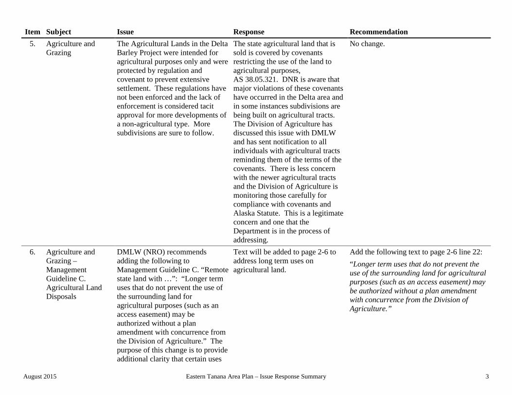
Item Subject Issue Response Recommendation 5. Agriculture and
Grazing The Agricultural Lands in the Delta Barley Project were intended for agricultural purposes only and were protected by regulation and covenant to prevent extensive settlement. These regulations have not been enforced and the lack of enforcement is considered tacit approval for more developments of a non-agricultural type. More subdivisions are sure to follow.
The state agricultural land that is sold is covered by covenants restricting the use of the land to agricultural purposes, AS 38.05.321. DNR is aware that major violations of these covenants have occurred in the Delta area and in some instances subdivisions are being built on agricultural tracts. The Division of Agriculture has discussed this issue with DMLW and has sent notification to all individuals with agricultural tracts reminding them of the terms of the covenants. There is less concern with the newer agricultural tracts and the Division of Agriculture is monitoring those carefully for compliance with covenants and Alaska Statute. This is a legitimate concern and one that the Department is in the process of addressing.
No change.
6. Agriculture and Grazing – Management Guideline C. Agricultural Land Disposals
DMLW (NRO) recommends adding the following to Management Guideline C. “Remote state land with …”: “Longer term uses that do not prevent the use of the surrounding land for agricultural purposes (such as an access easement) may be authorized without a plan amendment with concurrence from the Division of Agriculture.” The purpose of this change is to provide additional clarity that certain uses
Text will be added to page 2-6 to address long term uses on agricultural land.
Add the following text to page 2-6 line 22: “Longer term uses that do not prevent the use of the surrounding land for agricultural purposes (such as an access easement) may be authorized without a plan amendment with concurrence from the Division of Agriculture.”

August 2015 Eastern Tanana Area Plan – Issue Response Summary 4
Item Subject Issue Response Recommendation are not precluded within agricultural land disposals.
7. Agriculture and Grazing – Management Guideline C. Agricultural Land Disposals
DoAg indicated that developing permanent structures within floodways should be discouraged.
DNR will amend text to address the development of permanent structures within floodplains and floodways through a State Farm Conservation Plan.
The 5th bullet on Management Guideline C on page 2-6 will be revised as follows: “Where agricultural land disposals occur within a floodplain; the State Farm Conservation Plan will identify locations where permanent structures are inappropriate due to potential for flooding. Agricultural land disposals should exclude floodways. Where neither floodways nor flood plains have been mapped, the best available information will be used to identify areas where flooding is likely to be a severe limitation on development.”
8. Agriculture and Grazing – Management Guideline B
The ADF&G states that given the potential for grazing to occur within the planning area and affect riparian areas and wetlands, it would be appropriate to add text to the current wording in the plan that would establish the same approach to the management of grazing that is used for agriculture.
DNR will amend text to address grazing within floodplains and floodways.
Management Guideline B on page 2-8 will be revised as follows: “B. Areas Not Appropriate for Grazing Leases. In addition to the restrictions on grazing provided by 11 AAC 60 grazing leases are not appropriate on lands classified Water Resources Land, Transportation Corridor Land, Heritage Resources Land, and lands classified Wildlife Habitat that are designated Harvest in the plan. Lands classified as Settlement Land may be appropriate for short term grazing only under 11 AAC 60.010(b). A grazing lease should not be authorized within a floodway; however a grazing lease may be authorized within a floodplain. Floodways should be identified for exclusion in the Grazing Management Plan using the best available information. A lease will not be authorized without an approved

August 2015 Eastern Tanana Area Plan – Issue Response Summary 5
Item Subject Issue Response Recommendation Grazing Management Plan.”
9. Agriculture and Grazing – Management Guideline G
The ADF&G recommends plan changes to protect habitat areas.
DNR will revise Management Guideline G to address impacts to habitat areas.
Text for Management Guideline G on page 2-8 will be revised as follows: G. Other Guidelines Affecting Grazing. “The impacts of grazing on adjoining areas classified Habitat Land shall be evaluated in consultation with ADF&G during the decision process. Appropriate measures to minimize impacts of grazing on adjacent habitat will be incorporated into the Preliminary/Final Finding and Grazing Management Plan. It is not intended that mitigation measures will always be required in these instances, but that the need for such measures be assessed and required where necessary. Other guidelines may affect grazing. See other sections of this chapter.”
10. Agriculture and Grazing – Management Guideline G
The ADF&G states that historic, cultural and archaeological resources may be impacted by grazing. Consultation with OHA is appropriate.
DNR will address impacts to historic and archaeological resources from grazing within riparian and wetland areas. Management Guidelines on page 2-8 will be re-ordered and revised.
Management Guideline G on page 2-8 will be revised as follows: “Impacts to reported historic, archaeological, or paleontological sites should be avoided or minimized. Division of Agriculture staff shall consult with OHA to determine if agricultural activities can occur without significant impact to the cultural resource. OHA shall work with the Division of Agriculture to develop site-specific mitigation measures to protect known cultural sites while allowing agricultural operations.” The remaining Management Guidelines on page 2-8 will be re-ordered.
Fish and Wildlife Resource 11. Fish and Wildlife Comment recommends text be Easements adjudicated by DNR are No change.

August 2015 Eastern Tanana Area Plan – Issue Response Summary 6
Item Subject Issue Response Recommendation added, under the goal of ‘Maintain and protect Publicly Owned Habitat Base.’ The recommended text is: “Easements around and/or through non-public land will be publicized.”
identified and available for review on Alaska Mapper and other publically available source documents.
12. Fish and Wildlife USFWS: States that the BMPs identified in the draft plan are ‘practical’ and the 50-building setback and 100’ vegetated buffers on both anadromous and high value resident fish streams and habitats are ‘very valuable’ protection measures.
Acknowledged. No change.
13. Fish and Wildlife – Management Guideline N
USFWS: Migratory birds – the draft plan includes BPMs to protect swan and other waterfowl nesting, molting and migration concentration areas. However, all migratory birds and their nests are protected under the Migratory Bird Treaty Act (MBTA). Impacts to nesting migratory birds can be avoided by timing land disturbance activities to occur when birds are not nesting. For Interior Alaska, they recommend that such activities be conducted before May 1 or after July 15 to avoid nesting birds and to ensure compliance with MBTA.
DNR will revise Management Guideline N to include specific recommendations.
Text will be added on page 2-20 by adding a new paragraph which reads as follows: “The USFWS recommends for migratory birds affected by the federal Bird Migration Act (which includes other species besides waterfowl) that land disturbing activities be conducted before May 1 or after July 15 to avoid disturbing nesting birds and to ensure compliance with the federal Migratory Bird Act.”
14. Fish and Wildlife – Management Guideline J
USFWS suggests the recommended time period for avoiding disturbance for raptors is April 15 – August 1.
Text will be revised to reflect the timing requirements indicated by USFWS.
Text will be revised on page 2-18 to amend the current timing requirements: “… active bald eagle nests between March 15 and August 31. Temporary activities and facilities that do not alter eagle nesting

August 2015 Eastern Tanana Area Plan – Issue Response Summary 7
Item Subject Issue Response Recommendation habitat or disturb nesting eagles, as determined by the USFWS, may be allowed at other times. For additional information on these federal requirements, refer to the 2007 “National Bald Eagle Management Guidelines.”
15. Fish and Wildlife – Management Guideline A
Comment recommends adding the following text under Management Guideline A: “Consult/collaborate with ADFG to develop a comprehensive ATV/ORV plan to mitigate the habitat and environmental damage currently being caused by unregulated use of these vehicles on most of our public lands.”
Consistent with 11 AAC 96.020 ATV use on or off of an established road easement is a generally allowed use. However, this use must be conducted consistent with the conditions for generally allowed uses under 11 AAC 96.025.
No change.

August 2015 Eastern Tanana Area Plan – Issue Response Summary 8
Item Subject Issue Response Recommendation
Forestry Resource 16. Forestry –
Management Guideline C. Personal Use Wood Harvest
Public should be allowed to cut trees, especially those that are dead but standing not based on the feasibility of DOF administration of the program.
Cutting of dead and down timber is an allowed use under 11 AAC 96.020(a)(3)(C) this wood must be used on site for a cooking or warming fire. Forestry allows cutting firewood for personal use on designated areas of state land. Contact the local Division of Forestry office locate personal use harvest areas and to acquire a permit.
No change.
17. Forestry – Non Timber Forest Products Industries
DMLW (NRO) recommends adding a goal that emphasized the importance of the non-forest products that are associated with the use and management of state land. Many of these activities involve the commercial harvesting of products (birch bark, morels, Chaga, and similar items) that occur on both land managed for its timber resources as well as state land that is managed for multiple uses. These activities require authorization from DMLW. They represent a different, but growing use of state land.
DNR will add a new Non-Timber Forest Product management goal to the listing of goals related to Forestry.
Add text beginning on page 2-23, after line 38: “Non-timber Forest Products. Support Non-Timber Forest Products Industries. In addition to the management of state land for those designations that are delineated in Chapter 3 for specific management units, DNR shall manage state land to support the gathering of natural materials that have commercial value and that provide a basis for employment in areas of the state.”
18. Forestry – Management Guideline B. Timber Sales from Rights of Way
DMLW (NRO) recommends that the wording in Management Guideline B be clarified as it relates to the delegation of authority for the determination of the amount and kind of material to be authorized as part of a salvage sale.
Text will be revised to clarify delegation of authority for regional manager.
Revise text beginning on page 2-24, line 33: “The DMLW Regional Manager, or their delegate, shall determine … ”

August 2015 Eastern Tanana Area Plan – Issue Response Summary 9
Item Subject Issue Response Recommendation They recommend that the authority for the regional manager to delegate this responsibility be included.
19. Forestry – Management Guideline K. Timber Harvest in Areas Designated Settlement, Agriculture, Materials, Forestry, Coal or Minerals
Management Guideline K., permits timber harvest in areas with these classifications, but problems have arisen with the current management approach within areas that are designated Agriculture. Apparently timber sales have occurred prior to the Agricultural sale and have affected the manner of development of the agricultural tract. Division of Agriculture requests that the current requirement, which calls for consultation, be changed to require prior approval from the Division of Agriculture.
Text will be revised to require DOF consultation with Division of Agriculture prior to forestry operations being conducted on land designated agriculture.
Revise text on page 2-26, line 38: “Division of Forestry shall consult with the Division of Agriculture…”
20. Forestry – Management Guideline K. Timber Harvest in Areas Designated Settlement, Agriculture, Materials, Forestry, Coal or Minerals
DMLW (NRO) recommends the inclusion of ‘fire mitigation’ to the listing of purposes identified.
Text will be revised to capture the concept of reducing fire potential in settlement areas.
Revise text beginning on page 2-26, line 29 to read: “Timber harvests are considered appropriate in areas designated Settlement if intended to reduce fuel loads to minimize fire potential, support the costs of subdivision…”
21. Forestry – Management Guideline K. Timber Harvest in Areas Designated Settlement, Agriculture,
DMLW (NRO) indicated that text regarding appropriate authorizations of timber harvests needs to be corrected.
Concur, text will be revised to clarify the necessary actions to be taken with regard to timber harvests.
Text on page 2-26, line 39 will be revised to read: “If the use is consistent with the submitted plan of operations, timber harvests are also considered appropriate in areas designated Minerals or Materials. Prior to timber

August 2015 Eastern Tanana Area Plan – Issue Response Summary 10
Item Subject Issue Response Recommendation Materials, Forestry, Coal or Minerals
harvest on areas designated Minerals or Materials, DOF shall consult with staff in the Mining Resources Section and DMLW NRO.” Delete sentence on page 2-26, line 42 beginning with, “Consult with the Regional Manager…”
Public Access 22. Public Access –
Goal statement 3 DOD questioned State intentions to build additional bridges and its responsibility for design and environmental compliance on future infrastructure development.
This goal statement indicates future development of infrastructure is appropriate and will be conducted consistent with federal and state requirements. It does not indicate intent to build bridges.
No change.
23. Public Access – 17(b) Easements
Language should be added to Public Access Resource - Management Guideline D to clarify how 17(b) easements are used to access state land, including Interim Conveyed lands.
The current wording in Management Guideline D beginning on page 2-34 line 41 effectively deals with this issue and no additional clarification is necessary.
No change.
24. Public Access – Access for Development
Recommend Public Access Resource - Management Guideline E be updated to include language that protects cultural resources if a new route or facility is developed.
Revise text to address known cultural resources on new access routes.
Revise text on page 2-35 beginning on line 8 to: “If the new route or facility will not or should not provide public access due to concerns for public safety or the long-term detrimental impact on natural resources, or OHA identified cultural resource sites, the current means of public access should be retained. Consultation with OHA is necessary to determine identified cultural resources.”
25. Public Access – Management Guideline F.
Comment recommends the following wording for this management guideline to include
DNR does not limit access to public lands when fire danger is high or dangerous fire conditions
No change.

August 2015 Eastern Tanana Area Plan – Issue Response Summary 11
Item Subject Issue Response Recommendation Limiting Access “dangerous fire conditions” in the
second sentence. exist. DNR, through DOF, does limit access to public lands in certain locations during active fire operations. Additionally, DOF may restrict or prohibit certain types of fires based on fire danger. Current wording of the management guideline is correct and no change is warranted.
26. Public Access – Management Guideline K. Preservation of Access Opportunities
DMLW (NRO) recommends amending the second sentence in the guideline to be more specific to the action DMLW would take to vacate a section line easement.
Management guideline text on p. 2-36, line 7 will be revised to be more specific.
Revise text on page 2-38, line 7 as follows: “Unless there is a Final Decision to vacate approved through the DMLW vacation process, section line easements are to be preserved.”
27. Public Access – pages 2-36 to 2-38
DMLW (NRO) recommends replacing the word ‘Trails’ with ‘Access’ since this is a more inclusive term.
Text will be revised to replace the word “trail” with “access” as appropriate. A footnote will be added that conceptually describes access as incorporating both roads and trails.
Text on page 2-36 line 23 will be revised as follows: “Management Guidelines: Access(footnote
insert) Within and Between Developing Areas” Footnote added after the word access will read: “This term includes the general concept of access and is inclusive of roads and trails.” In this section of plan text, the word “trail” or “trails” will be replaced with “access” as appropriate where they occur under this subject heading on pages 2-36 to 2-38.
28. Public Access – Management Guideline C. Access to Non-State Land
DNR should coordinate with local Native entity regarding access to Native land. This coordination has occurred in the past and has been quite successful. This practice should continue and it is
Current wording of Management Guideline C will be revised to include intent for coordination with Native entities regarding access to Native land.
Revise Management Guideline C text on page 2-34 as follows: “Reasonable access will be provided across state lands to other public and private lands. If a proposed access route is located in close proximity to a village or Alaska Native

August 2015 Eastern Tanana Area Plan – Issue Response Summary 12
Item Subject Issue Response Recommendation recommended that a statement be included in the plan.
owned lands, DNR should coordinate with the relevant Alaska Native entity holding title to surface estate. Existing legal access will not be precluded unless equivalent access is available.”
Recreation and Scenic Resources 29. Recreation and
Scenic Resources – Goal – Recreation Opportunities
Objection to wording in the plan referencing minimization of recreational conflicts as it may lead to restrictions on trapping.
It is a standard policy of DNR to manage public lands in such a manner that user conflicts are reduce or minimized. This management guidance would not be used to prohibit trapping. Trapping is a protected Generally Allowed Use and limits on this use would require regulatory changes.
No change.
Reservations of Water Resource 30. Reservations of
Water DNR should actively resist current efforts of the National Park Service to manage water and water borne activities on the Yukon River near the Yukon Charley Preserve just northeast of the planning area.
The Yukon River is outside the boundary of the planning area. However, these waters are managed by the State, and the State actively resists efforts by agencies of the Federal Government to manage waters of the State.
No change.
31. Reservations of Water – Management Guidelines A - D
DMLW (Water) has recommended different wording for the Management Guidelines.
Recent discussions with the Water Section have suggested a revision of the way that certain of the management guidelines are stated. The Water Section is the recognized entity within DLMW on water related issues and RADS defers to their recommendations.
Revise wording on Page 2-42, beginning on line 14 as follows: “A. Considerations for Reservations of Water (General) …. intended to reserve sufficient water to maintain a specified in-stream flow or level of water on a stream or body of water for one or a combination…” “B. Priorities. Reservations of Water have been established according to AS 46.15.145 on the Tanana, Nenana, Chena, Salcha, Chatanika, and Delta Clearwater Rivers (see DMLW Water Rights and Temporary Use

August 2015 Eastern Tanana Area Plan – Issue Response Summary 13
Item Subject Issue Response Recommendation Authorizations webpage for current information). Proposals for new developments requiring the use of a significant amount of water as defined by 11 AAC 93.035 shall submit to the Department an application for water rights or temporary water use authorizations. See Appendix E for applications pending on water bodies in the planning area.” Delete second sentence from Management Guideline C. Delete Management Guideline D. An appendix (Appendix E) will be added with information on reservations of water existing in the planning area.
Settlement 32. Settlement The state should discontinue siting
subdivisions in fire prone areas. DNR considered several factors in the identification of new settlement areas during this planning process. Staff recommendations were based on a number of factors including slope, aspect, vegetation, soils, and access. Areas identified as Settlement in 1985 TBAP have generally been retained. Some of these may be located in remote areas where fire potential exists or may develop. Although consideration has been given to these impacts, it is impossible to locate remote settlement areas where risk of fire does not exist.
No change.

August 2015 Eastern Tanana Area Plan – Issue Response Summary 14
Item Subject Issue Response Recommendation 33. Settlement Subsistence activities are important
for local residents. Large areas of land classified settlement would degrade the ability of residents to engage in subsistence activities.
Lands classified as settlement remain available for use by the public including subsistence activities such as berry collection and harvest of game animals. Only lands conveyed to individuals are no longer available for public use. Text describing the land sale process will be added to the background for Settlement section in Chapter 2.
Revise text beginning on page 2-43 line 30 to add the following: “Settlement areas are identified in this plan through two ways. 1) They were existing settlement areas from the 1985 TBAP; or, 2) they were identified by evaluation of the physical characteristics (slope, aspect, topography, soils, etc.) or proximity to access through this planning process. The identification and ultimate sale of state land is a multi phased process. First land is identified as appropriate for settlement in the area plan. From the settlement areas identified in the plan, the competitive land sales unit will identify potential project areas where land may be sold. Once the project area has been identified the land sales team will initiate a step-down process that includes agency and public comment period to determine if the proposed land sale project remains appropriate. If DNR determines it is in the states best interest to move forward with a land disposal a Final Finding and Decision will be issued for the project, which is an appealable decision. Depending on the type of competitive land sale process determined appropriate for the projects area, parcels of land may be sold within the project area. The remaining unsold lands within a project area are available for multiple-use, including subsistence harvest, by the public.”

August 2015 Eastern Tanana Area Plan – Issue Response Summary 15
Item Subject Issue Response Recommendation
Shorelines and Stream Corridors 34. Shorelines and
Stream Corridors – Table 2-2 – Guidelines column
DMLW (NRO) recommends that the wording for Table 2-2 be simplified for clarification in regards to easements.
Revise wording to clarify statement regarding the function of a section line easement as a ‘To’ easement.
Revise text on page 2-56 in Guidelines column, Row 1, bullet 5 to the following: “A section line easement can function as a ‘To’ easement if it provides a practical route to the shore or a river. See 11 AAC 51.045.”
35. Shorelines and Stream Corridors – Table 2-2 – Guidelines column
DMLW (NRO) recommends that the word “intended” be replaced with “preferred.”
Replace word as suggested in issue. This is considered an appropriate wording change as it relates to building setbacks.
Revise text on page 2-57 in Guidelines column, Row 5, bullet 4 to the following: “It is preferred that the area…”

August 2015 Eastern Tanana Area Plan – Issue Response Summary 16
Item Subject Issue Response Recommendation
Chapter 3 Introduction
36. Introduction DOD (Air Force) is concerned with the statement on page 3-2 and that it should have specific language to clarify ANILCA applicability to federal land. This “concurrence statement” in ANILCA is limited in two ways. First, it is limited to actions taken by the Secretary of the Interior. Second, the action by the Secretary of the Interior must be one to “make contracts [or] grant leases, licenses, permits, rights-of-way, or easements.”
The text will be revised to provide more clarity on ANILCA applicability to federal land and DNR concurrence, as well as to provide more guidance to staff in adjudication.
Revise text on page 3-2 beginning on line 9: “The state exercises ANILCA 906(k) authority over the area of federal land affected by state selections, which requires that DNR concur on certain actions by the Secretary of the Interior that occur on federal land selected by the state including the granting of leases, licenses, permits, rights-of-way, or easements, or the making of contracts affecting such conveyances. This authority does not apply to pre-statehood withdrawals of federal land, which, within the planning area, includes the military installations.”
37. Designations Used in This Plan
DMLW has included an additional designation of Harvest to a management unit as a result of changes made during the public review process. Additionally, revisions to other designation definitions have been made for clarity.
Revise current text with wording that better expresses the authority and the intent of plan designations, and their related classifications. Add a definition for Harvest designation for unit U-58.
Revise text on pages 3-7 to 3-11: This change affects multiple definitions under the section Designations Used in This Plan.
38. Plan Structure Plan boundaries should be based on ecological-watershed boundaries intersecting straight lines for simplicity, or should follow existing straight line survey boundaries.
There are three types of boundaries in an area plan: an external plan boundary, boundaries for the regions in a plan, and the boundaries of individual management units. In some instances these boundaries do follow watershed or drainage boundaries. However, resources, land use, title, and legal boundaries,
No change.

August 2015 Eastern Tanana Area Plan – Issue Response Summary 17
Item Subject Issue Response Recommendation in conjunction with watershed boundaries, are all considered when configuring and delineating management units and regions within an area plan.
39. Wildlife Habitat Updated habitat information became available during review and should be indicated in affected units.
Where updated information exists, text and LLO 14 (Appendix F) will be amended to reflect more current wildlife habitat data.
Revise text in Chapter 3 to reflect updated wildlife habitat information in the Resource Allocation Table. These changes affect multiple units in the plan. Amend LLO 14 to reflect current spatial distribution of mineral licks.
40. Land Use Designations
No more than two designations area used for a unit in this plan.
Plan text referencing lands with three co-designations will be deleted.
Text on page 3-7, line 35 will be deleted after the sentence ending with “… adverse impacts.”
Fairbanks Region 41. F-11 DMLW Water Section has
recommended additions regarding Reservations of Water.
The Water Section has suggested additional text to the Management Intent and Resources and Uses to help clarify the reservations of water that occur within this unit.
The following text will be added beginning on page 3-31: Resources and Uses: “A reservation of water exists for the Chatanika River within this unit.” Management Intent: “DMLW Water Section should be consulted prior to development to determine impacts to the reserved water resources in this unit. See Appendix E for more information.”
42. F-13 Sub-unit F-144-02 should be incorporated into Unit F-13.
The former Sub-unit F-144-02 is similar to other material sites on the Steese Highway that should be managed consistently with the other sites and will be incorporated into Unit F-13.
Map 3-2 will be updated to reflect the incorporation of former Sub-unit F-144-02 into Unit F-13.
43. F-16 Habitat was not identified for this unit.
Further review of the resources in this unit reveal wildlife use patterns
Text will be revised beginning on page 3-32

August 2015 Eastern Tanana Area Plan – Issue Response Summary 18
Item Subject Issue Response Recommendation that indicate a need for a Habitat designation in addition to a Mineral designation.
as follows: Add to Resources and Uses: “Moose wintering, calving, and rutting habitat is present in this unit and a migration corridor is present in the western subunits.” Add to Management Intent: “Unit is to be retained and is to be managed for its mineral and habitat resource values. Recreation facilities…” “…and Fish and Wildlife Habitat. DNR shall consult with ADF&G regarding habitat prior to authorizing uses.”
44. F-24 ADF&G has recommended additions regarding agency consultation to the Management Intent.
It is appropriate to include agency consultation in the Management Intent of this unit.
Add text to page 3-35 before paragraph 3: Management Intent: “ADF&G should be consulted prior to development to determine impacts to wildlife populations in area.”
45. F-28 Unit F-28 contains a number of valid mining claims and should be designated Minerals, similar to F-16.
The management intent and designations vary between these two units because of their differing characteristics and use patterns. Management Intent and designation for Unit F-28 reflect the multiple uses and resources of the area. The management emphasis of this unit is on mineral exploration and development; however, it is also managed for its recreation, and forestry values. It is appropriate that the Management Intent reflect the resources and use patterns for this unit.
No change.

August 2015 Eastern Tanana Area Plan – Issue Response Summary 19
Item Subject Issue Response Recommendation 46. F-47 Individual requests that a portion of
section 36 in F001N001E be classified Settlement. This area has a dirt road/trail running through it and is bounded on two sides by residential neighborhoods.
F-47 includes section 36 in this township and already has a Settlement designation. Development in this section is governed by the requirements of the School Trust litigation.
No change.
47. F-49 Unit should be reconfigured to include state lands inadvertently missed.
A parcel totaling approximately 120 acres within F01N01E section 23 was identified as an overlooked parcel of state land, which has been added to this unit and designated Settlement.
DNR has modified the final configuration of this unit as depicted on maps 3-1a, 3-2, and 3-2a.
48. F-66 Unit should be reconfigured to reflect more current resources and uses, and to include unclassified areas of state land.
U-66 is slightly revised in response to updated data on resources and uses. Approximately 1,800 acres of Unit F-68 within F03N07E and F03N08E have been absorbed into this unit as the attributes in the portion of former unit F-68 are similar to those in this unit and are now designated Settlement. See F-68 response. Additionally, three parcels totaling approximately 14 acres within F08N08E sections 22 and 27 were identified as unclassified state land and have been added to this unit.
DNR has modified the final configuration of this unit as depicted on maps 3-1a, 3-2.
49. F-68 Unit should be reconfigured to reflect more current resources and uses.
U-68 is slightly revised in response to updated data on resources and uses. Approximately 900 acres of Unit F-66 within F03N07E and F03N08E have been absorbed into this unit as the attributes in the portion of former unit F-66 are similar to those in this unit and are
DNR has modified the final configuration of this unit as depicted on maps 3-1a and 3-2.

August 2015 Eastern Tanana Area Plan – Issue Response Summary 20
Item Subject Issue Response Recommendation now designated Habitat and Public Recreation. See F-66 response.
50. F-62 DMLW Water Section has recommended additions regarding Reservations of Water.
The Water Section has suggested additional text to the Management Intent and Resources and Uses to help clarify the reservations of water that occur within this unit.
Add text beginning on page 3-44: Resources and Uses: “A reservation of water exists for the Chatanika River within this unit.” Management Intent: “DMLW Water Section should be consulted prior to development to determine impacts to the reserved water resources in this unit. See Appendix E for more information.”
51. F-69 DMLW Water Section has recommended additions regarding Reservations of Water.
The Water Section has suggested additional text to the Management Intent and Resources and Uses to help clarify the reservations of water that occur within this unit.
Add text beginning on page 3-46: Resources and Uses: “A reservation of water exists for the Chatanika River within this unit.” Management Intent: “DMLW Water Section should be consulted prior to development to determine impacts to the reserved water resources in this unit. See Appendix E for more information.”
52. F-101 DMLW Water Section has recommended additions regarding Reservations of Water.
The Water Section has suggested additional text to the Management Intent and Resources and Uses to help clarify the reservations of water that occur within this unit.
Add text beginning on page 3-54: Resources and Uses: “A reservation of water exists for the Salcha River within this unit.” Management Intent: “DMLW Water Section should be consulted prior to development to determine impacts to the reserved water resources in this unit. See Appendix E for more information.”

August 2015 Eastern Tanana Area Plan – Issue Response Summary 21
Item Subject Issue Response Recommendation 53. F-102 DMLW Water Section has
recommended additions regarding Reservations of Water.
The Water Section has suggested additional text to the Management Intent and Resources and Uses to help clarify the reservations of water that occur within this unit.
Add text beginning on page 3-54: Resources and Uses: “A reservation of water exists for the Salcha River within this unit.” Management Intent: “DMLW Water Section should be consulted prior to development to determine impacts to the reserved water resources in this unit. See Appendix E for more information.”
54. F-115 This unit is outside the boundary of the Fairbanks region.
It is appropriate to remove this unit from the Fairbanks region and to include it in the Delta region as D-14.
Unit F-115 will be removed from Fairbanks region and placed in the Delta region portion of the RAT as D-14. Designation, Resources and Uses and Management Intent will remain the same.
55. F-116 DMLW Water Section has recommended additions regarding Reservations of Water.
The Water Section has suggested additional text to the Management Intent and Resources and Uses to help clarify the reservations of water that occur within this unit.
Add text beginning on page3-57: Resources and Uses: “A reservation of water exists for the Salcha River within this unit.” Management Intent: “DMLW Water Section should be consulted prior to development to determine impacts to the reserved water resources in this unit. See Appendix E for more information.”
56. F-124 ADF&G recommends that this unit remain designated Habitat, given the importance of the river to Chinook spawning and rearing. They also recommend that the 150’ riparian buffer should be expanded to protect both the riparian habitat and any future adjacent structures due to the migratory nature of the
The entirety of the Salcha River and its adjacent riparian areas are co- designated Habitat and Public Recreation-Dispersed. However, DNR maintains that this unit is appropriate for settlement. It is evident from ADF&G comments that there is a need to increase the buffer or setback area from the
Revise text beginning on page 3-59: Add to Resources and Uses: “Much of the western portion of the unit has braided channels that routinely shift within the floodplain. This river activity could affect structures within this unit.” Add to Management Intent: “…riparian buffer of 200’ adjacent to the

August 2015 Eastern Tanana Area Plan – Issue Response Summary 22
Item Subject Issue Response Recommendation river channel. They recommend that DMLW should consult ADF&G when determining specific areas for disposal.
river, due to migratory channels in this area. Such channel shifts are already causing significant problems for a number of current Salcha River cabin owners, with cabins being lost or having to be removed, and this condition needs to be taken into consideration in the siting of structures. Changes to the management intent and resources and uses sections of this unit will be amended to address this issue.
Salcha River…” “DMLW shall consult with ADF&G during the development of land disposal projects.”
57. F-131 DMLW Water Section has recommended additions regarding Reservations of Water.
The Water Section has suggested additional text to the Management Intent and Resources and Uses to help clarify the reservations of water that occur within this unit.
Add text beginning on page 3-60: Resources and Uses: “Reservations of water exist for the Chena and Tanana Rivers within this unit.” Management Intent: “DMLW Water Section should be consulted prior to development to determine impacts to the reserved water resources in this unit. See Appendix E for more information.”
58. F-137 Sub-unit formerly identified as F-143-01 should be incorporated into this unit.
Based on the DMLW review of this area it is appropriate to revise the configuration for unit F-143 within Township F001S002E. This unit is currently split into two subunits: F-143-01 and F-143-02. Because Subunit F143-01 is situated in close proximity to Unit F-137 and is similar in character, it is appropriate for this unit to be incorporated into the larger existing unit.
Map 3-2a will be revised to show both parcels in the unit. Text will be revised as follows: Resources and Uses: “This unit is comprised of three subunits. The northern unit consists of a small parcel in sections 4 on the north bank of the Chena River. Terrain in this subunit is level and is dominated by evergreen trees. It is accessible via the Chena River.

August 2015 Eastern Tanana Area Plan – Issue Response Summary 23
Item Subject Issue Response Recommendation Subunit F-143-02, designated Settlement, is now situated south of the Chena River and bisected by a section line. The southern parcel which is wholly within section 9 will be incorporated into the larger settlement unit F-137. The resources and uses will be revised to address the incorporation of the northern subunit. Management intent remains unchanged.
The second unit consists of a small parcel in section 9 on the south bank of the Chena River. Terrain in this subunit is level and is dominated by evergreen trees. It is accessible via Sternwheeeler Drive and Freeman and North Freeman roads as well as the Chena River which forms the northern border. The adjacent lands are developed for residential use. The third unit occupies sections 15 and 22 generally south of the Chena River. Development is most suitable in the area south of the Chena River that has the closest access to/from Peede Road and the area immediately adjacent to the Chena River. Wetlands occupy portions of the unit, although deciduous and evergreen vegetation is also present. The Chena River traverses the northernmost portion of section 15. Peede Road bisects the subunit at the common boundary of sections 15 and 22. The southern portion of section 22 is bisected by the Trans-Alaska Pipeline System. Wild land fire risk is considered to be moderate to high in portions of this unit.”
59. F-143 DMLW (Land Disposal) states that the recommendations in this unit need to be revised to reflect current project areas. Only the southern portion of the unit (F-143-02) is an active settlement project area.
Based on the DMLW review of this area it is appropriate to revise the configuration for unit F-143 within Township F001S002E. This unit is currently split into two subunits: F-143-01 and F-143-02. The portion of subunit F-143-02, situated within section 4 will become a separate unit and will be
Spatial representation will be updated to reflect this reconfiguration. This unit is composed of a small peninsula of land bordered by the Chena River on both sides. Add to plan text on page 3-63: “Subunit F-143 lies on the south side of the Chena River within section 4, designated as Public Recreation-Dispersed Use.”

August 2015 Eastern Tanana Area Plan – Issue Response Summary 24
Item Subject Issue Response Recommendation renumbered F-143 and retains the Public Recreation-Dispersed Use designation.
60. F-144 Currently within Unit F-144 there are two subunits with differing management intent. These subunits should be addressed in the Resource Allocation Table (RAT) as individual units.
Within the current draft plan, Unit 144 contains 2 sub-units (F-144-01&02) with differing management intent and designations. It is appropriate to separate these subunits to clarify management intent for these units. Sub-unit F-144-01 will be renumbered to F-145 and Sub-unit F-144-02 will be included in existing unit F-13. The remaining text for F-144 will be revised to reflect the aforementioned changes. Plan text and maps will be revised to reflect these changes. See Unit F-13 above and F-145 below.
Text for this unit will be revised as follows: Resources and Uses: “Unit encompasses the area around Cleary Summit. It is characterized by steep topography with a mix of wetland, deciduous, and evergreen vegetation. It has been an important recreation area over the last 25 years, a portion of the unit having been used for a recreational ski area. It continues to be important for recreation, although the ski lift is no longer in operation. Currently, this unit is used for dispersed recreation. This unit also has considerable mineral value. It is situated between two significant, either operational or historic mines – True North and Fort Knox. A third significant resource was identified in 2013 at the Dolphin and Cleary prospects, one mile north of the unit. Historic hard rock lode prospects are located in the unit; DGGS collected at least one sample with significant gold, silver, copper, lead, arsenic and antimony from one of the prospects. Gold-, silver-, arsenic-, antimony-, and lead-bearing quartz veins and veinlets are widely distributed in the Fairbanks schist in the immediate vicinity of the unit. It is expected that mineral development in the form of geophysical surveys, rock and soil sampling, and

August 2015 Eastern Tanana Area Plan – Issue Response Summary 25
Item Subject Issue Response Recommendation exploration drilling may occur in the unit and could potentially identify a mineral resource. Reflecting this mineral value, the unit has been co-classified Minerals and Public Recreation for the last 30 years. State mining claims - currently owned by Freegold Ventures - affect the entirety of the unit.” Management Intent: “F-144 is co-designated Minerals and Public Recreation. It is intended that this area will be managed for its mineral value and that authorizations are not to be issued that would be inconsistent with the management intent of this unit. Dispersed recreation uses are appropriate within this unit. Development of new recreational facilities should not be authorized unless they are determined to be a reasonable concurrent use with mining activities. If irreconcilable conflicts between recreational facilities are identified, recreational activities may need to be relocated or terminated. Conveyances are prohibited within the planning unit, although authorizations (permits, lease or another lawful method) may be issued, if determined to be in the best interest of the state and consistent with the management intent of this unit. Retain in state ownership.”
61. F-145 This area was originally identified as Subunit F-144-01in the PRD. It should be addressed as a separate unit due to differing management
A new unit, Unit F-145, will be created for the Cleary Summit Subdivision. This unit encompasses only the subdivision
Add text beginning on page 3-64 as follows: “Unit #: F-145 Designation/acres: Se, 48

August 2015 Eastern Tanana Area Plan – Issue Response Summary 26
Item Subject Issue Response Recommendation intent. A timely resolution was requested through the planning process for property ownership issues at Cleary Summit subdivision.
which has been in a long-term lease with the State. Text and plan maps will be revised to provide specific and clear management intent for this subdivision.
Map(s)/MTRS: Map 3-2, 3-2a” Resources and Uses: “This unit is adjacent to the Steese Highway and is characterized by steep topography with a mix of wetland, deciduous, and evergreen vegetation. It is comprised of Cleary Summit Subdivision that has been under a long-term lease (ADL 37) with residential, commercial and recreational uses. This unit is bisected by a utility easement (ADL 35135) and active state mining claims are present.” Management Intent: “Disposal may be appropriate during the planning period. A decision to dispose of land through a competitive or non-competitive process will only occur if it is determined to be in the best interest of the State. The impact of a disposal action on valid existing rights (including mining claims) must be evaluated in the determination. Lands within this unit will remain designated and classified as Settlement for a period of time not to exceed 15 years from the adoption the plan. If the State determines that continued lease or disposal of the property is not in the State’s interest or if a lease expires without being renewed, lands within the unit will be combined with, and part of, Unit F-144. This action is not considered to be an amendment of the plan and will not require a new classification and will be executed through a written determination. A lease

August 2015 Eastern Tanana Area Plan – Issue Response Summary 27
Item Subject Issue Response Recommendation shall not be issued for a period that exceeds 15 years from the adoption date of this plan.” Maps 3-2 and 3-2a will be updated to reflect this change.
62. F-146 Certain material sites along the Richardson Highway were missed in the original title review. New information from ADOT/PF indicated several additional sites.
Additional material sites will be included that reflect this new information. Since the management intent and designation is similar, and all of the sites are quite small, the plan will be revised to indicate these sites on the Fairbanks region maps.
The unit number of F-146 will be assigned. Unit #: F-146 Designation/acres: Ma, 6 Map(s)/MTRS: Map 3-2, 3-2a, 3-2b Resources and Uses: “Various small ADOT/PF material sites exist along the Richardson Highway.” Management Intent: “Manage unit for its material values and resources consistent with the authorization issued by DNR. Retain in state ownership.”
63. F-147 A small parcel of land has recently been conveyed into State ownership and should be classified.
This unit was recently conveyed into State ownership during the development of the plan. The plan will be revised to indicate this site on the Fairbanks region maps.
Unit #: F-147 Designation/acres: Se, 31 Map(s)/MTRS: Map 3-2, 3-2a Resources and Uses: “Unit is located on a bluff, directly northeast of the Tanana River. Unit is directly adjacent to Cripple Creek Road and is accessible by multiple other local roads as well. A small unimproved airstrip is present in the SE potion of this unit. Moose wintering, rutting, and calving habitat is present throughout this unit.” Management Intent: “Unit is appropriate for land disposal

August 2015 Eastern Tanana Area Plan – Issue Response Summary 28
Item Subject Issue Response Recommendation during the planning period. Future disposals or authorizations shall consider the present and continued airstrip-related uses within this unit. Continued use of the airstrip is appropriate and shall be continued in this unit.”
64. F-148 The existing unit F-145 will be renumbered as Unit F-148.
This unit remains unchanged but has been renumbered to accommodate other changes in the IRS.
No change.
65. L-01 DMLW Water Section has recommended additions regarding Reservations of Water.
The Water Section has suggested additional text to the Management Intent and Resources and Uses to help clarify the reservations of water that occur within this unit.
Add text beginning on page 3-64: Resources and Uses: “Reservations of water exist for the Chena and Tanana Rivers within this unit.” Management Intent: “DMLW Water Section should be consulted prior to development to determine impacts to the reserved water resources in this unit. See Appendix E for more information.”
Delta Region 66. D-05 DGGS indicates that the mineral
development is not specifically addressed.
It is appropriate to address anticipated mineral development within this unit.
Add text on page 3-82: Add to Management Intent: “Mineral exploration is anticipated in and around this unit and may be appropriate subject to standard permitting and regulatory requirements, and with consideration to forestry operations and moose wintering habitat.” Add to Resources and Uses: “Mining claims are present across the northern part of this unit, and future mineral exploration may occur.”

August 2015 Eastern Tanana Area Plan – Issue Response Summary 29
Item Subject Issue Response Recommendation 67. D-08 DGGS indicates that the mineral
development is not specifically addressed.
It is appropriate to address anticipated mineral development within this unit.
Add text on page 3-83: Add to Management Intent: “Mineral exploration is anticipated in and around this unit and may be appropriate subject to standard permitting and regulatory requirements, and with consideration to forestry operations.” Add to Resources and Uses: “Mining claims are present surrounding this unit, and future mineral exploration may occur.”
68. D-11 DPOR, Office of History and Archaeology (OHA) indicated that significant archaeological resources are known to occur within a portion of this unit. Due to the significance of these resources a new unit encompassing these lands should be created. Additionally, this unit was co-designated as Water Resources (Wr) and Public Recreation – Dispersed (Rd) in the PRD, but should have been designated as Water Resources (Wr) and Habitat (Ha).
It is appropriate to address these areas of significant archeological resources by creating a new management unit. A new unit, D-68, that encompasses the area of significant archaeological resources will be created from lands within this unit. Unit D-11 will be revised to exclude the lands around Lower Keystone Creek. Resources and use discussion and management intent remain unchanged for the remainder of Unit D-11. Currently, lands within Unit D-11 are designated Water Resources (Wr) and Public Recreation-Dispersed (Rd). To recognize the importance of lands in this unit as moose wintering habitat this unit should be co-designated as Water Resources (Wr) and Habitat (Ha). Public recreation values remain important and are recognized in the management intent language. The Public Recreation-Dispersed (Rd) designation will be removed and replaced by the Habitat (Ha)
Text will be revised to reflect the removal of lands in the Keystone Creek area from Unit D-11 to create a new unit (D-68). Map 3-3 will be revised to reflect the change in this unit. The Public Recreation-Dispersed (Rd) designation will be removed and will be replaced with a Habitat (Ha) designation. Text will be revised as follows: Management Intent: “Manage to protect water resources associated with Shaw Creek and the associated wetland complex, to maintain habitat values, and to preserve dispersed recreation opportunities. Uses inconsistent with this management intent should not to be authorized. Other uses that do not preclude the primary uses of this unit may be authorized. Unit is to …”

August 2015 Eastern Tanana Area Plan – Issue Response Summary 30
Item Subject Issue Response Recommendation designation. Management Intent language will be revised.
69. D-11&13 The Quartz Lake watershed, including a large portion of the Shaw Creek Flats, should be designated as a state park.
A portion of the land on the southwest shore of Quartz Lake is managed by DPOR through an Interagency Land Management Transfer agreement (ADL 65463). DPOR manages this site as the Quartz Lake State Recreation Area. Other lands in the unit are managed for continued public recreation while maintaining habitat values. State lands to the north and to the west within Unit D-11 are designated Water Resources (Wr) and Habitat (Ha). Lands in Unit D-11 are to be managed to protect water resources associated with Shaw Creek and the associated wetland complex, to preserve dispersed recreation opportunities, and to maintain habitat values. The management intent provided identified in the plan recognizes both the public recreational benefit and the habitat and water resources values associated with lands in this unit and
No change.
70. D-12 DGGS indicates that the mineral development is not specifically addressed.
It is appropriate to address anticipated mineral development within this unit.
Add text on page 3-85: Add to Management Intent: “Mineral exploration is anticipated in and around this unit and may be appropriate subject to standard permitting and regulatory requirements, and with

August 2015 Eastern Tanana Area Plan – Issue Response Summary 31
Item Subject Issue Response Recommendation consideration to forestry operations and moose wintering habitat.” Add to Resources and Uses: “Mineral exploration including drilling has occurred in F008S011E. Two mineral Alaska Resource Data File Occurrences present in the township. Continued mineral exploration should be expected in and near this township.”
71. D-25 Public access to Bluff Cabin Pond, a lake stocked by ADF&G, needs to be preserved. Additionally, land disposals should avoid low-lying wetlands.
The importance of maintaining public access to the stocked lake will be addressed in management intent. Identification of access to a land disposal area is addressed at the time a land sale project undergoes a Best Interest Finding process and is not typically addressed in an area plan. Management intent language regarding avoidance of wetland areas and retention of the same by the State in land offerings will be revised to be more inclusive of wetland areas in the unit.
Revise text on page 3-89: Management intent: “New land disposals and potential reoffers are appropriate within the planning period. Staking areas or land offerings should exclude wetland areas, particularly in the wetland area south of Cabin Bluff. Manage wetland areas to preserve wetland functions. Wetland areas should be retained by the State to facilitate general use by property owners and the public. See Chapter 2 for specific management guidelines, especially related to Settlement and riparian protection for streams. This unit is affected by Leasehold Location Order Number 34.”
72. D-26 State lands within F009S010E Sections 11 & 12 are currently used by community residents for recreation. These lands should be managed to preserve public recreation opportunities.
During the PRD public meeting in Delta Junction, community residents indicated that one of the parcels identified as proposed settlement located in F009010E Sections 11 & 12, known as Fourmile Hill, is used by residents for recreation. Fourmile Hill is a prominent feature on the mostly
Map 3-3 will be revised to reflect removal of the subunit and text beginning on page 3-89 will be revised as follows: Acres will be revised to: 323 Resources and Uses: “This unit consists of four parcels generally

August 2015 Eastern Tanana Area Plan – Issue Response Summary 32
Item Subject Issue Response Recommendation level agricultural land adjacent to the communities of Big Delta and Delta Junction. These lands will be removed from the proposed settlement unit and managed to preserve recreational use. This unit will be a new unit (D-70) designated Public Recreation-Dispersed (Rd). Approximately 41 acres of unit D-32 west of the Trans-Alaska Pipeline System in F09S10E section 35 has been absorbed by this unit and is now designated Settlement.
east…” “The first parcel is located just south of Fourmile Hill in section 14. It is densely vegetated and has a number of trails/roads including public easements (ADL 400064) and RST 333 the Tanana Crossing-Grundler Trail traversing portions of the parcel. Two private parcels...” “The second parcel is located…” The third parcel is located…” “The fourth parcel is located…”
73. D-27 Small parcels of land on Delta Clearwater Creek should be designated Habitat.
This unit is comprised of multiple small parcels that have been previously surveyed. The adjacent land ownership consists of many similar small private lots. Designating these lands for settlement remains appropriate.
No change.
74. D-32 DNR (Div. of Ag) staff requested removal the subunit in section 35 based on a lack of access.
Based on input from DNR staff, the subunit in F09S10E section 35 will be removed from the larger agriculture unit. The portion east of the Trans-Alaska Pipeline System will become a new unit (D-75) and will be designated Resources Management (Rm). The small portion lying west of the Trans Alaska Pipeline System will be incorporated into the existing unit (D-26) and will be designated Settlement.
DNR has modified the final configuration of this unit as depicted on maps 3-1a, 3-3, and 3-3a.

August 2015 Eastern Tanana Area Plan – Issue Response Summary 33
Item Subject Issue Response Recommendation Without access to the subunit, it is appropriate to remove the subunit in section 35.
75. D-35 DMLW Water Section has recommended additions regarding Reservations of Water.
The Water Section has suggested additional text to the Management Intent and Resources and Uses to help clarify the reservations of water that occur within this unit.
Add text beginning on page 3-92: Resources and Uses: “A reservation of water exists for the Delta Clearwater River within this unit.” Management Intent: “DMLW Water Section should be consulted prior to development to determine impacts to the reserved water resources in this unit. See Appendix E for more information.”

August 2015 Eastern Tanana Area Plan – Issue Response Summary 34
Item Subject Issue Response Recommendation 76. D-39 The Public Review Draft of the
ETAP failed to recommend the Delta Clearwater Lake and River waterbodies be legislatively designated as a state recreation river as had been done in the 1985 Tanana Basin Area Plan (1985 TBAP). ADF&G supports the continued recommendation for these waterbodies to be legislatively designated.
The Delta-Clearwater Lake and lower Delta-Clearwater River were recommended for legislative designation as the Delta-Clearwater State Recreation River in the 1985 TBAP. These areas receive upwelling water from the alluvial fan of the Delta and Gerstle rivers, which makes them some of the few waterbodies in interior Alaska that remain ice-free year-round. As a result, these waterbodies are extremely important for salmon spawning. These areas are also important for coho salmon rearing and for late-run salmon. Clearwater Lake also provides nesting habitat and is an important spring staging area for waterfowl. The 1985 plan also acknowledges their recreation importance. The PRD did not recommend that these waterbodies be legislatively designated as a recreation river. However, based on further review, DMLW has concluded that the legislative designation of these areas is appropriate and recommends their designation as a State Recreation River for the reasons stated above.
Add text on page 3-92: Resources and Uses: “Clearwater Lake, and the lower Delta-Clearwater River are in a region of upwelling water from the alluvial fan of the Delta and Gerstle rivers. This water makes these areas some of the few waterbodies in interior Alaska that remain ice-free year-round. As a result, they are extremely important spawning areas (and for Clearwater Lake, a coho salmon rearing area) for late-run salmon. Clearwater Lake also provides nesting habitat and is an important spring staging area for waterfowl. These waterbodies remain an important recreation area.” Management Intent: “Because of the recreational, fisheries, and habitat importance of these areas, they are recommended for designation as a LDA (State Recreation River). Until its designation as a State Recreation River the unit is to be managed according to the previous management intent.”
77. D-39 DMLW Water Section has recommended additions regarding Reservations of Water.
The Water Section has suggested additional text to the Management Intent and Resources and Uses to help clarify the reservations of water that occur within this unit.
Add text beginning on page 3-92: Resources and Uses: “A reservation of water exists for the Delta Clearwater River within this unit.”
August 2015 Eastern Tanana Area Plan – Issue Response Summary 35
Item Subject Issue Response Recommendation Management Intent: “DMLW Water Section should be consulted prior to development to determine impacts to the reserved water resources in this unit. See Appendix E for more information.”
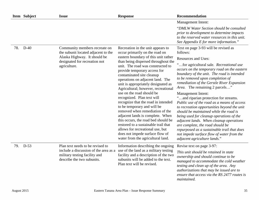
78. D-40 Community members recreate on the subunit located adjacent to the Alaska Highway. It should be designated for recreation not agriculture.
Recreation in the unit appears to occur primarily on the road on eastern boundary of this unit rather than being dispersed throughout the unit. The road was constructed to provide temporary access for contaminated site cleanup operations on adjacent land. The unit is appropriately designated as Agricultural; however, recreational use on the road should be recognized. Plan text will recognize that the road in intended to be temporary and will be removed when remediation of the adjacent lands is complete. When this occurs, the road bed should be restored to a sustainable trail that allows for recreational use, but does not impede surface flow of water from the agricultural land.
Text on page 3-93 will be revised as follows: Resources and Uses: “…for agricultural sale. Recreational use occurs on the temporary road on the eastern boundary of the unit. The road is intended to be removed upon completion of remediation of the Gerstle River Expansion Area. The remaining 2 parcels…” Management Intent: “…and riparian protection for streams. Public use of the road as a means of access to recreation opportunities beyond the unit should be maintained while the road is being used for cleanup operations of the adjacent lands. When cleanup operations are complete, the road should be repurposed as a sustainable trail that does not impede surface flow of water from the adjacent agriculture lands.”
79. D-53 Plan text needs to be revised to include a discussion of the area as a military testing facility and describe the two subunits.
Information describing the ongoing use of the land as a military testing facility and a description of the two subunits will be added to the text. Plan text will be revised.
Revise text on page 3-97: This unit should be retained in state ownership and should continue to be managed to accommodate the cold weather testing and clean up of the area. Any authorizations that may be issued are to ensure that access via the RS 2477 routes is maintained.

August 2015 Eastern Tanana Area Plan – Issue Response Summary 36
Item Subject Issue Response Recommendation Revise Resources and Uses to: “Situated south and east of Delta Junction on the south side of the Alaska Highway; this unit is comprised of 2 subunits which are both located southeast of the DJBR. Subunit 1 is located in F12S12E and is surrounded on three sides by the DJBR. Subunit 2 lies southeast of subunit 1 and is bordered by the DJBR and PLO 910, an existing military reservation, to the north. The terrain is mountainous in the south and west and transitions to fairly level in the north and east. Moose wintering and calving habitat, caribou wintering habitat, sheep wintering habitat, and the bison concentration area are indicated. RST 1609 (Richardson Hwy-Gerstle River) traverses both subunits. Subunit 1 was leased to the Department of Defense from 1964-1972 (LAS 19708). The area is commonly referred to as the Gerstle River Test Site. Portions that were used to test weapons are considered to be potentially hazardous (ADL 25072). The Alaska Department of Environmental Conservation changed the case status for the site to cleanup complete in 2013; however, data gaps have been identified and additional investigations may be required.”
80. D-56 Significant cultural resources associated with the Alaska Highway are known to occur within this unit. Additionally, a forestry salvage harvest has been identified by the Division of Forestry within the unit.
A 2.5 mile long segment of the original Alaska Highway is located in the eastern portion of the unit. This segment retains its original physical appearance and is still used as a road today. It was added to the National Register of Historic
Revise text on page 3-98: Resources and Uses: “This large settlement area is a significant expansion of the existing Craig Lake disposal area. This large unit has rolling terrain that contains a mixture of upland

August 2015 Eastern Tanana Area Plan – Issue Response Summary 37
Item Subject Issue Response Recommendation Places in 2013. Plan text will be revised. A tent platform maintained by ADF&G is located on the eastern shore of Craig Lake and is available for use by the public. Public use and access of this site should be maintained as well as the remote experience available at this site.
ridges and low lying wetlands and kettle-hole lakes. The uplands are dominated by deciduous trees while the flat and low-lying areas are dominated by conifers. In response to a recent blow down event that occurred in September 2012; a large portion of this unit has been identified for a salvage timber harvest by the Division of Forestry1. ADF&G maintains a tent platform on the eastern shore of the Craig Lake. Access to the platform is provided via public easement (ADL 415268). The western portion of this settlement area has been identified as moose wintering habitat. The Office of History and Archaeology (OHA) has identified a historically significant portion of the original Alaska Highway and other cultural resources that are present in this unit. This segment of the Alaska Highway retains its original physical appearance and is still used as a road today. It was added to the National Register of Historic Places in 2013.” Management Intent: “Land disposals are appropriate within the planning period but must be developed in a manner that avoids or minimizes impacts to the historic resources or physical character of this segment road. Manage to protect National Register listed property and other cultural resources that are present in this unit. Forestry operations within this settlement area are appropriate. Forestry staff shall consult with Land Sales and
1 Alaska Department of Natural Resources, Division of Forestry – Delta Area Five Year Schedule of Timber Sales, Fiscal Years 2014-18 Adopted September 10, 2013.

August 2015 Eastern Tanana Area Plan – Issue Response Summary 38
Item Subject Issue Response Recommendation Contract Administration Section staff during the Best Interest Finding and Forest Land Use Plan processes to ensure harvest methods, road placement, and operation timing is compliments proposed land sale activities. An area of land including the ADF&G maintained tent platform should be retained by the state to preserve public use opportunities and maintain the remote setting. The OHA shall be consulted before any earth disturbing activities, issuance of authorizations, or the commencement of forestry activities that may have direct or indirect effects on the known cultural resources within this unit. Disposals will not occur within the relatively large wetland area located in sections 25 and 36 F013S015E or sections 30 & 31 in F013S016E. See Chapter 2 for specific management guidelines, especially related to Settlement and riparian protection for streams. This unit is affected by Leasehold Location Order Number 34.”
81. D-64 DMLW Water Section has recommended additions regarding Reservations of Water.
The Water Section has suggested additional text to the Management Intent and Resources and Uses to help clarify the reservations of water that occur within this unit.
Add text beginning on page 3-100: Resources and Uses: “A reservation of water exists for the Tanana River within this unit.” Management Intent: “DMLW Water Section should be consulted prior to development to determine impacts to the reserved water resources in this unit.

August 2015 Eastern Tanana Area Plan – Issue Response Summary 39
Item Subject Issue Response Recommendation See Appendix E for more information.”
82. D-66 Existing unit does not recognize the important upwelling area at the mouth of the Delta River. Additionally, the PRD does not carry forward the recommendation to legislatively designate the area of upwelling as a Critical Habitat Area.
The lower reach of the Delta River – just upstream of the confluence with the Tanana River – was recommended for legislative designation as the Delta River Critical Habitat Area in the 1985 TBAP. The lower mile of the Delta River is fed by upwelling spring water after summer flows in the river subside. This area, along with several other upwelling areas nearby, serves as one of the two major fall chum spawning areas within the Yukon Drainage. Based on further review, DMLW recommends the designation of this area as a Critical Habitat Area for the reasons stated above. In order to clarify the management intent for this area, D-66 will be divided into two units – D-66 and D-67. Unit D-66 will consist of the existing Delta River unit excluding the portion of the river lower river encompassed by the Interagency Land Management Agreement (ILMA) with ADF&G (ADL 414914) and will remain co-designated as Ha and Rd. The new unit will be comprised of the land encompassed by the ILMA.
Add text beginning on page 3-101: Unit #: D-66 Designation(s)/Acres: Ha, Rd, 30,526 Map(s)/MTRS: Map 3-3, 3-3a Resources and Uses: “This unit contains the Delta River, which is defined as the area within the ordinary high water marks of this stream. As such, it includes the river and the shore lands associated with the river, which include islands, gravel bars, and similar upland type features. This unit excludes the portion of the river lower river encompassed by the Interagency Land Management Agreement (ILMA) with ADF&G (ADL 414914). The requirements of this unit apply to both the water column and the shore lands associated with it. It also, at times, contains upland riverine areas adjacent to the water body. Use of the Delta River is moderate to high, depending on river segment. Note: Some riverine areas are situated in adjacent upland units, outside the management unit of the Delta River itself. The management requirements for these riverine areas are derived from the management intent of the upland unit. In those instances where the upland unit may provide for development, it is the intent of this plan that the riverine areas are to be retained or protected through the use of stipulations.”

August 2015 Eastern Tanana Area Plan – Issue Response Summary 40
Item Subject Issue Response Recommendation Management Intent: “Manage unit for its habitat and public recreation values. Management will focus on maintaining water quality, habitat, and recreational use of the river. Shorelands within the unit are to be managed in a similar way as the water column and are to be retained in state ownership. Other types of projects may be authorized if they are determined to be in the best interest of the state and maintain the values and resources of the unit. See the Shorelands and Stream Corridors section of Chapter 2 for specific requirements affecting riverine areas.”
83. D-67 (new unit) The Public Review Draft of the ETAP failed to recommend the lower reach of the Delta River be legislatively designated as a critical habitat area as had been done in the 1985 Tanana Basin Area Plan (1985 TBAP). ADF&G supports the continued recommendation for this area to be legislatively designated.
The lower reach of the Delta River – just upstream of the confluence with the Tanana River – was recommended for legislative designation as the Delta River Critical Habitat Area in the 1985 TBAP. The lower mile of the Delta River is fed by upwelling spring water after summer flows in the river subside. This area, along with several other upwelling areas nearby, serves as one of the two major fall chum spawning areas within the Yukon Drainage. Based on further review, DMLW will continue to recommend this area be legislatively designated as a Critical Habitat Area for the reasons stated above. In order to clarify the management intent for this area, a new unit (D-67) is created that comprises the lower
Add text beginning on page 3-101: Unit #: D-67 Designation(s)/Acres: Ha, Wr, 508 Map(s)/MTRS: Map 3-3, 3-3a Resources and Uses: “This unit consists of the lower portion of the Delta River that is encompassed by the Interagency Land Management Agreement (ILMA) with ADF&G (ADL 414914). The unit includes a portion of the Delta River fed by upwelling spring water after summer flows in the river subside. This area, along with several other upwelling areas nearby, serves as one of the two major fall chum spawning areas within the Yukon Drainage. Because of its importance as salmon habitat, this plan recommends that the area of upwelling be legislatively designated as a critical habitat area. Use of this segment of the Delta River is moderate to high. MCO

August 2015 Eastern Tanana Area Plan – Issue Response Summary 41
Item Subject Issue Response Recommendation portion of the Delta River within the Interagency Land Management Agreement (ILMA) with ADF&G (ADL 414914). Unit D-67 will be co-designated as Ha and Wr.
601 closes land within this unit to new mineral entry.” Management Intent: “Manage unit for its habitat and water resource values. Management will focus on maintaining habitat for spawning salmon and recreational use of the river. Shorelands within the unit are to be managed in a similar way as the water column and are to be retained in state ownership. Other types of projects may be authorized if they are determined to be in the best interest of the state and maintain the spawning habitat and water resource values of the unit. Until, this unit is legislatively designated, ADF&G will maintain management authority consistent with the ILMA (ADL 414419). This unit remains closed to new mineral entry. See the Shorelands and Stream Corridors section of Chapter 2 for specific requirements affecting riverine areas.” The new unit will be added to Map 3-3.
84. D-68 (new unit) DPOR, Office of History and Archaeology (OHA) indicated that significant archaeological resources are known to occur within this unit. Designations should therefore reflect the importance of these resources.
Certain lands within this unit have been identified by Office of History and Archaeology staff as having significant archaeological resources. These important resources will be recognized through the creation of a new unit – D-68 – which encompasses the area of lower Keystone Creek. The new unit is created from lands within Unit D-11 in the ETAP PRD. Unit D-68 will be co-designated
Add text beginning on page 3-101: Unit #: D-68 Designation(s)/Acres: Hr, Wr, 6,635 Map(s)/MTRS: Map 3-3, 3-3a Resources and Uses: “This unit includes the lands and waters around Lower Keystone Creek adjacent to the Richardson Highway, contiguous with the Lower Shaw Creek drainage. The terrain is primarily level to gently sloping

August 2015 Eastern Tanana Area Plan – Issue Response Summary 42
Item Subject Issue Response Recommendation Heritage Resources (Hr) and Water Resources (Wr). The acres identified for in the Resources Allocation Table for Unit D-11A will reflect the decrease in acreage for the creation of unit D-68.
wetland complex. Vegetation is primarily composed of wetland species, however some forested areas exist. Moose calving habitat is indicated in the southeast portion of the unit. Dispersed recreation occurs in the unit and includes hunting and trapping. A small portion of the Pogo Mine access easement (ADL 416817) is located in Section 17, T007NR009EFM. The Office of History and Archaeology (OHA) has identified significant archaeological resources within the unit.” Management Intent: “Manage to protect and preserve the archaeological resources and the water resources associated with Keystone and Shaw creeks and the associated wetland complexes. The OHA shall be consulted before any earth disturbing activities or prior to authorizing any activity within this unit. Development shall not be authorized except for certain types of utilities, communication facilities, roads, and similar types of projects that provide a general public benefit. Unit is to continue in its natural state. ADNR shall consult with ADF&G regarding moose habitat prior to authorizing uses. Retain in state ownership. Because of the significance of the archaeological resource, these lands are to be retained in state ownership.” The new unit will be added to Map 3-3.
85. D-69 (new unit) DPOR, Office of History and Archaeology (OHA) indicated that significant archaeological resources
Certain lands have been identified by the Office of History and Archaeology staff as having
Add text beginning on page 3-101: Unit #: D-69

August 2015 Eastern Tanana Area Plan – Issue Response Summary 43
Item Subject Issue Response Recommendation are known to occur within this unit. significant archaeological resources
within and around the unit. These important resources will be recognized through the creation of a new unit – D-69 – which encompasses the area of the Shaw Creek Bluff Quarry between the Old and New Richardson Highway.
Designation(s)/Acres: Ma; 4.8 acres Map(s)/MTRS: Map 3-3, 3-3a Resources and Uses: “This small unit contains a material sale site (MS62-4-165-2, ADL419552) adjacent to the Richardson Highway within the Tanana Valley State Forest. This small quarry encompasses a bedrock extrusion on a south-facing bluff above the highway near the Tanana River. The Office of History and Archeology has identified significant archeological resources within or surrounding this unit.” Management Intent: “Manage for material extraction values and resources consistent with this authorization, and with due consideration to protect and preserve the archaeological resources within or surrounding this unit. OHA shall be consulted before any earth disturbing activities are conducted by State agencies or prior to authorizing any activity within this unit. Additionally, OHA and Division of Forestry shall be consulted prior to authorizing any activity within this unit. Retain in state ownership.” The new unit will be added to Map 3-3.
86. D-70 (new unit) State lands within F009S010E Sections 11 & 12 known as Fourmile Hill should be managed to preserve public recreation opportunities.
Fourmile Hill and the surrounding state land are used by residents for recreation and it is appropriate that they be preserved for continued recreational use. These lands will be designated Public Recreation-Dispersed (Rd).
The new unit will be added to Map 3-3 and 3-3a. Add text beginning on page 3-101: Unit #: D-70 Designation(s)/Acres: Rd, 323

August 2015 Eastern Tanana Area Plan – Issue Response Summary 44
Item Subject Issue Response Recommendation Map(s)/MTRS: Map 3-3, 3-3a Resources and Uses: “Encompassed by this unit is Fourmile Hill, a somewhat isolated prominence that rises above the adjacent relatively level agricultural and residential lands adjacent to the communities of Big Delta and Delta Junction. It is densely forested except for the southern exposure of the hill and has a well-developed network of trails or roads including public easements (ADL 400064). Currently, these lands are used for dispersed recreation by community residents.” Management Intent: “Manage to preserve and enhance access and recreational opportunities.”
87. D-71 (new unit) Existing parcels of state land (3 of them) within the City of Delta Junction were not identified in the ETAP PRD. The City of Delta Junction is currently seeking to acquire these parcels for the eventual development of a city park.
These three parcels of existing State land are located east of the intersection of the Alaska and Richardson highways in downtown Delta Junction (Lots 2, 1, and 83). Currently, these parcels are leased by the City of Delta Junction (ADL 415300) for the purpose of creating a park within the city. Recently, the City of Delta Junction has applied to the State for the conveyance of these lands (ADL 419913). The conveyance of these lands to the City of Delta Junction is appropriate under the existing TBAP and will remain appropriate within the ETAP. This plan will
Add text beginning on page 3-101: Unit #: D-71 Designation(s)/Acres: Pt, 5 Resources and Uses: “Unit consists of three parcels of Sate land within the City of Delta Junction. The adjacent land uses are a mixture of commercial and residential uses. Currently, these parcels are leased by the City of Delta Junction (ADL 415300) for the purpose of creating a park within the city. The City has applied to acquire this land for the purpose of creating a public park (ADL 419913).” Management Intent:

August 2015 Eastern Tanana Area Plan – Issue Response Summary 45
Item Subject Issue Response Recommendation create a new unit, consisting of the three parcels, and will designate the unit as Public Facilities-Transfer (abbreviated as Pt) with intent that the parcel be conveyed to the City of Delta Junction within a period of 5 years after the adoption of the plan. If the lands within the unit are not conveyed during the five year time period, the unit will automatically convert to a Settlement-Commercial (abbreviated as Sc) designation and the disposal of these lands by the state will be appropriate.
“The conveyance of these lands to the City of Delta Junction is appropriate under the existing TBAP and will remain appropriate within the ETAP. It is intended that the unit be conveyed to the City of Delta Junction within a period of 5 years after the adoption of the plan. If the unit is not conveyed during the five year time period, the unit will automatically convert to a Settlement-Commercial designation (classified Settlement Land) and the disposal of these lands by the State will be appropriate.” The new unit will be added to Map 3-3.
88. D-72 (new unit) An existing parcel of state land (Tract B in ASLS No. 2005-12) within the City of Delta Junction was not identified in the ETAP PRD. A 501(c)(3) non-profit group, Partners for Progress in Delta, Inc., has applied to develop land in this unit for the eventual development of the Delta Career Advancement Career Center Expansion facility (ADL 419984).
This unit consists of a 22.08 acre parcel of State land that lies just north and east of the Delta Junction School. It is identified as Tract B in ASLS No. 2005-12. DNR has a current application (ADL 419984) from Partners for Progress in Delta, Inc., a 501(c)(3) non-profit group, to acquire land in this unit for the eventual development of the Delta Career Advancement Career Center Expansion facility. The conveyance of these lands to Partners for Progress in Delta, Inc. is appropriate under the ETAP. This plan will create a new unit, consisting of this parcel, with intent that the parcel may be conveyed to Partners for Progress in Delta, Inc. if determined in the best interest of the State within a period of 5 years
Add text beginning on page 3-101: Unit #: D-72 Designation(s)/Acres: Sc, 22 Resources and Uses: “Unit consists of a 22 acre parcel of state land (Tract B in ASLS No. 2005-12) within the City of Delta Junction. The eastern portion of the unit is densely vegetated unit is level and vegetated with a mixture of evergreen and deciduous trees. Vegetation in the western portion of the unit is less dense, and has a well-developed network of trails. The adjacent land uses are a mixture of school land, commercial land, and residential uses. The airport lies just north and west of the unit.” Management Intent: “The conveyance of these lands to Partners for Progress in Delta, Inc., a 501(c)(3) non-

August 2015 Eastern Tanana Area Plan – Issue Response Summary 46
Item Subject Issue Response Recommendation after the adoption of the plan. If the lands within the unit are not conveyed during the five year time period, the disposal of these lands by the state will be appropriate.
profit group, for the development of the Delta Career Advancement Career Center Expansion facility may be appropriate. If determined in the best interest of the State, the unit may be conveyed to Partners for Progress in Delta, Inc. within a period of 5 years after the adoption of the plan. If the unit is not conveyed during the five year time period, the disposal of these lands by the State will be appropriate.” The new unit will be added to Map 3-3.
89. D-73 (new unit) State land including Rika’s Roadhouse/Big Delta State Historic Park was inadvertently missed during development of the PRD of ETAP. Additionally, DPOR was recently engaged by Alyeska Pipeline Service Company to express interest in purchasing private property adjacent Rika’s Roadhouse at Big Delta State Historical Park. This land has been used by DPOR through a license agreement for many years to provide public access.
This area of state land was inadvertently in the PRD of ETAP. A new unit (D-73) will be developed for these lands. These lands are managed by DPOR through a Management Right (ADL 400067) or an ILMA (ADL 414607). This unit will be designated Public Facilities-Retain (Pr). On November 20, 2014, Alyeska Pipeline Service Company, as the agent for the Trans-Alaska Pipeline System owners, provided DPOR with a Request for Expression of Interest to purchase property adjacent to Big Delta State Historical Park. A portion of this land has been used by DPOR to provide access to the park consistent with a license agreement. DPOR has responded that is interested in acquiring the lands as they are crucial for providing public access. Should these lands be acquired by the State, they should be managed to continue to provide public access to the park unit. A new unit will be developed for these
Add text beginning on page 3-101: Unit #: D-73 Designation(s)/Acres: Pr, 7 Map(s)/MTRS: Map 3-3, 3-3a Resources and Uses: “Situated on the south bank of the Tanana River just off the Alaska Highway, this unit includes all land managed by DPOR as Rika’s Roadhouse/Big Delta State Historical Park (ADLs 400067 & 404607). This relatively flat area of land has a high level of development in support of public use and includes the road house, access roads, trails, and parking areas. Access to a portion of these lands has been provided by a license agreement between the Trans-Alaska Pipeline System owners and DPOR. Two utility easements (ADLs 1794 & 414474) bisect this unit.” Management Intent: “All existing state land and acquired land in this unit shall be managed to preserve and enhance public use and access. It is intended

August 2015 Eastern Tanana Area Plan – Issue Response Summary 47
Item Subject Issue Response Recommendation lands that will provide management intent if the State acquires the property.
that these lands will be managed by DPOR via ILMA or Management Right. Activities that detract from this management intent should not be authorized.”
90. D-74 (new unit) Several parcels of state land south of Fort Greeley were inadvertently missed in the PRD of ETAP.
Several parcels of state land were inadvertently missed during the development of the PRD of ETAP. These parcels are located south of Fort Greely on the Richardson Highway. All three are in close proximity to the Trans-Alaska Pipeline System. The parcels appear to be undeveloped and are heavily wooded. A new unit (D-74) will be created for these lands. The will be designated Reserved Use (Rs).
Add text beginning on page 3-101: Unit #: D-75 Designation(s)/Acres: Rs, 30 Map(s)/MTRS: Map 3-3, 3-3a Add to Resources and Uses: “Located south of Fort Greely on the Richardson Highway, this unit is comprised of 3 parcels. All three parcels are in close proximity to the Trans-Alaska Pipeline System, appear to be undeveloped, and are heavily wooded. Parcel 1 lies just north of Pump Station 9. It is a small parcel of land at just over 2 acres. Parcel 2 is approximately 30 acres in size and is immediately adjacent to Pump Station 9. Parcel 3 lies south of the previous parcels and is just east of the Richardson Highway. It is approximately 30 acres in size. Add to Management Intent: This unit should be managed to support activities associated with the Trans-Alaska Pipeline System. Retain in State ownership.” The new unit will be added to Map 3-3.
91. D-75 (new unit) This is a new unit created from eastern portion of a subunit of Unit D-32.
While relatively large in size, this unit does not currently have access that would allow use as an agricultural parcel. Other than a couple of trails that bisect the unit it appears to receive little use. Until better access to the site is
The new unit will be added to Map 3-3 and 3-3a. Add text beginning on page 3-101: Unit #: D-75 Designation(s)/Acres: Rm, 248

August 2015 Eastern Tanana Area Plan – Issue Response Summary 48
Item Subject Issue Response Recommendation developed, it is appropriate that it be designated as Resources Management (Rm).
Map(s)/MTRS: Map 3-3, 3-3a Resources and Uses: “This flat unis lies east of the Trans-Alaska Pipeline System. Vegetation is dominated by evergreen trees with typical wetland vegetation found near the middle of the unit. A few trails are evident. The Trans-Alaska Pipeline System right-of-way is on the western boundary and the Golden Valley Electric easement bisects the eastern portion. Bison habitat is indicated.” Management Intent: “Manage for multiple uses. Development is not anticipated in this unit due to lack of adequate access.”
92. L-01 DMLW Water Section has recommended additions regarding Reservations of Water.
The Water Section has suggested additional text to the Management Intent and Resources and Uses to help clarify the reservations of water that occur within this unit.
Add text beginning on page 3-101: Resources and Uses: “A reservation of water exists for the Tanana River within this unit.” Management Intent: “DMLW Water Section should be consulted prior to development to determine impacts to the reserved water resources in this unit. See Appendix E for more information.”
93. L-02 Description of Delta Junction Bison Range does not mention the Gerstle River Test Site (a weapons test site). This site carries restrictions to hunting and access.
Text will be added to identify the presence of the Gerstle River Test Site within the Delta Junction Bison Range.
Revise text beginning on page 3-101: Resources and Uses: “The Gerstle River Test Site, a former weapons test site (PLO 910) is almost entirely contained in the Delta Junction Bison Range.” Management Intent:

August 2015 Eastern Tanana Area Plan – Issue Response Summary 49
Item Subject Issue Response Recommendation “DOD should be contacted prior to accessing this area.”
Upper Tanana Region 94. U-09 Tanacross Inc. indicated that many
areas shown within planning units were, in fact, owned by the native corporation. They recommended that the state do more extensive title research and remove those areas that were no longer state-owned or state-selected.
DNR conducted title review and confirmed in several instances that the areas identified by Tanacross Inc. were no longer state land.
DNR has modified the final configuration of this unit, depicted on maps 3-1a, 3-4 and 3-4a, to exclude lands owned by native entities.
95. U-10 Tanacross Inc. indicated that many areas shown within planning units were, in fact, owned by the native corporation. They recommended that the state do more extensive title research and remove those areas that were no longer state-owned or state-selected.
DNR conducted title review and confirmed in several instances that the areas identified by Tanacross Inc. were no longer state land.
DNR has modified the final configuration of this unit, depicted on maps 3-1a, 3-4 and 3-4a, to exclude lands owned by native entities.
96. U-12 Tanacross Inc. indicated that many areas shown within planning units were, in fact, owned by the native corporation. They recommended that the state do more extensive title research and remove those areas that were no longer state-owned or state-selected.
DNR conducted title review and confirmed in several instances that the areas identified by Tanacross Inc. were no longer state land.
DNR has modified the final configuration of this unit, depicted on maps 3-1a, 3-4 and 3-4a, to exclude lands owned by native entities.
97. U-13 The northern subunit has been renumbered as U-69 and redesignated as Settlement. The remainder of U-13 is unchanged.
As a result of the removal of settlement unit U-53 and U-58, both of which were designated as Settlement in the PRD, DMLW has determined that it is necessary and appropriate to designate another area or areas as Settlement in order to retain a robust inventory of
No change for remainder of U-13.

August 2015 Eastern Tanana Area Plan – Issue Response Summary 50
Item Subject Issue Response Recommendation Settlement land within this region and to provide opportunities for recreation. The northern subunit of U-13 is designated as Settlement. Further review indicates that this area is forested with rolling terrain and has good access. This area is appropriate for Settlement designation. The southern subunit retains the designation of RMG and is identified as U-13, as identified in the PRD. The northern area, which is recommended to be redesignated as Settlement is now identified as U-69, a discrete new parcel. See U-34 response.
98. U-18 Commenter indicated that many areas shown within planning units as state land were, in fact, owned by a native corporation and should be indicated as native or private land in the plan.
DNR title research confirmed that the area of this unit is no longer state land.
This unit has been removed from the plan, and maps 3-1a, 3-4 and 3-4a have been updated to reflect this change.
99. U-19 Commenter indicated that many areas shown within planning units as state land were, in fact, owned by a native corporation and should be indicated as native or private land in the plan.
DNR title research confirmed that the area of this unit is no longer entirely comprised of state land. While there are valid state selections within this unit, it is mostly native-owned.
This unit has been reconfigured to show updated land status in the plan, and maps 3-1a, 3-4 and 3-4a have been updated to reflect this change.
100. U-22 Western 2-miles of U-22 should be incorporated to the adjacent unit U-21 and designated Forestry and Habitat.
DNR conducted title review and confirmed in several instances that the areas identified by Tanacross Inc. were no longer state land.
DNR has modified the final configuration of this unit, depicted on maps 3-1a, 3-4 and 3-4a, to exclude lands owned by native entities.

August 2015 Eastern Tanana Area Plan – Issue Response Summary 51
Item Subject Issue Response Recommendation Additionally a natural vegetated buffer adjacent to the Alaska Highway for a two mile section in the western portion of the unit should be implemented.
DNR concurs that the natural vegetated buffer from both the Alaska and the Tok Cut-Off Highway should be maintained. See revised plan map for final configuration of this unit.
Revise text beginning on page 3-121: Management Intent: “Maintain a 150’ natural vegetated buffer on either side of the Alaska and Glenn (a.k.a. Tok Cut-Off) highway right-of-ways.”
101. U-24 ADFG recommends that this unit be co-classified Habitat and Forestry in order to protect wildlife movement corridors along the Tok and Robertson Rivers.
DNR, as a matter of policy and practice, protects movement corridors through the use of management intent statements. DNR does not re-designate an entire unit to a co-designation of Forestry and Habitat where the issue involving habitat protection is specific to particular areas. In this instance only the Tok River is situated within U-24. It is therefore inappropriate to redesignate this entire unit in the manner suggested by ADF&G since the critical habitat areas are largely specific to the Tok River, however changes will be made to Management Intent and Resources and Uses to indicate the presence of such corridors.
Revise text beginning on page 3-121: Resources and Uses: “Wildlife movement corridors are present in this unit.” Management Intent: “The maintenance of wildlife movement corridors along the Tok River is to be considered in any authorization that may be adjudicated by DNR. These areas are to be maintained in order to ensure their continued use as movement corridors. DNR shall consult with ADF&G in the adjudication of decisions affecting such corridors.”
102. U-29 Tanacross Inc. indicated that many areas shown within planning units were, in fact, owned by the native corporation. They recommended that the state do more extensive title research and remove those areas that were no longer state-owned or state-selected.
DNR conducted title review and confirmed in several instances that the areas identified by Tanacross Inc. were no longer state land.
This unit has been reconfigured to show updated land status in the plan, and maps 3-1a, 3-4 and 3-4a have been updated to reflect this change.
103. U-32 Tanacross Inc. indicated that many areas shown within planning units
DNR conducted title review and confirmed in several instances that
No change.

August 2015 Eastern Tanana Area Plan – Issue Response Summary 52
Item Subject Issue Response Recommendation were, in fact, owned by the native corporation. They recommended that the state do more extensive title research and remove those areas that were no longer state-owned or state-selected.
the areas identified by Tanacross Inc. were no longer state land. DNR reviewed this unit and found that it corresponds to a small portion of State land along the Alaska Highway, and is appropriate for inclusion in a planning unit.
104. U-34 The northern subunit has been renumbered as U-69 and redesignated as Settlement. The remainder of U-34 is unchanged.
As a result of the removal of settlement unit U-53 and U-58, both of which were designated as Settlement in the PRD, DMLW has determined that it is necessary and appropriate to designate another area or areas as Settlement in order to retain a robust inventory of Settlement land within this region and to provide opportunities for recreation. The northern subunit of U-34 is designated as Settlement. Further review indicates that this area is forested with rolling terrain and has good access. This area is appropriate for Settlement designation. See U-13 response. The southern subunit retains the designation of Forestry and Habitat. The northern subunit, which is recommended to be redesignated as Settlement is now identified as U-69, a discrete new parcel. See U-13 response.
No change for remainder of U-34.
105. U-44 As a result of the deletion of the Settlement unit U-53, approximately 2,500 acres in
U-44 is expanded to include portions of the previous unit U-53. The attributes of this portion of
Text will be revised as follows: Management Intent:

August 2015 Eastern Tanana Area Plan – Issue Response Summary 53
Item Subject Issue Response Recommendation previous unit U-53 have been incorporated into unit U-54.
former unit U-53 are similar to those in this unit and the area is designated Resource Management.
“Retain in state ownership.” DNR has modified the final configuration of this unit as depicted on maps 3-1a & 3-4.
106. U-53 Public comments and meetings with members of the surrounding communities in September 2014 and January 2015 expressed strong support for maintaining the resource values of the unit, and removing the settlement designation.
DNR concurs that Settlement is not appropriate for this unit, and it will be incorporated with the adjacent units. This area will be retained in state ownership. A portion of this unit has been incorporated into U-44 and designated as Resource Management. The remainder has been incorporated into U-54 and designated as Water Resources and Wildlife Habitat. See these units for further detail.
Unit U-53 has been removed from the plan, and maps 3-1a, 3-4 will be updated to reflect the change.
107. U-54 As a result of the deletion of the Settlement unit U-53, approximately 500 acres in previous unit U-53 have been incorporated into unit U-54.
U-54 is expanded to include portions of the previous unit U-53. The attributes of this portion of former unit U-53 are similar to those in this unit and the area is co-designated Habitat and Water Resources.
DNR has modified the final configuration of this unit as depicted on maps 3-1a and 3-4.
108. U-58 Lands within this unit have a significant level of concentrated subsistence use, including the harvest of moose and caribou. A settlement designation is inappropriate as it would directly impact subsistence activities.
DNR received strong opposition to the proposed settlement designation through public meetings, comments, and subsequent meetings with community and TCC representatives. The opposition to a settlement designation was based upon a concentrated use of these lands for subsistence harvest by members of the Northway community. Based on information received at
Revise text beginning on page 3-131: Unit #: U-58 Designation(s)/Acres: Ha, Hv, 9,648 Map(s)/MTRS: Map 3-4 Add to Resources and Uses: “Unit is located east of the Alaska Highway, which also provides access. Unit is adjacent to the Tetlin National Wildlife Refuge. The terrain is hilly throughout, and vegetation consists of evergreens with

August 2015 Eastern Tanana Area Plan – Issue Response Summary 54
Item Subject Issue Response Recommendation these meetings and through public comments, DNR has determined that the Settlement designation should be removed for the reasons stated by the community, and will be re-designated as Harvest and Wildlife Habitat Land. Management intent will be added to maintain the current values of subsistence harvest and wildlife habitat.
scattered shrub stands. This unit exhibits a long history of concentrated subsistence harvest, especially that of moose and caribou. Moose and caribou wintering occurs throughout the unit. The unit is traversed by RST 1589 – Paradise Hill Cabin Trail, and is affected by ADL 414154 (easement ROW), ADL 413509 (private timber sale). Native allotments exist within the unit. Cultural resources are present in this unit.” Management Intent: “Unit is to be managed to maintain its original state in order to facilitate the traditional harvest of subsistence resources. Specific consideration is to be given to maintaining the habitat for the harvest of moose and caribou. Authorizations which would have significant negative impact on these resources are not appropriate. Settlement is not appropriate within unit and land disposals for purposes of settlement should not be authorized. See Chapter 2 for specific management guidelines. In addition to the management guidelines of the Fish and Wildlife Habitat section of Chapter 2, consider impacts upon moose and caribou wintering habitat. Maintain access to adjacent forestry designated land and RS 2477 routes.”
109. U-66 There is an existing application for a preference right but the current
It is appropriate to include language which will provide for the
Revise text beginning on page 3-133: Resources and Uses:

August 2015 Eastern Tanana Area Plan – Issue Response Summary 55
Item Subject Issue Response Recommendation designation of Forestry is retained state land, which precludes the potential conveyance of this small area (4 acres) to the applicant. This preference right is of long standing duration.
adjudication of this non-competitive land sale.
“A preference right (4 acres within SE1/4 of Section 17 and the NE1/4 of Section 20, T014N, R011E, CM) was applied for in ADL 30089. DMLW cannot adjudicate the case since the area is not classified Settlement, required under Alaska Statute. Rather than require the amendment of the plan shortly after it had been approved, it is better to recognize this situation and provide for reclassification of the 4 acre parcel in this plan if the preference right adjudication determines that the application meets the requirements of statute and should be approved. See Management Intent.” Management Intent: “The designation/classification of the preference right application noted in the Description will convert to Settlement if the adjudication decision determines that to do so is in the best interest of the state and with the requirements pertinent to preference rights. (If the adjudication decision determines that the application is not in the best interest of the state or that the requirements pertinent to preference rights are not met, the designation and classification of the area of the preference right application remain Forestry.)”
110. U-69 To provide clarity, it is appropriate to include a new unit for the area to be designated settlement in T.019NR.015E, as described in units U-13 and U-34. See those units for further detail. This new unit should be designated
Identify a new unit (U-69) and designate this unit Settlement.
Revise text beginning on page 3-134: Unit #: U-69 Designation(s)/Acres: Se, 9,534 Map(s)/MTRS: Map 3-3 Resources and Uses:

August 2015 Eastern Tanana Area Plan – Issue Response Summary 56
Item Subject Issue Response Recommendation Settlement and appropriate management intent language should be included. Note: this issue is discussed at length in units U-13 and U-34.
“Unit is located north of Tetlin Junction adjacent to the Tanana Valley State Forest LDA, and bisected by the Taylor Highway. The terrain is hilly throughout and vegetation consists of both evergreen and deciduous cover. The unit is adjacent to the Dennison Fork River to the east, and the headwaters of the West Fork of the Fortymile river to the west. A small portion of moose calving and rutting habitat is present in the southeast corner of the unit along the creek bottom. ADL 414716 a Public Easement for the Taylor Highway Realignment Project also runs through the unit.” Management Intent: “Land disposals are appropriate within the planning period. Retain land for purposes of supporting the State’s land disposal program. Maintain access to adjacent forestry designated land and if authorized provide for personal use wood harvest. A 1200’ buffer on either side of the Taylor Highway is to be maintained to preserve the natural character of the immediate landscape. This is not intended to preclude clearing or widening of the right-of-way for safety or other management purposes. See Chapter 2 for specific management guidelines. In addition to the management guidelines of the Fish and Wildlife Habitat section of Chapter 2, consider impacts upon moose rutting and caribou wintering habitat.”

August 2015 Eastern Tanana Area Plan – Issue Response Summary 57
Item Subject Issue Response Recommendation The new unit will be added to Map 3-4.
Alaska Range Region 111. Management
Summary DMLW (NRO) recommends a change to wording in the first paragraph that describes “specific area.”
Add the recommended wording. Revise text beginning on page p. 3-142, lines 5 - 8: “All state land, including state-selected land, within this region is to be retained in state ownership and is to be managed for its recreation, habitat, and scenic values. Mining is recognized as an appropriate use and is subject to applicable state and federal permitting and regulatory requirements.”
112. E-02 DMLW (NRO) recommends clarifying that a use may be permitted within this unit, subject to the applicable requirements.
Add the recommended wording. Add text beginning on page 3-143: Add to Management Intent: “Other types of projects may be authorized if they are determined to be in the best interest of the state and maintain the values and resources of the unit.”
113. E-06 Pure Nickel Inc., a mineral exploration company, recommends that the area covered by their state mining claims in F010S007E through R012E and in portions of F020S009E, F020S010E, and F020S012E be classified Minerals and that the area of F-06, now situated to the north of this area, be expanded southward to include the aforementioned areas. They are particularly concerned that this area was dropped from the planning area of the Alaska Range Region (previously it had been included in the 1991 TBAP). They maintain
Concur. The area of E-06 will be expanded to (generally) include the westernmost portion of the state mining claims in this area. The revised configuration of this unit is depicted on plan maps. The classifications of unit E-06 (of Minerals and Habitat) will also apply to this area. (The actual management unit boundary is somewhat different than this and excludes some sensitive area along the Richardson Highway and areas with the Tangle Lake Archeological District.) This area is different from the area
Revise text beginning on page 3-145 Management Intent: “Authorizations shall consider impacts to both the caribou herd that uses this area (Nelchina Herd) and the need to maintain this area as a recreation area, as an extension of the activities that occur to the south in the Denali Highway area. This area generally occurs within Townships: F018S010E, F019S007-010E, F020S7-010E.” DNR has modified the final configuration of this unit as depicted on maps 3-1, 3-1a, and 3-5.

August 2015 Eastern Tanana Area Plan – Issue Response Summary 58
Item Subject Issue Response Recommendation that dropping this area from the ETAP planning area would mean that the area would be ‘without a plan’; this would preclude the Department from issuing authorizations that might involve a disposal of an interest (such as a material sale) since the area would no longer be classified (it is now classified Habitat and Public Recreation.) They also maintain that this area is different from the area to the south near the Denali Highway and within the Tangle Lake Archeological District (District). Their lands are north of the Amphitheatre Range, which is highly mineralized and has the probability for a polymetallic discovery, and receives infrequent public use – compared to the heavy public use within the Tangle Lakes District.
near the Denali Highway and it contains mineral occurrence that are similar in type to those in management unit E-06. This expanded area is, however, experiences caribou migration and receives heavy hunting pressure during the fall.

August 2015 Eastern Tanana Area Plan – Issue Response Summary 59
Item Subject Issue Response Recommendation 114. E-10 (new unit) Certain material sites along the
Richardson Highway were missed in the original title review. New information from ADOT/PF indicated additional sites.
An additional material site was indicated in this review and will be included to reflect this new information. This unit is composed of a 25 acre site adjacent to the Richardson Highway. Text for the new unit will be added to the Resource Allocation Table and the new unit will be added to Map 3-5.
Revise text on page 3-146. Unit #: E-10 Designation(s)/Acres: Ma, 25 Map(s)/MTRS: Map 3-5 Add to Resources and Uses: “This small unit contains a material sale site (MS 71-0-035-2, ADL416203) on the east side of the Richardson Highway”. Management Intent: “Manage unit for its material values and resources consistent with the authorization issued by DNR. Material sales to the public may be considered with the concurrence of ADOT/PF. Retain in state ownership.”
Navigability 115. Navigability High value resident fish streams
were not identified in the PRD since they are not indicated on research material available to DNR. Due to the importance of resident fish species in the Interior, DNR requested ADF&G prepare a listing of these streams.
It is appropriate to add streams and lakes within the planning area which are important to resident fish populations. These water bodies will be added to the listing of streams and lakes that are now identified as anadromous and/or high recreation value in Tables 3.1 and 3.2.
Revise text beginning on page 3-158: Add column to table 3.1 and 3.2 which indicates streams and lakes which are of high value to resident fish populations.

August 2015 Eastern Tanana Area Plan – Issue Response Summary 60
Item Subject Issue Response Recommendation
Chapter 4 116. Survivor
Designations and Classifications
DMLW (NRO) has expressed concern with the wording on p. 4-9, lines 3-5 that would seem to imply that the requirements related to 11 AAC 55.040(g) would be voided by the LCO that implements the plan. 11 AAC 55.040(g) states that land of a particular type (open to entry, homestead, and the like) be closed to mineral entry until the land is reclassified.
Although it is not the intent that the LCO implementing this plan void this requirement, this is the effect of this action, nonetheless. To ensure that there are no unintended consequences from this implementation, it is appropriate to qualify the wording in the draft plan such that areas not reclassified in this plan would remain closed to mineral entry under this provision of Administrative Code. We suspect that there are relatively few such areas, but this is an appropriate, prudent step.
Revise text on page 4-9: Areas not reclassified in this plan remain subject to the requirements of 11 AAC 55.040(g). A statement will also be included in the Land Classification Order.
117. Additions to Legislatively Designated Areas
ADF&G requests that the LDA recommendations in the 1991 TBAP be carried forward in the ETAP.
The 1991 TBAP recommended additions to a variety of LDAs, including state recreation rivers, state recreation areas, state game refuges, and state critical habitat areas. Several recommendations included in the TBAP are not within the ETAP planning area and therefore are not included in this response. Two proposed LDAs are within this plans boundary and are identified below. The Chatanika River is a popular recreational river in the Fairbanks area and warrants a LDA designation. The Delta River critical habitat area also merits consideration as a LDA. The lower mile of the Delta River is fed by
A new paragraph will be added beginning on page 4-12, line 31: “The Chatanika River State Recreation River and the Delta River Critical Habitat Area are recommended for Legislative designation.”

August 2015 Eastern Tanana Area Plan – Issue Response Summary 61
Item Subject Issue Response Recommendation upwelling spring water and this is one of the few spawning areas available for fall run chum salmon. DNR typically does not include recommendations for state game refuges in its area plans; we view the creation of such areas as a major recommendation and one that the ADF&G should advance and is the appropriate entity to do so. There is a Fielding Lake State Recreation Site currently.
118. Generally Allowed Uses
DMLW (NRO) recommends removing the words “particularly the Denali National Park” on p. 4-14, lines 3 and 4, since this is not inclusive of the land owned by the federal government and the phrase could be interpreted to mean that state regulations apply to borough and federal areas. They recommend replacing the wording with “that are under their jurisdiction”.
Wording will be revised to remove the final sentence.
Revise text in page 4-14: Delete sentence, “Uses are restricted on some borough and federally owned land, particularly the Denali National Park.”

August 2015 Eastern Tanana Area Plan – Issue Response Summary 62
Item Subject Issue Response Recommendation
Glossary 119. Disposal DMLW (NRO) indicates that the
word ‘easement’ is clearly a disposal and within the meaning of this definition. They are concerned that because an easement is a disposal, that the granting of easements on lands that are to be retained by the state will be problematic given recent Alaska Supreme Court decisions that defined this term and identified what the disposal of an easement encompassed.
This issue is already addressed in Chapter 3, in the section, ‘Disposal or Retention in State Ownership’. It states that the discussion of whether state land is to be retained is indicated, in general, by certain designations (forestry, habitat, etc.) and explains in the footnote (#6) that it is not intended that the issuance of easement is precluded by these general statements in the plan. It states, “Within the context of this plan, the issuance of easements also will not contradict the requirement to retain land in state ownership.” However, to clarify this issue, revision of glossary text will be made.
Revise text beginning on page A-3: Disposal. “Such disposals are evidenced by conveyance documents, including either a patent or Quit Claim Deed. The issuance of an easement or lease does not utilize these forms of conveyance documents.” Easement. “Easements may be issued within areas that are designated by the plan to be retained.”
120. Locatable Mineral DMLW (NRO) expressed concern with the definition of the term ‘locatable mineral’ and asked that it be more carefully defined.
Discussions with the Mining Section resulted in changes to the current definition.
Revised text beginning on page A-7: “Minerals that are subject to location under the mining laws of the United States on January 3, 1959, and that are described in AS 38.05.185. These include both metallic and non-metallic minerals.”
121. Mineral Order DMLW (NRO) is concerned that the statement on p. A-7, lines 1 and 2, referencing state status plats is outmoded and that better wording be added.
The use of the term of “state status plats”, while valid (since they are still widely used by DNR) is not the current standard for determining land status, since staff and the public generally use Alaska Mapper.
Revise text on page A-7: Replace “state status plats” with the following “graphic representations applicable at the time of review.”

August 2015 Eastern Tanana Area Plan – Issue Response Summary 63
Item Subject Issue Response Recommendation
Permanent Use 122. Retained Land DMLW (NRO) indicated that the
statement on page A-10, line 30 about the applicability of easements relative to retained land, while properly stated, could be further refined.
Revise this definition to include the recommendation.
Revise text on page A-10: “…and as described in the section ‘Disposal or Retention in State Ownership’ in Chapter 2.”
Temporary Use 123. Will DMLW (NRO) is confused by
what the term plan amendment means and what an amendment entails.
For clarity a reference to 11 AAC 55.040(f) will be added to text.
Revise text on page A-12: Add text on line 40 following “…guidelines requires a plan amendment consistent with 11 AAC 55.040(f).”
124. Land Classification Order
The land classification order needs to be amended to include the provision stated in ‘Survivor Designations and Classifications’ related to 11 AAC 55.040(g).
Revise section IV of the LCO. Revise text on page B-1, line 23: “Areas not reclassified in this plan remain subject to the requirements of 11 AAC 55.040(g).”