Embed Size (px)
Citation preview
R o b e r t s C r e e k
P i p e C ree k
Sout
hBr
a nc h
Man
i t owo
cR i
v er
M u d C r e e k
J o h n s o n C r e e k
S t o n yB r o o k
StatewideNonpoint
Easement Program
StockbridgeLedge Woods
State Natural Area
Calumet HarborRough Fish Station
StatewidePublicAccess
151
55
H
F
HH
C
BB
W
HHH
Kiel Road
West Jefferson Road
Court Street
South
Towe
r Roa
d
South
Was
hingto
n Roa
d
South
Town
Hall R
oad
Linco
ln Ro
ad
Scho
enbo
rn Ro
adTru
cker
Road
Indian Road
Mud Creek Road State Road
Pioneer
Road
Mina
han R
oad
Finne
gan R
oad
Salm
Roa
d
Stone Road
East Jefferson Road
McHu
gh R
oad
Stoney Brook Road
Banner Road
Dick Road
Ledge
Road
Weber Road
Moeh
rke R
oad
South
Colu
mbus
Roa
d
Shady Lane
North
Towe
r Roa
d
Long Road
Schluchter Road
Calmar Road
Harlo
w Ro
ad
Quinney Road
St Pa
ul Ro
ad
Town
Hall R
oad
Court Road
Saint Charles Road
Parad
ise Ro
ad
Lake
Shore
Driv
eSo
uth La
ke Sh
ore D
rive
Hickory Hills Road
CALUMET COUNTY
FOND DU LAC COUNTY
CALU
MET
COUN
TYW
INNE
BAGO
COU
NTY
FOND
DU
LAC
COUN
TYW
INNE
BAGO
COU
NTY
86
Un Spring
LakeWinnebago
St ockb r idge
CHILTON
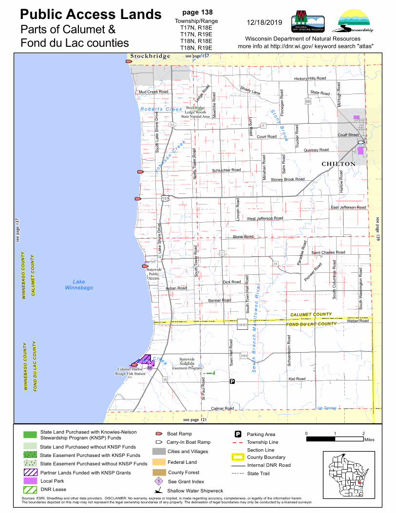
Public Access Landsmore info at http://dnr.wi.gov/ keyword search "atlas"
0 1 2Miles
Wisconsin Department of Natural Resources
Sources: ESRI, StreetMap and other data providers. DISCLAIMER: No warranty, express or implied, is made regarding accuracy, completeness, or legality of the information herein.The boundaries depicted on this map may not represent the legal ownership boundaries of any property. The delineation of legal boundaries may only be conducted by a licensed surveyor.
page 138Township/Range
T17N, R18ET17N, R19ET18N, R18ET18N, R19E
12/18/2019Parts of Calumet &Fond du Lac counties
see pa
ge 13
7
see page 157
see page 139
see page 121
State Land Purchased without KNSP Funds
State Land Purchased with Knowles-NelsonStewardship Program (KNSP) Funds
State Easement Purchased with KNSP FundsState Easement Purchased without KNSP Funds
State Trail
Section LineTownship LineParking Area
Cities and Villages
County ForestSee Grant Index1Shallow Water Shipwreck
County BoundaryInternal DNR Road
Carry-In Boat RampBoat Ramp
Federal LandPartner Lands Funded with KNSP GrantsLocal ParkDNR Lease
C e d a rC r e e k
K i l l s n a k e R i v e r
P i n e C r e e k
Ma n i t o w o c R i v e r
S h e b o y g a nR i v e r
Mu d
C r e e k
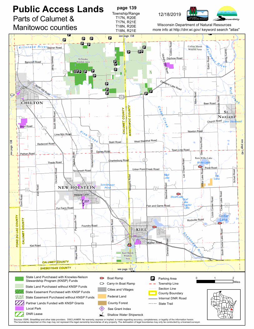
Collins MarshWildlife Area
Kiel MarshWildlife
Area
KillsnakeWildlife Area
Rem-Wilke Lake
151
67
32
X
Y
T
J
HH
H
C
W
G
XX
Point Road
Quarry Road
Rockville Road
Kiel Road
Gree
ndale
Roa
d
Pethan Road
Short Road
Charlesburg Road
Lime Kiln Road
Meye
r Roa
d
Stahl Road
Collin
s Roa
d
Wilke
Lake
Roa
d
Redwood Road
Scha
d Roa
d
North Mill Road
Duchow Road
Hickory Lane
Mueller Road
Danes Road
Ceda
r Lak
e Roa
d
Orch
ard R
oad
Thede Road
Weeks Road Eaton
Roa
d
Foundry Road
Steiner Road
Church Road
Ceme
tery R
oad
South
Ced
ar La
ke R
oad
Ucker Point Creek Road
Bancroft Road
West Steinthal Road
Seve
n Corn
ers R
oad
Niles
Roa
d
Town Line Road
Louis
Corn
er Ro
ad
Newton Road
South
Mill R
oad
Baer Road
Glen
Flora
Roa
d
Hayto
n Roa
d
Hickory Hills Road
Fish and Game Road
Hone
ymoo
n Hill R
oad
Steint
hal R
oad
Plymo
uth Tr
ail
Dorn
Road
Megg
ers R
oad
Carstens Lake Road
Fur Farm Road
Tecumseh Road
Irish R
oad
Lax C
hape
l Roa
d
CALUMET COUNTY
SHEBOYGAN COUNTY
CALU
MET
COUN
TYFO
ND D
U LA
C CO
UNTY
CALU
MET
COUN
TY
MANI
TOW
OC C
OUNT
Y
207
Wilke Lake
MudLake
PruederLake
Lake Oschwald
SyLake
SchildhauerPond
Shoe LakeGrafLake
CedarLake
St .Na zi an z
KIEL
CHILTON
NEW HOLSTEIN
Public Access Landsmore info at http://dnr.wi.gov/ keyword search "atlas"
0 1 2Miles
Wisconsin Department of Natural Resources
Sources: ESRI, StreetMap and other data providers. DISCLAIMER: No warranty, express or implied, is made regarding accuracy, completeness, or legality of the information herein.The boundaries depicted on this map may not represent the legal ownership boundaries of any property. The delineation of legal boundaries may only be conducted by a licensed surveyor.
page 139Township/Range
T17N, R20ET17N, R21ET18N, R20ET18N, R21E
12/18/2019Parts of Calumet &Manitowoc counties
see pa
ge 13
8
see page 158
see page 140
see page 122
State Land Purchased without KNSP Funds
State Land Purchased with Knowles-NelsonStewardship Program (KNSP) Funds
State Easement Purchased with KNSP FundsState Easement Purchased without KNSP Funds
State Trail
Section LineTownship LineParking Area
Cities and Villages
County ForestSee Grant Index1Shallow Water Shipwreck
County BoundaryInternal DNR Road
Carry-In Boat RampBoat Ramp
Federal LandPartner Lands Funded with KNSP GrantsLocal ParkDNR Lease
MENA SHAFox
Cross in g
K i l l
s n a k e R i v e r
Mi l l
C re e
k
K a n k a p o t C r e e k
M u d C r e e kStatewide
Public Access
High CliffStatePark
10
441
55
114
E
D
M
AP
N
KK
EE
B
BB
Custer Road
Mueller Road
Mayfl
ower
Lane
East Taft AvenueEast Sylvan Avenue
Cordy
Roa
d
Twain Road
Bran
t St J
ohn R
oad
Schneider Road
Milita
ry Ro
adVa
ns Ro
ad
Dundas Road
Moeh
n Roa
d
Kessler Road
South
Marx
Roa
d
Carney Road
Hill Road
Killsnake Road
Schmidt Road
South
Harw
ood R
oad
Moore Road
Harw
ood R
oad
Long
Roa
d
Lake
Shore
Driv
e
Crosstown Road
Harve
store
Road
Faro Springs Road
Elm R
oad
McHu
gh R
oad
CALUMET COUNTY
OUTAGAMIE COUNTY
CALU
MET
COUN
TYW
INNE
BAGO
COU
NTY
117
178
F ox
Ri v
e r
LakeWinnebago
Hilb er t
Sh erwood
St ockb r idge
Har rison
APPLETON KAUK AUNA
Public Access Landsmore info at http://dnr.wi.gov/ keyword search "atlas"
0 1 2Miles
Wisconsin Department of Natural Resources
Sources: ESRI, StreetMap and other data providers. DISCLAIMER: No warranty, express or implied, is made regarding accuracy, completeness, or legality of the information herein.The boundaries depicted on this map may not represent the legal ownership boundaries of any property. The delineation of legal boundaries may only be conducted by a licensed surveyor.
page 157Township/Range
T19N, R18ET19N, R19ET20N, R18ET20N, R19E
5/26/2020
Part of Calumet Countysee
page
156
see page 177
see page 158
see page 138
State Land Purchased without KNSP Funds
State Land Purchased with Knowles-NelsonStewardship Program (KNSP) Funds
State Easement Purchased with KNSP FundsState Easement Purchased without KNSP Funds
State Trail
Section LineTownship LineParking Area
Cities and Villages
County ForestSee Grant Index1Shallow Water Shipwreck
County BoundaryInternal DNR Road
Carry-In Boat RampBoat Ramp
Federal LandPartner Lands Funded with KNSP GrantsLocal ParkDNR Lease
Mu d
Cre
ek
S p r i n g C r e e k
E a s t R i v e r
Pl u mC re ek
M u d C r e e k
M a n i t o w o c R i v e r
N o r t h B r a n c hM a n i t o wo c
Ri ver
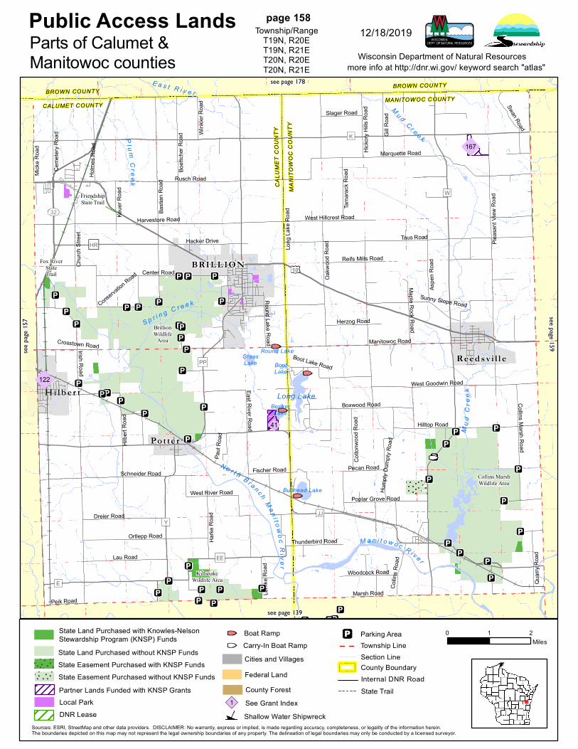
Collins MarshWildlife Area
KillsnakeWildlife Area
FriendshipState Trail
BrillionWildlife
Area
Fox RiverStateTrail 10
32
E
EE
JJ
W
Y
PP
HR
K
Manitowoc Road
West Goodwin Road
Hilltop Road
Collin
s Roa
d
Lemk
e Roa
d
Thunderbird Road
Maple Rock Road
Paul
Road
Mick
e Roa
d
Peik Road
Slager Road
Fischer Road Pecan Road
Keue
r Roa
d
Wink
ler R
oad
Holm
es R
oad
Center Road
Herzog Road
Woodcock Road
Cotto
nwoo
d Roa
d
Reifs Mills Road
Harke
Roa
d
Tama
rack R
oad
Hicko
ry Hil
ls Ro
ad
Gill R
oad
Crosstown Road
Swan Road
Aspe
n Roa
d
Round Lake Road
Quarr
y Roa
d
Ceme
tery R
oad
Dreier Road
Lau Road
Poplar Grove Road
Hacker Drive
West Hillcrest Road
Boot Lake Road
Marsh Road
Sunny Slope Road
Hump
ty Du
mpty
Road
Conservation Road
Boxwood Road
Oakw
ood R
oad
Collins Marsh Road
Churc
h Stre
et
Ortlepp Road
East River Road
Boett
cher
Road
Schneider Road
West River Road
Hilbe
rt Roa
d
Rusch Road
Pleas
ant V
iew R
oad
Basti
an R
oad
Harvestore Road
Taus Road
Long
Lake
Roa
d
Marquette Road
Irish Road
CALUMET COUNTYBROWN COUNTY
CALU
MET
COUN
TY
MANI
TOW
OC C
OUNT
Y
BROWN COUNTY
MANITOWOC COUNTY
167
41
122
GrassLake
BeckerLake
BootLake
Bullhead Lake
Round Lake
Long LakeHi lb er t
Potte r
Reed svi l l e
BRILLION
Public Access Landsmore info at http://dnr.wi.gov/ keyword search "atlas"
0 1 2Miles
Wisconsin Department of Natural Resources
Sources: ESRI, StreetMap and other data providers. DISCLAIMER: No warranty, express or implied, is made regarding accuracy, completeness, or legality of the information herein.The boundaries depicted on this map may not represent the legal ownership boundaries of any property. The delineation of legal boundaries may only be conducted by a licensed surveyor.
page 158Township/Range
T19N, R20ET19N, R21ET20N, R20ET20N, R21E
12/18/2019Parts of Calumet &Manitowoc counties
see pa
ge 15
7
see page 178
see page 159
see page 139
State Land Purchased without KNSP Funds
State Land Purchased with Knowles-NelsonStewardship Program (KNSP) Funds
State Easement Purchased with KNSP FundsState Easement Purchased without KNSP Funds
State Trail
Section LineTownship LineParking Area
Cities and Villages
County ForestSee Grant Index1Shallow Water Shipwreck
County BoundaryInternal DNR Road
Carry-In Boat RampBoat Ramp
Federal LandPartner Lands Funded with KNSP GrantsLocal ParkDNR Lease