Embed Size (px)
Citation preview
Page 1 of 2
RAIN 2016 PSV Tips and Instructions
The following tips and instructions are provided for Personal Support Vehicle (PSV) operators to assist in navigation from Terre Haute to Richmond during the course of the RAIN event. These instructions are organized chronologically, and it is suggested that you keep a copy for reference in your vehicle.
GPS files are available at: https://ridewithgps.com/events/17920‐rain‐2016‐thirtieth‐anniversary
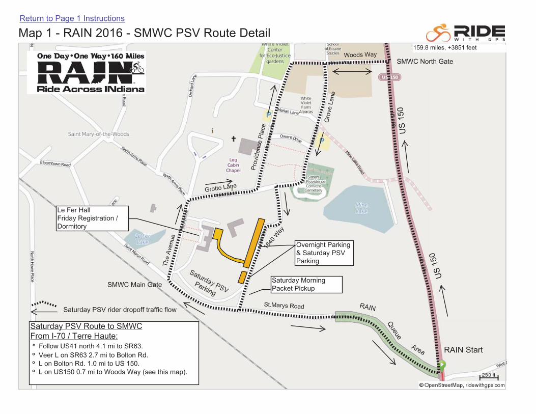
RAIN Start – Arrive at St. Mary-of-the-Woods College (SMWC) early and drop your rider off or park in designated areas. See Map 1. These areas are close to both the Saturday morning packet pickup area and the RAIN Starting Line. Do not drop your rider off or park along US 150 near St. Mary’s Road. This creates visibility problems and traffic congestion at the Start, and is frowned upon by on-site law enforcement. Use the North Entrance to SMWC, not the Main Entrance on St. Mary’s Road. One-way traffic will be maintained along campus roadways to facilitate traffic entry / exit prior to the start of the event.
After the start of RAIN, please exit SMWC north on US 150 along the designed PSV route. See Map 2. Do not follow your rider on the route through Terre Haute as this creates added congestion on city streets. The PSV route is south on SR 63 and US 41 (Third Street) to I-70. Following this route, you will pass the large number of motor lodges near the US 41 / I-70 interchange. If you are staying in this area, consider dropping your rider off at SMWC for the 7:00 RAIN start and then returning to your lodging for a leisurely checkout. You will have plenty of time to meet you rider at Rest Stop 1.
From the US 41 interchange, follow I-70 east 34 miles east to the US 231 interchange. Exit north on US 231 and proceed north 3.5 miles to Rest Stop 1 on the right side of the road.
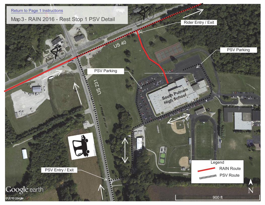
Rest Stop 1 – Rider Mile 39 South Putnam High School. This stop is located at the US 40 and US 231 intersection. Ample parking is available in the school parking lots. PSVs and Riders will enter and exit Stop 1 at different locations. PSVs will enter Rest Stop 1 from US 231. See Map 3. Follow signs to the parking lots on school property where you may meet your rider. Please do not park along the US 40 or US 231 roadway or shoulders near the rest stop as this may obstruct traffic and rider visibility. PSVs may follow US 40 east from Rest Stop 1 to Plainfield and Rest Stop 2.
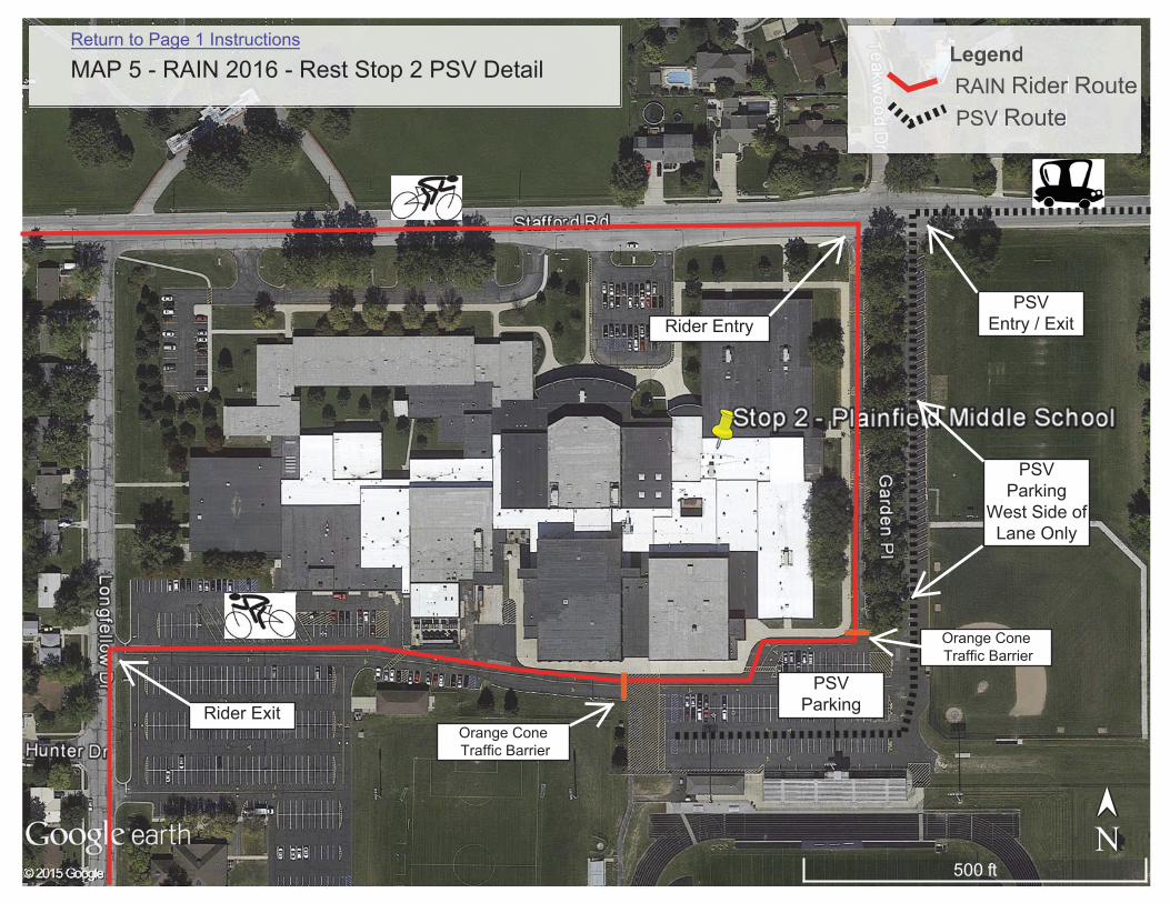
Rest Stop 2 – Rider Mile 64, Plainfield Middle School. PSVs and Riders will approach Rest Stop 2 along different routes. See Map 4. In Plainfield, PSVs will continue east on US 40 past the rider turnoff at East Street. PSVs will turn right on Simmons Street and follow the signed route to Rest Stop 2 along Simmons and Stafford Streets to enter the stop from the east. Ample parking is available in the school parking lots. See Map 5. Park only in the designated areas on
RAIN Start
Overnight Parking & Saturday PSV Parking
Saturday PSV Route to SMWCFrom I-70 / Terre Haute:o Follow US41 north 4.1 mi to SR63.o Veer L on SR63 2.7 mi to Bolton Rd.o L on Bolton Rd. 1.0 mi to US 150.o L on US150 0.7 mi to Woods Way (see this map).
Saturday PSV rider dropoff traffic flow
Le Fer Hall Friday Registration / Dormitory
Saturday Morning Packet PickupSMWC Main Gate
SMWC North Gate
159.8 miles, +3851 feet
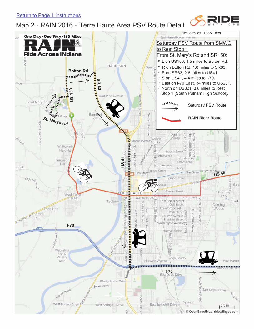
Saturday PSV Route from SMWCto Rest Stop 1From St. Mary's Rd and SR150:o L on US150, 1.5 miles to Bolton Rd.o R on Bolton Rd, 1.0 miles to SR63.o R on SR63, 2.6 miles to US41.o S on US41, 4.4 miles to I-70.o East on I-70 East, 34 miles to US231.o North on US321, 3.8 miles to Rest
Stop 1 (South Putnam High School).
Saturday PSV Route
RAIN Rider Route
159.8 miles, +3851 feet
Rider Entry / Exit
PSV Entry / Exit
PSV Parking
PSV Parking
Legend
PSV Route
RAIN Route
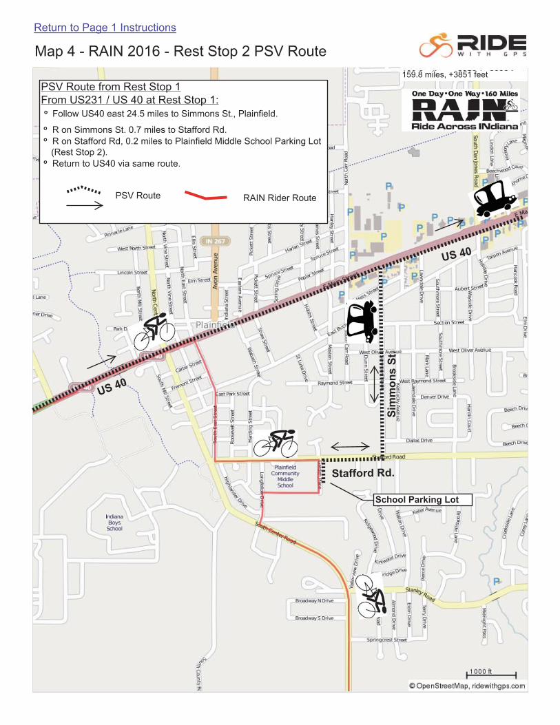
PSV Route from Rest Stop 1From US231 / US 40 at Rest Stop 1:o Follow US40 east 24.5 miles to Simmons St., Plainfield. o R on Simmons St. 0.7 miles to Stafford Rd. o R on Stafford Rd, 0.2 miles to Plainfield Middle School Parking Lot (Rest Stop 2). o Return to US40 via same route.
PSV Route RAIN Rider Route
School Parking Lot
159.8 miles, +3851 feet
Orange Cone Traffic Barrier
PSV Entry / Exit
PSV Parking
Rider Entry
PSV Parking
West Side of Lane Only
Orange Cone Traffic Barrier
Rider Exit
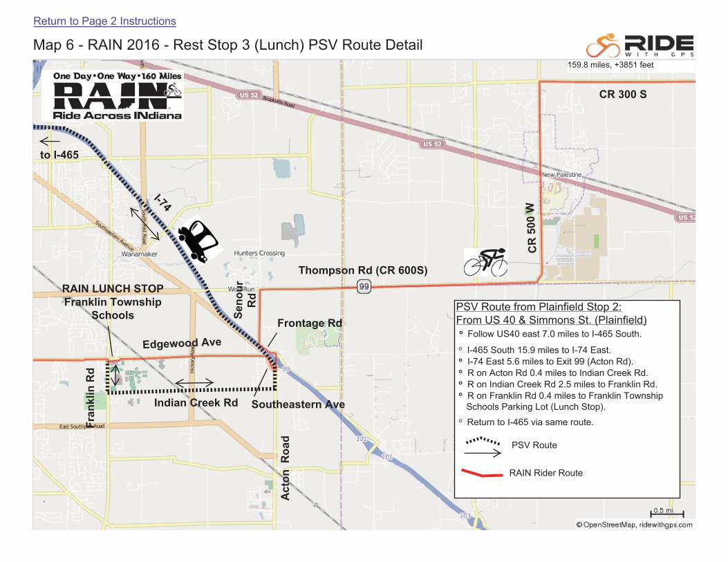
PSV Route from Plainfield Stop 2:From US 40 & Simmons St. (Plainfield) o Follow US40 east 7.0 miles to I-465 South.
o I-465 South 15.9 miles to I-74 East. o I-74 East 5.6 miles to Exit 99 (Acton Rd). o R on Acton Rd 0.4 miles to Indian Creek Rd. o R on Indian Creek Rd 2.5 miles to Franklin Rd. o R on Franklin Rd 0.4 miles to Franklin Township Schools Parking Lot (Lunch Stop).
o Return to I-465 via same route.
PSV Route
RAIN Rider Route
161.6 miles, +3868 feet159.8 miles, +3851 feet
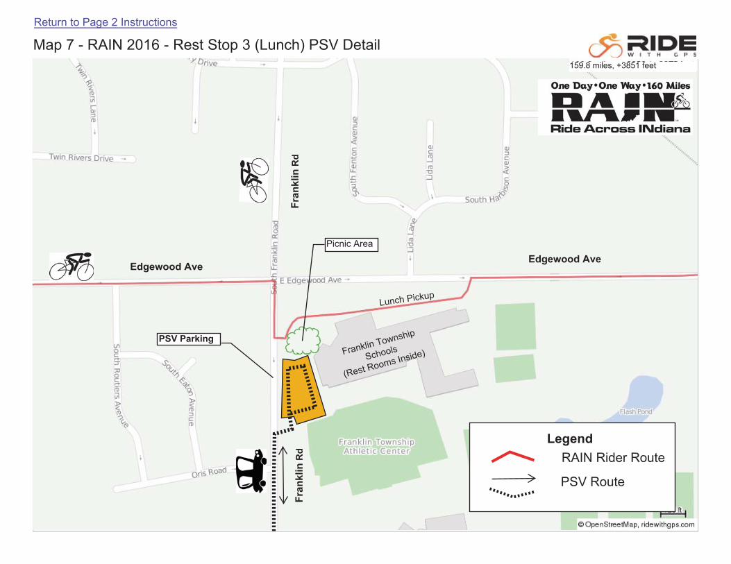
PSV Parking
Picnic Area
161.6 miles, +3868 feet159.8 miles, +3851 feet
LegendRAIN Rider Route
PSV Route
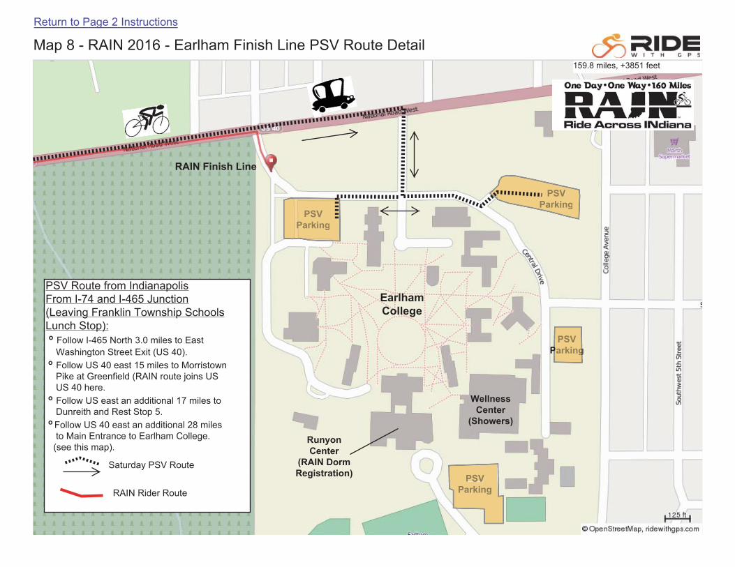
PSV Route from Indianapolis From I-74 and I-465 Junction (Leaving Franklin Township Schools Lunch Stop): o Follow I-465 North 3.0 miles to East
Washington Street Exit (US 40).o Follow US 40 east 15 miles to Morristown
Pike at Greenfield (RAIN route joins USUS 40 here.
o Follow US east an additional 17 miles toDunreith and Rest Stop 5.
o Follow US 40 east an additional 28 milesto Main Entrance to Earlham College.(see this map).
Saturday PSV Route
RAIN Rider Route
159.8 miles, +3851 feet