Embed Size (px)
Citation preview
PRUDHOE BAY UNIT
APPLICATION FOR THE FORMATION OF THE RAVEN PARTICIPATING AREA
FINDINGS AND DECISION OF THE DIRECTOR OF THE D1VISION OF OIL AND GAS UNDER DELEGATION OF AUTHORITY FROM THE COMISSIONER DEPARTMENT OF
NATURAL RESOURCES, STATE OF ALASKA
December 21, 2007

TABLE OF CONTENTS
I. INTRODUCTION, BACKGROUND, AND CONCLUSION 3
II. APPLICATION FOR THE RA VEN PARTICIPATING AREA 4
III. DISCUSSION OF THE DECISION CRITERIA 4
A) Decision Criteria Considered under 11 AAC 83.303(b) 5 1) Geological and Engineering characteristics of the Raven Reservoirs and prior Exploration and
Development activities 5 2) The Applicant's Plan of Development for the RPA 8 3) The Enviromnental Costs and Benefits 8 4) The Econom.ic Costs and Benefits to the State and Other Relevant Factors 9
4.1 Facility Sharing, Production Allocation, and Metering 9 4.2 Gas Disposition 10 4.3 Tract Allocation Schedule 11 4.4 Field Costs 11
B) Decision Criteria Considered under 11 AAC 83.303(a) 12 I) Promote the Conservation of all Natural Resources and Prevent Economic and Physical Waste 12 2) Provide for the Protection of all Parties of Interest, Including the State 13
IV. FINDINGS AND DECISION 14
Attachments:
Attaclm1ent #I - Maps of the RPA Attachment #2 - Proposed RP A Tract Description and Ownership Schedule Attachment #3 - Abbreviations Attachment #4 - Objection to formation of the RP A Attachm.ent #5 - RP A Data Submittal Requirement
2
I. INTRODUCTION, BACKGROUND, AND CONCLUSION
BP Exploration Alaska, Inc. (BPXA), the operator of the Prudhoe Bay Unit (PBU), on behalf of itself and the other PBU Working Interest Owners (WIO), Chevron U.S.A. (Chevron), Inc. ConocoPhillips Alaska Inc. (CP AI), ExxonMobil Alaska Production Inc. (Exxon), and Forest Oil Corporation (Forest), applied (Application) on February 8, 2006, to the State of Alaska, Department of Natural Resources (DNR), Division of Oil and Gas (Division), to fonn the Raven Participating Area (RPA) in the PBU.
The leases are currently owned by BPXA and the other PBU WI Os, Chevron CP AI, and Exxon, with the same tract ownership percentages in each of the leases, which is common to all of the PBU. Forest assigned its ownership interests to BPXA, CP AI, and Exxon, effective September 12, 2006, so that the following ownership interests cmTently apply:
BPXA-26.360567%; CP AI - 36.076746%; Exxon - 36.402687%; and Chevron - 1.16%.
The proposed RP A encompasses oil-bearing sands within the Penna-Triassic interval, including the Ivishak Sandstone and Sag River Formation (Raven Reservoirs), which underlie the Niakuk Kuparak Reservoir.
BPXA provided geologic, geophysical, and engineering (G&G) data supporting the fonnation of the RPA. Production from tract operations within the proposed RPA has demonstrated the potential of this hydrocarbon accumulation.
CmTently, there are two producing wells and one injector well in the proposed RP A, which is currently producing w1der a tract operation approval from the Division pending the approval of this Application. BPXA will combine production from the RP A with production from other Greater Point McIntyre field production and process it in the Lisbume Production Center (LPC).
As conditioned in the Findings and Decision, the Division approves the RP A.
3

II. APPLICATION FOR THE RA VEN PARTICIPATING AREA
Division staff attended pre-Application meetings on September 15 and 26, 2005, and January 25, 2006. BPXA provided overviews of the proposed RP A, drilling results, perfonnance data, simulation model results, and applicable G&G data, including maps, some of which are confidential. BPXA subsequently submitted the Application to fonn the RP A on February 8, 2006. An additional meeting took place on March 7, 2006, with foliow-up discussion and con-espondence the next weeks.
The proposed RPA encompasses 1,615 acres. It covers portions of Sections 24, 25, 26 and 36 of T12N, R15E and Sections 29, 30 and 31 of Tl 2N, Rl6E, Umiat Meridian, from three state leases-AD Ls 34625, 34630, and 34635.
Attachment #I includes hvo RPA maps, and Attachment #2 is a description of the tracts and ownership schedule for the RP A.
The Division has delayed approving the Application pending its decision on BPXA's application to combine the Niakuk and West Niakuk Participating Areas into the proposed Combined Niakuk Participating area (CNP A) .
III. DISCUSSION OF THE DECISION CRITERIA
The DNR Commissioner (Commissioner) reviews unit-related applications, including the formation of participating areas, under AS 38.05. l 80(p) and 11 AAC 83 .303-11 AAC 83.395. By memorandum dated September 30, 1999, the Commissioner approved a revision of Deparb11ent Order 003 and delegated this authority to the Division Director. This Finding and Decision evaluates the Application based on the criteria set out in 11 AAC 83.303 (a) and (b). A discussion of the subsection (b) criteria as they apply to this Application, is set out directly below, followed by a discussion of the subsection (a) criteria.
4

A) Decision Criteria Considered under 11 AAC 83.303(b)
1) Prior Exploration and Development Activities and the Geological and Engineering Characteristics of the Reservoir
Under 11 AAC 83.35l(a) a participating area "may include only the land reasonably known to be underlain by hydrocarbons and known or reasonably estimated through the use of G&G data to be capable of producing hydrocarbons in paying quantities."
The proposed RP A boundary is based on the known extent of the Raven Reservoirs using G&G data. BPXA submitted the following technical data to support the Application: location map, type log, core data, confidential cross sections, top Sag River Fonnation and top I vishak Sandstone structure maps, Sag River Formation and lvishak Sandstone gross oil and gross gas thickness maps, confidential seismic lines and additional well logs. The Division wilI hold these data confidential w1der AS 38.05.035(a)(9)(C) and 11 ACC 96.220.
The Raven Reservoirs are located below the Niakuk Oil Pool with.in the boundaries of the PBU. The RPA covers portions of Sections 24, 25, 26 and 36 of T12N-R15E and Sections 29, 30 and 31 of Tl2N-R16E, Umiat Meridian. The RPA is defined by the top Sag River Fonnation structural closure. Seismic coverage over the area of the proposed PA is provided by the LI-NI 3D survey acquired by Western Geophysical for Sohio/BP (permit MLUP-85-132-01) in the first quarter of 1986. Structure maps for the Raven Reservoirs were generated by BP using the 3D volume. An ru1certainty resides in the accuracy of any depth map derived from seismic data for an area that is located in the onshoreoffshore transition zone, as in the case of the RP A. Because of the rapid lateral changes in the shallow pemrnfrost section that occur in the transition zone, depth maps created from seismic data can sometimes contain significant errors where well penetrations are relatively sparse.
The Raven Reservoirs consist of the Sag River Formation and the Ivishak Sandstone Member of the Sadlerochit Group. The intervening Shublik Fonnation may eventually contribute to production of hydrocarbons in the RP A, but that fonnation is generally considered to be a low penneability carbonate. Potential for incidental production from the Sbublik could occur as a result of the existence of natural fractures; however, there is no currently planned development for the Shublik Formation. The Sag River Formation and Ivishak Sandstone are Permo-Triassic in age. The Raven oil pool is that interval that correlates with and is found from I 0,628 feet md to 11,165 feet md within the BP N iakuk 5 well. The proposed RP A encompasses 1,615 acres. Data provided in the Application indicates that both the Sag River Fonnation and the Ivishak Sandstone are proven capable of producing hydrocarbons in paying quantities.
The Permo-Triassic stratigraphy reflects an overall transgressive succession from fluvio-deltaic lvishak sandstones, conglomerates, siltstones and shales, to shelfal, marine transgressive deposits of the Sag River Fonnation. The lvishak Sandstone of the Sadlerochit Group was deposited in a multistoried fluvio-deltaic system. The Ivishak Sandstone is the primary reservoir at the Prudhoe Bay oil field. It is overlain by the Shublik Fonnation. The Shublik Formation represents deposits of a transgressive, shallow marine carbonate platfonu. The Shublik Formation is overlain by the Sag River
5
Formation. The Sag River Formation represents stacked, aggradational to transgressive shelfal deposits of several very fine to fine grained, glauconitic, quartz-rich sandstones.
Numerous small accumulations of oil and gas have been either tested or produced from the Ivishak Sandstone north of the Prudhoe Bay bounding fault, notably at Northstar, North Prod.hoe Bay, Eider, and in the Gwydyr Bay area. Similarly, oil and gas have been produced from the Sag River Fonnation n01th of Prudhoe Bay at Milne Point Unit, and North Prudhoe Bay. These accumulations, like the Raven Reservoirs, are strnctural closw·es. Faulting within the RP A, combined with the internal stratigraphy of the Sag River Formation and the lvishak Sandstone, has influenced gas-oil contacts. The water-oil contact appears to be common across the participating area. Because of internal faulting four areas are defined within the RP A--the North and South Fault blocks and the East and South areas. The North and South Fault blocks contain the bulk of the proven reserves.
Previous wells, both exploratory and early development, in the immediate area that have penetrated the Sag River Formation and the Ivishak Sandstone include the Niakuk 1A, 4, 5, NK-19, NK-19A, NK-38A, NK-38APB 1 and NK-43 wells.
Niakuk lA was drilled in March, 1976. It contains partial cores of both the Sag River Formation and the Ivishak Sandstone. The Sag River Formation is approximately 75' thick and the Ivishak Sandstone is 313' thick at this location. Minor hydrocarbon shows were found in the Sag River Formation, but the Ivishak is down dip and wet at this location. Log data indicates fair-to-poor porosity in the Sag River and good porosity in the Ivishak Sandstone.
The Niakuk 4 well was drilled in January, 1985. The Sag River Fonnation is faulted out in this well, but the Ivishak Sandstone was logged and cored. The well was not tested. The Ivishak Sandstone is hydrocarbon bearing with Lowest-Known-Oil down to approximately -9,874 feet true vertical depth subsea (TVDss). Ivishak Sandstone core data indicates average porosity of 20.5% and permeability that ranges from 385 millidarcies (md) to 140md. It is 318' TVD thick at this location. Repeat Formation Test (RFT) data indicates a gas gradient in the upper Ivishak of 0.11 psi/ft. A gas-oil contact of-9,780 feet TVDss is interpreted based on data from the RFT and oil saturation from core at Niakuk 4. No oil-water-contact was seen in Niakuk 4. Additional we11s drilled in the North Fault Block (NK-38A and NK-65A) confinn a gas-oil contact of-9,780 feet TVDss for the North Fault Block in the Ivishak Sandstone.
Thick overbank shale in the lower Ivishak Sandstone at Niakuk 4, which is correlative across the Raven reservoir, creates compartmentalization of the Ivishak Sandstone when combined with the structural trap. Minor faulting north of the Prudhoe Bounding fault further compartmentalizes the Ivishak Sandstone at Raven as evidenced by pressure data collected in the North and South Fault Blocks at wells NK-38A and NK-38APB1 respectively. This compartmentalization may be one reason a deeper gas-oil contact exists in the South Fault Block at -9850 feet TVDss.
The Niakuk 5 well was drilled in March, 1985. This well initially tested 32 API gravity oil from the Sag River Fom1ation. Niakuk 5 was partially cored in the Sag River. Core porosity averages 20.6% and core permeability averages 13 .3md with a range of 2.2md to 2 7md. Sag River Fomrntion DST
6
data indicates the Sag River gas-oil contact is above -9800 feet TVDss and the oil-water contact is at or below -9850 feet TVDss.
An extended Sag River Formation production test from well NK-43 in 2001 produced a high GOR condensate ( 49 deg. API) along with minor black oil. The well tested at a rate of 600 STE of hydrocarbons with a gas oil ratio (GOR) of 14 000scf/stb. Th.is data suggests that the NK-43 well located in the East Area of the RP A contains gas, condensate and oil in the Sag River Fonnation. Down dip in the South Fault Block the Niakuk 5 well test from 1985 indicates the Sag River Formation is oil bearing. The Sag River Fom1ation is wet further down dip as seen dming testing in the NK-19A well.
The NK-38APB I well in the South Fault Block contains the most complete set of engineering data regarding fluid and pressure characteristics. MDT (wire1ine formation fluid and pressure sampling log), pressure data and log curves indicate four fluids in the well and three slightly different pressure gradients (Sag River Fonnation, Upper lvishak Sandstone and Lower lvishak Sandstone). This will make effective reservoir management complex and EOR fluid injectivity will need to be carefully managed.
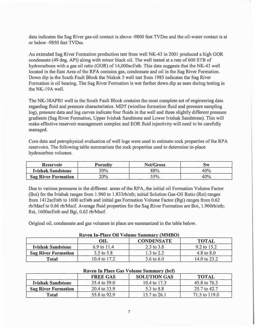
Core data and petrophysical evaluation of well logs were used to estimate rock properties of the RP A reservoirs. The following table summarizes the rock properties used to detem1ine in-place hydrocarbon volumes.
Reservoir Porosity Net/Gross Sw Ivishak Sandstone 20% 88% 40%
Sag River Formation 20% 55% 40%
Due to various pressures in the different areas of the RP A, the initial oil Formation Volume Factor (Boi) for the Ivishak ranges from 1.960 to 1.833rb/stb; initial Solution Gas-Oil Ratio (Rsi) ranges from 1412scf/stb to 1600 scf/stb and initial gas Fonnation Volume Factor(Bgi) ranges from 0.62 rb/Mscf to 0.66 rb/Mscf. Average fluid properties for the Sag River Fon11ation are Boi, l .960rb/stb; Rsi, 1600scf/stb and Bgi, 0.62 rb/Mscf.
Original oil, condensate and gas volumes in place are summarized in the table below.
Raven In-Place Oil Volume Summary (MMBO) OIL CONDENSATE TOTAL
Ivishak Sandstone 6.9 to 11.4 2.3 to 3.8 9.2 to 15.2 Sa~ Rivet· Formation 3.5 to 5.8 1.3 to 2.2 4.8 to 8.0
Total 10.4to17.2 3.6 to 6.0 14.0 to 23.2
Raven In Place Gas Volume Summary (bcf) FREE GAS SOLUTION GAS TOTAL
Ivishak Sandstone 35.4 to 59.0 10.4 to 17.3 45.8 to 76.3 Sa~ River Formation 20.4 to 33.9 5.3 to 8.8 25.7 to 42.7
Total 55.8 to 92.9 15.7 to 26.1 71.5 to 119.0
7

Based on the foregoing data, the Application proposes a paiticipating area that encompasses the reasonably known limits of the Raven Reservoirs that is capable of producing hydrocarbons in paying quantities.
2) The Applicant's Plan of Development for the RPA
BPXA has submitted plans of development for the RP A as a part of the Greater Point McIntyre area annual Plan of Development (POD) Review process. On October 1, 2007, the Division approved the POD for the proposed RP A. That approval remains in effect.
3) The Environmental Costs and Benefits
Approval of the RP A is only one step in the process of obtaining pem1ission to dri.11 a well or wells or develop the known reservoirs within the unit area. The approval of the RP A itself has no environmental impact. The approval does not entail any environmental costs in addition to those that may occur when pemlits are issued to conduct lease-by-lease exploration or development. Approval of the RP A is an administrative action that does not convey any authority to conduct any operations on the surface within the unit area. Unitization does not waive or reduce the effectiveness of the mitigation measures that condition the lessee's right to conduct operations on these leases. The unit operator also must obtain permits from various agencies before drilling a well or wells or initiating development activities to produce known reservoirs within the RP A. The operator must obtain the Division's approval of a plan of operations before the unit operator perfonns any field operations 11 AAC 83.346. The Plan of Operations pennit undergoes a multi-agency review that includes a public notice and 30-day comment period. A plan of operations must describe the operating procedures designed to prevent or minimize adverse effects on natural resources. When reviewing a plan of operations, the Division will consider the operator's ability to compensate the smface land owner for potential damage sustained to the surface estate and any needed plans for rehabilitation of the unit area. A PBU Plan of Operations is currently in place for the RP A and is independent of subsurface boundaries. PBU leases also contain stipulations designed to protect the environment and address concerns regarding impacts to the area's fish and wildlife species, habitat and subsistence activities and cultural resources.
The RP A and anticipated activity under the plans of development will affect habitat and subsistence activity less than if the lessees developed the leases individually. RP A plans of development provide for access to existing LPC facilities for consolidated development of the Raven Reservoirs. These efforts as well as other ongoing mitigation measures can reduce the impacts so that the anticipated development related activity is not likely to significantly impact bird, fish, and mammal populations.
Based on the foregoing the environmental costs and benefits of fanning the RP A justify approval of the Application under the section .303(b )(1) criteria.
8

4) The Economic Costs and Benefits to the State and Other Relevant Factors
4.1 Facility Sharing, Production Allocation, and Metering
The RP A will be developed from the Heald Point drill pad, which is also used to produce oil and gas shared with production from the Niakuk reservoirs. The RP A will share existing PBU facilities and infrastructure, mainly through production processing at the LPC facilities. Raven production will be constrained by the gas and water handling capacity at the LPC. The RP A will receive water injection from the LPC and gas lift gas supplied from the Lisbume high-pressure gas injection system at the Lisbume LS drillsite. Infrastmcture support facilities , including a camp, water, shop, roads, b1idges, and airstrip are shared with the Lisbume Participating Area (LP A) and the Initia1 Participating Area (IPA).
The Application includes, as Attachment #5, the draft Raven Special Supplemental Provisions (SSP) to the Pmdhoe Bay Unit Operating Agreement. The SSP provides tenns, between the various WI Os, for management and operation of the RP A, such as operator rights, voting provisions, budgeting, disposition of equipment, ru1d claims. BPXA has represented that a final version will be signed upon Division approval of the RPA. BPXA shall submit a final RPA SSP to the Division within 90 days of this Findings and Decision which must be consistent with the drafi version submitted with the Application or highlight ru1y chru1ges from the draft version, and must include all attaclunents.
BPXA bas represented that the third ru1d fourth amendments to the Lisbume SSP (Article 53) provide for RP A use of the LPC and sharing of other Lisburne equipment. On September 29, 2005, BPXA provided a copy of the Lisbume SSP, as amended, as a pait of its CNP A application and has asserted that no additional facility sharing documents exist or need to be provided to the Division with the Application. This approval is therefore based on the third and fourth amendments to the Lisbume SSP providing for RP A use of the LPC ru1d sharing of other Lisburne equipment and IP A infrastructure. If as a result of these Findings ru1d Decision, or any other reasons, the PB U WI Os adopt changes to the third ru1d fourth runendments to the Lisbume SSP, or ru1y other provision of the Raven or Lisbume SSPs relevru1t to RP A facility sharing BPXA shall provide the chru1ges to the Division within 30 days of their adoption.
RP A production will be allocated and metered in two ways. First, production commingled at the surface with 0th.er PBU oil pools will be allocated ru1d metered under the tem1s ru1d conditions set out in Alaska Oil and Gas Conservation Commission (AOGCC) Conservation Order No. 570.004, dated October 9, 2007, including as follows:
• conduct well tests to detennine production rates for each well;
• calculate each well's theoretical monthly production ("TMP") based on well test rates and actual time on production;
• sum the TMP volume for all wells in all pools;
9
• determine an allocation factor as the ratio of the metered volume to the TMP for all we11s in all pools (i.e., metered/TMP); and
• calculate each well's actual monthly production ("AMP") volume as: AMP = TMP x Allocation Factor.
Natural gas liquids (NGL) will be allocated based on actual gas production volumes and NGL process simulations. Process simulations will be updated at least once per year based on NGL samples.
Each producing wel1 will be tested at least twice each month. We11s that have been shut in and cannot meet the twice monthly test frequency must be tested within five days of staitup. All available test separator capacity within the constraints imposed by operating conditions must be used for well testing.
Use of new multi-phase meters remains in the research phase and are not approved for full-scale field implementation.
Second, BPXA is currently commingling production from the Kuparak and Raven Reservoirs (separate PAs and reservoirs) down-hole in NK-43 well. The down-hole commingling should result in greater oil recoveries from both reservoirs and is approved for the NK-43.
The commingled production must be allocated to the correct PA and reservoir because the state's royalty oil is valued differently in the RP A and CNP A. It wil1 be allocated between the Raven and Kuparak reservoirs under the tenns and conditions set out in AOGCC Administrative Approval CO329B.003, dated October 9, 2007, including as follows:
1. At least twice per year and not less frequently than once every seven months: a. samples must be collected from NK-43; and b. NK-43 well production must be allocated down-hole between the RPA and CNPA
based on a geochemical analysis.
The Division reserves the right to review down-hole sampling, down-hole allocation, well test, and surface allocation data to ensure compliance with the methodologies prescribed in this Decision. The review may include requesting any infonnation the Division deems pertinent to the review, which may include, but is not limited to inspection of facilities, equipment, and well test data.
4.2 Gas Disposition
The Initial POD states that "Raven produced gas (other than gas extracted as NGLs and blended with crude oil for shipment through TAPS) will be used or consumed for unit operations, or injected into another fonnation underlying the unit area, prior to initiation of gas sales." The Division recognizes that the WI Os may produce more gas than required for unit operations and therefore approves I) injecting this excess gas into another formation underlying the unit area and 2) extracting and blending RP A NG Ls with crude oil for shipment through TAPS. However, any residue gas from the
10

RPA injected into another formation underlying the unit area must only be injected into a reservoir that is part of an approved PA in the PBU. Any residue gas from the RP A injected into another fomrntion underlying the unit area will be treated as indigenous natural gas for royalty reporting purposes and the WI Os shall be responsible for royalty payments when the gas is ultimately sold. Any residue gas injected from the RP A into another formation underlying the unit area must be reported and accounted for separately on the LPC Gas Reserves and Debit Rep01t submitted monthly to the Division. The Division will allow RP A gas injection into another fonnation because it would be overly burdensome for the Division and the RP A WI Os to track and report the relatively small amount of gas produced from the Raven Reservoirs. BPXA has also represented that gas extracted as NG Ls and blended with crude oil for shipment through TA.PS will be processed the same as Niakuk NGLs, through the Lisbume NGL plant. Therefore, the Division approves extracting NG Ls from RP A produced gas at the Lisburne NGL plant. All NG Ls manufactured from RP A produced gas at the Lisburne NOL plant must be accounted for and reported as Raven NGLs.
4.3 Tract Allocation Schedule
Attachment #2 is the proposed RP A Tract Description and Ownership Schedule included with the Application. BPXA has represented that RP A tract allocations (participation percentages) are based on original oil in place for both the Sag River and Ivishak reservoirs and recoverable hydrocarbon liquids from the Sag River reservoir, all at smface conditions. BPXA has represented that hydrocarbon liquids from the Sag River are included in the tract participation percentages because NK-43 Sag River test production had a relatively high condensate yield (65bbl/Mscf) during prior testing and is a 40 A.Pl gravity condensate produced from the gas cap, with a minor black oil component produced from the oil leg.
When the Application was submitted, the WI Os owned the following percentages of RP A production: BPXA--26.355356; Chevron--1.16; Exxon-- 36.395491; CPAI--36.069385; and Forest--0.019768. Effective September 1, 2006, Forest's ownership was assigned to BPXA, CPAl, and Exxon. The revised Tract Desc1iption and Ownership Schedule percentages are: BPXA--26.360567; CPAl--36.076746; Exxon--36.402687; and Chevron--1.16. Within 30 days of this Decision, BPXA shall submit on behalf of the WI Os, a revised RP A Tract Description and Ownership Schedule that reflects this revision.
4.4 Field Costs
Because the RP A approved by this Findings and Decision is within the original PBU, the 1980 Royalty Settlement Agreement governs the field cost allowance for the state's royalty share of production from the RP A.
In summary, the economic benefits of fanning the RPA and developing the Raven Reservoirs outweigh the costs of not approving the RP A. The WlOs have made meaningful commitments to develop the RPA. Conditional approval of the proposed RPA will result in both sh01t and long-te1m economic benefits to the state. Development and production from the RP A will provide royalty and tax revenues to the state over the life of the field and the lessees may reinvest revenues in new
11

exploration and development in the state. Royalty, tax, and employment benefits derived from production and economic development will far exceed any additional administrative burdens associated with pennitting RPA activities, administering the unit leases, or collecting royalties on production. Therefore, the Division's evaluation of the section .303(b)(4) economic c1iteria supports approval of the Application.
8) Decision Criteria Considered under 11 AAC 83.303(a)
I) Promote the Conservation of all Natural Resources and Prevent Economic and Physical Waste
Through unitization and the fonnation of participating areas, the assignment of undivided equity interests in the oil and gas reservoirs to each lease and competition between lessees for their share of production is resolved so that resources can be conserved and economic and physical waste prevented. The RP A owners have agreed to share existing faci lities and infrastructure and have proposed plans of development that are intended to allow the RP A to be produced most economically and efficiently and in a way that prevents economic and physical waste and promotes the conservation of both surface and subsurface resources through unitized (rather than lease-by-lease) development.
The RP A will conserve resources by sharing production facilities and support infrastructure with the Niakuk, Lisbume, Pt. McIntyre, and Initial Participating Areas to avoid duplication of facilities and to minimize utilization of materials, gravel, power, staff, and other resources. A smaller facility footprint will result from the shared facilities and infrastructure, which will also minimize the economic and physical waste of surface resources. Further, the RP A provides a regulatory framework for application of mitigation measures so that resources can be conserved and economic and physical waste prevented. Compliance with these the Unit Plan of Operations will conserve, and prevent economic and physical waste of, surface resources.
The RP A will provide for efficient, integrated development of the Raven Reservoirs. The RP A will promote efficient development of reservoirs, efficient well spacing, and rational operating and reservoir management strategies. The RP A will also allow for the development of economically marginal hydrocarbon accumulations due to the lower capital and operating costs resulting from commingled production and common facilities. Marginally economic reserves which otherwise would not be produced on a lease-by-lease basis, can be produced from the RP A in combination with more productive leases. The RP A will al1ow more optimal pressure maintenance and secondary recovery through a joint, unitized effort ofWIOs. Maximizing oil and gas recovery results in a more optimal use of the resource and prevents economic and physical waste.
Formation of the RP A is expected to reduce costs and environmental impacts associated with development of the Raven Reservoirs, thereby conserving resources, preventing economic and physical waste, expediting development of reserves, and promoting more optimal ultimate recovery of oil and gas from the RP A. Therefore, the Division' s evaluation of the section .303(a)(l) and (2) criteria supports approval of the Application
12

2) Provide for the Protection of all Parties of Interest, Including the State
The RP A protects the economic interests of the state and a unified plan will be more likely to maximize hydrocarbon recovery and revenue to the state. Fornrntion of the RP A advances the efficient evaluation and development of the hydrocarbon resources while minimizing impacts to the area's cultural, biological , and environmental resources.
Fonnation of the RP A also protects the economic interests of the WI Os. The approved production allocation schedule agreed to by the WI Os ensures an equitable allocation of cost and revenue.
On April 21, 2006, the Division received a letter from Mr. Ray Givens, attorney for the Oenga heirs, who own smface rights to Heald Point. The letter requests that the Division defer its RP A approval until the surface lease between the Oenga heirs and BPXA is modified to allow for production from the Raven Reservoirs through the Heald Point production facilities. The heirs assert that the current lease language does not authorize that activity. The Oenga heirs indicated in a similar request to the AOGCC that they object to the establislunent of pool rules for the Raven Reservoir and that although they do not object to exploration or development of North Slope oil reserves they are concerned that "surface leases for oil production facilities authorize the use made of those facilities before production begins." They asseii that the Oenga heirs' lease with BPXA authorizes production from Niakuk, but not from any other pool, including from the Raven Reservoirs. The letter is included as Attachment# 5 to this Findings and Decision.
On May 26, 2006 the Division received a letter from Guess & Rudd, attorney for BPXA, providing its response to Mr. Given's letter and asking that the Division act on the Application without delay.
On June 21 , 2006, the Division received a second letter from Mr. Ray Givens responding to the Guess & Rudd letter who again asked the Division to defer its RPA approval until the smface lease between the Oenga heirs and BPXA is modified.
The Division will not further delay this Decision because of these requests. This Decision deals with subsurface issues surrounding the establishment of the participating area. The issue raised in the letters focuses on resolution of a private dispute regarding individual surface rights--an issue separate and apart from this Decision. It is a dispute that must be resolved between BPXA and the Oenga heirs.
13

IV. Findings and Decision
1. The RP A is approved effective on the first day of the month following this approval--January 1, 2008. This approval is subject to applicable state statutes and regulations and to the conditions set out in this Findings and Decision. The fonnation of the RP A is necessary and advisable to protect the public interest. 11 AAC 83.303.
2. The available G&G data indicates that the RP A is underlain by hydrocarbons and known and reasonably estimated through the use of the data to be capable of production or contributing to production in sufficient quantities to justify the fonnation of the RP A. The lands described in Attachment #2 to this Decision are included in the RP A.
3. BPXA shall conduct diligent exploration, delineation, and production of the Raven Reservoirs underlying the approved RP A under the plans of development and operations approved by the Division. BPXA may not commence drilling, development, or production operations until it acquires all required pennits.
4. The accounting unit code for the RP A is .. PBRA." The WIOs shall reference this account code on the monthly operator and royalty reports submitted to the Division for RP A production. The accounting code becomes effective on the first day of the month following this approval-January I , 2008. In the case where production from CNPA Kuparak Reservoir is commingled downhole with production from the proposed Raven Reservoirs such as is the case with NK-43, only the portion of production allocated to the RP A Raven Reservoirs must be referenced to the new accounting unit code of PBRA on the monthly operator and royalty reports submitted to the Division for RP A production. The CNPA K.uparak Reservoir portion must be appropriately allocated to its approved accounting code on the CNP A monthly operator and royalty reports submitted to the Division.
5. The formation of the RPA divides costs and allocates produced hydrocarbons in a manner cun-ently acceptable to a11 affected WIOs. Under 11 AAC 83.35l(a) and 11 AAC 83.371(a), and in accordance with the terms set out in this Findings and Decision, the Division approves the allocations of production and costs for the tracts within the RP A set out in Attachment #2, but subject to a revision of the ownership schedule as described in Section III .A. 4.3 of this Decision. Within 30 days of this Decision, BPXA shall submit on behalf of the WIOs, a revised RP A Tract Description and Ownership Schedule that reflects the transfer of Forest's interest.
6. BPXA may commingle RP A production with other PBU production in PBU surface facilities before custody transfer. Tenns for use of those facilities are amendments to the PBU Operating Agreement and referred to in Attachment #5 to the Application, the draft Raven Special Supplemental Provisions (SSP) to the Prudhoe Bay Unit Operating Agreement, and in the Lisburne SSP, as amended and provided to the Division on September 29, 2005, as a part ofBPXA's CNPA application. Section 111.A.4 of this Findings and Decision describes BPXA's submittals and representations regarding these documents. BPXA shall submit any
14

additional SSP and facility sharing documents in accordance with the tenns and conditions set out in Section III.A.4.1 of this Findings and Decision.
7. RP A production must be allocated and metered according to tenns set out in th.is Findings and Decision.
8. The Division recognizes that the WIOs may produce more gas than needed for unit operations and approves 1) injecting th.is excess gas into another fonnation underlying the unit area and 2) extracting NG Ls and blending them with crude oil for shipment tlu·ough TAPS, subject to tenns and conditions set out in Section III.A.4.2 of this Findings and Decision.
9. RP A data submittal requirements are listed in Attachment #5. BPXA shall provide this data to the Division, to the extent not already provided, in support of any RP A modification or future RP A plans of development as requested by the Division.
A person affected by this decision may appeal it, in accordance with 11 AAC 02. Any appeal must be received within 20 calendar days after the date of "issuance" of this decision, as defined in 11 AAC 02.040 (c) and (d), and may be mailed or delivered to Tom Irwin, Commissioner, Department of Natural Resources, 550 W. 7th. Avenue, Suite 1400, Anchorage, Alaska 99501; faxed to 1-907-269-8918; or sent by electronic mail to: [email protected]. If no appeal is filed by the appeal deadline, this decision becomes a final administrative order and decision of the Deparhnent on the 31st day after issuance. An eligible person must first appeal this decision in accordance with 11 AAC 02 before appealing this decision to Superior Court. A copy of 11 AAC 02 may be obtained from any regional infom1ation office of the Depaitment of Natural Resources.
~r
I J,-'J-0 -D7 Date
Division of Oil and Gas
Attachments:
Attachment #1 - Maps of the RP A Attachment #2 - Proposed RP A Tract Description and Ownership Schedule Attachment #3 - Abbreviations Attaclunent #4- Objection to fonnation of the RPA Attaclunent #5 - RP A Data Submittal Requirement
15

Attachment #1 - Maps of the RP A
p, EXHIBIT 207-A BOUNDARIES OF THE RAVEN PARTICIPATING AREA
i _ _ PRUOHO~ BAY u r~rT __ ___ _ __ ·11 ! I ADLO ~ 25 ~. ~ ~ mlm i I 14 s · I 15 I 1B
I
22 24 19
27 26 25 RAVEN P.A. 90
Tl2N
16
-r - - 10 ½ . 1 Mile l "-...... -
17 16 15
I- -------t - -- - -
20 21
-- -- -- -- ·- ·-·-·7·- 0 .
29
32
I ; RcSOLUTION I ISlAND
20 .- i I. -,
27 DIJCI<'
ISu\tJO 1 Ul !IT
- 1---7 -
33
T12N
I :-:, SAG DEL TA , T11N
Raven Participating Area Boundary December 21, 2007
., - ~
~
~
"' '7
- ~ ,.. ti .. £
"' .... ~ ,. •; -· • .:; .
e i::1 -
~ .. $ .,
r .. i:i ~ <':
\ - ,t• -,n
r £
11.
i\ .., u-
- fl .;, ~ ..
= -
... Ji
.. .: <,;: 0 -; .. ... :!
"' s:, !'' :r .., . ·~ - .. .,. .. ~ b
~ l; - c;:i -----~. ..
=-= ...
r .,
q
r,
:.. ll •.• ... .. -t. ... 0 n .., -

Attachment #2 - Proposed RP A Tract Description and O\vnership Schedule
T& Roy- Tract Tract ADL R, Section:
Acres alty, - - - - - - - -Tract Ownership % - - - - - - - - - - - - Particip-U.M.
Description % ation %
BPXA CPAI Exxon
Chevron Forest Mobil
4 034625 l2N-
Sec l5E
24 S/2SW/4 80 12.5 26.355356 36.069385 36.395491 1.1600000
0.0 19768 0.904
E/2 NW4, Sec E/2SW/4 25
31 034630 12N-15E
Sec E/2NE/4 720 12.5 26.355356 36.069385 36.395491 1. 1600000 0.019768 50.429 26
Sec N/2NE/4 36
Sec S/2NW/4
29 N/2SW/4
12N-SW/4SW/4
32 034635 16E
81 5 12.5 26.3 55356 36.069385 36.395491 1. 1600000 0.019768 48.667
Sec All
30
Sec NW/4NW/4
31
Total = I 6 l 5 acres
18

Attachment #3 - Abbreviations
BPXA - BP Exploration (Alaska) Inc. CP AI - ConocoPhillips Alaska, Inc. Forest - Forest Oil Corporation ExxonMobil - ExxonMobil Alaska Production Inc. Chevron - Chevron U.S.A. Inc
19

Attachment #4 - Objection to the Formation of the RP A
20
GIVENS L AW Frk.. .. ..: P.O. Box 400, 912 E. Sherman Ave. Coeur d 'Alene, ID 83 816-0400 ph one (2.08) 676-1310 fax (208) 676-1296 rnygivens@gi venslaw.com www.givenslaw.com
Bill Van Dyke Acting Director Director/ Administration
April 18, 2006
Alaska Department of Natural Resources 550 West i 11 Avenue, Suite 800 Anchorage, Alaska 99501-3560
Re: Prudhoe Bay Un.it - Objection to Application for Raven P.A.
Dear Mr. Van Dyke:
UI Vi~IUi-. LIi OIL AND GA.;,
I write to you as the attorney of the Heirs of Andrew Oenga (Oenga Heirs) regarding BIA Allotment# F-14632 and BIA Lease# F-89-01. The purpose of this letter is to memo1ialize the Oenga Heirs' objection to the current establ ishment of a Raven Participation Area (P.A).
The Oenga Heirs are the owners of BIA Allotment# F-14632, Parcel B - Heald Point: on the northeast edge of Prudhoe Bay. That allotment is subject to Lease # F-89-0 l. The lessor interests are now held by the Oenga Heirs, as owner, and the United States, as their trustee. The lessee interests are currently held by BP Exploration (Alaska) Inc. (BPX) as successor to the original lessee.
The allotment was originally leased for use as a pipeline c01Tidor. BPX has since constructed an oil production facility on the Heald Pont property. The Oenga Heirs understand that l) BPX is asking the Alaska Oil & Gas Conservation Conunission (Commission) to adopt Pool Rules for the Raven oil pool, 2) that BPX is asking the Alaska Department of Natural Resources (Department) to designate a Raven P.A. for the development of the Raven oil pool and 3) BPX is proposing to use this Heald Point facility as the production facility thru which oil from the Raven P.A. ,~,ill be produced.
In response the Oenga Heirs have objected to the Commission's establislunent of Pool Rules for the Raven Oil Pool. See Objection (Request for Postponement) To Establishment of Pool Rules - Raven Oil Pool, and letter of April 12, 2006 replying to BPX's response. The attached :fi lings with the Commission are incorporated herein. The Oenga Heirs herein o~jecl to the current establishment of a Raven P.A.

Lease# F-89-01 does not authorize BPX to produce oil or gas from the Raven Pool tluu the Heald Point property. A copy of the original lease and the first letter amendment/notice regarding the lease are attached and incorporated herein. They have previously been provided to the Commission. While the lease grants broad uses of the Heald Point property, it only allows those uses to be made regarding the "Niakuk Project" . Original lease p. 1 (last sentence), p. 2 (first sentence of third paragraph, and "Niakuk Development Project11 letter amendment title. This '1Niakuk Project1' or 11Niakuk Development Project" was more specifically referred to by BPX as:
This Lease provides authorization for BP to construct production facilities to support development of and production from our Niakuk oil accumulation.
July 29, 1993 Lease letter amendment/notice (emphasis added).
This explanation of the limited scope of the lease, in BPX's own words, makes clear that this lease is not applicable to any other oil accumulation, such as the Raven Pool.
For the reasons stated herein, and for those contained in the filings with the Commission, the Oenga Heirs object to the cunent establishment of a Raven Participation Area (P.A.). The Oenga Heirs are not opposed to the eventual development of the Raven Oil Pool or Lo the eventual establishment of a Raven P.A. However, this would only be appropriate once the lease for the surface rights of Heald Point, upon which the production facility is located is amended to authorize such use of the property.
According to the Oenga Heirs' estimates, over $1.5 billion worth of oil from the Niak.uk P.A. and the West Niakuk P.A. has been produced tlu·u the Heald Point production pad since its construction twelve years ago. During this period, the Oenga Heirs have been paid on average less than $90,000/year for the use of surface rights on which the production facility is constructed. This gross inequity should not be compounded by allowing yet another tmauthorized P.A. to be produced thru the Heald Point facility contrary to the existing lease.
The Oenga Heirs respectfully request that the establishment of any Raven P.A. be deferred until BPX can produce concurrence from all parties with an ownership interest in the Heald Point property that there is the requisite legal authority to produce oil and gas from the Raven Oil Pool thru the Heald Point p1·oduction facility.
The Department certainly has a valid interest in assuring itself that State oil/gas leases have a legally valid means of production from State leases. The relief requested would be in furtherance of that legitimate Department fimction in this contentious matter. It would also encourage all parties to reach a fair and reasonable agreement w:ith respect to the production from the Raven Pool tluu the Heald Point facility.

Thank you for your consideration.
RCG:jr Enclosure
cc: Oenga Heirs
Sincerely,
~~ Raymond C. Givens Idaho State Bar# I 695 Washington State Bar# 36029 [email protected]
On Behalf of Oenga Heirs
Roger Hudson, Deputy Solicitor, DOI Dorothy Edwardsen, ICAS Joseph J. Perkins, Guess & Rudd John Cyr, BPX

Attachment #5 -RP A Data Submittal Requirement
General Data Submittal requirement in support of any RP A modification or future RPA Plans of Development as requested by the Division. Data shall include the following:
(a) The lessee shall submit to the Alaska Deparhnent of Natural Resources all geological, geophysical and engineering data obtained from the lease within 30 days after completion, abandomnent, or suspension of the well and within 30 days after completion or plugging of a well branch, if occuning at a different time. The lessee shall submit to the Alaska Department of Natural Resources data acquired subsequent to well completion within 30 days following acquisition of that data. The state may waive receipt of operational data from some development, service or injection wells. The state will inform the operator of the waiver prior to well completion.
The lessee shall submit the data to the Division of Oil and Gas, Department of Natural Resources.
The data shall include the following:
1. a copy of the well completion report (AOGCC form l 0-407) with all attachments, including sununaiies of perforations open to production, production tests, core data, fonnation tops or geologic markers, ai1d fonnation tests.
2. daily d1illing reports or a summary report of daily drilling. 3. latitudinal and longitudinal coordinates (based on NAD-27 spheroid) for the completed
surface and bottom hole locations, include locations for all plug-backs and pilot holes. 4. Paper and digital copies of all directional surveys, include surveys for a11 plug-backs and
pilot holes. 5. a summary list of all logs run and the depth interval covered by each, also list logs for a11
plug-backs and pilot holes. 6. a list offonnations and other geologic markers encountered and the measured depths
(MD) and true vertical depths (TVD) of each. 7. a summary of cored intervals (both conventional and sidewall), including depth
formation name, lithology, presence of oil, gas and water, porosity, fractures and apparent dips, indicate "none" in space provided on completion report or in an attaclunent if no cores were taken.
8. paper and digital copies of all core reports including lab ai1alyses oflithology, porosity, permeability (ve11ical and hmizontal, air and liquid), density, capillary pressure, and fluid saturation, if available.
9. paper and digital copies of all conventional and sidewall core photos (plain light and ultraviolet), if available.
10. identify depth and fonnation name for oil and gas shows, indicate "none" on the completion report or in an attachment if no shows were observed.
11. identify zones of abnonnal pressure, indicate "none" on the completion report or in ai1 attachment if none were observed.
12. a synopsis or summary of testing and all fluid recovery efforts, including production tests (IP), drill stem tests (DST) wireline formation tests (i.e. repeat fom1ation tests (RFT) and
24

modular dynamics tests (MDT)), and other production and fonnation testing data· the summary should include test date, time, depth, formation name, method of operation, recovered fluid type(s) and amount(s), and fluid rate, gas-oil ratio (GOR), oil gravity, pressure, and choke size, when available. If no tests were undertaken, indicate "none" where appropriate on the completion report or in an attachment, if tests were undertaken but failed to recover fluids indicate "no recovery".
13. paper and digital copies of all pressure build-up, and fluid PVT analyses, if available. 14. copies of all open flow potential test reports and report attachments AOGCC Forms 10-
421 . 15. paper and digital copies of well test procedures, field chronologies, and field data;
including details - such as interval(s) open to test; volumes of oil, water and gas BS&S=W, APT gravity, gas density; wellhead and downhole pressure; and formation and wellhead temperature, - necessary to fully evaluate the test data.
16. paper and digital copies of geochemical and formation fluid analyses and reports, if available.
17. down hole and surface fluid sampling procedures, field chronologies, raw data, and laboratory test results for all water and hydrocarbon-bearing zones sampled; including details necessary to fully evaluate quality of sample data
18. a copy of the pennit to dtill (AOGCC fonn 10-401) and the survey as-built of the well location.
19. paper copy (no sepia copies, please) of all final 2-inch open hole and cased hole logs, including measured depth (MD) and true-vertical depth (TVD) versions, specialty logs (such as Schlumberger's cyberlook, fonnation microscanners and diprneter logs) , measured-while-drilling (MWD) and logged-while-drilling (L WD) logs (in color, when available). Provide 5-inch scale logs when 2-inch scale logs are wrnvailable.
20. paper copy of final composite mud or lithology log and report, with lithology display, oil and gas show indicators, and cuttings descriptions (in color, when available).
21. a digital version of well logs in LAS format on IBM format floppy disks, Zip 100 disk, CD or DVD, and a digital version of final directional surveys in ASCII format (other formats may be acceptable upon agreement with the Division of Oil and Gas).
22. Paper and digital (if available) copies of all well data and reports including, but not limited to, paleontology, palynology, petrography (including point-count analyses), X-ray diffraction analyses, SEM micrographs, thennal maturity, vitrinite reflectance, rock eval pyrolysis, geoclu·onology, fission track analyses, fluid inclusion analyses, Mercury injection capillary pressure analyses, chemical analyses (EPMA, XRF, TCP, etc.), isotope analyses, water chemistry, burial and temperature history analyses, strain analyses and acoustic analyses.
23. all final reports of velocity checkshot or VSP surveys (an ASCII format digital version of the above data shall also be submitted), indicate ' none" in your response to this request if no velocity, checkshot or VSP surveys were undertaken. Submission of veloci ty, checkshot, and VSP surveys are always required by DNR under the operator surface-use permit obligations.
24. paper and digital copies of all coalbed core, gas and water quality reports including lab analyses of core lithology coal rank, vitrinite reflectance, maceral composition, TOC,
.., -_ :,

ash, sulfer and BTU content, moisture content, cleating, adsorption/desorption data, residual gas measurements, porosity and pem1eability analyses, core photos, if available.
All material should be either hand-cani.ed by bonded courier or mailed by registered mail to:
Kristin Dirks, Geologist Dept. of Natural Resources-Div. of Oil and Gas State of Alaska 550 W. ih Avenue, Suite 800 Anchorage, AK 99501-3510
Telephone: Fax:
(907)269-8769 (907)269-8942
Email: kristin_ dirks@dnr. state.ak. us
The state may also require the lessee to submit additional data in accordance with the applicable statutes and regulations in effect at the time of the drilling and completion of the well.
Any data submitted to the state by the lessee in connection with this lease will be available at a11 times for use by the state and its agents. The state will keep infonnation confidential as provided in AS 38.05.035(a)(9) and its applicable regulations. In accordance with AS 38.05.035(a){9)(c), in order for geological, geophysical and engineering data submitted under the lease agreement named above to be held confidential , the l.essee must request confidentiality at the time the data is submitted by indicating "CONFIDENTIAL" on all confidential data items.
This action does not eliminate the need to file all data normally filed with the Alaska Oil and Gas Conservation Commission (AOGCC) under their pennit requirements.
26