Embed Size (px)
Citation preview
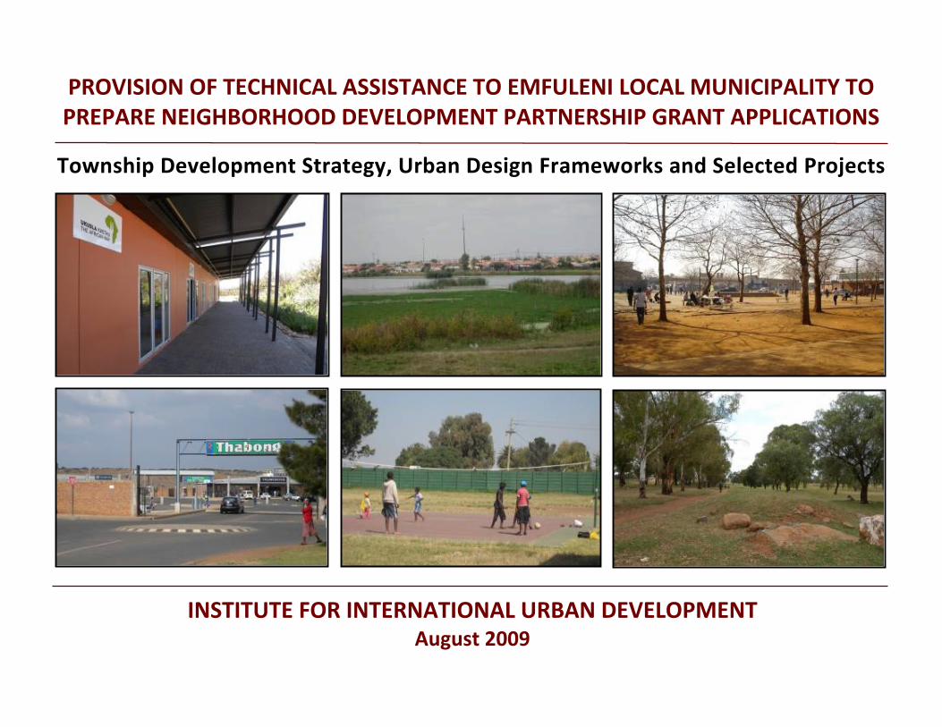
PROVISION OF TECHNICAL ASSISTANCE TO EMFULENI LOCAL MUNICIPALITY TO PREPARE NEIGHBORHOOD DEVELOPMENT PARTNERSHIP GRANT APPLICATIONS
Township Development Strategy, Urban Design Frameworks and Selected Projects
INSTITUTE FOR INTERNATIONAL URBAN DEVELOPMENTAugust 2009

TABLE OF CONTENTS
INSTITUTE FOR INTERNATIONAL URBAN DEVELOPMENT
1 INTRODUCTION ............................................................................................................................................................................................................................ 1
2 TOWNSHIP DEVELOPMENT STRATEGY ......................................................................................................................................................................................... 2
2.1 TRANSPORTATION CORRIDORS ............................................................................................................................................................................................ 3
2.2 WETLANDS............................................................................................................................................................................................................................. 9
2.3 STRATEGIC DEVELOPMENT NODES ..................................................................................................................................................................................... 10
2.4 TOURISM ROUTE ................................................................................................................................................................................................................. 13
2.5 TOWNSHIP DEVELOPMENT CONCEPT................................................................................................................................................................................. 16
3 URBAN DESIGN FRAMEWORKS .................................................................................................................................................................................................. 17
3.1 CIRCULATION ....................................................................................................................................................................................................................... 18
3.2 OPEN SPACE ........................................................................................................................................................................................................................ 23
3.3 CORRIDORS, PRECINCTS AND HISTORIC SITES .................................................................................................................................................................... 28
4 PROJECT SELECTION ................................................................................................................................................................................................................... 32
4.1 WETLAND REGENERATION AND PARK DEVELOPMENT IN BOIPATONG ............................................................................................................................. 36
4.2 UPGRADE OF CIVIC AND COMMERCIAL HUB IN BOPHELONG ............................................................................................................................................ 43
4.3 DEVELOPMENT OF OPEN SPACE IN BOPHELONG ALONG THE R57 .................................................................................................................................... 49
4.4 CREATION OF A CULTURAL PRECINCT IN SEBOKENG ......................................................................................................................................................... 58
4.5 A TRANSIT HUB NEAR BOIPATONG ..................................................................................................................................................................................... 66
4.6 DEVELOPMENT OF A REGIONAL NODE IN SEBOKENG ........................................................................................................................................................ 68
5 ANNEX ......................................................................................................................................................................................................................................... 76
TABLE OF CONTENTS
INTRODUCTION
INSTITUTE FOR INTERNATIONAL URBAN DEVELOPMENT 1
1 INTRODUCTION
In April 2009 Kwezi V 3 Engineers was appointed to provide technical assistance to Emfuleni Local Municipality (ELM) for the preparation of business plans for capital grant funding from the Neighborhood Development Partnership Grant (NDPG). This funding is intended to support township development projects in areas with economic growth potential in order to attract private sector investment. To effectively allocate funding and avoid ad‐hoc development, the NDPG requires that projects submitted as business plans be rooted in an overall township development strategy as well as in urban design frameworks for the specific townships or smaller neighborhood locations, depending on the propsed project scale. This report presents the township development strategy, urban design frameworks and selected priority projects for Boipatong, Bophelong, Sebokeng and Evaton in Emfuleni Local Municipality. These townships are part of the Gauteng Provincial Government’s 20 Priority Townships Programme (20 PTP) and have been selected by Sedibeng District Municipality (SDM) and ELM as target areas for NDPG‐funded projects. These townships are also historically significant in relation to the struggle against apartheid.
The township development strategy focuses on connecting the four townships, originally isolated by apartheid spatial planning, to the primary economic centers of Vanderbijlpark and Vereeniging as well as to each other. The strategy emphasizes three local development corridors that link each township to larger regional routes, and highlights five key nodes along these corridors where concentrated investment will likely have the most positive economic, social and environmental impact. It also delineates a tourism route featuring points of interest and historic sites in the four townships. The urban design frameworks for Boipatong, Bophelong, and the Sebokeng/Evaton area stress the importance of improving the internal circulation networks by establishing street hierarchies and recommending targeted improvements. Treatments for various types of open space are suggested and later developed in detail in several of the project proposals. Existing nodes, corridors and historic sites in the townships are noted and these activity centers guide the final project selection. 30 potential projects corresponding to the urban design frameworks for the townships are identified
at the beginning of Section 4. From this broad array, six priority projects have been selected that best fit the requirements for NDPG funding. Three to four of the priority projects will be prepared as business plans subject to the decision and approval of the Sedibeng Municipal Council. The township development strategy, urban design frameworks and plans for priority projects were formulated after an extensive review of relevant documentation and research reports, consultations with officials of SDM and ELM, discussions with local business people and township residents, attendance at key workshops and meetings, and numerous site visits with photodocumentation. (Please see the Annex for lists of documents and meetings). The first draft of the strategy was confirmed by the data obtained from a survey of 60 township residents and business owners conducted at the end of June, focusing on community needs and priorities. The strategy, frameworks and priority projects have been presented to representatives from SDM and ELM and the selection of projects to prepare as business plans is currently being debated by the Sedibeng Municipal Council.
TOWNSHIP DEVELOPMENT STRATEGY
INSTITUTE FOR INTERNATIONAL URBAN DEVELOPMENT 2
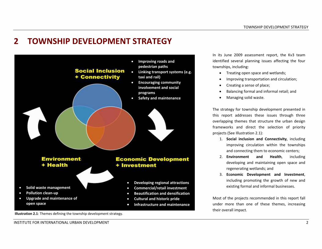
2 TOWNSHIP DEVELOPMENT STRATEGY In its June 2009 assessment report, the Kv3 team identified several planning issues affecting the four townships, including:
• Treating open space and wetlands;
• Improving transportation and circulation;
• Creating a sense of place;
• Balancing formal and informal retail; and
• Managing solid waste. The strategy for township development presented in this report addresses these issues through three overlapping themes that structure the urban design frameworks and direct the selection of priority projects (See Illustration 2.1):
1. Social inclusion and Connectivity, including improving circulation within the townships and connecting them to economic centers;
2. Environment and Health, including developing and maintaining open space and regenerating wetlands; and
3. Economic Development and Investment, including promoting the growth of new and existing formal and informal businesses.
Most of the projects recommended in this report fall under more than one of these themes, increasing their overall impact.
• Improving roads and pedestrian paths
• Linking transport systems (e.g. taxi and rail)
• Encouraging community involvement and social programs
• Safety and maintenance
• Developing regional attractions • Commercial/retail investment • Beautification and densification • Cultural and historic pride • Infrastructure and maintenance
• Solid waste management • Pollution clean‐up • Upgrade and maintenance of
open space
Illustration 2.1: Themes defining the township development strategy.
TOWNSHIP DEVELOPMENT STRATEGY
INSTITUTE FOR INTERNATIONAL URBAN DEVELOPMENT 3
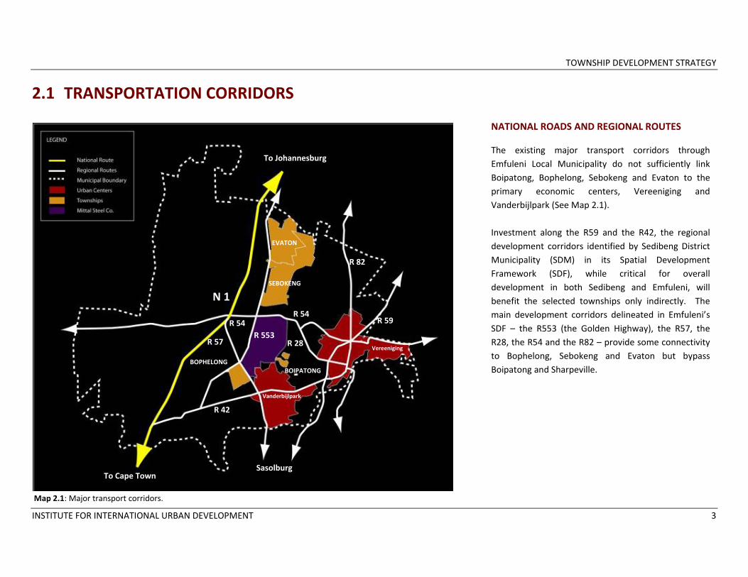
2.1 TRANSPORTATION CORRIDORS
NATIONAL ROADS AND REGIONAL ROUTES The existing major transport corridors through Emfuleni Local Municipality do not sufficiently link Boipatong, Bophelong, Sebokeng and Evaton to the primary economic centers, Vereeniging and Vanderbijlpark (See Map 2.1). Investment along the R59 and the R42, the regional development corridors identified by Sedibeng District Municipality (SDM) in its Spatial Development Framework (SDF), while critical for overall development in both Sedibeng and Emfuleni, will benefit the selected townships only indirectly. The main development corridors delineated in Emfuleni’s SDF – the R553 (the Golden Highway), the R57, the R28, the R54 and the R82 – provide some connectivity to Bophelong, Sebokeng and Evaton but bypass Boipatong and Sharpeville.
Map 2.1: Major transport corridors.
N 1
R 54
R 28
R 54R 59
R 42
R 57 R 553
R 82
Sasolburg
To Johannesburg
To Cape Town
EVATON
BOPHELONG BOIPATONG
Vereeniging
Vanderbijlpark
SEBOKENG

TOWNSHIP DEVELOPMENT STRATEGY
INSTITUTE FOR INTERNATIONAL URBAN DEVELOPMENT 4
TRANSPORTATION CORRIDORS
RAILWAYS Public transportation options for township residents in Emfuleni Local Municipality consist of trains, buses and taxis. The train system, while efficient and inexpensive for riders, primarily serves the residents of Sebokeng and Evaton at four stops along Sebe Street (See Map 2.3). Residents of Boipatong and Bophelong are not served by rail stations.
Existing rail lines that connect with the passenger line serving Sebokeng pass through land owned by Mittal Corportation and are likely owned by that company to be used for cargo transport around the large industrial site. One private rail line runs near to Boipatong and Bophelong. Emfuleni Local Municipality should investigate, with representatives from Mittal, the possibility of using these lines for passenger service to provide the residents of Boipatong and Bophelong with additional transport options. A passenger train station near these two townships would also serve the residents of the northern section of Vanderbijlpark who do not have easy access to train service.
Map 2.2: Rail system in Emfuleni Local Municipality

TOWNSHIP DEVELOPMENT STRATEGY
INSTITUTE FOR INTERNATIONAL URBAN DEVELOPMENT 5
Map 2.3: Rail stations serving Sebokeng/Evaton
EVATON
SEBOKENG
BOPHELONG
BOIPATONG
TOWNSHIP DEVELOPMENT STRATEGY
INSTITUTE FOR INTERNATIONAL URBAN DEVELOPMENT 6
TRANSPORTATION CORRIDORS
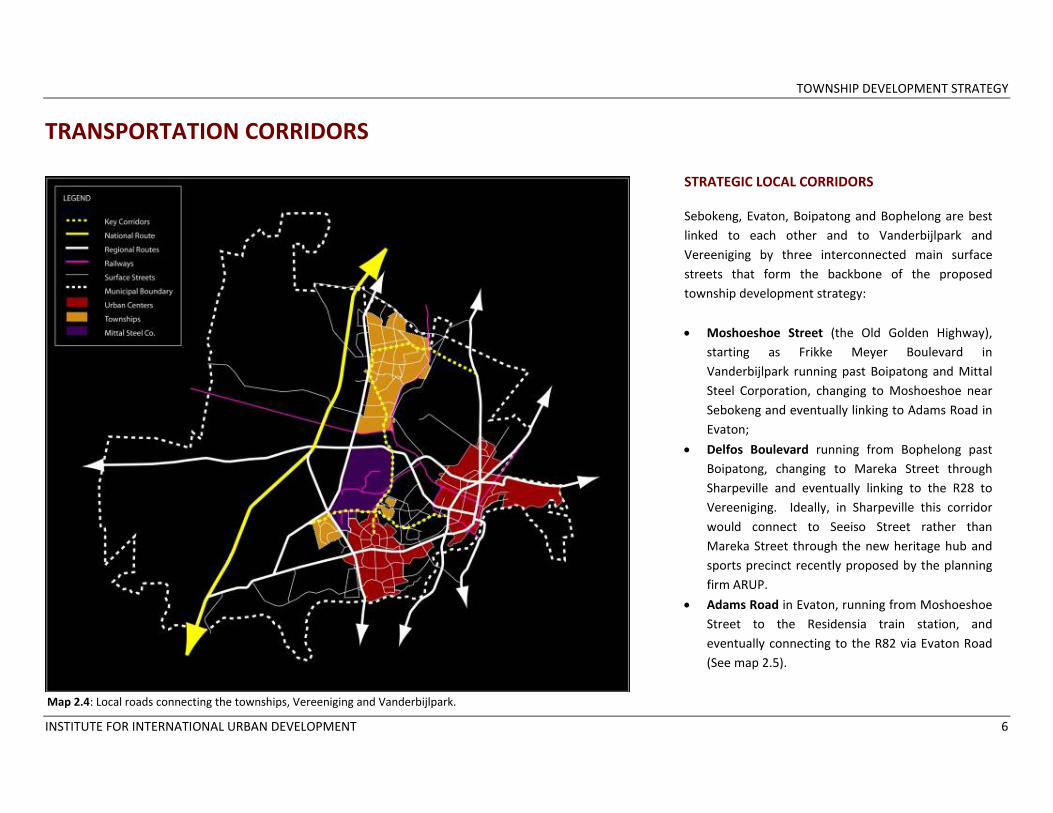
STRATEGIC LOCAL CORRIDORS Sebokeng, Evaton, Boipatong and Bophelong are best linked to each other and to Vanderbijlpark and Vereeniging by three interconnected main surface streets that form the backbone of the proposed township development strategy:
• Moshoeshoe Street (the Old Golden Highway), starting as Frikke Meyer Boulevard in Vanderbijlpark running past Boipatong and Mittal Steel Corporation, changing to Moshoeshoe near Sebokeng and eventually linking to Adams Road in Evaton;
• Delfos Boulevard running from Bophelong past Boipatong, changing to Mareka Street through Sharpeville and eventually linking to the R28 to Vereeniging. Ideally, in Sharpeville this corridor would connect to Seeiso Street rather than Mareka Street through the new heritage hub and sports precinct recently proposed by the planning firm ARUP.
• Adams Road in Evaton, running from Moshoeshoe Street to the Residensia train station, and eventually connecting to the R82 via Evaton Road (See map 2.5).
Map 2.4: Local roads connecting the townships, Vereeniging and Vanderbijlpark.

TOWNSHIP DEVELOPMENT STRATEGY
INSTITUTE FOR INTERNATIONAL URBAN DEVELOPMENT 7
Map 2.5: Corridors that form the backbone of the township development strategy.

TOWNSHIP DEVELOPMENT STRATEGY
INSTITUTE FOR INTERNATIONAL URBAN DEVELOPMENT 8
While officials from Emfuleni Local Municipality and township residents recognize Moshoeshoe Street and Adams Road as key local corridors, Delfos Boulevard is also strategic in that it links Bophelong, Boipatong and Sharpeville to each other, to Moshoeshoe Street, and eventually to Vereeniging through the R28. Each of these routes is critical to the development of the townships and should guide investment priorities. Focusing major interventions, streetscape improvements and openspace projects along these selected corridors will:
• Improve the image of the townships and create a stronger sense of place for residents, visitors and potential investors;
• Provide a location for a tourism route connecting historic sites to the Vaal River (See Section 2.4);
• Link key projects that are planned or underway in Evaton (Evaton Renewal Project), Sharpeville (Heritage Hub, Sports Precinct and Dam project), and Boipatong (Boipatong Massacre Memorial).
• Catalyze further development along these corridors, effectively blurring the edges between the townships and their surroundings. This is particularly necessary for Boipatong and Bophelong, the smaller and more isolated locations.
MOSHOESHOE STREET
ADAMS ROAD
DELFOS BOULEVARD

TOWNSHIP DEVELOPMENT STRATEGY
INSTITUTE FOR INTERNATIONAL URBAN DEVELOPMENT 9
2.2 WETLANDS
Map 2.6: Riparian system in Emfuleni Local Municipality.
A riparian system runs through Emfuleni Local Municipality connecting to the Vaal River. The wetlands are located primarily in the Municipality’s rural areas but also extend into Evaton, Sebokeng and Boipatong (See Map 2.6). Much attention has been paid to the Vaal River and its potential as a tourism destination, but little has been done to regenerate the wetland areas in the townships which have been polluted by industrial and household waste. These large open spaces must be treated carefully given their function as wetlands, but they provide considerable opportunities for environmental rehabilitation and beautification as well as for the development of passive and active recreational areas in townships with few formal parks. Evaton has several initiatives to restore and use its large greenspace/wetland area, including a hydroponics project and a community golf course. These approaches could also be tested in Boipatong and Sebokeng.

TOWNSHIP DEVELOPMENT STRATEGY
INSTITUTE FOR INTERNATIONAL URBAN DEVELOPMENT 10
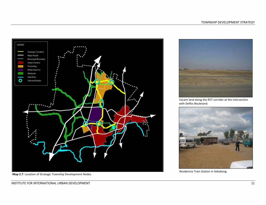
2.3 STRATEGIC DEVELOPMENT NODES Five strategic nodes along the selected development corridors stand out as having special significance given the objectives of social inclusion and connectivity, economic development and environmental regeneration in the four townships: 1. The vacant land surrounding the Vaal
University of Technology. This large area in Sebokeng comprising a university, a college, a stadium and a number of vacant land parcels is one of the most strategic nodes in ELM, particularly for township development. It has excellent access from the N1 along the R54, which subsequently leads to Vereeniging. It is relatively near one of the four train stations serving Sebokeng and could be the site of a large regional development project.
2. The vacant land between the R57 and Bophelong. A large expanse of open space along the R57 forms the eastern border of Bophelong and serves as an entrance to Emfuleni. The land is currently undeveloped. Although the area is studded with powerlines, some carefully planned construction and development of park and recreation areas is possible. ELM has identified this project as a priority.
3. The intersection of Delfos Boulevard and Frikke Meyer Boulevard near Boipatong. This intersection, located between the northern section of Vanderbijlpark and the southern part
of Boipatong, is an overlooked potential development area. Power lines constrain opportunities for construction, but large parcels of land around the intersection are open. Development in this area would help to connect Boipatong and Vanderbijlpark, currently separated by open land, and could provide much needed economic opportunities. A passenger train station located along the Mittal rail line near the intersection could act as a catalyst for further development.
4. The informal market area at the corner of Adams Road and Moshoeshoe Street
5. Residensia train station and the surrounding land.
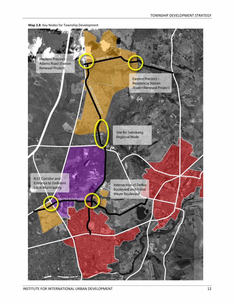
Concept plans for the last two strategic nodes have already been formulated under the Evaton Renewal Project funded by the Gauteng Department of Housing. The Project has several objectives, including upgrading infrastructure and housing, promoting local economic growth and improving social services. Several sites have been identified for future development:
1. The Eastern Precinct, comprising land near the Residencia Train Station;
2. The Western Precinct, located at the intersection of Moshoeshoe and Adams;
3. The Government and Sports Precinct, located near Evaton’s large wetland along Union and Easton Roads;
4. A Cultural and Heritage Route composed of historic sites in Evaton.
Construction on buildings within the Government Precinct has already begun, and the Heritage Route has recently been delineated. While each of the planned projects will be beneficial to Evaton, the Eastern Precinct at Residencia Station and the Western Precinct at the corner of Adams Road fit particularly well within the township development strategy and would be foundational projects anchoring the development of Adams Road as a commercial corridor linking to Moshoeshoe Street. The Western Precinct would provide structured space to informal traders located at the intersection while also supplying housing and community facilities. Development around the Residencia Station would take advantage of the pedestrian traffic in this busy area, upgrading existing commercial entities and formally structuring the busy taxi rank. Since the Evaton Renewal Project is already receiving R1.6 billion in Provincial funding, the selected projects in Evaton will not be prepared as business plans for the NDPG. However, Sedibeng District Municipality and Emfuleni Local Municipality should prioritize the development of the Eastern and Western Precincts within the framework of the Evaton Renewal Project.
TOWNSHIP DEVELOPMENT STRATEGY
INSTITUTE FOR INTERNATIONAL URBAN DEVELOPMENT 11
Map 2.7: Location of Strategic Township Development Nodes. Residencia Train Station in Sebokeng.
Vacant land along the R57 corridor at the intersection with Delfos Boulevard.
TOWNSHIP DEVELOPMENT STRATEGY
INSTITUTE FOR INTERNATIONAL URBAN DEVELOPMENT 12
Map 2.8: Key Nodes for Township Development
TOWNSHIP DEVELOPMENT STRATEGY
INSTITUTE FOR INTERNATIONAL URBAN DEVELOPMENT 13
2.4 TOURISM ROUTE
A goal of both SDM and ELM is to increase tourism by improving the Vaal waterfront area and by offering tourists other activities to encourage them to extend their stay in Emfuleni. The Vaal Meander Wine Route, linking 13 different venues near the Vaal River and showcasing wines from 30 South African wine estates, is one new initiative to attract additional visitors to the Vaal. Another alternative is a Vaal/Emfuleni heritage tour. Townships in the Municipality have a considerable history related to the anti‐Apartheid Struggle, from the Sharpeville Massacre in 1960 to the signing of the constitution in 1996. Several projects to commemorate historic events are currently underway in Evaton, Boipatong, Sebokeng and Sharpeville. The Sedibeng Department of Tourism stated that it already hosts about 1000 visitors per month, primarily organized bus tours for school groups to the Vaal Teknorama Museum and the Sharpeville Heritage sites. Occasionally the tours will extend to Sebokeng and Evaton depending on the parties’ time and interest. Given the existing tourism demand and the new projects to establish historic sites within the townships, the SDM and ELM should collaborate to develop an Emfuleni/Vaal heritage tour that would begin either
in Vereeniging or at the Vaal River and follow the selected corridors of Delfos Boulevard, Moshoeshoe Street and Adams Road to visit the following sites: Sharpeville. The Sedibeng Department of Tourism already guides tours to the Sharpeville Human Rights Memorial and Precinct. In 2008, the planning firm ARUP was commissioned to design a new Sharpeville Heritage Hub, a Sports Precinct and large green space project around the Dhlomo Dam for implementation by 2010. Boipatong. A memorial and historic route commemorating the 1992 Boipatong Massacre, funded by Gautrain’s Community Initiative, will be implemented by the Provincial Department of Public Transport, Roads and Works. The project was launched in 2008 and is currently in progress with plans for a monument, park, historical route, revamped commercial area and taxi rank. Mittal Steel (Formerly ISCOR). The steel industry, Emfuleni’s economic base for many years and the driving force behind the development of several townships, is interlinked with Emfuleni’s history. A tour of the workings of Mittal’s major industrial site
would be a key stop on a historic route tied to the anti‐apartheid struggle. SDM and ELM would need to collaborate with Mittal to provide this tour of the plant. Sebokeng. The SDM Department of Tourism currently brings visitors to several sites in Sebokeng, most of which are connected to Moshoeshoe Street. They visit the large Sebokeng hostels and the hospital at the township’s entrance, and they view the site of the Nangalembe Night Vigil massacre. In addition, visitors may attend events at the Mphatlalatsane Theatre. With several small improvements, the area near the theatre and nearby Shop‐Rite could be transformed into a plaza for a craft market and outdoor performing arts space. Evaton. In June 2009 the Evaton Renewal Project in conjunction with the planning firm Jaksa Barbir released the “Development Framework for the Establishment of the Evaton Cultural and Heritage Route,” documenting their work they development of heritage sites in Evaton, including Jada’s Square, the Cemetery, Wilberforce, McCamel Church, the Residencia Station, Masenkeng, St. John’s Apostolic Faith Mission, and the Wetlands. Jada’s Square and

TOWNSHIP DEVELOPMENT STRATEGY
INSTITUTE FOR INTERNATIONAL URBAN DEVELOPMENT 14
the Residencia Station Precinct are located along Adams Road and could easily be integrated into a heritage route along the selected development corridors. SDM and ELM should collaborate to set up a special tour bus to run along the delineated route. The bus/trolley should be designed to catch the eyes of visitors. There are two potential routes such a bus could take: 1. Starting in Vereenigning at the Vaal Teknorama
Museum, the bus would run from the R28 to
the improved Seeiso Street, through the proposed Sharpeville Heritage Hub and Sports Precinct, along Delfos Boulevard to Lekoa Street and the Boipatong Heritage sites, returning to Delfos and linking to Moshoeshoe Street and eventually Adams Road.
2. The heritage tour would connect to the Vaal Meander (See Map 2.9). The bus would start from the Emerald Casino and run up Frikke Meyer Boulevard, then along Delfos Boulevard to Boipatong and Seeiso Street in Sharpeville,
and would return along Delfos to Moshoeshoe Street and Adams Road.
Developing the tour route and bus service accompanied by trained guides from the Department of Tourism is the first step toward increasing tourism in the Municipality, as tourists are already visiting several of the selected sites. Momentum will increase as new sites are gradually added. Streetscape improvements, tasteful signage and entrance beautification are also essential to making the route attractive for tourists.
Site for the future Boipatong massacre memorial. The Mphatlalatsane Theatre in Sebokeng. Industrial areas would be interesting sites along a tour route.

TOWNSHIP DEVELOPMENT STRATEGY
INSTITUTE FOR INTERNATIONAL URBAN DEVELOPMENT 15
Map 2.9: Heritage route through the selected townships.

TOWNSHIP DEVELOPMENT STRATEGY
INSTITUTE FOR INTERNATIONAL URBAN DEVELOPMENT 16
2.5 TOWNSHIP DEVELOPMENT CONCEPT
The objectives of the proposed Township Development Strategy are summarized as follows: 1. Strengthening the connection between the four
townships of Boipatong, Bophelong, Sebokeng and Evaton and the economic centers of Vereeniging and Vanderbijlpark through improving the existing local corridors of Moshoeshoe Street, Delfos Boulevard and Adams Road;
2. Linking historic sites along the selected corridors to Vaal tourism destinations;
3. Bringing the Vaal River and the open space system to the townships through wetland regeneration and the development of parks and recreational areas;
4. Developing strategic regional and local nodes for economic development.
Illustration 2.2: Concept diagram illustrating township development strategy.
12
3 4
URBAN DESIGN FRAMEWORKS
INSTITUTE FOR INTERNATIONAL URBAN DEVELOPMENT 17
3 URBAN DESIGN FRAMEWORKS
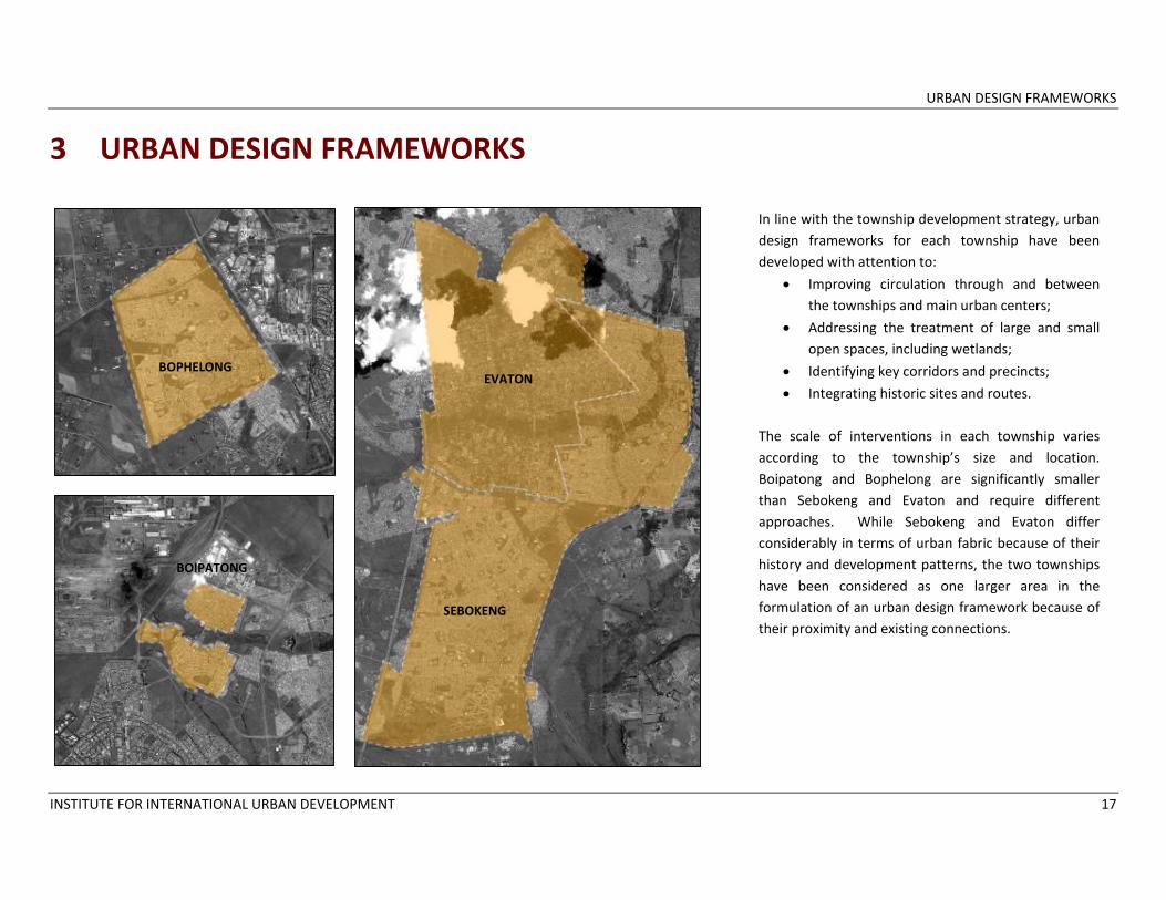
In line with the township development strategy, urban design frameworks for each township have been developed with attention to:
• Improving circulation through and between the townships and main urban centers;
• Addressing the treatment of large and small open spaces, including wetlands;
• Identifying key corridors and precincts;
• Integrating historic sites and routes. The scale of interventions in each township varies according to the township’s size and location. Boipatong and Bophelong are significantly smaller than Sebokeng and Evaton and require different approaches. While Sebokeng and Evaton differ considerably in terms of urban fabric because of their history and development patterns, the two townships have been considered as one larger area in the formulation of an urban design framework because of their proximity and existing connections.
BOPHELONG
BOIPATONG
EVATON
SEBOKENG
URBAN DESIGN FRAMEWORKS
INSTITUTE FOR INTERNATIONAL URBAN DEVELOPMENT 18
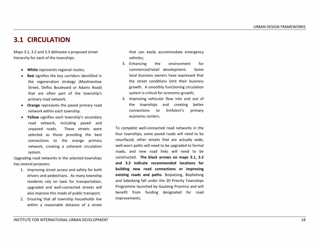
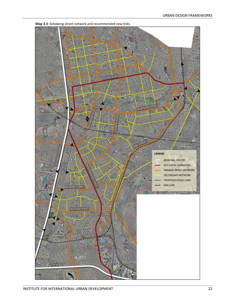
3.1 CIRCULATION Maps 3.1, 3.2 and 3.3 delineate a proposed street hierarchy for each of the townships:
• White represents regional routes;
• Red signifies the key corridors identified in the regeneration strategy (Moshoeshoe Street, Delfos Boulevard or Adams Road) that are often part of the township’s primary road network.
• Orange represents the paved primary road network within each township.
• Yellow signifies each township’s secondary road network, including paved and unpaved roads. These streets were selected as those providing the best connections to the orange primary network, creating a coherent circulation system.
Upgrading road networks in the selected townships has several purposes:
1. Improving street access and safety for both drivers and pedestrians. As many township residents rely on taxis for transportation, upgraded and well‐connected streets will also improve this mode of public transport;
2. Ensuring that all township households live within a reasonable distance of a street
that can easily accommodate emergency vehicles;
3. Enhancing the environment for commercial/retail development. Some local business owners have expressed that the street conditions limit their business growth. A smoothly functioning circulation system is critical for economic growth;
4. Improving vehicular flow into and out of the townships and creating better connections to Emfuleni’s primary economic centers.
To complete well‐connected road networks in the four townships, some paved roads will need to be resurfaced, other streets that are actually wide, well‐worn paths will need to be upgraded to formal roads, and new road links will need to be constructed. The black arrows on maps 3.1, 3.2 and 3.3 indicate recommended locations for building new road connections or improving existing roads and paths. Boipatong, Bophelong and Sebokeng fall under the 20 Priority Townships Programme launched by Gauteng Province and will benefit from funding designated for road improvements.
URBAN DESIGN FRAMEWORKS
INSTITUTE FOR INTERNATIONAL URBAN DEVELOPMENT 19
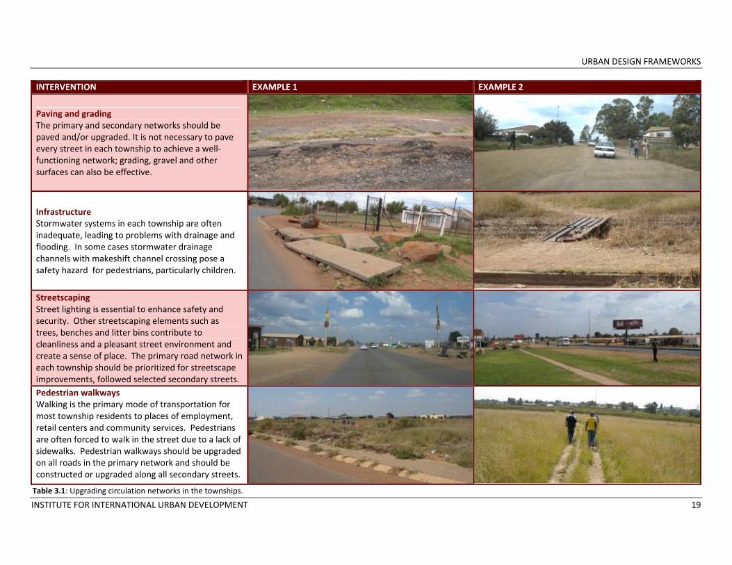
INTERVENTION EXAMPLE 1 EXAMPLE 2
Paving and grading The primary and secondary networks should be paved and/or upgraded. It is not necessary to pave every street in each township to achieve a well‐functioning network; grading, gravel and other surfaces can also be effective.
Infrastructure Stormwater systems in each township are often inadequate, leading to problems with drainage and flooding. In some cases stormwater drainage channels with makeshift channel crossing pose a safety hazard for pedestrians, particularly children.
Streetscaping Street lighting is essential to enhance safety and security. Other streetscaping elements such as trees, benches and litter bins contribute to cleanliness and a pleasant street environment and create a sense of place. The primary road network in each township should be prioritized for streetscape improvements, followed selected secondary streets. Pedestrian walkways Walking is the primary mode of transportation for most township residents to places of employment, retail centers and community services. Pedestrians are often forced to walk in the street due to a lack of sidewalks. Pedestrian walkways should be upgraded on all roads in the primary network and should be constructed or upgraded along all secondary streets.
Table 3.1: Upgrading circulation networks in the townships.
URBAN DESIGN FRAMEWORKS
INSTITUTE FOR INTERNATIONAL URBAN DEVELOPMENT 20
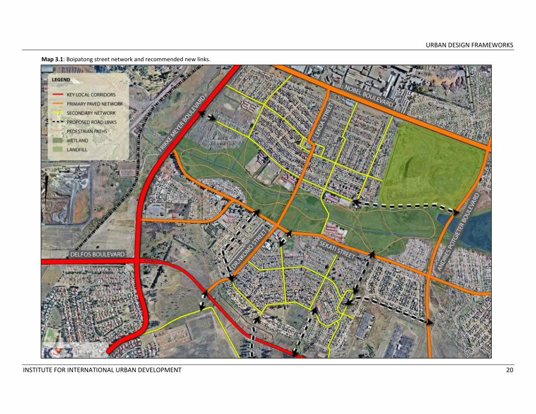
Map 3.1: Boipatong street network and recommended new links.

URBAN DESIGN FRAMEWORKS
INSTITUTE FOR INTERNATIONAL URBAN DEVELOPMENT 21
Map 3.2: Bophelong street network and recommended new links.
URBAN DESIGN FRAMEWORKS
INSTITUTE FOR INTERNATIONAL URBAN DEVELOPMENT 22
Map 3.3: Sebokeng street network and recommended new links.
URBAN DESIGN FRAMEWORKS
INSTITUTE FOR INTERNATIONAL URBAN DEVELOPMENT 23
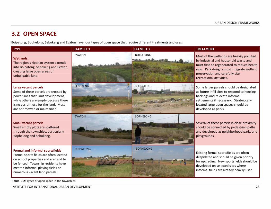
3.2 OPEN SPACE TYPE EXAMPLE 1 EXAMPLE 2 TREATMENT
Wetlands The region’s riparian system extends into Boipatong, Sebokeng and Evaton creating large open areas of unbuildable land.
Most of the wetlands are heavily polluted by industrial and household waste and must first be regenerated to reduce health risks. Park designs must integrate wetland preservation and carefully site recreational activities.
Large vacant parcels Some of these parcels are crossed by power lines that limit development, while others are empty because there is no current use for the land. Most are not mowed or maintained.
Some larger parcels should be designated as future infill sites to respond to housing backlogs and relocate informal settlements if necessary. Strategically located large open spaces should be developed as parks.
Small vacant parcels Small empty plots are scattered through the townships, particularly Bophelong and Sebokeng.
Several of these parcels in close proximity should be connected by pedestrian paths and developed as neighborhood parks and playgrounds.
Formal and informal sportsfields Formal sports fields are often located on school properties and are tend to be fenced. Township residents have created informal playing fields on numerous vacant land parcels.
Existing formal sportsfields are often dilapidated and should be given priority for upgrading. New sportsfields should be developed on selected sites where informal fields are already heavily used.
EVATON BOIPATONG
BOIPATONG BOPHELONG
SEBOKENG BOPHELONG
EVATON BOPHELONG
Table 3.2: Types of open space in the townships.
Boipatong, Bophelong, Sebokeng and Evaton have four types of open space that require different treatments and uses.

URBAN DESIGN FRAMEWORKS
INSTITUTE FOR INTERNATIONAL URBAN DEVELOPMENT 24
Guidelines
In the survey conducted under this technical assistance grant, residents of the four townships overwhelmingly expressed a need for additional recreational space in the form of landscaped parks, playgrounds and sportsfields. The availability of open land provides SDM and ELM with an opportunity to improve residents’ quality of life and increase economic development potential through large and small open space interventions. Several considerations should guide the placement and development of parks: 1. Open space should be developed such that
each household in Boipatong, Bophelong, Sebokeng and Evaton is within a ten minute walk (calculated at 800 meters) from a park or recreation area, ensuring that parks, playgrounds and sports fields are evenly distributed and are easily accessible.
2. As far as possible and keeping in mind the walking distance guideline, parks should be located along township development corridors and near other commercial and civic uses to encourage additional investment, provide increased security and facilitate maintenance.
3. Open space that is not developed into parks, sports fields and playgrounds should be
regularly mowed and maintained to address safety concerns, particularly on large vacant parcels that pedestrians cross to reach other destinations.
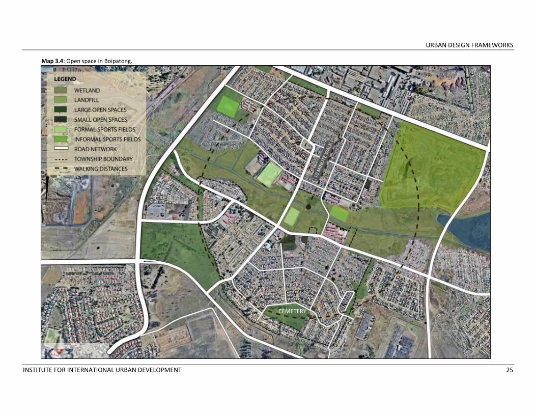
Recommendations for each township Open space patterns in each township differ considerably. Boipatong is dominated by one large wetland that creates a divide between the community’s two residential areas (See Map 3.4). This site can function as an effective wetland and be developed into an attractive park with careful planning and creative landscape designing. Regeneration of the wetland and closure of the nearby landfill should be the first priority. Bophelong has large vacant swaths that could be used for larger parks, particularly the land along the R57. Other large parcels should be used as infill sites to eventually provide homes to households living in informal settlements on the outskirts of the township. Bophelong also has a series of smaller vacant parcels that could be connected by pedestrian paths into a system of pocket parks, each with a distinct program. (See Map 3.5).
Sebokeng and Evaton represents a mixture of the four types with wetlands in the northern section and smaller interspersed parcels in the southern portion of Sebokeng (See Map 3.6). Evaton has already begun to use a section of its wetlands as a park and recreation area, with tree‐lined paths and a community golf course. These approaches could be applied in other townships. Parks and playgrounds should also be developed on vacant parcels along Moshoeshoe Street.
URBAN DESIGN FRAMEWORKS
INSTITUTE FOR INTERNATIONAL URBAN DEVELOPMENT 25
CEMETERY
Map 3.4: Open space in Boipatong.
CEMETERY

URBAN DESIGN FRAMEWORKS
INSTITUTE FOR INTERNATIONAL URBAN DEVELOPMENT 26
Map 3.5: Open space in Bophelong.

URBAN DESIGN FRAMEWORKS
INSTITUTE FOR INTERNATIONAL URBAN DEVELOPMENT 27
Map 3.6: Open space in Sebokeng and Evaton.
**Given the time constraints of this project, this mapping of open space in Sebokeng and Evaton is representative, not exhaustive.
URBAN DESIGN FRAMEWORKS
INSTITUTE FOR INTERNATIONAL URBAN DEVELOPMENT 28
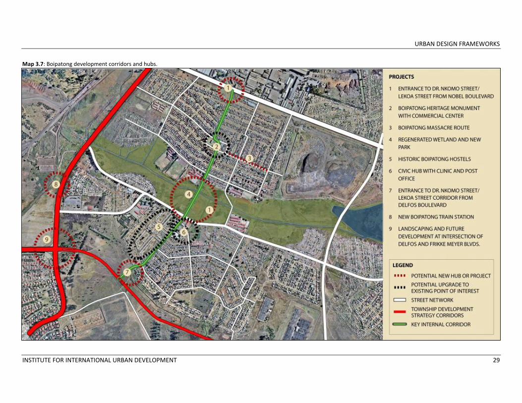
3.3 CORRIDORS, PRECINCTS AND HISTORIC SITES Development corridors following key transport routes structure both the township development strategy and the urban design frameworks. Each township is connected to Moshoeshoe Street, Delfos Boulevard or Adams Road, the main corridors identified in the development strategy. In addition, the smaller townships of Boipatong and Bophelong have internal development corridors that hold potential for economic growth. Existing activity hubs along each corridor should be upgraded and new interventions along the routes given priority. Boipatong is bounded by Frikke Meyer Boulevard (later changing to Moshoeshoe Street) on the west and Delfos Boulevard to the south. Larger scale interventions have already been recommended for the area near the intersection of Frikke Meyer and Delfos, possibly including a new train station. Boipatong’s main internal development corridor is Dr. Nkomo Street which changes to Lekoa Street as it crosses the wetland. Existing activity centers along this corridor include a civic hub with a municipal clinic and post office and, farther up, a commercial plaza area with a taxi rank which will be the site of the Boipatong Massacre Monument. The Boipatong hostels, a historic site that could be
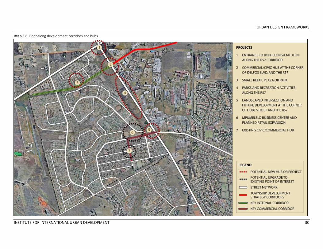
developed as a heritage location, are also located along the corridor. Transforming the overgrown wetland into a park and recreation area would add another major community hub, while landscaping the entrances from Delfos Boulevard and Noble Street would anchor the corridor (Map 3.7). The R57 runs the length of Bophelong’s east side and the intersections at Delfos Boulevard and Dube Street could be developed into activity hubs. The R57/Dube Street intersection upgrades should be extended along Dube Street to the Mpumelelo Business Center at the corner of Dube and Mathews, and should continue along Mathews to the existing civic hub at the center of the oldest part of Bophelong. Delfos Boulevard, with vacant land along both sides, could be transformed into a commercial avenue/greenway for the upper section of Bophelong, with a commercial/civic hub at the R57/Delfos intersection (Map 3.8). Sebokeng/Evaton’s main corridors anchor the township development strategy – Moshoeshoe Street and Adams Road. Existing activity hubs along these routes include the Sebokeng hospital area, the Thabong Shopping Plaza and nearby taxi rank across from the Sebokeng hostels, the
Mphatlalatsane Theater and nearby ShopRite, the informal market area at the corner of Moshoeshoe and Adams, Jada’s Square which has been recommended for development as a heritage site, and the Residensia train station. Several of these hubs would benefit from upgrades or new construction, some of which have already been planned. An informal market area has been suggested for the open land in front of the hostels. As recommended in section 1, a large‐scale regional development near the Sebokeng Campus of the Vaal University of Technology would be well‐placed along this corridor (Map 3.9).
URBAN DESIGN FRAMEWORKS
INSTITUTE FOR INTERNATIONAL URBAN DEVELOPMENT 29
Map 3.7: Boipatong development corridors and hubs.
URBAN DESIGN FRAMEWORKS
INSTITUTE FOR INTERNATIONAL URBAN DEVELOPMENT 30
Map 3.8: Bophelong development corridors and hubs.

URBAN DESIGN FRAMEWORKS
INSTITUTE FOR INTERNATIONAL URBAN DEVELOPMENT 31
Map 3.9: Sebokeng development corridors and hubs.
URBAN DESIGN FRAMEWORKS
INSTITUTE FOR INTERNATIONAL URBAN DEVELOPMENT 32
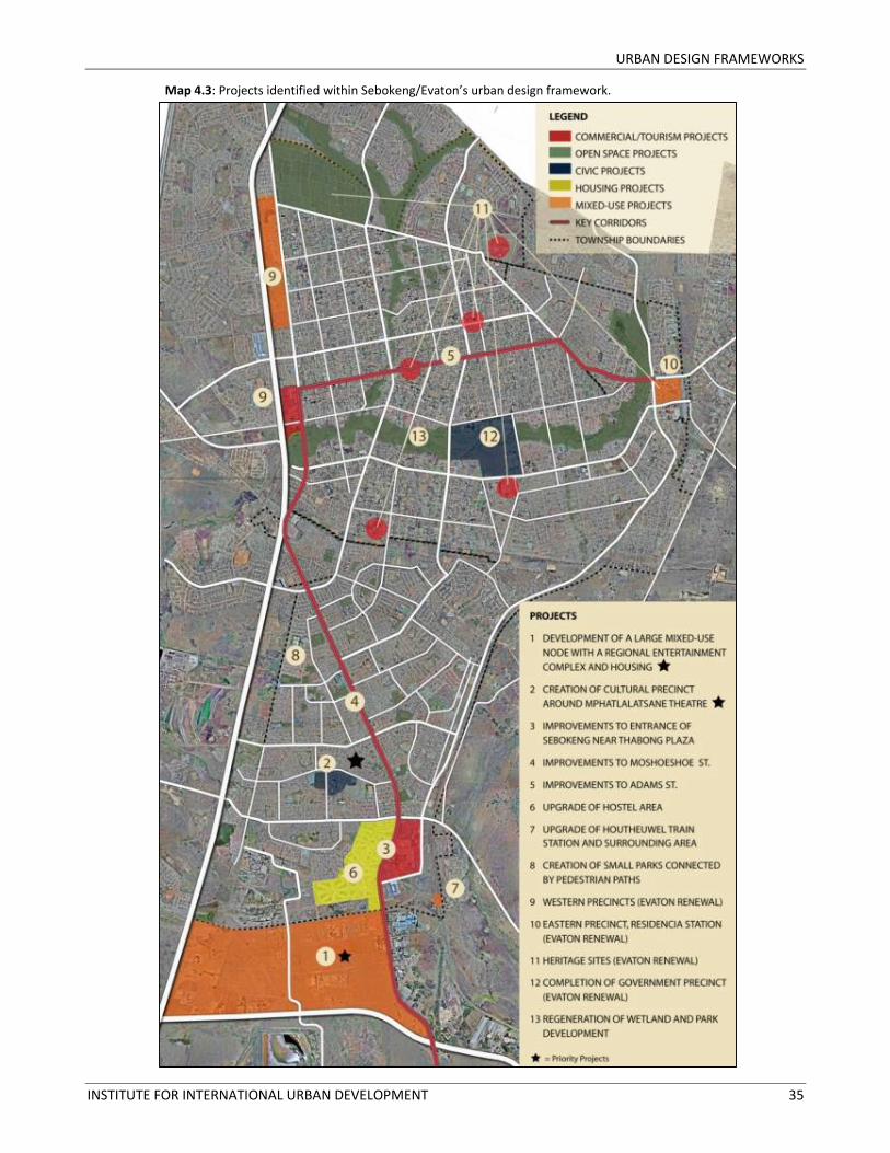
4 PROJECT SELECTION The urban design frameworks for each township guided the Kv3 team in identifying 30 potential projects to promote economic development, social inclusion and environmental regeneration (See Maps 4.1, 4.2 and 4.3). The projects were identified after the team read numerous municipal documents, conducted site visits and a survey of township residents, participated in workshops and stakeholder meetings, and discussed township development with SDM and ELM officials. From this array of possible interventions, a small number of priority projects were selected using the following criteria: 1. The requirements of the Neighborhood
Development Partnership Grant. The NDPG will support projects in townships that improve the environment for economic development and private sector investment.
2. Municipal support. Several of the selected sites had previously been highlighted by Emfuleni Local Municipality in its IDP and other documents. These proposals were assessed for feasibility and adapted as necessary given economic and social conditions. Each priority
project has been discussed with officials from SDM and ELM.
3. Community support. Meetings with stakeholders and a survey of township residents provided information on community needs that influenced the project selection.
4. Economic, social and environmental impact. Each project falls into at least two impact categories (e.g. economic and social, social and environmental, etc.). Several projects are intended to benefit the region, while others are “quick impact” projects designed to affect one township.
5. Other funding sources. The NDPG will not fund projects that are already financially supported by the public sector. Projects considered critical for township development, including the establishment of the Boipatong massacre monument and initiatives covered by the Evaton Renewal Project, have not been selected as they are receiving funding from other government sources.
6. Project distribution. Large and small priority projects are equally distributed among Boipatong, Bophelong and Sebokeng.
7. Possible partnerships. Each of the selected projects has strong potential to attract private sector partners.
The six priority projects selected are:
• Wetland regeneration and park development in Boipatong;
• Upgrade of commercial/civic hub in Bophelong;
• Development of open space in Bophelong along the R57;
• Creation of a cultural precinct in Sebokeng;
• Development of a transit node in Boipatong;
• Development of a regional node in Sebokeng.
These projects are recommended to SDM and ELM as priority developments. Of the six projects, however, only three to four will be selected for submission to the NDPG given the available funding envelope. The proposal to establish a transit node in Boipatong is included because of its key role in the township development strategy and the strong need for improved public transportation alternatives in Boipatong and Bophelong, but the project requires further exploration given the private ownership of the rail line and the high cost of establishing a train station in this location.

URBAN DESIGN FRAMEWORKS
INSTITUTE FOR INTERNATIONAL URBAN DEVELOPMENT 33
Map 4.1: Projects identified within Boipatong’s urban design framework.

URBAN DESIGN FRAMEWORKS
INSTITUTE FOR INTERNATIONAL URBAN DEVELOPMENT 34
Map 4.2: Projects identified within Bophelong’s urban design framework.
URBAN DESIGN FRAMEWORKS
INSTITUTE FOR INTERNATIONAL URBAN DEVELOPMENT 35
Map 4.3: Projects identified within Sebokeng/Evaton’s urban design framework.
URBAN DESIGN FRAMEWORKS
INSTITUTE FOR INTERNATIONAL URBAN DEVELOPMENT 36
Conceptual project plans have been developed for selected projects that are the most likely to receive funding either from the NDPG or from the private sector. At this stage the project plans are primarily schematic and will be further detailed upon approval from the NDPG.
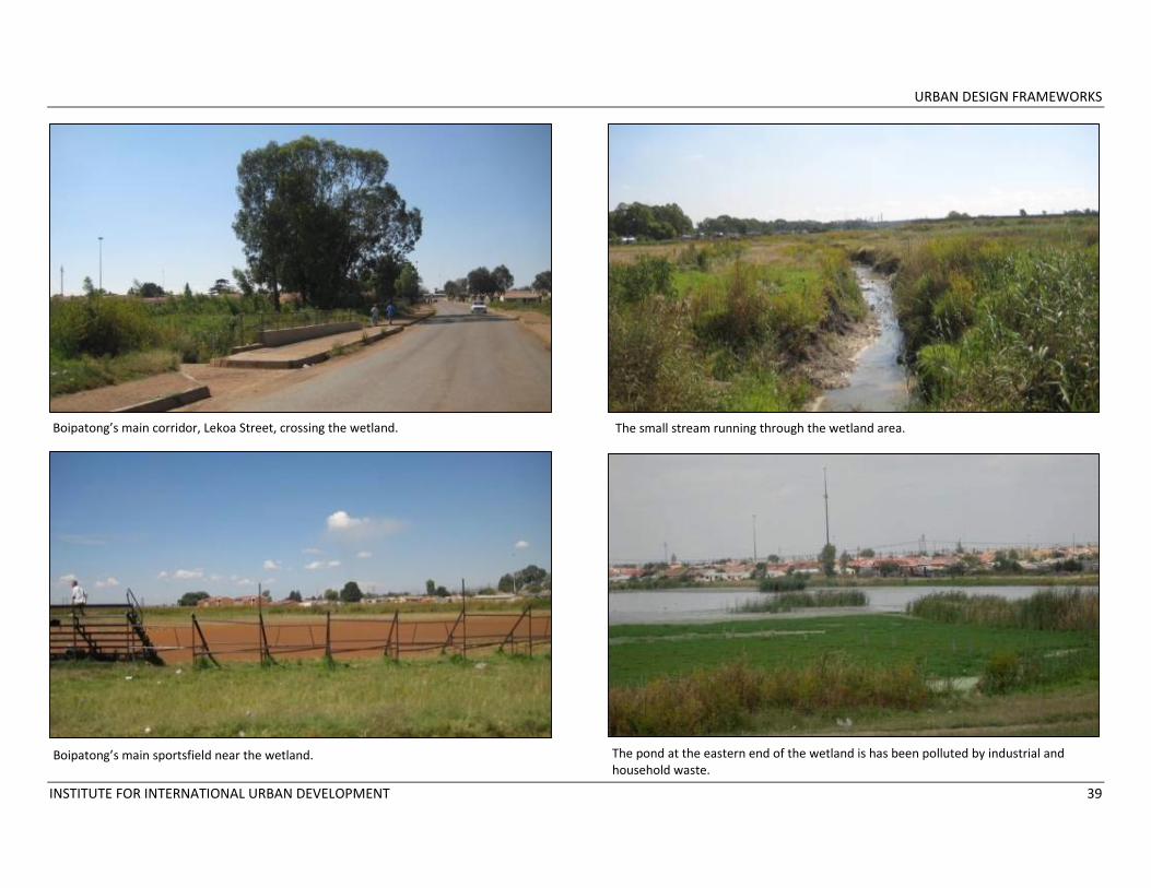
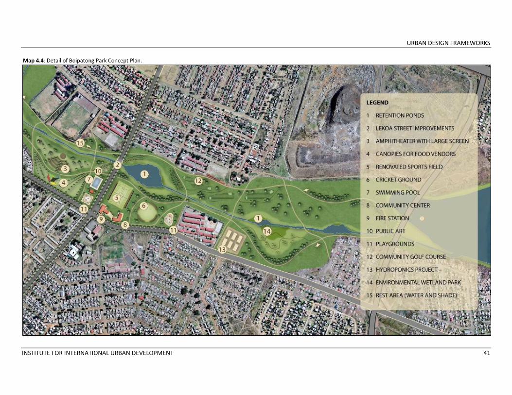
4.1 WETLAND REGENERATION AND PARK DEVELOPMENT IN BOIPATONG Description The two residential areas of Boipatong are separated by a large wetland that extends from Frikke Meyer Boulevard to Andres Potgeiter Boulevard. The space is hardly used by residents except to cross the grassy areas on makeshift paths or to play a match on the unmaintained sportsfield. The long grass represents a safety issue for pedestrians as it provides hiding places for predators, and grass‐cutting and maintenance have been requested by residents as priority interventions. The water in the stream running through the wetland is polluted by industrial and household waste, and may also be contaminated by leaching from the nearby landfill. Across from the landfill is a large pond that is currently overgrown by algae, indicating considerable pollution that increases residents’ risk of exposure to waterborne diseases. The pond has potential for recreational use, but its location near the landfill is unattractive and poses health hazards. Although the landfill is slated to be fully covered and closed in the next two years, parts
of it are uncovered at this point and garbage is visible. Reclaimers are active on the landfill, collecting items that can be recycled or sold. Despite its pollution, this wetland area has the potential to link the two residential sections of Boipatong rather than dividing it, while providing residents with beautiful parks, recreation activities, social spaces and community facilities. Wetlands contribute to the overall water quality of the Municipality, and any park development on this site must be designed considering wetland sustainability. A wetland specialist is currently assessing the site in Boipatong to delineate the boundaries of the wetland and determine floodlines. This information will be taken into account when preparing the project business plan. Key components of the Boipatong Park and Recreation Area Plan include:
1. Wetland regeneration. The first step in regenerating the existing wetland is to curb pollution from industrial and household sources by enforcing restrictions on
industrial dumping upstream and improving the sewerage system in Boipatong. Closing and covering the landfill site as quickly as possible will also contribute to the management of pollution. The wetland specialist assessing the site will be able to advise on plantings and soil treatments to rehabilitate the site. Land within the wetland boundaries will be preserved according to the specialist’s recommendations.
2. Well‐maintained park space landscaped in part with indigenous wetland grasses and trees. Wetland preservation and park development can occur simultaneously on this site once wetland boundaries have been delineated. It is critical to carefully determine the siting of parks and recreation activities. A trained landscape architect specializing in the treatment of wetlands should be retained to design the final park plan, using trees and grasses that contribute to regenerating the wetland while creating a usable park for Boipatong’s residents. Recreational activities and
URBAN DESIGN FRAMEWORKS
INSTITUTE FOR INTERNATIONAL URBAN DEVELOPMENT 37
community facilities should be located away from the most fragile areas.
3. A system of pedestrian paths. Boipatong’s residents have created paths through the wetland by frequent use. A path system formalizing these routes would provide safe passage across the wetland park as well as opportunities for recreational walking and biking. Paths over the wetland would need to be carefully constructed.
4. A community sports hub. The existing sports field is poorly maintained but could easily be renovated, while a new cricket ground would provide residents with recreational options. Neither field would need to be regulation size. Informal discussions with Boipatong residents indicated that a swimming pool would be appreciated by the community, with a toilet and changing facility. These recreational uses would be located near Lekoa Street, the main road crossing the wetland.
5. A natural outdoor amphitheater with a large screen for community viewing of sporting events and children’s programs. The non‐profit organization Township TV has been successfully installing large screen TVs in parks in townships throughout South Africa which projects sporting events and educational programs for township residents. A partnership arrangement to
provide such a screen to Boipatong should be explored. A natural (non‐constructed) amphitheater would provide seating for viewing the TV screen.
6. Space for informal traders and food vendors near the amphitheater. The crowds attracted by a large screen for community viewing of sporting events provide opportunities for vendors to sell food and other goods. Formalized market stalls or canopies would supply space for these activities.
7. A public art project commemorating Boipatong’s history along Lekoa Street. The Boipatong Heritage Project funded by Gautrain CSI will create a historic monument and route at the existing square and taxi rank along Lekoa Street to the north of the wetland. The hostels to the south of the wetland along the same street also relate to Boipatong’s history and when the hostels are renovated one block could be preserved and a plaza added as part of the township’s historic route. Adding a commemorative public art project with a seating area along the street through the wetland would link the two historic sites and connect the park to the heritage project.
8. A fire station and a new community center along Lekoa Street across Sekati Street
from the municipal clinic and post office. Boipatong does not have a fire station or a community center, and siting the two facilities in this central location will create a civic hub for the township.
9. A security station. To ensure safety, the park and recreation area will need 24‐hour security patrols.
10. Playgrounds. Areas with playground equipment such as slides and swings will be located in several areas of the park near other recreational activities such as the amphitheater and the sports fields.
11. A community garden, hydroponics project or orchard. A small community garden could contribute to meeting some food needs for Boipatong residents. Moreover, fruit trees grow abundantly given the climate, and a portion of the site could be set aside as an orchard. However, the selected land will need to be tested for contamination. Alternatively, the successful hydroponics initiative that is part of the Evaton Renewal Project could be replicated in Boipatong in collaboration with Gauteng Province.
12. A community golf course similar to the one in Evaton. That course, despite needing maintenance, is used and enjoyed by Evaton’s residents. A similar course in
URBAN DESIGN FRAMEWORKS
INSTITUTE FOR INTERNATIONAL URBAN DEVELOPMENT 38
Boipatong and would provide an alternative recreational activity in the township.
13. An environmental center and park with walking trails and indigenous wetland plants labeled and described. Nearby schools will be able to use this facility for environmental education.
Rationale The regeneration of the wetland and the development of a park and recreation area are critical to improving Boipatong’s image, enhancing the environment for private investment, establishing a key development corridor within the township and improving quality of life for residents. The project would provide considerable social benefits. First, the survey undertaken as part of this project indicated a considerable desire among township residents first for parks with family activities and secondly for playgrounds to provide recreation opportunities for children and youth. The proposed wetland park would meet both of these needs for Boipatong residents. Second, the development of the park would alleviate the safety concern when crossing large swaths of land covered in tall grasses, currently providing ample cover for potential attackers. Third, the regeneration of the wetland would reduce the health risks associated
with the polluted stream and pond and the open landfill. Establishing a park and recreation area that connects the residential areas of Boipatong is part of an overall strategy to increase investment in the township. The location of recreational activities along Boipatong’s main corridor will provide incentives for complementary commercial activities to locate there, particularly considering the development associated with the Boipatong Heritage Project farther along the corridor. The park will increase the Boipatong’s tourism potential, an objective in line with municipal and provincial goals for the township. Moreover, Township TV provides businesses with advertising opportunities during its programming, and informal traders will be able to take advantage of the large crowds using the park to expand their businesses. Support for the project Provincial and local authorities, community groups and local residents have been considering ideas for the development of this open space for several years. The Gauteng Province Department of Public Transport, Roads and Works (DPTRW), the department that is undertaking the Boipatong Heritage Project with money from Gautrain CSI, has expressed interest in regenerating the wetland.
This Department and Emfuleni Local Municipality should collaborate on the final designs for the project. The Sedibeng District Municipality Department of Tourism has also been working with Boipatong residents in conjunction with the DPTRW to establish the Boipatong massacre memorial and should be consulted regarding open space plans. The concept plan for the Boipatong park was presented with the township development strategy to Dr. Hein Weise of Emfuleni Local Municipality on July 9, 2009 and to the Sedibeng District Municipal Council on August 4, 2009. It was also presented to a group of community stakeholders on July 12, 2009. The plan was well‐received and supported at all three meetings. The Sedibeng Municipal Council expressed a desire to move forward quickly with this project so the park development will coincide with the construction of the Boipatong monument and massacre route. Dr. Weise noted that Mittal Steel Corporation has expressed willingness to partially fund an open space project in Boipatong and could be a willing private sector partner. The Township TV organization should be approached to explore a potential partnership to install a screen in the Boipatong Park. As one of Gauteng’s 20 Priority Townships, Boipatong might be an ideal location for the next Township TV project.
URBAN DESIGN FRAMEWORKS
INSTITUTE FOR INTERNATIONAL URBAN DEVELOPMENT 39
Boipatong’s main corridor, Lekoa Street, crossing the wetland. The small stream running through the wetland area.
Boipatong’s main sportsfield near the wetland. The pond at the eastern end of the wetland is has been polluted by industrial and household waste.
URBAN DESIGN FRAMEWORKS
INSTITUTE FOR INTERNATIONAL URBAN DEVELOPMENT 40
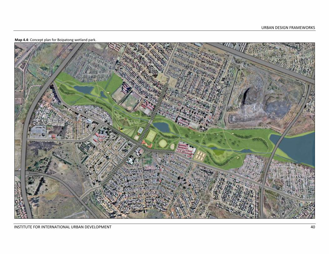
Map 4.4: Concept plan for Boipatong wetland park.
URBAN DESIGN FRAMEWORKS
INSTITUTE FOR INTERNATIONAL URBAN DEVELOPMENT 41
Map 4.4: Detail of Boipatong Park Concept Plan.
URBAN DESIGN FRAMEWORKS
INSTITUTE FOR INTERNATIONAL URBAN DEVELOPMENT 42
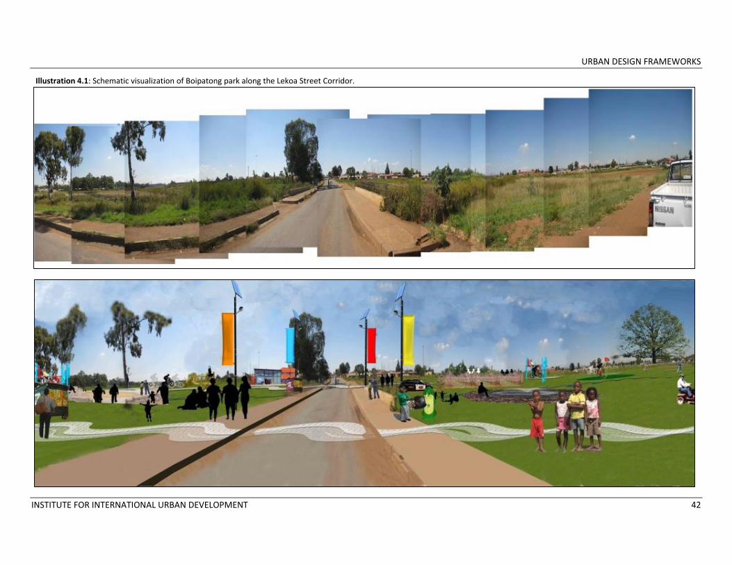
Illustration 4.1: Schematic visualization of Boipatong park along the Lekoa Street Corridor.

URBAN DESIGN FRAMEWORKS
INSTITUTE FOR INTERNATIONAL URBAN DEVELOPMENT 43
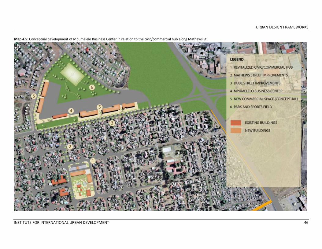
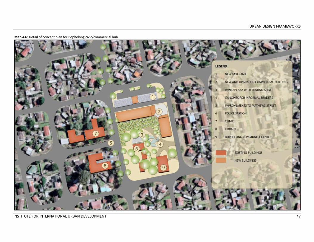
4.2 UPGRADE OF CIVIC AND COMMERCIAL HUB IN BOPHELONG Bophelong’s only civic hub and formal retail center serves residents from wards 6, 7, and 23, including households in the original part of the township established in 1955, in Bophelong’s large extensions and in the community of Bonanne to the south. The civic hub brings together a police station, municipal clinic, library and community center, and the retail plaza hosts several small grocery stores, a café, and a taxi rank. Fully‐grown trees provide shade and beauty to the unpaved plaza, but the commercial buildings are in disrepair and the taxi rank is informal and unstructured. Just 250 meters away at the corner of Mathews and Dube Streets is the relatively new Mpumelelo Business Center. Developed by the African Dream Trust, an NGO charged with creating employment opportunities in marginalized communities, this beautifully landscaped and maintained center provides local start‐ups and existing small businesses with visually attractive retail spaces. The center sits at the south end of a large piece of vacant land that is unused apart from informal sports activities. The African Dream Trust is planning further retail development in Bophelong on the vacant site, including the expansion of a local grocery store as an anchor for a larger
shopping plaza of several thousand square meters, and space for light industry. They are also intending to integrate parks and sports fields into the development, and they have won the support of the community for new projects. Given this center’s location along Dube Street, a key corridor in Bophelong, and its proximity to the existing civic/commercial hub along Mathews Street, the sites should be linked through streetscape improvements along Mathews Street and treated as one larger mixed‐use area (See Map 4.5). Components of this upgrade would include:
1. Formalizing the existing taxi rank. A structure would be built to house the taxi rank in its existing location. Emfuleni Municipal officials have indicated that the taxi rank may be moved to the vacant land the Business Center and that the community supports this move, but relocating well‐used taxi ranks is not always successful. Depending on the further expansion of the Business Center the taxi rank could be moved in the future.
2. Upgrading and improving the facades of the existing commercial buildings in hub on Mathews Street. Bophelong lacks
adequate well‐maintained space for small retail enterprises. The existing buildings around the plaza would be upgraded and expanded, and additional retail space added.
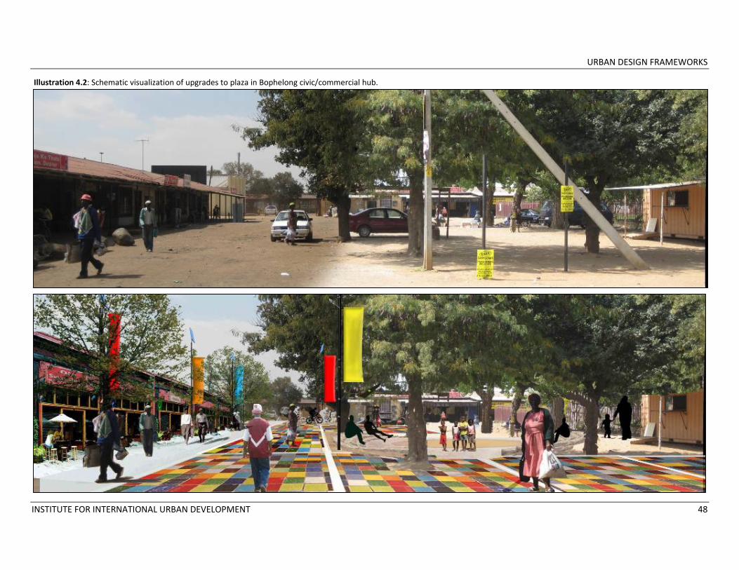
3. Using colorful, ornamental paving materials to surface part of the plaza area. Color and high quality paving materials create a sense of place and signify the importance of the civic/commercial hub.
4. Creating a small shaded seating area. The plaza area currently has no seating available and residents are using plastic chairs to rest and socialize. A planned seating area under the trees at the center of the plaza would give shoppers and pedestrians more opportunities for social interaction.
5. Establishing a market area in the plaza for street vendors. Informal vendors already use the plaza at times to sell their products. Market stalls or canopies would be set up to provide a formalized area for these activities.
6. Linking the retail areas by improving the streetscape. Mathews Street from the commercial/civic hub to the Mpumelelo

URBAN DESIGN FRAMEWORKS
INSTITUTE FOR INTERNATIONAL URBAN DEVELOPMENT 44
Business hive would be improved with trees, benches, litter bins, lighting, sidewalk upgrades, signage and colorful banners, designating the area as the central business district.
Rationale Upgrades to the civic/retail hub would improve its commercial viability, potentially attracting a broader range of shops to a center that already serves the residents of three wards. In addition, expansion of small‐scale retail space would support the development of SMMEs, an objective that is particularly important in Bophelong where residents have limited access to larger retail establishments. Emfuleni’s Department of Local Economic Development is committed to promoting SMMEs and is emphasizing their importance as they formulate an LED strategy. Both the business center and the civic/retail hub would benefit from a strong street connection along Mathews Street, particularly when the business center expands to house more retail and industrial space. Residents would begin to see the two centers as one commercial district where they
are able to purchase a variety of goods and services while also visiting the clinic, library or police station. The strong appeal of this project is its quick impact and relatively low cost. The improvements to the plaza and streetscape could be swiftly completed, spurring the renovations to the retail buildings and attracting new businesses. Improving the plaza area would provide a more appealing public space for social interaction and would entice additional customers. A rapidly‐completed project would increase community support for larger initiatives requiring more time. Support for the project
The concept plan for improvements to the Bophelong civic/retail hub was presented as part of the township development strategy to Dr. Hein Weise of Emfuleni Local Municipality on July 9, 2009 and to the Sedibeng District Municipal Council on August 4, 2009. It was also presented to a group of community stakeholders on July 12, 2009. The plan was supported at all three meetings, although participants in the stakeholder meeting expressed concern that interventions in Bophelong to date
had been concentrated in the lower “original” part of the township without addressing the needs of the residents living in the much larger extension areas that have developed over the years. This concern has been addressed in the R57 Corridor project (See Section 4.3). Most Bophelong residents participating in the community survey undertaken as part of this technical assistance grant indicated that they do not buy their most needed items within the township. Lower‐cost groceries were among the most requested items and residents identified Pick and Pay and Shoprite as stores they would like to see in their neighborhood. Given the current work of the African Dream Trust to expand a local grocery store, however, a larger grocery chain could supply unwanted competition and harm local businesses. The support and collaboration of the African Dream Trust are therefore critical to the future success of the project, particularly given the respect and trust they have gained from the community.
URBAN DESIGN FRAMEWORKS
INSTITUTE FOR INTERNATIONAL URBAN DEVELOPMENT 45
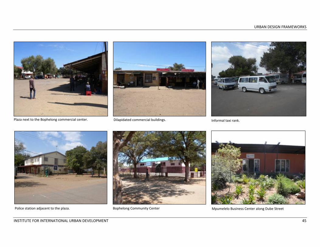
Plaza next to the Bophelong commercial center. Dilapidated commercial buildings. Informal taxi rank.
Police station adjacent to the plaza. Bophelong Community Center Mpumelelo Business Center along Dube Street
URBAN DESIGN FRAMEWORKS
INSTITUTE FOR INTERNATIONAL URBAN DEVELOPMENT 46
Map 4.5: Conceptual development of Mpumelelo Business Center in relation to the civic/commercial hub along Mathews St.
URBAN DESIGN FRAMEWORKS
INSTITUTE FOR INTERNATIONAL URBAN DEVELOPMENT 47
Map 4.6: Detail of concept plan for Bophelong civic/commercial hub.
URBAN DESIGN FRAMEWORKS
INSTITUTE FOR INTERNATIONAL URBAN DEVELOPMENT 48
Illustration 4.2: Schematic visualization of upgrades to plaza in Bophelong civic/commercial hub.

URBAN DESIGN FRAMEWORKS
INSTITUTE FOR INTERNATIONAL URBAN DEVELOPMENT 49
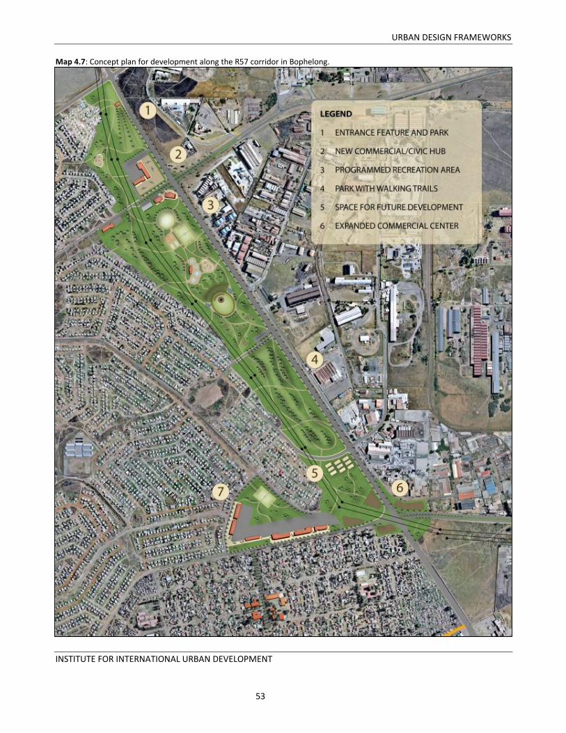
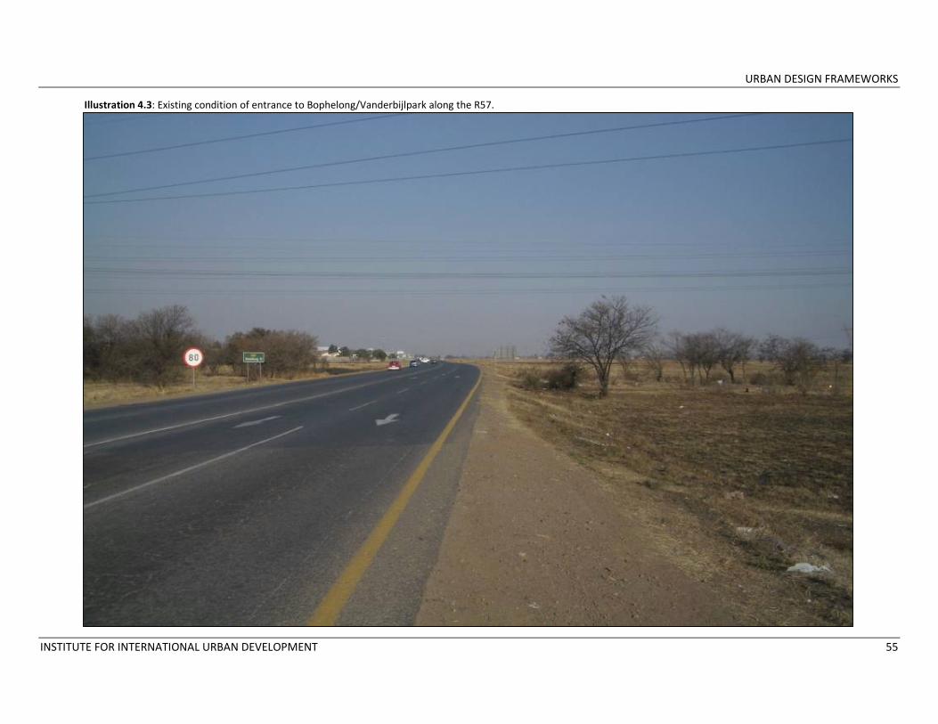
4.3 DEVELOPMENT OF OPEN SPACE IN BOPHELONG ALONG THE R57 Regional Route 57 (R57) forms part of the Golden Highway extending from the N1 Johannesburg highway and connecting to one of Vanderbijlpark’s major tourism areas on the Vaal River near Stonehaven and the Hotel Riverside. From the N1, the route passes through agricultural landholdings, establishes the eastern border of Bophelong township, crosses the R42 and runs along the western border of Vanderbijlpark before reaching the Vaal. For international visitors and Johannesburg/Pretoria residents enjoying recreational activities near the River, the R57 is the primary entrance into Emfuleni Local Municipality. Representatives from Emfuleni’s business sector, particularly those businesses concentrated near the Vaal River, have expressed concern that neglected sites along the R57 present a negative image of the Municipality to tourists and potential investors and are detrimental to business growth. It is not evident to visitors that they are entering the Municipality, nor that the route leads to the Vaal. Moreover, overgrown vacant land and illegal dumping sites are visible from the road, and poorly maintained intersections contribute to the sense of neglect. Improvements to this corridor will significantly enhance the environment for
investment in Bophelong, in Vanderbijlpark, and along the Vaal River. Projects along this corridor should be concentrated on the site requiring the most investment: the large vacant land parcel between the R57 and Bophelong, bounded by the R553 to the north and Dube Street to the south (See Map 4.7). Two strategic roads form intersections with the R57 along this open space: Delfos Boulevard, one of the three key corridors highlighted in the township development strategy (See Section 2); and Dube Street, a key connection to Vanderbijlpark, the location of the Mpumelelo Business Center and the street forming the edge of the original section of Bophelong. These intersections provide opportunities for the development of key commercial and civic uses. The R57/Bophelong site requires three types of interventions:
1. Beautification and safety projects. As the entrance to Bophelong, Vanderbijlpark and Vaal River tourist attractions, the site must convey an image of an area that is vibrant, well‐maintained and ready for new investment. Tasteful signage, landscaping
at key intersections and along streets, and public art projects can all contribute to creating a sense of place. While a pedestrian bridge is unnecessary given the moderate width of the R57, traffic robots at each major intersection, carefully placed speed bumps and well‐marked pedestrian crosswalks are critical to ensure the safety of drivers along the route and pedestrians crossing the R57 to reach the nearby industrial zone.
2. Development of parks and sports fields. The large open spaces on this site provide opportunities to develop parks and sports fields that will not only provide Bophelong with much needed recreational space but will also create a visually appealing corridor along the R57. Urban agriculture has been considered for this site but the land is likely extremely contaminated by industrial waste and unsuitable for gardening.
3. Development of commercial and civic buildings. The positioning of large power lines on the site limits the amount of construction that can occur given that a 30 to 50 meter buffer is required on both sides of the power lines. However, some space is

URBAN DESIGN FRAMEWORKS
INSTITUTE FOR INTERNATIONAL URBAN DEVELOPMENT 50
available. The area with the most available land for a retail/civic hub is the intersection of Delfos Boulevard and the R57, situated along a key corridor highlighted in the township development strategy.
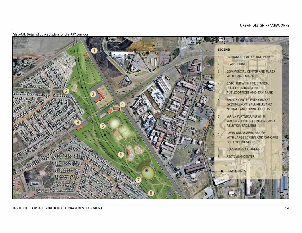
It is recommended that the R57 development be broken into four smaller projects to be completed in phases:
1. Bophelong/Vanderbijlpark entrance. A large welcome sign/feature incorporating creative landscaping, public art and flags would be located after the intersection of the R553 and the R57, surrounded by an entrance park with pedestrian paths, trees and plantings and a children’s playground. A design competition could be held to select artwork for the entrance.
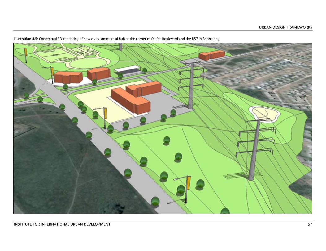
2. A civic/retail hub at the intersection of Delfos Boulevard and the R57. This key intersection is currently empty and unlandscaped. A retail hub would be located at the northern part of this junction, and a large plaza with colorful canopies would host a mobile craft market that would be visible from the R57. The commercial buildings would be designed to provide space for neighborhood‐level businesses rather than larger chain stores to align with the work of the African Dream
Trust (See Section 4.2). Civic uses, including fire and police stations and other municipal services, would be concentrated at the southern part of this intersection, providing households in the Bophelong extensions with a small town center for economic, social and civic purposes. Speedbumps, well‐marked pedestrian crosswalks and a traffic robot would be installed at this intersection.
3. Parks and sports fields between the Delfos and Dube intersections. The large park would include a system of walking and biking trails building on existing pedestrian paths, an outdoor amphitheater with a large screen for watching sporting events; covered braai areas; fields for a variety of sports, a water playground for children and shaded areas for resting. Strategic tree planting would create a buffer between the park and the R57. Speedbumps and pedestrian crosswalks at selected locations along the route would be added to ensure the safety of park users. A hydroponics project similar to the one underway in Evaton could be implemented along this corridor as well, rather than siting a community garden on land that is likely contaminated.
4. Landscaping and entrance signage at the intersection of Dube Street and the R57. This part of the R57/Bophelong initiative should be linked in design and implementation to the renovation of the civic/commercial hub along Mathews Street and the future development of the Mpumelelo center by the African Dream Trust (See Section 4.2). The Dube/Mathews/R57 link has strong potential as a commercial corridor, and landscaping/streetscape improvements should extend from the intersection along Dube to the Business Center. A small visitor’s information center would be set up at the Center given its proximity to the R57 entrance to Emfuleni.
Rationale: Development along the R57 would benefit business interests and the Municipality as a whole by creating an inviting entrance to Emfuleni leading to the tourism activities along the Vaal. This project is one of the five priority nodes identified in the township development strategy (See section 2). The project’s individual components will also provide social and economic opportunities to residents of Bophelong. Ward 6, comprising most of Bophelong’s extensions, has very few community
URBAN DESIGN FRAMEWORKS
INSTITUTE FOR INTERNATIONAL URBAN DEVELOPMENT 51
services or retail shops to serve its households. Most residents must walk to the Bophelong civic/retail center for goods and services. Creating a new civic/commercial precinct at the intersection of Delfos and the R57 will respond to these needs while establishing a strategic hub along two key local corridors. Park space, playgrounds and sportsfields are also lacking in Bophelong, as indicated by the survey conducted as part of this technical assistance grant. Most of the residents interviewed stated that the township requires more space for recreational activities, particularly sportsfields and playgrounds. The only formal sportsfield in Bophelong is located at its southern end and is a long walk for those living in Bophelong’s extensions. Sportsfields along the R57 would better serve these households. Beautifying the intersection at Dube Street and the R57 will serve several purposes, paving the way for future development at this intersection as well as creating another point of interest as visitors move into Vanderbijlpark. The intersection is also an entrance point for a new Dube Street commercial corridor extending to the Mpumelelo Business Center and linking to the proposed upgrades of the Mathews Street civic/commercial hub.
Support for the project Beautification of this large vacant land parcel along the R57 has for several years been a priority project of Emfuleni Local Municipality. The LED Department has been leading the project with the Vaal River Business Focus Group, an organization with a vested interest in improving the entrance to Emfuleni. Mittal Steel Corporation had originally committed R5 million to the beautification project which included a welcome sign, intersection improvements and a pedestrian bridge, but the company had eventually withdrawn the funds due to delays in the project progress. The Municipality still feels that the project is a priority for Emfuleni’s development. A rough draft of the concept plan for projects along the R57 corridor was presented as part of the township development strategy to Dr. Hein Weise of Emfuleni Local Municipality on July 9, 2009 and to the Sedibeng District Municipal Council on August 4, 2009. It was also presented to a group of community stakeholders on July 12, 2009. The draft plan did not meet with any resistance at the meetings. The plan also responds to an issue raised at the stakeholder meeting regarding the lack of investment in Bophelong’s extensions.
The retail development at the Delfos intersection should be discussed with representatives of the African Dream Trust to ensure that all parties are working productively together towards Bophelong’s development.

URBAN DESIGN FRAMEWORKS
INSTITUTE FOR INTERNATIONAL URBAN DEVELOPMENT 52
Open space with power lines along the R57 near Bophelong. Entrance area at the corner of R553 and R57.
Panorama of the intersection of Delfos Boulevard and the R57.
URBAN DESIGN FRAMEWORKS
INSTITUTE FOR INTERNATIONAL URBAN DEVELOPMENT 53
Map 4.7: Concept plan for development along the R57 corridor in Bophelong.
URBAN DESIGN FRAMEWORKS
INSTITUTE FOR INTERNATIONAL URBAN DEVELOPMENT 54
Map 4.8: Detail of concept plan for the R57 corridor.
URBAN DESIGN FRAMEWORKS
INSTITUTE FOR INTERNATIONAL URBAN DEVELOPMENT 55
Illustration 4.3: Existing condition of entrance to Bophelong/Vanderbijlpark along the R57.

URBAN DESIGN FRAMEWORKS
INSTITUTE FOR INTERNATIONAL URBAN DEVELOPMENT 56
Illustration 4.4: Conceptual visualization of improvements to the entrance to Bophelong/Vanderbijlpark along the R57.
URBAN DESIGN FRAMEWORKS
INSTITUTE FOR INTERNATIONAL URBAN DEVELOPMENT 57
Illustration 4.5: Conceptual 3D‐rendering of new civic/commercial hub at the corner of Delfos Boulevard and the R57 in Bophelong.
URBAN DESIGN FRAMEWORKS
INSTITUTE FOR INTERNATIONAL URBAN DEVELOPMENT 58
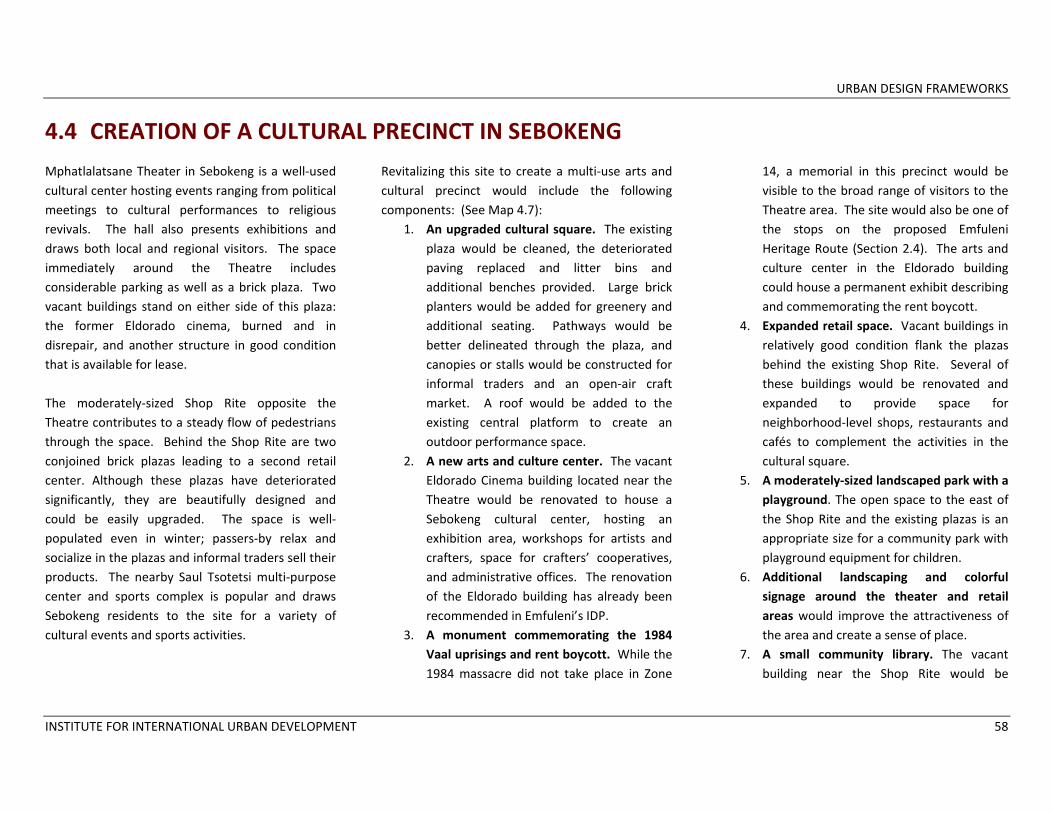
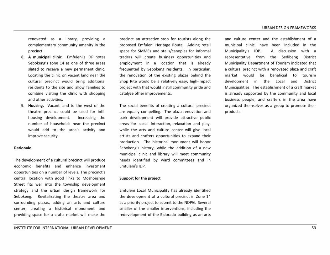
4.4 CREATION OF A CULTURAL PRECINCT IN SEBOKENG Mphatlalatsane Theater in Sebokeng is a well‐used cultural center hosting events ranging from political meetings to cultural performances to religious revivals. The hall also presents exhibitions and draws both local and regional visitors. The space immediately around the Theatre includes considerable parking as well as a brick plaza. Two vacant buildings stand on either side of this plaza: the former Eldorado cinema, burned and in disrepair, and another structure in good condition that is available for lease. The moderately‐sized Shop Rite opposite the Theatre contributes to a steady flow of pedestrians through the space. Behind the Shop Rite are two conjoined brick plazas leading to a second retail center. Although these plazas have deteriorated significantly, they are beautifully designed and could be easily upgraded. The space is well‐populated even in winter; passers‐by relax and socialize in the plazas and informal traders sell their products. The nearby Saul Tsotetsi multi‐purpose center and sports complex is popular and draws Sebokeng residents to the site for a variety of cultural events and sports activities.
Revitalizing this site to create a multi‐use arts and cultural precinct would include the following components: (See Map 4.7):
1. An upgraded cultural square. The existing plaza would be cleaned, the deteriorated paving replaced and litter bins and additional benches provided. Large brick planters would be added for greenery and additional seating. Pathways would be better delineated through the plaza, and canopies or stalls would be constructed for informal traders and an open‐air craft market. A roof would be added to the existing central platform to create an outdoor performance space.
2. A new arts and culture center. The vacant Eldorado Cinema building located near the Theatre would be renovated to house a Sebokeng cultural center, hosting an exhibition area, workshops for artists and crafters, space for crafters’ cooperatives, and administrative offices. The renovation of the Eldorado building has already been recommended in Emfuleni’s IDP.
3. A monument commemorating the 1984 Vaal uprisings and rent boycott. While the 1984 massacre did not take place in Zone
14, a memorial in this precinct would be visible to the broad range of visitors to the Theatre area. The site would also be one of the stops on the proposed Emfuleni Heritage Route (Section 2.4). The arts and culture center in the Eldorado building could house a permanent exhibit describing and commemorating the rent boycott.
4. Expanded retail space. Vacant buildings in relatively good condition flank the plazas behind the existing Shop Rite. Several of these buildings would be renovated and expanded to provide space for neighborhood‐level shops, restaurants and cafés to complement the activities in the cultural square.
5. A moderately‐sized landscaped park with a playground. The open space to the east of the Shop Rite and the existing plazas is an appropriate size for a community park with playground equipment for children.
6. Additional landscaping and colorful signage around the theater and retail areas would improve the attractiveness of the area and create a sense of place.
7. A small community library. The vacant building near the Shop Rite would be
URBAN DESIGN FRAMEWORKS
INSTITUTE FOR INTERNATIONAL URBAN DEVELOPMENT 59
renovated as a library, providing a complementary community amenity in the precinct.
8. A municipal clinic. Emfuleni’s IDP notes Sebokeng’s zone 14 as one of three areas slated to receive a new permanent clinic. Locating the clinic on vacant land near the cultural precinct would bring additional residents to the site and allow families to combine visiting the clinic with shopping and other activities.
9. Housing. Vacant land to the west of the theatre precinct could be used for infill housing development. Increasing the number of households near the precinct would add to the area’s activity and improve security.
Rationale The development of a cultural precinct will produce economic benefits and enhance investment opportunities on a number of levels. The precinct’s central location with good links to Moshoeshoe Street fits well into the township development strategy and the urban design framework for Sebokeng. Revitalizating the theatre area and surrounding plazas, adding an arts and culture center, creating a historical monument and providing space for a crafts market will make the
precinct an attractive stop for tourists along the proposed Emfuleni Heritage Route. Adding retail space for SMMEs and stalls/canopies for informal traders will create business opportunities and employment in a location that is already frequented by Sebokeng residents. In particular, the renovation of the existing plazas behind the Shop Rite would be a relatively easy, high‐impact project with that would instill community pride and catalyze other improvements. The social benefits of creating a cultural precinct are equally compelling. The plaza renovation and park development will provide attractive public areas for social interaction, relaxation and play, while the arts and culture center will give local artists and crafters opportunities to expand their production. The historical monument will honor Sebokeng’s history, while the addition of a new municipal clinic and library will meet community needs identified by ward committees and in Emfuleni’s IDP. Support for the project Emfuleni Local Municipality has already identified the development of a cultural precinct in Zone 14 as a priority project to submit to the NDPG. Several smaller of the smaller interventions, including the redevelopment of the Eldorado building as an arts
and culture center and the establishment of a municipal clinic, have been included in the Municipality’s IDP. A discussion with a representative from the Sedibeng District Municipality Department of Tourism indicated that a cultural precinct with a renovated plaza and craft market would be beneficial to tourism development in the Local and District Municipalities. The establishment of a craft market is already supported by the community and local business people, and crafters in the area have organized themselves as a group to promote their products.
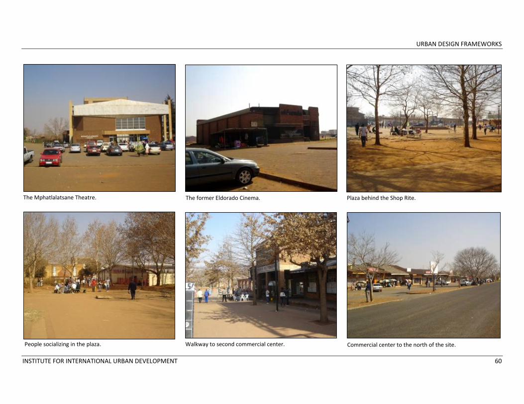
URBAN DESIGN FRAMEWORKS
INSTITUTE FOR INTERNATIONAL URBAN DEVELOPMENT 60
The Mphatlalatsane Theatre. The former Eldorado Cinema. Plaza behind the Shop Rite.
People socializing in the plaza. Walkway to second commercial center. Commercial center to the north of the site.

URBAN DESIGN FRAMEWORKS
INSTITUTE FOR INTERNATIONAL URBAN DEVELOPMENT 61
Map 4.9: Concept plan for the Sebokeng Cultural Precinct.
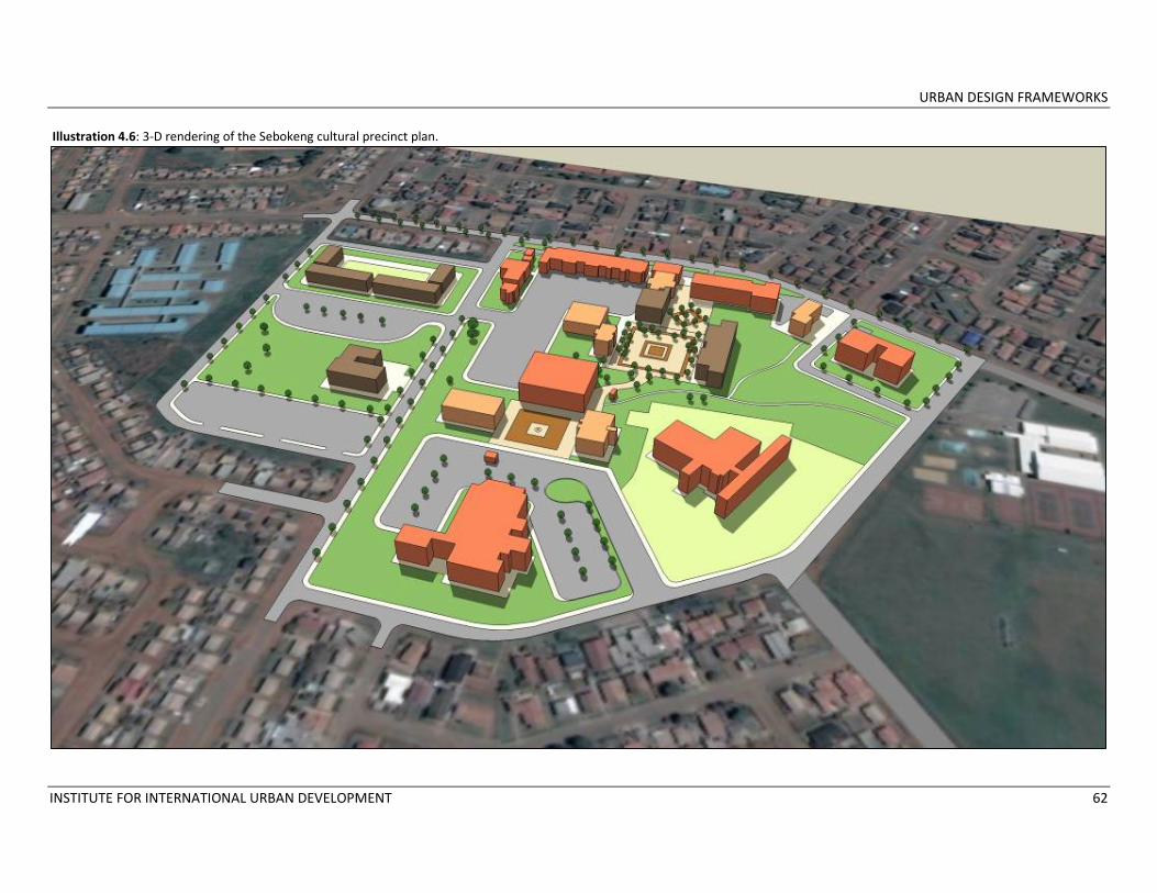
URBAN DESIGN FRAMEWORKS
INSTITUTE FOR INTERNATIONAL URBAN DEVELOPMENT 62
Illustration 4.6: 3‐D rendering of the Sebokeng cultural precinct plan.

URBAN DESIGN FRAMEWORKS
INSTITUTE FOR INTERNATIONAL URBAN DEVELOPMENT 63
Illustration 4.7: Existing condition of plaza behind Shop Rite near the Mphatlalatsane Theatre.
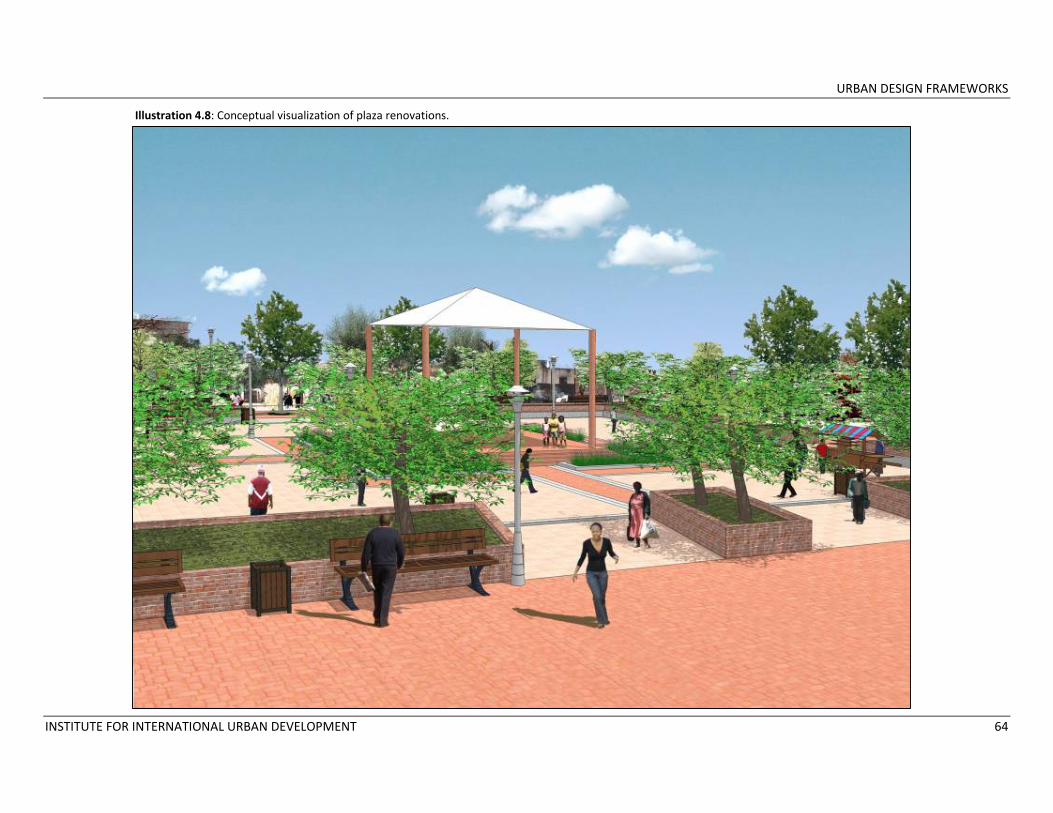
URBAN DESIGN FRAMEWORKS
INSTITUTE FOR INTERNATIONAL URBAN DEVELOPMENT 64
Illustration 4.8: Conceptual visualization of plaza renovations.
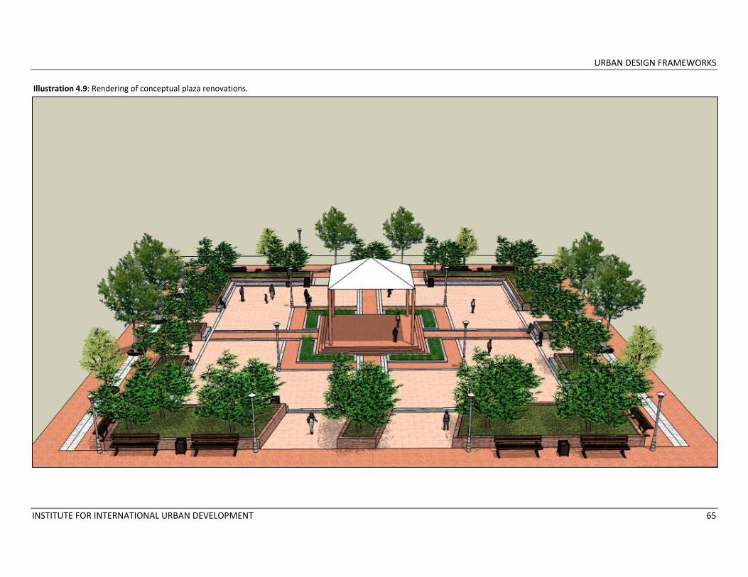
URBAN DESIGN FRAMEWORKS
INSTITUTE FOR INTERNATIONAL URBAN DEVELOPMENT 65
Illustration 4.9: Rendering of conceptual plaza renovations.
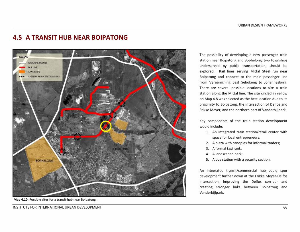
URBAN DESIGN FRAMEWORKS
INSTITUTE FOR INTERNATIONAL URBAN DEVELOPMENT 66
4.5 A TRANSIT HUB NEAR BOIPATONG
The possibility of developing a new passenger train station near Boipatong and Bophelong, two townships underserved by public transportation, should be explored. Rail lines serving Mittal Steel run near Boipatong and connect to the main passenger line from Vereenigning past Sebokeng to Johannesburg. There are several possible locations to site a train station along the Mittal line. The site circled in yellow on Map 4.8 was selected as the best location due to its proximity to Boipatong, the intersection of Delfos and Frikke Meyer, and the northern part of Vanderbijlpark. Key components of the train station development would include:
1. An integrated train station/retail center with space for local entrepreneurs;
2. A plaza with canopies for informal traders; 3. A formal taxi rank; 4. A landscaped park; 5. A bus station with a security section.
An integrated transit/commercial hub could spur development farther down at the Frikke Meyer‐Delfos intersection, improving the Delfos corridor and creating stronger links between Boipatong and Vanderbijlpark.
Map 4.10: Possible sites for a transit hub near Boipatong.
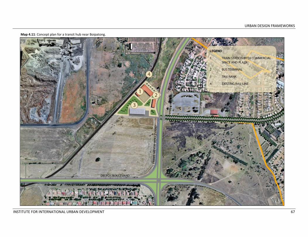
URBAN DESIGN FRAMEWORKS
INSTITUTE FOR INTERNATIONAL URBAN DEVELOPMENT 67
Map 4.11: Concept plan for a transit hub near Boipatong.
URBAN DESIGN FRAMEWORKS
INSTITUTE FOR INTERNATIONAL URBAN DEVELOPMENT 68
4.6 DEVELOPMENT OF A REGIONAL NODE IN SEBOKENG One of the most strategic sites for township development in Emfuleni is a large area located at the entrance to Sebokeng. This site, bounded by the Cyferpan land holdings near the Golden Highway to the west, Moshoeshoe Street to the east, the R28/R54 to the south and part of the rail network to the north, is situated at the center of the Municipality and the four townships (See Map 2.8). It is easily accessed from the N1 by R54, and is well connected to Vanderbijlpark by Moshoeshoe Road and Vereeniging by the R28. Moreover, the site is close to the Houtheuwel train station, serving residents of Johannesburg, Sebokeng and Vereeniging, as well as a large taxi rank to the north. The existing uses surrounding the site also contribute to its development potential. Most of the parcels are currently owned by the prominent Vaal University of Technology, and its Sebokeng Campus is constructed on the site near the R28. Other major uses in the immediate vicinity include:
• Sedibeng College, Sebokeng Campus (Renting land from Vaal University)
• Sedibeng West District of Education and Mittal Steel Science Center (Renting land from Vaal University);
• The Residencia Secondary School (Renting land from Vaal University);
• ESKOM Technical and Customer Services (Owns their land);
• The Vaal Training Center (Owns their land);
• The Self‐Help Association for the Disabled (SHAD) (Renting from Vaal University);
• The Thabo Vuyo Training Centre (Renting from Vaal University)
• A dilapidated stadium with a tartan track (this stadium is on land once held by Mittal but is currently being sold to another firm)
The parcels across Moshoeshoe Street from the site house large scale uses including the historic Sebokeng Hospital, the Houtkop Multi‐Government Services Center with a police station and municipal court, and a private hospital. Above the site is one of Sebokeng’s key shopping plazas, the Thabong Shopping Center, adjacent to the taxi rank. The Sebokeng hostels are located across from Thabong (See Map 4.12). Given the site’s excellent transportation access, surrounding concentration of commercial and institutional uses and large parcels of vacant land, it would best be used for a large‐scale development
of mixed regional uses and attractions that will serve residents of Emfuleni, Sedibeng, Johannesburg/Pretoria and international and domestic tourists, including:
• An iconic regional entertainment center/indoor‐outdoor mall. This center would host a range of activities from movies and restaurants to indoor/outdoor shopping, providing the townships with much‐needed retail venues and employment opportunities. The area lacks a cinema and this use would be an attraction in itself. A large‐scale family entertainment venue such as an amusement park, water park or zoo could also be considered.
• Housing. Emfuleni is facing a housing backlog and would benefit from the development of lower‐income or mixed‐income housing in the form of cost‐effective apartment buildings rather than single stand units. Vaal University has also indicated a considerable need for student housing and would be interested in giving the management of their housing needs to a private developer.

URBAN DESIGN FRAMEWORKS
INSTITUTE FOR INTERNATIONAL URBAN DEVELOPMENT 69
• Government services. Office space for businesses and government services would be combined with retail space in the housing development, creating a small town center for residents. This area would complement the existing nearby government services center.
• Sports Center. An existing deteriorating stadium on the site would be revamped to provide a space for regional matches. Other sports fields, netball and tennis courts, a swimming pool and changing facilities could be added to make the center a sports hub. Vaal University representatives expressed their need for such sports facilities and Sebokeng lacks formal sports fields.
• Space for health and education‐related uses. The site’s proximity to several educational institutions, a hospital and a private clinic offer an opportunity to develop a business or technology park catering to companies and organizations focusing on health and education.
• A business center with an incubator programme and space for growing businesses. Support for the development of SMMEs is critical to local economic development in the townships, and a business incubator programme would assist
new entrepreneurs to launch their commercial ventures. Vaal University is moving its Business Management Programme to the Sebokeng Campus on the site, representatives from the University indicated significant interest in partnering to establish a business incubator. A business park with space for start‐ups would complement this programme and provide opportunities to township residents and graduating students.
• Parks. The design of the site is anchored by a green spine extending from an existing wetland area through the housing development and entertainment center/shopping area. Some portions of this spine would be forested while others would be landscaped parks.
Rationale The primary objective of this mixed‐use project is to promote large‐scale economic development. The establishment of a regional attraction such as the proposed entertainment complex/outdoor mall will create considerable employment opportunities and reduce economic leakage by offering a broader range of products at better prices to township residents. The proposed business park and
industrial area will provide additional jobs. The site’s access and surrounding land uses make it an ideal location for a large mixed‐use development with a regional commercial center. Equally importantly, implementing a development of this type will demonstrate ELM’s and SDM’s commitment to improving Emfuleni’s townships and providing community amenities to previously disadvantaged areas. Parks, sports fields, and government services will complement the commercial and housing components of the plan. It is critical that the majority of the housing constructed is affordable to lower‐income residents despite its location near a regional attraction. Moreover, both Emfuleni LM and Sedibeng DM are seeking ways to provide tourists visiting the Vaal River with alternative activities that encourage them to extend their stay. As discussed, a heritage route presents one option for a one‐ or two‐day tourism programme (See Section 2.4). An entertainment and shopping complex offering family activities different from those along the Vaal is another alternative to increase the area’s tourism potential.
URBAN DESIGN FRAMEWORKS
INSTITUTE FOR INTERNATIONAL URBAN DEVELOPMENT 70
Support The concept plan for the Sebokeng Regional Node was presented with the township development strategy to Dr. Hein Weise of Emfuleni Local Municipality on July 9, 2009 and to the Sedibeng District Municipal Council on August 4, 2009. Both ELM officials and SDM Council Members expressed considerable interest in and support for the plan. Sedibeng and Emfuleni officials had previously designated the site as a priority development area to submit to the NDPG, and they agreed with the recommended development plan. The concept was also presented to a group of community stakeholders on July 12, 2009. Almost all of those
in attendance supported the idea of a regional entertainment complex/outdoor mall, but one business manager expressed concern that such a center could negatively affect his successful shopping plaza. Given that concern, the retail mix in the proposed entertainment complex must be carefully considered to avoid competing with local businesses. As shopping will not be the only activity in the complex, stores offering items currently unavailable in the townships should be considered, along with some up‐market boutiques given the higher purchasing power of Sebokeng. In addition, some space in the complex should be
reserved for independent local business owners to promote small business development.
The regional node was also presented to and discussed with Mr. Chris P. Booysen, the Project Director at Vaal University of Technology, and Prof. Piet Swanepoel on July 13, 2009. They were receptive to the idea of an entertainment complex, a housing development that could include student accommodations, a sports complex and space for a business incubator and training center. He indicated that as the owners of most of the land on the site, Vaal University would be interested in working with developers to accomplish the components of the project.

URBAN DESIGN FRAMEWORKS
INSTITUTE FOR INTERNATIONAL URBAN DEVELOPMENT 71
The road leading to Vaal University of Technology’s Sebokeng Campus. The existing stadium with a tartan track.
View of vacant land looking toward Vaal University. View of vacant land looking toward the power lines to the south of the site.
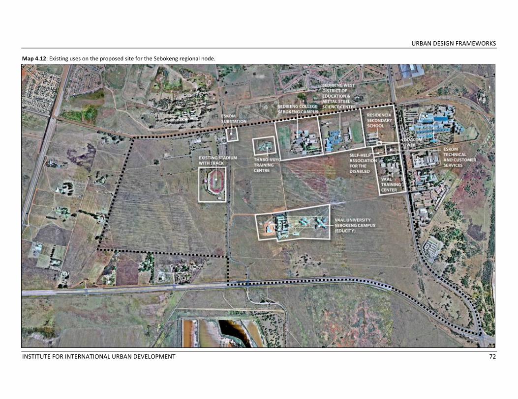
URBAN DESIGN FRAMEWORKS
INSTITUTE FOR INTERNATIONAL URBAN DEVELOPMENT 72
Map 4.12: Existing uses on the proposed site for the Sebokeng regional node.

URBAN DESIGN FRAMEWORKS
INSTITUTE FOR INTERNATIONAL URBAN DEVELOPMENT 73
Map 4.13: Concept plan for the Sebokeng regional node.

URBAN DESIGN FRAMEWORKS
INSTITUTE FOR INTERNATIONAL URBAN DEVELOPMENT 74
Illustration 4.10: Rendering of concept plan for Sebokeng regional node showing housing and the regional entertainment complex.

URBAN DESIGN FRAMEWORKS
INSTITUTE FOR INTERNATIONAL URBAN DEVELOPMENT 75
Illustration 4.11: Rendering of concept plan for Sebokeng regional node overlooking the housing development.

URBAN DESIGN FRAMEWORKS
INSTITUTE FOR INTERNATIONAL URBAN DEVELOPMENT 76
5 ANNEX LIST OF DOCUMENTS REVIEWED
• Emfuleni Local Municipality Draft IDP Review 2009/2010; • Emfuleni Local Municipality SDF 2007; • Sedibeng Growth and Development Strategy 2007; • Sedibeng District Municipality NDPG Pre‐Submission Consultation Report, 2008; • Emfuleni Local Municipality IDP Review 2007/2008; • Local Economic Development Strategy for the Tourism Sector of ELM by Vaal Research Group, 2009; • LED Situation Analysis of ELM by Intsiki Project Management 2009; • Emfuleni Local Municipality Proposal for the Beautification of the R57; • Sedibeng 2010 Strategy; • Vaal 21 Roadmap; • An Investigation into the State of Affairs and Sustainability of the Emfuleni Economy by TJC Slabbert, 2004; • Documents relating to the 2010 Precinct Development Projects in Vereeniging and Sharpeville; • Development Framework for the Establishment of the Evaton Cultural Heritage Route, Jaksa Barbir, 2009; • Evaton Cultural Heritage Route Market Research, Demacon, 2008; • Other documents relating to the Evaton Renewal Project.
LIST OF MEETINGS Emfuleni Local Municipality Dr. Hein Weise, Deputy Municipal Manager; Mr. Jerry Moledi, Acting Manager of Local Economic Development; Ms. Felicity Human, Manager of the Housing Department; Ms. Letitia Kalman, Manager of the Land Use Department; Mr. Johannes Matabane, Local Economic Development Department Ms. Mamokete Radebe, Local Economic Development Department
URBAN DESIGN FRAMEWORKS
INSTITUTE FOR INTERNATIONAL URBAN DEVELOPMENT 77
First Stakeholder Meeting Ms. Anna Khoali from Joint Women, an organization providing support and training to women‐run cooperatives; Ms. Puleng Makhale from Joint Women; A representative of Ms. Lydia Ikaneng from Ukhamba Properties in Johannesburg ; Mr. Ratladi Joel Monnakgotla, President, National African Federated Chamber of Commerce (NAFCOC), Sedibeng District; Ms. Tepsy Ntseoane from Eve’s Eden, a farming organization in Evaton; Ms. Colleen Rogers from Lifeline Vaal Triangle, a non‐profit organization offering services to victims of rape and domestic violence; A small business owner in Sebokeng; Second Stakeholder Meeting Mr. Elijah Moremi, Manager of Thabong Shopping Plaza; Mr. Motsoeneng, Evaton Plaza; Mr. George Sithole, Minister at a local church; Mr. Johnny Nije, Sharpeville Renewal Forum; Mr. Koos Piisetso Mafokeng, Evaton Plaza Mr. L.E. Thaele, Joint Women Cooperatives; Ms. Anna Khoali, Joint Women Cooperatives; Mr. P M. Ntsane, representing Emfuleni faith‐based organizations. Individual Meetings Mr. Elijah Moremi, Deputy Chairperson of the Evaton Development Forum, to discuss the Evaton Renewal Project and the progress of its various initiatives. Mr. Chris Booysen and Professor Piet Swanepoel, Vaal University of Technology, Department of Resources and Planning. As a major landholder just outside of Sebokeng, the University is a major stakeholder in the development of projects in that area. They described the University’s future expansion priorities and expressed a keen interest in the township regeneration strategy and proposed projects. Ms. Anina van Wyck, Vaal Teknorama Museum, operated by Sedibeng District Municipality. We discussed creating a heritage tour connecting sites in Boipatong, Sharpeville, Sebokeng and Evaton. Ms. van Wyck described current efforts to develop historical sites and mentioned tours that are already conducted focusing on the Vaal Teknorama Museum in Vereeniging and historic sites in Sharpeville.