Embed Size (px)
Citation preview

1 of 3
Ministry of Tourism, Culture and Sport
Culture Services Unit Programs and Services Branch Culture Division 401 Bay Street, Suite 1700 Toronto ON M7A 0A7 Tel: 416 314-7145 Fax: 416 212-1802
Ministère du Tourisme, de la Culture et du Sport
Unité des services culturels Direction des programmes et des services Division de culture 401, rue Bay, bureau 1700 Toronto ON M7A 0A7 Tél: 416 314-7145 Téléc: 416 212-1802
December 10, 2014 Meaghan Rivard Stantec Consulting Ltd. 49 Frederick Street Kitchener, ON N2H 6M7 E: [email protected] Project: Southgate Solar Project OPA Reference Number: F-003961-SPV-KC3-510 Report Title: Heritage Assessment Report: Southgate Solar Project Applicant: Southgate Solar LP Location: Southgate Township, Grey County, Ontario MTCS File No.: 0001705 Dear Meaghan Rivard: This office has reviewed the above-mentioned report (the “Report”), which has been submitted to this ministry as required under O. Reg. 359/09, as amended (Renewable Energy Approvals under the Environmental Protection Act) (the “REA regulation”). This letter constitutes the Ministry of Tourism, Culture and Sport (the “Ministry”) comments for the purposes of section 23(3)(a) of the REA regulation regarding the heritage assessment undertaken for the above project. The Report recommends the following:
6.0 RECOMMENDATIONS 6.1 SUMMARY The Heritage Assessment Report was executed according to the requirements of O. Reg. 359/09 Sections 19 and 23 as well as guidelines provided in the Bulletin (Government of Ontario 2013). Following a review of historic mapping, consultation with appropriate bodies, and two windshield surveys, a total of nine potential heritage resources were identified at the HAA. Upon review, eight resources were determined to satisfy criteria made under O. Reg. 9/06 indicating the presence of cultural heritage value or interest. As such, eight potential resources were determined to represent a heritage resource and therefore assessed to determine the impact of the Project on identified heritage attributes. Project related impacts were identified including an anticipated change in land use resulting in the destruction and alteration of the agricultural land use and the potential vibration impacts to heritage resources resulting from construction activities. The change in land use will occur throughout the life of the Project and impact all heritage resources identified. Potential vibration impacts are restricted exclusively to Project construction and decommissioning activities and may only affect hose heritage resources situated within 50 metres of the Project Location. Potential vibration impacts were identified for the following heritage resources:
• 392415 Sideroad 39 (CHR 1) • 392433 Sideroad 39 (CHR 2) • 392469 Sideroad 39 (CHR 3) • 223585 Sideroad 22 (CHR 5) • 223511 Sideroad 22 (CHR 7)

Southgate Solar Project F-003961-SPV-KC3-510
2 of 3
Following assessment, with regards to anticipated land use changes, it was determined that: 1. The change in land use is considered reversible; 2. The introduction of solar panels in the fields surrounding heritage resources does not disrupt or detract from an understanding of the historical relationship between the structures; 3. The introduction of solar panels will result in the loss of selected agricultural land use at the Project Location; and 4. A planned approach to mitigation measures emphasizing reversibility will be serve to reduce the loss of agricultural land. Following assessment, with regards to potential vibration impacts resulting from construction activities, it was determined that: 1. None of the heritage resources where potential vibration impacts were identified are at risk of removal and will be retained intact; 2. Heritage resources where potential vibration impacts were identified are contained within a 50 metre assessment area; and 3. A preventive approach to mitigation measures using planning mechanisms will best serve to reduce the risk of indirect impacts. 6.2 REVERSIBLE ALTERATIONS The Draft Decommissioning Plan Report (Dillon Consulting December 2014, in progress), describes the planned approach to decommissioning which is anticipated to take place at the close of the Project, currently estimated to be 2035. The report anticipates that the land will be restored to an agricultural use. It is anticipated that this will align with heritage attributes identified in relation to the vernacular rural landscape (CHR 8). Therefore, it is recommended that the Project adhere to the site restoration plans as discussed in the Decommissioning Plan Report when finalized. 6.3 PLANNING MECHANISMS Components of four heritage resources and a single potential heritage resource were determined to be situated within 50 metres of the Project Location. In order to prevent negative indirect Project impacts related to construction vibrations, heritage resources positioned within the Project Location should be isolated from Project activities. It is recommended that site plan controls be put in place prior to construction to prevent potential indirect impacts. The site plan controls shall include fencing to indicate where Project activities are restricted as described below. These controls should be indicated on all construction mapping and communicated to the construction team leads. Given the position of the heritage resources it is recommended that where construction activities may occur a 50 metre buffer zone be established around each heritage resource to indicate where all construction activities must be avoided including, but not limited to, ground disturbance and the movement of equipment and people to and from the site. If construction activities enter into the 50 metre buffer zone, all activities should cease immediately and a qualified building condition specialist should be retained to determine if any damage was incurred as a result of the construction activities. Only following approval from the building specialist, should construction activities resume at which point the 50 metre buffer should be re-established. Where construction activities cannot be avoided within the 50 metre buffer zone, it is recommended that maximum acceptable vibration levels, or peak particle velocity (PPV) levels, should be determined by a qualified engineer prior to any construction activities (preconstruction survey). Construction within the 50 metre buffer zone should be monitored to confirm that acceptable PPV levels are not exceeded. All construction activities should cease if levels are exceeded until an acceptable solution can be identified. Equal care should be applied during decommissioning activities to safeguard heritage resource, particularly with regards to vibration levels adjacent to heritage resources.

Southgate Solar Project F-003961-SPV-KC3-510
3 of 3
6.4 GENERAL In order to understand the visual effects of the Project generally, MTCS should be notified when the Visual Impact Assessment is posted for public review. As a general recommendation, any extant cabins, log houses, or built features encountered in wooded portions of the Study Area during the construction of Project infrastructure should not be removed without first undertaking a Heritage Impact Assessment of the resource. To assist in the retention of historic information, copies of this report should be deposited with a local repository of historic material. Therefore, it is recommended that this report be deposited in the local history collection at the following location: Southgate Library, 80 Proton Street North Dundalk, Ontario.
Based on the information contained in the Report, the Ministry is satisfied that the heritage assessment process and reporting are consistent with the applicable heritage assessment requirements established in Section 23 of O. Reg. 359/09. Please note that the Ministry makes no representation or warranty as to the completeness, accuracy or quality of the heritage assessment report (please see Note 1). This letter does not waive any requirements under the Ontario Heritage Act. This letter does not constitute approval of the renewable energy project. Approvals or licences for the project may be required under other statutes and regulations. Please ensure that you obtain all required approvals and/or licences. Please ensure that the proponent is aware that, if new information or substantive project changes arise after issuance of this letter, the applicant should discuss them with you to determine if any additional assessment or reporting is required. If additional reporting or revisions are required, they should be submitted to the Ministry for review. Upon completion of that review, the Ministry will determine if any revisions to the content of this letter are required. Should you have any questions or require further information, please do not hesitate to contact me. Sincerely, Joseph Muller, RPP/MCIP Heritage Planner 416 314 7145 [email protected] cc. José De Armas, Manager, Project Development, Samsung Renewable Energy Inc. Agatha Garcia-Wright, Director Environmental Approvals Branch, Ministry of the Environment and Climate Change (MOECC) Sarah Paul, Director Environmental Approvals Access and Service Integration Branch, MOECC Paula Kulpa, Manager (A) Culture Services Unit, Ministry of Tourism, Culture and Sport ______________________________________________________________________ Note 1: In no way will the Ministry be liable for any harm, damages, costs, expenses, losses, claims or actions that may result: (a) if the Report or its recommendations are discovered to be inaccurate, incomplete, misleading or fraudulent; or (b) from the issuance of this letter. Further measures may need to be taken in the event that additional heritage resources are identified or the Report is otherwise found to be inaccurate, incomplete, misleading or fraudulent.

Heritage Assessment Report: Southgate Solar Project, Southgate Solar LP
Former Township of Egremont Now Southgate Township Grey County, Ontario
Prepared for: Southgate Solar LP 2050 Derry Road West 2nd Floor, Mississauga, ON L5N OB9 Tel: (905) 542-3535
Prepared by: Stantec Consulting Ltd. 49 Frederick Street Kitchener, ON N2H 6M7 Tel: 519-579-4410 Fax: 519-579-4239
Project # 160940283
December 9, 2014

HERITAGE ASSESSMENT REPORT: SOUTHGATE SOLAR PROJECT, SOUTHGATE SOLAR LP
Table of Contents
EXECUTIVE SUMMARY ............................................................................................................. III
PROJECT PERSONNEL ............................................................................................................... V
ACKNOWLEDGEMENTS ............................................................................................................. V
GLOSSARY ............................................................................................................................... VI
1.0 INTRODUCTION ...........................................................................................................1.1 1.1 STUDY PURPOSE AND OBJECTIVES ............................................................................... 1.1 1.2 PROJECT OVERVIEW ...................................................................................................... 1.2 1.3 COMPONENT AND ACTIVITY SUMMARY ..................................................................... 1.2
1.3.1 Project Components ................................................................................... 1.2 1.3.2 Project Activities .......................................................................................... 1.4
2.0 METHODOLOGY ..........................................................................................................2.1 2.1 REGULATORY REQUIREMENTS ....................................................................................... 2.1 2.2 BACKGROUND HISTORY ................................................................................................ 2.3 2.3 MUNICIPAL AND AGENCY CONSULTATION................................................................ 2.3 2.4 FIELD PROGRAM ............................................................................................................ 2.5
2.4.1 Ontario Regulation 9/06 ............................................................................. 2.5 2.5 ASSESSMENT OF PROJECT IMPACTS ............................................................................. 2.6 2.6 MITIGATION STRATEGIES ................................................................................................ 2.7
3.0 HISTORICAL DEVELOPMENT ........................................................................................3.1 3.1 INTRODUCTION ............................................................................................................... 3.1 3.2 PHYSIOGRAPHY .............................................................................................................. 3.1 3.3 SURVEYS........................................................................................................................... 3.1 3.4 SETTLEMENT ..................................................................................................................... 3.2 3.5 19TH CENTURY LAND USE ................................................................................................ 3.2 3.6 20TH CENTURY LAND USE ................................................................................................ 3.4
4.0 RESULTS ........................................................................................................................4.1 4.1 AGENCY AND MUNICIPAL CONSULTATION................................................................ 4.1 4.2 FIELD PROGRAM ............................................................................................................ 4.2 4.3 EVALUATION OF CULTURAL HERITAGE VALUE OR INTEREST ...................................... 4.2
5.0 EVALUATION OF ANTICIPATED AND POTENTIAL IMPACTS AND MITIGATION OPTIONS ......................................................................................................................5.1
5.1 DESCRIPTION OF THE UNDERTAKING ........................................................................... 5.1 5.2 ANTICIPATED AND POTENTIAL IMPACTS ...................................................................... 5.1
5.2.1 Anticipated Impacts (Destruction, Alteration, and Change in Land Use) ...................................................................................................... 5.4
5.2.2 Potential Impacts (Land Disturbance) ..................................................... 5.6
mr w:\160940283 - samsung phase iii ontario solar - southgate\work_program\report\final\heritage\rpt_160940283_har_southgatesolar_2041208_fnl.docx i

HERITAGE ASSESSMENT REPORT: SOUTHGATE SOLAR PROJECT, SOUTHGATE SOLAR LP
5.3 MITIGATION OPTIONS .................................................................................................... 5.6
6.0 RECOMMENDATIONS ..................................................................................................6.1 6.1 SUMMARY ....................................................................................................................... 6.1 6.2 REVERSIBLE ALTERATIONS .............................................................................................. 6.2 6.3 PLANNING MECHANISMS .............................................................................................. 6.2 6.4 GENERAL ......................................................................................................................... 6.3
7.0 CLOSURE ......................................................................................................................7.1
8.0 SOURCES ....................................................................................................................... 1
LIST OF TABLES Table 1: Protected Properties Under Section 19 of O. Reg. 359/09 ..................... 2.3 Table 2: Summary of Potential Heritage Resources Identified During Site Visits 4.2 Table 3: Summary of Determination of Cultural Heritage Value or Interest ....... 4.3 Table 4: Evaluation of Anticipated and Potential Impacts .................................. 5.2 Table 5: Evaluation of Mitigation and Avoidance Options .................................. 5.7
LIST OF FIGURES Figure 1: Study Area, Heritage Assessment Area, and Project Location............. 1.7 Figure 2: Portion of 1846 Survey Map of Egremont Township ................................ 3.5 Figure 3: Portion of 1852 Survey Map of Egremont Township ................................ 3.6 Figure 4: Portion of 1880 Historic Atlas Map of Egremont Township ..................... 3.7 Figure 5: Topographic Maps, 1945 to Present ......................................................... 3.8 Figure 6: Potential Heritage Resources within the Heritage Assessment Area ... 4.5 Figure 7: Heritage Resources within the Heritage Assessment Area .................... 4.6
LIST OF APPENDICES
APPENDIX A SITE PLAN INCLUDING PROJECT COMPONENTS
APPENDIX B SOLAR RACK DRAWINGS
APPENDIX C CULTURAL HERITAGE VALUE OR INTEREST EVALUATION FORMS
APPENDIX D QUALIFICATIONS OF HERITAGE CONSULTANT
APPENDIX E AGENCY AND MUNICIPAL CONSULTATION
mr w:\160940283 - samsung phase iii ontario solar - southgate\work_program\report\final\heritage\rpt_160940283_har_southgatesolar_2041208_fnl.docx ii

HERITAGE ASSESSMENT REPORT: SOUTHGATE SOLAR PROJECT, SOUTHGATE SOLAR LP
Executive Summary
Stantec Consulting Ltd. (Stantec) was retained by Dillon Consulting Limited (Dillon) on behalf of Southgate Solar LP to complete a heritage assessment for the Southgate Solar Project located within an area generally bounded by Southgate Road 24 to the north, Southgate Road 14 to the south, Southgate Sideroad 47 to the east, and Highway 6 to the west in the former Township of Egremont, now Southgate Township, in Grey County, Ontario. The Study Area comprises approximately 2,540 hectares of agricultural and rural lands; the Project Location will be confined to approximately 235 hectares of this land.
The heritage assessment conducted by Stantec was undertaken in order to meet the requirements for an application for a Renewable Energy Approval (Government of Ontario 2011), as outlined in Ontario Regulation (O. Reg.) 359/09 sections 19 and 23 under Part V.0.1 of the Environmental Protection Act (Government of Ontario 1990a). The Regulations require that where the Project may affect known or potential heritage resources, a heritage assessment be completed to identify the presence of heritage resources within or abutting the Project Location, understand the potential impacts of the Project on these resources, and prepare mitigation strategies to minimize any impacts. For the purposes of this study, a Heritage Assessment Area (HAA) was defined which included the Project Location and the property parcels within which the Project Location is situated.
Following a review of historic mapping, consultation with appropriate bodies, and two windshield surveys, a total of nine potential heritage resources were identified at the HAA including eight built heritage resources and one cultural landscape. Upon review, eight resources were determined to satisfy criteria made under O. Reg. 9/06 indicating the presence of cultural heritage value or interest. As such, eight potential resources were determined to represent a heritage resource and therefore assessed to determine the impact of the Project on identified heritage attributes. Project related impacts were identified including an anticipated change in land use resulting in the destruction and alteration of the agricultural land use and the potential vibration impacts to heritage resources resulting from construction activities. The change in land use will occur throughout the life of the Project and impact all heritage resources identified. Potential vibration impacts are restricted exclusively to Project construction and decommissioning activities and may only affect those heritage resources situated within 50 metres of the Project Location. Potential vibration impacts were identified for the following heritage resources:
• 392415 Sideroad 39 (CHR 1) • 392433 Sideroad 39 (CHR 2) • 392469 SIderoad 39 (CHR 3) • 223585 Sideroad 22 (CHR 5) • 223511 Sideroad 22 (CHR 7)
mr w:\160940283 - samsung phase iii ontario solar - southgate\work_program\report\final\heritage\rpt_160940283_har_southgatesolar_2041208_fnl.docx iii

HERITAGE ASSESSMENT REPORT: SOUTHGATE SOLAR PROJECT, SOUTHGATE SOLAR LP
Following assessment, with regards to anticipated land use changes, it was determined that:
1. The change in land use is considered reversible; 2. The introduction of solar panels in the fields surrounding heritage resources does not disrupt
or detract from an understanding of the historical relationship between the structures; 3. The introduction of solar panels will result in the loss of selected agricultural land use at the
Project Location; and 4. A planned approach to mitigation measures emphasizing reversibility will be serve to reduce
the loss of agricultural land.
Following assessment, with regards to potential vibration impacts resulting from construction activities, it was determined that:
5. None of the heritage resources where potential vibration impacts were identified are at risk of removal and will be retained intact;
6. Heritage resources where potential vibration impacts were identified are contained within a 50 metre assessment area; and
7. A preventive approach to mitigation measures using planning mechanisms will best serve to reduce the risk of indirect impacts, including a 50 metre buffer from heritage resources where feasible and where not feasible, establishment of appropriate vibration levels through baseline determination and monitoring of and peak particle velocity levels during the course of Project construction.
mr w:\160940283 - samsung phase iii ontario solar - southgate\work_program\report\final\heritage\rpt_160940283_har_southgatesolar_2041208_fnl.docx iv

HERITAGE ASSESSMENT REPORT: SOUTHGATE SOLAR PROJECT, SOUTHGATE SOLAR LP
Project Personnel
Heritage Consultant: Meaghan Rivard, MA, CAHP
Project Manager: Meaghan Rivard, MA, CAHP
Report Writer: James Sebele, BA, Meaghan Rivard, MA, CAHP
GIS Specialist: Kent Buchanan, H.B.Sc., OCGC, Sarah Allen, BGIS
Office Assistant: Carol Meermann
Technical Review: Colin Varley, MA, RPA, Jeffrey Muir, BA
Senior Review: Jim Wilson, MA
Acknowledgements
Proponent Contact: Michael Enright, Dillon Consulting Limited Megan Bellamy, Dillon Consulting Limited
Ontario Heritage Trust: Michael Sawchuck, Manager, Acquisitions and Conservation Services Jeremy Collins, Acquisitions Coordinator
Ministry of Tourism, Culture and Sport: Deborah Hossack, Registrar Joseph Muller, Heritage Planner
Township of Southgate: Clint Stredwick, Municipal Planner
South Grey Museum: Kate Russell, Manager/Curator
Grey Roots Museum & Archives: Kate Jackson, Assistant Archives
Map and Data Centre, Western Libraries: Brent LaRue, Library Assistant
mr w:\160940283 - samsung phase iii ontario solar - southgate\work_program\report\final\heritage\rpt_160940283_har_southgatesolar_2041208_fnl.docx v

HERITAGE ASSESSMENT REPORT: SOUTHGATE SOLAR PROJECT, SOUTHGATE SOLAR LP
Glossary
Abutting As used herein refers to properties which are positioned immediately adjacent to each other. According to the Ministry of Tourism, Culture and Sport, for purposes of renewable energy projects, the term “abutting” also includes parcels of land that are separated by an intervening road allowance, trail, etc.
Built Heritage Resource As used herein refers to buildings, structures, monuments, installations or remains associated with architectural, cultural, social, political, economic, or military history and identified as being important to a community, as defined by the Ministry of Tourism, Culture and Sport.
Cultural Heritage Landscape As used herein refers to a defined geographic area that provides the context, setting or support for the character of an area. Cultural heritage landscapes are groupings of buildings, structures, spaces, archaeological sites, and/or natural elements that collectively are of cultural heritage value or interest, as defined by the Ministry of Tourism, Culture and Sport.
Heritage Assessment Area As used herein refers to the municipal property parcels upon which the Project Location is proposed. This area has been delineated based on guidance provided by the Ministry of Tourism, Culture and Sport, and represents the area within which potential heritage resources were identified. This includes property parcels proposed to be used during all phases of the Project including construction, installation, operation and use, and changing or retiring of the facility (Figure 1).
Heritage Attributes As used herein refers to the attributes that contribute to the cultural heritage interest or value of a heritage resource. The heritage attributes of a heritage resource embody those features of the resource to which value or interest is ascribed.
Heritage Resource As used herein refers to a built or cultural landscape resource where cultural heritage value or interest has been determined according to Ontario Regulation 9/06. Prior to evaluation, resources identified to be 40 years of age or older are considered to be potential heritage resources. There are two categories of Heritage Resources: Built Heritage Resources and
mr w:\160940283 - samsung phase iii ontario solar - southgate\work_program\report\final\heritage\rpt_160940283_har_southgatesolar_2041208_fnl.docx vi

HERITAGE ASSESSMENT REPORT: SOUTHGATE SOLAR PROJECT, SOUTHGATE SOLAR LP
Cultural Heritage Landscapes.
Identified Property As used herein refers to a property previously identified in a register, list, or inventory by municipal staff or provincial agencies as containing, or having the potential to contain, cultural heritage value or interest.
Potential Heritage Resource As used herein refers to resources identified during the windshield survey portion of the site assessment and prior to the evaluation of cultural heritage value or interest. This includes both built resources and cultural landscapes. Where cultural heritage value or interest is identified, the resource is considered to be a heritage resource.
Project Components As used herein refers to components that make up the Project Location, including both those temporary (during construction) and permanent (which will remain for the length of the Power Purchase Agreement). These components include but are not limited to: photovoltaic (PV) solar modules and mounting system; Medium Voltage (MV) Stations and equipment; electrical collector system; high-voltage transformer (main substation) and other equipment; access roads; perimeter fence; temporary storage and construction areas; operations and maintenance building; and water crossings.
Project Location As used herein refers to a part of land and all or part of any building or structure in, on or over which the Proponent is engaging in or proposes to engage in the Project and any air space in which a person is engaging in or proposes to engage in the project. This includes land proposed to be used during all phases of the Project including construction, installation, operation and use, and changing or retiring of the facility (Figure 1).
Protected Property As used herein refers to a property over which the Ministry of Tourism, Culture and Sport, Ontario Heritage Trust, or a local municipality, has passed a by-law or granted an easement due to its cultural heritage value or interest. Protected properties are further described in Section 19 of Ontario Regulation 359/09 made under the Environmental Protection Act.
Study Area As used herein refers to a defined tract of land surrounding and including the Project Location and Heritage Assessment Area. The area was developed early in the Project by the Proponent
mr w:\160940283 - samsung phase iii ontario solar - southgate\work_program\report\final\heritage\rpt_160940283_har_southgatesolar_2041208_fnl.docx vii

HERITAGE ASSESSMENT REPORT: SOUTHGATE SOLAR PROJECT, SOUTHGATE SOLAR LP
and used to define the area within which the Project Location would be situated (Figure 1). According to Cultural Heritage Resources: An Information Bulletin for Projects Subject to Ontario Regulation 359/09 - Renewable Energy Approvals published by the Ministry of Tourism, Culture and Sport (2013), for the purposes of the heritage assessment, considering a larger study area is a recommended best practice. The Study Area should include any property (or properties) on which project components are located and any abutting protected properties. If a cultural heritage landscape is identified during the assessment, this too may be included in the Study Area.
mr w:\160940283 - samsung phase iii ontario solar - southgate\work_program\report\final\heritage\rpt_160940283_har_southgatesolar_2041208_fnl.docx viii

HERITAGE ASSESSMENT REPORT: SOUTHGATE SOLAR PROJECT, SOUTHGATE SOLAR LP
Introduction December 9, 2014
1.0 INTRODUCTION
1.1 STUDY PURPOSE AND OBJECTIVES
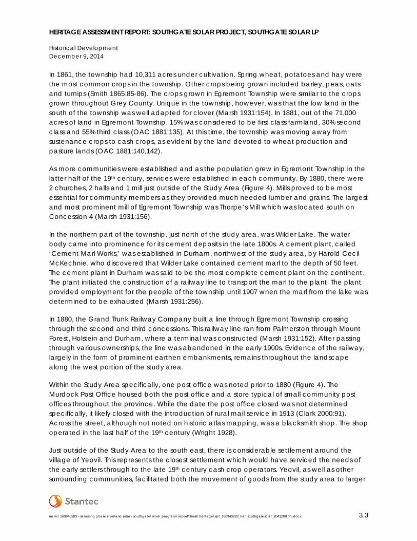
Stantec Consulting Ltd. (Stantec) was retained by Dillon Consulting Limited (Dillon) on behalf of Southgate Solar LP to complete a heritage assessment for the Southgate Solar Project located within an area generally bounded by Southgate Road 24 to the north, Southgate Road 14 to the south, Southgate Sideroad 47 to the east, and Highway 6 to the west in the former Township of Egremont, now Southgate Township, in Grey County, Ontario. The Study Area comprises approximately 2,540 hectares of agricultural and rural lands; the Project Location will be confined to approximately 235 hectares of this land. See the Glossary above for explanation of heritage specific boundaries.
The heritage assessment conducted by Stantec was undertaken in order to meet the requirements for an application for a Renewable Energy Approval (Government of Ontario 2011), as outlined in Ontario Regulation (O. Reg.) 359/09 sections 19 and 23 under Part V.0.1 of the Environmental Protection Act (Government of Ontario 1990a). The Regulations require that where the Project may affect known or potential heritage resources, a heritage assessment be completed to identify the presence of heritage resources within or abutting the Project Location, understand the potential impacts of the Project on these resources, and prepare mitigation strategies to minimize any impacts. For the purposes of this study, a Heritage Assessment Area (HAA) was defined which included the Project Location and the property parcels within which the Project Location is situated.
To meet these objectives, the heritage assessment:
• Summarizes the historical context of the area surrounding the Project Location;
• Identifies properties protected under the Ontario Heritage Act (Government of Ontario 1990b) through consultation with the local heritage planners and regulatory bodies;
• Identifies and describes potential heritage resources situated on properties within the HAA based on a windshield survey;
• Evaluates the cultural heritage value or interest of potential heritage resources at the HAA according to O. Reg. 9/06 (Government of Ontario 2006d) to determine the presence of heritage resources;
• Identifies areas of potential impacts according to the Ministry of Tourism, Culture and Sport’s (MTCS) InfoSheet #5 in Heritage Resources in the Land Use Planning Process, Cultural Heritage and Archaeology Policies of the Ontario Provincial Policy Statement, 2005 (Government of Ontario 2006a); and
• Establishes measures to mitigate negative direct or indirect impacts to heritage resources associated with construction and operation of the Project.
mr w:\160940283 - samsung phase iii ontario solar - southgate\work_program\report\final\heritage\rpt_160940283_har_southgatesolar_2041208_fnl.docx 1.1

HERITAGE ASSESSMENT REPORT: SOUTHGATE SOLAR PROJECT, SOUTHGATE SOLAR LP
Introduction December 9, 2014
1.2 PROJECT OVERVIEW
Southgate Solar LP (the Proponent) proposes to develop a ground-mount solar photovoltaic (PV) energy generation facility (Solar Facility) with a maximum name plate capacity of 50 megawatts alternating current (MWac), located in the Township of Southgate, Ontario (Figure 1). The Project will include installation of approximately 197,000 to 207,000 solar panels in the range of 290 to 305 watts (direct current (DC)). Solar panels create DC electricity, which is then converted to alternating current (AC) electricity through the inverter. The AC voltage created by the inverters will be “stepped-up” through multiple Medium Voltage (MV) Stations. The AC electrical energy output from the MV Stations will be collected via underground/overhead cables and connected to the main substation transformer. The collector system voltage will be stepped-up to the Independent Electricity System Operator’s (IESO) transmission grid voltage at one collector/interconnection substation.
The Project Location spans parts of Lots 21 – 28, Concession 3, Lots A and 1 – 4, Concession 17, and Lots A and 1-3, Concession 18, in the former Township of Egremont, now Township of Southgate, Ontario. Currently, the Project Location comprises 235 hectares of fields used primarily for agriculture, plus municipal roadways. As suggested in Cultural Heritage Resources: An Information Bulletin for Projects Subject to Ontario Regulation 359/09 - Renewable Energy Approvals (the Bulletin) (Government of Ontario 2013), a larger Study Area was defined surrounding the HAA and Project Location.
1.3 COMPONENT AND ACTIVITY SUMMARY
1.3.1 Project Components
Details about the project components, both temporary and permanent, that will be used to construct, operate, maintain and decommission the Southgate Solar Project are provided below. More detailed information regarding project components are provided in the Design and Operations Report (DOR). The following is based on an understanding of project components as provided in the Project Description Report (PDR). Additional information regarding select project components and the site plan layout are depicted in more detail in Appendix A and Appendix B.
Solar Modules and Mounting System
Approximately 197,000 to 207,000 solar panels of between 290 - 305W direct current (DC) each will be installed for the Project. This results in a high-level estimate for the number of modules (panels) to be installed. The panels will be aligned in rows approximately 8 – 12 m apart and will be mounted on 28 – 36 degree fixed tilt ground mounting system. Further details on the racking system and supporting structures are provided in the DOR.
mr w:\160940283 - samsung phase iii ontario solar - southgate\work_program\report\final\heritage\rpt_160940283_har_southgatesolar_2041208_fnl.docx 1.2

HERITAGE ASSESSMENT REPORT: SOUTHGATE SOLAR PROJECT, SOUTHGATE SOLAR LP
Introduction December 9, 2014
Medium Voltage Stations and Equipment
Solar panels create DC electricity, which is then converted to AC electricity through the inverter. The AC voltage created by the inverters will be “stepped-up” through multiple Medium Voltage (MV) Stations. An MV Station houses multiple components, including inverters and an MV transformer. A total of 45 MV Stations will be required for the project. Additional details are provided in the DOR.
Electrical Collector System
The AC electrical energy output from the MV Stations will be collected via underground cables and connected to the main substation transformer. The location of the cables will be completely within the Project Location boundary as shown in Figure 1 and will generally follow the internal access roads and existing municipal Rights of Way.
Substation and Other Equipment
The collector system voltage will be stepped up to the Independent Electricity System Operator (IESO)’s transmission grid voltage at the main substation transformer to be located at the northwest corner of the Project Location immediately adjacent to the Hydro One Network Inc. (HONI) corridor, which contains an existing 230 kV transmission line. Specifically, the Project will be connected to the IESO controlled grid using a tap-line from the Point of Common Coupling (PCC) located west of the substation to the Point of Interconnection (POI) within its corridor. The tap-line will be constructed, owned and operated by HONI.
The main substation transformer will be sized appropriately for a 50 MWac solar energy facility. Equipment supplied must be CSA approved, meet ESA requirement and be acceptable to HONI/IESO with respect to protection, control and SCADA requirements. DSTATCOM (as well as capacitors and reactors) will be required for HV transformer VAR compensation, which will be used to regulate the IESO transmission grid voltage to an established set point. The size of the DSTATCOM, capacitors and reactors will ultimately be confirmed by the IESO.
The main substation transformer will require an auxiliary source in the event that its power supply is interrupted from the grid. The auxiliary power source is assumed to be a secondary power supply from the Local Distribution Company (LDC). The load is to be assumed to be approximately 200kW. Additional details are provided in the DOR.
Access Roads
The Southgate Solar Project will be accessed using seven or more main access roads allowing vehicles and equipment to enter the Project Location at various property locations. In addition, temporary and/or permanent gravel access roads will be constructed to facilitate installation and delivery of equipment as well as maintenance requirements during operations. The roads will be granular and approximately 6 m wide and will be constructed as appropriate for the project site and engineering design. Details on the access roads are provided in the DOR.
mr w:\160940283 - samsung phase iii ontario solar - southgate\work_program\report\final\heritage\rpt_160940283_har_southgatesolar_2041208_fnl.docx 1.3

HERITAGE ASSESSMENT REPORT: SOUTHGATE SOLAR PROJECT, SOUTHGATE SOLAR LP
Introduction December 9, 2014
Fence
For the safety of the public and to prevent vandalism, a chain link fence of standard height will be installed around all project components. The fence is a requirement of the Electrical Safety Authority (ESA) and will be built to their specifications. Typically, the ESA requires a 1.8 m high fence with three strands of barbed wire on top; alternative fencing types may also be considered. Gates will be installed where the fence intersects access roads.
Temporary Storage and Construction Areas
During construction it will be necessary to designate/construct temporary storage areas for equipment and components. These areas form part of the Project Location and will be included in the detailed Site Plan of the Design and Operations Report. Such areas will fall within the outer boundary of the Project Location as shown in Figure 1.
Operations and Maintenance Building
An Operations and Maintenance Building will be constructed as part of the Project. The location for the Operations and Maintenance building will be in the west portion of the Project Location near the substation yard. It is likely that temporary office buildings (e.g., portable trailers) may also be required during construction. Any such buildings would be located within the boundary of the Project Location as shown in Figure 1.
Water Crossings
It is not anticipated that the Project will require installation of new water crossings. Appropriate buffers have been applied to water bodies found within 300 m of the Project Location. Additional details on water bodies within the Project Location are provided in the PDR and will be further refined during the approvals process.
1.3.2 Project Activities
The following subsections outline project activities during the construction, operations and decommissioning phases of the project. The Southgate Solar Project will not require the collection, transmission, treatment, storage, handling, processing or disposal of sewage, biogas, biomass or source separated organics or surface water. The operation of the facility will not discharge contaminants to the air. Some management of stormwater may be required. Further detail on stormwater management will be provided in the DOR. The following is based on an understanding of project activities as provided in the PDR.
Construction
The activities associated with construction of the solar facility will take between ten to twelve months and are anticipated to begin in late 2015. They will occur in relative order in which they
mr w:\160940283 - samsung phase iii ontario solar - southgate\work_program\report\final\heritage\rpt_160940283_har_southgatesolar_2041208_fnl.docx 1.4

HERITAGE ASSESSMENT REPORT: SOUTHGATE SOLAR PROJECT, SOUTHGATE SOLAR LP
Introduction December 9, 2014
are presented below. More information will be forthcoming in the draft Construction Plan Report (CPR).
Anticipated construction activities include:
• Clearing, ground levelling, and grading; • Installation of storm water management equipment/facility; • Installation of the perimeter fence; • Installation of security lighting; • Construction of access roads; • Delineation of temporary storage and construction areas and installation of temporary
facilities; • Construction of foundations; • Installation of supports and photovoltaic (PV) modules (the solar panels); • Wiring, MV Station and substation transformer; and • Remediation and clean-up of work areas.
Construction activities will be conducted by licensed contractors in accordance with required standards and codes and all activities will abide by local laws. All construction-related activities will be conducted within the Project Location outlined in Figure 1. Testing and commissioning of the facility will occur over the last few weeks of construction. During construction, fuel, oils or grease may be stored on site. These materials will be stored in accordance with a Spills Response Plan to be developed prior to the start of construction. Decisions on waste disposal or recycling during, and immediately after, construction will be made by the on-site contractor who will refer to the Environmental Protection Act.
Operation and Maintenance
The following activities are associated with the operation and maintenance of the solar facility. These activities will take place over the operational lifetime of the facility. More information will be forthcoming in the draft DOR.
Anticipated operation and maintenance activities include:
• Monitoring and meter calibrations; • Periodic maintenance and inspection of project components; • Cleaning of panels (seldom); • Major or additional maintenance; • Periodic landscape maintenance; and • Inspections and testing.
Overall, few activities are associated with the operational phase of the project. The proposed solar energy facility will be monitored and managed remotely and minimal on-site activity is required for its daily operation. An operations and maintenance manual will be prepared prior
mr w:\160940283 - samsung phase iii ontario solar - southgate\work_program\report\final\heritage\rpt_160940283_har_southgatesolar_2041208_fnl.docx 1.5

HERITAGE ASSESSMENT REPORT: SOUTHGATE SOLAR PROJECT, SOUTHGATE SOLAR LP
Introduction December 9, 2014
to the start of construction of the project. Security and minor maintenance will be the only regular activities anticipated on-site.
Decommissioning
Most of the materials used in a solar facility are reusable or recyclable, and some equipment may have manufacturer take-back and recycling requirements. Through the decommissioning phase of the Project, the site will be returned to a state similar to its pre-construction condition. Materials such as steel/aluminum from the racking and copper from the electrical infrastructure will be removed and recycled. The PV panels will be removed and either returned through manufacturers’ recycling protocols or refurbished and recycled where possible. Any remaining materials will be removed and disposed of off-site at an appropriate location.
The following activities are associated with the decommissioning of the solar facility. These activities will take place approximately 20 years after commissioning. Decommissioning activities are expected to take between 6-9 months and will occur in the relative order in which they are presented below. More information will be forthcoming in the draft Decommissioning Plan Report (DPR):
• Disconnection and removal of above and below-ground wiring; • Removal of PV modules, steel/aluminum structures and electrical equipment; • Removal of foundations and any maintenance buildings or other structures; • Removal of access roads; • Removal of perimeter fence; • Topsoil replacement as necessary; • Site grading and rehabilitation as necessary; and • Removal of waste from the Project Location.
The final decision on waste disposal or recycling will be contracted to the on-site contractor that will refer to the Environmental Protection Act before submitting a Generator Registration Report for each waste product produced at the facility.
mr w:\160940283 - samsung phase iii ontario solar - southgate\work_program\report\final\heritage\rpt_160940283_har_southgatesolar_2041208_fnl.docx 1.6

Site Location
Ontario
LakeHuron
LakeOntarioCambridge
Kitchener
OwenSound
StratfordWaterloo
Brampton
BurlingtonGuelph
Hamilton
Mississauga
Orillia
TorontoVaughan
Barrie
Sideroad 47 Southgate
Road21
Sideroad41
Southgate
Concession 12
Southgate Road 24
Southgate Road 14
Sideroad 39 Southgate
Southgate Road 14
Southgate Road 22
Southgate Road 22
Sideroa d
41S
o uthgate
Cem
etery
Drive
Grey R
oad 109
Grey Road 9
Highw
ay6
Client/Project
Figure No.
TitleStudy Area, Heritage Assessment Area, and Project Location
1
Dillon Consulting LimitedHeritage Assessment ReportSouthgate Solar Project
October 201416040283
Notes
Legend
1.
2.
3.
Coordinate System: NAD 1983 UTM Zone 17N
Base features produced under license with the Ontario Ministry of Natural Resources © Queen's Printer for Ontario, 2013.
2010 orthoimagery © First Base Solutions, 2010.
0 625 1,250m
1:25,000
Study Area
Heritage Assessment Area (HAA)
Project Location
Parcel Boundary
L:\a
ctiv
e\16
0940
283
- Sa
msu
ng P
hase
III O
nta
rio S
ola
r - S
outh
ga
te\w
ork_
pro
gram
\dra
win
g\M
XD\H
erita
ge_
Ass
essm
ent\
1609
4028
3_Fi
g01
_Stu
dy_
Are
a.m
xdRe
vise
d: 2
014-
10-2
7 By
: sa
llen
±
KEY MAP

HERITAGE ASSESSMENT REPORT: SOUTHGATE SOLAR PROJECT, SOUTHGATE SOLAR LP
Methodology December 9, 2014
2.0 METHODOLOGY
2.1 REGULATORY REQUIREMENTS
The study methodology is broadly based on guidelines provided in InfoSheet #5 Heritage Impact Assessments and Conservation Plans (InfoSheet #5) prepared by the MTCS within the Heritage Resources in the Land Use Planning Process, Cultural Heritage and Archaeology Policies of the Ontario Provincial Policy Statement, 2005 (Government of Ontario 2006a). The contents of InfoSheet #5 are supplemented by requirements for the Heritage Assessment Report contained within O. Reg. 359/09 including Sections 19 and 23.
Section 19 of O. Reg. 359/09 concerns protected properties, stating that:
(1) A person who proposes to engage in a renewable energy project shall determine whether the Project Location is on a property described in Column 1 of the Table to this section. O. Reg. 359/09, section (s.) 19 (1) [see Table 1 of Section 2.3 of this report].
(2) If a person mentioned in subsection (1) determines that the Project Location is on a property described in Column 1 of the Table to this section [see Table 1 of Section 2.3 of this report], the person shall submit, as part of the application for the issue of a renewable energy approval,
(a) a copy of the written authorization,
(i) of the person or body set out opposite the description in Column 2 of the Table [see Table 1 of Section 2.3 of this report], and
(ii) of the type set out opposite the description in Column 3 of the Table [see Table 1 of Section 2.3 of this report]; or
(b) written confirmation from the person or body set out in Column 2 of the Table [see Table 1 of Section 2.3 of this report] that authorization is not required. O. Reg. 521/10, section s. 12 (1); O. Reg. 195/12, s. 13 (1).
Section 23 (1) of O. Reg. 359/09 states that:
Subject to subsections (2) and (5), a person who proposes to engage in a renewable energy project shall ensure that a heritage assessment is conducted, consisting of the following steps:
1. Conduct an investigation, including historical research and visual inspection, to determine whether,
mr w:\160940283 - samsung phase iii ontario solar - southgate\work_program\report\final\heritage\rpt_160940283_har_southgatesolar_2041208_fnl.docx 2.1

HERITAGE ASSESSMENT REPORT: SOUTHGATE SOLAR PROJECT, SOUTHGATE SOLAR LP
Methodology December 9, 2014
i. there is potential for the presence of a heritage resource at the Project Location on any part of the Project Location that is not on a property described in Column 1 of the Table to section 19, and
ii. any properties described in Column 1 of the Table to section 19 abut the parcel of land on which the Project Location is situated.
2. If the determination under subparagraph 1 i is that there is potential for the presence of a heritage resource, confirm the presence or absence of a heritage resource by applying the criteria set out in Ontario Regulation 9/06 (Criteria for Determining Cultural Heritage Value or Interest) made under the Ontario Heritage Act.
3. Evaluate the impact of engaging in the renewable energy project on the heritage attributes of any heritage resources at the Project Location and on any abutting properties described in subparagraph 1 ii and provide recommendations for measures to avoid, eliminate or mitigate the impact if,
i. the determination under subparagraph 1 ii is that there are abutting properties as described in that subparagraph, or
ii. the presence of a heritage resource at the Project Location is confirmed under paragraph 2. O. Reg. 195/12, s. 15 (1).
Section 23 (2.1) of O. Reg. 359/09 further states that:
A person who is subject to subsection (1) shall submit a heritage assessment report to the Ministry of Tourism, Culture and Sport, consisting of,
a) a summary of the qualifications and experience of the persons who conducted the assessment and prepared the report;
b) a summary of the process followed in each applicable step of the heritage assessment and the conclusions reached at the end of each step;
c) a description of any documents used to conduct the assessment; d) a statement of cultural heritage value or interest for each confirmed heritage
resource, including a description of the heritage attributes; e) maps or diagrams depicting the Project Location, the renewable energy
generation facility and any heritage resources and protected properties identified as a result of assessment; and
f) the recommendations of the persons who conducted the assessment for measures to avoid, eliminate or mitigate the impact on heritage resources. O. Reg. 195/12, s. 15 (1).
mr w:\160940283 - samsung phase iii ontario solar - southgate\work_program\report\final\heritage\rpt_160940283_har_southgatesolar_2041208_fnl.docx 2.2

HERITAGE ASSESSMENT REPORT: SOUTHGATE SOLAR PROJECT, SOUTHGATE SOLAR LP
Methodology December 9, 2014
In addition, for the purposes of this study, a HAA was defined. The Project is proposed to be located exclusively within the Project Location as shown in Figure 1. As described in the Bulletin, heritage best practices suggest that the entire municipal property within which the Project Location is situated be assessed.
2.2 BACKGROUND HISTORY
The Heritage Assessment Report is composed of a program of archival research. Local historical resources were consulted, archival documents were reviewed, and a summary of the historical background of the vicinity was prepared. Specifically, a series of 19th and 20th century mapping was consulted to identify the presence of structures, settlements, and other potential heritage resources in advance of the field program. Mapping from 1846, 1852, 1880, 1945, 1976, and 2014 was reviewed and is presented in Section 3.0, where appropriate. In addition, local experts were consulted to identify potential heritage resources (see Section 2.3 for further discussion).
2.3 MUNICIPAL AND AGENCY CONSULTATION
Listings of provincially and locally designated properties, districts and easements for each municipality were collected from the Township of Southgate, the Ontario Heritage Trust (OHT), and the MTCS. Consultation with these interested agencies and the municipality within which the Project is proposed was undertaken to determine the presence of designated, listed, or registered heritage properties at or abutting the Project Location as described in Section 19 of O. Reg. 359/09 made under the Environmental Protection Act (see Table 1).
Table 1: Protected Properties Under Section 19 of O. Reg. 359/09
Description of property Authority involved Type of authorization required to be submitted
A property that is the subject of an agreement, covenant or easement entered into under clause 10 (1) (b) of the Ontario Heritage Act.
OHT. Authorization to undertake any activities related to the renewable energy project that requires the approval of the OHT pursuant to the easement or covenant.
A property in respect of which a notice of intention to designate the property to be of cultural heritage value or interest has been given in accordance with section 29 of the Ontario Heritage Act.
Municipality that gave the notice.
If, as part of the renewable energy project, the alteration of the property or the demolition or removal of a building or structure on the property is proposed, consent to alter the property or demolish or remove the building or structure.
A property designated by a municipal by-law made under section 29 of the Ontario Heritage Act as a property of cultural heritage value or interest.
Municipality that made the by-law.
If, as part of the renewable energy project, the alteration of the property or the demolition or removal of a building or structure on the property is proposed, consent to alter the property or demolish or remove the building or structure.
A property designated by order of the MTCS made under section 34.5 of the Ontario Heritage Act as a property of
MTCS. If, as part of the renewable energy project, the alteration of the property or the demolition or removal of a building or
mr w:\160940283 - samsung phase iii ontario solar - southgate\work_program\report\final\heritage\rpt_160940283_har_southgatesolar_2041208_fnl.docx 2.3

HERITAGE ASSESSMENT REPORT: SOUTHGATE SOLAR PROJECT, SOUTHGATE SOLAR LP
Methodology December 9, 2014
Table 1: Protected Properties Under Section 19 of O. Reg. 359/09
Description of property Authority involved Type of authorization required to be submitted cultural heritage value or interest of provincial significance.
structure on the property is proposed, consent to alter the property or demolish or remove the building or structure.
A property in respect of which a notice of intention to designate the property as property of cultural heritage value or interest of provincial significance has been given in accordance with section 34.6 of the Ontario Heritage Act.
MTCS. If, as part of the renewable energy project, the alteration of the property or the demolition or removal of a building or structure on the property is proposed, consent to alter the property or demolish or remove the building or structure.
A property that is the subject of an easement or a covenant entered into under section 37 of the Ontario Heritage Act.
Municipality that entered into the easement or covenant.
Authorization to undertake any activities related to the renewable energy project that require the approval of the municipality that entered into the easement or covenant.
A property that is part of an area designated by a municipal by-law made under section 41 of the Ontario Heritage Act as a heritage conservation district.
Municipality that made the by-law.
If, as part of the renewable energy project, the alteration of the property or the erection, demolition or removal of a building or structure on the property is proposed, a permit to alter the property or to erect, demolish or remove a building or structure on the property.
A property designated as a historic site under Regulation 880 of the Revised Regulations of Ontario, 1990 (Historic Sites) made under the Ontario Heritage Act.
MTCS. If, as part of the renewable energy project, the excavation or alteration of the property of historical significance is proposed, a permit to excavate or alter the property.
(O. Reg. 359/09, s. 19, Table; O. Reg. 195/12, s. 13 (3)).
In addition, a number of local experts were consulted to determine the presence of potential heritage resources within the Study Area. Southgate Township does not have a Municipal Heritage Committee. As such, Stantec consulted the Ontario Historical Society’s Heritage Directory to determine the presence of local historical society, heritage museum, or other heritage related group who may have information pertaining to potential heritage resources. Consultation focused on the larger Study Area in order for the Project team to determine the position of the potential heritage resource in relation to the Project. More specifically, Stantec did not want to limit the information request to only the Project Location, preferring a more wide reaching approach.
Recognition of “heritage” properties varies greatly and is dependent on the level of cultural heritage value or interest identified or, in some cases, the level of investigation undertaken. For the purpose of this study, only properties as defined in Table 1 were considered to be protected properties. Where previously identified by municipal staff or provincial agencies as containing, or having the potential to contain, cultural heritage value or interest, the property, or structure, was determined to be an identified property and evaluated against O. Reg. 9/06 to determine whether or not it is a heritage resource. Specific requirements pertaining to protected properties
mr w:\160940283 - samsung phase iii ontario solar - southgate\work_program\report\final\heritage\rpt_160940283_har_southgatesolar_2041208_fnl.docx 2.4
HERITAGE ASSESSMENT REPORT: SOUTHGATE SOLAR PROJECT, SOUTHGATE SOLAR LP
Methodology December 9, 2014
are described within the Bulletin (Government of Ontario 2013). Identified properties, although important to consider as potential heritage resources and evaluated as such, do not require authorization as described in Table 1.
2.4 FIELD PROGRAM
A vehicular windshield survey was conducted on July 14, 2014 from publicly accessible roadways. Additional information was collected on October 9, 2014 from within property parcels. During both surveys, while the Study Area was reviewed for potential heritage resources including both potential built heritage resources and components of cultural landscapes, the documentation of potential heritage resources was restricted to the HAA unless noted otherwise. Where identified, these were photographed and their characteristics and locations recorded.
As described in the Bulletin, types of potential built heritage resources that may be identified include residential buildings or structures, farm buildings, mills, industrial, commercial, institutional buildings. Bridges, water systems, dams, canals, locks, ruins, cairns, statues, monuments, fountains, retaining walls, boundary or claim marker. Types of potential cultural heritage landscapes that may be identified include burial sites, cemeteries, historic roadways, rail corridors, waterscapes, historical settlements, streetscapes, agricultural landscapes, parks or designed recreational community spaces, or heritage conservation districts.
In general, buildings, structures, and potential cultural landscapes of more than 40 years of age were evaluated during the survey for their potential to satisfy O.Reg.9/06 criteria. The use of the 40 year threshold is generally accepted by both the federal and provincial authorities as a preliminary screening measure for cultural heritage interest or value. This practice does not imply that all buildings, structures, or landscapes more than 40 years of age are inherently of significant heritage value, nor does it exclude exceptional examples constructed within the past 40 years of being of significant cultural heritage value. In order for a potential built heritage resource or potential cultural heritage landscape to be considered a heritage resource it must satisfy O.Reg.9/06 criteria. Evaluation of Cultural Heritage Value or Interest
The criteria for determining cultural heritage value or interest are defined by O. Reg. 9/06. Each potential heritage resource was considered both as an individual structure and as a cultural landscape. Where cultural heritage value or interest was identified, a structure or landscape was assigned a Cultural Heritage Resource (CHR) number and the property was determined to contain a heritage resource. Evaluations for each property are contained within Appendix C.
2.4.1 Ontario Regulation 9/06
In order to identify cultural heritage value or interest at least one of the following criteria must be met:
1. The property has design value or physical value because it,
mr w:\160940283 - samsung phase iii ontario solar - southgate\work_program\report\final\heritage\rpt_160940283_har_southgatesolar_2041208_fnl.docx 2.5

HERITAGE ASSESSMENT REPORT: SOUTHGATE SOLAR PROJECT, SOUTHGATE SOLAR LP
Methodology December 9, 2014
i. is a rare, unique, representative or early example of a style, type, expression, material or construction method,
ii. displays a high degree of craftsmanship or artistic merit, or
iii. demonstrates a high degree of technical or scientific achievement.
2. The property has historical value or associative value because it,
i. has direct associations with a theme, event, belief, person, activity, organization or institution that is significant to a community,
ii. yields, or has the potential to yield, information that contributes to an understanding of a community or culture, or
iii. demonstrates or reflects the work or ideas of an architect, artist, builder, designer or theorist who is significant to a community.
3. The property has contextual value because it,
i. is important in defining, maintaining or supporting the character of an area,
ii. is physically, functionally, visually or historically linked to its surroundings, or
iii. is a landmark.
(O. Reg. 9/06 s. 1 (2)).
2.5 ASSESSMENT OF PROJECT IMPACTS
Where a heritage resource was identified within the HAA, an assessment of potential impacts as a result of the Project was undertaken. The assessment of potential impacts was undertaken according to InfoSheet #5 in Heritage Resources in the Land Use Planning Process, Cultural Heritage and Archaeology Policies of the Ontario Provincial Policy Statement, 2005 (Government of Ontario 2006a). Seven potential negative impacts have been identified, including:
• Destruction of any, or part of any, significant heritage attributes or features;
• Alteration that is not sympathetic, or is incompatible, with the historic fabric and appearance;
• Shadows created that alter the appearance of a heritage attribute or change the viability of a natural feature or plantings, such as a garden;
• Isolation of a heritage attribute from its surrounding environment, context or a significant relationship;
• Direct or indirect obstruction of significant views or vistas within, from, or of built and natural features;
• A change in land use such as rezoning a battlefield from open space to residential use, allowing new development or site alteration to fill in the formerly open spaces; and
mr w:\160940283 - samsung phase iii ontario solar - southgate\work_program\report\final\heritage\rpt_160940283_har_southgatesolar_2041208_fnl.docx 2.6

HERITAGE ASSESSMENT REPORT: SOUTHGATE SOLAR PROJECT, SOUTHGATE SOLAR LP
Methodology December 9, 2014
• Land disturbances such as a change in grade that alters soils, and drainage patterns that adversely affect an archaeological resource.
(Government of Ontario 2006a)
In addition to direct impacts related to destruction, the potential for indirect impacts resulting from the vibrations of construction and the transportation of Project components and personnel were also evaluated. Although the effect of traffic and construction vibrations on historic period structures is not fully understood, negative effects have been demonstrated on buildings with a setback of less than 40 metres from the curbside (Crispino and D’Apuzzo 2001; Ellis 1987; Rainer 1982; Wiss 1981). The proximity of Project components to heritage resources was considered in this assessment, particularly those within 50 metres, in order to encompass a wide enough buffer zone to account for built resources less than 40 metres from curbside or potential Project activities.
2.6 MITIGATION STRATEGIES
Mitigation strategies were prepared based on guidelines provided by the MTCS. The MTCS suggests methods of minimizing or avoiding negative direct or indirect impacts including, but not limited to:
• Alternative development approaches; • Isolating development and site alteration from significant built and natural features and
vistas; • Design guidelines that harmonize mass, setback, setting, and materials; • Limiting height and density; • Allowing only compatible infill and additions; • Reversible alterations; and • Buffer zones, site plan control, and other planning mechanisms.
(Government of Ontario 2006a)
In the case of solar energy projects, as discussed in more detail in Section 5.3, buffer zones and site plan controls are often the most appropriate method of mitigation when used in combination with alternative development approaches.
mr w:\160940283 - samsung phase iii ontario solar - southgate\work_program\report\final\heritage\rpt_160940283_har_southgatesolar_2041208_fnl.docx 2.7

HERITAGE ASSESSMENT REPORT: SOUTHGATE SOLAR PROJECT, SOUTHGATE SOLAR LP
Historical Development December 9, 2014
3.0 HISTORICAL DEVELOPMENT
3.1 INTRODUCTION
What follows is a land use history of the Study Area with particular focus on developments within the HAA. Although the collection of heritage resources for this HAR was restricted to the HAA, it is important to establish the historical context within which these heritage resources existed at the time and continue to exist today. This contributed to an understanding of the cultural heritage value or interest associated with each resource as well as understanding of the development of the landscape within the HAA.
3.2 PHYSIOGRAPHY
The Project is located within the Horseshoe Moraines physiographic region, an area characterized by meltwater stream deposits that give the region two main land form components: 1) irregular, stony knobs and ridges composed of till with some sand and gravel deposits, 2) pitted sand and gravel terraces and swampy valley floors (Chapman and Putnam 1984:127). Huron clay loam is the dominant soil type in this region that is well suited for various crops such as wheat, beans, corn and areas that can be devoted to pasture (Chapman and Putnam 1984:127). Many townships within this physiographic region are covered by a complex of till ridges, kame moraines, spillways, outwash plains, and interspersed with moulded till plains and drumlinized areas (Chapman and Putnam 1984:127).
3.3 SURVEYS
Three phases of surveys took place in Egremont Township. The first known survey of Egremont was conducted in 1837 by Charles Rankin who was instructed by the Government of Upper Canada to establish a transportation route between Owen Sound, a major port along Lake Huron, and Fergus, a bustling hamlet southeast of Egremont (Cork 2000:94). The Rankin survey established Garafraxa Road, now Highway #6 and provided the earliest settlers with a means to access the Egremont Township. By the mid-19th century, Garafraxa Road had become a busy roadway and the lifeline for pioneers coming to Egremont from England.
Surveying of the land halted during the Rebellion of 1837 and was resumed in 1841 when John MacDonald, a Provincial Land Surveyor, resurveyed Garafraxa Road. This was done to correct minor errors in Rankin’s original survey (Smith 1865:147). It was this survey which established Concession 1 just east of Garafraxa Road, where the very first pioneers settled. Both surveys were completed according to a modification of the single front survey system, popular between 1783 and 1818, with minor modifications to account for the winding route of Garafraxa Road (Dean 1984: Plate 9). In this particular concession, the survey divided the land into lots along the roadway, containing 200 acre parcels surrounded by roads (Figure 2).
mr w:\160940283 - samsung phase iii ontario solar - southgate\work_program\report\final\heritage\rpt_160940283_har_southgatesolar_2041208_fnl.docx 3.1

HERITAGE ASSESSMENT REPORT: SOUTHGATE SOLAR PROJECT, SOUTHGATE SOLAR LP
Historical Development December 9, 2014
The second phase occurred when Robert W. Kerr surveyed Concessions 2 and 3 in 1845. Although the second survey completed, this became known as the “Old Survey” (Figure 2). These two concessions were home to many of the first settlers of the area. In Concessions 2 and 3, the land was divided into seven long and narrow lots surrounded by roads. These concessions may have been divided in this manner to accommodate the many settlers that arrived during this phase of the survey.
The third phase was completed by John D. Daniel in 1851. The Daniel survey covered the remainder of the township towards the east, which ran parallel to Garafraxa Road. Concessions 4 to 22 followed the standard single front system that divided the land into five lots containing 200 acre parcels surrounded by roads (Figure 3).
3.4 SETTLEMENT
Settlers of the area were mainly Loyalists or recent immigrants from England. The township was named for a town in Cumberland County, England, where many of the original settlers originated (Wright 1928:146). By 1850, the township was home to 34 families, most of whom settled on Concessions 2 and 3. This provided the settlers with access to Garafraxa Road and thus the resources needed to clear and settle the land.
In the mid-1850s Grey County experienced a boom in population. Egremont was a favoured spot to settle and by 1861 had a population of 2,934. This placed it as the 6th largest township out of the 16 townships in Grey County. By 1864, the township had a population of nearly 3,500 people, an increase of 19% over three years (Smith 1865:84). The settlers who came to Egremont at this time settled on concessions to the east, further inland of Garafraxa Road.
As an influx of settlers arrived, small communities were established. The community of Holstein was established in 1855, the community of Orchardville was established in 1858, the community of Dromore was settled around 1860 and the communities of Bothwell, Varney and Yeovil were established sometime during this period (Marsh 1931:158-159).
With the presence of Garafraxa Road along the western boundary of the township, Egremont became a desirable place to settle in the mid-19th century. Geographically, Egremont Township became the halfway point between Owen Sound and Fergus, which made it convenient for settlers who wanted to make trips to either of these towns and to the villages in between.
3.5 19TH CENTURY LAND USE
Land use throughout the Study Area and surrounding region was, and continues to be, primarily agriculture. In Grey County, large proportions of land in the north were rolling and cultivable, while other smaller parts of lands in the south were swampy and not suitable for cultivation (OAC 1881:13). Egremont is one of the more elevated townships of Grey County, with its highest point on its north-east corner reaching 1380 feet above sea level while its lowest point was in the southern quarter of the township (Marsh 1931:154).
mr w:\160940283 - samsung phase iii ontario solar - southgate\work_program\report\final\heritage\rpt_160940283_har_southgatesolar_2041208_fnl.docx 3.2
HERITAGE ASSESSMENT REPORT: SOUTHGATE SOLAR PROJECT, SOUTHGATE SOLAR LP
Historical Development December 9, 2014
In 1861, the township had 10,311 acres under cultivation. Spring wheat, potatoes and hay were the most common crops in the township. Other crops being grown included barley, peas, oats and turnips (Smith 1865:85-86). The crops grown in Egremont Township were similar to the crops grown throughout Grey County. Unique in the township, however, was that the low land in the south of the township was well adapted for clover (Marsh 1931:154). In 1881, out of the 71,000 acres of land in Egremont Township, 15% was considered to be first class farmland, 30% second class and 55% third class (OAC 1881:135). At this time, the township was moving away from sustenance crops to cash crops, as evident by the land devoted to wheat production and pasture lands (OAC 1881:140,142).
As more communities were established and as the population grew in Egremont Township in the latter half of the 19th century, services were established in each community. By 1880, there were 2 churches, 2 halls and 1 mill just outside of the Study Area (Figure 4). Mills proved to be most essential for community members as they provided much needed lumber and grains. The largest and most prominent mill of Egremont Township was Thorpe’s Mill which was located south on Concession 4 (Marsh 1931:156).
In the northern part of the township, just north of the study area, was Wilder Lake. The water body came into prominence for its cement deposits in the late 1800s. A cement plant, called ‘Cement Marl Works,’ was established in Durham, northwest of the study area, by Harold Cecil McKechnie, who discovered that Wilder Lake contained cement marl to the depth of 50 feet. The cement plant in Durham was said to be the most complete cement plant on the continent. The plant initiated the construction of a railway line to transport the marl to the plant. The plant provided employment for the people of the township until 1907 when the marl from the lake was determined to be exhausted (Marsh 1931:256).
In 1880, the Grand Trunk Railway Company built a line through Egremont Township crossing through the second and third concessions. This railway line ran from Palmerston through Mount Forest, Holstein and Durham, where a terminal was constructed (Marsh 1931:152). After passing through various ownerships, the line was abandoned in the early 1900s. Evidence of the railway, largely in the form of prominent earthen embankments, remains throughout the landscape along the west portion of the study area.
Within the Study Area specifically, one post office was noted prior to 1880 (Figure 4). The Murdock Post Office housed both the post office and a store typical of small community post offices throughout the province. While the date the post office closed was not determined specifically, it likely closed with the introduction of rural mail service in 1913 (Clark 2000:91). Across the street, although not noted on historic atlas mapping, was a blacksmith shop. The shop operated in the last half of the 19th century (Wright 1928).
Just outside of the Study Area to the south east, there is considerable settlement around the village of Yeovil. This represents the closest settlement which would have serviced the needs of the early settlers through to the late 19th century cash crop operators. Yeovil, as well as other surrounding communities, facilitated both the movement of goods from the study area to larger
mr w:\160940283 - samsung phase iii ontario solar - southgate\work_program\report\final\heritage\rpt_160940283_har_southgatesolar_2041208_fnl.docx 3.3

HERITAGE ASSESSMENT REPORT: SOUTHGATE SOLAR PROJECT, SOUTHGATE SOLAR LP
Historical Development December 9, 2014
markets as well as the movement of people to and from the township. In addition, Yeovil, was the host of the first Agricultural Fair, a crucial 19th century development which facilitated the disbursement of knowledge and the spread of new and innovative agricultural developments to the further reaching corners of the county (Cork 2000:112).
3.6 20TH CENTURY LAND USE
During the 20th century, the Study Area remained largely unchanged. Egremont Township specifically, and Grey County more generally, remain primarily rural in nature with a strong focus on agricultural output. The transition to cash crop agriculture that began at the end of the 19th century continued into the 20th century with an increased focus on moving goods to larger markets.
Agriculturally, the County’s crops, herds and orchards contributed to the wealth of the County, with a value estimated at 20 million dollars. Additionally, the County had 91 factories by 1931 that employed more than 3,000 people with payrolls amounting to just under 3 million dollars (Marsh 1931:386). The most notable export of the county from factories was period furniture made from local trees (Marsh 1931:386). With a strong economic foundation at the turn of the century, the County was able to prosper well into the 20th century.
Technological improvements and capabilities improved services within and around Egremont Township at the beginning of the 20th century. In 1908, The Mount Forest-Wellington-Grey Telephone Company established rural phone service to the south part of Egremont. By 1913, telephone lines were up on Concessions 6, 8, 10 and 12. By 1922, most of the township had phone service (Cork 2000:88). When mail began to be transferred by rail to post offices, rather than by horse and buggy, the need for many post offices along mail routes declined. This resulted in the closing of many post offices in Egremont Township and the surrounding area (Cork 2000:90). Hydro services were established first in Holstein in 1913, and by 1939, most farmers had electricity (Cork 2000:92).
A physical development of the land that can be seen at the onset of the 20th century was the building of permanent roads. Between 1920 and 1930, four Provincial roads (Garafraxa Road, Toronto Line, Lake Shore Road and Highway 21 that connected Owen Sound and Southampton) were constructed. This made travel substantially safer and more efficient within Grey County. By 1927, nearly 15,000 vehicles used these roads for travel (Marsh 1931:385). Provincial Highway 6, which now encompasses Garafraxa Road, is the longest Provincial Highway in Ontario and has become a main throughway that connects Port Dover from south to Manitoulin in the north (Bevers 2014: online).
Within the Project Area specifically, it is evident that more people settled inside Egremont Township, particularly on present day Grey Road 9 and Grey Road 109. However, most of the settlement of the 20th century occurred in the villages of Holstein, Varney and Yeovil, all outside of the Study Area (Figure 5).
mr w:\160940283 - samsung phase iii ontario solar - southgate\work_program\report\final\heritage\rpt_160940283_har_southgatesolar_2041208_fnl.docx 3.4

Site Location
Ontario
LakeHuron
LakeOntarioCambridge
Kitchener
OwenSound
StratfordWaterloo
Brampton
BurlingtonGuelph
Hamilton
Mississauga
Orillia
TorontoVaughan
Barrie
Client/Project
Figure No.
Title
Portion of 1880 Historic AtlasMap of Egremont Township
4
Dillon Consulting LimitedHeritage Assessment ReportSouthgate Solar Project
October 201416040283
Notes
Legend
1.
2.
Coordinate System: NAD 1983 UTM Zone 17N
Egremont Township map from Grey supplement in Illustrated atlas of the Dominion of CanadaToronto : H. Belden and Co., 1880.
Study Area
L:\a
ctiv
e\16
0940
283
- Sa
msu
ng P
hase
III O
nta
rio S
olar
- So
uthg
ate
\wor
k_p
rogr
am
\dra
win
g\M
XD\H
erita
ge_A
sses
smen
t\16
0940
283_
Fig0
4_18
80_H
istor
ic_M
ap.m
xdRe
vise
d: 2
014-
10-1
0 By
: sa
llen
±
KEY MAP
NOT TO SCALE

Site Location
Ontario
LakeHuron
LakeOntarioCambridge
Kitchener
OwenSound
StratfordWaterloo
Brampton
BurlingtonGuelph
Hamilton
Mississauga
Orillia
TorontoVaughan
Barrie
Client/Project
Figure No.
Title
Portion of 1852 SurveyMap of Egremont Township
3
Dillon Consulting LimitedHeritage Assessment ReportSouthgate Solar Project
October 201416040283
Notes
Legend
1.
2.
Coordinate System: NAD 1983 UTM Zone 17N
Daniel, John D. 1855. Egremont. Plan 859.Unpublished map, on file with the Ministry of Natural ResourcesCrown Land Survey Records Office, Peterborough, Ontario
Study Area
\\cd
1217
-f01\
Wor
k_g
roup
\016
09\a
ctiv
e\1
6094
0283
- Sa
msu
ng P
hase
III O
nta
rio S
ola
r - S
outh
ga
te\w
ork
_pro
gra
m\d
raw
ing
\MXD
\Her
itag
e_A
sses
smen
t\16
0940
283_
Fig0
3_18
52_H
istor
ic_M
ap
.mxd
Revi
sed:
201
4-10
-17
By: s
alle
n
±
KEY MAP
NOT TO SCALE

Site Location
Ontario
LakeHuron
LakeOntarioCambridge
Kitchener
OwenSound
StratfordWaterloo
Brampton
BurlingtonGuelph
Hamilton
Mississauga
Orillia
TorontoVaughan
Barrie
NOT TO SCALE
Client/Project
Fig u re No.
TitlePortion of 1846 SurveyMap of Egremont Township
2
Dillon Consu lting Lim itedHeritag e Assessm ent Rep ortSou th g ate Solar Project
October 201416040283
Notes
Legend
1.
2.
Coordinate System : NAD 1983 UT M Zone 17N
A p lan of th e 2nd and 3rd concession of th e townsh ip s of Eg rem ont and Norm anby – su rveyed by th e order of T h e Hon. Com m issioner of Crown Lands by Robert W. Kerr DPS, 1846
Stu dy Area
\\cd
1217
-f01\
Wor
k_gr
oup\
0160
9\ac
tive\
1609
4028
3 - Sa
msun
g Pha
se III
Onta
rio So
lar - S
outhg
ate\
work_
prog
ram\
draw
ing\M
XD\H
erita
ge_A
ssessm
ent\1
6094
0283
_Fig0
2_18
46_H
istoric
_Map
.mxd
Revis
ed: 2
014-1
0-17 B
y: sa
llen
±
KEY MAP

Site Location
Ontario
LakeHuron
LakeOntarioCambridge
Kitchener
OwenSound
StratfordWaterloo
Brampton
BurlingtonGuelph
Hamilton
Mississauga
Orillia
TorontoVaughan
Barrie
Client/Project
Figure No.
Title
Topographic Maps, 1945 to Present
5
Dillon Consulting LimitedHeritage Assessment ReportSouthgate Solar Project
October 201416040283
Notes
Legend
1.
2.
3.
Coordinate System: NAD 1983 UTM Zone 17N
Base features produced under license with the Ontario Ministry of Natural Resources © Queen's Printer for Ontario, 2014.
Orthoimagery © First Base Solutions, 20xx.
L:\a
ctiv
e\16
0940
283
- Sa
msu
ng P
hase
III O
nta
rio S
olar
- So
uthg
ate
\wor
k_p
rogr
am
\dra
win
g\M
XD\H
erita
ge_A
sses
smen
t\16
0940
283_
Fig0
5_To
po_
Ma
ps.m
xdRe
vise
d: 2
014-
10-1
0 By
: sa
llen
±
KEY MAP
!
!!!!
!
!!!
!
!
!!!!
!
!
!
!
!!!
!!!
!!
!! !
!
!
!
!!
!!!!
!!!
!!
!
!
!!!!
!!
!!
!
!
!!!
!
!
!
! !
!!
!!
!!
!!
!!
!
!
!
!
!!
!
!
!
!
!!!
!
!!!
!
! !!!
!!
! !
!!
!!!
!
!!!
!!!
!!!
!
!!!
!!!
!!!
!!!!
!
!
!
!!
!
!
!!
!!!!! !! !!
!!
!!
!
!
!!!
!!
!!!
!
!
!!
!
!!!! !
!
!!!
!!!
!!
!
!!
!
!!
!
!!
!!
!!
!
!
!
!!
!!
!!
!
!!!
!
!!!!!
!!
!
!!!!
!!!
!
!!! !!
!
!!!
!!
!!!
!!!
!!
!!!
!!!
!
!!
!!
!!!
!!
!!!!!
!!! ! !
!!!!!! !
!!
!
!!
!!
!!!!!
!!
!!
!!!
!
!
!
!
!!!!
!
!! !!!
!!!
!
!
!!
!
!!!!
!!!!
!
!
!!
!
!!!
!!!
!!!!
!!!
!!!
!!!
!!!
!
!!!
!
!!!
!
!
!!!
! !!
!
!
!
!
!
!
!!!
!!!!
!
!!!!
!!
!!!
!
!
!
!
!
!
!
!
!
!
!
!
!
!
!
!
!
!
!
!
!
!
!
!
!
!
!
!
!
!
!
!
!
!
!
!
!
!
!
!
!
!
!
!
!
!
!
!
!
!
!
!
!
!
!
!
!
!
!
!
!
!
!
!
!
!
!
!
!
!
!
!
!
!
!
!
!
!
!
!
!
!
!
!
!
!
!
!
!
!
!
!
!
!
!
!
!
!
!
!
!
!
!
!
!
!
!
!
!
!
!
!
!
!
!
!
!
!
!
!
!
!
!
!
!
!
!
!
!
!
!
!
!
!
!
!
!
!
!
!
!
!
!
!
!
!
!
!
!
!
!
!
!
!
!
!
!
!
!
!
!
!
!
!
!
! !! ! !
!
!
!
!
!
!
!
!
!
!
!
!
!
!
!
!
!
!
!
!
!
!
!
!
!
!
!
!
!
!
!
!
!
!
!
!
!
!
!
!
!
!
!
!
!
!
!
!
!
!
!
!
!
!
!
!
!
!
!
!
!
!
!
!
!
!
!
!
!
!
!
!
!
!
!
!
!
!
!
!
!
!
!
!
!
!
!
!
!
!
!
!
!
!
!
!
!
!
!
Cem
etery Drive
Sideroad 41
Southgate
SouthgateRoad 14
Southgate Road 14
Southgate Road 22
Southgate Road 22
Sideroad 39 Southgate
Sideroad 41 Southgate
Southgate Road 14
Sideroad47
Sou thgate
Southgate Road 24
Grey R
oad 109
Grey Road 9
Highw
ay 6
0 1,250 2,500m
1:50,000
±±
±
5A1945 Topographic Map
5B1976 Topographic Map
5C2014 Topographic Map
Study Area
! Building
Contour (m)
Railway
Highway
Major Road
Local Road
! ! Transmission Line
Watercourse
Unevaluated Wetland
Provincially Significant Wetland
Waterbody
Wooded Area

HERITAGE ASSESSMENT REPORT: SOUTHGATE SOLAR PROJECT, SOUTHGATE SOLAR LP
Results December 9, 2014
4.0 RESULTS
4.1 AGENCY AND MUNICIPAL CONSULTATION
In order to identify protected properties the MTCS, OHT, and Township of Southgate were consulted by Meaghan Rivard, Heritage Consultant with Stantec (Appendix D and E). Deborah Hossack, Registrar, Register Developer, Heritage Advisor with the MTCS reported that there are no properties on the List of Provincial Heritage Properties within the vicinity of the HAA. Michael Sawchuck, Manager, Acquisitions and Conservation Services with the OHT, reported that there are no heritage easement sites in the vicinity of the HAA that will be directly impacted or visually affected by the Project.
Clint Stredwick, Municipal Planner for the Township of Southgate, reported that there are no protected properties within the vicinity of the HAA (personal communication). Mr. Stredwick suggested Stantec contact David Milliner, the Chief Administrative Officer for the Township of Southgate, to determine the presence of a Municipal Heritage Register (MHR) or any previously unidentified protected properties in the vicinity of the Study Area. Mr. Milliner confirmed that the township does not maintain a MHR and all protected properties in the township are confined to urban areas outside of the Study Area (personal communication).
As part of the consultation program, Stantec contacted numerous local heritage organizations to determine the presence of potential resources within the Study Area as recommended in the Bulletin. Included in this consultation were the following organizations:
• Grey Highlands Public Library; • Grey County Historical Society; • Grey County Heritage Alliance; • Grey Roots Museum & Archives; • South Grey Museum & Historical Library; • Ontario Genealogical Society – Bruce & Grey Region Branch (Region III); and • Southgate Library.
A response was received from Kate Russell, the Manager/Curator at the South Grey Museum. Ms. Russell reported that the South Grey Museum does not cover the area contained within the Study Area. However, Ms. Russell provided information regarding additional contacts that may have additional information. Ms. Russell also provided a list of Egremont Township cemeteries present within the Study Area as well as the 1880 Historical Atlas map of Grey and Bruce Counties (see Figure 4). No other responses were received.
It was determined, based on agency and municipal consultation, that none of the property types listed in section 19 of O.Reg. 359/09 are present at the Project Location or abutting parcels of land on which the Project Location is situated.
mr w:\160940283 - samsung phase iii ontario solar - southgate\work_program\report\final\heritage\rpt_160940283_har_southgatesolar_2041208_fnl.docx 4.1

HERITAGE ASSESSMENT REPORT: SOUTHGATE SOLAR PROJECT, SOUTHGATE SOLAR LP
Results December 9, 2014
4.2 FIELD PROGRAM
As described in Section 2.4, two windshield surveys of the Study Area were undertaken to identify potential heritage resources situated within the HAA. Where identified, the site was photographically documented from publicly accessible roadways. A total of eight sites and one landscape were identified as summarized in Table 2 and shown on Figure 6.
Table 2: Summary of Potential Heritage Resources Identified During Site Visits
Potential Heritage Resource Potential Heritage Resource Type
392415 Sideroad 39 Southgate Farmstead
392433 Sideroad 39 Southgate Farmstead
392469 SIderoad 39 Southgate Farmstead
392531 Sideroad 39 Southgate Farmstead
223544 Sideroad 22 Southgate Residence and Barn
223585 Sideroad 22 Southgate Mixed
223624 Sideroad 22 Southgate Farmstead
223511 Sideroad 22 Southgate Farmstead
Vernacular Rural Landscape Landscape
The study area, as described in Section 3.1, consists of a rolling landscape under mixed use agriculture including cash crop agriculture, pasture lands, and various woodlots. In many cases, where a property contains structures that are set back from the road, there is extensive foliage between the road and the structures. As a result, not all portions of each property could be assessed from publically accessible roads. The use of 2014 aerial photography to confirm field conditions and supplement property descriptions was extensive. Where this was the case, it is noted in Appendix C.
The overall HAA was considered a candidate for a potential heritage resource as a rural landscape at the outset of the study. At the time of the site assessment the rural landscape contained within the HAA was determined to be characteristic of the surrounding landscape and was thus included as a potential heritage resource.
4.3 EVALUATION OF CULTURAL HERITAGE VALUE OR INTEREST
Where a potential heritage resource was identified within the HAA, an evaluation of the cultural heritage value or interest of the resource was undertaken. This was undertaken at the property level so that both potential built heritage resources and potential cultural heritage landscapes could be evaluated. Detailed evaluations are contained within Appendix C.
As described in Section 2.5, each potential heritage resource was evaluated according to O. Reg. 9/06, the criteria for determining cultural heritage value or interest. There were nine
mr w:\160940283 - samsung phase iii ontario solar - southgate\work_program\report\final\heritage\rpt_160940283_har_southgatesolar_2041208_fnl.docx 4.2

HERITAGE ASSESSMENT REPORT: SOUTHGATE SOLAR PROJECT, SOUTHGATE SOLAR LP
Results December 9, 2014
potential heritage resources identified, eight of which were determined to represent heritage resources (Figure 7). Table 3 summarizes the findings.
Table 3: Summary of Determination of Cultural Heritage Value or Interest
Municipal Address CHVI CHR Number
392415 Sideroad 39 Yes CHR 1
392433 Sideroad 39 Yes CHR 2
392469 SIderoad 39 Yes CHR 3
392531 Sideroad 39 Yes CHR 4
223544 Sideroad 22 No N/A
223585 Sideroad 22 Yes CHR 5
223624 Sideroad 22 Yes CHR 6
223511 Sideroad 22 Yes CHR 7
Various (Vernacular Rural Landscape) Yes CHR 8
The majority of heritage resources identified were constructed in the 19th century. Although barn construction often ranges from the mid-19th century to the early 20th century, based on the historical development of the area, it is likely that most agricultural structures were constructed during or after the late 19th century. This suggests that although the area remains in use for agricultural purposes, there is little evidence in the study area of any boom or bust cycles where substantial 20th century structures were added to the landscape. While modern outbuildings were identified at roughly half of the properties inventoried, in most cases these were constructed recently and in use for livestock storage. These structures are often built to replace timber frame construction and are evident throughout the province.
Where barns were identified contemporary residences were also often identified. In approximately 80% of properties, residential construction was consistent with agricultural buildings. In only one case was the residence substantially more modern than agricultural buildings on the property. The result is a large number of one or one and one half storey structures with medium roof pitches constructed in the mid to late 19th century and early 20th century. In fact, only two, two storey structures were identified in the HAA.
The landscape of the HAA is primarily rural and characterized by agricultural land use (including cash crop agriculture), pasture lands, various woodlots, single lane rural roads (both paved and gravel), and a hydroelectric corridor containing three lines. Along Southgate Road 22 the agricultural land is divided into smaller squares separated by hedge rows. This practice is characteristic of farming practices throughout the township specifically, and the county more broadly. Properties along Sideroad 39 Southgate, in contrast, have larger cleared land with less separation, although some smaller squares are still apparent along the east side of the properties adjacent to woodlots. This division of land is characteristic of surrounding counties and
mr w:\160940283 - samsung phase iii ontario solar - southgate\work_program\report\final\heritage\rpt_160940283_har_southgatesolar_2041208_fnl.docx 4.3

HERITAGE ASSESSMENT REPORT: SOUTHGATE SOLAR PROJECT, SOUTHGATE SOLAR LP
Results December 9, 2014
townships and not unique to the former Egremont Township. Both divisions of land result from ongoing use for agricultural purposes.
Following evaluation, the vernacular rural landscape as a whole was determined to contain some CHVI given its association with agricultural activities representative of historic land use characteristic of the HAA, the study area, and even the former Township of Southgate and Grey County. The vernacular rural landscape was determined to represent an agricultural theme which is significant to the community and linked to its surroundings physically, functionally, visually, and historically. The Bulletin makes explicit reference to agricultural landscapes and that which is contained by the HAA was determined to be an example of such a landscape. As the farmsteads discussed above were determined to be related to the surrounding landscape, so too was the landscape determined to be related to the farmsteads.
While some CHVI was identified, the amount of CHVI was determined to be minimal and associated exclusively with land use relating to agricultural activities. At its core, the vernacular rural landscape is an evolved landscape that is changing over time and continues to integrate different, and in some cases new, elements. Examples include ongoing crop rotation and the transition of land use from cash crops to pasture. However, during this time the landscape remains associated with agricultural activities and thus was determined to have some CHVI.
mr w:\160940283 - samsung phase iii ontario solar - southgate\work_program\report\final\heritage\rpt_160940283_har_southgatesolar_2041208_fnl.docx 4.4

Site Location
Ontario
LakeHuron
LakeOntarioCambridge
Kitchener
OwenSound
StratfordWaterloo
Brampton
BurlingtonGuelph
Hamilton
Mississauga
Orillia
TorontoVaughan
Barrie
Sideroad
39S
outhgate
Southgate Road 22
Southgate Road 22
Sideroad 47 Southgate
Sider oad
41S
ou thga te
Grey R
oad 109
Grey Road 9Client/Project
Figure No.
TitlePotential HeritageResources within the Heritage Assessment Area
6
Dillon Consulting LimitedHeritage Assessment ReportSouthgate Solar Project
November 201416040283
Notes
Legend
1.
2.
3.
Coordinate System: NAD 1983 UTM Zone 17N
Base features produced under license with the Ontario Ministry of Natural Resources © Queen's Printer for Ontario, 2013.
2010 orthoimagery © First Base Solutions, 2010.
0 375 750m
1:15,000
Study Area
Heritage Assessment Area (HAA)
Project Location
Parcel Boundary
Potential Heritage ResourcesPotential Built Heritage Resource
Potential Cultural Heritage Landscape
L:\1
6094
0283
- Sa
msu
ng P
hase
III O
nta
rio S
ola
r - S
outh
ga
te\w
ork_
pro
gram
\dra
win
g\M
XD\H
erita
ge_
Ass
essm
ent\
1609
4028
3_Fi
g06
_Pot
entia
l_H
erit
ag
e_Re
sour
ces.
mxd
Revi
sed:
201
4-11
-28
By: s
alle
n
±
KEY MAP

Site Location
Ontario
LakeHuron
LakeOntarioCambridge
Kitchener
OwenSound
StratfordWaterloo
Brampton
BurlingtonGuelph
Hamilton
Mississauga
Orillia
TorontoVaughan
Barrie
Sideroad
39S
outhgate
Southgate Road 22
Southgate Road 22
Sideroad 47 Southgate
Sider oad
41S
ou thga te
Grey R
oad 109
Grey Road 9Client/Project
Figure No.
TitleHeritage Resources within theHeritage Assessment Area
7
Dillon Consulting LimitedHeritage Assessment ReportSouthgate Solar Project
December 201416040283
Notes
Legend
1.
2.
3.
Coordinate System: NAD 1983 UTM Zone 17N
Base features produced under license with the Ontario Ministry of Natural Resources © Queen's Printer for Ontario, 2013.
2010 orthoimagery © First Base Solutions, 2010.
0 375 750m
1:15,000
Heritage Resource
Study Area
Heritage Assessment Area (HAA)
Heritage Resource
Project Location
Parcel Boundary
L:\1
6094
0283
- Sa
msu
ng P
hase
III O
nta
rio S
ola
r - S
outh
ga
te\w
ork_
pro
gram
\dra
win
g\M
XD\H
erita
ge_
Ass
essm
ent\
1609
4028
3_Fi
g07
_He
rita
ge_
Reso
urce
s.m
xdRe
vise
d: 2
014-
12-0
9 By
: sa
llen
±
KEY MAP
HERITAGE ASSESSMENT REPORT: SOUTHGATE SOLAR PROJECT, SOUTHGATE SOLAR LP
Evaluation of Anticipated and Potential Impacts and Mitigation Options December 9, 2014
5.0 EVALUATION OF ANTICIPATED AND POTENTIAL IMPACTS AND MITIGATION OPTIONS
5.1 DESCRIPTION OF THE UNDERTAKING
Details about the project components, both temporary and permanent, that will be used to construct, operate, maintain and decommission the solar energy facility are provided in Section 1.3 and depicted in Appendices A and B. Summarized, the undertaking involves installation of the following:
• Approximately 197,000 to 207,000 solar panels solar panels mounted on racking structures; • 45 Medium Voltage (MV) Stations; • Underground cables connected to the main substation transformer; • One collector/interconnection substation including a DSTATCOM and possibly switched
static capacitors; • Seven or more main access roads allowing vehicles and equipment to enter the Project
Location at various property locations; • A perimeter fence surrounding all project components; • Temporary storage and construction areas; and • One Operation and Maintenance Building as well as a temporary office building.
The understanding of project activities is based on those provided in the PDR which are contained within the Project Location as provided in Figure 1. If, at any point during the development of the Project, these activities are modified to reach beyond the Project Location footprint as it exists at the writing of this Report, a review of the modifications will be undertaken. Where additional impacts may result from the modifications, an assessment of the impacts on the heritage resources will be undertaken.
5.2 ANTICIPATED AND POTENTIAL IMPACTS
Where a heritage resource was determined to be situated within the HAA, the impacts of the proposed undertaking on identified heritage attributes were evaluated. The impacts were evaluated according to InfoSheet #5 in Heritage Resources in the Land Use Planning Process, Cultural Heritage and Archaeology Policies of the Ontario Provincial Policy Statement, 2005 (included in the MTCS Ontario Heritage Toolkit). See Section 2.5 for further discussion of impacts assessed and Table 4 for the findings. Further discussion of resource specific anticipated and potential impacts identified follows in Sections 5.2.1 and 5.2.2.
mr w:\160940283 - samsung phase iii ontario solar - southgate\work_program\report\final\heritage\rpt_160940283_har_southgatesolar_2041208_fnl.docx 5.1

HERITAGE ASSESSMENT REPORT: SOUTHGATE SOLAR PROJECT, SOUTHGATE SOLAR LP
Evaluation of Anticipated and Potential Impacts and Mitigation Options December 9, 2014
Table 4: Evaluation of Anticipated and Potential Impacts
Address
Direct Impact Indirect Impact
Discussion
Dest
ruct
ion
Alte
ratio
n
Shad
ows
Isol
atio
n
Obs
truct
ion
Cha
nge
in
Land
Use
La
nd
Dist
urba
nces
392415 Sideroad 39
NA
NA
NA
NA
NA
A P The use of agricultural fields surrounding the residence, road, barn and outbuildings will be modified as a result of the Project. These fields were identified as a heritage attribute of the heritage resource. Currently, and historically, used for agricultural purposes, the introduction of solar panels represents an anticipated change in land use as the land will no longer be used exclusively for agricultural activities. The position of the heritage resource outside of the area of direct impact minimizes the potential of destruction as a result of Project construction. However, its position within 50 metres of project activities suggests the potential for indirect impacts resulting from land disturbance during construction and decommissioning activities.
392433 Sideroad 39
NA
NA
NA
NA
NA
A P The use of agricultural fields surrounding the residence, road, barn and outbuildings will be modified as a result of the Project. These fields were identified as a heritage attribute of the heritage resource. Currently, and historically, used for agricultural purposes, the introduction of solar panels represents an anticipated change in land use as the land will no longer be used exclusively for agricultural activities. The position of the heritage resource outside of the area of direct impact minimizes the potential of destruction as a result of Project construction. However, its position within 50 metres of project activities suggests the potential for indirect impacts resulting from land disturbance during construction and decommissioning activities.
392469 SIderoad 39
NA
NA
NA
NA
NA
A P The use of agricultural fields surrounding the residence, road, barn and outbuildings will be modified as a result of the Project. These fields were identified as a heritage attribute of the heritage resource. Currently, and historically, used for agricultural purposes, the introduction of solar panels represents an anticipated change in land use as the land will no longer be used exclusively for agricultural activities. The position of the heritage resource outside of the area of direct impact minimizes the potential of destruction as a result of Project construction. However, its position within 50 metres of project activities suggests the potential for indirect impacts resulting from land
mr w:\160940283 - samsung phase iii ontario solar - southgate\work_program\report\final\heritage\rpt_160940283_har_southgatesolar_2041208_fnl.docx 5.2

HERITAGE ASSESSMENT REPORT: SOUTHGATE SOLAR PROJECT, SOUTHGATE SOLAR LP
Evaluation of Anticipated and Potential Impacts and Mitigation Options December 9, 2014
Table 4: Evaluation of Anticipated and Potential Impacts
Address
Direct Impact Indirect Impact
Discussion
Dest
ruct
ion
Alte
ratio
n
Shad
ows
Isol
atio
n
Obs
truct
ion
Cha
nge
in
Land
Use
La
nd
Dist
urba
nces
disturbance during construction and decommissioning activities.
392531 Sideroad 39
NA
NA
NA
NA
NA
A NA
The use of agricultural fields surrounding the residence, road, barn and outbuildings will be modified as a result of the Project. These fields were identified as a heritage attribute of the heritage resource. Currently, and historically, used for agricultural purposes, the introduction of solar panels represents an anticipated change in land use as the land will no longer be used exclusively for agricultural activities.
223585 Sideroad 22
NA
NA
NA
NA
NA
A P The use of agricultural fields surrounding the road and barn will be modified as a result of the Project. These fields were identified as a heritage attribute of the heritage resource. Currently, and historically, used for agricultural purposes, the introduction of solar panels represents an anticipated change in land use as the land will no longer be used exclusively for agricultural activities. The position of the heritage resource outside of the area of direct impact minimizes the potential of destruction as a result of Project construction. However, its position within 50 metres of project activities suggests the potential for indirect impacts resulting from land disturbance during construction and decommissioning activities.
223624 Sideroad 22
NA
NA
NA
NA
NA
A NA
The use of agricultural fields surrounding the residence, road, barn and outbuildings will be modified as a result of the Project. These fields were identified as a heritage attribute of the heritage resource. Currently, and historically, used for agricultural purposes, the introduction of solar panels represents an anticipated change in land use as the land will no longer be used exclusively for agricultural activities.
223511 Sideroad 22
NA
NA
NA
NA
NA
A P The use of agricultural fields surrounding the residence, road, barn and outbuildings will be modified as a result of the Project. These fields were identified as a heritage attribute of the heritage resource. Currently, and historically, used for agricultural purposes, the introduction of solar panels represents an anticipated change in land use as the land will no longer be used exclusively for agricultural activities. The position of the heritage resource outside of the area
mr w:\160940283 - samsung phase iii ontario solar - southgate\work_program\report\final\heritage\rpt_160940283_har_southgatesolar_2041208_fnl.docx 5.3

HERITAGE ASSESSMENT REPORT: SOUTHGATE SOLAR PROJECT, SOUTHGATE SOLAR LP
Evaluation of Anticipated and Potential Impacts and Mitigation Options December 9, 2014
Table 4: Evaluation of Anticipated and Potential Impacts
Address
Direct Impact Indirect Impact
Discussion
Dest
ruct
ion
Alte
ratio
n
Shad
ows
Isol
atio
n
Obs
truct
ion
Cha
nge
in
Land
Use
La
nd
Dist
urba
nces
of direct impact minimizes the potential of destruction as a result of Project construction. However, its position within 50 metres of project activities suggests the potential for indirect impacts resulting from land disturbance during construction and decommissioning activities.
Vernacular Rural Landscape
A A NA
NA
NA
A P The use of some agricultural fields within the landscape will be modified as a result of the Project. These fields were identified as a heritage attribute of the vernacular rural landscape. Currently, and historically, used for agricultural purposes, the introduction of solar panels will result in the following: • Destruction of part of a heritage attribute; • Alteration that is incompatible with the historic fabric
and appearance; and • A change in land use as the land will no longer be
used exclusively for agricultural activities. In addition, land disturbances have been identified which will change the grade of the land and may alter the soil and drainage patterns.
NA = Not Anticipated A= Anticipated Impact P= Potential Impact
5.2.1 Anticipated Impacts (Destruction, Alteration, and Change in Land Use)
Project activity is planned for portions of each property currently in use either under cultivation or as pasture land. This agricultural use of the land was identified as a heritage attribute for each heritage resource. The construction of solar panels will remove land from agricultural use and will introduce a new element into the landscape and thus destruction, alteration, and a change in land use is anticipated. The impact, in this case, is related exclusively to post-construction solar panels as the introduction of new buildings, fences, and other project infrastructure would be considered consistent with the evolved nature of each heritage resource including both built heritage and cultural heritage resources.
Where solar panels differ from the current land use is in the modification of large portions of the landscape from cash crop production or pasture lands to power production. This fundamentally changes the use of the land for the duration of the Project and represents both a direct and indirect impact to a heritage attribute.
mr w:\160940283 - samsung phase iii ontario solar - southgate\work_program\report\final\heritage\rpt_160940283_har_southgatesolar_2041208_fnl.docx 5.4
HERITAGE ASSESSMENT REPORT: SOUTHGATE SOLAR PROJECT, SOUTHGATE SOLAR LP
Evaluation of Anticipated and Potential Impacts and Mitigation Options December 9, 2014
The direct impacts anticipated relate to the destruction and alteration of a heritage attribute described for each of the eight heritage resources identified; the agricultural use of the land. The Project will result in the reduction of the quantity of land used for agricultural purposes through both destruction and alteration. However, it will not eliminate all agricultural land use and will retain other characteristics of the vernacular rural landscape, including the position of woodlots and the two lane transportation corridors. Evaluation of the proposed modifications must include an understanding of the evolved nature of the landscape. It is through changes in land use, expansion of pasture land and the transition from sustenance to cash crop agriculture for example, which have given shape to the landscape as it exists today.
When considering the heritage attributes described in Appendix C for CHR 1 through CHR 7, the impacts caused by the Project are restricted to this land use. For CHR 1 through CHR 7, this relates to the relationship between the barn and the surrounding agricultural fields. While the relationship of the barns to the surrounding landscape is noted as a heritage attribute, introduction of solar panels in the landscape does not disrupt or detract from an understanding of the historical relationship between the structures as a portion of each property will be retained for agricultural use at the discretion of each individual property owner. For CHR 8, the vernacular rural landscape, this relates to the overall land use for agricultural purposes including cash crop agriculture, pasture lands, woodlots, and two lane transportation corridors. The change in land use is anticipated to be restricted to portions of each property currently in use for cash crop agriculture and/or pasture; both areas which undergo ongoing modifications.
In the case of each of these eight heritage resources, the introduction of solar panels and associated infrastructure is restricted to the rear portion of the property. In one case, CHR 7, Project infrastructure is proposed southeast of the heritage resource between the resource and the road. According to Appendix A, land where agricultural activity may take place is being retained although the use of this land is left to each property owner. While prescriptive land use of individual property owners is beyond the scope of this study, it has been determined that agricultural activity may occur at each heritage resource. Therefore, the historic relationship between the barns and the surrounding fields will be maintained and the land use retained where feasible.
Finally, while the destruction, alteration, and change in land use is anticipated to impact heritage resources throughout the lifespan of the Project, given the nature of the heritage attribute identified it is anticipated that these impacts are reversible in nature. The installation of solar panels will require substantial modifications in the landscape, however, according to the Draft Decommissioning Plan Report (Dillon Consulting December 2014, in progress), the land will be returned to agricultural use.
Thus, although land use will be modified, it is not considered to be a negative impact as the change in use is reflective of the evolved nature of the landscape (CHR 8). It was not determined to disrupt the relationship between the agricultural fields and structures throughout the landscape (CHR 1 through 7) or detract from an understanding of the relationship between the structures. Furthermore, it was determined that the Project will retain selective land use
mr w:\160940283 - samsung phase iii ontario solar - southgate\work_program\report\final\heritage\rpt_160940283_har_southgatesolar_2041208_fnl.docx 5.5

HERITAGE ASSESSMENT REPORT: SOUTHGATE SOLAR PROJECT, SOUTHGATE SOLAR LP
Evaluation of Anticipated and Potential Impacts and Mitigation Options December 9, 2014
associated with agricultural use as determined by each property owner, thereby retaining some CHVI associated with the heritage attribute. As a contributor to CHVI, land use will be retained in part and the potential for the landscape to be return to pre-Project conditions is feasible, therefore, the impact to the heritage attributes identified is considered to be minimal. As such, mitigation options must be prepared.
5.2.2 Potential Impacts (Land Disturbance)
Although it is not anticipated, the potential for indirect impacts was identified related to construction vibrations and the transportation of Project components and personnel throughout the Project Location. Although the effect of traffic and construction vibrations on historic period structures is not fully understood, negative effects have been demonstrated on buildings with a setback of less than 40 metres from the curbside (Crispino and D’Apuzzo 2001; Ellis 1987; Rainer 1982; Wiss 1981). Screening for potential impacts related to construction vibrations for this assessment included identified heritage resources within 50 metres of the Project Location. As construction activities within the Project Location are under evaluation and dependant on a wide range of variables, the use of a 50 metre assessment area serves to minimize negative impacts related to vibrations resulting from these activities.
Due to the nature of the solar panels over the lifetime of the project and the minimal vibrations anticipated during operation, the potential impact was identified for the duration of construction activities and decommissioning activities exclusively. The potential for vibration impacts resulting from construction activities varies greatly depending on the nature of construction activities and the equipment used. Where a heritage resource was positioned within this 50 metre assessment area, the potential for indirect impacts resulting from land disturbance was identified.
Given the nature of construction activities outlined in Section 1.3, while identified as a potential impact, the likelihood of impacts resulting from construction vibrations is considered to be low. Therefore, vibration impacts were determined to have potential but not be anticipated.
5.3 MITIGATION OPTIONS
Where potential or anticipated impacts are identified, measures to avoid, eliminate or mitigate these impacts have been prepared as required by O. Reg. 359/09 section 23 (see Section 2.1 for regulatory requirements). The below options are based on mitigation or avoidance measures developed by the MTCS and contained within InfoSheet #5 in Heritage Resources in the Land Use Planning Process, Cultural Heritage and Archaeology Policies of the Ontario Provincial Policy Statement, 2005 (included in the MTCS Ontario Heritage Toolkit). These serve to either minimize or avoid project related impacts to heritage resources. See Section 2.7 for further discussion of mitigation methods assessed.
The proposed undertaking involves construction of solar panels and associated infrastructure in agricultural fields currently in use for cultivation or pasture. Project related impacts have been
mr w:\160940283 - samsung phase iii ontario solar - southgate\work_program\report\final\heritage\rpt_160940283_har_southgatesolar_2041208_fnl.docx 5.6

HERITAGE ASSESSMENT REPORT: SOUTHGATE SOLAR PROJECT, SOUTHGATE SOLAR LP
Evaluation of Anticipated and Potential Impacts and Mitigation Options December 9, 2014
identified including, destruction, alteration, change in land use, and potential vibration impacts. The first three impacts relate to the modification of the land from agricultural purposes to power production purposes. The last, involves potential vibration impacts to heritage resource resulting from construction activities.
Generally, retention in situ is the preferred option when addressing any resource where CHVI has been identified, even if limited. In the case of the first three impacts, the introduction of Project infrastructure was determined to not disrupt or detract from an understanding of the historical relationship between structures comprising heritage resources although Project infrastructure will result in the loss of some of the agricultural land use. In the second case, none of the heritage resources identified are positioned within the Project Location but rather within the 50 metre assessment area. Therefore, a preventive approach to mitigation measures will best serve to reduce the risk of indirect impacts. Table 5 contains a summary of the evaluation of mitigation options.
Table 5: Evaluation of Mitigation and Avoidance Options
Methods Discussion
Destruction, Alteration, and Change in Land Use
Land Disturbance
Alternative Development
The introduction of Project infrastructure will not disrupt or detract from an understanding of the heritage resources. Therefore, alternative development approaches are not required.
All anticipated impacts are related to construction activities. Heritage resources are not at risk of removal and will be retained intact. Therefore, alternative development approaches are not required.
Isolation of Development
The introduction of Project infrastructure will not disrupt or detract from an understanding of the heritage resources. Therefore, isolation of development activities is not required.
All anticipated impacts are related to construction activities. Heritage resources are not at risk of removal and will be retained intact. Therefore, isolation of Project development is not required.
Harmonization of Design Guidelines
The introduction of Project infrastructure will not disrupt or detract from an understanding of heritage resources. Therefore, no additional design guidelines are required.
All anticipated impacts are related to construction activities. Heritage resources are not at risk of removal and will be retained intact. Therefore, harmonization of design guidelines is not required.
Limitation of Construction
The introduction of Project infrastructure will not disrupt or detract from an understanding of heritage resources. Therefore, limitations on height or density of construction are not required.
All anticipated impacts are related to construction activities. Heritage resources are not at risk of removal and will be retained intact. Therefore, limitation of construction is restricted to construction activities through planning mechanisms ahead of construction activities rather than limitations on height or density of construction.
Compatible Additions
The introduction of Project infrastructure will not disrupt or detract from an understanding of heritage resources. Therefore, compatible additions are not
All anticipated impacts are related to construction activities. Heritage resources are not at risk of removal and will be retained intact. Therefore, a preventive approach to impacts opposed to alternative development
mr w:\160940283 - samsung phase iii ontario solar - southgate\work_program\report\final\heritage\rpt_160940283_har_southgatesolar_2041208_fnl.docx 5.7

HERITAGE ASSESSMENT REPORT: SOUTHGATE SOLAR PROJECT, SOUTHGATE SOLAR LP
Evaluation of Anticipated and Potential Impacts and Mitigation Options December 9, 2014
Table 5: Evaluation of Mitigation and Avoidance Options
Methods Discussion
Destruction, Alteration, and Change in Land Use
Land Disturbance
required. approaches will best serve to reduce the risk of indirect vibration impacts.
Reversible Alterations
It is anticipated that following the Project lifespan, the landscape will be returned to agricultural use following decommissioning. Therefore, the change in land use is considered reversible.
All anticipated impacts are related to construction activities. Heritage resources are not at risk of removal and will be retained intact. The Project is considered reversible and thus incorporating further reversible alterations is not required.
Planning Mechanisms
The introduction of Project infrastructure will not disrupt or detract from an understanding of heritage resources. Furthermore, while berms are often used to mitigate the visual impacts, in this case the berm would represent an intrusion into the landscape that would confuse the relationship between the heritage resources and the surrounding fields suggesting that they are not visually connected, as they are now. Therefore, planning mechanisms are not required for the change in land use.
The use of buffer zones on construction maps to indicate where a heritage resource is positioned within 50 metres of the Project Location will indicate to construction crews the need for avoidance of construction activities in the vicinity of each heritage resource. Where this occurs physical markers should be used during Project activities to demarcate the appropriate buffer zone. The use of planning mechanisms will therefore serve to avoid where feasible and mitigate where necessary any impacts resulting from vibration impacts associated with land disturbances.
mr w:\160940283 - samsung phase iii ontario solar - southgate\work_program\report\final\heritage\rpt_160940283_har_southgatesolar_2041208_fnl.docx 5.8

HERITAGE ASSESSMENT REPORT: SOUTHGATE SOLAR PROJECT, SOUTHGATE SOLAR LP
Recommendations December 9, 2014
6.0 RECOMMENDATIONS
6.1 SUMMARY
The Heritage Assessment Report was executed according to the requirements of O. Reg. 359/09 Sections 19 and 23 as well as guidelines provided in the Bulletin (Government of Ontario 2013). Following a review of historic mapping, consultation with appropriate bodies, and two windshield surveys, a total of nine potential heritage resources were identified at the HAA. Upon review, eight resources were determined to satisfy criteria made under O. Reg. 9/06 indicating the presence of cultural heritage value or interest. As such, eight potential resources were determined to represent a heritage resource and therefore assessed to determine the impact of the Project on identified heritage attributes.
Project related impacts were identified including an anticipated change in land use resulting in the destruction and alteration of the agricultural land use and the potential vibration impacts to heritage resources resulting from construction activities. The change in land use will occur throughout the life of the Project and impact all heritage resources identified. Potential vibration impacts are restricted exclusively to Project construction and decommissioning activities and may only affect hose heritage resources situated within 50 metres of the Project Location. Potential vibration impacts were identified for the following heritage resources:
• 392415 Sideroad 39 (CHR 1) • 392433 Sideroad 39 (CHR 2) • 392469 SIderoad 39 (CHR 3)
• 223585 Sideroad 22 (CHR 5) • 223511 Sideroad 22 (CHR 7)
Following assessment, with regards to anticipated land use changes, it was determined that:
1. The change in land use is considered reversible; 2. The introduction of solar panels in the fields surrounding heritage resources does not disrupt
or detract from an understanding of the historical relationship between the structures; 3. The introduction of solar panels will result in the loss of selected agricultural land use at the
Project Location; and 4. A planned approach to mitigation measures emphasizing reversibility will be serve to reduce
the loss of agricultural land.
Following assessment, with regards to potential vibration impacts resulting from construction activities, it was determined that:
1. None of the heritage resources where potential vibration impacts were identified are at risk of removal and will be retained intact;
2. Heritage resources where potential vibration impacts were identified are contained within a 50 metre assessment area; and
mr w:\160940283 - samsung phase iii ontario solar - southgate\work_program\report\final\heritage\rpt_160940283_har_southgatesolar_2041208_fnl.docx 6.1

HERITAGE ASSESSMENT REPORT: SOUTHGATE SOLAR PROJECT, SOUTHGATE SOLAR LP
Recommendations December 9, 2014
3. A preventive approach to mitigation measures using planning mechanisms will best serve to reduce the risk of indirect impacts.
6.2 REVERSIBLE ALTERATIONS
The Draft Decommissioning Plan Report (Dillon Consulting December 2014, in progress), describes the planned approach to decommissioning which is anticipated to take place at the close of the Project, currently estimated to be 2035. The report anticipates that the land will be restored to an agricultural use. It is anticipated that this will align with heritage attributes identified in relation to the vernacular rural landscape (CHR 8). Therefore, it is recommended that the Project adhere to the site restoration plans as discussed in the Decommissioning Plan Report when finalized.
6.3 PLANNING MECHANISMS
Components of four heritage resources and a single potential heritage resource were determined to be situated within 50 metres of the Project Location. In order to prevent negative indirect Project impacts related to construction vibrations, heritage resources positioned within the Project Location should be isolated from Project activities. It is recommended that site plan controls be put in place prior to construction to prevent potential indirect impacts. The site plan controls shall include fencing to indicate where Project activities are restricted as described below. These controls should be indicated on all construction mapping and communicated to the construction team leads.
Given the position of the heritage resources it is recommended that where construction activities may occur a 50 metre buffer zone be established around each heritage resource to indicate where all construction activities must be avoided including, but not limited to, ground disturbance and the movement of equipment and people to and from the site. If construction activities enter into the 50 metre buffer zone, all activities should cease immediately and a qualified building condition specialist should be retained to determine if any damage was incurred as a result of the construction activities. Only following approval from the building specialist, should construction activities resume at which point the 50 metre buffer should be re-established.
Where construction activities cannot be avoided within the 50 metre buffer zone, it is recommended that maximum acceptable vibration levels, or peak particle velocity (PPV) levels, should be determined by a qualified engineer prior to any construction activities (pre- construction survey). Construction within the 50 metre buffer zone should be monitored to confirm that acceptable PPV levels are not exceeded. All construction activities should cease if levels are exceeded until an acceptable solution can be identified. Equal care should be applied during decommissioning activities to safeguard heritage resource, particularly with regards to vibration levels adjacent to heritage resources.
mr w:\160940283 - samsung phase iii ontario solar - southgate\work_program\report\final\heritage\rpt_160940283_har_southgatesolar_2041208_fnl.docx 6.2

HERITAGE ASSESSMENT REPORT: SOUTHGATE SOLAR PROJECT, SOUTHGATE SOLAR LP
Recommendations December 9, 2014
6.4 GENERAL
In order to understand the visual effects of the Project generally, MTCS should be notified when the Visual Impact Assessment is posted for public review.
As a general recommendation, any extant cabins, log houses, or built features encountered in wooded portions of the Study Area during the construction of Project infrastructure should not be removed without first undertaking a Heritage Impact Assessment of the resource.
To assist in the retention of historic information, copies of this report should be deposited with a local repository of historic material. Therefore, it is recommended that this report be deposited in the local history collection at the following location: Southgate Library, 80 Proton Street North Dundalk, Ontario.
mr w:\160940283 - samsung phase iii ontario solar - southgate\work_program\report\final\heritage\rpt_160940283_har_southgatesolar_2041208_fnl.docx 6.3
HERITAGE ASSESSMENT REPORT: SOUTHGATE SOLAR PROJECT, SOUTHGATE SOLAR LP
Closure December 9, 2014
7.0 CLOSURE
This report has been prepared for the sole benefit of Southgate Solar LP, and may not be used by any third party without the express written consent of Stantec Consulting Ltd. Any use which a third party makes of this report is the responsibility of such third party.
We trust this report meets your current requirements. Please do not hesitate to contact us should you require further information or have additional questions about any facet of this report.
Yours truly,
STANTEC CONSULTING LTD.
Meaghan Rivard, MA Heritage Consultant Tel: (519) 645-2007 Fax: (519) 645-6575 Cell: (226) 268-9025 [email protected]
Jim Wilson, MA Regional Discipline Leader, Archaeology and Heritage Tel: (613) 738-6098 Fax: (613) 979-0434 Cell: (226) 979-0434 [email protected]
mr w:\160940283 - samsung phase iii ontario solar - southgate\work_program\report\final\heritage\rpt_160940283_har_southgatesolar_2041208_fnl.docx 7.1

HERITAGE ASSESSMENT REPORT: SOUTHGATE SOLAR PROJECT, SOUTHGATE SOLAR LP
Sources December 9, 2014
8.0 SOURCES
Bevers, Cameron. 2013. The King’s Highway 5. Electronic document: http://www.thekingshighway.ca/Highway21.htm Last accessed October 8, 2014.
Cork, Campbell (editor). 2000. While We Still Remember: A History of Egremont Township 1840-2000 (With Update). Owen Sound: Stan Brown Printers.
Chapman, L.J. and D.F. Putnam. 1984. The Physiography of Southern Ontario. Third Edition. Ontario Geological Survey. Special Volume 2. Toronto: Ministry of Natural Resources.
Crispino, M. and M. D’Apuzzo. 2001. Measurement and Prediction of Traffic-induced Vibrations in a Heritage Building. Journal of Sound and Vibration 246(2): 319-335.
Dean, W. G. (ed). 1969. Economic Atlas of Ontario. Toronto: University of Toronto Press.
Ellis, Patricia. 1987. Effects of Traffic Vibration on Historic Buildings. The Science of the Total Environment. 59, 37-45.
Government of Ontario. 1990a. Environmental Protection Act, R.S.O. 1990, CHAPTER E.19. Last amendment: 2010, c. 16, Sched. 7, s. 2. Electronic document: http://www.e-laws.gov.on.ca/html/statutes/english/elaws_statutes_90e19_e.htm. Last accessed July 31, 2014.
Government of Ontario. 1990b. Ontario Heritage Act, R.S.O. 1990, CHAPTER O.18. Last amendment: 2009, c. 33, Sched. 11, s. 6. Electronic document: http://www.e-laws.gov.on.ca/html/statutes/english/elaws_statutes_90o18_e.htm. Last accessed July 31, 2014.
Government of Ontario. 2006a. InfoSheet #5 in Heritage Resources in the Land Use Planning Process, Cultural Heritage and Archaeology Policies of the Ontario Provincial Policy Statement, 2005. Ministry of Tourism, Culture, and Sport (formerly Ministry of Tourism and Culture). Toronto: Queen’s Printer for Ontario.
Government of Ontario. 2006b. InfoSheet #2 Cultural Heritage Landscapes in the Land Use Planning Process: Cultural Heritage and Archaeology Policies of the Ontario Provincial Statement, 2005. Ministry of Tourism, Culture, and Sport (formerly Ministry of Tourism and Culture). Toronto: Queen’s Printer for Ontario.
Government of Ontario. 2006c. InfoSheet #1 Built Heritage Resources in the Land Use Planning Process: Cultural Heritage and Archaeology Policies of the Ontario Provincial Statement, 2005. Ministry of Tourism, Culture and Sport (formerly Ministry of Tourism and Culture). Toronto: Queen’s Printer for Ontario.
mr w:\160940283 - samsung phase iii ontario solar - southgate\work_program\report\final\heritage\rpt_160940283_har_southgatesolar_2041208_fnl.docx 8.1

HERITAGE ASSESSMENT REPORT: SOUTHGATE SOLAR PROJECT, SOUTHGATE SOLAR LP
Sources December 9, 2014
Government of Ontario. 2006d. Ontario Regulation 9/06, Criteria for Determining Cultural Heritage Value or Interest, Under the Ontario Heritage Act. Electronic document: http://www.e-laws.gov.on.ca/html/regs/english/elaws_regs_060009_e.htm. Last accessed July 31, 2014.
Government of Ontario. 2011. Ontario Regulation 359/09: Renewable Energy Approval Under Part V.0.1 of the Act. Electronic document: http://www.e-laws.gov.on.ca/html/regs/english/elaws_regs_090359_e.htm. Last accessed July 31, 2014.
Government of Ontario. 2013. Cultural Heritage Resources: An Information Bulletin for Projects Subject to Ontario Regulation 359/09 - Renewable Energy Approvals. Electronic document: http://www.mtc.gov.on.ca/en/publications/REA_INFO_BULLETIN.pdf. Last accessed July 31, 2014.
Marsh, Edith Louise. 1931. A History of the county of Grey. Owen Sound, Ontario: Fleming Publishing Company.
Ontario Agricultural Commission. 1881. Appendix B. Vol. II. Toronto: C. Blackett Robinson.
Rainer, J.H. 1982. Effect of Vibrations on Historic Buildings. The Association for Preservation Technology Bulletin. XIV, No. 1: 2-10.
Smith, W. W. 1865. The Gazetteer and Directory of the County of Grey for 1865-6. Toronto: TheGlobe Steam Press.
Wiss, J.F., 1981. Construction Vibrations; State-of-the-Art. Journal of Geotechnical Engineering Division. 107:167-181.
Wright, Arthur Walker (editor). 1928. Memories of Mount Forest and Surrounding Townships: Minto, Arthur, West Luther, Normanby, Egremont, Proton. Mount Forest: The Confederate.
Personal Communications
Clint Stredwick, Municipal Planner for the Township of Southgate, various dates.
mr w:\160940283 - samsung phase iii ontario solar - southgate\work_program\report\final\heritage\rpt_160940283_har_southgatesolar_2041208_fnl.docx 8.1

HERITAGE ASSESSMENT REPORT: SOUTHGATE SOLAR PROJECT
Appendix A Site Plan Including Project Components;

GREY ROAD 9
GR
EYR
OA
D1
09
SIDER
D 3
9 S
OU
TH
GA
TE
SIDER
D 4
7 S
OU
TH
GA
TE
SOUTHGATE RD 22
SIDER
D 4
1 S
OU
TH
GA
TE
SOUTHGATE RD 24
SOUTHGATE RD 22
Source: Esri, DigitalGlobe, GeoEye, i-cubed, Earthstar Geographics, CNES/Airbus DS, USDA, USGS, AEX, Getmapping,Aerogrid, IGN, IGP, swisstopo, and the GIS User Community
SOUTHGATE SOLAR PROJECT
FIGURE 2PROJECT LOCATION
0 200 400 600100 m ²MAP DRAWING INFORMATION:DATA PROVIDED BY MNRMAP CREATED BY: GMMAP CHECKED BY: JPMAP PROJECTION: NAD 1983 UTM Zone 17N
FILE LOCATION: I:\GIS\149154 - Samsung Southgate\mxd\Records Review
PROJECT: 149154STATUS: DRAFTDATE: 10/10/2014
1:15,000
Fence
Access Road
Inverter
Solar Panel
Permanent Watercourse
Intermittent Watercourse
Project Location
Project Location 50 m Setback
Project Location 120 m Setback
Project Location 300 m Setback
Substation
Parcel Boundary

HERITAGE ASSESSMENT REPORT: SOUTHGATE SOLAR PROJECT
Appendix B Solar Rack Drawings

C500RACK ASSEMBLY DETAILS
MMM
MMM
AS SHOWN
19-AUG-2014
A CLIENT REVIEW - CONCEPTUAL DESIGN 19-08-14 MMM
DATE
DESIGN
DRAWN
PROJECT NO.
SHEET NO.
No. DATE BYISSUED FOR
written permission from Dillon Consulting Limited.than those intended at the time of its preparation without prior
Do not scale dimensions from drawing.
Report any discrepancies to Dillon Consulting Limited.Verify elevations and/or dimensions on drawing prior to use.
Conditions of UseREVIEWED BY
CHECKED BY
Do not modify drawing, re-use it, or use it for purposes otherSCALE
Southgate Solar Project 14-9154-2000
DILL
ON C
ONSU
LTIN
G LI
MITE
D, 32
00 D
EZIE
L DR
IVE,
SUI
TE 60
8, W
INDS
OR, O
NTAR
IO, N
8W 5K
8, PH
ONE
(519
) 948
-500
0, FA
X (5
19) 9
48-5
054

C501PANEL LAYOUT
MMM
MMM
AS SHOWN
19-AUG-2014
A CLIENT REVIEW - CONCEPTUAL DESIGN 19-08-14 MMM
DATE
DESIGN
DRAWN
PROJECT NO.
SHEET NO.
No. DATE BYISSUED FOR
written permission from Dillon Consulting Limited.than those intended at the time of its preparation without prior
Do not scale dimensions from drawing.
Report any discrepancies to Dillon Consulting Limited.Verify elevations and/or dimensions on drawing prior to use.
Conditions of UseREVIEWED BY
CHECKED BY
Do not modify drawing, re-use it, or use it for purposes otherSCALE
Southgate Solar Project 14-9154-2000
DILL
ON C
ONSU
LTIN
G LI
MITE
D, 32
00 D
EZIE
L DR
IVE,
SUI
TE 60
8, W
INDS
OR, O
NTAR
IO, N
8W 5K
8, PH
ONE
(519
) 948
-500
0, FA
X (5
19) 9
48-5
054

C502SOLAR MODULE LAYOUT
MMM
MMM
AS SHOWN
19-AUG-2014
A CLIENT REVIEW - CONCEPTUAL DESIGN 19-08-14 MMM
DATE
DESIGN
DRAWN
PROJECT NO.
SHEET NO.
No. DATE BYISSUED FOR
written permission from Dillon Consulting Limited.than those intended at the time of its preparation without prior
Do not scale dimensions from drawing.
Report any discrepancies to Dillon Consulting Limited.Verify elevations and/or dimensions on drawing prior to use.
Conditions of UseREVIEWED BY
CHECKED BY
Do not modify drawing, re-use it, or use it for purposes otherSCALE
Southgate Solar Project 14-9154-2000
DILL
ON C
ONSU
LTIN
G LI
MITE
D, 32
00 D
EZIE
L DR
IVE,
SUI
TE 60
8, W
INDS
OR, O
NTAR
IO, N
8W 5K
8, PH
ONE
(519
) 948
-500
0, FA
X (5
19) 9
48-5
054

HERITAGE ASSESSMENT REPORT: SOUTHGATE SOLAR PROJECT
Appendix C Cultural Heritage Value or Interest Evaluation Forms

Fil
epat
h: w
:\16
0940
283
- sam
sung
pha
se iii
ont
ario
sola
r - so
uthg
ate\
wor
k_pr
ogra
m\r
epor
t\fin
al\h
erita
ge\c
h-hr
lr_frm
_402
83_s
outh
gate
_201
4120
8.do
cx
December 2014 160940283
Page 1 of 19
Client/Project Southgate Solar LP Southgate Solar Project
Appendix C
Title Cultural Heritage Resource/Landscape Record Form
Municipal Address:
392415 Sideroad 39
Former Township and County:
Egremont Township, Grey County
Municipality:
Township of Southgate
Resource Type:
Farmstead (“Love Farms”)
Associated Dates:
Various (mid-19th century to early 20th century)
Relationship to the Project:
Solar panels are proposed east of the farmstead. Description:
The property contains a farmstead comprised of a residence and barn surrounded by agricultural fields under cultivation or in use as pasture.
The residence is a single storey, side gabled structure with three bays and a prominent full-width front porch. The structure is clad in modern siding, has a medium roof pitch and undetermined foundation. Multiple additions were identified including a rear front gabled addition and a more recent single storey side addition. The timber frame barn is front gabled and clad with a metal roof, has a medium roof pitch, and a side gabled addition. The barn sits on a stone foundation.
Evaluation of Cultural Heritage Value or Interest According to O. Reg. 9/06:
Design or Physical Value:
Representative of mid to late 19th century residential design. Barn is characteristic of late 19th and early 20th century agricultural design.
Historical or Associative Value:
None identified.
Contextual Value:
The location of the buildings on the property in relation to each other, the road, and the surrounding agricultural fields physically and functionally link the structures to their surroundings. Popular design and date of construction support the rural character of the study area.
Identified Heritage Attributes:
Residence: Single storey, side gabled, three bays, full width front porch.
Barn: Front gable roof, timber frame, and stone foundation. Relationship of residence to the road, barn, outbuildings and surrounding agricultural fields.
Identification of CHVI: Yes
Completed by (name): Meaghan Rivard
Date Completed: 10/6/2014 Heritage Resource Number:
CHR 1

Fil
epat
h: w
:\16
0940
283
- sam
sung
pha
se iii
ont
ario
sola
r - so
uthg
ate\
wor
k_pr
ogra
m\r
epor
t\fin
al\h
erita
ge\c
h-hr
lr_frm
_402
83_s
outh
gate
_201
4120
8.do
cx
December 2014 160940283
Page 2 of 19
Client/Project Southgate Solar LP Southgate Solar Project
Appendix C
Title Cultural Heritage Resource/Landscape Record Form
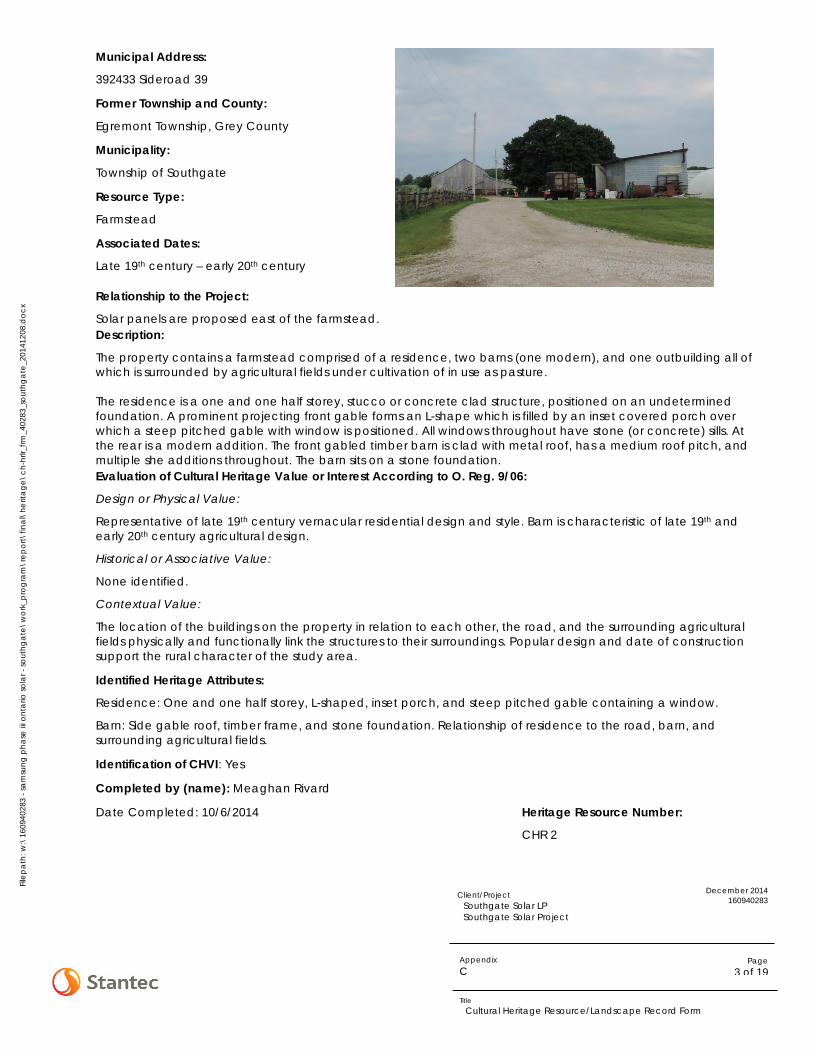
Fil
epat
h: w
:\16
0940
283
- sam
sung
pha
se iii
ont
ario
sola
r - so
uthg
ate\
wor
k_pr
ogra
m\r
epor
t\fin
al\h
erita
ge\c
h-hr
lr_frm
_402
83_s
outh
gate
_201
4120
8.do
cx
December 2014 160940283
Page 3 of 19
Client/Project Southgate Solar LP Southgate Solar Project
Appendix C
Title Cultural Heritage Resource/Landscape Record Form
Municipal Address:
392433 Sideroad 39
Former Township and County:
Egremont Township, Grey County
Municipality:
Township of Southgate
Resource Type:
Farmstead
Associated Dates:
Late 19th century – early 20th century
Relationship to the Project:
Solar panels are proposed east of the farmstead. Description:
The property contains a farmstead comprised of a residence, two barns (one modern), and one outbuilding all of which is surrounded by agricultural fields under cultivation of in use as pasture. The residence is a one and one half storey, stucco or concrete clad structure, positioned on an undetermined foundation. A prominent projecting front gable forms an L-shape which is filled by an inset covered porch over which a steep pitched gable with window is positioned. All windows throughout have stone (or concrete) sills. At the rear is a modern addition. The front gabled timber barn is clad with metal roof, has a medium roof pitch, and multiple she additions throughout. The barn sits on a stone foundation. Evaluation of Cultural Heritage Value or Interest According to O. Reg. 9/06:
Design or Physical Value:
Representative of late 19th century vernacular residential design and style. Barn is characteristic of late 19th and early 20th century agricultural design.
Historical or Associative Value:
None identified.
Contextual Value:
The location of the buildings on the property in relation to each other, the road, and the surrounding agricultural fields physically and functionally link the structures to their surroundings. Popular design and date of construction support the rural character of the study area.
Identified Heritage Attributes:
Residence: One and one half storey, L-shaped, inset porch, and steep pitched gable containing a window.
Barn: Side gable roof, timber frame, and stone foundation. Relationship of residence to the road, barn, and surrounding agricultural fields.
Identification of CHVI: Yes
Completed by (name): Meaghan Rivard
Date Completed: 10/6/2014 Heritage Resource Number:
CHR 2

Fil
epat
h: w
:\16
0940
283
- sam
sung
pha
se iii
ont
ario
sola
r - so
uthg
ate\
wor
k_pr
ogra
m\r
epor
t\fin
al\h
erita
ge\c
h-hr
lr_frm
_402
83_s
outh
gate
_201
4120
8.do
cx
December 2014 160940283
Page 4 of 19
Client/Project Southgate Solar LP Southgate Solar Project
Appendix C
Title Cultural Heritage Resource/Landscape Record Form

Fil
epat
h: w
:\16
0940
283
- sam
sung
pha
se iii
ont
ario
sola
r - so
uthg
ate\
wor
k_pr
ogra
m\r
epor
t\fin
al\h
erita
ge\c
h-hr
lr_frm
_402
83_s
outh
gate
_201
4120
8.do
cx
December 2014 160940283
Page 5 of 19
Client/Project Southgate Solar LP Southgate Solar Project
Appendix C
Title Cultural Heritage Resource/Landscape Record Form
Municipal Address:
392469 Sideroad 39
Former Township and County:
Egremont Township, Grey County
Municipality:
Township of Southgate
Resource Type:
Farmstead
Associated Dates:
Mid to late 19th century
Relationship to the Project:
Solar panels are proposed east of the farmstead. Description:
The property contains a farmstead comprised of a residence, multiple barns (some of which were not visible from the road), and multiple outbuildings including modern steel silos, all of which is positioned at the top of a ridge. The structures are surrounded by agricultural fields under cultivation or in use as pasture The residence is a one and one half storey, three bay structure clad with modern siding, a steep pitched metal roof, and undetermined foundation. At the centre of the front façade is a steep pitched gable containing a small window. A front gabled modern addition extends from the rear of the residence. The barn is a side gabled timber frame structure covered by metal roof and clad in metal siding with an undetermined foundation. Surrounding the barn are a series of outbuildings built overtime. Evaluation of Cultural Heritage Value or Interest According to O. Reg. 9/06:
Design or Physical Value:
Representative of mid to late 19th century residential design. Residence is characteristic of a vernacular interpretation of residential Gothic Revival design. Barn is characteristic of early 20th century agricultural design.
Historical or Associative Value:
None identified.
Contextual Value:
The location of the buildings on the property in relation to each other, the road, and the surrounding agricultural fields physically and functionally link the structures to their surroundings. Popular design of residence and date of construction support the rural character of the study area.
Identified Heritage Attributes:
Residence: One and one half storey, three bays, and steep central gable.
Barn: Side gable roof and timber frame. Relationship of residence to the road, barn, outbuildings and surrounding agricultural fields.
Identification of CHVI: Yes
Completed by (name): Meaghan Rivard
Date Completed: 10/6/2014 Heritage Resource Number:
CHR 3

Fil
epat
h: w
:\16
0940
283
- sam
sung
pha
se iii
ont
ario
sola
r - so
uthg
ate\
wor
k_pr
ogra
m\r
epor
t\fin
al\h
erita
ge\c
h-hr
lr_frm
_402
83_s
outh
gate
_201
4120
8.do
cx
December 2014 160940283
Page 6 of 19
Client/Project Southgate Solar LP Southgate Solar Project
Appendix C
Title Cultural Heritage Resource/Landscape Record Form

Fil
epat
h: w
:\16
0940
283
- sam
sung
pha
se iii
ont
ario
sola
r - so
uthg
ate\
wor
k_pr
ogra
m\r
epor
t\fin
al\h
erita
ge\c
h-hr
lr_frm
_402
83_s
outh
gate
_201
4120
8.do
cx
December 2014 160940283
Page 7 of 19
Client/Project Southgate Solar LP Southgate Solar Project
Appendix C
Title Cultural Heritage Resource/Landscape Record Form
Municipal Address:
392531 Sideroad 39
Former Township and County:
Egremont Township, Grey County
Municipality:
Township of Southgate
Resource Type:
Farmstead
Associated Dates:
Late 19th to early 20th century
Relationship to the Project:
Solar panels are proposed east of the farmstead. Description:
The property contains a farmstead comprised of a residence and barn surrounded by agricultural fields under cultivation or in use as pasture. The residence is a one and one half storey, side gabled structure with three bays and a front saltbox addition (possibly a front porch repurposed for full year use). The structure is clad in modern siding, has a steep roof pitch and undetermined foundation under the original structure (the front addition foundation is concrete). A rear front gabled addition is visible in aerial photography. The timber frame barn is side gabled and clad with a metal roof, timber siding, and sits on a stone foundation that has been painted white. A side shed addition is also clad with a metal roof, timber siding, and sits on an undetermined foundation. Evaluation of Cultural Heritage Value or Interest According to O. Reg. 9/06:
Design or Physical Value:
Representative of mid to late 19th century vernacular residential design and style. Barn is characteristic of late 19th to early 20th century agricultural design.
Historical or Associative Value:
None identified.
Contextual Value:
The location of the buildings on the property in relation to each other, the road, and the surrounding agricultural fields physically and functionally link the structures to their surroundings. Popular design and date of construction support the rural character of the study area.
Identified Heritage Attributes:
Residence: One and one half storey, side gabled, three bays.
Barn: Side gable roof, timber frame, stone foundation. Relationship of residence to the road, barn, outbuildings and surrounding agricultural fields.
Identification of CHVI: Yes
Completed by (name): Meaghan Rivard
Date Completed: 10/6/2014 Heritage Resource Number:
CHR 4

Fil
epat
h: w
:\16
0940
283
- sam
sung
pha
se iii
ont
ario
sola
r - so
uthg
ate\
wor
k_pr
ogra
m\r
epor
t\fin
al\h
erita
ge\c
h-hr
lr_frm
_402
83_s
outh
gate
_201
4120
8.do
cx
December 2014 160940283
Page 8 of 19
Client/Project Southgate Solar LP Southgate Solar Project
Appendix C
Title Cultural Heritage Resource/Landscape Record Form

Fil
epat
h: w
:\16
0940
283
- sam
sung
pha
se iii
ont
ario
sola
r - so
uthg
ate\
wor
k_pr
ogra
m\r
epor
t\fin
al\h
erita
ge\c
h-hr
lr_frm
_402
83_s
outh
gate
_201
4120
8.do
cx
December 2014 160940283
Page 9 of 19
Client/Project Southgate Solar LP Southgate Solar Project
Appendix C
Title Cultural Heritage Resource/Landscape Record Form
Municipal Address:
223544 Sideroad 22
Former Township and County:
Egremont Township, Grey County
Municipality:
Township of Southgate
Resource Type:
Residence and Barn
Associated Dates:
Various (late 19th to early 20th century and mid-20th century)
Relationship to the Project:
Solar panels are proposed south of the residence and barn. Description:
The property contains a residence, barn, and multiple modern agricultural buildings surrounded by woodlots, agricultural fields under cultivation or in use as pasture at the rear. The residence is a single storey side gabled ranch style structure. The structure has a low pitch roof with three ventilations, is clad in a brick veneer, and sits on an undetermined foundations. Aerial photography suggests that presence of a rear addition. The timber frame is front gabled and clad with a metal roof, timber siding, and sits on a concrete foundation. Evaluation of Cultural Heritage Value or Interest According to O. Reg. 9/06:
Design or Physical Value:
None identified.
Historical or Associative Value:
None identified.
Contextual Value:
None identified.
Identified Heritage Attributes:
None identified
Identification of CHVI: No
Completed by (name): Meaghan Rivard
Date Completed: 10/6/2014 Heritage Resource Number:
N/A

Fil
epat
h: w
:\16
0940
283
- sam
sung
pha
se iii
ont
ario
sola
r - so
uthg
ate\
wor
k_pr
ogra
m\r
epor
t\fin
al\h
erita
ge\c
h-hr
lr_frm
_402
83_s
outh
gate
_201
4120
8.do
cx
December 2014 160940283
Page 10 of 19
Client/Project Southgate Solar LP Southgate Solar Project
Appendix C
Title Cultural Heritage Resource/Landscape Record Form

Fil
epat
h: w
:\16
0940
283
- sam
sung
pha
se iii
ont
ario
sola
r - so
uthg
ate\
wor
k_pr
ogra
m\r
epor
t\fin
al\h
erita
ge\c
h-hr
lr_frm
_402
83_s
outh
gate
_201
4120
8.do
cx
December 2014 160940283
Page 11 of 19
Client/Project Southgate Solar LP Southgate Solar Project
Appendix C
Title Cultural Heritage Resource/Landscape Record Form
Municipal Address:
223585 Side Road 22
Former Township and County:
Egremont Township, Grey County
Municipality:
Township of Southgate
Resource Type:
Mixed
Associated Dates:
Various (range from late 19th century to modern)
Relationship to the Project:
Solar panels are proposed north of the resource.
Description:
The property contains two residences, one of which is modern, a barn, and various outbuildings. The structures are surrounded by woodlots, agricultural field under cultivation, or are in use as pasture. The modern residence is a single storey structure positioned between the barn and the older residence. The older residence is a one and one half storey, three bay structure clad with stucco (or plaster), and covered by a side gabled roof with medium pitch and a prominent central hipped dormer. The front façade is symmetrical and includes a central porch with a hipped roof containing approximately eight three-over-one windows with small windows at either side of the porch. Numerous windows have been removed which suggests that the residence is no longer in use. The barn is a front gabled timber frame structure covered by a metal room and clad in timber siding with an undetermined foundation. Surrounding the bar are a series of outbuilding built overtime. Evaluation of Cultural Heritage Value or Interest According to O. Reg. 9/06:
Design or Physical Value:
Representative of late 19th century vernacular residential design and style. Barn is characteristic of late 19th to early 20th century agricultural design.
Historical or Associative Value:
None identified.
Contextual Value:
The location of the buildings on the property in relation to each other, the road, and the surrounding agricultural fields physically and functionally link the structures to their surroundings. Popular design and date of construction support the rural character of the study area.
Identified Heritage Attributes:
Residence: One and one half storey, side gabled, three bays, central hipped dormer and porch with eight, three-over-one windows, symmetrical façade.
Barn: Front gable roof, timber frame and siding. Relationship of barn to the road and surrounding agricultural fields.
Identification of CHVI: Yes
Completed by (name): Meaghan Rivard
Date Completed: 10/6/2014 Heritage Resource Number:
CHR 5

Fil
epat
h: w
:\16
0940
283
- sam
sung
pha
se iii
ont
ario
sola
r - so
uthg
ate\
wor
k_pr
ogra
m\r
epor
t\fin
al\h
erita
ge\c
h-hr
lr_frm
_402
83_s
outh
gate
_201
4120
8.do
cx
December 2014 160940283
Page 12 of 19
Client/Project Southgate Solar LP Southgate Solar Project
Appendix C
Title Cultural Heritage Resource/Landscape Record Form

Fil
epat
h: w
:\16
0940
283
- sam
sung
pha
se iii
ont
ario
sola
r - so
uthg
ate\
wor
k_pr
ogra
m\r
epor
t\fin
al\h
erita
ge\c
h-hr
lr_frm
_402
83_s
outh
gate
_201
4120
8.do
cx
December 2014 160940283
Page 13 of 19
Client/Project Southgate Solar LP Southgate Solar Project
Appendix C
Title Cultural Heritage Resource/Landscape Record Form
Municipal Address:
223624 Sideroad 22
Former Township and County:
Egremont Township, Grey County
Municipality:
Township of Southgate
Resource Type:
Farmstead
Associated Dates:
Late 19th to early 20th century
Relationship to the Project:
Solar panels are proposed south of the farmstead. Description:
The property contains a residence, shed, and barn. The structures are surrounded by woodlots and agricultural fields under cultivation or in use as pasture. The residence is s two storey structure with three bays and a modern rear addition. It has a hipped roof with steep pitch clad in modern cedar shingles. The residence is clad in a brick veneer and sits on an undetermined foundation. The front façade is symmetrical with numerous decorative details including a front door casing with a decorative crown, stone lintels covering each of the windows and possible stone sills. Modern shutters have been secured to the front façade as well. The shed is a timber frame structure with a front gable roof, timber siding, and undetermined foundation. The barn, obstructed from view, is a front gabled structure according the aerial photography. Evaluation of Cultural Heritage Value or Interest According to O. Reg. 9/06:
Design or Physical Value:
Unique example of two storey century construction in the study area. Representative of a design popular during the early 20th century. Barn is characteristic of late 19th to early 20th century agricultural design.
Historical or Associative Value:
None identified.
Contextual Value:
The location of the buildings on the property in relation to each other, the road, and the surrounding agricultural fields physically and functionally link the structures to their surroundings. Popular design and date of construction support the rural character of the study area.
Identified Heritage Attributes:
Residence : Two storey, hipped roof, three bays, symmetrical façade, red brick veneer, decorative details including front door casing and crown, stone lintels, stone sills.
Shed: Front gable roof, timber frame and siding.
Barn: Side gable roof. Relationship of residence to the road, barn, outbuildings and surrounding agricultural fields.

Fil
epat
h: w
:\16
0940
283
- sam
sung
pha
se iii
ont
ario
sola
r - so
uthg
ate\
wor
k_pr
ogra
m\r
epor
t\fin
al\h
erita
ge\c
h-hr
lr_frm
_402
83_s
outh
gate
_201
4120
8.do
cx
December 2014 160940283
Page 14 of 19
Client/Project Southgate Solar LP Southgate Solar Project
Appendix C
Title Cultural Heritage Resource/Landscape Record Form
Identification of CHVI: Yes
Completed by (name): Meaghan Rivard
Date Completed: 10/6/2014 Heritage Resource Number:
CHR 6

Fil
epat
h: w
:\16
0940
283
- sam
sung
pha
se iii
ont
ario
sola
r - so
uthg
ate\
wor
k_pr
ogra
m\r
epor
t\fin
al\h
erita
ge\c
h-hr
lr_frm
_402
83_s
outh
gate
_201
4120
8.do
cx
December 2014 160940283
Page 15 of 19
Client/Project Southgate Solar LP Southgate Solar Project
Appendix C
Title Cultural Heritage Resource/Landscape Record Form
Municipal Address:
223511 Sideroad 22
Former Township and County:
Egremont Township, Grey County
Municipality:
Township of Southgate
Resource Type:
Farmstead
Associated Dates:
Late 19th to early 20th century
Relationship to the Project:
Solar panels are proposed north and southeast of the farmstead. Description:
The property contains a residence, shed, and two barns. The structures are surrounded by agricultural fields under cultivation or in use as pasture. The residence is s two storey structure with cross gables characteristic of a vernacular interpretation of a Queen Anne design. The hipped roof with multiple gables has a medium pitch and sits over the stucco or plastered exterior surrounded by a wrap-around porch and positioned on top of an undetermined foundation. Above inset portion of the porch on the front façade is a Juliet balcony extending from the second floor. Supporting the porch roof are subtle beams over which are positioned brackets. The rear addition, although not contemporary to the residence, is likely not a modern addition. The barns are both timber frame, gabled structures with metal roofs, metal siding, and undetermined foundations. On the smaller of the two barns is a cupola which may be original to the structure. The shed is also a timber frame construction with metal roof, timber siding, and concrete foundation. Evaluation of Cultural Heritage Value or Interest According to O. Reg. 9/06:
Design or Physical Value:
Unique example of two storey century construction in the study area. Representative of a vernacular interpretation of Queen Anne design popular during the early 20th century. Barns are characteristic of late 19th to early 20th century agricultural design.
Historical or Associative Value:
None identified.
Contextual Value:
The location of the buildings on the property in relation to each other, the road, and the surrounding agricultural fields physically and functionally link the structures to their surroundings. Popular design and date of construction support the rural character of the study area.
Identified Heritage Attributes:
Residence: Two storey, cross gabled, wrap-around porch with front façade inset and Juliet balcony, and porch supports with brackets.
Shed: Front gable roof, timber frame.
Barns: Both side gable roof and timber frame construction. Smaller barn has prominent cupola. Relationship of residence to the road, barn, outbuildings and surrounding agricultural fields.

Fil
epat
h: w
:\16
0940
283
- sam
sung
pha
se iii
ont
ario
sola
r - so
uthg
ate\
wor
k_pr
ogra
m\r
epor
t\fin
al\h
erita
ge\c
h-hr
lr_frm
_402
83_s
outh
gate
_201
4120
8.do
cx
December 2014 160940283
Page 16 of 19
Client/Project Southgate Solar LP Southgate Solar Project
Appendix C
Title Cultural Heritage Resource/Landscape Record Form
Identification of CHVI: Yes
Completed by (name): Meaghan Rivard
Date Completed: 10/6/2014 Heritage Resource Number:
CHR 7

Fil
epat
h: w
:\16
0940
283
- sam
sung
pha
se iii
ont
ario
sola
r - so
uthg
ate\
wor
k_pr
ogra
m\r
epor
t\fin
al\h
erita
ge\c
h-hr
lr_frm
_402
83_s
outh
gate
_201
4120
8.do
cx
December 2014 160940283
Page 17 of 19
Client/Project Southgate Solar LP Southgate Solar Project
Appendix C
Title Cultural Heritage Resource/Landscape Record Form
Municipal Address:
Various
Former Township and County:
Egremont Township, Grey County
Municipality:
Township of Southgate
Resource Type:
Landscape
Associated Dates:
Various
Relationship to the Project:
Solar panels are proposed within the landscape. Description:
The Heritage Assessment Area (HAA) is comprised of a vernacular rural landscape characterized by agricultural land use and division including, but not limited to: cash crop agriculture, pasture lands, woodlots, transportation via two single lane gravel roads and two single lane paved road, and a hydroelectric transmission line and corridor. Along Southgate Road 22 the agricultural land is divided into smaller squares separated by hedge rows. Properties along Sideroad 39 Southgate, in contrast, have larger cleared land with less separation, although some is still apparent along the east side of the properties adjacent to woodlots. Six farmsteads consisting of a residential building and various numbers of agricultural buildings are positioned throughout the landscape at variable distances from the roads. These are described individually above.
The vernacular rural landscape is not bounded by the HAA; it reaches beyond property boundaries and is generally descriptive of the area surrounding the HAA. This land use is characteristic of farming practices throughout the township specifically and the county more broadly.
Evaluation of Cultural Heritage Value or Interest According to O. Reg. 9/06:
Design or Physical Value:
None identified.
Historical or Associative Value:
The vernacular rural landscape is associated with an agricultural theme prevalent throughout the former Township of Southgate representative of historic land use following settlement. The landscape is also associated with agricultural activities historically practiced beginning in the mid-19th century which continues today.
Contextual Value:
The vernacular rural landscape was determined to support the general character of the surrounding area through its agricultural use. While not essential in its definition, as a vernacular rural landscape it is characteristic of the area which surrounds it. The vernacular rural landscape was determined to be physically, functionally, visually, and historically linked to its surroundings as it was settled in the mid-19th century for agricultural purposes and is the primary land use which continues today.

Fil
epat
h: w
:\16
0940
283
- sam
sung
pha
se iii
ont
ario
sola
r - so
uthg
ate\
wor
k_pr
ogra
m\r
epor
t\fin
al\h
erita
ge\c
h-hr
lr_frm
_402
83_s
outh
gate
_201
4120
8.do
cx
December 2014 160940283
Page 18 of 19
Client/Project Southgate Solar LP Southgate Solar Project
Appendix C
Title Cultural Heritage Resource/Landscape Record Form
Identified Heritage Attributes:
Agricultural land use reflected in cash crop agriculture, pasture lands, woodlots, and two lane transportation corridors.
Identification of CHVI: Yes
Completed by (name): Meaghan Rivard
Date Completed: 11/27/2014 Heritage Resource Number:
CHR 8

Fil
epat
h: w
:\16
0940
283
- sam
sung
pha
se iii
ont
ario
sola
r - so
uthg
ate\
wor
k_pr
ogra
m\r
epor
t\fin
al\h
erita
ge\c
h-hr
lr_frm
_402
83_s
outh
gate
_201
4120
8.do
cx
December 2014 160940283
Page 19 of 19
Client/Project Southgate Solar LP Southgate Solar Project
Appendix C
Title Cultural Heritage Resource/Landscape Record Form

HERITAGE ASSESSMENT REPORT: SOUTHGATE SOLAR PROJECT
Appendix D Qualifications of Heritage Consultant

Meaghan Rivard MA, CAHP Heritage Consultant
Meaghan Rivard is a Heritage Consultant with expertise in Environmental Assessments. Ms. Rivard is a member of the Canadian Association of Heritage Professionals and completed her Masters at Western University where she specialized in Public History. Her studies emphasized the communication of complex historical information to a wide audience and culminated in local publication of the Social History of Oil Springs. Ms. Rivard brings experience working with municipal and provincial authorities on behalf of clients from both the private and public realms completing projects according to municipal, provincial, and federal guidelines. She has assessed more than 900 properties as part of Renewable Energy Approvals and worked under various classed environmental assessments including corridor assessments for provincial and municipal authorities. In addition to EA related work, Ms. Rivard continues to be actively involved in the assessment of individual properties. Here she utilizes knowledge in the identification, evaluation, and documentation of heritage resources alongside expertise in the assessment of proposed change and preparation of options to mitigate negative impacts on heritage resources. EDUCATION M.A. Public History, University of Western Ontario, London, Ontario, 2009 B.A. History - Honours with Distinction, Brock University, St. Catharines, ON, 2008 MEMBERSHIPS Member, Canadian Association of Heritage Professionals PROJECT EXPERIENCE Wind Power Fairview Wind Project, Clearview Township, Simcoe County, Ontario (Heritage Consultant) Completion of the Revised Heritage Assessment Report for the Fairview Wind Project as required by O. Reg. 359/09. Activities included updating background history, field assessment, preparation of detailed inventory of heritage resource including evaluation according to O. Reg. 9/06. Minimal impacts were anticipated as a result of construction activities. Options were prepared to mitigate these impacts and recommendations made regarding future activities. Sol-luce Kingston Solar PV Energy Project, Kingston, Ontario (Task Manager and Heritage Consultant) Review of a previously completed Heritage Assessment Report in response to Project changes. Following review, a letter was prepared summarizing the changes, the heritage resources identified, and the potential impact. Work involved site analysis, preparation of detailed mapping showing modifications, and liaison with the MTCS.
Clarington Wind Farm*, Regional Municipality of Durham, Ontario (Task Manager, Cultural Heritage Specialist) Heritage Assessment Report for a project containing five turbines. Following extensive consultation with MTCS, Leader Resources Services Corp. sought assistance in obtaining MTCS satisfaction. A revised report was completed according to O. Reg. 359/09 including a modified inventory, evaluation, and assessment of impacts. Following resubmission, MTCS issued a letter of satisfaction with the report. Majestic/Meyer Wind Farm*, Municipality of Kincardine, Ontario (Task Manager, Cultural Heritage Specialist) Heritage Assessment Report for a project containing three turbines. Following extensive consultation with MTCS, Leader Resources Services Corp. sought assistance in obtaining MTCS satisfaction. A revised report was completed according to O. Reg. 359/09 which included a modified inventory, evaluation, and assessment of impacts. Following resubmission, MTCS issued a letter of satisfaction with the report. Cedar Point Wind Power Project*, Lambton County, Ontario (Task Manager, Cultural Heritage Specialist) Heritage Assessment Report for a project containing up to 46 turbines. Report completed as required by O. Reg. 359/09 included detailed background history of the Project Study Area, consultation with local historical societies and other knowledgeable individuals, collection an inventory of potential heritage resources , evaluation of each potential resource, and development of strategies to address negative impacts, if any, on the identified heritage resources.
* denotes projects completed with other firms Design with community in mind
Meaghan Rivard MA, CAHP Heritage Consultant
Summerhaven Wind Energy Centre, Haldimand County, Ontario (Cultural Heritage Specialist) Heritage Assessment Report completed as required by O. Reg. 359/09 for an estimated 60 turbine project. A background history of the Project Study Area was prepared in consultation with local historical societies and other knowledgeable individuals. This facilitated the collection of an inventory of potential heritage resources, evaluation of cultural heritage value or interest of each potential resource, and development of strategies to address negative impacts on the identified heritage resources. Armow Wind Project*, Kincardine, Ontario (Cultural Heritage Specialist) Heritage Assessment Report completed as required by O. Reg. 359/09 for a roughly 60 turbine project. Detailed reporting included preparation of a background history of the Project Study Area, consultation with local historical societies and other knowledgeable individuals, collection an inventory of potential heritage resources, evaluation of cultural heritage value or interest of each potential resource, and development of strategies to address negative impacts, if any, on the identified heritage resources. Bluewater Wind Energy Centre*, Huron County, Ontario (Cultural Heritage Specialist) Heritage Assessment Report completed as required by O. Reg. 359/09 for a 35 – 41 turbine project. A detailed background history of the Project Study Area was prepared in consultation with local historical societies and other knowledgeable individuals. Following this, an inventory of potential heritage resources was collected, evaluation of cultural heritage value or interest of each potential resource, and development of strategies to address negative impacts, if any, on the identified heritage resources. Goshen Wind Energy Centre*, Huron County, Ontario(Cultural Heritage Specialist) Heritage Assessment Report completed as required by O. Reg. 359/09 for a 60 – 70 turbine project. Reporting requirements included detailed background history of the Project Study Area, consultation with local historical societies and other knowledgeable individuals, collection an inventory of potential heritage resources, evaluation of cultural heritage value or interest of each potential resource, and development of strategies to address negative impacts, if any, on the identified heritage resources.
Jericho Wind Energy Centre*, Lambton County, Ontario (Cultural Heritage Specialist) Heritage Assessment Report for a project planning between 90 and 100 turbines. Expansive report included detailed background history of the Project Study Area, consultation with local historical societies and other knowledgeable individuals, collection an inventory of potential heritage resources, evaluation of cultural heritage value or interest of each potential resource, and development of strategies to address negative impacts, if any, on the identified heritage resources. Report required by O. Reg. 359/09. Twenty Two Degrees Wind Farm*, Huron County, Ontario (Cultural Heritage Specialist) Heritage Assessment Report completed as required by O. Reg. 359/09 for a 20 – 30 turbine project. Report included background history of the Project Study Area, collection an inventory of potential heritage resources, evaluation of cultural heritage value or interest of each potential resource, and development of strategies to address negative impacts, if any, on the identified heritage resources. Adelaide Wind Power Project*, Middlesex County, Ontario (Cultural Heritage Specialist) Heritage Assessment Report completed as required by O. Reg. 359/09 for a 30 – 40 turbine project. Expansive report included detailed background history of the Project Study Area, consultation with local historical societies and other knowledgeable individuals, collection an inventory of potential heritage resources, evaluation of cultural heritage value or interest of each potential resource, and development of strategies to address negative impacts, if any, on the identified heritage resources. Municipal Development Plans CPR Station Heritage Conservation Plan, City of Owen Sound, Ontario (Project Manager, Heritage Consultant) The CPR Station in Owen Sound was purchased by the City in 2010. Previously designated a heritage railway station under federal legislation, it was later designated under the Ontario Heritage Act and an OHT easement was placed on the property. Given the various levels of protection, the City retained Stantec to produce a Heritage Conservation Plan which established guidelines for the future use and preservation of heritage attributes associated with the CPR Station. The report was completed according to provincial and federal guidelines for conservation.
* denotes projects completed with other firms

Meaghan Rivard MA, CAHP Heritage Consultant
Filsinger Park Improvement Project, Kitchener, Ontario (Task Manager, Heritage Consultant) Heritage Impact Assessment of timber frame railway bridges crossing the Henry Strum Greenway. An HIA was undertaken to determine the value or interest of the structure as well as the potential impacts of its removal. Mitigation options were prepared, including photographic documentation during its removal and a commemorative program. Undertook development of mitigation options and recommendations and oversaw report production. Horst House, Town of Elmira, Waterloo, Ontario (Task Manager, Heritage Consultant) Heritage Impact Assessment in advance of site development. Prior to development, the Township and Region request the 85 acre property be assessed for potential cultural heritage value or interest. The property contained a residence with various additions and two barns. Mitigation options to address the loss of the limited CHVI indentified included professional salvage prior to demolition as the HIA represented appropriate documentation given the CHVI identified. Supervised site visit and report production and prepared evaluation of CHVI and mitigation options. Alberton Road House, Hamilton, Ontario (Heritage Consultant, Project Manager) Document and Salvage Report prepared as requested by the City of Hamilton prior to demolition. Residence was determined to have minimal cultural heritage value or interest but fall under the purview of the heritage planning staff. Prepared report that summarized the history of the property and provided a detailed description and high resolution photographic documentation of the buildings proposed to be demolished. Fox House*, Milton, Ontario (Project Manager, Cultural Heritage Specialist) Heritage Impact Assessment of early-mid 19th century yellow brick residence and timber frame barn to determine the cultural heritage value or interest of the property prior to site development. Although in poor visual condition, the residence exhibited signs of elaborate design details throughout the interior. Mitigation recommendations included detailed photographic documentation prior to demolition. Field assessment undertaken and oversaw background research as well as report production.
Featherstone House*, Milton, Ontario (Project Manager, Cultural Heritage Specialist) Heritage Impact Assessment of early–mid 19th century stone residence to determine the cultural heritage value or interest of the property prior to site development. Residence was associated with prominent local resident and architecturally interesting; both indicating value. Given poor structural condition of residence, measures were recommended to mitigate the removal of the structure, including but not limited to detailed photographic documentation. Background research, field assessment, and portions of report production undertaken. Patterson House*, Milton, Ontario (Project Manager, Cultural Heritage Specialist) Heritage Impact Assessment of a 19th century farmstead including prominent red brick residence and outbuildings to determine the cultural heritage value or interest of the property prior to site development. The site was determined to have limited value and site development approved. Mitigation included salvage of interior portions of the residence prior to demolition. Background research, field assessment and report production undertaken. Bowes House*, Milton, Ontario (Project Manager, Cultural Heritage Specialist) Review and revision of previously completed Heritage Impact Assessment. Review determined extensive revisions required to satisfy municipal requirements. Original 19th century farmstead exhibited salvageable materials although highly modified. Agricultural buildings included both 19th century timber frame barns and early 20th century concrete block structures. Background research, field assessment and report production undertaken. Beaty House*, Milton, Ontario (Project Manager, Cultural Heritage Specialist) Review and revision of previously completed Heritage Impact Assessment. Review determined extensive revisions required to satisfy municipal requirements. Assessment included original 19th century residence and timber frame barn. Background research, field assessment and report production undertaken.
* denotes projects completed with other firms
Meaghan Rivard MA, CAHP Heritage Consultant
London Psychiatric Hospital*, London, Ontario (Cultural Heritage Specialist) Adaptive Reuse Study of five 19th century structures associated with the former London Asylum. Assisted with field work, report production and project coordination. Highway and Transportation Heritage Building Condition Assessments, North Pickering, Ontario (Heritage Reviewer) Three properties owned by Transport Canada were identified for Building Condition Assessments (BCA). Each of the properties was protected through federal designation and under the purview of the Federal Heritage Building Review Office. As such, as part of each BCA, a review of the recommendations on identified heritage attributes was undertaken. The review was incorporated into each report in order to satisfy Parks Canada Standards and Guidelines for the Conservation of Historic Places in Canada. Highbury Avenue CN Overpass, London, Ontario (Task Manager, Heritage Consultant) Cultural Heritage Evaluation Report for 1960s bridge crossing historic railway to determine level of Environmental Assessment required prior to road improvements. Site assessment and background research determined that the bridge used what was considered sophisticated technology at the time of construction resulting in what was once the longest bridge of its kind. Recommendations were made for construction monitoring where the once innovated construction techniques may be exposed. Undertook field assessment and oversaw background research as well as report production. Smith Creek Bridge*, Perth County, Ontario (Project Manager, Cultural Heritage Specialist) Heritage Impact Assessment of proposed railing reconstruction to determine heritage significance and impacts of proposed undertaking. Undertook site assessment, background research and oversaw report production. Markham GO Station*, Markham, Ontario (Project Manager, Cultural Heritage Specialist) Heritage Impact Assessment of proposed track realignment and station platform construction. Undertook field work, site assessment, background research and report production.
Wawanosh Drain Bridge*, Sarnia, Ontario (Project Manager, Cultural Heritage Specialist) Heritage Impact Assessment of proposed road maintenance prior to the Wawanosh Drain Bridge. Undertook field work, site assessment, background research and report production. Intersection Rehabilitation*, MTO Central Region, Ontario (Cultural Heritage Specialist) Heritage Impact Assessment of three intersections in Simcoe and Peel Counties where road improvements are proposed. Undertook field work, site assessment, background research and oversaw report production. Bridge Master Plan*, Bruce County, Ontario (Cultural Heritage Specialist) Heritage evaluation of eight bridges selected for inclusion in county-wide planning exercise. Undertook field work, site assessment, and report writing. Queensville Residence*, Queensville, Ontario (Cultural Heritage Specialist) Documentation and salvage report of a 19th century railway station converted into a residence in the 20th century. The report was prepared according to MTO guidelines in order to mitigate negative impacts associated with demolition of the residence prior to road widening. Assisted with site assessment, inventory, and drawing coordination. Ottawa OLRT*, Ottawa, Ontario (Cultural Heritage Specialist) Development and collection of an inventory of built heritage features as part of the installation of light rail transit in the downtown core. Assisted with field work, inventory development, and prepared historical background material. Schomberg Bridge*, York County, Ontario (Cultural Heritage Specialist) Cultural heritage Evaluation undertaken to determine potential significance of the Schomberg Bridge. Undertook field work, site assessment, background research, and report production.
* denotes projects completed with other firms

Meaghan Rivard MA, CAHP Heritage Consultant
Woodbine Residence*, Toronto, Ontario (Cultural Heritage Specialist) Documentation and salvage report of a 19th century farmstead and three timber frame barns. The report was prepared according to the Ontario Ministry of Transportation guidelines in order to mitigate negative impacts associated with demolition of the residence prior to planned highway expansions. Assisted with site assessment, inventory, and drawing coordination. Londesboro Bridge*, Huron County, Ontario (Cultural Heritage Specialist) Heritage Impact Assessment of proposed reconstruction of the Londesboro Bridge. Undertook site assessment, background research and report production. Highway 23 Bridges*, Perth County, Ontario (Cultural Heritage Specialist) Cultural Heritage Evaluation reports for two bridges in Perth County for the Ministry of Transportation where bridge improvements were proposed. Undertook field work, site assessment and report production. Environmental Assessment Simpson Lake Quarry, Township of Addington Highlands, County of Lennox and Addington, Ontario (Heritage Consultant) The proposed Simpson Lake Quarry followed the process outlined for a Category C Project under the Ministry of Natural Resources (MNR) Class Environmental Assessment for Resource Stewardship and Facility Development Projects (MNR Class EA - RSFD). As part of this process, the Checklist for Determining High/Low Potential for Cultural Heritage Resources and the Municipal Class EA Checklist was completed. This involved consultation with provincial, regional, and local agencies as well as background research. Throughout the course of completing this checklist, there were no potential built heritage resources or cultural heritage landscapes identified within the subject properties. Old Orchard Sewage Storage Facility*, Grimsby, Ontario (Project Manager, Cultural Heritage Specialist) Cultural Heritage Assessment as part of a Class EA of a former sewage storage facility adjacent to historic War of 1812 battle site. Undertook field work, historical background research, site analysis and report production.
Little Long Lac Mining District, Municipality of Greenstone, Ontario (Task Manage, Heritage Consultant) Cultural Heritage Evaluation Report (CHER) completed as part of Environmental Baseline Work Program prior to the initiation of an Environmental Assessment. The CHER screened for resources of potential cultural heritage value or interest (CHVI) where project impacts were anticipated. A preliminary property inspection and review of available resources determined the presence of potential heritage resources within the study area. Each potential resource was evaluated to determine the presence of CHVI. Undertook site assessment, background research, and report production including all analysis. Weber Street Widening, Waterloo, Ontario (Heritage Consultant) As part of a multidisciplinary team managing a Schedule "C" Class Environmental Assessment for the Weber Street widening, Stantec undertook the identification, assessment, and documentation prior to demolition. Documentation of 36 properties took place as properties were acquired between 2011 and 2013. The results were compiled into a comprehensive document including photographic record, detailed research and site drawings, submitted in August 2013. Led the team who undertook the Final Documentation Report. Power Transmission & Distribution Kirkland Lake Operations Centre*, Kirkland Lake, Ontario (Project Manager, Cultural Heritage Specialist) Heritage Impact Assessment, including detailed background history and site evaluation, prior to proposed removal of the operations centre onsite. Undertook field work, site analysis, and report production. Strathroy Transformer Station Area Office*, Strathroy, Ontario (Project Manager, Cultural Heritage Specialist) Heritage Impact Assessment, including detailed background history and site evaluation, prior to proposed removal of the station area office. Undertook field work, site analysis, and oversaw report production.
* denotes projects completed with other firms

Meaghan Rivard MA, CAHP Heritage Consultant
Toronto Transformer Station*, Niagara Falls, Ontario (Cultural Heritage Specialist) Heritage Impact Assessment of the Toronto Power Transformer Station. Assisted with field work, site inventory and photographic documentation. Goderich Transformer Station*, Goderich, Ontario (Cultural Heritage Specialist) Heritage Impact Assessment, including detailed background history and site evaluation, prior to proposed removal of the control building onsite. Undertook field work, historical background, site analysis and report production. Pipeline Survey Guelph Line Tie-In Project City of Hamilton, Ontario, (Task Manager and Heritage Consultant) A Built and Cultural Heritage Overview was prepared to identify potential heritage resources within the Project Study Area to meet Ontario Energy Board Guidelines. Two protected properties were identified and thus the need for a CHAR was identified. Reporting is underway. Energy East Pipeline – New Build, Eastern Ontario, Various Locations, Ontario (Task Manager and Heritage Consultant) A Cultural Heritage Assessment Report (CHAR) was prepared to meet the National Energy Board Filing Manual and Ontario Energy Board Guidelines. The CHAR included extensive site assessment, development of a background history, analysis of the impacts of the proposed project and development of mitigation recommendations. Reporting is ongoing. Lakeshore Panhandle Replacement Project, Town of Lakeshore, Essex County, Ontario (Task Manager and Heritage Consultant) A Built and Cultural Heritage Overview was prepared to meet Ontario Energy Board Guidelines which require evaluation of potential heritage resources in advance of pipeline project construction. The Heritage Overview was composed of a program of agency consultation, review of historic mapping, and a visual assessment of the Study Area. During the site visit, potential heritage resources, including components of potential cultural heritage landscapes, were photographed and their locations recorded. Following further analysis, there were no heritage resources determined to be situated at the Project Location and thus no additional work was required. Brantford-Kirkwall Replacement Project, Waterloo and Wentworth Counties, Ontario (Task Manager and Heritage Consultant) A Cultural Heritage Assessment Report (CHAR) was prepared to meet Ontario Energy Board Guidelines which require evaluation of potential heritage resources in advance of
pipeline project construction. The CHAR was composed of a program of agency consultation, review of historic mapping and preparation of historical background material, visual assessment of the Study Area, identification of potential impacts and preparation of mitigation strategies to minimize the impacts of the proposed Project. Where identified, the use of site planning and buffer zones were recommended to mitigate negative impacts. Report is currently under review with MTCS. Hamilton-Milton Pipeline Project, Cities of Hamilton, Burlington, and Milton, Ontario (Task Manager and Heritage Consultant) A Built and Cultural Heritage Overview was prepared to identify potential heritage resources within the Project Study Area to meet Ontario Energy Board Guidelines. Following review of historic mapping, consultation with municipalities, and a site visit, multiple sites of potential and protected heritage resources were identified. As a result, the Overview identified the need for a more detailed assessment in the form of a Cultural Heritage Assessment Report (CHAR). Reporting is underway. Industrial Development Deloro Mine Site*, Deloro, Ontario (Cultural Heritage Specialist) Assessment of 19th century mining and smelting technology at Deloro gold mine. Report and inventory prepared for the Ontario Ministry of the Environment. Undertook field work, inventory preparation and assisted with report production and coordination.
* denotes projects completed with other firms

HERITAGE ASSESSMENT REPORT: SOUTHGATE SOLAR PROJECT
Appendix E Agency and Municipal Consultation

23/10/2014
DIRECT CONSULTATION
MINISTRY OF TOURISM, CULTURE, AND SPORT
None identified (6/19/2014)
ONTARIO HERITAGE TRUST
None identified (6/20/2014)
MUNICIPALITY/TOWNSHIP
No identified or protected heritage resources (confirmed by township planner July 10, 2014 via phone)
INDIRECT CONSULTATION
PLAQUES
Federal
Parks Canada: Searched the “Directory of Federal Heritage Designations”. There was one plaque associated with Grey County. It was reviewed and not determined to be within the study area. Additional search criteria included “Egremont” and “Southgate”. No additional plaques were identified.
Provincial
Ontario Heritage Trust: Searched the “Ontario Heritage Trust's Online Plaque Guide”. There was one plaque associated with Southwestern Ontario, County of Grey, and Township of Southgate. It was reviewed, and determined not to be within the study area.
Municipal
There were 66 plaques identified in the Grey County Database Listings available on the County’s website. Of these, none were determined to be situated within the study area.
NATIONAL HISTORIC SITE
National Historic Sites and Monuments Board of Canada through the Directory of Federal Heritage Designations: Following review of the Canadian Register’s search results for “Grey County”, “Egremont”, “Southgate”, and “Highway 6”, four sites were identified. There were no sites determined to be situated within the study area.
BURIAL SITE OR CEMETERY
None Identified
CANADIAN HERITAGE RIVER
Canadian Heritage Rivers System: Not applicable. The Grand River is the closest heritage river, but is situated outside of the study area.
consultation_checklist_169040283.docx

23/10/2014 TRAILS AND OTHER LOCAL RESOURCES
Trails: ontariotrails.on.ca was not available.
Grey County Historical Society: No response received
Municipal Heritage Committees: Not Applicable.
ADDITIONAL CONSULTATION UNDERTAKEN Grey Highlands Public Library: No response received
Grey County Historical Society: No response received
Grey County Heritage Alliance: No response received
Grey Roots Museum & Archives: No response received
South Grey Museum & Historical Library: No response received
Ontario Genealogical Society – Bruce & Grey Region Branch: No response received
Southgate Library: No response received
consultation_checklist_169040283.docx


From: Museum To: Rivard, Meaghan Cc: [email protected]; Best, Dan; [email protected]; Nancy Matthews [[email protected]] Subject: RE: Southgate Solar LP Project - Historical Information Request Date: Thursday, August 28, 2014 4:00:07 PM Attachments: gre-m-egremont.jpg
Hello Meaghan,
Thank you for your correspondence today in search of cultural heritage assets in the former Township of Egremont.
The South Grey Museum is a municipal museum in the township of Grey Highlands.
Our coverage area does not specifically cover the area bounded by your study – though we do include heritage information from Southgate in our Museum as it comes forward or is required.
As noted, our mandate does not specifically cover this area – but I am aware of an individual who was involved in the publication of “Bethel to Boothville” a history book covering some of your stated area.
You may wish to contact Erma Fell of the Bethel to Boothville Historical Society – you may reach her at (519) 923-5270 (no email on file).
I would also suggest you may want to correspond with the Southgate Library (copied on this email) in search of any local historical societies/heritage committees now extant at:
Librarian CEO Dianne Dean Phone: 519 923 3248 Email: [email protected]
I am also copying this response to our municipal CAO – Dan Best (and the Southgate CAO Dave Milliner) and our Heritage Grey Highlands chair Nancy Matthews for their consideration of your request.
My thinking is there may be heritage cemeteries (abandoned) in the area you have identified. These may be sought via the Bruce Grey Branch of the Ontario Genealogical Society (http://www.ogs.on.ca/bruce_grey/)
I have the following lists for Egremont Township cemeteries (you may find their exact locations via the Grey County GIS mapping search tool – at: http://maps.grey.ca/):
- Hilts Methodist Cemetery – Egremont – Conc. 2 Lot 49 - Holstein (Reid) Cemetery – Egremont – Conc. 3 Lot 37 - Cochrane Cemetery – Egremont – Conc. 1 Lot 28 Div. 2 - Amos – Dromore Cemetery – Egremont Conc. 8 Lot 12 - Amos- Dromore Cemetery – Egremont – Conc. 18, Lot 12

- Wareham Cemetery – Lot 18 ISDR - Johnston’s Cemetery – Egremont - Conc. 18 Lot 6 - Old Methodist Cemetery – Egremont – Conc. 1 Lot 1 - Mount Gilead Methodist – Egremont – Conc. 11 Lot A - Mount Zion Methodist – Egremont – Conc. 13 Lot 27 - Pioneer Cemetery – Egremont (1840) – Div. 1 Conc. 1 Lot 29 - Springfield Methodist – Egremont - Conc. 3 Lot 26 - Wilder’s Cemetery – Egremont – Conc. 20 Lot 5 - Woodland Cemetery – Egremont – Conc. 8 Lot 10
I also attach a map of Egremont from the 1880 Historical Atlas of Grey and Bruce Counties (H. Beldon & Co.) as digitized by the McGill University Atlas project – online at: http://digital.library.mcgill.ca/countyatlas/.
This will assist in locating early mill sites, heritage schools and buildings noted on the map.
You may also want to approach the Grey County Historical Society – at http://www.greycountyhs.ca/contact.html.
I trust this will get you started in identifying local cultural heritage resources in your study area.
Cheers,
Kate
Kate Russell South Grey Museum – Manager/Curator The Municipality of Grey Highlands + 40 Sydenham Street South, P.O.Box 299, Flesherton, Ontario N0C 1E0 (519-924-2843 Toll-Free (1-888-342-4059 (municipal office) Fax 519-986-3643 (municipal office) * [email protected] 8 [email protected]
DISCLAIMER: This electronic transmission, including any accompanying attachments, may contain information that is confidential, privileged and/or exempt from disclosure under applicable law, and is intended only for the recipient(s) named above. Any distribution, review, dissemination or copying of the contents of this communication by anyone other than the intended recipient(s) is strictly prohibited. If you have received this communication in error, please notify the sender immediately by return e-mail and permanently delete the copy you have received.

From: Rivard, Meaghan [mailto:[email protected]] Sent: August-28-14 3:22 PM To: Museum Subject: Southgate Solar LP Project - Historical Information Request Importance: High
Good afternoon,
My name is Meaghan Rivard and I am a Heritage Consultant with Stantec Consulting Ltd. I am writing you today regarding heritage resources within the former Township of Egremont.
Stantec Consulting Ltd., on behalf of Dillon Consulting Limited, has been retained to complete cultural heritage reporting for the Southgate Solar LP Solar Project, situated in the former Egremont Township in Grey County, today Southgate Township. The study area is bounded generally by Southgate Road 14 to the south, Highway 6 to the west, Wilder Lake Road (Southgate Road 26) to the north, and Southgate Sideroad 49 to the east. As part of this study, we are identifying any known, or potential, heritage resources within or adjacent to the study area.
We have contacted the county, municipality, Ontario Heritage Trust, Infrastructure Ontario, and the Ministry of Tourism, Culture and Sport to confirm the presence of any protected properties within the study area. Now, we are contacting you to inquire as to the presence of any non- protected heritage resources. Heritage resources may include buildings, monuments, landscapes, or really any part of the built environment.
For the ease of review, mapping has been prepared depicting the project study area (see attached). Unfortunately this request is made with a relatively short timeline. If anything comes to mind within this specific area I would very much appreciate any information you can provide. Please do not hesitate to contact me directly with any questions that this inquiry may generate.
Thank you in advance for your time.
Warm regards, Meaghan
Meaghan Rivard, MA, CAHP Heritage Consultant Stantec 49 Frederick Street Kitchener ON N2H 6M7 Phone: (519) 575-4114 Fax: (519) 579-4239 [email protected]
The content of this email is the confidential property of Stantec and should not be copied, modified, retransmitted, or used for any purpose except with Stantec's written authorization. If you are not the intended recipient, please delete all copies and notify us immediately.
Please consider the environment before printing this email.

From: Registrar (MTCS) To: Rivard, Meaghan Subject: RE: Southgate Solar LP Solar Project - MTCS Information Request Date: Thursday, June 19, 2014 4:32:02 PM
Good afternoon Meaghan, We do not have any properties on our List from this location, but as we have advised before, if there is any provincial property in the area, please contact the appropriate Ministry or authority , as requirements under the Standards and Guidelines for Conservation of Provincial Heritage Property may apply.
Kind regards, Deborah Hossack
Registrar, Register Developer, Heritage Advisor Ministry of Tourism, Culture and Sport 401 Bay Street., Suite 1700 Toronto ON M7A 0A7 ph: 416 314 7204 fx: 416 314 7175
From: Rivard, Meaghan [mailto:[email protected]] Sent: June-16-14 11:48 AM To: Registrar (MTCS) Subject: Southgate Solar LP Solar Project - MTCS Information Request
Good morning,
Stantec Consulting Ltd., on behalf of Dillon Consulting Limited, has been retained to complete cultural heritage reporting for the Southgate Solar LP Solar Project, situated in the former Egremont Township in Grey County, today Southgate Township. It is bounded generally by Southgate Road 14 to the south, Highway 6 to the west, Wilder Lake Road (Southgate Road 26) to the north, and Southgate Sideroad 49 to the east.
As part of this study, we are completing the REA Checklist: Consideration of Potential for Heritage Resources as defined within Ontario Regulation 359/09. As such, we are interested in protected heritage resources within or adjacent to the project study area. We are in the process of contacting the Ontario Heritage Trust, Infrastructure Ontario, and the local municipalities within which the project is located.
Are you aware of any MTCS interests in the project study area or of properties adjacent to the study area?
For the ease of review, mapping has been prepared depicting the project study area (see attached). This map appears in draft form and may contain confidential information not yet released to the public. We ask that you maintain confidentiality while responding to this inquiry.
Please let me know if I can provide any additional information or assist in the identification of resources in any way.

Thank you in advance for the time! Best, Meaghan
Meaghan Rivard, MA, CAHP Heritage Consultant Stantec 49 Frederick Street Kitchener ON N2H 6M7 Phone: (519) 575-4114 Fax: (519) 579-4239 [email protected]
The content of this email is the confidential property of Stantec and should not be copied, modified, retransmitted, or used for any purpose except with Stantec's written authorization. If you are not the intended recipient, please delete all copies and notify us immediately.
Please consider the environment before printing this email.