Embed Size (px)
Citation preview

American Journal of Engineering Research (AJER) 2013
w w w . a j e r . o r g
Page 229
American Journal of Engineering Research (AJER)
e-ISSN : 2320-0847 p-ISSN : 2320-0936
Volume-02, Issue-10, pp-229-238
www.ajer.org
Research Paper Open Access
Prospect of Buchanan’s Traffic Planning Approach in Small
Towns of India: A Case Study in Tezpur Town
Prakash Jyoti Saikia, Dr. Abani Kumar Bhagabati 1Department of Geography, Tezpur College, Assam, India
2Department of Geography, Gauhati University, Assam, India
Abstract: - With fast pace of increase in vehicular population, even the small towns in India are facing serious
traffic and parking problems. So, traffic planning from modern perspectives becomes the need of the hour.
Today, the much-adopted transport planning tool for urban centres has been the simulation models and there are
many such models that are available for the purpose. But, while many resources have been devoted to the
development of more complex computer modelling tools (e.g., UrbanSim and TRANSIMS etc.), less attention is focused on simpler modelling approaches. In the case of the small towns of India, it is next to impossible to
think for a modern and sophisticated method of transportation planning, not only because they are too
expensive, time consuming, but also from the view point of expertise and other managerial constraints. So, this
paper preferred to take the help of the approach suggested in famous ‘Traffic in Towns’, 1963 (popularly known
as Buchanan Report after Professor Colin Buchanan). To illustrate the role of the adopted approach, the present
work uses a descriptive case study of Tezpur town. More specifically, this case study provides a practical study
to suggest that this simpler approach can be a cost-effective approach to support certain aspects of the urban
planning decision-making process.
Keywords: - Small town, Transportation planning, Urban master plan
I. INTRODUCTION
In the towns of India, road transport is the most widespread means of transport. But, the continued growth of traffic on urban roads has led to unwanted traffic congestion as well as noticeable increase in road
accident. For the purpose of planning a town, preparation of land-use master plan is a common approach in
India. Here, the transport planning process is based on the premise that capacity requirements of urban transport
networks should be dimensioned to meet predicted demand resulting from changes in land use and socio-
economic factors[1]. In other words, the transport system has been based on the layout of the land use instead of
the other way round, where the land use plan should be formulated based on the transport forecast and analysis.
This may probably be one of the causes why, despite having master plans, most of the Indian towns face serious
traffic and parking problems. So, the central research question of this paper is concerned with the problem of
managing moving traffic and parking in the towns of India (particularly the small towns) by an affordable
approach that could support the master planning process.
The study of the current state-of-the-art in transportation planning shows that within the transportation planning process, an entire set of transportation forecasting modeling tools has been developed[2]. But, while
vast resources have been spent in the development of more complex computer modelling tools, less attention has
been focused on simpler approaches[3]. The high cost and large data requirements to run large-scale models have
necessitated the use of simpler approaches for the small towns of India and, thus, the present work preferred to
take the help of the approach suggested in famous ‘Traffic in Towns’, 1963 (popularly known as Buchanan
Report after Professor Colin Buchanan). To illustrate the role of the adopted approach, the present work uses a
descriptive case study of Tezpur town. More specifically, this case study illustrates how this simple approach
can be used as a part and parcel of the master plans.

American Journal of Engineering Research (AJER) 2013
w w w . a j e r . o r g
Page 230
II. METHODOLOGY AND DATABASE
The goal of this research is not to develop a new Transportation and Land use Modelling tool, but to
use an existing approach and apply it to the small towns of India. For this purpose the present work mainly
resorts to the established work of the steering group and working group appointed by the Ministry of Transport,
Her Majesty’s Stationary Office (HMSO), London, entitled ‘Traffic in Towns’. It is the pioneer study on the
long-term problems of traffic in urban areas, published by HMSO in 1963. The present work finds this approach
as an example of a simpler modelling approach that could be used to support urban planning decision-making. For the small and medium sized towns of India, such an approach can be beneficial for two basic reasons –
firstly, it involves the collection of a very modest data and secondly, it is operational. Here, question may arise
as to whether the approach taken by Buchanan in 1960s may be considered as a modern approach or not? But it
is worth to mention that, in majority of the Indian towns (especially in the small towns), most of the variables
for the traffic problems are almost the same as they were in the 60s in England and though the number and
magnitude of some of them may show some change, they can be treated as those affected the traffic of London
in 1960s.
The methods for working on the Buchanan’s approach and modifying it as per the local conditions
include a practical case study on the master plan area of Tezpur town, Assam (Fig. 1) and surveys for the
purpose. For instance, a random survey with survey schedule method was taken as means to collect data on
economic condition of the residents of the town, number of vehicles they have and the places of their work and market. As the population is very large, this survey covered only 2 to 3 per cent households of the municipal
area and each of the villages forming the master plan area of the town. The information from this survey was
then used to obtain the basic catchment area of the major nodes in the town and used for further analysis.
Besides the above, 2 municipality wards and 14 villages from the master plan area were chosen
randomly to collect detail information. It is noteworthy that for this selection, the master plan area was first
divided into well defined population density zones as per 2001 Census and then the proportionate representation
from each of the density zones was maintained as far as possible. Information from these selected wards and
villages are then collected by means of a schedule, covering at least 50% of the residential households for the
wards and 70 - 100% households in the case of the villages.
The primary data regarding traffic volume were collected at all the 8 major entry points into the town.
It was done manually by counting and classifying traffic, flowing past the selected fixed lines on the road. To know the hourly pattern of traffic volume in the central area of the town, the traffic on the roads in the central
area of the town were also counted at 13 different locations.
The carriageway widths as well as the shoulder widths of roads within the master plan area were
measured manually at 104 cross sections on different roads. While taking the measurement, the condition of the
road was also observed and recorded. The conditions were evaluated on the basis of black toped, graveled or
kutcha road and the physical condition of the road.
In order to gather an understanding of the parking situation in the town, a parking survey was done by
the ‘walked petrol’ method[4]. Here, a frequency of half an hour was taken for recording the on-street parking.
Accident data were generated from the secondary source, i.e. from the police records. For this, month wise total
number of accidents, place of having maximum number of casualties, hour of the day having maximum number
of accidents and the days of the week having maximum case of accidents for the period from 2004 to 2008 were
collected. To address the specific need of the work, the surrogate variable of transportation structure indices viz.
Cyclomatic number (μ), Alpha index (α), Beta index (β) and Gamma index (γ) for assessing the transport
network were used[5]. Similarly, the population projection is done by arithmetic projection (the horizon year is
taken as 2025) method with formula-
𝑃𝑛 = 𝑃𝑜 + 𝑛(𝑃𝑜 − 𝑃𝑚)/𝑚 , Where, Pn = Projected population in n year later from the year, Po = Present
population and Pm = Population at a date m years earlier from the present
The numbers of vehicles at present (2011) as well as at the horizon year are projected with the same
above formula, as has been used for projecting the population. Again, with the help of the per capita trip
generation (as obtained from the household survey of the aforementioned 14 villages and wards), the number of
daily trips for different population density zones and catchment areas of major nodes are estimated.
Last but not the least, it may be mentioned that, due to lack of reliable statistics, the observations are a vital part in the investigation. The necessary secondary data were collected from Public Works Department,
District Transport Office, Municipal office, Office of the Town and Country Planning, Census office etc. To
know the planning procedure, the Town and Country Planning Officer and two of the engineers were
interviewed.

American Journal of Engineering Research (AJER) 2013
w w w . a j e r . o r g
Page 231
III. APPROACH OF BUCHANAN In 1963, Professor Colin Buchanan in the ‘Traffic in Towns’ had explained the traffic planning in such
a way that it has received appropriate treatment. It had produced a new design for towns, which was meant for
contriving the efficient distribution or accessibility of large number of vehicles to large number of buildings in
such a way that a satisfactory standard of environment is achieved[6]. The following few paragraphs highlight
the main recommendations of the report, its response and legacy.
The report recommended that the urban redevelopment should look to the long term, and avoid parsimonious short-termism. Further, it stresses that if a town or city is both financially able and willing, it
should rebuild itself with modern traffic in mind. However, if circumstances meant that this was not possible, it
would have to restrain traffic, perhaps severely. According to this report, planners should set a policy regarding
the character being sought for each urban area, and the level of traffic should then be managed to produce the
desired effect in a safe manner. The report also emphasised on a lattice of environmentally-planned areas in the
town, joined by a road hierarchy, with longer distance traffic being directed around and away from these areas.
In the case of small towns, for instance, the report showed the possible way that could be taken to redevelop
Newbury town in a pattern with vehicles easily integrating into the urban scenery. The suitability of this
approach has been proved when the A34 Newbury Bypass was proposed, alongside extensive pedestrianisation
and road changes within the town. The new roads dramatically reduced the impact of motor vehicles on the
town and accompanied the reinvigoration of Newbury which had managed to retain its historic core[7]
. However, as towns were developed according to the Buchanan’s blue print, several issues emerged. For
instance, some of the grand plans that were called for have had a poor reputation in their implementation.
Another point of criticism was the courage needed to develop the schemes proposed in the report. The
recognition of environmental issues was also less well understood in the 1960s. Because, the considerations in
the report were more for the human environment, rather than the natural issues which have tended to confound
some subsequent road proposals.
IV. CASE STUDY TOWN Tezpur is the administrative headquarters of Sonitpur district of Assam, a north-eastern state of India. It is located in and around 26º 37´ N latitude and 92º 47´ E longitude and its altitude is about 79 metres above
mean sea level[8]. It is located over a slightly undulating topography. While a few low hills (with heights 120 to
160 m) cover the southern part, the northern side of the town is flat. It has also some low-lying areas (locally
known as hollas) and is dotted with many tanks, tillas and tikas. The area of its Municipal jurisdiction is 7.10 sq.
km, and the Master Plan area is 126.60 sq. km[9].
Fig. 1: Location of Tezpur town
American Journal of Engineering Research (AJER) 2013
w w w . a j e r . o r g
Page 232
History shows that the Chinese aggression of 1962 had a great impact on this town, which had
enhanced the importance of the town as a strategic place from defense point of view. Moreover, the Government
and Semi-Government establishments that came after this had created employment opportunities to a
considerable extent and as a result of this, people from outside were attracted to the town [10]. In 2001, the total
population of the town had crossed the one lakh mark (with a population density of 11,349 persons per sq.km.)
and became a class-I town of Assam. As far as the whole master plan area is concerned, the 2001 Census put the
total population as 2,17,791 (with density 1,720 persons per sq. km).
V. RESULTS AND DISCUSSION
V.1 Provision of road traffic planning
The study reveals that though the master plan of the town has a brief chapter on urban transportation
and there is a provision for the formulation of an efficient circulation plan, the plan resort only to short-term
programs to cope mainly with the present transport difficulties. But, these schemes are not based on detail study
as well as on sound traffic engineering and management measures.
V.2 Present status and estimation
Tezpur is a cosmopolitan town. There are also many Army bases in the northern and the north-western
portion just outside its outgrowths. But, the most striking feature regarding the spatial distribution is that while the western part of the master plan area, particularly to the west of the NH-52, is inhabited by Hindu people, the
eastern half of it is inhabited mainly by the Muslim Community. As a matter of fact, the spatial pattern of
growth of population shows that while the growth has been high in the eastern half of the master plan area, in
the western half and in the municipal area, the population growth is relatively low. The spatial pattern of the
growth of houses and the workers also conform to the growth of population.
About the road network, the general framework is seen to be composed of four radial roads,
interlinking transverse roads and some lower order feather roads, all of which woven intricately to form a
pattern of spider web. However, the local physiography causes it to deviate from the general spider web.
Similarly, the situation of the town on the river bank also has made the spider web limited to its half. Out of the
total roads of this network, above 59% roads are black topped, 23% are gravelled and about 18% are kutcha.
The computed connectivity indices for the existing road networks show that in terms of degree of connectivity the town presents a poor picture. For instance, the computed alpha index is 19.15%. The strength of
the existing network is further aggravated by the overall condition of the roadways. Most of the roads are
narrow. Lack of sidewalks or specified track forces pedestrians, cyclists and other slow movers to use the
shoulder or the roadway itself. Uncontrolled on-street parking exacerbates the situation by narrowing further the
right of way (R/W) for moving traffic. Many roads are in a dismal state of disrepair, often unpaved and riddled
with potholes. It is also observed that there has been a general lack of modern traffic signals, even in situations
where they are warranted.
The traffic in the town is of heterogeneous in nature. Modes having maximum speed ranging from 15-
100 km per hour and width ranging from 0.5 - 2.6 metre are sharing the same road space. To be mentioned that
the carriageway width of the National Highways in the town is 7.10 metre. In the case of the major distributors,
the paved portion ranges from 3 to 7.35 metre, with maximum frequency at 5.7 to 5.8 metre category. But, the
paved portion is found to be narrow on almost all the local distributors (ranging from 2.7 to 5.8 metre, with maximum frequency to the lower ends). When compared to the peak hour traffic volume (as obtained from the
traffic count), the widths of the roads are found inadequate for the existing and growing needs of traffic. It is
found that the roads have been carrying up to 2 to 3 times more traffic than their prescribed capacity[11]. The
study shows that due to the narrowness of the carriageway, many roads face a good deal of congestion. In these
roads, even a stationary vehicle can impede the flow of traffic in the whole road. The accessibility, especially at
the time of the peak period, is also found to be significantly low. Moreover, inadequate loading facilities, lack of
parking etc. are also observed at several places.
It is found that apart from the town centre, there are five major nodes in the master plan area of Tezpur,
where people go for work and shopping. So, the shortest routes from the catchment areas of these nodes form
the corridors for movement. Generally the radial roads form these major corridors [(Fig.3 (A)]. However, the
transverse road, in the form of NH 37(A) and a part of NH 52, forms another important corridor. Within the central area, the important corridors identified are the road from Tribeni point to Civil Hospital point, road from
Murhateteli to Chandmari, the Barahalia road and the road from Dadhara to Dhanwanagar etc.
The roads having basically the intra-master plan area traffic have a peak hour between 8.30 AM to 9.30
AM. On such roads, a sharp decrease in the traffic can be seen after this peak hour. The reason for this is that the
traffic on these roads basically consisted of workers, who have to reach the town centre by 9.00 AM to 10.00
AM. On the other hand, the roads, where both long distance and intra-town commuters along with through
traffic move, there has been a more or less constant high traffic after 9.00 AM. For example, count points like

American Journal of Engineering Research (AJER) 2013
w w w . a j e r . o r g
Page 233
Mission Chariali, Haleswar and Murhateteli show such trend, having a peak hour at 10.30 AM to 11.30 AM. In
the case of the traffic to the town centre, the peak volume of traffic forms a wave, starting at around 9.00 AM at
the periphery and ends at around 10.00 to 10.30 AM at the town centre.
Lack of adequate parking place for motorised vehicles has already created serious problem in the
commercial area of the town. The parking survey revealed a shortage of about 230 car parking spaces at the
peak hour. The investigation of the cases of accidents shows that places like Mission Chariali, Batamari and
Solagaon exhibit high accident proneness not only in terms of number of cases, but also in terms of casualties.
The study shows that while majority of cases in and around the municipal area is between light motor vehicles
and pedestrians (38.08% during the study period 2004 - 2008), out side the municipal area it is the heavy vehicles that cause most of the accidents with other road users (nearly 54% of the total number of accidents
caused by all types of vehicles). The involvement of motor cycles in the accidents is also found to be high
(27%). Following are the results of the estimation of the population, number of vehicles, number of daily trips
and modal preference in the town:
(a) The projected population at present and at the horizon year for the master plan area is around 26 to 28 and
30 to 36 lakhs respectively.
(b) By 2025 or so, the number of motorised vehicles, especially the motorcycles and cars for the journey to
work itself would rise (given an adequate network and suitable parking places) from about 22,449 at present
to nearly 33,844 (about 66% increase). On the contrary, the total number of persons travelling for work by
all forms of transport would increase by only about 41%.
(c) The number of motorised vehicles seeking to enter the municipality area daily would increase from about 22,000 - 23,000 at present to about 29,000 - 32,000 by 2025. In addition to this, there would be about
50,000 - 55,000 non-motorised vehicles. The total peak hour flow would be of the order of 3,662 motorised
vehicles (out of which about 80% would be composed of motor cycles and cars) and about 2,600 - 2,700
non-motorised vehicles. The composition of the non-motorised vehicles would be about 1,750 cycles, about
700 - 800 cycle rickshaws and 200 - 300 thelas and animal drawn carts. The ultimate parking demand for
this level of traffic would be about 3,000 spaces (as against about 2,000 spaces at present) for the motorised
vehicles and above 2,000 spaces to accommodate the non-motorised ones.
(d) The field survey places the per capita trip generation to be 0.57. Again, from the total trips found in the
survey, the estimated total trips for the Tezpur master plan area becomes 1,40,498 at present and 1,78,207 at
the horizon year. It is to be noted that, the worked out per capita trip generation by different modes for
different density zones and the catchment areas (which was done in lieu of the conventional techniques of
multi-stage distribution of the trips) also gives the total trips to be about 1,60,000 – 1,65,000 for the horizon year.
(e) The total number of vehicles in the whole master plan area would rise from about 84,484 at present to about
1,07,253 at the horizon year. Out of this, above 50 % will be bicycles and cycle rickshaws, 30% will be
motor cycles and 10% will be cars and the remaining 10% will embrace all other types of vehicles.
Regarding the spatial pattern, it is seen that while bicycles and motor cycles predominate in the
comparatively low income zones of the northern and eastern sides of the study area, the percentage of cars
is high in the zone comprising the municipal area and its fringe.
V.3 Future directions
The heterogeneous nature of traffic is likely to continue in less motorised Tezpur town and because of
the socio-economic realities and compulsions, pedestrians, bicyclists and motorised two-wheeler riders will remain dominant on the roads of the towns for many decades. So the future traffic planning for the town has to
address the following issues:
Various road users have different and often, conflicting requirements. Motorised vehicles need clear
pavements and shoulders, while the bicyclists and pedestrians need shaded trees along the pavement. Owners of
private transport modes prefer uninterrupted flow and minimum delays, whereas public buses require frequent
stops for picking and discharging passengers. Since our infrastructure design does not account for the existing
conflicting requirements of different modes, future traffic models must account for the users of these different
transport modes. Another cause of concern for the traffic problems in this town is that the sections of National
Highways passing through it have to serve multiple purposes. On the one hand they carry through traffic and on
the other, the adjacent land use generates cross-traffic and demands multiple space usage like space for parking
vehicles or space for informal shopping, etc. The existing design standards do not account for conflicting
demand between local traffic and through traffic resulting in long delays for through traffic and safety hazards for both kinds of traffic. So, despite the situation of low per-capita income and low capacity for capital intensive
infrastructure compared to that of the advanced nations, road efficiency and safety has to be promoted.
It is found that a large number of road users in the town are bicyclists, pedestrians and other slow
moving vehicles. So, the road designs have to address their needs in addition to the needs of motorised vehicles.

American Journal of Engineering Research (AJER) 2013
w w w . a j e r . o r g
Page 234
Motorised vehicles can use a longer route and over-bridges, but, a pedestrian or bicyclist would prefer not to use
an underpass or over-bridge just because it is safer to do so. A major shift, thus, is required in the design
principles itself. The quality of roads is perhaps the greatest issue that has to be addressed with high priority.
This is important in terms of providing better facilities for the traffic and relief to the road side residents.
VI. DESIRABLE POLICY OBJECTIVES
VI.1 Transport policy objectives The paper wants to stress on an integrated transportation planning policy, which may consider three
policy issues for the overall transport planning of the town. These are (i) Promoting and improving public
transportation and to encourage public transport use. It is important because many rural and suburban
commuters of the study town are seen to depend on scooters, motor cycles or personal cars due to lack of
convenient public transport. Other techniques may include coordinating interdepartmental efforts, shift of
work/school hours from peak period to off-peak period, enforcing stricter traffic rules etc., (ii) Policy
innovations for managing traffic and travel demand and (iii) Policy for promoting non-motorised modes of
transportation, especially the bicycles, increasing education and awareness levels, controlling urban population
growth etc.
VI.2 Land use policy objectives The key land use policy objectives would be land use concentration and mix of uses. These types of
spatial structures are described in the planning literature as economical in both transport and land use terms. One
may also envisage the development of some of the urban nodes, so as to provide them with self-containment in
terms of the proportion of the total trips generated by their hinterlands, having destination within that node. It
may also be helpful in terms of purpose and mode of travel.
VI.3 The strategy
The basis for the strategy lies on a vision of the town’s future and the position of the transport system
in it. Now if one follows Buchanan, this vision should include solutions for allocating urban space and attention
for modes of transport. For example, an area within the central location of the town that is accessible for all
forms of passenger traffic cannot at the same time be efficiently supplied. Another example may be that the choice for an effective and efficient public transport system cannot be combined with a system in which the
passenger car is given all the space it needs. Having analysed the present and future status of different aspects
related with traffic, the desired traffic planning for Tezpur town may be seen as a series of choices at different
levels. But, by following Buchanan, in this study we seek to consider following principles upon which the traffic
problems might be tackled –
(i) Numbers, types and speeds of vehicles to be kept down to a level compatible with environmental standards.
(ii) Circulation of essential traffic to destinations to be contrived, but not necessarily by the shortest route nor
even any choice of route.
(iii) Streets and areas which are used predominantly by the pedestrians to be converted for pedestrian use only.
(iv) All through movements to be prevented.
(v) Internal movements to be reorganised to eliminate the conflict of criss-cross journeys.
Thus, in the conditions that are likely to arise in the future, following may be the ideal basis of any
transportation planning for the study town: As the first ideal, one could see that what is needed for Tezpur town
is an efficient primary network, which is capable of discharging the heavy load of different types of vehicles
even at the peak hour. Now, considering the principles on which this primary network could be planned, the
present work assumes that the thorough traffic using the road running from Kalia Bhomora Bridge to Mission
Chariali and then proceed to Balipara side on the one hand and towards Mangoldoi side on the other would be
removed by the provision of suitable by-passes. The location of the by-passes is outside the scope of this paper.
However, it may be pointed out that any by-pass should not criss-cross the main line of movement to the town
centre. In that sense, the location of one of such by-pass, relieving NH 37(A) from the through traffic to and
from Nagaon side, may be thought of running through the bank of the Brahmaputra. Question may arise whether
the provision of these by-passes would be a solution to Tezpur’s problems. The answer is that if the by-passes could be built now they would certainly bring a measure of relief as far as the movement in the master plan area
is concerned. However, regarding the movement into the municipality area, the proposed provision of by-pass
would not affect the traffic. Further, our study shows that as the number vehicles increases in the future it is the
build up of traffic within the master plan area that really becomes the formidable problem to cope with.
As the second principle, one may consider the environment of the town. For this purpose, the whole
town was examined in order to determine the possible arrangement of the town into groups of major
environmental areas. These environmental areas are taken as the residential areas, areas of educational

American Journal of Engineering Research (AJER) 2013
w w w . a j e r . o r g
Page 235
institutions (particularly the schools for small children) and their surroundings, important commercial as well as
industrial centres or areas used by other important activities such as by Air Force and Army base etc. (Fig. 2). It
is found that a particular environmental difficulty arose on all the four radial roads from the town centre. In the
areas away from the municipal area, these roads not only serve to provide direct access to the dwellings, but also
function as local distributors (linking with a number of access roads). In the absence of any alternative route
there has been some added complication that through traffic to and from the southernmost part of the town has
to make use of the radials. Even if the through traffic is disconnected, the volume of traffic in 2025 would build
up along these radials. A decision has to be taken, therefore, whether to direct traffic away from the radials or to
convert the radial roads into distributors. Here, the present work has opted for the second alternative and will try to treat the radial roads as major distributors.
Fig. 2: Tentative grouping of environmental areas
Then the question of cyclists arises. Because, in the analysis of model choice, it is seen that though the
car ownership is now growing, it still lags behind the widespread use of bicycles. It is also seen that though the car ownership and use has been increasing, the bicycle has remained popular. Thus, it can be said that bicycle
has a good future and its use could still be increased significantly especially in a small town like Tezpur. In this
regard, the scope for increasing bicycle use for the trips currently made by car may be considered. This
particularly applies to short trips currently made by cars. In the study, it has been found that almost 40% of the
short trips are not longer than 5 km, and 67% are not longer than 7.5 km. Motorists themselves admit that a
quarter of all car trips could easily be made by motor cycles or bicycles, and another quarter could be made by
bicycles. Thus almost up to 50% of car trips within the town could be replaced by bicycle trips. To be noted that
from the household survey it was evident that 37.41% of all non-walking urban journeys in the town are made
using bicycles and only 9.30% use cars. However, some town planners may see the bicycle as a significant
cause of traffic congestion and traffic accidents, and want to discourage its use in the town centre. Others may
see the bicycles as a cheap and non-polluting mode of transport that should be further encouraged. But, realising the popularity and possibility for an increase in bicycle use in Tezpur town, present work envisages an urgent
need to have a clear policy regarding the use of bicycles. In this context, it should be mentioned that, according
to Buchanan cycles should not be admitted on the primary network. It is because of the fact that cycle tracts on
the primary network become too complicated to build. At the same time, he also clearly stated that it is really
expensive, and probably impracticable, to create and maintain a completely separate system of tracts for cycles.
So, the structural change, which is required in the entire transport and traffic system, will be a major challenge.
Here, it is to be cleared that, by following Buchanan we may think for the diversion of cycle traffic increasingly
to the less busy roads. But such a venture may result in inconvenience to the majority of cyclists in a town like
Tezpur, where cycle is one of the prime modes of journey. So, in spite of Buchanan’s remark, we may think for
at least a network of radial bicycle routes as the first step towards such a change. In future, these radial routes
may be added with some ring routes to upgrade the system. On the basis of the road inventory, present paper
wants to suggest 2 such cycle routes [(Fig. 4 (B)]. The fast growth of motorcycles becomes the next cause of concern. The household survey reveals that
the motorcycle ownership in the town is above 125 vehicles per 1,000 persons (much higher than that of only

American Journal of Engineering Research (AJER) 2013
w w w . a j e r . o r g
Page 236
about 40 cars per 1,000 persons). As a means of transport, the motorcycle has played two important roles: first,
it has replaced a number of bicycles, taking up an increasingly higher share in the total trip modes; second, it
becomes the convenient transport means for suburban dwellers to enter the town for work and business,
promoting integration of the urban and rural economies. Compared to the automobile, the motorcycle has
advantages in price, energy consumption and road occupation and compared to bicycles, it has advantages in
speed and comfort. It, therefore, seems to have strong potential for competing against all other kinds of transport
means in the town. However, they are also creating certain specific problems. For example, without any control
these are growing at a very fast pace and swamping the urban road system causing frequent accidents and also
the problem of pollution. Thus, the use of motorcycles should be brought under strict enforcement and covered by the suitable medium of education.
Turning to the design of the primary network for the town, the basis for the design is shown in the
diagrams from (A) to (C) in Fig. 3. Here, the first diagram (A) shows the main zones of traffic generations in
relation to the main corridors of movements in the master plan area. The second diagram (B) depicts the
directions of main movement-desires. The third diagram (C) shows the main nodes, where most of the people
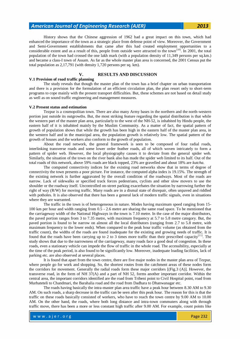
work. Figure 4 (A) and (B) presents tow options for the primary network, one at minimum redevelopment and
the other at some partial redevelopment.
Fig. 3: The sequence of diagrams (A to C), show the basis for the design of the primary network
American Journal of Engineering Research (AJER) 2013
w w w . a j e r . o r g
Page 237
Fig.4: The theoretical network with a minimum redevelopment and with partial redevelopment
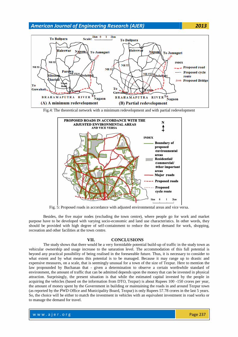
Fig. 5: Proposed roads in accordance with adjusted environmental areas and vice versa.
Besides, the five major nodes (excluding the town centre), where people go for work and market purpose have to be developed with varying socio-economic and land use characteristics. In other words, they
should be provided with high degree of self-containment to reduce the travel demand for work, shopping,
recreation and other facilities at the town centre.
VII. CONCLUSIONS
The study shows that there would be a very formidable potential build-up of traffic in the study town as
vehicular ownership and usage increase to the saturation level. The accommodation of this full potential is
beyond any practical possibility of being realised in the foreseeable future. Thus, it is necessary to consider to
what extent and by what means this potential is to be managed. Because it may range up to drastic and expensive measures, on a scale, that is seemingly unusual for a town of the size of Tezpur. Here to mention the
law propounded by Buchanan that - given a determination to observe a certain worthwhile standard of
environment, the amount of traffic that can be admitted depends upon the money that can be invested in physical
attraction. Surprisingly, the present situation is that while the estimated capital invested by the people in
acquiring the vehicles (based on the information from DTO, Tezpur) is about Rupees 100 -150 crores per year,
the amount of money spent by the Government in building or maintaining the roads in and around Tezpur town
(as reported by the PWD Office and Municipality Board, Tezpur) is only Rupees 57.78 crores in the last 5 years.
So, the choice will be either to match the investment in vehicles with an equivalent investment in road works or
to manage the demand for travel.

American Journal of Engineering Research (AJER) 2013
w w w . a j e r . o r g
Page 238
Turning to the master plan of the study town, it is trying to cope with the steadily increasing volume
of traffic by means of minor alteration. But, as per Buchanan, such a venture will lead to both a poor traffic
access and a grievously eroded environment. So, while supporting Buchanan, this paper wants to emphasise that
the approach used by him seems to provide a reliable base for formulation of suitable plans. Further, in the light
of present study, the paper wants to conclude that the most economical course (though at the first instance, it
seems to be expensive) and probably the best course for Tezpur town would be to build the primary network
along with the by-passes that curtail the load of through traffic. It would be the best choice because it would
immediately give the town a relief from the through traffic and also provide a sound framework on which the
local traffic would build up.
VIII. GLOSSARY
Hollas - low lying marshy/wet lands. Tillas – Low hillocks. Tikas – low plateau like small table lands in
between hollas. Lakh – One lakh means 1, 00,000. Chowk Bazar – the central market place. Kutcha road –
Earthen road. Thela- A light two wheeled carrier-vehicle pushed by a person walking.
IX. ACKNOWLEDGEMENT
We take the pleasure to acknowledge the co-operation and advice received in all aspect of this work
from Dr. Padma Kanta Borah, renowned professor and retired head of the Department of Civil Engineering,
Assam Engineering College, Guwahati.
REFERENCES
[1] D. B. Sarma, Nagar Jyoti (a special souvenir highlighting the achievements in Urban Sector), Urban
Development Department, Government of Assam, Dispur, 2004.
[2] Iacono, Michael, David Levinson, and Ahmed El-Geneidy, Models of Transportation and Land Use
Change: A Guide to the Territory, Journal of Planning Literature 22(4), 2008, 323-340, available at http://www.jpl.sagepub.com/cgi/collection/topcitedtransport
[3] Hardy, H. Matthew, Simplified Integrated Transportation and Land Use Modeling to Support
Metropolitan Planning Decisions: An Application and Assessment, doctoral diss., George Mason
University, Fairfax, VA, 2011, 4-5, available at ProQuest Dissertations and Theses,
http://www.udini.proquest.com/view/simplified-integrated-pqid:2346138251/
[4] L.R. Kadiyali, Traffic Engineering and Transport Planning (Khanna Publishers, New Delhi, 2004) 70-
71, 529-533
[5] M. H. Yeates, An introduction to Quantitative Analysis in Economic Geography (New York: Mc. Graw
Hill Book Co., 1968) 115.
[6] Traffic in Towns: A study of the long term problems of traffic in urban areas: Reports of the Steering
Group and working Group appointed by the Minister of Transport, Her Majesty’s Stationary Office, London, 1963, 41-52.
[7] Historic Newbury fit for the future, West Berkshire Council, 2006, 17, available at
http://www.westberks.gov.uk/media/pdf/h/t/historic_newbury_cs_1.pdf
[8] Kanak Sharma, Tezpur Nam Eto Nagar Bisesh (Self publishing, 2001) 26-27.
[9] The Assam Gazette, Extraordinary, No. 401, Government of Assam, Dispur, 28th Dec., 2007, 2532-2533.
[10] The Assam Gazette, Extraordinary, No. 166, Government of Assam, Dispur, 14th Dec., 1977, 915.