Embed Size (px)
Citation preview
Submitted to: UBC Properties Trust Suite 101 - 555 Great Northern Way Vancouver, British Columbia V5T 1E2
Phone:
Date: May 15, 2019
Submitted by:
Proposed Trail Location and Arborist Assessment For: West Greenway Project University of British Columbia

Proposed Trail Location and Arborist Assessment: UBCPT Western Greenway
3559 Commercial Street, Vancouver B.C. V5N 4E8 | T 604-733-4886 1
The following Diamond Head Consulting staff conducted the on-site tree inventory and prepared or reviewed the report. All staff accreditations are provided below for reference.
Trevor Cox, RPP, MCIP ISA Certified Arborist (PN-1920A) ISA Tree Risk Assessment Qualified (TRAQ) BC Parks Wildlife and Danger Tree Assessor
Conor Corbett MSFM, RPF ISA Certified Arborist (PN-8429A) ISA Tree Risk Assessment Qualified (TRAQ)
Kristian Short, Cert. Horticulture ISA Certified Arborist (PN-8029 A) ISA Tree Risk Assessment Qualified (TRAQ) BC Parks Wildlife and Danger Tree Assessor (P2229)
Please contact us if there are any questions or concerns about the contents of this report. Phone: 604-733-4886 Fax: 604-733-4879 Email: [email protected] or [email protected] Website: www.diamondheadconsulting.com WCB: # 657906 AQ (003)

Proposed Trail Location and Arborist Assessment: UBCPT Western Greenway
3559 Commercial Street, Vancouver B.C. V5N 4E8 | T 604-733-4886 2
Contents 1.0 Introduction ........................................................................................................................... 3
1.1 Scope of Assignment .................................................................................................................................... 3 1.2 Site Overview ............................................................................................................................................... 3
2.0 Process and Methods Trail Location......................................................................................... 6 3.0 Findings: Trees in the Proposed Pathway ................................................................................. 7
3.1 Tree Conflicts ............................................................................................................................................... 7 4.0 Process and Methods Tree Risk Assessment ............................................................................ 9
4.1 Tree Hazards .............................................................................................................................................. 10 5.0 Summary and Conclusions ..................................................................................................... 12 Appendix 1 Report Assumptions and Limiting Conditions .......................................................... 13 Appendix 2 Maps of Trees to be Retained and Removed with the Path Location ........................ 15

Proposed Trail Location and Arborist Assessment: UBCPT Western Greenway
3559 Commercial Street, Vancouver B.C. V5N 4E8 | T 604-733-4886 3
1.0 Introduction 1.1 Scope of Assignment Diamond Head Consulting Ltd. (DHC) was retained to review the location of the proposed trail amongst the trees within the greenway and offer input in relation to the path direction and the potential impact on trees. In addition, select areas were assessed for tree risk. DHC visited the site in April and May of 2019. In preparing this report, we also reviewed the following information:
Arborist Assessment for the Western Greenway Project, report prepared by Diamond Head Consulting Ltd, May 2, 2018.
Tree survey, AutoCad dwg from Murray and Associates (obtained from UBC Properties Trust). Initial trail location, AutoCad dwg from Perry and Associates.
This report is produced with the following primary limitations, detailed limitations specified in Appendix 1:
1) Our investigation is based solely on visual inspection of the trees during our last site visit. 2) This inspection is conducted from ground level and is involves a visual inspection of the tree
from all sides to look at the site, roots, trunk and branches. We do not conduct aerial inspections, soil tests or below grade root examinations to assess the condition of tree root systems unless specifically contracted to do so.
3) Risk assessments consider only known targets and visible tree conditions, and represent the condition at the time of inspection only.
4) Only the trees specified in the scope of work [see the map below indicating the areas assessed] were assessed and assessments were performed within the limitations specified.
5) Risk is assessed in the context of the timeframe specified (1 year). However, it is not a guarantee period for the risk assessment.
6) This report does not provide any estimates to implement the proposed recommendations provided in this report.
7) Tree Risk Assessments were completed following ISA Standards to the accepted industry standard of care. Trees that do not have signs of visible weakness can however fail under abnormal weather conditions and wind events, or in any case where the forces applied exceed the strength of the tree or its parts.
1.2 Site Overview The western greenway is in the South Campus neighbourhood of UBC and is adjoining to the Farm property boundary (see Figure 1 below). It is a well forested, linear strip that is located between Ross Road, and the development that is occurring along it to the south, and the northeastern edge of the Farm. The forest cover is a mixed stand dominated by western redcedar (Thuja plicata) and Douglas-fir (Pseudotsuga mensiezzii). Along the edges of the stand where there has been previous disturbance there is red alder (Alnus rubra) and throughout the stand there are scattered bigleaf maple (Acer macrophyllum), willow (Salix scouleriana hybrid) and cherry (Prunus emarginata). There are a few

Proposed Trail Location and Arborist Assessment: UBCPT Western Greenway
3559 Commercial Street, Vancouver B.C. V5N 4E8 | T 604-733-4886 4
scattered western hemlock (Tsuga heterophylla) trees, a large Sitka spruce (Picea sitchensis) and an arbutus (Arbutus mensiezzii). Both the arbutus (#7292 by the large fir with the eagle’s nest) and spruce (#7256 south of the Polygon Development) are uncommon in this area and region. Within this greenway there are a few factors affecting the overall health of the trees. These include:
1) There are two laminated root rot pockets (Phellinus suphurascens) where large Douglas-fir trees are dead. This disease is significant in that tree species that are susceptible to the disease (Douglas-fir and Western hemlock in this forested area) are infected by root to root contact. Infected trees are prone to failure in any direction with little to no force exerted on them. Western redcedar and deciduous tree species are thought to be resistant to immune to this disease. Fortunately, in both areas near these pockets there are few susceptible species nearby to continue the spread of the disease.
2) Many of the western redcedar in the lower mainland are declining in response to several stressors including climate change and this is being exacerbated by other stressors including development. The forest health specialist from the province stated that “by the end of the 2017 summer, many areas throughout the province were displaying symptoms of drought stress and drought related mortality. On the Coast, the most obvious signs were detected in western redcedar (on drier sites such as rocky outcrops/areas with thin soils and south facing slopes) and young plantations. We anticipate there will be more drought impact that will manifest in 2018 and although we have had periods of drought in the past, what we’ve experienced since the late 90s does seem to be more out of the ordinary.”1
3) Those trees that have been removed for the development to the north of the greenway have left a forested edge that got exposed to light and warmth that it was not accustomed to on the lower canopy levels. The needles on those trees that were in the shade were accustomed to lower light levels (shade needles) and with the new sun exposure had to expend energy to grow new needles to adapt to the sunlight (sun needles). This can take up to three years for the tree to change and if the tree is also experiencing drought, this new needle growth can cause a lot of stress on the tree and cause it to decline. All along the new edge there are smaller western redcedar trees that have died and it is suspected that many died in response the change in light levels.
4) Human caused impacts. Any work near or that changes the hydrology of a site will cause some impact to trees nearby. Some tree species are more susceptible to these changes than others. Western redcedar is one of the more intolerant species found within this stand of trees.
1 Email correspondence with Babita Bains, Provincial Forest Entomologist from Ministry of Forests, Lands and Natural Resource Operations. October 24, 2018.

Proposed Trail Location and Arborist Assessment: UBCPT Western Greenway
3559 Commercial Street, Vancouver B.C. V5N 4E8 | T 604-733-4886 5
Figure 1. The top map indicates the layout of the greenway in relation to Ross Road and the aerial below shows the forested area in relation to the South Campus Neighborhood and the UBC Farm.

Proposed Trail Location and Arborist Assessment: UBCPT Western Greenway
3559 Commercial Street, Vancouver B.C. V5N 4E8 | T 604-733-4886 6
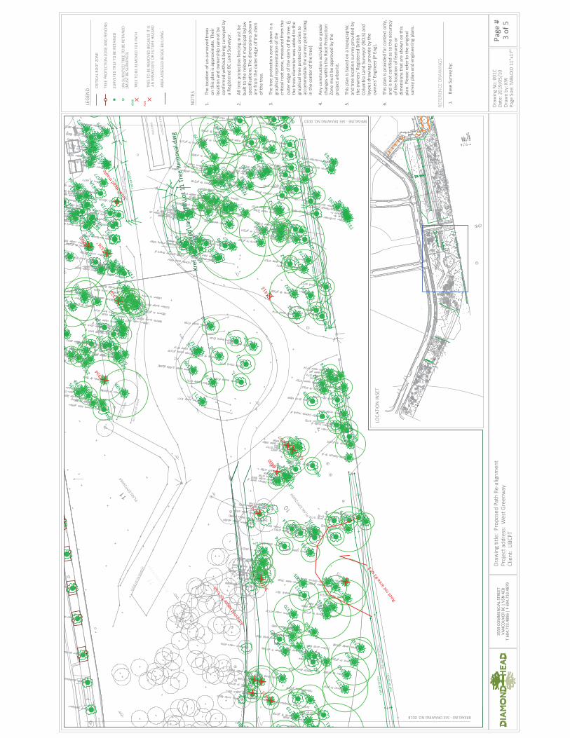
2.0 Process and Methods Trail Location A pathway is proposed within the greenway to help facilitate the movement of people throughout the campus. The pathway is to be a 3-4 meter asphalt path. When it is located amongst trees the path will narrow to 3 meters and may be even narrow where located adjacent to significant trees. The proposed route prepared by Perry and Associates was initially developed considering design principles prepared by UBC Campus Planning. This included the principle that “mature tree root systems, forest soils, understory and mid-canopy vegetation should be retained whenever possible.” It is recommended that the restoration work that is proposed for this area consider placing mulch around those larger western redcedar trees that are in close proximity to the development as they are stressed and will potentially need supplemental irrigation this summer. In addition, it is critical that any machine work that is to be done within the greenway be conducted under supervision or with strict guidelines about what constitutes disturbance of the surrounding ecology and penalties for not following these guidelines. The following maps and tables provide a summary of the trees impacted by the proposed route and those trees that are either dead or considered hazards in relation to the development or people on the trail. The proposed trail is to be built with no excavation in the root zone of trees and in general is to be built above the existing grade. It will meander with the existing topography to help reduce the impacts to the surrounding soils and vegetation. The trail design is to incorporate techniques to allow the passage of air to roots below and help minimize compaction. Appendix 2 provides the maps showing the initial location of the path and where it was re-routed to accommodate mature trees.
Figure 2. A typical trail detail with aerated base material in critical root zones. Asphalt would be placed instead of
clear crush.

Proposed Trail Location and Arborist Assessment: UBCPT Western Greenway
3559 Commercial Street, Vancouver B.C. V5N 4E8 | T 604-733-4886 7
Figure 3. A trail detail from the City of Vancouver showing an asphalt trail over root zones. The aeration pipes
would only be necessary in areas where the depth of the trail is to exceed 0.30m.
3.0 Findings: Trees in the Proposed Pathway 3.1 Tree Conflicts Table 1. Attributes of trees to be removed for the pathway.
Tag # Species DBH (cm)
Ht (m)
Condition Comments
2530 Alder (A. rubra) 30 20 Moderate Single stem, intermediate tree.
2586 Cedar (T. plicata) 27 12 Good Single stem, intermediate.
2509 Maple (A. macrophyllum)
23 15 Moderate
2526 Alder (A. rubra) 21 17 Moderate Phototropic lean west
2530 Alder (A. rubra) 30 20 Moderate Single stem, intermediate tree.
2567 Holly (I. aquifolium) 18 12 Moderate Two main stems
2577 Cedar (T. plicata) 93 25 Moderate Two stems from base, 42 and 51, acute union, small seam.
2586 Cedar (T. plicata) 27 12 Good Single stem, intermediate.
2598 Cedar (T. plicata) 17 12 Poor suppressed
2624 Maple (A. macrophyllum)
28 15 Moderate

Proposed Trail Location and Arborist Assessment: UBCPT Western Greenway
3559 Commercial Street, Vancouver B.C. V5N 4E8 | T 604-733-4886 8
Tag # Species DBH (cm)
Ht (m)
Condition Comments
2636 Alder (A. rubra) 48 18 Moderate
2991 Alder (A. rubra) 16 6 Poor
2994 Alder (A. rubra) 27 18 Good
6658 Alder (A. rubra) 28 18 Moderate
6680 Cedar (T. plicata) 20 5 Poor Adj tree failure broke main stem
6681 Douglas-fir (P. menziesii)
45 27 Poor Lean to W. unsure why, dominant adj fir has very thin crown, possibly root rot.
6800 Alder (A. rubra) 55 17 Dead/Dying 2 stems both in Advanced decline
6892 Hemlock (T. heterophylla)
15 10 Poor
6898 Cedar (T. plicata) 24 12 Moderate
6931 Alder (A. rubra) 24 12 Moderate
6938 Cedar (T. plicata) 28 7 Moderate Two stems
6964 Alder (A. rubra) 20 7 Moderate
6983 Alder (A. rubra) 18 15 Moderate
6990 Birch (B. papyrifera) 21 14 Moderate Suppressed
7300 Cedar (T. plicata) 84 25 Moderate Crooked upper stem
7359 Hemlock (T. heterophylla)
57 28 Poor
Heavy cone crop, thinning crown. Possible decay column, bird activity. New exposure north.
8970 Maple (A. macrophyllum)
20,21,15,10
15 Moderate Coppiced maple, young tree
Table 2. Total number of trees to be removed for the trail by species.
Tree Species Trees to be Removed
Alder (A. rubra) 10
Birch (B. papyrifera) 1
Cedar (T. plicata) 7
Douglas-fir (P. menziesii) 1
Hemlock (T. heterophylla) 2
Holly (I. aquifolium) 1
Maple (A. macrophyllum) 3
Grand Total
25

Proposed Trail Location and Arborist Assessment: UBCPT Western Greenway
3559 Commercial Street, Vancouver B.C. V5N 4E8 | T 604-733-4886 9
4.0 Process and Methods Tree Risk Assessment Tree risk assessments were completed following methods of the ISA Tree Risk Assessment Manual2 published in 2013 by the International Society of Arboriculture, which is the current industry standard for assessing tree risk. This methodology assigns risk based on the likelihood of failure, the likelihood of impact and the severity of consequence if a failure occurs. The likelihood and risk rating matrices used to categorize tree risk are provided below. These two risk rating matrices are taken from the International Society of Arboriculture Tree Risk Assessment Qualification Manual. We conducted a basic assessment from ground level.
Matrix 1: Likelihood
Likelihood of Failure
Likelihood of Impacting Target
Very Low Low Medium High
Imminent Unlikely Somewhat Likely Likely Very Likely
Probable Unlikely Unlikely Somewhat Likely Likely
Possible Unlikely Unlikely Unlikely Somewhat Likely
Improbable Unlikely Unlikely Unlikely Unlikely
Matrix 2: Risk Rating
Likelihood of Failure and Impact
Consequences of Failure
Negligible Minor Significant Severe
Very Likely Low Moderate High Extreme
Likely Low Moderate High High
Somewhat Likely Low Low Moderate Moderate
Unlikely Low Low Low Low
This risk assessment was limited to targets located on the proposed trail as well as the buildings at Lot 8 and Lot 11. No other areas were assessed for targets. Please note that trees that were rated as a moderate risk but had an extreme consequence of failure were noted for removal. In addition, dead trees that could strike a target were also noted. Many of these trees can have a part or parts removed such that they no longer pose a risk to the target. This includes ‘wildlifing’ (cutting it down) to a certain height so that it can continue to provide habitat.
2 Dunster, J.A., Smiley, E.T., Matheny, N. and Lilly, S. (2013). Tree Risk Assessment Manual. International Society of Arboriculture. Champaign, Illinois.

Proposed Trail Location and Arborist Assessment: UBCPT Western Greenway
3559 Commercial Street, Vancouver B.C. V5N 4E8 | T 604-733-4886 10
In addition, some of the recently dead or dying trees have an overall lower risk in that they have yet to decay in such a way that the probability of their failure has increased substantially. There is an opportunity to remove some of these trees in subsequent years. There are operational efficiencies in being able to remove these trees all at once, but it comes at a cost to the habitat that these trees provide. UBC Campus and Community Planning should carefully consider the risk these trees pose versus the habitat they provide in deciding which trees to remove. These trees are identified in Table 5 below. 4.1 Tree Hazards Table 3. Attributes of tree hazards that should be removed/wildlifed prior to trail building.
Tag # Species DBH (cm)
Ht (m)
Condition Comments
2538 Cedar (T. plicata) 43 20 Dead/Dying
2570 Cedar (T. plicata) 62 25 Poor Poor structure
3033 Alder (A. rubra) 26 18 Dead/Dying
4773 Cedar (T. plicata) 83 30 Dead/Dying Dead
4780 Cedar (T. plicata) 35 15 Moderate One main stem, secondary stems growing from large surface roots. Dieback in top
4789 Cedar (T. plicata) 49 18 Moderate Still roots have formed. Large intermediate tree,
6657 Hemlock (T. heterophylla)
38 26 Dead/Dying Dead
6676 Cherry (P. emarginata)
17 16 Dead/Dying Tree is dead and has a high height to diameter ratio
6682 Douglas-fir (P. menziesii)
35 27 Poor Lean to W. unsure why, dominant adj fir has very thin crown, possibly root rot.
6688 Douglas-fir (P. menziesii)
85 40 Poor Very thin. Down, appears to be in decline. Looks like root rot..
6691 Cedar (T. plicata) 22 5 Poor Adj tree failure broke mai stem.
6757 Alder (A. rubra) 34 18 Dead/Dying Dead
6797 Maple (A. macrophyllum)
50 24 Poor Large cavity midstem.
6807 Alder (A. rubra) 25 13 Dead/Dying In advanced decline
6821 Hemlock (T. heterophylla)
26 15 Dead/Dying Dead
7266 Cedar (T. plicata) 77 23 Poor Major decay cavity at base.
7375 Douglas-fir (P. menziesii)
83 40 Poor Sig. dieback in crown. Potential root rot. Can’t confirm.

Proposed Trail Location and Arborist Assessment: UBCPT Western Greenway
3559 Commercial Street, Vancouver B.C. V5N 4E8 | T 604-733-4886 11
Table 4. Total number of immediate hazard trees to be removed or wildlifed.
Tree Species Trees to be Removed
Alder (A. rubra) 3
Cedar (T. plicata) 7
Cherry (P. emarginata) 1
Douglas-fir (P. menziesii) 3
Hemlock (T. heterophylla) 2
Maple (A. macrophyllum) 1
Grand Total
17
Table 5. Attributes of tree hazards that can be removed subsequently if desired.
Tag # Species DBH (cm)
Ht (m)
Condition Comments
413 Maple (A. macrophyllum)
21 15 Dead/Dying Dead tree
773 Cherry (P. emarginata)
33 16 Dead/Dying
2526 Cedar (T. plicata) 65 25 Moderate
2934 Cedar (T. plicata) 35,35 25 Dead/Dying In decline, create wildlife tree such that no part can reach a target. two stems from base.
2934 Cedar (T. plicata) 70 25 Dead/Dying In decline, almost dead
6622 Alder (A. rubra) 99 21 Moderate Two stems from base, 51 and 48 cm
6698 Cedar (T. plicata) 55 20 Dead/Dying Almost dead, in decline
6698 Cedar (T. plicata) 55 20 Dead/Dying In decline, create wildlife tree such that no part can reach a target.
7251 Cedar (T. plicata) 32 18 Dead/Dying In decline
7261 Cedar (T. plicata) 77 25 Poor Dead top
7263 Cedar (T. plicata) 88 19 Moderate Codominant in stand, thinning of foliage. Tree is almost dead .
7271 Cedar (T. plicata) 66 25 Dead/Dying In decline. Dead as of May 2019
7271 Cedar (T. plicata) 68 25 Dead/Dying Tree is dead
7322 Cedar (T. plicata) 30 16 Dead/Dying Almost dead, in decline
7322 Cedar (T. plicata) 30 16 Dead/Dying In decline, create wildlife tree such that no part can reach a target.

Proposed Trail Location and Arborist Assessment: UBCPT Western Greenway
3559 Commercial Street, Vancouver B.C. V5N 4E8 | T 604-733-4886 12
Tag # Species DBH (cm)
Ht (m)
Condition Comments
7326 Cedar (T. plicata) 70 20 Poor In decline almost dead
7326 Cedar (T. plicata) 70 20 Dead/Dying In decline. Create as a wildlife tree to a height that no part can reach a target
Table 6. Total number of trees that can be removed/wildlife in the near future.
Tree Species Trees to be Removed
Alder (A. rubra) 1
Cedar (T. plicata) 14
Cherry (P. emarginata) 1
Maple (A. macrophyllum) 1
Grand Total
17
5.0 Summary and Conclusions In total, 25 trees were found to be in direct conflict with the proposed path. There are 17 trees that are immediate tree hazards and another 17 trees that UBC Campus and Community Planning can determine their risk threshold for recently dead trees adjacent to targets. The time-frame for this risk assessment covers 1 year and is based on the conditions present at the time of assessment. It is up to the risk manager (tree owner or manager) to choose among these risk mitigation options and prioritize the treatments according to their threshold for acceptable risk. It is recommended that trees on-site be inspected adjacent to the trail after construction and a frequency for re-assessment be discussed based on budgets and other tree related policies that UBC adheres to. A tree risk assessment adjacent to the buildings is recommended every two years or at any time site conditions change or after unusual weather events.

Proposed Trail Location and Arborist Assessment: UBCPT Western Greenway
3559 Commercial Street, Vancouver B.C. V5N 4E8 | T 604-733-4886 13
Appendix 1 Report Assumptions and Limiting Conditions 1) Unless expressly set out in this report or these Assumptions and Limiting Conditions, Diamond Head
Consulting Ltd. (“Diamond Head”) makes no guarantee, representation or warranty (express or implied) regarding this report, its findings, conclusions or recommendations contained herein, or the work referred to herein.
2) The work undertaken in connection with this report and preparation of this report have been conducted by Diamond Head for the “Client” as stated in the report above. It is intended for the sole and exclusive use by the Client for the purpose(s) set out in this report. Any use of, reliance on or decisions made based on this report by any person other than the Client, or by the Client for any purpose other than the purpose(s) set out in this report, is the sole responsibility of, and at the sole risk of, such other person or the Client, as the case may be. Diamond Head accepts no liability or responsibility whatsoever for any losses, expenses, damages, fines, penalties or other harm (including without limitation financial or consequential effects on transactions or property values, and economic loss) that may be suffered or incurred by any person as a result of the use of or reliance on this report or the work referred to herein. The copying, distribution or publication of this report (except for the internal use of the Client) without the express written permission of Diamond Head (which consent may be withheld in Diamond Head’s sole discretion) is prohibited. Diamond Head retains ownership of this report and all documents related thereto both generally and as instruments of professional service.
3) The findings, conclusions and recommendations made in this report reflect Diamond Head’s best professional judgment given the information available at the time of preparation. This report has been prepared in a manner consistent with the level of care and skill normally exercised by arborists currently practicing under similar conditions in a similar geographic area and for specific application to the trees subject to this report on the date of this report. Except as expressly stated in this report, the findings, conclusions and recommendations it sets out are valid for the day on which the assessment leading to such findings, conclusions and recommendations was conducted. If generally accepted assessment techniques or prevailing professional standards and best practices change at a future date, modifications to the findings, conclusions, and recommendations in this report may be necessary. Diamond Head expressly excludes any duty to provide any such modification if generally accepted assessment techniques and prevailing professional standards and best practices change.
4) Conditions affecting the trees subject to this report (the “Conditions”, include without limitation, structural defects, scars, decay, fungal fruiting bodies, evidence of insect attack, discoloured foliage, condition of root structures, the degree and direction of lean, the general condition of the tree(s) and the surrounding site, and the proximity of property and people) other than those expressly addressed in this report may exist. Unless otherwise stated information contained in this report covers only those Conditions and trees at the time of inspection. The inspection is limited to visual

Proposed Trail Location and Arborist Assessment: UBCPT Western Greenway
3559 Commercial Street, Vancouver B.C. V5N 4E8 | T 604-733-4886 14
examination of such Conditions and trees without dissection, excavation, probing or coring. While every effort has been made to ensure that any trees recommended for retention are both healthy and safe, no guarantees, representations or warranties are made (express or implied) that those trees will not be subject to structural failure or decline. The Client acknowledges that it is both professionally and practically impossible to predict with absolute certainty the behavior of any single tree, or groups of trees, in all given circumstances. Inevitably, a standing tree will always pose some risk. Most trees have the potential for failure and this risk can only be eliminated if the risk is removed. If Conditions change or if additional information becomes available at a future date, modifications to the findings, conclusions, and recommendations in this report may be necessary. Diamond Head expressly excludes any duty to provide any such modification of Conditions change or additional information becomes available.
5) Nothing in this report is intended to constitute or provide a legal opinion and Diamond Head expressly disclaims any responsibility for matters legal in nature (including, without limitation, matters relating to title and ownership of real or personal property and matters relating to cultural and heritage values). Diamond Head makes no guarantee, representation or warranty (express or implied) as to the requirements of or compliance with applicable laws, rules, regulations, or policies established by federal, provincial, local government or First Nations bodies (collectively, “Government Bodies”) or as to the availability of licenses, permits or authorizations of any Government Body. Revisions to any regulatory standards (including by-laws, policies, guidelines an any similar directions of a Government Bodies in effect from time to time) referred to in this report may be expected over time. As a result, modifications to the findings, conclusions and recommendations in this report may be necessary. Diamond Head expressly excludes any duty to provide any such modification if any such regulatory standard is revised.
6) Diamond Head shall not be required to give testimony or to attend court by reason of this report unless subsequent contractual arrangements are made, including payment of an additional fee for such services as described in the fee schedule and contract of engagement.
7) In preparing this report, Diamond Head has relied in good faith on information provided by certain
persons, Government Bodies, government registries and agents and representatives of each of the foregoing, and Diamond Head assumes that such information is true, correct and accurate in all material respects. Diamond Head accepts no responsibility for any deficiency, misinterpretations or fraudulent acts of or information provided by such persons, bodies, registries, agents and representatives.
8) Sketches, diagrams, graphs, and photographs in this report, being intended as visual aids, are not
necessarily to scale and should not be construed as engineering or architectural reports or surveys.
9) Loss or alteration of any part of this report invalidates the entire report.

Proposed Trail Location and Arborist Assessment: UBCPT Western Greenway
3559 Commercial Street, Vancouver B.C. V5N 4E8 | T 604-733-4886 15
Appendix 2 Maps of Trees to be Retained and Removed with the Path Location

HEDGE
PLAN
BCP3
0252
38
38
PLAN BCP30252
6501
6502
6503
6504 65
05
6506
6507
6508
6556
6557
6623 66
2466
25
6626
6627
6628
6629
8514
8921
8922 89
23
8925
8934
8959
8960
8961
8962
8963 89
64 8965
8966
8967
8968
8969
8970
8971
8972
8973
8974
8975
8976
8977
8978
89798980
8981
8982
8983 8984
8985
8986
898789
8889
89
8990
8991
8992
8996
8998
8999
9000
D1
781
8927
8926
779
8924
773
776
1512
775
Mb
2991
2994
Adjuste
d rou
te fo
r tra
il
Adjuste
d rou
te fo
r tra
il
(ACTI
VE)
BOTTOM OF BANK
STOCK
PILE
S
FARM ACCESS
CO
NC
RET
E PA
D
BUIL
DIN
G
EDGE OF BUSH
HEDGE
EDGE OF BUSH
EDGE OF BUSH
RO
SS D
RIV
E
EDG
E O
F PA
VEM
ENT
FEN
CE
TOP
OF
BAN
K
BOTT
OM
OF
BAN
K
CONCRETE PAD
MEMBRANE
POND
DRIVEWAY
FEN
CE
FEN
CE
SID
EWAL
K
GU
TTER
LIN
E
BOTT
OM
OF
DIT
CH
TOP
OF
DIT
CH
TOP
OF
DIT
CH
TOP
OF
DIT
CH
BOTT
OM
OF
DIT
CH
TOP
OF
DIT
CH
TOP
OF
BANK
BOTT
OM
OF
BAN
K
BOTT
OM
OF
DIT
CH
TOP
OF
DIT
CH
TOP
OF
DIT
CH
SIDEWALK
SID
EWAL
K
GU
TTER
LIN
E
GUTTERLINE
EDG
E O
F PA
VEM
ENT
RO
AD C
ENTE
RLI
NE
EDG
E O
F PA
VEM
ENT
BOTT
OM
OF
BAN
K
FEN
CE
TOP
OF
BAN
K
BOTT
OM
OF
BAN
K
TOP
OF
DIT
CH
BOTT
OM
OF
DIT
CH
TOP
OF
DIT
CH
CONCRETE W
ALL
ROSS
DRI
VE
PLAN
BCP3
0252
PLAN
BCP3
0252
PLAN
EPP
2948
41
PLAN
EPP
2948
4
6
PLAN E
PP2948
4
PLAN
EPP
2948
4
PLAN
EPP
2948
4
8
11
9
10
REF PLAN BCP30253
PLAN
BCP3
0252
24
26
32
38
BIRNEY AVENUE
GRAY AVENUE
NEST
RAPTOR
11
PLAN
EPP
6811
1
PROPO
SED LO
T A
Box
DES
= 114
.3mEL
EVAT
ION
TREE
TOP
= 111
.5mEL
EVAT
ION
TREE
TOP
= 120
.1mEL
EVAT
ION
TREE
TOP
= 107
.7mELE
VATION
TREE
TOP
= 112
.0mEL
EVAT
ION
TREE
TOP
= 115
.8mEL
EVAT
ION
TREE
TOP
26°25'30"
27°33'50"
167°
40'13
"
27°33'50"
52.91
7
167°
40'13
"
45.15
3
77°40'13"
44.845
29°52'13"
110.
313
117°
33'5
0"
38.011
28°57'12"
69.0
58
117°
33'5
0"
69.9
80
117°
33'5
0"
38.000
27°33'50"
Inv.=7
6.31
Inv.=7
5.34 (
E dr
ain)
Inv.=7
5.75(
N drain
)
Inv.=
73.99
Inv.=7
4.07
Inv.=7
6.20
Inv.=
75.9
3
Inv.=7
5.39
Inv.=7
5.44
Inv.=
75.2
7
PLAN
BCP3
0252
PLAN
EPP
2948
4
PLAN
EPP
2948
4
PLAN
EPP
2948
4
7
9
23
RO
SS D
RIV
E38
PT. 24
PLAN BCP30252
10
9
11
PLAN EPP29484
PLAN EPP29484
PLAN EPP29484
PLAN BCP30252
PLAN EPP68111
A
LEG
END
NO
TES
1.
Th
e lo
catio
n of
un-
surv
eyed
tree
son
this
plan
is a
ppro
xim
ate.
The
irlo
catio
n an
d ow
ners
hip
cann
ot b
eco
nfirm
ed w
ithou
t bei
ng su
rvey
ed b
ya
Regi
ster
ed B
C La
nd S
urve
yor.
2.Al
l tre
e pr
otec
tion
fenc
ing
mus
t be
built
to th
e re
leva
nt m
unici
pal b
ylaw
spec
ifica
tions
.The
dim
ensio
ns sh
own
are
from
the
oute
r edg
e of
the
stem
of th
e tr
ee.
3.Th
e tr
ee p
rote
ctio
n zo
ne sh
own
is a
grap
hica
l rep
rese
ntat
ion
of th
ecr
itica
l roo
t zon
e, m
easu
red
from
the
oute
r edg
e of
the
stem
of t
he tr
ee. (
1 2th
e tr
ees d
iam
eter
was
add
ed to
the
grap
hica
l tre
e pr
otec
tion
circle
s to
acco
mm
odat
e th
e su
rvey
poi
nt b
eing
in th
e ce
nter
of t
he tr
ee)
4.An
y co
nstr
uctio
n ac
tiviti
es o
r gra
dech
ange
s with
in th
e Ro
ot P
rote
ctio
nZo
ne m
ust b
e ap
prov
ed b
y th
epr
ojec
t arb
orist
.
5.Th
is pl
an is
bas
ed o
n a
topo
grap
hic
and
tree
loca
tion
surv
ey p
rovi
ded
byth
e ow
ners
’ Reg
ister
ed B
ritish
Colu
mbi
a La
nd S
urve
yor (
BCLS
) and
layo
ut d
raw
ings
pro
vide
by
the
owne
rs’ E
ngin
eer (
P En
g).
6.Th
is pl
an is
pro
vide
d fo
r con
text
onl
y,an
d is
not c
ertif
ied
as to
the
accu
racy
of th
e lo
catio
n of
feat
ures
or
dim
ensio
ns th
at a
re sh
own
on th
ispl
an. P
leas
e re
fer t
o th
e or
igin
alsu
rvey
pla
n an
d en
gine
erin
g pl
ans.
REFE
REN
CE D
RAW
ING
S
1.Ba
se S
urve
y by
:
CRIT
ICAL
RO
OT
ZON
E
TREE
PRO
TECT
ION
ZO
NE
AND
FEN
CIN
G
SURV
EYED
TRE
E TO
BE
RETA
INED
UN
-SU
RVEY
ED T
REE
TO B
E RE
TAIN
ED
Draw
ing
title
: Pr
opos
ed T
rail
Re-a
lignm
ent
Clie
nt:
UBC
PTPr
ojec
t add
ress
: W
est G
reen
way
3559
CO
MM
ERCI
AL S
TREE
TVA
NCO
UVER
BC
| V5
N 4E
8T
604.
733.
4886
| F
604
.733
.487
9
Page
#1
of 5
Date
: 201
9/05
/10
Draw
n by
: KW
Page
Siz
e: T
ABLO
ID 1
1"x1
7"
Draw
ing
No:
001
A
TREE
TO
BE
REM
OVE
D FO
R PA
TH
(MU
ST B
E SU
RVEY
ED)
LOCA
TIO
N IN
SET
BREAKLINE - SEE DRAWING NO. 001B
TREE
TO
BE
REM
OVE
D BE
CAU
SE IT
IS
AN IM
MED
IATE
OR
FUTU
RE H
AZAR
D
8998
7261
AREA
ASS
ESSE
D BE
SIDE
BU
ILDI
NG

(ACTI
VE)
BOTTOM OF BANK
STOCK
PILE
S
EDGE OF BUSH
HEDGE
EDGE OF BUSH
SID
EWAL
K
GU
TTER
LIN
E
RIVE
PLAN
EPP
29
10
PLAN EPP29484
1504
1508
1511
1513
1515
1517
1518
2984 2990
3758
4719
6556 6557
6626
6627
6628
29
6630
6631 66
4466
45 6646
6647
6648
6649
6650
6651
6652 66
53
6656
6657
6658
6659
6660
6661
6662
6663
6664
666566
6666
686669
6670
6671
6672
6673
6674
6675
6676 6678
6679
668066
8166
82
6683
6684
6685
6686
6687
6688
6689
6690
6691 6692
6693 66
94
6695
6676
6788
6795
6818
6868
32
6833
6
6865
6870
6872
6892
6904
6915
6927
6931
6936
6939
6940
6952
6961
6964
6965
6967
6971
6972
6983
6984
6985
6988
6990
6993
6994
6995
6999
7334
7341
7342
7344
7358
7361
7365
7373
7374
73
7377
2991
2994
6938
6979
6898
Root
rot a
rea #
1 of 2
Adjuste
d rou
te fo
r tra
il
(ACTI
VE)
BOTTOM OF BANK
STOCK
PILE
S
FARM ACCESS
CO
NC
RET
E PA
D
BUIL
DIN
G
EDGE OF BUSH
HEDGE
EDGE OF BUSH
EDGE OF BUSH
RO
SS D
RIV
E
EDG
E O
F PA
VEM
ENT
FEN
CE
TOP
OF
BAN
K
BOTT
OM
OF
BAN
K
CONCRETE PAD
MEMBRANE
POND
DRIVEWAY
FEN
CE
FEN
CE
SID
EWAL
K
GU
TTER
LIN
E
BOTT
OM
OF
DIT
CH
TOP
OF
DIT
CH
TOP
OF
DIT
CH
TOP
OF
DIT
CH
BOTT
OM
OF
DIT
CH
TOP
OF
DIT
CH
TOP
OF
BANK
BOTT
OM
OF
BAN
K
BOTT
OM
OF
DIT
CH
TOP
OF
DIT
CH
TOP
OF
DIT
CH
SIDEWALK
SID
EWAL
K
GU
TTER
LIN
E
GUTTERLINE
EDG
E O
F PA
VEM
ENT
RO
AD C
ENTE
RLI
NE
EDG
E O
F PA
VEM
ENT
BOTT
OM
OF
BAN
K
FEN
CE
TOP
OF
BAN
K
BOTT
OM
OF
BAN
K
TOP
OF
DIT
CH
BOTT
OM
OF
DIT
CH
TOP
OF
DIT
CH
CONCRETE W
ALL
ROSS
DRI
VE
PLAN
BCP3
0252
PLAN
BCP3
0252
PLAN
EPP
2948
41
PLAN
EPP
2948
4
6
PLAN E
PP2948
4
PLAN
EPP
2948
4
PLAN
EPP
2948
4
8
11
9
10
REF PLAN BCP30253
PLAN
BCP3
0252
24
26
32
38
BIRNEY AVENUE
GRAY AVENUE
NEST
RAPTOR
11
PLAN
EPP
6811
1
PROPO
SED LO
T A
Box
DES
= 114
.3mEL
EVAT
ION
TREE
TOP
= 111
.5mEL
EVAT
ION
TREE
TOP
= 120
.1mEL
EVAT
ION
TREE
TOP
= 107
.7mELE
VATION
TREE
TOP
= 112
.0mEL
EVAT
ION
TREE
TOP
= 115
.8mEL
EVAT
ION
TREE
TOP
26°25'30"
27°33'50"
167°
40'13
"
27°33'50"
52.91
7
167°
40'13
"
45.15
3
77°40'13"
44.845
29°52'13"
110.
313
117°
33'5
0"
38.011
28°57'12"
69.0
58
117°
33'5
0"
69.9
80
117°
33'5
0"
38.000
27°33'50"
Inv.=7
6.31
Inv.=7
5.34 (
E dr
ain)
Inv.=7
5.75(
N drain
)
Inv.=
73.99
Inv.=7
4.07
Inv.=7
6.20
Inv.=
75.9
3
Inv.=7
5.39
Inv.=7
5.44
Inv.=
75.2
7
PLAN
BCP3
0252
PLAN
EPP
2948
4
PLAN
EPP
2948
4
PLAN
EPP
2948
4
7
9
23
RO
SS D
RIV
E38
PT. 24
PLAN BCP30252
10
9
11
PLAN EPP29484
PLAN EPP29484
PLAN EPP29484
PLAN BCP30252
PLAN EPP68111
A
LEG
END
NO
TES
1.
Th
e lo
catio
n of
un-
surv
eyed
tree
son
this
plan
is a
ppro
xim
ate.
The
irlo
catio
n an
d ow
ners
hip
cann
ot b
eco
nfirm
ed w
ithou
t bei
ng su
rvey
ed b
ya
Regi
ster
ed B
C La
nd S
urve
yor.
2.Al
l tre
e pr
otec
tion
fenc
ing
mus
t be
built
to th
e re
leva
nt m
unici
pal b
ylaw
spec
ifica
tions
.The
dim
ensio
ns sh
own
are
from
the
oute
r edg
e of
the
stem
of th
e tr
ee.
3.Th
e tr
ee p
rote
ctio
n zo
ne sh
own
is a
grap
hica
l rep
rese
ntat
ion
of th
ecr
itica
l roo
t zon
e, m
easu
red
from
the
oute
r edg
e of
the
stem
of t
he tr
ee. (
1 2th
e tr
ees d
iam
eter
was
add
ed to
the
grap
hica
l tre
e pr
otec
tion
circle
s to
acco
mm
odat
e th
e su
rvey
poi
nt b
eing
in th
e ce
nter
of t
he tr
ee)
4.An
y co
nstr
uctio
n ac
tiviti
es o
r gra
dech
ange
s with
in th
e Ro
ot P
rote
ctio
nZo
ne m
ust b
e ap
prov
ed b
y th
epr
ojec
t arb
orist
.
5.Th
is pl
an is
bas
ed o
n a
topo
grap
hic
and
tree
loca
tion
surv
ey p
rovi
ded
byth
e ow
ners
’ Reg
ister
ed B
ritish
Colu
mbi
a La
nd S
urve
yor (
BCLS
) and
layo
ut d
raw
ings
pro
vide
by
the
owne
rs’ E
ngin
eer (
P En
g).
6.Th
is pl
an is
pro
vide
d fo
r con
text
onl
y,an
d is
not c
ertif
ied
as to
the
accu
racy
of th
e lo
catio
n of
feat
ures
or
dim
ensio
ns th
at a
re sh
own
on th
ispl
an. P
leas
e re
fer t
o th
e or
igin
alsu
rvey
pla
n an
d en
gine
erin
g pl
ans.
REFE
REN
CE D
RAW
ING
S
1.Ba
se S
urve
y by
:
CRIT
ICAL
RO
OT
ZON
E
TREE
PRO
TECT
ION
ZO
NE
AND
FEN
CIN
G
SURV
EYED
TRE
E TO
BE
RETA
INED
UN
-SU
RVEY
ED T
REE
TO B
E RE
TAIN
ED
Draw
ing
title
: Pr
opos
ed P
ath
Re-a
lignm
ent
Clie
nt:
UBC
PTPr
ojec
t add
ress
: W
est G
reen
way
3559
CO
MM
ERCI
AL S
TREE
TVA
NCO
UVER
BC
| V5
N 4E
8T
604.
733.
4886
| F
604
.733
.487
9
Page
#2
of 5
Date
: 201
9/05
/10
Draw
n by
: KW
Page
Siz
e: T
ABLO
ID 1
1"x1
7"
Draw
ing
No:
001
B
(MU
ST B
E SU
RVEY
ED)
LOCA
TIO
N IN
SET
BREAKLINE - SEE DRAWING NO. 001C
BREAKLINE - SEE DRAWING NO. 001A
TREE
TO
BE
REM
OVE
D FO
R PA
TH89
98
TREE
TO
BE
REM
OVE
D BE
CAU
SE IT
IS
7261
AN IM
MED
IATE
OR
FUTU
RE H
AZAR
D
AREA
ASS
ESSE
D BE
SIDE
BU
ILDI
NG
Xref
.\Re
ceiv
ed\J
an 2
018\
Lot 1
1 Tr
ee R
emov
al.d
wgC
ON
CR
ETE
PAD
BUIL
DIN
G
EDG
E O
F PA
VEM
ENT
DEW
ALK
BOTT
OM
OF
DIT
CH
TOP
OF
DIT
CH
TOP
OF
DIT
CH
TOP
OF
DIT
CH
BOTT
OM
OF
DIT
CH
TOP
OF
DIT
CH
TOP
OF
BANK
BOTT
OM
OF
BAN
K
BOTT
OM
OF
DIT
CH
TOP
OF
DIT
CH
TOP
OF
DIT
CH
PLAN
EPP
2948
4
PLAN
EPP
2948
411
10
NER
11
11
PLAN EPP29484
670
119
2593
2596
2599
2930
2933
2934
2935
2937
2939
2940
2943
2944
2945
2946
2947
2950
2951
3002
3003 3005
3006
3011
3013 30
2330
32
3033
4719
4763
6600
660
6602
6604
6609
6613
6614
6617
6617
6797
6624
6627
6634
6642
6645
6647
6648
6649
6650 66
51
6652
6653
665466
5566
56
66
6658
6661
66626663
6664
6666
6668
6669
667066
71
6672
6673
6674
6675
6676
6677
6678
6679
6680
6681
A
6682
6683
6684 66
856689
6690
6691
6693
6694
6695
6696
6697
6698
669967
00
6701 67
02
6703
6705
6707
6708
6710
6711
6712
6713
6716
6718
6719
6720
6721
6722
6723
6724
6725
6726
6727
6729
6731
6732
6733
6734
6735
6738
6740
6741
6742
6745
6745
6746
6747
6748
6750
6752
6753
6755
6756
6757
6758 67
60
6761
6762
6762
6763
6763
6765
6766
6767
6768
6769
6770
6771
6772
6773
6774
6775
6776
6778
6779
6782
6785
6788
6790
6792
679467
96
6798
6802
6803
6804
6805
6806
6806
6807
6809
6817
6818
6821
6824
6828
6838
6838 68
4068
42
6843
6859
6861
6864
6867
6868
6870
6871
6887
6904
6908
6914
15
7272
7274
7275
7276
7277
7278
7279
7281
7281
7282
7283
7284
7285
7286
7287
7288
7291
7292
7293
7294
7295
7296
7297
7309
7317
7319
7322
7324
7326
7329
7330
7331
7332
7335
7336 73
38
341
7359
7360
7362
7363
7364
7368
7370
7371
7372
7375
7376
7379
7381
1109
1109
8
6866
6869
6800
Root
rot a
rea #
1 of 2
Adjuste
d rou
te fo
r tra
il
413
Small
dead
map
le
(ACTI
VE)
BOTTOM OF BANK
STOCK
PILE
S
FARM ACCESS
CO
NC
RET
E PA
D
BUIL
DIN
G
EDGE OF BUSH
HEDGE
EDGE OF BUSH
EDGE OF BUSH
RO
SS D
RIV
E
EDG
E O
F PA
VEM
ENT
FEN
CE
TOP
OF
BAN
K
BOTT
OM
OF
BAN
K
CONCRETE PAD
MEMBRANE
POND
DRIVEWAY
FEN
CE
FEN
CE
SID
EWAL
K
GU
TTER
LIN
E
BOTT
OM
OF
DIT
CH
TOP
OF
DIT
CH
TOP
OF
DIT
CH
TOP
OF
DIT
CH
BOTT
OM
OF
DIT
CH
TOP
OF
DIT
CH
TOP
OF
BANK
BOTT
OM
OF
BAN
K
BOTT
OM
OF
DIT
CH
TOP
OF
DIT
CH
TOP
OF
DIT
CH
SIDEWALK
SID
EWAL
K
GU
TTER
LIN
E
GUTTERLINE
EDG
E O
F PA
VEM
ENT
RO
AD C
ENTE
RLI
NE
EDG
E O
F PA
VEM
ENT
BOTT
OM
OF
BAN
K
FEN
CE
TOP
OF
BAN
K
BOTT
OM
OF
BAN
K
TOP
OF
DIT
CH
BOTT
OM
OF
DIT
CH
TOP
OF
DIT
CH
CONCRETE W
ALL
ROSS
DRI
VE
PLAN
BCP3
0252
PLAN
BCP3
0252
PLAN
EPP
2948
41
PLAN
EPP
2948
4
6
PLAN E
PP2948
4
PLAN
EPP
2948
4
PLAN
EPP
2948
4
8
11
9
10
REF PLAN BCP30253
PLAN
BCP3
0252
24
26
32
38
BIRNEY AVENUE
GRAY AVENUE
NEST
RAPTOR
11
PLAN
EPP
6811
1
PROPO
SED LO
T A
Box
DES
= 114
.3mEL
EVAT
ION
TREE
TOP
= 111
.5mEL
EVAT
ION
TREE
TOP
= 120
.1mEL
EVAT
ION
TREE
TOP
= 107
.7mELE
VATION
TREE
TOP
= 112
.0mEL
EVAT
ION
TREE
TOP
= 115
.8mEL
EVAT
ION
TREE
TOP
26°25'30"
27°33'50"
167°
40'13
"
27°33'50"
52.91
7
167°
40'13
"
45.15
3
77°40'13"
44.845
29°52'13"
110.
313
117°
33'5
0"
38.011
28°57'12"
69.0
58
117°
33'5
0"
69.9
80
117°
33'5
0"
38.000
27°33'50"
Inv.=7
6.31
Inv.=7
5.34 (
E dr
ain)
Inv.=7
5.75(
N drain
)
Inv.=
73.99
Inv.=7
4.07
Inv.=7
6.20
Inv.=
75.9
3
Inv.=7
5.39
Inv.=7
5.44
Inv.=
75.2
7
PLAN
BCP3
0252
PLAN
EPP
2948
4
PLAN
EPP
2948
4
PLAN
EPP
2948
4
7
9
23
RO
SS D
RIV
E38
PT. 24
PLAN BCP30252
10
9
11
PLAN EPP29484
PLAN EPP29484
PLAN EPP29484
PLAN BCP30252
PLAN EPP68111
A
6630
LEG
END
NO
TES
1.
Th
e lo
catio
n of
un-
surv
eyed
tree
son
this
plan
is a
ppro
xim
ate.
The
irlo
catio
n an
d ow
ners
hip
cann
ot b
eco
nfirm
ed w
ithou
t bei
ng su
rvey
ed b
ya
Regi
ster
ed B
C La
nd S
urve
yor.
2.Al
l tre
e pr
otec
tion
fenc
ing
mus
t be
built
to th
e re
leva
nt m
unici
pal b
ylaw
spec
ifica
tions
.The
dim
ensio
ns sh
own
are
from
the
oute
r edg
e of
the
stem
of th
e tr
ee.
3.Th
e tr
ee p
rote
ctio
n zo
ne sh
own
is a
grap
hica
l rep
rese
ntat
ion
of th
ecr
itica
l roo
t zon
e, m
easu
red
from
the
oute
r edg
e of
the
stem
of t
he tr
ee. (
1 2th
e tr
ees d
iam
eter
was
add
ed to
the
grap
hica
l tre
e pr
otec
tion
circle
s to
acco
mm
odat
e th
e su
rvey
poi
nt b
eing
in th
e ce
nter
of t
he tr
ee)
4.An
y co
nstr
uctio
n ac
tiviti
es o
r gra
dech
ange
s with
in th
e Ro
ot P
rote
ctio
nZo
ne m
ust b
e ap
prov
ed b
y th
epr
ojec
t arb
orist
.
5.Th
is pl
an is
bas
ed o
n a
topo
grap
hic
and
tree
loca
tion
surv
ey p
rovi
ded
byth
e ow
ners
’ Reg
ister
ed B
ritish
Colu
mbi
a La
nd S
urve
yor (
BCLS
) and
layo
ut d
raw
ings
pro
vide
by
the
owne
rs’ E
ngin
eer (
P En
g).
6.Th
is pl
an is
pro
vide
d fo
r con
text
onl
y,an
d is
not c
ertif
ied
as to
the
accu
racy
of th
e lo
catio
n of
feat
ures
or
dim
ensio
ns th
at a
re sh
own
on th
ispl
an. P
leas
e re
fer t
o th
e or
igin
alsu
rvey
pla
n an
d en
gine
erin
g pl
ans.
REFE
REN
CE D
RAW
ING
S
1.Ba
se S
urve
y by
:
CRIT
ICAL
RO
OT
ZON
E
TREE
PRO
TECT
ION
ZO
NE
AND
FEN
CIN
G
SURV
EYED
TRE
E TO
BE
RETA
INED
UN
-SU
RVEY
ED T
REE
TO B
E RE
TAIN
ED
3559
CO
MM
ERCI
AL S
TREE
TVA
NCO
UVER
BC
| V5
N 4E
8T
604.
733.
4886
| F
604
.733
.487
9
Page
#3
of 5
Date
: 201
9/05
/10
Draw
n by
: KW
Page
Siz
e: T
ABLO
ID 1
1"x1
7"
Draw
ing
No:
001
C
(MU
ST B
E SU
RVEY
ED)
LOCA
TIO
N IN
SET
BREAKLINE - SEE DRAWING NO. 001D
BREAKLINE - SEE DRAWING NO. 001B
Draw
ing
title
: Pr
opos
ed P
ath
Re-a
lignm
ent
Clie
nt:
UBC
PTPr
ojec
t add
ress
: W
est G
reen
way
TREE
TO
BE
REM
OVE
D FO
R PA
TH
TREE
TO
BE
REM
OVE
D BE
CAU
SE IT
IS
AN IM
MED
IATE
OR
FUTU
RE H
AZAR
D
AREA
ASS
ESSE
D BE
SIDE
BU
ILDI
NG
8998
7261

al.d
wg
FARM ACCESS
CO
NC
RET
E PA
D
BUIL
DIN
G
EDGE OF BUSH
EDG
E O
F PA
VEM
ENT
RO
AD C
ENTE
RLI
NE
EDG
E O
F PA
VEM
ENT
BOTT
OM
OF
BAN
K
FEN
CE
PLAN
EPP
6811
1
PROPO
SED
= 11
4.3m
ELEV
ATIO
N
TREE
TOP
= 11
2.0m
ELEV
ATIO
N
TREE
TOP
= 11
5.8m
ELEV
ATIO
N
TREE
TOP
117°
33'5
0"
38.011
28°57'12"
69.0
58
117°
33'5
0"
117°
33'5
0"
38.000
27°33'50"
Inv.=
76.31
PLAN
EPP
2948
4
PLAN
EPP
2948
4
7
9
9
PLAN EPP2948
PLAN EPP68111
A
2631
2617
2632
1035
2501
2502
2502
2504
2504
2505
2506
2509
2511
2512
2515
2516 25
17
2522
2523
2524
2525
25252526
2527
252925
30
2531
2532
2533
2536
2537
2538
2539
2540
2541
2544
2545
2546
2547
2548
2552
2555
2559
2561
2564
2565
2569
2571
2572
2577
2579
2582
2584
2585
2586
2
2588
259
2600
2604
2605
2607
2608
2610
2611
2612
2614
2618
2619
2620
2623
2624
2625 26
26
2628
2629
2633
2639
2640
2641
2642
2643
2644
2648
2649
2650
2651
2653
2656
2657
2659
2660
2661
2664
2668
2671
2672
2674
2677
2678
2679
2680
26812682 26
83 2684
2685
268626
87
2688
2689
2690
2691
2692
269426
95
4766
4771
4778
4786
4788
5270
6600
6601
6603
6606
6611
6621
6623
6625
6626
27
6631
6633
6638
6640
6641
642
6645
6646
665466
5566
56
6656
6660
6661
66626663
6665
6666
6669
6672
6673
7273
7279 7284
7285
7289
7297
7300
7301
7303
7304
7306
7307
7310
7311
731273
1373
14 7315
7316
7318
7323
4
7325
7327
1053
0
1053
110
533
2675
2508
2609
2621
6620
6629
2634
2693
2597
1286
2603
2630
2654
2655
2658
2663
2665
2673
2636
6622
- rem
ove n
orth
stem
Adjuste
d rou
te fo
r tra
ilAdju
sted r
oute
for t
rail
A
(ACTI
VE)
BOTTOM OF BANK
STOCK
PILE
S
FARM ACCESS
CO
NC
RET
E PA
D
BUIL
DIN
G
EDGE OF BUSH
HEDGE
EDGE OF BUSH
EDGE OF BUSH
RO
SS D
RIV
E
EDG
E O
F PA
VEM
ENT
FEN
CE
TOP
OF
BAN
K
BOTT
OM
OF
BAN
K
CONCRETE PAD
MEMBRANE
POND
DRIVEWAY
FEN
CE
FEN
CE
SID
EWAL
K
GU
TTER
LIN
E
BOTT
OM
OF
DIT
CH
TOP
OF
DIT
CH
TOP
OF
DIT
CH
TOP
OF
DIT
CH
BOTT
OM
OF
DIT
CH
TOP
OF
DIT
CH
TOP
OF
BANK
BOTT
OM
OF
BAN
K
BOTT
OM
OF
DIT
CH
TOP
OF
DIT
CH
TOP
OF
DIT
CH
SIDEWALK
SID
EWAL
K
GU
TTER
LIN
E
GUTTERLINE
EDG
E O
F PA
VEM
ENT
RO
AD C
ENTE
RLI
NE
EDG
E O
F PA
VEM
ENT
BOTT
OM
OF
BAN
K
FEN
CE
TOP
OF
BAN
K
BOTT
OM
OF
BAN
K
TOP
OF
DIT
CH
BOTT
OM
OF
DIT
CH
TOP
OF
DIT
CH
CONCRETE W
ALL
ROSS
DRI
VE
PLAN
BCP3
0252
PLAN
BCP3
0252
PLAN
EPP
2948
41
PLAN
EPP
2948
4
6
PLAN E
PP2948
4
PLAN
EPP
2948
4
PLAN
EPP
2948
4
8
11
9
10
REF PLAN BCP30253
PLAN
BCP3
0252
24
26
32
38
BIRNEY AVENUE
GRAY AVENUE
NEST
RAPTOR
11
PLAN
EPP
6811
1
PROPO
SED LO
T A
Box
DES
= 114
.3mEL
EVAT
ION
TREE
TOP
= 111
.5mEL
EVAT
ION
TREE
TOP
= 120
.1mEL
EVAT
ION
TREE
TOP
= 107
.7mELE
VATION
TREE
TOP
= 112
.0mEL
EVAT
ION
TREE
TOP
= 115
.8mEL
EVAT
ION
TREE
TOP
26°25'30"
27°33'50"
167°
40'13
"
27°33'50"
52.91
7
167°
40'13
"
45.15
3
77°40'13"
44.845
29°52'13"
110.
313
117°
33'5
0"
38.011
28°57'12"
69.0
58
117°
33'5
0"
69.9
80
117°
33'5
0"
38.000
27°33'50"
Inv.=7
6.31
Inv.=7
5.34 (
E dr
ain)
Inv.=7
5.75(
N drain
)
Inv.=
73.99
Inv.=7
4.07
Inv.=7
6.20
Inv.=
75.9
3
Inv.=7
5.39
Inv.=7
5.44
Inv.=
75.2
7
PLAN
BCP3
0252
PLAN
EPP
2948
4
PLAN
EPP
2948
4
PLAN
EPP
2948
4
7
9
23
RO
SS D
RIV
E38
PT. 24
PLAN BCP30252
10
9
11
PLAN EPP29484
PLAN EPP29484
PLAN EPP29484
PLAN BCP30252
PLAN EPP68111
A
6630
LEG
END
NO
TES
1.
Th
e lo
catio
n of
un-
surv
eyed
tree
son
this
plan
is a
ppro
xim
ate.
The
irlo
catio
n an
d ow
ners
hip
cann
ot b
eco
nfirm
ed w
ithou
t bei
ng su
rvey
ed b
ya
Regi
ster
ed B
C La
nd S
urve
yor.
2.Al
l tre
e pr
otec
tion
fenc
ing
mus
t be
built
to th
e re
leva
nt m
unici
pal b
ylaw
spec
ifica
tions
.The
dim
ensio
ns sh
own
are
from
the
oute
r edg
e of
the
stem
of th
e tr
ee.
3.Th
e tr
ee p
rote
ctio
n zo
ne sh
own
is a
grap
hica
l rep
rese
ntat
ion
of th
ecr
itica
l roo
t zon
e, m
easu
red
from
the
oute
r edg
e of
the
stem
of t
he tr
ee. (
1 2th
e tr
ees d
iam
eter
was
add
ed to
the
grap
hica
l tre
e pr
otec
tion
circle
s to
acco
mm
odat
e th
e su
rvey
poi
nt b
eing
in th
e ce
nter
of t
he tr
ee)
4.An
y co
nstr
uctio
n ac
tiviti
es o
r gra
dech
ange
s with
in th
e Ro
ot P
rote
ctio
nZo
ne m
ust b
e ap
prov
ed b
y th
epr
ojec
t arb
orist
.
5.Th
is pl
an is
bas
ed o
n a
topo
grap
hic
and
tree
loca
tion
surv
ey p
rovi
ded
byth
e ow
ners
’ Reg
ister
ed B
ritish
Colu
mbi
a La
nd S
urve
yor (
BCLS
) and
layo
ut d
raw
ings
pro
vide
by
the
owne
rs’ E
ngin
eer (
P En
g).
6.Th
is pl
an is
pro
vide
d fo
r con
text
onl
y,an
d is
not c
ertif
ied
as to
the
accu
racy
of th
e lo
catio
n of
feat
ures
or
dim
ensio
ns th
at a
re sh
own
on th
ispl
an. P
leas
e re
fer t
o th
e or
igin
alsu
rvey
pla
n an
d en
gine
erin
g pl
ans.
REFE
REN
CE D
RAW
ING
S
1.Ba
se S
urve
y by
:
CRIT
ICAL
RO
OT
ZON
E
TREE
PRO
TECT
ION
ZO
NE
AND
FEN
CIN
G
SURV
EYED
TRE
E TO
BE
RETA
INED
UN
-SU
RVEY
ED T
REE
TO B
E RE
TAIN
ED
3559
CO
MM
ERCI
AL S
TREE
TVA
NCO
UVER
BC
| V5
N 4E
8T
604.
733.
4886
| F
604
.733
.487
9
Page
#4
of 5
Date
: 201
9/05
/10
Draw
n by
: KW
Page
Siz
e: T
ABLO
ID 1
1"x1
7"
Draw
ing
No:
001
D
(MU
ST B
E SU
RVEY
ED)
LOCA
TIO
N IN
SET
BREAKLINE - SEE DRAWING NO. 001E
BREAKLINE - SEE DRAWING NO. 001C
Draw
ing
title
: Pr
opos
ed P
ath
Re-a
lignm
ent
Clie
nt:
UBC
PTPr
ojec
t add
ress
: W
est G
reen
way
TREE
TO
BE
REM
OVE
D FO
R PA
TH
TREE
TO
BE
REM
OVE
D BE
CAU
SE IT
IS
AN IM
MED
IATE
OR
FUTU
RE H
AZAR
D
8998
7261

FEN
CE
CO
POND
BOTTOM OF RETAINING WALL
TOP OF RETAINING WALL
DRIVEWAY
SHED
FEN
CE
TOP
OF
BAN
K
BOTT
OM
OF
BAN
K
TOP
OF
DIT
CH
BOTT
OM
OF
DIT
CH
TOP
OF
DIT
CH
HEDG
E
PLAN
EPP
2948
4
8
9
= 11
1.5m
ELEV
ATIO
N
TREE
TOP
= 12
0.1m
ELEV
ATIO
N
TREE
TOP
= 10
7.7m
ELEV
ATIO
N
TREE
TOP
26°25'30"
27°33'50"
29°52'13"
110.
313
117°
33'5
0"
PLAN
EPP
2948
4
9
PLAN EPP29484
11
2555
2602
2502
2510
2518
2519
2520
2520
2522
2524
25252526
2526
2527
2528
2528
2529
2530
2531
2532
2533
2534
2535
2535
2536
7 9
2539
2540
2540
2541
2542
2543
2544
2545
2546
2547
2548
2550
2551
2552
2553 25
54
2557
2558
2559
2560
2561
2563
2564
2565
2566
2568
2569
2570
2572
2574
2575
2576
2578
2580
2581
2584
2585
2586
2587
2588
258925
90
2591
2592
2594
2595
2598 25
99
2601
2604
2606
0
2613
2614
2616
2622
2624
2625 26
26
4773
4774 4775
4777
4778
4779
4780
4781
4782
4783
4784
4785
4787
4789
4790
4791
4792
4793
4794
4805 4806
4807
4808
4810
4811
4812
4813
4814
4815
4816
4817
4818
4821
4822
4823
4824
4825
482648
27
4828
4829
4830
4849
4857
6583
6945
7251
7253
7255
7256
7258
7260
7261
7263
761
7266
7267
7268
7270
7271
7352
7395
7396
7425
7427
7444
7446
7
7453
1053
0
2609
2621
2549
2556
2577
2597
1286
2603Adju
sted r
oute
for t
rail
Adjuste
d rou
te fo
r tra
il
Adjuste
d rou
te fo
r tra
il
(ACTI
VE)
BOTTOM OF BANK
STOCK
PILE
S
FARM ACCESS
CO
NC
RET
E PA
D
BUIL
DIN
G
EDGE OF BUSH
HEDGE
EDGE OF BUSH
EDGE OF BUSH
RO
SS D
RIV
E
EDG
E O
F PA
VEM
ENT
FEN
CE
TOP
OF
BAN
K
BOTT
OM
OF
BAN
K
CONCRETE PAD
MEMBRANE
POND
DRIVEWAY
FEN
CE
FEN
CE
SID
EWAL
K
GU
TTER
LIN
E
BOTT
OM
OF
DIT
CH
TOP
OF
DIT
CH
TOP
OF
DIT
CH
TOP
OF
DIT
CH
BOTT
OM
OF
DIT
CH
TOP
OF
DIT
CH
TOP
OF
BANK
BOTT
OM
OF
BAN
K
BOTT
OM
OF
DIT
CH
TOP
OF
DIT
CH
TOP
OF
DIT
CH
SIDEWALK
SID
EWAL
K
GU
TTER
LIN
E
GUTTERLINE
EDG
E O
F PA
VEM
ENT
RO
AD C
ENTE
RLI
NE
EDG
E O
F PA
VEM
ENT
BOTT
OM
OF
BAN
K
FEN
CE
TOP
OF
BAN
K
BOTT
OM
OF
BAN
K
TOP
OF
DIT
CH
BOTT
OM
OF
DIT
CH
TOP
OF
DIT
CH
CONCRETE W
ALL
ROSS
DRI
VE
PLAN
BCP3
0252
PLAN
BCP3
0252
PLAN
EPP
2948
41
PLAN
EPP
2948
4
6
PLAN E
PP2948
4
PLAN
EPP
2948
4
PLAN
EPP
2948
4
8
11
9
10
REF PLAN BCP30253
PLAN
BCP3
0252
24
26
32
38
BIRNEY AVENUE
GRAY AVENUE
NEST
RAPTOR
11
PLAN
EPP
6811
1
PROPO
SED LO
T A
Box
DES
= 114
.3mEL
EVAT
ION
TREE
TOP
= 111
.5mEL
EVAT
ION
TREE
TOP
= 120
.1mEL
EVAT
ION
TREE
TOP
= 107
.7mELE
VATION
TREE
TOP
= 112
.0mEL
EVAT
ION
TREE
TOP
= 115
.8mEL
EVAT
ION
TREE
TOP
26°25'30"
27°33'50"
167°
40'13
"
27°33'50"
52.91
7
167°
40'13
"
45.15
3
77°40'13"
44.845
29°52'13"
110.
313
117°
33'5
0"
38.011
28°57'12"
69.0
58
117°
33'5
0"
69.9
80
117°
33'5
0"
38.000
27°33'50"
Inv.=7
6.31
Inv.=7
5.34 (
E dr
ain)
Inv.=7
5.75(
N drain
)
Inv.=
73.99
Inv.=7
4.07
Inv.=7
6.20
Inv.=
75.9
3
Inv.=7
5.39
Inv.=7
5.44
Inv.=
75.2
7
PLAN
BCP3
0252
PLAN
EPP
2948
4
PLAN
EPP
2948
4
PLAN
EPP
2948
4
7
9
23
RO
SS D
RIV
E38
PT. 24
PLAN BCP30252
10
9
11
PLAN EPP29484
PLAN EPP29484
PLAN EPP29484
PLAN BCP30252
PLAN EPP68111
A
6630
LEG
END
NO
TES
1.
Th
e lo
catio
n of
un-
surv
eyed
tree
son
this
plan
is a
ppro
xim
ate.
The
irlo
catio
n an
d ow
ners
hip
cann
ot b
eco
nfirm
ed w
ithou
t bei
ng su
rvey
ed b
ya
Regi
ster
ed B
C La
nd S
urve
yor.
2.Al
l tre
e pr
otec
tion
fenc
ing
mus
t be
built
to th
e re
leva
nt m
unici
pal b
ylaw
spec
ifica
tions
.The
dim
ensio
ns sh
own
are
from
the
oute
r edg
e of
the
stem
of th
e tr
ee.
3.Th
e tr
ee p
rote
ctio
n zo
ne sh
own
is a
grap
hica
l rep
rese
ntat
ion
of th
ecr
itica
l roo
t zon
e, m
easu
red
from
the
oute
r edg
e of
the
stem
of t
he tr
ee. (
1 2th
e tr
ees d
iam
eter
was
add
ed to
the
grap
hica
l tre
e pr
otec
tion
circle
s to
acco
mm
odat
e th
e su
rvey
poi
nt b
eing
in th
e ce
nter
of t
he tr
ee)
4.An
y co
nstr
uctio
n ac
tiviti
es o
r gra
dech
ange
s with
in th
e Ro
ot P
rote
ctio
nZo
ne m
ust b
e ap
prov
ed b
y th
epr
ojec
t arb
orist
.
5.Th
is pl
an is
bas
ed o
n a
topo
grap
hic
and
tree
loca
tion
surv
ey p
rovi
ded
byth
e ow
ners
’ Reg
ister
ed B
ritish
Colu
mbi
a La
nd S
urve
yor (
BCLS
) and
layo
ut d
raw
ings
pro
vide
by
the
owne
rs’ E
ngin
eer (
P En
g).
6.Th
is pl
an is
pro
vide
d fo
r con
text
onl
y,an
d is
not c
ertif
ied
as to
the
accu
racy
of th
e lo
catio
n of
feat
ures
or
dim
ensio
ns th
at a
re sh
own
on th
ispl
an. P
leas
e re
fer t
o th
e or
igin
alsu
rvey
pla
n an
d en
gine
erin
g pl
ans.
REFE
REN
CE D
RAW
ING
S
1.Ba
se S
urve
y by
:
CRIT
ICAL
RO
OT
ZON
E
TREE
PRO
TECT
ION
ZO
NE
AND
FEN
CIN
G
SURV
EYED
TRE
E TO
BE
RETA
INED
UN
-SU
RVEY
ED T
REE
TO B
E RE
TAIN
ED
3559
CO
MM
ERCI
AL S
TREE
TVA
NCO
UVER
BC
| V5
N 4E
8T
604.
733.
4886
| F
604
.733
.487
9
Page
#5
of 5
Date
: 201
9/05
/10
Draw
n by
: KW
Page
Siz
e: T
ABLO
ID 1
1"x1
7"
Draw
ing
No:
001
E
(MU
ST B
E SU
RVEY
ED)
LOCA
TIO
N IN
SET
BREAKLINE - SEE DRAWING NO. 001D
Draw
ing
title
: Pr
opos
ed P
ath
Re-a
lignm
ent
Clie
nt:
UBC
PTPr
ojec
t add
ress
: W
est G
reen
way
TREE
TO
BE
REM
OVE
D FO
R PA
TH
TREE
TO
BE
REM
OVE
D BE
CAU
SE IT
IS
AN IM
MED
IATE
OR
FUTU
RE H
AZAR
D
AREA
ASS
ESSE
D BE
SIDE
BU
ILDI
NG
8998
7261