Embed Size (px)
Citation preview
289 Great Road, Suite 202 Acton, Massachusetts 01720
PH 978.263.9588 FAX 978.263.9594
www.geosyntec.com
Proposed Omya MonPlan Revisions 2016 (R1)
M e m o r a n d u m
To: James "Buzz" Surwilo, VTDEC Waste Management
Michael Laurent, Omya, Inc.
From: Rhiannon Scott PhD, David Adilman PG; Geosyntec Consultants
Date: 29 April 2016
Subject: Proposed Modifications to the Approved Monitoring Plan, Omya Verpol Site and Hogback Quarry, Florence, VT.
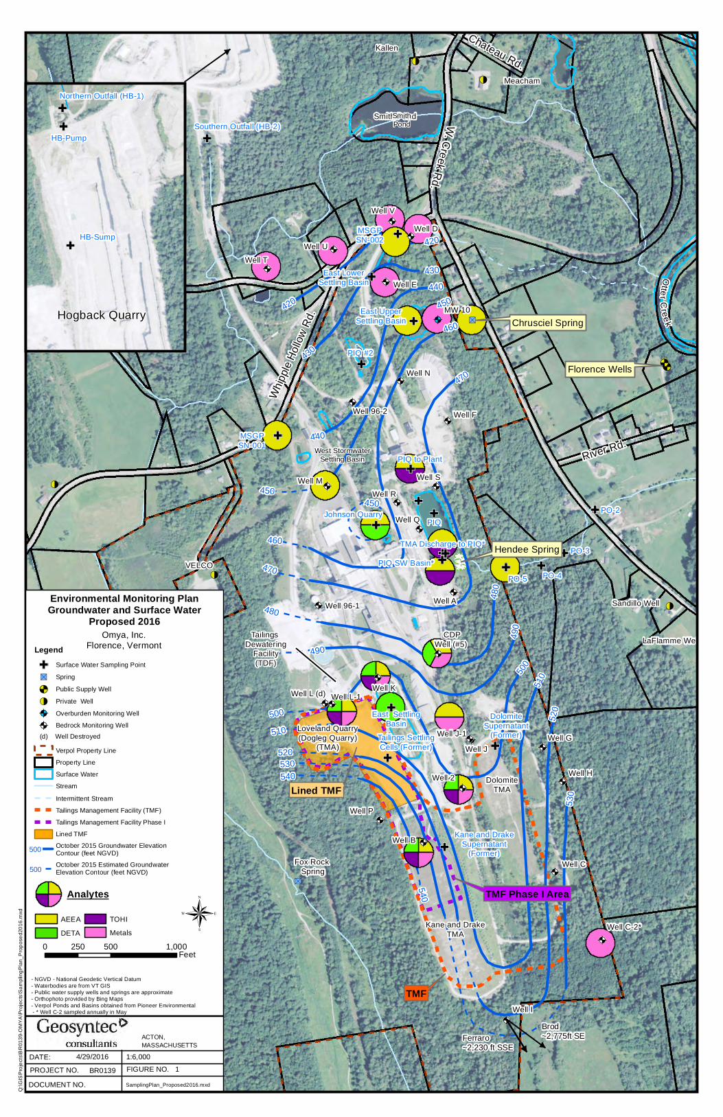
This memorandum presents proposed modifications to monitoring requirements as set forth in the current Monitoring Plan for the Omya Verpol Site (Geosyntec, 2012). The approved plan incorporated several rounds of modifications to the original Site Monitoring Plan written in 2008 (Geosyntec, 2008). The most recent revisions to the Monitoring Plan were approved by the Vermont Department of Environmental Conservation (VTDEC) on October 1, 2012, and have been implemented since the May 2013 monitoring event. In this memorandum we propose further changes to the 2012 approved plan based on results of recent monitoring events through October 2015 and Omya’s November 19, 2015 Solid Waste Disposal Certification. This certification allows the disposal of tailings in an unlined Tailings Management Facility (TMF), adjacent to the lined TMF (VTDEC, 2015). These modifications are presented by analyte class (flotation agent, metals and perchlorate) and media (groundwater and surface water) below. A revised Monitoring Plan table (Table 1) is attached along with figures illustrating the proposed changes. Figure 1 presents the 2016 proposed monitoring locations and analytes for groundwater and surface water and Figure 2 presents the 2012 approved groundwater and surface water monitoring program for comparison. This document has received preliminary approval from the Vermont Agency of Natural Resources.
Flotation Agent
Under the current monitoring program, flotation agent analysis is conducted at 10 on-site groundwater monitoring wells and 9 surface water monitoring locations (Figure 2). Since the fall of 2006, groundwater and surface water samples have been analyzed for flotation agent compounds using the high performance liquid chromatography/tandem mass spectrometer (HPLC/MS/MS) method (developed by Test America of Sacramento, CA).
Omya used a tall oil hydroxyethyl imidazoline (TOHI)-based flotation agent that contained residual aminoethylethanolamine (AEEA) until October 2010, when the use of a new tall oil diethylenetriamine imidazoline (TODI)-based flotation agent containing residual diethylenetriamine (DETA) commenced. Tailings containing flotation agents were historically disposed of in the unlined Tailings Settling Cells and Tailings Management Areas (TMAs).
Proposed Modifications to Omya Monitoring Plan 29 April 2016 Page 2
Proposed Omya MonPlan Revisions 2016 (R1)
Between October 2009 and December 31, 2010, these former unlined facilities were closed, and since January 3, 2011 the tailings have been mechanically dewatered prior to being disposed in the new lined TMF. The switch to a DETA-derived flotation agent should result in no significant increase in AEEA and TOHI concentrations in groundwater or surface water during future monitoring, and no significant increases have been observed. Monitoring for DETA commenced in May 2011 and DETA has not been detected in any groundwater or surface water samples. Further, new tailings management practices limit the possibility of release of any flotation agent constituents to surface water or groundwater.
Groundwater
Since flotation agent monitoring began in the fall of 2006, flotation agent compounds AEEA and TOHI have been detected in only three monitoring wells (Wells B and 2 [AEEA and TOHI], and Well K [AEEA only]), all of which are located immediately downgradient of the former unlined TMAs.
The nine years of groundwater data and revised practices at the site indicate that AEEA and TOHI are unlikely to be detected in other groundwater monitoring wells. We recognize the importance of continued monitoring for AEEA and TOHI, and therefore do not recommend the removal of all monitoring wells with no AEEA or TOHI detections. We recommend eliminating flotation agent analysis from three select monitoring wells: Well J, Well 96-2, and Well R.
Well J is screened deeper than the bottom of the Dolomite TMA. Well J-1 has a shallower screened interval that is more appropriate for monitoring groundwater that may come in contact with residual tailings in the closed Dolomite TMA. Therefore, we recommend the continued sampling of Well J-1 and the elimination of flotation agent analysis at Well J.
Neither AEEA nor TOHI has been detected at Well 96-2 or Well R, and neither location is immediately downgradient of a TMF; therefore, we recommend the elimination of flotation agent monitoring from Well 96-2 and Well R.
In addition to J-1 mentioned above, several monitoring wells will continue to be monitored for flotation agent constituents (Figure 1). Well K and Well L-1 (the replacement for Well L) will continue to be sampled for AEEA, TOHI, and DETA. Well M will also continue to be monitored for AEEA. CDP Well (#5) will continue to be monitored for AEEA and DETA per the 2012 sampling plan. Well B and Well 2, where flotation agent constituents have historically been detected, will also continue to be sampled for AEEA and TOHI.
In the unlikely event that AEEA or TOHI is detected in any of the wells L-1, M, or CDP Well (#5), then AEEA/TOHI analysis would resume at downgradient wells, Wells R and 96-2.
We recommend that DETA be added to the Monitoring Plan for Well B and Well 2, which are both near the current lined TMF and newly permitted adjacent unlined TMF.
Proposed Modifications to Omya Monitoring Plan 29 April 2016 Page 3
Proposed Omya MonPlan Revisions 2016 (R1)
Surface Water
As described in the Omya Stormwater Pollution Prevention Plan (Vanasse Hangen Brustlin, Inc., 2011), stormwater from the Tailings Management Facility Phase I Area is collected in the East Settling Basin. Because this basin is located adjacent to the newly permitted unlined TMF, we recommend the addition of DETA analysis at the East Settling Basin (Figure 1).
Metals (Arsenic, Iron, Manganese)
Under the 2012 Monitoring Plan, collection of samples for metals analysis occurs at 18 on-site wells and 1 surface water location. The purpose of metals analysis is to evaluate the extent and potential causes of elevated arsenic and manganese at the site. Analysis for iron is primarily directed at evaluation of groundwater geochemistry. Through October 2015, 18 rounds of groundwater data have been collected for these metals. The existing data define the extent of arsenic, indicate that the extent is not increasing, and demonstrate that no significant exposures to arsenic exist.
Groundwater
We recommend the elimination of metals sampling at five locations where arsenic has never been detected above its Vermont Groundwater Enforcement Standard (VTGES) of 10 µg/L:
• Well J
• Well N
• Well 96-1
• Well 96-2
• Well R
Iron concentrations at Well 96-2 and Well 96-1 have been below the secondary VTGES since 2009. The iron concentrations at Well J, Well N, and Well R are above the secondary VTGES, but remain steady. Manganese concentrations have never been above the VTGES except at Well J where concentrations hover around the VTGES and are steady.
Additionally, arsenic and manganese concentrations have never been detected above their respective VTGES at Well C-2. Iron concentrations at Well C-2 have been below the secondary VTGES since 2009. Metals behavior at Well C-2 is well understood based on the data that has been collected since 2008; however, Well C-2 is the furthest upgradient well and provides information on the geochemistry upgradient of the TMF Area. Therefore, we recommend Well C-2 be sampled for metals annually in May.
We recognize the importance of continuing to monitor the extent of arsenic and manganese across the site; therefore, twelve groundwater wells located throughout the site will continue to be analyzed in May and October for all three metals:
Proposed Modifications to Omya Monitoring Plan 29 April 2016 Page 4
Proposed Omya MonPlan Revisions 2016 (R1)
• Well B
• Well E
• Well K
• Well L-1
• Well 2
• CDP Well #5
• MW-10
• Well J-1
• Well D
• Well T
• Well U
• Well V
If site conditions change or if arsenic or manganese concentrations at these wells suggest that the extent of elevated arsenic is increasing, we may recommend expanding the monitoring effort to include additional existing wells.
Surface Water
We recommend that metals analysis at MSGP S/N 002 be suspended. MSGP S/N 002 is only sampled when the PIQ is discharging to the location during the sampling event. This has occurred in only 3 of 18 sampling events since 2007 and arsenic concentrations have never been detected above the VTGES.
Perchlorate
Under the 2012 Monitoring Plan, collection of samples for perchlorate analysis occurs at three locations in the Hogback Quarry. There is no VTGES for perchlorate; however, there is a Vermont Health Advisory for perchlorate of 4 µg/L. Perchlorate concentrations at the Northern Outfall and the Quarry Sump have been well below the Vermont Health Advisory since sampling began in 2008. We recommend the elimination of perchlorate sampling at the Northern Outfall.
Perchlorate concentrations in the Southern Outfall have periodically been above the Vermont Health Advisory; since the Quarry Sump feeds into the Southern Outfall, we recommend keeping perchlorate sampling at the Quarry Sump and Southern Outfall.
Under the 2012 Monitoring Plan, the field duplicate and field blank for perchlorate is collected at the Northern Outfall. Since we are recommending the removal of perchlorate sampling at the
Proposed Modifications to Omya Monitoring Plan 29 April 2016 Page 5
Proposed Omya MonPlan Revisions 2016 (R1)
Northern Outfall, we recommend performing the field duplicate and field blank at the Southern Outfall.
Other Analytes
We may at times wish to collect additional samples or conduct additional analyses to evaluate the fate and transport of arsenic at the Site. These additional analyses may include analytes such as alkalinity, nitrate, sulfate, chloride, phosphate, free ferrous iron, and total organic carbon (TOC).
Contingency
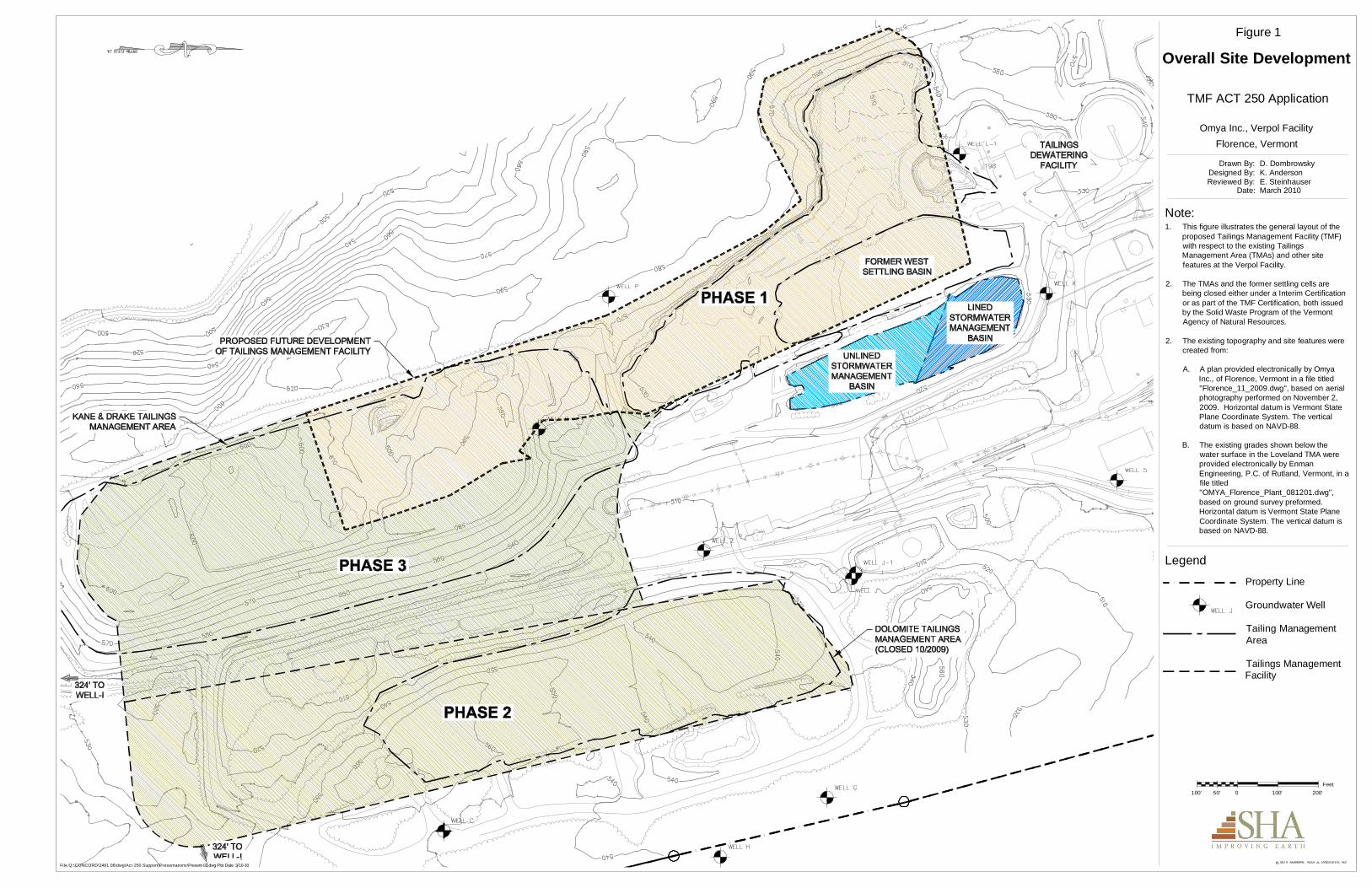
Attachment 1 shows Omya’s planned future tailings management areas. Omya is currently managing tailings in the Phase 1 area; as the Phase I area reaches capacity, tailings will be managed in the Phase 2 area followed by the Phase 3 area. As tailings are moved to new areas, additional analyses, or sampling locations maybe added to the sampling plan (e.g. the addition of DETA to Well J-1).
Summary
The attached recommended sampling table incorporates the following changes relative to the approved October 2012 Monitoring Plan:
• Elimination of all flotation agent analysis at Well J, Well 96-2, and Well R;
• Addition of DETA analysis at Well B and Well 2;
• Addition of DETA at the East Settling Basin;
• Elimination of metals analysis at Well J, Well N, Well 96-1, Well 96-2, and Well R;
• Modifying metals sampling at Well C-2 to occur annually in May;
• Elimination of metals analysis at surface water location MSGP S/N 002;
• Elimination of perchlorate sampling at the Northern Outfall; and
• Addition of a field duplicate and field blank from the Southern Outfall.
Thank you for your consideration of these recommendations, which we believe provide an appropriate focus going forward for monitoring at this site. We would be happy to discuss them with you in detail at your convenience.
Proposed Modifications to Omya Monitoring Plan 29 April 2016 Page 6
Proposed Omya MonPlan Revisions 2016 (R1)
References
Cambridge Environmental and Geosyntec Consultants, 2008, An Assessment of the Environmental and Public Health Impacts of Omya’s Operations in Florence, Vermont: Integrated Report, February 15, 2008.
Geosyntec Consultants, 2008, Site Monitoring Plan, Omya Verpol Plant, Florence, Vermont, March 2008.
Geosyntec Consultants, 2012, Proposed Modifications to the Approved Monitoring Plan, Omya Verpol Site and Hogback Quarry, Florence, Vermont, April 2012.
Vanasse Hangen Brustlin, Inc., 2011, Stormwater Pollution Prevention Plan for Omya Inc. Verpol Plant, Pittsford, Vermont, October 2011.
VTDEC, 2015, Solid Waste Disposal Facility Certification, Omay, Inc., Verpl Site, Whipple Hollow Road, Florence Vermont, November 19, 2015. Vermont Agency of Natural Resources, Department of Environmental Conservation, Waste Management and Prevention Division.
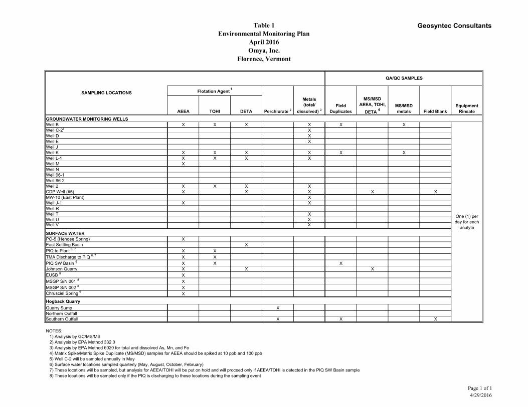
Table 1Environmental Monitoring Plan
April 2016Omya, Inc.
Florence, Vermont
Geosyntec Consultants
AEEA TOHI DETA Perchlorate 2
Metals (total/
dissolved) 3 Field
DuplicatesMS/MSDmetals Field Blank
Equipment Rinsate
GROUNDWATER MONITORING WELLSWell B X X X X X XWell C-25 XWell D XWell E XWell JWell K X X X X X XWell L-1 X X X XWell M XWell NWell 96-1 Well 96-2Well 2 X X X XCDP Well (#5) X X X X XMW-10 (East Plant) XWell J-1 X XWell RWell T XWell U XWell V X
SURFACE WATERPO-5 (Hendee Spring) XEast Settling Basin XPIQ to Plant 6, 7 X XTMA Discharge to PIQ 6, 7 X XPIQ SW Basin 6 X X X Johnson Quarry X X XEUSB 8 XMSGP S/N 001 8 XMSGP S/N 002 8 XChrusciel Spring 6 X
Hogback QuarryQuarry Sump X Northern OutfallSouthern Outfall X X X
NOTES: 1) Analysis by GC/MS/MS2) Analysis by EPA Method 332.03) Analysis by EPA Method 6020 for total and dissolved As, Mn, and Fe4) Matrix Spike/Matrix Spike Duplicate (MS/MSD) samples for AEEA should be spiked at 10 ppb and 100 ppb5) Well C-2 will be sampled annually in May6) Surface water locations sampled quarterly (May, August, October, February)7) These locations will be sampled, but analysis for AEEA/TOHI will be put on hold and will proceed only if AEEA/TOHI is detected in the PIQ SW Basin sample8) These locations will be sampled only if the PIQ is discharging to these locations during the sampling event
One (1) per day for each
analyte
SAMPLING LOCATIONS
QA/QC SAMPLES
Flotation Agent 1
MS/MSDAEEA, TOHI,
DETA 4
Page 1 of 14/29/2016
&<&<
!<
!<
"S
"S
GF
GF
GFGFGF
GF
GF
GF
!<
!<
GF
GF
GF
GF
GF
GF
GF
GF
@A
@A
@A
@A
@A
@A
@A
@A
@A
@A
@A
@A
@A
@A
@A
@A
@A
@A
@A
@A
GF
GF
@A
@A
!<
@A
@A
@A
@A
@A
@A
@A
@A
GF
GF
!<
GF
GF
Southern Outfall (HB-2)
PO-5
PO-1
LaFlamme Well
Sandillo Well
MSGPSN-002
MSGPSN-001
Kane and DrakeSupernatant
(Former)Fox Rock
Spring
Well G
Well H
Well C-2*
PO-2
Well L (d)
Well P
Well N
Well M
Well J
Well K
Well F
Well E
Well D
Well C
Well B
Well A
Well 2
Well I
Well 96-2
Well 96-1OGS 1+2
VELCO
CDPWell (#5)
PO-3
PO-4
Meacham
Kallen
DolomiteSupernatant
(Former)
Well L-1
Well RWell S
Well Q
MW 10
PIQ
Well TWell U
Well V
Well J-1
TMA Discharge to PIQ*
PIQ SW Basin*
Kane and DrakeTMA
DolomiteTMA
Tailings SettlingCells (Former)
Loveland Quarry(Dogleg Quarry)
(TMA)
Johnson Quarry
PIQ to Plant
PIQ #2
East UpperSettling Basin
East LowerSettling Basin
Smith Pond
Tailings Dewatering
Facility(TDF)
East SettlingBasin
470
460
530
480
470
500 520
510
440430
490
420
510
520
530
50049
0
460450
480
450
440
430
420
540
450
540
OtterC reek
River Rd.
Chateau Rd.
Whipp
le Ho
llow Rd
.
W. Creek Rd.
Hendee Spring
Florence Wells
Chrusciel Spring
West StormwaterSettling Basin
SmithPond
TMF Phase I Area
TMF
Lined TMF
ACTON, MASSACHUSETTS
DOCUMENT NO.PROJECT NO.DATE:
®- NGVD - National Geodetic Vertical Datum- Waterbodies are from VT GIS- Public water supply wells and springs are approximate- Orthophoto provided by Bing Maps- Verpol Ponds and Basins obtained from Pioneer Environmental - * Well C-2 sampled annually in May
4/29/2016BR0139
SamplingPlan_Proposed2016.mxd
1:6,000
Q:\G
ISPr
ojects
\BR0
139-O
MYA\
Proje
cts\Sa
mplin
gPlan
_Prop
osed
2016
.mxd
FIGURE NO. 1
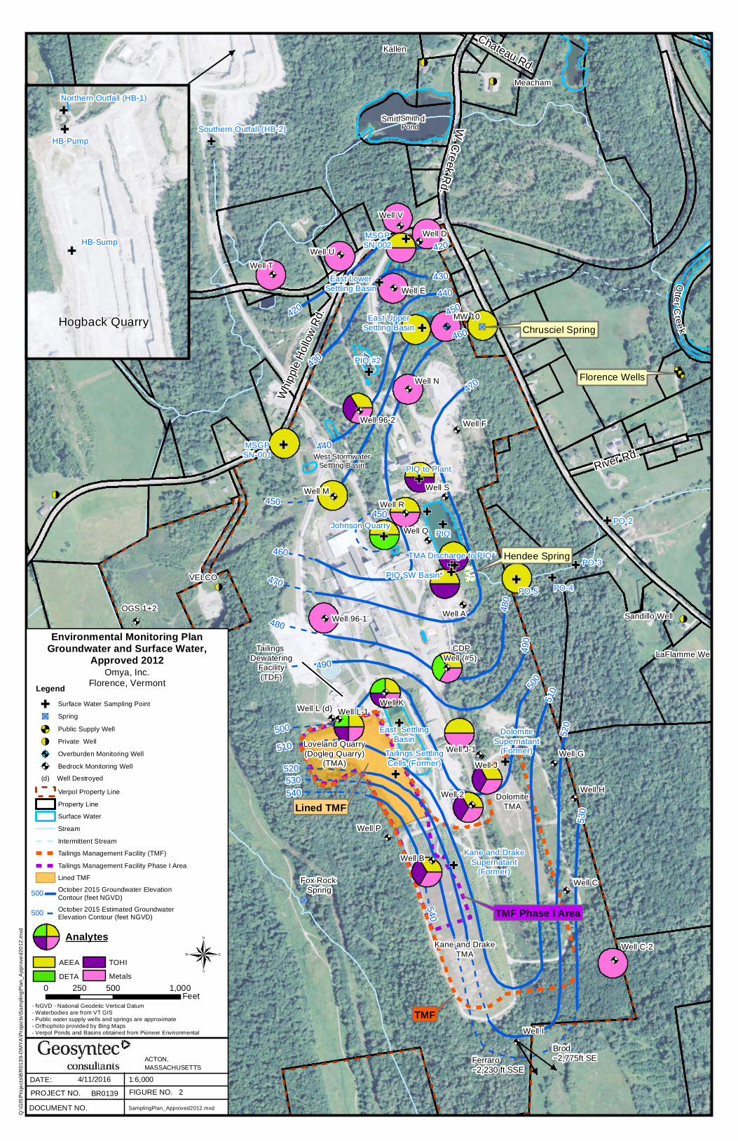
LegendGF Surface Water Sampling Point"S Spring&< Public Supply Well!< Private Well@A Overburden Monitoring Well@A Bedrock Monitoring Well
Verpol Property LineProperty LineSurface WaterStreamIntermittent StreamTailings Management Facility (TMF)Tailings Management Facility Phase ILined TMFOctober 2015 Groundwater ElevationContour (feet NGVD)October 2015 Estimated GroundwaterElevation Contour (feet NGVD)
0 500 1,000250 Feet
Environmental Monitoring PlanGroundwater and Surface Water
Proposed 2016
GF
GF
GF
Northern Outfall (HB-1)
HB-Sump
HB-Pump
Hogback Quarry
(d) Well Destroyed
Ferraro~2,230 ft SSE
Brod~2,775ft SE
Omya, Inc.Florence, Vermont
500
500
Analytes
AEEADETA
TOHIMetals
&<&<
!<
!<
"S
"S
GF
GF
GFGFGF
GF
GF
GF
!<
!<
GF
GF
GF
GF
GF
GF
GF
GF
@A
@A
@A
@A
@A
@A
@A
@A
@A
@A
@A
@A
@A
@A
@A
@A
@A
@A
@A
@A
GF
GF
@A
@A
!<
@A
@A
@A
@A
@A
@A
@A
@A
GF
GF
!<
GF
GF
Southern Outfall (HB-2)
PO-5
PO-1
LaFlamme Well
Sandillo Well
MSGPSN-002
MSGPSN-001
Kane and DrakeSupernatant
(Former)Fox Rock
Spring
Well G
Well H
Well C-2
PO-2
Well L (d)
Well P
Well N
Well M
Well J
Well K
Well F
Well E
Well D
Well C
Well B
Well A
Well 2
Well I
Well 96-2
Well 96-1OGS 1+2
VELCO
CDPWell (#5)
PO-3
PO-4
Meacham
Kallen
DolomiteSupernatant
(Former)
Well L-1
Well RWell S
Well Q
MW 10
PIQ
Well TWell U
Well V
Well J-1
TMA Discharge to PIQ*
PIQ SW Basin*
Kane and DrakeTMA
DolomiteTMA
Tailings SettlingCells (Former)
Loveland Quarry(Dogleg Quarry)
(TMA)
Johnson Quarry
PIQ to Plant
PIQ #2
East UpperSettling Basin
East LowerSettling Basin
Smith Pond
Tailings Dewatering
Facility(TDF)
East SettlingBasin
470
460
530
480
470
500 520
510
440430
490
420
510
520
530
50049
0
460450
480
450
440
430
420
540
450
540
OtterC reek
River Rd.
Chateau Rd.
Whipp
le Ho
llow Rd
.
W. Creek Rd.
Hendee Spring
Florence Wells
Chrusciel Spring
West StormwaterSettling Basin
SmithPond
TMF Phase I Area
TMF
Lined TMF
ACTON, MASSACHUSETTS
DOCUMENT NO.PROJECT NO.DATE:
®- NGVD - National Geodetic Vertical Datum- Waterbodies are from VT GIS- Public water supply wells and springs are approximate- Orthophoto provided by Bing Maps- Verpol Ponds and Basins obtained from Pioneer Environmental
4/11/2016BR0139
SamplingPlan_Approved2012.mxd
1:6,000
Q:\G
ISPr
ojects
\BR0
139-O
MYA\
Proje
cts\Sa
mplin
gPlan
_App
roved
2012
.mxd
FIGURE NO. 2
LegendGF Surface Water Sampling Point"S Spring&< Public Supply Well!< Private Well@A Overburden Monitoring Well@A Bedrock Monitoring Well
Verpol Property LineProperty LineSurface WaterStreamIntermittent StreamTailings Management Facility (TMF)Tailings Management Facility Phase I AreaLined TMFOctober 2015 Groundwater ElevationContour (feet NGVD)October 2015 Estimated GroundwaterElevation Contour (feet NGVD)
0 500 1,000250 Feet
Environmental Monitoring PlanGroundwater and Surface Water,
Approved 2012
GF
GF
GF
Northern Outfall (HB-1)
HB-Sump
HB-Pump
Hogback Quarry
(d) Well Destroyed
Ferraro~2,230 ft SSE
Brod~2,775ft SE
Omya, Inc.Florence, Vermont
500
500
Analytes
AEEADETA
TOHIMetals
Proposed Omya MonPlan Revisions 2016 (R1)
ATTACHEMNT 1 – Omya Overall Site Development
File:Q:\CONCORD\2461.06\dwg\Act 250 Support\Presentations\Present-02.dwg Plot Date: 3-10-10
Property LineGroundwater WellTailing ManagementAreaTailings ManagementFacility
Legend
1. This figure illustrates the general layout of theproposed Tailings Management Facility (TMF)with respect to the existing TailingsManagement Area (TMAs) and other sitefeatures at the Verpol Facility.
2. The TMAs and the former settling cells arebeing closed either under a Interim Certificationor as part of the TMF Certification, both issuedby the Solid Waste Program of the VermontAgency of Natural Resources.
2. The existing topography and site features werecreated from:
A. A plan provided electronically by OmyaInc., of Florence, Vermont in a file titled"Florence_11_2009.dwg", based on aerialphotography performed on November 2,2009. Horizontal datum is Vermont StatePlane Coordinate System. The verticaldatum is based on NAVD-88.
B. The existing grades shown below thewater surface in the Loveland TMA wereprovided electronically by EnmanEngineering, P.C. of Rutland, Vermont, in afile titled"OMYA_Florence_Plant_081201.dwg",based on ground survey preformed.Horizontal datum is Vermont State PlaneCoordinate System. The vertical datum isbased on NAVD-88.
Overall Site Development
Omya Inc., Verpol Facility
TMF ACT 250 Application
Florence, Vermont
Note:
Figure 1
50'100' 0 100' 200'Feet
Date:Reviewed By:Designed By:
Drawn By:K. AndersonD. Dombrowsky
March 2010E. Steinhauser