Embed Size (px)
Citation preview

Proposed New World Supermarket
11-19 Paerata Road and 3 Comrie Place, Pukekohe
Assessment of Environmental Effects
Revision History
Date Issue Description
12/06/2017 1 Draft for internal review
13/06/2017 2 Draft for client review
16/06/2017 3 Final for lodgement
Assessment of Environmental Effects Prepared by Evita Key B&A Ref: 15317 1 Reviewed by Matt Norwell
CONTENTS
1.0 THE APPLICANT AND PROPERTY DETAILS .................................................................... 2 2.0 SITE CONTEXT ............................................................................................................... 3
2.1 Site Description ............................................................................................................ 3 2.2 Surrounding Locality .................................................................................................... 5
3.0 PROPOSAL .................................................................................................................... 6 3.1 Site Works .................................................................................................................... 6 3.2 Building......................................................................................................................... 8 3.3 Activities and Operation .............................................................................................. 9 3.4 Signage ......................................................................................................................... 9 3.5 Access and Manouevring ............................................................................................. 9 3.6 Car Parking ................................................................................................................. 10 3.7 Loading and Servicing Area ........................................................................................ 10 3.8 Infrastructure ............................................................................................................. 10
4.0 REASONS WHY RESOURCE CONENT IS REQUIRED ..................................................... 11 4.1 Auckland Unitary Plan - Operative in Part (AUP (OP)) ............................................... 11 4.2 National Environmental Standard (NES) for Assessing and Managing Contaminants
in Soil to Protect Human Health ................................................................................ 12 4.3 Summary .................................................................................................................... 12
5.0 NOTIFICATION (SECTIONS 95A TO 95E) ..................................................................... 13 5.1 Statutory Matters ....................................................................................................... 13
6.0 SECTION 104 ASSESSMENT ........................................................................................ 13 6.1 Statutory Matters ....................................................................................................... 13 6.2 Part 2 of the RMA - Purpose and Principles (Section 34(1)(b)) .................................. 14 6.3 Actual and Potential Effects on the Environment (Section 104(1)(A)) ...................... 15 6.4 Auckland Unitary Plan - Operative in Part (Section 104(1)(B)(vi)) ............................. 26 6.5 Other Matters (Section 104(1)(C)) ............................................................................. 33 6.6 Particular Restrictions for Non-Complying Activities (Section 104(D)) ...................... 33
7.0 CONCLUSION .............................................................................................................. 34 APPENDICES:
Appendix 1: Certificate of Title Appendix 2: Topographic Survey Appendix 3: Architectural Plans Appendix 4: Engineering Report and Plans Appendix 5: Transport Assessment Appendix 6: AUP (OP) Activities and Standards Assessment Appendix 7: Geotechnical Reports Appendix 8: Acoustic Assessment Appendix 9: Flood Risk Assessment Appendix 10: Moat Inlet Assessment Appendix 11: Economic Impact Assessment Appendix 12: Contamination Reports Appendix 13: AUP (OP) Objectives and Policies Assessment

Assessment of Environmental Effects Prepared by Evita Key B&A Ref: 15317 2 Reviewed by Matt Norwell
1.0 THE APPLICANT AND PROPERTY DETAILS
To: Auckland Council
Site Address: 11-17 Paerata Road and 3 Comrie Place, Pukekohe
Applicant's Name: Foodstuffs North Island Ltd
Address for Service Barker & Associates Ltd PO Box 1986 Shortland Street Auckland 1140 Attention: Evita Key / Matt Norwell
Site Owners: Chapman Farms Ltd and Tanus Investments Ltd
Legal Description: Lots 3-4 DP 38868, Lot 2 DP 111837 and Lot 5 DP 72188 (refer to CTs in Appendix 1)
Site Area: 16,672m2
District Plan: Auckland Unitary Plan - Operative in Part (AUP (OP))
AUP (OP) Zoning: Business - Light Industrial
AUP (OP) Overlays: High-Use Aquifer Management Areas Overlay - Pukekohe Kaawa Aquifer and Pukekohe Central Volcanic
Quality-Sensitive Aquifer Management Areas Overlay - Franklin Volcanic Aquifer
Overlays/Limitations: Floodplain Overland flow path Macroinvertebrate Community Index
Locality Diagram: Refer to Figure 1
Brief Description of Proposal: Construction and operation of a new supermarket and ancillary retail/café tenancies along with associated parking and loading areas, vehicle accesses and signage.
Summary of Reasons for Consent: Various (see Section 4 of this report)
We attach an assessment of environmental effects that corresponds with the scale and significance of the effects that the proposed activity may have on the environment.
Assessment of Environmental Effects Prepared by Evita Key B&A Ref: 15317 3 Reviewed by Matt Norwell
2.0 SITE CONTEXT
2.1 SITE DESCRIPTION
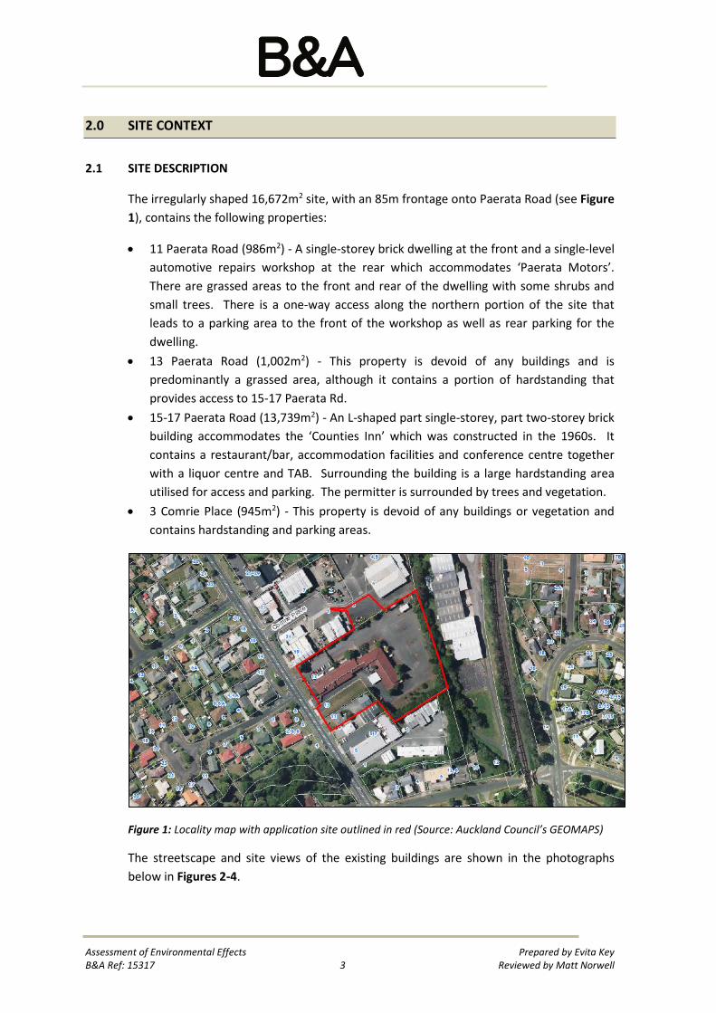
The irregularly shaped 16,672m2 site, with an 85m frontage onto Paerata Road (see Figure 1), contains the following properties:
• 11 Paerata Road (986m2) - A single-storey brick dwelling at the front and a single-level automotive repairs workshop at the rear which accommodates ‘Paerata Motors’. There are grassed areas to the front and rear of the dwelling with some shrubs and small trees. There is a one-way access along the northern portion of the site that leads to a parking area to the front of the workshop as well as rear parking for the dwelling.
• 13 Paerata Road (1,002m2) - This property is devoid of any buildings and is predominantly a grassed area, although it contains a portion of hardstanding that provides access to 15-17 Paerata Rd.
• 15-17 Paerata Road (13,739m2) - An L-shaped part single-storey, part two-storey brick building accommodates the ‘Counties Inn’ which was constructed in the 1960s. It contains a restaurant/bar, accommodation facilities and conference centre together with a liquor centre and TAB. Surrounding the building is a large hardstanding area utilised for access and parking. The permitter is surrounded by trees and vegetation.
• 3 Comrie Place (945m2) - This property is devoid of any buildings or vegetation and contains hardstanding and parking areas.
Figure 1: Locality map with application site outlined in red (Source: Auckland Council’s GEOMAPS)
The streetscape and site views of the existing buildings are shown in the photographs below in Figures 2-4.

Assessment of Environmental Effects Prepared by Evita Key B&A Ref: 15317 4 Reviewed by Matt Norwell
Figure 2: Streetscape view of the application site as viewed from Paerata Road
Figure 3: View of the rear of the application site
Figure 4: View from 3 Comrie Place of the location of the proposed right of way
The application site is of a gentle contour sloping down approximately 4.5m from the western street frontage, with a small stream (Whangapouri Stream) running along the rear eastern boundary as illustrated in the topographical survey (Appendix 2).

Assessment of Environmental Effects Prepared by Evita Key B&A Ref: 15317 5 Reviewed by Matt Norwell
The Council’s GIS indicates that there is an overland flow path that traverses through the site, a flood plain over the majority of the site and a portion of flood prone land (see Figure 5).
Figure 5: Hydrology information with overland flow paths shown as blue lines, flood prone shown as blue hatching and flood plain shown as light blue shading (Source: GEOMAPS)
The application site is located within the Light Industry zone (see Figure 6). There are no known heritage items/places or significant indigenous habitat or vegetation on the site.
Figure 6: Auckland Unitary Plan zoning with the site outlined in red (Source: GEOMAPS)
2.2 SURROUNDING LOCALITY
The neighbouring properties to the north, east and south are all located with the Light Industry zone (see Figure 6) and contain the following activities:
• 12 Cape Hill Road - This large 3.29ha site is located to the east of the application site and accommodates ‘The Park Business Estate’, which contains a collection of large warehouse buildings. Current tenants include Chemsafe Group, Pallet Racking Services, CAS Enterprises, Free Range Eggs NZ and Taurean (Fletchers). The Southern Line railway is located to the east of this property.
• 3 Paerata Road - This site is located to the south of the application site and contains double height warehouse buildings that accommodates storage and distribution activities and an automotive paint workshop.

Assessment of Environmental Effects Prepared by Evita Key B&A Ref: 15317 6 Reviewed by Matt Norwell
• 5-7 and 9 Paerata Road - These sites are located along the western boundary of the rear portion of 17 Paerata Road. These properties contain single-storey buildings that accommodate a retail pet shop and dog grooming (Animal Shack), a childcare centre (Lollipops), an automotive electrical business and a dentist (Mint).
• 19 Paerata Road - This site is located to the north and contains a double height warehouse building that accommodates an industrial engineering company.
• 1, 2, 4 and 5 Comrie Place - These sites are located adjacent to 3 Comrie Place and accommodate a variety of light industrial activities including Placemakers.
On the opposite site of Paerata Road to the application site, 10-12 Paerata Road is zoned Neighbourhood Centre and contains single and two-storey buildings that accommodate the Pukekohe Motel as well as a diary on the corner of Paerata Road and Crisp Avenue. Surrounding properties contain predominantly single-storey residential dwellings. Hickeys Recreation Reserve is located directly opposite to 11 Paerata Road.
Further afield, the Pukekohe township has a population of approximately 30,000. The site is approximately 1km from the Pukekohe Town Centre, as well as 2.1km from the Belmont Special Housing Area (SHA) and 3.5km from the Wesley College SHA which are both high growth areas and expected to yield 7201 and 3,3002 new homes respectively over the next 10-20 years.
3.0 PROPOSAL
The applicant seeks land use consent to construct and operate a New World supermarket and ancillary café/retail tenancies. The proposal includes measures to avoid or mitigate any potential adverse effects on the environment.
Details of the proposed development are provided in the architectural drawings at Appendix 3 and a summary of the key elements of the proposal are set out in the following sections. More detailed descriptions on particular aspects of the proposal are documented in the specialist reports accompanying this application.
3.1 SITE WORKS
It is proposed to remove all the existing buildings and undertake earthworks over the site to provide an appropriate building platform and gradients for vehicular accesses and car parking.
1 http://www.aucklandcouncil.govt.nz/EN/ratesbuildingproperty/housingsupply/Pages/specialhousingareas.aspx 2 http://www.aucklandcouncil.govt.nz/EN/planspoliciesprojects/plansstrategies/Councilstrategies/Documents/finalfutureurbanlandsupplystrategyplan.pdf

Assessment of Environmental Effects Prepared by Evita Key B&A Ref: 15317 7 Reviewed by Matt Norwell
Stiffe Hooker Ltd have prepared a proposed cut-fill and sediment and erosion control plan. This is attached as Appendix 4. The earthworks proposed will involve approximately 10,660m3 of cut and 5,050m3 of fill (total of 15,710m3) across a total area of 10,955m2 involving the following:
• 135m3 of cut and 4,915m3 of fill over a 3,820m2 area to form the building platform and access ramps to the goods handling/storage area. Concrete retaining walls up to a maximum of 2.5m in height will be constructed in order to contain the fill material;
• 2,065m3 of cut and 135m3 of fill over a 6,671m2 area to the car parking area; and
• 310m3 and 8,150m3 of excavated material to construct the stormwater moat and conveyance trenches respectively.
The following erosion and sediment control measures are proposed:
• A silt control fence and bunding are proposed to the east of the earthworks excavation area;
• Areas that are not required to be excavated will be left undisturbed; and
• To minimise the potential sediment generation from the six proposed stormwater conveyance trenches that need to be laid, it is proposed to complete them one at a time before backfilling and moving onto the next trench.
Given the presence of underlying basalt over portions of the site, some rock breaking and/or explosive excavation techniques may be required during the installation of the stormwater moat and conveyance trenches.
The earthworks are anticipated to be completed within a one single stage (approximately three months) and any cut to waste material will be removed from the site to a licensed landfill. All sediment control devices will remain in place until the contribution catchment is fully stabilised.
The works will be carried out in accordance with the former Auckland Council’s Technical Publication 90: Erosion and Sediment Control Guidelines for Land Disturbing Activities in the Auckland Region (TP90).
It is proposed that a detailed construction and traffic management plan (CTMP) and a construction noise and vibration management plan (CNVMP) will be prepared and submitted to Council for approval prior to commencement of works which will address the timing and number of vehicle movements and noise and vibration monitoring and mitigation requirements.

Assessment of Environmental Effects Prepared by Evita Key B&A Ref: 15317 8 Reviewed by Matt Norwell
3.2 BUILDING
The supermarket and ancillary retail units will be located within the north-eastern portion of the site. The building will have a total gross floor area (GFA) of 3,121m2 comprising of a ground floor of 2,691m² and a mezzanine floor of 430m². The roofline is a shallow sloped gable with a maximum height of 9.4m above the ground level. A roof mounted plant platform and equipment (subject to detailed design of the required plant machinery and structure) will be located near the eastern end of the building and will largely be screened from view from the public realm. A 260m2 enclosed truck unloading area will accommodate deliveries to the 720m2 back of house area of the supermarket.
Figure 7: Proposed western elevation
Figure 8: Proposed southern elevation
The following materials are generally proposed (subject to variations during the detailed design process):
• Facades: A mixture of glazing, vertical profiled metal cladding and textured precast concrete panels;
• Roofing: Colorsteel; and
• Colours: In line with the New World corporate colour palette.
Other structures proposed in the development include:
• A covered walkway along the central carpark aisle;
• A sprinkler valve and pump room located to the rear of the retail tenancies, near the northern boundary;
• Roof top plant equipment;
• 2m high solid fencing along the boundary with 9 Paerata Road; and
• Six stormwater outfall structures with scruffy dome lids.

Assessment of Environmental Effects Prepared by Evita Key B&A Ref: 15317 9 Reviewed by Matt Norwell
3.3 ACTIVITIES AND OPERATION
The applicant proposes to operate a New World supermarket within the supermarket building. It is expected that the supermarket will operate between the hours of 7am to 10pm, however, it may on occasion operate up to 24 hours per day, seven days a week. The assessment of effects on the environment for the supermarket operation is based on 24 hr/7 days operation.
Deliveries to the supermarket will generally occur between 7am and 3pm daily with an estimated 25 deliveries anticipated with only bread and milk deliveries prior to 7am.
3.4 SIGNAGE
Signs on the building and the freestanding signs are of a standard design used throughout the New World supermarket chain. All signage consists of a brand identifier incorporating the words “New World” or “NW” logo. The following signs are proposed:
• Freestanding ‘pylon’ sign: One sign is proposed at the southern car park entry point on Paerata Road. The sign will be 8.5m in height, 2.8m in width and 0.65m in depth. Each face of the sign will be 23.8m2. The signs will include New World branding and be internally illuminated with a 0.92m x 2.44m LED screen (refer to Drawing RC01 for location details and Drawing RC02 for appearance details).
• Carpark ‘entry’ sign: A small sign is proposed at the northern customer car park entry point. This sign will be 1m in height and 0.8m in width. The sign will include the word ‘Entry’, New World branding and be internally illuminated (refer to Drawing RC01 for location details).
• Supermarket façade: “New World” will be identified by logo and lettering up to 1.65m in height on the upper western elevation that faces Paerata Road and will be internally illuminated (Refer to Drawing RC02).
3.5 ACCESS AND MANOUEVRING
In terms of vehicle access to the site, there are two customer accesses proposed off Paerata Road, located at the northern and southern ends of the road frontage. Both will be available for left and right turn access and exit from the site. A separate third vehicle access for service/delivery will be created via a proposed right of way over 3 Comrie Place which is illustrated on the site plan within Appendix 3. These vehicles will then utilise the southernmost Paerata Road access to exit the site.
There are four existing vehicle crossings off Paerata Road. The northern most crossing will be modified to accommodate the proposed access, with a new crossing proposed to the

Assessment of Environmental Effects Prepared by Evita Key B&A Ref: 15317 10 Reviewed by Matt Norwell
southern end. The other three redundant crossings will be reinstated as kerb and footpath.
In terms of circulation, sufficient turning area is available both within the customer carpark and the service/staff access area to ensure vehicles do not need to reverse exit onto the street carriageways.
With regard to pedestrian access to and within the site, it is proposed to provide a centrally located footpath crossing extending from Paerata Road and within the car parking area a pedestrian crossing, covered walkway and shared zone to the supermarket lobby, as illustrated on the architectural drawings and explained further within the Transport Assessment (Appendix 5).
3.6 CAR PARKING
A total of 158 parking spaces are proposed on the site with 147 spaces located in the main parking area and 11 staff spaces to the south of the supermarket. The customer carparks include five mobility accessible carparks.
Four trolley bays will be interspersed throughout the parking areas along with trundler storage near the supermarket entry as indicated on the plans.
Landscaped areas have been maximised within the car park area and a 1.6-5.0m wide landscaped strip will be provided along the street frontage and 1.5m along the side boundaries.
All parking spaces have been developed in accordance with the AUP (OP) parking space dimension and manoeuvring standards with compliance shown in the Transport Assessment (see Appendix 5).
3.7 LOADING AND SERVICING AREA
The loading and servicing areas for the supermarket, including an enclosed delivery area, will be located at the rear (east) of the supermarket with access from Comrie Place via a proposed right of way over 3 Comrie Place and egress onto Paerata Road as detailed in the Transport Assessment (see Appendix 5).
3.8 INFRASTRUCTURE
The infrastructure details of the proposal are outlined within the Engineering Report (see Appendix 4). In summary, the following infrastructure and servicing works are proposed.
• Stormwater: There are two existing outfalls structures that discharge into the Whangapouri Stream at the rear of the site. The proposed development will utilise

Assessment of Environmental Effects Prepared by Evita Key B&A Ref: 15317 11 Reviewed by Matt Norwell
these existing outfalls with the inlet pipes to be upgraded and six additional outfalls proposed. There will be separate pipe systems for the runoff from the building roof and car parking areas, with the car parking area runoff treated prior to discharging to the stream outlet.
• Wastewater: The site is currently serviced by a number of existing wastewater lines and private sewer connections. During the demotion of the existing buildings the existing sewer drains will be identified and protected. Two existing sewer manholes will be utilised for the supermarket development with the remaining redundant private connections sealed off at the manholes. The works will be carried out in accordance with the Code of Practice and subject to approval from the infrastructure provider.
• Water supply: There is an existing 200mm water main on the western side of Paerata Road with a 100mm feeder crossing Paerata Road and extending into the site. The supply to the existing building will be terminated prior to demolition and a new connection will be provided for.
• Utility Services: Power supply and telecommunications will be connected from the existing supply services available in the general locality of the site.
• Refuse and recycling: Private commercial collection is proposed.
4.0 REASONS WHY RESOURCE CONENT IS REQUIRED
4.1 AUCKLAND UNITARY PLAN - OPERATIVE IN PART (AUP (OP))
A comprehensive assessment against the relevant AUP (OP) rules is attached as Appendix 6. In summary, resource consent is required for the following reasons:
• The proposal includes a 6,671m2 high contaminant generating car park. Pursuant to E9.4.1(A6), this is a controlled activity.
• The proposal involves 15,710m3 earthworks over an area of 10,955m2. Pursuant to E12.4.1(A6) and E12.4.1(10), this is a restricted discretionary activity.
• The proposed blasting activity is predicted to exceed the vibration and noise limits in Standards E.25.6.30.1 and E.25.6.31 which is a restricted discretionary activity pursuant to E25.4.1(A2).
• The proposed parking and access do not comply with the following transport standards, which is a restricted discretionary activity pursuant to E27.4.1(A2):
- Standard E27.6.1(1)(b) - The proposed supermarket will exceed the trip generation threshold of greater than 100 vehicles per hour.

Assessment of Environmental Effects Prepared by Evita Key B&A Ref: 15317 12 Reviewed by Matt Norwell
- Standard E27.6.4.1 - A new vehicle crossing is proposed at 11 Paerata Road which has a frontage to an arterial road (Vehicle Access Restriction).
• The proposed supermarket will exceed the trip generation threshold of >100 vehicles per hour set out in Standard E27.6.1(1)(b). Pursuant to E27.4.1(A3), this is a restricted discretionary activity.
• The proposal included the construction of new vehicle crossings where a Vehicle Access Restriction applies and the establishment of the vehicle crossing is to relocate an existing vehicle crossing that will reduce the number of crossings serving a site. Pursuant to E27.4.1(A7), this is a restricted discretionary activity.
• The depth of flood water in a 1% AEP event for the proposed southern-most vehicle entry and exit point will exceed 200mm above ground level. Pursuant to E36.4.1(A25), this is a controlled activity.
• The six proposed stormwater outfall structures will be constructed within the 1% AEP floodplain. Pursuant to E36.4.1(A33), this is a restricted discretionary activity.
• The overland flow path will be piped within the proposed stormwater conveyance system. Pursuant to E36.4.1(A41), this is a restricted discretionary activity.
• A new supermarket and retail tenancies are proposed in the Light Industry zone. Pursuant to H17.4.1(A21), a retail activity that is not provided for is a non-complying activity.
• The 2m front yard standard is infringed by the pylon sign by a maximum of 1m reducing to nothing over a length of 0.65m. Pursuant to Rule C1.9(2), this is a restricted discretionary activity for non-compliance with Standard H17.6.4.
4.2 NATIONAL ENVIRONMENTAL STANDARD (NES) FOR ASSESSING AND MANAGING CONTAMINANTS IN SOIL TO PROTECT HUMAN HEALTH
Earthworks volumes exceed the NES permitted activity limits on a site where a detailed site investigation exists and the soil contamination does not exceed the applicable standard. This requires consent is as a controlled activity pursuant to Regulation 9 of the NES.
4.3 SUMMARY
Overall, this application is deemed to be a non-complying activity.

Assessment of Environmental Effects Prepared by Evita Key B&A Ref: 15317 13 Reviewed by Matt Norwell
5.0 NOTIFICATION (SECTIONS 95A TO 95E)
5.1 STATUTORY MATTERS
Section 95A gives a council discretion to decide whether to publicly notify an application or not. However, an application must be publicly notified if:
(a) the activity will have, or is likely to have, adverse effects on the environment that are more than minor;
(b) the applicant requests public notification of the application; or
(c) a rule or national environment standard requires public notification.
Foodstuffs currently have a conditional offer to purchase the application site. To expedite the planning process, the applicant requests public notification of this resource consent application in accordance with Section 95A(2)(b) of the Resource Management Act (RMA). Notwithstanding, the conclusion of this report and accompanying technical reports is that the effects of the proposal will not be more than minor and that the proposal is not contrary to the objectives and policies of the AUP (OP).
6.0 SECTION 104 ASSESSMENT
6.1 STATUTORY MATTERS
Subject to Part 2 of the RMA, when considering an application for resource consent, a council must, in accordance with section 104(1) of the RMA have regard to:
• any actual and potential effects on the environment of allowing the activity;
• any relevant provisions of a national environmental standard, other regulations, national policy statement, a New Zealand coastal policy statement, a regional policy statement or proposed regional policy statement; a plan or proposed plan; and
• any other matter a council considers relevant and reasonably necessary to determine the application.
Section 104(2) of the RMA provides a basis from which a baseline for development on the site can be derived. When forming an opinion of the actual and potential effects on the environment under s104(1)(a), the RMA allows the Council to consider only those effects beyond those which would otherwise be permitted by the plan (i.e. Council may consider the “permitted baseline”). We consider it appropriate that potential adverse effects of this proposal should be assessed from this baseline.
The AUP (OP) Business - Light Industrial zoning provides for demolition and new buildings as well as industrial activities, garden centres, motor vehicle sales, service stations, trade

Assessment of Environmental Effects Prepared by Evita Key B&A Ref: 15317 14 Reviewed by Matt Norwell
suppliers, small scale food/beverage outlets and retail/office activities ancillary to light industrial activities as permitted activities.
In the case of a supermarket development, it is considered that while the 3,121m2 retail development could not occur as of right, an activity with similar physical characteristics i.e. a large industrial activity could be built as of right under the AUP (OP) requirements. For example, a 3,000m2 industrial warehouse building with a minimum of 30 car parking spaces (based on 1 space/100m2 GFA) and associated loading areas could be built in a similar style and site layout to that proposed by the supermarket development.
It is considered, therefore, that a 3,000m2 industrial warehouse development that complies with the relevant standards for the Light Industrial zone can reasonably be expected to form part of the baseline from which any effects from the proposal should be assessed.
As a non-complying activity, section 104B of the RMA states that a council:
a) may grant or refuse the application; and
b) if it grants the application, may impose conditions under section 108.
6.2 PART 2 OF THE RMA - PURPOSE AND PRINCIPLES (SECTION 104(1))
Part 2 contains the purpose and principles of the RMA. Section 5 sets out the purpose of the RMA and requires a broad judgement as to whether a proposal would promote the sustainable management of natural and physical resources. This exercise of this judgement is informed by the principles in sections 6 to 8 and considered in light of the particular circumstances of each application.
The proposal will achieve the overall purpose of the RMA as stated in section 5 by enabling the community to provide for their social and economic wellbeing through provision of a conveniently located supermarket in a high growth area. Employment opportunities will be created during construction phase as well as when the supermarket becomes operational. This will be achieved without affecting health or safety (s5(2)), the sustainability of resources to continue to meet the needs of future generations (s5(2)(a)), or the life-supporting capacity of air, water, soil and ecosystems (s5(2)(b)). As assessed in Section 6.3 of this report, the proposal integrates measures to avoid or mitigate any potential adverse effects of the development on the environment (s5(2)(c)).
With regard to Section 6 of the RMA, it is considered that there are no matters of national importance (e.g. outstanding natural features/landscapes and historic heritage) relating to this application.
The following other matters (section 7) have been considered:
Assessment of Environmental Effects Prepared by Evita Key B&A Ref: 15317 15 Reviewed by Matt Norwell
• (b) the efficient use and development of natural and physical resources: the proposed development provides for the continued use of a portion of the site for a commercial use whilst ensuring that the flooding hazard is appropriately mitigated to allow for the remainder of the site it be potentially re-developed in the future.
• (c) the maintenance and enhancement of amenity values: the proposed modern building design, site layout and landscaping will contribute positively to the Paerata Road streetscape.
• (f) maintenance and enhancement of the quality of the environment: the proposed landscaping will maintain the quality of the natural environment in the urban context.
With regard to the principles of the Treaty of Waitangi (Section 8), the proposal involves redevelopment of an existing brownfield site and will not generate any adverse effects on the natural environment or on any sites of cultural importance. No matters of importance to Tangata Whenua have therefore been identified.
The proposal is considered to be consistent with all of the above sections of the RMA and is therefore consistent with Part 2 of the RMA.
6.3 ACTUAL AND POTENTIAL EFFECTS ON THE ENVIRONMENT (SECTION 104(1)(A))
6.3.1 Introduction
The proposed development will change the existing character of the site and introduce a new building and activities which have the potential to generate both adverse effects and positive effects on the environment.
This section provides an assessment of the following potential effects from the construction and operation of a supermarket activity:
• Earthworks and geotechnical impacts • Construction • Flooding • Infrastructure provision • Visual Amenity • Noise • Traffic, access and parking • Impacts upon the existing and planned AUP (OP) centres • Use of industrial zoned land • Contamination
Each of these matters is addressed in detail below.

Assessment of Environmental Effects Prepared by Evita Key B&A Ref: 15317 16 Reviewed by Matt Norwell
6.3.2 Earthworks and Geotechnical Impacts
As set out in Section 3.1, the proposal involves approximately 10,660m3 of earthworks cut and 5,050m3 of fill (total of 15,710m3) across a total area of 10,955m2.
During the earthworks construction, it is proposed to install appropriate sediment and erosion control measures to mitigate any adverse environmental effects. An engineering report with proposed cut-fill and sediment and erosion control plan has been prepared by Stiffe Hooker (see Sheet SD-RC05 of Appendix 4). All proposed sediment and erosion control measures will be designed in accordance with the Auckland Council guidelines prescribed in TP90. Key elements of the sediment control plan include a silt fence and bunding as well as minimising the amount of land disturbance at any one time by completing each of the six proposed stormwater conveyance trenches individually before backfilling and moving onto the construction of the next trench.
As well as measures to mitigate sediment and erosion runoff effects, measures to control dust and noise generation will also be implemented in accordance with standard good practice procedures.
With respect to suitability of the site for the proposed development, Tonkin and Taylor have carried out geotechnical assessments of the site (see Appendix 7) which confirm that the site is underlain with a thin layer of fill overlaying soils or basalt rock and alluvial soils below. Tonkin and Taylor advise that shallow building foundations are suitable for the proposed development provided these are founded on the recommended fill set out within the Geotechnical Investigation Report. This report also notes that rock breakers and/or explosive excavation techniques may be required during the installation of the drainage pipes due to the presence of basalt. The noise and vibration effects from this are excavation are considered within Section 6.3.3 of this report.
On the basis of the above, and subject to a detailed CTMP being prepared, it is considered that any adverse effects associated with earthworks will be less than minor. Furthermore, there are no significant geotechnical constraints that would preclude the type of development proposed.
6.3.3 Construction
Earthworks and subsequent construction activities are common precursors to any development. The Acoustic Assessment prepared by Chiles Ltd (Appendix 8) predicts that construction noise will generally comply with noise limits set out in the Chapter E25 of the AUP (OP) and concludes that noise effects of the development should be acceptable in this environment subject to some suggested mitigation measures. These are discussed in more detail below.
Works will be undertaken in accordance with the Council’s construction standards in relation to hours. A CTMP will be provided prior the commencement of works which sets
Assessment of Environmental Effects Prepared by Evita Key B&A Ref: 15317 17 Reviewed by Matt Norwell
out ways in which the site will be managed to avoid potential adverse effects arising from construction activities.
The nearest residential properties are located on the opposite side of Paerata Road and on the eastern side of the Southern Line on Cape Hill Road and Rooseville Mews. These properties are located 20-32m and 85-104m respectively from the boundary of the application site. Given these separation distances, it is considered that any disturbance generated by the construction activities will be minimal.
There is a childcare centre located at 5-7 Paerata Road. The rear of the childcare building backs onto the application site located to the east which is densely vegetated with trees. The outdoor play areas are located to the west of the childcare building and there is an existing building located to the north at 9 Paerata Road, both which provide a built form buffer to the outdoor play area from the application site. Given these buffers and that the proposed supermarket activity is to be located at least 30m away from the boundary with 5-7 Paerata Road, it is considered that there would be very minimal disruption generated by the proposed construction activities on the childcare centre.
The proposed stormwater moat and conveyance trenches will require excavation into basalt in some places. It is considered likely the upper parts of the excavation through fractured basalt could be achieved with excavators and below this it is likely that rock breaking or blasting will be required.
Given the separation distance from neighbouring sites, the acoustic assessment considers that rock breaking can be conducted in compliance with the noise and vibration limits of the AUP (OP). Where there are works proposed near the boundaries with 9 and 19 Paerata Road and 1 Comrie Place, noise and vibration management for rock breaking will be required to maintain compliance with the AUP (OP) limits, i.e. either conducting rock breaking when the buildings are unoccupied or an absorbent-lined portable acoustics screen will be required around the location of the rock breaking. The preparation of a CNVMP is recommended to manage any adverse effects. The CNVMP would include performance standards that must be complied with, predicted noise and vibration levels, mitigation considerations, noise and vibration monitoring requirements and communication, consultation and complaints response protocols. A CNVMP will involve liaising with the neighbours to ensure that works are carried out in a way that minimises disruption to them.
As an alternative to undertaking rock breaking, blasting could be utilised. The acoustic assessment predicts that blasting will likely exceed the permitted AUP (OP) vibration and noise limits, however this alternative activity could potentially reduce adverse effects on neighbours due to the significantly shorter duration of this technique compared to rock breaking. The assessment recommends that the effects of exceedances should be managed by first monitoring effects from blasting on the site at locations further from
Assessment of Environmental Effects Prepared by Evita Key B&A Ref: 15317 18 Reviewed by Matt Norwell
neighbouring buildings, and through pre and post blasting condition surveys of neighbouring buildings and rectification of any cosmetic damage caused.
Overall, it is considered that potential adverse construction effects will be temporary in nature and can be managed through the preparation and implementation of a CTMP and CNVMP such that any adverse effects in this regard will be minor to surrounding residents and business.
6.3.4 Flooding
The Council’s GEOMAPS viewer identifies that the site has a potential flooding risk as there is a flood plain over the majority of the site, a portion is flood prone and an overland flow path traverses through the site. A flood risk assessment has been undertaken by CKL (Appendix 9). A hydraulic model was used to determine the water depths within the area potentially affected by the floodplain for a 100-year flood event, including effects of climate change. Given the predicated peak flow of water (33.42m3/s) that will likely pass over the site, before discharging to the Whangapouri Stream along the eastern boundary of the site, it was determined that a flood mitigation system will be required. A number of various options were considered and discussed with the Council’s Healthy Waters Unit, particularly with regards to potential catchment-wide improvements. While these discussions are ongoing3, in the interests of providing a workable solution in the short term, it is proposed to construct a moat inlet along the entire western site frontage. Upon entering the moat, floodwater will be conveyed to six x 1.8m diameter manholes and 1.6m diameter pipes that traverse underground eastwards before flowing to the six outlet manholes for bubble up discharge to the stream. This mitigation measure will ensure that the floodplain no longer extends over the portion of the site that is to be developed. Further details are provided on the proposed moat and conveyance system in Appendix 10.
Overall, it is considered that the potential flooding hazard can be adequately mitigated across the site to ensure that the proposed supermarket activity, including the building, supermarket customers, staff, and vehicles will be appropriately protected in a flood event. Furthermore, the proposed development and flood mitigation system will ensure that the flood hazard existing in the area is not exacerbated for upstream or downstream properties.
6.3.5 Infrastructure Provision
Details of the proposed infrastructure services such as stormwater, wastewater, water supply and utilities, are outlined in Section 3.8 above and further detailed in Stiffe Hooker’s Engineering Report and Plans (see Appendix 4). This report confirms that the site can be adequately serviced.
3 The applicant is currently awaiting a catchment-wide assessment to be completed by the Council.

Assessment of Environmental Effects Prepared by Evita Key B&A Ref: 15317 19 Reviewed by Matt Norwell
With regards to the stormwater runoff from the car park area, this will be pre-treated through a proprietary device such as an Up-Flo filter prior to discharging into the stream.
In summary, based on the findings within the Engineering Report, provided that the recommended site infrastructure upgrades are made, it is considered that the proposed development can be adequately serviced and that the stormwater from the high contaminant generating carpark can be adequately treated to ensure that there are no adverse effects to the stream.
6.3.6 Visual Amenity
As outlined in Section 2.1, the application site currently accommodates a number of buildings including the ‘Counties Inn’, a single-storey dwelling and automotive repairs workshop. These building have a combined area of 2,738m2. There is also 9,905m2 of parking and hardstanding, with the 4,029m2 balance being grass and garden areas.
It is proposed to clear the existing buildings and redevelop the site for a new supermarket building (2,896m2) and associated parking, manoeuvring, loading (6,931m2) and landscaping areas (670m2). The balance being existing hardstanding (4,090m2) and grass (2,085m2) areas.
The removal of the existing buildings and introduction of a new built form on the site has the potential to impact on visual amenity of the area. “Amenity values” are defined in section 2 of the Resource Management Act 1991, as:
“…those natural and physical qualities and characteristics of an area that contribute to people’s appreciation of its pleasantness, aesthetic coherence, and cultural and recreational attributes”.
Amenity values of the site and wider area are derived from the busy vehicle environment of Paerata Road, commercial/industrial activities operating within the area and the suburban residential environment and public open space on the opposite side of Paerata Road. The existing characteristics of the area could be described as having an average amenity value for a light industrial area mainly due to the presence of the large grass berms, landscaped front yards and garden areas and the adjacent residential dwellings. It is also noted that the proposed building and parking areas will not be that dissimilar to the existing arrangement, albeit with a different site layout. The potential effects on the built form scale and visual amenity from the proposed development are assessed in this context.
The supermarket proposes a built form and site layout in keeping with the amenity expectations of a development of this type with the building set back into the site and parking located between the building and road. The overall site layout has been comprehensively designed to ensure an integrated approach to buildings, signage, vehicular access, pedestrian movement and parking. This integrated approach has been

Assessment of Environmental Effects Prepared by Evita Key B&A Ref: 15317 20 Reviewed by Matt Norwell
designed to relate to the site characteristics and surrounding environment without detracting from the visual amenity of the surrounding area.
The scale and form of the proposed supermarket building is considered appropriate as it presents a functional yet contemporary design which will contribute positively to the streetscape through the quality of the building design, materials and glazing. While the zone permits buildings up to 20m in height, the proposed height has been restricted to 9.4m with a shallow sloped gable roofline, to keep the scale in proportion with the surrounding industrial developments. Materials include frontage glazing, textured panels and metal cladding which provide a palate consistent with the industrial/commercial nature of the site and surrounds. The loading and services area will be located to the rear building which will largely screen them from streetscape views.
The proposal roof mounted plant platform and equipment will be located near the eastern end of the building. Given that it will be set back over 126m from Paerata Road, and will only protrude above the roofline by 0.45m, it will not be out of context with the scale of the building and will barely be discernible from the streetscape. Overall, it will not detract from the visual amenity of the supermarket building.
The proposed signs will provide clear identification of the supermarket without generating visual clutter in the landscape. When viewing the signage within the context of the surrounding existing and future environment, it is considered that the proposed signage will not be out of character nor generate visual amenity issues. Given the size of the site, the scale of the building and the length of street frontage occupied by the site, the size, location, content and form of the proposed signage is considered appropriate.
Finally, when applying the permitted baseline as set out in Section 6.1 above, the proposed building and site layout could be built as of right, for example, as a warehouse activity. Given this baseline, the proposed development in terms of bulk and location will not have any adverse visual amenity effects.
Overall, it is considered that the proposed supermarket development will contribute positively to the area in respect of visual amenity.
6.3.7 Noise
The noise generated from the proposed supermarket operation has been assessed by Chiles Ltd in the Acoustic Assessment (Appendix 8). This assessment predicted that the noise levels generated by the building services and vehicles in the car parking area, loading bay and public roads will not exceed the noise limits set out in the Chapter E25 of the AUP (OP) provided the proposal includes the following noise mitigation measures:
• Installation of a 2m high boundary fence (without gaps) on the boundary with 9 Paerata Road;
Assessment of Environmental Effects Prepared by Evita Key B&A Ref: 15317 21 Reviewed by Matt Norwell
• The loading bay to be covered; and • The design of the building services plant to comply with AUP (OP) noise limits.
The proposed drawings (Appendix 3) illustrate that a 2m high solid fence is proposed along with boundary with 9 Paerata Road and that the loading bay will be enclosed. The applicant is accepting of conditions of consent to secure these matters along with the noise levels of the building services.
The predicted noise levels for the proposed supermarket operation are considered to be appropriate for a commercial activity in an urban business area and conditions of consent will ensure that the operation of the proposed supermarket activity will maintain appropriate noise levels for the surrounding environment.
Overall, taking into account the above specialist comments and the mitigation measures proposed, the noise generation arising from the operation of the proposed supermarket activity is considered to have less than minor adverse effects on the surrounding environment.
The noise effects from the proposed construction and excavation activities are considered above within Section 6.3.3 of this report.
6.3.8 Traffic, Access and Parking
Traffic, access and parking matters have been comprehensively considered in the Transport Assessment prepared by Traffic Planning Consultants (TPC) and their report is attached as Appendix 5.
TPC’s assessment considers effects with respect to the road network, road safety, parking standards, servicing, access and signage. The key conclusions with respect to traffic related matters are as follows:
• The site is readily accessible from the primary road network and the 158 on-site car parking spaces proposed is appropriate to meet the expected demand. There should be no over-spill parking beyond the site which will ensure there are no adverse parking impacts on surrounding properties.
• Maximum separation between customers and delivery activities is largely achieved given that delivery vehicles will utilise the proposed right of way off Comrie Place, circulate around to the loading area at the rear of the supermarket building, and exit Paerata Road via the southern access point which is physically separated from the customer car park.
• The predicted traffic generation that will result from the proposed development is able to be adequately serviced by the two vehicle crossings proposed at peak periods,

Assessment of Environmental Effects Prepared by Evita Key B&A Ref: 15317 22 Reviewed by Matt Norwell
particularly as there is an existing painted flush median that is able to be utilised if required.
• Beyond the immediate vicinity of the site, the proposed additional traffic flows will be barely noticeable on the wider road network, and the overall effects will be less than minor.
• The two proposed vehicle crossings on Paerata Road have been located to ensure that vehicle movements to and from the site can occur safely and efficiently with less than minor effects on traffic using Paerata Road.
• The impacts of the proposed supermarket operation on neighbouring properties will be less than minor.
• Adverse impacts from construction traffic can be appropriately minimised via the preparation of a CTMP to control the times of operation, routes used, and other matters to minimise potential impact. The capacity of Paerata Road is able to accommodate the sorts of traffic volumes anticipated from the activities relating to the construction of a supermarket.
Given the assessment and conclusions from TPC’s assessment, the proposed parking, trip generation, loading, servicing and access arrangements are considered to be appropriate for the development and the proposal will not compromise the function, capacity or safety of the roading network. Overall, it is considered that any adverse effects with respect to traffic, access and parking related matters will be less than minor.
6.3.9 Impacts upon the Existing and Planned Centres
Whilst it is noted that the AUP (OP) readily supports locating supermarkets within the Business Centre zones to consolidate urban expansion, increase the viability of public transport, reduce vehicle trips and relieve pressure on the infrastructure and land resources, it is not always practicable to locate a new supermarket within a centre due to its large site size demand, the large amount of parking required, and the type of vehicles expected to access the site, such as large vehicles. In this particular instance, the applicant has been attempting to acquire a suitable site within the Pukekohe area for a number of years.
The establishment of a supermarket outside of an existing business centre can have potential adverse impacts on the viability and vitality of centres, ultimately undermining the robustness of existing centres, as well as potentially leading to the development of unplanned out-of-centre expansion which is an undesirable outcome.
The potential for effects on centres, in particular the Pukekohe Town Centre, has been addressed in detail within the Retail and Light Industrial Impact Assessment prepared by Property Economics (Appendix 11). This assessment covers the economic and social

Assessment of Environmental Effects Prepared by Evita Key B&A Ref: 15317 23 Reviewed by Matt Norwell
characteristics of the proposed supermarket’s retail catchment, a retail audit of the Pukekohe Town Centre and other local non-centre supermarkets, projected population and household growth, types of food retailing, sustainable retail floorspace for the catchment and the potential effect of the proposed supermarket being located outside of a centre. It is not intended to repeat their assessment here, however the following salient conclusions are made:
• The retail catchment’s current population is almost 40,300 people with just over 14,500 households. Potential growth is forecast to increase by over 1,000 people/annum which equates to nearly 56,900 people and 21,300 households by 2033.
• While residents are fee to travel in an out of an area, they will typically choose the centres within their preferred proximity, range of stores and price points. Supermarket spending generally remains more localised while drawing from a wider catchment therefore a consumer could be in the primary catchment for numerous supermarkets.
• Analysis of the food retail demand on a sustainable footprint (i.e. able to trade profitably and provide a good quality retail environment) for the catchment was undertaken. Sustainable floorspace is considered to account for the net food retail floorspace which is approximately 70% of the GFA. It was determined that currently 19,100m2 was a sustainable footprint for the catchment and it was forecast that by 2033 the sustainable footprint would increase to 28,600m2. As such, a significant amount of food retailing supply will be required in the future.
• Within the Pukekohe township there are currently 214 retail stores encompassing an estimated 88,300m2 GFA. Of this there are current three supermarkets that cover approximately 13,000m2. There are also 31 other food retailing stores encompassing around 8,200m2.
• Two scenarios of the current food retail supply versus demand of the Pukekohe market were considered. Both scenarios determined that there is already presently enough demand/opportunity for a new supermarket to be sustained within the catchment as well as the required need for this service as the area experiences further growth over time. As such, it is considered very unlikely that the proposal will result in the closure of any existing supermarkets.
• Pukekohe Town Centre operates as the commercial heart of the wider Franklin area, containing a number of retail, office, community and light industrial activities as well as recreation spaces, all which will be unaffected by the proposed development.

Assessment of Environmental Effects Prepared by Evita Key B&A Ref: 15317 24 Reviewed by Matt Norwell
• New supermarket activities have been provided for within the Wesley College SHA (Paerata North) rezoning4, however any such development will likely be a number of years away from having a catchment that could sustain a supermarket. Based on the projected population and household growth for the area, by this time, a further 1-2 supermarkets would be able to be supported. As such, the proposal will have no adverse impact on the future Wesley College SHA centre.
Based on the aforementioned assessment on the potential impacts on the existing and planned centres, the proposed New World supermarket at 11-17 Paerata Road is considered to be of a scale and activity that can be appropriately supported by the existing and future local community, without undermining the ability of the Pukekohe Town Centre, the smaller scale neighbourhood centres or the planned future centre at Wesley College SHA, to carry out their functions. It will provide a positive contribution to the economic and social wellbeing of the local community by providing employment opportunities, increased supermarket choice and competition without generating any significant adverse effects on the centres. As such, it is considered that any adverse effects will be minor on the exiting Pukekohe Town Centre and negligible on the future Wesley College SHA centre.
6.3.10 Use of Industrial Zoned Land
In this case, a retail activity (supermarket) seeks to establish within the Light Industrial zone. As such, the issue arises in respect of diminishing the supply of industrial land available for industrial activities. The use of industrial land for non-industrial purposes has been carefully considered within the assessment undertaken by Property Economics (Appendix 11). In summary, this assessment notes:
• Of the current 122ha of light industrial zoned land within the catchment, occupancy rates are approximately 73%. There is also a significant quantum of other land that also caters for light industrial activity growth (i.e. General Business zone). Furthermore, there are several other light and heavy industrial zoned land on the edges of the catchment such as Drury South, Glenbrook and Waiuku. This encompasses over 800ha which is considered enough to cater for any spill over light industrial land demand from the Pukekohe market.
• Projected growth averages approximately 50 new light industrial employees/annum. By 2033 it is forecast that there will be 2,667 light industrial employees requiring a total land of 131ha. This results in the need for an additional 41.3ha of light industrial land based on current employment to land usage ratios.
4 Within Area A of the Wesley sub-precinct of the Franklin 2 Precinct (6.30) supermarkets up to 4000m2 GFA are a permitted activity and greater than 4000m2 GFA are a restricted discretionary activity.

Assessment of Environmental Effects Prepared by Evita Key B&A Ref: 15317 25 Reviewed by Matt Norwell
• Notwithstanding the above, since 2000 the total net light industrial employment has increased from 1,656 to 1,830 employees. As a proportion of the total growth, light industry has decreased from 17% of the catchment workforce to 14%. Based on this trend, there would be a decrease in demand over time which requires no additional light industrial land in the foreseeable future.
• Given the current zoning provisions within the catchment and wider area, it is concluded there is sufficient industrial zoned both within the catchment and within the wider area to service the Pukekohe industrial land demand requirements in the short to medium term. As such, the proposed development of light industrial zoned land for retail would not undermine the growth potential, efficiency and function of the light industrial market with Pukekohe.
Given the assessment undertaken by Property Economics, and the key conclusions above, it is considered that the use of industrial land for non-industrial purpose is, in this case, appropriate. In the context of the existing environment and the nature of light industrial land uptake, the use of the light industrial zoned land for the proposed supermarket development is appropriate in this instance. Overall, it is concluded that any adverse effects will be less than minor on the use of industrial land for a non-industrial purpose.
6.3.11 Contamination
The Ground Contamination Assessment, prepared by Tonkin and Taylor (see Appendix 12), identifies that a previous land use of the application site included motor vehicle maintenance activities, as well as potential fill and a former building that was constructed with asbestos building materials. As these are potential sources of contamination, targeted soil investigations were undertaken. Based on these investigations, it is noted that the contamination status meets the permitted activity criteria contaminated land rules of the AUP (OP). As such, no contaminant discharge consent is required in this instance and there will be no adverse effects on the environment.
6.3.12 Summary
Overall, the application is supported by analysis of all the actual and potential effects resulting from the proposed supermarket. Based on the above analysis and the expert reports submitted with the application, it is considered that any adverse and potential effects on the environment, subject to the mitigation measures proposed, will be less than minor or minor.
Furthermore, it is concluded that there will be a number of positive effects arising from the proposal such as the construction of a modern, attractive building which will improve the visual amenity of the site, remediation of a contaminated site, and the provision of new supermarket that will provide benefits to the local community’s economic and social wellbeing.
Assessment of Environmental Effects Prepared by Evita Key B&A Ref: 15317 26 Reviewed by Matt Norwell
6.3.13 NATIONAL ENVIRONMENTAL STANDARD (NES) FOR ASSESSING AND MANAGING CONTAMINANTS IN SOIL TO PROTECT HUMAN HEALTH (SECTION 104(1)(B)(I))
The NES for Assessing and Managing Contaminants in Soil to Protect Human Health seeks to ensure that land affected by contaminants in soil is appropriately identified and assessed before it is developed.
Tonkin and Taylor’s Ground Contamination Assessment (see Appendix 12) noted that historical land use activities on the site included motor vehicle maintenance activities, as well as potential fill and a tool shed constructed prior to 1953 that contained asbestos building materials. As such, the site is deemed to have been used for the Ministry for the Environment’s Hazardous Activities and Industries List (HAIL) activities and industries which have the potential to lead to soil contamination.
The soil sampling identified that no contaminants in the soil samples undertaken exceeded the applicable NES human health guidelines and no asbestos was detected. As the site is to be largely covered in asphalt and building foundations and concentrations of contaminants do not exceed applicable NES guidelines, the Contamination Assessment concludes that the proposed development of the site is highly unlikely to pose a risk to human health.
Notwithstanding the above, low concentrations of heavy metals (chromium) and hydrocarbons were detected indicating that this material cannot be classified and disposed of as cleanfill therefore consent is required under the NES.
A site management plan (SMP) has been prepared (Appendix 12) to support the controlled activity consent application to establish the site management/validation procedures and provide contingency procedures should unexpected contamination be encountered. As such, the potential risks to human health are considered to be appropriately managed, subject to appropriate conditions of consent.
6.4 AUCKLAND UNITARY PLAN - OPERATIVE IN PART (SECTION 104(1)(B)(VI))
6.4.1 Regional Policy Statement (RPS)
Chapter B2 of the AUP (OP) RPS provides the overarching policy framework to guide urban future growth and form in the region. This chapter recognises that growth needs to be provided for in a way that supports integrated planning of land use, infrastructure and development as well as optimising the efficient use of the existing urban area.
In general terms, the urban growth and form adopts a quality compact urban form around a hierarchy of centres. At a regional level the town centres function as the commercial, cultural and social focal points for the region and at a local level the local and

Assessment of Environmental Effects Prepared by Evita Key B&A Ref: 15317 27 Reviewed by Matt Norwell
neighbourhood centres provide for a range of activities and serve as focal points for the local communities.
Commercial and industrial growth objectives and policies (B2.5) are focussed on employment, commercial and industrial opportunities meeting current and future demands. B2.5.2(6) states that commercial activities are enabled, where appropriate, in business zones in locations other than town centres and identified growth corridors (in particular, in neighbourhood and local centres and on those major transport corridors not identified as identified growth corridors), having regard to all of the following:
• adverse effects on the function, role and amenity of the town centres, beyond those effects ordinarily associated with trade effects on trade competitors;
• adverse effects on the quality compact urban form including the existing and planned location of activities, facilities, infrastructure and public investment;
• effects on community social and economic wellbeing and accessibility;
• the efficient use and integration of land and infrastructure;
• effects on the safe and efficient operation of the transport network;
• effects of the development on the efficient use of any industrial land, in particular opportunities for land extensive industrial activities and heavy industry;
• avoiding conflicts between incompatible activities;
• the effects on residential activity;
• the extent to which the activity would compromise the commercial growth and development in the centres and identified growth corridors as focal points for communities and compact mixed-use environments; and
• the extent to which the activity would compromise the hierarchy of locations of the centres.
The Auckland Plan5 sets out the Council’s strategic direction on how growth will be accommodated within the next 30 years. As part of a quality compact approach to growth, the Auckland Plan anticipates that up to 70% of new dwellings will be built within the existing urban area (i.e. the Metropolitan Urban Limit) and up to 40% outside of this.
Auckland Council’s Future Urban Land Supply Strategy6 identifies the sequencing and
5 http://theplan.theaucklandplan.govt.nz/ 6 www.aucklandcouncil.govt.nz/EN/planspoliciesprojects/plansstrategies/Councilstrategies/Documents/finalfutureurbanlandsupplystrategyplan.pdf
Assessment of Environmental Effects Prepared by Evita Key B&A Ref: 15317 28 Reviewed by Matt Norwell
timing of future urban land for development readiness. The future urban zoning within the southern area makes up the largest proportion of future urban areas in Auckland (approx. 5,327ha) with Pukekohe comprising 1,027ha and Paerata comprising 506ha. Given the advanced planning that has occurred through the Wesley College SHA process and relatively few infrastructure constraints in the area, Paerata is considered to be the most development ready of all the southern greenfield areas and is therefore sequenced to be developed between 2017-2021 with a capacity for 3,000-3,500 dwellings. For similar reasons, Pukekohe has been sequenced to be developed between 2022-2026 with a capacity for 5,600-6,600 dwellings.
It is considered that the proposal is consistent with and not contrary to the RPS and will support the dwelling growth anticipated in the Pukekohe/ Paerata area for the following reasons:
• The majority of the development site is currently utilised as a restaurant/bar, accommodation facilities and conference centre together with a liquor centre and TAB. It is therefore not currently being utilised for light industrial activities (except for the repairs workshop). As such, the proposal will not be displacing existing industrial activity and the unused balance land will enable 4,029m2 to accommodate a light industrial use in the future given that the flooding hazard is to be mitigated.
• The proposal represents a new development which will cater for the growing population of the supermarket catchment and the need to accommodate employment and retail development.
• For the reasons set out in the Transport Assessment prepared by TPC (Appendix 5) and summed up in Section 6.3.8 of this report, the proposal will not adverse effects the safe and efficient operation of the transport network.
• For the considerations set out in the Retail and Light Industrial Impact Assessment prepared by Property Economics (Appendix 11) and summarised in Sections 6.3.9 and 6.3.10 of this report, the proposal will not have adverse impacts on the function, role and amenity of surrounding centres, or the efficient use of industrial land, therefore the proposed location of a supermarket on an arterial road (i.e. a major transport corridor) is acceptable in this instance.
• An assessment relating to the noise effects of the proposal on the neighbouring childcare centre and adjacent residential properties has been summarised in Section 6.3.7 of this report. Mitigation measures have been proposed to ensure that any potential conflicts are minimised to an acceptable level.

Assessment of Environmental Effects Prepared by Evita Key B&A Ref: 15317 29 Reviewed by Matt Norwell
6.4.2 Objectives and Policies
The objectives and policies that are relevant to this application are considered in detail in Appendix 13 and summarised below:
Lakes, Rivers, Streams and Wetlands (E3)
The AUP (OP) objectives and policies see to maintain and enhance streams while providing for the operation of structures associated with the diversion of water. The six proposed stormwater outfall structures are required to ensure the site has adequate protection in a flood event and will comply with the relevant standards to ensure significant adverse effects are avoided.
The outfalls will not result in erosion, stream bed disturbance, prevent fish passage or increase flood levels. As such, it is considered that the proposal will not be contrary to the relevant stream objectives and policies.
Stormwater - Discharge and Diversion (E8) and Stormwater Quality (E9)
The stormwater AUP (OP) objectives and policies relate to water quality. Erosion and sediment control measures, designed in accordance with TP90, will be utilised when the earthworks are being undertaken to ensure that the potential for sediment surface run-off into the stream is avoided. With regards to stormwater discharge and quality, the car parking area runoff will be treated through a proprietary device such as an Up-Flo filter prior to discharging to the stream outlet to ensure contaminants do not adversely affect the stream water quality. This will ensure that the proposal will not be contrary to the relevant water quality objectives and policies.
Land Disturbance (E12)
The AUP (OP) acknowledges that earthworks are an essential prerequisite for development of urban land and focuses on managing earthworks through best practice land management techniques to minimise adverse effects of silt and sediment, including dust, leaving the site. Furthermore, the policies seek to manage the impacts on Mana Whenua cultural heritage by requiring appropriate protocols for accidental discovery.
Earthworks across the site will be managed appropriately to ensure that any effects associated with silt and sediment are appropriately managed. The proposed erosion and sediment controls detailed in Stiffe Hooker’s sediment and erosion control plan (see Sheet SD-RC05 of Appendix 4) have been designed in accordance with the Auckland Council guidelines prescribed in TP90. The site contains no known cultural heritage and if any items were to be accidentally discovered during development, it is confirmed that the appropriate protocols will be employed.

Assessment of Environmental Effects Prepared by Evita Key B&A Ref: 15317 30 Reviewed by Matt Norwell
Overall, it is considered that the proposal is consistent with and not contrary to the relevant objectives and policies for land disturbance at the district plan level.
Noise (E25)
The AUP (OP) objectives and policies seek to control the levels of noise and vibration created by activities to limit the adverse effects of noise and vibration on amenity values, human health and to protect existing noisy activities from reverse sensitivity effects.
The Acoustic Assessment by Chiles Ltd (Appendix 8) predicts that noise and vibration from construction and the supermarket activity will generally comply with limits set out in the Chapter E25 and concludes that effects of the development should be acceptable in this environment subject to some suggested mitigation measures as detailed in Section 6.3.3 and 6.3.7.
The only activity that that may result in the permitted limits being exceeded would be if blasting was utilised instead of rock breaking. This alternative activity could potentially reduce adverse effects on neighbours due to the significantly shorter duration of this technique compared to rock breaking. It is considered that this would meet the objectives and policies of protecting people from unreasonable noise and vibration and managing adverse effects, however this will need to be in consultation with the neighbouring owners/occupiers.
Overall, it is considered that the proposal will not be contrary to the objectives and policies that relate to noise and vibration.
Transport (E27)
The relevant transport objectives and policies seek to encourage that land use and transport (including public transport, walking and cycling) is integrated in a manner that enables adverse effects of traffic generation on the transport network to be managed. In addition, the objectives and policies ensure that parking is designed, located and accessed safely and efficiently for pedestrians and vehicles within and outside the site.
The Transport Assessment by TPC within Appendix 5 provides details on the existing road network, traffic volumes and reported road crashes as well as the proposed traffic generation, parking demands, vehicle accesses and parking numbers and layout. TPC’s assessment considers that the traffic generation from the proposed development can be accommodated on the road network with little or no effect, the proposed accesses will not result in any adverse safety impacts and that sufficient parking is provided on the site for the development to meet normal levels of parking demand
On this basis, it is considered that the safe and efficient operation of the transport network will not be unreasonably compromised in the future, that the proposal is

Assessment of Environmental Effects Prepared by Evita Key B&A Ref: 15317 31 Reviewed by Matt Norwell
consistent with the outcomes sought by the AUP (OP) and will not be contrary to relevant objectives and policies that related to transport.
Flooding (E36)
The AUP (OP) objectives and policies seek to ensure that use and development does not increase the overall risk of adverse effects from natural hazards to people, buildings, infrastructure and the environment, and where practicable are reduced or minimised. The design and construction of buildings and structures should assess whether the effects of flooding are avoided or mitigated through site layout and management.
Analysis of the flooding risks has been undertaken by CKL (see Appendices 9 and 10) which determined that a flood mitigation system will be required. It was determined that the best practical option in this instance would be to construct a moat inlet along the entire western site frontage. In a flooding event the stormwater will then be conveyed via six underground pipes that connect to the moat and then discharge to the stream. This will ensure that the flooding hazard is adequately mitigated to appropriately protected, in a flood event, the proposed supermarket activity including the building, customers, staff and vehicles. Furthermore, there will be no additional adverse effects to properties upstream or downstream.
Overall, it is considered that the proposal is not contrary with the relevant objectives and policies that relate to flooding hazards.
Business - Light Industry Zone (H17)
The site is located within the Business - Light Industry zone (see Figure 6). This zoning provides for light industrial activities as well as predominantly smaller scale commercial activities. Objectives and policies seek the avoidance of activities that may compromise the efficiency and functionality of the zone for light industrial activities or that do not support the primary function of the zone.
The applicant has been attempting to acquire a site within the Pukekohe area for a number of years. Given that they have been unable to secure an appropriate site within the Pukekohe Town Centre, they are now seeking to establish a New World supermarket within the Light Industrial zone. The proposed use of industrial land for a non-industrial activity has been assessed by Property Economics (Appendix 11) who concluded that there is sufficient industrial zoned land both within the catchment and within the wider area to service the Pukekohe industrial land demand requirements in the short to medium term.
As such, the proposed development of light industrial zoned land for retail would not undermine the growth potential, efficiency and function of the light industrial market within Pukekohe and beyond.

Assessment of Environmental Effects Prepared by Evita Key B&A Ref: 15317 32 Reviewed by Matt Norwell
Overall, it is considered that the proposal it not contrary to the relevant objectives and policies for the Light Industry zone.
Summary
Based on the foregoing and further detail in Appendix 13, it is considered that the proposed development is not contrary to the AUP (OP) objectives and policies.
6.4.3 AUP (OP) Assessment Criteria
The proposed development requires consent pursuant to activities and standards within the AUP (OP) as outlined within Section 4 of this report. In this case, the AUP (OP) includes assessment criteria relating to the consideration of the stormwater quality, earthworks, transport and flooding. In general, these matters have been considered in the broader assessment for the direction of the AUP (OP) above and it is considered that the proposal accords with the relevant assessment criteria. The Transport Impact Assessment (Appendix 5) also provide further consideration on the proposal’s accordance with the relevant AUP (OP) transport assessment criteria. To avoid further repetition, these matters are not expanded upon here again.
6.4.4 Integrity of the Plan
In this particular case, notwithstanding the overall non-complying activity status relating to the proposed development, it is considered that no AUP (OP) integrity issues will arise from the granting of consent.
The RMA clearly and specifically provides that, if a non-complying activity can pass either one of the gateway tests, then it will be considered on its merits. A section 104D assessment has been undertaken in Section 6.6 of this report and, in summary, it is considered that both of the gateway tests are satisfied. For example, as set out at Section 6.3 of this report, it is considered that there will be minor adverse effects with respect to construction, noise, and impacts upon centres and less than minor effects with respect to earthworks and geotechnical impacts, flooding, visual amenity, traffic, use of industrial land and contamination. Furthermore, the analysis undertaken in Section 6.4 of this report confirms that the proposal is not contrary to the relevant AUP (OP) objectives and policies.
AUP (OP) integrity issues would more likely arise if there was a policy conflict. In this case, however, there is none. Given the absence of AUP (OP) policy conflict, it is considered that there will be no loss of confidence in the integrity of the AUP (OP) and its aspirations for a quality compact city and that the consent authority can be confident that the proposed development will not raise any possible “lack of confidence in the administration of the plan” issues.
Assessment of Environmental Effects Prepared by Evita Key B&A Ref: 15317 33 Reviewed by Matt Norwell
6.5 OTHER MATTERS (SECTION 104(1)(C))
6.5.1 Monitoring
Council is required to monitor the exercise of resource consents under section 35 of the RMA and can charge the consent holder under section 36 of the RMA in order to carry out monitoring functions. The amount that can be charged is based on actual and reasonable costs associated with monitoring and covers such tasks as site inspections, carrying out tests and administration.
The main components of this consent that will require monitoring are ensuring that the works are carried out in accordance with the approved plans and specialist reports and any conditions of consent are met. It is therefore anticipated that an acceptable monitoring fee will be set by the Council as a condition of consent should consent be granted.
6.5.2 Financial or Development Contributions
The applicant will pay the necessary development contributions to Council required for this development (if required).
6.6 PARTICULAR RESTRICTIONS FOR NON-COMPLYING ACTIVITIES (SECTION 104(D))
Pursuant to Section 104D of the RMA if a proposal is a non-complying activity then it must pass at least one of the tests of either section 104D(1)(a) or section 104D(1)(b) before an application can be assessed to make a decision under section 104B of the RMA. If the application fails both tests of section 104D then the application must be declined.
6.6.1 Section 104D(1)(a) - Adverse Effects on the Environment
Section 104D(1)(a) of the RMA requires that a consent authority be satisfied that the adverse effects of the activity on the environment, (other than any effect to which s.104(3)(a)(ii) applies) will be minor. All relevant actual and potential adverse effects of this proposal have been analysed in Section 6.3 of this report and in the other expert reports which form part of this application. Those assessments conclude that none of the effects on the environment (including cumulative effects) will be more than minor. The proposal is considered, therefore, to satisfy the threshold test of (s104D(1)(a)).
6.6.2 Section 104D(1)(b) - Objectives and Policies
The subject site is zoned Business - Light Industrial under the AUP (OP) and emphasis is placed on providing for a wide range of light industrial and related activities whilst managing environmental effects. The objectives and policies of the zone seek the

Assessment of Environmental Effects Prepared by Evita Key B&A Ref: 15317 34 Reviewed by Matt Norwell
avoidance of activities that may compromise the efficiency and functionality of the zone for light industrial activities or that do not support the primary function of the zone.
As demonstrated in Section 6.4 above, at the RPS objectives and policies level, growth activities, such as the proposed supermarket, are enabled where appropriate in business zones along major transport corridors. The assessments undertaken in this report confirm that the proposal will have no significant adverse effects on the future viability, integrity and environmental enhancement of the existing and planned AUP (OP) centres. In all instances, the proposal is considered to in accordance with the relevant objectives and policies. Overall, it is considered that the proposal is not contrary to the objectives and policies of the AUP (OP). The proposal is considered, therefore, to satisfy the threshold test of (s104D(1)(b)).
7.0 CONCLUSION
This application relates to the development of a supermarket and ancillary retail/café tenancies on the subject site and associated parking, loading, access, landscaping, and signage.
A comprehensive analysis of potential adverse effects has been provided in Section 6.3 of this report and the accompanying specialist assessments. It is concluded that there will be minor adverse effects with respect to construction, noise, and impacts upon centres and less than minor adverse effects with respect to earthworks and geotechnical impacts, flooding, visual amenity, traffic, use of industrial land and contamination.
Further, it is considered that the proposal will also result in significant positive effects. The functional yet contemporary design of the building will provide an attractive addition to the surrounding streetscape. The supermarket will meet a community need through the provision of retail in the local market, without detracting from the vitality and vibrancy of the existing and planned AUP (OP) zoned centres. This will increase convenience for the local community, and minimise traffic generation to outside of the catchment.
The analysis carried out in Section 6.4 of this report confirms that the proposal is not contrary to the relevant AUP (OP) objectives, policies and assessment criteria. For all of these reasons, it is considered that the proposal is not contrary to the purpose and principles outlined in Part 2 of the RMA.
Accordingly, it is concluded that the proposal satisfies all matters the consent authority is required to address in terms of section 104 of the RMA and in particular 104D. The preceding assessment concludes that the proposal should be granted consent, subject to appropriate conditions.

Assessment of Environmental Effects Prepared by Evita Key B&A Ref: 15317 35 Reviewed by Matt Norwell
Evita Key Matt Norwell Associate Planner Director