Embed Size (px)
Citation preview

Ordinary Meeting of Council 05 July 2017
Page 1
3.13 PROPOSED DWELLING - LOT 62 (NO.550) RAILWAY PARADE, BASKERVILLE (DA658-13/A)
Ward: (Swan Valley/Gidgegannup Ward) (Statutory Planning)
Disclosure of Interest: N/A
Authorised Officer: (Executive Manager Planning and Development)
KEY ISSUES
• The application seeks planning approval for a single house on the subject lot, it not being exempt under the City’s Local Planning Scheme No.17 by virtue of the proposed dwellings siting (setback from side boundary).
• The subject property is zoned ‘Swan Valley Rural’ under the City’s Local Planning Scheme No.17 (LPS17) and comprises an area of 7,924m2.
• The lot is currently vacant, except for a shed but has mature vegetation and grass cover.
• The lot is designated Bushfire Prone in accordance with State regulations.
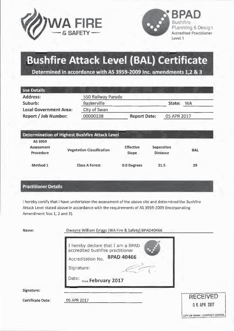
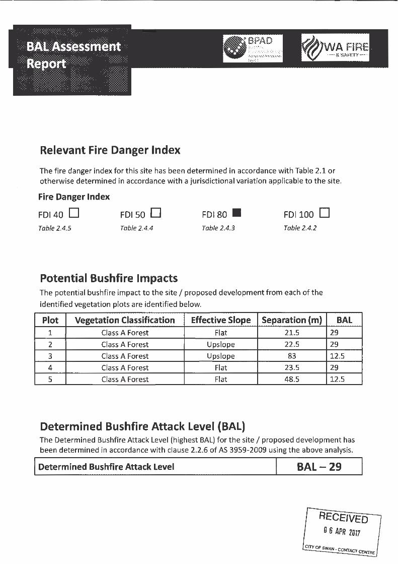
• The applicant has submitted a Bushfire Risk Assessment that indicates that a Bushfire Attack Level Rating of BAL 29 can be achieved subject to the installation of an Asset Protection Zone around the building to maintain vegetation in a low fuel state.
• Whilst that treatment is acceptable to the extent that it applies to the applicant’s property, the proposed house is to be one metre from the abutting rail corridor. The grassland and trees within that rail corridor would render a bushfire attack level of BALFZ or BAL 40 to the applicant’s house. State Planning Policy recommends against exposure of dwellings to such attack levels and advises that these should be reduced through vegetation clearing.
• The applicant is not able to access or undertake vegetation clearing of the rail corridor. Whilst it is understood that the Public Transport Authority do undertake a programme of fuel reduction within their reserves it is not clear that they are bound to do so under State regulations.
• City staff cannot be satisfied that the siting of the house will not entail its exposure to a bushfire attack level of BALFZ or BAL40 which is considered to present an unacceptable risk.
It is recommended that the Council refuse the application.
AUTHORITY/DISCRETION
LPS17 (cl.10.3)
Council has discretion in accordance with cl.10.3 of Local Planning Scheme No.17 to approve (with or without conditions) or refuse the application.

Ordinary Meeting of Council 05 July 2017
Page 2
RIGHT OF REVIEW
LPS17 (cl.10.10)
In accordance with cl.10.10 of Local Planning Scheme No.17 if the applicant is aggrieved with the decision of the Council, a right of appeal may exist in accordance with Part 3 of the State Administrative Tribunal Act 2004 and Part 14 of the Planning and Development Act 2005.
PROPOSAL AND PROPERTY DETAILS
Applicant: Withheld Section 51B Owner: Withheld Section 51B Zoning: LPS17 - Swan Valley Rural MRS - Rural Strategy/Policy: State Planning Policy 3.7 and the Guidelines for Planning
in Bushfire Prone Areas Development Scheme: Local Planning Scheme No.17 Existing Land Use: Vacant rural landholding Lot Area: 7,924m2 Use Class: Single house Use Class Permissibility: “P”
CONSULTATION WITH OTHER AGENCIES AND/OR CONSULTANTS
Public Transport Authority (PTA) – responsible authority for adjoining Railway Regional Reserve.
ASSESSMENT
Zoning & Permissibility of Land Use
The subject property is zoned ‘Rural’ under the Metropolitan Region Scheme and ‘Swan Valley Rural’ under the City’s Local Planning Scheme No.17 (LPS17).
The proposed dwelling is classified as a ‘single house’ pursuant to Local Planning Scheme No.17 and as such is a ‘P’ use within the ‘Swan Valley Rural’ zone.
The objectives of the ‘Swan Valley Rural’ zone are to:
(a) promote the core area of the Swan Valley primarily as a horticultural, recreational, tourism and landscape resource;
(b) provide for limited rural living within the Swan Valley, subject to locational, design and landscaping requirements to enhance the character and amenity of the valley and to ensure compatibility with productive rural activities;

Ordinary Meeting of Council 05 July 2017
Page 3
(c) recognise the occurrence of high quality horticultural soils and scarce plastic clays and to protect these resources from development which would jeopardise their current and future use;
(d) ensure that the development and use of land accords with the planning objectives for Area B as specified in the Swan Valley Planning Act (2005).
Bushfire Risk The property is mapped by the DFES as being within a bushfire prone area. The mapping indicates that approximately three quarters of the property is within a bushfire prone area. A northern portion of the property is not mapped as being within a bushfire prone area, measuring approximately 1,780sqm (refer to plan below).
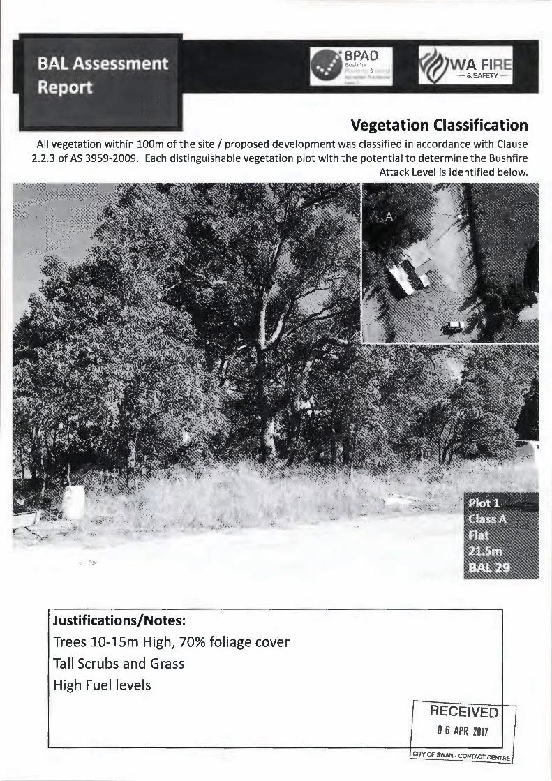
Bushfire prone land (shaded in red) The applicant has provided a Bushfire Attack Level (BAL) Assessment for the property that identifies that vegetation both on the property, the adjoining railway reserve and to the south of the subject site cannot be excluded from consideration and poses a threat. Vegetation within the railway reserve and on-site is located within 10m of the proposed dwelling.

Ordinary Meeting of Council 05 July 2017
Page 4
Vegetation within the railway reserve (left) and on-site (right) Bushfire threat is categorised into six levels under the Australian Standards for the Construction of buildings in bushfire-prone areas (AS 3959-2009). This is calculated, based on the type of vegetation, slope and distance that the development is located from the bushfire threat. These levels are shown below in further detail.
BAL DESCRIPTION (Source: AS 3959-2009, Appendix G)
BAL-LOW The risk is considered to be VERY LOW. There is insufficient risk to warrant any specific construction requirements but there is still some risk.
BAL-12.5 The risk is considered to be LOW. There is a risk of ember attack. The construction elements are expected to be exposed to a heat flux not greater than 12.5kW/m2.
BAL-19 The risk is considered to be MODERATE. There is a risk of ember attack and burning debris ignited by wind-borne embers and a likelihood of exposure to radiant heat. The construction elements are expected to be exposed to a heat flux not greater than 19kW/m2.

Ordinary Meeting of Council 05 July 2017
Page 5
BAL-29 The risk is considered to be HIGH. There is an increased risk of ember attack and burning debris ignited by wind-borne embers and a likelihood of exposure to an increased level of radiant heat. The construction elements are expected to be exposed to a heat flux not greater than 29kW/m2.
BAL-40 The risk is considered to be VERY HIGH. There is a much increased risk of ember attack and burning debris ignited by wind-borne embers, a likelihood of exposure to a high level of radiant heat and some likelihood of direct exposure to flames from the fire front. The construction elements are expected to be exposed to a heat flux not greater than 40kW/m2.
BAL-Flame Zone (FZ)
The risk is considered to be EXTREME. There is an extremely high risk of ember attack and burning debris ignited by wind-borne embers, and a likelihood of exposure to an extreme level of radiant heat and direct exposure to flames from the fire front. The construction elements are expected to be exposed to a heat flux greater than 40kW/m2.
SPP 3.7 and the Guidelines require that when development is within a bushfire prone area, the property size exceeds 1,100m2 and will be exposed to a BAL rating above BAL-LOW, a Bushfire Management Plan (BMP) is required to be submitted. A BMP contains measures to establish and maintain a suitable site, including any additional development standards. This is needed for the City to determine whether a proposal is acceptable so as to avoid any increase in the threat of bushfire to people. SPP 3.7 states that the “preservation of life and the management of bushfire impact are paramount.”. As each property contains different characteristics, including vegetation, slopes, etc. BMP can vary and need to be site specific. It is critical that a BMP is provided in order to inform the City whether the proposal will have a greater chance of survival in the event of a bushfire and provide the inhabitants with a greater chance of survival should they need to take shelter in the dwelling.

Ordinary Meeting of Council 05 July 2017
Page 6
The applicant has refused to provide a BMP and has provided deficient management measures in the BAL report, despite being provided the opportunity to address concerns. The management recommendation within the BAL report recommends the following:
“Maintenance of the grass all year round <100mm and to a distance of 25-30m in order to maintain BAL-29.”
This fails to address several criteria of the Guidelines, which are critical and discussed in further detail below. Element 1: Location The development fails to locate in an area that will, on completion, be subject to a BAL-29 or less. The proposal is reliant on vegetation within the Public Transport Authority’s (PTA) railway reserve to be cleared and maintained. This would require the City to approve an Asset Protection Zone (APZ) within the railway reserve. The PTA has advised that they do not support an APZ within the reserve, which would require vegetation to be cleared and maintained. Should the proposal be approved without the applicant being able to establish and maintain an APZ within the railway reserve, the dwelling would likely be exposed to a BAL-40 or BAL-FZ, which exposes development and human life to undue risk. The Guidelines states that:
“Where there is an extreme bushfire hazard or requirement for use of BAL-40 or BAL-FZ construction standards, the land is not considered suitable for development unless it meets the definition of minor or unavoidable development.”
The proposal is not ‘minor or unavoidable development’ and therefore this proposal does not comply with acceptable solution A1.1. Element 2: Siting and Design of Development The Guidelines convey that an APZ should be solely contained within the boundaries of the lot on which the development is situated.
“The APZ should be contained solely within the boundaries of the lot on which the building is situated, except in instances where the neighbouring lot or lots will be managed in a low-fuel state on an ongoing basis, in perpetuity. The APZ may include public roads, waterways, footpaths, buildings, rocky outcrops, golf courses, maintained parkland as well as cultivated gardens in an urban context, but does not include grassland or vegetation on a neighbouring rural lot, farmland, wetland reserves and unmanaged public reserves.”
The BAL report submitted by the applicant identifies vegetation within the railway reserve as not excludable vegetation and presents a fire risk. A 22-25m APZ needs to be established immediately surrounding the proposed dwelling. Approximately 1,600sqm of APZ needs to be established and maintained within the PTA railway reserve. The PTA has advised that whilst there is a general programme for keeping vegetation within some parts of the railway reserve in a low fuel state, this does not include the land immediately adjoining the property, which presents part of the threat to any future dwelling.
Ordinary Meeting of Council 05 July 2017
Page 7
The PTA does not support an APZ being located within their reserve and the BAL report does not outline all necessary standards for APZs, contained under the Guidelines. The PTA has advised that access onto the reserve by the landowner to undertake and maintain an APZ is not supported. Compliance with the Guidelines under acceptable solution A2.1 cannot be met. Element 3: Vehicular Access The development fails to accommodate an internal perimeter firebreak of a minimum width of three metres as the dwelling is located within one metre of the western boundary. An alternative firebreak would need to be installed to comply with requirements. City staff cannot be satisfied that the siting of the house will not entail its exposure to a bushfire attack level of BALFZ or BAL40 which is considered to present an unacceptable risk.
OPTIONS AND IMPLICATIONS
Option 1: That Council resolve to refuse the application for planning approval for a Single House, for the following reasons:
1. The proposal does not comply with the Policy objectives of State Planning Policy 3.7 Planning in Bushfire Prone Areas, including:
5.1 Avoid any increase in the threat of bushfire to people, property and infrastructure. The preservation of life and the management of bushfire impact are paramount.
5.3 Ensure that higher order strategic planning documents, strategic planning proposals, subdivision and development applications take into account bushfire protection requirements and include specified bushfire protection measures.
2. The Public Transport Authority has advised that they do not support the establishment and maintenance of an Asset Protection Zone (APZ) within the Railway Regional Reserve adjoining the subject site.
3. The application has not demonstrated compliance with Elements 1, 2 and 3 of the Guidelines for Planning in Bushfire Prone Areas.
Implications: The applicant may elect to have the decision reviewed by the State Administrative Tribunal.
This is the recommended option.

Ordinary Meeting of Council 05 July 2017
Page 8
Option 2: Council may resolve to Approve the application for a Single House at Lot 62 (No.550) Railway Parade, Baskerville subject to the following conditions:
1. The dwelling shall be constructed to the relevant standards applicable to a Bushfire Attack Level of BAL FZ as set out in AS3959.
2. The applicant shall install an Asset Protection Zone within 25 metres of the perimeter of the dwelling where grass shall be kept to less than 100mm in height and trees and vegetation do not overhang the dwelling.
3. All drainage is to be contained onsite.
4. The dwelling is to be provided with a potable water supply.
Implications: The applicant may elect to have the decision reviewed by the State Administrative Tribunal.
This is not the recommended option.
CONCLUSION
The application seeks planning approval for a single house on the subject lot, it not being exempt under the City’s Local Planning Scheme No.17 by virtue of the proposed dwellings siting (setback from side boundary).
The subject property is zoned ‘Swan Valley Rural’ under the City’s Local Planning Scheme No.17 (LPS 17) and comprises an area of 7,924m2.
The lot is designated Bushfire Prone in accordance with State regulations.
The applicant has submitted a Bushfire Risk Assessment that indicates that a Bushfire Attack Level Rating of BAL 29 can be achieved subject to the installation of an Asset Protection Zone around the building to maintain vegetation in a low fuel state.
Whilst that treatment is acceptable to the extent that it applies to the applicant’s property, the proposed house is to be one metre from the abutting rail corridor. The grassland and trees within that rail corridor would render a bushfire attack level of BALFZ or BAL 40 to the applicant’s house. State Planning Policy recommends against exposure of dwellings to such attack levels and advises that these should be reduced through vegetation clearing.
The applicant is not able to access or undertake vegetation clearing of the rail corridor. Whilst it is understood that the Public Transport Authority do undertake a programme of fuel reduction within their reserves it is not clear that they are bound to do so under State regulations.
City staff cannot be satisfied that the siting of the house will not entail its exposure to a bushfire attack level of BALFZ or BAL40 which is considered to present an unacceptable risk. Accordingly refusal is recommended.

Ordinary Meeting of Council 05 July 2017
Page 9
ATTACHMENTS
Location Plan
Site Plan
BAL Assessment Report
STRATEGIC IMPLICATIONS
Nil
STATUTORY IMPLICATIONS
Local Planning Scheme No. 17
State Planning Policy 3.7 – Planning in Bushfire Prone Areas
Guidelines for Planning in Bushfire Prone Areas
FINANCIAL IMPLICATIONS
Nil
VOTING REQUIREMENTS
Simple majority

Ordinary Meeting of Council 05 July 2017
Page 10
RECOMMENDATION
That the Council resolve:
1) Pursuant to cl.68(2) of the Planning and Development Local Planning Schemes) Regulations 2015 to refuse the proposed Single Dwelling at Lot 62 (No.550) Railway Parade, Baskerville, for the following reasons:
1. The proposal does not comply with the Policy objectives of State Planning Policy 3.7 Planning in Bushfire Prone Areas, including:
5.1 Avoid any increase in the threat of bushfire to people, property and infrastructure. The preservation of life and the management of bushfire impact are paramount.
5.3 Ensure that higher order strategic planning documents, strategic planning proposals, subdivision and development applications take into account bushfire protection requirements and include specified bushfire protection measures.
2. The Public Transport Authority does not support the establishment and maintenance of an Asset Protection Zone (APZ) within the Railway Regional Reserve adjoining the subject site.
3. The application has not demonstrated compliance with Elements 1, 2 and 3 of the Guidelines for Planning in Bushfire Prone Areas.
MOTION that the Council resolve to:
1) Defer consideration of this matter to the 2 August 2017 Council meeting.
2) Record the reason for changing the staff recommendation is to provide the opportunity for the applicant to make a deputation to Council.
RESOLVED UNANIMOUSLY TO:
1) Defer consideration of this matter to the 2 August 2017 Council meeting.
2) Record the reason for changing the staff recommendation is to provide the opportunity for the applicant to make a deputation to Council.

DISCLAIMER: Information shown hereon is a composite of information from various different data sources. Users are warned that the information is provided by the City of Swan in this format as a general resource on the understanding that it is not suitable as a basis for decision making without verification with the original source.
Location Plan
22 June 2017
1:4000
Subject site