Embed Size (px)
Citation preview

Documents-GLCF Reports
Proposal Type 2-ESIPUniversity of Maryland, College Park
A Landcover Earth Science Information Partnership
Contents Introduction UMCP Research Activities Relevant to Land Cover Data Sets and Products to be Provided by the Land Cover ESIP Services to Support Earth System Science Research Innovative Approaches for Data Processing, Archiving, Distribution and User Support Earth System Science User Support Land Cover ESIP Interoperability Participation in the WP-Federation Management Plan Personnel Bibliographic Team Member Details
Introduction
The University of Maryland at College Park (UMCP) is proposing to establish a Land Cover ESIP.Development and operation of this ESIP is a logical development of the substantial terrestrial researchactivities which have been accomplished on this campus over the last decade. In 1986 Dr. Gowardestablished the Laboratory for Global Remote Sensing Studies (LGRSS). Shortly thereafter Drs. Princeand Dubayah joined the Geography faculty and Dr. John Townshend was recruited as DepartmentChair. From the beginning the major emphasis of our research has been to address critical global andregional scale terrestrial Earth Systems Science issues that are central to NASA's Mission to PlanetEarth. This is indicated in our publications since the mid 1980s (e.g., Goward et al., 1985; Townshendand Tucker 1984; Justice et al., 1985; Prince and Tucker, 1986.)
Our explorations of the value of available regional and global-scale satellite observations havecaused us to pay considerable attention to various efforts to process and analyze AVHRR and Landsatobservations (Goward et al., 1990; Goward et al., 1991; Goward et al., 1993; Townshend et al., 1995;Townshend 1989; Townshend 1995; Prince and Goward 1995; Goward 1989; Goward et al., 1990.)We further have examined other observation sources when they appear to provide important additionalinformation ( e.g., Dye 1992; Tucker 1989.) Our attention to data quality has always been driven byour science needs. Each of the LGRSS researchers has pursued specific aspects of Earth SystemsScience (Townshend et al.,1987; Goward 1989; Goward and Kazantsev 1991; Prince 1991;Townshend et al., 1991; Dubayah 1992; Goward et al., 1994; Goward and Prince 1995; Prince andGoward 1995; Prince et al., 1995.) Recognition of our attention to both science and data quality isfound in our current service to the NASA EOS program, as members of the MODIS team, the Team
1 of 40 3/6/00 1:33 PM
A Landcover Earth Science Information Partnership http://glcf.umiacs.umd.edu/documents/proposal.html

Leader for Landsat-7, IDS membership, our participation in the Landsat Tropical DeforestationPathfinder project and our leadership in the AVHRR Land Pathfinder for both versions 1 and 2, aswell as leadership in the International Geosphere Biosphere Programme (IGBP) and the GlobalClimate Observing System (GCOS).
In the early 1990s we concluded that typical, existing computer facilities and data handlingprocedures were insufficient to address the large volumes of data needed for our research. In 1993, theDepartment of Geography joined forces with the University of Maryland Institute for AdvancedComputer Studies (UMIACS) to explore use of advanced computational approaches to attack thisproblem (Davis and Townshend, 1993; Liang, 1995 #81.) This resulted in the awarding of a NationalScience Foundation Grand Challenge grant to UMIACS and Geography to resolve the data volumeissue in regional and global-scale studies of land cover and other critical Earth Systems Science issuesas well as the need for greatly increased computational speeds. This work has led to remarkablecomputational advances. For example, atmospheric clearing of Landsat TM images which wouldnormally take 3-4 hours on a typical UNIX workstation we now accomplish in less than 10 minutes.We are also re-examining the basic approaches to remote sensing data storage and retrieval for globalscale research (Schock et al., 1995.) We now understand these advanced scaleable computertechnologies sufficiently to propose their use in Working Prototype Earth Science InformationPartnership.
We believe that our long experience in processing and analyzing regional and global-scaleterrestrial remote sensing measurements, combined with our recent progress in employing advancedcomputer technologies to solve basic data handling and processing problems, provides an exceptionalopportunity to develop and exploit the ESIP concept. The recent founding of the Earth System ScienceInterdisciplinary Center as a collaborative activity between the University and the Goddard SpaceFlight Center, with its emphasis on inter-disciplinary research contributing to the program of Missionto Planet Earth (MTPE) is another key argument for locating the proposed ESIP at UMCP.
There is no single path to addressing the data handling and processing issues posed by the NASAEarth Observing System and MTPE goals. This University of Maryland team has significantexperience in EOS/MTPE science and data handling, internationally recognized expertise across thewide range of skills needed to address the problems from a fundamental perspective, and enthusiasmfor the advances in Earth System Science that can come from focused collaboration on developing thenew data, information and analytical systems that are now possible.
UMCP Research Activities Relevant to Land Cover
UMCP has an extremely broad range of research capabilities associated with land cover researchusing remotely sensed data. We propose an ESIP to facilitate the distribution of data products andprovision of analytical services based on the extensive program of on-going research on this topic atand research in computer science at UMCP. Current funds support either research leading to thecreation of algorithms or, in some cases protype products and services, but we lack funds to enablesustained support of their provision to the broader user communities.
We envisage an expanding array of products and services as the ESIP evolves, based on thecontinuing research that we are carrying out and eventually also on collaboration with other researchgroups concerned with land cover. We are able to specify in some detail the initial products andservices to be made available, but for later periods we deliberately give only general indications of thenew products and services to be provided, since we wish to be able continuously to introduce
2 of 40 3/6/00 1:33 PM
A Landcover Earth Science Information Partnership http://glcf.umiacs.umd.edu/documents/proposal.html

innovation into all aspects of our work. The initial and subsequent products and services will,nevertheless, all conform to certain archiving and retrieval standards that we propose as fundamentalinnovations in this ESIP.
The principal land cover research projects from which we will draw are outlined below for theproposed ESIP. They clearly demonstrate the breadth and depth of our research in land cover and theleadership we have in this field. This perspective gives us a unique overview of the current communityof land cover researchers and will facilitate our efforts under this ESIP to encourage communityparticipation in the development and identification of new products and services.
Landsat Pathfinder Humid Tropical Deforestation Project(PI John Townshend)
The NASA Landsat Pathfinder Humid Tropical Deforestation Project is a collaborative effortbetween the UMCP Geography Department, the University of New Hampshire Complex SystemsResearch Group, and NASA-Goddard Space Flight Center GIMMS Group. The project is focusing onthe three regions where most of the tropical deforestation in the world has occurred--the AmazonBasin, Central Africa, and Southeast Asia (Townshend et al., 1995.) UMCP has responsibility for thenon-Brazilian Amazon Basin (also known as the Pan-Amazon) and Central Africa. Results of thecountry-wide mapping for Bolivia and Peru are available through our homepage.
The prime application for the data set is the identification of changes in carbon stock for globalmodeling. But many other applications are developing, including monitoring of fragmentation ofhabitats; identification of new areas of future development for planning purposes; assessment offorestry resources; and land use changes in relation to National Parks and other protected areas.
Coastal Marsh Loss Mapping Project(PI Michael Kearney)
The purpose of the Coastal Marsh Project, funded by a NASA Applications Center grant, is toanalyze the surface condition of coastal marshes and detect areas that are at risk from rapid loss ofland area (Kearney and Rogers 1995.) Thematic Mapper (TM) satellite imagery and NationalWetlands Inventory (NWI) classification maps are combined in our study using mixture modellingprocedures. Marshes are categorized into one of four different classes: (1) healthy, (2) moderately, (3)heavily, and (4) completely deteriorated, based primarily on the percentage of the marsh surface that iscovered with water detected using spectral mixture modeling. So far, we have analyzed satelliteimages covering the east coast of the United States from Massachusetts to Georgia, for a time periodfrom the early 1980s to 1990s.
High Performance Computing For Land Cover Characterization(PI Larry Davis)
UMIACS, in conjunction with the Department of Geography, holds an NSF Grand Challenge grantfor the application of high performance computing to land cover characterization. Among the manyresults from this work has been the development of procedures allowing very rapid atmosphericcorrection of complete scenes of Thematic Mapper data using the dark target approach (Fallah-Adl etal., 1996; Fallah-Adl et al., 1996,) generation of bidirectional reflectance distribution functionproducts at a global scale, (Kalluri et al., 1997) and several new classification algorithms and a range
3 of 40 3/6/00 1:33 PM
A Landcover Earth Science Information Partnership http://glcf.umiacs.umd.edu/documents/proposal.html

of high performance computing tools for dealing with problems associated with the necessarily veryhigh I/O rates.
Global hierarchical indexing system(PI Samuel Goward)
Also as part of the NSF Grand challenge grant, we have developed a prototype global hierarchicalindexing scheme that will optimize access and processing of remotely sensed data and higher leveldata sets (Schock et al., 1995.) The goal is to allow data sets to be stored, accessed and processed in anunsampled form so as to preserve data integrity. The procedure means that data sets can be fused invarious ways without having to suffer from multiple reprojections and resampling. Currently we haveimplemented the system for a global AVHRR data set.
Global Land Cover Classification Using Coarse Resolution Data(PIs Ruth DeFries and John Townshend)
NASA's Terrestrial Ecology Program provided funding from 1991 through August 1997 (to becontinued by NASA's Land Cover land Use Change (LCLUC) program) for mapping global landcover from satellite data, with the aim of improving the accuracy of land cover data sets and toparameterize global change models. These efforts have produced a global land cover data set atone-degree spatial resolution (Defries and Townshend, 1994; Defries et al., 1995) based on amaximum likelihood classification of annual NDVI temporal profiles. This data set has been madeavailable at a web page. An 8-km data set has subsequently been created and is ready for distribution.
Improved AVHRR Data Sets(PIs Eric Vermote and John Townshend)
Over many years, since the inception of global remotely sensed data sets, we have contributedsignificantly to the development and improvement of algorithms and processing chains to advancetheir capabilities. This effort has been especially strong for AVHRR data where members of theDepartment of Geography took leadership roles both in the specification of the NOAA/NASAPathfinder AVHRR Land data set (James and Kalluri 1994) and in the specification of the IGBP-DISglobal 1 km AVHRR data set (Townshend et al., 1994.) More recently, as part of our NASA-fundedsecond phase of Pathfinder activity, new algorithms and processing procedures are being implementedto create much improved land products from the AVHRR data stream.
Monitoring Global Primary Production(PI Stephen Prince)
Net Primary Production (NPP) is a key ecological parameter that describes the fixation ofatmospheric carbon by plants, and thus measures the potential supply of carbon to humans and animalsfor food fuel and fiber (Field et al., 1995.) Our GLO-PEM model (Global Production EfficiencyModel) represents the first attempt to infer plant production and also the environmental factors thatdetermine the actual growth (Prince and Goward, 1995; Prince et al., 1995.) Our goal is to estimateannual NPP from the entire AVHRR data set which starts from 1981 and continues to the present andto examine the variations in NPP from year to year associated with land cover changes, interannualvegetation dynamics and climate fluctuations.
Retrieval Of Atmospheric And Biospheric Variables from Remote Sensing Data
4 of 40 3/6/00 1:33 PM
A Landcover Earth Science Information Partnership http://glcf.umiacs.umd.edu/documents/proposal.html
(PI Samuel Goward)
Accurate high spatial resolution meteorological and surface variables are needed to modelland-atmosphere interactions in ecosystem and energy balance studies. We have developed and testedseveral algorithms to derive these parameters from satellite data during our participation in large scalefield experiments (such as FIFE, HAPEX-Sahel and BOREAS) and through the Pathfinder 2 project.Surface temperature, air temperature, atmospheric perceptible water, and vapor pressure deficit werederived from AVHRR measurements alone (Prince et al., 1997.). Net solar radiation has beenestimated using transportables oftware using Landsat Thematic Mapper corrected for topographic andatmospheric effects (Dubayah 1992.)
Principal Investigatorship Of The Vegetation Canopy Lidar(PI Ralph Dubayah).
Dr. Ralph Dubayah is the principal investigator for the recently-announced NASA-fundedVegetation Canopy Lidar (VCL) instrument. The VCL is an active laser remote sensing system whoseprincipal objective is the three-dimensional characterization of the vertical structure of the earth,including canopy top heights, vegetation canopy vertical distribution, and sub-canopy topography. Theinformation provided by this instrument is unique, and is expected to provide information on globalvegetation biomass and topography that is highly relevant to understanding biogeochemical andhydrological cycling, land use and land cover change.
Memberships of MODIS Team(PIs John Townshend and Eric Vermote).
John Townshend is a member of the MODIS Team generating algorithms for the creation of a250m resolution land cover change indicator product, which in a simplified form can also be used as aland cover change alarm product to assist acquisitions strategies data from fine resolution systemssuch as Landsat 7. Algorithms to create 500m and 250m land cover products depicting continuousfields of land cover components are also being produced.
The work of our second MODIS team member, Dr. Eric Vermote, is on the atmospheric correctionof the MODIS visible bands. Previous operational correction schemes have assumed a standardatmosphere with zero or constant aerosol loading and a uniform, Lambertian land surface. TheMODIS operational atmospheric correction algorithm will use aerosol and water vapor informationderived from MODIS data, correct for adjacency effects and take into account the directionalreflectance properties of the observed surface.
Membership of Landsat 7 Science Team(PI Samuel Goward)
Dr. Samuel Goward is currently a team member and Team Leader of the MTPE Landsat ScienceTeam. He is designing an end-to-end Landsat data acquisition, handling and processing system whichwill achieve current MTPE science objectives in global-scale land cover/land use assessment. Thecritical contribution of Landsat to MTPE land cover assessment is that it provides the combination ofspectral integrity, spatial detail, and temporal repetitiveness (SST) which captures and delineates thespatio-temporal dynamics of the Earth's land area in sufficient detail to assess location and cause oflands cover change.
Land Cover and Land Use Change in Central and Southern Africa
5 of 40 3/6/00 1:33 PM
A Landcover Earth Science Information Partnership http://glcf.umiacs.umd.edu/documents/proposal.html

(PI Stephen Prince)
As part of NASA's LCLUC program Dr. Stephen Prince is devloping an integrated landdegradation and deforestation detection system for the Southern African Development Community(SADC) region plus southern Zaire. The scale for the inventory and monitoring will be 1 km2. Usingour past experience with degradation studies in Africa, the analysis of very large volumes of Landsatdata, socio-economics of land and fuelwood, and inference of biophysical variables for large areasfrom remotely sensed measurements, we will map land cover and biophysical properties of the landsurface related to degradation, thus moving beyond classification of land cover to monitor theprocesses involved. Socio-economic drivers of land cover change as well as biophysical factors will beemployed to select processes that can be expected to cause degradation and to choose representativestudy areas. Radar and optical methods will be implemented to measure biomass. Primary productivityof crops, rangelands and forests will be monitored using models driven by remotely sensed data. Soilmoisture and runoff will be derived from surface water and energy balance models also driven withremotely sensed data.
Data Sets and Products To Be Provided By the Land Cover ESIP
Selection of the specific data sets and products for any given year will be carried out through theprocess described in Section 5 (Management). The basic rationale behind our approach involvescareful internal and external review of the results of both our own existing research projects and thoseof others to assess whether the results have a maturity appropriate for product and service distributionby the Land Cover ESIP. The review process will identify the highest priority products and servicesarising from the land cover research activities. Those selected will then be incorporated into the ESIPand the ESIP will then be the principal mechanism for their distribution to the external usercommunity.
We are proposing both improved remotely sensed data products which can be used for land coverresearch, advanced land cover products and in some cases highly portable software for users to applythe procedures at their own facilities (all software will be made available to users requesting it)
YEAR 1: Data sets and Products to be provided (1997-98)
Based on an evaluation of the results of our current research and scientific priority we haveidentified a number of products from our research projects, which have reached a level of maturity andtimeliness such that they are suitable for immediate distribution through our proposed Land CoverESIP. A final decision on the release of these would only be made following input from the StrategicAdvisory Team described in section 5. Details of the supporting research on which the products arebased is given in section 2.1.
Atmospherically corrected Thematic Mapper data on demand for users.
Using the procedures developed under our NSF Grand Challenge grant (Fallah-Adl, et al., 1996;Fallah-Adl et al., 1996) involving implementation of the dark target approach (Kaufman and Sendra1988) we will correct Thematic Mapper images for aerosol and other atmospheric effects. This methodcan do much to remove the effects of thin clouds as well. Users will provide their own data sets unlesswe have the data in-house. Users will receive advice on the appropriateness of the approach for theirdata, since in the absence of suitable dark targets within the scene the procedure is not effective. Userswill receive full resolution data sets with all the reflective bands corrected for these effects. We will
6 of 40 3/6/00 1:33 PM
A Landcover Earth Science Information Partnership http://glcf.umiacs.umd.edu/documents/proposal.html

also provide our software for this correction so that users can carry out their own corrections if they sowish.
Coastal wetlands health products.
We propose providing products from our coastal wetlands research; these are completed for muchof the coastal eastern US. The data layers will include 1) visually enhanced National WetlandsInventory products, 2) enhanced Thematic Mapper data - (depending on date and copyrightrestrictions, charges may have to be made for this layer to the copyright owner) and 3) a layer in whichthe marshes are characterized according to health categories. The products will involve provision ofdata in flexible units of aggregation including Thematic Mapper scenes, US map quads or by localgovernment unit.
Tropical humid rain forest land cover
Wewill use the Land Cover ESIP to operationalize the distribution of the completed products fromour work on the Landsat Pathfinder Humid Tropical Rain Forest project for those areas for whichUMCP has responsibility; namely, the pan-Amazon (Bolivia, Peru, Ecuador, Colombia Venezuela andthe Guianas) and central Africa (principally the Republic of Congo, Democratic Republic of theCongo and Cameroon). Products showing the distribution of closed tropical rain forest, and areas ofclearance and regrowth will be made available at the full resolution of the product (128m). Data willbe provided on flexible units of aggregation, principally by Landsat scene, multiple scenes from aLandsat row, or by country. Comprehensive meta-data describing the classificationr esults will beprovided with each product. This will include information on product quality including informationand commentaries on the analyses from in-country experts and the published documents used togenerate the products. Change products between the 70s and 80s and the 80s and 90s will also beavailable at a resolution of 16 km. (The lower resolution relates to the need to reduce errors introducedby spatial misregistration).
We regard this effort as being highly complementary to the proposed ESIP of Dr. David Skole andothers, which is concerned with tropical rain forests in Brazil and south east Asia.
Coarse resolution land cover products.
Over the last three years we have generated global land cover products at resolutions of 1 degreeand 8 km using the IGBP-DIS land cover classification scheme, based on AVHRR data. They arewidely requested and we will make these available through the proposed Land Cover ESIP. Weanticipate they will be of particular use in modelling work at regional and global scales. Associatedwith these global products are the training and testing data sets based on Landsat data used in theirproduction. Partial sets of these Landsat data have already been published on the Web. The additionalresources available through the Land Cover ESIP will allow a much more comprehensive set of datafor training and testing to be released. We will make available the original Landsat data (none of thesedata has copyright restrictions), and the data layer identifying the land cover types present. Themeta-data describing the source of information used in identifying the cover types will also beprovided. All these data sets will be provided in a format that is registered to the Pathfinder 8-km dataset in its Goode projection.
YEAR 2: Data Sets and Products to be provided (1998-99).
In subsequent years we envisage adding products to those described above. The identity of these
7 of 40 3/6/00 1:33 PM
A Landcover Earth Science Information Partnership http://glcf.umiacs.umd.edu/documents/proposal.html

will be dependent on the progress of our research and collaborations with other land cover researchers,who may wish to collaborate with us in distributing their products through the Land Cover ESIP.Therefore, the following products and services should be considered preliminary and subject to thereview and evaluation process described in Section 5.
Production of user-defined 1 km AVHRR products for the land.
We will use code developed as part of our Pathfinder 2 project to allow users to specify the type ofproduct they want derived from 1 km AVHRR data, based on choices of map projection, type ofcompositing procedure and choice of atmospheric correction algorithm. We intend to acquire fromEDC all of the Level 1B composited orbits of the global 1 km data set and stage them to allow usersaccess to this type of processing for any region. We will offer this flexible processing possibility onlyfor options other than the standard processing being offered through EDC. Currently EDC offers aproduct based solely on the initial IGBP recommendations. It is likely they will wish to offer a version2 product based on our research under Pathfinder 2. It is our understanding that this product willconsist of a single non-optional processing chain without the flexibility we propose to offer. Initiallywe will only make our products available for regional subsets, since provision of global data setsbased on multiple options could easily overwhelm our proposed capacity.
We will also consider providing products based on other 1 km data sets, assuming computingresources are available, since the EDC 1 km data set only represents a fraction of the 1 km dataavailable. We will entertain requests from users to process other 1 km data and will use the variousmanagement structures described in section 5 to decide on whether to respond positively to requestsfor such processing. For a maximum specified computing load (provisionally set at approximately a1000 by 1000 pixel image for a year), we will carry out on-demand processing of products and supplythese in near-real time.This will form an important prototypE activity in assessing the extent to whichnon-standard products are required and the logistics involved in supplying these to the usercommunity.
Atmospherically corrected products from Landsat 7.
We will provide atmospherically corrected Thematic Mapper products on a similar basis to thatproposed for those from previous Landsats (see Year 1). Additionally we intend to use products fromMODIS, with its channels designed specifically to assist atmospheric correction, to carry out improvedcorrection of Thematic Mapper data. This will be facilitated by the similar overpass times of the twoplatforms.
Improved global land cover products.
Our Pathfinder AVHRR project has proposed a number of substantial improvements in theprocessing of the GAC and LAC/HRPT data sets. We anticipate that these data sets will be availableby the second year. Using these we will generate revised global land cover products using these datasets. We will be incoporating advanced decision-tree procedures and object-based algorithms derivedfrom our NSF Grand Challenge project.
YEAR 3: Data sets and Products to be provided (1998-99).
In subsequent years, we envisage several other products' becoming available, dependent in partupon our current research and collaborations ith other groups. For example, we currently have bids for
8 of 40 3/6/00 1:33 PM
A Landcover Earth Science Information Partnership http://glcf.umiacs.umd.edu/documents/proposal.html

resources to allow us to carry out large scale integration of multiple remotely sensed data sets,including Landsat and MODIS. We would anticipate using the ESIP to assist in the distribution of theresulting advanced products.
Processing of data through the Global Hierarchical Indexing System.
We propose to begin handling, processing and (as desired) delivering data sets in the GlobalHierarchical Indexing System structure developed as part of our NSF Grand Challenge project, inwhich data sets are stored in unresampled forms and are located through an advanced indexing system.Use of this system means that the full integrity of the data is preserved. Such an approach will be ofparticular value where it is necessary to fuse two or more data sets with inherently different internalgeometries. We anticipate that this approach will eventually form the procedure for handling all datain the ESIP. A working prototype already exists, so it may be possible to advance this capability to thesecond year of ESIP operation.
Advanced Land cover Products from MODIS and Landsat.
For both MODIS and Landsat projects described in the section 2.1, we have already definedprocedures for the creation of standard land cover products and distribution through EOS-DIS andexisting DAACs. However, continuing research is leading to the creation of more advanced products.As these products mature, we will use the ESIP to allow early production and release of prototype datasets from this work
Additionally, we currently have under consideration bids for a major enhancement of computingresources for a Remote Sensing Center of Excellence that will allow us to carry out large-scaleintegration of multiple remotely sensed data sets including Landsat and MODIS. We would use theLand Cover ESIP for the distribution of the resulting advanced products, whereas we anticipate thatthe standard EOS products we are contracted to generate would be distributed through EOSDIS asplanned.
Degradation early warning system (DEWS)
The aim of Dr. Stephen Prince's work on a Degradation Early Warning System (DEWS) is todevelop a prototype that can be applied to the whole of southern and central Africa and provide apattern for similar areas worldwide. By the third year of the ESIP we anticipate that we will haveestablished a prototype DEWS. FEWS has a routine protocol for famine early warning; we willpropose a parallel protocol for a DEWS. The DEWS will contain a range of techniques developed inthe project from which an operational DEWS can select. The protocol will be designed so that it canrespond to existing and new threats to the environment, optimize the use of a range of remotely sensedand human indicators and add value to the available information through the use of degradationmodels.
Annual Assessment of the State of Global Land Cover Change
Several of our currently funded projects, notably Landsat and MODIS, are concerned with thegeneration of land cover change. Using this information, we intend to provide an annual assessment ofthe state of the Earth's land cover transformations starting in Year 3. This assessment will containindicators of the distribution of the main types of land cover change and will provide estimates of theintensities of change. Embedded within the text of the assessment will be hyperlinks to the Landsat
9 of 40 3/6/00 1:33 PM
A Landcover Earth Science Information Partnership http://glcf.umiacs.umd.edu/documents/proposal.html

and MODIS products and data sets used in deriving the assessments.
Services to Support Earth System Science Research
Our Land Cover ESIP will provide the following main types of service to user communities:
1. Supply of standardized products derived from existing and on-going land cover projects (seeSection 2.2). Through a process of selection involving internal and external advisors, asdescribed below, we will provide products of high scientific priority in user-friendly forms.
On-demand processing of certain data sets to create advanced products according to optionsselected by the user (see section 2.2). For selected products we will allow substantial user inputin specifying their characteristics.
High level global assessment of land cover change with active links to the data bases on whichthe assessment is based.
Supply of transportable computer code for selected products and services so that users canapply the code to use on other computing systems. This capability is an important one that willpromote more rapid progress in the development of advanced products.
2. A web interface that will allow users to browse meta-data and data sets to assess how theirneeds can best be met. This interface will assist users in making best judgments about whetherany particular products will assist their goals. Provision of interfaces to meta-data and carefullydesigned browse products will substantially reduce the user effort needed to identify therequired products.
3. High level science support of the products (see section 2.5). Many levels of user support will beprovided. To ensure the highest possible levels of scientific support we will provide a hierarchyof support levels as described in section 3.
4. Documentation of data products, software and services. Information on these topics is necessaryto provide users with best opportunities to assess and use the provided products. They will beprovided both as web-based information, as hard copy and through several other mechanismsincluding workshops and seminars.
5. Provision of advice and cooperation with other members of the federations (see section 3).
All data sets and products supplied by the Land Cover ESIP will be accompanied by metadata, browsedata sets, documentation and science support. Information about the services of the ESIP will also bepublicized by a wide variety of means for example on the Web, by presenting papers at professionalmeetings organized for example by the AGU (American Geophysical Union), IGARSS (IEEEGeoscience and Remote Sensing Symposium), and ASPRS (American Society for Photogrammetryand Remote Sensing) and through journal publications.
Innovative Approaches for Data Processing, Archiving, Distibtution and UserSupport
Standard products inevitably pose problems for many users who need data customized in specificformats to analyze them in their own computing environments. In addition to providing easy andefficient access to the multiple sets of the data products described in section 2.2, we intend to offer the
10 of 40 3/6/00 1:33 PM
A Landcover Earth Science Information Partnership http://glcf.umiacs.umd.edu/documents/proposal.html

possibility for user-specified products starting with regional samples of the AVHRR 1 km data set.Reprocessing of large volumes of data sets will be scheduled to reduce impact on the overall operationof our Land Cover ESIP. A process will be set up to handle such requests from the users. For someproducts, the processing of relatively limited data sets will be permitted on demand.
To enable the generation of customer-specified data products and efficient access to the AVHRRand Landsat data products, we propose a robust and cost-effective architecture that is scaleable interms of size and functionality of EOSDIS. This architecture consists of:
A balanced, high performance, integrated compute- and data-server capable of 1 GFLOP ofpeak performance, with a 10 TB tape subsystem and a 160 GB of disks with a transfer rate up to40 MB/s for tertiary storage. A software infrastructure that offers a distributed programming environment, automatic datamanagement between the different levels of the storage hierarchy controlled by anobject-relational database, and a novel Web-interface design, all tailored for easy integrationinto the Working Prototype ESIP Federation.
We have had considerable experience in using, developing and enhancing such technologiesthrough the UMIACS Laboratory for Parallel Computing, which currently houses a 16-node IBM SP2system with 240 GB of disks and 3-TB of tape subsystem, and an ATM Cluster of 10 DEC SMPAlpha nodes, each node containing 4 Alpha processors, and through the Human-Computer InteractionLaboratory (HCIL). The current UMIACS SP2 system will be used to develop prototypes of many ofthe data products.
UMIACS has been selected as an Earth System Science data repository partner of the recentlyannounced NSF award to the San Diego Supercomputer Center, and therefore will be able to transfermany of the high performance technologies for data-intensive computing and for handling distributeddigital libraries directly into the proposed ESIP and the WP-Federation. In addition, we have anexcellent networking infrastructure that includes a campus-wide high speed ATM network (currentlymanaged by UMIACS), an OC3 connectivity to NASA at Goddard Space Flight Center through theATDNet, and, soon to be established, an OC3 connectivity to the NSF-funded vBNS network.
Data Processing and Archiving Hardware
Our intent is to set up an integrated high performance data processing and archiving system thatprovides a distributed, scaleable, and open computing and data access environment. The data productsand information services of our proposed Land Cover ESIP impose several requirements in terms ofstorage capacity, I/O throughput, computational speed, and operating environment. We consider theserequirements first in terms of raw storage capacity and then in terms of total system throughput in theexpected operating environment.
The activities conducted by our Land Cover ESIP require adequate storage to handle both a largevolume of "raw" (level 1) remotely-sensed data sets as well as standard and user-defined products.Based on the AVHRR and Landsat raw data currently available to us and the data products that weintend to provide, we have set the storage requirement to 10 TB of tertiary storage and 160 GB ofdisks. With respect to the throughput requirement of such a storage system, consider, for example, theproduction of user specified 1 km AVHRR data products. Some studies require applying a specific setof processing algorithms to multiple years of level 1B AVHRR data. It is clear that such processingrequires fast access to and manipulation of large amounts of data residing in tertiary storage. We have
11 of 40 3/6/00 1:33 PM
A Landcover Earth Science Information Partnership http://glcf.umiacs.umd.edu/documents/proposal.html

set a transfer rate of 20 MB/s for tertiary storage and 200 MB/s between the disks and the mainmemory, rates which will allow a 10-TB archive to be rotated onto the disks in approximately a week.
The computational heart of the system must strike a compromise between several disparaterequirements. We expect heterogeneous usage and must support co-existing batch and interactive jobsas well as sequential jobs. A wide variety of users also demands a flexible and robust operatingenvironment. The compute engine should not only be computationally fast , but should co-exist wellwith other computing resources. We have selected IBM's SP-2 platform as an integrated compute anddata server. UMIACS researchers and technical staff already have extensive experience with theUMIACS SP2, currently supporting a wide variety of users. The SP-2, with its native software suite,has proven effective at handling concurrent heterogeneous processing tasks. The softwareconfiguration for the SP includes all of the necessary elements for system management, monitoring,job scheduling, and development. Several years after its installation, its user community has grown toinclude a wide variety of applications users. We will use our current SP2 to prototype many of theproducts to be developed under the proposed Land Cover ESIP, which will then be transferred to thecompute/data server system requested under this proposal.
The proposed SP frame houses five nodes connected through a high performance data switch. Theswitch allows nodes to exchange data at 100MB/sec. The five nodes are divided into one "high" nodeand four "super thin" nodes. Each thin node contains a single 120 Mhz POWER2 processor, achieves234 MFLOPS, and is configured with 128 MB of main memory to allow large data sets to beprocessed completely in core. The high node contains two 112-Mhz 604 processors and 256 MB ofmain memory and, while available for computation, is primarily intended as a data server. Thecombined system will deliver a peak of about 1 GFLOPS. The 160 GB of fast disk will be distributedacross the nodes using 4 of IBM's SSA adapters per node. This yields sustained throughput of35MB/sec per SSA card for a nominal aggregate disk throughput of 700MB/sec. We expect the actualthroughput to be around 400 MB/sec.
Finally, we have selected StorageTek's Infinity 9710 Cartridge Tape Library equipped with eightQuantum DLT7000 drives for tertiary storage. Each drive is capable of 5MB/sec sustained datathroughput, and each DLT cartridge holds 35 GB of data with no compression. We chose DLTbecause it is a common format and the large capacity of an individual cartridge reduces latency fromtape swapping. The unit will hold 588 DLT cartridges for an overall capacity in excess of 20 TB.Aggregate tape throughput is 40MB/sec. The tape library will be connected to the SP's high node usingan SCSI-3 interface rated at 40MB/sec. We will acquire the ADSTAR Distributed Storage Manager(ADSM) software to support our tape library, which will allow the users to readily access data fromtertiary storage.
Storage Organization and Management
We have set the following ambitious but achievable goals for our hierarchical storage management:
1. Efficient search across multiple data sets by queries on metadata attributes through a Webinterface.
2. Ease of incremental evolution, derivation, and integration of metadata and data sets. 3. Ability of cross-correlation and knowledge discovery through data mining. 4. Automatic data handling and movement between the different levels of the storage hierarchy. 5. Ease of integration into the ESIP WP Federation.
12 of 40 3/6/00 1:33 PM
A Landcover Earth Science Information Partnership http://glcf.umiacs.umd.edu/documents/proposal.html

These goals impose a number of challenging performance requirements on the file managementsystem, metadata modeling and management, and database management system. The issues related toWeb and interaction technologies will be addressed separately. We focus here on the storagemanagement and access issues. Our overall approach will be based on an object-relational databasemanagement system and a hierarchical indexing scheme that is tailored for efficient access andmanipulation of remotely sensed data at different levels.
A hybrid object-relational database will support declarative, multi-resolution and temporal querieson top of relational systems, with the more interactive, navigational aspects of object-orienteddatabase (OODB) systems. Such a hybrid database management system (DBMS) will allow thecreation of a "meta-catalog" that integrates metadata from heterogeneous databases and other datasystems. We will use reference types to link object classes and collection types to support multi-valuedattributes, special purpose methods and "overloaded" operators. We will use Illustra as the underlyingcommercial DBMS, since it offers the advantages of OODB modeling and the ease of writing SQLqueries. It supports SQL3 OO features such as inheritance, polymorphism, and user-defined datatypes. One of the most important features of Illustra is its extendible data types that are crucial forimplementing complex searches and in particular, its spatial data type with its underlying R-treeindexing. Illustra also allows access to relational systems (such as Sybase) through special type andaccess method extensions called datablades.
Our UMCP Data Base group has built a similar system for astrophysics meta-data catalogs whichbecame operational a year ago (Cheung et al., 1995.) The AMASE prototype development is a jointeffort between the ADF at GSFC and the University of Maryland. The development was funded by theNASA Space Science Technology and Information Systems Office from 1995 to 1996 and currentlyrenewed for another three years of funding. In AMASE we concentrated on building the fundamentalcapabilities that allow multispectral queries and have populated the database with data from theROSAT and IRAS missions.
Encouraged by the success of AMASE, we propose to further exploit the OODB technology foraccessing and managing multi-temporal, multi-resolution, and multi-mission earth system science dataarchives. We will capitalize on the "richness" and "extensibility" of OODB in order to create a"meta-catalog" that truly integrates metadata from heterogeneous databases and/or systems. Wepropose to develop a query engine for scientific search and discovery which supports objectclassification, object cross-identification, and knowledge discovery through data mining.
We will use emerging computer science technologies to provide scientists and other users withtimely and efficient access to large data sets. The methodologies that will be used for the engineinclude positional queries, positional and attribute-based cross-identification of objects, multiple anduser-defined views, and automated meta-data capture that are directly applicable to many scientificdisciplines.
If the WP federation is to have a significant impact on the scientific community, the core of theeffort should be devoted to data integration. NASA and several other agencies have created many datacenters and accumulated very large amounts of data, but the level of integration is very limited. Thereason for this is that most centers concentrate on data entry, usually with very restricted dataintegration. Data entry just collects data as a byproduct of missions rather than taking a"data-integration-centric view" that recognizes the reason for these missions is the discovery of theinformation and that integration and linking with the previous discoveries is the goal, rather than justcollecting unlinkable data sets. Therefore, this proposal departs from the previously "mission-centric
13 of 40 3/6/00 1:33 PM
A Landcover Earth Science Information Partnership http://glcf.umiacs.umd.edu/documents/proposal.html

view" and treats the data integration and products as the prime goal.
In the AMASE project, 85% of the effort was devoted to the loading and linking of data sets. Datacleansing and data linking were the most time- and resource-consuming tasks. For this reason, wepropose to concentrate the core of the effort in formalizing and creating appropriate tools for managingthe evolution, derivation, and integration of data sets. The tools that we propose to build include bulkincremental loaders, pipelined data loaders, data derivation capture managers, and otherpre-processing for integration and linking (Xue 1997.)
The OODB approach reflects the "data-integration-centric" view, as loading and linking preparesthe data for the scientist, as opposed to the data-centric one of the Relational Database (RDB) whichleaves all the linking and cross-referencing to the scientist. Among features of the OODB, we will usereference types to link object classes and collection types to support multi-valued attributes, specialpurpose methods and "overloaded" operators. These will allow us to take advantage of the hierarchy ofclasses and its "property inheritance."
The storage and data movement will be supported by the ADSM file management system that willallow transparent access to the tape subsystem and, in particular, will allow applications to store andretrieve files in a secure manner without human intervention. In addition, we will develop ahierarchical indexing scheme that will optimize access and processing of level 1B and higher leveldata sets. The goal is to allow data sets to be stored in an unsampled form so as to preserve dataintegrity.
Processing Software and Data Production
We will provide a distributed and open, heterogeneous computing environment that will supportboth batch and interactive jobs as well as sequential and parallel jobs. The basic softwareconfiguration will include the necessary elements for system management and monitoring, jobscheduling, and parallel application development and execution. The IBM AIX provides the low levelfunctionality such as network I/O, file system management, backup and restore capabilities and otherbasic administration utilities. Other high level packages installed include the LoadLeveler software tohandle job management such as allocating and maintaining system resources, load balancing, andscheduling for batch and parallel jobs. The application environment will include all the necessaryelements for software development, including FORTRAN, C, HPF, MPI, and PVM. It will alsoinclude the tools for code development, debugging and profiling.
In addition to the basic software infrastructure, we will transfer some of the software and toolsdeveloped through our NSF-funded Grand Challenge project on the development of high performancecomputing technologies for land cover dynamics. One type of software encompasses processingalgorithms and their efficient implementations on current and emerging high performance computingplatforms such as the system requested under this proposal. Algorithmic efficiency and theoptimization of data movement between the different levels of the storage hierarchy are of utmostimportance, especially given that we will provide custom-tailored products and on-demand processing.
Our past work (Fallah-Adl et al., 1996) has shown several orders of magnitude improvements inexecution times (including I/O time) compared to traditional methods. As an illustration, we haverecently developed an optimized global BRDF (bidirectional reflectance function) retrieval softwareand applied it to the Pathfinder AVHRR Land data covering a period of four years (1983 through1986), using three widely different models, namely the modified Walthall model (Nilson and Kuusk
14 of 40 3/6/00 1:33 PM
A Landcover Earth Science Information Partnership http://glcf.umiacs.umd.edu/documents/proposal.html

1989) , the Rahman model (Rahman et al., 1991), and a new temporal model developed by S. Liang(Liang and Townshend 1997.) For example, the global BRDF retrieval of 30 GB of data usingWalthall's model took less than four minutes on our SP2 system, including I/O time (Kalluri et al.,1997.) Another example is the atmospheric correction of complete Thematic Mapper scenes(Fallah-Adl et al., 1996) based on Kaufman's dark target approach (Kaufman and Sendra 1988), whichwe can complete in approximately 10 minutes per scene, including I/O.
Development and Application of Web Technologies and Visualization Tools
Query languages are effective for frequent users who are also willing to take training, but morerobust querying interfaces are needed for a system that supports intermittent users, from scientists tohigh school teachers, with very varying levels of computer experience. Users will come to theWP-Federation information systems with problems that vary according to several factors, includinghow well-defined is the solution to the problem and how well-defined is the problem in theinformation seeker's mind. Thus information systems must accommodate different levels ofexperience with the data, with the information system itself, and with information seeking in general.Classic form fill-in interfaces for EOSDIS exist, but zero-hit queries are a problem as well as queriesreturning too many hits. It is difficult to estimate how much data are available on a given topic andhow to refine or relax a query to return a useful set of hits.
In the past two years, the Human-Computer Interaction Laboratory (HCIL) at the University ofMaryland has been developing prototypes of highly interactive query interfaces for EOSDIS using theprinciples of dynamic queries and query preview. Dynamic queries have been shown to be an effectivetechnique to browse information and encourage exploration, as well as to find patterns and exceptions.Dynamic queries involve the interactive control by a user of visual query parameters that generaterapid (100 ms update), animated, and visual displays of database search results (Ahlberg andShneiderman 1994.) We have developed novel algorithms and data structures that guarantee real timeinteraction (less than 100 ms updates) for 100,000 records and 10 attributes (Tanin et al., 1996.) Toovercome the problems of slow networks and data volume, we have also developed a two-phaseapproach to query formulation using query preview and query refinement, both following dynamicquery principles (Doan et al., 1997.) Our work has been very well received by the EOSDIS communityand has reached a level of maturity such that a working prototype is now being developed for anoperational system (Global Master Change Directory). We believe that preview interfaces will be amajor component of successful networked information systems interfaces (North et al., 1996.)
For this project, we propose to work on the following tasks for the proposed Land Cover ESIP:
Refinement of the dynamic query and query preview. User interfaces for on-demand data processing.
We will integrate visualization tools with our Web interface coupled with the GeographicInformation System (GIS) ESRI ARC-Info for which the University has a site license. In-situ spatialinformation will be handled by the GIS and correlated with the remotely sensed data.
Dynamic query and query preview interface for the UMCP ESIP
Our Human-Computer Interaction Laboratory has developed prototypes of dynamic queries andquery previews for EOSDIS. Those prototypes were well received by EOSDIS users during aprototype workshop organized by Hughes in Landover. Our prototype interface works as follows:
15 of 40 3/6/00 1:33 PM
A Landcover Earth Science Information Partnership http://glcf.umiacs.umd.edu/documents/proposal.html

Users first select rough ranges for a few attributes (time, location and parameter) in the querypreviewer (Figure 2). The impact of their selections is shown on the preview bars, which aredynamically updated to reflect the number of data sets available: e.g., when a user selects NorthAmerica (Figure 3), the preview bars reflect the distribution of data sets for North America. The querypreview interface makes use of data set counts maintained by providers about their holdings, anddownloaded when users initiate a query session.
Figure 2(a): The Query Provider displays on preview bars aggregate data about all EOSDIS datasets.Users learn about the holdings of the collection and make rough selections over a few parameters(here locations, parameter and time). The preview bars are updated immediately. The result bar at thebottom shows the total number of selected datasets.
16 of 40 3/6/00 1:33 PM
A Landcover Earth Science Information Partnership http://glcf.umiacs.umd.edu/documents/proposal.html

Figure 2(b): North America and two parameters are selected. Next, years will be selected and thequery submitted to request more details about the datasets.
17 of 40 3/6/00 1:33 PM
A Landcover Earth Science Information Partnership http://glcf.umiacs.umd.edu/documents/proposal.html
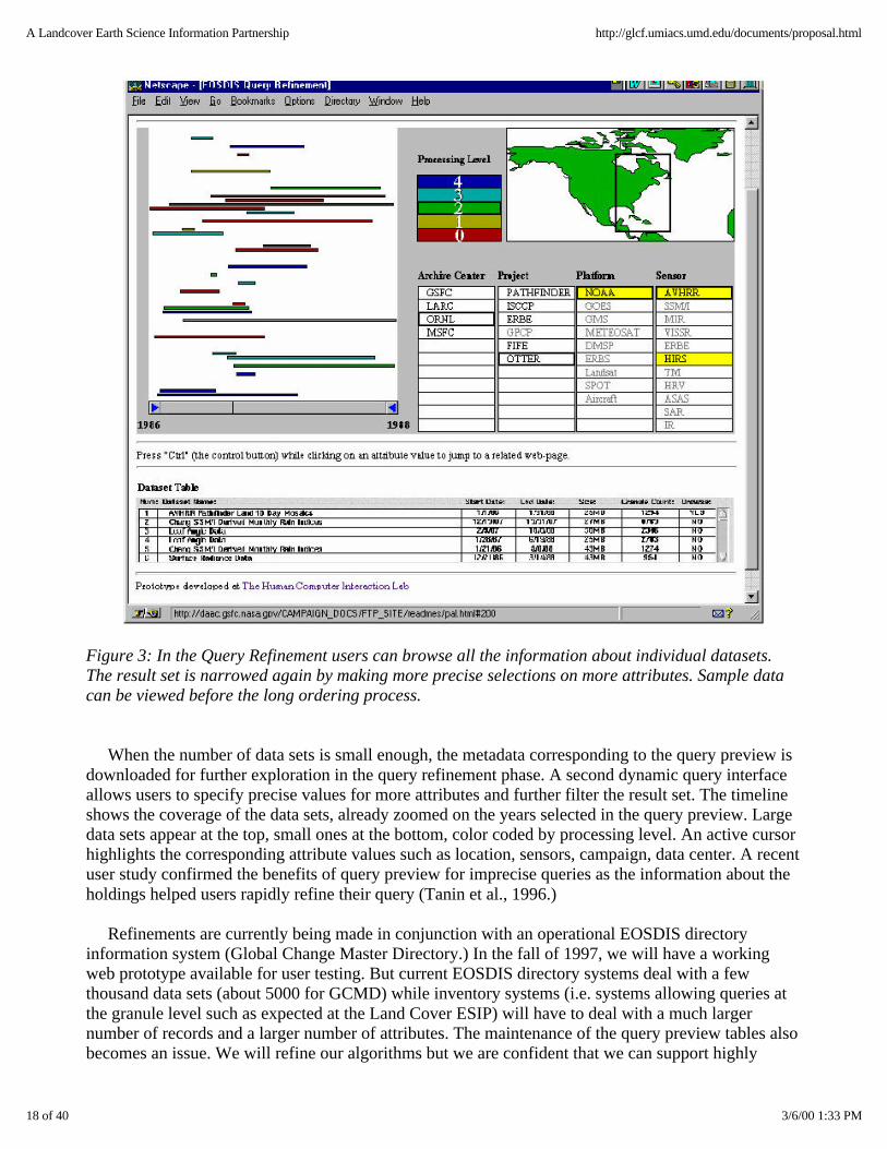
Figure 3: In the Query Refinement users can browse all the information about individual datasets.The result set is narrowed again by making more precise selections on more attributes. Sample datacan be viewed before the long ordering process.
When the number of data sets is small enough, the metadata corresponding to the query preview isdownloaded for further exploration in the query refinement phase. A second dynamic query interfaceallows users to specify precise values for more attributes and further filter the result set. The timelineshows the coverage of the data sets, already zoomed on the years selected in the query preview. Largedata sets appear at the top, small ones at the bottom, color coded by processing level. An active cursorhighlights the corresponding attribute values such as location, sensors, campaign, data center. A recentuser study confirmed the benefits of query preview for imprecise queries as the information about theholdings helped users rapidly refine their query (Tanin et al., 1996.)
Refinements are currently being made in conjunction with an operational EOSDIS directoryinformation system (Global Change Master Directory.) In the fall of 1997, we will have a workingweb prototype available for user testing. But current EOSDIS directory systems deal with a fewthousand data sets (about 5000 for GCMD) while inventory systems (i.e. systems allowing queries atthe granule level such as expected at the Land Cover ESIP) will have to deal with a much largernumber of records and a larger number of attributes. The maintenance of the query preview tables alsobecomes an issue. We will refine our algorithms but we are confident that we can support highly
18 of 40 3/6/00 1:33 PM
A Landcover Earth Science Information Partnership http://glcf.umiacs.umd.edu/documents/proposal.html

interactive query interfaces for such inventory systems.
User Interfaces For Earth System Science Data Processing
The current interfaces of EOSDIS have been limited to the searching and ordering of data sets. Forour Land Cover ESIP, the users will not only want to retrieve data but also require or apply differenttypes of processing for calibration, projection, atmospheric and topographic correction, classification,etc., so that multiple data samples can be processed to produce a new product satisfying users' needs.
Typically, those operations have been performed with either ad hoc programming tools or withcomplex science data toolkits that are not widely available to the public. Therefore, there is a need forsimple but powerful data processing services available to the broader user communities. For the moreexpert user, this will be accessed from a flexible and powerful web user interface to specify theoperations needed and to maintain an history of the operations performed. For the occasional users,such as students and teachers, this implies an intuitive visual interface making clear what operationsare possible to combine data of interest, and what standard combination of operations is required incommon situations.
We propose to start by focusing on AVHRR data processing and identifying the spectrum ofpossible operations likely to be requested. Then we will prepare prototypes of visual interfaces thatallow both occasional and expert users to specify a series of operations and repeat those operations onsets of data sets. A powerful history and macro facility will be provided that allows users to record aset of base operation and then apply variations of those operations on each selected data sets. This willalso lead to a better understanding of the requirement of such adaptable interfaces that can both satisfythe needs of occasional and expert users. As the project progresses, we will adapt and extend ourtechnique to other data types.
Our prototypes will be tested with a series of usability studies. First, informal studies will identifymissing functionalities and implementation problems; later, usability tests will verify that users canaccomplish their data processing tasks rapidly without help and feel confident that the data wasprocessed as they requested.
JAVA-Based Architecture for Interoperation
We plan to integrate Java and the Java Runtime Environment with the static DBMS operationsfound in conventional database execution engines in order to allow "code shipping" in addition to"data shipping." Code shipping will allow us to transfer small inter-platform code to be executed atremote data storage facilities where the bulky data are stored, e.g. export of functions to other sites ofthe WP-Federation systems. In this way special purpose queries and/or processing modules that havebeen developed in one site can be exported to a remote site and filter most of the data beforetransferring back either much smaller amounts of it (decision support aggregates) or simply control.
Java provides an object-oriented and architecture-independent programming paradigm whichallows developers to create modular applications that can be run on any Java-enabled platform. Usingthe object-oriented paradigm on the web and the relational support of Illustra we will developcomponent-based software by combining several independent software components. The advantage ofthis approach is the modularity and reusability of the code that is written,and the ability to changeparts of an application in a plug-and-play manner. It also enables the inclusion of third party softwarecomponents so as to use the most suitable tools available. Another advantage is the ability to make
19 of 40 3/6/00 1:33 PM
A Landcover Earth Science Information Partnership http://glcf.umiacs.umd.edu/documents/proposal.html

applications interact with each other and with the host operating system in an easy and efficientmanner by using the proper component interface.
With the full support of classes in Java, we will create just one version of the software that will runon many different machines. For example, a calibration module will be transportable to a remote siteand run on the raw data without having to ship and import the data. Having access to a remoteobject-oriented DBMS, the module will be able to store the new data product at a remote site as well.This Java-based architecture will provide the infrastructure for the WP-Federation and theinteroperation of its constituent systems. Within this framework, we can integrate heterogeneous datastorage facilities, web access to them, and visualization tools.
User Need Assessment
The diversity of the products we create will also attract many other users, as have our activities inthis arena in the past. We envisage that the main user communities above and beyond the purelyscientific will include the undergraduate and graduate students, the upper levels of the K-12community, and state and local authority users concerned with natural resources and landmanagement. Additionally, there will likely be a demand from commercial users. We anticipate theseusers based on analyses of current substantive acces ses to our current Web pages. Moreover, webelieve that many of their needs can be met by a careful design of our Web pages and otherinformation and delivery systems we will be providing, but additional outreach activities will likely beneeded.
We will institute a monitoring system to assess the characteristics of our users. This informationwill be used to adapt the operation of the Land Cover ESIP, its services and products through theadvice of our Strategic Advisory Team. We will combine a variety of techniques to assess the needs ofthe user community targeted by the Land Cover ESIP.
First, we will document automatically, using Web tools that record the characteristics of userinteractions with the Land Cover ESIP, the typical number of parameters used, and the type ofoperations most commonly applied to the data sets. We will ensure that the usage data of every LandCover ESIP data set or tool is adequately recorded and analyzed. If available, we will also study thedata collected by other data centers.
Second, we will gather information from current and potential users of the Land Cover ESIPregarding the type of query and data processing they usually perform or that they wish to perform. Thiswill be conducted with one or two small workshops and an e-mail survey broadcast on appropriatemailing lists. Statistics will be generated every month about the access and distribution volume ofevery product from the ESIP to determine the popularity and usage of the services. By monitoring thecustomers, we will be able to determine the distribution of users in educational institutions,government, industry and private sector. This information will help in targeting specific usercommunities to increase the usage of our services. We plan to hold an internal meeting at least onceevery two months to discuss, improve and monitor the services of the ESIP.
Third, we will conduct interviews of representative users, discuss their use of existing on-line datacenters and more traditional data gathering techniques. Those interviews will be important to identifythe needs for community support tools. We will produce and update a report regarding user assessmentneeds and make it available on the Web.
20 of 40 3/6/00 1:33 PM
A Landcover Earth Science Information Partnership http://glcf.umiacs.umd.edu/documents/proposal.html
Community Building and Collaboration Tools
The Land Cover ESIP will be used to foster the development of a scientific community that trulymerits the title Earth System Information Partnership We will provide information on other users whoordered the same data, performed similar operations, or published papers using the same data, subjectto necessary privacy constraints.
This implies building an archive center that not only delivers data and information services, butnurtures the community of users by facilitating access to other users. The first step is to keep track ofhow the data are used. Summary data will be made available about popular data sets and a rewardsystem can recognize the most productive data sets. We will build a collaborative environment thatallows the users to ask for the documents which refer to a data set of interest and find colleagues withsimilar specialist interests.
Costs and benefits of application of new technology
All the technologies proposed for our ESIP are based on commodity off-the-shelf hardware andsoftware components that are supplied by a number of vendors. We believe that an integratedprocessing and data server hardware architecture based on commodity high-performance processorswith a high-performance interconnect is the most cost-effective architecture; that it will allow efficientprocessing/re-processing/on-demand processing, archiving, and access to large amounts ofmulti-sensor data. In fact, it is the only scaleable architecture for use in large science data centers.
The specific vendors selected were based on the best performance/cost quotes obtained fromamong a number of vendors contacted. In addition to the ADSM software, we have considered theIBM HPSS, which is perhaps an emerging standard for a high-performance storage managementsystem that allows parallel I/O, but the cost was prohibitive. The ADSM software available at no costto us is appropriate for our purposes, and will allow easy access for tertiary storage by concurrent usersas we have configured our hardware. As for the users, we are only assuming that they have access tolow-cost platforms with Web browsers.
Other specific aspects of the proposal leading to costs and benefits include the following:
1. On-demand production of custom products. On-demand production dramatically reduces thevolume of data the system needs to archive on tertiary storage. In addition, custom processingallows an "infinite" number of products to be created from every L1B scene, giving far morevalue. While this does incur an added CPU load on the processor, we believe that our SP2system will reduce operational costs through parallel processing. Part of our investigation willseek to quantify the cost/benefits of this "lazy processing" architecture, as opposed to the currentEOSDIS "eager processing" architecture, in which all data products are precomputed and stored.We will also examine the trade-off between the higher upfront costs associated with theinstallation of the powerful SP2 system, and the expected lower operational costs associatedwith faster processing.
2. Global Hierarchical Indexing System. Storing projected data sets both corrupts the data andincurs excess costs. For example, the Interrupted Goode Hemispheric projection used by the8km AVHRR Land product contains ~20% blank space part from the oceans. This spacerepresents useless data that must be stored on tape or disk. Our proposed spherical databasesmake subsetting a routine part of query resolution, giving users only the data they require, thusdramatically reducing the network data transfer load.
21 of 40 3/6/00 1:33 PM
A Landcover Earth Science Information Partnership http://glcf.umiacs.umd.edu/documents/proposal.html

3. User interface: Our HMI Lab has already developed EOSDIS prototype interface. This interfacesupports dynamic query preview, a mechanism which allows users to locate more quickly thedata that is of interest to them.
4. Interoperability concept: Our interoperability architecture advocates keeping inter-site as simpleas possible. While users can find data at any ESIP through a single interface, advanced services(e.g. scheduling, security) are not included in this infrastructure. This intentional simplicityshould reduce costs associated with running Distributed Computing Environment (DCE) cells,as EOSDIS currently does.
5. Development Costs . There will be considerable cost-saving as a consequence of the extent towhich we can and will leverage off already-completed research and prototype implementationsas part of our NSF-funded Grand Challenge high-performance and EOSDIS prototyping.
6. Platform specific development. Given our approach and required commitments, for mostsoftware we only need to develop for the SP2, and not a multiplicity of other platforms.such asSGI, Sun, HP as ECS does.
Earth System Science User Support
A crucial goal of the Land Cover ESIP will be to reach out to the potentially large community ofusers and involve them from the outset in the development of various products, assessment of theirneeds and services required, and provision of related services. Our approach will focus on three issues(1) target community, (2) user support, and (3) data distribution.
Target community
Our main user community will be scientists who need land cover products to further their EarthScience System goals. This is by no means a homogeneous group. Their heterogeneity must beaddressed in the ways that the ESIP operates. Some of the diversity which needs to be addressed canbe described as follows:
Science users do not form a homogeneous community but vary across several dimensions:
from users who will be intensive users of remote sensing data to those who will need accessonly to high level products, from users who will deal with extremely large volumes of data to those who will use only verylow volumes, from users concerned mainly with the biophysical environment to those interested insocio-economic applications, from users interested mainly in scientific applications to those assessing natural resources, from users who will apply sophisticated models to those who will search for empirical trends inthe data.
The problems they will examine will be very diverse and likely will include the following:
Global scale modeling of the climate system, e.g. for climate prediction. Global scale observation and modeling of components of the biospheric systems, such as netprimary productivity on land. Global modeling of the carbon cycle. Regional observation and modeling of hydrological processes and biogeochemical cycling. Monitoring of climate change to assess the extent of global and regional scale changes of
22 of 40 3/6/00 1:33 PM
A Landcover Earth Science Information Partnership http://glcf.umiacs.umd.edu/documents/proposal.html

climate elements. Exchange of heat, momentum, water and carbon dioxide and trace gases across the land-airinterface. Assessment of the impacts of climate change on vegetation cover. Impact of climate change on land use, agricultural production. Monitoring and modeling of land cover and land use change especially global deforestation. Assessment of loss of biodiversity. Mapping and quantifying land degradation/desertification Impacts of land cover changes on freshwater and coastal waters. Early warning assessments on the state of the environment.
Although our principal customer is likely to be the scientific user as indicated in section 2.4.8 weanticipate many other types of users as well, including K-12 students, undergraduates, state, local andcommercial and many other users. We believe it is crucial to the success of the Land Cover ESIP (andfor that matter to the whole of MTPE) that we address their needs by providing comprehensible,highly informative Web pages and documents, as well as sample data sets illustrating key issues inEarth System Science and their broader societal significance. The integrated research and educationalmission of the newly created joint UMCP/NASA-GSFC (Earth System Science InterdisciplinaryCenter will be especially valuable in fostering and developing these activities
Data Distribution
The primary method of data ordering will be through the Internet. We will also use the GlobalChange Master Directory and the Advertising Service provided by EOSDIS to announce theavailability of our products and services. In addition to the Internet, orders for products may be placedby conventional means, such as telephones and faxes. For large data sets and images,reduced-resolution browse images will be made available on-line for visual inspection by the usersbefore they place an order. The data will be distributed either by magnetic media (tapes) or byanonymous ftp, depending upon the volume of the data. Users will be given a choice of formats inwhich they can order the data (e.g., 8mm, 4mm, tar, dd, etc.) Some of the frequently-requested datawill be provided on CD-ROMs. Besides providing the products as flat binary files, some of theproducts will also be distributed as ARC/Info files, so that they can be readily ingested into a GIS. Ifthe products received from the Land Cover ESIP are published by the users in their research, the userswould be requested to cite the source of the data.
User Support
User support has to be an integral part of the work of the ESIP. We are proposing an integrated usersupport system that involves several different types of activity. In this way we intend to give a higherlevel of support than conventionally has been achieved and at the same time provide a degree ofprotection for scientists having to respond to basic questions.
Web based and hard copy support: Our experience indicates that the majority of information thatusers need can be provided through well-designed scientifically and technically authoritative webpages and corresponding hard copy support. We will publish and disseminate a brochure that willdetail all the products and services provided by our ESIP. Our Web page will have the followinginformation:
23 of 40 3/6/00 1:33 PM
A Landcover Earth Science Information Partnership http://glcf.umiacs.umd.edu/documents/proposal.html

1. Information about the Land Cover ESIP (project objectives, personnel, services, user statisticsetc.)
2. On-line documentation and publications about the data and services provided by the ESIP. Thisdocumentation will be very detailed, and will include a description of the algorithms, accuracyand limitations of the products, references and bibliography, product status, and frequentlyasked questions (FAQ) for each product. The documentation will be in a platform independentform such as PDF or postscript.
3. Data browse and order. 4. Operational status and schedule. 5. Software tools. 6. News and announcements. 7. User feedback and comments. 8. Customer support 9. Links to other ESIPs and data services.
Technical support through members of the user support group: User-support personnel willcontinue to be an important part of the support that we provide, since there will inevitably be queriesabout product creation, availability and delivery, not dealt with through publication on the web orthrough hard copy means. Users can contact the Land Cover ESIP either by e-mail or by other meanssuch as voice and fax. Questions regarding the status of a specific order by the users will be dealt withby the operations personnel; however, more specific queries about the algorithms and processingmethods will be referred to an appropriate member of the science team or the technical team.Feedback from the users will be utilized to define and implement new products.
Workshops and seminars focusing on new products and services and the underlying science: Theunderlying philosophy behind our ESIP is to bring forward reliable novel products and services forland cover. To aid that goal we will be running regular seminars, workshops, and special conferencesessions to discuss current and planned products in a very timely fashion. The ESIP will provide achannel through which land cover scientists can much more effectively provide products to a broaduser community.
Land Cover ESIP Interoperability
As participants in a Federated EOSDIS, the Land Cover ESIP will adopt the system-wideinteroperability layer (SWIL) chosen by the WP-Federation. For the purposes of this proposal, we willoutline our interoperability philosophy (based on the data needs of the terrestrial science community),and present a provisional plan to implement these ideas.
User Services
The concept of "one-stop shopping" for data and services has been a long-standing need forEOSDIS, so that users might access any data provider from a single user interface. In fact,system-wide interoperability is actually a spectrum, offering increasingly powerful service levels tousers at the cost of increased complexity (Figure 4). The most basic service level is that of "collectiondiscovery" (e.g. catalog or directory search), which enables users to locate data sets (collections) thatphysically reside at disparate sites around the world. The Global Change Master Directory (GCMD)and the EOSDIS Advertising Service represent examples of this service level. More tightly coupledsystems allow distributed search and order of specific data granules (e.g. images), typically in response
24 of 40 3/6/00 1:33 PM
A Landcover Earth Science Information Partnership http://glcf.umiacs.umd.edu/documents/proposal.html

to a set of user-provided attributes (e.g. "find all MODIS NDVI images for Missouri during May,2000"). This service level requires metadata commonality, or translation software that can convert asystem query into a local query. The most sophisticated service level provides remote invocation of awide array of software methods across a distributed computing environment. Currently, only ECS isscheduled to provide this level of interoperability.
Figure 4: Spectrum of user service associated with "one-stop shopping".
Unfortunately, high levels of interoperability come at the price of either (1) reduced site autonomyor (2) increased system complexity. For example, implementing production scheduling across adistributed environment either requires identical software at all sites, or a complex distributedcomputing architecture. We feel reducing site autonomy compromises the purpose of theWP-Federation, while distributed computing lacks the maturity needed to produce a robust, low-costsystem. Therefore, the University of Maryland advocates a level of interoperability which supports"one-stop" collection discovery, granule search/order, and a few key services (e.g. subsetting). Moreadvanced services must be accessed by users through local client-server systems.
This conceptual system architecture is illustrated in Figure 5. Queries for individual granules ordata sets can be launched through the distributed Federation of ESIPs (path 1) using a Federationclient. These queries will perform collection and granule searches, using a generic set of metadataterms. Translator software (T) can translate between local and distributed protocols. This system-wideinteroperability may be thought of as a "least-common denominator" version of one-stop shopping.More sophisticated, site-specific services can be invoked through the use of custom client software(Path 2), which in turn can be accessed from the Federated client via the World-Wide Web (WWW).Finally, we anticipate that both routine and on-demand production will require automated data "feeds"from other ESIPs (Path 3).
25 of 40 3/6/00 1:33 PM
A Landcover Earth Science Information Partnership http://glcf.umiacs.umd.edu/documents/proposal.html

Figure 5: Conceptual interoperability architecture for the WP-Federation. Key: T=translationsoftware (different at each site); D=database; S=server software; A=data archive.
The simplest existing solution that meets the immediate needs of our user community is theEOSDIS V0 IMS. The V0 system offers support for directory search using the GCMD DirectoryInterchange Format (DIF) standard, and inventory search by sensor, data set name, geophysicalparameter, site, geographic location, and temporal range. In addition, planned extensions to the V0system will allow a subsetting specification (coordinate list) to be passed to a V0 server. The V0system is accessible via WWW, which will provide easy access to our custom WWW-based client orother local WWW tools. Finally, users of the V1 EOSDIS will be able to search V0 data sets throughthe 2-way V1/V0 Interoperability Gateway.
Specifically, our Landcover ESIP proposes to set up a V0 IMS server, database managementsystem, and translation service, the latter necessary for translating V0 queries into our local metadataspecification. Users will be able to:
find data sets resident at UMCP; search for existing granules based on sensor, parameter, space, and time; view browse images; subset data products using a rectangular region-of-interest; order data products.
Certain key services will not be available via "one-stop shopping." For example, on-demandproduction of custom data sets, geographic projection, and file format conversion services cannot becurrently supported via the V0 system. For these services, users will need to link to the Land CoverESIP WWW client. While the V0 system does not currently support coincident search, routing ofqueries through an intermediate query optimizer/join function could facilitate this service.
The Committee on Earth Observation Satellites (CEOS) Catalog Interoperability Protocol (CIP)
26 of 40 3/6/00 1:33 PM
A Landcover Earth Science Information Partnership http://glcf.umiacs.umd.edu/documents/proposal.html

provides a somewhat more flexible and sophisticated solution based on the popular Z39.50 protocol.The CIP relies on a three-part interaction between client, server, and a middleware layer, the CIPRetrieval Manager, which allows for greater autonomy for both client and server. The presence of theRetrieval Manager also facilitates system-wide distributed services, such as query optimization andcoincident search. In addition, the CEOS system organizes data sets into flexible, hierarchicalcollections, which can be defined according to user specifications.
Despite these advantages we feel that the CEOS CIP has not been prototyped sufficiently for use inthe early stages of our Land Cover ESIP. We will, however, follow development of the protocolclosely, and could migrate our system within the three years of prototype support. In this case, wewould reuse our metadata model and database, but change the translation service to make itcompatible with CIP syntax. We may also install a Retrieval Manager locally to allow hierarchicalorganization of data for the land processes community.
Metadata and Data Format
A key aspect of interoperability is the choice of metadata to be associated with archived products.This choice should be driven by (1) the needs of the targeted user community (e.g. terrestrial sciencein this case) and (2) FGDC compliance. Although the V0 IMS requires only a handful of attributes fordistributed query, we intend to archive considerably more attributes. Storing additional attributes bothempowers our custom client software, and also provides "hooks" for the WP-Federation SWIL.
To meet these goals, we intend to use a select subset of the EOSDIS Core System (ECS) sciencedata model attributes as our base metadata model. ECS has assimilated metadata models from adiverse range of data providers for their current (B.1) science data model. While not all of theseattributes are appropriate for our needs, many can be reused, and doing so guarantees FGDCcompliance. In addition, we intend to add attributes specific to land processes data which mightcurrently be Product Specific in ECS. For example, solar zenith angle, WRS coordinate, and viewangle are all critical parameters for terrestrial remote sensing, and will be included in the LandcoverESIP archive.
Participation in the WP-Federation
The goal of the Federation, namely to provide user-friendly and seamless access to Earth SystemScience data that reside on widely distributed and heterogeneous systems, is a challenging task. Thistask will only be accomplished by a visionary intellectual leadership coupled with active participationof users from the very beginning. The evolution of the Federation governance structure will be acritical first step. The Land Cover ESIP intends to fully participate in the governance of the Federationand in setting the process for Federation-wide system interoperability and standards, user participation,and coordination in user services.
Our philosophy regarding SWIL was outlined in Section 2.6. Other systems issues that users needto be addressed at the Federation level include metadata, data integration and interface design. As weindicated in Section 2.4.2, we believe that object-oriented data base systems will allow the creation ofa "meta-catalog" that integrates metadata from heterogeneous data bases across the Federation. Theprototype object relational DBMS to be installed at our ESIP can be easily scaled to handle data accessand integration across the different ESIPs of the Federation. The arguments presented in Section 2.4.2in favor of such an approach carry over to the Federation level. Regarding the interface design, webelieve that the development of the different ESIP interfaces should be coordinated from the start sothat all the interfaces will be consistent, and have the same look and feel. A group of human-computer
27 of 40 3/6/00 1:33 PM
A Landcover Earth Science Information Partnership http://glcf.umiacs.umd.edu/documents/proposal.html
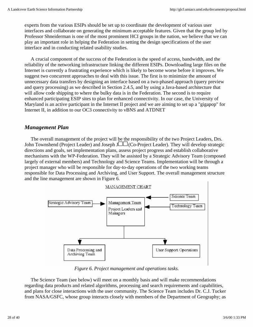
experts from the various ESIPs should be set up to coordinate the development of various userinterfaces and collaborate on generating the minimum acceptable features. Given that the group led byProfessor Shneiderman is one of the most prominent HCI groups in the nation, we believe that we canplay an important role in helping the Federation in setting the design specifications of the userinterface and in conducting related usability studies.
A crucial component of the success of the Federation is the speed of access, bandwidth, and thereliability of the networking infrastructure linking the different ESIPs. Downloading large files on theInternet is currently a frustrating experience which is likely to become worse before it improves. Wesuggest two concurrent approaches to deal with this issue. The first is to minimize the amount ofunnecessary data transfers by designing an interface based on a two-phased approach (query previewand query processing) as we described in Section 2.4.5, and by using a Java-based architecture thatwill allow code shipping to where the bulky data is in the Federation. The second is to requireenhanced participating ESIP sites to plan for enhanced connectivity. In our case, the University ofMaryland is an active participant in the Internet II project and we are aiming to set up a "gigapop" forInternet II, in addition to our OC3 connectivity to vBNS and ATDNET
Management Plan
The overall management of the project will be the responsibility of the two Project Leaders, Drs.John Townshend (Project Leader) and Joseph J (Co-Project Leader). They will develop strategicdirections and goals, set implementation plans, assess project progress and establish collaborativemechanisms with the WP-Federation. They will be assisted by a Strategic Advisory Team (composedlargely of external members) and Technology and Science Teams. Implementation will be through aproject manager who will be responsible for day-to-day operations of the two working teamsresponsible for Data Processing and Archiving, and User Support. The overall management structureand the line management are shown in Figure 6.
Figure 6. Project management and operations tasks.
The Science Team (see below) will meet on a monthly basis and will make recommendationsregarding data products and related algorithms, processing and search requirements and capabilities,and plans for close interactions with the user community. The Science Team includes Dr. C.J. Tuckerfrom NASA/GSFC, whose group interacts closely with members of the Department of Geography; as
28 of 40 3/6/00 1:33 PM
A Landcover Earth Science Information Partnership http://glcf.umiacs.umd.edu/documents/proposal.html

well as Dr. Eric Vermote, a UMCP Associate research scientist based at NASA/GSFC. TheTechnology Team (see section 6), will review the recommendations of the Science Team and developstrategies for hardware/software acquisitions, software development for data production, data storageand archiving, and user interactions. In addition, the Technology Team will set and review goals forsystem interoperability with the WP-Federation. The Technology team includes Dr Nazmi El Saleous,a member of the UMCP research faculty based at NASA/GSFC.
As demonstrated in Section 2.1 of this proposal, we are currently carrying our a wide range ofresearch activities, all of which potentially can contribute useful products and services contributing tothe mission of MTPE. We intend to carry out a rigorous internal and external review process with thehelp of the Strategic Advisory Team to establish which of these many products and services should bedeveloped in consultation with research Pis. The ESIP Management Team will identify in apreliminary fashion which of these should be developed. The Strategic Advisory Team will thenconsider these proposals on an annual basis and then advise the ESIP Management Team on theactivities of the ESIP for the following year.
We will use the following basic criteria to assess the priorities for products and services:
1. Scientific priority. 2. Novelty of services and products, especially in relation to those provided by other members of
the Federation. 3. Thoroughness of validation of products. 4. Computing loads.
The Project Manager will be in charge of day-to-day management of the ESIP. He will oversee theimplementation plans in each of the working groups, review their progress, coordinate between them,and meet with the Project Leaders on a weekly basis to review overall operations and developmentactivities. He will also be involved in coordination with the WP-Federation and attend relatedmeetings as appropriate.
The Data Processing and Archiving Working Team will consist of a database manager, a databaseadministrator, three programmers, one systems staff, and two graduate students. This team will beresponsible for systems support, setting up the file and database management systems, developing thetools to handle incremental evolution, derivation, and integration of metadata, as well as implementingprocessing algorithms and generating various data products.
The User Support Working Team will consist of two people for customer services, twoprogrammers for the Web-interface, visualization tools and human-computer interaction, and onegraduate student. This team will be responsible for handling all the user services and setting andupdating the Web-interface and visualization tools, as well as conducting the user need assessment.
Interactions with the WP-Federation will be the prime responsibility of Drs. J and Townshendand the Project Manager. Other members of the management team will participate as needed and asdeemed appropriate by the Project Leaders. We have provisionally identified Mr. J. Sobieski ofUMIACS and Ms. Vivre Bell from Geography to fill the main management positions.
The Strategic Advisory Team will provide overall advice on all aspects of the work of the LandCover ESIP including advice on the inclusion of new products, especially from research groupsoutside of UMCP, the relative allocation of human financial and computing resources for different
29 of 40 3/6/00 1:33 PM
A Landcover Earth Science Information Partnership http://glcf.umiacs.umd.edu/documents/proposal.html

tasks. They will consist of leading experts from the fields of Earth System Science and ComputerScience. Dr. Christopher Justice of the University of Virginia has agreed to chair this Team.
Personnel Dr. John Townshend(Project Leader)
Professor, Department of Geography, member of the Institute forAdvanced Computing Studies, and Interim Director, EarthSystems Interdisciplinary Center
Dr. Joseph J ¡(Co-Project Leader)
Director of the Institute for Advanced Computing Studies, andProfessor of Electrical Engineering
Management Team
Dr. John Townshend(Chair)
Professor, Department of Geography, and Interim Director, EarthSystems Interdisciplinary Center
Dr. Joseph J ¡ Director of the Institute for Advanced Computing Studies
Mr. Bruce Douglas Sr. Research Scientist, Department of Geography
Mr. Jerry Sobieski UMIACS
Ms. Vivre Bell Project Manager, Humid Tropical Deforestation Project, Department of Geography
Science Team
Dr. Samuel Goward(Chair)
Professor and Chair, Department of Geography
Dr. John Townshend Professor, Department of Geograp hy, and Interim Director, Earth Systems Sciences InterdisciplinaryCenter.
Dr. Joseph J ¡ Director of the Institute for Advanced Computing Studies
Dr. Stephen Prince Professor of Geography, Department of Geography
Director Laboratory for Global Remote Sensing Systems
Dr. Ralph Dubayah Associate Professor, Department of Geography and Institute forAdvanced Computing Studies
Dr. C. J. Tucker Biospheric Sciences Branch, NASA Goddard Space Flight Center
Dr. Eric Vermote Associate Research Scientist, Department of Geography and GSFC
Dr. Satya Kalluri Assistant Research Scientist, Department of Geography
30 of 40 3/6/00 1:33 PM
A Landcover Earth Science Information Partnership http://glcf.umiacs.umd.edu/documents/proposal.html

Technology Team
Dr. N. Roussopoulos (Chair) Professor, Computer Science and UMIACS
Dr. John TownshendProfessor, Department of Geography, and Interim Director Earth Systems Sciences InterdisciplinaryCenter.
Dr. Joseph J ¡ Director of the Institute for Advanced Computing Studies
Dr. Ben Shneiderman Professor, Department of Computer Science and Institute forAdvanced Computer Studies
Dr. Larry Davis Professor, Department of Computer Science and Institute forAdvanced Computing Studies
Dr. Nazmi El Saleous Assistant Research Scientist, Department of Geography
Dr. C. Plaisant-Schwenn, Acting Director, Human Computer Interaction Laboratory andUMIACS
Dr. Jeffrey Masek Assistant Research Scientist, Department of Geography
APPENDIX A
Bibliographic Details of Team Members
PROJECT LEADERJohn R. G. Townshend
Department of Geography,University of Maryland, College Park, Maryland 20742
Telephone: 301-405-4050.Fax: 301-314-9299.
E-mail: [email protected].
EDUCATION
B.Sc.1967 Geography with Geology, University College London. Ph.D. 1971 Geomorphology, University College London.
APPOINTMENTS
Professor, Department of Geography, University of Maryland since 1989, member of UMIACS,interim Director of the Earth Systems Science Interdisciplinary Center (until December 1997).
Professor in the Department of Geography, University of Reading, Reading, U.K., and Director,Natural Environment Research Council's Unit for Thematic Information Systems (NUTIS); previously
31 of 40 3/6/00 1:33 PM
A Landcover Earth Science Information Partnership http://glcf.umiacs.umd.edu/documents/proposal.html

lecturer and reader (1972-89)
Visiting National Research Council Senior Post-Doctoral Research Fellow at NASA's Goddard SpaceFlight Center, Greenbelt, MD. (1979-80).
RELEVANT PUBLICATIONS
Townshend, J.R.G., Tucker, C. J. and Goward, S. N. 1993. Global Vegetation Mapping. In Gurney,R., Foster, J. and Partensin, C. (Eds.) Atlas of Satellite Observations related to Global Change ,Cambridge University Press 301-311.
Townshend, J.R.G. and Rasool, S. I. 1993 Global change, In Codata Bulletin, 24 (4) (special issue onData for Global Change), 1-14.
Townshend, J.R.G. 1994. Global data sets for land applications from the Advanced Very HighResolution Radiometer: an introduction, International Journal of Remote Sensing , 15 (17) 3319-3332.
Townshend, J.R.G., Justice C.O., Skole, D., Malingreau, J.-P., Cihlar J., Teillet, P., Sadowski, F. andRuttenberg, S. 1994. The 1 km resolution global data set: needs of the International GeosphereBiosphere Program, International Journal of Remote Sensing 15 (17), 3417-3442.
Townshend. J.R.G. and Skole, D. L. 1995. The global 1km AVHRR data set. In P. Matter (editor),Understanding the Terrestrial Environment, Remote Sensing Data Systems and Networks , Ed P.M.Mather, John Wiley and Sons, 75-82.
PROFESSIONAL SERVICE
Chairman International Geosphere Biosphere Program's Working Group on Land Cover Change(1988- 93) Member and Chair IGBP-DIS Standing Committee (1990-1996) Chairman NASA/NOAA AVHRR Land Pathfinder Working Group (1991-1993) Member Editorial Board of the International Journal of Remote Sensing (1981-1995) Member National Academy of Science's Committee on Geophysical and Environmental Data(1992-5) Chair of the Joint Scientific and Technical Committee of the Global Climate Observing System(1995-present) Member of the Planning Committee of the Global Terrestrial Observing System (1993-1995).
C0-PROJECT LEADERJoseph J ¡
DirectorInstitute for Advanced Computer Studies
University of MarylandCollege Park, MD 20742
Tel: 301-405-6722Fax: 301-314-9658
E-mail: [email protected]
32 of 40 3/6/00 1:33 PM
A Landcover Earth Science Information Partnership http://glcf.umiacs.umd.edu/documents/proposal.html

EDUCATION
PhD 1977, MS 1976, Applied Mathematics, Division of Engineering and Applied Physics, HarvardUniversity.
APPOINTMENTS
Director, Institute for Advanced Computer Studies, University of Maryland, 1994- present.
Electrical Engineering, University of Maryland, 1983- present.
Computer Science, Pennsylvania State University, 1977-1983.
HONORS AND AWARDS
IEEE Fellow Award, 1996.
Maryland Industrial Partnerships Award of Excellence, 1992.
BOOKS
An Introduction to Parallel Algorithms, Addison-Wesley, 1992.
RELEVANT PUBLICATIONS
H. Fallah-Adl, J. J S. Liang, Y. Kaufman, and J. Townshend, Fast Algorithms for RemovingAtmospheric Effects from Remotely Sensed Imagery, IEEE Computational Science and Engineering,66-77, 1996
H. Fallah-Adl, J. J and S. Liang, Estimating Aerosol Optical Depth and Correcting ThematicMapper Imagery, The Journal of Supercomputing, 10, 315-329, 1996.
S. Liang, H. Fallah-Adl, J. J S. Kalluri, Y. Kaufman, and J. Townshend, Development of anOperational Atmospheric Correction Algorithm for TM Imagery, Journal of GeophysicalResearch-Atmosphere (to appear).
Retrieval of Bidirectional Reflectance Distribution Function (BRDF) at Continental Scales fromAVHRR Data Using High Performance Computing, to be presented at IGARSS Symposium, August1997.
D. Bader, J. J and R. Chellappa, Scalable Data Parallel Algorithms for Texture Synthesis andCompression Using Gibbs Random Fields, IEEE Transactions on Image Processing,4(10):1456-1460, 1995.
PROFESSIONAL SERVICE
Special Issue of JPDC on Data-Parallel Algorithms and Programming, Guest Editor, 1994. Journal of Parallel and Distributed Computing, Subject Area Editor on Parallel Algorithms,1993-.
33 of 40 3/6/00 1:33 PM
A Landcover Earth Science Information Partnership http://glcf.umiacs.umd.edu/documents/proposal.html

IEEE Transactions on Parallel and Distributed Systems, Associate Editor, 1995-. Frontiers on Massi vely Parallel Computation, Program Committee Chair, 1991. International Parallel Processing Symposium, Program Committee Chair, 1995. Workshop on Parallel Algorithms, Program Chair, 1996.
PROJECT MEMBERSamuel N. GowardProfessor and Chair
Department of GeographyUniversity of Maryland, College Park
College Park, MD 20742Voice: (301) 405-4050FAX: (301) 314-9299
E-mail: sg21@umai l.umd.edu
EDUCATION
Ph. D.,1979. Indiana State University, Department of Geography and Geology M. A., 1974. Boston University, Department of Geography A. B., 1967. Boston University College of Liberal Arts. Major: Geography
RELEVANT PUBLICATIONS
Goward, S. N. and Dye, D. G. 1997, Global biospheric monitoring with remote sensing. The Use ofRemote Sensing in Modeling Forest Productivity at Scales from Stand to the Globe. (H. L. Gholz, K.Nakane and H. Shimoda, Ed.), New York, Kluwer Academic Publishers, pp. 241-272
Prihodko, L. and Goward, S. N., 1997, Estimation of air temperature from remotely sensedobservations, Remote Sensing of Environment (in press).
Czajkowski, K. P., T. Mulhern, S. N. Goward, and J. Cihlar, 1997, Validation of the geocoding andcompositing system (GEOCOMP) using contextual analysis for AVHRR images, InternationalJournal of Remote Sensing, (in press).
Goward, S. N. and D. Williams, 1997. Landsat and Earth Systems Science: Development of TerrestrialMonitoring, Photogrammetric Engineering and Remote Sensing (in press)
Prince, S. D. and Goward, S. N., 1995, Global primary production: a remote sensing approach,Journal of Biogeography 22: 815-835.
Prince, S. D. and Goward, S. N., 1995, Evaluation of the NOAA/NASA Pathfinder Land data set forglobal primary production modeling, International Journal of Remote Sensing, 17 (1): 217-221.
PROJECT MEMBERBen Shneiderman
Department of Computer ScienceInstitute for Advanced Computer Studies
University of Maryland
34 of 40 3/6/00 1:33 PM
A Landcover Earth Science Information Partnership http://glcf.umiacs.umd.edu/documents/proposal.html
College Park, MD 20742E-mail: [email protected]
Voice: (301) 405-2680Fax: (301) 405-6707
Personal: http://www.cs.umd.edu/~benLab: http://www.cs.umd.edu/projects/hcil
Ben Shneiderman is a Professor in the Department of Computer Science, Head of theHuman-Computer Interaction Laboratory, and Member of the Institute for Systems Research, all at theUniversity of Maryland at College Park. He has taught previously at the State University of New Yorkand at Indiana University.
He regularly gives conference keynote speeches and public talks on "Human values and the future oftechnology" and "Relate-Create-Donate: Applying educational technology for the post-TVgeneration." Dr. Shneiderman's professional talks and courses cover user interface design, informationvisualization, and educational technology. He organizes an annual satellite television presentation on"User Interface Strategies" seen by thousands of professionals since 1987.
Dr. Shneiderman is the author of Software Psychology: Human Factors in Computer and InformationSystems (1980) and Designing the User Interface: Strategies for Effective Human-ComputerInteraction (1987, second edition 1992, third edition 1997), Addison-Wesley Publishers, Reading,MA. His 1989 book, co-authored with Greg Kearsley, Hypertext Hands-On!, contains a hypertextversion on two disks. It was the world's first commercial electronic book and pioneered thehighlighted embedded link. This concept was part of the Hyperties hypermedia system, now producedby Cognetics Corp., Princeton Junction, NJ.
Dr. Shneiderman has co-authored two textbooks, edited three technical books, and published morethan 180 technical papers and book chapters. His 1993 edited book Sparks of Innovation inHuman-Computer Interaction collects 25 papers from ten years of research at the University ofMaryland. This collection includes Dr. Shneiderman's seminal paper on direct manipulation, a term hecoined in 1981 to describe the graphical user interface design principles: visual presentation of objectsand actions combined with pointing techniques to accomplish rapid incremental and reversibleoperations.
Ben Shneiderman has been on the Editorial Advisory Boards of nine journals including the newlyformed ACM Transactions on Computer-Human Interaction and the ACM Interactions. He edits theAblex Publishing Co. book series on "Human-Computer Interaction." He has consulted and lecturedfor many organizations including Apple, AT&T, Citicorp, GE, Honeywell, IBM, Intel, Library ofCongress, NASA, and university research groups.
Ben Shneiderman received his BS from City College of New York in 1968, his PhD from StateUniversity of New York at Stony Brook in 1973. He received an Honorary Doctorate of Science fromthe University of Guelph, Ontario, Canada in 1996 and was elected as a Fellow of the Association forComputing (ACM) in 1997.
PROJECT MEMBERNicholas Roussopoulos
Department of Computer ScienceE-mail: [email protected]
35 of 40 3/6/00 1:33 PM
A Landcover Earth Science Information Partnership http://glcf.umiacs.umd.edu/documents/proposal.html

Institute for Advanced Computer StudiesUniversity of Maryland
College Park, MD 20742Voice: (301) 405-2687
Fax:(301) 405-6707
APPOINTMENTS
1991-present: Professor, Institute of Advanced Computer Studies, University of Maryland 1991-present: Professor, Department of Computer Science, University of Maryland 1993-1994: Visiting Professor, NTUA Athens, RWTH Aachen Germany, ETH Zurich 1985-1990: Associate Professor, Institute of Advanced Computer Studies, University of Maryland 1985-1990: Associate Professor, Department of Computer Science, University of Maryland 1985-1987: Associate Chairman for Administration and Research, Department of Computer Science,University of Maryland 1981-1984: Assistant Professor, Department of Computer Science, University of Maryland 1977-1980: Assistant Professor, Department of Computer Science, University of Texas at Austin 1976-1977: Research Scientist, IBM Research Lab, San Jose, California
FIELDS OF SPECIALIZATION
Fast OLAP Querying and Indexing of data aggregates, Client-Server Database Architectures,Distributed Database Systems, Geographic Information Systems, Spatial Indexing, High PerformanceDatabase Systems, Scallable Parallel I/O Systems, Parallel and Scalable I/O, Network ManagementInformation Systems, Database Design and Management, Expert Database Systems, and ArtificialIntelligence Databases.
RELEVANT PUBLICATIONS
N. Roussopoulos, Y. Kotidis, M. Roussopoulos. Cubetree: Organization of and Bulk Updates on theData Cube,ACM-SIGMOD International Conference on Management of Data, Tucson, Arizona, May13-15, 1997.
N. Roussopoulos, C.M. Chen, S. Kelley, A. Delis and Y. Papakonstantinou. The ADMS Project Views'R' Us, IEEE Data Engineering Bulletin, June 1995.
N. Roussopoulos, S. Kelley and F. Vincent, Nearest Neighbor Queries. ACM-SIGMOD InternationalConference on Management of Data, San Jose, California, May 22-25, 1995.
A. Delis and N. Roussopoulos. Management of Updates in the Enhanced Client-Server DBMS. (BestPaper Award), IEEE/CS 14th International Conference on Distributed Computing Systems, Poznan,Poland, June 1994.
C. Cheung, N. Roussopoulos, D. Leisawitz, S. Kelley, G. Reichert, D. Silberberg and J. Wang.AMASE: An Object-Oriented Metadatabase Catalog for Accessing Multi-Mission Astrophysics Data.Science Information Systems Interoperability Conference, College Park, Nov. 6-9, 1995.
OTHER PROJECT MEMBERS
36 of 40 3/6/00 1:33 PM
A Landcover Earth Science Information Partnership http://glcf.umiacs.umd.edu/documents/proposal.html

Dr. Stephen Prince Professor of Geography, Department of Geography; and Director, Laboratory for Global Remote Sensing Systems
Dr. Ralph Dubayah Associate Professor, Department of Geography and Institute for Advanced Computing Studies
Dr. C. J. Tucker Biospheric Sciences Branch, NASA Goddard Space Flight Center
Dr. Eric Vermote Associate Research Scientist, Department of Geography and GSFC
Dr. Satya Kalluri Assistant Research Sci entist, Department of Geography
Dr. Larry Davis Professor, Department of Computer Science and Institute for Advanced Computing Studies
Dr. Nazmi El Saleous Assi stant Research Scientist, Department of Geography
Dr. C. Plaisant-Schwenn Acting Director, Human Computer Interaction Laboratory and UMIACS
Dr. Jeffrey Masek Assistant Research Scientist, Department of Geography
Mr. Bruce Douglas Sr. Research Scientist, Department of Geography
REFERENCES
Ahlberg, C. and B. Shneiderman (1994). "Visual Information Seeking: Tight coupling of dynamicquery filters with starfield displays." Readings in Human-Computer Interaction: Toward the Year2000. R. M. Baeker, J. Gruden, W. A. S. Buxton and S. Greenberg, Morgan Kaufmann Pubs., Inc:450-456.
Cheung, C., N. Roussopoulos, D. Leisawitz, S. Kelley, G. Reichert, D. Silberberg and J. Wang (1995).AMASE: An Object-Oriented Metadatabase Catalog for Accessing Multi-Mission Astrophysics Data.Science Information Systems Interoperability Conference, College Park, MD.
Davis, L. D. and J. Townshend (1993). High Preformance Computing for Land Cover Dynamics.UMIACS/University of Maryland.
Defries, R. S., M. Hansen and J. R. G. Townshend (1995). "Global descrimination of land cover typesfrom metrics derived from AVHRR Pathfinder data." Remote Sensing of Environment 54: 209-222.
Defries, R. S. and J. R. G. Townshend (1994). "NDVI-derived land cover classifications at a globalscale." International Journal of Remote Sensing 15(17): 3567-3586.
Doan, K., C. Plaisant, B. Shneiderman and T. Burns (1997). Query Previews for NetworkedInformation Systems: A Case Study with NASA Environmental Data. College Park, Department ofComputer Science, University of Maryland.
37 of 40 3/6/00 1:33 PM
A Landcover Earth Science Information Partnership http://glcf.umiacs.umd.edu/documents/proposal.html

Dubayah, R. (1992). "Estimating net solar radiation using Landsat Thematic Mapper and digitalelevation data." Water Resources Research 28(9): 2469-2484.
Dubayah, R. (1992). "Estimating regional variabiity in net solar radiation using Landsat ThematicMapper and digital elevation data." Water Resources Research (In press).
Dye, D. G. (1992). Satellite estimation of global distribution and variability of incidentphotosynthetically active radiation Geography, University of Maryland at College Park.
Fallah-Adl, H., J. Ja a S. Liang, J. R. G. Townshend and Y. J. Kaufman (1996). "Fast algorithmsfor removing atmospheric effects from satellite images." IEEE Computational Science andEngineering 3(2): 66-77.
Fallah-Adl, H., J. JaJa and S. Liang (1996). "Estimating aerosol optical depth and correcting thematicmapper imagery." The Journal of Supercomputing.
Field, C. B., J. T. Randerson and C. M. Malmstrom (1995). "Global net primary production:Combining ecology and remote sensing." Remote Sensing of Environment 51: 74-88.
Goward, S. G. and S. D. Prince (1995). "Transient effects of climate on vegetation dynamics: Satelliteobservations." Journal of Biogeography 22: 549-563.
Goward, S. N. (1989). "Landsat 1989: Remote sensing at the crossroads." Remote Sensing ofEnvironment 28: 3-4.
Goward, S. N. (1989). "Satellite bioclimatology." Journal of Climate 7(2): 710-720.
Goward, S. N., D. G. Dye, W. Dulaney and J. Yang (1990). "Critical assessment of the NOAA GlobalVegetation Index data product." Workshop on Use of Satellite-Derived Vegetation Indices in Weatherand Climate Prediction Models, NOAA World Weather Building, Camp Springs, Maryland, U.S.Department of Commerce, National Oceanic and Atmospheric Administration.
Goward, S. N., D. G. Dye, S. Turner and J. Yang (1993). "Objective assessment of the NOAA GlobalVegetation Index data product." International Journal of Remote Sensing 14(18): 3365-3394.
Goward, S. N. and N. N. Kazantsev (1991). "Monitoring environmental change: Geographicinformation systems and remote sensing." Global Change: Geographical Approaches. J. R. Mather andG. V. Sdasyuk. Tucson, University of Arizona Press: 183-198.
Goward, S. N., B. Markham, D. G. Dye, W. Dulaney and J. Yang (1991). "Normalized differencevegetation index measurements from advanced very high resolution radiometer." Remote Sensing ofEnvironment 35(2&3): 259-279.
Goward, S. N., C. J. Tucker and D. G. Dye (1985). "North American vegetation patterns observedwith the NOAA-7 advanced very high resolution radiometer." Vegetatio 64: 3-14.
Goward, S. N., R. H. Waring, D. G. Dye and J. Yang (1994). "Ecological remote sensing at OTTER:Macroscale satellite observations." Ecological Applications 4(2): 322-343.
38 of 40 3/6/00 1:33 PM
A Landcover Earth Science Information Partnership http://glcf.umiacs.umd.edu/documents/proposal.html

James, M. E. and S. N. V. Kalluri (1994). "The Pathfinder AVHRR land data set: an improved coarseresolution data set for terrestrial monitoring." International Journal of Remote Sensing 15(17):3347-3364.
Justice, C. O., J. R. G. Townshend, B. N. Holben and C. J. Tucker (1985). "Analysis of the phenologyof global vegetation using meteorological satellite data." International Journal of Remote Sensing 6(8):1271-1381.
Kalluri, S. N. V., Z. Zhang, S. Liang, J. JaJa and J. R. G. Townshend (1997). "Retrieval ofbidirectional reflectance distribution function (BRDF) at continental scales from AVHRR data usinghigh performance computing." IGARSS, Singapore.
Kaufman, Y. J. and C. Sendra (1988). "Algorithm for automatic atmospheric corrections to visible andnear-IR satellite data." International Journal of Remote Sensing 9(8): 1357-1381.
Kearney, M. and A. Rogers (1995). "Measurement of percent water in coastal marsh pixels usingmixture modeling." ACSM/ASPRS annual convention, Charlotte, NC.
Liang, S. and J. R. G. Townshend (1997). "Angular signatures of NOAA/NASA Pathfinder AVHRRLand data and applications to land cover identification." IGARSS, Singapore.
Nilson, T. and A. Kuusk (1989). "A reflectance model for homogeneous plant canopies and itsinversion." Remote Sensing of Environment 27: 157-167.
North, C., B. Shneiderman and C. Plaisant (1996). "User Controlled Overviews of an Image Library:A Case Study of the Visible Human." Proc. of the 1st ACM International Conference on DigitalLibraries, Bethesda, MD.
Prince, S. D. (1991). "A model of regional primary production for use with course resolution satellitedata." International Journal of Remote Sensing 12(6): 1313-1330.
Prince, S. D., S. J. Goetz, R. O. Dubayah, K. P. Czajkowski and M. Thawley (1997). "Inference ofsurface and air temperature, atmospheric precipitable water and vapor pressure deficit using AVHRRsatellite observations: comparison with field observations." Journal of Geophysical Research(Submitted).
Prince, S. D., S. J. Goetz and S. N. Goward (1995). "Monitoring primary production from earthobserving satellites." Water, Air and Soil Pollution 82: 509-522.
Prince, S. D. and S. N. Goward (1995). "Evaluation of the NOAA/NASA Pathfinder AVHRR LandData Set for global primary production." International Journal of Remote Sensing 17: 217-221.
Prince, S. D. and S. N. Goward (1995). "Global net primary production: A remote sensing approach."Journal of Biogeography 22: 815-835.
Prince, S. D. and S. N. Goward (1995). "Global primary production: a remote sensing approach."Journal of Biogeography 22: 815-835.
Prince, S. D., Y. H. Kerr, J.-P. Goutorbe, T. Lebel, A. Tinga, P. Bessemoulin, J. Brouwer, A. J.
39 of 40 3/6/00 1:33 PM
A Landcover Earth Science Information Partnership http://glcf.umiacs.umd.edu/documents/proposal.html

Dolman, E. T. Engman, J. H. C. Gash, M. Hoepffner, P. Kabat, B. Monteny, F. Said, P. Sellers and J.Wallace (1995). "Geographical, biological, and remote sensing aspects of the Hydrologic AtmosphericPilot Experiment in the Sahel (HAPEX-Sahel)." Remote Sensing of Environment 51: 215-234.
Prince, S. D. and C. J. Tucker (1986). "Satellite remote sensing of rangelands in Botswana, II,AVHRR and herbaceous vegetation." International Journal of Remote Sensing 7(11): 1555-1570.
Rahman, H., M. M. Verstraete and B. Pinty (1991). "Coupled surface-atmosphere reflectance model(CSAR). 1. Model description and inversion against synthetic data." Journal of Geophysical Research98: 20791-20801.
Shock, C. T., L. Davis, S. N. Goward and A. Sussman (1995). A global-scale remotely sensed imagedata base.
Tanin, E., R. Beigel and B. Shneiderman (1996). "Incremental Data Structures and Algorithms forDynamic Query Interfaces." Proceedings of ACM SIGMOND 25: 21-24.
Townshend, J. R. G. (1989). "Special issue: Comparison of passive microwave with near-infrared andvisible data for terrestrial environmental monitoring." International Journal of Remote Sensing 10(10):1575-1691.
Townshend, J. R. G. (1995). "Global data sets for land applications from the Advanced Very HighResolution Radiometer." International Journal of Remote Sensing 15(17): 3319-3332.
Townshend, J. R. G., V. Bell, A. C. Desch, C. Havlicek, C. O. Justice, W. E. Lawrence, D. Skole, W.W. Chomentowski, B. Moore III, W. Salas and C. J. Tucker (1995). "The NASA Landsat PathfinderHumid Tropical Deforestation Project." Land Satellite Information in the Next Decade, TysonsCorner, Virginia, American Society of Photogrammetry and Remote Sensing.
Townshend, J. R. G., C. O. Justice and V. T. Kalb (1987). "Characterization and classification ofSouth American land cover types using satellite data." International Journal of Remote Sensing, 8:1189-1207.
Townshend, J. R. G., C. O. Justice, W. Li, C. Gurney and J. McManus (1991). "Global land coverclassification by remote sensing: present capabilities and future possibilities." Remote Sensing ofEnvironment 35: 243-255.
Townshend, J. R. G., C. O. Justice, D. Skole, J. P. Malingreau, J. Cihlar, P. Teillet, F. Sadowski andS. Ruttenberg (1994). "The 1 km AVHRR global data set: needs of the International GeophereBiosphere Programme." International Journal of Remote Sensing 15(17): 3417-3441.
Townshend, J. R. G. and C. J. Tucker (1984). "Objective assessment of AVHRR data for land covermapping." International Journal of Remote Sensing 5: 492-501.
Tucker, C. J. (1989). "Comparing SMMR and AVHRR data for drought monitoring." InternationalJournal of Remote Sensing 10: 1663-1672.
Xue, X. (1997). Developments in AMASE: An Object-Oriented Astrophysics Database. Departmentof Computer Science. College Park, University of Maryland.
40 of 40 3/6/00 1:33 PM
A Landcover Earth Science Information Partnership http://glcf.umiacs.umd.edu/documents/proposal.html