Embed Size (px)
Citation preview
Proponent’s Environmental Assessment
Cressey–Gallo 115 kV Power Line Project
Prepared for
Pacific Gas and Electric Company
November 2011
Prepared by
155 GRAND AVE. STE. 800
OAKLAND, CA 94611


ES091411004121BAO\113260005 iii
Contents
Acronyms and Abbreviations ....................................................................................................... ix
Index to CPUC PEA Requirements ............................................................................................xiii
1.0 Executive Summary.......................................................................................................... 1-1
2.0 Project Description........................................................................................................... 2-1 2.1 Overview ............................................................................................................... 2-1 2.2 Project Objective ................................................................................................... 2-1 2.3 Project Location .................................................................................................... 2-1 2.4 Existing System..................................................................................................... 2-2 2.5 Proposed Project ................................................................................................... 2-5 2.6 Project Components ............................................................................................. 2-5
2.6.1 Power Line................................................................................................ 2-5 2.6.2 Poles ........................................................................................................ 2-14 2.6.3 Modification and Expansion of Substations...................................... 2-19
2.7 Right-of-Way (ROW) Requirements................................................................ 2-24 2.8 Construction........................................................................................................ 2-28
2.8.1 Staging Areas ......................................................................................... 2-28 2.8.2 Work Areas............................................................................................. 2-28 2.8.3 Access Roads and/or Spur Roads....................................................... 2-30 2.8.4 Vegetation Clearance ............................................................................ 2-31 2.8.5 Erosion and Sediment Control and Pollution Prevention During
Construction........................................................................................... 2-31 2.8.6 Cleanup and Post-construction Restoration...................................... 2-32 2.8.7 Power Line Construction...................................................................... 2-32 2.8.8 Distribution and Power Line Relocation and Conductor
Installation.............................................................................................. 2-35 2.8.9 Substation Construction ....................................................................... 2-36 2.8.10 Construction Workforce and Equipment........................................... 2-38 2.8.11 Construction Schedule.......................................................................... 2-41
2.9 Operation and Maintenance ............................................................................. 2-42 2.10 Electric and Magnetic Fields Summary........................................................... 2-42 2.11 Alternatives ......................................................................................................... 2-43 2.12 Applicant Proposed Measures.......................................................................... 2-43 2.13 References............................................................................................................ 2-43
3.0 Environmental Setting and Impact Assessment Summary................................... 3.1-1 3.1 Aesthetics............................................................................................................ 3.1-1
3.1.1 Introduction and Methodology.......................................................... 3.1-1 3.1.2 Regulatory Background..................................................................... 3.1-10 3.1.3 Environmental Setting ....................................................................... 3.1-12 3.1.4 Impact Assessment............................................................................. 3.1-17 3.1.5 References............................................................................................ 3.1-37

PROPONENT’S ENVIRONMENTAL ASSESSMENT CONTENTS CRESSEY-GALLO 115 KV POWER LINE PROJECT
iv ES091411004121BAO\113260005
3.2 Agricultural and Forest Resources, Land Use and Planning, and Recreation............................................................................................................3.2-1 3.2.1 Introduction and Methodology ..........................................................3.2-1 3.2.2 Regulatory Background .......................................................................3.2-1 3.2.3 Environmental Setting..........................................................................3.2-4 3.2.4 Compatibility with Plans and Policies.............................................3.2-12 3.2.5 Impact Assessment .............................................................................3.2-14 3.2.6 References ............................................................................................3.2-19
3.3 Air Quality and Greenhouse Gas ....................................................................3.3-1 3.3.1 Introduction and Methodology ..........................................................3.3-1 3.3.2 Regulatory Background .......................................................................3.3-1 3.3.3 Environmental Setting..........................................................................3.3-7 3.3.4 Impact Assessment ...............................................................................3.3-8 3.3.5 References ............................................................................................3.3-17
3.4 Biological Resources ..........................................................................................3.4-1 3.4.1 Introduction and Methodology ..........................................................3.4-1 3.4.2 Regulatory Background .......................................................................3.4-3 3.4.3 Environmental Setting..........................................................................3.4-7 3.4.4 Impact Assessment .............................................................................3.4-19 3.4.5 References ............................................................................................3.4-26
3.5 Cultural Resources.............................................................................................3.5-1 3.5.1 Introduction and Methodology ..........................................................3.5-1 3.5.2 Regulatory Background .......................................................................3.5-3 3.5.3 Environmental Setting..........................................................................3.5-5 3.5.4 Impact Assessment .............................................................................3.5-11 3.5.5 References ............................................................................................3.5-14
3.6 Geology and Soils, Mineral Resources, and Paleontological Resources ....3.6-1 3.6.1 Introduction and Methodology ..........................................................3.6-1 3.6.2 Regulatory Background .......................................................................3.6-1 3.6.3 Environmental Setting..........................................................................3.6-2 3.6.4 Impact Assessment .............................................................................3.6-34 3.6.5 References ............................................................................................3.6-39
3.7 Hazards and Hazardous Materials .................................................................3.7-1 3.7.1 Introduction and Methodology ..........................................................3.7-1 3.7.2 Regulatory Background .......................................................................3.7-1 3.7.3 Environmental Setting..........................................................................3.7-3 3.7.4 Impact Assessment ...............................................................................3.7-4 3.7.5 References ..............................................................................................3.7-8
3.8 Hydrology and Water Quality .........................................................................3.8-1 3.8.1 Introduction and Methodology ..........................................................3.8-1 3.8.2 Regulatory Background .......................................................................3.8-1 3.8.3 Environmental Setting..........................................................................3.8-2 3.8.4 Impact Assessment ...............................................................................3.8-9 3.8.5 References ............................................................................................3.8-13
3.9 Noise ....................................................................................................................3.9-1 3.9.1 Introduction and Methodology ..........................................................3.9-1 3.9.2 Regulatory Background .......................................................................3.9-4
PROPONENT’S ENVIRONMENTAL ASSESSMENT CRESSEY-GALLO 115 KV POWER LINE PROJECT CONTENTS
ES091411004121BAO\113260005 v
3.9.3 Environmental Setting ......................................................................... 3.9-4 3.9.4 Impact Assessment............................................................................... 3.9-9 3.9.5 References............................................................................................ 3.9-13
3.10 Population and Housing, Public Services, and Utilities and Service Systems ............................................................................................................. 3.10-1 3.10.1 Introduction and Methodology........................................................ 3.10-1 3.10.2 Regulatory Background..................................................................... 3.10-1 3.10.3 Environmental Setting ....................................................................... 3.10-3 3.10.4 Impact Assessment............................................................................. 3.10-5 3.10.5 References.......................................................................................... 3.10-10
3.11 Traffic and Transportation ............................................................................. 3.11-1 3.11.1 Introduction and Methodology........................................................ 3.11-1 3.11.2 Regulatory Background..................................................................... 3.11-1 3.11.3 Environmental Setting ....................................................................... 3.11-4 3.11.4 Impact Assessment............................................................................. 3.11-7 3.11.5 References.......................................................................................... 3.11-11
3.12 Mandatory Findings of Significance and Cumulative and Growth- Inducing Analysis............................................................................................ 3.12-1 3.12.1 Introduction and Methodology........................................................ 3.12-1 3.12.2 Mandatory Findings of Significance................................................ 3.12-1 3.12.3 References.......................................................................................... 3.12-12
Tables
2.8-1 Access Roads Area .......................................................................................................... 2-30 2.8-2 Summary of Approximate Pole Metrics....................................................................... 2-33 2.8-3 Anticipated Personnel and Equipment Required for Project Construction............ 2-38 2.8-4 Equipment Expected to be Used During Construction.............................................. 2-40 2.8-5 Preliminary Proposed Construction Schedule ............................................................ 2-41 2.12-1 Applicant Proposed Measures....................................................................................... 2-44
3.1-1 Summary of Landscape Units Within the Project Viewshed ................................. 3.1-13 3.1-2 CEQA Checklist for Aesthetics................................................................................... 3.1-17 3.1-3 Approximate Dimensions of Major Project Components....................................... 3.1-19 3.1-4 Summary of Simulation Views................................................................................... 3.1-32
3.2-1 CEQA Checklist for Agricultural and Forestry Resources ..................................... 3.2-15 3.2-2 CEQA Checklist for Land Use and Planning ........................................................... 3.2-15 3.2-3 CEQA Checklist for Recreation .................................................................................. 3.2-16
3.3-1 Ambient Air Quality Standards ................................................................................... 3.3-2 3.3-2 Federal and California Air Quality Attainment Status for Merced County .......... 3.3-3 3.3-3 Summary of Maximum Ambient Air Monitoring Data in the Project Area .......... 3.3-8 3.3-4 CEQA Checklist for Air Quality and Greenhouse Gas Emissions .......................... 3.3-9 3.3-5 Construction Emission Estimates with Implementation of APMs........................ 3.3-13 3.3-6 Expected Emissions Reductions from APM AQ-2 Addressing Impacts from
GHGs During Construction ........................................................................................ 3.3-15 3.3-7 Estimated Total GHG Emissions During Construction .......................................... 3.3-15
PROPONENT’S ENVIRONMENTAL ASSESSMENT CONTENTS CRESSEY-GALLO 115 KV POWER LINE PROJECT
vi ES091411004121BAO\113260005
3.3-8 Potential SF6 Process Loss Emissions ........................................................................3.3-16
3.4-1 Approximate Extent of Vegetation and Other Land Cover Types Within the Study Area .......................................................................................................................3.4-8
3.4-2 CEQA Checklist for Biological Resources .................................................................3.4-19
3.5-1 Cultural Resources within the Project Area and Eligibility Status ........................3.5-11 3.5-2 CEQA Checklist for Cultural Resources....................................................................3.5-12
3.6-1 CEQA Checklist for Geology and Soils, Mineral Resources, and Paleontological Resources........................................................................................................................3.6-34
3.7-1 CEQA Checklist for Hazards and Hazardous Materials...........................................3.7-4
3.8-1 CEQA Checklist for Hydrology and Water Quality ..................................................3.8-9
3.9-1 Typical Sound Levels Measured in the Environment and Industry........................3.9-2 3.9-2 CEQA Checklist for Noise .............................................................................................3.9-9 3.9-3 Typical Construction Equipment Noise Levels ........................................................3.9-10 3.9-4 Construction Equipment Noise Levels Versus Distance.........................................3.9-11
3.10-1 CEQA Checklist for Population and Housing ..........................................................3.10-6 3.10-2 CEQA Checklist for Public Services ...........................................................................3.10-6 3.10-3 CEQA Checklist for Utilities and Service Systems...................................................3.10-7
3.11-1 Summary of Study Area Roadway Characteristics..................................................3.11-5 3.11-2 Level of Service Criteria for Roadways .....................................................................3.11-6 3.11-3 Existing Traffic Operations on SR 99 in the Project Area ........................................3.11-6 3.11-4 CEQA Checklist for Traffic and Transportation.......................................................3.11-8 3.11-5 Summary of Projected Study Area Roadway Characteristics During Project
Construction ................................................................................................................3.11-10
3.12-1 CEQA Checklist for Mandatory Findings of Significance.......................................3.12-2 3.12-2 Cumulative Projects in the Project Vicinity...............................................................3.12-4 Figures
2.3-1 Project Location ................................................................................................................... 2-3 2.4-1 Existing Transmission System........................................................................................... 2-4 2.6-1 Project Components and Construction Elements........................................................... 2-6 2.6-2 Typical Guard Structure .................................................................................................. 2-16 2.6-3 Typical Light-Duty Steel Pole ......................................................................................... 2-17 2.6-4 Typical Tubular Steel Pole ............................................................................................... 2-18 2.6-5 Cressey Substation Existing Aerial View ...................................................................... 2-21 2.6-6 Cressey Substation Modification Profile View ............................................................. 2-22 2.6-7 Cressey Substation Existing Aerial View with Proposed Modification Plan
View .................................................................................................................................... 2-23 2.6-8 Gallo Substation Existing Aerial View........................................................................... 2-25 2.6-9 Gallo Substation Expansion Profile View..................................................................... 2-26 2.6-10 Gallo Substation Existing Aerial View with Proposed Expansion Plan View ......... 2-27 2.8-1 Typical Construction Stringing Diagram ...................................................................... 2-37
PROPONENT’S ENVIRONMENTAL ASSESSMENT CRESSEY-GALLO 115 KV POWER LINE PROJECT CONTENTS
ES091411004121BAO\113260005 vii
3.1-1 Photograph ViewPoint Locations ..................................................................................3.1-2 3.1-2 Photographs of Project Route and Vicinity...................................................................3.1-3 3.1-3A Existing View from VP 1 ...............................................................................................3.1-20 3.1-3B Visual Simulation of Proposed Project at VP 1 ..........................................................3.1-21 3.1-4A Existing View from VP 7 ...............................................................................................3.1-22 3.1-4B Visual Simulation of Proposed Project at VP 7 ..........................................................3.1-23 3.1-5A Existing View from VP 8 ...............................................................................................3.1-24 3.1-5B Visual Simulation of Proposed Project at VP 8 ..........................................................3.1-25 3.1-6A Existing View from VP 9 ...............................................................................................3.1-26 3.1-6B Visual Simulation of Proposed Project at VP 9 ..........................................................3.1-27 3.1-7A Existing View from VP 11 .............................................................................................3.1-28 3.1-7B Visual Simulation of Proposed Project at VP 11 ........................................................3.1-29 3.1-8A Existing View from VP 13 .............................................................................................3.1-30 3.1-8B Visual Simulation of Proposed Project at VP 13 ........................................................3.1-31 3.2-1 Jurisdictional Boundaries Within the Project Area......................................................3.2-3 3.2-2 Existing Agricultural Use ................................................................................................3.2-5 3.2-3 FMMP Farmland Classification Lands Within the Project Area................................3.2-6 3.2-4 Williamson Act Program Contract Lands Within the Project Area ..........................3.2-7 3.2-5 Merced County Land Use Designations .......................................................................3.2-8 3.2-6 Merced County Zoning Designations ...........................................................................3.2-9 3.4-1 CNDDB Occurrences and Critical Habitat Within 5 Miles of the Power Line
Route ................................................................................................................................3.4-14 3.4-2 Preliminary Power Pole Layout and Elderberry Bushes With Stems Greater
Than 1 Inch ......................................................................................................................3.4-15 3.6-1 Topographic Site Map......................................................................................................3.6-4 3.6-2 Geologic Map ....................................................................................................................3.6-9 3.6-3 Soils Map .........................................................................................................................3.6-11 3.6-4 Fault Map.........................................................................................................................3.6-29 3.8-1 Groundwater Basin and Subbasins................................................................................3.8-5 3.8-2 Flood Potential ..................................................................................................................3.8-7 3.8-3 Regional Reservoirs and Dams.......................................................................................3.8-8 3.9-1 Sensitive Receptors...........................................................................................................3.9-5 3.10-1 Public Services Within the Project Area ......................................................................3.10-2
Appendices
A Affected Properties B Electric and Magnetic Fields C Construction and Operation Emissions D Native American Heritage Commission Correspondence

ES091411004121BAO\113260005 ix
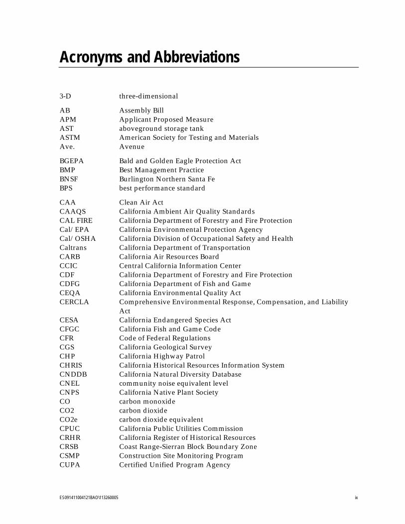
Acronyms and Abbreviations
3-D three-dimensional
AB Assembly Bill APM Applicant Proposed Measure AST aboveground storage tank ASTM American Society for Testing and Materials Ave. Avenue
BGEPA Bald and Golden Eagle Protection Act BMP Best Management Practice BNSF Burlington Northern Santa Fe BPS best performance standard
CAA Clean Air Act CAAQS California Ambient Air Quality Standards CAL FIRE California Department of Forestry and Fire Protection Cal/EPA California Environmental Protection Agency Cal/OSHA California Division of Occupational Safety and Health Caltrans California Department of Transportation CARB California Air Resources Board CCIC Central California Information Center CDF California Department of Forestry and Fire Protection CDFG California Department of Fish and Game CEQA California Environmental Quality Act CERCLA Comprehensive Environmental Response, Compensation, and Liability
Act CESA California Endangered Species Act CFGC California Fish and Game Code CFR Code of Federal Regulations CGS California Geological Survey CHP California Highway Patrol CHRIS California Historical Resources Information System CNDDB California Natural Diversity Database CNEL community noise equivalent level CNPS California Native Plant Society CO carbon monoxide CO2 carbon dioxide CO2e carbon dioxide equivalent CPUC California Public Utilities Commission CRHR California Register of Historical Resources CRSB Coast Range-Sierran Block Boundary Zone CSMP Construction Site Monitoring Program CUPA Certified Unified Program Agency

PROPONENT’S ENVIRONMENTAL ASSESSMENT 0BACRONYMS AND ABBREVIATIONS CRESSEY-GALLO 115 KV POWER LINE PROJECT
x ES091411004121BAO\113260005
CVC California Vehicle Code CWA Clean Water Act CWHR California Wildlife Habitat Relationships System
dBA decibels DMG California Division of Mines and Geology DOC California Department of Conservation DPR California Department of Parks and Recreation DTSC California Department of Toxic Substances Control DWR California Department of Water Resources
EDR Environmental Data Resources Inc. EIR Environmental Impact Report ESA federal Endangered Species Act
FAA Federal Aviation Administration FEMA Federal Emergency Management Agency FHWA Federal Highway Administration FIRM Flood Insurance Rate Maps FMMP Farmland Mapping and Monitoring Program FRAP Fire Resource Assessment Program
GANDA Garcia and Associates General Permit California Stormwater NPDES General Construction Permit Order No.
2009-0009-DWQ General Plan Merced County Year 2000 General Plan GHG greenhouse gas GIS Geographic Information System GPS global positioning system GWP global warming potential
HCP Habitat Conservation Plan HIC Highway Interchange Centers HSAA Hazardous Substance Account Act HWCL Hazardous Waste Control Law HWMP Hazardous Waste Management Plan
I-5 Interstate 5 ISR Indirect Source Review
JRP JRP Historical Consulting Services
kV kilovolts
LOS Level of Service
M&RP Monitoring and Reporting Program MBTA Migratory Bird Treaty Act MCFD Merced County Fire Department MCSD Merced County Sheriff’s Department MLD Most Likely Descendants
PROPONENT’S ENVIRONMENTAL ASSESSMENT CRESSEY-GALLO 115 KV POWER LINE PROJECT 0BACRONYMS AND ABBREVIATIONS
ES091411004121BAO\113260005 xi
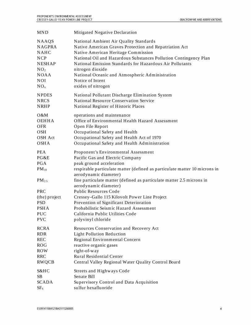
MND Mitigated Negative Declaration
NAAQS National Ambient Air Quality Standards NAGPRA Native American Graves Protection and Repatriation Act NAHC Native American Heritage Commission NCP National Oil and Hazardous Substances Pollution Contingency Plan NESHAP National Emission Standards for Hazardous Air Pollutants NO2 nitrogen dioxide NOAA National Oceanic and Atmospheric Administration NOI Notice of Intent NOx oxides of nitrogen
NPDES National Pollutant Discharge Elimination System NRCS National Resource Conservation Service NRHP National Register of Historic Places
O&M operations and maintenance OEHHA Office of Environmental Health Hazard Assessment OFR Open File Report OSH Occupational Safety and Health OSH Act Occupational Safety and Health Act of 1970 OSHA Occupational Safety and Health Administration
PEA Proponent’s Environmental Assessment PG&E Pacific Gas and Electric Company PGA peak ground acceleration PM10 respirable particulate matter (defined as particulate matter 10 microns in
aerodynamic diameter) PM2.5 fine particulate matter (defined as particulate matter 2.5 microns in
aerodynamic diameter) PRC Public Resources Code (the) project Cressey–Gallo 115 Kilovolt Power Line Project PSD Prevention of Significant Deterioration PSHA Probabilistic Seismic Hazard Assessment PUC California Public Utilities Code PVC polyvinyl chloride
RCRA Resources Conservation and Recovery Act RDR Light Pollution Reduction REC Regional Environmental Concern ROG reactive organic gases ROW right-of-way RRC Rural Residential Center RWQCB Central Valley Regional Water Quality Control Board
S&HC Streets and Highways Code SB Senate Bill SCADA Supervisory Control and Data Acquisition SF6 sulfur hexafluoride
PROPONENT’S ENVIRONMENTAL ASSESSMENT 0BACRONYMS AND ABBREVIATIONS CRESSEY-GALLO 115 KV POWER LINE PROJECT
xii ES091411004121BAO\113260005
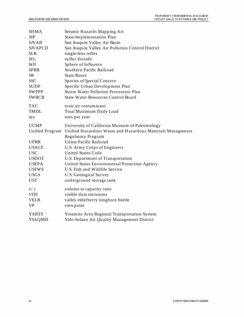
SHMA Seismic Hazards Mapping Act SIP State Implementation Plan SJVAB San Joaquin Valley Air Basin SJVAPCD San Joaquin Valley Air Pollution Control District SLR single-lens reflex SO2 sulfur dioxide SOI Sphere of Influence SPRR Southern Pacific Railroad SR State Route SSC Species of Special Concern SUDP Specific Urban Development Plan SWPPP Storm Water Pollution Prevention Plan SWRCB State Water Resources Control Board
TAC toxic air contaminant TMDL Total Maximum Daily Load tpy tons per year
UCMP University of California Museum of Paleontology Unified Program Unified Hazardous Waste and Hazardous Materials Management
Regulatory Program UPRR Union Pacific Railroad USACE U.S. Army Corps of Engineers USC United States Code USDOT U.S. Department of Transportation USEPA United States Environmental Protection Agency USFWS U.S. Fish and Wildlife Service USGS U.S. Geological Survey UST underground storage tank
v/c volume to capacity ratio VDE visible dust emissions VELB valley elderberry longhorn beetle VP viewpoint
YARTS Yosemite Area Regional Transportation System YSAQMD Yolo-Solano Air Quality Management District
ES091411004121BAO\113260005 xiii
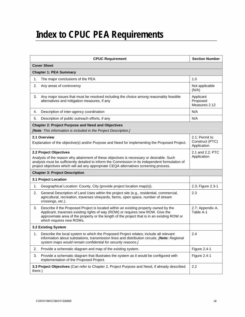
Index to CPUC PEA Requirements
CPUC Requirement Section Number
Cover Sheet
Chapter 1: PEA Summary
1. The major conclusions of the PEA 1.0
2. Any areas of controversy Not applicable (N/A)
3. Any major issues that must be resolved including the choice among reasonably feasible alternatives and mitigation measures, if any
Applicant Proposed Measures 2.12
4. Description of inter-agency coordination N/A
5. Description of public outreach efforts, if any N/A
Chapter 2: Project Purpose and Need and Objectives
[Note: This information is included in the Project Description.]
2.1 Overview
Explanation of the objective(s) and/or Purpose and Need for implementing the Proposed Project.
2.1; Permit to Construct (PTC) Application
2.2 Project Objectives
Analysis of the reason why attainment of these objectives is necessary or desirable. Such analysis must be sufficiently detailed to inform the Commission in its independent formulation of project objectives which will aid any appropriate CEQA alternatives screening process.
2.1 and 2.2; PTC Application
Chapter 3: Project Description
3.1 Project Location
1. Geographical Location: County, City (provide project location map(s)). 2.3; Figure 2.3-1
2. General Description of Land Uses within the project site (e.g., residential, commercial, agricultural, recreation, traverses vineyards, farms, open space, number of stream crossings, etc.).
2.3
3. Describe if the Proposed Project is located within an existing property owned by the Applicant, traverses existing rights of way (ROW) or requires new ROW. Give the approximate area of the property or the length of the project that is in an existing ROW or which requires new ROWs.
2.7; Appendix A, Table A-1
3.2 Existing System
1. Describe the local system to which the Proposed Project relates; include all relevant information about substations, transmission lines and distribution circuits. [Note: Regional system maps would remain confidential for security reasons.]
2.4
2. Provide a schematic diagram and map of the existing system. Figure 2.4-1
3. Provide a schematic diagram that illustrates the system as it would be configured with implementation of the Proposed Project.
Figure 2.4-1
3.3 Project Objectives (Can refer to Chapter 2, Project Purpose and Need, if already described there.)
2.2
PROPONENT’S ENVIRONMENTAL ASSESSMENT 1BINDEX TO CPUC PEA REQUIREMENTS CRESSEY-GALLO 115 KV POWER LINE PROJECT
xiv ES091411004121BAO\113260005
CPUC Requirement Section Number
3.4 Proposed Project
1. Describe whole of the Proposed Project. Is it an upgrade, a new line, new substations, switching station etc.?
2.5
2. Describe how the Proposed Project fits into the Regional system. Does it create a loop for reliability, etc.?
2.5
3. Describe all reasonably foreseeable future phases, or other reasonably foreseeable consequences of the Proposed Project.
2.5
4. Provide capacity increase in MW. If the project does not increase capacity, state it. N/A
5. Provide GIS (or equivalent) data layers for the Proposed Project preliminary engineering including estimated locations of all physical components of the Proposed Project as well as those related to construction. For physical components, this could include but is not limited to the existing components (e.g., ROW, substation locations, poles, etc.) as well as the proposed pole locations, transmission lines, substations, switching station etc. For elements related to construction include: proposed or likely lay-down areas, work areas at the pole sites, pull and tension sites, access roads (e.g., temporary, permanent, existing, etc.), areas where special construction methods may need to be employed, areas where vegetation removal may occur, areas to be heavily graded, etc. More details about this type of information are provided below. [Note: For security reasons, GIS data layers are submitted by PG&E Law Department under confidentiality restrictions.]
For security reasons, GIS data layers will be submitted confidentially under California Public Utilities Code (PUC) Section 583
3.5 Project Components
3.5.1 Transmission Line
1. What type of line exists and what type of line is proposed (e.g., single-circuit, double-circuit, upgrade 69 kV to 115 kV).
2.6.1
2. Identify the length of the upgraded alignment, the new alignment, etc. 2.6.1
3. Would construction require one-for-one pole replacement, new poles, steel poles, etc.?
2.6.1
4. Describe what would occur to other lines and utilities that may be collocated on the poles to be replaced (e.g., distribution, communication, etc.).
2.6.1
3.5.2 Poles/Towers
Provide the following information for each pole/tower that would be installed and for each pole/tower that would be removed:
1. Unique ID number to match GIS database information. [Law Department prefers that you renumber poles (1, 2, 3, etc.) rather than use existing poles numbers, for security reasons.]
For security reasons, unique ID numbers have not been provided. Available GIS data layers will be submitted confidentially under PUC Section 583.
2. Structure diagram and, if available, photos of existing structure. Preliminary diagram or “typical” drawings and, if possible, photos of proposed structure. Also provide a written description of the most common types of structures and their use (e.g., Tangent poles would be used when the run of poles continues in a straight line, etc.). Describe if the pole/tower design meets raptor safety requirements.
Figures 2.6-3 to 2.6-4; Section 2.6.2
3. Type of pole (e.g., wood, steel, etc.) or tower (e.g., self-supporting lattice). 2.6.2
PROPONENT’S ENVIRONMENTAL ASSESSMENT CRESSEY-GALLO 115 KV POWER LINE PROJECT 1BINDEX TO CPUC PEA REQUIREMENTS
ES091411004121BAO\113260005 xv
CPUC Requirement Section Number
4. For poles, provide “typical” drawings with approximate diameter at the base and the tip; for towers, estimate the width at base and top.
Figures 2.6-3 and 2.6-4; “typical” drawings will be provided separately to CPUC staff
5. Identify typical total pole lengths, the approximate length to be embedded, and the approximate length that would be above ground surface; for towers, identify the approximate height above ground surface and approximate base footprint area.
2.6.2
6. Describe any specialty poles or towers; note where they would be used (e.g., angle structures, heavy angle lattice towers, stub guys); make sure to note if any guying would likely be required across a road.
2.6.2
7. If the project includes pole-for-pole replacement, describe the approximate location of where the new poles would be installed relative to the existing alignment.
2.6.1
8. Describe any special pole types (e.g., poles that require foundations, transition towers, switch towers, microwave towers, etc.) and any special features.
2.6.2
3.5.3 Conductor Cable
3.5.3.1 Above-Ground Installation
1. Describe the type of line to be installed on the poles/tower (e.g., single circuit with distribution, double circuit, etc.).
2.6.1
2. Describe the number of conductors required to be installed on the poles or tower and how many on each side including applicable engineering design standards.
2.6.1; 2.6.2
3. Provide the size and type of conductor (e.g., ACSR, non-specular, etc.) and insulator configuration.
2.6.1
4. Provide the approximate distance from the ground to the lowest conductor and the approximate distance between the conductors (i.e., both horizontally and vertically) Provide specific information at highways, rivers, or special crossings.
2.6.1 – specifics are not provided; instead, standards are stated.
5. Provide the approximate span lengths between poles or towers, note where different if distribution is present or not if relevant.
2.6.2
6. Describe if other infrastructure would likely be collocated with the conductor (e.g., fiber optics, etc); if so, provide conduit diameter of other infrastructure.
2.6.1
3.5.3.2 Below-Ground Installation
1. Describe the type of line to be installed (e.g., single circuit cross-linked polyethylene-insulated solid-dielectric, copper-conductor cables).
N/A
2. Describe the type of casing the cable would be installed in (e.g., concrete-encased duct bank system); provide the dimensions of the casing.
N/A
3. Provide an engineering ‘typical’ drawing of the duct bank and describe what types of infrastructure would likely be installed within the duct bank (e.g., transmission, fiber optics, etc.).
N/A
PROPONENT’S ENVIRONMENTAL ASSESSMENT 1BINDEX TO CPUC PEA REQUIREMENTS CRESSEY-GALLO 115 KV POWER LINE PROJECT
xvi ES091411004121BAO\113260005
CPUC Requirement Section Number
3.5.4 Substations and Switching Stations
1. Provide “typical” Plan and Profile views of the proposed substation or switching station and the existing substation or switching station if applicable.
Figures 2.6-6 through 2.6-10
2. Describe the basic bus pattern or provide a basic one-line diagram and explain the types of equipment that would be temporarily or permanently installed and provide details as to what the function/use of said equipment would be. Include information such as, but not limited to: mobile substations or switching stations, switchgear, circuit breakers, transformers, capacitors, and new lighting.
2.6.3
3. Provide the approximate or “typical” dimensions (width and height) of new structures including engineering and design standards that apply.
2.6.3
4. Describe the extent of the Proposed Project. Would it occur within the existing fence line, existing property line or would either need to be expanded?
2.6.3
5. Describe the electrical need area served by the distribution substation or switching station.
2.1
3.6 Right-of-Way Requirements
1. Describe the ROW location, ownership, and width. Would existing ROW be used or would new ROW be required?
2.7
2. If new ROW is required, describe how it would be acquired and approximately how much would be required (length and width).
2.7
3. List properties likely to require acquisition. 2.7
3.7 Construction
3.7.1 For All Projects
3.7.1.1 Staging Areas
1. Where would the main staging area(s) likely be located? 2.8.1
2. Approximately how large would the main staging area(s) be? 2.8.1
3. Describe any site preparation required, if known, or generally describe what might be required (i.e., vegetation removal, new access road, installation of rock base, etc.).
2.8.1
4. Describe what the staging area would be used for (i.e., material and equipment storage, field office, reporting location for workers, parking area for vehicles and equipment, etc.).
2.8.1
5. Describe how the staging area would be secured, would a fence be installed? If so, describe the type and extent of the fencing.
2.8.1
6. Describe how power to the site would be provided if required (i.e., tap into existing distribution, use of diesel generators, etc.).
2.8.1
7. Describe any grading activities and/or slope stabilization issues. 2.8.1
3.7.1.2 Work Areas
1. Describe known work areas that may be required for specific construction activities (i.e., pole assembly, hill side construction, etc.).
2.8.2
2. For each known work area, provide the area required (include length and width) and describe the types of activities that would be performed.
2.8.2
PROPONENT’S ENVIRONMENTAL ASSESSMENT CRESSEY-GALLO 115 KV POWER LINE PROJECT 1BINDEX TO CPUC PEA REQUIREMENTS
ES091411004121BAO\113260005 xvii
CPUC Requirement Section Number
3. Identify the approximate location of known work areas in the GIS database. Available GIS data layers will be submitted confidentially under PUC Section 583.
4. How would the work areas likely be accessed (e.g., construction vehicles, walk in, helicopter, etc.)?
2.8.2
5. If any site preparation is likely required, generally describe what and how it would be accomplished.
2.8.2
6. Describe any grading activities and/or slope stabilization issues. 2.8.2
7. Based on the information provided, describe how the site would be restored. 2.8.2
3.7.1.3 Access Roads and/or Spur Roads
1. Describe the types of roads that would be used and or would need to be created to implement the Proposed Project. See table below as an example of information required. Road types may include, but are not limited to: new permanent road; new temporary road; existing road that would have permanent improvements; existing road that would have temporary improvements, existing paved road; existing dirt/gravel road, and overland access.
2.8.3
2. For road types that require preparation, describe the methods and equipment that would be used.
2.8.3
3. Identify approximate location of all access roads (by type) in the GIS database. Available GIS data layers will be submitted confidentially under PUC Section 583.
4. Describe any grading activities and/or slope stabilization issues. See table in PEA Checklist as an example of information required. Road types may include, but are not limited to: new permanent road; new temporary road; existing road that would have permanent improvements; existing road that would have temporary improvements, existing paved road; existing dirt/gravel road, and overland access
2.8.3
3.7.1.4 Helicopter Access
1. Identify which proposed poles/towers would be removed and/or installed using a helicopter.
N/A
2. If different types of helicopters are to be used, describe each type (e.g., light, heavy or sky crane) and what activities they will be used for.
N/A
3. Provide information as to where the helicopters would be staged, where they would refuel, where they would land within the Project site.
N/A
4. Describe any Best Management Practices (BMPs) that would be employed to avoid impacts caused by use of helicopters, for example: air quality and noise considerations.
N/A
5. Describe flight paths, payloads, hours of operations for known locations and work types.
N/A
PROPONENT’S ENVIRONMENTAL ASSESSMENT 1BINDEX TO CPUC PEA REQUIREMENTS CRESSEY-GALLO 115 KV POWER LINE PROJECT
xviii ES091411004121BAO\113260005
CPUC Requirement Section Number
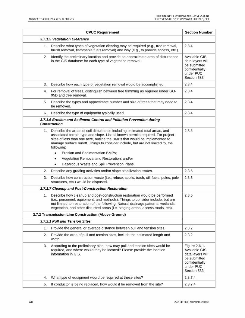
3.7.1.5 Vegetation Clearance
1. Describe what types of vegetation clearing may be required (e.g., tree removal, brush removal, flammable fuels removal) and why (e.g., to provide access, etc.).
2.8.4
2. Identify the preliminary location and provide an approximate area of disturbance in the GIS database for each type of vegetation removal.
Available GIS data layers will be submitted confidentially under PUC Section 583.
3. Describe how each type of vegetation removal would be accomplished. 2.8.4
4. For removal of trees, distinguish between tree trimming as required under GO-95D and tree removal.
2.8.4
5. Describe the types and approximate number and size of trees that may need to be removed.
2.8.4
6. Describe the type of equipment typically used. 2.8.4
3.7.1.6 Erosion and Sediment Control and Pollution Prevention during Construction
1. Describe the areas of soil disturbance including estimated total areas, and associated terrain type and slope. List all known permits required. For project sites of less than one acre, outline the BMPs that would be implemented to manage surface runoff. Things to consider include, but are not limited to, the following:
Erosion and Sedimentation BMPs;
Vegetation Removal and Restoration; and/or
Hazardous Waste and Spill Prevention Plans.
2.8.5
2. Describe any grading activities and/or slope stabilization issues. 2.8.5
3. Describe how construction waste (i.e., refuse, spoils, trash, oil, fuels, poles, pole structures, etc.) would be disposed.
2.8.5
3.7.1.7 Cleanup and Post-Construction Restoration
1. Describe how cleanup and post-construction restoration would be performed (i.e., personnel, equipment, and methods). Things to consider include, but are not limited to, restoration of the following: Natural drainage patterns; wetlands; vegetation, and other disturbed areas (i.e. staging areas, access roads, etc).
2.8.6
3.7.2 Transmission Line Construction (Above Ground)
3.7.2.1 Pull and Tension Sites
1. Provide the general or average distance between pull and tension sites. 2.8.2
2. Provide the area of pull and tension sites, include the estimated length and width.
2.8.2
3. According to the preliminary plan, how may pull and tension sites would be required, and where would they be located? Please provide the location information in GIS.
Figure 2.6-1. Available GIS data layers will be submitted confidentially under PUC Section 583.
4. What type of equipment would be required at these sites? 2.8.7.4
5. If conductor is being replaced, how would it be removed from the site? 2.8.7.4
PROPONENT’S ENVIRONMENTAL ASSESSMENT CRESSEY-GALLO 115 KV POWER LINE PROJECT 1BINDEX TO CPUC PEA REQUIREMENTS
ES091411004121BAO\113260005 xix
CPUC Requirement Section Number
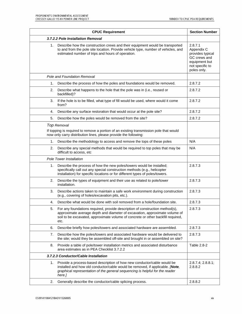
3.7.2.2 Pole Installation Removal
1. Describe how the construction crews and their equipment would be transported to and from the pole site location. Provide vehicle type, number of vehicles, and estimated number of trips and hours of operation.
2.8.7.1 Appendix C provides typical GC crews and equipment but not specific to poles only.
Pole and Foundation Removal
1. Describe the process of how the poles and foundations would be removed. 2.8.7.2
2. Describe what happens to the hole that the pole was in (i.e., reused or backfilled)?
2.8.7.2
3. If the hole is to be filled, what type of fill would be used, where would it come from?
2.8.7.2
4. Describe any surface restoration that would occur at the pole site? 2.8.7.2
5. Describe how the poles would be removed from the site? 2.8.7.2
Top Removal If topping is required to remove a portion of an existing transmission pole that would now only carry distribution lines, please provide the following:
1. Describe the methodology to access and remove the tops of these poles N/A
2. Describe any special methods that would be required to top poles that may be difficult to access, etc
N/A
Pole Tower Installation
1. Describe the process of how the new poles/towers would be installed; specifically call out any special construction methods (e.g., helicopter installation) for specific locations or for different types of poles/towers.
2.8.7.3
2. Describe the types of equipment and their use as related to pole/tower installation.
2.8.7.3
3. Describe actions taken to maintain a safe work environment during construction (e.g., covering of holes/excavation pits, etc.).
2.8.7.3
4. Describe what would be done with soil removed from a hole/foundation site. 2.8.7.3
5. For any foundations required, provide description of construction method(s), approximate average depth and diameter of excavation, approximate volume of soil to be excavated, approximate volume of concrete or other backfill required, etc.
2.8.7.3
6. Describe briefly how poles/towers and associated hardware are assembled. 2.8.7.3
7. Describe how the poles/towers and associated hardware would be delivered to the site; would they be assembled off-site and brought in or assembled on site?
2.8.7.3
8. Provide a table of pole/tower installation metrics and associated disturbance area estimates as in PEA Checklist 3.7.2.2
Table 2.8-2
3.7.2.3 Conductor/Cable Installation
1. Provide a process-based description of how new conductor/cable would be installed and how old conductor/cable would be removed, if applicable. [Note, graphical representation of the general sequencing is helpful for the reader here.]
2.8.7.4; 2.8.8.1; 2.8.8.2
2. Generally describe the conductor/cable splicing process. 2.8.8.2
PROPONENT’S ENVIRONMENTAL ASSESSMENT 1BINDEX TO CPUC PEA REQUIREMENTS CRESSEY-GALLO 115 KV POWER LINE PROJECT
xx ES091411004121BAO\113260005
CPUC Requirement Section Number
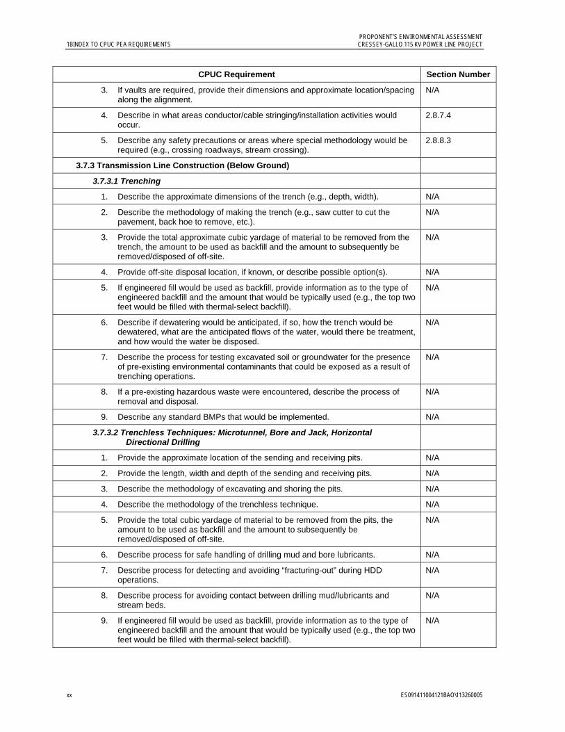
3. If vaults are required, provide their dimensions and approximate location/spacing along the alignment.
N/A
4. Describe in what areas conductor/cable stringing/installation activities would occur.
2.8.7.4
5. Describe any safety precautions or areas where special methodology would be required (e.g., crossing roadways, stream crossing).
2.8.8.3
3.7.3 Transmission Line Construction (Below Ground)
3.7.3.1 Trenching
1. Describe the approximate dimensions of the trench (e.g., depth, width). N/A
2. Describe the methodology of making the trench (e.g., saw cutter to cut the pavement, back hoe to remove, etc.).
N/A
3. Provide the total approximate cubic yardage of material to be removed from the trench, the amount to be used as backfill and the amount to subsequently be removed/disposed of off-site.
N/A
4. Provide off-site disposal location, if known, or describe possible option(s). N/A
5. If engineered fill would be used as backfill, provide information as to the type of engineered backfill and the amount that would be typically used (e.g., the top two feet would be filled with thermal-select backfill).
N/A
6. Describe if dewatering would be anticipated, if so, how the trench would be dewatered, what are the anticipated flows of the water, would there be treatment, and how would the water be disposed.
N/A
7. Describe the process for testing excavated soil or groundwater for the presence of pre-existing environmental contaminants that could be exposed as a result of trenching operations.
N/A
8. If a pre-existing hazardous waste were encountered, describe the process of removal and disposal.
N/A
9. Describe any standard BMPs that would be implemented. N/A
3.7.3.2 Trenchless Techniques: Microtunnel, Bore and Jack, Horizontal Directional Drilling
1. Provide the approximate location of the sending and receiving pits. N/A
2. Provide the length, width and depth of the sending and receiving pits. N/A
3. Describe the methodology of excavating and shoring the pits. N/A
4. Describe the methodology of the trenchless technique. N/A
5. Provide the total cubic yardage of material to be removed from the pits, the amount to be used as backfill and the amount to subsequently be removed/disposed of off-site.
N/A
6. Describe process for safe handling of drilling mud and bore lubricants. N/A
7. Describe process for detecting and avoiding “fracturing-out” during HDD operations.
N/A
8. Describe process for avoiding contact between drilling mud/lubricants and stream beds.
N/A
9. If engineered fill would be used as backfill, provide information as to the type of engineered backfill and the amount that would be typically used (e.g., the top two feet would be filled with thermal-select backfill).
N/A
PROPONENT’S ENVIRONMENTAL ASSESSMENT CRESSEY-GALLO 115 KV POWER LINE PROJECT 1BINDEX TO CPUC PEA REQUIREMENTS
ES091411004121BAO\113260005 xxi
CPUC Requirement Section Number
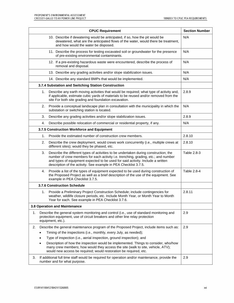
10. Describe if dewatering would be anticipated, if so, how the pit would be dewatered, what are the anticipated flows of the water, would there be treatment, and how would the water be disposed.
N/A
11. Describe the process for testing excavated soil or groundwater for the presence of pre-existing environmental contaminants.
N/A
12. If a pre-existing hazardous waste were encountered, describe the process of removal and disposal.
N/A
13. Describe any grading activities and/or slope stabilization issues. N/A
14. Describe any standard BMPs that would be implemented. N/A
3.7.4 Substation and Switching Station Construction
1. Describe any earth moving activities that would be required; what type of activity and, if applicable, estimate cubic yards of materials to be reused and/or removed from the site For both site grading and foundation excavation.
2.8.9
2. Provide a conceptual landscape plan in consultation with the municipality in which the substation or switching station is located.
N/A
3. Describe any grading activities and/or slope stabilization issues. 2.8.9
4. Describe possible relocation of commercial or residential property, if any. N/A
3.7.5 Construction Workforce and Equipment
1. Provide the estimated number of construction crew members. 2.8.10
2. Describe the crew deployment, would crews work concurrently (i.e., multiple crews at different sites); would they be phased, etc.
2.8.10
3. Describe the different types of activities to be undertaken during construction; the number of crew members for each activity i.e. trenching, grading, etc.; and number and types of equipment expected to be used for said activity. Include a written description of the activity. See example in PEA Checklist 3.7.5.
Table 2.8-3
4. Provide a list of the types of equipment expected to be used during construction of the Proposed Project as well as a brief description of the use of the equipment. See example in PEA Checklist 3.7.5.
Table 2.8-4
3.7.6 Construction Schedule
1. Provide a Preliminary Project Construction Schedule; include contingencies for weather, wildlife closure periods, etc. Include Month Year, or Month Year to Month Year for each. See example in PEA Checklist 3.7.6.
2.8.11
3.8 Operation and Maintenance
1. Describe the general system monitoring and control (i.e., use of standard monitoring and protection equipment, use of circuit breakers and other line relay protection equipment, etc.).
2.9
2. Describe the general maintenance program of the Proposed Project, include items such as:
Timing of the inspections (i.e., monthly, every July, as needed);
Type of inspection (i.e., aerial inspection, ground inspection); and
Description of how the inspection would be implemented. Things to consider, who/how many crew members; how would they access the site (walk to site, vehicle, ATV); would new access be required; would restoration be required, etc.
2.9
3. If additional full time staff would be required for operation and/or maintenance, provide the number and for what purpose.
2.9

PROPONENT’S ENVIRONMENTAL ASSESSMENT 1BINDEX TO CPUC PEA REQUIREMENTS CRESSEY-GALLO 115 KV POWER LINE PROJECT
xxii ES091411004121BAO\113260005
CPUC Requirement Section Number
3.9 Applicant Proposed Measures
1. If there are measures that the Applicant would propose to be part of the Proposed Project, please include those measures and reference plans or implementation descriptions.
2.12
Chapter 4: Environmental Setting
[Note: PG&E has elected to combine Environmental Setting with the impact assessment. Detailed descriptions should be limited to those resource areas which may be subject to a potentially significant impact.]
4.1 Aesthetics
1. A description of the physical environment in the vicinity of the project (e.g. topography, land use patterns, biological environment, etc.)
Local environment (site-specific) 3.1.3
Regional environment 3.1.3
2. A description of the regulatory environment/context
Federal 3.1.2.1
State 3.1.2.2
Local 3.1.2.3
4.2 Agriculture Resources
1. A description of the physical environment in the vicinity of the project (e.g. topography, land use patterns, biological environment, etc.)
Local environment (site-specific) 3.2.3.2
Regional environment 3.2.3.1
2. A description of the regulatory environment/context
Federal 3.2.2.1
State 3.2.2.2
Local 3.2.2.3; 3.2.2.4
4.3 Air Quality
1. A description of the physical environment in the vicinity of the project (e.g. topography, land use patterns, biological environment, etc.)
Local environment (site-specific) 3.3.3.2
Regional environment 3.3.3.1
2. A description of the regulatory environment/context
Federal 3.3.2.1
State 3.3.2.2
Local 3.3.2.3
4.4 Biological Resources
1. A description of the physical environment in the vicinity of the project (e.g. topography, land use patterns, biological environment, etc.)
Local environment (site-specific) 3.4.3
Regional environment 3.4.3

PROPONENT’S ENVIRONMENTAL ASSESSMENT CRESSEY-GALLO 115 KV POWER LINE PROJECT 1BINDEX TO CPUC PEA REQUIREMENTS
ES091411004121BAO\113260005 xxiii
CPUC Requirement Section Number
2. A description of the regulatory environment/context
Federal 3.4.2.1
State 3.4.2.2
Local 3.4.2.3
4.5 Cultural Resources
1. A description of the physical environment in the vicinity of the project (e.g. topography, land use patterns, biological environment, etc.)
Local environment (site-specific) 3.5.3
Regional environment 3.5.3
2. A description of the regulatory environment/context
Federal 3.5.2.1
State 3.5.2.2
Local 3.5.2.3
4.6 Geology, Soils and Seismic Potential
1. A description of the physical environment in the vicinity of the project (e.g. topography, land use patterns, biological environment, etc.)
Local environment (site-specific) 3.6.3
Regional environment 3.6.3.1
2. A description of the regulatory environment/context
Federal 3.6.2.1
State 3.6.2.2
Local 3.6.2.3
4.7 Hazards and Hazardous Materials
1. A description of the physical environment in the vicinity of the project (e.g. topography, land use patterns, biological environment, etc.)
Local environment (site-specific) 3.7.3
Regional environment 3.7.3
2. A description of the regulatory environment/context
Federal 3.7.2.1
State 3.7.2.2
Local 3.7.2.3
4.8 Hydrology and Water Quality
1. A description of the physical environment in the vicinity of the project (e.g. topography, land use patterns, biological environment, etc.)
Local environment (site-specific) 3.8.3
Regional environment 3.8.3
2. A description of the regulatory environment/context
Federal 3.8.2.1

PROPONENT’S ENVIRONMENTAL ASSESSMENT 1BINDEX TO CPUC PEA REQUIREMENTS CRESSEY-GALLO 115 KV POWER LINE PROJECT
xxiv ES091411004121BAO\113260005
CPUC Requirement Section Number
State 3.8.2.1
Local 3.8.2.2
4.9 Land Use and Planning
1. A description of the physical environment in the vicinity of the project (e.g. topography, land use patterns, biological environment, etc.)
Local environment (site-specific) 3.2.3.2
Regional environment 3.2.3.1
2. A description of the regulatory environment/context
Federal 3.2.2.1
State 3.2.2.2
Local 3.2.2.3; 3.2.2.4
4.10 Mineral Resources
1. A description of the physical environment in the vicinity of the project (e.g. topography, land use patterns, biological environment, etc.)
Local environment (site-specific) 3.6.3
Regional environment 3.6.3.1
2. A description of the regulatory environment/context
Federal 3.6.2.1
State 3.6.2.2
Local 3.6.2.3
4.11 Noise
1. A description of the physical environment in the vicinity of the project (e.g. topography, land use patterns, biological environment, etc.)
Local environment (site-specific) 3.9.3
Regional environment 3.9.3
2. A description of the regulatory environment/context
Federal 3.9.2
State 3.9.2
Local 3.9.2
4.12 Population and Housing
1. A description of the physical environment in the vicinity of the project (e.g. topography, land use patterns, biological environment, etc.)
Local environment (site-specific) 3.10.3
Regional environment 3.10.3
2. A description of the regulatory environment/context
Federal 3.10.2.1
State 3.10.2.2
Local 3.10.2.3
PROPONENT’S ENVIRONMENTAL ASSESSMENT CRESSEY-GALLO 115 KV POWER LINE PROJECT 1BINDEX TO CPUC PEA REQUIREMENTS
ES091411004121BAO\113260005 xxv
CPUC Requirement Section Number
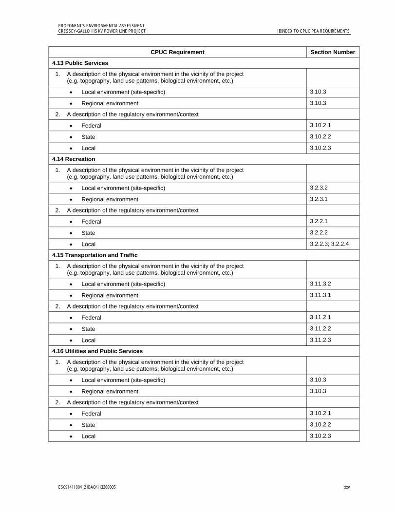
4.13 Public Services
1. A description of the physical environment in the vicinity of the project (e.g. topography, land use patterns, biological environment, etc.)
Local environment (site-specific) 3.10.3
Regional environment 3.10.3
2. A description of the regulatory environment/context
Federal 3.10.2.1
State 3.10.2.2
Local 3.10.2.3
4.14 Recreation
1. A description of the physical environment in the vicinity of the project (e.g. topography, land use patterns, biological environment, etc.)
Local environment (site-specific) 3.2.3.2
Regional environment 3.2.3.1
2. A description of the regulatory environment/context
Federal 3.2.2.1
State 3.2.2.2
Local 3.2.2.3; 3.2.2.4
4.15 Transportation and Traffic
1. A description of the physical environment in the vicinity of the project (e.g. topography, land use patterns, biological environment, etc.)
Local environment (site-specific) 3.11.3.2
Regional environment 3.11.3.1
2. A description of the regulatory environment/context
Federal 3.11.2.1
State 3.11.2.2
Local 3.11.2.3
4.16 Utilities and Public Services
1. A description of the physical environment in the vicinity of the project (e.g. topography, land use patterns, biological environment, etc.)
Local environment (site-specific) 3.10.3
Regional environment 3.10.3
2. A description of the regulatory environment/context
Federal 3.10.2.1
State 3.10.2.2
Local 3.10.2.3
PROPONENT’S ENVIRONMENTAL ASSESSMENT 1BINDEX TO CPUC PEA REQUIREMENTS CRESSEY-GALLO 115 KV POWER LINE PROJECT
xxvi ES091411004121BAO\113260005
CPUC Requirement Section Number
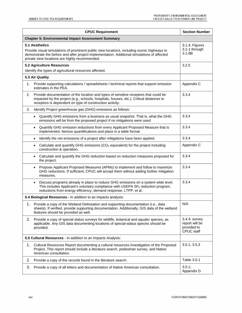
Chapter 5: Environmental Impact Assessment Summary
5.1 Aesthetics
Provide visual simulations of prominent public view locations, including scenic highways to demonstrate the before and after project implementation. Additional simulations of affected private view locations are highly recommended.
3.1.4; Figures 3.1-1 through 3.1-8B
5.2 Agriculture Resources
Identify the types of agricultural resources affected.
3.2.5
5.3 Air Quality
1. Provide supporting calculations / spreadsheets / technical reports that support emission estimates in the PEA.
Appendix C
2. Provide documentation of the location and types of sensitive receptors that could be impacted by the project (e.g., schools, hospitals, houses, etc.). Critical distances to receptors is dependent on type of construction activity.
3.3.4
3. Identify Project greenhouse gas (GHG) emissions as follows:
Quantify GHG emissions from a business as usual snapshot. That is, what the GHG emissions will be from the proposed project if no mitigations were used
3.3.4
Quantify GHG emission reductions from every Applicant Proposed Measure that is implemented. Itemize quantifications and place in a table format
3.3.4
Identify the net emissions of a project after mitigations have been applied. 3.3.4
Calculate and quantify GHG emissions (CO2 equivalent) for the project including construction & operation.
Appendix C
Calculate and quantify the GHG reduction based on reduction measures proposed for the project.
3.3.4
Propose Applicant Proposed Measures (APMs) to implement and follow to maximize GHG reductions. If sufficient, CPUC will accept them without adding further mitigation measures.
3.3.4
Discuss programs already in place to reduce GHG emissions on a system wide level. This includes Applicant’s voluntary compliance with USEPA SF6 reduction program, reductions from energy efficiency, demand response, LTPP, et al.
3.3.4
5.4 Biological Resources - In addition to an impacts analysis:
1. Provide a copy of the Wetland Delineation and supporting documentation (i.e., data sheets). If verified, provide supporting documentation. Additionally, GIS data of the wetland features should be provided as well.
N/A
2. Provide a copy of special status surveys for wildlife, botanical and aquatic species, as applicable. Any GIS data documenting locations of special-status species should be provided.
3.4.4; survey report will be provided to CPUC staff
5.5 Cultural Resources - In addition to an Impacts Analysis:
1. Cultural Resources Report documenting a cultural resources investigation of the Proposed Project. This report should include a literature search, pedestrian survey, and Native American consultation.
3.5.1; 3.5.3
2. Provide a copy of the records found in the literature search. Table 3.5-1
3. Provide a copy of all letters and documentation of Native American consultation. 3.5.1; Appendix D
PROPONENT’S ENVIRONMENTAL ASSESSMENT CRESSEY-GALLO 115 KV POWER LINE PROJECT 1BINDEX TO CPUC PEA REQUIREMENTS
ES091411004121BAO\113260005 xxvii
CPUC Requirement Section Number
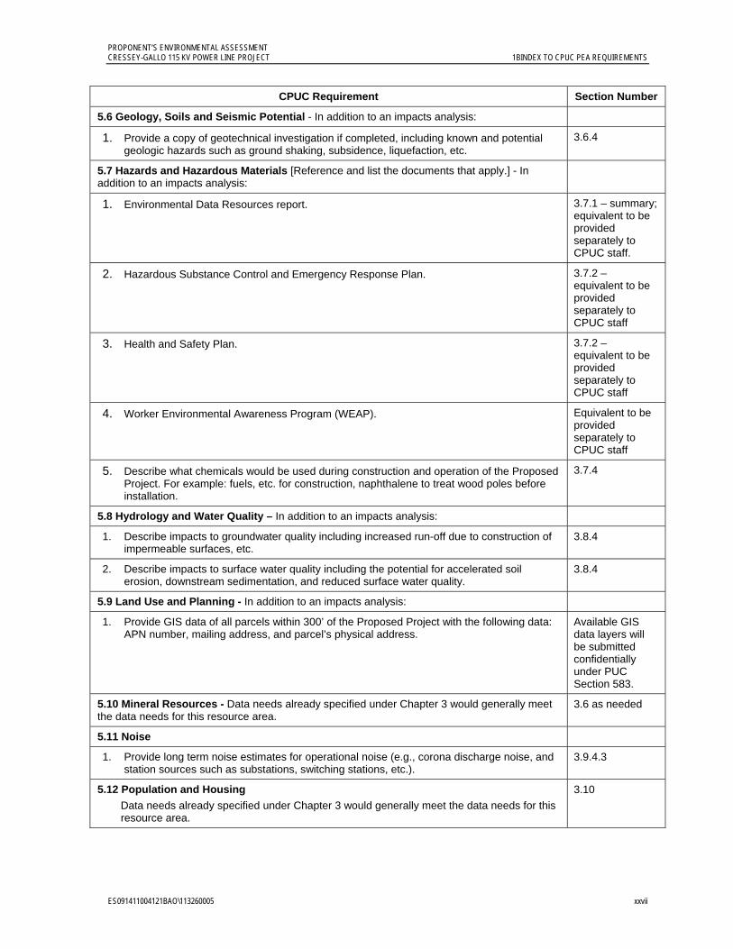
5.6 Geology, Soils and Seismic Potential - In addition to an impacts analysis:
1. Provide a copy of geotechnical investigation if completed, including known and potential geologic hazards such as ground shaking, subsidence, liquefaction, etc.
3.6.4
5.7 Hazards and Hazardous Materials [Reference and list the documents that apply.] - In addition to an impacts analysis:
1. Environmental Data Resources report. 3.7.1 – summary; equivalent to be provided separately to CPUC staff.
2. Hazardous Substance Control and Emergency Response Plan. 3.7.2 – equivalent to be provided separately to CPUC staff
3. Health and Safety Plan. 3.7.2 – equivalent to be provided separately to CPUC staff
4. Worker Environmental Awareness Program (WEAP). Equivalent to be provided separately to CPUC staff
5. Describe what chemicals would be used during construction and operation of the Proposed Project. For example: fuels, etc. for construction, naphthalene to treat wood poles before installation.
3.7.4
5.8 Hydrology and Water Quality – In addition to an impacts analysis:
1. Describe impacts to groundwater quality including increased run-off due to construction of impermeable surfaces, etc.
3.8.4
2. Describe impacts to surface water quality including the potential for accelerated soil erosion, downstream sedimentation, and reduced surface water quality.
3.8.4
5.9 Land Use and Planning - In addition to an impacts analysis:
1. Provide GIS data of all parcels within 300’ of the Proposed Project with the following data: APN number, mailing address, and parcel’s physical address.
Available GIS data layers will be submitted confidentially under PUC Section 583.
5.10 Mineral Resources - Data needs already specified under Chapter 3 would generally meet the data needs for this resource area.
3.6 as needed
5.11 Noise
1. Provide long term noise estimates for operational noise (e.g., corona discharge noise, and station sources such as substations, switching stations, etc.).
3.9.4.3
5.12 Population and Housing
Data needs already specified under Chapter 3 would generally meet the data needs for this resource area.
3.10
PROPONENT’S ENVIRONMENTAL ASSESSMENT 1BINDEX TO CPUC PEA REQUIREMENTS CRESSEY-GALLO 115 KV POWER LINE PROJECT
xxviii ES091411004121BAO\113260005
CPUC Requirement Section Number
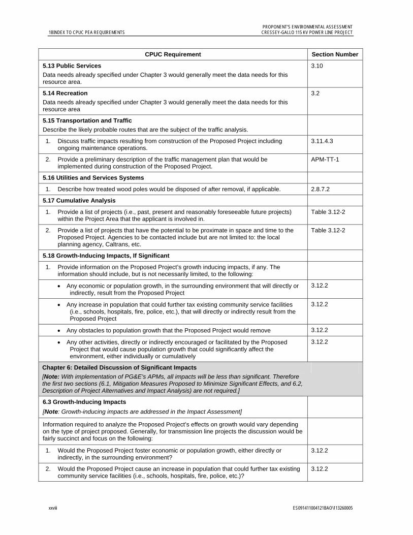
5.13 Public Services Data needs already specified under Chapter 3 would generally meet the data needs for this resource area.
3.10
5.14 Recreation
Data needs already specified under Chapter 3 would generally meet the data needs for this resource area
3.2
5.15 Transportation and Traffic
Describe the likely probable routes that are the subject of the traffic analysis.
1. Discuss traffic impacts resulting from construction of the Proposed Project including ongoing maintenance operations.
3.11.4.3
2. Provide a preliminary description of the traffic management plan that would be implemented during construction of the Proposed Project.
APM-TT-1
5.16 Utilities and Services Systems
1. Describe how treated wood poles would be disposed of after removal, if applicable. 2.8.7.2
5.17 Cumulative Analysis
1. Provide a list of projects (i.e., past, present and reasonably foreseeable future projects) within the Project Area that the applicant is involved in.
Table 3.12-2
2. Provide a list of projects that have the potential to be proximate in space and time to the Proposed Project. Agencies to be contacted include but are not limited to: the local planning agency, Caltrans, etc.
Table 3.12-2
5.18 Growth-Inducing Impacts, If Significant
1. Provide information on the Proposed Project’s growth inducing impacts, if any. The information should include, but is not necessarily limited, to the following:
Any economic or population growth, in the surrounding environment that will directly or indirectly, result from the Proposed Project
3.12.2
Any increase in population that could further tax existing community service facilities (i.e., schools, hospitals, fire, police, etc.), that will directly or indirectly result from the Proposed Project
3.12.2
Any obstacles to population growth that the Proposed Project would remove 3.12.2
Any other activities, directly or indirectly encouraged or facilitated by the Proposed Project that would cause population growth that could significantly affect the environment, either individually or cumulatively
3.12.2
Chapter 6: Detailed Discussion of Significant Impacts
[Note: With implementation of PG&E’s APMs, all impacts will be less than significant. Therefore the first two sections (6.1, Mitigation Measures Proposed to Minimize Significant Effects, and 6.2, Description of Project Alternatives and Impact Analysis) are not required.]
6.3 Growth-Inducing Impacts [Note: Growth-inducing impacts are addressed in the Impact Assessment]
Information required to analyze the Proposed Project’s effects on growth would vary depending on the type of project proposed. Generally, for transmission line projects the discussion would be fairly succinct and focus on the following:
1. Would the Proposed Project foster economic or population growth, either directly or indirectly, in the surrounding environment?
3.12.2
2. Would the Proposed Project cause an increase in population that could further tax existing community service facilities (i.e., schools, hospitals, fire, police, etc.)?
3.12.2

PROPONENT’S ENVIRONMENTAL ASSESSMENT CRESSEY-GALLO 115 KV POWER LINE PROJECT 1BINDEX TO CPUC PEA REQUIREMENTS
ES091411004121BAO\113260005 xxix
CPUC Requirement Section Number
3. Would the Proposed Project remove obstacles to population growth? 3.12.2
4. Would the Proposed Project encourage and facilitate other activities that would cause population growth that could significantly affect the environment, either individually or cumulatively?
3.12.2
6.4 Applicant Proposed Measures to address GHG Emissions
[Note: GHG Emissions and PG&E’s associated APMs are discussed in the Air Quality chapter.]
3.3.4.3 APM AQ-2 APM AQ-3
See the menu of suggested APMs in PEA Checklist Section 6.4 that applicants can consider. Applicants can and are encouraged to propose other GHG reducing mitigations. Priority is given to on-site and/or nearby mitigation measures. Off-site mitigation measures within California will be considered.
Chapter 7: Other Process-Related Data Needs
1. Excel spreadsheet that includes all parcels within 300 feet of any project component with the following data: APN number, owner mailing address, and parcels physical address. [Note: notice of all property owners within 300 feet is required under GO 131-D.]
Appendix A, Table A-2

ES091411004121BAO\113260005 1-1
1.0 Executive Summary
Pacific Gas and Electric Company (PG&E) is proposing to construct the Cressey–Gallo 115 Kilovolt (kV) Power Line Project (the project), a new, approximately 14.4-mile-long, single-circuit power line needed to improve transmission system reliability for customers in north-central Merced County, California, near the community of Cressey and the City of Livingston. The project will interconnect PG&E’s existing Cressey and Gallo substations, expand Gallo Substation, and modify Cressey Substation.
The project consists of constructing a new 115 kV power line between Cressey and Gallo substations to form a power line loop with two other area substations (Livingston and Atwater). The new transmission loop will allow power to flow from another direction when there is an outage on a line feeding the loop, avoiding customer service interruptions from single-line outages in this area.
This Proponent’s Environmental Assessment (PEA) describes the project and PG&E’s Applicant Proposed Measures (APMs) for minimizing potential impacts. The project’s environmental setting and applicable regulations are described, followed by an evaluation of potential environmental impacts that may result from construction, operation and maintenance of the project. The PEA confirms that all impacts will be less than significant.
As required by the California Public Utilities Commission (CPUC) guidelines, the PEA utilizes Appendix G of the California Environmental Quality Act (CEQA) Guidelines (hereafter referred to as the CEQA Checklist) for the general format for analyzing potential environmental impacts caused by the project. The CPUC will review the PEA and any supplemental information submitted, and serve as lead agency responsible for conducting an environmental review under CEQA.
This PEA is organized in the following manner:
Chapter 2.0, Project Description, provides a detailed description of the project and a compiled list of all the APMs later described in the various resource subsections in Chapter 3.0.
Chapter 3.0, Environmental Setting and Impact Assessment Summary, describes the environmental setting and presents an analysis of potential impacts to various categories of resources (as defined in the CEQA Checklist) that may result from implementing the project. Each subsection includes a description of the regulatory context, environmental setting, resource-specific APMs for minimizing potential impacts, and analysis of potential impacts resulting from construction, operation, and maintenance of the project. The final section provides discussion addressing Mandatory Findings of Significance and Cumulative and Growth-Inducing Impacts.
PROPONENT’S ENVIRONMENTAL ASSESSMENT 1.0 2BEXECUTIVE SUMMARY CRESSEY-GALLO 115 KV POWER LINE PROJECT
1-2 ES091411004121BAO\113260005
Appendices include the following:
Appendix A: Affected Properties (tables listing properties within the planned ROW and within 300 feet of project)
Appendix B: Electric and Magnetic Fields (general background information)
Appendix C: Construction and Operation Emissions (calculations supporting the greenhouse gas emissions calculations discussed in Section 3.3)
Appendix D: Native American Heritage Commission Correspondence (project correspondence with the Native American Heritage Commission and Native American organizations and individuals)
ES091411004121BAO\113260005 2-1
2.0 Project Description
2.1 Overview The Cressey–Gallo 115 kV Power Line Project is needed to improve transmission system reliability for customers served from PG&E’s Cressey, Livingston, and Gallo substations, near the community of Cressey and the City of Livingston, California. All three substations are located on radial power lines (taps), with power flowing one direction from the Atwater-Merced 115 kV Power Line. Cressey Substation serves the electrical needs of the greater area of Cressey; Livingston Substation serves the greater area of Livingston; and Gallo Substation serves the E. & J. Gallo Winery (Gallo Winery). When an outage occurs on one of the radial power lines, electrical service to everyone served by the line is interrupted. The proposed project will connect the Cressey and Gallo substations to form a power line loop that includes Livingston Substation and another area substation, Atwater Substation. The new looped configuration will allow power to flow from another direction when there is an outage on part of the loop, thus avoiding customer service interruptions. As proposed by PG&E, and as further described in the chapters that follow, the project includes:
Constructing a new, approximately 14.4-mile, single-circuit 115 kV power line interconnecting Cressey Substation and Gallo Substation.
Upgrading the bus configurations at Cressey Substation and replacing the existing radial power line transition into the substation within the existing substation property.
Expanding Gallo Substation to add switchgear and upgrade the bus configurations.
2.2 Project Objective The primary objective of the project is to improve transmission system reliability by creating a looped power line system between area substations, thereby greatly reducing the number and duration of power outages. The more than 9,000 customers currently served from Cressey, Gallo and Livingston substations (including Gallo Winery and Dole Foods) have experienced an average of approximately 2.4 outages per year since 2005, with each outage lasting an average of over 8 hours. The looped system will provide an alternate source of power for these customers, eliminating customer service interruptions resulting from single-line outages.
2.3 Project Location The project is located in the San Joaquin Valley in Merced County near the City of Livingston, California. The project route is oriented primarily east-to-west between Cressey Substation and Gallo Substation, intersecting with State Route (SR) 99 south of the City of Livingston. The project will connect Cressey Substation (located at the southeast corner of West Lane and Meadow Drive approximately 2 miles east of the community of Cressey) to an expanded Gallo Substation (located on the property of the Gallo Winery facility at 18000
PROPONENT’S ENVIRONMENTAL ASSESSMENT 2.0 3BPROJECT DESCRIPTION CRESSEY-GALLO 115 KV POWER LINE PROJECT
2-2 ES091411004121BAO\113260005
River Road approximately 4 miles west of the City of Livingston). The project location is presented in Figure 2.3-1.
Land use within the project route is primarily agricultural with intermittent rural residences. Agricultural uses include orchards, vineyards, field crops, pastures, and dairies. Open fields and landscaping are located along the project route. The Gallo Winery facility and some light industry are located adjacent to the project route.
The dominant geographic features that intersect with the project are SR 99 and active railroad lines. The Southern Pacific Railroad (SPRR) runs parallel and generally adjacent to SR 99, from the northwest to the southeast. The Burlington Northern Santa Fe (BNSF) Railway runs in the same direction as the SPRR, intersecting the project at Santa Fe Drive and Mercedes Avenue. The Merced River and the City of Livingston are located to the north of the project route. Merced Irrigation District and PG&E power and distribution lines are located near and within the project right-of-way (ROW).
2.4 Existing System PG&E’s existing Merced 115 kV transmission system, located in central California, serves over 55,000 PG&E electric customers in the northern half of Merced County. Communities in this area include Atwater, Cressey, the City of Livingston, and the City of Merced. PG&E’s Wilson Substation is the main source for PG&E’s Merced 115 kV transmission system. From Wilson Substation, power is transferred to Atwater Substation through PG&E’s Wilson–Atwater 115 kV Power Line and Wilson–El Capitan 115 kV Power Line, and to Merced Substation through PG&E’s Wilson-Merced No. 1 and 2 115 kV Power Lines. Merced Substation is also connected to Atwater Substation by the Merced-Atwater 115 kV Power Line, which forms a loop connecting the Merced, Atwater, El Capitan and Wilson substations. Taps from the Merced-Atwater 115 kV Power Line serve Cressey Substation (an approximately 6-mile radial tap line (Cressey Tap) emanating from Atwater Substation) and Livingston and Gallo substations (an approximately 9-mile radial tap line from Atwater Junction to Livingston Substation (Livingston Tap), which then extends another 4 miles to Gallo Substation (Gallo Tap)). Because they are currently served by tap lines that are not looped with other substations, Cressey, Livingston and Gallo substations are susceptible to customer interruptions from a single-line outage.
The Atwater–Merced 115 kV Power Line is comprised of 28 miles (including all tap lines) of various conductor sizes and is constructed mainly on wood poles. The largest conductor on the Atwater–Merced 115 kV Power Line is 715.5 Aluminum. As discussed further in Section 2.5, the new power line will be sized to match this conductor.
Figure 2.4-1, Existing Transmission System, depicts the approximate physical locations of the substations and power lines in the current and proposed PG&E Merced 115 kV transmission system.

PROPONENT’S ENVIRONMENTAL ASSESSMENT CRESSEY-GALLO 115 KV POWER LINE PROJECT 2.0 3BPROJECT DESCRIPTION
ES091411004121BAO\113260005 2-3
Insert Figure
2.3-1 Project Location
8.5 x 11

PROPONENT’S ENVIRONMENTAL ASSESSMENT 2.0 3BPROJECT DESCRIPTION CRESSEY-GALLO 115 KV POWER LINE PROJECT
2-4 ES091411004121BAO\113260005
Insert Figure
2.4-1 Existing Transmission System 8.5 x 11
PROPONENT’S ENVIRONMENTAL ASSESSMENT CRESSEY-GALLO 115 KV POWER LINE PROJECT 2.0 3BPROJECT DESCRIPTION
ES091411004121BAO\113260005 2-5
2.5 Proposed Project The project includes a new, approximately 14.4-mile-long, single-circuit 115 kV power line using a 715 Multi-Chip Model (MCM) non-specular, all aluminum conductor (AAC) on wood poles, light-duty steel poles, and tubular steel poles, as well as modifications to Cressey Substation and expansion of Gallo Substation. The project will provide enhanced reliability by creating a loop connecting Gallo, Livingston, Atwater and Cressey substations.
The project does not have reasonably foreseeable future phases or consequences. The power line construction, substation expansion, and substation modification will complete the transmission loop that will improve system reliability. The purpose of the project is not to increase the electrical capacity of the system.
2.6 Project Components The project components described in this section include the power line, poles, conductor installation, and substations modification and expansion including new switchgear, circuit breakers, and a modified bus configuration. The project components, including construction elements, are shown on the maps in Figure 2.6-1.
2.6.1 Power Line The project line will be a 115 kV, single-circuit, approximately 14.4-mile power line. As described further in Section 2.6.2, the new poles will include wood, light-duty steel, and tubular steel poles.
The conductor installed will be three new non-specular type 715 MCM AAC, 0.97-inch-diameter, one per phase.
The approximate distance from the ground to the lowest conductor will conform to the California Public Utilities Commission’s (CPUC’s) General Order 95 (GO 95) requirements, including the following:
Vehicular Thoroughfares and Highway Crossings (e.g., SR 99) - 30 feet minimum ground clearance
Water crossing less than 20 acres - 27 feet minimum ground clearance
There will be at least 8.5 feet of separation between conductors. PG&E will notify the telephone company(ies) of the new construction in accordance with the Northern California Joint Pole Association guidelines for new construction (NCJPA 1998).
Gallo Tap and some existing PG&E distribution lines and equipment will likely be moved onto new power poles where reasonably feasible. The existing Gallo Tap 115 kV line will be transferred to the new power poles, effectively creating a double circuit for the line segment leading into Gallo Substation, and existing power poles will be removed. The new power line will be located on the opposite side of West Palm Avenue and West Lane from Cressey Tap. The existing Cressey Tap wood pole that acts as a transition into Cressey Substation will be removed and replaced with two new tubular steel poles to connect to the new substation configuration.

PROPONENT’S ENVIRONMENTAL ASSESSMENT 2.0 3BPROJECT DESCRIPTION CRESSEY-GALLO 115 KV POWER LINE PROJECT
2-6 ES091411004121BAO\113260005
Insert Figure
2.6-1 Project Components and Construction Elements
8.5 x 11
8 sheets

PROPONENT’S ENVIRONMENTAL ASSESSMENT 2.0 3BPROJECT DESCRIPTION CRESSEY-GALLO 115 KV POWER LINE PROJECT
2-14 ES091411004121BAO\113260005
Existing PG&E distribution lines crossing SR 99 within the project route will be co-located on new power line poles. For portions of the power line route where the existing PG&E distribution line is located on the same side of the road as the project route, the distribution line will be co-located on the new power poles and the distribution line wood poles will be removed. Where three or fewer distribution poles are located on the opposite side of the road from the project route, the distribution line will not be co-located with the project. Where four or more distribution poles are located on the opposite side of the road from the project route, the distribution line is expected to be co-located with the project, and the existing distribution poles will be removed. All existing wood power and distribution poles that are replaced will be removed after the lines are transferred. Existing telephone lines are not expected to be removed or co-located on the project poles; however, PG&E will contact communication service providers to offer to move their communication lines to the new power line.
The power line will connect to Cressey Substation on the northern side of the substation (see Figure 2.6-1, Map 7). In this northeast section of the project route, poles are expected to be installed on private property along the west side of West Lane, the north side of West Palm Avenue, the east side alignment of Central Avenue through an orchard property (no road exists through the orchard), and the south side of Mercedes Avenue. In the central-eastern section of the project, poles are expected to be installed on the east side of Arena Way and to follow the alignment of Arena Way when crossing orchard property without a road.
Proceeding south of Liberty Avenue to the SR 99 and SPRR crossing, poles will be installed on the east side of Arena Way within the county road (franchise). Poles south of SR 99 are expected to be installed on the west side of Arena Way. In the central-southern section of the project, poles are expected to be installed on private property on the north side of Magnolia Avenue. In the southwest portion of the project route, the poles are expected to be located on the east side of the Gallo Winery vineyard access road, replacing the existing Gallo Tap poles.
2.6.2 Poles The project will include wood poles, light-duty steel poles, and, in specific and limited circumstances, tubular steel poles. Temporary wire-stringing guard structures will be installed on wood poles. Pole heights will differ with pole type. The expected location, heights, and types of poles are discussed further in this subsection. New pole heights will accommodate conductor sway and insulator style, conform to applicable PG&E requirements, provide electric and magnetic field minimization near residences, and meet GO 95 clearance requirements for the new conductor.
Tangent poles will be used when the run of poles continues in a straight line. Dead-end poles with guying will be used at the end of each reel of conductor (approximately 4,500 feet), at angle changes, and at high strain locations.
PG&E will use existing standard raptor-safe design for its poles, providing 8.5 feet distance between conductors with an occasional 12 kV underbuild. In areas of underbuild, triangular raptor perch deterrents will be installed per the Edison Electric Institute’s Avian Power Line Interaction Committee (APLIC) and U.S. Fish and Wildlife Service (USFWS) Avian Protection Plan Guidelines (APLIC and USFWS 2005).

PROPONENT’S ENVIRONMENTAL ASSESSMENT CRESSEY-GALLO 115 KV POWER LINE PROJECT 2.0 3BPROJECT DESCRIPTION
ES091411004121BAO\113260005 2-15
Pole framing types for wood poles and light-duty steel poles are expected to include type T-1 crossarm construction, suspension (SS2 type) crossarm construction, triangular post and deadend (TPD) crossarm construction, and vertical angle.
Wood poles. Wood poles will be installed where distribution or grounded service to a customer exist (i.e., transformers, capacitor or other distribution hardware on the pole). Wood poles are direct-buried and do not have foundations.
The existing wood distribution poles are buried approximately 6 to 8 feet in the ground, with a typical height of 39 to 57 feet above ground. The new wood poles will be buried approximately 9 to 11 feet in the ground and will be approximately 65 to 80 feet above ground. The existing wood Gallo Tap poles are approximately 7 to 10 feet in the ground, with a typical height of 48 to 60 feet above ground. The new wood poles supporting the double-circuit portion of the line to Gallo Substation will be approximately 20 feet taller than the existing Gallo Tap wood poles to allow sufficient separation between the conductors on the double-circuit portion of the line. A typical wood power pole with SS2 framing, which is expected to be used for this double-circuit portion of the line. Temporary guard structure (as described in 2.8.8) are wood poles that typically extend approximately 50 feet above ground level, are buried approximately 7 feet in the ground, and have a diameter of approximately 16 to 24 inches at ground level. These poles will have at least a 25-foot clearance above ground. A guard structure is illustrated in Figure 2.6-2.
Light-duty steel poles. Light-duty steel poles will be installed where wood poles or tubular steel poles will not be required. New light-duty steel poles will have a surface treatment designed to render the appearance of natural weathering of a wood pole.
The poles have two sections and will be assembled during installation. Light-duty steel poles will be direct-buried and will not have foundations. The poles will be between approximately 65 to 70 feet above ground (except for angle poles and orchard crossings as noted below) and have a typical depth of 11 to 14 feet below ground. A typical light-duty steel pole that will be installed for this project is shown in Figure 2.6-3. Angle poles are expected to be between approximately 80 to 85 feet above ground with a setting depth of 11 to 14 feet. In areas where light-duty steel poles will be used to cross orchards, the pole heights are expected to be approximately 65 to 70 feet above ground to provide adequate clearance for a mature orchard tree.
Tubular steel poles. Tubular steel poles will be installed where the power line crosses over SR 99, intersects with Gallo Tap, and enters Cressey Substation and Gallo Substation. Two tubular steel poles are expected to be installed on the south side of Cressey Substation, replacing the existing Cressey Tap wood transition pole. Based on current preliminary project design, 11 tubular steel poles are expected to be installed as part of the project.
The typical tubular steel pole height is expected to be approximately 80 to 90 feet above ground. The tubular steel pole concrete footing depth will be approximately 15 to 30 feet. The average concrete footing diameter is expected to be between 5 and 5.5 feet. A typical tubular steel pole design is shown in Figure 2.6-4.

PROPONENT’S ENVIRONMENTAL ASSESSMENT 2.0 3BPROJECT DESCRIPTION CRESSEY-GALLO 115 KV POWER LINE PROJECT
2-16 ES091411004121BAO\113260005
Insert Figure
2.6-2 Typical Guard Structure
8.5 x 11

PROPONENT’S ENVIRONMENTAL ASSESSMENT CRESSEY-GALLO 115 KV POWER LINE PROJECT 2.0 3BPROJECT DESCRIPTION
ES091411004121BAO\113260005 2-17
Insert Figure
2.6-3 Typical Light-Duty Steel Pole
8.5 x 11

PROPONENT’S ENVIRONMENTAL ASSESSMENT 2.0 3BPROJECT DESCRIPTION CRESSEY-GALLO 115 KV POWER LINE PROJECT
2-18 ES091411004121BAO\113260005
Insert Figure
2.6-4 Typical Tubular Steel Pole
8.5 x 11

PROPONENT’S ENVIRONMENTAL ASSESSMENT CRESSEY-GALLO 115 KV POWER LINE PROJECT 2.0 3BPROJECT DESCRIPTION
ES091411004121BAO\113260005 2-19
The existing PG&E distribution line across SR 99 will be co-located with the new power line as underbuild on the same poles. The tubular steel poles at this crossing are expected to be approximately 80 feet above ground. The existing distribution wood poles are approximately 62 feet above ground. After moving the distribution line to the tubular steel poles, the distribution poles will be removed.
Pole locations. New poles typically will be located on private property within approximately 5 feet of the edge of the county road ROW. The new pole locations will be approximately 4 to 7 feet from any existing distribution pole alignment if present. Distribution poles are typically located two feet inside the county road ROW. Where the project route is not parallel to a county road ROW, the new poles typically will be located on private property approximately 20 feet from the property line. Where the project route does not follow an existing county road ROW or property line, the project will follow an existing, unimproved road to prevent the possibility of parcel bisection by the project. Distances between poles (spans) are anticipated to range from approximately 300 to 350 feet.
The existing distribution poles on either side of SR 99 are located in county franchise. The new tubular steel poles are expected to be placed in franchise within approximately five feet of the existing distribution poles. At Arena Way south of Liberty Avenue, the current county road ROW is 20 feet on the west side and 60 feet on the east. In this area, the pole line will be on the east side of Arena Way within existing franchise south of Liberty (and not on private property).
The Cressey–Gallo power line transition pole is expected to be located within the Cressey Substation footprint where a steel lattice tower is currently located (which will be removed as discussed further in Section 2.6.3). The new Cressey Tap tubular steel poles will be located on existing PG&E Cressey Substation property on the south side of the southern fence line. These two poles are expected to be located near the corners of the southern fence line.
Where orchard roads are not sufficiently wide to allow PG&E operation and maintenance vehicles to access the poles, a limited number of trees are expected to be removed to allow access. When poles are located in an orchard, they will be located along and within a line of trees and placed between trees, outside of the orchard’s current roads. PG&E will discuss required tree removal with the respective landowners.
2.6.3 Modification and Expansion of Substations To support the new power line, new equipment will be installed at Cressey Substation and Gallo Substation. The modifications at Cressey Substation will occur within the existing fence line. At Gallo Substation, the modifications will require the acquisition of additional property and the expansion of the existing fence line. Water may be used to soften the dirt and control dust during substation surface blading activities. A 4,000-gallon water truck will be present for such use as needed during grading activities. The grading contractor is expected to seek water supplied from various sources, including local famers or property owners with private wells, and sources linked to the community of Cressey and the City of Livingston water supplies.
PROPONENT’S ENVIRONMENTAL ASSESSMENT 2.0 3BPROJECT DESCRIPTION CRESSEY-GALLO 115 KV POWER LINE PROJECT
2-20 ES091411004121BAO\113260005
Cressey Substation. PG&E will remove the existing 80-foot-tall lattice steel tower and telecommunications control building in the northeast corner of Cressey Substation because these facilities are no longer needed for the operation of the substation. The removed materials may contain asbestos. PG&E will submit a notification to the San Joaquin Valley Air Pollution Control District (SJVAPCD) 10 days prior to the removal of these facilities.
The surface of the substation where the new equipment will be installed will be bladed to achieve a finish grade. The existing control building with batteries will not be removed. The new power line will enter the substation from West Lane and connect to a new tubular steel pole where the lattice steel tower (to be removed) is currently located inside the northeastern corner of the fence line. A new bay will be located on the east side of the existing bays. The existing Cressey Tap transition pole will be replaced with two tubular steel poles south of the existing fence on PG&E property to accommodate the new bay. Approximately four new electrical grounding rods (approximately 100 feet deep) will be installed for the ground grid system.
Cressey Substation will be modified to include two new high-voltage circuit breakers (HVCBs), a new control and battery building, five coupling capacitor voltage transformers (CCVTs), and associated structures, switches, lighting, and busing. The new equipment will terminate the new incoming lines and provide superior electrical system protection and automation. Permanently installed equipment will include three dead-end structures, eight 115 kV switches, two 115 kV breakers, 32 bus and CCVT support structures, and structure-mounted lighting to maintain general and operational lighting levels. Cressey Substation will use a Single Bus Single Breaker (SBSB) pattern.
The new building will be mounted on a concrete foundation pad approximately three feet deep. The new bay will require limited excavations and augering for concrete structure foundations, and typically will extend to a depth of 5 to 7 feet, with the dead-end structures extending to a depth of approximately 14 feet.
Figures 2.6-5, 2.6-6 and 2.6-7 provide the existing aerial view, typical profile and the proposed expansion aerial view of Cressey Substation. The Figure 2.6-7 aerial view provided is shown without the existing substation equipment, telecommunication control buildings, lattice steel tower, and Cressey Tap poles that will be removed during construction.
The approximate dimensions of the Cressey Substation modifications will follow PG&E design standards. The new control building will be approximately 11 feet high, 16 feet wide and 49 feet long. The three main dead-end structures will be approximately 36 feet high and 36 feet wide. The multiple bus supports with insulators and bus will be between approximately 12 feet wide and 19 feet high. The three CCVT support structures will be approximately 7 feet high by 21 feet wide.
Gallo Substation. To accommodate the modified bus configuration, the Gallo Substation footprint will be expanded by approximately 4,500 square feet through acquisition of additional property. PG&E will make arrangements with the Gallo Winery to acquire the additional property. The southern fence at Gallo Substation will be removed and the fence line will be extended to enclose the entire expanded substation area. Existing asphalt within the area of expansion will be removed and the surface bladed to achieve a finish grade.
PROPONENT’S ENVIRONMENTAL ASSESSMENT CRESSEY-GALLO 115 KV POWER LINE PROJECT 2.0 3BPROJECT DESCRIPTION
ES091411004121BAO\113260005 2-21
Insert Figure
2.6-5 Cressey Substation Existing Aerial View
8.5 x 11

PROPONENT’S ENVIRONMENTAL ASSESSMENT 2.0 3BPROJECT DESCRIPTION CRESSEY-GALLO 115 KV POWER LINE PROJECT
2-22 ES091411004121BAO\113260005
Insert Figure
2.6-6 Cressey Substation Modification Profile View
8.5 x 11
PROPONENT’S ENVIRONMENTAL ASSESSMENT CRESSEY-GALLO 115 KV POWER LINE PROJECT 2.0 3BPROJECT DESCRIPTION
ES091411004121BAO\113260005 2-23
Insert Figure
2.6-7 Cressey Substation Existing Aerial View with Proposed Modification Plan View
8.5 x 11
PROPONENT’S ENVIRONMENTAL ASSESSMENT 2.0 3BPROJECT DESCRIPTION CRESSEY-GALLO 115 KV POWER LINE PROJECT
2-24 ES091411004121BAO\113260005
The existing Gallo Tap transition pole to Gallo Substation will be removed and replaced with new tubular steel poles at the southeast corner of the expanded substation to facilitate the interconnections. The existing Gallo Tap will reconnect to the southernmost circuit breaker in the expanded substation. This configuration will create an electrical loop through the substation, enabling PG&E to isolate the circuits if needed. The new equipment will be used to terminate the existing and new 115 kV lines and tie them into the existing station equipment, providing reliability, protection, control, operation, and automation. Approximately four electrical grounding rods (approximately 100 feet deep) will be installed for the ground grid system.
Figures 2.6-8, 2.6-9 and 2.6-10 provide the existing aerial view, a typical profile, and aerial view of the proposed expansion to Gallo Substation. The aerial view in Figure 2.6-10 is shown with the expansion plan view superimposed on the existing 115/12 kV equipment and control building that will remain. The expanded Gallo Substation will use an SBSB pattern. The substation will be modified to include permanent installation of two HVCBs, a new control and battery building, five CCVTs, and associated structures, switches, lighting, and busing. Permanently-installed equipment will include four dead-end structures, six 115 kV switches, two 115 kV breakers, six bus and CCVT support structures, and structure-mounted lighting to maintain general and operational lighting levels.
The new control building will be approximately 11 feet tall, 16 feet wide, and 30 feet long. The nearby existing control building, approximately, 12 feet wide by 16 feet long, will remain. The four main dead-end structures will be approximately 36 to 45 feet high and 20 to 32 feet wide. The three bus supports with insulators and bus will be approximately 20 feet high by 20 feet wide. The CCVT support structures are approximately 7 feet high by 21 feet wide.
2.7 Right-of-Way (ROW) Requirements The new ROW for the Cressey-Gallo 115 kV Power Line will be approximately 40 feet wide when located on private property. The new poles are expected to be located in the center of the ROW with approximately 20 feet on each side. When the power line is located adjacent to franchise in county road, the ROW is expected to be approximately 22 to 25 feet wide. Adjacent to franchise in county road, new poles will be located on private property within approximately 2 to 5 feet of the edge of the county road ROW. The power line will be located within franchise in county road to either side the SR 99 crossing along Arena Way. The ROW line may be adjusted to support final pole locations. The ROW will be parallel to and contiguous with existing property and/or lot lines. The existing ROW for Gallo Tap power line will be increased from 40 feet to approximately 50 feet. A list of properties likely to be included in the easement is included in Appendix A, Table A-1.
PG&E will purchase the additional land for the existing Gallo Substation and the expanded portion of Gallo Substation from E. & J. Gallo Winery.
Addresses of property owners identified within 300 feet of the proposed power line and the Gallo Substation expansion are included in Appendix A, Table A-2.
PROPONENT’S ENVIRONMENTAL ASSESSMENT CRESSEY-GALLO 115 KV POWER LINE PROJECT 2.0 3BPROJECT DESCRIPTION
ES091411004121BAO\113260005 2-25
Insert Figure
2.6-8 Gallo Substation Existing Aerial View
8.5 x 11

PROPONENT’S ENVIRONMENTAL ASSESSMENT 2.0 3BPROJECT DESCRIPTION CRESSEY-GALLO 115 KV POWER LINE PROJECT
2-26 ES091411004121BAO\113260005
Insert Figure
2.6-9 Gallo Substation Expansion Profile View
8.5 x 11
PROPONENT’S ENVIRONMENTAL ASSESSMENT CRESSEY-GALLO 115 KV POWER LINE PROJECT 2.0 3BPROJECT DESCRIPTION
ES091411004121BAO\113260005 2-27
Insert Figure
2.6-10 Gallo Substation Existing Aerial View with Proposed Expansion Plan View
8.5 x 11
PROPONENT’S ENVIRONMENTAL ASSESSMENT 2.0 3BPROJECT DESCRIPTION CRESSEY-GALLO 115 KV POWER LINE PROJECT
2-28 ES091411004121BAO\113260005
2.8 Construction 2.8.1 Staging Areas Temporary staging areas will be the main base of operations during project construction. They will be the assembly point for project personnel, as well as the location for temporary, portable bathroom facilities, equipment storage during off work hours and weekends, materials storage, employee parking, and a meeting area as needed for project management.
Approximately two staging areas will be established along the project route during construction: one located in the vicinity of the construction site north of SR 99, and one south of SR 99. Staging area size will vary depending on negotiations with third-party property owners to establish the staging area temporary construction easements. A staging area is expected to have a footprint of approximately 300 feet by 300 feet. A secured, fenced location with access by an existing road is preferable. Prior to use, if the site is not comprised of a solid earth or concrete foundation, weeds will be cleared. There will be no grading at the staging areas aside from some minor scraping to remove any weeds that may be present. If there is no fence, a temporary fence will be erected by a contracted fencing supplier. Any temporary fencing will be chain link with gates secured by a PG&E lock. If existing distribution facilities allow for it, PG&E will run a temporary overhead service drop to the staging areas to provide power.
2.8.2 Work Areas The following discussion is preliminary and based on typical construction practices. Although final design may require modification to expected work areas described in this text, impacts are not expected to be different at nearby locations.
Cressey Substation. Work at Cressey Substation is expected to occur within the existing substation property. Some equipment may be parked along the adjacent road during work hours or equipment delivery. The work area within the fence line will be accessed through the northerly gate and the southerly gate along West Lane. The Cressey Tap pole replacement work areas will be accessed from West Lane. Site preparation, removal of some existing structures, and surface blading to achieve a final grade will be part of construction as previously described in Section 2.6.4. As such, the work area will not be restored because the grading is part of the final design.
Gallo Substation. Work at Gallo Substation is expected to occur within the expanded substation footprint. A narrow, temporary work area (physically constrained by an existing winery structure and landscaping) is expected to be set up on the winery property directly outside the expanded substation fenceline. This temporary work area will be used during the asphalt removal and finish grading, adjacent vegetation management, and new fence installation. Some equipment may be parked along the adjacent winery parking lot during work hours or equipment delivery. The work area will be accessed from River Road along the winery entrance driveway. Site preparation, removal of some existing structures, surface blading to achieve a final grade, and fenceline relocation are part of construction as previously described in Section 2.6.4. As such, the work area will not be restored because the grading will be part of the final design. If adjacent winery landscaping is removed

PROPONENT’S ENVIRONMENTAL ASSESSMENT CRESSEY-GALLO 115 KV POWER LINE PROJECT 2.0 3BPROJECT DESCRIPTION
ES091411004121BAO\113260005 2-29
during construction, PG&E will coordinate its removal and/or replacement with the winery.
Power and distribution poles. Pole work will include: power pole assembly, power pole installation, installation of travelers to support the wire stringing, and distribution pole removal. Pole work areas are expected to be located approximately every 300 to 350 feet within the ROW at new pole locations. Where final design allows, power and distribution pole work areas will overlap. Final design will determine final power pole locations.
Work areas will typically be the width of the ROW (40 feet) and approximately 100 feet in length. For work areas accessed from an orchard access road, the work areas may be located on the orchard road depending on pole placement. PG&E will coordinate with landowners when accessing such parcels during construction and when locating work areas on orchard roads. Construction vehicles and equipment are expected to be staged or parked alongside the access road in the project ROW unless other arrangements have been made with the property owner.
Work areas will be accessed primarily from the adjacent road. The orchard access road bordered by the Cressey Lateral irrigation ditch and the BNSF alignment along the Mercedes Avenue portion of the route alignment will be accessed from Central Avenue on the south side of the orchard.
Site preparation is not expected for the majority of the project’s pole work areas. Some vegetation removal or tree trimming may be required for vehicle access and to minimize the risk of fire. Site restoration is not expected to be necessary.
Project plans include the partial or complete removal of one row of almond trees in an orchard between Eucalyptus Avenue and Mercedes Avenue. In general, orchard trees will be avoided where feasible; isolated tree trimming or removal will be coordinated with the landowner or operator. Removal of some orchard trees may be required in certain locations to locate poles and to provide access to the pole location for construction, operation and maintenance. PG&E will coordinate with orchard landowners prior to removing trees and locating poles.
Pull and tension. Pull and tension activities are expected to include guard structure installation, pull and tension equipment staging, temporary pole anchor installation, and pulling and tensioning of the conductor. Pull and tension work areas are expected to be located within the ROW and may be located approximately 0.5 to 2 miles apart as required by the final design. Preliminary pull and tension site locations are shown on Figure 2.6-1. It may be necessary to access areas in the ROW away from a pole work area to support pull and tension activities. Pull and tension site locations are preliminary and subject to change based on CPUC requirements, final engineering, and other factors. If pulling is required through an angle, or at the start of a new direction of the route, the site may be located at an angle outside the ROW or off the end of a ROW corner. A pull and tension site is typically located at a 1:3 ratio from a pole (pole height and distance from the pole – for example, the pull and/or tension site for a 50-foot-tall pole will be located approximately 150 feet from the pole location). Work areas will typically be the width of the ROW (40 feet) and approximately 100 feet in length. Guard structures (as described in Section 2.8.8.3) will be installed when the conductor is being pulled across a road. Guard structures are
PROPONENT’S ENVIRONMENTAL ASSESSMENT 2.0 3BPROJECT DESCRIPTION CRESSEY-GALLO 115 KV POWER LINE PROJECT
2-30 ES091411004121BAO\113260005
temporarily installed during construction. A work area of approximately 40 feet by 40 feet will be used to install the guard structures. Final design will determine guard structure work area locations.
Construction vehicles and equipment needed at the pull and tension sites are expected to be staged or parked within the project ROW or alongside the access road, and pull and tension sites within orchards may be located on the orchard road. PG&E will coordinate with landowners when accessing parcels during construction and when locating pull and tension sites. Site preparation is not expected to be needed for the majority of the project’s pull and tension sites. Some vegetation removal or tree trimming may be required for vehicle access and to minimize the risk of fire. Site restoration is not expected to be necessary.
2.8.3 Access Roads and/or Spur Roads Pole work areas along the route will be parallel and adjacent to county, farm, orchard, or vineyard roads or orchard rows. As such, work areas are expected to be accessed from adjacent roads. Figure 2.6-1 identifies access roads expected to be used during construction and operations and maintenance. Access roads will be either paved or dirt as described in Table 2.8-1. In some orchard locations, after PG&E consultation with the landowner, trees will be removed and trees adjacent to access roads may be trimmed to avoid damage from construction vehicles. Following tree removal, the access road area created may require minimal surface contouring to level the dirt. Water may be used during surface blading to
soften the dirt and control dust. The amount of water used is expected to vary depending on the soil conditions at the time of grading. Road improvement work is not expected to be required.
TABLE 2.8-1 Access Roads Area Cressey-Gallo 115 kV Power Line Project
Type of Road Description Distance
Existing Paved Road Typically paved two-lane private or county road. No preparation required, although a few sections may need to have trees trimmed.
12.7 miles
Existing Dirt Road a Typically double-track existing orchard access roads, previously graded. A few sections may need to have vegetation cleared, or to have trees trimmed.
3.6 miles
New Orchard Dirt Road a
Typically the area previously occupied by a row of orchard trees. Minimal surfacing contouring may be required to level the dirt following tree removal. Adjacent orchard trees may be trimmed to avoid damage from construction vehicles.
0.2 mile
Note: a Typical dirt road is expected to have a width of 12 feet.
Fugitive dust is not expected to be an issue during the use of unpaved access roads. Infrequent travel on unpaved access roads and vehicle speed control are expected to minimize potential dust. Travel on any one access road is expected to be limited given the limited duration of work at each pole site work area, the limited amount of vehicles to be used during construction, and the small size of each construction crew.
PROPONENT’S ENVIRONMENTAL ASSESSMENT CRESSEY-GALLO 115 KV POWER LINE PROJECT 2.0 3BPROJECT DESCRIPTION
ES091411004121BAO\113260005 2-31
2.8.4 Vegetation Clearance Some vegetation removal or tree trimming may be required for vehicle access and to minimize the risk of fire. Site restoration is not expected. Tree removal and trimming will be conducted in accordance with CPUC GO 95 requirements. Along some access roads, trees will also be trimmed to provide clearance for vehicles. Some orchard trees will be removed for pole placement and/or access for construction and operations and maintenance activities. PG&E will coordinate with landowners when planning tree removal on private property. Tree trimming and removal will be avoided where feasible.
One vegetation management crew of typically two to three people will access work areas in a line truck or pick-up truck with trailer as needed. Vegetation and trees will be trimmed or removed with equipment appropriate to the type of management. Vegetation management equipment will typically include manual clippers, chain saws, and shredders. Generally, removed vegetation will be shredded in place and spread nearby.
Two palm trees located on private property at the driveway entrance to 9261 West Palm Avenue will be relocated or replaced nearby on the landowner’s property. PG&E will coordinate the relocation or replacement with the landowner.
The partial or complete removal of one row of almond trees in an orchard between Mercedes Avenue and the Livingston Canal to the south is expected. Orchard trees will be avoided where feasible; isolated trimming or removal will be coordinated with the landowner or operator.
Oleanders located near the existing Gallo Tap transition pole into Gallo Substation will be removed to allow installation of a new transition pole. PG&E will coordinate removal with the Gallo Winery and, if requested, will provide replacement landscaping.
2.8.5 Erosion and Sediment Control and Pollution Prevention During Construction
The approximately 0.2 mile of new orchard access roads will require surface blading/leveling, as discussed in Section 2.8.3. Grading at Cressey and Gallo substations is discussed in Section 2.6.4. Applicant Proposed Measures (APMs) to minimize and avoid erosion and pollution and provide sediment control during construction are listed in Section 2.12 and are discussed in their respective Chapter 3.0 resource sections. Please see Sections 3.7.4.2 and 3.8.4.2 for APMs addressing hazardous waste, spill prevention, erosion and sedimentation.
A small, temporary stockpile of excavated dirt may be located near a pole hole excavation to be used for backfill for a nearby old distribution pole hole or temporary guard structure pole hole. Stockpiles will be located away from and/or down-gradient of waterways. Sediment control best management practices (BMPs) will be implemented to manage temporary stockpiles.
Construction debris will be taken on a line truck with a trailer to an area Service Center as needed for recycling or disposal. Wood poles will be taken to an area Service Center collection bin for transport with other materials for disposal to a licensed Class 1 landfill or a composite-lined portion of a solid waste landfill.
PROPONENT’S ENVIRONMENTAL ASSESSMENT 2.0 3BPROJECT DESCRIPTION CRESSEY-GALLO 115 KV POWER LINE PROJECT
2-32 ES091411004121BAO\113260005
2.8.6 Cleanup and Post-construction Restoration During construction, construction debris will be picked up daily from line work areas and hauled away for recycling or disposal. Construction debris will be picked up from substation construction areas and stored in approved containers on site, and will be hauled away for recycling or disposal periodically during construction. PG&E will conduct a final survey to document that clean-up activities have been successfully completed as required.
Existing access roads and new dirt roads will not be re-vegetated; they will continue to be used for operations and maintenance. Work areas where vegetation management, ruderal vegetation removal, and/or tree trimming occurred are expected to re-vegetate naturally; restoration is not expected. Orchard trees removed for pole placement and access will not be restored.
2.8.7 Power Line Construction 2.8.7.1 Pole Transportation A line truck with trailer and a second transport vehicle (crew-cab truck or half-ton pickup) is expected to be used to transport construction personnel to a pole work area. A line truck will haul new poles to the site on a trailer and haul away removed distribution poles on a trailer. A line truck with trailer is expected to deliver approximately three wood or light-duty poles per trip. A line truck with a trailer likely will deliver one tubular steel pole per trip. Typically a second transport vehicle will accompany the delivery truck during pole staging. Multiple removed distribution poles will likely be transported from work areas per trip, when feasible.
Pole transportation methods depend on the timing of pole delivery to the PG&E from the vendor. There are three possible scenarios for pole delivery:
Scenario 1: The vendor delivers the poles within 2 to 3 weeks of construction. Under this scenario, the vendor will meet a PG&E representative along the construction route and deliver the poles to individual pole work areas.
Scenario 2: The vendor delivers the poles to PG&E 4 to 10 weeks prior to construction. Under this scenario, a staging area along the construction route, if available, will be utilized to take delivery of the poles. From this staging area, the poles will be transported to individual pole work areas by a PG&E line truck with a trailer.
Scenario 3: The vendor delivers the poles to PG&E more than 11 weeks before construction. Under this scenario, PG&E will direct the vendor to deliver the poles to the PG&E’s area General Construction Headquarters, currently located at Wilson Substation, 1717 Tower Road, Merced, CA. The poles will be stored at the substation or other existing PG&E storage yard until needed for construction. When needed, the pole transport vendor will transport the poles from storage to pole work areas. A line truck with trailer will remove the old distribution poles and transport them to an area Service Center for disposal.
2.8.7.2 Distribution Pole Removal After the new power poles are installed, old distribution poles will be removed using a line truck-mounted hydraulic jack to loosen the old pole if needed. A line truck will be used to
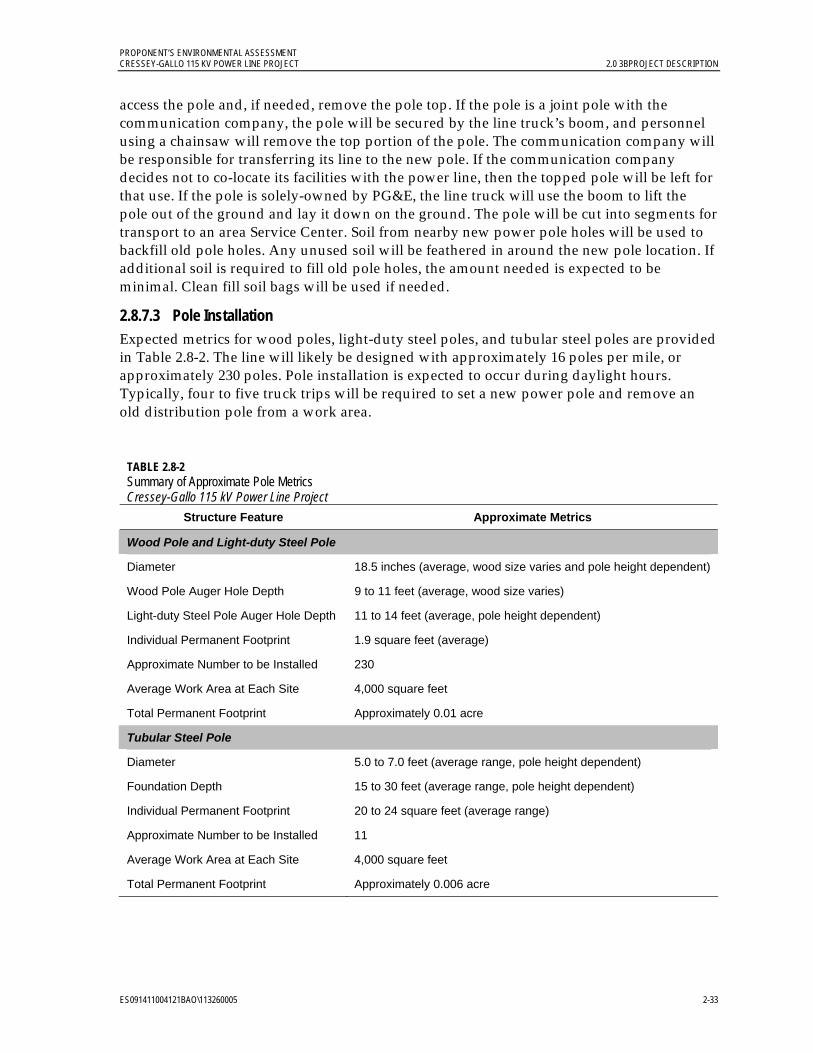
PROPONENT’S ENVIRONMENTAL ASSESSMENT CRESSEY-GALLO 115 KV POWER LINE PROJECT 2.0 3BPROJECT DESCRIPTION
ES091411004121BAO\113260005 2-33
access the pole and, if needed, remove the pole top. If the pole is a joint pole with the communication company, the pole will be secured by the line truck’s boom, and personnel using a chainsaw will remove the top portion of the pole. The communication company will be responsible for transferring its line to the new pole. If the communication company decides not to co-locate its facilities with the power line, then the topped pole will be left for that use. If the pole is solely-owned by PG&E, the line truck will use the boom to lift the pole out of the ground and lay it down on the ground. The pole will be cut into segments for transport to an area Service Center. Soil from nearby new power pole holes will be used to backfill old pole holes. Any unused soil will be feathered in around the new pole location. If additional soil is required to fill old pole holes, the amount needed is expected to be minimal. Clean fill soil bags will be used if needed.
2.8.7.3 Pole Installation Expected metrics for wood poles, light-duty steel poles, and tubular steel poles are provided in Table 2.8-2. The line will likely be designed with approximately 16 poles per mile, or approximately 230 poles. Pole installation is expected to occur during daylight hours. Typically, four to five truck trips will be required to set a new power pole and remove an old distribution pole from a work area.
TABLE 2.8-2 Summary of Approximate Pole Metrics Cressey-Gallo 115 kV Power Line Project
Structure Feature Approximate Metrics
Wood Pole and Light-duty Steel Pole
Diameter 18.5 inches (average, wood size varies and pole height dependent)
Wood Pole Auger Hole Depth 9 to 11 feet (average, wood size varies)
Light-duty Steel Pole Auger Hole Depth 11 to 14 feet (average, pole height dependent)
Individual Permanent Footprint 1.9 square feet (average)
Approximate Number to be Installed 230
Average Work Area at Each Site 4,000 square feet
Total Permanent Footprint Approximately 0.01 acre
Tubular Steel Pole
Diameter 5.0 to 7.0 feet (average range, pole height dependent)
Foundation Depth 15 to 30 feet (average range, pole height dependent)
Individual Permanent Footprint 20 to 24 square feet (average range)
Approximate Number to be Installed 11
Average Work Area at Each Site 4,000 square feet
Total Permanent Footprint Approximately 0.006 acre

PROPONENT’S ENVIRONMENTAL ASSESSMENT 2.0 3BPROJECT DESCRIPTION CRESSEY-GALLO 115 KV POWER LINE PROJECT
2-34 ES091411004121BAO\113260005
Wood and light-duty steel poles. Wood poles and light-duty steel poles will be direct buried and will not require foundations. The poles will be placed directly into augered holes. A line truck with a truck-mounted auger is expected to be used to create the holes. The line truck or a pick-up truck will be used to transport crew members to the work area. If the pole is not set immediately after the hole is dug, the holes will be covered with plywood or other temporary, solid, heavy covering until the new pole is installed. Soil removed from the new pole hole will be used to back-fill old pole holes and to secure the new pole in place. Soil may be temporarily stockpiled in accordance with applicable BMP measures until it is used as backfill. A water truck may be on-site to support dust suppression during ground disturbing work.
Light-duty steel poles will be manufactured in two pieces that are a matched set specific to a pole location. The pole pieces are closed at each end; there are no openings that wildlife may view as a potential burrow. The bottom piece of the pole assembly will be placed in the hole while the top piece has the hardware assembled to it on the ground. The poles will be assembled by having a truck-mounted crane lift the top piece and lower it onto the lower section. Soil will be backfilled around the newly-installed pole to fill any void remaining around the pole.
Tubular steel pole installation. Installation of tubular steel poles is expected to include the following steps for site preparation, foundation installation, and pole installation. To prepare the site, the pole location will be staked. The work area will be flagged, and required BMP measures installed. If required, a crane pad will be prepared, which may require surface blading to create a level surface. Pole foundation installation will include: 1) excavating the hole; 2) installing forms, rebar, and anchor bolts; 3) pouring concrete; 4) removing forms; and 5) placing gravel around and grooming the base area. After the new pole is installed, any distribution line will be moved to the new pole and the old wood distribution pole will be removed. Excess soil onsite will be feathered around the work area, and other construction materials will be transported to an area Service Center or other appropriate facility for disposal.
Tubular steel poles will have concrete pier foundations approximately five to seven feet in diameter. Tubular steel poles will be set approximately 15 to 30 feet below ground. A line truck will be used to haul foundation forms, anchor bolts, rebar, and pole structures to work areas. The line truck with a boom will be used to place foundation forms, anchor bolts, and rebar in place prior to pouring of concrete for the foundation, and to remove the forms following completion of the foundation.
A four-wheel drive concrete mixer truck capable of delivering eight yards of concrete will be used to deliver and pour concrete for the tubular steel pole foundations. Concrete trucks will not be washed out at pole locations, but rather will be rinsed using the portable stations established for concrete clean-up at project staging areas. A backhoe will be used to place gravel around the tubular steel pole foundation after formwork has been removed and to groom the area surrounding the pole installations. A crane will be used to place tubular steel poles on the foundations.
PROPONENT’S ENVIRONMENTAL ASSESSMENT CRESSEY-GALLO 115 KV POWER LINE PROJECT 2.0 3BPROJECT DESCRIPTION
ES091411004121BAO\113260005 2-35
2.8.7.4 Pull and Tension Work Areas A line truck with trailer and a second transport vehicle (crew-cab truck and/or half-ton pickup) are expected to be used to transport construction personnel to a pull and tension work area. A line truck will haul the conductor to the site with reel trailers and mounted reel stands. An 18-wheeled truck with trailer may be used to transport more than one reel to the work area. Pullers will be mounted on the line truck or trailer to install the conductor. Old distribution line will be removed from the sites on a line truck with trailer. Pole anchors may be installed to stabilize poles when pulling the conductor.
2.8.8 Distribution and Power Line Relocation and Conductor Installation 2.8.8.1 Distribution Line, Gallo Tap, and Cressey Tap Relocation Up to 6 crews (a total of approximately 30 personnel) will participate in distribution line and Gallo Tap power line relocation. If the existing line is on the same side of the street as the new power line, a line clearance will be obtained before the existing line is relocated to the new power poles. If the distribution line is being moved across the street, the new power line with distribution underbuild will be constructed without taking the distribution line out of service except to connect the distribution to the customer(s). Moving or removing old or pre-existing lines will be done after a clearance is obtained (while the lines are de-energized). During this time, PG&E will make every effort to minimize power outages to customers. The anticipated average length of a line clearance is 8 hours for this project. The maximum length of a line clearance is expected to be 12 hours. If the customer is sensitive to power outages (for example, a medical condition), PG&E will provide a temporary backup gasoline generator with a 5- to 7-horsepower motor. Businesses in the area will be contacted and PG&E will accommodate normal business hours of operation whenever possible.
2.8.8.2 Conductor Installation Typically seven steps will be taken to install a new conductor (wire stringing):
1. Travelers (pulleys) will be installed on the ends of insulators on each pole frame. A line truck with a bucket will be required to install the pulleys. Installation of pulleys may be phased to correspond with the specific section of wire stringing.
2. A truck, an all terrain vehicle (ATV), or a person will pull a light rope (sock line) in line with the route and lace it through the travelers. A line truck with a bucket will be used or a person may climb the structure.
3. When the sock line is laced through the travelers for the length of the pull, the sock line will be connected to a hard line (steel cable). The hard line will be on a reel that will be on a tensioner. Typically the reel and tensioner will be located on a line truck or semi-truck trailer.
4. The sock line will be pulled back with a truck, an ATV or a person pulling the hard line into place. The sock line will be removed from its connection to the hard line.
5. That same end of the hard line will be connected to conductor. A trailer-mounted tensioner will then pull the hard line, pulling the conductor in the reverse direction.
6. The conductor will be sagged into place using the tensioner.

PROPONENT’S ENVIRONMENTAL ASSESSMENT 2.0 3BPROJECT DESCRIPTION CRESSEY-GALLO 115 KV POWER LINE PROJECT
2-36 ES091411004121BAO\113260005
7. The conductor will be clipped into the insulators and the travelers will be removed by using the line truck with a bucket or a person may climb the structure.
Figure 2.8-1 depicts typical conductor stringing line truck placement when wire stringing a section of line.
2.8.8.3 Guard Structures Prior to stringing conductors, temporary guard structures will be installed at irrigation canals, road crossings, and other locations where the new conductors may otherwise come into contact with electrical, communication, or rail facilities, waterways, or vehicular traffic during installation. Guard structures will be positioned and configured to catch and support the weight of the conductor if it unexpectedly drops or sags excessively during the tensioning process. These structures will be placed on one side or on each side of the road or other location being crossed. For example, the temporary structures are expected to be installed across SR 99, Merced Irrigation District transmission lines, and the BNSF and UPRR railroad crossings. Each temporary structure would typically consist of a wood pole with a frame at the top that resembles a “Y” or “H”. Figure 2.6-5 provides examples of temporary clearance structures. Foundations and grading would not be required. Methods for installation and removal of clearance structures would be similar to those described for light-duty steel poles; however, the wood poles would be installed approximately six to ten feet deep. Netting will be installed between the two Y-frame or H-frame structures as needed to avoid contact between the new conductor and an existing facility. Where necessary, traffic control will be provided during installation and removal of these temporary guard structures, and as specified in Caltrans and Merced County encroachment permits.
2.8.9 Substation Construction Cressey Substation. During construction at Cressey Substation, four electrical grounding rods (approximately 100 feet in depth) will be required for the ground grid system. A drilling rig will be used to install the four electrical ground anodes. The substation modification is expected to include installation of 52 structure footings and one building excavation and foundation. Excavated material will be used elsewhere on site or removed from the project site. If removal is necessary, transportation and disposal will be arranged after testing of the debris.
The existing fence will not change with the Cressey Substation modifications, and new landscaping is not proposed. Approximately half of the existing Cressey Substation yard will be bladed to create a finish grade using a motor grader. The grader will be transported to the substation work area on a semi-truck trailer. A water truck will be on-site to support dust suppression during ground disturbing work. Soil is not expected to be removed from the work area.

PROPONENT’S ENVIRONMENTAL ASSESSMENT CRESSEY-GALLO 115 KV POWER LINE PROJECT 2.0 3BPROJECT DESCRIPTION
ES091411004121BAO\113260005 2-37
Insert Figure
2.8-1 Typical Construction Stringing Diagram
8.5 x 11
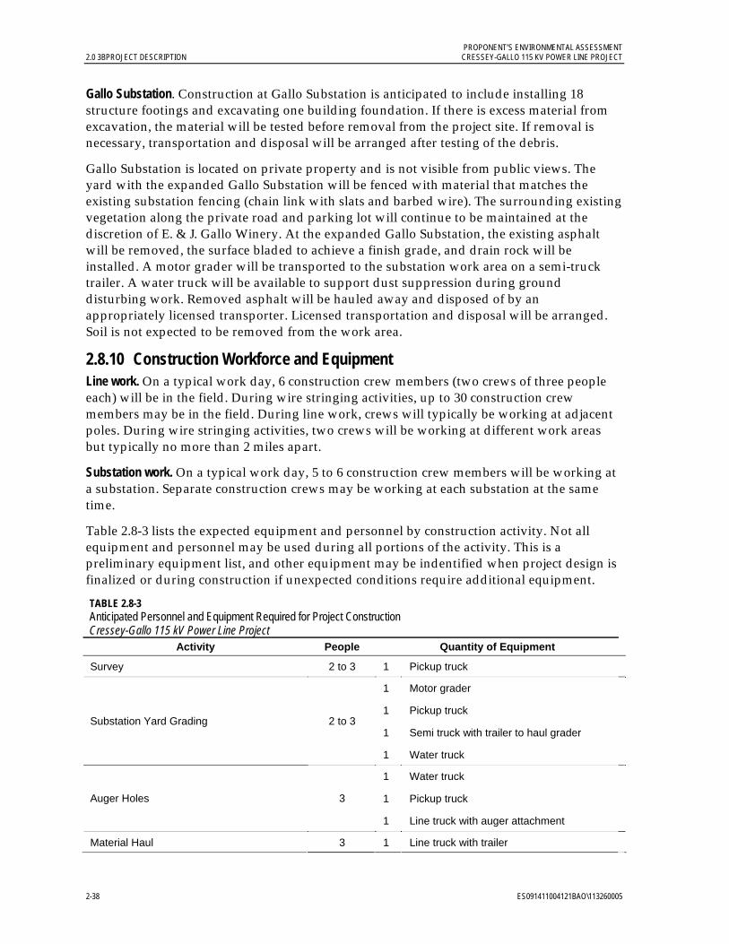
PROPONENT’S ENVIRONMENTAL ASSESSMENT 2.0 3BPROJECT DESCRIPTION CRESSEY-GALLO 115 KV POWER LINE PROJECT
2-38 ES091411004121BAO\113260005
Gallo Substation. Construction at Gallo Substation is anticipated to include installing 18 structure footings and excavating one building foundation. If there is excess material from excavation, the material will be tested before removal from the project site. If removal is necessary, transportation and disposal will be arranged after testing of the debris.
Gallo Substation is located on private property and is not visible from public views. The yard with the expanded Gallo Substation will be fenced with material that matches the existing substation fencing (chain link with slats and barbed wire). The surrounding existing vegetation along the private road and parking lot will continue to be maintained at the discretion of E. & J. Gallo Winery. At the expanded Gallo Substation, the existing asphalt will be removed, the surface bladed to achieve a finish grade, and drain rock will be installed. A motor grader will be transported to the substation work area on a semi-truck trailer. A water truck will be available to support dust suppression during ground disturbing work. Removed asphalt will be hauled away and disposed of by an appropriately licensed transporter. Licensed transportation and disposal will be arranged. Soil is not expected to be removed from the work area.
2.8.10 Construction Workforce and Equipment Line work. On a typical work day, 6 construction crew members (two crews of three people each) will be in the field. During wire stringing activities, up to 30 construction crew members may be in the field. During line work, crews will typically be working at adjacent poles. During wire stringing activities, two crews will be working at different work areas but typically no more than 2 miles apart.
Substation work. On a typical work day, 5 to 6 construction crew members will be working at a substation. Separate construction crews may be working at each substation at the same time.
Table 2.8-3 lists the expected equipment and personnel by construction activity. Not all equipment and personnel may be used during all portions of the activity. This is a preliminary equipment list, and other equipment may be indentified when project design is finalized or during construction if unexpected conditions require additional equipment.
TABLE 2.8-3 Anticipated Personnel and Equipment Required for Project Construction Cressey-Gallo 115 kV Power Line Project
Activity People Quantity of Equipment
Survey 2 to 3 1 Pickup truck
1 Motor grader
1 Pickup truck
1 Semi truck with trailer to haul grader Substation Yard Grading 2 to 3
1 Water truck
1 Water truck
1 Pickup truck Auger Holes 3
1 Line truck with auger attachment
Material Haul 3 1 Line truck with trailer
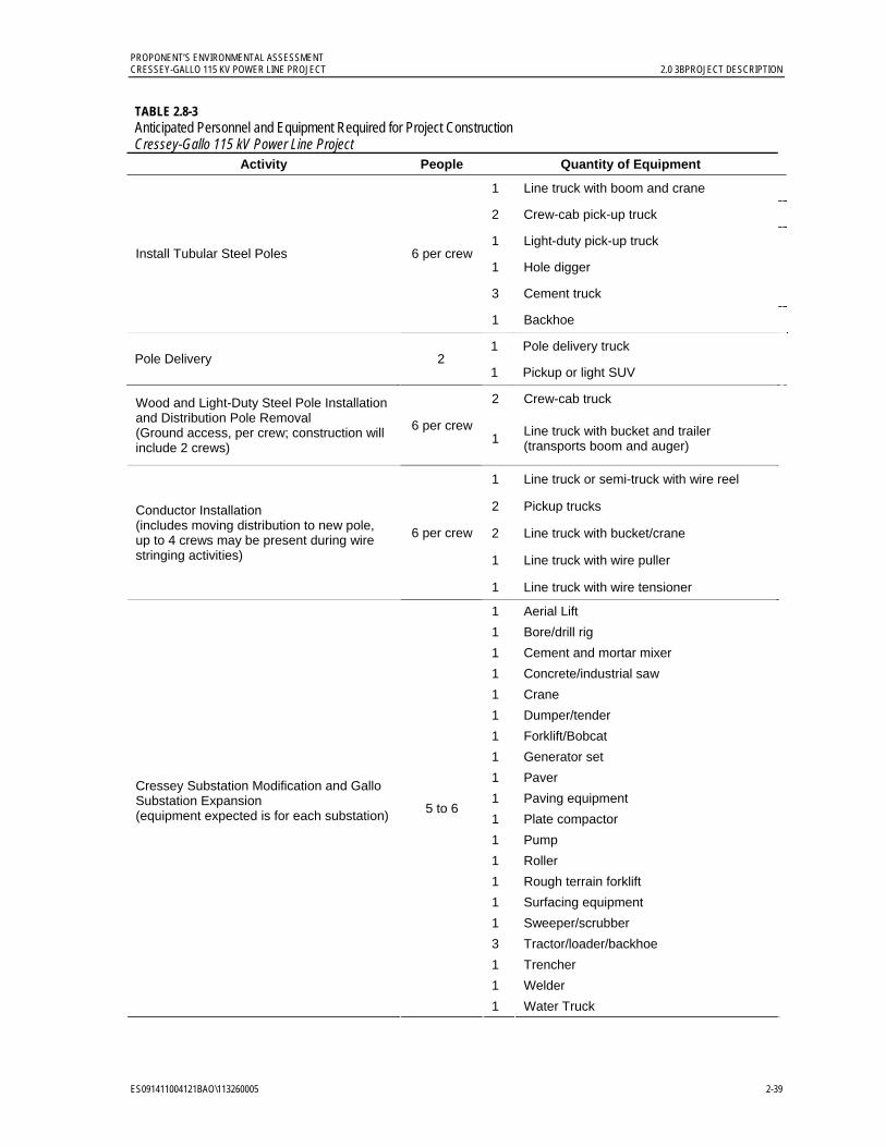
PROPONENT’S ENVIRONMENTAL ASSESSMENT CRESSEY-GALLO 115 KV POWER LINE PROJECT 2.0 3BPROJECT DESCRIPTION
ES091411004121BAO\113260005 2-39
TABLE 2.8-3 Anticipated Personnel and Equipment Required for Project Construction Cressey-Gallo 115 kV Power Line Project
Activity People Quantity of Equipment
1 Line truck with boom and crane
2 Crew-cab pick-up truck
1 Light-duty pick-up truck
1 Hole digger
3 Cement truck
Install Tubular Steel Poles 6 per crew
1 Backhoe
1 Pole delivery truck Pole Delivery 2
1 Pickup or light SUV
2 Crew-cab truck
Wood and Light-Duty Steel Pole Installation and Distribution Pole Removal (Ground access, per crew; construction will include 2 crews)
6 per crew 1
Line truck with bucket and trailer (transports boom and auger)
1 Line truck or semi-truck with wire reel
2 Pickup trucks
2 Line truck with bucket/crane
1 Line truck with wire puller
Conductor Installation (includes moving distribution to new pole, up to 4 crews may be present during wire stringing activities)
6 per crew
1 Line truck with wire tensioner 1 Aerial Lift
1 Bore/drill rig
1 Cement and mortar mixer
1 Concrete/industrial saw
1 Crane
1 Dumper/tender
1 Forklift/Bobcat
1 Generator set
1 Paver
1 Paving equipment
1 Plate compactor
1 Pump
1 Roller
1 Rough terrain forklift
1 Surfacing equipment
1 Sweeper/scrubber
3 Tractor/loader/backhoe
1 Trencher
1 Welder
Cressey Substation Modification and Gallo Substation Expansion (equipment expected is for each substation)
5 to 6
1 Water Truck

PROPONENT’S ENVIRONMENTAL ASSESSMENT 2.0 3BPROJECT DESCRIPTION CRESSEY-GALLO 115 KV POWER LINE PROJECT
2-40 ES091411004121BAO\113260005
Table 2.8-4 describes the anticipated use of the equipment listed in Table 2.8-3.
TABLE 2.8-4 Equipment Expected to be Used During Construction Cressey–Gallo 115 kV Power Line Project
Equipment Use
Aerial Lift Lifts crew members to make line connections
Auger (truck mounted highway digger 15- to 18-foot depth capability)
Drill holes for pole installation
Bore/drill rig Installation of holes for new conduits
Cement and mortar mixer Backfill of conduits
Concrete/industrial saw Asphalt/concrete cutting associated with substation modification/expansion
Crane Lifting of heavy equipment
Crew-cab truck or pickup truck Transport personnel
Drill rig Install electrical wells
Dumper/tender Earth movement associated with substation modification/expansion; miscellaneous trash removal
Generator set Power generation for operation of tools
Line truck (with auger, puller, worker-lift bucket, crane/boom, etc.)
Install and remove holes, poles, conductor
Mechanics service trucks Service/repair vehicles
Motor grader Create a finish grade at substation or orchard access road
Reel trailers with reel stands (semi-trailer or truck mounted type)
Haul conductor
Paver and paving equipment Asphalt installation
Plate compactor Grading
Puller/Tensioner/Reel (line truck or trailer-mounted) Install conductor
Pump Dewatering if groundwater is encountered, and watering for dirt suppression, if necessary
Roller Asphalt installation
Rough Terrain Forklift Activities associated with substation modification/expansion, including transport of poles
Semi truck (with trailer) Haul motor grader, wire reel, or tubular steel pole
Surfacing Equipment Asphalt surfacing
Sweeper/Scrubber Road cleaning, if necessary
Tensioner (line truck-mounted) Install conductor
Tractor/loader/backhoe Grading and foundation removal; backfilling of holes
Trencher Installation of conduits and grounds at substations
Water truck Dust suppression
Welder Welds associated with substation modification/expansion
Worker-lift (truck mounted) Lift workers to perform work on structures
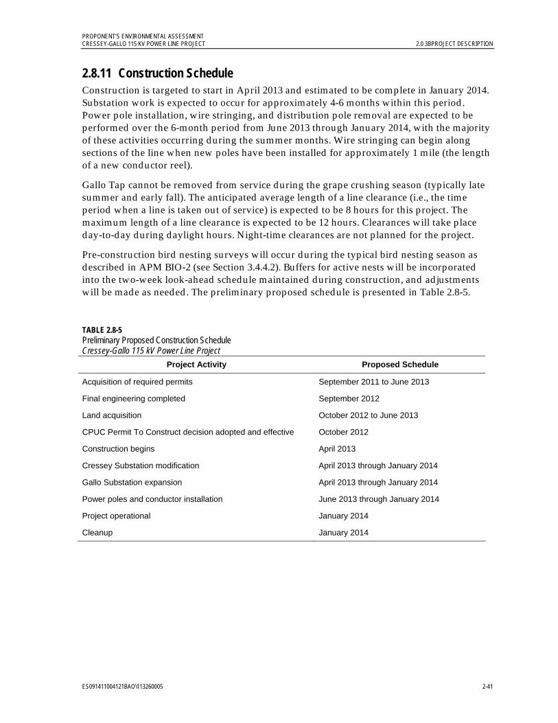
PROPONENT’S ENVIRONMENTAL ASSESSMENT CRESSEY-GALLO 115 KV POWER LINE PROJECT 2.0 3BPROJECT DESCRIPTION
ES091411004121BAO\113260005 2-41
2.8.11 Construction Schedule Construction is targeted to start in April 2013 and estimated to be complete in January 2014. Substation work is expected to occur for approximately 4-6 months within this period. Power pole installation, wire stringing, and distribution pole removal are expected to be performed over the 6-month period from June 2013 through January 2014, with the majority of these activities occurring during the summer months. Wire stringing can begin along sections of the line when new poles have been installed for approximately 1 mile (the length of a new conductor reel).
Gallo Tap cannot be removed from service during the grape crushing season (typically late summer and early fall). The anticipated average length of a line clearance (i.e., the time period when a line is taken out of service) is expected to be 8 hours for this project. The maximum length of a line clearance is expected to be 12 hours. Clearances will take place day-to-day during daylight hours. Night-time clearances are not planned for the project.
Pre-construction bird nesting surveys will occur during the typical bird nesting season as described in APM BIO-2 (see Section 3.4.4.2). Buffers for active nests will be incorporated into the two-week look-ahead schedule maintained during construction, and adjustments will be made as needed. The preliminary proposed schedule is presented in Table 2.8-5.
TABLE 2.8-5 Preliminary Proposed Construction Schedule Cressey-Gallo 115 kV Power Line Project
Project Activity Proposed Schedule
Acquisition of required permits September 2011 to June 2013
Final engineering completed September 2012
Land acquisition October 2012 to June 2013
CPUC Permit To Construct decision adopted and effective October 2012
Construction begins April 2013
Cressey Substation modification April 2013 through January 2014
Gallo Substation expansion April 2013 through January 2014
Power poles and conductor installation June 2013 through January 2014
Project operational January 2014
Cleanup January 2014

PROPONENT’S ENVIRONMENTAL ASSESSMENT 2.0 3BPROJECT DESCRIPTION CRESSEY-GALLO 115 KV POWER LINE PROJECT
2-42 ES091411004121BAO\113260005
2.9 Operation and Maintenance A typical Supervisory Control and Data Acquisition (SCADA) system will continue to be used to monitor equipment and control breakers at Cressey and Gallo substations.
Maintenance of the area substation and power line facilities will continue to be performed as follows:
• Inspections will be performed annually by existing local staff.
• A detailed inspection will be performed by existing local staff every two years, with an air patrol inspection being performed in between, as outlined in PG&E’s Electric Transmission Preventative Maintenance Manual (PG&E 2011).
• A single inspector (existing local staff) will patrol the line as part of the Merced 115 kV transmission system detailed inspection and aerial patrols. Normal inspection and patrols will typically be completed in a 4x4 pickup and/or an off-road utility vehicle. While not expected, if walking is required, the inspector will complete portions of the inspection on foot.
Once the new Cressey-Gallo 115 kV Power Line is built and energized, PG&E’s existing local maintenance and operations group will assume inspection, patrol, and maintenance duties as needed. No additional staff will be required after substation work is completed. Existing operation and maintenance crews will operate and maintain the new substation equipment as part of their current substation operation and maintenance activities.
2.10 Electric and Magnetic Fields Summary Recognizing that there is public interest and concern regarding potential health effects from exposure to electric and magnetic fields (EMF) from power line lines, this document provides some general background information regarding EMF associated with electric utility facilities in Appendix B. However, EMF is not addressed here as an environmental impact under CEQA. The CPUC has repeatedly recognized that EMF is not an environmental impact to be analyzed in the context of CEQA because (1) there is no agreement among scientists that EMF creates a potential health risk; and (2) there are no defined or adopted CEQA standards for defining health risk from EMF. See, for example, CPUC Decision No. 04-07-027 (Jul. 16, 2004); Delta DPA Capacity Increase Substation Project Final Mitigated Negative Declaration and Supporting Initial Study (November 2006), A.05-06-022, Section B.1.14.1, page B-31, adopted in Decision 07-03-009 (March 1, 2007).
Section X(A) of the CPUC’s General Order 131-D, CPUC Decision No. D.06-01-042 (“EMF Decision”), and PG&E’s EMF Design Guidelines prepared in accordance with the EMF Decision, require PG&E to prepare a Field Management Plan that indicates the no-cost and low-cost EMF measures that will be installed as part of the final engineering design for the project. The Field Management Plan evaluates the no-cost and low-cost measures considered for the project, the measures adopted, and reasons that certain measures were not adopted. A copy of the Field Management Plan for this project will be included as an exhibit to the Cressey-Gallo 115 kV Project Application provided to the CPUC.

PROPONENT’S ENVIRONMENTAL ASSESSMENT CRESSEY-GALLO 115 KV POWER LINE PROJECT 2.0 3BPROJECT DESCRIPTION
ES091411004121BAO\113260005 2-43
2.11 Alternatives CEQA does not require a review of alternatives1 where, as here, the proposed project will result in no significant environmental impacts. (See Atlantic-Del Mar Reinforcement Project, A.01-07-004, Assigned Commissioner’s Ruling dated 10-16-02.) As required by General Order 131-D, Section IX.B.1(c), a brief discussion of the reasons for selecting the power line route and a comparison with other routes is included in the application.
2.12 Applicant Proposed Measures PG&E proposes to implement the APMs listed in Table 2.12-1 to avoid or further minimize potential less-than-significant project impacts. The APMs are discussed in context with the environmental resources presented in their respective resource category subsections in Chapter 3.0.
2.13 References Edison Electric Institute’s Avian Power Line Interaction Committee (APLIC) and U.S. Fish
and Wildlife Service (USFWS). 2005. Avian Protection Plan (APP) Guidelines. Online: http://www.aplic.org/uploads/files/2634/APPguidelines_final-draft_Aprl2005.pdf. April.
Pacific Gas and Electric Company (PG&E). 2011. Electric Transmission Preventative Maintenance Manual. TD-1001M. January.
1
CEQA defines a “feasible alternative” as one that would attain most of the basic objectives of the project but would avoid or substantially lessen any of the significant effects of the project. Economic viability is also taken into account when determining the feasibility of alternatives. (CEQA Guidelines, California Code of Regulations, Title 14, Section 15126.6.)

PROPONENT’S ENVIRONMENTAL ASSESSMENT 2.0 3BPROJECT DESCRIPTION CRESSEY-GALLO 115 KV POWER LINE PROJECT
2-44 ES091411004121BAO\113260005
TABLE 2.12-1 Applicant Proposed Measures PG&E Cressey-Gallo 115 kV Power Line Project
Applicant Proposed Measures
Aesthetics
APM Aesthetics (AE)-1: Construction Activities. Construction activities will be kept as clean and inconspicuous as practical.
APM AE-2: Non-reflective Finish on Permanent Equipment. A galvanized finish that weathers to a dull, non-reflective patina will be used for substation components, chain link fencing, and power structures to reduce the potential for new sources of glare.
APM AE-3: Nighttime Substation Lighting to Minimize Potential Visual Impacts. Design and layout for new lighting at the two existing substations will incorporate measures such as use of non-glare fixtures and directional lighting to reduce spillover into areas outside the substation site and minimize the visibility of lighting from off-site locations.
APM AE-4: Distribution Line Co-location. Where the project power line and existing distribution lines are present along the same roadway corridor, distribution lines will be co-located on project poles where feasible, and existing distribution line poles will be removed in order to reduce the number and overall visibility of power poles in the project area. For portions of the power line route, where an existing PG&E distribution line is located on the same side of the road as the project route, the distribution line will be co-located on the new power poles and the distribution line’s wood poles will be removed. Where three or more distribution poles are located on the opposite side of the project route, the distribution line will be co-located on project poles and the existing distribution poles will be removed.
Land Use
APM Land Use (LU)-1: Agriculture Impacts Avoidance and Compensation. To avoid or minimize potential less-than-significant impacts to agriculture, PG&E will work with farmers and ranchers to schedule project work, to the extent feasible, around their harvest and planting periods. Access across active fields will be negotiated with the farmer and/or landowner in advance of any construction activities. In areas containing permanent crops (i.e., grape vines, orchard crops, etc.) that must be removed to gain access to pole sites for construction purposes, PG&E will provide compensation to the farmer and/or landowner in accordance with its Project Damage Assessment and Resolution Program.
Air Quality
APM Air Quality (AQ)-1: Minimize Fugitive Dust. PG&E will minimize fugitive dust during construction by implementing the following measures. According to SJVAPCD, implementation of the following measures minimizes fugitive dust emissions to a less-than-significant level (SJVAPCD 2002a).
Visible dust emissions (VDE) will not exceed 20 percent opacity during times when soil is disturbed.
All disturbed areas, including storage piles, which are not being actively utilized for construction purposes, will be effectively stabilized to control dust emissions using water, chemical stabilizer/suppressants, or covering soils with a tarp or other suitable cover or vegetative ground cover.
All onsite unpaved roads and offsite unpaved access roads will be effectively stabilized against dust emissions using water or chemical stabilizer/suppressant.
All land clearing, grubbing, scraping, excavation, land leveling, grading, cut and fill, and demolition activities will be effectively controlled to prevent fugitive dust emissions by application of water or presoaking.
When materials are transported offsite, all material will be covered, or effectively wetted to limit VDE, and at least 6 inches of freeboard space from the top of the container shall be maintained.
All operations will limit or expeditiously remove the accumulation of mud or dirt from adjacent public streets at the end of each workday.1
Following the addition of materials to, or the removal of materials from, the surface of outdoor storage piles, said piles will be effectively stabilized to control fugitive dust emissions by application of water or chemical stabilizer/suppressant.
Within urban areas, trackout will be immediately removed when it extends 50 or more feet from the site and at the end of each workday.
Vehicle speeds will be limited to 15 miles per hour on unpaved roads.
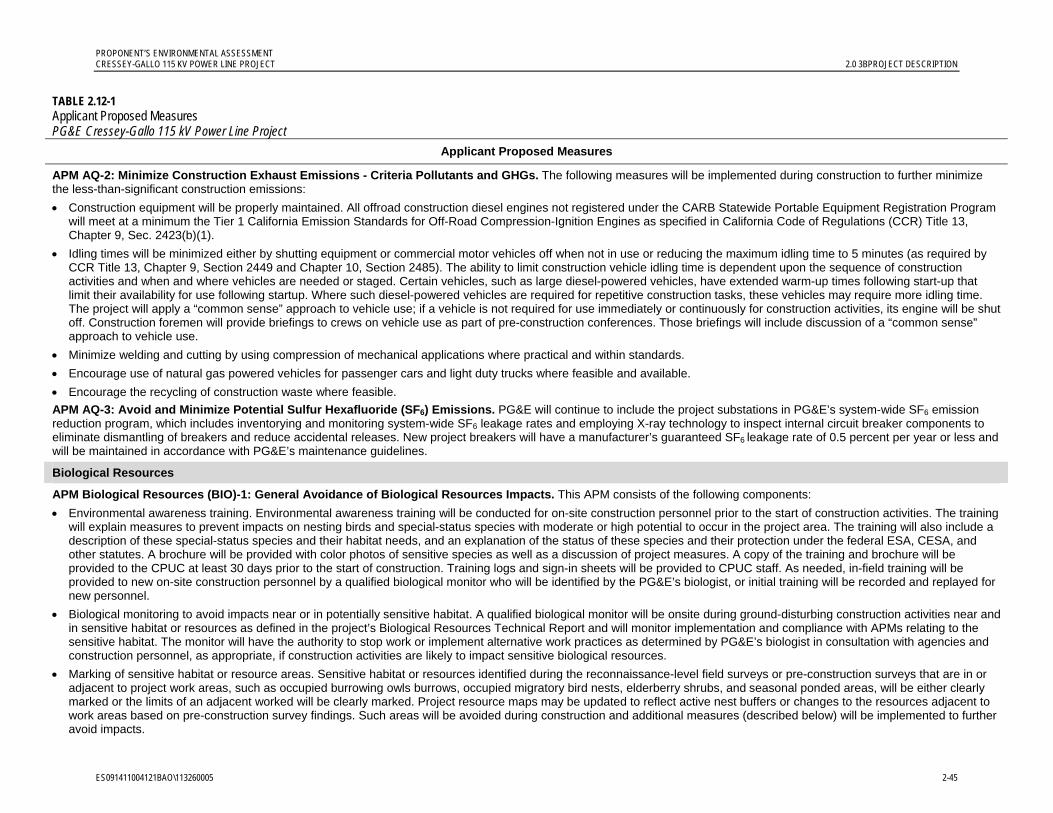
PROPONENT’S ENVIRONMENTAL ASSESSMENT CRESSEY-GALLO 115 KV POWER LINE PROJECT 2.0 3BPROJECT DESCRIPTION
ES091411004121BAO\113260005 2-45
TABLE 2.12-1 Applicant Proposed Measures PG&E Cressey-Gallo 115 kV Power Line Project
Applicant Proposed Measures
APM AQ-2: Minimize Construction Exhaust Emissions - Criteria Pollutants and GHGs. The following measures will be implemented during construction to further minimize the less-than-significant construction emissions:
Construction equipment will be properly maintained. All offroad construction diesel engines not registered under the CARB Statewide Portable Equipment Registration Program will meet at a minimum the Tier 1 California Emission Standards for Off-Road Compression-Ignition Engines as specified in California Code of Regulations (CCR) Title 13, Chapter 9, Sec. 2423(b)(1).
Idling times will be minimized either by shutting equipment or commercial motor vehicles off when not in use or reducing the maximum idling time to 5 minutes (as required by CCR Title 13, Chapter 9, Section 2449 and Chapter 10, Section 2485). The ability to limit construction vehicle idling time is dependent upon the sequence of construction activities and when and where vehicles are needed or staged. Certain vehicles, such as large diesel-powered vehicles, have extended warm-up times following start-up that limit their availability for use following startup. Where such diesel-powered vehicles are required for repetitive construction tasks, these vehicles may require more idling time. The project will apply a “common sense” approach to vehicle use; if a vehicle is not required for use immediately or continuously for construction activities, its engine will be shut off. Construction foremen will provide briefings to crews on vehicle use as part of pre-construction conferences. Those briefings will include discussion of a “common sense” approach to vehicle use.
Minimize welding and cutting by using compression of mechanical applications where practical and within standards.
Encourage use of natural gas powered vehicles for passenger cars and light duty trucks where feasible and available.
Encourage the recycling of construction waste where feasible.
APM AQ-3: Avoid and Minimize Potential Sulfur Hexafluoride (SF6) Emissions. PG&E will continue to include the project substations in PG&E’s system-wide SF6 emission reduction program, which includes inventorying and monitoring system-wide SF6 leakage rates and employing X-ray technology to inspect internal circuit breaker components to eliminate dismantling of breakers and reduce accidental releases. New project breakers will have a manufacturer’s guaranteed SF6 leakage rate of 0.5 percent per year or less and will be maintained in accordance with PG&E’s maintenance guidelines.
Biological Resources
APM Biological Resources (BIO)-1: General Avoidance of Biological Resources Impacts. This APM consists of the following components:
Environmental awareness training. Environmental awareness training will be conducted for on-site construction personnel prior to the start of construction activities. The training will explain measures to prevent impacts on nesting birds and special-status species with moderate or high potential to occur in the project area. The training will also include a description of these special-status species and their habitat needs, and an explanation of the status of these species and their protection under the federal ESA, CESA, and other statutes. A brochure will be provided with color photos of sensitive species as well as a discussion of project measures. A copy of the training and brochure will be provided to the CPUC at least 30 days prior to the start of construction. Training logs and sign-in sheets will be provided to CPUC staff. As needed, in-field training will be provided to new on-site construction personnel by a qualified biological monitor who will be identified by the PG&E’s biologist, or initial training will be recorded and replayed for new personnel.
Biological monitoring to avoid impacts near or in potentially sensitive habitat. A qualified biological monitor will be onsite during ground-disturbing construction activities near and in sensitive habitat or resources as defined in the project’s Biological Resources Technical Report and will monitor implementation and compliance with APMs relating to the sensitive habitat. The monitor will have the authority to stop work or implement alternative work practices as determined by PG&E’s biologist in consultation with agencies and construction personnel, as appropriate, if construction activities are likely to impact sensitive biological resources.
Marking of sensitive habitat or resource areas. Sensitive habitat or resources identified during the reconnaissance-level field surveys or pre-construction surveys that are in or adjacent to project work areas, such as occupied burrowing owls burrows, occupied migratory bird nests, elderberry shrubs, and seasonal ponded areas, will be either clearly marked or the limits of an adjacent worked will be clearly marked. Project resource maps may be updated to reflect active nest buffers or changes to the resources adjacent to work areas based on pre-construction survey findings. Such areas will be avoided during construction and additional measures (described below) will be implemented to further avoid impacts.
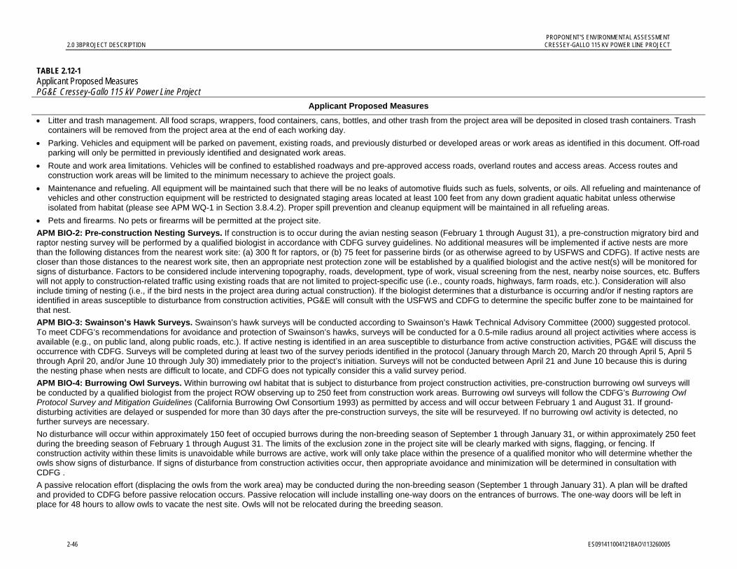
PROPONENT’S ENVIRONMENTAL ASSESSMENT 2.0 3BPROJECT DESCRIPTION CRESSEY-GALLO 115 KV POWER LINE PROJECT
2-46 ES091411004121BAO\113260005
TABLE 2.12-1 Applicant Proposed Measures PG&E Cressey-Gallo 115 kV Power Line Project
Applicant Proposed Measures
Litter and trash management. All food scraps, wrappers, food containers, cans, bottles, and other trash from the project area will be deposited in closed trash containers. Trash containers will be removed from the project area at the end of each working day.
Parking. Vehicles and equipment will be parked on pavement, existing roads, and previously disturbed or developed areas or work areas as identified in this document. Off-road parking will only be permitted in previously identified and designated work areas.
Route and work area limitations. Vehicles will be confined to established roadways and pre-approved access roads, overland routes and access areas. Access routes and construction work areas will be limited to the minimum necessary to achieve the project goals.
Maintenance and refueling. All equipment will be maintained such that there will be no leaks of automotive fluids such as fuels, solvents, or oils. All refueling and maintenance of vehicles and other construction equipment will be restricted to designated staging areas located at least 100 feet from any down gradient aquatic habitat unless otherwise isolated from habitat (please see APM WQ-1 in Section 3.8.4.2). Proper spill prevention and cleanup equipment will be maintained in all refueling areas.
Pets and firearms. No pets or firearms will be permitted at the project site.
APM BIO-2: Pre-construction Nesting Surveys. If construction is to occur during the avian nesting season (February 1 through August 31), a pre-construction migratory bird and raptor nesting survey will be performed by a qualified biologist in accordance with CDFG survey guidelines. No additional measures will be implemented if active nests are more than the following distances from the nearest work site: (a) 300 ft for raptors, or (b) 75 feet for passerine birds (or as otherwise agreed to by USFWS and CDFG). If active nests are closer than those distances to the nearest work site, then an appropriate nest protection zone will be established by a qualified biologist and the active nest(s) will be monitored for signs of disturbance. Factors to be considered include intervening topography, roads, development, type of work, visual screening from the nest, nearby noise sources, etc. Buffers will not apply to construction-related traffic using existing roads that are not limited to project-specific use (i.e., county roads, highways, farm roads, etc.). Consideration will also include timing of nesting (i.e., if the bird nests in the project area during actual construction). If the biologist determines that a disturbance is occurring and/or if nesting raptors are identified in areas susceptible to disturbance from construction activities, PG&E will consult with the USFWS and CDFG to determine the specific buffer zone to be maintained for that nest.
APM BIO-3: Swainson’s Hawk Surveys. Swainson’s hawk surveys will be conducted according to Swainson’s Hawk Technical Advisory Committee (2000) suggested protocol. To meet CDFG’s recommendations for avoidance and protection of Swainson’s hawks, surveys will be conducted for a 0.5-mile radius around all project activities where access is available (e.g., on public land, along public roads, etc.). If active nesting is identified in an area susceptible to disturbance from active construction activities, PG&E will discuss the occurrence with CDFG. Surveys will be completed during at least two of the survey periods identified in the protocol (January through March 20, March 20 through April 5, April 5 through April 20, and/or June 10 through July 30) immediately prior to the project’s initiation. Surveys will not be conducted between April 21 and June 10 because this is during the nesting phase when nests are difficult to locate, and CDFG does not typically consider this a valid survey period.
APM BIO-4: Burrowing Owl Surveys. Within burrowing owl habitat that is subject to disturbance from project construction activities, pre-construction burrowing owl surveys will be conducted by a qualified biologist from the project ROW observing up to 250 feet from construction work areas. Burrowing owl surveys will follow the CDFG’s Burrowing Owl Protocol Survey and Mitigation Guidelines (California Burrowing Owl Consortium 1993) as permitted by access and will occur between February 1 and August 31. If ground-disturbing activities are delayed or suspended for more than 30 days after the pre-construction surveys, the site will be resurveyed. If no burrowing owl activity is detected, no further surveys are necessary.
No disturbance will occur within approximately 150 feet of occupied burrows during the non-breeding season of September 1 through January 31, or within approximately 250 feet during the breeding season of February 1 through August 31. The limits of the exclusion zone in the project site will be clearly marked with signs, flagging, or fencing. If construction activity within these limits is unavoidable while burrows are active, work will only take place within the presence of a qualified monitor who will determine whether the owls show signs of disturbance. If signs of disturbance from construction activities occur, then appropriate avoidance and minimization will be determined in consultation with CDFG .
A passive relocation effort (displacing the owls from the work area) may be conducted during the non-breeding season (September 1 through January 31). A plan will be drafted and provided to CDFG before passive relocation occurs. Passive relocation will include installing one-way doors on the entrances of burrows. The one-way doors will be left in place for 48 hours to allow owls to vacate the nest site. Owls will not be relocated during the breeding season.
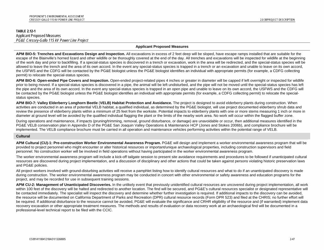
PROPONENT’S ENVIRONMENTAL ASSESSMENT CRESSEY-GALLO 115 KV POWER LINE PROJECT 2.0 3BPROJECT DESCRIPTION
ES091411004121BAO\113260005 2-47
TABLE 2.12-1 Applicant Proposed Measures PG&E Cressey-Gallo 115 kV Power Line Project
Applicant Proposed Measures
APM BIO-5: Trenches and Excavations Design and Inspection. All excavations in excess of 2 feet deep will be sloped, have escape ramps installed that are suitable for the escape of the Blainville’s horned lizard and other wildlife or be thoroughly covered at the end of the day. All trenches and excavations will be inspected for wildlife at the beginning of the work day and prior to backfilling. If a special-status species is discovered in a trench or excavation, work in the area will be redirected, and the special-status species will be allowed to leave the trench and the area of its own accord. In the event any special-status species is trapped in a trench or an excavation and unable to leave on its own accord, the USFWS and the CDFG will be contacted by the PG&E biologist unless the PG&E biologist identifies an individual with appropriate permits (for example, a CDFG collecting permit) to relocate the special-status species.
APM BIO-6: Open-ended Pipe Covers and Inspection. Open-ended project-related pipes 4 inches or greater in diameter will be capped if left overnight or inspected for wildlife prior to being moved. If a special-status species is discovered in a pipe, the animal will be left undisturbed, and the pipe will not be moved until the special-status species has left the pipe and the area of its own accord. In the event any special-status species is trapped in an open pipe and unable to leave on its own accord, the USFWS and the CDFG will be contacted by the PG&E biologist unless the PG&E biologist identifies an individual with appropriate permits (for example, a CDFG collecting permit) to relocate the special-status species.
APM BIO-7: Valley Elderberry Longhorn Beetle (VELB) Habitat Protection and Avoidance. The project is designed to avoid elderberry plants during construction. When activities are conducted in an area of potential VELB habitat, a qualified individual, as determined by the PG&E biologist, will use project documented elderberry shrub data and review the presence of elderberry plants within a minimum of 25 feet from the worksite. Potential impacts to elderberry plants with one or more stems measuring 1 inch or more in diameter at ground level will be avoided by the qualified individual flagging the plant or the limits of the nearby work area. No work will occur within the flagged buffer zone.
During operations and maintenance, if impacts (pruning/trimming, removal, ground disturbance, or damage) are unavoidable or occur, then additional measures identified in the PG&E VELB conservation plan in Appendix D of the PG&E San Joaquin Valley Operations & Maintenance HCP (Jones and Stokes 2006b), and compliance brochure will be implemented. The VELB compliance brochure must be carried in all operation and maintenance vehicles performing activities within the potential range of VELB.
Cultural
APM Cultural (CU)-1: Pre-construction Worker Environmental Awareness Program. PG&E will design and implement a worker environmental awareness program that will be provided to project personnel who might encounter or alter historical resources or important/unique archaeological properties, including construction supervisors and field personnel. No construction worker will be involved in field operations without having participated in the worker environmental awareness program.
The worker environmental awareness program will include a kick-off tailgate session to present site avoidance requirements and procedures to be followed if unanticipated cultural resources are discovered during project implementation, and a discussion of disciplinary and other actions that could be taken against persons violating historic preservation laws and PG&E policies.
All project workers involved with ground-disturbing activities will receive a pamphlet listing how to identify cultural resources and what to do if an unanticipated discovery is made during construction. The worker environmental awareness program may be conducted in concert with other environmental or safety awareness and education programs for the project, and may be recorded for use in subsequent training sessions.
APM CU-2: Management of Unanticipated Discoveries. In the unlikely event that previously unidentified cultural resources are uncovered during project implementation, all work within 100 feet of the discovery will be halted and redirected to another location. The find will be secured, and PG&E’s cultural resources specialist or designated representative will be contacted immediately. The specialist will inspect the discovery and determine whether further investigation is required. If additional impacts to the discovery can be avoided, the resource will be documented on California Department of Parks and Recreation (DPR) cultural resource records (Form DPR 523) and filed at the CHRIS; no further effort will be required. If additional disturbance to the resource cannot be avoided, PG&E will evaluate the significance and CRHR eligibility of the resource and (if warranted) implement data recovery excavation or other appropriate treatment measures. The methods and results of evaluation or data recovery work at an archaeological find will be documented in a professional-level technical report to be filed with the CCIC.
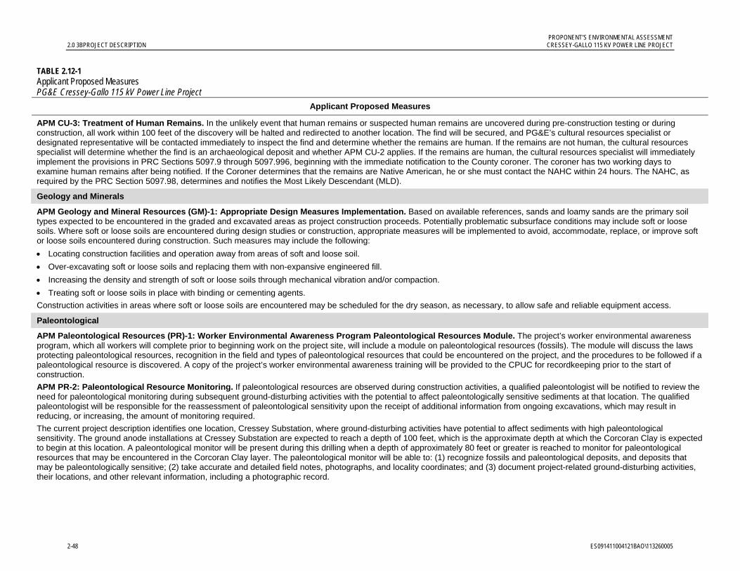
PROPONENT’S ENVIRONMENTAL ASSESSMENT 2.0 3BPROJECT DESCRIPTION CRESSEY-GALLO 115 KV POWER LINE PROJECT
2-48 ES091411004121BAO\113260005
TABLE 2.12-1 Applicant Proposed Measures PG&E Cressey-Gallo 115 kV Power Line Project
Applicant Proposed Measures
APM CU-3: Treatment of Human Remains. In the unlikely event that human remains or suspected human remains are uncovered during pre-construction testing or during construction, all work within 100 feet of the discovery will be halted and redirected to another location. The find will be secured, and PG&E’s cultural resources specialist or designated representative will be contacted immediately to inspect the find and determine whether the remains are human. If the remains are not human, the cultural resources specialist will determine whether the find is an archaeological deposit and whether APM CU-2 applies. If the remains are human, the cultural resources specialist will immediately implement the provisions in PRC Sections 5097.9 through 5097.996, beginning with the immediate notification to the County coroner. The coroner has two working days to examine human remains after being notified. If the Coroner determines that the remains are Native American, he or she must contact the NAHC within 24 hours. The NAHC, as required by the PRC Section 5097.98, determines and notifies the Most Likely Descendant (MLD).
Geology and Minerals
APM Geology and Mineral Resources (GM)-1: Appropriate Design Measures Implementation. Based on available references, sands and loamy sands are the primary soil types expected to be encountered in the graded and excavated areas as project construction proceeds. Potentially problematic subsurface conditions may include soft or loose soils. Where soft or loose soils are encountered during design studies or construction, appropriate measures will be implemented to avoid, accommodate, replace, or improve soft or loose soils encountered during construction. Such measures may include the following:
Locating construction facilities and operation away from areas of soft and loose soil.
Over-excavating soft or loose soils and replacing them with non-expansive engineered fill.
Increasing the density and strength of soft or loose soils through mechanical vibration and/or compaction.
Treating soft or loose soils in place with binding or cementing agents.
Construction activities in areas where soft or loose soils are encountered may be scheduled for the dry season, as necessary, to allow safe and reliable equipment access.
Paleontological
APM Paleontological Resources (PR)-1: Worker Environmental Awareness Program Paleontological Resources Module. The project’s worker environmental awareness program, which all workers will complete prior to beginning work on the project site, will include a module on paleontological resources (fossils). The module will discuss the laws protecting paleontological resources, recognition in the field and types of paleontological resources that could be encountered on the project, and the procedures to be followed if a paleontological resource is discovered. A copy of the project’s worker environmental awareness training will be provided to the CPUC for recordkeeping prior to the start of construction.
APM PR-2: Paleontological Resource Monitoring. If paleontological resources are observed during construction activities, a qualified paleontologist will be notified to review the need for paleontological monitoring during subsequent ground-disturbing activities with the potential to affect paleontologically sensitive sediments at that location. The qualified paleontologist will be responsible for the reassessment of paleontological sensitivity upon the receipt of additional information from ongoing excavations, which may result in reducing, or increasing, the amount of monitoring required.
The current project description identifies one location, Cressey Substation, where ground-disturbing activities have potential to affect sediments with high paleontological sensitivity. The ground anode installations at Cressey Substation are expected to reach a depth of 100 feet, which is the approximate depth at which the Corcoran Clay is expected to begin at this location. A paleontological monitor will be present during this drilling when a depth of approximately 80 feet or greater is reached to monitor for paleontological resources that may be encountered in the Corcoran Clay layer. The paleontological monitor will be able to: (1) recognize fossils and paleontological deposits, and deposits that may be paleontologically sensitive; (2) take accurate and detailed field notes, photographs, and locality coordinates; and (3) document project-related ground-disturbing activities, their locations, and other relevant information, including a photographic record.
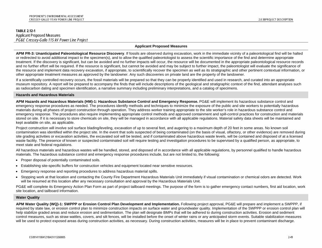
PROPONENT’S ENVIRONMENTAL ASSESSMENT CRESSEY-GALLO 115 KV POWER LINE PROJECT 2.0 3BPROJECT DESCRIPTION
ES091411004121BAO\113260005 2-49
TABLE 2.12-1 Applicant Proposed Measures PG&E Cressey-Gallo 115 kV Power Line Project
Applicant Proposed Measures
APM PR-3: Unanticipated Paleontological Resource Discovery. If fossils are observed during excavation, work in the immediate vicinity of a paleontological find will be halted or redirected to avoid additional impact to the specimen(s), and to allow the qualified paleontologist to assess the scientific importance of the find and determine appropriate treatment. If the discovery is significant, but can be avoided and no further impacts will occur, the resource will be documented in the appropriate paleontological resource records and no further effort will be required. If the resource is significant, but cannot be avoided and may be subject to further impact, the paleontologist will evaluate the significance of the resource and implement data recovery excavation, if appropriate, to scientifically recover the specimen as well as its stratigraphic and other pertinent contextual information, or other appropriate treatment measures as approved by the landowner. Any such discoveries on private land are the property of the landowner.
If a scientifically controlled recovery occurs, the fossil materials will be prepared so that they can be properly identified and used in research, and curated into an appropriate museum repository. A report will be prepared to accompany the finds that will include descriptions of the geological and stratigraphic context of the find, attendant analyses such as radiocarbon dating and specimen identification, a narrative summary including preliminary interpretations, and a catalog of specimens.
Hazards and Hazardous Materials
APM Hazards and Hazardous Materials (HM)-1: Hazardous Substance Control and Emergency Response. PG&E will implement its hazardous substance control and emergency response procedures as needed. The procedures identify methods and techniques to minimize the exposure of the public and site workers to potentially hazardous materials during all phases of project construction through operation. They address worker training appropriate to the site worker’s role in hazardous substance control and emergency response. The procedures also require implementing appropriate control methods and approved containment and spill-control practices for construction and materials stored on site. If it is necessary to store chemicals on site, they will be managed in accordance with all applicable regulations. Material safety data sheets will be maintained and kept available on site, as applicable.
Project construction will involve soil surface blading/leveling, excavation of up to several feet, and augering to a maximum depth of 20 feet in some areas. No known soil contamination was identified within the project site. In the event that soils suspected of being contaminated (on the basis of visual, olfactory, or other evidence) are removed during site grading activities or excavation activities, the excavated soil will be tested, and if contaminated above hazardous waste levels, will be contained and disposed of at a licensed waste facility. The presence of known or suspected contaminated soil will require testing and investigation procedures to be supervised by a qualified person, as appropriate, to meet state and federal regulations.
All hazardous materials and hazardous wastes will be handled, stored, and disposed of in accordance with all applicable regulations, by personnel qualified to handle hazardous materials. The hazardous substance control and emergency response procedures include, but are not limited to, the following:
Proper disposal of potentially contaminated soils.
Establishing site-specific buffers for construction vehicles and equipment located near sensitive resources.
Emergency response and reporting procedures to address hazardous material spills.
Stopping work at that location and contacting the County Fire Department Hazardous Materials Unit immediately if visual contamination or chemical odors are detected. Work will be resumed at this location after any necessary consultation and approval by the Hazardous Materials Unit.
PG&E will complete its Emergency Action Plan Form as part of project tailboard meetings. The purpose of the form is to gather emergency contact numbers, first aid location, work site location, and tailboard information.
Water Quality
APM Water Quality (WQ)-1: SWPPP or Erosion Control Plan Development and Implementation. Following project approval, PG&E will prepare and implement a SWPPP, if required by state law, or erosion control plan to minimize construction impacts on surface water and groundwater quality. Implementation of the SWPPP or erosion control plan will help stabilize graded areas and reduce erosion and sedimentation. The plan will designate BMPs that will be adhered to during construction activities. Erosion and sediment control measures, such as straw wattles, covers, and silt fences, will be installed before the onset of winter rains or any anticipated storm events. Suitable stabilization measures will be used to protect exposed areas during construction activities, as necessary. During construction activities, measures will be in place to prevent contaminant discharge.
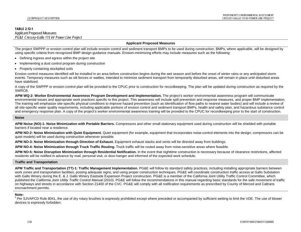
PROPONENT’S ENVIRONMENTAL ASSESSMENT 2.0 3BPROJECT DESCRIPTION CRESSEY-GALLO 115 KV POWER LINE PROJECT
2-50 ES091411004121BAO\113260005
TABLE 2.12-1 Applicant Proposed Measures PG&E Cressey-Gallo 115 kV Power Line Project
Applicant Proposed Measures
The project SWPPP or erosion control plan will include erosion control and sediment transport BMPs to be used during construction. BMPs, where applicable, will be designed by using specific criteria from recognized BMP design guidance manuals. Erosion-minimizing efforts may include measures such as the following:
Defining ingress and egress within the project site
Implementing a dust control program during construction
Properly containing stockpiled soils
Erosion control measures identified will be installed in an area before construction begins during the wet season and before the onset of winter rains or any anticipated storm events. Temporary measures such as silt fences or wattles, intended to minimize sediment transport from temporarily disturbed areas, will remain in place until disturbed areas have stabilized.
A copy of the SWPPP or erosion control plan will be provided to the CPUC prior to construction for recordkeeping. The plan will be updated during construction as required by the SWRCB.
APM WQ-2: Worker Environmental Awareness Program Development and Implementation. The project’s worker environmental awareness program will communicate environmental issues and appropriate work practices specific to this project. This awareness will include spill prevention and response measures, and proper BMP implementation. The training will emphasize site-specific physical conditions to improve hazard prevention (such as identification of flow paths to nearest water bodies) and will include a review of all site-specific water quality requirements, including applicable portions of erosion control and sediment transport BMPs, health and safety plan, and hazardous substance control and emergency response plan. A copy of the project’s worker environmental awareness training will be provided to the CPUC for recordkeeping prior to the start of construction.
Noise
APM Noise (NO)-1: Noise Minimization with Portable Barriers. Compressors and other small stationary equipment used during construction will be shielded with portable barriers if located near a residence.
APM NO-2: Noise Minimization with Quiet Equipment. Quiet equipment (for example, equipment that incorporates noise-control elements into the design; compressors can be quiet models) will be used during construction whenever possible.
APM NO-3: Noise Minimization through Direction of Exhaust. Equipment exhaust stacks and vents will be directed away from buildings.
APM NO-4: Noise Minimization through Truck Traffic Routing. Truck traffic will be routed away from noise-sensitive areas where feasible.
APM NO-5: Noise Disruption Minimization through Residential Notification. In the event that nighttime construction is necessary because of clearance restrictions, affected residents will be notified in advance by mail, personal visit, or door-hanger and informed of the expected work schedule.
Traffic and Transportation
APM Traffic and Transportation (TT)-1: Traffic Management Implementation. PG&E will follow its standard safety practices, including installing appropriate barriers between work zones and transportation facilities, posting adequate signs, and using proper construction techniques. PG&E will coordinate construction traffic access at Gallo Substation with Gallo Winery during the E. & J. Gallo Winery Eastside Expansion Project construction. PG&E is a member of the California Joint Utility Traffic Control Committee, which published the California Joint Utility Traffic Control Manual (2010). PG&E will follow the recommendations in this manual regarding basic standards for the safe movement of traffic on highways and streets in accordance with Section 21400 of the CVC. PG&E will comply with all notification requirements as prescribed by County of Merced and Caltrans encroachment permits.
Note: 1 Per SJVAPCD Rule 8041, the use of dry rotary brushes is expressly prohibited except where preceded or accompanied by sufficient wetting to limit the VDE. The use of blower devices is expressly forbidden.
ES091411004121BAO\113260005 3.1-1
3.0 Environmental Setting and Impact Assessment Summary
3.1 Aesthetics 3.1.1 Introduction and Methodology This section describes existing conditions and potential impacts on aesthetic resources as a result of construction, operation, and maintenance of the project. Visual or aesthetic resources are generally defined as both the natural and built features of the landscape that are seen and that contribute to the public’s experience and appreciation of the environment. Visual resource or aesthetic impacts are generally defined in terms of a project’s physical characteristics and potential visibility and the extent to which its presence will alter the perceived visual character and quality of the environment. As described below, impacts to scenic resources will be less than significant; the APMs described below in Section 3.1.4.2 will further reduce the project’s less-than-significant aesthetic impacts.
The study process began with a review of background material describing general visual conditions in the project area. Preliminary drawings of the project provided by PG&E were also reviewed to determine the physical characteristics of project elements. Project features were then plotted, including the project route and existing substations, on an aerial photograph to relate them to the location of potentially sensitive visual receptors. In addition, regional atlases and geographic information system (GIS) data were reviewed to establish the locations of sensitive viewing areas, including local communities, residences, public roadways (in particular, any designated scenic routes), historic sites, and public open space or recreation areas (Delorme Mapping Company 2003 and Google 2011). A list of planned projects from the City of Livingston was reviewed as well (City of Livingston 2011). The following sensitive viewpoints in the project vicinity were identified:
Nearby residences along Magnolia Road and along other roadways in proximity to the project route
Nearby residences along Arena Way and along other roadways in proximity to the project route
Planned residential areas south of the of the City of Livingston
The crossing of State Route 99 (SR 99)
In July 2011, field observations and site photography were completed to document existing visual conditions in the project area. In consideration of California Environmental Quality Act (CEQA) guidance for aesthetic impact evaluation and on the basis of the field observations, a set of 14 photographs was taken to depict representative baseline visual conditions and public views in the project area as seen from key representative public viewpoints designated as VP 1 through VP 14 (see Figures 3.1-1 and 3.1-2). Six of these viewpoints (VPs 1, 7, 8, 9, 11, and 13) were selected to represent views seen by the greatest
PROPONENT’S ENVIRONMENTAL ASSESSMENT 3.1 20BAESTHETICS CRESSEY-GALLO 115 KV POWER LINE PROJECT
3.1-2 ES091411004121BAO\113260005
Insert Figure
3.1-1 Photograph ViewPoint Locations
8.5 x 11

PROPONENT’S ENVIRONMENTAL ASSESSMENT CRESSEY-GALLO 115 KV POWER LINE PROJECT 3.1 20BAESTHETICS
ES091411004121BAO\113260005 3.1-3
Insert Figure
3.1-2 Photographs of Project Route and Vicinity
7 sheets
8.5 x 11, page 1

PROPONENT’S ENVIRONMENTAL ASSESSMENT 3.1 20BAESTHETICS CRESSEY-GALLO 115 KV POWER LINE PROJECT
3.1-4 ES091411004121BAO\113260005
3.1-2, page 2

PROPONENT’S ENVIRONMENTAL ASSESSMENT CRESSEY-GALLO 115 KV POWER LINE PROJECT 3.1 20BAESTHETICS
ES091411004121BAO\113260005 3.1-5
3.1-2, page 3

PROPONENT’S ENVIRONMENTAL ASSESSMENT 3.1 20BAESTHETICS CRESSEY-GALLO 115 KV POWER LINE PROJECT
3.1-6 ES091411004121BAO\113260005
3.1-2, page 4

PROPONENT’S ENVIRONMENTAL ASSESSMENT CRESSEY-GALLO 115 KV POWER LINE PROJECT 3.1 20BAESTHETICS
ES091411004121BAO\113260005 3.1-7
3.1-2, page 5

PROPONENT’S ENVIRONMENTAL ASSESSMENT 3.1 20BAESTHETICS CRESSEY-GALLO 115 KV POWER LINE PROJECT
3.1-8 ES091411004121BAO\113260005
3.1-2, page 6

PROPONENT’S ENVIRONMENTAL ASSESSMENT CRESSEY-GALLO 115 KV POWER LINE PROJECT 3.1 20BAESTHETICS
ES091411004121BAO\113260005 3.1-9
page 7

PROPONENT’S ENVIRONMENTAL ASSESSMENT 3.1 20BAESTHETICS CRESSEY-GALLO 115 KV POWER LINE PROJECT
3.1-10 ES091411004121BAO\113260005
number of affected viewers and/or from sensitive locations, such as residential areas. For these six “simulation viewpoints” visual simulations were prepared to illustrate “before and after” visual conditions in the proposed project area. The baseline (before project) photographs were taken using a digital single-lens reflex (SLR) camera and a “normal” 50-millimeter equivalent lens, which represents a horizontal view angle of approximately 40 degrees. Described briefly below, the simulation methods employ systematic computer modeling and rendering techniques.
Digital aerial photographs, project route and preliminary project design information supplied by PG&E provided the basis for developing a three–dimensional (3-D) computer model of the existing site and proposed substation improvements and power poles. For each simulation viewpoint, viewer location was input from global positioning system (GPS) data, using five feet as the assumed eye level. Computer “wireframe” perspective plots were overlaid on the simulation photographs to verify scale and viewpoint location. Digital visual simulation images were then produced based on computer renderings of the 3-D model combined with digital versions of the selected site photographs. Figures depicting existing views and computer-generated visual simulations of the proposed project were produced, as discussed in Section 3.1.4.5.
Analysis of the views was informed by the evaluative process set out by the Federal Highway Administration in Visual Impact Assessment for Highway Projects and other accepted visual analysis techniques (FHWA 1988). The FHWA analysis approach was developed by a major federal agency that invested considerable resources in its creation, testing, and implementation. As a result, this approach is robust and is now widely used to provide systematic and objective evaluations of visual change. The FHWA visual quality and aesthetics assessment method addresses the visual qualities and characteristics of the existing landscape in the project area, the project’s potential effects on the area’s visual quality and aesthetics, and the likely level of concern about or reaction by viewers to how the project visually fits within the existing landscape.
The project’s visual impact assessment is based on evaluation of the changes to the existing visual resources that will result from construction, operation, and maintenance of the project. These changes, and viewer response to those changes, were assessed, in part, by evaluating the “after” views provided by the computer-generated visual simulations and comparing them to the existing visual environment.
3.1.2 Regulatory Background 3.1.2.1 Federal There are no federal regulations applicable to the project related to aesthetic or visual resources.
3.1.2.2 State
California Scenic Highway Program. California’s Scenic Highways Program, a provision of the Streets and Highways Code (S&HC), was established by the Legislature in 1963 to preserve and enhance the natural beauty of California. The State Scenic Highway System includes highways that are either eligible for designation as scenic highways or have been designated as such. The status of a state scenic highway changes from eligible to officially designated when the local jurisdiction adopts a scenic corridor protection program, applies

PROPONENT’S ENVIRONMENTAL ASSESSMENT CRESSEY-GALLO 115 KV POWER LINE PROJECT 3.1 20BAESTHETICS
ES091411004121BAO\113260005 3.1-11
to the California Department of Transportation (Caltrans) for scenic highway approval, and receives the designation from Caltrans (Caltrans 2009). A city or county may propose adding routes with outstanding scenic elements to the list of eligible highways. However, state legislation is required for a highway to be officially designated.
No designated state scenic routes are located near the project. The nearest scenic highway is Interstate 5 (I-5) located approximately 18 miles to the southwest, and the project will not be visible from this roadway.
3.1.2.3 Local Because the CPUC has exclusive jurisdiction over project siting, design, and construction, the project is not subject to local discretionary regulations. This section includes a description of the local regulations relevant to the visual resource issues associated with the project and is provided for informational purposes to assist with CEQA review.
The project is located in an unincorporated area of Merced County, and although it is 0.25 mile outside of the City of Livingston, it is adjacent to the City of Livingston 2025 General Plan Sphere of Influence (SOI) of the City along a portion of Magnolia Avenue (City of Livingston 2008). This section reviews visual resource-related polices and regulations contained in the Merced County Year 2000 General Plan (1990). The plan is in the process of being updated, and this section also reviews the new 2030 Merced County General Plan Public Review Draft (2011), which has not yet been adopted.
Merced County Year 2000 General Plan (1990). The General Plan broadly addresses scenic resources and identifies the Coastal and Sierra mountain ranges and the Merced, San Joaquin, and Bear Creek River corridors as important scenic features in the county (p. I-39). Additionally, the plan includes provisions for preserving scenic resources along state scenic highways, but does not identify any county scenic roadways. Chapter II, Circulation, encourages locating new transmission lines within existing utility easements:
GOAL 3: An adequate system for the transmission and distribution of energy, water and information. (p. II-23)
Policies: 2. New transmission and distribution lines shall be encouraged within existing utility easements and rights-of-way. (p. II-24)
The project complies with the Merced County Year 2000 General Plan because a majority of the project will be located in existing utility corridors.
2030 Merced County General Plan (2011). The proposed 2030 General Plan reiterates some of the guidelines regarding preserving visual resources within scenic highway corridors; however, no scenic roadways aside from the state scenic roadways are designated. The Public Facilities and Service Element restates the existing policy of encouraging locating new transmission lines within existing rights-of-way.
In addition, the Natural Resources Element of the proposed plan also includes a new policy addressing light pollution:
PROPONENT’S ENVIRONMENTAL ASSESSMENT 3.1 20BAESTHETICS CRESSEY-GALLO 115 KV POWER LINE PROJECT
3.1-12 ES091411004121BAO\113260005
Policy NR-4.5: Light Pollution Reduction (RDR) Require good lighting practices, such as the use of specific light fixtures that reduce light pollution, minimize light impacts, and preserve views of the night sky. (p. NR-9)
Some new lighting is proposed on new or modified structures at the substations, and it will be designed to avoid casting light or glare offsite. No new lighting is proposed along the power line route. Therefore, the project is compatible with the proposed 2030 General Plan.
3.1.3 Environmental Setting Figure 3.1-1 includes a map and an annotated aerial photograph that show the Cressey-Gallo 115 kV Power Line Project location within a regional and local landscape context. The site is in central California within the San Joaquin Valley, the southern portion of the much larger Central Valley. Bordered by the Sierra Mountains on the east and the Central Coast Ranges on the west, the landscape within this portion of the valley reflects a high level of human modification, including vast areas of agricultural land and a network of highways and rural roads, canals, railroad corridors, and electric utility structures that traverse the landscape. I-5 and SR 99 provide major north-south transportation links between the valley’s cities and smaller communities.
Located in Merced County, the project site lies in a sparsely populated agricultural landscape setting approximately 8 miles southeast of the City of Turlock and 11 miles northwest of the City of Merced. The vicinity includes single rural residences and some groups of residences. The project passes within 0.25 mile of the city limits of the City of Livingston and through Arena, an unincorporated community located along SR 99. Other nearby unincorporated communities in the area include Cressey, Winton, Hilmar-Irwin, and Atwater. Situated at an elevation of approximately 120 to 160 feet above sea level, the area’s topography is generally flat and rises gradually to the east. To the north, and within 1 mile of the project route, the Merced River flows toward the southwest. The Coast Ranges lie approximately 20 miles to the east with nearby peaks rising to over 3,800 feet in elevation. The Sierra foothills lie approximately 17 miles west. These mountain ranges are barely visible from locations along the project route.
In the project vicinity, flat agricultural terrain, including orchards, vineyards and field crops, dominates the landscape character. Within this setting, a grid of roadways and canals provides a physical and visual framework for the area’s overall land use development pattern. The composition of roadway views varies from unobstructed, open agricultural land, sometimes with hills or mountains discernable in the backdrop, to corridors enclosed by mature orchards. More dense areas of tree cover are seen at orchards and near residential development. Agricultural facilities, including large-scale processing plants such as the Gallo Winery and Foster Farms Poultry Company, are also found in the project area. Electric utility structures are established landscape features in the project area including substations and distribution lines, as well as Merced Irrigation District power lines, which cross the project route in two places.
3.1.3.1 Project Viewshed and Representative Views The project viewshed is defined as the general area from which a project is visible or can be seen. For purposes of describing a project’s visual setting and assessing potential visual
PROPONENT’S ENVIRONMENTAL ASSESSMENT CRESSEY-GALLO 115 KV POWER LINE PROJECT 3.1 20BAESTHETICS
ES091411004121BAO\113260005 3.1-13
impacts, the viewshed can be broken down into foreground, middleground, and background zones. The foreground is defined as the zone within a quarter-mile to a half-mile from the viewer. Landscape detail is most noticeable and objects generally appear most prominent when seen in the foreground. The middleground can be defined as a zone that extends from the foreground up to 3 to 5 miles from the viewer, and the background extends from about 3 to 5 miles to infinity (Smardon et al. 1986).
For the purpose of this analysis, the potential effects on foreground viewshed conditions are emphasized, particularly those areas within 0.25 mile of the project. As seen from many locations within the surrounding area, it is anticipated that views of the proposed project will be partially or fully screened by intervening structures and vegetation. The proposed project will not be visible in its entirety from any single viewing location given its overall length, the height of structures, and the presence of intervening vegetation.
3.1.3.2 Landscape Units and Representative Views The project follows an approximately 14.4-mile route that connects Cressey Substation with Gallo Substation. In addition to these two substations, a set of three distinct sub-areas or landscape units has been identified for purposes of documenting and describing the project’s foreground viewshed moving from the east (Cressey Substation) to the west (Gallo Substation). Table 3.1-1 summarizes the landscape units identified within the project viewshed. Figure 3.1-1 delineates the project route, landscape units, and photograph viewpoint locations. Figure 3.1-2 presents a set of 14 photographs that depict representative visual conditions and public views in the project area; all references to Photographs 1 through 14 in this section refer to the photographs presented in Figure 3.1-2.
TABLE 3.1-1 Summary of Landscape Units Within the Project Viewshed PG&E Cressey-Gallo 115 kV Power Line Project
Landscape Unit
Approximate Length
Approx. No. of New
Poles* Primary Affected
Viewers
Approx. No. of Residences within
0.25-mile radius
PEA Figure No. of Representative
Visual Simulation(s)
Cressey Substation
N.A. 4 Motorists 2 3.1-3
East 4.8 miles 40 Motorists
Few Residents
30 3.1-3 and 3.1-4
Central 6.1 miles 110 Motorists
Residents
70 3.1-5 through 3.1-7
West 3.5 miles 80 Motorists 10 3.1-8
Gallo Substation
N.A. 3 Limited Number of Motorists
0 N.A.
Note: * May change with final design. Note that approximately 170 existing wood poles will be removed as part of the project. N.A. = not applicable
PROPONENT’S ENVIRONMENTAL ASSESSMENT 3.1 20BAESTHETICS CRESSEY-GALLO 115 KV POWER LINE PROJECT
3.1-14 ES091411004121BAO\113260005
Cressey Substation (Photographs 1, 2, and 3) Cressey Substation occupies approximately 1.5 acres located southeast of the intersection of Meadow Drive and West Lane, and 2 miles east of the community of Cressey. Situated 100 feet south of Meadow Drive, the substation site is relatively level and bordered on the south by orchards, on the west by West Lane, and by Ward Canal on the north and east. Close-range views of the substation are limited to locations along Meadow Drive and West Lane, as well as from a couple of nearby residences. From many locations along West Lane and along Meadow Drive, intervening orchard trees screen views of the substation. The substation generally lies at the same elevation as the adjacent roadways (Photograph 2 on Figure 3.1-2); however, due to variations in topography, Meadow Drive east of the site lies at an elevation below the substation (Photograph 1). More distant views of Cressey Substation are generally obstructed by intervening vegetation and topography.
Photographs 1, 2 and 3 show views from nearby roadways that include existing substation components, a lattice tower, several wood poles, and overhead wires. Additionally, wood poles and an overhead distribution line run along adjacent roadways.
Primary viewers in this area are motorists using lightly traveled rural roads adjacent to the substation. In addition, approximately two residences lie within 0.25 mile of the substation.
East Landscape Unit (Figure 3.1-2, Photographs 1 to 7) This landscape unit runs almost 5 miles, from Cressey Substation to the northern edge of the community of Arena. In this landscape unit, the project route follows paved and unpaved rural roads, and passes through private agricultural land. Mature orchards with a limited number of rural residences characterize the landscape in this unit. The community of Cressey lies approximately one and a half miles from the project route. Roadways are rural and used primarily by agricultural workers and local residents.
From the northwest corner of Cressey Substation the project route continues south on West Lane, a narrow rural road. Views from the northern portion of this road are enclosed by orchard trees (Photograph 3 on Figure 3.1-2); however, further south on West Lane, the landscape opens onto flat pastures. At Palm Avenue, the route turns west, continues through this open landscape (Photograph 4), and passes in close proximity to approximately three rural residences. Photographs 3 and 4 show that existing power lines run parallel to the project route along both the east side of West Lane and the south side of Palm Avenue, respectively.
Approximately 0.5 mile west of West Lane the route turns south, follows an unpaved road through orchards for approximately 0.5 mile, and approximately 400 feet past Palm Avenue it crosses the Cressey Lateral Canal.
The project route travels west along Mercedes Avenue for approximately 1.5 miles. Along Mercedes Avenue, the route passes within 500 feet of about seven rural residences; however, views from these residences toward the project route are largely screened by intervening orchards. The route also crosses the Atchison Topeka and Santa Fe Railroad and Santa Fe Drive (County Road 37), a relatively well-used, paved, two-lane road (Photograph 5). Mercedes Avenue is paved east of Santa Fe Drive, however, the road is not continuous, and does not cross the railroad. West of the canal the route follows an unpaved road until Cressey Way, at which point Mercedes Avenue again becomes a paved road.

PROPONENT’S ENVIRONMENTAL ASSESSMENT CRESSEY-GALLO 115 KV POWER LINE PROJECT 3.1 20BAESTHETICS
ES091411004121BAO\113260005 3.1-15
One-half mile west of Cressey Way (Photograph 6), the route turns south through an orchard, crosses the Livingston Canal, and continues along a dirt road through more orchards. Between Eucalyptus Avenue and Olive Avenue, Arena Way is paved, and lined by mature orchards. Along Arena Way, the project route lies within 500 feet of at least two residences. For much of this landscape unit, existing wood distribution poles and overhead lines parallel the route. In addition, at both Eucalyptus and Walnut Avenues, the route crosses Merced Irrigation District power lines (see Photograph 7).
Primary viewers in this landscape unit are local motorists using lightly-traveled rural roads. The area also includes 32 residences that lie within 0.25 mile of the project route.
Central Landscape Unit (Figure 3.1-2, Photographs 8 to 12) Beginning at Walnut Avenue, the Central Landscape Unit is approximately 6 miles long and lies in proximity to numerous residences including some located in the community of Arena and at the edge of the City of Livingston. (Note: although VP 7 is physically located south of Walnut Avenue and hence in the Central Landscape Unit, for the purposes of this report VP 7 is considered to be part of the East Landscape Unit because the viewpoint was selected to depict the southern boundary of the East Unit [i.e., Walnut Avenue] in a northward-looking view shown in Photograph 7.) Within the Central Landscape Unit, most of the project route runs along paved roadways lined with row crops and orchards. Viewers include residents and motorists on local roadways and SR 99.
The route continues on Arena Way, where it passes through the community of Arena, a group of approximately 30 homes on Arena Way and Liberty Avenue, situated just north of SR 99. The route crosses SR 99 and the Southern Pacific railroad corridor. Immediately south of SR 99 two residences are located on Arena Way; there is no through traffic in this area.
The route turns west on Magnolia Avenue and continues just over 7 miles. At approximately 2.5 miles west of Arena Way, the route crosses Lincoln Boulevard, a major north-south corridor connecting the City of Livingston with Highway 140 to the south. The route also crosses Sultana Drive, Sheesley Road, Dwight Way, and the Curtner Lateral Canal. The project route passes about 0.25 mile from the southern city limits of the City of Livingston. The route passes approximately 40 existing residences on or near Magnolia Avenue. As Photograph 12 indicates, these residential properties typically include mature vegetation that provides considerable screening. West of Lincoln Boulevard, the route also crosses Robin Avenue, Washington Boulevard, the Arena Canal, and the McCoy Lateral Canal.
For much of Magnolia Avenue, existing wood distribution poles are visible along the roadway (Photographs 10, 11, and 12). In this area, Livingston Substation, located on Washington Boulevard at Legion Avenue, lies approximately 0.25 mile south of Magnolia Avenue.
Primary viewers in this unit are motorists traveling on either SR 99 or on rural roadways that connect Livingston with other communities. Rural roads in this area are moderately traveled, while SR 99 is relatively heavily traveled. This unit has the largest number of residences, with approximately 70 located within 0.25 mile of the route.
PROPONENT’S ENVIRONMENTAL ASSESSMENT 3.1 20BAESTHETICS CRESSEY-GALLO 115 KV POWER LINE PROJECT
3.1-16 ES091411004121BAO\113260005
West Landscape Unit (Figure 3.1-2, Photographs 13 and 14) This 3.5-mile landscape unit is dominated by private lands associated with the Gallo Winery, including a winery facility. Surrounding agricultural land is predominantly vineyards with some row crops and occasional mature tree clusters along roadsides. Along Magnolia Avenue, the route is paralleled by existing wood distribution poles and overhead lines. At Howard Road, a gate on Magnolia marks the edge of private Gallo Winery property. Although this gate and another near Griffith Avenue is open at least part of the year, signs posted on the gates indicate private property, and the gates can be closed to limit access to roadways within the Gallo property. The route continues along the north side of Magnolia Avenue past this gate for 1.75 miles until turning north at an unpaved road approximately 0.25 mile east of Griffith Avenue (Photograph 13 on Figure 3.1-2). The route proceeds for 0.75 mile along this unnamed road, crosses River Road (a paved public roadway), and then follows the paved, tree-lined Gallo Winery access road. The Gallo Tap line parallels this leg of the project route until its terminus at Gallo Substation, located on the winery facility.
Typical viewers in this unit are motorists traveling to the Gallo Winery facility along lightly-used public and private rural roads. A single cluster of approximately 6 residences, situated on the north side of Magnolia Avenue near Weir Avenue, lies within 0.25 mile of the route.
Gallo Substation (Figure 3.1-2, Photograph 14) Gallo Substation is located on the Gallo Winery property, situated on flat land along River Road between Griffith and Weir Avenues. The Gallo Winery property includes a large-scale agricultural processing facility, and the substation is adjacent to industrial equipment, including more than two hundred large fermentation tanks, situated to the east and northeast of the substation. An existing solar photovoltaic facility that is part of the Gallo Winery lies approximately 600 feet south of the substation. The substation is not visible to the public at close range; the nearest public view is from River Road, which is more than 1,000 feet away (Photograph 14). Mature trees and industrial structures generally screen public views. In addition, because the wine processing facilities are considerably larger in scale than the substation structures, Gallo Substation is not particularly noticeable within its landscape setting. Lined by dense riparian vegetation, the Merced River lies north of the substation. Views toward the substation are available from across the river, near Williams and Griffith Avenues, more than 0.5 mile away. The winery is visible from this location; however, the substation is screened by industrial equipment and vegetation. Approximately five residences are located on the south side of Williams Avenue, and substation elements may be visible from these residences; however, these elements would not be readily apparent within the overall context of the larger industrial facility.
Primary viewers of Gallo Substation are limited to motorists traveling on River Road and those entering the Gallo Winery facility along private access roads. No residences are located within 0.25 mile of the substation.
3.1.3.3 Potentially Affected Viewers Within the project viewshed there are two primary types of potentially affected viewers: roadway motorists and residents.
Motorists, the largest viewer group, include people traveling on SR 99, a major north-south freeway, as well as travelers on local roadways, including Magnolia Avenue and Arena
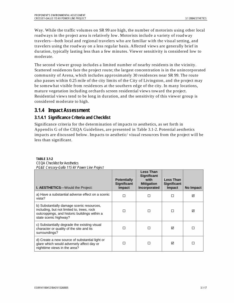
PROPONENT’S ENVIRONMENTAL ASSESSMENT CRESSEY-GALLO 115 KV POWER LINE PROJECT 3.1 20BAESTHETICS
ES091411004121BAO\113260005 3.1-17
Way. While the traffic volumes on SR 99 are high, the number of motorists using other local roadways in the project area is relatively low. Motorists include a variety of roadway travelersboth local and regional travelers who are familiar with the visual setting, and travelers using the roadway on a less regular basis. Affected views are generally brief in duration, typically lasting less than a few minutes. Viewer sensitivity is considered low to moderate.
The second viewer group includes a limited number of nearby residents in the vicinity. Scattered residences face the project route; the largest concentration is in the unincorporated community of Arena, which includes approximately 30 residences near SR 99. The route also passes within 0.25 mile of the city limits of the City of Livingston, and the project may be somewhat visible from residences at the southern edge of the city. In many locations, mature vegetation including orchards screen residential views toward the project. Residential views tend to be long in duration, and the sensitivity of this viewer group is considered moderate to high.
3.1.4 Impact Assessment 3.1.4.1 Significance Criteria and Checklist Significance criteria for the determination of impacts to aesthetics, as set forth in Appendix G of the CEQA Guidelines, are presented in Table 3.1-2. Potential aesthetics impacts are discussed below. Impacts to aesthetic/visual resources from the project will be less than significant.
TABLE 3.1-2 CEQA Checklist for Aesthetics PG&E Cressey-Gallo 115 kV Power Line Project
I. AESTHETICS—Would the Project:
Potentially Significant
Impact
Less Than Significant
with Mitigation
Incorporated
Less Than Significant
Impact No Impact
a) Have a substantial adverse effect on a scenic vista?
b) Substantially damage scenic resources, including, but not limited to, trees, rock outcroppings, and historic buildings within a state scenic highway?
c) Substantially degrade the existing visual character or quality of the site and its surroundings?
d) Create a new source of substantial light or glare which would adversely affect day or nighttime views in the area?
PROPONENT’S ENVIRONMENTAL ASSESSMENT 3.1 20BAESTHETICS CRESSEY-GALLO 115 KV POWER LINE PROJECT
3.1-18 ES091411004121BAO\113260005
3.1.4.2 Applicant Proposed Measures PG&E will implement the following APMs to further minimize less-than-significant project impacts on aesthetics/visual resources:
APM Aesthetics (AE)-1: Construction Activities. Construction activities will be kept as clean and inconspicuous as practical.
APM AE-2: Non-reflective Finish on Permanent Equipment. A galvanized finish that weathers to a dull, non-reflective patina will be used for substation components, chain link fencing, and power structures to reduce the potential for new sources of glare.
APM AE-3: Nighttime substation Lighting to Minimize Potential Visual Impacts. Design and layout for new lighting at the two existing substations will incorporate measures such as use of non-glare fixtures and directional lighting to reduce spillover into areas outside the substation site and minimize the visibility of lighting from off-site locations.
APM AE-4: Distribution Line Co-location. Where the project power line and existing distribution lines are present along the same roadway corridor, distribution lines will be co-located on project poles where feasible, and existing distribution line poles will be removed in order to reduce the number and overall visibility of power poles in the project area. For portions of the power line route where an existing PG&E distribution line is located on the same side of the road as the project route, the distribution line will be co-located on the new power poles and the distribution line’s wood poles will be removed. Where three or more distribution poles are located on the opposite side of the project route, the distribution line will be co-located on project poles and the existing distribution poles will be removed.
3.1.4.3 Project Appearance As discussed in Section 2.0, Project Description, the project includes installation of wood, light-duty steel, and tubular steel poles along the 14.4-mile route. In addition, the existing Cressey and Gallo substations will be improved. Modifications to Cressey Substation will take place entirely within the existing fenceline. Gallo Substation will be expanded approximately 4,500 square feet to the south, and the southern fence will be relocated. Table 3.1-3 outlines the approximate dimensions of the major project components.
3.1.4.4 Lighting Some of the new or modified structures at the two existing substations will include new lighting. Like the existing lighting at the substations, the new lighting will be operated only for safety and security purposes. New project lighting will be designed to avoid casting light or glare offsite.
During construction, if work needs to be performed at night, portable temporary lighting may be used to illuminate the immediate work area.
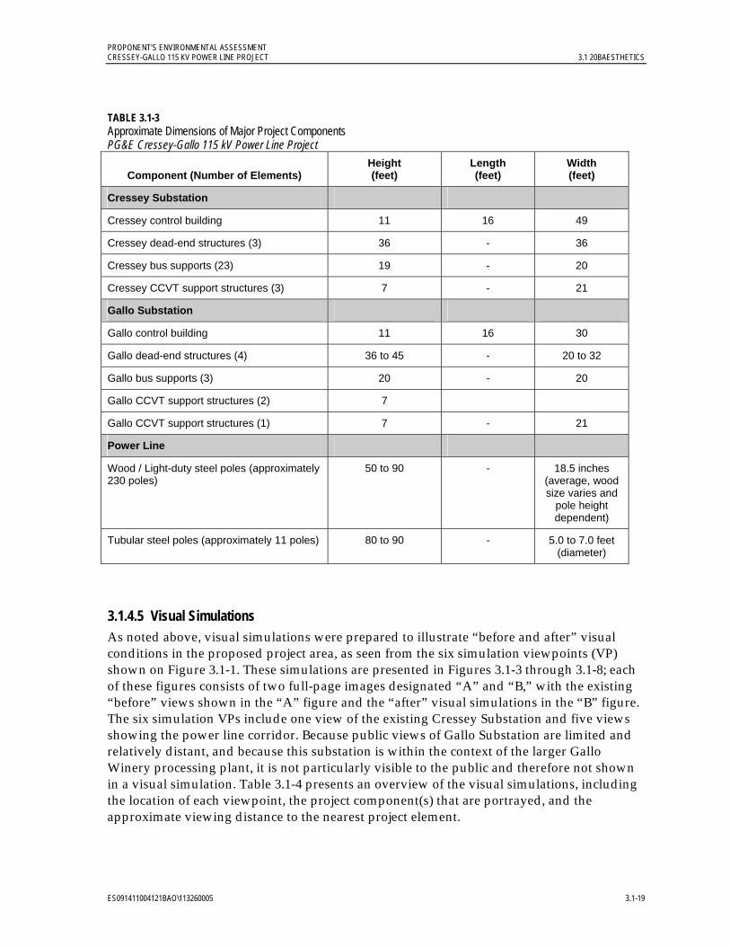
PROPONENT’S ENVIRONMENTAL ASSESSMENT CRESSEY-GALLO 115 KV POWER LINE PROJECT 3.1 20BAESTHETICS
ES091411004121BAO\113260005 3.1-19
TABLE 3.1-3 Approximate Dimensions of Major Project Components PG&E Cressey-Gallo 115 kV Power Line Project
Component (Number of Elements) Height (feet)
Length (feet)
Width (feet)
Cressey Substation
Cressey control building 11 16 49
Cressey dead-end structures (3) 36 - 36
Cressey bus supports (23) 19 - 20
Cressey CCVT support structures (3) 7 - 21
Gallo Substation
Gallo control building 11 16 30
Gallo dead-end structures (4) 36 to 45 - 20 to 32
Gallo bus supports (3) 20 - 20
Gallo CCVT support structures (2) 7
Gallo CCVT support structures (1) 7 - 21
Power Line
Wood / Light-duty steel poles (approximately 230 poles)
50 to 90 - 18.5 inches (average, wood size varies and
pole height dependent)
Tubular steel poles (approximately 11 poles) 80 to 90 - 5.0 to 7.0 feet (diameter)
3.1.4.5 Visual Simulations As noted above, visual simulations were prepared to illustrate “before and after” visual conditions in the proposed project area, as seen from the six simulation viewpoints (VP) shown on Figure 3.1-1. These simulations are presented in Figures 3.1-3 through 3.1-8; each of these figures consists of two full-page images designated “A” and “B,” with the existing “before” views shown in the “A” figure and the “after” visual simulations in the “B” figure. The six simulation VPs include one view of the existing Cressey Substation and five views showing the power line corridor. Because public views of Gallo Substation are limited and relatively distant, and because this substation is within the context of the larger Gallo Winery processing plant, it is not particularly visible to the public and therefore not shown in a visual simulation. Table 3.1-4 presents an overview of the visual simulations, including the location of each viewpoint, the project component(s) that are portrayed, and the approximate viewing distance to the nearest project element.

PROPONENT’S ENVIRONMENTAL ASSESSMENT 3.1 20BAESTHETICS CRESSEY-GALLO 115 KV POWER LINE PROJECT
3.1-20 ES091411004121BAO\113260005
Insert Figure
3.1-3A Existing View from VP 1
8.5 x 11

PROPONENT’S ENVIRONMENTAL ASSESSMENT CRESSEY-GALLO 115 KV POWER LINE PROJECT 3.1 20BAESTHETICS
ES091411004121BAO\113260005 3.1-21
Insert Figure
3.1-3B Visual Simulation of Proposed Project at VP 1
8.5 x 11

PROPONENT’S ENVIRONMENTAL ASSESSMENT 3.1 20BAESTHETICS CRESSEY-GALLO 115 KV POWER LINE PROJECT
3.1-22 ES091411004121BAO\113260005
Insert Figure
3.1-4A Existing View from VP 7
8.5 x 11

PROPONENT’S ENVIRONMENTAL ASSESSMENT CRESSEY-GALLO 115 KV POWER LINE PROJECT 3.1 20BAESTHETICS
ES091411004121BAO\113260005 3.1-23
Insert Figure
3.1-4B Visual Simulation of Proposed Project at VP 7
8.5 x 11

PROPONENT’S ENVIRONMENTAL ASSESSMENT 3.1 20BAESTHETICS CRESSEY-GALLO 115 KV POWER LINE PROJECT
3.1-24 ES091411004121BAO\113260005
Insert Figure
3.1-5A Existing View from VP 8
8.5 x 11

PROPONENT’S ENVIRONMENTAL ASSESSMENT CRESSEY-GALLO 115 KV POWER LINE PROJECT 3.1 20BAESTHETICS
ES091411004121BAO\113260005 3.1-25
Insert Figure
3.1-5B Visual Simulation of Proposed Project at VP 8
8.5 x 11

PROPONENT’S ENVIRONMENTAL ASSESSMENT 3.1 20BAESTHETICS CRESSEY-GALLO 115 KV POWER LINE PROJECT
3.1-26 ES091411004121BAO\113260005
Insert Figure
3.1-6A Existing View from VP 9
8.5 x 11

PROPONENT’S ENVIRONMENTAL ASSESSMENT CRESSEY-GALLO 115 KV POWER LINE PROJECT 3.1 20BAESTHETICS
ES091411004121BAO\113260005 3.1-27
Insert Figure
3.1-6B Visual Simulation of Proposed Project at VP 9
8.5 x 11

PROPONENT’S ENVIRONMENTAL ASSESSMENT 3.1 20BAESTHETICS CRESSEY-GALLO 115 KV POWER LINE PROJECT
3.1-28 ES091411004121BAO\113260005
Insert Figure
3.1-7A Existing View from VP 11
8.5 x 11

PROPONENT’S ENVIRONMENTAL ASSESSMENT CRESSEY-GALLO 115 KV POWER LINE PROJECT 3.1 20BAESTHETICS
ES091411004121BAO\113260005 3.1-29
Insert Figure
3.1-7B Visual Simulation of Proposed Project at VP 11
8.5 x 11

PROPONENT’S ENVIRONMENTAL ASSESSMENT 3.1 20BAESTHETICS CRESSEY-GALLO 115 KV POWER LINE PROJECT
3.1-30 ES091411004121BAO\113260005
Insert Figure
3.1-8A Existing View from VP 13
8.5 x 11

PROPONENT’S ENVIRONMENTAL ASSESSMENT CRESSEY-GALLO 115 KV POWER LINE PROJECT 3.1 20BAESTHETICS
ES091411004121BAO\113260005 3.1-31
Insert Figure
3.1-8B Visual Simulation of Proposed Project at VP 13
8.5 x 11
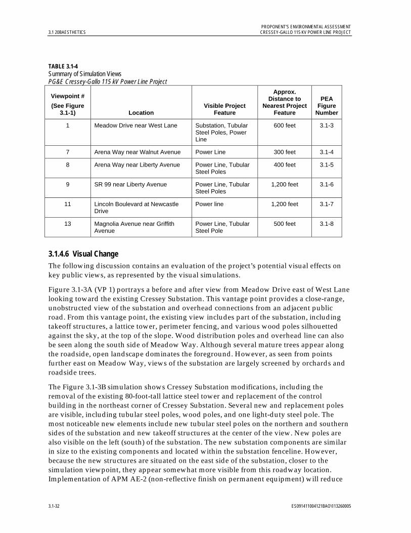
PROPONENT’S ENVIRONMENTAL ASSESSMENT 3.1 20BAESTHETICS CRESSEY-GALLO 115 KV POWER LINE PROJECT
3.1-32 ES091411004121BAO\113260005
TABLE 3.1-4 Summary of Simulation Views PG&E Cressey-Gallo 115 kV Power Line Project
Viewpoint #
(See Figure 3.1-1) Location
Visible Project Feature
Approx. Distance to
Nearest Project Feature
PEA Figure
Number
1 Meadow Drive near West Lane Substation, Tubular Steel Poles, Power Line
600 feet 3.1-3
7 Arena Way near Walnut Avenue Power Line 300 feet 3.1-4
8 Arena Way near Liberty Avenue Power Line, Tubular Steel Poles
400 feet 3.1-5
9 SR 99 near Liberty Avenue Power Line, Tubular Steel Poles
1,200 feet 3.1-6
11 Lincoln Boulevard at Newcastle Drive
Power line 1,200 feet 3.1-7
13 Magnolia Avenue near Griffith Avenue
Power Line, Tubular Steel Pole
500 feet 3.1-8
3.1.4.6 Visual Change The following discussion contains an evaluation of the project’s potential visual effects on key public views, as represented by the visual simulations.
Figure 3.1-3A (VP 1) portrays a before and after view from Meadow Drive east of West Lane looking toward the existing Cressey Substation. This vantage point provides a close-range, unobstructed view of the substation and overhead connections from an adjacent public road. From this vantage point, the existing view includes part of the substation, including takeoff structures, a lattice tower, perimeter fencing, and various wood poles silhouetted against the sky, at the top of the slope. Wood distribution poles and overhead line can also be seen along the south side of Meadow Way. Although several mature trees appear along the roadside, open landscape dominates the foreground. However, as seen from points further east on Meadow Way, views of the substation are largely screened by orchards and roadside trees.
The Figure 3.1-3B simulation shows Cressey Substation modifications, including the removal of the existing 80-foot-tall lattice steel tower and replacement of the control building in the northeast corner of Cressey Substation. Several new and replacement poles are visible, including tubular steel poles, wood poles, and one light-duty steel pole. The most noticeable new elements include new tubular steel poles on the northern and southern sides of the substation and new takeoff structures at the center of the view. New poles are also visible on the left (south) of the substation. The new substation components are similar in size to the existing components and located within the substation fenceline. However, because the new structures are situated on the east side of the substation, closer to the simulation viewpoint, they appear somewhat more visible from this roadway location. Implementation of APM AE-2 (non-reflective finish on permanent equipment) will reduce

PROPONENT’S ENVIRONMENTAL ASSESSMENT CRESSEY-GALLO 115 KV POWER LINE PROJECT 3.1 20BAESTHETICS
ES091411004121BAO\113260005 3.1-33
the visual impact of the new structures by minimizing reflective glare. This simulation represents a brief-duration roadway view in an area where vegetation and topography generally screen views toward the substation. Given the presence of existing substation and power structures, the overall character of the landscape in this area would not be substantially altered by the project.
Figure 3.1-4A (VP 7) portrays the existing view from Arena Way near Walnut Avenue looking north along the proposed power line route. This view represents the northbound motorists’ view and also a view near a residence at the northern edge of Arena. In this photograph, an existing wood pole and overhead distribution lines can be seen along the left (west) side of Arena Way. Vehicles and a mailbox at a residence also appear on the left. A Merced Irrigation District pole with overhead conductors is visible just beyond Walnut Avenue.
In the Figure 3.1-4B simulation, new light-duty steel poles appear on the right side of the road; the closest is approximately 90 feet tall and approximately 300 feet from the simulation vantage point. The new poles are considerably taller than the existing wood poles and are a noticeable visual change, particularly where the upper portions appear against the sky. However, similar to the existing wood pole seen on the left, the lower part of the new poles blends in with the orchard backdrop, reducing their overall visibility. A comparison of the existing photograph and visual simulation shows that the project represents an incremental change to the visual character of the roadway view, due to the presence of existing utility structures.
Figure 3.1-5A (VP 8), a view from Arena Way near Liberty Avenue approximately 800 feet north of Highway 99, represents a motorist’s and resident’s view toward the project from the community of Arena. In this area, approximately a dozen residences face directly onto the road and the project route. Wood distribution poles appear on the right (west) side of the road, and in the distance wood distribution poles can be seen along the continuation of Arena Way. Residences, parked cars and mailboxes are visible on the left (east) side of the roadway. Vehicles traveling along SR 99 can be seen near the center of this view, beyond where Arena Way dead-ends.
The Figure 3.1-5B simulation depicts the project where it crosses SR 99. One 90-foot-tall wood pole appears in the foreground, on the left side of the road; on the right side, two tubular steel poles are visible against the sky. Project poles replace existing wood poles, with the distribution line relocated to the replacement poles. In addition, on the right side of the road, a wood distribution pole has been removed with the implementation of APM AE-4 (distribution line co-location). As shown in the simulation, due to their height and proximity to several residences, the introduction of the new wood poles along the east side of Arena Way will be a noticeable change; however, given the presence of existing utility structures, as well as the freeway, the project will represent an incremental change that would not substantially alter the visual character of the landscape as viewed from this location.
Figure 3.1-6A (VP 9) is a photo taken from SR 99 that shows a freeway motorist’s existing view of the project where the route crosses the roadway. In light of the high traffic volumes on SR 99, this view represents the greatest number of viewers that will see the project. In the distance, wood distribution poles and overhead lines are visible including an overhead distribution line that can be seen crossing over the highway. Further away, the Sultana

PROPONENT’S ENVIRONMENTAL ASSESSMENT 3.1 20BAESTHETICS CRESSEY-GALLO 115 KV POWER LINE PROJECT
3.1-34 ES091411004121BAO\113260005
Drive overpass as well as freeway signage are visible on the horizon. Mature tree clusters on the left (south) side of the roadway and orchards on the right (north) are additional landscape elements seen from this landscape location. The trees provide minimal screening of utility structures from this location.
The Figure 3.1-6B simulation depicts an unobstructed view of the project, including two approximately 80-foot-tall tubular steel poles that replace existing wood distribution poles, one on either side of the freeway. These structures are located more than 1000 feet from the vantage point and support the project line, as well as the existing distribution line. The conductors of both of these lines can be seen crossing the highway. The new structures are taller and slightly bulkier than the existing poles. This is a view experienced by a relatively large number of motorists; however, views of the project from the roadway will be brief. A comparison of the existing photograph and simulation demonstrates that this the project will result in an incremental visual change that will not substantially alter the existing landscape character currently experienced by SR 99 motorists.
Figure 3.1-7A (VP 11) portrays the existing view from Lincoln Boulevard at Newcastle Drive looking south toward the project. This photograph represents a view from the southern edge of the City of Livingston. The view is taken from a location adjacent to a produce warehouse. Residential subdivisions have been proposed in the vicinity of VP 11 and the project, but no construction has begun and the status of the subdivisions is uncertain. Wood distribution poles and overhead line are visible along Lincoln Boulevard, and a second line, supported by wood poles, is visible along Magnolia Avenue (the project route).
The Figure 3.1-7B simulation shows the new poles along Magnolia Avenue; the closest pole appears on the left side of the view at a distance of approximately 1,240 feet away. The existing distribution poles remain. Although the new, weathered light-duty steel poles are taller than the existing wood poles along Magnolia Avenue, the general form and appearance of the new poles is comparable to that of the existing structures. Given the presence of other utility structures along this roadway and along Lincoln Avenue, the project represents a minor, incremental change in the landscape that will not be particularly noticeable from this vantage point at the edge of the City of Livingston. Implementation of APM AE-4 (distribution line co-location) will further reduce the visual impact.
Figure 3.1-8A (VP 13) is a before view from Magnolia Avenue near Griffith Avenue looking east. This location is seasonably accessible; a gate to the east of this vantage point at Howard Road on Magnolia Avenue is closed part of the year. The viewpoint represents a view from Gallo Winery property that would be experienced by Gallo employees rather than the general public and also provides a general depiction of the western portion of the project route. This view includes mature vineyards and wood distribution poles with overhead lines along the left (north) side of Magnolia Avenue. Three wood poles of the Gallo Tap power line are visible near the foreground of the photo; the bases are partially screened by vineyards and roadside vegetation.
The Figure 3.1-8B simulation shows the project route where it turns north from Magnolia Avenue, passing through agricultural land. Wood replacement poles appear against the sky, along the left side of Magnolia Avenue; the new replacement poles carry both the new power line and the relocated distribution line. In addition, two replacement poles (one tubular steel pole and one double-circuit wood pole) can be seen along the Gallo Tap; these

PROPONENT’S ENVIRONMENTAL ASSESSMENT CRESSEY-GALLO 115 KV POWER LINE PROJECT 3.1 20BAESTHETICS
ES091411004121BAO\113260005 3.1-35
poles carry the new power line as well as the relocated Gallo Tap and distribution lines. The taller replacement poles appear somewhat more prominent than the existing wood poles; however, implementation of APM AE-4 (distribution line co-location) will reduce the overall number and visibility of power poles in the project area. This change does not substantially alter the composition or character of this agricultural landscape setting.
3.1.4.7 Construction, Operation, and Maintenance Impacts The following discussion evaluates potential project construction, operation, and maintenance impacts on aesthetics/visual resources against the significance criteria.
a) Will the project have a substantial adverse effect on a scenic vista? No impact.
For purposes of this evaluation, a scenic vista is defined as a distant public view along or through an opening or corridor that is recognized and valued for its scenic quality. No recognized scenic vistas have been identified within the project viewshed.
b) Will the project substantially damage scenic resources, including, but not limited to, trees, rock outcroppings, and historic buildings within a state scenic highway? No impact.
No designated state scenic routes are near the project area; the nearest designated state scenic highway, I-5, is located approximately 18 miles from the project. Therefore, the project will not affect scenic resources within a state scenic highway corridor.
c) Will the project substantially degrade the existing visual character or quality of the site and its surroundings? Less-than-significant impact.
Construction: The project will not substantially degrade the existing visual character or quality of the site and its surroundings. During construction, visual impacts will include the presence of workers, temporary structures, construction equipment, and vehicles associated with the installation of poles and substation components. Although portions of the project lie adjacent to public roadways, other portions of the route and Gallo Substation will not be particularly visible to the public. Construction is expected to take approximately ten months, but considerably less time at any one location along the project route. The project lies in an area where mechanized agricultural production activities typically employ the use of trucks and other equipment that is not unlike construction equipment. In addition, nearby residences are generally screened by vegetation. Due to the presence of mechanized agricultural activities and the limited number of affected viewers, temporary construction-related visual effects will be less than significant. Implementation of APM AE-1 will further minimize these less-than-significant impacts.
Operations: The project will involve improvements at two existing substations and will introduce approximately 14.4 miles of new power line. Approximately two-thirds of the new project follows public roadways where, for the most part, distribution lines currently exist. The remaining one-third of the route crosses (private) agricultural land where the project will have limited visibility. The project involves minimal grading and vegetation removal. Project construction will require removal of one row of almond trees in an orchard located on private land between Eucalyptus Avenue and Mercedes Avenue. This visual change will be minor and not particularly noticeable to the public. In general, the project vicinity is a working landscape and heavily modified for agricultural production activity. Electric utility structures including existing substations, wood poles, and overhead lines are
PROPONENT’S ENVIRONMENTAL ASSESSMENT 3.1 20BAESTHETICS CRESSEY-GALLO 115 KV POWER LINE PROJECT
3.1-36 ES091411004121BAO\113260005
currently seen in the immediate vicinity. Large-scale agricultural processing facilities are also a part of the landscape setting.
The Figure 3.1-3B simulation indicates that improvements at Cressey Substation will be noticeable from short segments of lightly-traveled rural roadways adjacent to the facility; however, given the brief duration of views and the presence of the existing substation, the overall quality of the landscape setting in this area will not be substantially altered. Gallo Substation is located within the context of a large-scale industrial agricultural facility and public views of this facility are both distant and limited. Therefore the visual change at Gallo Substation will generally not be noticeable.
Close-range, unobstructed views of the power line will occur along public roads and from nearby residences. However, as described in Section 3.1.3.5 and depicted in Figures 3.1-3A through 3.1-8B, the project represents an incremental visual change to the visual landscape setting. The project will introduce new wood, light-duty steel, and tubular steel poles, along with overhead conductors, to a landscape in which existing electric utility structures, including power poles and overhead lines, are present. The project will not obstruct views to the Coast and Sierra ranges and nearby rivers. Overall the changes brought about by the project will not substantially degrade the existing visual character or quality of the landscape setting. With the aesthetics APMs proposed as part of the project, less-than-significant impacts to visual resources will be further reduced.
d) Will the project create a new source of substantial light or glare which would adversely affect day or nighttime views in the area? Less-than-significant impact.
Glare. Glare exists when a high degree of contrast between bright and dark areas in a field of view make it difficult for the human eye to adjust to differences in brightness. At high levels, glare can make it difficult to see, such as when driving westward at sunset. APM AE-2, which calls for the use of a galvanized finish that will weather to a dull, non-reflective patina on new chain link fencing and equipment enclosures located at the existing substations, will minimize the potential effect of glare.
Nighttime Lighting. During construction, if work must be accomplished at night, portable temporary lighting will be used to illuminate the immediate work area. Current project plans call for construction activities to take place during daylight hours and for nighttime construction activities to be avoided, if possible.
The project is in a rural setting with little roadway lighting adjacent to the site. Lighting sources tend to be localized and associated with agricultural processing facilities, residences, and some roadway intersections including interchanges along SR 99. The City of Livingston, 0.25 mile away from the project, has street lighting. No new lighting is proposed along the power line. The project will include new nighttime lighting on some new structures at two existing substations; the new lighting will be operated as needed for safety, security, and emergency nighttime work. Safety and security lighting will use a Dark Sky rated element (automatically turns on at night). The yard’s operational and maintenance lighting will have a manual switch to allow the lighting to be turned off when not in use. Nighttime operation and maintenance work is not typically planned, but may occur on an emergency basis as needed; as such, nighttime lighting for work will be infrequent, if it occurs. The additional lighting will represent a minor incremental change to existing nighttime lighting conditions

PROPONENT’S ENVIRONMENTAL ASSESSMENT CRESSEY-GALLO 115 KV POWER LINE PROJECT 3.1 20BAESTHETICS
ES091411004121BAO\113260005 3.1-37
at the two substations. The impact will be less than significant and implementation of APM AE-3 (Nighttime substation lighting to minimize potential visual impacts) will further reduce potential night lighting effects.
3.1.5 References California Department of Transportation (Caltrans). 2009. California Scenic Highway Program.
City of Livingston. 2008. City of Livingston 2025 General Plan. Adopted October 2008.
_______. 2011. City of Livingston Project List. City of Livingston. Community Development Director, Donna Kenney. July 26.
DeLorme Mapping Company. 2003. Northern California Atlas and Gazetteer, Sixth Edition. Yarmoth, ME.
Federal Highway Administration (FHWA). 1988. Visual Impact Assessment for Highway Projects. United States Department of Transportation.
Google. 2011. Google Earth Pro Version 6.0.2. Software.
Merced County. 1990. Merced County Year 2000 General Plan. Adopted December 4, 1990.
_______. 2011. 2030 Merced County General Plan: Planning Commission Review Draft. June 2011.
Smardon, RC, J.F. Palmer, and J.P. Felleman, editors. 1986. Foundations for Visual Project Analysis. New York: Wiley.

PROPONENT’S ENVIRONMENTAL ASSESSMENT CRESSEY-GALLO 115 KV POWER LINE PROJECT 3.2 21BAGRICULTURAL AND FOREST RESOURCES, LAND USE AND PLANNING, AND RECREATION
ES091411004121BAO\113260005 3.2-1
3.2 Agricultural and Forest Resources, Land Use and Planning, and Recreation
3.2.1 Introduction and Methodology This section describes existing conditions and potential impacts on agricultural and forest resources, land use and planning, and recreation as a result of construction, operation, and maintenance of the project. The analysis concludes that impacts on agricultural resources will be less than significant, and that there will be no other impacts in these areas.
To evaluate potential effects on agricultural resources and land use, maps developed by the California Department of Conservation (DOC) Farmland Mapping and Monitoring Program (FMMP) were reviewed to determine whether the project will convert Important Farmland to non-agricultural uses (DOC 2011a). The Merced County Year 2000 General Plan, Merced County Department of Public Works Improvement Standards and Specifications, 2030 Merced County General Plan Public Review Draft, and the Merced County Code (Merced County 1990; 2009; 2011a; 2011b) , and City of Livingston 2025 General Plan (Livingston 2008) were reviewed to determine whether the project will be compatible with existing land use designations and zoning. Because the 2030 plan is a draft that is not yet finalized, the Year 2000 General Plan (Merced County 1990) was used for this analysis. Project activities during construction and operation were evaluated within the context of surrounding land uses and farmland protections to determine whether the project may result in changes that will indirectly lead to farmland conversion.
Recreation resources include recreational facilities such as state, local and regional parks. The California Department of Parks and Recreation Website (California State Parks 2011) and the Merced County General Plan (Merced County Year 2000 General Plan, and 2030 Merced County General Plan Public Review Draft) were reviewed as part of the recreational resources evaluation (Merced County 1990, 2011a).
3.2.2 Regulatory Background The CPUC has primary jurisdiction over the project by virtue of its exclusive discretionary approval authority over construction, operation, and maintenance of public utility facilities. Because local governments do not have discretionary authority over this type of utility project, such projects are exempt from local land use and zoning regulations and permitting. However, as part of the CEQA impact assessment, PG&E considered local and state land use plans and policies, and local issues. The following information is being provided for informational purposes and to assist with the CEQA review.
3.2.2.1 Federal There are no federal regulations applicable to the project related to agricultural resources or land use.
3.2.2.2 State
California Public Utilities Commission. The CPUC has exclusive jurisdiction over the design, siting, installation, operation, maintenance, and repair of electric transmission facilities, pursuant to Article XII, Section 8 of the California Constitution. The CPUC is the Lead
PROPONENT’S ENVIRONMENTAL ASSESSMENT 3.2 21BAGRICULTURAL AND FOREST RESOURCES, LAND USE AND PLANNING, AND RECREATION CRESSEY-GALLO 115 KV POWER LINE PROJECT
3.2-2 ES091411004121BAO\113260005
Agency for CEQA review for this project and has authority over the discretionary project approval.
Williamson Act. The California Land Conservation Act, better known as the Williamson Act, was passed in 1965 by the California Legislature to preserve agricultural and open space lands through private landowner contracts that voluntarily restrict land to agricultural and open space uses. Williamson Act contracts have a rolling 10-year term (i.e., unless either party files a “notice of nonrenewal” the contract is automatically renewed annually for an additional year). Williamson Act-contracted parcels are assessed for property tax at a lower rate consistent with their actual use, rather than at potential market value. Local governments receive a partial subvention of forgone tax revenues from the state pursuant to the Open Space Subvention Act of 1971 (DOC 2011b).
Recently, a decision was made by the State to eliminate State-sponsored financial support for the Williamson Act program. As a result, two bills were passed providing a short-term solution to fund the program and encourage continued participation in the Williamson Act program. Assembly Bill (AB) 2530, signed by former Governor Arnold Schwarzenegger on September 25, 2010, and subsequently replaced by Senate Bill (SB) 863, signed on October 19, 2010, provides an opportunity for counties to offset a portion of the loss of Williamson Act Subvention funds by receiving a pro rata share of a one-time $10 million subvention appropriation, and by reducing the term of the Williamson Act contracts from ten years to nine years as of January 1, 2011. The one-year reduction in contract term reduces a landowner’s property tax savings by 10 percent and allows the resulting tax recapture to be transferred directly into the County’s General Fund to help partially offset the lost revenue to the County. SB 863 is a temporary solution that will sunset in 2015 (Merced County 2011c).
3.2.2.3 Regional
Habitat Conservation Plans (HCPs). PG&E has an HCP for its operations and maintenance (O&M) activities in the San Joaquin Valley (PG&E San Joaquin Valley Operations & Maintenance Habitat Conservation Plan [Jones and Stokes 2006]). This HCP covers routine O&M activities for PG&E’s electric and gas transmission and distribution systems within nine counties of the San Joaquin Valley, including Merced County. The Cressey-Gallo 115 kV Power Line Project is included within the boundaries of this HCP. However, the HCP only pertains to the O&M components of the project, and not the new construction.
3.2.2.4 Local As described above, although the project is not subject to local agency regulations, PG&E has considered local plans and policies as part of its CEQA impact assessment. As shown in Figure 3.2-1, the entire project area is located within Merced County. Local plans and ordinances including the Merced County Year 2000 General Plan, 2030 Merced County General Plan Public Review Draft, Merced County Department of Public Works Improvement Standards and Specifications, and the Merced County Code were evaluated and are discussed below in Section 3.2.3, Compatibility with Plans and Policies. In addition, limited portions of the project are located within the SOI for the City of Livingston which is covered under the City of Livingston 2025 General Plan also discussed below in Sections 3.2.2.2 and 3.2.3.4.

PROPONENT’S ENVIRONMENTAL ASSESSMENT CRESSEY-GALLO 115 KV POWER LINE PROJECT 3.2 21BAGRICULTURAL AND FOREST RESOURCES, LAND USE AND PLANNING, AND RECREATION
ES091411004121BAO\113260005 3.2-3
Insert Figure
3.2-1 Jurisdictional Boundaries Within the Project Area
8.5 x 11
PROPONENT’S ENVIRONMENTAL ASSESSMENT 3.2 21BAGRICULTURAL AND FOREST RESOURCES, LAND USE AND PLANNING, AND RECREATION CRESSEY-GALLO 115 KV POWER LINE PROJECT
3.2-4 ES091411004121BAO\113260005
3.2.3 Environmental Setting 3.2.3.1 Regional The approximately 14.4-mile 115 kV power line route is located in a primarily agricultural area with intermittent rural residences. The project will intersect with SR 99, which is the major transportation corridor through the area, southeast of the City of Livingston. As shown in Figure 3.2-2, production of a variety of agricultural commodities including deciduous fruits and nuts, field crops, grain and hay crops, nurseries, and berry crops occurs within the project area. The area also contains vineyards, pasture lands, semi-agricultural land, and idle fields. There are approximately 270,641 acres of Prime Farmland located throughout Merced County, which accounts for approximately 21.4 percent of the land within County boundaries.
3.2.3.2 Local Land in the majority of the power line route is classified as Prime Farmland or Farmland of Statewide Importance, with a few smaller areas classified as Farmland of Local Importance; Unique Farmland; Semi-Agricultural and Rural Commercial Land; Confined Animal Agriculture; and Rural Residential Land (Figure 3.2-3). As shown in Figure 3.2-4, approximately one-third of the route is on Williamson Act-contracted land.
A majority of the project route is designated as Agricultural land use (see Figure 3.2-5) and zoned by Merced County as General Agricultural (Figures 3.2-6), including the existing Cressey and Gallo substations. Within a half-mile of the project route southwest of Cressey Substation, small areas are designated as Agricultural Residential, Single-Family Residential, General Commercial, and General Manufacturing land uses; the corresponding Merced County zoning designations for these areas are Agricultural Residential, Residential, General Commercial, and Industrial, respectively.
The southernmost portion of the City of Livingston is also located within half a mile of the project route. This small area of the City includes portions with county land use/zoning designations of High Density Residential, Medium Density Residential, Low Density Residential, Neighborhood Commercial/Community Commercial, and Public Facility/Public/Quasi Public Facilities, respectively. Portions of the southern and eastern extents of the City’s 2025 General Plan Sphere of Influence include or are adjacent to the project alignment on Magnolia Avenue between Washington Avenue and Arena Way, and Arena Way between Magnolia Avenue and a half block north of Liberty Way. However, as the project route is not located within the City of Livingston, no impact to agricultural resources or land use within the City will occur, and further discussion of the City’s land use and zoning designations is limited to SOI discussion.
PROPONENT’S ENVIRONMENTAL ASSESSMENT CRESSEY-GALLO 115 KV POWER LINE PROJECT 3.2 21BAGRICULTURAL AND FOREST RESOURCES, LAND USE AND PLANNING, AND RECREATION
ES091411004121BAO\113260005 3.2-5
Insert Figure
3.2-2 Existing Agricultural Use
8.5 x 11

PROPONENT’S ENVIRONMENTAL ASSESSMENT 3.2 21BAGRICULTURAL AND FOREST RESOURCES, LAND USE AND PLANNING, AND RECREATION CRESSEY-GALLO 115 KV POWER LINE PROJECT
3.2-6 ES091411004121BAO\113260005
Insert Figure
3.2-3 FMMP Farmland Classification Lands Within the Project Area
8.5 x 11

PROPONENT’S ENVIRONMENTAL ASSESSMENT CRESSEY-GALLO 115 KV POWER LINE PROJECT 3.2 21BAGRICULTURAL AND FOREST RESOURCES, LAND USE AND PLANNING, AND RECREATION
ES091411004121BAO\113260005 3.2-7
Insert Figure
3.2-4 Williamson Act Program Contract Lands Within the Project Area
8.5 x 11

PROPONENT’S ENVIRONMENTAL ASSESSMENT 3.2 21BAGRICULTURAL AND FOREST RESOURCES, LAND USE AND PLANNING, AND RECREATION CRESSEY-GALLO 115 KV POWER LINE PROJECT
3.2-8 ES091411004121BAO\113260005
Insert Figure
3.2-5 Merced County Land Use Designations
8.5 x 11

PROPONENT’S ENVIRONMENTAL ASSESSMENT CRESSEY-GALLO 115 KV POWER LINE PROJECT 3.2 21BAGRICULTURAL AND FOREST RESOURCES, LAND USE AND PLANNING, AND RECREATION
ES091411004121BAO\113260005 3.2-9
Insert Figure
3.2-6 Merced County Zoning Designations
8.5 x 11

PROPONENT’S ENVIRONMENTAL ASSESSMENT 3.2 21BAGRICULTURAL AND FOREST RESOURCES, LAND USE AND PLANNING, AND RECREATION CRESSEY-GALLO 115 KV POWER LINE PROJECT
3.2-10 ES091411004121BAO\113260005
General Plan Land Use Designations. The following Merced County Year 2000 General Plan land use designations are present within 0.5 mile of the power line route and are shown in Figure 3.2-5:
Agricultural. This land use designation is generally applied to lands in the “valley floor” between the Sierra Nevada Foothills and the Diablo Range. Characteristic features of the areas designated Agricultural generally include: slope less than or equal to 4 percent, elevations less than 200 feet above sea level, very slow to moderate water runoff potential, very limited to moderate erosion potential, moderate to excellent water availability, and deeper more fertile topsoils. Primarily, the Agricultural areas are used for cultivated agricultural practices that rely on good soil quality and water availability, and minimal slopes. There are other lands within these areas that have no agricultural use but have high open space value for recreation or wildlife. Other land use activities that may be appropriate include livestock facilities, wastewater lagoons, utility lines, and agricultural commercial facilities. Certain nonagricultural uses may also be found including mineral resource extraction and processing, outdoor public and private recreational facilities, and all related uses. Housing is considered an accessory use to the primary activity of a site and may be in the form of manufactured or conventional single-family dwelling units, or group quarters for farm laborers.
Agricultural Residential. This designation is generally applied to areas considered appropriate for the construction of single-family dwelling units on large lots in a semi-rural environment, with less than a full range of public services. These areas may be used as a buffer between urban and rural land use activities. Conventional or manufactured single-family dwelling units are the primary land use activity in these areas, although other land use activities may include recreational and institutional facilities, animal husbandry or hobby farm activities, and all necessary accessory uses related to such uses.
Residential (Very Low and Low Density). This designation is generally applied to areas considered appropriate for the construction of single-family dwelling units within a Specific Urban Development Plan (SUDP). (An SUDP is the broadest General Plan boundary designation intended to accommodate all classifications of urban land use and has a boundary line that is recognized as the ultimate growth boundary of a community over the life of the Plan. Depending on the level of urban services available, development is allowed at a higher density and to a greater extent within an SUDP than anywhere else in the County). These areas provide for the majority of housing opportunities throughout the unincorporated communities in the County and are normally utilized in areas that may lack public water or sewer systems. Conventional or manufactured single-family dwelling units are the primary land use activity in these areas.
General Commercial. This designation is generally applied to areas within an SUDP considered appropriate for general retail commercial activities. Typical uses in this area include retail commercial activities, personal and professional services, and recreational and institutional uses.
Industrial. This designation is generally applied to areas within an SUDP considered appropriate and necessary for manufacturing and wholesale activities. Typical uses in
PROPONENT’S ENVIRONMENTAL ASSESSMENT CRESSEY-GALLO 115 KV POWER LINE PROJECT 3.2 21BAGRICULTURAL AND FOREST RESOURCES, LAND USE AND PLANNING, AND RECREATION
ES091411004121BAO\113260005 3.2-11
these areas include research, processing, distribution, storage, or wholesale trade of various materials and products. Transportation facilities, such as air, rail or motor freight transfer services or maintenance facilities, and recreational or institutional activities may also be considered appropriate in these areas.
Zoning Districts. The following Merced County zoning districts are present within a half-mile of the power line route and are shown in Figure 3.2-6:
General Agricultural (A-1). The purpose of the general agricultural zone is to provide for areas for more intensive farming operations dependent on higher quality soils, water availability and relatively flat topography, and agricultural commercial and/or industrial uses dependent on proximity to urban areas or location in sparsely populated low-traffic areas. Parcels smaller than 40 acres down to a minimum of 20 acres can be considered where agricultural productivity of the property will not be reduced.
Agricultural Residential (A-R). The purpose of the agricultural residential zone is to provide areas for rural residential development and hobby farming and limited animal raising operations with less than a full range of urban services. It is intended that this zone typically serve as a transitional area between more dense urban communities and agricultural uses with the option of allowing either one unit or three units per acre.
Single-Family Residential (R-1). The purpose of the single-family residential zone is to provide a full range of urban services and reserve appropriately located areas for family living at a range of low population densities consistent with sound standards of public health, welfare, and safety. It is the intent of this zone to protect the residential characteristics of an area and to promote a suitable environment for family life.
General Commercial (C-2). The purpose of the general commercial zone is to provide areas for a wide variety of retail stores, entertainment establishments, offices and service businesses that serve unincorporated urban communities or regional markets. The C-2 districts are mainly located in the central business districts or along major transportation routes, such as arterial and major collector roads.
General Manufacturing (M-2). The purpose of the general manufacturing zone is to provide for all types of manufacturing, distribution and storage uses. Uses within this zone tend to have moderate to high nuisance characteristics, such as noise, heat, glare, odor and vibration that may require separation from incompatible uses such as residential and office commercial. Typical uses in this zone include manufacturing of autos or trucks, asphaltic materials, glass, and paint products.
Parks and Recreation. Merced County contains several county, state, and federal parks and recreation areas and public open space areas. There are approximately 114,000 acres of park and recreation facilities in the County that offer a variety of amenities such as picnicking, swimming, boating, hunting, bird watching, playgrounds, sports fields, and hiking. While no parks or recreational facilities are located within a half-mile of the project area, nearby parks and recreational facilities within two miles of the project area include Arakelian Park, Lucero Park, Livingston Memorial Park, and Livingston Sports Complex in the City of Livingston. Amenities at these recreational facilities include the following:
PROPONENT’S ENVIRONMENTAL ASSESSMENT 3.2 21BAGRICULTURAL AND FOREST RESOURCES, LAND USE AND PLANNING, AND RECREATION CRESSEY-GALLO 115 KV POWER LINE PROJECT
3.2-12 ES091411004121BAO\113260005
Arakelian Park: Playground, covered picnic area, baseball field, and barbeque area; approximately 0.7 mile north of the project area.
Lucero Park: Playground, picnic table, and volleyball area; approximately 1.6 miles north of the project area.
Livingston Memorial Park: Playground, covered picnic area, barbeque area, and stage; approximately 0.7 mile north of the project area.
Livingston Sports Complex: Picnic tables, baseball field, and soccer field; approximately 1.5 miles north of the project area.
In addition, Winton County Park in the community of Winton is approximately 3.3 miles east of the project area. McConnell State Recreation Area is also located approximately 3.1 miles to the north of the project area and provides fishing, picnic, camping, and play areas (California State Parks 2011). The locations of these parks and recreational facilities are shown on Figure 3.11-1 in Section 3.11, Population and Housing, Public Services, and Utilities and Service Systems.
City of Livingston. The City of Livingston 2025 General Plan provides policy direction for land uses within the current city limits, the City’s Sphere of Influence, and areas outside of the city limits within the unincorporated area of Merced County. While the City does not have land use authority over land areas outside of the City, the 2025 General Plan provides direction on the City’s vision of land use within the SOI should those properties be annexed to the City. Due to the recent rate of growth in the City of Livingston, the City has expanded the SOI by approximately 3,000 acres to encompass two large, mixed-use developments comprised of residential, commercial, industrial, parks, public facilities, and conservation resource areas (Livingston 2008).
3.2.4 Compatibility with Plans and Policies As stated above, the project is not subject to local agency regulations. However, PG&E has considered local plans and policies in its design of the proposed project. This section provides a discussion of the project’s compatibility with applicable local plans and ordinances including the Merced County Year 2000 General Plan and the 2030 Merced County General Plan Public Review Draft, and Merced County Department of Public Works Improvement Standards and Specifications.
3.2.4.1 Merced County Year 2000 General Plan
Agriculture Element Goal 2, Objective 2.A, Policy 1: Conversion of agricultural land into urban uses shall be allowed only where a clear and immediate need can be demonstrated, based on population projections and lack of land availability for nonagricultural uses.
Land Use Element Goal 7, Objective 7.A, Policy 1: Conversion of agricultural and other rural land into urban uses shall only be allowed where a clear and immediate need can be demonstrated based on anticipated growth and availability of public services and facilities. For proposals to expand an existing community into rural lands the available vacant land inventory within the urban boundary shall also be considered.

PROPONENT’S ENVIRONMENTAL ASSESSMENT CRESSEY-GALLO 115 KV POWER LINE PROJECT 3.2 21BAGRICULTURAL AND FOREST RESOURCES, LAND USE AND PLANNING, AND RECREATION
ES091411004121BAO\113260005 3.2-13
The project will not result in the conversion of agricultural land. The land where a row of almond trees will be removed to accommodate project construction, operation and maintenance will remain zoned for agricultural use.
Goal 7, Objective 7.A, Policy 3: Premature and uncoordinated division of land which forces the early cessation of valid agricultural uses shall be avoided.
The project will not result in the division of land that will force the early cessation of valid agricultural uses. Construction and staging areas will primarily be located along the route at the perimeters of existing uses and as such will not divide any agricultural land. A majority of the project route and access points run along existing roads so as to minimize impacts on surrounding agricultural land.
While removal of one row of almond trees in an orchard that is designated as Prime Farmland is expected as part of the project, this removal will not divide land in such a way that impedes the continued use of the land for agriculture. As such, the project will be compatible with this policy.
Goal 9, Objective 9.A: Recreational areas, institutional and public facilities, hazardous and non-hazardous waste facilities, power and communication towers and airports are appropriately located to minimize land use conflicts while satisfying local or regional demands.
The project route is located primarily along roads and will replace existing distribution lines, which will minimize land use conflicts with the surrounding agricultural practices and other land uses. During construction, staging areas are expected to be located on paved, gravel or other disturbed sites to minimize disruption to surrounding agricultural practices. The project is sited to minimize land use conflicts while providing improved power service for existing customers; therefore the project is compatible with this policy.
3.2.4.2 2030 Merced County General Plan Public Review Draft The 2030 Merced County General Plan Public Review Draft, which was released for public review in February 2011, contains policies that shall govern the use of agricultural lands within the County once it is approved and adopted by the Board of Supervisors. The following draft policies have been reviewed.
Agriculture Element Goal AG-2, Policy AG-2.1: Protect agriculturally-designated areas and direct urban growth away from productive agricultural lands into cities, Urban Communities, and New Towns.
While the project route is located in a predominantly agricultural area, it will provide improved power service to existing customers, and is not intended to encourage new development. As such, the project will not cause an increase in urban growth in the area, and will be compatible with this policy.
Goal AG-2, Policy AG-2.9: Oppose the extension of urban services, such as sewer lines, water lines, or other urban infrastructure, into areas designated for agricultural use, unless necessary to protect public health, safety, and welfare.
The proposed project will improve power service for existing customers in the area, including surrounding agricultural uses. As such, the project is intended to provide a more
PROPONENT’S ENVIRONMENTAL ASSESSMENT 3.2 21BAGRICULTURAL AND FOREST RESOURCES, LAND USE AND PLANNING, AND RECREATION CRESSEY-GALLO 115 KV POWER LINE PROJECT
3.2-14 ES091411004121BAO\113260005
reliable source of power to existing customers. It will not extend service into areas where it does not already exist. Therefore, the project will be compatible with this policy.
Goal AG-2, Policy AG-2.12: Encourage the voluntary merger of antiquated subdivision lots that conflict with adjacent agricultural uses, and continue to require environmental review of permits that could result in adverse environmental impacts in agricultural and rural areas, including traffic generation, groundwater contamination, stormwater drainage disposal, and air quality deterioration.
This project is subject to approval by the CPUC following environmental review in accordance with CEQA. As such, the project will be compatible with this policy.
Land Use Element Goal LU-2, Policy LU-2.3: Limit allowed land use within Agricultural and Foothill Pasture areas to agricultural crop production, farm support operations, and grazing and open space uses.
Goal LU-2, Policy LU-2.4: Limit ancillary uses in Agricultural and Foothill Pasture areas to include secondary single-family residences, farmworker housing, agricultural tourism related uses, and agricultural support services.
As the proposed project will improve power service for existing customers, including agricultural uses, the project will provide support to existing farm and agricultural operations in the area. Therefore, the project will be compatible with these policies.
3.2.4.3 Merced County Department of Public Works Improvement Standards and Specifications
The Merced County Department of Public Works Improvement Standards and Specifications, Appendix A, Utilities Occupying County Roadways, contains standards and specifications for power pole placement. The project design will be compatible with these standards and specifications.
3.2.4.4 City of Livingston 2025 General Plan A project compatibility evaluation with applicable plans and policies will be performed if the City of Livingston officially annexes lands that include a portion of the project within their SOI through the Merced County Local Agency Formation Commission prior to submittal of the PEA to the CPUC.
3.2.5 Impact Assessment 3.2.5.1 Significance Criteria and Checklist As there is no forest land within the project area, no impacts to forestry resources will occur and no further discussion of such impacts is included. In accordance with Appendix G of the CEQA Guidelines, the potential significance of project impacts on agricultural resources, land use and planning, and recreation must be evaluated for each of the criteria in Tables 3.2-1 through 3.2-3, respectively.
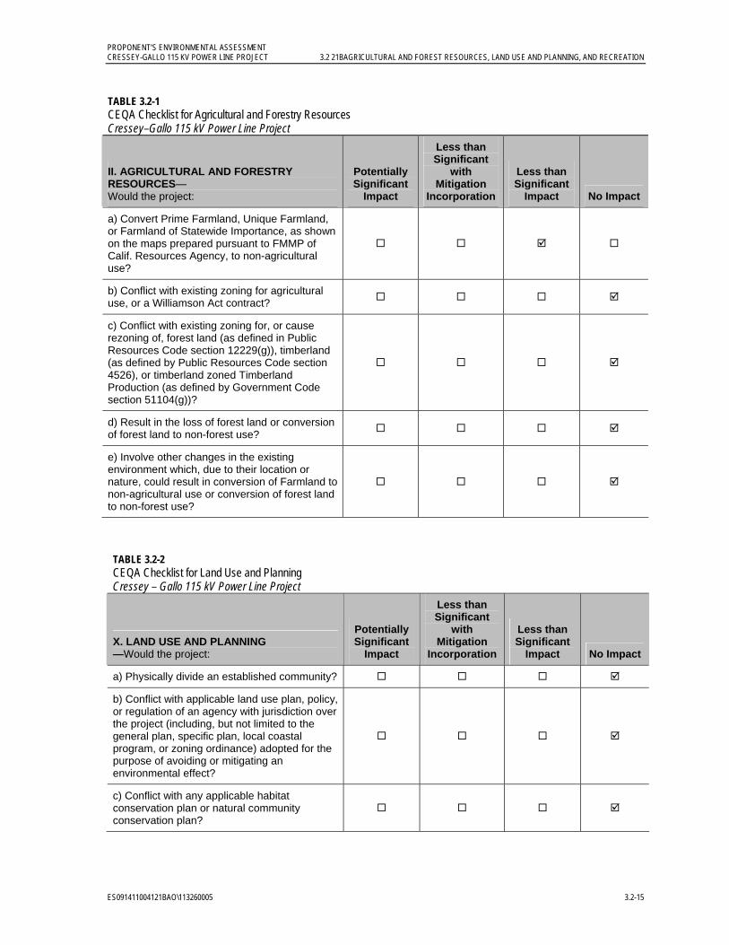
PROPONENT’S ENVIRONMENTAL ASSESSMENT CRESSEY-GALLO 115 KV POWER LINE PROJECT 3.2 21BAGRICULTURAL AND FOREST RESOURCES, LAND USE AND PLANNING, AND RECREATION
ES091411004121BAO\113260005 3.2-15
TABLE 3.2-1 CEQA Checklist for Agricultural and Forestry Resources Cressey–Gallo 115 kV Power Line Project
II. AGRICULTURAL AND FORESTRY RESOURCES— Would the project:
Potentially Significant
Impact
Less than Significant
with Mitigation
Incorporation
Less than Significant
Impact No Impact
a) Convert Prime Farmland, Unique Farmland, or Farmland of Statewide Importance, as shown on the maps prepared pursuant to FMMP of Calif. Resources Agency, to non-agricultural use?
b) Conflict with existing zoning for agricultural use, or a Williamson Act contract?
c) Conflict with existing zoning for, or cause rezoning of, forest land (as defined in Public Resources Code section 12229(g)), timberland (as defined by Public Resources Code section 4526), or timberland zoned Timberland Production (as defined by Government Code section 51104(g))?
d) Result in the loss of forest land or conversion of forest land to non-forest use?
e) Involve other changes in the existing environment which, due to their location or nature, could result in conversion of Farmland to non-agricultural use or conversion of forest land to non-forest use?
TABLE 3.2-2 CEQA Checklist for Land Use and Planning Cressey – Gallo 115 kV Power Line Project
X. LAND USE AND PLANNING —Would the project:
Potentially Significant
Impact
Less than Significant
with Mitigation
Incorporation
Less than Significant
Impact No Impact
a) Physically divide an established community?
b) Conflict with applicable land use plan, policy, or regulation of an agency with jurisdiction over the project (including, but not limited to the general plan, specific plan, local coastal program, or zoning ordinance) adopted for the purpose of avoiding or mitigating an environmental effect?
c) Conflict with any applicable habitat conservation plan or natural community conservation plan?
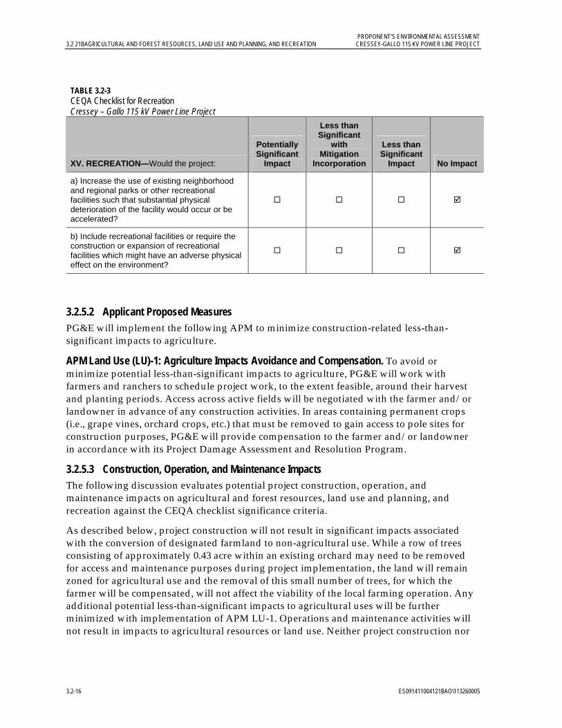
PROPONENT’S ENVIRONMENTAL ASSESSMENT 3.2 21BAGRICULTURAL AND FOREST RESOURCES, LAND USE AND PLANNING, AND RECREATION CRESSEY-GALLO 115 KV POWER LINE PROJECT
3.2-16 ES091411004121BAO\113260005
TABLE 3.2-3 CEQA Checklist for Recreation Cressey – Gallo 115 kV Power Line Project
XV. RECREATION—Would the project:
Potentially Significant
Impact
Less than Significant
with Mitigation
Incorporation
Less than Significant
Impact No Impact
a) Increase the use of existing neighborhood and regional parks or other recreational facilities such that substantial physical deterioration of the facility would occur or be accelerated?
b) Include recreational facilities or require the construction or expansion of recreational facilities which might have an adverse physical effect on the environment?
3.2.5.2 Applicant Proposed Measures PG&E will implement the following APM to minimize construction-related less-than-significant impacts to agriculture.
APM Land Use (LU)-1: Agriculture Impacts Avoidance and Compensation. To avoid or minimize potential less-than-significant impacts to agriculture, PG&E will work with farmers and ranchers to schedule project work, to the extent feasible, around their harvest and planting periods. Access across active fields will be negotiated with the farmer and/or landowner in advance of any construction activities. In areas containing permanent crops (i.e., grape vines, orchard crops, etc.) that must be removed to gain access to pole sites for construction purposes, PG&E will provide compensation to the farmer and/or landowner in accordance with its Project Damage Assessment and Resolution Program.
3.2.5.3 Construction, Operation, and Maintenance Impacts The following discussion evaluates potential project construction, operation, and maintenance impacts on agricultural and forest resources, land use and planning, and recreation against the CEQA checklist significance criteria.
As described below, project construction will not result in significant impacts associated with the conversion of designated farmland to non-agricultural use. While a row of trees consisting of approximately 0.43 acre within an existing orchard may need to be removed for access and maintenance purposes during project implementation, the land will remain zoned for agricultural use and the removal of this small number of trees, for which the farmer will be compensated, will not affect the viability of the local farming operation. Any additional potential less-than-significant impacts to agricultural uses will be further minimized with implementation of APM LU-1. Operations and maintenance activities will not result in impacts to agricultural resources or land use. Neither project construction nor
PROPONENT’S ENVIRONMENTAL ASSESSMENT CRESSEY-GALLO 115 KV POWER LINE PROJECT 3.2 21BAGRICULTURAL AND FOREST RESOURCES, LAND USE AND PLANNING, AND RECREATION
ES091411004121BAO\113260005 3.2-17
operation will result in significant impacts to recreational resources. Therefore, no temporary or permanent construction, operation, or maintenance impacts are anticipated.
II. Agriculture and Forest Resources a) Would the project convert Prime Farmland, Unique Farmland, or Farmland of Statewide Importance, as shown on the maps prepared pursuant to the FMMP, to non-agricultural use? Less–than-significant impact.
During project construction, work areas will typically be the width of the right-of-way (ROW) and approximately 100 feet in length. If work areas extended out of the power line ROW, PG&E will coordinate with the landowner to minimize both temporary and permanent impacts on agricultural land. In addition, PG&E will coordinate with landowners before the removal of trees. The implementation of APM LU-1 will further reduce potential less-than-significant impacts.
Implementation of the project will not result in the conversion of Unique Farmland or Farmland of Statewide Importance to non-agricultural use. Partial or complete removal of one row of almond trees in an orchard that is designated as Prime Farmland between Eucalyptus Avenue and Mercedes Avenue is expected as part of project implementation, resulting in the removal of approximately 0.43 acre of Prime Farmland from active cultivation. However, while a row of trees located on Prime Farmland will be removed during project construction, it will remain zoned for agricultural use and the small number of trees removed will not affect the viability of the farming operation; this impact will be less than significant. Further, the area of land that will be impacted during project construction amounts to a small percentage of total Prime Farmland in Merced County. As stated above, there are approximately 270,641 acres of Prime Farmland located throughout Merced County, which accounts for approximately 21.4 percent of land within the County. The approximately 0.43 acre of Prime Farmland permanently affected by the project represents a minute percentage of the total Prime Farmland acreage in Merced County.
Operation and maintenance activities will not result in the conversion of any farmland to non-agricultural use.
b) Would the project conflict with existing zoning for agricultural use, or a Williamson Act contract? No impact.
Construction and operation of the project will not conflict with existing agricultural zoning, or with a Williamson Act contract. While there are lands under Williamson Act contract within the project right-of-way (see Figure 3.2-4, Williamson Act Contract Program Lands within the Project Area), no land within these areas will be converted to non-agricultural use, or be removed from a Williamson Act contract with project implementation. While a row of trees located on Prime Farmland will be removed during project construction, this land is not under Williamson Act contract, and will remain zoned for agricultural use.
c) Would the project conflict with existing zoning for, or cause rezoning of, forest land (as defined in Public Resources Code section 12229(g)), timberland (as defined by Public Resources Code section 4526), or timberland zoned Timberland Production (as defined by Government Code section 51104(g))? No impact.
No forest land is located within the project area; no impacts to forestry resources will occur.
PROPONENT’S ENVIRONMENTAL ASSESSMENT 3.2 21BAGRICULTURAL AND FOREST RESOURCES, LAND USE AND PLANNING, AND RECREATION CRESSEY-GALLO 115 KV POWER LINE PROJECT
3.2-18 ES091411004121BAO\113260005
d) Would the project result in the loss of forest land or conversion of forest land to non-forest use? No impact.
No forest land is located within the project area; no impacts to forestry resources will occur.
e) Would the project involve other changes in the existing environment which, due to their location or nature, could result in conversion of Farmland to non-agricultural use or conversion of forest land to non-forest use? No impact.
As stated above, implementation of the project will not discourage the continued use of adjacent land as agricultural use. Rather, the project will improve power service reliability for existing customers in the area, including agricultural uses, so that such uses can continue their operations with a more reliable power source. The project will not induce growth so as to result in the conversion of farmland to non-agricultural use, and no impact will occur.
X. Land Use and Planning a) Would the project physically divide an established community? No impact.
Implementation of this project will not physically divide an established community. No impact will occur.
b) Would the project conflict with applicable land use plan, policy, or regulation of an agency with jurisdiction over the project (including, but not limited to the general plan, specific plan, local coastal program, or zoning ordinance) adopted for the purpose of avoiding or mitigating an environmental effect? No impact.
No changes in land use or zoning, as designated by the Merced County General Plan, will be required as part of the project. No impact will occur.
c) Would the project conflict with any applicable habitat conservation plan or natural community conservation plan? No impact.
The PG&E San Joaquin Valley Operations & Maintenance Habitat Conservation Plan (Jones & Stokes 2006) is the only potentially applicable HCP or natural community conservation plan to the project. Construction of the Cressey-Gallo 115 kV Power Line Project is not covered by the PG&E San Joaquin Valley O&M HCP. Biological resource APMs (see Section 3.4.4.2) are compatible with the conditions of the HCP Avoidance and Minimization Measures. Construction activities will not conflict with any applicable HCP or natural community conservation plan. Project operations and maintenance activities will comply with the PG&E San Joaquin Valley O&M HCP; no impacts will occur.
XV. Recreation a) Would the project increase the use of existing neighborhood and regional parks or other recreational facilities such that substantial physical deterioration of the facility would occur or be accelerated? No impact.
The project will not result in any residential or commercial development that will result in increased use of existing parks or other recreational facilities. Workers may use nearby park facilities during project construction, but any increase associated with such use will be negligible and temporary and will not contribute substantially to the physical deterioration of existing facilities. Therefore, no impact will occur.
PROPONENT’S ENVIRONMENTAL ASSESSMENT CRESSEY-GALLO 115 KV POWER LINE PROJECT 3.2 21BAGRICULTURAL AND FOREST RESOURCES, LAND USE AND PLANNING, AND RECREATION
ES091411004121BAO\113260005 3.2-19
b) Would the project include recreational facilities or require the construction or expansion of recreational facilities which might have an adverse physical effect on the environment? No impact.
The project will not include recreational facilities or require the construction or expansion of recreational facilities. Therefore, no impact will occur.
3.2.6 References California Department of Conservation (DOC). 2011a. “FMMP – Important Farmland Map
Categories” Website. Online: http://www.conservation.ca.gov/dlrp/fmmp/mccu/Pages/map_categories.aspx. Accessed May 10, 2011.
_______. 2011b. “Williamson Act Program – Basic Contract Provisions” Website. Online: http://www.conservation.ca.gov/dlrp/lca/basic_contract_provisions/Pages/wa_overview.aspx. Accessed May 10, 2011.
_______. 2011c. Department of Conservation Senate Bill 863 Advisory Statement. Online: http://www.consrv.ca.gov/dlrp/lca/Documents/SB%20863%20Advisory%20statement.pdf. Accessed June 16, 2011.
California Department of Parks and Recreation (California State Parks). 2011. “McConnell SRA” Website. Online: http://www.parks.ca.gov/?page_id=554. Accessed on May 13, 2011.
City of Livingston. 2008. City of Livingston 2025 General Plan (adopted October 2008). Prepared by PMC. October.
Jones & Stokes. 2006. Final PG&E San Joaquin Valley Operations and Maintenance Habitat Conservation Plan (includes updated Chapter 4 and Tables 5-3, 5-4 and 5-5, December 2007). December. J&S 02-067. Sacramento, CA.
Merced County. 1990. Merced County Year 2000 General Plan. Online: http://www.co.merced.ca.us/documents/Planning_and_Community_Development/General_Plan/Complete%20Document.PDF. Agricultural and Land Use Elements. Adopted December 4, 1990.
_______. 2009. Merced County Department of Public Works Improvement Standards and Specifications. Appendix A, Utilities Occupying County Roadways. Online: http://www.co.merced.ca.us/documents/Public%20Works/Roads/Compliled%20Standards.PDF. February 24.
_______. 2011a. 2030 Merced County General Plan Public Review Draft. Agricultural Element and Land Use and Community Character Element. Online: http://www.co.merced.ca.us/pdfs/planning/generalplan/focusgroup4/policies/focus4combined.pdf. February.
_______. 2011b. “Merced County Code, Title 18, Zoning” Website. Online: http://www.qcode.us/codes/mercedcounty/index.php?topic=18. Accessed June 6, 2011.

PROPONENT’S ENVIRONMENTAL ASSESSMENT 3.2 21BAGRICULTURAL AND FOREST RESOURCES, LAND USE AND PLANNING, AND RECREATION CRESSEY-GALLO 115 KV POWER LINE PROJECT
3.2-20 ES091411004121BAO\113260005
_______. 2011c. Sb 863 Modifications to Williamson Act Contracts for 2011 Approved by The Merced County Board of Supervisors on December 14, 2010. Online: http://www.co.merced.ca.us/index.aspx?NID=1741. Accessed May 13, 2011.
PROPONENT’S ENVIRONMENTAL ASSESSMENT CRESSEY-GALLO 115 KV POWER LINE PROJECT 3.3 22BAIR QUALITY AND GREENHOUSE GAS
ES091411004121BAO\113260005 3.3-1
3.3 Air Quality and Greenhouse Gas 3.3.1 Introduction and Methodology This section discusses the regulatory background, environmental setting, and potential air quality impacts and impacts from greenhouse gas (GHG) emissions generated by the project, and concludes that any impacts will be less than significant. Although short-term emissions from construction of the project will result in some temporary impacts, all impacts will be less than significant. Because maintenance or repair activities associated with operation of the project are expected to be similar to current activities and there will be minimal new GHG emissions, permanent air quality impacts from operation of the project will also be less than significant.
Information on air quality impacts was compiled from following the San Joaquin Valley Air Pollution Control District (SJVAPCD) guidance document Guide for Assessing and Mitigating Air Quality Impacts (SJVAPCD 2002a). Short-term construction emissions of carbon monoxide (CO), sulfur dioxide (SO2), respirable particulate matter (defined as particulate matter less than 10 microns in aerodynamic diameter [PM10]), fine particulate matter (defined as particulate matter less than 2.5 microns in aerodynamic diameter [PM2.5]), and carbon dioxide equivalents (CO2e2) were evaluated. Because ozone is formed through chemical reactions in the atmosphere, the ozone precursors oxides of nitrogen (NOx) and reactive organic gases (ROG) were also evaluated. Detailed construction emission calculations are presented in Appendix C. Construction emissions were estimated using construction equipment emission factors from URBEMIS 2007 (version 9.2.4) and truck emission factors from EMFAC2007 (version 2.3). PM10 emissions from soil disturbance were quantified using the grading and excavation emission factors in URBEMIS 2007 (version 9.2.4). PM10 emissions from vehicle travel on paved and unpaved roads were estimated using U.S. Environmental Protection Agency (USEPA) emission factors (USEPA 2006 and 2011).
3.3.2 Regulatory Background 3.3.2.1 Federal
Air Quality The federal Clean Air Act (CAA) establishes the statutory framework for regulation of air quality in the United States. Pursuant to this act, the USEPA has established various regulations to achieve and maintain acceptable air quality, including the adoption of National Ambient Air Quality Standards (NAAQS), mandatory State Implementation Plan (SIP) or maintenance plan requirements to achieve and maintain the NAAQS, and emission standards for both stationary and mobile sources of air pollution. NAAQS have been established for the following air pollutants (called “criteria” pollutants): CO, ozone, nitrogen dioxide (NO2), SO2, PM10, PM2.5, and lead. The NAAQS represent levels established by USEPA to avoid specific adverse health and welfare effects associated with each pollutant with a margin of safety. Table 3.3-1 summarizes the ambient air quality standards.
2 CO2e is a measure used to uniformly report the emissions from various greenhouse gases based on each pollutant’s global warming potential (GWP) using carbon dioxide as a reference with a GWP = 1 (for example, methane [CH4] has a much higher GWP than CO2 and emissions of CH4 are therefore multiplied by the CH4 GWP factor to develop CO2e emissions).
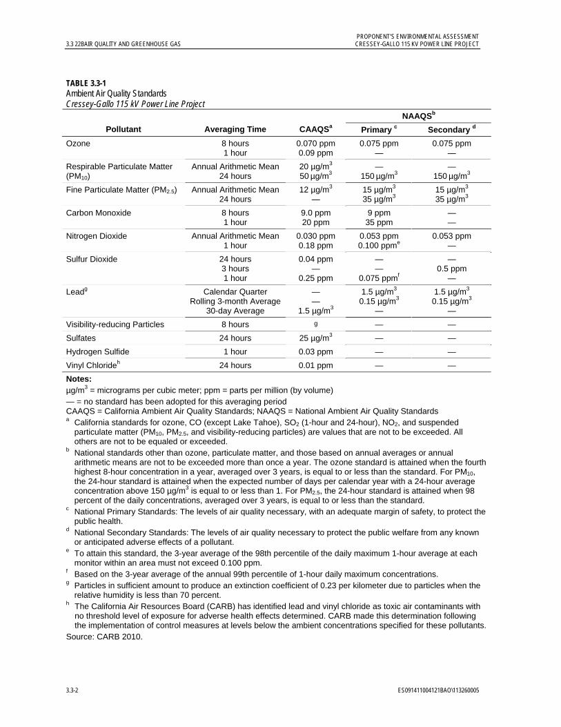
PROPONENT’S ENVIRONMENTAL ASSESSMENT 3.3 22BAIR QUALITY AND GREENHOUSE GAS CRESSEY-GALLO 115 KV POWER LINE PROJECT
3.3-2 ES091411004121BAO\113260005
TABLE 3.3-1 Ambient Air Quality Standards Cressey-Gallo 115 kV Power Line Project
NAAQSb
Pollutant Averaging Time CAAQSa Primary c Secondary d
Ozone 8 hours 1 hour
0.070 ppm 0.09 ppm
0.075 ppm —
0.075 ppm —
Respirable Particulate Matter (PM10)
Annual Arithmetic Mean24 hours
20 µg/m3
50 µg/m3 —
150 µg/m3 —
150 µg/m3
Fine Particulate Matter (PM2.5) Annual Arithmetic Mean24 hours
12 µg/m3 —
15 µg/m3 35 µg/m3
15 µg/m3 35 µg/m3
Carbon Monoxide 8 hours 1 hour
9.0 ppm 20 ppm
9 ppm 35 ppm
— —
Nitrogen Dioxide Annual Arithmetic Mean1 hour
0.030 ppm 0.18 ppm
0.053 ppm 0.100 ppme
0.053 ppm —
Sulfur Dioxide 24 hours 3 hours 1 hour
0.04 ppm —
0.25 ppm
— —
0.075 ppmf
— 0.5 ppm
—
Leadg Calendar Quarter Rolling 3-month Average
30-day Average
— —
1.5 µg/m3
1.5 µg/m3
0.15 µg/m3
—
1.5 µg/m3
0.15 µg/m3
—
Visibility-reducing Particles 8 hours g — —
Sulfates 24 hours 25 µg/m3 — —
Hydrogen Sulfide 1 hour 0.03 ppm — —
Vinyl Chlorideh 24 hours 0.01 ppm — —
Notes: µg/m3 = micrograms per cubic meter; ppm = parts per million (by volume) — = no standard has been adopted for this averaging period CAAQS = California Ambient Air Quality Standards; NAAQS = National Ambient Air Quality Standards a California standards for ozone, CO (except Lake Tahoe), SO2 (1-hour and 24-hour), NO2, and suspended
particulate matter (PM10, PM2.5, and visibility-reducing particles) are values that are not to be exceeded. All others are not to be equaled or exceeded.
b National standards other than ozone, particulate matter, and those based on annual averages or annual arithmetic means are not to be exceeded more than once a year. The ozone standard is attained when the fourth highest 8-hour concentration in a year, averaged over 3 years, is equal to or less than the standard. For PM10, the 24-hour standard is attained when the expected number of days per calendar year with a 24-hour average concentration above 150 µg/m3 is equal to or less than 1. For PM2.5, the 24-hour standard is attained when 98 percent of the daily concentrations, averaged over 3 years, is equal to or less than the standard.
c National Primary Standards: The levels of air quality necessary, with an adequate margin of safety, to protect the public health.
d National Secondary Standards: The levels of air quality necessary to protect the public welfare from any known or anticipated adverse effects of a pollutant.
e To attain this standard, the 3-year average of the 98th percentile of the daily maximum 1-hour average at each monitor within an area must not exceed 0.100 ppm.
f Based on the 3-year average of the annual 99th percentile of 1-hour daily maximum concentrations. g Particles in sufficient amount to produce an extinction coefficient of 0.23 per kilometer due to particles when the
relative humidity is less than 70 percent. h The California Air Resources Board (CARB) has identified lead and vinyl chloride as toxic air contaminants with
no threshold level of exposure for adverse health effects determined. CARB made this determination following the implementation of control measures at levels below the ambient concentrations specified for these pollutants.
Source: CARB 2010.
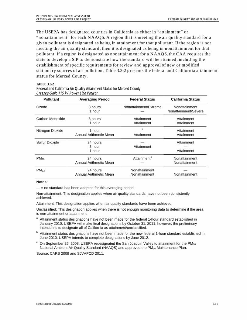
PROPONENT’S ENVIRONMENTAL ASSESSMENT CRESSEY-GALLO 115 KV POWER LINE PROJECT 3.3 22BAIR QUALITY AND GREENHOUSE GAS
ES091411004121BAO\113260005 3.3-3
The USEPA has designated counties in California as either in “attainment” or “nonattainment” for each NAAQS. A region that is meeting the air quality standard for a given pollutant is designated as being in attainment for that pollutant. If the region is not meeting the air quality standard, then it is designated as being in nonattainment for that pollutant. If a region is designated as nonattainment for a NAAQS, the CAA requires the state to develop a SIP to demonstrate how the standard will be attained, including the establishment of specific requirements for review and approval of new or modified stationary sources of air pollution. Table 3.3-2 presents the federal and California attainment status for Merced County.
TABLE 3.3-2 Federal and California Air Quality Attainment Status for Merced County Cressey-Gallo 115 kV Power Line Project
Pollutant Averaging Period Federal Status California Status
Ozone 8 hours 1 hour
Nonattainment/Extreme—
Nonattainment Nonattainment/Severe
Carbon Monoxide 8 hours 1 hour
Attainment Attainment
Attainment Attainment
Nitrogen Dioxide 1 hour Annual Arithmetic Mean
a Attainment
Attainment Attainment
Sulfur Dioxide 24 hours 3 hour 1 hour
— Attainment
b
Attainment —
Attainment
PM10 24 hours Annual Arithmetic Mean
Attainmentc —
Nonattainment Nonattainment
PM2.5 24 hours Annual Arithmetic Mean
Nonattainment Nonattainment
— Nonattainment
Notes:
— = no standard has been adopted for this averaging period.
Non-attainment: This designation applies when air quality standards have not been consistently achieved.
Attainment: This designation applies when air quality standards have been achieved.
Unclassified: This designation applies when there is not enough monitoring data to determine if the area is non-attainment or attainment. a Attainment status designations have not been made for the federal 1-hour standard established in
January 2010. USEPA will make final designations by October 31, 2011; however, the preliminary intention is to designate all of California as attainment/unclassified.
b Attainment status designations have not been made for the new federal 1-hour standard established in June 2010. USEPA intends to complete designations by June 2012.
c On September 25, 2008, USEPA redesignated the San Joaquin Valley to attainment for the PM10 National Ambient Air Quality Standard (NAAQS) and approved the PM10 Maintenance Plan.
Source: CARB 2009 and SJVAPCD 2011.

PROPONENT’S ENVIRONMENTAL ASSESSMENT 3.3 22BAIR QUALITY AND GREENHOUSE GAS CRESSEY-GALLO 115 KV POWER LINE PROJECT
3.3-4 ES091411004121BAO\113260005
Greenhouse Gases The USEPA Mandatory Reporting Rule became effective on December 29, 2009, and sources required to report were to begin collecting data on January 1, 2010. In general, suppliers of fossil fuels or industrial GHGs, manufacturers of vehicles and engines, and facilities that emit 25,000 metric tons or more per year of CO2e emissions are required to submit annual reports to the USEPA. The USEPA reporting requirements continue to be updated.
On December 7, 2009, the Administrator of the USEPA signed two findings regarding GHGs. The first finds that the current and projected concentrations of the six key well-mixed greenhouse gases in the atmosphere-- carbon dioxide (CO2), methane (CH4), nitrous oxide (N2O), hydrofluorocarbons (HFCs), perfluorocarbons (PFCs), and sulfur hexafluoride (SF6)-- threaten the public health and welfare of current and future generations. The second finds that the combined emissions of these well-mixed GHGs from new motor vehicles and new motor vehicle engines contribute to the GHG pollution that threatens public health and welfare. These findings do not themselves impose any requirements on industry or other entities.
3.3.2.2 State
Air Quality The California Air Resources Board (CARB) is the state agency responsible for California air quality management, including establishment of California Ambient Air Quality Standards (CAAQS), mobile source emission standards, and GHG regulations, as well as oversight of local air quality districts and preparation of implementation plans, including regulations for stationary sources of air pollution. The CAAQS are generally more stringent, except for the 1-hour NO2 and SO2 standards, and include more pollutants than the NAAQS (see Table 3.3-1). Similar to USEPA, CARB designates counties in California as being in attainment or nonattainment for the CAAQS. Table 3.3-2 presents the state attainment status for Merced County.
The California Clean Air Act requires each local air district in the state to prepare an air quality plan (part of the SIP) to achieve compliance with CAAQS. CARB has ultimate responsibility for the SIP for nonattainment pollutants but relies on each local air district to adopt mandatory statewide programs and provide tailored additional strategies for sources under their local jurisdiction. CARB combines its data with local district data and submits the completed SIP to USEPA. The SIP consists of the emissions standards for vehicular sources and consumer products set by CARB, as well as attainment plans adopted by the air districts and approved by CARB.
Greenhouse Gases In 2006, the California State Legislature signed the Global Warming Solutions Act of 2006 (Assembly Bill [AB] 32), which provides the framework for regulating GHG emissions in California. This law requires CARB to design and implement emission limits, regulations, and other measures such that statewide GHG emissions are reduced in a technologically feasible and cost-effective manner to 1990 levels by 2020. The statewide 2020 emissions limit is 427 million metric tons CO2e (CARB 2007). CO2 emissions account for approximately 90 percent of the statewide GHG emissions (CARB 2007). Methane, nitrous oxide, hydrofluorocarbons, perfluorocarbons, and SF6 emissions account for the remainder of the statewide GHG emissions (CARB 2007). In addition to AB 32, former Governor

PROPONENT’S ENVIRONMENTAL ASSESSMENT CRESSEY-GALLO 115 KV POWER LINE PROJECT 3.3 22BAIR QUALITY AND GREENHOUSE GAS
ES091411004121BAO\113260005 3.3-5
Schwarzenegger signed Executive Order S-3-05 establishing a statewide goal for year 2050 GHG emissions to be 80 percent below 1990 statewide GHG emission levels. No regulations have yet been adopted to implement this more aggressive statewide GHG target.
Part of CARB’s direction under AB 32 was to develop a scoping plan that contains the main strategies California will use to reduce GHG emissions that cause climate change. The scoping plan includes a range of GHG reduction actions, which include direct regulations, alternative compliance mechanisms, monetary and non-monetary incentives, voluntary actions, market-based mechanisms such as a cap-and-trade system, and an AB 32 cost of implementation fee regulation to fund the program (CARB 2008). The first regulation adopted by CARB pursuant to AB 32 was the regulation requiring mandatory reporting of GHG emissions. The California cap-and-trade program was adopted by CARB on October 20, 2011. Covered entities will have an obligation to hold GHG allowances beginning in 2013 (CARB 2011a). Recently, the Regulation for Reducing SF6 Emissions from Gas Insulated Switchgear was implemented as part of AB 32. This regulation will be applicable to the project because both Cressey Substation and Gallo Substation will include permanent installation of two SF6- insulated 115 kV breakers subject to this regulation. CARB published interim guidance for assessing the significance of GHGs under CEQA in October 2008. CARB guidance indicates that GHG emissions for non-transportation-related sources of less than 7,000 metric tons of CO2e per should be presumed to have a less than significant impact (CARB, 2008b).
3.3.2.3 Regional and Local Because the California Public Utilities Commission has exclusive jurisdiction over the siting, design, and construction of the project, the project is not subject to local discretionary air quality regulations. The following analysis of local regulations is provided for informational purposes and to assist with CEQA review.
Air Quality The project is located within the jurisdiction of the SJVAPCD. The SJVAPCD is the local agency charged with preparing, adopting, and implementing stationary and area air emission control measures and standards. Under the California Clean Air Act, SJVAPCD is required to develop an air quality plan to achieve and/or maintain compliance with federal and state nonattainment criteria pollutants within the air district. The SJVAPCD has taken action and developed plans to achieve and/or maintain compliance with:
Federal 8-hour ozone standard Federal 1-hour ozone standard Federal PM10 standard Federal CO standard
SJVAPCD has also adopted regulations and rules to achieve and maintain compliance with air quality standards. Those that apply to this project include specific rules within the following regulations:
Regulation I – General Provisions Regulation III - Fees Regulation VIII – Fugitive PM10 Prohibitions Regulation IX – Mobile and Indirect Sources

PROPONENT’S ENVIRONMENTAL ASSESSMENT 3.3 22BAIR QUALITY AND GREENHOUSE GAS CRESSEY-GALLO 115 KV POWER LINE PROJECT
3.3-6 ES091411004121BAO\113260005
Because the project will not involve construction of new stationary sources, the project does not require preconstruction permits from SJVAPCD. However, SJVAPCD has regulations that require compliance with the asbestos demolition and renovation requirements developed by the USEPA in the National Emission Standards for Hazardous Air Pollutants (NESHAP) regulation, 40 CFR, Part 61, Subpart M. Removed materials at Cressey Substation may contain asbestos, so PG&E will submit an asbestos notification form and fees to SJVAPCD prior to the removal action. In addition, specific SJVAPCD rules that potentially apply to construction of this project include:
Rule 3050 – Asbestos Removal Fee Rule 3135 – Dust Control Plan Fee Rule 4101 – Visible Emissions Rule 4102 – Nuisance Rule 4601 – Architectural Coatings Rule 4622 – Gasoline Transfer into Motor Vehicle Fuel Tanks Rule 4641 – Cutback, Slow Cure, and Emulsified Asphalt, Paving and Maintenance
Operations Rule 8011 – General Requirements Rule 8021 – Construction, Demolition, Excavation, Extraction and Other Earthmoving
Activities Rule 8041 – Carryout and Trackout Rule 8051 – Open Areas Rule 8061 – Paved and Unpaved Roads Rule 8071 – Unpaved Vehicle/Equipment Traffic Areas
The project is not subject to Rule 9510 – the Indirect Source Review (ISR) because the project is only adding approximately 4,500 square feet to the existing footprint at Gallo Substation and the permanent disturbance from the new power line will be 0.015 acre (653 square feet). The additional square footage created by the project is therefore below the ISR applicability threshold of 25,000 square feet for the category “light industrial space.” Cressey and Gallo substations will be operated and maintained by PG&E’s existing local service department staff. No additional staff will be required after substation work is completed. The ISR is a one-time assessment of a project that focuses primarily on reducing NOx and PM10 emissions. The fees generated from ISR are used to fund SJVAPCD emission reduction projects.
Merced County also contributes to improving air quality through land-use planning policies. The county’s Draft 2030 General Plan includes an Air Quality element that provides the policy context for Merced County to achieve its vision for air quality and greenhouse gas reduction (Merced County 2011). For example, Policy AQ 6.1: PM10 Emissions from Construction addresses reducing sources of fugitive dust during construction (Merced County 2011). The project will be compatible with this policy because there will be a water truck on-site to provide dust suppression during construction.
Although PG&E is not subject to local discretionary permitting, ministerial permits will be secured, as required.
PROPONENT’S ENVIRONMENTAL ASSESSMENT CRESSEY-GALLO 115 KV POWER LINE PROJECT 3.3 22BAIR QUALITY AND GREENHOUSE GAS
ES091411004121BAO\113260005 3.3-7
Greenhouse Gases To assist lead agencies, project proponents, permit applicants, and interested parties in assessing and reducing the impacts of project-specific GHGs on global climate change, SJVACPD has adopted two guidance and policy documents: Guidance for Valley Land-use Agencies in Addressing GHG Emission Impacts for New Projects under CEQA, and District Policy – Addressing GHG Emission Impacts for Stationary Source Projects Under CEQA When Serving as the Lead Agency (SJVAPCD 2009a and 2009b). Neither of these documents is applicable to PG&E’s power line project.
A policy identified in the Air Quality Element of the Merced General Plan states that Merced County will prepare a Climate Action Plan to achieve reductions in greenhouse gas emissions (Merced County 2011). The Plan has not yet been issued.
3.3.3 Environmental Setting 3.3.3.1 Regional Setting The project site is located in Merced County within the San Joaquin Valley Air Basin (SJVAB). According to the SJVAPCD (2002b), the SJVAB is defined by the Sierra Nevada Mountains in the east (8,000 to 14,000 feet in elevation), the Coast Ranges in the west (averaging 3,000 feet in elevation), and the Tehachapi Mountains in the south (6,000 to 8,000 feet in elevation). The valley is basically flat with a slight downward gradient to the northwest. The valley opens to the sea at the Carquinez Straits where the San Joaquin-Sacramento Delta empties into San Francisco Bay. Although marine air generally flows into the basin from the San Joaquin River Delta, the region’s topographic features restrict air movement through and out of the basin. In addition, the SJVAB has an “inland Mediterranean” climate averaging over 260 sunny days per year. The valley floor is characterized by warm, dry summers and cooler winters. These characteristics result in the SJVAB being highly susceptible to pollutant accumulation over time. For additional details regarding the topography and climate influences that are important to air quality in Merced County, please refer to the Technical Document Information for Preparing Air Quality Sections in EIRs (SJVAPCD, 2002b).
3.3.3.2 Ambient Air Quality The primary pollutants of concern in Merced County are ozone, PM10, and PM2.5 because the County is designated nonattainment by CARB for the state standards. Ozone is not directly emitted but is formed in the atmosphere by complex chemical reactions of various precursors, ROG and NOx, in the presence of sunlight. The major sources of ozone precursor emissions in Merced County are on-road and off-road vehicles, fuel combustion, and solvent usage (paints, consumer products, and certain industrial processes) (SJVAPCD 2002b). Sources of PM10 and PM2.5 include mineral quarries, grading, demolition, agricultural tilling, road dust, and vehicle exhaust (SJVAPCD 2002a). Additional information on ozone and other pollutants of concern is provided in the Technical Document Information for Preparing Air Quality Sections in EIRs (SJVAPCD, 2002b).
The SJVAPCD operates a network of ambient air quality monitoring stations that measure concentrations of ozone, PM10, CO, NO2, SO2, and PM2.5. To determine the existing ambient air quality for the project, the nearest monitoring stations were identified. The nearest monitoring stations are located in Merced, California, approximately 15 miles from the project area: one on South Coffee Avenue (Merced-S Coffee Avenue) and one on M Street

PROPONENT’S ENVIRONMENTAL ASSESSMENT 3.3 22BAIR QUALITY AND GREENHOUSE GAS CRESSEY-GALLO 115 KV POWER LINE PROJECT
3.3-8 ES091411004121BAO\113260005
(Merced-2334 M Street). As shown in Table 3.3-3, measured ozone, PM10, and PM2.5
concentrations in Merced have exceeded the federal and/or state standards in the past 3 years. Concentrations of NO2 have not exceeded a federal or state standard in the past 3 years. CO and SO2 concentrations are not monitored in Merced County. CO concentrations measured in nearby Stanislaus County, at the Turlock S Minaret Street monitoring station, have not exceeded federal or state standard in the past 3 years (CARB 2011b). The nearest monitoring station that measures SO2 concentrations is located in Fresno, California. SO2 concentrations measured at the Fresno 1st Street monitoring station have not exceeded federal or state standards in the past 3 years (CARB 2011b).
TABLE 3.3-3 Summary of Maximum Ambient Air Monitoring Data in the Project Area Cressey-Gallo 115 kV Power Line Project
Pollutant Averaging Time 2008 2009 2010
Ozone (ppm) 1 Hour 8 Hour
0.131 0.121
0.094 0.084
0.117 0.096
PM10 (µg/m3) 24 Hour Annual Arithmetic Mean
76.8 34.5
65.1 26.9
91.4 25.5
PM2.5 (µg/m3) 24 Hour Annual Arithmetic Mean
54.0 *
53.3 13.6
46.9 11.2
Notes:
µg/m3 = micrograms per cubic meter; ppm = parts per million
Ozone concentrations are from the Merced-S. Coffee Avenue monitoring station and the particulate matter concentrations are from the Merced-2334 M Street monitoring station.
Carbon monoxide, sulfur dioxide, hydrogen sulfide, vinyl chloride, and visibility-reducing particles are not monitored in Merced County.
Bold text indicates figure exceeds standards.
* There were insufficient (or no) data to determine the value.
Source: CARB 2011b.
3.3.4 Impact Assessment The following sections describe significance criteria for air quality impacts derived from Appendix G of the CEQA Guidelines, Applicant-Proposed Measures (APMs), and potential project-related construction and operational air quality impacts.
3.3.4.1 Significance Criteria and Checklist In accordance with Appendix G of the CEQA Guidelines, project impacts on air quality may be considered significant if the project has the potential to contribute to a violation of an ambient air quality standard; the significance of such impacts must be evaluated for each of the criteria shown in Table 3.3-4. In addition, for evaluating air quality impacts, the SJVAPCD uses 10 tons per year for ROG or NOx as a guideline for determining the significance of construction or operation impacts (SJVAPCD 2002a). This quantitative threshold was used to evaluate whether construction emissions could violate any air quality standard or will result in a cumulatively considerable net increase in emissions.

PROPONENT’S ENVIRONMENTAL ASSESSMENT CRESSEY-GALLO 115 KV POWER LINE PROJECT 3.3 22BAIR QUALITY AND GREENHOUSE GAS
ES091411004121BAO\113260005 3.3-9
TABLE 3.3-4 CEQA Checklist for Air Quality and Greenhouse Gas Emissions Cressey – Gallo 115 kV Power Line Project
III. AIR QUALITY—Would the project:
Potentially Significant
Impact
Less Than Significant
With Mitigation
Incorporated
Less Than Significant
Impact No
Impact
a) Conflict with or obstruct implementation of the applicable air quality plan?
b) Violate any air quality standard or contribute substantially to an existing or projected air quality violation?
c) Expose sensitive receptors to substantial pollutant concentrations?
d) Result in a cumulatively considerable net increase of any criteria pollutant for which the project region is non-attainment under an applicable federal or state ambient air quality standard (including releasing emissions that exceed quantitative thresholds for ozone precursors)?
e) Create objectionable odors affecting a substantial number of people?
VII. GREENHOUSE GAS EMISSIONS — Would the project:
Potentially Significant
Impact
Less Than Significant
With Mitigation
Incorporated
Less than Significant
Impact No
Impact
a) Generate greenhouse gas emissions, either directly or indirectly, that may have a significant impact on the environment?
b) Conflict with any applicable plan, policy or regulation of an agency adopted for the purpose of reducing the emissions of greenhouse gases?
CARB developed state-wide interim thresholds of significance for GHGs. For industrial projects, CARB proposed a quantitative threshold of 7,000 metric tons of CO2e per year. This threshold was used to evaluate whether GHG emissions from construction or operation of the project could have a significant impact on the environment.
3.3.4.2 Applicant Proposed Measures Specific potential air quality impacts and APMs are discussed in the following sections. The APMs include measures that are required by existing regulations and/or requirements or standard practices that will minimize or prevent potential impacts. PG&E will implement the following APMs, or similar measures as practicable for this utility project.
Construction APM Air Quality (AQ)-1: Minimize Fugitive Dust. PG&E will minimize fugitive dust during construction by implementing the following measures. According to SJVAPCD, implementation of the following measures minimizes fugitive dust emissions to a less-than-significant level (SJVAPCD 2002a).
PROPONENT’S ENVIRONMENTAL ASSESSMENT 3.3 22BAIR QUALITY AND GREENHOUSE GAS CRESSEY-GALLO 115 KV POWER LINE PROJECT
3.3-10 ES091411004121BAO\113260005
Visible dust emissions (VDE) will not exceed 20 percent opacity during times when soil is disturbed.
All disturbed areas, including storage piles, which are not being actively utilized for construction purposes, will be effectively stabilized to control dust emissions using water, chemical stabilizer/suppressants, or covering soils with a tarp or other suitable cover or vegetative ground cover.
All onsite unpaved roads and offsite unpaved access roads will be effectively stabilized against dust emissions using water or chemical stabilizer/suppressant.
All land clearing, grubbing, scraping, excavation, land leveling, grading, cut and fill, and demolition activities will be effectively controlled to prevent fugitive dust emissions by application of water or presoaking.
When materials are transported offsite, all material will be covered, or effectively wetted to limit VDE, and at least 6 inches of freeboard space from the top of the container shall be maintained.
All operations will limit or expeditiously remove the accumulation of mud or dirt from adjacent public streets at the end of each workday.3)
Following the addition of materials to, or the removal of materials from, the surface of outdoor storage piles, said piles will be effectively stabilized to control fugitive dust emissions by application of water or chemical stabilizer/suppressant.
Within urban areas, trackout will be immediately removed when it extends 50 or more feet from the site and at the end of each workday.
Vehicle speeds will be limited to 15 miles per hour on unpaved roads.
APM AQ-2: Minimize Construction Exhaust Emissions - Criteria Pollutants and GHGs. The following measures will be implemented during construction to further minimize the less-than-significant construction emissions:
Construction equipment will be properly maintained. All offroad construction diesel engines not registered under the CARB Statewide Portable Equipment Registration Program will meet at a minimum the Tier 1 California Emission Standards for Off-Road Compression-Ignition Engines as specified in California Code of Regulations (CCR) Title 13, Chapter 9, Sec. 2423(b)(1).
Idling times will be minimized either by shutting equipment or commercial motor vehicles off when not in use or reducing the maximum idling time to 5 minutes (as required by CCR Title 13, Chapter 9, Section 2449 and Chapter 10, Section 2485). The ability to limit construction vehicle idling time is dependent upon the sequence of construction activities and when and where vehicles are needed or staged. Certain vehicles, such as large diesel-powered vehicles, have extended warm-up times following start-up that limit their availability for use following startup. Where such
3 Per SJVAPCD Rule 8041, the use of dry rotary brushes is expressly prohibited except where preceded or accompanied by sufficient wetting to limit the VDE. The use of blower devices is expressly forbidden.
PROPONENT’S ENVIRONMENTAL ASSESSMENT CRESSEY-GALLO 115 KV POWER LINE PROJECT 3.3 22BAIR QUALITY AND GREENHOUSE GAS
ES091411004121BAO\113260005 3.3-11
diesel-powered vehicles are required for repetitive construction tasks, these vehicles may require more idling time. The project will apply a “common sense” approach to vehicle use; if a vehicle is not required for use immediately or continuously for construction activities, its engine will be shut off. Construction foremen will provide briefings to crews on vehicle use as part of pre-construction conferences. Those briefings will include discussion of a “common sense” approach to vehicle use.
Minimize welding and cutting by using compression of mechanical applications where practical and within standards.
Encourage use of natural gas powered vehicles for passenger cars and light duty trucks where feasible and available.
Encourage the recycling of construction waste where feasible.
Operations and Maintenance There will be less than significant impacts to air quality due to the operations and maintenance of the project. PG&E will employ standard Best Management Practices (BMPs) during operations, such as minimizing vehicle trips and keeping vehicles and equipment well maintained and will comply with CARB Early Action Measures (CARB 2011c) as these policies become effective. PG&E will also implement the following APM specifically related to avoidance and minimizing potential SF6 emissions:
APM AQ-3: Avoid and Minimize Potential Sulfur Hexafluoride Emissions. PG&E will continue to include the project substations in PG&E’s system-wide SF6 emission reduction program, which includes inventorying and monitoring system-wide SF6 leakage rates and employing X-ray technology to inspect internal circuit breaker components to eliminate dismantling of breakers and reduce accidental releases. New project breakers will have a manufacturer’s guaranteed SF6 leakage rate of 0.5 percent per year or less and will be maintained in accordance with PG&E’s maintenance guidelines.
In addition to APM AQ-3, PG&E is implementing the following voluntary company-wide actions to further reduce GHG emissions:
PG&E is an active member of the SF6 Emission Reduction Partnership for Electric Power Systems, a voluntary program between the USEPA and electric power companies that focuses on reducing emissions of SF6 from transmission and distribution operations. Since 1998, PG&E has reduced its SF6 leak rate by 89 percent and absolute SF6 emissions by 83 percent.
PG&E supports the Natural Gas STAR program, a program promoting the reduction of methane (at least 21 times the global warming potential of CO2 on a per-ton basis) from natural gas pipeline operations. Since 1998, PG&E has avoided the release of thousands of tons of methane.
In June 2007, PG&E launched the ClimateSmart program, a voluntary GHG emission reduction program that allows its customers to balance out the GHG emissions that are produced by the energy they use, making their energy use “climate neutral.” One hundred percent of customer payments are applied to funding new GHG emission
PROPONENT’S ENVIRONMENTAL ASSESSMENT 3.3 22BAIR QUALITY AND GREENHOUSE GAS CRESSEY-GALLO 115 KV POWER LINE PROJECT
3.3-12 ES091411004121BAO\113260005
reduction projects in California, such as projects that capture methane gas from dairy farms and landfills and those that conserve and restore California’s forests.
PG&E is offsetting all of the GHG emissions associated with the energy used in PG&E’s buildings by participating in its ClimateSmart program. In 2007, this amounted to over 50,000 tons of CO2 reductions.
PG&E will implement the CARB Early Action Measures for publicly-owned electric utilities as these policies become effective.
3.3.4.3 Construction, Operation and Maintenance Impacts Project impacts on air quality were evaluated against the CEQA significance criteria, as discussed below. This section evaluates potential project impacts from both the construction phase and operation and maintenance phase.
III. Air Quality a) Would the project conflict with or obstruct implementation of the applicable air quality plan? No impact.
The SJVAPCD air quality plans and the Air Quality Element of the Merced County General Plan were reviewed to determine whether the project will conflict with air quality plans. The SJVAPCD’s plans present the strategies and control measures needed to continue to improve air quality in SJVAB. SJVAPCD is responsible for implementing and regulating stationary and area sources of air emissions.
Construction of the project will result in short-term air emissions below the SJVAPCD’s thresholds of significance, and dust control will be implemented during construction (see Table 3.3-5). Therefore, project construction is compatible with the applicable air quality plans, and the short-term construction-related emissions will not impact SJVAPCD’s implementation of its approved air quality plans.
The project will be operated using a Supervisory Control and Data Acquisition (SCADA) system. Therefore, no additional operating and maintenance staff will be required after construction is completed. Existing O&M crews will operate and maintain the new equipment as part of their current O&M activities. Consequently, operation of the project will not result in an incremental increase in O&M emissions (except for minor SF6 emissions discussed in under section VII. A below) and will not conflict with air quality plans, violate an air quality standard, or result in a cumulatively considerable impact to air quality.

PROPONENT’S ENVIRONMENTAL ASSESSMENT CRESSEY-GALLO 115 KV POWER LINE PROJECT 3.3 22BAIR QUALITY AND GREENHOUSE GAS
ES091411004121BAO\113260005 3.3-13
TABLE 3.3-5 Construction Emission Estimates with Implementation of APMs Cressey-Gallo 115 kV Power Line Project
Emissions (tons/year)
Construction Year and Thresholds ROG NOx CO SO2
Exhaust PM10
Fugitive PM10
Exhaust PM2.5
2013 0.34 2.88 4.10 0.008 0.17 3.8 0.14
2014 0.05 0.42 0.64 0.001 0.02 0.6 0.02
SJVAPCD Threshold 10 10 NE NE NE NE NE
Threshold Exceeded? No No NA NA NA NA NA
Notes:
CO = carbon monoxide CO2e = carbon dioxide equivalent NA = Not applicable. NE = Quantitative threshold has not been established. NOx = oxides of nitrogen PM2.5 = particulate matter less than 2.5 microns in aerodynamic diameter PM10 = particulate matter less than 10 microns in aerodynamic diameter ROG = reactive organic gas SO2 = sulfur dioxide a The CO2 emissions are reported in units of metric tons to be consistent with the units used by the CARB for the statewide GHG emission inventory.
b) Would the project violate any air quality standard or contribute substantially to an existing or projected air quality violation? Less-than-significant impact.
Exhaust emissions from construction will result in short-term emissions of ROG, NOx, CO, SO2, PM10, and PM2.5. As shown in Table 3.3-5, the construction phase ROG and NOx emissions are expected to be less than the quantitative thresholds of significance for construction projects established by the SJVAPCD (10 tons per year). Quantitative thresholds have not been established for CO, SO2, PM10, or PM2.5 emissions. However, construction exhaust CO, SO2, PM10, and PM2.5 emissions are expected to be minimal, as shown in Table 3.3-5.
Fugitive particulate matter emissions during construction will result from soil disturbance and travel on paved and unpaved roads. Table 3.3-5 presents the fugitive PM10 emissions from project construction. The construction emission estimates in Table 3.3-5 take into account reductions in fugitive dust and exhaust that will result from implementation of APMs AQ-1 and AQ-2, respectively. Therefore, with implementation of APMs AQ-1 and APM AQ-2, emissions from project construction will not violate any air quality standard or result in an air quality violation. Air quality impacts will be less than significant.
c) Would the project expose sensitive receptors to substantial pollutant concentrations? Less-than-significant-impact.
Sensitive receptors are locations where people more vulnerable to air emissions reside. The nearest sensitive receptors are residences located approximately 0.01 mile from the power line, 0.08 mile from Cressey Substation, and 0.5 mile from Gallo Substation (see

PROPONENT’S ENVIRONMENTAL ASSESSMENT 3.3 22BAIR QUALITY AND GREENHOUSE GAS CRESSEY-GALLO 115 KV POWER LINE PROJECT
3.3-14 ES091411004121BAO\113260005
Figure 3.10-1). Project construction will generate a short-term increase in emissions, but construction of the power line and activities at the substations will impact nearby residents only briefly (2-3 days at a time); construction is not expected to result in substantial pollutant concentrations (as described above), and therefore the air quality impact will be less than significant.
d) Would the project result in a cumulatively considerable net increase of any criteria pollutant for which the project region is non-attainment under an applicable federal or state ambient air quality standard (including releasing emissions that exceed quantitative thresholds for ozone precursors)? Less-than-significant impact.
The project is located in an area that is nonattainment for the state and federal ozone and PM2.5 ambient air quality standards and state PM10 standards. Project construction is not expected to result in a cumulatively significant increase in the nonattainment pollutants NOx or ROG (ozone precursors) because the emissions will be well below the SJVAPCD significance thresholds (see Table 3.3-5). In addition, fugitive particulate matter and exhaust emissions will be minimized with the implementation of the APMs AQ-1 and APM AQ-2; therefore, the air quality impact is expected to be less than significant.
e) Create objectionable odors affecting a substantial number of people? No Impact.
The project does not include any facilities expected to create objectionable odors such as dairies, wastewater treatment plants, or solid waste facilities (SJVAPCD, 2002a). Project construction will involve the temporary use of vehicles and construction equipment that may generate intermittent, minor odors from exhaust emissions. These temporary and minor odors will occur in a sparsely populated, rural area. Therefore, there will be no impact from odorous emissions affecting a substantial number of people.
VII. Greenhouse Gas Emissions a) Would the project generate greenhouse gas emissions, either directly or indirectly, that may have a significant impact on the environment? Less-than-significant impact.
GHG emissions directly generated during construction of the project will be a less than significant short-term increase. GHG emissions will be further reduced with implementation of APM AQ-2. GHG emissions with and without implementation of APM AQ-2 are detailed in Table 3.3-6. As shown in Table 3.3-7, the emissions from the construction phase of the project, even without APM AQ-2, are expected to be well below CARB’s proposed threshold of 7,000 metric tons CO2e/yr.

PROPONENT’S ENVIRONMENTAL ASSESSMENT CRESSEY-GALLO 115 KV POWER LINE PROJECT 3.3 22BAIR QUALITY AND GREENHOUSE GAS
ES091411004121BAO\113260005 3.3-15
TABLE 3.3-6 Expected Emissions Reductions from APM AQ-2 Addressing Impacts from GHGs During Construction Cressey-Gallo 115 kV Power Line Project
Measure
Baseline Emissions
(metric tons CO2e /yr)
Reduction (metric tons
CO2e /yr)
Reduced Emissions
(metric tons CO2e /yr)
Percent Reduction
(of total emissions) Notes
Minimize Idling 447 44 403 5.5
Reduce line construction equipment hours from 12 hours to 10 hours per day average for the construction period.
Low Emission or Electric Equipment
Unknown*
Minimize Welding and Cutting
Unknown*
Natural Gas / Electric Vehicles
Unknown*
Recycling Construction Waste
Unknown*
Notes: CO2e = carbon dioxide equivalent
*Unknown: measure will be implemented as feasible; unknown potential reduction.
Expected emission reduction calculations are provided in Appendix C.
TABLE 3.3-7 Estimated Total GHG Emissions During Construction Cressey-Gallo 115 kV Power Line Project
Activity Total CO2e Emissions
(metric tons/year)
Construction without APM AQ-2 843
Construction with APM AQ-2 Implemented
797
CARB Threshold 7,000
Notes: CO2e = carbon dioxide equivalent See Section 3.3.4.2 for a description of APM AQ-2.
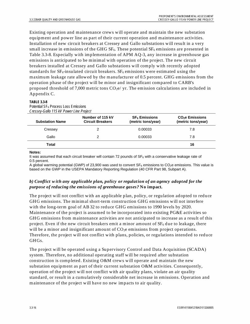
PROPONENT’S ENVIRONMENTAL ASSESSMENT 3.3 22BAIR QUALITY AND GREENHOUSE GAS CRESSEY-GALLO 115 KV POWER LINE PROJECT
3.3-16 ES091411004121BAO\113260005
Existing operation and maintenance crews will operate and maintain the new substation equipment and power line as part of their current operation and maintenance activities. Installation of new circuit breakers at Cressey and Gallo substations will result in a very small increase in emissions of the GHG SF6. These potential SF6 emissions are presented in Table 3.3-8. Especially with implementation of APM AQ-3, any increase in greenhouse gas emissions is anticipated to be minimal with operation of the project. The new circuit breakers installed at Cressey and Gallo substations will comply with recently adopted standards for SF6-insulated circuit breakers. SF6 emissions were estimated using the maximum leakage rate allowed by the manufacturer of 0.5 percent. GHG emissions from the operation phase of the project will be minor and insignificant compared to CARB’s proposed threshold of 7,000 metric tons CO2e/yr. The emission calculations are included in Appendix C.
TABLE 3.3-8 Potential SF6 Process Loss Emissions Cressey-Gallo 115 kV Power Line Project
Substation Name Number of 115 kV Circuit Breakers
SF6 Emissions (metric tons/year)
CO2e Emissions (metric tons/year)
Cressey 2 0.00033 7.8
Gallo 2 0.00033 7.8
Total 16
Notes: It was assumed that each circuit breaker will contain 72 pounds of SF6 with a conservative leakage rate of 0.5 percent. A global warming potential (GWP) of 23,900 was used to convert SF6 emissions to CO2e emissions. This value is based on the GWP in the USEPA Mandatory Reporting Regulation (40 CFR Part 98, Subpart A).
b) Conflict with any applicable plan, policy or regulation of an agency adopted for the purpose of reducing the emissions of greenhouse gases? No impact.
The project will not conflict with an applicable plan, policy, or regulation adopted to reduce GHG emissions. The minimal short-term construction GHG emissions will not interfere with the long-term goal of AB 32 to reduce GHG emissions to 1990 levels by 2020. Maintenance of the project is assumed to be incorporated into existing PG&E activities so GHG emissions from maintenance activities are not anticipated to increase as a result of this project. Even if the new circuit breakers emit a minor amount of SF6 due to leakage, there will be a minor and insignificant amount of CO2e emissions from project operations. Therefore, the project will not conflict with plans, policies, or regulations intended to reduce GHGs.
The project will be operated using a Supervisory Control and Data Acquisition (SCADA) system. Therefore, no additional operating staff will be required after substation construction is completed. Existing O&M crews will operate and maintain the new substation equipment as part of their current substation O&M activities. Consequently, operation of the project will not conflict with air quality plans, violate an air quality standard, or result in a cumulatively considerable net increase in emissions. Operation and maintenance of the project will have no new impacts to air quality.
PROPONENT’S ENVIRONMENTAL ASSESSMENT CRESSEY-GALLO 115 KV POWER LINE PROJECT 3.3 22BAIR QUALITY AND GREENHOUSE GAS
ES091411004121BAO\113260005 3.3-17
3.3.5 References California Air Resources Board (CARB). 2007. “California 1990 Greenhouse Gas Emissions
Level and 2020 Limit.” December. Available online at: http://www.arb.ca.gov/cc/inventory/ 1990level/1990level.htm. Accessed March 17, 2009.
__________. 2008a. Climate Change Scoping Plan. Available online at: http://www.arb.ca.gov/cc/scopingplan/document/scopingplandocument.htm. December.
__________. 2008b. Recommended Approaches for Setting Interim Significance Thresholds for Greenhouse Gases under the California Environmental Quality Act (Preliminary Draft Staff Proposal). Available online at: http://www.arb.ca.gov/cc/localgov/ceqa/meetings/102708/prelimdraftproposal102408.pdf. Accessed November 4, 2011.
__________. 2009. “Area Designations.” Available online at: http://www.arb.ca.gov/desig/adm/adm.htm. Accessed August 3, 2011.
__________. 2010. “Ambient Air Quality Standards.” Available online at: http://www.arb.ca.gov/research/aaqs/aaqs.htm. Accessed on August 3, 2011.
__________.2011a. “Cap-and-Trade Program” Web site. Available online at: http://arb.ca.gov/cc/capandtrade/capandtrade.htm. Accessed October 21, 2011.
__________.2011b. “Air Quality Data Statistics.” Available online at: http://www.arb.ca.gov/adam/cgi-bin/db2www/adamtop4b.d2w/start. Accessed August 15, 2011.
__________.2011c. “Early Action Items.” Available online at: http://arb.ca.gov/cc/ccea/ccea.htm. Accessed November 2, 2011.
Merced County. 2011. Draft 2030 Merced County General Plan, Air Quality Element. June. http://www.co.merced.ca.us/index.aspx?NID=1791. Accessed August 8, 2011.
San Joaquin Valley Air Pollution Control District (SJVAPCD). 2002a. Guide for Assessing and Mitigating Air Quality Impacts. Revised January 10, 2002. Available online at: http://www.valleyair.org/transportation/ceqa_guidance_documents.htm. Accessed August 8, 2011.
__________. 2002b. Technical Document Information for Preparing Air Quality Sections in EIRs. January. Available online at: http://www.valleyair.org/transportation/ceqa_guidance_documents.htm. Accessed August 8, 2011.
__________. 2009a. Guidance for Valley Land-use Agencies in Addressing GHG Emission Impacts for New Projects under CEQA. December.
__________. 2009b. District Policy – Addressing GHG Emission Impacts for Stationary Source Projects Under CEQA When Serving as the Lead Agency. December.

PROPONENT’S ENVIRONMENTAL ASSESSMENT 3.3 22BAIR QUALITY AND GREENHOUSE GAS CRESSEY-GALLO 115 KV POWER LINE PROJECT
3.3-18 ES091411004121BAO\113260005
__________. 2011. Ambient Air Quality Standards & Valley Attainment Status. http://www.valleyair.org/aqinfo/attainment.htm. Accessed August 8, 2011.
United States Environmental Protection Agency (USEPA). 2006. AP-42, Fifth Edition, Compilation of Air Pollutant Emission Factors, Chapter 13.2.2. November.
__________. 2011. AP-42, Fifth Edition, Compilation of Air Pollutant Emission Factors, Chapter 13.2.1. January.
PROPONENT’S ENVIRONMENTAL ASSESSMENT CRESSEY-GALLO 115 KV POWER LINE PROJECT 3.4 23BBIOLOGICAL RESOURCES
ES091411004121BAO\113260005 3.4-1
3.4 Biological Resources 3.4.1 Introduction and Methodology This section describes biological resources (vegetation, wildlife, and wetlands) in the project area, identifies potential impacts on habitats and species that could result from the implementation of the project, and concludes that impacts on biological resources will be less than significant. Incorporation of the APMs described in Section 3.4.4.2 will further minimize potential less-than-significant project impacts on biological resources.
For biological resources, the study area limits included the 14.4-mile, 600-foot-wide corridor for the proposed power line, and the area around Cressey and Gallo substations. Biological database and literature sources concerning the habitats, geographic ranges and documented occurrences of sensitive plant and wildlife taxa in the vicinity of the study area were reviewed. Information sources included, but were not limited to, the following:
California Department of Fish and Game (CDFG) RareFind 3.1.0 California Natural Diversity Database (CNDDB) (CDFG 2011a)
U.S. Fish and Wildlife Service (USFWS) species list website (USFWS 2011)
California Wildlife Habitat Relationships (CWHR) System (CDFG 2008) and Special Animals List (CDFG 2011b)
California Native Plant Society (CNPS) online version of the Inventory of Rare and Endangered Plants of California (CNPS 2010); species designated as List 4 by the CNPS were also considered
CNDDB Quickviewer online database (CDFG 2011d)
Aerial photographs
The Jepson Online Interchange (2011) database for California floristics
Other literature reviewed on wildlife distribution in the project region included the PG&E Draft Environmental Impact Report (EIR) for the San Joaquin Valley Operations and Maintenance Program Habitat Conservation Plan (HCP) (Jones and Strokes 2006a), Draft EIR for the City of Merced Wastewater Treatment Plant Expansion Project (City of Merced 2006), Wildlife and Rare Plant Ecology of Eastern Merced County’s Vernal Pool Grasslands (Vollmar 2002), and Eastern Merced County Natural Community Conservation Plan HCP (Noss et al. 2002).
A CNDDB database search for special-status plants and wildlife typically includes nine U.S. Geological Survey (USGS) 7.5-minute quadrangle maps for a project located within a single quadrangle: the quadrangle that covers the project area, and the eight quadrangles that surround the project quadrangle. However, in this case, the project area spanned four quadrangles, and additional quadrangles were therefore searched to account for all the areas surrounding the four project quadrangles.
PROPONENT’S ENVIRONMENTAL ASSESSMENT 3.4 23BBIOLOGICAL RESOURCES CRESSEY-GALLO 115 KV POWER LINE PROJECT
3.4-2 ES091411004121BAO\113260005
A plant was considered to be of special status if it met one or more of the following criteria:
Federally or state-listed, or proposed for listing, as rare, threatened or endangered (CDFG 2011a).
Special Plant as defined by the CNDDB (CDFG 2011a).
Listed by the CNPS in the online version of its Inventory of Rare and Endangered Plants of California (CNPS 2010). Species designated as List 4 by the CNPS were also considered special-status species.
Special-status wildlife included species that met one or more of the following:
Listed, proposed for listing, or candidates for listing as threatened or endangered under the federal Endangered Species Act (ESA).
Listed or candidates for listing as threatened or endangered under the California Endangered Species Act.
Designated as Species of Special Concern or a fully protected species by the CDFG.
Listed on the CDFG “Special Animals” list (CDFG 2011b); or that otherwise meet the definition of rare, threatened or endangered as described in the California Environmental Quality Act (CEQA) Guidelines, Section 15380.
The CEQA Guidelines, Section 15380, include consideration of non-listed species. A species that is not listed will also be considered rare or endangered if it can be shown to meet one or more of the following criteria:
Its survival and reproduction in the wild are in immediate jeopardy from one or more causes.
It exists in such small numbers throughout all or a significant portion of its range that it may become endangered if its environment deteriorates.
It is likely to become endangered within the foreseeable future throughout all or a significant portion of its range.
Reconnaissance-level field surveys of botanical, wetland, and wildlife resources were conducted by Garcia and Associates (GANDA) wildlife biologist Loni Cooper, botanist Ann Howald, and wetland ecologist Molly Graber on April 4 and 5, 2011. Surveys were conducted along the 600-foot-wide corridor, with a closer focus in the 120-foot-wide area of potential direct effects. The 120-foot-wide area is centered on the road, section line or other alignment adjacent to the power line alignment. A survey of botanical resources within 50 feet of Cressey Substation was conducted by CH2M HILL senior biologist Marjorie Eisert on August 29, 2011. The purpose of these surveys was to identify and map potential habitat for special-status species and to field-verify the mapped vegetation types and wetland features that were based on remote Geographic Information System (GIS) sensing techniques.

PROPONENT’S ENVIRONMENTAL ASSESSMENT CRESSEY-GALLO 115 KV POWER LINE PROJECT 3.4 23BBIOLOGICAL RESOURCES
ES091411004121BAO\113260005 3.4-3
The likelihood of special-status species occurrence (low, moderate, high) is based on habitat requirements (such as, substrate, hydrology, vegetation type, and disturbance factors) and range, applied by using the following general guidelines:
Low: Habitat within the study area and/or project vicinity satisfies very few of the species’ requirements and/or the range of the species overlaps with the vicinity of the project, but not with the project corridor itself. The species’ presence within the project corridor is unlikely.
Moderate: Habitat within the study area and/or project vicinity meets some of the species’ requirements, and known locations for the species are found in the vicinity of the project corridor. Presence of the species within the project corridor is moderately likely.
High: Habitat within the study area and/or project vicinity meets most or all of the species’ requirements, and known locations for the species are found within 5 miles of the project corridor. Presence of the species within the project corridor is highly likely.
Potential project impacts were considered for special-status species observed during project reconnaissance-level field surveys and any species considered to have a moderate or high likelihood to occur in the corridor. Special–status species unlikely to be found in the project corridor are not likely to be impacted by the project and are not discussed in this chapter.
Unless otherwise noted, methodology and environmental information presented in this chapter is summarized from the Biological Resources Technical Report for the Cressey-Gallo 115 kV Power Line Project (Biological Resources Technical Report) that will be provided to CPUC staff under separate cover (GANDA 2011).
3.4.2 Regulatory Background 3.4.2.1 Federal
U.S. Fish and Wildlife Service and National Oceanic and Atmospheric Administration Fisheries Service. The federal ESA protects plants and wildlife that are listed as endangered or threatened by USFWS and the National Oceanic and Atmospheric Administration (NOAA) Fisheries Service. Section 9 of the ESA prohibits the take of listed fish and wildlife, where “take” is defined as “harass, harm, pursue, hunt, shoot, wound, kill, trap, capture, collect, or attempt to engage in such conduct” (50 Code of Federal Regulations [CFR] 17.3). For plants, this statute governs removing, possessing, maliciously damaging, or destroying any listed plant on federal land and removing, cutting, digging-up, damaging, or destroying any listed plant on non-federal land in knowing violation of state law (16 United States Code [USC] 1538).
Section 10 of the ESA allows for issuance of incidental take permits to private parties provided a Habitat Conservation Plan is developed. The private party initiates consultation with USFWS or NOAA Fisheries through consultation to discuss target species in the project area. The private party then prepares an HCP assessing the potential for the project to adversely affect federally listed species and presenting the measures that will be undertaken to avoid and minimize such impacts.

PROPONENT’S ENVIRONMENTAL ASSESSMENT 3.4 23BBIOLOGICAL RESOURCES CRESSEY-GALLO 115 KV POWER LINE PROJECT
3.4-4 ES091411004121BAO\113260005
Under Section 7 of the ESA, federal agencies are required to consult with USFWS if their actions, including permit approvals or funding, could adversely affect an endangered species (including plants) or its critical habitat. In consultations with the USFWS the federal agency determines whether a proposed agency action(s) is likely to jeopardize the continued existence of a listed species (jeopardy) or destroy or adversely modify critical habitat (adverse modification). Through consultation and the issuance of a Biological Opinion, the USFWS may issue an incidental take statement allowing take of the species that is incidental to an otherwise authorized activity, provided the action will not jeopardize the continued existence of the species.
Habitat Conservation Plans (HCPs). PG&E has an HCP for its operations and maintenance activities in the San Joaquin Valley (PG&E San Joaquin Valley Operations & Maintenance HCP [Jones and Stokes 2006b]). This HCP covers 23 wildlife and 42 plant species for 33 routine operations and maintenance activities for PG&E’s electric and gas transmission and distribution systems within nine counties of the San Joaquin Valley, including Merced County. The project is included within the boundaries of this HCP. The HCP pertains to the operations and maintenance components of the project, but construction practices and APMs are also designed to be compatible with the HCP avoidance and minimization measures.
Migratory Bird Treaty Act (16 USC Sections 703–711). The Migratory Bird Treaty Act (MBTA) of 1918 protects all migratory birds, including active nests and eggs. Birds protected under the MBTA include all native waterfowl, shorebirds, hawks, eagles, owls, doves, and other common birds such as ravens, crows, sparrows, finches, swallows, and others, including their body parts (for example feathers and plumes), active nests, and eggs. A complete list of protected species is found at 50 CFR 10.13. Enforcement of the provisions of the MBTA is the responsibility of USFWS.
Bald and Golden Eagle Protection Act (16 USC Section 668). The Bald and Golden Eagle Protection Act (BGEPA) of 1940 specifically protects bald and golden eagles and their nests from harm or trade in parts of these species. The 1972 amendments increased penalties for violating provisions of the BGEPA or regulations issued pursuant thereto and strengthened other enforcement measures. Rewards are provided for information leading to arrest and conviction for violation of the BGEPA.
Waters and Wetlands: Clean Water Act (CWA) Sections 401 and 404. The purpose of the CWA is to “restore and maintain the chemical, physical, and biological integrity of the nation’s waters.” The definition of “waters of the United States” includes rivers, streams, estuaries, the territorial seas, ponds, lakes, and wetlands. Wetlands are defined as those areas “that are inundated or saturated by surface or ground water at a frequency and duration sufficient to support, and that under normal circumstances do support, a prevalence of vegetation typically adapted for life in saturated soil conditions” (33 CFR 328.3 7b).
The U.S. Army Corps of Engineers (USACE) issues permits based on guidelines established under Section 404 of the CWA and Section 10 of the Rivers and Harbors Act. Section 404 of the CWA prohibits the discharge of dredged or fill material into “waters of the United States”, including wetlands, without a permit from USACE. The USEPA also has authority over wetlands and may under Section 404(c) veto a USACE permit. Under Section 10 of the Rivers and Harbors Act, the USACE has the authority to regulate the navigable capacity of
PROPONENT’S ENVIRONMENTAL ASSESSMENT CRESSEY-GALLO 115 KV POWER LINE PROJECT 3.4 23BBIOLOGICAL RESOURCES
ES091411004121BAO\113260005 3.4-5
any of the waters of the United States. Under this Act, it is not lawful “to excavate or fill, or in any manner to alter or modify the course, location, condition, or capacity of…any navigable water of the United States…”
Depending on the amount of impacts to Waters of the U.S., a USACE Section 404 permit application can either: a) invoke usage of any of the 50 Nationwide Permits issued in March 12, 2007 (Federal Register, Vol. 72, No. 47) or b) entail the submittal of an individual permit application. If the project would have minimal individual and cumulative adverse effects on the aquatic environment and if General Conditions are met, one (or more than one) of the Nationwide Permits could be used and a Pre-Construction Notification would be required. If more than a minimal effect on the aquatic environment is expected, then an Individual Permit must be obtained.
All Section 404 CWA permit actions require water quality certification or a waiver pursuant to Section 401 of the CWA. This authority has been delegated by USEPA to the state level and this certification or waiver is issued by the appropriate state water quality authority (in California this is delegated by the Regional Water Quality Control Boards). Section 401 is addressed more fully in Section 3.8, Hydrology and Water Quality.
3.4.2.2 State
California Endangered Species Act (CESA). Sections 2050-2098 of the California Fish and Game Code (CFGC) prohibit the take of state-listed endangered and threatened species unless specifically authorized by CDFG. The state definition of “take” is to hunt, pursue, catch, capture, or kill a member of a listed species or attempt to do so. CDFG administers CESA and authorizes take through permits or memorandums of understanding issued under Section 2081 of CFGC, or through a consistency determination issued under section 2080.1. Section 2090 of CFGC requires state agencies to comply with threatened and endangered species protection and recovery and to promote conservation of these species.
Fully Protected Species CFGC` Sections 3511, 4700, 5050, and 5515. CFGC designates certain animal species as “fully protected” under Sections 3511 (birds), 4700 (mammals), 5050 (reptiles and amphibians), and 5515 (fish). Fully protected species may not be taken or possessed at any time, and no permits may be issued for incidental take of these species.
Protection for Birds: CFGC Section 3503 et seq. CFGC Section 3503 states that it is unlawful to take, possess, or needlessly destroy the nest or eggs of any bird, except as otherwise provided by this code or any regulation made pursuant thereto. Section 3513 makes it unlawful to take, possess, or destroy any birds of prey or to take, possess, or destroy the nest or eggs of any such bird.
Native Plant Protection Act of 1973 (CFGC Sections 1900-1913). The Native Plant Protection Act of 1973 includes provisions that prohibit the taking of endangered or rare native plants from the wild and a salvage requirement for landowners. CDFG administers the Native Plant Protection Act of 1973 and generally regards as rare many plant species included on Lists 1A, 1B, and 2, and sometimes Lists 3 and 4, of the CNPS Inventory of Rare and Endangered Vascular Plants of California.
California Species of Special Concern (SSC). SSC is a category conferred by CDFG on those species that are indicators of regional habitat changes or considered potential future
PROPONENT’S ENVIRONMENTAL ASSESSMENT 3.4 23BBIOLOGICAL RESOURCES CRESSEY-GALLO 115 KV POWER LINE PROJECT
3.4-6 ES091411004121BAO\113260005
protected species. SSC do not have any legal status, but they are intended by CDFG for use as a management tool to take these species into special consideration when decisions are made concerning the future of any land parcel. SSCs should be considered during the environmental review process. CEQA (California Public Resources Code §§ 21000-21177) requires state agencies, local governments, and special districts to evaluate and disclose impacts from “projects” in the state. Section 15380 of the CEQA Guidelines clearly indicates that species of special concern should be included in an analysis of project impacts if they can be shown to meet the criteria of sensitivity outlined therein.
3.4.2.3 Local Because the CPUC has exclusive jurisdiction over the siting, design, and construction of the project, the project is not subject to local discretionary regulations relating to biological resources. The following analysis of local regulations is provided for informational purposes and to assist with CEQA review.
Merced County General Plan. Merced County is currently operating under the Merced County Year 2000 General Plan (Merced County 1989; B. Nicholson pers. comm.) The County is in the process of updating this plan and has a draft of the revised plan (Merced County General Plan Policies; Planning Commission Review Draft; Merced County 2011). The revised plan is scheduled to be finalized by the end of 2011. The goals, objectives, and policies pertaining to the comprehensive and long-range management, preservation, and conservation of open-space lands, including wildlife, vegetation, and wetland resources, most relevant to the project are listed below for both plans.
Merced County Year 2000 General Plan
GOAL 1: Habitats that support rare, endangered, or threatened species are not substantially degraded.
Objective 1. A.: Rare and endangered species are protected from urban development and are recognized in rural areas.
Policies:
1. Recognize as significant wetland habitats areas that meet the definition of having a high wetland habitat value based on the Adamus methodology and based on the Army Corps of Engineers delineation method.
2. Continue to regulate the location, density, and design of development to minimize adverse impacts and encourage enhancement of rare and endangered species habitats.
7. In wetland areas, all public utilities and facilities, such as roads, sewage disposal ponds and gas, electrical and water systems, should be located and constructed to minimize or avoid significant loss of wetland resources.
Merced County General Plan Policies; Planning Commission Review Draft
Goal NR-1: Preserve and protect, through coordination with the public and private sectors, the biological resources of the County.
PROPONENT’S ENVIRONMENTAL ASSESSMENT CRESSEY-GALLO 115 KV POWER LINE PROJECT 3.4 23BBIOLOGICAL RESOURCES
ES091411004121BAO\113260005 3.4-7
Policies:
NR-1.1: Habitat Protection
Identify areas that have significant long term habitat and wetland values including riparian corridors, wetlands, grasslands, rivers and waterways, oak woodlands, and vernal pools, and provide information to landowners.
NR-1.4: Important Vegetative Resource Protection
Minimize the removal of vegetative resources which stabilize slopes, reduce surface water runoff, erosion, and sedimentation.
NR-1.5: Wetland and Riparian Habitat Buffer
Identify wetlands and riparian habitat areas and designate a buffer zone around each area sufficient to protect them from degradation, encroachment, or loss.
NR-1.7: Agricultural Practices
Encourage agricultural, commercial, and industrial uses and other related activities to coordinate with environmental groups in order to minimize adverse effects to important or sensitive biological resources.
NR-1.10: Aquatic and Waterfowl Habitat Protection
Cooperate with local, State, and Federal water agencies in their efforts to protect significant aquatic and waterfowl habitats against excessive water withdrawals or other activities that would endanger or interrupt normal migratory patterns or aquatic habitats.
NR-1.11: On-Going Habitat Protection and Monitoring
Cooperate with local, State, and Federal agencies to ensure that adequate on-going protection and monitoring occurs adjacent to rare and endangered species habitats or within identified significant wetlands.
NR-1.12: Wetland Avoidance
Avoid or minimize loss of existing wetland resources by careful placement and construction of any necessary new public utilities and facilities, including roads, railroads, high speed rail, sewage disposal ponds, gas lines, electrical lines, and water/wastewater systems.
NR-1.17: Agency Coordination
Coordinate with private, local, State, and Federal agencies to assist in the protection of biological resources and prevention of degradation, encroachment, or loss of resources managed by these agencies.
3.4.3 Environmental Setting The proposed project is located in northern Merced County, in the central San Joaquin Valley, California. Merced County is bordered by the foothills of the Sierras to the east and the Coast Range to the west. The county supports a variety of vegetative communities, including annual grasslands, wetlands, valley foothill riparian, and foothill oak woodlands. Agriculture is a very important part of the county’s land use; large cattle ranches and farms

PROPONENT’S ENVIRONMENTAL ASSESSMENT 3.4 23BBIOLOGICAL RESOURCES CRESSEY-GALLO 115 KV POWER LINE PROJECT
3.4-8 ES091411004121BAO\113260005
are found in the west, while smaller farms are located in the east. Agricultural practices include dairy-lands and croplands such as irrigated pastures, vineyards, row crops, and orchards. The proposed project is located primarily on or adjacent to agricultural land and pastureland.
3.4.3.1 Vegetation and Other Landcover Types Seven vegetation types were identified within the study area. Most of these are some form of agricultural land, including pastureland, orchard, vineyard, and other croplands. Natural vegetation is limited to very low quality annual grassland. Other landcover types include developed/landscaped areas, irrigation canals and ditches, and bare ground. The acreage and detailed description of each type are shown in the Biological Resources Technical Report, Figure 1 and summarized in Table 3.4-1.
TABLE 3.4-1 Approximate Extent of Vegetation and Other Land Cover Types Within the Study Area Cressey-Gallo 115 kV Power Line Project
Vegetation and Land Cover Types Approximate Area (acres)
Vegetation Types
Orchard 377.7
Cropland 248.9
Vineyard 127.7
Ruderal 70.6
Pastureland 67.1
Planted trees 10.9
Annual Grassland 3.1
Other Land Cover Types
Developed/Landscaped 126.7
Bare ground 12.3
Irrigation canal 5.4
Ditch 0.7
Total 1,051.1
Note: The study area consisted of the 600-foot-wide buffer along the 14.4-mile proposed power line corridor. The ends of the corridor are also buffered, which includes the 3.8 acres that are not shown in the table.
3.4.3.2 Land Cover Types and Wildlife Habitats The study area crosses a variety of land cover and vegetation types. The classification of wildlife habitats generally follows that used for vegetation types. While vegetation types are defined by plant species composition, wildlife habitats can include various land cover types and other important features such as rock outcrops, underground refugia, and open water. In some cases, a wildlife habitat type includes more than one plant community or land cover

PROPONENT’S ENVIRONMENTAL ASSESSMENT CRESSEY-GALLO 115 KV POWER LINE PROJECT 3.4 23BBIOLOGICAL RESOURCES
ES091411004121BAO\113260005 3.4-9
types that provide similar habitat characteristics and support a similar assemblage of wildlife species. A description of wildlife habitats in the study area follows; these are based on the California Wildlife Habitat Relationships System (CDFG 2008).
Agricultural (Crops/Orchard/Vineyard) Orchards are a dominant vegetation type in the eastern and central parts of the study area (approximately 377.7 acres). Almost all of these are almond (Prunus amygdalus) orchards. There are also a few walnut (Juglans regia) orchards. The understory is barren to very sparsely vegetated. Low-growing, shade-tolerant, forbs are the predominant plants, including wartcress (Lepidium didymum), pygmy weed (Crassula sp.), white-stemmed filaree, and knotweed (Polygonum aviculare ssp. depressum).
A total of approximately 248.9 acres of other croplands including wheat, row crops, and fallow fields are present in the study area. Typical species found in agricultural lands include red-tailed hawk, common crow (Corvus brachyrhynchos), Brewer’s blackbird (Euphagus cyanocephalus), western meadowlark, house finch (Carpodacus mexicanus), red-winged blackbird (Agelaius phoeniceus), California ground squirrel, and deer mouse. Disked fields typically provide foraging habitat for wildlife species such as great egret (Ardea alba), great blue heron (Ardea herodus), northern harrier (Circus cyaneus), red-tailed hawk, killdeer (Charadrius vociferous), white-tailed kite (Elanus leucurus), and burrowing owl (Athene cunicularia).
Extensive vineyards of wine grapes (Vitus spp.) occur in the western third of the study area and cover approximately 127.7 acres of the study area. The understory is barren or contains annual grasses, likely planted for erosion control. These were present only in vegetative form and could not be identified to species.
Developed/Landscaped/Planted Trees Developed and landscaped areas are located at rural residential areas; farm buildings, schools, and other structures; paved roads; and the associated landscaping. A total of approximately 126.7 acres of developed/landscaped lands occur in the study area. Landscaping associated with some of these areas includes lawns, and many kinds of planted flowers, shrubs, and trees. Rows of planted trees (approximately 10.9 acres) were observed along the roadsides and adjacent to the vineyards in the western part of the study area, especially along Magnolia Avenue. Planted trees and shrubs included cork oak (Quercus suber), coast live oak (Quercus agrifolia), oleander (Nerium oleander), Fremont cottonwood (Populus fremontii), almonds, plums (Prunus domestica), and apples (Malus sylvestris).
Developed areas, particularly areas with landscaping vegetation and planted trees, can provide moderate habitat value for wildlife. The planting and maintenance of shrubs, trees, and other ornamental plants in developed and landscaped areas can enhance this habitat for opportunistic animal species that can coexist with humans. Examples of species found in this habitat type are the northern mockingbird, house finch, Brewer’s blackbird, and raccoon (Procyon lotor). Also, buildings and structures such as bridges, overpasses, and transmission towers can provide shelter, roosting, or nesting sites for species such as cliff swallow (Petrochelidon pyrrhonota), barn swallow (Hirundo rustica), rock pigeon (Columba livia), and small mammals such as mice, rats, and a variety of bats.

PROPONENT’S ENVIRONMENTAL ASSESSMENT 3.4 23BBIOLOGICAL RESOURCES CRESSEY-GALLO 115 KV POWER LINE PROJECT
3.4-10 ES091411004121BAO\113260005
Ruderal Vegetation and Bare Ground Ruderal vegetation consists of non-native weedy grasses and forbs that are typically associated with roadsides and other highly disturbed locations. A total of approximately 70.6 acres of ruderal habitat were identified in the study area. Common species observed include annual ryegrass (Lolium multiflorum), foxtail barley, wild oats, ripgut brome, soft brome (Bromus hordeaceus), annual bluegrass (Poa annua), fiddleneck, white-stemmed filaree, linaria (Linaria canadensis), narrow-leaved plantain (Plantago lanceolata), common mustard, jointed charlock, milk thistle (Silybum marianum), bur clover (Medicago polymorpha), vetch (Vicia sp.), and cudweed (Gnaphalium palustre). The approximately 12.3 acres of bare ground in the study area consists mainly of unpaved roads, including roads through orchards and some public rural roads.
Ruderal areas generally provide relatively low habitat value for wildlife because they are degraded communities dominated by non-native, weedy plants. These areas typically provide low-quality foraging habitat for most birds and small mammals, but can provide marginal habitat for some species depending on the type and amount of vegetation present. Common birds found in ruderal habitat include Brewer’s blackbird, house finch, and mourning dove. The western fence lizard (Sceloporus occidentalis), a common reptile, often utilizes bare ground areas such as roadsides and railroad berms for thermal basking.
Pastureland Grazed pastureland covers approximately 67.1 acres within the study area, mainly in the eastern third of the proposed route. Vegetation consists mainly of non-native grasses and forbs. The grasses were largely unidentifiable to species due to grazing, but include foxtail barley (Hordeum murinum ssp. leporinum), annual fescue (Vulpia spp.), and mannagrass (Glyceria sp.). Other plants include common mustard, mallow (Malva sp.), white-stemmed filaree, curly dock (Rumex crispus), spikerush (Eleocharis sp.), and prickle-seed buttercup (Ranunculus muricatus). Within the pasturelands scattered small areas are tentatively identified as seasonal ponded areas.
Pastures are used by a variety of wildlife depending on the geographic area and types of adjacent habitat. The pastureland found in the study area provides suitable foraging and nesting habitat for some animals, especially birds. Ground nesting birds including waterfowl, western meadowlark, and pheasant (Phasianus colchicus) nest in pastures if adequate residual vegetation is present during the nesting season. Flood irrigation of pastures provides foraging habitat for many wetland-associated birds, including shorebirds, wading birds, gulls, waterfowl, and raptors.
Irrigation Canal/Ditch Irrigation canals (approximately 5.4 acres) and ditches (approximately 0.7 acre) within the study area include some with concrete or other hard structure banks, and some with dirt banks. A few of these were dry at the time of the survey, but most were filled with irrigation water. The channels and banks of most of the canals and ditches observed were unvegetated. The project will be designed to avoid ditches and canals that occur in the study area.
The channelized irrigation canals and ditches associated with agricultural and crop lands on the study area serve as habitats for amphibians and reptiles such as Pacific treefrog (Pseudacris regilla), western spadefoot (Spea [= Scaphiopus] hammondii), and bullfrog

PROPONENT’S ENVIRONMENTAL ASSESSMENT CRESSEY-GALLO 115 KV POWER LINE PROJECT 3.4 23BBIOLOGICAL RESOURCES
ES091411004121BAO\113260005 3.4-11
(Lithobatescatesbeiana) as well as reptiles such as western pond turtle (Actinemys marmorata). A variety of waterbirds can also utilize these features as refuge and/or foraging sites. The giant garter snake (Thamnophis gigas) is a federally- and state-listed threatened species that may also use irrigation canals and ditches; however, all CNDDB occurrences were found more than 10 miles to the southwest of the study area in or adjacent to Stevinson Wildlife Reserve.
Annual Grassland Annual grassland is described as an upland community type composed of dense to sparse cover of mainly introduced annual grasses, usually less than 3 feet in height (Holland 1986). The very low-quality annual grassland observed within the study area is ungrazed, which separates it from the type described below as pastureland. The 3.1 acres of annual grassland within the study area are dominated by non-native grasses such as wild oats (Avena spp.) and ripgut brome (Bromus diandrus). No native grasses were observed. Introduced forbs were abundant, including wild radish (Raphanus sativus), jointed charlock (Raphanus raphanistrum), common mustard (Brassica rapa), and white-stemmed filaree (Erodium moschatum). Native fiddleneck (Amsinckia sp.) occurs in low abundance.
California annual grassland can support a variety of small mammals and provide foraging or nesting habitat for raptors and other birds. Birds commonly found foraging in annual grasslands include red-tailed hawk (Buteo jamaicensis), American kestrel (Falco sparverius), and turkey vulture (Cathartes aura). Common seed eaters, including California quail (Callipepla californica), mourning dove (Zenaida macroura), and western meadowlark (Sturnella neglecta) will nest on the ground in grasslands. Other common species, such as western scrub-jay (Aphelocoma californica) and northern mockingbird (Mimus polyglottos), will disperse through, and forage within, grassland habitats.
Common mammals of annual grasslands include California ground squirrel (Spermophilus beecheyi), Botta’s pocket gopher (Thomomys bottae), deer mouse (Peromyscus maniculatus), broad-footed mole (Scapanus latimanus), western harvest mouse (Reithrodontomys megalotis), and black-tailed jackrabbit (Lepus californicus). These small mammals utilize open grassland for both foraging and breeding. Burrows of California ground squirrels can also provide important refuge sites for other species. Grassland wildflowers provide important nectar sources for butterflies, bees, and other insects.
3.4.3.3 Wetlands and Aquatic Resources Aquatic resources observed in the study area include seasonal ponded areas, agricultural ditches, and irrigation canals. Irrigated pasture and cropland observed during reconnaissance-level field surveys are not considered wetland or aquatic resources and are not discussed in this section. These aquatic features are represented on the maps in the Biological Resources Technical Report, Figure 1. Descriptions of hydrophytic vegetation and hydrology for these features are provided below. Irrigation canals and ditches were addressed above.
Potential seasonal ponded areas included approximately 1.6 acres within pastureland on the eastern side of the study area, approximately 0.1 acre (apparently man-made feature) near the intersection of Mercedes Avenue and the Burlington Northern Santa Fe railroad tracks, and approximately 0.06 acre within a developed area between a house site and cropland. The dominant vegetation associated with the features on the eastern side of the project
PROPONENT’S ENVIRONMENTAL ASSESSMENT 3.4 23BBIOLOGICAL RESOURCES CRESSEY-GALLO 115 KV POWER LINE PROJECT
3.4-12 ES091411004121BAO\113260005
within pasturelands includes species such as Italian rye grass, spikerush, curly dock, and mannagrass. There were areas of saturation present within these features as well as cattle trampling. The apparent man-made feature near the railroad tracks is a low-lying area characterized by curly dock, common rush (Juncus effusus) and loosestrife. There is a culvert adjacent to this feature. The feature within the developed area is a lower-lying area where water collects and has left surface soil cracks. The dominant vegetation in this area is annual bluegrass. One seasonally wet depression was observed within a field of planted wheat. Plant species observed within this depression included spurrey (Spergula arvensis), common groundsel (Senecio vulgaris), and red maids (Calandrinia ciliata).
Pooled water covered approximately 0.07 acre within pastureland on the eastern side of the study area. With the exception of Italian ryegrass, these areas had little vegetation due to cattle grazing and standing water that was present in lower-lying areas at the time of the survey. The source of the standing and pooled water was from recent rain events.
Seasonal freshwater ponded areas often support a unique assemblage of species that are adapted to an annual regime of inundation and desiccation. These habitats provide valuable resources for a variety of wildlife species. Species composition within seasonal ponded areas depends in part on the period of inundation (or hydroperiod) during the wet season. When water is present, these habitats can support many aquatic invertebrates, including federally listed vernal pool crustaceans, and provide breeding sites for amphibians such as Pacific treefrog, western toad (Anaxyrus boreas), and western spadefoot. Because they are often hydrologically isolated from rivers and streams and subject to seasonal drying, fish are absent from these seasonal ponded areas. Such areas provide unique habitat conditions that can be essential for locally endemic and rare species. In the winter and spring, seasonal ponded areas can also provide foraging habitat for resident and migratory birds.
3.4.3.4 Special-Status Species The study area does not include designated critical habitat for any plant or wildlife species. Although the Merced River is designated critical habitat for Central Valley steelhead (Oncorhynchus mykiss irideus), the river is 0.26 mile north of Gallo Substation. Additionally, designated critical habitat for four animal and five plant species is located within 5 miles of the study area (Biological Resources Technical Report, Figure 2). Critical habitat for Conservancy fairy shrimp (Branchinecta conservatio) and vernal pool fairy shrimp (Branchinecta lynchi) is present 4.6 miles south of Magnolia Avenue (Ave.) and 3.4 miles east of Cressey Substation. Vernal pool tadpole shrimp (Lepidurus packardi) is also included in the designated Critical Habitat south of Magnolia Ave. Critical habitat for five plant species is located 4.6 miles south of Magnolia Ave. and 3.4 miles east of Cressey Substation. No wildlife connectivity areas or linkage corridors were identified within 5 miles of the study area (USFWS 1998; CDFG 2011c).
Special-Status Plant Species The database search identified 38 special-status plant species in the regional vicinity of the proposed project. The data base results for special-status plants in the project vicinity are provided in the Biological Resources Technical Report, Table 2. After the field reconnaissance, it was determined that no suitable habitat (e.g., native or natural grasslands, natural alkaline flats, chenopod scrub, or vernal pools) occurs in the study area for any of these species except Sanford’s arrowhead (Sagittaria sanfordii). Sanford’s arrowhead has
PROPONENT’S ENVIRONMENTAL ASSESSMENT CRESSEY-GALLO 115 KV POWER LINE PROJECT 3.4 23BBIOLOGICAL RESOURCES
ES091411004121BAO\113260005 3.4-13
been observed in irrigation canals in Merced County (pers. comm. R. Huddleston 2011), and thus was considered to have a moderate potential to occur in the study area. As noted above in the Irrigation Canal/Ditch subsection in Section 3.4.3.2, the project is designed to avoid ditches and canals that could potentially support Sanford’s arrowhead within in the study area.
Special-Status Wildlife Species The literature and database review identified 54 special-status wildlife species with potential to occur in or near the study area (Biological Resources Technical Report, Table 3). Based on the initial assessment of wildlife habitats conducted during the reconnaissance field survey, 10 of these species were determined to have moderate potential to occur within the study area. Two of these species, Swainson’s hawk (Buteo swainsoni) and white-tailed kite, were observed during the field reconnaissance surveys. Species that have been documented to occur in the study area or have a moderate potential to occur are discussed below.
An active red-tailed hawk nest was observed in the study area. The nest was located on a transformer below an existing power and distribution pole, south of Gallo Substation (Biological Resources Technical Report, Figure 1, Map 2).
Valley elderberry longhorn beetle – Federally Threatened Valley elderberry longhorn beetle (Desmocerus californicus dimorphus; VELB) is completely dependent on its host plant, elderberry (Sambucus spp.). Elderberry shrubs are commonly found in the remaining riparian forests and adjacent uplands of California’s Central Valley. VELB require elderberry stems that are at least 1.0 inch in diameter (measured at the base) to lay their eggs on. Larvae excavate passages into the elderberry shrub, where they may remain in larval form for as long as two years before they emerge as adults. Exit holes are usually on stems greater than 0.5 inch in diameter, with 70 percent of the exit holes at heights of 4 feet or greater (Barr 1991).
The dense riparian habitat along the Merced River is known to support elderberry shrubs (Vollmar 2002). There are three CNDDB occurrences of VELB from the late 1980s and early 1990s within 5 miles of the study area (Figure 3.4-1). Each of these occurrences is located in the Merced River riparian corridor. During reconnaissance field surveys for the project, 25 elderberry shrubs were observed along the west and east side of West Lane, on Palm Avenue, and on the north side of Cressey Substation (Figure 3.4-2). The majority of these elderberry shrubs were small with stems less than 1.0 inch in diameter. However, there were five larger, healthy shrubs that had stems larger than 1.0 inch in diameter; two were located on the northern end of West Lane on the east and west side of the road, one was located on the far southeast side of the West Lane near the intersection of Palm Avenue, and two were located adjacent to the northern fence line of Cressey Substation. All five of these plants were observed to be healthy and unstressed.
Due to the observed occurrence of suitable host plants within the study area, in the vicinity of Cressey Substation, the VELB is considered to have a moderate potential to occur at that location, and at any location where suitably-sized and healthy host plants are found to occur.

PROPONENT’S ENVIRONMENTAL ASSESSMENT 3.4 23BBIOLOGICAL RESOURCES CRESSEY-GALLO 115 KV POWER LINE PROJECT
3.4-14 ES091411004121BAO\113260005
Insert Figure
3.4-1 CNDDB Occurrences and Critical Habitat Within 5 Miles of the Power Line Route
8.5 x 11

PROPONENT’S ENVIRONMENTAL ASSESSMENT CRESSEY-GALLO 115 KV POWER LINE PROJECT 3.4 23BBIOLOGICAL RESOURCES
ES091411004121BAO\113260005 3.4-15
Insert Figure
3.4-2 Preliminary Power Pole Layout and Elderberry Bushes With Stems Greater Than 1 Inch
8.5 x 11
PROPONENT’S ENVIRONMENTAL ASSESSMENT 3.4 23BBIOLOGICAL RESOURCES CRESSEY-GALLO 115 KV POWER LINE PROJECT
3.4-16 ES091411004121BAO\113260005
Western spadefoot – State Species of Special Concern Western spadefoot toad occurs primarily in lowlands and is found frequently in washes, floodplains of rivers, and alluvial fans and flats; however, this species’ range also extends into foothills and mountain habitats. Western spadefoots prefer open vegetation with short grasses and sandy or gravely soil (Stebbins 2003). Adult spadefoots are almost entirely terrestrial and spend the majority of their lives underground in burrows they typically construct themselves. The average terrestrial habitat use is within 1,207 feet of aquatic habitats (Semlitsch and Brodie 2003). This species generally emerges above ground during relatively warm rains in the late fall through late spring to breed in ponds and ephemeral wetlands (Morey and Guinn 1992). Water must be present for more than three weeks for metamorphosis to be complete (Jennings and Hayes 1994).
Western spadefoots have been found in scattered locations throughout Merced County (Laabs et al. 2002, CDFG 2011a). Typical breeding habitat for the western spadefoot in Merced County includes vernal pools, stock ponds, seasonal pools, and ephemeral wetlands that hold water for at least 22 days and are free of introduced fish and bullfrogs. The nearest reported occurrence is located 7.8 miles south of Magnolia Avenue and Arena Way (Figure 3.4-1). Reconnaissance-level field surveys identified suitable breeding habitat (e.g., seasonal ponded areas, ponded water, and ditches) in the pastures south of Cressey Substation. The seasonal ponded area located near the intersection of Mercedes Avenue and the Burlington Northern Santa Fe railroad tracks lacked suitable upland habitat necessary for this species.
Due to the presence of suitable aquatic breeding habitat found in the pastureland south of Cressey Substation, western spadefoots have a moderate potential to occur in the study area.
Blainville’s (coast) horned lizard – State Species of Special Concern The Blainville’s (coast) horned lizard (Phrynosoma blainvillii) is associated with a wide variety of habitats including scrubland, grassland, coniferous forest, and woodlands. This species is commonly found in lowlands along sandy washes and in habitats with loose, sandy loams and/or sandy-gravelly soils (Jennings and Hayes 1994; Stebbins 2003). This species requires open bare soil for basking, and presence of native harvester ants as prey.
Little is known about Blainville’s horned lizards’ presence in Merced County (Noss et al. 2002). There is one CNDDB record from 1989 in the vicinity of the study area, approximately 6 miles south of Magnolia Avenue (Figure 3.4-1). Historically, Blainville’s horned lizards could survive in vineyards with sandy soil where the substrate was infrequently disturbed; however, with current agricultural practices this is probably no longer the case (Jennings and Hayes 1994). During the reconnaissance-level field surveys, colonies of harvester ants and sandy soils were observed throughout the study area. However, much of the study area, including locations where harvester ants and sandy soils were observed, has been developed by agriculture and thereby provides this species with only marginally suitable habitat. Overall, based on the presence of sandy soils and harvester ants, Blainville’s horned lizard has a moderate potential to occur in the study area.
Western pond turtle – State Species of Special Concern The western pond turtle requires still or slow-moving, temporary or permanent waters, such as ponds, freshwater marshes and pools in perennial streams. They may remain active
PROPONENT’S ENVIRONMENTAL ASSESSMENT CRESSEY-GALLO 115 KV POWER LINE PROJECT 3.4 23BBIOLOGICAL RESOURCES
ES091411004121BAO\113260005 3.4-17
all year and sometimes move overland for distances of more than 300 feet to find a suitable nesting site (Jennings and Hayes 1994). Pond turtles generally lay their eggs in open areas that are on dry slopes with soils rich in silt and clay.
Western pond turtle is found throughout Merced County (Orloff 2002; CDFG 2011a). There is one CNDDB record of this species 2.25 miles north of Magnolia Avenue (Figure 3.4-1). Canals and ditches have been found to create travel corridors and connectivity between habitats that have been compromised by fragmentation (Holland 1994). The larger, mud bottom/vegetated irrigation canals in the study area provide suitable habitat for this species.
Due to the observed suitable aquatic habitat (e.g., mud bottom and vegetated irrigation canals), western pond turtle has a moderate potential to occur in the study area.
Loggerhead shrike – State Species of Special Concern The loggerhead shrike (Lanius ludovicianus) frequents open habitats with sparse trees and shrubs. They are known to utilize fences, trees, power lines, and utility poles as lookout posts for scanning broad open areas where suitable prey abounds. This species nests in small trees, large shrubs, and hedgerows (Yosef 1996). There are no CNDDB records of this species nesting in the vicinity of the study area; however, this species is a common winter and breeding bird in Merced County (Sloat and Whisler 2002). Suitable foraging and nesting habitat is present in open annual grasslands, pastureland, and adjacent planted trees throughout the study area. This species was found to have a moderate potential to occur in the study area.
Mountain plover – State Species of Special Concern Mountain plovers (Charadrius montanus) are winter migrants generally found on plowed agricultural fields. During the summer they migrate to nest in the dry prairies and short grass plains of northern Montana, southeastern Colorado, and Wyoming. Typically this species nests in a scraped depression on bare ground, lined with grasses, roots, and cow manure (Kaufman 1996). There is one CNDDB record of this species in the project vicinity, approximately 14 miles northeast of Cressey Substation (Figure 3.4-1). Suitable foraging habitat for this species is present in open pastureland and grasslands found throughout the study area. Mountain plover has a moderate potential to occur (during the winter) in the study area.
Swainson’s hawk – State Threatened Swainson’s hawk occurs in California during the breeding season (March-September) and winters in South America and Mexico. This species primarily consumes insects and small rodents while foraging in large, open plains and grasslands. Hay, grain, and most row crops also provide suitable foraging habitat during at least part of the breeding season. Vineyards and orchards are unsuitable because prey is scarce or unavailable due to vegetation density (Estep 1989). Swainson’s hawks usually nest in large trees, preferring native species. Most nest sites are found in riparian habitats, but species may also use mature roadside trees, isolated individual trees in agricultural fields, small groves of oaks, and trees around farm houses (Schlorff and Bloom 1984). Swainson’s hawks nest in low densities in Merced County.

PROPONENT’S ENVIRONMENTAL ASSESSMENT 3.4 23BBIOLOGICAL RESOURCES CRESSEY-GALLO 115 KV POWER LINE PROJECT
3.4-18 ES091411004121BAO\113260005
Four Swainson’s hawk CNDDB occurrences were found within 5 miles of the study area (Figure 3.4-1). Three of these occurrences were observations of active nests; the closest is approximately 1.9 miles northwest of Mercedes Avenue. During the reconnaissance-level survey an adult Swainson’s hawk was observed flying over the study area. Suitable foraging habitat is present in open annual grasslands, pastureland, and agricultural croplands throughout the study area. Suitable nest trees were observed throughout the study area; many are located adjacent to farm houses in the vicinity of urban complexes. Swainson’s hawk was determined to have a moderate potential to nest on the study area and/or in the vicinity.
Western burrowing owl – State Species of Special Concern Western burrowing owls (Athene cunicularia hypugea) prefer open, flat, or gently sloped grasslands and require burrows for nesting. This species nests and forages in grasslands and agricultural lands. Western burrowing owls typically nest in burrows created by California ground squirrels but they will also nest in artificial structures, such as polyvinyl chloride (PVC) pipe, concrete rubble piles, and small, dry culverts. Western burrowing owls are known to occur throughout Merced County where breeding owls are more common than wintering owls (Sloat and Whisler 2002).
There are five CNDDB occurrences of western burrowing owl within the vicinity of the study area, with the closest occurrence located 6.5 miles southwest of Magnolia Avenue and Arena Way (Figure 3.4-1). During the reconnaissance field surveys, suitable foraging habitat was found in open annual grasslands, pastureland, and agricultural croplands throughout the study area. California ground squirrel burrows, which are suitable as nesting sites, were also present.
Due to the observed suitable nesting and foraging habitat throughout the study area, western burrowing owl was determined to have a moderate potential to occur on the project.
White-tailed kite – State Fully Protected Species The white-tailed kite inhabits open lowland valleys and low, rolling foothills. They forage in grasslands, marshes, riparian edges, and cultivated fields where prey species (mainly ground squirrels and jackrabbits) are relatively abundant (Kaufman 1996). Kites typically nest on the tops of trees in close proximity to good foraging locations. There are no CNDDB records of this species nesting in the vicinity of the study area. However, a kite was observed foraging in the western part of the study area and suitable foraging habitat is present in the open annual grasslands, pastureland, and agricultural croplands throughout the study area. Marginal nesting habitat was found present in the study area during the reconnaissance field surveys. White-tailed kite was determined to have a moderate potential to nest on the study area and/or in the vicinity.
Western red bat – State Species of Special Concern The western red bat (Lasiurus blossevillii) is widely distributed throughout California and known to occur in a variety of habitats, including forested canyons, riparian zones, and arid areas where they primarily roost in trees (Reid 2006). This non-colonial species roosts almost exclusively in foliage, under overhanging leaves. Western red bats have been either observed or detected acoustically at the time of emergence in cottonwood/sycamore and willow riparian habitats, and in fruit orchards (Pierson et al. 2000, Pierson and Rainey 2002).
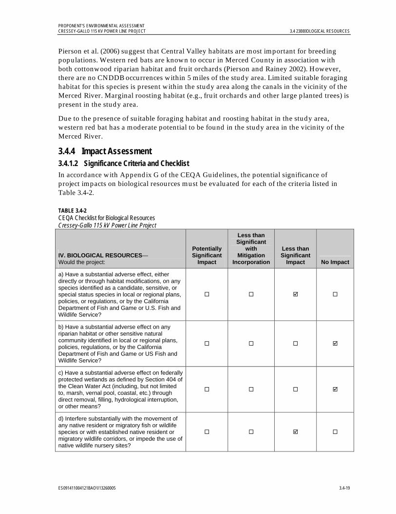
PROPONENT’S ENVIRONMENTAL ASSESSMENT CRESSEY-GALLO 115 KV POWER LINE PROJECT 3.4 23BBIOLOGICAL RESOURCES
ES091411004121BAO\113260005 3.4-19
Pierson et al. (2006) suggest that Central Valley habitats are most important for breeding populations. Western red bats are known to occur in Merced County in association with both cottonwood riparian habitat and fruit orchards (Pierson and Rainey 2002). However, there are no CNDDB occurrences within 5 miles of the study area. Limited suitable foraging habitat for this species is present within the study area along the canals in the vicinity of the Merced River. Marginal roosting habitat (e.g., fruit orchards and other large planted trees) is present in the study area.
Due to the presence of suitable foraging habitat and roosting habitat in the study area, western red bat has a moderate potential to be found in the study area in the vicinity of the Merced River.
3.4.4 Impact Assessment 3.4.1.2 Significance Criteria and Checklist In accordance with Appendix G of the CEQA Guidelines, the potential significance of project impacts on biological resources must be evaluated for each of the criteria listed in Table 3.4-2.
TABLE 3.4-2 CEQA Checklist for Biological Resources Cressey-Gallo 115 kV Power Line Project
IV. BIOLOGICAL RESOURCES— Would the project:
Potentially Significant
Impact
Less than Significant
with Mitigation
Incorporation
Less than Significant
Impact No Impact
a) Have a substantial adverse effect, either directly or through habitat modifications, on any species identified as a candidate, sensitive, or special status species in local or regional plans, policies, or regulations, or by the California Department of Fish and Game or U.S. Fish and Wildlife Service?
b) Have a substantial adverse effect on any riparian habitat or other sensitive natural community identified in local or regional plans, policies, regulations, or by the California Department of Fish and Game or US Fish and Wildlife Service?
c) Have a substantial adverse effect on federally protected wetlands as defined by Section 404 of the Clean Water Act (including, but not limited to, marsh, vernal pool, coastal, etc.) through direct removal, filling, hydrological interruption, or other means?
d) Interfere substantially with the movement of any native resident or migratory fish or wildlife species or with established native resident or migratory wildlife corridors, or impede the use of native wildlife nursery sites?

PROPONENT’S ENVIRONMENTAL ASSESSMENT 3.4 23BBIOLOGICAL RESOURCES CRESSEY-GALLO 115 KV POWER LINE PROJECT
3.4-20 ES091411004121BAO\113260005
TABLE 3.4-2 CEQA Checklist for Biological Resources Cressey-Gallo 115 kV Power Line Project
IV. BIOLOGICAL RESOURCES— Would the project:
Potentially Significant
Impact
Less than Significant
with Mitigation
Incorporation
Less than Significant
Impact No Impact
e) Conflict with any local policies or ordinances protecting biological resources, such as a tree preservation policy or ordinance?
f) Conflict with the provisions of an adopted Habitat Conservation Plan, Natural Community Conservation Plan, or other approved local, regional, or state habitat conservation plan?
3.4.1.3 Applicant Proposed Measures (APMs) PG&E will implement the following APMs to further minimize impacts on biological resources:
APM Biological Resources (BIO)-1: General Avoidance of Biological Resources Impacts. This APM consists of the following components:
Environmental awareness training. Environmental awareness training will be conducted for on-site construction personnel prior to the start of construction activities. The training will explain measures to prevent impacts on nesting birds and special-status species with moderate or high potential to occur in the project area. The training will also include a description of these special-status species and their habitat needs, and an explanation of the status of these species and their protection under the federal ESA, CESA, and other statutes. A brochure will be provided with color photos of sensitive species as well as a discussion of project measures. A copy of the training and brochure will be provided to the CPUC at least 30 days prior to the start of construction. Training logs and sign-in sheets will be provided to CPUC staff. As needed, in-field training will be provided to new on-site construction personnel by a qualified biological monitor who will be identified by the PG&E’s biologist, or initial training will be recorded and replayed for new personnel.
Biological monitoring to avoid impacts near or in potentially sensitive habitat. A qualified biological monitor will be onsite during ground-disturbing construction activities near and in sensitive habitat or resources as defined in the project’s Biological Resources Technical Report and will monitor implementation and compliance with APMs relating to the sensitive habitat. The monitor will have the authority to stop work or implement alternative work practices as determined by PG&E’s biologist in consultation with agencies and construction personnel, as appropriate, if construction activities are likely to impact sensitive biological resources.
Marking of sensitive habitat or resource areas. Sensitive habitat or resources identified during the reconnaissance-level field surveys or pre-construction surveys that are in or adjacent to project work areas, such as occupied burrowing owls burrows, occupied

PROPONENT’S ENVIRONMENTAL ASSESSMENT CRESSEY-GALLO 115 KV POWER LINE PROJECT 3.4 23BBIOLOGICAL RESOURCES
ES091411004121BAO\113260005 3.4-21
migratory bird nests, elderberry shrubs, and seasonal ponded areas, will be either clearly marked or the limits of an adjacent worked will be clearly marked. Project resource maps may be updated to reflect active nest buffers or changes to the resources adjacent to work areas based on pre-construction survey findings. Such areas will be avoided during construction and additional measures (described below) will be implemented to further avoid impacts.
Litter and trash management. All food scraps, wrappers, food containers, cans, bottles, and other trash from the project area will be deposited in closed trash containers. Trash containers will be removed from the project area at the end of each working day.
Parking. Vehicles and equipment will be parked on pavement, existing roads, and previously disturbed or developed areas or work areas as identified in this document. Off-road parking will only be permitted in previously identified and designated work areas.
Route and work area limitations. Vehicles will be confined to established roadways and pre-approved access roads, overland routes and access areas. Access routes and construction work areas will be limited to the minimum necessary to achieve the project goals.
Maintenance and refueling. All equipment will be maintained such that there will be no leaks of automotive fluids such as fuels, solvents, or oils. All refueling and maintenance of vehicles and other construction equipment will be restricted to designated staging areas located at least 100 feet from any down gradient aquatic habitat unless otherwise isolated from habitat (please see APM WQ-1 in Section 3.8.4.2). Proper spill prevention and cleanup equipment will be maintained in all refueling areas.
Pets and firearms. No pets or firearms will be permitted at the project site.
APM BIO-2: Pre-construction Nesting Surveys. If construction is to occur during the avian nesting season (February 1 through August 31), a pre-construction migratory bird and raptor nesting survey will be performed by a qualified biologist in accordance with CDFG survey guidelines. No additional measures will be implemented if active nests are more than the following distances from the nearest work site: (a) 300 ft for raptors, or (b) 75 feet for passerine birds (or as otherwise agreed to by USFWS and CDFG). If active nests are closer than those distances to the nearest work site, then an appropriate nest protection zone will be established by a qualified biologist and the active nest(s) will be monitored for signs of disturbance. Factors to be considered include intervening topography, roads, development, type of work, visual screening from the nest, nearby noise sources, etc. Buffers will not apply to construction-related traffic using existing roads that are not limited to project-specific use (i.e., county roads, highways, farm roads, etc.). Consideration will also include timing of nesting (i.e., if the bird nests in the project area during actual construction). If the biologist determines that a disturbance is occurring and/or if nesting raptors are identified in areas susceptible to disturbance from construction activities, PG&E will consult with the USFWS and CDFG to determine the specific buffer zone to be maintained for that nest.
APM BIO-3: Swainson’s Hawk Surveys. Swainson’s hawk surveys will be conducted according to Swainson’s Hawk Technical Advisory Committee (2000) suggested protocol.
PROPONENT’S ENVIRONMENTAL ASSESSMENT 3.4 23BBIOLOGICAL RESOURCES CRESSEY-GALLO 115 KV POWER LINE PROJECT
3.4-22 ES091411004121BAO\113260005
To meet CDFG’s recommendations for avoidance and protection of Swainson’s hawks, surveys will be conducted for a 0.5-mile radius around all project activities where access is available (e.g., on public land, along public roads, etc.). If active nesting is identified in an area susceptible to disturbance from active construction activities, PG&E will discuss the occurrence with CDFG. Surveys will be completed during at least two of the survey periods identified in the protocol (January through March 20, March 20 through April 5, April 5 through April 20, and/or June 10 through July 30) immediately prior to the project’s initiation. Surveys will not be conducted between April 21 and June 10 because this is during the nesting phase when nests are difficult to locate, and CDFG does not typically consider this a valid survey period.
APM BIO-4: Burrowing Owl Surveys. Within burrowing owl habitat that is subject to disturbance from project construction activities, pre-construction burrowing owl surveys will be conducted by a qualified biologist from the project ROW observing up to 250 feet from construction work areas. Burrowing owl surveys will follow the CDFG’s Burrowing Owl Protocol Survey and Mitigation Guidelines (California Burrowing Owl Consortium 1993) as permitted by access and will occur between February 1 and August 31. If ground-disturbing activities are delayed or suspended for more than 30 days after the pre-construction surveys, the site will be resurveyed. If no burrowing owl activity is detected, no further surveys are necessary.
No disturbance will occur within approximately 150 feet of occupied burrows during the non-breeding season of September 1 through January 31, or within approximately 250 feet during the breeding season of February 1 through August 31. The limits of the exclusion zone in the project site will be clearly marked with signs, flagging, or fencing. If construction activity within these limits is unavoidable while burrows are active, work will only take place within the presence of a qualified monitor who will determine whether the owls show signs of disturbance. If signs of disturbance from construction activities occur, then appropriate avoidance and minimization will be determined in consultation with CDFG .
A passive relocation effort (displacing the owls from the work area) may be conducted during the non-breeding season (September 1 through January 31). A plan will be drafted and provided to CDFG before passive relocation occurs. Passive relocation will include installing one-way doors on the entrances of burrows. The one-way doors will be left in place for 48 hours to allow owls to vacate the nest site. Owls will not be relocated during the breeding season.
APM BIO-5: Trenches and Excavations Design and Inspection. All excavations in excess of 2 feet deep will be sloped, have escape ramps installed that are suitable for the escape of the Blainville’s horned lizard and other wildlife or be thoroughly covered at the end of the day. All trenches and excavations will be inspected for wildlife at the beginning of the work day and prior to backfilling. If a special-status species is discovered in a trench or excavation, work in the area will be redirected, and the special-status species will be allowed to leave the trench and the area of its own accord. In the event any special-status species is trapped in a trench or an excavation and unable to leave on its own accord, the USFWS and the CDFG will be contacted by the PG&E biologist unless the PG&E biologist identifies an individual with appropriate permits (for example, a CDFG collecting permit) to relocate the special-status species.
PROPONENT’S ENVIRONMENTAL ASSESSMENT CRESSEY-GALLO 115 KV POWER LINE PROJECT 3.4 23BBIOLOGICAL RESOURCES
ES091411004121BAO\113260005 3.4-23
APM BIO-6: Open-ended Pipe Covers and Inspection. Open-ended project-related pipes 4 inches or greater in diameter will be capped if left overnight or inspected for wildlife prior to being moved. If a special-status species is discovered in a pipe, the animal will be left undisturbed, and the pipe will not be moved until the special-status species has left the pipe and the area of its own accord. In the event any special-status species is trapped in an open pipe and unable to leave on its own accord, the USFWS and the CDFG will be contacted by the PG&E biologist unless the PG&E biologist identifies an individual with appropriate permits (for example, a CDFG collecting permit) to relocate the special-status species.
APM BIO-7: Valley Elderberry Longhorn Beetle Habitat Protection and Avoidance. The project is designed to avoid elderberry plants during construction. When activities are conducted in an area of potential VELB habitat, a qualified individual, as determined by the PG&E biologist, will use project documented elderberry shrub data and review the presence of elderberry plants within a minimum of 25 feet from the worksite. Potential impacts to elderberry plants with one or more stems measuring 1 inch or more in diameter at ground level will be avoided by the qualified individual flagging the plant or the limits of the nearby work area. No work will occur within the flagged buffer zone.
During operations and maintenance, if impacts (pruning/trimming, removal, ground disturbance, or damage) are unavoidable or occur, then additional measures identified in the PG&E VELB conservation plan in Appendix D of the PG&E San Joaquin Valley Operations & Maintenance HCP (Jones and Stokes 2006b), and compliance brochure will be implemented. The VELB compliance brochure must be carried in all operation and maintenance vehicles performing activities within the potential range of VELB.
Construction Impacts Modification of the substations will occur in areas that are already disturbed or heavily managed. All work on Cressey Substation will occur within the existing fenced area. The Gallo Substation footprint will be expanded into an area that is currently paved. Vegetation that will be affected is limited to Gallo winery landscaping.
Line construction work areas will require some vegetation removal, but this will be limited to one row of almond trees, possibly removal or trimming of individual orchard trees, and fire hazard reduction vegetation management in ROW. Some vegetation mowing or trimming may be required for construction vehicle and equipment access. Tree trimming and removal will be avoided where feasible.
The following discussion evaluates potential project construction impacts on biological resources using the CEQA Checklist significance criteria.
a) Would the project have a substantial adverse effect, either directly or through habitat modifications, on any species identified as a candidate, sensitive, or special status species in local or regional plans, policies, or regulations, or by the California Department of Fish and Game or U.S. Fish and Wildlife Service? Less than significant impact.
The implementation of APMs BIO-1 through BIO-7 and APM WQ-1 (see Section 3.8.4.2) will further reduce potential project-related permanent and temporary less-than-significant impacts to special-status species. It is very unlikely that a direct take of a special-status species through habitat loss or modification will occur as the project is located in disturbed roadside areas or active agricultural areas.

PROPONENT’S ENVIRONMENTAL ASSESSMENT 3.4 23BBIOLOGICAL RESOURCES CRESSEY-GALLO 115 KV POWER LINE PROJECT
3.4-24 ES091411004121BAO\113260005
One special-status plant species, Sanford’s arrowhead, may occur in irrigation canals within the project area, but no project-related work will occur in canals and no adverse affects will occur to this species.
Habitat for ten special-status wildlife species occurs within the study area. The VELB may occur wherever their host plant, elderberry shrubs with stems greater than 1 inch at base, are found (elderberry shrubs are documented in the eastern part of the study area). The project will be designed to avoid permanent and temporary impact to the documented locations of this host plant. New pole locations and pole work areas will be located at least 25 feet from the document elderberry shrubs with stems greater than 1 inch at base (Figure 3.4-2). Construction work conducted within Cressey Substation will avoid direct impacts to nearby host plants; construction will not alter the condition of the elderberry shrubs. Pre-construction flagging will mark the limits of the work area(s) to avoid impacts to elderberry shrubs (APM BIO-1 and APM BIO-7).
Swainson’s hawk, burrowing owl, loggerhead shrike, mountain plover, white-tailed kite, and western red bat likely occasionally use the study area for foraging, roosting, or nesting. Pre-construction surveys and the establishment of nest buffers will avoid impacts to this wildlife (APM BIO-1, APM BIO-2, APM BIO-3, APM BIO-4, and APM BIO-6). Aquatic habitats throughout the study area provide potential habitat for western spadefoot toad and western pond turtle. Project work will not occur in aquatic habitats and the project is designed to avoid impacts to aquatic habitats (APM BIO-1 and APM WQ-1).
Marginal habitat for the Blainville’s horned lizard occurs in sandy soils. Pre-construction surveys of work areas and flagging the limits of the work area when work occurs near or in potential marginal habitat will avoid impacts to Blainville’s horned lizard (APM BIO-1).
Construction activities (such as elevated noise, human activity, and ground vibrations) may have minor, short-term impacts on wildlife or habitat, resulting in less than significant impacts on wildlife populations. Potential direct impacts may occur when species come into contact with equipment and construction workers. Given the generally marginal habitat for sensitive wildlife in the areas of construction, direct impacts will be less than significant. APM BIO-1 through BIO-7 and APM WQ-1 will further minimize potential less-than-significant impacts.
b) Would the project have a substantial adverse effect on any riparian habitat or other sensitive natural community identified in local or regional plans, policies, regulations, or by the California Department of Fish and Game or U.S. Fish and Wildlife Service? No impact.
No riparian habitat or sensitive natural community types are present in the study area. The Merced River riparian corridor is the closest riparian habitat to the project; it is located approximately 0.26 mile north of Gallo Substation and will not be affected by the project. No impacts will occur to riparian habitat or other sensitive natural community.

PROPONENT’S ENVIRONMENTAL ASSESSMENT CRESSEY-GALLO 115 KV POWER LINE PROJECT 3.4 23BBIOLOGICAL RESOURCES
ES091411004121BAO\113260005 3.4-25
c) Would the project have a substantial adverse effect on federally protected wetlands as defined by Section 404 of the Clean Water Act (including, but not limited to, marsh, vernal pool, coastal, etc.) through direct removal, filling, hydrological interruption, or other means? No impact.
Project design will avoid impacts to potential wetlands in the project area. No removal, filling or other hydrologic alteration wetlands or other aquatic resources will occur.
d) Would the project interfere substantially with the movement of any native resident or migratory fish or wildlife species or with established native resident or migratory wildlife corridors, or impede the use of native wildlife nursery sites? Less than significant impact.
No wildlife connectivity areas or linkage corridors were identified within 5 miles of the project area (USFWS 1998, CDFG 2011c). The project route follows the alignment of existing distribution lines and communication lines along roads or through active orchards. Cressey Substation will be modified within the existing substation property. Gallo Substation will be expanded onto a paved area within an active winery facility. Temporary construction-related impacts (such as elevated noise, human activity, and ground vibrations) may have a minor, short-term impact on wildlife foraging and nesting, but any potential impacts will be less than significant. The implementation of APMs BIO-1 through BIO-7 and APM WQ-1 will further reduce potential less-than-significant impacts.
e) Would the project conflict with any local policies or ordinances protecting biological resources, such as a tree preservation policy or ordinance? No impact.
The project design and permitting are compatible with the Merced County General Plan’s relevant goals addressing habitat protection and coordination with public and private sectors to protect biological resources. Merced County does not have a tree preservation policy or ordinance applicable to this project.
f) Would the project conflict with the provisions of an adopted Habitat Conservation Plan, Natural Community Conservation Plan, or other approved local, regional, or state habitat conservation plan? No impact.
Project construction is not covered by the operation and maintenance activities of the PG&E San Joaquin Valley Operations & Maintenance HCP (the only relevant habitat conservation plan). Biological resource APMs are compatible with the conditions of the HCP AMMs. No construction impacts will occur.
3.4.1.4 Operation and Maintenance Impacts Operation and maintenance for the proposed project will not change from the existing operation and maintenance activities associated with Cressey and Gallo substations and distribution lines along the project route. PG&E will continue to implement the PG&E San Joaquin Valley Operations & Maintenance HCP during operation and maintenance activities (Jones and Stokes 2006b). Areas where no distribution line currently exists (approximately 20 percent of the project route) are in disturbed roadside areas or in active orchards. The annual maintenance for the power line will occur in the same manner as the current annual maintenance of the distribution lines. Potential impacts will not occur.
PROPONENT’S ENVIRONMENTAL ASSESSMENT 3.4 23BBIOLOGICAL RESOURCES CRESSEY-GALLO 115 KV POWER LINE PROJECT
3.4-26 ES091411004121BAO\113260005
3.4.5 References Barr, C. B. 1991. The Distribution, Habitat and Status of the Valley Elderberry Longhorn Beetle
Desmocerus californicus demorphus Fisher (Insecta: Coleoptera: Cermabycidae). U.S. Fish and Wildlife Service, Sacramento, CA.
California Burrowing Owl Consortium. 1993. Burrowing Owl Survey Protocol and Mitigation Guidelines. Online: http://www.dfg.ca.gov/wildlife/nongame/docs/boconsortium.pdf.
California Department of Fish and Game (CDFG). 2008. California Wildlife Habitat Relationships System (Version 8.2 Software and Manual).
_______. 2011a.California Natural Diversity Database (RareFind3, version 3.0.5). Electronic database. Sacramento, CA.
_______. 2011b. Special Animals (898 taxa). Biogeographic Data Branch. California Natural Diversity Database. Online: http://www.dfg.ca.gov/biogeodata/cnddb/pdfs/spanimals.pdf. January.
_______. 2011c. BIOS Essential Habitat Connectivity database. February.
_______. 2011d. California Natural Diversity Database. Quickviewer online database. Online: http://imaps.dfg.ca.gov/viewers/cnddb_quickviewer/app.asp
California Native Plant Society (CNPS). 2011. Inventory of rare and endangered plants of California (online edition, version 6.3). Online: http://www.cnps.web.aplus.net/cgi-bin/inv/inventory.cgi
City of Merced. 2006. Wastewater Treatment Plant Expansion Project. Draft Environmental Impact Report.
Estep, J. A. 1989. Biology, Movements, and Habitat Relationships of the Swainson’s Hawk in the Central Valley of California, 1986-1987. California Department of Fish and Game. Sacramento, CA.
Garcia and Associates (GANDA). 2011. Biological Resources Technical Report, Cressey-Gallo 115 kV Power Line Project, Merced County, California. Prepared for Pacific Gas & Electric Company. September.
Holland, D. C. 1994. The Western Pond Turtle: Habitat and History. Final Report for Bonneville Power Administration and Oregon Department of Fish and Wildlife.
Holland, R. F. 1986. Preliminary Descriptions of the Terrestrial Natural Communities of California. California Department of Fish and Game. Unpublished report.
Huddleston, R. 2011. Personal communication regarding Sanford’s arrow (Sagittaria sanfordii) being detected in a ditch during the Merced to Fresno High Speed Rail plant surveys. Mr. Huddleston, a CH2M HILL biologist, indicated that CNDDB forms were filled out but may have not been submitted yet or the data not entered into the system yet. (Phone conversation June 1, 2011).
PROPONENT’S ENVIRONMENTAL ASSESSMENT CRESSEY-GALLO 115 KV POWER LINE PROJECT 3.4 23BBIOLOGICAL RESOURCES
ES091411004121BAO\113260005 3.4-27
Jennings, M. R. and M. P. Hayes. 1994. Amphibian and reptile species of special concern in California. California Department of Fish and Game. Rancho Cordova 255 pp.
Jepson Online Interchange. 2010. An online database for California floristics. Online: http://ucjeps.berkeley.edu/interchange.html
Jones and Stokes. 2006a. Draft Environmental Impact Statement/Environmental Impact Report Pacific Gas and Electric Company San Joaquin Valley Operations and Maintenance Program Habitat Conservation Plan. March. http://www.fws.gov/sacramento/es/documents/PGE_O&M_draft_HCP/PGE_SJ_Valley_draft_HCP_EIS-EIR.htm
Jones and Stokes. 2006b. Pacific Gas & Electric Company San Joaquin Valley Operations and Maintenance Habitat Conservation Plan (includes updated Chapter 4 and Tables 5-3, 5-4 and 5-5, December 2007). December. (J&S 02-067.) Sacramento, CA.
Kaufman, K. 1996. Lives of North American Birds. Houghton Mifflin Company, New York, New York. 675 pp.
Laabs, D. M., S. G. Orloff and M. L. Allaback. 2002. Chapter 5, Pond and Stream-breeding Amphibians. Pg. 191-229 in J.E. Vollmar (Ed). Wildlife and Rare Plant Ecology of Eastern Merced County’s Vernal Pool Grasslands.
Merced County. 1989. Merced County Year 2000 General Plan, Including Revisions Resulting from the Phase II Policy Update. Online: http://www.co.merced.ca.us/documents/Planning_and_Community_Development/General_Plan/Complete%20Document.PDF
Merced County. 2011. Merced County General Plan Policies; Planning Commission Review Draft. Online: http://www.co.merced.ca.us/index.aspx?NID=100
Morey, S. R. and D. A. Guinn. 1992. “Activity patterns, food habits, and changing abundance in a community of vernal pool amphibians.” Pages 149-158 In: D.F. Williams, S. Byrne and T. A. Rado (editors), Endangered and sensitive species in the San Joaquin Valley, California: Their biology, management, and conservation. The California Energy Commission, Sacramento, California, and the Western Section of the Wildlife Society.
Nicholson, B. 2011. Personal communication via email with Pam Spinelli/GANDA regarding the two versions of the Merced County General Plan. Ms. Spinelli emailed Mr. Nicholson, listed as the contact person on the Merced County website, to inquire as to whether the “Planning Commission Review Draft” was the current guiding document for the County. Mr. Nicholson responded that no, the County is working under the older, 1989, plan. He provided Ms. Spinelli with a link to the 1989 plan. (June 28-30, 2011 email correspondence).
Noss, R., R. Amundson, M. Barbour, R. Bugg, B. Cypher, R. Grosberg. T. Hanes, R. Hansen, B. Pavlik, K. Rice, P. Trenham, B. Shaffer, and B. Weir. 2002. Eastern Merced County Natural Community Conservation Plan Habitat Conservation Plan.
Orloff, S. G. 2002. Chapter 6, Aquatic Reptiles. Pg. 233-252 in J.E. Vollmar (Ed). Wildlife and Rare Plant Ecology of Eastern Merced County’s Vernal Pool Grasslands.

PROPONENT’S ENVIRONMENTAL ASSESSMENT 3.4 23BBIOLOGICAL RESOURCES CRESSEY-GALLO 115 KV POWER LINE PROJECT
3.4-28 ES091411004121BAO\113260005
Pierson, E. D. W. E. Rainey, and C. Corben. 2000. Distribution and status of red bats, Lasiurs blossevillii in California. Report to Species Conservation and Recovery Program, Habitat Conservation Planning Branch, California Department of Fish and Game, Sacramento, CA. 40 pp.
Pierson, E. D. and W.E. Rainey. 2002. Chapter 10, Bats. Pg. 385-400 in J.E. Vollmar (Ed). Wildlife and Rare Plant Ecology of Eastern Merced County’s Vernal Pool Grasslands.
Pierson, E. D., W. E. Rainey and C. Corben. 2006. Distribution and status of Western red bats (Lasiurus blossevillii) in California. California Dept. of Fish and Game, Habitat Conservation Planning Branch, Species Conservation and Recovery Program Report 2006-04, Sacramento, CA 45 pp.
Reid, F. A. 2006. Mammals of North America, Fourth Edition. Houghton Mifflin, Boston.
Schlorff, R. W. and P. H. Bloom. 1984. Importance of riparian systems to nesting Swainson’s hawks in the Central Valley of California. Pp. 612-618 in R.W. Warner and K.M. Hendrix (Eds.). California riparian systems – ecology, conservation, and productive management. University of California Press. Berkeley, CA.
Semlitsch, R. D. and J. R. Brodie. 2003. “Biological criteria for buffer zones around wetlands and riparian habitats for amphibians and reptiles.” Conservation Biology 17(5): 1219-1228.
Sloat, T. R. and E. D. Whisler. 2002. Chapter 7, Birds. Pg. 253-285 in J.E. Vollmar (Ed). Wildlife and Rare Plant Ecology of Eastern Merced County’s Vernal Pool Grasslands.
Stebbins, R. C. 2003. Western Reptiles and Amphibians, Third Edition. Houghton Mifflin, Boston.
Swainson’s Hawk Technical Advisory Committee. 2000. Recommended Timing and Methodology for Swainson's Hawk Nesting Surveys in California's Central Valley. Online: http://www.dfg.ca.gov/wildlife/nongame/docs/swain_proto.pdf.
United States Fish and Wildlife Service (USFWS). 1998. Recovery Plan for Upland Species of the San Joaquin Valley, California. Region 1, Portland, OR. 319 pp.
_______. 2011. Endangered Species Program Website. Online: www.fws.gov/sacramento/es/spp_lists/auto_list_form.cfm January.
Vollmar, J. E. 2002. Wildlife and Rare Plant Ecology of Eastern Merced County’s Vernal Pool Grasslands.
Yosef, R. 1996. Loggerhead shrike (Lanius ludovicianus) in A. Poole and F. Gill (Eds.). The Birds of North America, Number 231. The Academy of Natural Sciences, Philadelphia, PA, and The American Ornithologists’ Union, Washington, D.C.

PROPONENT’S ENVIRONMENTAL ASSESSMENT CRESSEY-GALLO 115 KV POWER LINE PROJECT 3.5 24BCULTURAL RESOURCES
ES091411004121BAO\113260005 3.5-1
3.5 Cultural Resources 3.5.1 Introduction and Methodology This section presents the methods and results of a cultural resources study of the project area, including pre-field research, Native American consultation, an assessment of sensitivity for buried archaeological deposits, and a field inventory of the project area. Cultural resources types within the project area include historic period sites. This study concludes that impacts on cultural resources will be less than significant. Incorporation of the APMs described in Section 3.5.4.2 will further minimize potential project less-than-significant impacts on cultural resources.
Paleontological resources are evaluated in Section 3.6, Geology and Soils, Mineral Resources, and Paleontological Resources.
3.5.1.1 Pre-field Research
Records Search. A records search for the project area was conducted by research staff at the Central California Information Center (CCIC) of the California Historical Resources Information System (CHRIS) at California State University, Stanislaus on January 4, 2011. The results of the records search indicate that 28 previous cultural resources investigations have been completed within a 0.25-radius of the project area, eight of which have been completed within the project area. These studies resulted in the identification of eight previously recorded cultural resources and numerous unrecorded canal segments within the project area. All of the known cultural resources are historic-period resources and include canals, railroads, buildings, land parcels, and ranch complexes. The project area contains no cultural resources listed in the National Register of Historic Places (NRHP), the California Register of Historical Resources (CRHR), California Points of Historical Interest, or California State Historic Landmarks. In addition, the records search did not result in the identification of any prehistoric archaeological sites within a 0.25-mile radius of the project area.
Archival Research. Archival research was conducted at the Merced Irrigation District‘s main office in Merced, the Merced County Library in Merced, and the Kolligian Library at the University of California, Merced to review primary and secondary resources regarding the history of the project area. Topics of research included the communities of Livingston and Cressey as well as Merced County, with a particular emphasis on the history of the Merced Irrigation District, irrigated farming, and early twentieth century agricultural colonies such as Yamato Colony. In addition, letters were sent to local historical societies in an effort to identify sites, resources, or locations of cultural or historical importance. Letters and a project map were sent on January 18, 2011 to the following organizations: Milliken Museum, Atwater Historical Society, Castle Air Museum, Gustine Museum, Merced County Courthouse Museum, Merced County Genealogical Society, Livingston Historical Museum, Filipino/American National Historical Society, and Southern Pacific Historical and Technical Society.
Native American Consultation. As part of the consultation process with Native American organizations and individuals, the California Native American Heritage Commission (NAHC) was contacted on December 21, 2010, with a request for information about the potential existence of sacred lands that may be within the project area, and a list of
PROPONENT’S ENVIRONMENTAL ASSESSMENT 3.5 24BCULTURAL RESOURCES CRESSEY-GALLO 115 KV POWER LINE PROJECT
3.5-2 ES091411004121BAO\113260005
interested Native American groups and individuals for Merced County. A search of the Sacred Lands Files housed at the NAHC did not result in the identification of any known sacred lands within the project area. On January 18, 2011, a letter was sent to each of the following groups listed by the NAHC:
Southern Sierra Miwuk Nation Northern Valley Yokuts Tribe Amaha Mustun Tribal Band
Follow-up phone calls were made on February 2, 2011 to each of the listed individuals/groups. To date, no follow-up phone calls or consultation letters have resulted in responses from any of the Native American tribes or individuals contacted. Copies of correspondence on this issue and a summary of follow-up contacts are included in Appendix D.
Buried Site Sensitivity Analysis. The project area is situated within the Pleistocene-age Modesto Formation (m). These deposits, which have well-developed soil profiles, are generally described as large dissected fans, forming steep terraces along streams and rivers (Rosenthal and Meyer 2004). The upper Modesto Formation (m) deposits, which encompass the majority of the project area, tend to be less weathered (i.e. younger) in comparison to Riverbank Formation deposits (r3), which comprise a very small portion of the project area.
Rosenthal and Meyer (2004) examined topography, subsurface exposures, soils series, and geologic maps to better understand the existing stratigraphic framework for Modesto and post-Modesto deposits in the Central Valley. The results of their field investigations suggest that early mapping is problematic when tested against soil samples and dates obtained from various localities. Rosenthal and Meyer (2004) inspected Modesto Formation strata along the Tuolumne River, east of Modesto, and noted Tujunga sandy loam within the upper units. Existing maps depict Tujunga soils as late Pleistocene in age; however Rosenthal and Meyer have identified Tujunga soils within late Holocene landforms as well. The presence of younger soils in previously mapped Pleistocene-age landforms also appears east of Merced, where a radiocarbon date of A.D. 1415 was obtained below the surface of an upper Modesto Formation. The importance of this discovery reveals that “some previously mapped Pleistocene-age landforms are capped by localized areas of unmapped Holocene-aged deposits” (Rosenthal and Meyer 2004).
While the project area is situated within the previously mapped Pleistocene-age Modesto Formation, approximately 75 percent of this is mapped as upper Modesto Formation. It is possible that portions of the project area, currently mapped as Pleistocene in age, may be overlain with unmapped buried Holocene-age deposits, as suggested by similar findings in Merced County by Rosenthal and Meyer (2004).
The project area has a low sensitivity for the presence of buried prehistoric archaeological deposits because the antiquity of the underlying Pleistocene landforms (older than 13,500 years before present) is too old to contain prehistoric archaeological remains. In addition, there is a low sensitivity for the presence of prehistoric archaeological sites due to the significant level of agricultural disturbances and the absence of documented prehistoric archaeological sites.

PROPONENT’S ENVIRONMENTAL ASSESSMENT CRESSEY-GALLO 115 KV POWER LINE PROJECT 3.5 24BCULTURAL RESOURCES
ES091411004121BAO\113260005 3.5-3
Field Inventory. An intensive pedestrian survey was completed by GANDA archaeologists in May 2011. The two-person crew completed the survey by walking two parallel, 60-foot-wide transects on either side of the approximately14.4-mile proposed route. Archaeologists systematically inspected all exposed soils within the project area where feasible. Ground visibility varied from full exposure to highly obscured, depending on factors including vegetation, infrastructure, agricultural crops, and landowner restrictions. Visibility was excellent in areas where agricultural fields had been recently tilled and disturbed, and in areas where grazing was ongoing. Orchards, which comprised a large portion of the project area, allowed for moderate visibility around trees, intermittently disturbed by sparse patches of annual grasses and forbs. Roadside conditions were often dominated by tall grasses and vegetation, providing little ground visibility overall. Some areas could not be surveyed due to landowner restrictions, fumigated fields, or dense agricultural vegetation.
A total of 14 cultural resources were identified within the project area during the pedestrian survey (as summarized below in Section 3.5.3.4, Known Cultural Resources in the Project Area). Out of the 14 resources, eight were previously identified and six were newly identified. The project area contains no cultural resources listed in the NRHP, the CRHR, California Points of Historical Interest, or California State Historic Landmarks. In addition, the pedestrian survey did not result in the identification of any prehistoric archaeological sites within the project area.
3.5.2 Regulatory Background 3.5.2.1 Federal Regulations There are no federal regulations applicable to the project related to cultural resources. Section 106 of the National Historic Preservation Act does not apply because there is no federal agency discretionary action required for the project.
3.5.2.2 State Regulations
CEQA and the California Register of Historical Resources (CRHR). The California Environmental Quality Act (CEQA), encoded in Sections 21000 et seq. of the Public Resources Code (PRC), with Guidelines for implementation codified in CCR Title 14, Chapter 3, Sections 15000 et seq., requires state and local public agencies to identify the environmental impacts of proposed discretionary activities or projects, determine whether the impacts will be significant, and identify alternatives and mitigation measures that will substantially reduce or eliminate significant impacts to the environment. Under CEQA, the environment includes archaeological or historical resources.
Under Section 21083.2 of CEQA, an important archaeological or historical resource is an object, artifact, structure, or site that is listed on, or eligible for listing on, the CRHR. Eligible resources are those that can be clearly shown to meet any of the following criteria:
1. Is associated with events that have made a significant contribution to the broad patterns of California’s history and cultural heritage
2. Is associated with the lives of persons important in our past
3. Embodies the distinctive characteristics of a type, period, region, or method of construction, or represents the work of an important creative individual, or possesses high artistic value
PROPONENT’S ENVIRONMENTAL ASSESSMENT 3.5 24BCULTURAL RESOURCES CRESSEY-GALLO 115 KV POWER LINE PROJECT
3.5-4 ES091411004121BAO\113260005
4. Has yielded, or may be likely to yield, information important in prehistory or history
Automatic listings include properties that are listed in the National Register of Historic Places, that have been determined eligible either by the Keeper of the National Register or through a consensus determination on a project review, or that are State Historical Landmarks from Number 770 onward. In addition, Points of Historical Interest nominated from January 1998 onward are to be jointly listed as Points of Historical Interest and in the CRHR. Landmarks prior to Number 770 and Points of Historical Interest that were nominated prior to 1998 may be listed through an action of the State Historical Resources Commission.
Resources listed in a local historic register or deemed significant in a historical resources survey, as provided under PRC Section 5024.1(g), are presumed to be historically or culturally significant unless the preponderance of evidence demonstrates that they are not. A resource that is not listed on or determined to be ineligible for listing on the CRHR, not included in a local register of historical resources, or not deemed significant in a historical resources survey may nonetheless be historically significant (PRC Section 21084.1 and Section 21098.1).
California Health and Safety Code and Public Resources Code. Broad provisions for the protection of Native American cultural resources are contained in the California Health and Safety Code, Division 7, Part 2, Chapter 5 (Sections 8010 through 8030). In addition, the federal Native American Graves Protection and Repatriation Act (NAGPRA) has established a state-level policy to ensure that California Native American human remains and cultural items are treated with respect and dignity. NAGPRA also provides the mechanism for disclosure and return of human remains and cultural items held by publicly funded agencies and museums in California, and outlines the process that non-federally recognized California Native American tribes can use to file claims for the repatriation of human remains and associated cultural items held by agencies or museums.
Several provisions of PRC also govern archaeological finds of human remains or other related objects of archaeological or historical interest or value. Procedures are detailed under PRC Section 5097.9 through 5097.996 for actions to be taken whenever Native American remains are discovered. Furthermore, Section 7050.5 of the California Health and Safety Code states that any person who knowingly mutilates or disinters, wantonly disturbs, or willfully removes human remains in or from any location other than a dedicated cemetery without authority of law is guilty of a misdemeanor, except as provided in Section 5097.99 of the PRC. Any person removing human remains without authority of law or written permission of the person or persons having the right to control the remains under PRC Section 7100 has committed a public offense that is punishable by imprisonment.
3.5.2.3 Local Regulations This public utility project is not subject to local regulations. Based on the background research conducted for this project, there are no cultural resources designated for local listing.

PROPONENT’S ENVIRONMENTAL ASSESSMENT CRESSEY-GALLO 115 KV POWER LINE PROJECT 3.5 24BCULTURAL RESOURCES
ES091411004121BAO\113260005 3.5-5
3.5.3 Environmental Setting 3.5.3.1 Prehistory Rosenthal et al. (2007) note that archaeology in the Central Valley suffers from a lack of modern research, large-scale destruction of sites from agriculture and development, and natural processes of landscape evolution that probably have buried or destroyed the oldest archaeological sites. Partly for these reasons, the prehistory of the San Joaquin Valley is not well understood. Most archaeologists working in the Fresno region have had to fall back on cultural chronologies that were developed many decades ago and that have rarely been rigorously tested or refined.
Rosenthal and his colleagues chose to apply a more general scheme based largely on the work of James Bennyhoff and David A. Fredrickson. This chronology includes five periods: Paleo-Indian, Lower Archaic, Middle Archaic, Upper Archaic, and Emergent. Ethnographic and historical periods are discussed following the five-period chronology. The following overview is adapted from Rosenthal et al. 2007 (pp. 150-159).
Paleo-Indian (11,550 to 8550 B.C.). The spread of human occupation into the Central Valley regions is first documented during the Paleo-Indian period. According to Rosenthal et al. (2007) evidence of human occupation within the Central Valley and around the Tulare Lake Basin area of southern San Joaquin Valley is limited to isolated occurrences. However, basally thinned and fluted projectile points (often compared to Clovis points) are recorded along the shores of pluvial lakes and other waterways (2007), including the Wolfsen mound site (CA-MER-215). In southern San Joaquin Valley, at the Witt site (CA-KIN-32), hundreds of early concave base points were recovered along a remnant Late Pleistocene shoreline (Tulare Lake), including human bone fragments and extinct fauna. However, there has been no confirmed association between the projectile points and bones (Rosenthal et al. 2007).
Lower Archaic (8550 to 5550 B.C.). Similar to the Paleo-Indian period, archaeological discoveries from the Lower Archaic Period are isolated. Within the Los Vaqueros watershed, archaeologists obtained a radiocarbon date of 7920 B.C. from a charcoal sample in the deepest component of CA-CCO-696, which also contained a wide-stemmed projectile point of Napa obsidian, and plant remains including acorns and wild cucumbers (Meyer and Rosenthal 1997). The earliest documented human remains in west central California were recovered during this time period at the Los Vaqueros Reservoir site (CA-CC0-637), which yielded a radiocarbon date of 6570 B.C. (Milliken et al. 2007). Artifacts recovered in these sites include handstones, milling slabs, and various cobble tools.
Middle Archaic (5550 to 550 B.C). Distinct cultural adaptations for the valley floor and foothills are demonstrated in sites dating to the Middle Archaic period. Artifact assemblages for the foothill tradition are composed of flaked stone dart points and cobble tools, similar to those of the Lower Archaic. Tabular pendants, incised slate, and perforated stone plummets are rare, but have been identified across a broad geographical area. Middle Archaic sites are also characterized by rock-filled hearths and ovens and “cairn capped” graves (Rosenthal et al. 2007).
Middle Archaic sites of the valley tradition are fairly well represented in the archaeological record. The accepted Middle Archaic archaeological manifestation (Rosenthal et al. 2007) is considered to be the Windmiller Pattern. However, the advent, spatial distribution, and

PROPONENT’S ENVIRONMENTAL ASSESSMENT 3.5 24BCULTURAL RESOURCES CRESSEY-GALLO 115 KV POWER LINE PROJECT
3.5-6 ES091411004121BAO\113260005
variation across the regional landscape of the Windmiller Pattern are not clearly defined at this time. Situated in riverine, marshland or valley floor settings, as well as on small knolls above prehistoric seasonal floodplains, most Windmiller Pattern sites contain ventrally extended burials that are oriented to the west. These sites generally contain large amounts of mortuary artifacts which indicate social hierarchy, and often include large projectile points and a variety of fishing gear such as net weights, bone hooks, and spear points. The presence of faunal remains throughout the archaeological record suggests a hunting economy that included both large and small mammals.
The high frequency of mortars and pestles in delta area sites indicates a shift to a more intensive subsistence strategy. However, the types of plant foods that the population was procuring did not change during this time period; it was simply the method used to process the resources that changed, which increased efficiency and may have allowed for a more sedentary lifestyle (Rosenthal et al. 2007). There is archaeological evidence for the advent of other technologies such as cordage, twined basketry, basketry awls, simple pottery and other baked clay objects, stone plummets, bird bone tubes, and shell beads in the Middle Archaic sites. The presence of exotic items, such as obsidian and shell ornaments, points to a complex exchange system with other native groups throughout California.
Upper Archaic (550 B.C to A.D. 1100). The Upper Archaic is characterized by a large and varied assemblage of bone and antler objects. These include sweat scrapers or “ceremonial wands,” beaver mandibles, tubes, whistles, incised gaming pieces, perforated needles, atlatl spurs, barbless harpoon tips, ground sturgeon mouth plates, and wedges. Characteristic artifacts made from other materials include large obsidian and chert concave- and stemmed-based projectile points, charmstones, Olivella beads, Haliotis beads and ornaments, quartz crystals, millingstones and handstones, red ochre, asphaltum, chrysolite asbestos splinters, steatite tubes and earplugs, slate pendants, baked-clay spools, net weights, and occasional mortars and pestles (Heizer and Fenenga 1939). Mortuary practices at these sites were characterized by flexed burials, with variable orientations. The number of interments with associated artifacts, and the quantity of those offerings declined considerably during the Upper Archaic. While many of these artifacts were found in burial contexts, they also occurred in other contexts in Upper Archaic components at CA-SAC-60, -107, -66, -99, and -1, and CA-SJO-139 and -142. The Upper Archaic clearly marks a florescence in the variety of artifact types and the materials used in their manufacture. Dart and atlatl projectile technology was still in use, usually with non-stemmed projectile points to tip the darts. Obsidian appears to have been the favored material for the manufacture of projectile points.
A baked-clay industry appears at this time, including clay net weights for both fishing and fowling (Kielusiak 1982; Ragir 1972). Milling technology is generally well represented in Upper Archaic (Berkeley Pattern) artifact assemblages, and primarily includes minimally shaped cobble mortars and cobble pestles, but also handstones (manos) and milling slabs (metates). A generally higher proportion of grinding implements to projectile points occurs in Berkeley Pattern artifact assemblages, suggesting an emphasis on the processing of acorns and other plant resources, rather than the hunting economy that appears to be represented heavily in Early Period assemblages. The number of components and the depth of deposits at Berkeley Pattern sites suggest a larger population when compared to the Early Period. The Berkeley Pattern also exhibits inter- and intra-regional variation, which seems to suggest gradual expansion rather than abrupt population replacement (Fredrickson 1973).
PROPONENT’S ENVIRONMENTAL ASSESSMENT CRESSEY-GALLO 115 KV POWER LINE PROJECT 3.5 24BCULTURAL RESOURCES
ES091411004121BAO\113260005 3.5-7
Emergent Period (A.D. 1000 to Historic). The Augustine Pattern coincides with the Late or Emergent Period (further divided into Lower and Upper), ranging from as early as A.D. 1100 to the time of European settlement of this general area in the late 1700s. The Emergent period is characterized by artifact assemblages including Haliotis ornaments and whole shells; beads made of Haliotis, Olivella, and clamshell, as well as magnesite and steatite; small chert and obsidian arrow points, with an emphasis on “Stockton Serrated” types south of the Sacramento area; charmstones; ear spools and tubes; mammal-bone tubes; incised bird-bone whistles; barbed harpoon tips; antler arrow-shaft straighteners; baked clay objects; wooden fishhooks; netting and basketry items; and mortars and pestles (Heizer and Fenenga 1939). These assemblages were found at CA-CCO-138 and at CA-SAC-1, -6, 107, -120, -126, and -127. Mortuary practices at these sites varied, with both flexed interments and cremations present. Also characteristic of this component is the number of burials found in the midden deposits within the village site, often in the floors of house structures. The most characteristic differences between the Late and preceding periods are apparent changes in technology and subsistence strategies. Bow-and-arrow technology was introduced during the Emergent Period, as evidenced by a growing increase in the number of small projectile points. Mortars and pestles continued to be used, with acorns becoming the dominant staple subsistence resource (Heizer and Fenenga 1939).
3.5.3.2 Ethnographic Period At the time of initial European contact, the territory of the Yokut Indians extended from the foothills of the Sierra Nevada east to the crest of the Diablo range. The northern extent was bounded by the territories of the Chulamni tribe, just north of the Calaveras River, and south into the Tehachapi Mountains (Wallace 1978). Although having been one of the largest pre-contact, aboriginal groups in California, there exists little definitive ethnographic information about the Yokut. What is known is largely based on early texts by explorers, travelers and missionaries. Records concerning such things as tribal designations, territories, and localities are particularly scant. Historically, there are several names attached to the native inhabitants of and around the Livingston area, but whether these represent the names of specific tribes, prominent leaders, or particular places is not altogether clear (Kroeber 1925). Based on territorial boundaries identified by Cook (1960), the project area would have likely included the territories of Coconoon people, a presumed group of Northern Valley Yokuts who resided along the Merced River and were first chronicled by early Spanish explorers. Additional biographical accounts mention the Nopchinichi group, who are said to have resided between the mouth of the Merced River down to modern day Mendota, and the Lakisamni, a tribe believed to have held territory around the city of Manteca (Wallace 1978).
By the early nineteenth century, the Northern Yokuts had established themselves throughout the valley region, with particularly dense settlements along the east bank of the San Joaquin River and its main tributaries. The first Spanish explorers described these village settlements as prosperous and well populated (Wallace 1978). Although the total population of Northern Yokuts is unknown, Cook (1955) estimated that 25,100 individuals resided in the upper region of the San Joaquin, while Baumhoff (1963) placed the total at 31,404. On average, individual tribelets consisted of 250-350 members (Kroeber 1925; Wallace 1978), and possessed a known territory of approximately 250 square miles (Kroeber 1925).
PROPONENT’S ENVIRONMENTAL ASSESSMENT 3.5 24BCULTURAL RESOURCES CRESSEY-GALLO 115 KV POWER LINE PROJECT
3.5-8 ES091411004121BAO\113260005
According to Wallace (1978), Northern Valley Yokuts were arranged in politically independent tribelets, which often included two powerful headmen. Kroeber (1925), however, suggests that chieftainship primarily involved a single leader, but acknowledges the dual-headed type in certain tribes such as the Tachi. At any rate, it is generally accepted that tribelets followed a totemic moiety, based on a patrilineal descent (Kroeber 1925; Wallace 1978).
In general, the subsistence strategies of the Northern Yokut closely resemble that of their Southern Yokut kinsman and other neighboring tribes. Cultural differences between groups generally reflected specific environments and the nature of their food supply. Given the close proximity of waterways, it follows that fishing was a primary means of satisfying subsistence demands. This is especially true among valley populations closest to the major watersheds of the Sierra Nevada and the river delta. White sturgeon, river perch, western suckers, chub, and Sacramento pike were all regularly caught, with salmon being a chief staple when seasonally available (Kroeber 1925). Various species of waterfowl, ungulates, and other land mammals were also present in the diet, albeit to a lesser extent. Tubers, berries, roots, seeds, and nuts were also of prime dietary significance. Strands of valley oaks provided large quantities of acorns; a single valley oak can yield as much as 300-500 pounds of acorns per year (Baumhoff 1963). Resources were harvested seasonally by small groups of people, while a handful of older individuals remained in the village settlements. Wallace (1978) also suggests that Northern Valley Yokuts likely utilized the widespread native custom of burning vegetation to promote seed yields.
Single-family dwellings were built atop sunken, hard-packed earth floors and constructed of a wooden stick framework, and covered with woven tule mats. Dwellings were typically built on low mounds and in close proximity to water sources (Schenck 1926; Cook 1960). In addition to small dwellings, there is also archaeological evidence for larger communal structures (Olsen and Payen 1968; Gayton 1936; Pritchard 1970). The significance and specific use of these semi-subterranean, earth-covered lodges is unknown; however, they likely served some kind of ceremonial function and may indicate a cult system of belief (Wallace 1978).
The Northern Yokuts manufactured an array of primary and secondary implements for hunting, storing, carrying, and processing resources. They utilized hammer stones, choppers, and both portable and bedrock mortars, made from stone and wood (Wallace 1978). Flaked stone tools known to the archaeological record include projectile points, knives and scrapers manufactured from locally obtained jasper, chalcedony, basalt, chert, and to a lesser degree, obsidian (Wallace 1978). Tule stalks were woven and twined using bone awls to create containers, mats, and baskets, and were often adorned with distinctively Yokut designs. Artifacts found at Los Banos Creek site, located approximately 30 miles southwest of the project area, demonstrate a usage of coiling, among other weaving methods (Pritchard 1970). Rafts were constructed of bundled tule stalks, and used for transportation and fishing. Shell ornamentation, bows and arrows, and earthenware vessels were all obtained through trade relations with neighboring tribes.
3.5.3.3 Historical Period American settlers began arriving in the San Joaquin Valley after Mexico ceded California and other borderland territories to the United States in 1848. They were attracted to the
PROPONENT’S ENVIRONMENTAL ASSESSMENT CRESSEY-GALLO 115 KV POWER LINE PROJECT 3.5 24BCULTURAL RESOURCES
ES091411004121BAO\113260005 3.5-9
valley’s rich agricultural land located along streams and rivers, such as the Merced River, just north of the project area. The San Joaquin Valley forms the southern half of the great Central Valley, an approximately 400- to 500-mile-long by 20- to 60-mile-wide valley between the Coastal Ranges and the Sierra Nevada. The Central Valley has become the state’s principal agricultural area (JRP Historical Consulting Services [JRP] and California Department of Transportation [Caltrans] 2000).
In 1855, Merced County was formed from part of Mariposa County. Its namesake derived from El Río de Nuestra Señora de la Merced, or “The River of our Lady of Mercy,” named by Spanish explorer Gabriel Moraga in 1806 (Moraga made a subsequent trip two years later to trace the source of the Merced River in the Sierra Nevada). With around 500 residents, the county’s first seat was located at the Turner and Osborn Ranch, and moved to Snelling’s Ranch in 1857, and then to its final location in Merced in 1872 (Kyle 1990; Hope 2000).
Several towns in Merced County were founded following the early settlement of these ranches and farms, and the arrival of the railroad in the 1870s. Near the project area, the City of Livingston became an agricultural shipping and supply center for local farmers and ranchers. Originally named Cressey, the community changed its name following the arrival of the Santa Fe Railroad. At that time, two communities were named Cressey, and the railroad erected a station at the second Cressey, located around four miles to the northeast. Livingston was a prosperous community, although little has been written on its early history (Quad Knopf 1999; Hope 2000).
The growth of irrigated farming and the arrival of the railroad in the San Joaquin Valley also led to the formation of land colonies, which bought large tracts of land between the 1890s and 1920s, and then sold 20-acre parcels to farmers. The colonies were speculative land ventures rather than utopian or religions communities, and the colonies’ organizers made money through land and water rights sales (Hope 2000). A segment of the project area extends through the Yamato Colony, which is regarded as one of the most important examples of ethnic agricultural cooperatives in California (Quad Knopf 1999). It was one of around three colonies formed by Japanese immigrants in the Central Valley in the early twentieth century (Dice 2010). Although no extant buildings associated with the Yamato Colony are within the project area, its history has been extensively documented.
The rise of irrigated farming also spurred the formation of organizations with the financial and political clout to construct large-scale irrigation systems. These water systems were often too expensive or complex for a solitary farmer to construct and maintain. In California, several different types of irrigation organizations developed in the late twentieth century, including private water companies, which owned and maintained canals, but did not own the adjacent land; mutual water companies, which consisted of a cooperative organization of landowners, who bought company stock based on the number of acres owned; and irrigation districts, which were public corporations empowered to maintain and operate irrigation systems (JRP and Caltrans 2000).
Encompassing the project area, the Merced Irrigation District initially began in the 1870s, when William G. Collier, William P. Sproul, and Stephen Bratzley organized the Robla Canal Company to divert water from the Merced River to the company’s land holdings. Throughout the twentieth century, the District maintained and improved its water system by realigning or relining its existing canals, and by constructing new canals and laterals. It

PROPONENT’S ENVIRONMENTAL ASSESSMENT 3.5 24BCULTURAL RESOURCES CRESSEY-GALLO 115 KV POWER LINE PROJECT
3.5-10 ES091411004121BAO\113260005
currently maintains a complex water system comprised of the New Exchequer Dam (built in 1967 to replace the old dam), McSwain Dam (built in 1967), reservoirs, ditches, canals, laterals, wells, pumping plants, and hydroelectric facilities (Byrd 1998). Five canals or laterals owned by Merced Irrigation District are located within the project area, including Lehner Lateral, Curtner Lateral, Wakefield Canal, Cressey Lateral, and King Lateral.
Following World War II, rural Merced County continued to grow and change in response to evolving transportation networks and agricultural practices. Highway 99, which runs northwest-southeast through the project area, was expanded from a two-lane road to a four-lane, divided highway in 1949. The expanded highway allowed residents to travel more quickly to urban areas for work. As a result, people increasingly moved to the area, because they could live farther from their offices and purchase cheaper housing. Sections of land along Highway 99 were subdivided into one-acre lots to house non-farming residences, representing a change in the county’s historic pattern of land ownership. Old farmhouses once encompassed by large agricultural fields now stand on small lots surrounded by property owned by other families (Hope 2000).
In conjunction with an increase in suburban-style residential development, farms began to be consolidated, and the number of families engaged in farming decreased. The 20- to 40-acre farms promoted by colonies like Yamato Colony in Merced County became no longer economically viable. Fewer farms with larger fields and orchards became more common in the landscape. These larger farms also produced a less diversified crop yield, particularly near Livingston and Atwater. Peach and nut (almond and walnut) orchards became the dominant crop. Barns have largely disappeared from the landscape, because dairy cows raised separately on specialized dairy farms made large hay barns on family farms obsolete (Hope 2000).
3.5.3.4 Known Cultural Resources in the Project Area There are 14 documented historic-period resources in the project area (Table 3.5-1). No prehistoric archaeological sites were identified during the cultural resources study, and there are no historic properties listed on the NRHP/CRHR within the project area.
Out of the 14 historic-period resources, one resource, the Livingston Canal (P-24-000552) has been determined ineligible for listing in the NRHP/CRHR with review by SHPO, and five resources (P-24-000093, P-24-000097, P-0001666, GANDA-CG-1H, and GANDA-CG-4H) have been recommended as ineligible for listing in the NRHP/CRHR through survey evaluation. Three resources, Merced Irrigation District Historic District, McCoy Lateral, and Yamato Colony (P-24-001909, P-24-001911, and P-24-000697, respectively), have been recommended as eligible for listing in the NRHP/CRHR through survey evaluation. Based on the field inventory, there are no extant buildings or structures associated with the Yamato Colony within the project area. Historic map research indicates the presence of former structures or buildings within close proximity to the construction corridor (USGS 1953 and 1961). However, based on the following factors, the construction corridor is not sensitive for the presence of subsurface historic-era deposits associated with the Yamato Colony: (1) extensive previous ground disturbances within the construction corridor, such as agricultural land uses and roadway construction, that have resulted in no documented cultural resources; (2) no previously documented buildings, structures or deposits associated with the Yamato Colony within the construction corridor, and (3) no surface
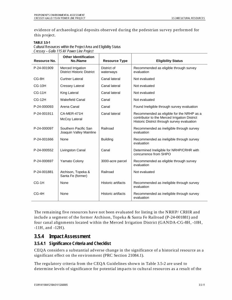
PROPONENT’S ENVIRONMENTAL ASSESSMENT CRESSEY-GALLO 115 KV POWER LINE PROJECT 3.5 24BCULTURAL RESOURCES
ES091411004121BAO\113260005 3.5-11
evidence of archaeological deposits observed during the pedestrian survey performed for this project.
TABLE 3.5-1 Cultural Resources within the Project Area and Eligibility Status Cressey – Gallo 115 kV Power Line Project
Resource No. Other Identification
No./Name Resource Type Eligibility Status
P-24-001909 Merced Irrigation District Historic District
District of waterways
Recommended as eligible through survey evaluation
CG-8H Curtner Lateral Canal lateral Not evaluated
CG-10H Cressey Lateral Canal lateral Not evaluated
CG-11H King Lateral Canal lateral Not evaluated
CG-12H Wakefield Canal Canal Not evaluated
P-24-000093 Arena Canal Canal Found Ineligible through survey evaluation
P-24-001911 CA-MER-471H
McCoy Lateral
Canal lateral Recommended as eligible for the NRHP as a contributor to the Merced Irrigation District Historic District through survey evaluation
P-24-000097 Southern Pacific San Joaquin Valley Mainline
Railroad Recommended as ineligible through survey evaluation
P-24-001666 None Building Recommended as ineligible through survey evaluation
P-24-000552 Livingston Canal Canal Determined Ineligible for NRHP/CRHR with concurrence from SHPO
P-24-000697 Yamato Colony 3000-acre parcel Recommended as eligible through survey evaluation
P-24-001881 Atchison, Topeka & Santa Fe (former)
Railroad Not evaluated
CG-1H None Historic artifacts Recommended as ineligible through survey evaluation
CG-4H None Historic artifacts Recommended as ineligible through survey evaluation
The remaining five resources have not been evaluated for listing in the NRHP/CRHR and include a segment of the former Atchison, Topeka & Santa Fe Railroad (P-24-001881) and four canal alignments located within the Merced Irrigation District (GANDA-CG-8H, -10H, -11H, and -12H).
3.5.4 Impact Assessment 3.5.4.1 Significance Criteria and Checklist CEQA considers a substantial adverse change in the significance of a historical resource as a significant effect on the environment (PRC Section 21084.1).
The regulatory criteria from the CEQA Guidelines shown in Table 3.5-2 are used to determine levels of significance for potential impacts to cultural resources as a result of the

PROPONENT’S ENVIRONMENTAL ASSESSMENT 3.5 24BCULTURAL RESOURCES CRESSEY-GALLO 115 KV POWER LINE PROJECT
3.5-12 ES091411004121BAO\113260005
project. Under each of these criteria, a significant impact is defined as destruction, damage, alteration, or neglect to an eligible or potentially eligible cultural resource. Only those elements of a resource that contribute to its eligibility need to be considered; effects to non-contributing elements are less than significant.
TABLE 3.5-2 CEQA Checklist for Cultural Resources Cressey-Gallo115 kV Power Line Project
V. CULTURAL RESOURCES— Would the project:
Potentially Significant
Impact
Less than Significant
with Mitigation
Incorporation
Less than Significant
Impact No
Impact
a) Cause a substantial adverse change in the significance of a historical resource as defined in § 15064.5?
b) Cause a substantial adverse change in the significance of an archaeological resource pursuant to § 15064.5?
d) Disturb any human remains, including those interred outside of formal cemeteries?
Note: Item c) in Section V., Cultural Resources, in Appendix G of the CEQA Guidelines is not included in this table or in the impacts analysis below because it pertains to paleontological resources. This item is addressed instead in Section 3.6 in the Geology and Soils, Mineral Resources, and Paleontological Resources section of this PEA.
3.5.4.2 Applicant Proposed Measures PG&E construction crews and heavy equipment will avoid construction activities at canal and railroad segments within the project area, including the avoidance of all potentially contributing structural elements or physical features associated with the Merced Irrigation District Historic District (P-24-001909) within the project area. While the Yamato Colony (P-24-000697) has been recommended as eligible for the NRHP/CRHR, there are no existing buildings or structures within the project area; therefore there will be no impact to this resource.
The project area has a low to very low potential for buried prehistoric archaeological sites. No further archaeological studies are recommended for the project area. However, if project plans change to include areas outside the present impact area covered by this study, additional cultural work may be necessary. Furthermore, in the unlikely event that historic, archaeological, or other cultural resources are identified during construction, the following APMs have been provided to further minimize the project’s potential less-than-significant impacts.
APM Cultural (CU)-1: Pre-construction Worker Environmental Awareness Program. PG&E will design and implement a worker environmental awareness program that will be provided to project personnel who might encounter or alter historical resources or important/unique archaeological properties, including construction supervisors and field personnel. No construction worker will be involved in field operations without having participated in the worker environmental awareness program.
PROPONENT’S ENVIRONMENTAL ASSESSMENT CRESSEY-GALLO 115 KV POWER LINE PROJECT 3.5 24BCULTURAL RESOURCES
ES091411004121BAO\113260005 3.5-13
The worker environmental awareness program will include a kick-off tailgate session to present site avoidance requirements and procedures to be followed if unanticipated cultural resources are discovered during project implementation, and a discussion of disciplinary and other actions that could be taken against persons violating historic preservation laws and PG&E policies.
All project workers involved with ground-disturbing activities will receive a pamphlet listing how to identify cultural resources and what to do if an unanticipated discovery is made during construction. The worker environmental awareness program may be conducted in concert with other environmental or safety awareness and education programs for the project, and may be recorded for use in subsequent training sessions.
APM CU-2: Management of Unanticipated Discoveries. In the unlikely event that previously unidentified cultural resources are uncovered during project implementation, all work within 100 feet of the discovery will be halted and redirected to another location. The find will be secured, and PG&E’s cultural resources specialist or designated representative will be contacted immediately. The specialist will inspect the discovery and determine whether further investigation is required. If additional impacts to the discovery can be avoided, the resource will be documented on California Department of Parks and Recreation (DPR) cultural resource records (Form DPR 523) and filed at the CHRIS; no further effort will be required. If additional disturbance to the resource cannot be avoided, PG&E will evaluate the significance and CRHR eligibility of the resource and (if warranted) implement data recovery excavation or other appropriate treatment measures. The methods and results of evaluation or data recovery work at an archaeological find will be documented in a professional-level technical report to be filed with the CCIC.
APM CU-3: Treatment of Human Remains. In the unlikely event that human remains or suspected human remains are uncovered during pre-construction testing or during construction, all work within 100 feet of the discovery will be halted and redirected to another location. The find will be secured, and PG&E’s cultural resources specialist or designated representative will be contacted immediately to inspect the find and determine whether the remains are human. If the remains are not human, the cultural resources specialist will determine whether the find is an archaeological deposit and whether APM CU-2 applies. If the remains are human, the cultural resources specialist will immediately implement the provisions in PRC Sections 5097.9 through 5097.996, beginning with the immediate notification to the County coroner. The coroner has two working days to examine human remains after being notified. If the Coroner determines that the remains are Native American, he or she must contact the NAHC within 24 hours. The NAHC, as required by the PRC Section 5097.98, determines and notifies the Most Likely Descendant (MLD).
3.5.4.3 Construction, Operation, and Maintenance Impacts No known prehistoric resources are in the project area, and it has little or no potential to contain buried resources. However, there are known historic-period resources within the project area, as described above. The following discussion evaluates potential project construction, operation, and maintenance impacts on cultural resources against the significance criteria.

PROPONENT’S ENVIRONMENTAL ASSESSMENT 3.5 24BCULTURAL RESOURCES CRESSEY-GALLO 115 KV POWER LINE PROJECT
3.5-14 ES091411004121BAO\113260005
a) Will the project cause a substantial adverse change in the significance of a historical resource as defined in § 15064.5? Less-than-significant impact.
Cultural resources surveys and records searches identified 14 potential historic-period resources in the project area. Of these, three resources are recommended as eligible for listing in the NRHP/CRHR and need to be analyzed for potential impacts. PG&E will avoid the Merced Irrigation District Historic District (P-24-001909) and McCoy Lateral (P-24-001911). Therefore, there will be no project construction, operation, and maintenance impacts. The third resource, Yamato Colony (P-24-000697), has no associated extant building structures within the project area. The project area is also not considered sensitive for the presence of historic-period deposits associated with this colony; therefore, there will be no impact to this resource or visual impacts to the portion of the colony within the project area. In the unlikely event that historical resources are discovered during construction activities, APM CU-1 and APM CU-2 will further minimize the less-than-significant potential project impacts.
b) Will the project cause a substantial adverse change in the significance of an archaeological resource pursuant to § 15064.5? Less-than-significant impact.
Surface surveys and records searches identified two historic artifact scatters (GANDA-CG-1H and GANDA-CG-4H) within the project area; however, these archaeological resources are recommended as ineligible for listing in the NRHP/CRHR. In addition, a geoarchaeological study has indicated that the project area has low to very low potential to contain buried archaeological remains. APM CU-1 and APM CU-2 will further minimize the less-than-significant potential project impacts in the unlikely event that archaeological resources are discovered.
d) Will the project disturb any human remains, including those interred outside of formal cemeteries? Less-than-significant impact.
Cultural resources surveys have identified no human remains on the project site. In the unlikely event that human remains are uncovered during construction, APM CU-3 will further minimize the less-than-significant potential project impacts.
3.5.5 References Baumhoff, M. A. 1963. “Ecological Determinants of Aboriginal California Populations.”
University of California Publications in American Archaeology and Ethnography 49(2): 155-236. Berkeley.
Byrd, David S. 1998. Historic Resource Evaluation Report: Livingston Canal, Merced Irrigation District, Merced County, California. Prepared by JRP Historical Consulting Services. Prepared for URS Greiner Woodward-Clyde.
Cook, S. F. 1955. “The Aboriginal Population of the San Joaquin Valley, California.” University of California Anthropological Records (16)2: 31-80. Berkeley.
_______. 1960 Colonial Expeditions to the Interior of California: Central Valley, 1800-1820. University of California Anthropological Records. 16(6): 239-292. Berkeley.
Dice, Michael H. 2010. Department of Parks and Recreation 523 Forms for P-24-001909, Merced Irrigation District, Merced County, California. Prepared by Michael Brandman

PROPONENT’S ENVIRONMENTAL ASSESSMENT CRESSEY-GALLO 115 KV POWER LINE PROJECT 3.5 24BCULTURAL RESOURCES
ES091411004121BAO\113260005 3.5-15
Associates. On file at Central California Information Center, Department of Anthropology, California State University, Stanislaus.
Fredrickson, D.A. 1973. Early Cultures of the North Coast Ranges, California. Ph.D. dissertation, Department of Anthropology, University of California, Davis.
Gayton, A. H. 1936. “Estudillo among the Yokuts: 1819.” Pp. 67-85 in Essays in Anthropology Presented to A.L. Kroeber in Celebration of his Sixtieth Birthday. Robert H. Lowie. Ed. Berkeley: University of California Press.
Heizer, R. F. and F. Fenenga 1939. “Archaeological Horizons in Central California.” American Anthropologist 41:378-399.
Hope, Andrew. 2000. “Second Supplementary Historic Architectural Survey Report for the Livingston Freeway Project (Re-evaluation), State Route 99, Merced County, 10-Mer-99, P.M. 26.5-28.8, EA 316960.” Prepared by California Department of Transportation.
JRP Historical Consulting Services and California Department of Transportation. 2000. Water Conveyance Systems in California: Historic Context Development and Evaluation Procedures. California Department of Transportation, Sacramento, California.
Kielusiak, C. M. 1982. Variability and Distribution of Baked Clay Artifacts from the Lower Sacramento-Northern San Joaquin Valleys of California. Unpublished Masters Thesis, Department of Anthropology, California State University, Sacramento.
Kroeber, A.L.F. 1925. Handbook of the Indians of California. Smithsonian Institution. Bureau of American Ethnology, 78. Dover Publications, New York. Reprinted 1976.
Kyle, Douglas. 1990. Historic Spots in California. Stanford University Press, Stanford, California.
Meyer, Jack and Jeff Rosenthal. 1997. Archaeological and Geoarchaeological Investigations at Eight Prehistoric Sites in the Los Vaqueros Reservoir Area, Contra Costa County, California. Los Vaqueros Final Report #7. ASC, SSUAF, Rohnert Park, California. Prepared for Contra Costa Water District, Concord, California.
Milliken, Randall; Richard T. Fitzgerald, Mark G. Hylkema, Randy Groza, Tom Origer, David G. Bieling, Alan Leventhal, Randy S. Wiberg, Andrew Gottsfield, Donna Gillette, Viviana Bellifemine, Eric Strother, Robert Cartier, and David A. Frederickson. 2007. “Punctuated Culture Change in the San Francisco Bay Area.” Chapter 8 in California Prehistory: Colonization, Culture, and Complexity. Terry L. Jones and Katharine A. Klar, eds. Altamira Press, Rowman and Littlefield Publishers, New York.
National Park Service. 1995. National Register Bulletin: How to Apply the National Register Criteria for Evaluation. U.S. Department of the Interior, National Park Service, Cultural Resources. Originally published 1990; revised for Internet in 1995. Online: http://www.nps.gov/nr/publications/bulletins/pdfs/nrb15.pdf.
Olsen, W.H. and Payen, L.A. 1968. Archaeology of the Little Panoche Reservoir, Fresno County, California. California State Department of Parks and Recreation, Archaeological Resources Section Report 11. Sacramento.
PROPONENT’S ENVIRONMENTAL ASSESSMENT 3.5 24BCULTURAL RESOURCES CRESSEY-GALLO 115 KV POWER LINE PROJECT
3.5-16 ES091411004121BAO\113260005
Pritchard, W.E. 1970. Archaeology of the Menjoulet Site Merced County, California. California State Department of Parks and Recreation, Archaeological Resources Section Report 13. Sacramento.
Quad Knopf. 1999. Livingston, California General Plan. Submitted to City of Livingston, California.
Ragir, S. 1972. The Early Horizon in Central California Prehistory. In Contributions of the University of California Archaeological Research Facility, No.15. Department of Anthropology, University of California, Berkeley.
Rosenthal, J., Meyer, J. 2004. Cultural Resources Inventory of Caltrans District 10 Rural Conventional Highways. Volume III: Goearchaeological Study. Landscape Evolution and the Archaeological Record of Central California. Prepared by Far Western Anthropological Research Group, Inc. Davis, California. Prepared for Caltrans, Stockton, California.
Rosenthal, J., G. White., and M. Sutton. 2007. “The Central Valley: A View from the Catbird’s Seat.” Chapter 10 in California Prehistory: Colonization, Culture, and Complexity. Terry L. Jones and Katharine A. Klar, eds. Altamira Press, Rowman and Littlefield Publishers, Inc. New York.
Schenck, E.W. 1926. “Historic Aboriginal Groups of the California Delta Region.” University of California Publications in American Archaeology and Ethnology 23(2): 123-146. Berkeley.
U.S. Geological Survey (USGS). 1953. Cressey, California 7.5-minute topographic quadrangle. USGS, Washington D.C.
_______. 1961. Cressey, California 7.5-minute topographic quadrangle. USGS, Washington D.C.
Wallace, W.J. 1978. “Northern Valley Yokuts.” In Handbook of North American Indians: California. Vol. 8. Edited by R.F. Heizer. Smithsonian, Washington D.C.
PROPONENT’S ENVIRONMENTAL ASSESSMENT CRESSEY-GALLO 115 KV POWER LINE PROJECT 3.6 25BGEOLOGY AND SOILS, MINERAL RESOURCES, AND PALEONTOLOGICAL RESOURCES
ES091411004121BAO\113260005 3.6-1
3.6 Geology and Soils, Mineral Resources, and Paleontological Resources
3.6.1 Introduction and Methodology This section describes the existing geological and soil conditions, potential geologic and geotechnical hazards, mineral resources, and paleontological resources at the project site and surrounding areas, and concludes that any impacts will be less than significant. Potential geologic hazards including fault-surface rupture, ground shaking, landsliding, liquefaction, and other ground-failure mechanisms are addressed in Section 3.6.3. The implementation of Applicant Proposed Measures (APMs) described in Section 3.6.4.2 will further reduce less-than-significant impacts on geology, soils, mineral resources, and paleontological resources.
Information on the geology, soils, and mineral resources was compiled from published literature, maps, and examination of aerial photographs. Geologic units and structural features were obtained from maps published by the California Geological Survey (CGS) and United States Geological Survey (USGS).
Information on paleontological resources potentially within the project area was obtained from databases such as that maintained by the University of California Museum of Paleontology (UCMP), other environmental assessments in the general area, and through the geological literature.
Soil descriptions were obtained from mapping by the United States Department of Agriculture’s Natural Resource Conservation Service (NRCS). Information on mineral resources was obtained from the USGS, CGS, and the Merced County Year 2000 General Plan. Seismic information was developed from several sources, including the USGS, CGS, Caltrans, and the Safety Element of the Merced County General Plan.
3.6.2 Regulatory Background 3.6.2.1 Federal No federal requirements are applicable to geological or soil conditions, potential geological and geotechnical hazards, paleontological or mineral resources for the project.
3.6.2.2 State Various state regulations include requirements for the safe construction of structures in geologically sensitive areas. Such regulations include Title 24 of CCR, also referred to as the California Building Standards Code, which sets building construction standards for safety and protection in the event of ground shaking, and the Geologic Hazard Zones Act of the California State Mining and Geology Board, which requires the mapping of seismically active and hazardous areas. California’s earthquake protection law (California Health and Safety Code 19100 et seq.) requires the design of buildings to include safety provisions to resist stresses produced by lateral forces caused by wind and earthquakes.
Alquist-Priolo Earthquake Fault Zoning Act. California enacted the Alquist-Priolo Special Studies Zones Act in 1972, which was renamed the Alquist-Priolo Earthquake Fault Zoning Act in 1994. Also known as the Alquist-Priolo Act, it requires the establishment of
PROPONENT’S ENVIRONMENTAL ASSESSMENT 3.6 25BGEOLOGY AND SOILS, MINERAL RESOURCES, AND PALEONTOLOGICAL RESOURCES CRESSEY-GALLO 115 KV POWER LINE PROJECT
3.6-2 ES091411004121BAO\113260005
“earthquake fault zones” along known active faults in California (Bryant and Hart 2007). Regulations on development within these zones are enforced to reduce the potential for damage resulting from fault displacement. Information on earthquake fault zones is provided for public information purposes (see Section 3.6.3.5, Seismicity, for further discussion). The Seismic Hazards Mapping Act (SHMA) of 1990 addresses earthquake hazards other than fault rupture, including liquefaction and seismically induced landslides. Seismic hazard zones are to be mapped by the State Geologist to assist local governments in land use planning.
The SHMA states that “it is necessary to identify and map seismic hazard zones in order for cities and counties to adequately prepare the safety element of their general plans and to encourage land use management policies and regulations to reduce and mitigate those hazards to protect public health and safety.” Section 2697(a) of the SHMA additionally requires that “cities and counties shall require, prior to the approval of a project located in a seismic hazard zone, a geotechnical report defining and delineating any seismic hazard.” Merced County has not yet been mapped under the SHMA since the State has targeted higher-risk areas, such as the San Francisco Bay Area and the Los Angeles/Riverside areas.
3.6.2.3 Local Because the CPUC has exclusive jurisdiction over the siting, design, and construction of the project, the project is not subject to local discretionary regulations. The following analysis of local regulations is provided for informational purposes and to assist with CEQA review.
Merced County General Plan. The General Plan includes a Safety Element (Chapter V) to identify the various hazards impacting the county and to provide policies for the protection of the community from unreasonable risks associated with these hazards. The hazards identified include seismic activity and related impacts; slope instability; and other geologic hazards such as subsidence. One or more of these topics is also covered in other chapters of the General Plan including the chapters on Land Use (Chapter I), Open Space/Conservation (Chapter VI), and Agricultural (Chapter VII). Mineral resources of Merced County are identified and discussed in Chapter VI of the General Plan.
Work began on an update to the General Plan in 2006, and a draft update has been released (the 2030 Merced County General Plan Public Review Draft) but has not yet been adopted (Merced County 2011).
Although PG&E is not subject to local discretionary permitting, ministerial permits will be secured, as required.
3.6.3 Environmental Setting 3.6.3.1 Regional Setting The project site is located near the geographic center of California in the San Joaquin Valley, which is the southern portion of the Central Valley of California. The Central Valley is also referred to as the Great Valley Geomorphic Province. It extends for approximately 450 miles from low-lying hills near Red Bluff in the north to the San Emigdio and Tehachapi Mountains near Bakersfield in the south. The Central Valley is bounded on the northeast by a volcanic plateau of the Cascade Range; on the east by the Sierra Nevada, which rise to a maximum height of over 14,000 feet above mean sea level; and on the west by the Coast Ranges, including
PROPONENT’S ENVIRONMENTAL ASSESSMENT CRESSEY-GALLO 115 KV POWER LINE PROJECT 3.6 25BGEOLOGY AND SOILS, MINERAL RESOURCES, AND PALEONTOLOGICAL RESOURCES
ES091411004121BAO\113260005 3.6-3
the Diablo Range which extends into the western margin of Merced County. Elevations in the Central Valley range from slightly below mean sea level to 400 feet above mean sea level at its northern and southern ends. The northern one-third of the valley is known as the Sacramento Valley and the southern two-thirds as the San Joaquin Valley (California Department of Conservation [DOC] 2002; Page 1986; Norris and Webb 1990).
In Merced County, small intermittent streams enter the valley from the semi-arid Diablo Range on the west. Some streams terminate on alluvial fans and others have been dammed to form reservoirs for irrigation. To the east, perennial rivers flow from the more humid, larger drainage areas of the Sierra Nevada and have been dammed to provide irrigation. In the past, runoff from these drainages deposited sand, silt, and clay and built up large alluvial fans along each side of the valley. The larger, more gently sloping fans on the east side of the valley are primarily composed of sediment deposits derived from granitic rock, which have created extensive foothills. Alluvial fans on the west side of the San Joaquin River are composed of sediment derived primarily from sedimentary source rock deposits and generally have steeper slopes. The valley floor is composed of alluvial, floodplain, and delta plain deposits from the surrounding ranges.
During the late Mesozoic and Cenozoic, the region existed as a lowland or shallow marine embayment. In the late Cenozoic, much of the area was occupied by shallow brackish and freshwater lakes, particularly in the San Joaquin Valley (Page 1986; Norris and Webb 1990; Merced County 1989).
The project route ranges in elevation from a high of approximately 180 feet above mean sea level at Cressey Substation on the eastern end to a low of approximately 110 feet above mean sea level at Gallo Substation on the western end. Figure 3.6-1 illustrates the site topography using a USGS base map (USGS 1976, 1987). The surface topography is relatively flat with an overall slope of 0 to 1 percent. Land use along the project route is primarily agricultural with intermittent rural residences. Agricultural uses include orchards, vineyards, field crops, pastures, and dairies. Open fields, landscaping, the Gallo Winery facility, and some light industry are also located along or adjacent to the project route.
3.6.3.2 Stratigraphic Units A map of the geologic units in the project area using USGS data is provided on Figure 3.6-2. The shallowest geologic unit underlying the majority of the project site and vicinity is the Pleistocene-age Modesto formation (DOC 1990). The Modesto formation is composed of alluvial and terrace deposits consisting primarily of unconsolidated granitic sands over stratified silts and sands. It has a maximum thickness of approximately 100 feet (Arkley 1964).
Gallo Substation and the western portion of the project route are underlain by eolian sands associated with subdued, stabilized dunes of the upper member of the Modesto formation. Cressey Substation and the eastern portion of the project route are underlain by moderately well-sorted eolian sands of the lower member of the Modesto formation. These upper and lower eolian sand members are interfingered in the central portion of the project route. A small outcropping of the stratigraphically underlying Pleistocene-age Riverbank formation is mapped along the project route approximately 0.75 mile north of its intersection with State Route (SR) 99. This unit consists of alluvial sand, silt, and gravel. Alluvium of the Riverbank formation also outcrops within a hundred feet north of Cressey Substation.

PROPONENT’S ENVIRONMENTAL ASSESSMENT 3.6 25BGEOLOGY AND SOILS, MINERAL RESOURCES, AND PALEONTOLOGICAL RESOURCES CRESSEY-GALLO 115 KV POWER LINE PROJECT
3.6-4 ES091411004121BAO\113260005
Insert Figure
3.6-1 Topographic Site Map
5 pages
8.5 x 11

PROPONENT’S ENVIRONMENTAL ASSESSMENT CRESSEY-GALLO 115 KV POWER LINE PROJECT 3.6 25BGEOLOGY AND SOILS, MINERAL RESOURCES, AND PALEONTOLOGICAL RESOURCES
ES091411004121BAO\113260005 3.6-9
Insert Figure
3.6-2 Geologic Map
8.5 x 11
PROPONENT’S ENVIRONMENTAL ASSESSMENT 3.6 25BGEOLOGY AND SOILS, MINERAL RESOURCES, AND PALEONTOLOGICAL RESOURCES CRESSEY-GALLO 115 KV POWER LINE PROJECT
3.6-10 ES091411004121BAO\113260005
Holocene alluvium associated with the floodplains and low terraces of the Merced River outcrops a few hundred feet north of both substations (Marchand and Allwardt 1978).
Regionally, the site area is underlain by approximately 10,000 feet of Tertiary and Quaternary units consisting of alluvial deposits, sedimentary rocks, and minor volcanic rocks. These deposits are underlain by the Great Valley sequence, consisting of a wedge of Tertiary to Jurassic sedimentary rock mélanges that thicken toward the west side of the San Joaquin Valley (Bartow 1991).
3.6.3.3 Soils The NRCS soil data for the project area are depicted on Figure 3.6-3, Maps 1-15. The project site surface soils are predominantly mapped as Atwater loamy sand, 0 to 3 percent slopes; Atwater loamy sand, deep over hardpan, 0 to 3 percent slopes; Atwater sand, 0 to 3 percent slopes; Delhi sand, 0 to 3 percent slopes; Delhi sand, silty substratum, 0 to 3 percent slopes; Delhi loamy fine sand, silty substratum, 0 to 3 percent slopes; and Delhi loamy sand, 0 to 3 percent slopes. Soils of the Atwater series are present largely in the eastern portion of the project site, and the Delhi series soils are more predominant in the western portion. Smaller areas of both the Delhi and Atwater series with 3 to 8 percent slopes are also present, as well as minor areas of Hilmar loamy sand, Dello sand, and Snelling sandy loam, all with maximum 3 percent slopes (NRCS 2011).
The Atwater series consists of very deep, porous, well-drained soils formed in granitic alluvium. They are friable, low in organic matter, slightly acidic, and have moderately rapid permeability and slow runoff. They have mixed mineralogy and are uniformly sorted, with a minimum of coarse and very coarse particles (NRCS 2003). The Delhi series consists of very deep, somewhat excessively drained soils. They formed from wind-modified material weathered from granitic rock sources and are found on floodplains, alluvial fans, and alluvial terraces. They are single-grained, loose, slightly to strongly acidic, and have rapid permeability and negligible to slow runoff (NRCS 2006).
Expansive soils are those that contain significant amounts of clays that expand when wet and can cause damage to foundations if moisture collects beneath structures. According to NRCS data, soils within the project site do not contain significant amounts of clay.
3.6.3.4 Minerals According to the General Plan, the mineral resources of Merced County include, but are not limited to, sand and gravel, aragonite, calcite, chalcopyrite, copper, glauconite, gold, gypsum, hydromagnesite, jarosite, lawsonite, pumpellyite, soda niter, sphalerite, stibnite, and stilpnomelane. Much of Merced County's mineral wealth is due to its proximity to the eastern and western foothill areas. Sand and gravel extraction constitute the major portion of the County's mining activity, both in terms of quantity of material produced and value of extracted resource. According to the General Plan, Cressey and Gallo substations are located in potential sand and gravel resource areas associated with their proximity to the banks of the Merced River. The project is not located within a mineral recovery site.

PROPONENT’S ENVIRONMENTAL ASSESSMENT CRESSEY-GALLO 115 KV POWER LINE PROJECT 3.6 25BGEOLOGY AND SOILS, MINERAL RESOURCES, AND PALEONTOLOGICAL RESOURCES
ES091411004121BAO\113260005 3.6-11
Insert Figure
3.6-3 Soils Map
8.5 x 11
17 pages

PROPONENT’S ENVIRONMENTAL ASSESSMENT 3.6 25BGEOLOGY AND SOILS, MINERAL RESOURCES, AND PALEONTOLOGICAL RESOURCES CRESSEY-GALLO 115 KV POWER LINE PROJECT
3.6-28 ES091411004121BAO\113260005
According to the California Division of Mines and Geology publication Mineral Land Classification of Merced County, California (Clinkenbeard 1999), the only mineral resource zone mapped in the project site area is an MRZ-3a zone at the northeast (Cressey Substation) end. MRZ-3a refers to an area containing known mineral occurrences of undetermined mineral resource significance (Clinkenbeard 1999). This potential resource is a part of the Modesto formation alluvium, which may be a sand and gravel resource. This potential resource is mapped as an approximately 2-mile-wide and 17-mile-long northwest-southeast trending swath that includes approximately the last four miles of the northeast portion of the project site.
3.6.3.5 Seismicity
Fault Zones. The Alquist-Priolo Act requires the establishment of “earthquake fault zones” along known active faults in California. A fault is considered active if it has generated earthquakes accompanied by surface rupture during historical time (approximately the last 200 years) or has shown evidence of fault displacement during the Holocene period (approximately the last 11,000 years) (Bryant and Hart 2007). A fault is considered potentially active if there is evidence of fault displacement during the Quaternary period (approximately the last 1.6 million years). A fault is considered inactive if the most recent documented fault displacement pre-dates the Quaternary period. For the purposes of this report, multiple sources were used to identify faults within a distance of 50 miles that may potentially affect the site, including the USGS, CGS, and Merced County (see References in Section 3.6.5). A regional map of the fault zones in proximity to the site using data from a CGS source is included as Figure 3.6-4 (Bryant 2005).
No known active faults cross the project site or are located in the immediate project vicinity (CGS 2010; see Figure 3.6-1). The only known active fault within Merced County is the Ortigalita fault, also known as the Tesla-Ortigalita fault, which is a north-northwest-striking, right-lateral strike-slip fault located approximately 25 miles from the western end of the project site.
The Ortigalita fault zone extends from about 20 km northwest of San Luis Reservoir southeast to the vicinity of Panoche Valley (Bryant and Cluett 2000). The Ortigalita fault zone is characterized by ‘en echelon‘ fault traces separated by pull-apart basins. The fault zone is divided into four segments. From north to south the fault segments are named Cottonwood Arm, Los Banos Valley, Piedra Azul, and Little Panoche Valley. The USGS Quaternary fault map indicates that sections of the Ortigalita fault have been active within the last 15,000 years (USGS 2006). The CGS fault activity map indicates the Ortigalita fault has been active within the last 11,700 years (DOC 2010). Other faults and fault zones in proximity to the site include right lateral strike-slip faults associated with the San Andreas fault system, the Foothills fault system, and the Coast Range-Sierran Block Boundary Zone (CRSB).
San Andreas Fault System. The nearest faults of major historical significance are the San Andreas fault, which passes within a distance of approximately 55 miles of the project site, and the associated Calaveras fault, which passes within a distance of approximately 45 miles of the project site. These active right-lateral, strike-slip faults extend in a northwest-southeast direction to the northwest, west, and southwest of Merced County.

PROPONENT’S ENVIRONMENTAL ASSESSMENT CRESSEY-GALLO 115 KV POWER LINE PROJECT 3.6 25BGEOLOGY AND SOILS, MINERAL RESOURCES, AND PALEONTOLOGICAL RESOURCES
ES091411004121BAO\113260005 3.6-29
Insert Figure
3.6-4 Fault Map
8.5 x 11
PROPONENT’S ENVIRONMENTAL ASSESSMENT 3.6 25BGEOLOGY AND SOILS, MINERAL RESOURCES, AND PALEONTOLOGICAL RESOURCES CRESSEY-GALLO 115 KV POWER LINE PROJECT
3.6-30 ES091411004121BAO\113260005
The San Andreas fault zone extends from the Gulf of California in Mexico to the Mendocino coast in northern California and accommodates the majority of movement between the Pacific and North American plates. Several active faults along the section of the San Andreas in closest proximity to the project site are not generally considered to be independent seismic sources, but rather to experience movement triggered by seismic events on the San Andreas. These include the Sargent and Paicines faults, approximately 50 miles southwest of the project site (Working Group on Northern California Earthquake Potential 1996; Working Group on California Earthquake Probabilities 2008).
Other predominantly active, northwest-striking right-lateral faults of the San Andreas fault system associated with historic seismic activity in proximity to the project site include the Greenville fault, approximately 40 miles to the west, and the Quien Sabe fault, approximately 45 miles to the southwest.
Coast Range-Sierran Block Boundary Zone. The CRSB is a complex zone of thrust faults buried beneath the Great Valley sequence that mark the boundary between the Coast Ranges and the Sierra Nevada basement rocks. This zone is not generally believed to rupture at the surface, but is evident by a series of fault-propagated folds which form low hills along the western side of the Sacramento and San Joaquin Valleys. The CRSB extends over 300 miles from near Red Bluff in the northern Sacramento Valley to Wheeler Ridge in the southern San Joaquin Valley. The CRSB has been identified as the probable source of several significant historic earthquakes, including the 1983 Coalinga earthquake (Wong et al 1988). Faults of the CRSB zone are located within 25 miles west of the site.
Foothills Fault System. The Foothills fault system is a major north-northwest trending group of relatively short, discontinuous normal faults extending along the western Sierra Nevada from Oroville in the north to Fresno in the south. The Bear Mountain fault extends parallel to the eastern border of Merced County and is the closest member of the Foothill fault system to the project site. The fault map included in the General Plan (Merced County 1989) illustrates the location of the Bear Mountain fault within approximately 24 miles northeast of the site. The CGS fault activity map does not indicate evidence of displacement on this portion of the Bear Mountain fault during the Quaternary period.
In addition to the mapped faults described above, a preliminary map published in 1978, a portion of which is included as Figure 3.6-2, shows a series of inferred faults and photo lineaments extending toward the northwest from near the north bank of the Merced River (Marchand and Allwardt 1978). One of these structures is shown to pass within approximately one hundred feet of Cressey Substation, and others extend to within a mile of the site route. The more recent USGS and CGS referenced publications do not indicate the presence of these faults or activity associated with them, and they have not been zoned under the Alquist-Priolo Act. Although the lineaments parallel the Foothills fault system, none of them have been positively identified as faults. Investigations conducted in association with planning and construction of the Merced campus of the University of California, which included trenching, review of stereoscopic aerial photographs and field reconnaissance, found no definitive evidence for the lineaments and concluded they were not faults (Kleinfelder 1999).
PROPONENT’S ENVIRONMENTAL ASSESSMENT CRESSEY-GALLO 115 KV POWER LINE PROJECT 3.6 25BGEOLOGY AND SOILS, MINERAL RESOURCES, AND PALEONTOLOGICAL RESOURCES
ES091411004121BAO\113260005 3.6-31
Strong Ground Motion. The project site is not located within an active fault zone as defined by the Alquist-Priolo Act; however, the Ortigalita fault is within the Special Studies Zone (DOC 1997a-f). The project site is in an area that is subject to ground shaking from earthquakes generated on the Ortigalita fault and other faults associated with the Coast Ranges, in particular the San Andreas and Calaveras faults. Shaking from an earthquake can result in structural damage and can trigger other geologic hazards such as liquefaction. Ground shaking is controlled by the earthquake magnitude, duration, and distance from the source. Ground conditions will also influence impacts from strong ground motions. Seismic waves attenuate with distance from their sources, so estimated bedrock accelerations are highest in areas closest to the source. Local soil conditions may amplify or dampen seismic waves as they travel from the underlying bedrock to the ground surface.
Ground motions for the site were calculated using the CGS Probabilistic Seismic Hazard Assessment (PSHA) online tool and the USGS Earthquake Ground Motions Tool (CGS 2010; USGS 2008). These programs use the USGS/CGS PSHA Model (2002) to obtain the ground motions for the site. The peak ground acceleration (PGA) was obtained for the ground motion with a 10 percent probability of being exceeded in 50 years, or a 475-year return period. These ground motions are provided for bedrock conditions and are corrected using National Earthquake Hazards Reduction Program soil corrections to calculate site response in soft rock and alluvium. The values were obtained for the western end of the project site at Longitude 120.785 and Latitude 37.368 for firm rock, soft rock, and alluvium. According to available information and the calculated PGA values below, the project site will likely be categorized as alluvium, PGA of 0.239 g. This is considered a low to moderate value for the state. PGA values across California range from about 0.1 g to over 1.0 g. More than three-fourths of the population of the state resides in counties with seismic hazard calculated to be above 0.4 g (DOC and USGS 1996).
Ground Motion Firm Rock Soft Rock Alluvium
Peak ground acceleration (PGA) 0.178 g 0.194 g 0.239 g
3.6.3.6 Landslides A landslide is a mass of rock, soil, or debris that has been displaced downslope by sliding, flowing, or falling. There is a low probability for landslides in the project area because of the relatively flat (0 to 1 percent slope) topography and distance from hills, mountains, or slopes. The project site is not located within a landslide hazard area, as indicated by the Merced County General Plan.
Several irrigation canals are located along the project site route, the largest being Livingston Canal, which crosses the site route between Mercedes Avenue and Eucalyptus Avenue as the route follows Arena Way. These canals are largely concrete-lined; therefore, the possibility that localized sloughs, slumps, or other failures along the canal banks could result from seismic events, weather, or high water is minimal.
3.6.3.7 Subsidence Subsidence, which is the downward displacement of a large portion of land, has affected many areas in California, including portions of Merced County. There are various causes of
PROPONENT’S ENVIRONMENTAL ASSESSMENT 3.6 25BGEOLOGY AND SOILS, MINERAL RESOURCES, AND PALEONTOLOGICAL RESOURCES CRESSEY-GALLO 115 KV POWER LINE PROJECT
3.6-32 ES091411004121BAO\113260005
subsidence, most of which happen slowly. The exception is tectonic subsidence, which occurs suddenly as a result of soil compaction due to strong ground shaking during earthquakes. Merced County is most affected by subsidence caused by groundwater withdrawal, hydrocompaction, and earthquakes.
Large parts of the western San Joaquin Valley have been affected by subsidence resulting from extensive groundwater withdrawal that began in the 1920s; ground subsidence reached a maximum of 29.7 feet below historic ground surface levels in 1981 (Ireland 1986). Subsidence has been mitigated by importation of surface water through major canals and the California Aqueduct in the 1950s through 1970s. By 1983, water levels throughout most of the San Joaquin Valley had recovered to 1940 to 1950 levels, and land subsidence in most of the San Joaquin Valley resulting from groundwater withdrawals seemed to have slowed or stopped (Ireland 1986). However, average water levels in much of Merced County, including the project area, declined nearly 30 feet from 1970 through 2000 due to groundwater withdrawal (California Department of Water Resources [DWR] 2004). Localized areas within the San Joaquin Valley continue to be subject to subsidence due to groundwater withdrawal, and have been mapped in Merced County. The project site is not located within one of these mapped areas (Merced County 1989).
Hydrocompaction occurs when open-textured soils become saturated with water for the first time, lose strength, and consolidate under their own weight. About 124 square miles of land surface in California has experienced or is subject to subsidence due to hydrocompaction. Hydrocompaction on the west side of the San Joaquin Valley required special consideration and engineering treatment during construction of the California Aqueduct. The Delta-Mendota Canal was built without knowledge of the problem, and subsidence of portions of it has required costly repair.
Tectonic subsidence results in the compaction of loose, non-cohesive soils and could occur in parts of Merced County where the groundwater surface is deep. Loose to medium dense, uniformly graded sands are most susceptible. In areas with shallow groundwater, liquefaction is more likely in the event of significant seismic shaking. The potential for ground subsidence due to earthquake motion is largely dependent on the magnitude, duration, and frequency of the earthquake waves. Probable seismic ground shaking for the site is expected to be minimal, as calculated in Section 3.6.3.5; therefore, tectonic subsidence is also anticipated to be minimal.
3.6.3.8 Erosion Erosion is the process by which rocks, soil, and other land materials are abraded or worn away from Earth’s surface over time. The rate of erosion depends on many factors, including soil type and geologic parent materials, slope and placement of soils, and human activity. The potential for erosion is highest in loose, unconsolidated soils. The steepness of slopes and absence of vegetation are also factors that increase the natural rates of erosion. Thus, erosion potential is high in steep, unvegetated areas, especially those disturbed by grading or other construction activities.
A soil’s susceptibility to erosion varies and is a function of its characteristics, such as soil texture, soil structure, topography, amount of vegetative cover, and climate. Erosion from water mainly occurs in loose soils on moderate to steep slopes, particularly during

PROPONENT’S ENVIRONMENTAL ASSESSMENT CRESSEY-GALLO 115 KV POWER LINE PROJECT 3.6 25BGEOLOGY AND SOILS, MINERAL RESOURCES, AND PALEONTOLOGICAL RESOURCES
ES091411004121BAO\113260005 3.6-33
high-intensity storm events. Because the topography at the project site is relatively flat, erosion potential is low.
3.6.3.9 Liquefaction Liquefaction is a phenomenon in which saturated, cohesionless soils such as sand and silt temporarily lose their strength and liquefy when subjected to dynamic forces such as intense and prolonged ground shaking. The vast majority of liquefaction hazards are associated with sandy soils and silty soils of low plasticity (CGS 2008). In order to be susceptible to liquefaction, potentially liquefiable soils must be saturated or nearly saturated. In general, liquefaction hazards are most severe in saturated soils within the upper 50 feet of the ground surface. The potential for liquefaction increases with shallower groundwater.
Regional groundwater data from nearby wells collected from the DWR and the California State Water Resources Control Board (SWRCB) websites indicate that the groundwater table along the project alignment is on the order of 45 to 85 feet below ground surface. Additionally, the General Plan indicates the project site does not fall within an area mapped as having a high water table, defined as within 20 feet of the ground surface (Merced County 1989). Sandy and silty soils comprise the majority of the soils underlying the project site, and localized areas of silty clay may act as aquitards, allowing groundwater to collect at higher levels in the substrata. The introduction of water to the site through irrigation or excessive rainfall may increase the potential for liquefaction. Specific liquefaction hazard areas have not been identified in Merced County; however, this potential exists in areas of the San Joaquin Valley where unconsolidated sediments and a high water table coincide.
3.6.3.10 Paleontological Resources The project area is underlain directly by the Late Pleistocene Modesto Formation and at greater depth by the Middle Pleistocene Riverbank Formations. The Modesto Formation, which comprises approximately 99 percent of the project area, differentiated into floodplain or floodbasin deposits, and into alluvial deposits away from the principal river courses. Near the intersection of Walnut Avenue and Arena Way, the upper member of the Riverbank Formation (about 1 percent of the project area) has been mapped.
The results of reviews of paleontological records from the Merced River and Tuolumne River alluvial fans in Stanislaus and Merced counties were combined with paleontological and geological studies and past monitoring results to identify geological units with low, moderate, and high paleontological sensitivity in the project area. Based on these findings, fluvial facies (floodplain and floodbasin deposits) of the Modesto Formation were determined to possess high paleontological sensitivity, and a capping soil below the Modesto and comprising approximately the top 6 feet of the Riverbank Formation has moderate paleontological sensitivity. The Modesto Formation away from the rivers and the Riverbank Formation beneath its capping paleosol possess low paleontological sensitivity.
At depths beginning at about 100 feet below the surface in the vicinity of Cressey Substation, and dipping to greater depths farther west, is the highly fossiliferous Corcoran Clay Member of the Tulare Formation. This deeply buried geological unit has yielded abundant vertebrate fossils as well as paleobotanical remains, and is considered to possess high paleontological sensitivity.
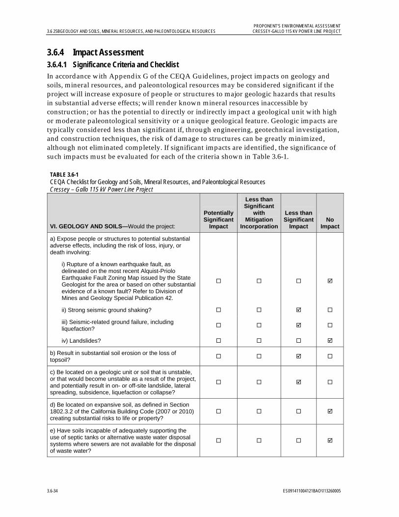
PROPONENT’S ENVIRONMENTAL ASSESSMENT 3.6 25BGEOLOGY AND SOILS, MINERAL RESOURCES, AND PALEONTOLOGICAL RESOURCES CRESSEY-GALLO 115 KV POWER LINE PROJECT
3.6-34 ES091411004121BAO\113260005
3.6.4 Impact Assessment 3.6.4.1 Significance Criteria and Checklist In accordance with Appendix G of the CEQA Guidelines, project impacts on geology and soils, mineral resources, and paleontological resources may be considered significant if the project will increase exposure of people or structures to major geologic hazards that results in substantial adverse effects; will render known mineral resources inaccessible by construction; or has the potential to directly or indirectly impact a geological unit with high or moderate paleontological sensitivity or a unique geological feature. Geologic impacts are typically considered less than significant if, through engineering, geotechnical investigation, and construction techniques, the risk of damage to structures can be greatly minimized, although not eliminated completely. If significant impacts are identified, the significance of such impacts must be evaluated for each of the criteria shown in Table 3.6-1.
TABLE 3.6-1 CEQA Checklist for Geology and Soils, Mineral Resources, and Paleontological Resources Cressey – Gallo 115 kV Power Line Project
VI. GEOLOGY AND SOILS—Would the project:
Potentially Significant
Impact
Less than Significant
with Mitigation
Incorporation
Less than Significant
Impact No
Impact
a) Expose people or structures to potential substantial adverse effects, including the risk of loss, injury, or death involving:
i) Rupture of a known earthquake fault, as delineated on the most recent Alquist-Priolo Earthquake Fault Zoning Map issued by the State Geologist for the area or based on other substantial evidence of a known fault? Refer to Division of Mines and Geology Special Publication 42.
ii) Strong seismic ground shaking?
iii) Seismic-related ground failure, including liquefaction?
iv) Landslides?
b) Result in substantial soil erosion or the loss of topsoil?
c) Be located on a geologic unit or soil that is unstable, or that would become unstable as a result of the project, and potentially result in on- or off-site landslide, lateral spreading, subsidence, liquefaction or collapse?
d) Be located on expansive soil, as defined in Section 1802.3.2 of the California Building Code (2007 or 2010) creating substantial risks to life or property?
e) Have soils incapable of adequately supporting the use of septic tanks or alternative waste water disposal systems where sewers are not available for the disposal of waste water?

PROPONENT’S ENVIRONMENTAL ASSESSMENT CRESSEY-GALLO 115 KV POWER LINE PROJECT 3.6 25BGEOLOGY AND SOILS, MINERAL RESOURCES, AND PALEONTOLOGICAL RESOURCES
ES091411004121BAO\113260005 3.6-35
TABLE 3.6-1 CEQA Checklist for Geology and Soils, Mineral Resources, and Paleontological Resources Cressey – Gallo 115 kV Power Line Project
XI. MINERAL RESOURCES—Would the project:
Potentially Significant
Impact
Less than Significant
with Mitigation
Incorporation
Less thanSignificant
Impact No
Impact
a) Result in the loss of availability of a known mineral resource that would be of value to the region and the residents of the state?
b) Result in the loss of availability of a locally important mineral resource recovery site delineated on a local general plan, specific plan or other land use plan?
V. PALEONTOLOGICAL RESOURCES (included as item c. under Section V., Cultural Resources, in the CEQA Guidelines) —Would the project:
Potentially Significant
Impact
Less than Significant
with Mitigation
Incorporation
Less thanSignificant
Impact No
Impact
c) Directly or indirectly destroy a unique paleontological resource or site or unique geologic feature?
3.6.4.2 Applicant Proposed Measures Specific potential impacts and each respective APM are discussed in the following sections. These APMs include measures that are required by existing regulations and/or requirements or standard practices that will minimize or prevent potential impacts.
APM Geology and Mineral Resources (GM)-1: Appropriate Design Measures Implementation. Based on available references, sands and loamy sands are the primary soil types expected to be encountered in the graded and excavated areas as project construction proceeds. Potentially problematic subsurface conditions may include soft or loose soils. Where soft or loose soils are encountered during design studies or construction, appropriate measures will be implemented to avoid, accommodate, replace, or improve soft or loose soils encountered during construction. Such measures may include the following:
Locating construction facilities and operation away from areas of soft and loose soil.
Over-excavating soft or loose soils and replacing them with non-expansive engineered fill.
Increasing the density and strength of soft or loose soils through mechanical vibration and/or compaction.
Treating soft or loose soils in place with binding or cementing agents.
Construction activities in areas where soft or loose soils are encountered may be scheduled for the dry season, as necessary, to allow safe and reliable equipment access.

PROPONENT’S ENVIRONMENTAL ASSESSMENT 3.6 25BGEOLOGY AND SOILS, MINERAL RESOURCES, AND PALEONTOLOGICAL RESOURCES CRESSEY-GALLO 115 KV POWER LINE PROJECT
3.6-36 ES091411004121BAO\113260005
APM Paleontological Resources (PR)-1: Worker Environmental Awareness Program Paleontological Resources Module. The project’s worker environmental awareness program, which all workers will complete prior to beginning work on the project site, will include a module on paleontological resources (fossils). The module will discuss the laws protecting paleontological resources, recognition in the field and types of paleontological resources that could be encountered on the project, and the procedures to be followed if a paleontological resource is discovered. A copy of the project’s worker environmental awareness training will be provided to the CPUC for recordkeeping prior to the start of construction.
APM PR-2: Paleontological Resource Monitoring. If paleontological resources are observed during construction activities, a qualified paleontologist will be notified to review the need for paleontological monitoring during subsequent ground-disturbing activities with the potential to affect paleontologically sensitive sediments at that location. The qualified paleontologist will be responsible for the reassessment of paleontological sensitivity upon the receipt of additional information from ongoing excavations, which may result in reducing, or increasing, the amount of monitoring required.
The current project description identifies one location, Cressey Substation, where ground-disturbing activities have potential to affect sediments with high paleontological sensitivity. The ground anode installations at Cressey Substation are expected to reach a depth of 100 feet, which is the approximate depth at which the Corcoran Clay is expected to begin at this location. A paleontological monitor will be present during this drilling when a depth of approximately 80 feet or greater is reached to monitor for paleontological resources that may be encountered in the Corcoran Clay layer. The paleontological monitor will be able to: (1) recognize fossils and paleontological deposits, and deposits that may be paleontologically sensitive; (2) take accurate and detailed field notes, photographs, and locality coordinates; and (3) document project-related ground-disturbing activities, their locations, and other relevant information, including a photographic record.
APM PR-3: Unanticipated Paleontological Resource Discovery. If fossils are observed during excavation, work in the immediate vicinity of a paleontological find will be halted or redirected to avoid additional impact to the specimen(s), and to allow the qualified paleontologist to assess the scientific importance of the find and determine appropriate treatment. If the discovery is significant, but can be avoided and no further impacts will occur, the resource will be documented in the appropriate paleontological resource records and no further effort will be required. If the resource is significant, but cannot be avoided and may be subject to further impact, the paleontologist will evaluate the significance of the resource and implement data recovery excavation, if appropriate, to scientifically recover the specimen as well as its stratigraphic and other pertinent contextual information, or other appropriate treatment measures as approved by the landowner. Any such discoveries on private land are the property of the landowner.
If a scientifically controlled recovery occurs, the fossil materials will be prepared so that they can be properly identified and used in research, and curated into an appropriate museum repository. A report will be prepared to accompany the finds that will include descriptions of the geological and stratigraphic context of the find, attendant analyses such
PROPONENT’S ENVIRONMENTAL ASSESSMENT CRESSEY-GALLO 115 KV POWER LINE PROJECT 3.6 25BGEOLOGY AND SOILS, MINERAL RESOURCES, AND PALEONTOLOGICAL RESOURCES
ES091411004121BAO\113260005 3.6-37
as radiocarbon dating and specimen identification, a narrative summary including preliminary interpretations, and a catalog of specimens.
3.6.4.3 Construction, Operation, and Maintenance Impacts Project impacts on geology and soils, mineral resources, and paleontological resources were evaluated against the CEQA significance criteria, as discussed below. This section evaluates potential project impacts from both the construction phase and operation and maintenance phase.
VI. Geology and Soils a) Would the project expose people or structures to potential substantial adverse effects, including the risk of loss, injury, or death involving (i) rupture of a known earthquake fault as on the most recent Alquist-Priolo Earthquake Fault Zoning Map issued by the State Geologist…,(ii) strong seismic ground shaking, (iii) seismic-related ground failure, including liquefaction, and (iv) landslides? Less-than-significant impact.
No known active faults underlie the site; therefore, there are no impacts associated with the potential rupture of a known fault. Because of relatively flat topography, there is no potential for landslides in the project area; therefore, no impact will occur due to landslides. The project is in an area of low liquefaction potential, resulting in a less-than-significant impact. Seismic ground shaking on the project site may occur because of earthquakes generated on faults at the western margin of the Central Valley; however, if an earthquake occurs, the impact will be less than significant.
b) Would the project result in substantial soil erosion or the loss of topsoil? Less-than-significant impact.
The potential for increased erosion exists because of surface-disturbing activities associated with project construction. During construction, grading activities will be conducted at Cressey and Gallo substations and in specific areas along the site route to create new orchard access roads. Best Management Practices (BMPs) will be implemented to minimize and avoid surface runoff, erosion, and pollution. Stockpiles will be located away from or down-gradient of waterways in accordance with the Storm Water Pollution Prevention Plan (SWPPP) that will be prepared for the project. Sediment control BMPs will be implemented to manage temporary stockpiles.
Because the project site is relatively flat, impacts from erosion or topsoil loss will be less-than-significant and implementation of APM GM-1 and APM WQ-1 (Section 3.8.4.2) will further reduce those impacts.
c) Would the project be located on a geologic unit or soil that is unstable, or that would become unstable as a result of the project, and potentially result in on- or off-site landslide, lateral spreading, subsidence, liquefaction or collapse? Less-than-significant impact.
Mapped soils in the project area are primarily unconsolidated sands and loamy sands, which could be subject to subsidence. Appropriate design measures will be implemented to avoid, accommodate, replace, or improve any problematic soft or loose soils encountered during construction. The implementation of APM GM-1 will further reduce less-than-significant impacts associated with potentially soft or loose soils. The project construction, operation, and maintenance do not include or require that groundwater wells be

PROPONENT’S ENVIRONMENTAL ASSESSMENT 3.6 25BGEOLOGY AND SOILS, MINERAL RESOURCES, AND PALEONTOLOGICAL RESOURCES CRESSEY-GALLO 115 KV POWER LINE PROJECT
3.6-38 ES091411004121BAO\113260005
constructed for the purpose of water extraction and use, so the project will not result in any impact from subsidence associated with groundwater withdrawal.
The depths to groundwater across the project area minimize the likelihood of liquefaction, as do the low to moderate peak ground accelerations for the site. Although localized areas of silty clay in the project area may act as aquitards, allowing groundwater to collect at higher levels in the substrata, the potential for surface manifestations of liquefaction is low and the potential impact on the project is therefore minimal. The project construction, operation, and maintenance will not require that significant amounts of water be introduced into the subsurface soils; therefore, the project will have no impact on the liquefaction potential of the site.
d) Would the project be located on expansive soil, as defined in Section 1802.3.2 of the California Building Code (2007 or 2010), creating substantial risks to life or property? No impact.
Based on the available references, the project is not located in an area with expansive surficial soil; therefore, no impact will occur.
e) Would the project have soils incapable of adequately supporting the use of septic tanks or alternative waste water disposal systems where sewers are not available for the disposal of waste water? No impact.
The project type does not include a waste disposal system; therefore, no impact will occur.
XI. Mineral Resources a) Would the project result in the loss of availability of a known mineral resource that would be of value to the region and residents of the state? No impact.
Cressey and Gallo substations are located in potential but not confirmed sand and gravel resource areas. No impact will occur to known mineral resources.
b) Would the project result in the loss of availability of a locally important mineral resource recovery site delineated on a local general plan, specific plan, or other land use plan? No impact.
The project will not result in the loss of availability of a locally important mineral recovery site; therefore, no impact will occur.
V. Paleontological Resources c) Would the project directly or indirectly destroy a unique paleontological feature or site or unique geologic feature? Less-than-significant-impact.
The project does not occur near or on a unique geologic feature. Based on the results of the background research and records search, limited areas of Pleistocene geological units possess high or moderate paleontological sensitivity are found within the project area. The project is located away from the fluvial facies of the Modesto Formation above the river, and therefore will not affect sediments of high paleontological sensitivity there. The Riverbank Formation paleosol of moderate sensitivity may be affected although it typically occurs at depths exceeding ten feet, which is greater than the average pole depth. The Corcoran Clay of high paleontological sensitivity may be affected by the installation of grounding rods that may extend to a depth of about 100 feet at Cressey Substation. The implementation of APMs

PROPONENT’S ENVIRONMENTAL ASSESSMENT CRESSEY-GALLO 115 KV POWER LINE PROJECT 3.6 25BGEOLOGY AND SOILS, MINERAL RESOURCES, AND PALEONTOLOGICAL RESOURCES
ES091411004121BAO\113260005 3.6-39
PR-1 through PR-3, directed at the recognition and recovery of encountered paleontological resources, will further reduce less-than-significant potential impacts to paleontological resources. Operation and maintenance activities will not be ground-disturbing and no impacts will occur.
3.6.5 References Arkley, Rodney J. 1964. The Geology, Geomorphology, and Soils of the San Joaquin Valley in the
Vicinity of the Merced River, California. California Geological Survey (CGS) Bulletin 182.
Bartow, J.A. 1991. The Cenozoic Evolution of the San Joaquin Valley, California. U.S. Geological Survey Professional Paper 1501.
Bryant, W. A. (compiler), 2005. Digital Database of Quaternary and Younger Faults from the Fault Activity Map of California, version 2.0. California Geological Survey Web Page. Online: http//www.consrv.ca.gov/CGS/information/publications/QuaternaryFaults_ver2.htm. Accessed on July 26, 2011.
Bryant, W.A., and Cluett, S.E., compilers. 2000 Fault number 52d, Ortigalita fault zone, Little Panoche Valley section. In “Quaternary Fault and Fold Database of the United States” Web site (U.S. Geological Survey). Online: http://earthquakes.usgs.gov/regional/qfaults
Bryant, W. A. and E. W. Hart. 2007. Fault-rupture Hazard Zones in California, Alquist-Priolo Earthquake Fault Zoning Act with Index to Earthquake Fault Zones Maps: Department of Conservation, California Geological Survey. Special Publication 42, Interim Revision 2007.
California Department of Conservation (DOC). 2010. “2010 Fault Activity Map of California” Web page. Geologic Data Map No. 6. Online: http://www.quake.ca.gov/gmaps/FAM/faultactivitymap.html. Accessed on June 26, 2011.
_______. 2002. California Geomorphic Provinces. California Geological Survey Note 36. Online: http://www.consrv.ca.gov/cgs/information/publications/cgs_notes/note_36/Documents/note_36.pdf.
_______. 1990. Geologic Map of the San Francisco-San Jose Quadrangle. Division of Mines and Geology.
_______. 1997a. Fault-Rupture Hazard Zones in California Alquist-Priolo Earthquake Fault Zoning Act; Crevison Peak Quadrangle Official Map. Division of Mines and Geology. Revised 1997.
_______. 1997b. Fault-Rupture Hazard Zones in California Alquist-Priolo Earthquake Fault Zoning Act; Los Banos Valley Quadrangle Official Map. Division of Mines and Geology. Revised 1997.
PROPONENT’S ENVIRONMENTAL ASSESSMENT 3.6 25BGEOLOGY AND SOILS, MINERAL RESOURCES, AND PALEONTOLOGICAL RESOURCES CRESSEY-GALLO 115 KV POWER LINE PROJECT
3.6-40 ES091411004121BAO\113260005
_______. 1997c. Fault-Rupture Hazard Zones in California Alquist-Priolo Earthquake Fault Zoning Act; Ortigalita Peak Quadrangle Official Map. Division of Mines and Geology. Revised 1997.
_______. 1997d. Alquist-Priolo Earthquake Fault Zoning Act; Ortigalita Peak NW Quadrangle Official Map. Division of Mines and Geology. Revised 1997.
_______. 1997e. Fault-Rupture Hazard Zones in California Alquist-Priolo Earthquake Fault Zoning Act; Pacheco Pass Quadrangle Official Map. Division of Mines and Geology. Revised 1997.
_______. 1997f. Fault-Rupture Hazard Zones in California Alquist-Priolo Earthquake Fault Zoning Act; San Luis Dam Quadrangle Official Map. Division of Mines and Geology. Revised 1997.
California Department of Conservation (DOC) and U. S. Geological Survey (USGS). 1996. Probabilistic Seismic Hazard Assessment for the State of California. California Division of Mines and Geology (DMG) Open File Report 96-08.
California Department of Water Resources (DWR). 2004. San Joaquin Valley Groundwater Basin, Merced Subbasin. San Joaquin River Hydrologic Region. California’s Groundwater Bulletin No. 118. Last updated February 27, 2004.
California Geological Survey (CGS). 2010. “Probabilistic Seismic Hazards Mapping Ground Motion Page” Web page. Online: http://redirect.conservation.ca.gov/cgs/rghm/pshamap/pshamap.asp. Accessed on June 26, 2011.
_______. 2008. “Guidelines for Evaluating and Mitigating Seismic Hazards in California”. Special Publication 117A.
Clinkenbeard J. P. 1999. Mineral Land Classification of Merced County, California. California Division of Mines and Geology (DMG) Open File Report (OFR) 99-08.
Ireland, R. L. 1986. Land Subsidence in the San Joaquin Valley, California as of 1983. U.S. Geological Survey Water-Resources Investigations Report 85-4196.
Kleinfelder and Associates. 1999. Engineering geology and preliminary geotechnical planning study, proposed Merced University Campus and Community Plan, Merced, California.
Marchand, D. E. and Allwardt, A. 1978. Preliminary Geologic Map Showing Quaternary Deposits of the Northeastern San Joaquin Valley, California. U.S. Geological Survey.
Merced County. 2011. “Schedule” Web page for the 2030 Merced County General Plan. Online: http://www.co.merced.ca.us/index.aspx?NID=1168. Accessed on June 27, 2011.
_______. 1989. Merced County Year 2000 General Plan. Planning Department. June.
Natural Resources Conservation Service (NRCS). 2011. “Web Soil Survey” Web site. Online: http://websoilsurvey.nrcs.usda.gov/app/WebSoilSurvey.aspx. U.S. Department of Agriculture. Accessed on June 26, 2011.
PROPONENT’S ENVIRONMENTAL ASSESSMENT CRESSEY-GALLO 115 KV POWER LINE PROJECT 3.6 25BGEOLOGY AND SOILS, MINERAL RESOURCES, AND PALEONTOLOGICAL RESOURCES
ES091411004121BAO\113260005 3.6-41
_______. 2006. “Delhi Series” Web site. Online: https://soilseries.sc.egov.usda.gov/OSD_Docs/D/DELHI.html. U.S. Department of Agriculture. National Cooperative Soil Survey. Dated May 2006; accessed on June 26, 2011.
_______. 2003. “Atwater Series” Web site. Online: https://soilseries.sc.egov.usda.gov/OSD_Docs/A/ATWATER.html. U.S. Department of Agriculture. National Cooperative Soil Survey. Dated January 2003; accessed on June 26, 2011.
Norris, R. M. and Webb, R. W. 1990. Geology of California. 2nd Edition. New York, NY: John Wiley and Sons, Inc.
Page, R. W. 1986. Geology of the Fresh Ground-Water Basin of the Central Valley, California, with Texture Maps and Sections. U. S. Geological Survey Professional Paper 1401-C.
U. S. Geological Survey (USGS). 2008. “National Seismic Hazard Maps – 2008, Peak Horizontal Acceleration (%g) with 10% Probability of Exceedance in 50 Years” Web page. Online: http//gldims.cr.usgs.gov/website/nshmp2008/viewer.htm. Accessed on June 26, 2011.
_______. 2006. “Quaternary Fault and Fold Database of the United States” Web page. Online: http://earthquake.usgs.gov/hazards/qfaults/. Accessed on June 26, 2011.
_______. 1987. 7.5 Minute Quadrangle Topographic Maps. Arena, Cressey and Stevinson, California Quadrangles. 1:24,000 Scale.
_______. 1976. 7.5 Minute Quadrangle Topographic Map. Turlock Quadrangle. 1:24,000 Scale.
Wong, I. G., Ely, R. W. and Kollmann, A. C. 1988. “Contemporary seismicity and tectonics of the Northern and Central Coast Ranges-Sierran Block Boundary zone, California.” Journal of Geophysical Research. V. 93.
Working Group on California Earthquake Probabilities. 2008. “The Uniform California Earthquake Rupture Forecast, Version 2 (UCERF 2)” Web site. U.S. Geological Survey Open-File Report 2007-1437 and California Geological Survey Special Report 203. Online: http://pubs.usgs.gov/of/2007/1437/.
Working Group on Northern California Earthquake Potential. 1996. Database of potential sources for earthquakes larger than magnitude 6 in northern California. U.S. Geological Survey. Open-File Report 96-705.

PROPONENT’S ENVIRONMENTAL ASSESSMENT CRESSEY-GALLO 115 KV POWER LINE PROJECT 3.7 26BHAZARDS AND HAZARDOUS MATERIALS
ES091411004121BAO\113260005 3.7-1
3.7 Hazards and Hazardous Materials 3.7.1 Introduction and Methodology This section discusses potential hazards, hazardous materials, and health and safety issues associated with the project construction, operation, and maintenance, including both regional and site-specific concerns, and concludes that impacts will be less than significant in these areas. The implementation of the Applicant Proposed Measure described in Section 3.7.4.2 will further reduce less-than-significant impacts.
The methodology for analyzing impacts from hazards and hazardous materials includes identifying general types of hazardous materials and activities used during project construction, operation, and maintenance. Potential impacts on the environment and public health from hazards and hazardous materials were further evaluated using information on the existing uses of the project site and adjacent properties, historical uses, and known contamination to determine the likelihood of encountering hazardous materials. A report was obtained from Environmental Data Resources Inc. (EDR) and reviewed to screen for nearby hazardous sites and Recognized Environmental Concerns (RECs) that may exist along the project route. The American Society for Testing and Materials (ASTM) standard for Phase I Site Assessment Process E-1527-05 identifies RECs as “the presence or likely presence of any hazardous substance or petroleum products on a property under conditions that indicate an existing release, past release, or a material threat of a release of any hazardous substances or petroleum products into structures on the property or into the ground, groundwater, or surface water of the property.” The EDR report (EDR 2011) includes: 1) information on sites within one mile of the project site that were identified in federal, state, and local databases related to hazardous materials and wastes; 2) a map showing the locations of these sites; and 3) historical topographic maps for the project area.
The potential for activities and equipment that could pose fire hazards was evaluated through review of state fire hazard maps. Public safety issues for the project associated with use of hazardous materials, risk of property damage by wildfires, and an increase in accidents were identified through review of Merced County land use documents (Merced County 1989, 2010, 2011).
3.7.2 Regulatory Background The use of hazardous materials and disposal of hazardous waste are subject to numerous laws and regulations at all levels of government. Below is an overview of pertinent regulations.
3.7.2.1 Federal
Resource Conservation and Recovery Act. Under the Resource Conservation and Recovery Act of 1976 (RCRA; 42 United States Code Section 6901 et seq.), individual states may implement their own hazardous waste programs in lieu of RCRA as long as the state program is at least as stringent as the federal RCRA requirements. The federal government approved California’s RCRA program, called the Hazardous Waste Control Law (HWCL), in 1992.
Comprehensive Environmental Response, Compensation, and Liability Act. The Comprehensive Environmental Response, Compensation, and Liability Act (CERCLA) and associated Superfund Amendments provide USEPA with the authority to identify hazardous sites, to require site remediation, and to recover the costs of site remediation
PROPONENT’S ENVIRONMENTAL ASSESSMENT 3.7 26BHAZARDS AND HAZARDOUS MATERIALS CRESSEY-GALLO 115 KV POWER LINE PROJECT
3.7-2 ES091411004121BAO\113260005
from polluters. CERCLA also enabled the revision of the National Oil and Hazardous Substances Pollution Contingency Plan, also known as the National Contingency Plan (NCP). The NCP provides the guidelines and procedures needed to respond to releases and threatened releases of hazardous substances, pollutants, or contaminants.
3.7.2.2 State The HWCL authorizes the California Environmental Protection Agency (Cal/EPA) and the Department of Toxic Substances Control (DTSC), a department within Cal/EPA, to regulate the generation, transportation, treatment, storage, and disposal of hazardous wastes. DTSC can also delegate enforcement responsibilities to local jurisdictions that enter into agreements with DTSC for the generation, transport, and disposal of hazardous materials under the authority of HWCL.
The Hazardous Substance Account Act (HSAA) is California’s equivalent to CERCLA. It addresses hazardous waste sites and apportions liability for them. The HSAA also provides that owners are responsible for the cleanup of such sites and the removal of toxic substances, where possible.
The two state agencies with primary responsibility for enforcing federal and state regulations related to hazardous material transport, and responding to hazardous materials transportation emergencies, are the California Highway Patrol (CHP) and California Department of Transportation (Caltrans), respectively.
The California Division of Occupational Safety and Health (Cal/OSHA) assumes primary responsibility for developing and enforcing workplace safety regulations within the state. Cal/OSHA standards are more stringent than federal Occupational Safety and Health Administration regulations and take precedence.
The California Office of Emergency Services is the state office responsible for establishing emergency response and spill notification plans related to hazardous materials accidents. Title 26 of the CCR is a compilation of those chapters or titles of the CCR that are applicable to hazardous materials management.
3.7.2.3 Local Because the CPUC has exclusive jurisdiction over the siting, design, and construction of the project, the project is not subject to local discretionary regulations. The following analysis of local regulations relating to hazards and hazardous materials is provided for informational purposes and to assist with CEQA review.
Unified Hazardous Waste and Hazardous Materials Management Regulatory Program. The Unified Hazardous Waste and Hazardous Materials Management Regulatory Program (Unified Program) was mandated by the State of California in 1993. The Unified Program was created to consolidate, coordinate, and make consistent the administrative requirements, permits, inspections, and enforcement activities for six hazardous materials programs. The program has six elements:
Hazardous Waste Generators and Hazardous Waste On-site Treatment Underground Storage Tanks Aboveground Petroleum Storage Act Hazardous Materials Release Response Plans and Inventories

PROPONENT’S ENVIRONMENTAL ASSESSMENT CRESSEY-GALLO 115 KV POWER LINE PROJECT 3.7 26BHAZARDS AND HAZARDOUS MATERIALS
ES091411004121BAO\113260005 3.7-3
California Accidental Release Prevention Uniform Fire Code Hazardous Materials Management Plans and Hazardous Materials
Inventory Statements
At the local level, this is accomplished by identifying a Certified Unified Program Agency (CUPA) that coordinates all of these activities to streamline the process for local businesses. The Merced County Health Department, Division of Environmental Health is approved by Cal/EPA as the CUPA for Merced County. Merced County Division of Environmental Health is also a Local Oversight Program implementing agency under contract with the SWRCB.
Merced County General Plan. Hazardous materials policies and implementation measures are briefly outlined in Chapter I and addressed further in Chapter VI of the Merced County General Plan (Merced County 1989) and are expanded upon and updated in the 2030 Merced County General Plan due to be approved by the end of 2011 (Merced County 2010, 2011). Because the 2030 plan is not yet operative, the Year 2000 General Plan (Merced County 1990) was used for this analysis.
Merced County prepared the Merced County Hazardous Waste Management Plan (HWMP) in 1989 in accordance with California Health and Safety Code Section 25135. The HWMP addresses waste reduction and on-site treatment, the siting of off-site hazardous waste facilities, transportation of hazardous wastes, cleanup of contaminated sites, and emergency response procedures. The HWMP mirrors the General Plan and outlines responsibilities for County departments and divisions that have significant roles in responding to or planning for hazardous material release incidents. The Merced County Division of Environmental Health enforces the HWMP and maintains a list of known hazardous waste sites within the County that is updated continuously. The Merced County Fire Department works with the Division of Environmental Health to provide hazardous material emergency response services.
Although PG&E is not subject to local discretionary permitting, ministerial permits will be secured, as required.
3.7.3 Environmental Setting The project site is located in the San Joaquin Valley in Merced County, California near the City of Livingston. The project route is approximately 14.4 miles long and is oriented primarily east to west between the existing PG&E Cressey and Gallo substations, as shown in Figure 3.6-1. The project route intersects State Route (SR) 99 and the Southern Pacific Railroad (SPRR) southeast of the City of Livingston. It intersects the Burlington Northern Santa Fe (BNSF) railroad northeast of the City of Livingston near the town of Cressey.
Land use within and adjacent to the project route is primarily agricultural with intermittent rural residences. Agricultural uses include orchards, vineyards, field crops, pastures, poultry farms, and dairies. Open fields and landscaping are also located along the project route. The Gallo Winery facility is located at the western end of the project route, and some light industrial facilities are located adjacent to the southwest side of the project route intersection with SR 99.

PROPONENT’S ENVIRONMENTAL ASSESSMENT 3.7 26BHAZARDS AND HAZARDOUS MATERIALS CRESSEY-GALLO 115 KV POWER LINE PROJECT
3.7-4 ES091411004121BAO\113260005
The Merced River passes in a generally east-west direction approximately 800 feet north of Gallo Substation at an elevation approximately 15 feet below Gallo Substation. Cressey Substation, located approximately 10 miles northeast of Gallo Substation, is located approximately 3,000 to 4,000 feet south of the Merced River. Within the first 1,000 feet north of Cressey Substation, the ground surface elevation drops approximately 50 feet, and then flattens out. Little John’s Creek, also known as Jones Drain, is located in this relatively flat area between Cressey Substation and the Merced River.
The project route intersects Livingston Canal between Mercedes Avenue and Eucalyptus Avenue (see Figure 3.6-1). Numerous other smaller irrigation canals cross or extend parallel to the project route, as discussed further in Section 3.9.3.1 (USGS 1976, 1987).
No schools are within 0.25 mile of the project site. No public airports or private airstrips are within 2 miles of the project site (Merced County 1998; USGS 1976, 1987).
Based on known agricultural use, there is potential for the presence of pesticides and herbicides in soil in the project site. Petroleum products and other related chemicals may also be present in soil, especially where the project site intersects SR 99 and the SPRR and where it intersects the BNSF railroad. The EDR report (EDR 2011) included twelve sites that are potentially located along the project route and a number of other sites adjacent to or within one mile of the project route. Of those potentially along the project route, most are listed by EDR because of historical or currently permitted underground storage tanks (USTs) on the property, several are listed because they maintain wastewater discharge permits, and one (5679 Arena Way) is listed as a clandestine drug laboratory that was closed in 2004. None of these are considered RECs; however, their locations should be considered as described in Section 3.7.4 below. None of the off-site properties listed in the EDR report were identified as potential RECs for the project route.
3.7.4 Impact Assessment 3.7.4.1 Significance Criteria and Checklist Per Appendix G of the CEQA Guidelines, the potential significance of project impacts on hazards and hazardous materials must be evaluated for each of the criteria shown below in Table 3.7-1.
TABLE 3.7-1 CEQA Checklist for Hazards and Hazardous Materials Cressey–Gallo 115 kV Power Line Project
VIII. HAZARDS AND HAZARDOUS MATERIALS—Would the project:
Potentially Significant
Impact
Less than Significant
with Mitigation
Incorporation
Less than Significant
Impact No Impact
a) Create a significant hazard to the public or the environment through the routine transport, use, or disposal of hazardous materials?
b) Create a significant hazard to the public or the environment through reasonably foreseeable upset and accident conditions involving the release of hazardous materials into the environment?

PROPONENT’S ENVIRONMENTAL ASSESSMENT CRESSEY-GALLO 115 KV POWER LINE PROJECT 3.7 26BHAZARDS AND HAZARDOUS MATERIALS
ES091411004121BAO\113260005 3.7-5
TABLE 3.7-1 CEQA Checklist for Hazards and Hazardous Materials Cressey–Gallo 115 kV Power Line Project
VIII. HAZARDS AND HAZARDOUS MATERIALS—Would the project:
Potentially Significant
Impact
Less than Significant
with Mitigation
Incorporation
Less than Significant
Impact No Impact
c) Emit hazardous emissions or handle hazardous or acutely hazardous materials, substances, or waste within one quarter mile of an existing or proposed school?
d) Be located on a site which is included on a list of hazardous materials sites compiled pursuant to Government Code Section 65962.5 and, as a result, would it create a significant hazard to the public or the environment?
e) For a project located within an airport land use plan or, where such a plan has not been adopted, within two miles of a public airport or public use airport, would the project result in a safety hazard for people residing or working in the project area?
f) For a project within the vicinity of a private airstrip, would the project result in a safety hazard for people residing or working in the project area?
g) Impair implementation of or physically interfere with an adopted emergency response plan or emergency evacuation plan?
h) Expose people or structures to a significant risk of loss, injury or death involving wildland fires, including where wildlands are adjacent to urbanized areas or where residences are intermixed with wildlands?
3.7.4.2 Applicant Proposed Measure An APM to address potential impacts from hazards and hazardous materials is described below. This APM consists of standard practices incorporated into the project design to further minimize potential less-than-significant impacts from hazards or hazardous materials.
APM Hazards and Hazardous Materials (HM)-1: Hazardous Substance Control and Emergency Response. PG&E will implement its hazardous substance control and emergency response procedures as needed. The procedures identify methods and techniques to minimize the exposure of the public and site workers to potentially hazardous materials during all phases of project construction through operation. They address worker training appropriate to the site worker’s role in hazardous substance control and emergency response. The procedures also require implementing appropriate control methods and approved containment and spill-control practices for construction and materials stored on site. If it is necessary to store chemicals on site, they will be managed in accordance with all applicable regulations. Material safety data sheets will be maintained and kept available on site, as applicable.
PROPONENT’S ENVIRONMENTAL ASSESSMENT 3.7 26BHAZARDS AND HAZARDOUS MATERIALS CRESSEY-GALLO 115 KV POWER LINE PROJECT
3.7-6 ES091411004121BAO\113260005
Project construction will involve soil surface blading/leveling, excavation of up to several feet, and augering to a maximum depth of 20 feet in some areas. No known soil contamination was identified within the project site. In the event that soils suspected of being contaminated (on the basis of visual, olfactory, or other evidence) are removed during site grading activities or excavation activities, the excavated soil will be tested, and if contaminated above hazardous waste levels, will be contained and disposed of at a licensed waste facility. The presence of known or suspected contaminated soil will require testing and investigation procedures to be supervised by a qualified person, as appropriate, to meet state and federal regulations.
All hazardous materials and hazardous wastes will be handled, stored, and disposed of in accordance with all applicable regulations, by personnel qualified to handle hazardous materials. The hazardous substance control and emergency response procedures include, but are not limited to, the following:
Proper disposal of potentially contaminated soils.
Establishing site-specific buffers for construction vehicles and equipment located near sensitive resources.
Emergency response and reporting procedures to address hazardous material spills.
Stopping work at that location and contacting the County Fire Department Hazardous Materials Unit immediately if visual contamination or chemical odors are detected. Work will be resumed at this location after any necessary consultation and approval by the Hazardous Materials Unit.
PG&E will complete its Emergency Action Plan Form as part of project tailboard meetings. The purpose of the form is to gather emergency contact numbers, first aid location, work site location, and tailboard information.
3.7.4.3 Construction, Operation, and Maintenance Impacts The following discussion evaluates potential project construction, operation, and maintenance impacts against the CEQA significance criteria.
a) Would the project create a significant hazard to the public or the environment through the routine transport, use, or disposal of hazardous materials? Less-than-significant impact.
The project will not create a significant hazard to the public or the environment through the routine transport, use, or disposal of hazardous materials. Other than substances associated with construction vehicles and equipment, no hazardous materials are associated with the construction of the project. Other than substances associated with motor vehicles that will be used for annual line inspection and the SF6 used to insulate the new breakers, no hazardous materials are associated with maintenance and operation of the project. The existing substations include transformers, which use mineral oils, and breakers, which use SF6. Aside from the SF6 used in the new breakers, no additional or new impacts are anticipated to occur as a result of the substation expansion and modification. Implementation of APM HM-1, Hazardous Substance Control and Emergency Response, and APM AQ-3, Avoid Sulfur Hexafluoride Emissions (see Section 3.3.4.2), will further
PROPONENT’S ENVIRONMENTAL ASSESSMENT CRESSEY-GALLO 115 KV POWER LINE PROJECT 3.7 26BHAZARDS AND HAZARDOUS MATERIALS
ES091411004121BAO\113260005 3.7-7
reduce the small risk of minor exposures of the environment, the public, or site workers to potentially hazardous materials during project construction or O&M. The existing PG&E O&M policies to address hazardous materials use will be implemented after the project construction is complete. Impacts will be less than significant.
b) Would the project create a significant hazard to the public or the environment through reasonably foreseeable upset and accident conditions involving the release of hazardous materials into the environment? Less-than-significant impact.
If USTs or aboveground storage tanks (ASTs) are found to be located along the project route and the route cannot be adjusted to avoid disturbance, the tanks will be removed prior to project construction or segregated from the work area and not disturbed. If it is determined that removal of tanks is necessary, a separate workplan describing the proper decommissioning and removal of the tanks and removal of any associated impacted soil will be prepared prior to removal.
Project construction will require the use of motorized heavy equipment, including trucks. During construction activities, there is an increased potential for an accidental release of fluids from a vehicle or motorized piece of equipment. The existing PG&E operation and maintenance policies addressing the potential release of hazardous materials in upset or accident conditions will be implemented after the project is complete. Implementation of APM HM-1 will further reduce the potential less-than-significant impact.
c) Would the project emit hazardous emissions or handle hazardous or acutely hazardous materials, substances, or waste within one quarter mile of an existing or proposed school? No impact.
Project activities will not emit hazardous emissions or require handling of hazardous or acutely hazardous materials, substances, or waste within 0.25 mile of an existing or proposed school; therefore, no impact will occur.
d) Would the project be located on a site which is included on a list of hazardous materials sites compiled pursuant to Government Code Section 65962.5 and, as a result, would it create a significant hazard to the public or the environment? No impact.
The project is not known to be located on a hazardous material site (DTSC 2011); therefore, no impact will occur.
e) For a project located within an airport land use plan or, where such a plan has not been adopted, within two miles of a public airport or public use airport, would the project result in a safety hazard for people residing or working in the project area? No impact.
The project is not located within an airport land use plan or within 2 miles of an airport; therefore, no impact will occur.
f) For a project within the vicinity of a private airstrip, would the project result in a safety hazard for people residing or working in the project area? No impact.
The project is not known to be located within 2 miles of a private airstrip; therefore, no impact will occur.

PROPONENT’S ENVIRONMENTAL ASSESSMENT 3.7 26BHAZARDS AND HAZARDOUS MATERIALS CRESSEY-GALLO 115 KV POWER LINE PROJECT
3.7-8 ES091411004121BAO\113260005
g) Would the project impair implementation of or physically interfere with an adopted emergency response plan or emergency evacuation plan? No impact.
If road closures are necessary, they will occur in accordance with regulations and will not impede emergency response. The project will not impair the implementation of or physically interfere with an adopted emergency response or evacuation plan; therefore, no impact will occur.
h) Would the project expose people or structures to a significant risk of loss, injury or death involving wildland fires, including where wildlands are adjacent to urbanized areas or where residences are intermixed with wildlands? No impact.
The project is not adjacent to wildlands and will not expose people or structures to a significant risk involving wildland fires. The project site does not lie within a fire hazard zone as identified by the Merced County General Plan. No impact will occur.
3.7.5 References California Department of Toxic Substances Control (DTSC). 2011. Envirostor.
http://www.envirostor.dtsc.ca.gov/public. Accessed on June 27 and July 26, 2011.
Environmental Data Resources, Inc (EDR). 2011. EDR DataMap™ Corridor Study Cressey-Gallo, Livingston, CA 95334. July.
Merced County. 2011. 2030 Merced County General Plan, Planning Commission Review Draft. Planning Department. June.
_______. 2010. Merced Vision 2030 General Plan, Draft Program Environmental Impact Report. Planning Department. August.
_______. 1989a. Merced County Year 2000 General Plan. Planning Department. June.
_______. 1989b. Merced County Hazardous Waste Management Plan. Environmental Health Services Department. December.
U. S. Geological Survey (USGS). 1987. 7.5 Minute Quadrangle Topographic Maps Arena, Cressey and Stevinson, California Quadrangles. 1:24,000 Scale.
_______. 1976. 7.5 Minute Quadrangle Topographic Map. Turlock, California Quadrangle. 1:24,000 Scale.

PROPONENT’S ENVIRONMENTAL ASSESSMENT CRESSEY-GALLO 115 KV POWER LINE PROJECT 3.8 27BHYDROLOGY AND WATER QUALITY
ES091411004121BAO\113260005 3.8-1
3.8 Hydrology and Water Quality 3.8.1 Introduction and Methodology This section discusses the existing surface water and groundwater hydrology, use, and quality, as well as the potential for erosion and flooding in the project area. It also discusses the potential impacts from development and operation of the project on surface water and groundwater quality, and concludes that project impacts will be less than significant. Implementation of the APMs described in Section 3.8.4.2 will further reduce less-than-significant impacts to hydrology and water quality.
Information on surface water and groundwater in the project area was obtained from published studies prepared by state, county, and local water agencies. Potential impacts to surface water and groundwater were evaluated by considering the initial construction activities and the long-term operation of the project. PG&E will comply with all applicable federal, state, and local regulatory requirements that protect surface water and groundwater.
3.8.2 Regulatory Background The following sections provide a brief overview of regulations applicable to the project.
3.8.2.1 Federal and State Section 303(d) of the Clean Water Act (CWA) requires states, territories, and authorized Tribes to develop a list of water quality limited segments that do not meet water quality standards, even after point sources of pollution have installed the minimum required levels of pollution control technology. The law further requires that these jurisdictions establish priority rankings for water on the lists and develop action plans, called Total Maximum Daily Loads (TMDLs), to improve water quality (SWRCB 2011).
The Central Valley Regional Water Quality Control Board (RWQCB), Region V, implements water quality regulations under Section 402 of the federal CWA and the state Porter-Cologne Act. The regulations require compliance with the National Pollutant Discharge Elimination System (NPDES) program. Construction activities for this project must comply with the California Stormwater NPDES General Construction Permit Order No. 2009-0009-DWQ (General Permit) for discharges of stormwater runoff associated with construction activity. The project applicant may need to submit a Notice of Intent (NOI) to the SWRCB to be covered by the General Permit prior to initiating construction. The General Permit requires the implementation of a Storm Water Pollution Prevention Plan (SWPPP), which must be prepared before construction begins. If PG&E does not need to obtain an NOI, it will prepare an erosion control plan. The SWPPP or erosion control plan will address the following objectives:
1. All pollutants and their sources will be controlled, including sources of sediment associated with construction, construction site erosion, and all other activities associated with construction activity.
2. Where not otherwise required to be under a RWQCB permit, all non-storm water discharges will be identified and either eliminated, controlled, or treated.
PROPONENT’S ENVIRONMENTAL ASSESSMENT 3.8 27BHYDROLOGY AND WATER QUALITY CRESSEY-GALLO 115 KV POWER LINE PROJECT
3.8-2 ES091411004121BAO\113260005
3. Site best management practices (BMPs) will be effective and will result in the reduction or elimination of pollutants in storm water discharges and authorized non-storm water discharges from construction activity to the Best Available Technology Economically Achievable/Best Conventional Pollutant Control Technology standard.
4. Calculations and design details as well as BMP controls for site run-on will be complete and correct.
5. Methods to implement BMP inspections, visual monitoring, and a Monitoring and Reporting Program (M&RP) or a Construction Site Monitoring Program (CSMP) will be incorporated into the erosion control plan or the SWPPP, if required, to document compliance with the General Permit.
6. Stabilization BMPs will be installed to reduce or eliminate pollutants after construction is completed.
3.8.2.2 Local Because the CPUC has exclusive jurisdiction over project siting, design, and construction, the project is not subject to local discretionary regulations. The following summary of local regulations and regulatory agencies relating to hydrogeology and water quality is provided for informational purposes and to assist with the CEQA review.
The Building and Safety Division of the Merced County Department of Public Works requires and enforces standards contained in the California Building Code related to grading and construction, including those that may directly or indirectly affect surface water quality by contributing to erosion or siltation or alter existing drainage patterns.
Although PG&E is not subject to local discretionary permitting, ministerial permits will be secured, as required.
3.8.3 Environmental Setting 3.8.3.1 Regional Hydrology The project site is located in the San Joaquin Valley, which is separated into two hydrologic regions by an indistinct divide consisting of accumulated alluvium which interrupts the lengthwise slope of the Valley. The Tulare Lake Hydrologic Region is the southern region and drains internally except when rare flooding carries its water north across the divide into the San Joaquin River. The rivers in the Tulare Lake Hydrologic Region include the Kings, Kaweah, Tule, and Kern Rivers. The San Joaquin River Hydrologic Region comprises the northern San Joaquin Valley and is drained toward the Sacramento-San Joaquin Delta by the San Joaquin River and its tributaries, including the Fresno, Merced, Tuolumne, and Stanislaus Rivers (DWR 2003). The San Joaquin River Hydrologic Region relies heavily on groundwater, which makes up approximately 30 percent of the annual supply for agricultural and urban uses (DWR 2003).
The project site is located in the San Joaquin River Hydrologic Region, which covers approximately 9.7 million acres and includes all of Calaveras, Tuolumne, Mariposa, Madera, San Joaquin, and Stanislaus counties, most of Merced and Amador counties, and parts of seven other counties (DWR 2003). The region contains the entire Yosemite Valley Basin and Los Banos Creek Valley Basin, and part of the San Joaquin Valley Groundwater Basin. The
PROPONENT’S ENVIRONMENTAL ASSESSMENT CRESSEY-GALLO 115 KV POWER LINE PROJECT 3.8 27BHYDROLOGY AND WATER QUALITY
ES091411004121BAO\113260005 3.8-3
project site is located within the San Joaquin Valley Groundwater Basin in the Merced Subbasin.
The project site elevation ranges from approximately 180 to 110 feet above mean sea level from Cressey Substation in the east to Gallo Substation in the west, respectively. The surface topography is relatively flat with a slope of 0 to 1 percent (USGS 1976, 1987). The majority of the project site parallels County roads and consists of agricultural land.
3.8.3.2 Climate The project site is located in a Mediterranean-type climate zone typical of central California. This zone is characterized by cool, wet winters and hot, dry summers, with winds typically blowing from the northwest. Typical of the San Joaquin Valley, the project site is situated in the rain shadow of the Coast Ranges, resulting in average annual precipitation of 11 to 13 inches with over 95 percent of all rain falling between the months of October and April (California Department of Forestry and Fire Protection [CDF] 2000). Periods of abundant rainfall and prolonged droughts are frequent in the historical record.
3.8.3.3 Surface Water Although no rivers or streams flow through the project site, Livingston Canal and several smaller irrigation canals cross the project alignment. In addition, the Merced River and the California Aqueduct are both located within the vicinity of the project.
Livingston Canal. The Livingston Canal is a large, concrete-lined irrigation canal that crosses Arena Way and the project route in an east-west direction about 1,000 feet south of Mercedes Avenue, as shown on Figure 3.6-1. The Livingston Canal originates approximately three miles to the west where it adjoins the south bank of the Merced River. From its intersection with the project route, it extends south to wrap around the southern end of the former Castle Air Force Base before heading northward to terminate near the northeast corner of the former base. It measures over 20 miles in length and ranges in elevation from 48 to 157 feet above mean sea level. It serves as a major conveyor or irrigation water for this area of Merced County (California Hometown Locator 2011; USGS 1981).
Other Irrigation Canals. Numerous other smaller irrigation canals cross or extend parallel to the project route (see Figure 3.6-1). From the eastern end of the project site, these include the King Lateral, which crosses West Lane approximately 1,000 feet south of Cressey Substation; Cressey Lateral, which crosses Mercedes Avenue in a north-south direction near Santa Fe Avenue and the BNSF railroad; the Wakefield Lateral Canal, which crosses Arena Way in an east-west direction approximately 1,000 feet south of Eucalyptus Avenue; and the Arena Canal, which crosses Arena Way in an east-west direction about 1,000 feet north of its intersection with SR 99.
To the west of SR 99, canals include portions of the Lehner Lateral which run adjacent to Magnolia Avenue in the vicinity of Dwight Way; the Arena Canal, which crosses Magnolia Avenue in a north-south direction about 2,000 feet west of Lincoln Boulevard and intersects Lehner Lateral to the south; and an unnamed canal that crosses Magnolia Avenue approximately 1,000 feet east of Washington Avenue, extends along the south side of Magnolia Avenue, then turns south and extends along the east side of Washington Boulevard. The canals in the project vicinity provide an important source of water for the surrounding agricultural lands. Canals and irrigation ditches primarily include concrete or
PROPONENT’S ENVIRONMENTAL ASSESSMENT 3.8 27BHYDROLOGY AND WATER QUALITY CRESSEY-GALLO 115 KV POWER LINE PROJECT
3.8-4 ES091411004121BAO\113260005
other hard structure banks with some unvegetated dirt banks. Limited vegetation is present on dirt banks or in mud bottoms.
The Merced River. The Merced River is a major tributary of the San Joaquin River and is located north of the project site. Its headwaters lie at an elevation of over 7,900 feet above mean sea level at the foot of the Clark Range, part of the Sierra Nevada. It flows from its source in Yosemite National Park near Merced Lake through a series of canyons and gorges, meanders through Yosemite Valley and over drops such as Nevada and Vernal Falls, through Merced River Canyon, and into Lake McClure, which was formed by New Exchequer Dam (DWR 2003). The Merced River continues westward onto the alluvial plain of the San Joaquin Valley where it meanders slowly across the valley to join the San Joaquin River approximately 8.5 miles west of Gallo Substation. It passes within 4,000 to 5,000 feet north of Cressey Substation and 800 feet north of Gallo Substation (see Figure 3.6-1). Little John’s Creek, also known as Jones Drain, is located in a relatively flat area between the Merced River and Cressey Substation (USGS 1976, 1987).
The drainage basin of the Merced River is located in the central Sierra Nevada and encompasses over 1,700 square miles between the Tuolumne River basin and the San Joaquin River. The majority of the project site lies just south of the Lower Merced River Watershed, as mapped by the DWR and USGS. The western portion of the project site, including Gallo Substation, is within the watershed (DWR 2005).
California Aqueduct. The project site is approximately 19 miles northeast of the California Aqueduct at its closest point. The California Aqueduct conveys water for agricultural, industrial, and municipal users throughout its approximate 400-mile length, which extends from the Sacramento-San Joaquin Delta through the San Joaquin Valley, over the Tehachapi Mountains, and south to the Los Angeles Basin.
3.8.3.4 Groundwater The project site is located within the Merced Subbasin of the San Joaquin Valley Groundwater Basin. The Merced Subbasin includes lands south of the Merced River between the San Joaquin River on the west and the crystalline basement rock of the Sierra Nevada foothills on the east. The southern boundary of the Merced Subbasin is marked in part by the Chowchilla River (DWR 2004). Figure 3.8-1 illustrates the site location with respect to the regional groundwater basins and subbasins.
The Merced Subbasin includes geologic units consisting of consolidated rocks and overlying unconsolidated deposits. The consolidated rocks include the middle Eocene Ione formation, which consists primarily of sandstone and kaolinitic clay with a maximum thickness of 200 feet, overlain by the late Miocene Valley Springs formation, which consists primarily of rhyolitic ash and clay with maximum thickness of 270 feet. The Valley Springs formation is conformably overlain by the Pliocene Mehrten formation, which consists largely of andesitic tuff, sandstone, conglomerate, and claystone, and reaches a maximum thickness of 1,200 feet under the center of the San Joaquin Valley (Arkley 1964). The Mehrten formation forms an important aquifer in the eastern part of the area and occurs under both confined and unconfined conditions.

PROPONENT’S ENVIRONMENTAL ASSESSMENT CRESSEY-GALLO 115 KV POWER LINE PROJECT 3.8 27BHYDROLOGY AND WATER QUALITY
ES091411004121BAO\113260005 3.8-5
Insert Figure
3.8-1 Groundwater Basin and Subbasins
8.5 x 11
PROPONENT’S ENVIRONMENTAL ASSESSMENT 3.8 27BHYDROLOGY AND WATER QUALITY CRESSEY-GALLO 115 KV POWER LINE PROJECT
3.8-6 ES091411004121BAO\113260005
The unconsolidated deposits are of Pliocene to recent age and overlie the consolidated rocks. They include continental deposits, lacustrine and marsh deposits, older alluvium, younger alluvium, and flood basin deposits. The primary water-yielding units in the unconsolidated deposits are the continental deposits and the older alluvium (DWR 2004). The lacustrine and marsh deposits include the Corcoran Clay member of the Tulare formation, also referred to as the “E-“ Clay, which is a layer of diatomaceous lacustrine clay underlying the western half of the Merced Subbasin at depths ranging from approximately 50 to 200 feet (DWR 1981). The Corcoran Clay acts as an important confining layer in the area. A confined water body occurs in the unconsolidated deposits below the Corcoran Clay, and an unconfined water body occurs primarily in the unconsolidated deposits above and east of the Corcoran Clay (DWR 2004). The average specific yield of the Merced Subbasin is estimated by the DWR to be 9.0 percent.
Within the Merced Subbasin, groundwater flow is generally toward the southwest, following the regional dip of basement rock and sedimentary units. Readily available water well data indicates that first groundwater along the project route ranges from approximately 45 to 85 feet below ground surface (DWR 2009). DWR data indicate that the average water level in the Merced Subbasin declined nearly 30 feet from 1970 through 2000 due to groundwater withdrawal. Groundwater level data for wells near the project site clearly reflect this decline. The greatest water level declines have been in the eastern portion of the subbasin (DWR 2004).
3.8.3.5 Flood Potential The Merced River is located to the north of the project site. Federal Emergency Management Agency (FEMA) Flood Insurance Rate Maps (FIRMs) indicate that the project site does not lie within a flood hazard area; however, Gallo Substation and the western end of the project route are mapped within 0.5 mile of a FEMA 100-year floodplain. The site location is depicted on the FEMA FIRM base map as Figure 3.8-2. The General Plan also shows the project site as outside of the 100-year flood hazard zone associated with the Merced River.
The project site is located within a potential dam failure inundation area associated with Lake McClure, as identified by the General Plan (Merced County 1989). There are eleven major dams either in or adjacent to Merced County with known populations in their respective inundation areas. Figure 3.8-3 illustrates the location of the site with respect to the major reservoirs and dams in the region, including Lake McClure and the associated New Exchequer Dam, located on the Merced River. Virtually no urban area in the County is free from potential flooding in the event of dam failure.

PROPONENT’S ENVIRONMENTAL ASSESSMENT CRESSEY-GALLO 115 KV POWER LINE PROJECT 3.8 27BHYDROLOGY AND WATER QUALITY
ES091411004121BAO\113260005 3.8-7
Insert Figure
3.8-2 Flood Potential
8.5 x 11

PROPONENT’S ENVIRONMENTAL ASSESSMENT 3.8 27BHYDROLOGY AND WATER QUALITY CRESSEY-GALLO 115 KV POWER LINE PROJECT
3.8-8 ES091411004121BAO\113260005
Insert Figure
3.8-3 Regional Reservoirs and Dams
8.5 x 11

PROPONENT’S ENVIRONMENTAL ASSESSMENT CRESSEY-GALLO 115 KV POWER LINE PROJECT 3.8 27BHYDROLOGY AND WATER QUALITY
ES091411004121BAO\113260005 3.8-9
3.8.4 Impact Assessment 3.8.4.1 Significance Criteria and Checklist In accordance with Appendix G of the CEQA Guidelines, the potential significance of project impacts on hydrology and water quality must be evaluated for each of the criteria shown in Table 3.8-1.
TABLE 3.8-1 CEQA Checklist for Hydrology and Water Quality Cressey-Gallo 115 kV Power Line Project
IX. HYDROLOGY AND WATER QUALITY—Would the project:
Potentially Significant
Impact
Less than Significant
with Mitigation
Incorporation
Less than Significant
Impact No Impact
a) Violate any water quality standards or waste discharge requirements?
b) Substantially deplete groundwater supplies or interfere substantially with groundwater recharge such that there would be a net deficit in aquifer volume or a lowering of the local groundwater table level (e.g., the production rate of pre-existing nearby wells would drop to a level which would not support existing land uses or planned uses for which permits have been granted)?
c) Substantially alter the existing drainage pattern of the site or area, including through the alteration of the course of a stream or river, in a manner which would result in substantial erosion or siltation on- or off-site?
d) Substantially alter the existing drainage pattern of the site or area, including through the alteration of the course of a stream or river, or substantially increase the rate or amount of surface runoff in a manner which would result in flooding on- or off-site?
e) Create or contribute runoff water which would exceed the capacity of existing or planned stormwater drainage systems or provide substantial additional sources of polluted runoff?
f) Otherwise substantially degrade water quality?
g) Place housing within a 100-year flood hazard area as mapped on a federal Flood Hazard Boundary or Flood Insurance Rate Map or other flood hazard delineation map?
h) Place within a 100-year flood hazard area structures which would impede or redirect flood flows?
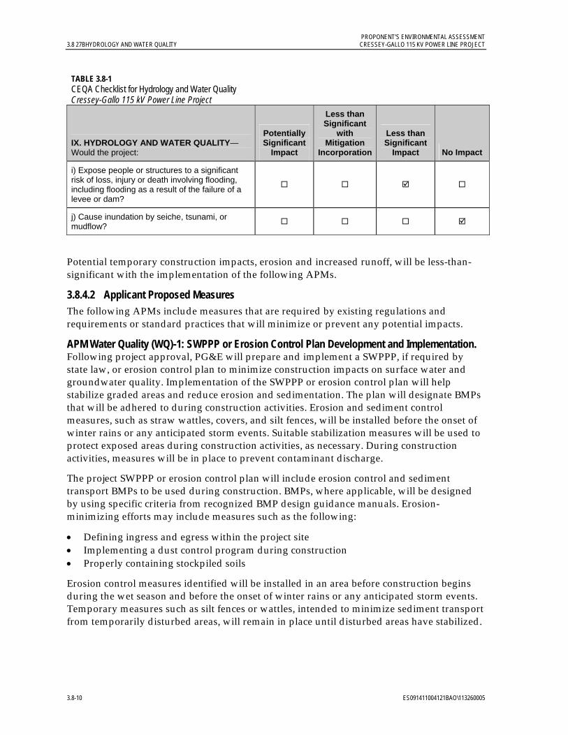
PROPONENT’S ENVIRONMENTAL ASSESSMENT 3.8 27BHYDROLOGY AND WATER QUALITY CRESSEY-GALLO 115 KV POWER LINE PROJECT
3.8-10 ES091411004121BAO\113260005
TABLE 3.8-1 CEQA Checklist for Hydrology and Water Quality Cressey-Gallo 115 kV Power Line Project
IX. HYDROLOGY AND WATER QUALITY—Would the project:
Potentially Significant
Impact
Less than Significant
with Mitigation
Incorporation
Less than Significant
Impact No Impact
i) Expose people or structures to a significant risk of loss, injury or death involving flooding, including flooding as a result of the failure of a levee or dam?
j) Cause inundation by seiche, tsunami, or mudflow?
Potential temporary construction impacts, erosion and increased runoff, will be less-than-significant with the implementation of the following APMs.
3.8.4.2 Applicant Proposed Measures The following APMs include measures that are required by existing regulations and requirements or standard practices that will minimize or prevent any potential impacts.
APM Water Quality (WQ)-1: SWPPP or Erosion Control Plan Development and Implementation. Following project approval, PG&E will prepare and implement a SWPPP, if required by state law, or erosion control plan to minimize construction impacts on surface water and groundwater quality. Implementation of the SWPPP or erosion control plan will help stabilize graded areas and reduce erosion and sedimentation. The plan will designate BMPs that will be adhered to during construction activities. Erosion and sediment control measures, such as straw wattles, covers, and silt fences, will be installed before the onset of winter rains or any anticipated storm events. Suitable stabilization measures will be used to protect exposed areas during construction activities, as necessary. During construction activities, measures will be in place to prevent contaminant discharge.
The project SWPPP or erosion control plan will include erosion control and sediment transport BMPs to be used during construction. BMPs, where applicable, will be designed by using specific criteria from recognized BMP design guidance manuals. Erosion-minimizing efforts may include measures such as the following:
Defining ingress and egress within the project site Implementing a dust control program during construction Properly containing stockpiled soils
Erosion control measures identified will be installed in an area before construction begins during the wet season and before the onset of winter rains or any anticipated storm events. Temporary measures such as silt fences or wattles, intended to minimize sediment transport from temporarily disturbed areas, will remain in place until disturbed areas have stabilized.
PROPONENT’S ENVIRONMENTAL ASSESSMENT CRESSEY-GALLO 115 KV POWER LINE PROJECT 3.8 27BHYDROLOGY AND WATER QUALITY
ES091411004121BAO\113260005 3.8-11
A copy of the SWPPP or erosion control plan will be provided to the CPUC prior to construction for recordkeeping. The plan will be updated during construction as required by the SWRCB.
APM WQ-2: Worker Environmental Awareness Program Development and Implementation. The project’s worker environmental awareness program will communicate environmental issues and appropriate work practices specific to this project. This awareness will include spill prevention and response measures, and proper BMP implementation. The training will emphasize site-specific physical conditions to improve hazard prevention (such as identification of flow paths to nearest water bodies) and will include a review of all site-specific water quality requirements, including applicable portions of erosion control and sediment transport BMPs, health and safety plan, and hazardous substance control and emergency response plan. A copy of the project’s worker environmental awareness training will be provided to the CPUC for recordkeeping prior to the start of construction.
3.8.4.3 Construction, Operation, and Maintenance Impacts Potential temporary impacts during construction include erosion, increased runoff and sedimentation, and release of hazardous materials from construction equipment and vehicles. Potential temporary impacts during operation and maintenance include the release of hazardous materials from maintenance equipment. Permanent impacts to hydrology and water quality are not expected. Temporary impacts will be less than significant and will be further reduced with implementation of the proposed APMs. The following discussion evaluates potential project construction, operation, and maintenance impacts on hydrology and water quality against the significance criteria.
a) Would the project violate any water quality standards or waste discharge requirements? Less-than-significant impact.
Accelerated soil erosion, downstream sedimentation, and reduced surface water quality could potentially occur during construction of the project due to the following activities: (1) vehicular traffic on unpaved areas; (2) excavation, augering, and grading of the project site; and (3) soil disturbance at material laydown areas. Construction activities conducted when the ground is wet also create the potential for increased sediment runoff. Impacts will be less than significant, and implementation of APM WQ-1 and APM WQ-2 will further reduce potential impacts.
Construction of the project will require the use of a variety of motorized heavy equipment, including a variety of transport trucks, graders, and drill rigs. An accidental release from a vehicle or motorized piece of equipment during construction or maintenance activities could infiltrate the soil. Understanding that groundwater is located approximately 45 to 85 feet below the project site surface, an accidental release of petroleum-based fuels and lubricants at the surface or within excavations poses minimal risk to groundwater quality. Potential impacts to nearby irrigation canals and other surface water bodies will be less than significant. Implementation of APM HM-1 (see Section 3.7.4.2) as well as APMs WQ–1 and WQ–2 (Section 3.8.4.2) will further minimize potential less-than-significant impacts.

PROPONENT’S ENVIRONMENTAL ASSESSMENT 3.8 27BHYDROLOGY AND WATER QUALITY CRESSEY-GALLO 115 KV POWER LINE PROJECT
3.8-12 ES091411004121BAO\113260005
b) Would the project substantially deplete groundwater supplies or interfere substantially with groundwater recharge such that there would be a net deficit in aquifer volume or a lowering of the local groundwater table level? No impact.
A water truck with a capacity of 4,000 gallons will be available for to support project construction activities and dust suppression. The water is expected to be obtained for local sources. The project’s minimal use of water will not deplete or interfere with groundwater supply or recharge; therefore, no impact will occur.
c) Would the project substantially alter the existing drainage pattern of the site or area, including through the alteration of the course of a stream or river, in a manner which would result in substantial erosion or sedimentation on- or off-site? No impact.
The project does not alter the course of a stream or river. The project is not designed to substantially alter the drainage pattern of the site; therefore, no impact will occur.
d) Would the project substantially alter the existing drainage pattern of the site or area, including through the alteration of the course of a stream or river, or substantially increase the rate or amount of surface runoff in a manner which would result in flooding on- or off-site? No impact.
The project does not alter the course of a stream or river. The project is not designed to substantially alter the drainage pattern of the site; therefore, no impact will occur.
e) Would the project create or contribute runoff water that would exceed the capacity of existing or planned stormwater drainage systems or provides substantial additional sources of polluted runoff? Less-than-significant impact.
Activities associated with project construction, including grading of the access roads and Cressey and Gallo substations, will have a less-than-significant impact to stormwater drainage systems and will not provide substantial additional sources of polluted runoff. Following construction, the project site will not create or contribute runoff water that will exceed the capacity of existing or planned stormwater drainage systems or provide substantial additional sources of polluted runoff. The implementation of APMs WQ–1, WQ–2, and HM–1 will further reduce potential less-than-significant impacts.
f) Would the project otherwise substantially degrade water quality? No impact.
The project will not substantially degrade water quality; therefore, no impact will occur.
g) Would the project place housing within a 100-year flood hazard area as mapped on a federal Flood Hazard Boundary or Flood Insurance Rate Map? No impact.
The project will not involve housing construction; therefore, no impact will occur.
h) Would the project place within a 100-year flood hazard area structures that would impede or redirect flood flows? No impact.
The project site is not located within a 100-year flood hazard area as indicated by the Merced County General Plan or within a flood hazard area as indicated by FEMA FIRM references (FEMA 2011); therefore, no impact will occur.
PROPONENT’S ENVIRONMENTAL ASSESSMENT CRESSEY-GALLO 115 KV POWER LINE PROJECT 3.8 27BHYDROLOGY AND WATER QUALITY
ES091411004121BAO\113260005 3.8-13
i) Would the project expose people or structures to a significant risk of loss, injury, or death involving flooding, including flooding as a result of the failure of a levee or dam? Less-than-significant impact.
The project site is not located within a 100-year flood hazard area as indicated by the General Plan or within a flood hazard area as indicated by FEMA FIRM information.
Approximately two-thirds of the project site, including the Gallo substation and the western two-thirds of the power line corridor, is located within a potential dam failure inundation area associated with the New Exchequer Dam at Lake McClure, as identified by the Merced County General Plan and a City of Ripon document (Kleinfelder 2006). The inundation maps show the potentially affected project areas to be in zones where released water would spread out onto the alluvial floodplain. Based on correlation of USGS topographic maps and the inundation map, it appears that the potentially affected areas of the project route might be temporary flooded by the initial water surge following a catastrophic failure of New Exchequer Dam, but would not remain under flood waters (i.e., the project areas shown within the inundation area are 10 or more feet higher in elevation than the mapped inundation area boundary). The project will have a less-than-significant impact.
j) Would the project cause inundation by seiche, tsunami, or mudflow? No impact.
Given the project’s distance from any bodies of water subject to tsunami, the project will not expose people or structures to hazards associated with tsunami. Although the project route intersects several canals, these water bodies are not subject to inundation due to seiches because of their small size and non-confined nature. These canals are also not subject to mudflow that could impact the project route because of their small size and/or lined nature, and the flat topography of the site. Project construction, operation and maintenance will not interfere with or affect these canals. Therefore, no impact will occur.
3.8.5 References Arkley, Rodney J. 1964. The Geology, Geomorphology, and Soils of the San Joaquin Valley in the
Vicinity of the Merced River, California. California Geological Survey (CGS) Bulletin 182.
California Department of Forestry and Fire Protection (CDF). 2000. State of California Precipitation Map. Fire Resource Assessment Program (FRAP). Online: http://frap.cdf.ca.gov/webdata/maps/statewide/rainmap.pdf. Accessed on June 27, 2011.
California Department of Water Resources (DWR). 2009. CDWR Groundwater Level Data, Map Interface. http://wdl.water.ca.gov/gw/. Accessed on July 5, 2011.
_______. 2005. Lower Merced River Watershed Map. http://water.ca.gov/watershedrestoration/mapping/images/lower_merced. Accessed on July 6, 2011. June.
_______. 2004. San Joaquin Valley Groundwater Basin, Merced Subbasin. San Joaquin River Hydrologic Region. California’s Groundwater Bulletin No. 118. Last updated February 27, 2004.
PROPONENT’S ENVIRONMENTAL ASSESSMENT 3.8 27BHYDROLOGY AND WATER QUALITY CRESSEY-GALLO 115 KV POWER LINE PROJECT
3.8-14 ES091411004121BAO\113260005
_______. 2003. California’s Groundwater Update 2003. San Joaquin River Hydrologic Region. California’s Groundwater Bulletin No. 118.
_______. 1981. Depth to Top of Corcoran Clay. 1:253,440 Scale Map.
California Hometown Locator. 2011. Livingston Canal - Maps, Driving Directions & Local Area Information. http://california.hometownlocator.com/maps/feature-map. Accessed on July 11, 2011.
Federal Emergency Management Agency (FEMA). 2011. “Flood Insurance Rate Maps (FIRM)” Web site. Online: http://fema.gov/hazard/map/firm/. Accessed on July 6, 2011.
Kleinfelder, Inc. 2006. Inundation Map, New Exchequer Dam. City of Ripon Disaster Management, Emergency Operations Plan. Web page. Online: http://www.cityofripon.org/DisasterManagement/Figures/Ripon%20Inundation%20Fig%208E%20A%20size.pdf. Accessed on August 15, 2011.
Merced County. 1989. Merced County Year 2000 General Plan. Planning Department. June.
_______. 1989. Merced County Hazardous Waste Management Plan. Environmental Health Services Department. December.
State Water Resources Control Board (SWRCB). 2011. “303(d) List of Impaired Waterbodies” Web page. Online: http://www.swrcb.ca.gov/rwqcb3/water_issues/programs/tmdl/303d_list.shtml. Accessed on July 6, 2011.
University of California at Berkeley Museum of Paleontology (UCMP). 2011. “Berkeley Natural History Museums” specimen search Web page. Online: http://bnhm.berkeley.edu/query/index.php. Website accessed on April 12, 2011.
U. S. Geological Survey (USGS). 1987. 7.5 Minute Quadrangle Topographic Maps, Arena, Cressey and Stevinson, California.1:24,000 Scale.
_______. 1981. “Feature Detail Report for: Livingston Canal“ Web page. Online: http://geonames.usgs.gov/pls/gnispublic/. Accessed on July 11, 2011. January 19.
_______. 1976. 7.5 Minute Quadrangle Topographic Map. Turlock, California Quadrangle. 1:24,000 Scale.
PROPONENT’S ENVIRONMENTAL ASSESSMENT CRESSEY-GALLO 115 KV POWER LINE PROJECT 3.9 28BNOISE
ES091411004121BAO\113260005 3.9-1
3.9 Noise 3.9.1 Introduction and Methodology This chapter describes the noise-sensitive receptors and identifies potential noise-related impacts that could result from implementation of the project. Project impacts will be less than significant, and will be further minimized with the APMs described in Section 3.9.3.2.
Evaluation of potential noise impacts from the project included reviewing relevant County, community, and city noise standards, characterizing the existing noise environment, and predicting noise levels and related impacts during both construction and operations.
Noise-sensitive receptors are generally defined as locations where people reside or where the presence of unwanted sound could adversely affect the designated use of the land. Typically, noise-sensitive land uses include residences, hospitals, places of worship, libraries, and schools, as well as nature and wildlife preserves and parks.
3.9.1.1 Fundamentals of Noise Noise is defined as unwanted sound. Airborne sound is a rapid fluctuation of air pressure above and below the ambient pressure. There are several ways to measure noise, depending on the source of the noise, the receiver, and the reason for the noise measurement.
The most common noise metric is the overall A-weighted sound-level measurement that has been adopted by regulatory bodies worldwide. The A-weighting network utilizes frequency-dependent factors to produce a measurement which defines sound in a similar fashion to how a person perceives or hears it, thus achieving a strong correlation in terms of how to evaluate acceptable and unacceptable sound levels. Table 3.9-1 presents the relative A-weighted noise levels of common sounds measured in the environment and industry for various qualitative sound levels.
A-weighted sound levels may be measured or presented as the equivalent sound pressure level (Leq), which is defined as the average equivalent noise level required to produce the same total energy on an equal energy basis for a stated period of time. It is commonly used to measure steady-state sound or the noise level that is usually dominant. Statistical methods are used to define the dynamics of a changing acoustical environment. Statistical measurements are typically denoted by percentile exceeded sound level Lxx, where xx
represents the percentile of time the sound level is exceeded. Therefore, L90 represents the noise level that is exceeded during 90 percent of the measurement period. Similarly, L10 represents the noise level exceeded for 10 percent of the measurement period.
Another factor in determining the impact of environmental noise is the difference in response that people have to daytime and nighttime noise levels. During the evening and still more so at night, exterior background noise levels are generally lower than daytime levels. Most household noise also decreases at night, and exterior noise becomes more noticeable. Furthermore, most people sleep at night and are thus more sensitive to intrusive noises. To account for human sensitivity to evening and nighttime noise levels, the day-night noise level (Ldn) average and the community noise equivalent level (CNEL) were developed. Ldn is a noise metric that accounts for the greater annoyance of noise during the nighttime hours (10:00 p.m. to 7:00 a.m.). CNEL is a noise index that accounts for the greater
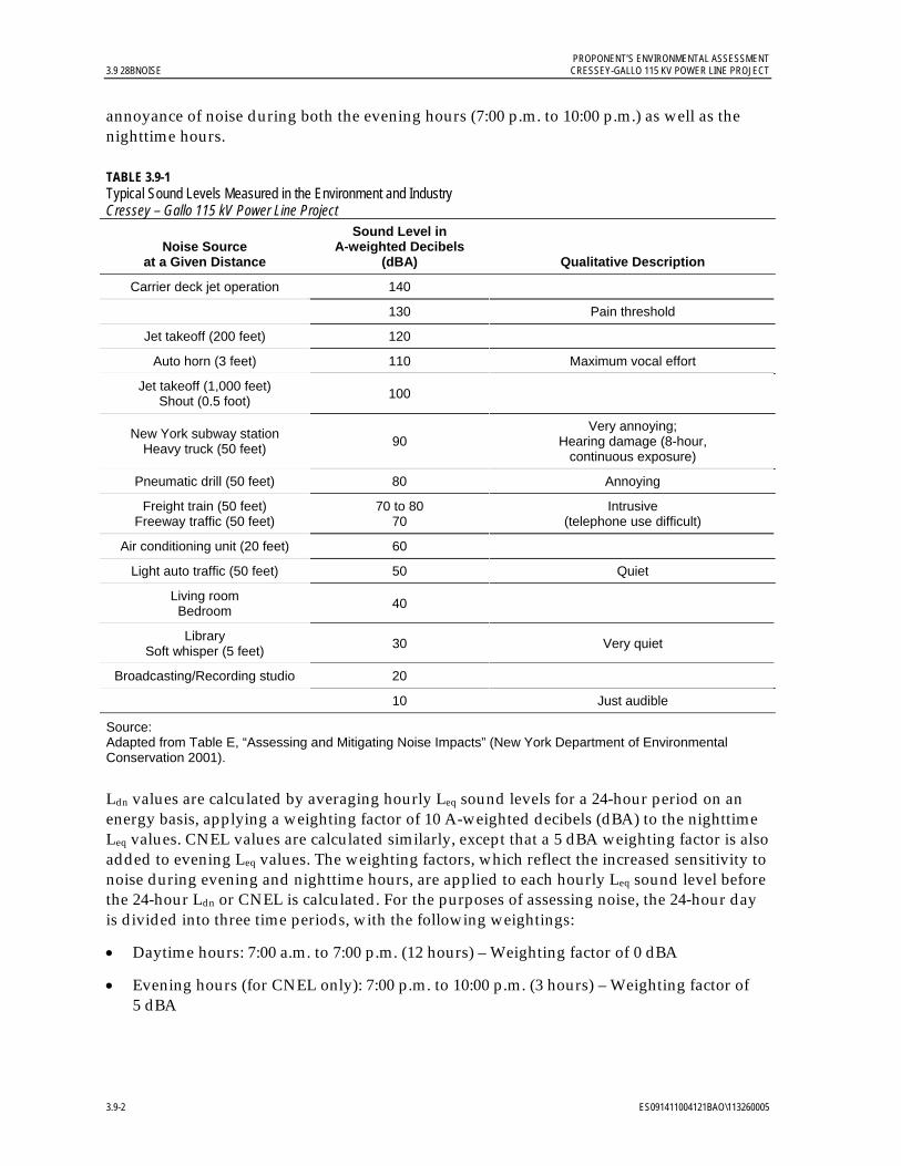
PROPONENT’S ENVIRONMENTAL ASSESSMENT 3.9 28BNOISE CRESSEY-GALLO 115 KV POWER LINE PROJECT
3.9-2 ES091411004121BAO\113260005
annoyance of noise during both the evening hours (7:00 p.m. to 10:00 p.m.) as well as the nighttime hours.
TABLE 3.9-1 Typical Sound Levels Measured in the Environment and Industry Cressey – Gallo 115 kV Power Line Project
Noise Source at a Given Distance
Sound Level in A-weighted Decibels
(dBA) Qualitative Description
Carrier deck jet operation 140
130 Pain threshold
Jet takeoff (200 feet) 120
Auto horn (3 feet) 110 Maximum vocal effort
Jet takeoff (1,000 feet) Shout (0.5 foot)
100
New York subway station Heavy truck (50 feet)
90 Very annoying;
Hearing damage (8-hour, continuous exposure)
Pneumatic drill (50 feet) 80 Annoying
Freight train (50 feet) Freeway traffic (50 feet)
70 to 80 70
Intrusive (telephone use difficult)
Air conditioning unit (20 feet) 60
Light auto traffic (50 feet) 50 Quiet
Living room Bedroom
40
Library Soft whisper (5 feet)
30 Very quiet
Broadcasting/Recording studio 20
10 Just audible
Source: Adapted from Table E, “Assessing and Mitigating Noise Impacts” (New York Department of Environmental Conservation 2001).
Ldn values are calculated by averaging hourly Leq sound levels for a 24-hour period on an energy basis, applying a weighting factor of 10 A-weighted decibels (dBA) to the nighttime Leq values. CNEL values are calculated similarly, except that a 5 dBA weighting factor is also added to evening Leq values. The weighting factors, which reflect the increased sensitivity to noise during evening and nighttime hours, are applied to each hourly Leq sound level before the 24-hour Ldn or CNEL is calculated. For the purposes of assessing noise, the 24-hour day is divided into three time periods, with the following weightings:
Daytime hours: 7:00 a.m. to 7:00 p.m. (12 hours) – Weighting factor of 0 dBA
Evening hours (for CNEL only): 7:00 p.m. to 10:00 p.m. (3 hours) – Weighting factor of 5 dBA
PROPONENT’S ENVIRONMENTAL ASSESSMENT CRESSEY-GALLO 115 KV POWER LINE PROJECT 3.9 28BNOISE
ES091411004121BAO\113260005 3.9-3
Nighttime hours (for both CNEL and Ldn): 10:00 p.m. to 7:00 a.m. (9 hours) – Weighting factor of 10 dBA
The hourly adjusted time-period noise levels are then averaged (on an energy basis) to compute the overall Ldn or CNEL value. For a continuous noise source, the Ldn value can be computed by adding 6.4 dBA to the overall 24-hour noise level (Leq). For example, if the expected continuous noise level from a noise source is 60.0 dBA, the resulting Ldn from the source would be 66.4 dBA. Similarly, the CNEL for a continuous noise source is computed by adding 6.7 dBA to the overall 24-hour Leq.
The general human response to changes in noise levels that are similar in frequency content (such as comparing increases in continuous (Leq) traffic noise levels) are summarized as follows:
A 3-decibel change in sound level is considered a barely noticeable difference. A 5-decibel change in sound level will typically be noticeable. A 10-decibel increase is considered to be a doubling in loudness.
3.9.1.2 Project Noise Sources Equipment used in the construction of the proposed project will generate noise. Typical noise levels generated by construction equipment have been previously calculated and published in various reference documents. The most recent and complete compilation of construction equipment noise is the Roadway Construction Noise Model prepared by the Federal Highway Administration (FHWA). The expected equipment noise levels listed in the Roadway Construction Noise Model User’s Guide (FHWA 2006) were used for this evaluation.
There are three potential sources of operational noise associated with electric power lines and substations: corona noise from the transmission lines, transformer noise from the substation equipment, and vehicle noise from maintenance vehicles (infrequent). This project is not installing new transformers or removing existing transformers, and the infrequent noise from maintenance vehicles will not change noticeably from the existing maintenance noise. Corona noise, as discussed below, is generally not an issue for 115 kV power lines. Thus, none of these sources will result in substantial impacts from the proposed project.
Corona generates audible noise during operation of high-voltage transmission lines. The noise is generally characterized as a crackling, hissing, or humming noise. During wet or foul weather conditions (such as rain or fog), the conductor will produce the greatest amount of corona noise and have the greatest potential to be noticeable. However, during heavy rain the ambient noise generated by the falling raindrops will typically be greater than the noise generated by corona. This noise is caused by small electrical discharges from the water drops and is generally more noticeable on high-voltage lines. Corona is usually not a design issue for power lines rated at 230 kV and lower.

PROPONENT’S ENVIRONMENTAL ASSESSMENT 3.9 28BNOISE CRESSEY-GALLO 115 KV POWER LINE PROJECT
3.9-4 ES091411004121BAO\113260005
3.9.2 Regulatory Background Federal There are no federal regulations that limit overall environmental noise levels for this project.
State Although there is no statewide noise regulation or specific threshold for determining what constitutes a substantial increase in noise, the CEQA Checklist identifies the criteria that must be considered when analyzing a project’s potential to result in temporary and permanent impacts on sensitive receptors as a result of noise (see Section 3.9.3.1, Significance Criteria).
Local Because the California Public Utilities Commission has exclusive jurisdiction over the siting, design, and construction of the project, the project is not subject to local discretionary noise requirements. The following analysis of local regulations relating to noise is provided for information purposes and to assist with CEQA review.
Section 10.60.030 of the County Ordinance Code (Merced County 2009) states that no person shall cause, suffer, allow or permit the operation of any sound source on private property in such a manner as to create a sound level that results in any of the following, when measured at or within the real property line of the receiving property:
1. Exceeds the background sound level by at least 10 dBA during daytime hours (7:00 a.m. to 10:00 p.m.) and by at least 5 dBA during nighttime hours (10:00 p.m. to 7:00 a.m.); or
2. Exceeds 65 dBA Ldn on residential real property or 70 dBA Ldn on nonresidential real property; or
3. Exceeds 75 dBA Lmax on residential real property or 80 dBA Lmax on nonresidential real property.
Construction activity is exempt from these requirements, provided that all construction occurring in or adjacent to urban areas is limited to the daytime hours between 7:00 a.m. and 6:00 p.m., and that all construction equipment is properly muffled and maintained.
3.9.3 Environmental Setting The project is located in the San Joaquin Valley in Merced County near the City of Livingston, California; however, none of the project elements are within the City of Livingston. Land use within the project route is primarily agricultural with intermittent rural residences. Agricultural uses include orchards, vineyards, field crops, pastures, poultry farms, and dairies. Open fields and landscaping are located along the project route. The Gallo Winery facility and some light industry are located adjacent to the project route, such as on the southwest side of the project route intersection with SR 99.
As noted above, noise-sensitive land uses generally are defined as locations where people reside or where the presence of unwanted sound could adversely affect the designated use of the land. Typically, noise-sensitive land uses include residences, hospitals, places of worship, libraries, and schools, as well as nature and wildlife preserves and parks.
Figure 3.9-1 shows the locations of the sensitive receptors in relation to the project site.

PROPONENT’S ENVIRONMENTAL ASSESSMENT CRESSEY-GALLO 115 KV POWER LINE PROJECT 3.9 28BNOISE
ES091411004121BAO\113260005 3.9-5
Insert Figure
3.9-1 Sensitive Receptors
8.5 x 11
4 pages

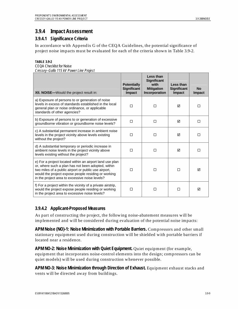
PROPONENT’S ENVIRONMENTAL ASSESSMENT CRESSEY-GALLO 115 KV POWER LINE PROJECT 3.9 28BNOISE
ES091411004121BAO\113260005 3.9-9
3.9.4 Impact Assessment 3.9.4.1 Significance Criteria In accordance with Appendix G of the CEQA Guidelines, the potential significance of project noise impacts must be evaluated for each of the criteria shown in Table 3.9-2.
TABLE 3.9-2 CEQA Checklist for Noise Cressey–Gallo 115 kV Power Line Project
XII. NOISE—Would the project result in:
Potentially Significant
Impact
Less than Significant
with Mitigation
Incorporation
Less than Significant
Impact No
Impact
a) Exposure of persons to or generation of noise levels in excess of standards established in the local general plan or noise ordinance, or applicable standards of other agencies?
b) Exposure of persons to or generation of excessive groundborne vibration or groundborne noise levels?
c) A substantial permanent increase in ambient noise levels in the project vicinity above levels existing without the project?
d) A substantial temporary or periodic increase in ambient noise levels in the project vicinity above levels existing without the project?
e) For a project located within an airport land use plan or, where such a plan has not been adopted, within two miles of a public airport or public use airport, would the project expose people residing or working in the project area to excessive noise levels?
f) For a project within the vicinity of a private airstrip, would the project expose people residing or working in the project area to excessive noise levels?
3.9.4.2 Applicant-Proposed Measures As part of constructing the project, the following noise-abatement measures will be implemented and will be considered during evaluation of the potential noise impacts:
APM Noise (NO)-1: Noise Minimization with Portable Barriers. Compressors and other small stationary equipment used during construction will be shielded with portable barriers if located near a residence.
APM NO-2: Noise Minimization with Quiet Equipment. Quiet equipment (for example, equipment that incorporates noise-control elements into the design; compressors can be quiet models) will be used during construction whenever possible.
APM NO-3: Noise Minimization through Direction of Exhaust. Equipment exhaust stacks and vents will be directed away from buildings.

PROPONENT’S ENVIRONMENTAL ASSESSMENT 3.9 28BNOISE CRESSEY-GALLO 115 KV POWER LINE PROJECT
3.9-10 ES091411004121BAO\113260005
APM NO-4: Noise Minimization through Truck Traffic Routing. Truck traffic will be routed away from noise-sensitive areas where feasible.
APM NO-5: Noise Disruption Minimization through Residential Notification. In the event that nighttime construction is necessary because of clearance restrictions, affected residents will be notified in advance by mail, personal visit, or door-hanger and informed of the expected work schedule.
3.9.4.3 Construction, Operation and Maintenance Impacts Typical noise levels generated by the construction equipment listed in the project description have been calculated previously and published in various reference documents. The expected equipment noise levels listed in the FHWA Roadway Construction Noise Model User’s Guide (FHWA 2006) were used for this evaluation. The User’s Guide provides the most recent comprehensive assessment of noise levels from construction equipment. Table 3.9-3 summarizes the average (Leq) noise level at several distances.
TABLE 3.9-3 Typical Construction Equipment Noise Levels Cressey–Gallo 115 kV Power Line Project
Equipment Description
Acoustical Usage Factor
(%)
Specified Lmax at 50 feet (dBA)
Calculated Leq at
100 feet (dBA)
Calculated Leq at
1,000 feet(dBA)
Calculated Leq at
2,000 feet (dBA)
Calculated Leq at
4,000 feet(dBA)
All Other Equipment > 5 horsepower 50 85 76 56 50 44
Auger Drill Rig 20 85 72 52 46 40
Backhoe 40 80 70 50 44 38
Crane 16 85 71 51 45 39
Dump Truck 40 84 74 54 48 42
Grader 40 85 75 55 49 43
Pickup Truck 40 55 45 25 19 13
Tractor 40 84 74 54 48 42
Notes:
dBA = A-weighted decibels; Leq = equivalent sound pressure level
Source: FHWA Roadway Construction Noise Model User’s Guide (FHWA 2006).
Equation to calculate Lmax at 1,000, 2,000 and 4,000 feet is as follows:
Leq(h) = Lmax + 10*log(A.U.F.) – 20*log(D/Do)
where:
Lmax = Maximum noise emission level of equipment based on work cycle at D/Do (decibel).
A.U.F. = Acoustical usage factor, which accounts for the percent time that equipment is in use over the time period of interest (1 hour).
D = Distance from the equipment to the receptor (feet).
Do = Reference distance (generally, 50 feet) at which the Lmax was measured for the equipment of interest (feet).

PROPONENT’S ENVIRONMENTAL ASSESSMENT CRESSEY-GALLO 115 KV POWER LINE PROJECT 3.9 28BNOISE
ES091411004121BAO\113260005 3.9-11
Review of the typical construction equipment noise levels in Tables 2.8-3 and 2.8-4 of the Project Description (see Section 2) indicates that the loudest equipment generally emits noise in the range of 80 to 90 dBA at 50 feet, with usage factors of 40 percent to 50 percent. Noise at any specific receptor is dominated by the closest and loudest equipment. The types and numbers of construction equipment near any specific receptor location will vary over time. The following conservative assumptions were used for modeling construction noise:
One piece of equipment generating a reference noise level of 85 dBA (at 50 feet distance with a 40-percent usage factor) located on the power line route.
Two pieces of equipment generating reference 85-dBA noise levels located 50 feet farther away on the power line route (100 feet distance with a 40 percent usage factor).
Two additional pieces of equipment generating reference 85-dBA noise levels located 100 feet farther away on the power line route (200 feet distance with a 40 percent usage factor).
Table 3.9-4 presents construction equipment noise levels at various distances based on this scenario.
TABLE 3.9-4 Construction Equipment Noise Levels Versus Distance Cressey–Gallo 115 kV Power Line Project
Distance from Construction Activity (feet)
Leq Noise Level (dBA)
50 83
100 79
200 74
400 69
800 63
1,600 58
3,200 52
6,400 46
Notes:
dBA = A-weighted decibels; Leq = equivalent sound pressure level
See text narrative preceding this table for the parameters of this noise modeling scenario.
a) Would the project result in exposure of persons to or generation of noise levels in excess of standards established in the local general plan or noise ordinance, or applicable standards of other agencies? Less-than-significant impact.
The project will be designed to be compatible with applicable County noise standards. Construction activities will be short-term at each pole location (one or two days), temporary, and limited to daytime hours, compatible with the local requirements. If nighttime construction is necessary to continue work until a safe stopping point is reached or if planned electrical outages (clearances) are scheduled at night, activities will be infrequent
PROPONENT’S ENVIRONMENTAL ASSESSMENT 3.9 28BNOISE CRESSEY-GALLO 115 KV POWER LINE PROJECT
3.9-12 ES091411004121BAO\113260005
and short-term. Construction is expected to last a total of approximately 9 months, with work occurring five days per week. Construction of the project will result in a less-than-significant impact under this criterion. The implementation of APM NO-1, APM NO-2, APM NO-3, APM NO-4, and APM NO-5 will further minimize exposure to less-than-significant construction noise.
Corona noise associated with moisture on the new electrical wires is anticipated to be minimal. The corona noise under the worst case foul weather condition is expected to be less than the existing sound levels. No increases in noise from the existing substations are expected from the proposed modifications to the bus work. Therefore, the impacts from operation noise from the proposed project will result in a less-than-significant impact under this criterion.
Maintenance activities currently performed on the existing distribution line along the project will continue and include the power line and the co-located or other distribution line along the route. Maintenance activities will typically occur over short timeframes each year and generate minimal noise. As with existing maintenance activities involving noise-generating equipment or vehicles, noise reduction measures will be employed to reduce temporary noise impacts. Therefore, the impacts from maintenance noise due to implementation of the proposed project will remain less than significant under this criterion.
b) Would the project result in exposure of persons to or generation of excessive groundborne vibration or groundborne noise levels? Less-than-significant impact.
Construction activities (e.g., ground-disturbing activities, including grading and movement of heavy construction equipment) may generate localized groundborne vibration and noise. Heavy equipment operation is not anticipated to result in excessive groundborne vibration. Groundborne vibration and noise will occur during daytime hours and will be of short-term duration. Therefore, construction of the proposed project will result in a less-than-significant impact under this criterion.
Equipment associated with operation and maintenance of the proposed project will not produce any groundborne noise or vibration; therefore, operation and maintenance of the project will result in no impact under this criterion.
c) Would the project result in substantial permanent increase in ambient noise levels in the project vicinity above levels existing without the project? Less-than-significant impact.
Project construction will not result in a permanent increase in ambient noise levels.
Corona typically becomes a design concern for transmission lines at 230 kV and higher, and is less noticeable or inaudible on lines operated at lower voltages such as this 115 kV power line. Corona noise associated with operation of the proposed project is anticipated to be minimal. The corona noise under foul weather conditions is expected to be less than the existing sound levels. No increases in noise from the substations are expected from the proposed modifications to the bus work. Therefore, the impacts from operation noise from the proposed project will be a less-than-significant impact under this criterion.
Maintenance activities will be temporary and are addressed under the next criterion.
PROPONENT’S ENVIRONMENTAL ASSESSMENT CRESSEY-GALLO 115 KV POWER LINE PROJECT 3.9 28BNOISE
ES091411004121BAO\113260005 3.9-13
d) Would the project result in substantial temporary or periodic increase in ambient noise levels in the project vicinity above levels existing without the project? Less-than-significant impact.
Any increases in ambient noise levels in the project vicinity during construction will be short-term, intermittent, and temporary. Adverse construction noise impacts (e.g., nighttime construction near residences) are not anticipated. Construction noise impacts from the proposed project will be a less-than-significant impact under this criterion. Implementation of APM NO-1, APM NO-2, APM NO-3, APM NO-4 and APM NO-5 will further minimize construction equipment noise.
Maintenance activities currently performed on the distribution lines along the project route will continue and will include the new 115 kV power line. Maintenance activities will typically occur over short timeframes each year and generate minimal noise. As with existing maintenance activities involving noise-generating equipment or vehicles, noise reduction measures will be employed to reduce temporary noise impacts. Operation will not change from existing conditions to result in substantial temporary or periodic increase in ambient noise levels in the project vicinity above existing levels. Therefore, the impacts from operation and maintenance noise due to implementation of the proposed project will continue to be less than significant under this criterion.
e) For a project located within an airport land use plan or, where such a plan has not been adopted, within 2 miles of a public airport or public use airport, would the project expose people residing or working in the project area to excessive noise levels? No impact.
Construction, operation, and maintenance of the project will occur at a distance greater than 2 miles from a public airport; therefore, the project will result in no impact under this criterion.
f) For a project within the vicinity of a private airstrip, would the project expose people residing or working in the project area to excessive noise levels? No impact.
No private airstrips are located within 2 miles of the project; therefore, the project will result in no impact under this criterion.
3.9.5 References Federal Highway Administration (FHWA). 2006. FHWA Roadway Construction Noise Model
User’s Guide. Final Report. U.S. Department of Transportation. FHWA-HEP-05-054. DOT-VNTSC-FHWA-05-01. Online: http://www.fhwa.dot.gov/environment/noise/construction_noise/rcnm/rcnm.pdf. January.
Merced County. 2009. Merced County Code. Adopted August 20, 2008.
Merced County. 2008. Merced County General Plan Noise Element. Adopted October 2008.
Miller, L.N. 1978. Sound Levels of Rain and Wind in the Trees, Noise Control Engineering, Vol. 11, No. 3, pp. 101-109, November/December.
New York Department of Environmental Conservation. 2001. Assessing and Mitigating Noise Impacts. February 2001.


PROPONENT’S ENVIRONMENTAL ASSESSMENT CRESSEY-GALLO 115 KV POWER LINE PROJECT 3.10 29BPOPULATION AND HOUSING, PUBLIC SERVICES, AND UTILITIES AND SERVICE SYSTEMS
ES091411004121BAO\113260005 3.10-1
3.10 Population and Housing, Public Services, and Utilities and Service Systems
3.10.1 Introduction and Methodology This section describes existing conditions and potential impacts on population and housing, public services, and utilities and service systems as a result of construction, operation, and maintenance of the project, and concludes that there will be no project impacts in these areas.
Public services include fire and police protection, and maintenance of public facilities such as schools and parks. Utilities and service systems include power, natural gas, communications, water treatment and distribution, sewer and septic facilities, stormwater drainage, solid waste disposal, and local and regional water supplies. Figure 3.10-1 illustrates the public services located within the vicinity of the project area. This section was prepared on the basis of reviews of the Merced County Year 2000 General Plan, 2030 Merced County General Plan Public Review Draft, Merced County General Plan Housing Element, Merced County Department of Public Works Improvement Standards and Specifications, Merced County Fire Department (MCFD) Website, phone communication with the Merced County Sheriff’s Department (MCSD), and the U.S. Census Bureau Website (Merced County 1990, 2007, 2009, 2010 and 2011; MCFD 2011; MCSD 2011; and United States Census Bureau 2009a; 2009b; 2010a; 2010b and 2010c). Because the 2030 Merced County General Plan is not yet operative, the Year 2000 General Plan (Merced County 1990) was used for this analysis.
3.10.2 Regulatory Background 3.10.2.1 Federal Occupational Safety and Health (OSH) Act of 1970. The OSH Act is a federal law aimed at providing workers with safe and healthful working conditions. The Act also created the Occupational Safety and Health Administration (OSHA), which oversees and enforces worker safety. Job site conditions will be maintained in accordance with this law.
3.10.2.2 State California Occupational Safety and Health Act of 1973. This Act establishes regulations for a safe working environment. The Division of Occupational Safety and Health (known as Cal/OSHA) is responsible for enforcing California laws and regulations pertaining to workplace safety and health and for providing assistance to employers and workers regarding workplace safety and health issues. Job site conditions will be maintained in accordance with this law.
Title 14 California Code of Regulations Sections 1250-1258, Fire Prevention Standards for Electric Utilities. 14 CCR 1250–1258 provide clearance standards for electric poles and tower firebreaks and electric conductors.
The California Public Utilities Commission (CPUC) General Order 95, Rules for Overhead Electric Line Construction. In Section 35, the CPUC rule covers all aspects of design, construction, operation, and maintenance of electrical power lines and fire safety hazards.

PROPONENT’S ENVIRONMENTAL ASSESSMENT 3.10 29BPOPULATION AND HOUSING, PUBLIC SERVICES, AND UTILITIES AND SERVICE SYSTEMS CRESSEY-GALLO 115 KV POWER LINE PROJECT
3.10-2 ES091411004121BAO\113260005
Insert Figure
3.10-1 Public Services Within the Project Area
8.5 x 11

PROPONENT’S ENVIRONMENTAL ASSESSMENT CRESSEY-GALLO 115 KV POWER LINE PROJECT 3.10 29BPOPULATION AND HOUSING, PUBLIC SERVICES, AND UTILITIES AND SERVICE SYSTEMS
ES091411004121BAO\113260005 3.10-3
3.10.2.3 Local Because the CPUC has exclusive jurisdiction over the siting, design, and construction of the project, the project is not subject to local discretionary regulations. The following analysis of local regulations relating to population and housing, public services, and utilities and service systems is provided for informational purposes and to assist with CEQA review.
3.10.3 Environmental Setting 3.10.3.1 Population and Housing The project is located in a primarily agricultural area in the San Joaquin Valley within Merced County. Merced County has an estimated land area of 1,928.69 square miles (U.S. Census Bureau 2010a), and an estimated 2010 population of 255,793 (U.S. Census Bureau 2010c). The project is located outside the City of Livingston; the city limits are approximately 0.25 mile from the closest portion of the project route.
The primary population centers in the project area are the incorporated Cities of Livingston, Merced, and Atwater as well as the communities of Delhi, Winton, and Cressey. According to U.S. Census Bureau 2009 Population Estimates, as of July 2009 the population of the City of Livingston was 13,368, the population of the City of Merced was 76,273, and the population of the City of Atwater was 26,198 (U.S. Census Bureau 2009a). The average populations of the communities of Delhi and Winton between 2005 and 2009 were 10,003 and 9,625, respectively (U.S. Census Bureau 2009b), while the population of the community of Cressey in 2010 was 394 (U.S. Census Bureau 2010b). In addition, rural residences are located in unincorporated areas intermittently along the project route.
The Merced County General Plan Housing Element was adopted June 22, 2010. According to the Housing Element, over the last several decades unincorporated Merced County’s housing stock has consisted mostly of moderately priced, single-family homes built in traditional suburban and rural subdivisions. Although Merced County’s housing stock is considered relatively affordable by California standards, there still exists a sizeable demand for quality, affordable housing for a significant portion of the County’s population. The County has approved several new large-scale master-planned communities (including the Villages of Laguna San Luis, Fox Hills, and University Community) to provide a variety of housing types to meet the needs of its diversifying population. These new communities provide opportunities to meet the County’s regional housing need while also creating affordable housing.
3.10.3.2 Public Services Fire Protection. The Merced County Fire Department is a full-service fire department providing emergency services to the Cities of Gustine, Dos Palos, and Livingston including the unincorporated community of Cressey, as well as all unincorporated areas of the County. The MCFD staffs a total of 20 fire stations and a fleet of approximately 80 vehicles. The MCFD is administered, and fire suppression personnel are provided, through a contract with the California Department of Forestry and Fire Protection (CAL FIRE). Fire stations are staffed 24 hours a day by a full-time career Fire Captain or Fire Apparatus Engineer and emergency response is augmented with over 300 Paid Call Firefighters that are organized into engine companies by the station’s response area within which they reside (MCFD 2011). The MCFD will be designated as the first responder for all project-related incidents.
PROPONENT’S ENVIRONMENTAL ASSESSMENT 3.10 29BPOPULATION AND HOUSING, PUBLIC SERVICES, AND UTILITIES AND SERVICE SYSTEMS CRESSEY-GALLO 115 KV POWER LINE PROJECT
3.10-4 ES091411004121BAO\113260005
Police Protection. The Merced County Sheriff’s Department provides law enforcement services to all unincorporated areas of the County, including the project area. Currently, the MCSD consists of 72 full-time and 25 part-time sworn officers (MCSD 2011).
Schools. There are a total of 20 school districts with 90 schools within Merced County. Public primary education is overseen by the Merced County Office of Education, a regional agency whose mission is to provide educational leadership, resources, and service to assist school districts to be effective facilitators of learning for all pupils. In addition to the core programs offered, these districts provide many other social, health, and education-related programs and services for children, parents, and educators. There are also several private schools throughout Merced County. As shown in Figure 3.10-1 above, Schelby School (a Merced County special education school serving approximately 215 students) is located within a half-mile of the project route (Merced County 2007). No other schools are located within a half mile of the project.
Parks. Merced County contains several county, state, and federal parks and public open space areas. There are approximately 114,000 acres of park and recreation facilities in the County that offer a variety of amenities such as picnicking, swimming, boating, hunting, bird watching, playgrounds, sports fields, and hiking. While no parks are located within a half-mile of the project area, nearby parks within two miles of the project area include Arakelian Park, Lucero Park, Livingston Memorial Park, and Livingston Sports Complex in the City of Livingston. Amenities at these facilities include the following:
Arakelian Park: Playground, covered picnic area, baseball field, and barbeque area; approximately 0.7 mile north of the project area.
Lucero Park: Playground, picnic table, and volleyball area; approximately 1.6 miles north of the project area.
Livingston Memorial Park: Playground, covered picnic area, barbeque area, and stage; approximately 0.7 mile north of the project area.
Livingston Sports Complex: Picnic tables, baseball field, and soccer field; approximately 1.5 miles north of the project area.
In addition, Winton County Park in the community of Winton is approximately 3.3 miles east of the project area. McConnell State Recreation Area is also located approximately 3.1 miles to the north of the project area and provides fishing, picnic, camping, and play areas (California State Parks 2011). Please refer to Figure 3.10-1 above for the locations of these park facilities. For additional information on recreational resources potentially affected by the project, see Section 3.2, Agricultural and Forest Resources, Land Use and Planning, and Recreation.
3.10.3.3 Utilities and Service Systems Wastewater Treatment. Several special districts, including community service districts, water districts, and sanitary districts, provide sanitary sewer service within the unincorporated communities in Merced County. Unincorporated communities that lack sanitary sewer infrastructure are serviced by septic systems. Within the project vicinity, wastewater services are provided to the City of Livingston by Environmental Management Services and

PROPONENT’S ENVIRONMENTAL ASSESSMENT CRESSEY-GALLO 115 KV POWER LINE PROJECT 3.10 29BPOPULATION AND HOUSING, PUBLIC SERVICES, AND UTILITIES AND SERVICE SYSTEMS
ES091411004121BAO\113260005 3.10-5
to the City of Atwater by Veolia Water. The City of Merced operates its own wastewater treatment plant, while the community of Cressey relies on septic systems.
Water Supply. Merced County depends heavily on groundwater for its water needs. Historical water data show that the use of surface water supplied by the irrigation districts is decreasing during droughts, while the pumping of groundwater for irrigation has been increasing. Merced County does not own or control water rights within the County. There are five major irrigation districts, nine medium-sized irrigation districts or water agencies, and 15 smaller irrigation districts or water agencies that control and manage water resources within the County. Water in the project area is provided by the Merced Irrigation District (Nolte Associates 2009).
Electricity. Electrical services within Merced County are provided by PG&E, Merced Irrigation District, and Turlock Irrigation District.
Natural Gas. Natural gas services within Merced County are provided by PG&E.
Communications. Telecommunication services are primarily provided by SBC/AT&T, with a wide range of other service providers in the market for wireless and long-distance services.
Stormwater Drainage. Some areas of Merced County are exposed to flooding due to periodic heavy rainfall, snowmelt, dam failures, and inadequate storm drainage systems. To prevent flooding in Merced County, the County enforces stormwater and floodplain management practices. Developers are required to provide their own storm drainage systems within subdivisions in most unincorporated communities of the County unless there is a community system in place. With the exception of the community of Hilmar, the County maintains these storm drainage systems.
Solid Waste Disposal. Merced County does not operate solid waste hauling operations. Solid waste hauling and disposal within the project area is conducted by Winton Disposal/Waste Management. No transfer stations exist within the County. Waste is collected through drop boxes and curbside collection. Within the County, there are two active solid waste disposal/landfill facilities owned and operated by the Merced County Regional Waste Management Authority: the Highway 59 Landfill and the Billy Wright Landfill. The Department of Public Works operates a Household Hazardous Waste Collection Facility at the Highway 59 Landfill that collects waste oil, batteries, household pesticides, antifreeze, electronics wastes, and other household hazardous waste.
3.10.4 Impact Assessment 3.10.4.1 Significance Criteria In accordance with Appendix G of the CEQA Guidelines, the potential significance of project impacts on population and housing, public services, and utilities and service systems must be evaluated for each of the criteria listed in Tables 3.10-1 through 3.10-3, respectively.
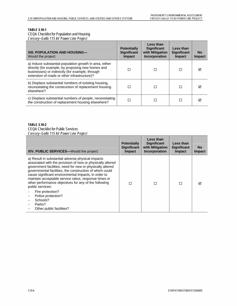
PROPONENT’S ENVIRONMENTAL ASSESSMENT 3.10 29BPOPULATION AND HOUSING, PUBLIC SERVICES, AND UTILITIES AND SERVICE SYSTEMS CRESSEY-GALLO 115 KV POWER LINE PROJECT
3.10-6 ES091411004121BAO\113260005
TABLE 3.10-1 CEQA Checklist for Population and Housing Cressey–Gallo 115 kV Power Line Project
XIII. POPULATION AND HOUSING— Would the project:
Potentially Significant
Impact
Less than Significant
with Mitigation Incorporation
Less than Significant
Impact No
Impact
a) Induce substantial population growth in area, either directly (for example, by proposing new homes and businesses) or indirectly (for example, through extension of roads or other infrastructure)?
b) Displace substantial numbers of existing housing, necessitating the construction of replacement housing elsewhere?
c) Displace substantial numbers of people, necessitating the construction of replacement housing elsewhere?
TABLE 3.10-2 CEQA Checklist for Public Services Cressey–Gallo 115 kV Power Line Project
XIV. PUBLIC SERVICES—Would the project:
Potentially Significant
Impact
Less than Significant
with Mitigation Incorporation
Less than Significant
Impact No
Impact
a) Result in substantial adverse physical impacts associated with the provision of new or physically altered government facilities, need for new or physically altered governmental facilities, the construction of which could cause significant environmental impacts, in order to maintain acceptable service ratios, response times or other performance objectives for any of the following public services:
Fire protection? Police protection? Schools? Parks? Other public facilities?
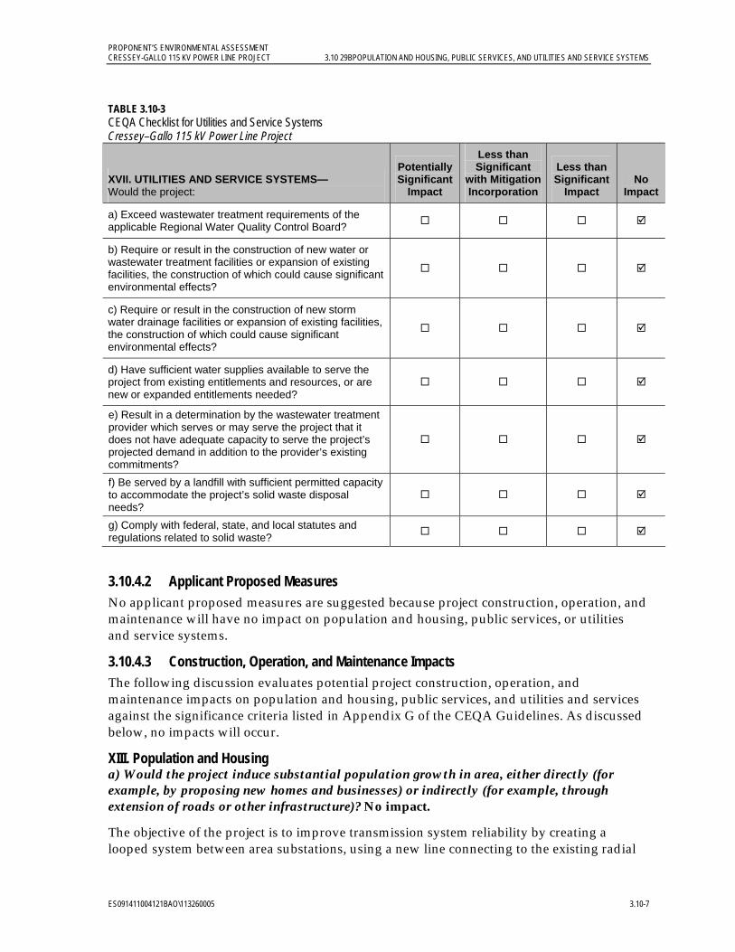
PROPONENT’S ENVIRONMENTAL ASSESSMENT CRESSEY-GALLO 115 KV POWER LINE PROJECT 3.10 29BPOPULATION AND HOUSING, PUBLIC SERVICES, AND UTILITIES AND SERVICE SYSTEMS
ES091411004121BAO\113260005 3.10-7
TABLE 3.10-3 CEQA Checklist for Utilities and Service Systems Cressey–Gallo 115 kV Power Line Project
XVII. UTILITIES AND SERVICE SYSTEMS— Would the project:
Potentially Significant
Impact
Less than Significant
with Mitigation Incorporation
Less than Significant
Impact No
Impact
a) Exceed wastewater treatment requirements of the applicable Regional Water Quality Control Board?
b) Require or result in the construction of new water or wastewater treatment facilities or expansion of existing facilities, the construction of which could cause significant environmental effects?
c) Require or result in the construction of new storm water drainage facilities or expansion of existing facilities, the construction of which could cause significant environmental effects?
d) Have sufficient water supplies available to serve the project from existing entitlements and resources, or are new or expanded entitlements needed?
e) Result in a determination by the wastewater treatment provider which serves or may serve the project that it does not have adequate capacity to serve the project’s projected demand in addition to the provider’s existing commitments?
f) Be served by a landfill with sufficient permitted capacity to accommodate the project’s solid waste disposal needs?
g) Comply with federal, state, and local statutes and regulations related to solid waste?
3.10.4.2 Applicant Proposed Measures No applicant proposed measures are suggested because project construction, operation, and maintenance will have no impact on population and housing, public services, or utilities and service systems.
3.10.4.3 Construction, Operation, and Maintenance Impacts The following discussion evaluates potential project construction, operation, and maintenance impacts on population and housing, public services, and utilities and services against the significance criteria listed in Appendix G of the CEQA Guidelines. As discussed below, no impacts will occur.
XIII. Population and Housing a) Would the project induce substantial population growth in area, either directly (for example, by proposing new homes and businesses) or indirectly (for example, through extension of roads or other infrastructure)? No impact.
The objective of the project is to improve transmission system reliability by creating a looped system between area substations, using a new line connecting to the existing radial

PROPONENT’S ENVIRONMENTAL ASSESSMENT 3.10 29BPOPULATION AND HOUSING, PUBLIC SERVICES, AND UTILITIES AND SERVICE SYSTEMS CRESSEY-GALLO 115 KV POWER LINE PROJECT
3.10-8 ES091411004121BAO\113260005
power lines to provide backfeed throughout the loop if there is single-line outage. Thus, while the project will strengthen the existing power infrastructure, this stronger infrastructure is meant to better serve existing customers in the area by preventing service interruptions. The purpose of the project is not to increase the electrical capacity of the system. Furthermore, the project does not include new housing or businesses or land use changes that will induce population growth in the area. Construction workers will be drawn from existing PG&E staff in the local area or workers who commute from the neighboring cities. Because the construction duration will be short (approximately 6 months) and the local workforce is anticipated to be sufficient, it is not expected that the construction workforce will relocate to the area. Therefore, no impact will occur.
b) Would the project displace substantial numbers of existing housing, necessitating the construction of replacement housing elsewhere? No impact.
Project construction, operation, and maintenance will not displace existing housing, nor will replacement housing need to be constructed; therefore, no impact will occur.
c) Would the project displace substantial numbers of people, necessitating the construction of replacement housing elsewhere? No impact.
Project construction, operation, and maintenance will not displace people, nor will replacement housing need to be constructed; therefore, no impact will occur.
XIV. Public Services a) Would the project result in substantial adverse physical impacts associated with the provision of new or physically altered government facilities, need for new or physically altered governmental facilities, the construction of which could cause significant environmental impacts, in order to maintain acceptable service ratios, response times, or other performance objectives for any of the following public services: fire protection, police protection, schools, parks, and/or other public facilities? No impact.
The public services providers identified above will be capable of serving the project site during construction. Although not anticipated, emergency personnel will be notified if lane closures on nearby roadways are required for project construction to avoid interference with emergency vehicles or routes to local medical facilities. The project does not include the development of new residential units or services that would generate a new daytime or residential population in the area that would increase the demand on public services. While it is possible that construction, maintenance, or operation workers traveling to the area may use existing public services or amenities such as parks, this potential increase in demand will be minimal and temporary. As such, no new or expanded public services will be required as a result of project operation and maintenance; therefore, no impact will occur.
XVII. Utilities and Service Systems a) Would the project exceed wastewater treatment requirements of the applicable Regional Water Quality Control Board? No impact.
The minimal amount of effluent generated by construction workers will not cause a wastewater treatment plant to exceed its treatment capacity. Wastewater treatment requirements will not be exceeded; therefore no impact will occur.
PROPONENT’S ENVIRONMENTAL ASSESSMENT CRESSEY-GALLO 115 KV POWER LINE PROJECT 3.10 29BPOPULATION AND HOUSING, PUBLIC SERVICES, AND UTILITIES AND SERVICE SYSTEMS
ES091411004121BAO\113260005 3.10-9
b) Would the project require or result in the construction of new water or wastewater treatment facilities or expansion of existing facilities, the construction of which could cause significant environmental effects? No impact.
The project will not require the construction of new, or expansion of existing, water treatment facilities; existing supplies are sufficient to provide water for dust control. Wastewater service will be provided by portable toilets, and waste disposal will occur at appropriately licensed facilities offsite. The minimal amount of effluent generated by construction workers will not cause a wastewater treatment plant to exceed its treatment capacity. Therefore, no impacts will occur to water or wastewater treatment facilities resulting in the need for new or expanded facilities.
c) Would the project require or result in the construction of new storm water drainage facilities or expansion of existing facilities, the construction of which could cause significant environmental effects? No impact.
The project will not cause the need for or result in new or expanded stormwater drainage facilities; therefore no impact will occur.
d) Would the project have sufficient water supplies available to serve the project from existing entitlements and resources, or are new or expanded entitlements needed? No impact.
The primary need for water will be construction-related dust control activities. Water will be trucked from the City of Livingston area as needed. Potable water for construction workers will be brought in on construction vehicles. The minimal water needed for dust control and construction crew consumption will not exceed available supplies. Sufficient existing water supplies are available; therefore, no impact will occur.
e) Would the project result in a determination by the wastewater treatment provider which serves or may serve the project that it does not have adequate capacity to serve the project’s projected demand in addition to the provider’s existing commitments? No impact.
The project will require portable toilets for construction workers. Sanitary waste will be disposed of at appropriately licensed facilities with adequate capacity. Licensed official facilities in the area have adequate capacity; therefore, no impact will occur.
f) Would the project be served by a landfill with sufficient permitted capacity to accommodate the project’s solid waste disposal needs? No impact.
On average, approximately 2 cubic yards of food, glass, paper, plastic, and packing materials will be generated for every month of construction activity. No impact will result to existing landfills to accommodate this solid waste. The landfills serving the project area have adequate capacity; therefore, no impact will occur.
g) Would the project comply with federal, state, and local statutes and regulations related to solid waste? No impact.
PG&E will comply with all federal, state, and local statutes related to solid waste. The project will be in compliance with statutes and regulations; therefore, no impact will occur.
PROPONENT’S ENVIRONMENTAL ASSESSMENT 3.10 29BPOPULATION AND HOUSING, PUBLIC SERVICES, AND UTILITIES AND SERVICE SYSTEMS CRESSEY-GALLO 115 KV POWER LINE PROJECT
3.10-10 ES091411004121BAO\113260005
3.10.5 References California Department of Parks and Recreation (California State Parks). 2011. “McConnell
SRA” Website. Online: http://www.parks.ca.gov/?page_id=554. Accessed on May 13, 2011.
Merced County. 1990. Merced County Year 2000 General Plan. Online: http://www.co.merced.ca.us/documents/Planning_and_Community_Development/General_Plan/Complete%20Document.PDF. Adopted December 4, 1990.
_______. 2007. Merced County Family Resource Council. Community Resource Directory. Eleventh Edition. Online: http://frc.mcoe.org/frcweb/Resources/CRD2007-4-Print.pdf. Schelby School Last Updated 3/10/2004. Page 249. June.
_______. 2009. Merced County Department of Public Works Improvement Standards and Specifications. Appendix A, Utilities Occupying County Roadways. Online: http://www.co.merced.ca.us/documents/Public%20Works/Roads/Compliled%20Standards.PDF. February 24.
_______. 2010. Merced County General Plan Housing Element. Online: http://www.co.merced.ca.us/documents/Planning_and_Community_Development/General_Plan/MCHEU_Adopted_CompleteHE_2010-06-22_screen.pdf. Adopted June 22, 2010.
_______. 2011. 2030 Merced County General Plan Public Review Draft. Online: http://www.co.merced.ca.us/pdfs/planning/generalplan/focusgroup4/policies/focus4combined.pdf. February.
Merced County Fire Department (MCFD). 2011. “About the Department” Website. Online: http://www.co.merced.ca.us/index.aspx?nid=349. Accessed on May 11, 2011.
Merced County Sheriff’s Department (MCSD). 2011. Telephone communication with Deputy Mackenzie. June 8.
Nolte Associates, Inc. 2009. Merced County General Plan Update, Qualitative Comparison of Water Supply and Demands in Merced County, Technical Memorandum. Draft. Online: http://www.co.merced.ca.us/pdfs/gpu/documents_maps/Supply_and_Demand_TM_drft_1109.pdf. November.
U.S. Census Bureau. 2009a. “American FactFinder” Website. Online: http://factfinder.census.gov/. Accessed on July 13, 2001.
_______. 2009b. “American Community Survey” Website. Online: http://www.census.gov/acs/www/. Accessed on July 13, 2011.
_______. 2010a. “American FactFinder” Website. Online: http://factfinder2.census.gov. Accessed on May 10, 2011.
_______. 2010b. “Race and Hispanic or Latino: 2010 – State – Place” search result. Online: http://factfinder2.census.gov/faces/tableservices/jsf/pages/productview.xhtml?pid=DEC_10_PL_GCTPL1.ST13&prodType=table. Accessed on June 30, 2011.
PROPONENT’S ENVIRONMENTAL ASSESSMENT CRESSEY-GALLO 115 KV POWER LINE PROJECT 3.10 29BPOPULATION AND HOUSING, PUBLIC SERVICES, AND UTILITIES AND SERVICE SYSTEMS
ES091411004121BAO\113260005 3.10-11
_______. 2010c. “State and County QuickFacts” Website: Merced County, California. Online: http://quickfacts.census.gov/qfd/states/06/06047.html. Accessed on June 6, 2011.

PROPONENT’S ENVIRONMENTAL ASSESSMENT CRESSEY-GALLO 115 KV POWER LINE PROJECT 3.11 30BTRAFFIC AND TRANSPORTATION
ES091411004121BAO\113260005 3.11-1
3.11 Traffic and Transportation 3.11.1 Introduction and Methodology This section describes existing conditions and potential project-related impacts regarding traffic and transportation in the project area, as well as an applicant proposed measure to reduce such impacts. The project will not conflict with any applicable transportation policies. Although existing traffic conditions will be temporarily affected by project construction, project-related impacts will be less than significant. Implementation of the APM described in Section 3.11.4.2 will further reduce the less-than-significant project impacts to traffic and transportation.
Traffic data and other transportation system information were obtained from maps, literature searches, aerial photos, and personal communications with state and local government personnel (see Section 3.11.5, References). The information was then used to evaluate the project using the CEQA Checklist to determine potential impacts.
3.11.2 Regulatory Background 3.11.2.1 Federal The U.S. Department of Transportation (USDOT) and the California Department of Transportation (Caltrans) are the administrating agencies for the following regulations:
Title 49 Code of Federal Regulations Sections 171 through 177 (49 CFR 171-177) governs the transportation of hazardous materials, the types of materials defined as hazardous, and the marking of the transportation vehicles.
49 CFR 350-399 and Appendixes A through G, Federal Motor Carrier Safety Regulations, address safety considerations for the transport of goods, materials, and substances over public highways.
49 CFR 397.9, the Hazardous Materials Transportation Act of 1974, directs USDOT to establish criteria and regulations for the safe transportation of hazardous materials.
USDOT and the Federal Aviation Administration (FAA) are the administrating agencies for the following regulations:
- 14 CFR 77.13(2)(i) requires an applicant to notify the FAA of the construction of structures within 20,000 feet of the nearest point of the nearest runway of an airport with at least one runway longer than 3,200 feet.
- 14 CFR 77.17 requires an applicant to submit a Notice of Proposed Construction or Alteration (FAA Form No. 7460-1) to the FAA for construction within 20,000 feet of the nearest runway of an airport with at least one runway longer than 3,200 feet. 14 CFR 77.21, 77.23, and 77.25 outline the criteria used by the FAA to determine whether an obstruction would create an air navigation conflict.
Because there is no airport runway located within 20,000 feet of the proposed project site, these FAA requirements are not applicable.
PROPONENT’S ENVIRONMENTAL ASSESSMENT 3.11 30BTRAFFIC AND TRANSPORTATION CRESSEY-GALLO 115 KV POWER LINE PROJECT
3.11-2 ES091411004121BAO\113260005
3.11.2.2 State Caltrans owns the ROW for SR 99 including the on- and off-ramps that provide access to the project area. When any work within the SR 99 ROW is necessary for the project, a ministerial Encroachment Permit from Caltrans will be required.
Caltrans is the administrating agency for the following regulations:
California Vehicle Code (CVC) Sections 13369, 15275, and 15278 address the licensing of drivers (and classifications of licenses) required to operate particular types of vehicles as well as certificates permitting the operation of vehicles transporting hazardous materials.
CVC Sections 25160 et seq. address the safe transport of hazardous materials.
CVC Sections 2500-2505 authorize the issuance of licenses by the Commissioner of the California Highway Patrol to transport hazardous materials, including explosives.
CVC Sections 31300 et seq. regulate the highway transportation of hazardous materials, routes used, and restrictions. CVC Section 31303 requires that hazardous materials be transported on state or interstate highways that offer the shortest overall transit time possible.
CVC Sections 31600-31620 regulate the transportation of explosive materials.
CVC Sections 32000-32053 regulate the licensing of carriers of hazardous materials and include noticing requirements.
CVC Sections 32100-32109 establish special requirements for the transportation of substances presenting inhalation hazards and poisonous gases. CVC Section 32105 requires shippers of inhalation hazards or explosive materials to contact the California Highway Patrol and apply for a Hazardous Material Transportation License. Upon receiving this license, the shipper will obtain a handbook specifying approved routes.
CVC Sections 34000-34121 establish special requirements for transporting flammable and combustible liquids over public roads and highways.
CVC Sections 34500, 34501, 34501.2-4, 34501.10, 34505.5-7, 34506, 34507.5, and 34510-11 regulate the safe operation of vehicles, including those used to transport hazardous materials.
California Street and Highways Code (S&HC) Sections 660, 670, 1450, 1460 et seq., 1470, and 1480 regulate ROW encroachment and granting of permits for encroachments on state and county roads.
S&HC Sections 117 and 660-711 and CVC Sections 35780 et seq. require permits to transport oversized or excessive loads on county roads. S&HC Sections 117 and 660-711 also require permits for any construction, maintenance, or repair involving encroachment on state highway ROWs. CVC Section 35780 requires approval for a permit to transport oversized or excessive loads over state highways.
Caltrans weight and load limitations for state highways apply to all state and local roadways. The weight and load limitations are specified in the CVC Sections 35550-
PROPONENT’S ENVIRONMENTAL ASSESSMENT CRESSEY-GALLO 115 KV POWER LINE PROJECT 3.11 30BTRAFFIC AND TRANSPORTATION
ES091411004121BAO\113260005 3.11-3
35559. The following provisions from the CVC apply to all roadways and are therefore applicable to this project:
General Provisions:
The gross weight imposed upon the highway by the wheels on any axle of a vehicle shall not exceed 20,000 pounds, and the gross weight upon any one wheel or wheels supporting one end of an axle and resting upon the roadway shall not exceed 10,500 pounds.
The maximum wheel load is the lesser of the following: (1) the load limit established by the tire manufacturer, or (2) a load of 620 pounds per lateral inch of tire width, as determined by the manufacturer’s rated tire width.
Vehicles with Trailers or Semitrailers:
The gross weight imposed upon the highway by the wheels on any one axle of a vehicle shall not exceed 18,000 pounds, and the gross weight upon any one wheel or wheels supporting one end of an axle and resting upon the roadway shall not exceed 9,500 pounds, except that the gross weight imposed upon the highway by the wheels on any front steering axle of a motor vehicle shall not exceed 12,500 pounds.
California State Planning Law, Government Code Section 65302 requires each city and county to adopt a General Plan, consisting of seven mandatory elements, to guide its physical development. Section 65302(b) requires that a circulation element be one of the mandatory elements.
All construction in the public ROW must comply with the Manual of Traffic Control Devices (Caltrans and Federal Highway Administration 2010).
3.11.2.3 Local Because the CPUC has exclusive jurisdiction over the siting, design, and construction of the project, the project is not subject to local discretionary regulations. The following analysis of local regulations is provided for informational purposes and to assist with CEQA review.
Merced County. Merced County is currently updating its Year 2000 General Plan (Merced County 2000) and has released the 2030 Merced County General Plan Public Review Draft (Merced County 2011). Because the 2030 plan is not yet operative, the 2000 General Plan (Merced County 1990) was used for this analysis. The Circulation Element of the Merced County General Plan identifies Level of Service (LOS) C as acceptable in rural areas and LOS D in Highway Interchange Centers (HICs), Specific Urban Development Plan (SUDP) areas, and Rural Residential Centers (RRCs). The project area does not include any portion of a HIC, SUCP or RRC. The Merced County Department of Public Works Improvement Standards and Specifications were reviewed for compatibility with project design (Merced County 2009).
PROPONENT’S ENVIRONMENTAL ASSESSMENT 3.11 30BTRAFFIC AND TRANSPORTATION CRESSEY-GALLO 115 KV POWER LINE PROJECT
3.11-4 ES091411004121BAO\113260005
3.11.3 Environmental Setting 3.11.3.1 Regional Setting The regional transportation system in the vicinity of the project is comprised of one regional highway, SR 99. This highway will be used to access the site during construction and operations. The power line will be strung overhead across SR 99 during construction.
SR 99 serves as one of California’s primary north-south roadways, linking Bakersfield and Sacramento. Access to SR 99 from the project site is via the Hamatt Avenue, Westside Boulevard, or Sultana Drive interchanges. According to traffic counts conducted by Caltrans in 2009, SR 99 carries an average of 46,000 vehicles per day in the vicinity of these interchanges (Caltrans 2011).
3.11.3.2 Local Setting The local transportation system in the vicinity of the project is comprised of county-maintained (West Lane, Palm Avenue, Mercedes Avenue, County Road 37, Cressey Way, Arena Way, Eucalyptus Avenue, Olive Avenue, Walnut Avenue Liberty Avenue, Magnolia Avenue, Sultan Drive, Dwight Way, Lincoln Boulevard, Robin Avenue, Washington Boulevard and Weir Avenue) and private roadways. These roadways will be used for access to the project site during construction and for periodic access for operations and maintenance.
A summary of study area roadway characteristics is provided in Table 3.11-1.
To evaluate the operational characteristics of a roadway segment, a grading system is used to compare the traffic volume carried by a road with the capacity of that road. The volume/capacity (V/C) ratio is an indicator of traffic flow characteristics. Table 3.11-2 presents roadway traffic flow characteristics of each LOS category.
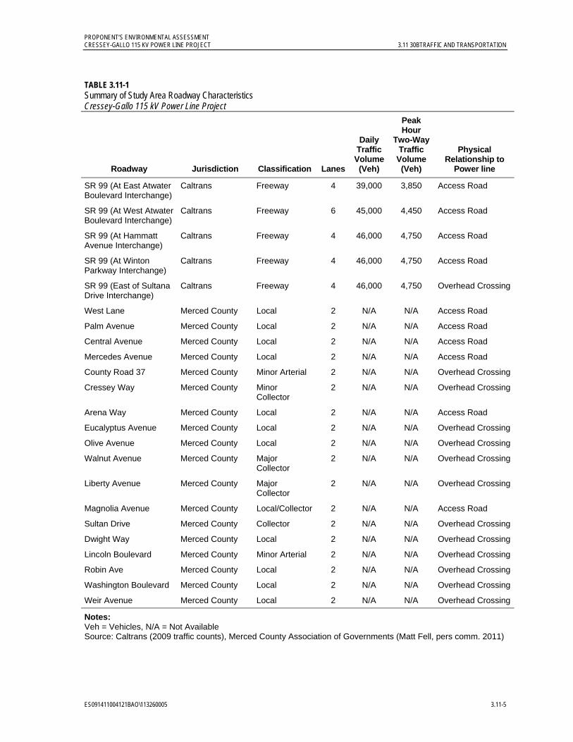
PROPONENT’S ENVIRONMENTAL ASSESSMENT CRESSEY-GALLO 115 KV POWER LINE PROJECT 3.11 30BTRAFFIC AND TRANSPORTATION
ES091411004121BAO\113260005 3.11-5
TABLE 3.11-1 Summary of Study Area Roadway Characteristics Cressey-Gallo 115 kV Power Line Project
Roadway Jurisdiction Classification Lanes
Daily Traffic
Volume(Veh)
Peak Hour
Two-Way Traffic
Volume (Veh)
Physical Relationship to
Power line
SR 99 (At East Atwater Boulevard Interchange)
Caltrans Freeway 4 39,000 3,850 Access Road
SR 99 (At West Atwater Boulevard Interchange)
Caltrans Freeway 6 45,000 4,450 Access Road
SR 99 (At Hammatt Avenue Interchange)
Caltrans Freeway 4 46,000 4,750 Access Road
SR 99 (At Winton Parkway Interchange)
Caltrans Freeway 4 46,000 4,750 Access Road
SR 99 (East of Sultana Drive Interchange)
Caltrans Freeway 4 46,000 4,750 Overhead Crossing
West Lane Merced County Local 2 N/A N/A Access Road
Palm Avenue Merced County Local 2 N/A N/A Access Road
Central Avenue Merced County Local 2 N/A N/A Access Road
Mercedes Avenue Merced County Local 2 N/A N/A Access Road
County Road 37 Merced County Minor Arterial 2 N/A N/A Overhead Crossing
Cressey Way Merced County Minor Collector
2 N/A N/A Overhead Crossing
Arena Way Merced County Local 2 N/A N/A Access Road
Eucalyptus Avenue Merced County Local 2 N/A N/A Overhead Crossing
Olive Avenue Merced County Local 2 N/A N/A Overhead Crossing
Walnut Avenue Merced County Major Collector
2 N/A N/A Overhead Crossing
Liberty Avenue Merced County Major Collector
2 N/A N/A Overhead Crossing
Magnolia Avenue Merced County Local/Collector 2 N/A N/A Access Road
Sultan Drive Merced County Collector 2 N/A N/A Overhead Crossing
Dwight Way Merced County Local 2 N/A N/A Overhead Crossing
Lincoln Boulevard Merced County Minor Arterial 2 N/A N/A Overhead Crossing
Robin Ave Merced County Local 2 N/A N/A Overhead Crossing
Washington Boulevard Merced County Local 2 N/A N/A Overhead Crossing
Weir Avenue Merced County Local 2 N/A N/A Overhead Crossing
Notes: Veh = Vehicles, N/A = Not Available Source: Caltrans (2009 traffic counts), Merced County Association of Governments (Matt Fell, pers comm. 2011)
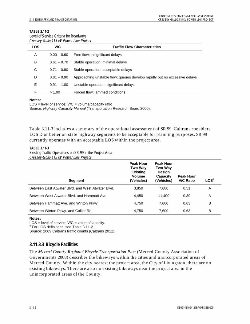
PROPONENT’S ENVIRONMENTAL ASSESSMENT 3.11 30BTRAFFIC AND TRANSPORTATION CRESSEY-GALLO 115 KV POWER LINE PROJECT
3.11-6 ES091411004121BAO\113260005
TABLE 3.11-2 Level of Service Criteria for Roadways Cressey-Gallo 115 kV Power Line Project
LOS V/C Traffic Flow Characteristics
A 0.00 – 0.60 Free flow; insignificant delays
B 0.61 – 0.70 Stable operation; minimal delays
C 0.71 – 0.80 Stable operation; acceptable delays
D 0.81 – 0.90 Approaching unstable flow; queues develop rapidly but no excessive delays
E 0.91 – 1.00 Unstable operation; significant delays
F > 1.00 Forced flow; jammed conditions
Notes: LOS = level of service; V/C = volume/capacity ratio Source: Highway Capacity Manual (Transportation Research Board 2000).
Table 3.11-3 includes a summary of the operational assessment of SR 99. Caltrans considers LOS D or better on state highway segments to be acceptable for planning purposes. SR 99 currently operates with an acceptable LOS within the project area.
TABLE 3.11-3 Existing Traffic Operations on SR 99 in the Project Area Cressey-Gallo 115 kV Power Line Project
Segment
Peak Hour Two-Way Existing Volume
(Vehicles)
Peak Hour Two-Way Design
Capacity (Vehicles)
Peak Hour V/C Ratio LOSa
Between East Atwater Blvd. and West Atwater Blvd. 3,850 7,600 0.51 A
Between West Atwater Blvd. and Hammatt Ave. 4,450 11,400 0.39 A
Between Hammatt Ave. and Winton Pkwy. 4,750 7,600 0.63 B
Between Winton Pkwy. and Collier Rd. 4,750 7,600 0.63 B
Notes: LOS = level of service; V/C = volume/capacity. a For LOS definitions, see Table 3.11-2. Source: 2009 Caltrans traffic counts (Caltrans 2011).
3.11.3.3 Bicycle Facilities The Merced County Regional Bicycle Transportation Plan (Merced County Association of Governments 2008) describes the bikeways within the cities and unincorporated areas of Merced County. Within the city nearest the project area, the City of Livingston, there are no existing bikeways. There are also no existing bikeways near the project area in the unincorporated areas of the County.
PROPONENT’S ENVIRONMENTAL ASSESSMENT CRESSEY-GALLO 115 KV POWER LINE PROJECT 3.11 30BTRAFFIC AND TRANSPORTATION
ES091411004121BAO\113260005 3.11-7
3.11.3.4 Air Traffic Castle Air Force Base (KMER) is the nearest air traffic facility to the project and is located 3.8 miles southeast of Cressey Substation. It has a 11,800-foot runway and averages 198 aircraft operations per day as of July 2010. The Turlock Municipal Airport (015) is located 4.6 miles northwest of Cressey Substation. It has a 2,985-foot runway and averages 28 aircraft operations per day, as of May 2009. Stevinson Strip (CA45) is a privately owned runway located 4.9 miles southwest of Gallo Substation that has a 2,400-foot runway. Ahlem Farms Airport (CL84) is a privately owned runway located 6.5 miles west of Gallo Substation that has a 2,600-foot runway. The Turlock Airpark (9CL0) is privately owned and located 6.6 miles north of Gallo Substation; it has a 2,075-foot runway (AirNav.com 2011a-e).
3.11.3.5 Transit and Rail Services “The Bus” is the primary public transport provider within Merced County. The Bus services the City of Merced and surrounding cities and communities near the project area, including Livingston and Winton. Dial-A-Ride service is also available within Merced County (The Bus 2011).
The Yosemite Area Regional Transportation System (YARTS) also provides service within Merced County. YARTS provides service between the City of Merced and Yosemite Valley via Highway 140. All YARTS stop locations in the vicinity of the project are located within the City of Merced (YARTS 2011).
Regional bus service is provided by Greyhound in the City of Merced.
The Union Pacific Railroad (UPRR) runs parallel and generally adjacent to SR 99 from the northwest to the southeast, and intersects the project near the Sultan Drive interchange. The Burlington Northern Santa Fe (BNSF) railway runs in the same direction as the UPRR approximately 3 miles to the east and intersects the project at Santa Fe Drive and Mercedes Avenue. Amtrak’s “San Joaquin” route offers train service between Oakland and Bakersfield with stops in Merced, Turlock and Madera and operates on the BNSF railway (Amtrak 2011).
3.11.4 Impact Assessment 3.11.4.1 Significance Criteria and Checklist In accordance with Appendix G of the CEQA Guidelines, the potential significance of project impacts on transportation or traffic resources must be evaluated for each of the criteria listed in Table 3.11-4. The magnitude of a potential impact was compared to the Merced County Year 2000 General Plan (Merced County 1990) thresholds. The applicable CEQA criteria are listed below followed by a discussion regarding the project’s conformance with the criteria.

PROPONENT’S ENVIRONMENTAL ASSESSMENT 3.11 30BTRAFFIC AND TRANSPORTATION CRESSEY-GALLO 115 KV POWER LINE PROJECT
3.11-8 ES091411004121BAO\113260005
TABLE 3.11-4 CEQA Checklist for Traffic and Transportation Cressey-Gallo 115 kV Power Line Project
XV. TRAFFIC AND TRANSPORTATION -- Would the Project:
Potentially Significant
Impact
Less Than Significant
with Mitigation
Incorporation
Less Than Significant
Impact No Impact
a) Cause an increase in traffic which is substantial in relation to the existing traffic load and capacity of the street system (i.e., result in a substantial increase in either the number of vehicle trips, the volume to capacity (v/c) ratio on roads, or congestion at intersections)?
b) Exceed, either individually or cumulatively, a level of service standard established by the county congestion management agency for designated roads or highways?
c) Result in a change in air traffic patterns, including either an increase in traffic levels or a change in location that result in substantial safety risks?
d) Substantially increase hazards due to a design feature (e.g. sharp curves or dangerous intersections) or incompatible uses (e.g. farm equipment)?
e) Result in inadequate emergency access?
f) Result in inadequate parking capacity?
g) Conflict with adopted policies, plans, or programs supporting alternative transportation (e.g. bus turnouts, bicycle racks)?
3.11.4.2 Applicant Proposed Measure The following APM includes existing regulations and/or requirements or standard practices that will further minimize or avoid potential less-than-significant traffic and transportation impacts:
APM Traffic and Transportation (TT)-1: Traffic Management Implementation. PG&E will follow its standard safety practices, including installing appropriate barriers between work zones and transportation facilities, posting adequate signs, and using proper construction techniques. PG&E will coordinate construction traffic access at Gallo Substation with Gallo Winery during the E. & J. Gallo Winery Eastside Expansion Project construction. PG&E is a member of the California Joint Utility Traffic Control Committee, which published the California Joint Utility Traffic Control Manual (2010). PG&E will follow the recommendations in this manual regarding basic standards for the safe movement of traffic on highways and streets in accordance with Section 21400 of the CVC. PG&E will comply with all notification requirements as prescribed by County of Merced and Caltrans encroachment permits.
PROPONENT’S ENVIRONMENTAL ASSESSMENT CRESSEY-GALLO 115 KV POWER LINE PROJECT 3.11 30BTRAFFIC AND TRANSPORTATION
ES091411004121BAO\113260005 3.11-9
3.11.4.3 Construction, Operation, and Maintenance Impacts Project Trip Generation. At the peak month of project construction, during the PM peak hour, it is estimated that 10 trucks will be required for equipment and materials and 10 construction worker vehicles will be required. Project line truck trips were converted to passenger-car equivalent trips using a passenger-car equivalent factor of 1.5.
Construction of the new facilities at Cressey and Gallo substations will require a total of 11 one-way vehicle trips in the PM peak hour. There will be six one-way trips for Cressey Substation and five one-way trips for Gallo Substation. All vehicle trips during the PM peak hour for project work at the substations will be passenger vehicle trips by workers leaving the respective substation sites.
To conduct a conservative analysis it was assumed that the power line and modifications at the interconnecting substations will be constructed concurrently. This results in a total of 36 PM peak hour passenger car equivalents.
For project power line construction, vehicles will park outside the roadway and within the project ROW. During construction at Cressey and Gallo substations, adequate parking for workers will be provided in a location not affecting public right of way.
Project Trip Distribution. It is estimated that all workers will access the project sites from SR 99, with half coming from the north and half from the south. Local access routes to the Cressey-Gallo line will vary depending on the location of construction on any given day. Local access to Cressey Substation will likely be along Sultana Drive, Liberty Avenue, Cressey Way, County Road 37, Palm Avenue, and/or West Lane. Local access to Gallo Substation will likely be along Hammatt Avenue, Peach Avenue, Main Street, Magnolia Avenue, Griffith Avenue, and/or River Road.
Operation and Maintenance. In order to facilitate proper equipment operation and safety for the new and existing facilities, current project operation and maintenance activities will continue. No impacts due to operation and maintenance activities are anticipated.
a) Would the project cause an increase in traffic which is substantial in relation to the existing traffic load and capacity of the street system (i.e., result in a substantial increase in either the number of vehicle trips, the volume to capacity (v/c) ratio on roads, or congestion at intersections)? Less-than-significant impact.
Short-term traffic impacts were assessed by adding the anticipated project-related construction traffic to the existing traffic on selected state roadway facilities. Table 3.11-5 provides a summary of the results of this comparison.
Operations of roadways potentially affected by project traffic will have negligible changes from existing conditions. PG&E will contact the Gallo Winery to coordinate construction access along the project access road to Gallo Substation during the E. & J. Gallo Winery Eastside Expansion Project. Therefore, there will be no impact to the existing traffic load and capacity of the street system. Although data for non-state roadways is not currently available, these roadways are generally low-volume rural roads that are expected to continue to operate at an acceptable LOS given the small amount of incremental traffic attributable to the project.

PROPONENT’S ENVIRONMENTAL ASSESSMENT 3.11 30BTRAFFIC AND TRANSPORTATION CRESSEY-GALLO 115 KV POWER LINE PROJECT
3.11-10 ES091411004121BAO\113260005
TABLE 3.11-5 Summary of Projected Study Area Roadway Characteristics During Project Construction Cressey-Gallo 115 kV Power Line Project
Roadway Jurisdiction
Peak Hour Traffic Volume
(Vehicles)
Construc-tion
Traffic Added
Existing Peak Hour V/C
Construc-tion Peak Hour V/C
Construc-tion Peak Hour LOS
SR 99 (At East Atwater Boulevard Interchange)
Caltrans 3,850 18 0.51 0.51 A
SR 99 (At West Atwater Boulevard Interchange)
Caltrans 4,450 18 0.39 0.39 A
SR 99 (At Hammatt Avenue Interchange)
Caltrans 4,750 18 0.63 0.63 B
SR 99 (At Winton Parkway Interchange)
Caltrans 4,750 18 0.63 0.63 B
Notes: A Passenger Car Equivalent factor of 1.5 is applied to the number of trucks trips. LOS = level of service; V/C – volume/capacity ratio For LOS definitions, see Table 3.11-2.
The roads listed in Table 3.11-1 as potential access roads will not see a significant increase in their traffic volumes because no more than two six-person crews are anticipated at a pole location at any given time. Temporary road closures (rolling stops) are anticipated when certain sections of the line are being reconductored at the road overhead crossings listed in Table 3.11-1. Road closures on private and county roads are not expected to exceed five minutes in duration. For SR 99 crossings, the California Highway Patrol and Caltrans will be contacted to organize 5- to 10-minute rolling stops. These rolling stops typically occur on Sundays between 6 AM and 8 AM. Any necessary encroachment permits will be obtained from the affected agencies. Potential short-term impacts associated with these traffic issues will be less than significant.
b) Would the project exceed, either individually or cumulatively, a level of service standard established by the county congestion management agency for designated roads or highways? Less-than-significant impact.
The potential impacts to LOS standards are discussed under the response the previous checklist question. Potential short-term impacts to LOS will have a less-than-significant impact and will be further reduced with the implementation of APM TT-1.
c) Would the project result in a change in air traffic patterns, including either an increase in traffic levels or a change in location that results in substantial safety risks? No impact.
No change in air traffic patterns will occur as a result of the project.
d) Would the project substantially increase hazards due to a design feature (e.g. sharp curves or dangerous intersections) or incompatible uses (e.g. farm equipment)? Less-than-significant impact.
Potential short-term impacts associated with placement of equipment and vehicles during construction will be less than significant, but will be further reduced with implementation of
PROPONENT’S ENVIRONMENTAL ASSESSMENT CRESSEY-GALLO 115 KV POWER LINE PROJECT 3.11 30BTRAFFIC AND TRANSPORTATION
ES091411004121BAO\113260005 3.11-11
APM TT-1. The project route currently includes distribution poles and lines for approximately 80 percent of the route. The majority of these wood distribution poles will be removed and replaced with wood power poles of roughly similar circumferences. Wood pole circumferences vary between poles due to the natural properties of the pole material. Where distribution poles will be replaced by power poles, the power poles will be placed farther away from the roadway at approximately 5 feet away from the former distribution pole location. When the project route is located in orchard areas, the power poles will be placed to avoid affecting farm equipment routes. PG&E will coordinate with landowners to avoid impact as discussed in APM LU-1 in Section 3.2.4.2.
Oversize trucks may be used to deliver poles along the project route during construction. These trucks may not be able to turn at some intersections without special maneuvers and may drive slowly. These deliveries will typically be coordinated and met in the field by PG&E personnel to maximize safety to the public and vendor delivering the poles; potential impacts will be less than significant.
e) Would the project result in inadequate emergency access? Less-than-significant impact.
Routes for emergency vehicles will be maintained throughout project construction. The proposed project activities could have the potential, in rare circumstances, to slow emergency response vehicles (for example, a rolling stop or slow-moving pole delivery truck occurring simultaneously with the need for emergency vehicle access); this potential impact will be less than significant and will be further minimized with implementation of APM TT-1.
f) Would the project result in inadequate parking capacity? No impact.
All personal worker vehicles will be parked within project ROW as discussed in the Project Trip Generation subsection at the beginning of Section 3.11.4.3. No impact will result.
g) Would the project conflict with adopted policies, plans, or programs supporting alternative transportation (e.g., bus turnouts, bicycle racks)? No impact.
Both shorter-term construction and longer-term operations activities are not anticipated to conflict with any alternative transportation plans, policies, or programs. No impacts will result.
3.11.5 References AirNav.com. 2011a. “Ahlem Farms Airport” Web page. Online:
http://www.airnav.com/airport/CL84. Accessed on 6/23/2011.
AirNav.com. 2011b. “Castle Airport” Web page. Online: http://www.airnav.com/airport/KMER. Accessed on 6/23/2011.
AirNav.com. 2011c. “Stevinson Strip Airport” Web site. Online: http://www.airnav.com/airport/CA45. Accessed on 6/23/2011.
AirNav.com. 2011d. “Turlock Airpark” Web site. Online: http://www.airnav.com/airport/9CL0. Accessed on 6/23/2011.
PROPONENT’S ENVIRONMENTAL ASSESSMENT 3.11 30BTRAFFIC AND TRANSPORTATION CRESSEY-GALLO 115 KV POWER LINE PROJECT
3.11-12 ES091411004121BAO\113260005
AirNav.com. 2011.e “Turlock Municipal Airport” Web page. Online: http://www.airnav.com/airport/O15. Accessed on 6/23/2011.
Amtrak. 2011. “San Joaquin” route information Web page. Online: http://www.amtrak.com/servlet/ContentServer?c=AM_Route_C&pagename=am%2FLayout&cid=1241245650084
The Bus. 2011. “Downtown Merced” system map. Online: http://www.mercedthebus.com/routes/pdf/system_map.pdf
California Department of Motor Vehicles. 2011. California Vehicle Code. Online: http://dmv.ca.gov/pubs/vctop/vc/vc.htm.
California Department of Transportation (Caltrans). 2011. Traffic Volumes on California State Highways. Online: http://traffic-counts.dot.ca.gov/.
California Department of Transportation (Caltrans) and Federal Highway Administration (FHWA). 2010. Manual on Uniform Traffic Control Devices.
California Joint Utility Traffic Control Committee. 2010. California Joint Utility Traffic Control Manual. 5th Edition. Online: www.sce.com/nrc/aboutsce/regulatory/distributionmanuals/tcm.pdf.
Fell, Matt. 2011. Personal communication regarding Merced County traffic volumes. Senior Planner, Merced County Association of Governments. Email correspondence June 30th, 2011.
Merced County. 1990. Merced County Year 2000 General Plan. Online: http://www.co.merced.ca.us/index.aspx?NID=436.
_______. 2009. Merced County Department of Public Works Improvement Standards and Specifications. Appendix A, Utilities Occupying County Roadways. Online: http://www.co.merced.ca.us/documents/Public%20Works/Roads/Compliled%20Standards.PDF. February 24.
_______. 2011. 2030 Merced County General Plan. Online: http://www.co.merced.ca.us/index.aspx?NID=1791
Merced County Association of Governments. 2008. Merced County Regional Bicycle Transportation Plan. Online: http://www.mcagov.org/publications/trans.html
Transportation Research Board. 2000. Highway Capacity Manual.
Yosemite Area Regional Transportation System (YARTS). 2011. System map. Online: http://www.yarts.com/maps/stops.pdf.

PROPONENT’S ENVIRONMENTAL ASSESSMENT CRESSEY-GALLO 115 KV POWER LINE PROJECT 3.12 31BMANDATORY FINDINGS OF SIGNIFICANCE AND CUMULATIVE AND GROWTH-INDUCING ANALYSIS
ES091411004121BAO\113260005 3.12-1
3.12 Mandatory Findings of Significance and Cumulative and Growth-Inducing Analysis
3.12.1 Introduction and Methodology This section discusses mandatory findings of significance as well as potential cumulative and growth-inducing impacts, related to the Cressey-Gallo 115 kV Power Line Project. CEQA Section 15065 requires that the lead agency determine whether the proposed project will have a significant effect on the environment. To assist the CPUC with this determination and mandatory findings of significance, PG&E is providing the following information.
To address potential growth-inducing impacts, CEQA requires a discussion of the ways in which a project could foster economic or population growth, either directly or indirectly, in the surrounding environment, including projects that remove barriers to population growth. CEQA also requires a discussion of the cumulative effects of a project. Cumulative impacts refer to two or more individual impacts that, when considered together, are considerable or that compound or increase other environmental impacts. A cumulative impact is the change in the environment that results from the incremental impact of a project when added to other closely related past, present, or reasonably foreseeable future projects. Cumulative impacts can result from individually minor but collectively significant impacts occurring over time.
3.12.2 Mandatory Findings of Significance The following conditions presented in Table 3.12-1 were reviewed to determine if there exists substantial evidence that the project, when considering the whole record, may have a significant effect on the environment. The project will not have a significant effect on the environment as described in the following sections.
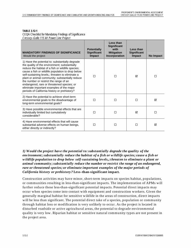
PROPONENT’S ENVIRONMENTAL ASSESSMENT 3.12 31BMANDATORY FINDINGS OF SIGNIFICANCE AND CUMULATIVE AND GROWTH-INDUCING ANALYSIS CRESSEY-GALLO 115 KV POWER LINE PROJECT
3.12-2 ES091411004121BAO\113260005
TABLE 3.12-1 CEQA Checklist for Mandatory Findings of Significance Cressey–Gallo 115 kV Power Line Project
MANDATORY FINDINGS OF SIGNIFICANCE Would the project
Potentially Significant
Impact
Less than Significant
with Mitigation
Incorporation
Less than Significant
Impact No Impact
1) Have the potential to: substantially degrade the quality of the environment; substantially reduce the habitat of a fish or wildlife species; cause a fish or wildlife population to drop below self-sustaining levels,; threaten to eliminate a plant or animal community; substantially reduce the number or restrict the range of an endangered, rare or threatened species; or eliminate important examples of the major periods of California history or prehistory?
2) Have the potential to achieve short-term environmental goals to the disadvantage of long-term environmental goals?
3) Have possible environmental effects that are individually limited but cumulatively considerable?
4) Have environmental effects that will cause substantial adverse effects on human beings, either directly or indirectly?
1) Would the project have the potential to: substantially degrade the quality of the environment; substantially reduce the habitat of a fish or wildlife species; cause a fish or wildlife population to drop below self-sustaining levels,; threaten to eliminate a plant or animal community; substantially reduce the number or restrict the range of an endangered, rare or threatened species; or eliminate important examples of the major periods of California history or prehistory? Less–than-significant impact.
Construction activities may have minor, short-term impacts on species habitat, populations, or communities resulting in less-than-significant impacts. The implementation of APMs will further reduce these less-than-significant potential impacts. Potential direct impacts may occur when species come into contact with equipment and construction workers. Given the generally marginal habitat for sensitive wildlife in the areas of construction, direct impacts will be less than significant. The potential direct take of a species, population or community through habitat loss or modification is very unlikely to occur. As the project is located in disturbed roadside or active agricultural areas, the potential to degrade environmental quality is very low. Riparian habitat or sensitive natural community types are not present in the project area.
PROPONENT’S ENVIRONMENTAL ASSESSMENT CRESSEY-GALLO 115 KV POWER LINE PROJECT 3.12 31BMANDATORY FINDINGS OF SIGNIFICANCE AND CUMULATIVE AND GROWTH-INDUCING ANALYSIS
ES091411004121BAO\113260005 3.12-3
Project-related work will avoid canals, which are potential habitat for Sanford’s arrowhead, a special-status plant species, so that no adverse affects will occur to this species. Habitat for ten special-status wildlife species occurs within the study area; however, project work will avoid most habitat areas and minimize potential impacts to other habitat areas through pre-construction surveys to establish buffers and mark the limits of work areas when proximate to sensitive resources.
Cultural resources surveys and records searches identified 14 potential historic-period resources in the project area; however, no project construction, operation, and maintenance impacts will occur. In the unlikely event that historical resources are discovered during construction activities, APM CU-1 and APM CU-2 will further minimize the potential less-than-significant project impacts.
2) Would the project have the potential to achieve short-term environmental goals to the disadvantage of long-term environmental goals? No impact.
The project will not result in achievement of short-term environmental goals to the disadvantage of long-term environmental goals. Potential project short-term impacts (construction phase) and long-term impacts (operation and maintenance phase) are less than significant, compatible with County environmental goals, and do not conflict with state or federal environmental policies and regulations.
3) Would the project have possible environmental effects that are individually limited but cumulatively considerable? Less-than-significant impact.
Significance Criteria. Consistent with the revised CEQA Guidelines (Section 15130), a project could have a significant cumulative impact if a cumulatively considerable change in the environment resulted from the incremental effects of the proposed project when viewed in connection with the effects of other closely-related past, present, and probable future projects. Cumulative impacts can result from individually minor but collectively significant effects occurring over a period of time.
Planned Projects. Projects included in the cumulative impact assessment were identified by using a list approach (CEQA Guidelines Section 15130[b][1][A]) of pending projects within a 5-mile radius of the proposed project. This area includes the City of Atwater, the City of Livingston, and census-designated places of Winton, Ballico, Delhi, and Hillmar-Irwin in Merced County. Table 3.12-2, Cumulative Projects, provides a list of development projects in the project vicinity. In summary the following list of planned projects were identified:
City of Livingston: A pending projects list from the City of Livingston (City of Livingston 2011a) and City Council and Planning Commission meeting minutes for 2011 (City of Livingston 2011b) were reviewed. The 2011 Planning Commission meeting minutes do not identify any upcoming projects outside of current city limits.
City of Atwater: Development projects are not currently planned according to city staff and no list was available of planned or projects in construction (City of Atwater/Stephanie Ruiz, Personal Communication 2011).
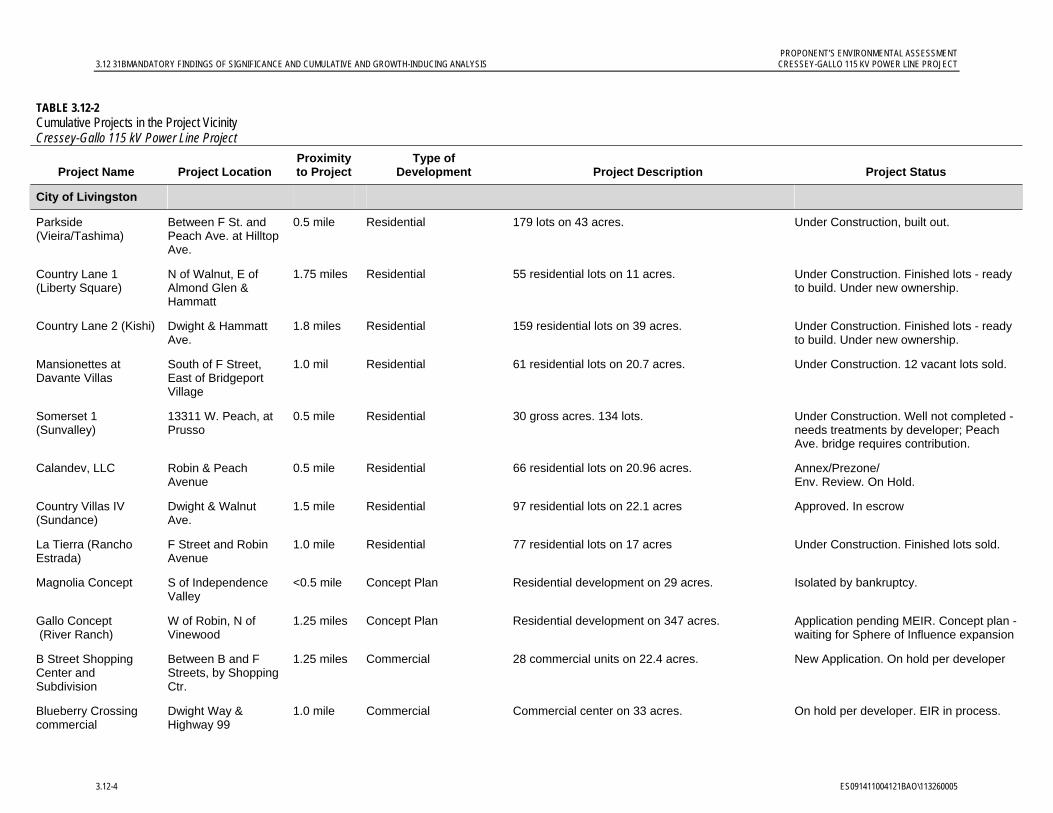
PROPONENT’S ENVIRONMENTAL ASSESSMENT 3.12 31BMANDATORY FINDINGS OF SIGNIFICANCE AND CUMULATIVE AND GROWTH-INDUCING ANALYSIS CRESSEY-GALLO 115 KV POWER LINE PROJECT
3.12-4 ES091411004121BAO\113260005
TABLE 3.12-2 Cumulative Projects in the Project Vicinity Cressey-Gallo 115 kV Power Line Project
Project Name Project Location Proximity to Project
Type of Development Project Description Project Status
City of Livingston
Parkside (Vieira/Tashima)
Between F St. and Peach Ave. at Hilltop Ave.
0.5 mile Residential 179 lots on 43 acres. Under Construction, built out.
Country Lane 1 (Liberty Square)
N of Walnut, E of Almond Glen & Hammatt
1.75 miles Residential 55 residential lots on 11 acres. Under Construction. Finished lots - ready to build. Under new ownership.
Country Lane 2 (Kishi) Dwight & Hammatt Ave.
1.8 miles Residential 159 residential lots on 39 acres. Under Construction. Finished lots - ready to build. Under new ownership.
Mansionettes at Davante Villas
South of F Street, East of Bridgeport Village
1.0 mil Residential 61 residential lots on 20.7 acres. Under Construction. 12 vacant lots sold.
Somerset 1 (Sunvalley)
13311 W. Peach, at Prusso
0.5 mile Residential 30 gross acres. 134 lots. Under Construction. Well not completed - needs treatments by developer; Peach Ave. bridge requires contribution.
Calandev, LLC Robin & Peach Avenue
0.5 mile Residential 66 residential lots on 20.96 acres. Annex/Prezone/ Env. Review. On Hold.
Country Villas IV (Sundance)
Dwight & Walnut Ave.
1.5 mile Residential 97 residential lots on 22.1 acres Approved. In escrow
La Tierra (Rancho Estrada)
F Street and Robin Avenue
1.0 mile Residential 77 residential lots on 17 acres Under Construction. Finished lots sold.
Magnolia Concept S of Independence Valley
<0.5 mile Concept Plan Residential development on 29 acres. Isolated by bankruptcy.
Gallo Concept (River Ranch)
W of Robin, N of Vinewood
1.25 miles Concept Plan Residential development on 347 acres. Application pending MEIR. Concept plan - waiting for Sphere of Influence expansion
B Street Shopping Center and Subdivision
Between B and F Streets, by Shopping Ctr.
1.25 miles Commercial 28 commercial units on 22.4 acres. New Application. On hold per developer
Blueberry Crossing commercial
Dwight Way & Highway 99
1.0 mile Commercial Commercial center on 33 acres. On hold per developer. EIR in process.
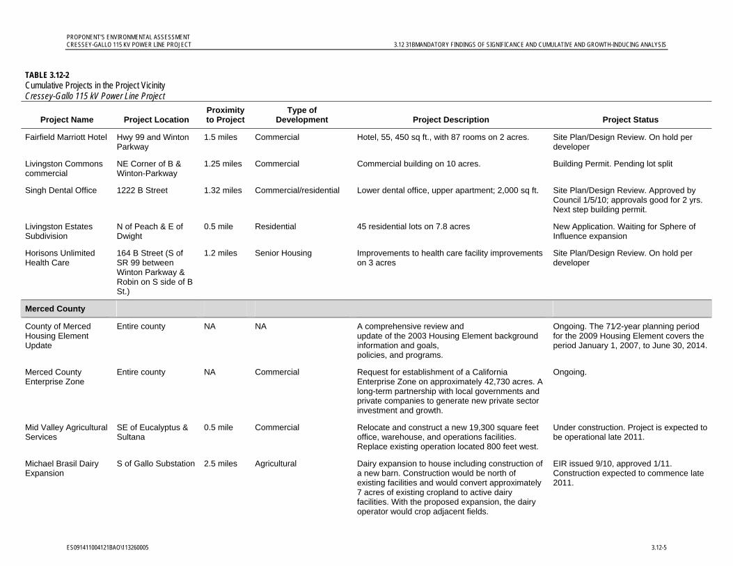
PROPONENT’S ENVIRONMENTAL ASSESSMENT CRESSEY-GALLO 115 KV POWER LINE PROJECT 3.12 31BMANDATORY FINDINGS OF SIGNIFICANCE AND CUMULATIVE AND GROWTH-INDUCING ANALYSIS
ES091411004121BAO\113260005 3.12-5
TABLE 3.12-2 Cumulative Projects in the Project Vicinity Cressey-Gallo 115 kV Power Line Project
Project Name Project Location Proximity to Project
Type of Development Project Description Project Status
Fairfield Marriott Hotel Hwy 99 and Winton Parkway
1.5 miles Commercial Hotel, 55, 450 sq ft., with 87 rooms on 2 acres. Site Plan/Design Review. On hold per developer
Livingston Commons commercial
NE Corner of B & Winton-Parkway
1.25 miles Commercial Commercial building on 10 acres. Building Permit. Pending lot split
Singh Dental Office 1222 B Street 1.32 miles Commercial/residential Lower dental office, upper apartment; 2,000 sq ft. Site Plan/Design Review. Approved by Council 1/5/10; approvals good for 2 yrs. Next step building permit.
Livingston Estates Subdivision
N of Peach & E of Dwight
0.5 mile Residential 45 residential lots on 7.8 acres New Application. Waiting for Sphere of Influence expansion
Horisons Unlimited Health Care
164 B Street (S of SR 99 between Winton Parkway & Robin on S side of B St.)
1.2 miles Senior Housing Improvements to health care facility improvements on 3 acres
Site Plan/Design Review. On hold per developer
Merced County
County of Merced Housing Element Update
Entire county NA NA A comprehensive review and update of the 2003 Housing Element background information and goals, policies, and programs.
Ongoing. The 71⁄2-year planning period for the 2009 Housing Element covers the period January 1, 2007, to June 30, 2014.
Merced County Enterprise Zone
Entire county NA Commercial Request for establishment of a California Enterprise Zone on approximately 42,730 acres. A long-term partnership with local governments and private companies to generate new private sector investment and growth.
Ongoing.
Mid Valley Agricultural Services
SE of Eucalyptus & Sultana
0.5 mile Commercial Relocate and construct a new 19,300 square feet office, warehouse, and operations facilities. Replace existing operation located 800 feet west.
Under construction. Project is expected to be operational late 2011.
Michael Brasil Dairy Expansion
S of Gallo Substation 2.5 miles Agricultural Dairy expansion to house including construction of a new barn. Construction would be north of existing facilities and would convert approximately 7 acres of existing cropland to active dairy facilities. With the proposed expansion, the dairy operator would crop adjacent fields.
EIR issued 9/10, approved 1/11. Construction expected to commence late 2011.
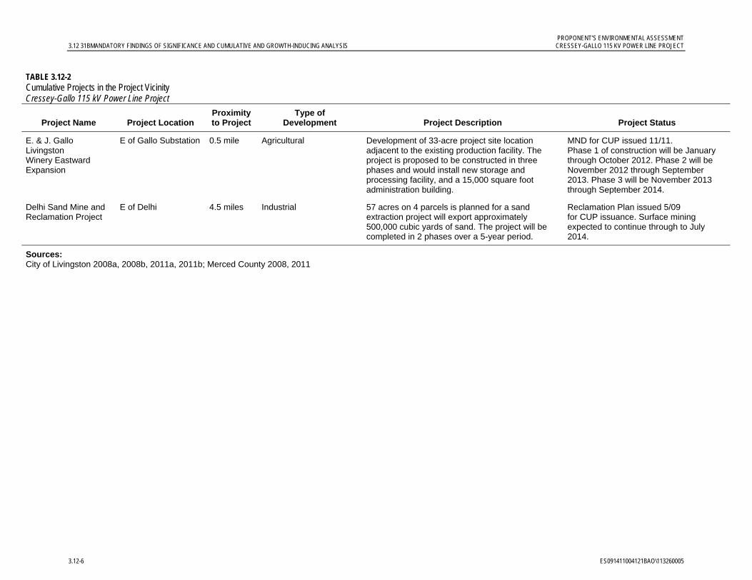
PROPONENT’S ENVIRONMENTAL ASSESSMENT 3.12 31BMANDATORY FINDINGS OF SIGNIFICANCE AND CUMULATIVE AND GROWTH-INDUCING ANALYSIS CRESSEY-GALLO 115 KV POWER LINE PROJECT
3.12-6 ES091411004121BAO\113260005
TABLE 3.12-2 Cumulative Projects in the Project Vicinity Cressey-Gallo 115 kV Power Line Project
Project Name Project Location Proximity to Project
Type of Development Project Description Project Status
E. & J. Gallo Livingston Winery Eastward Expansion
E of Gallo Substation 0.5 mile Agricultural Development of 33-acre project site location adjacent to the existing production facility. The project is proposed to be constructed in three phases and would install new storage and processing facility, and a 15,000 square foot administration building.
MND for CUP issued 11/11. Phase 1 of construction will be January through October 2012. Phase 2 will be November 2012 through September 2013. Phase 3 will be November 2013 through September 2014.
Delhi Sand Mine and Reclamation Project
E of Delhi 4.5 miles Industrial 57 acres on 4 parcels is planned for a sand extraction project will export approximately 500,000 cubic yards of sand. The project will be completed in 2 phases over a 5-year period.
Reclamation Plan issued 5/09 for CUP issuance. Surface mining expected to continue through to July 2014.
Sources: City of Livingston 2008a, 2008b, 2011a, 2011b; Merced County 2008, 2011
PROPONENT’S ENVIRONMENTAL ASSESSMENT CRESSEY-GALLO 115 KV POWER LINE PROJECT 3.12 31BMANDATORY FINDINGS OF SIGNIFICANCE AND CUMULATIVE AND GROWTH-INDUCING ANALYSIS
ES091411004121BAO\113260005 3.12-7
Merced County: Merced County is seeking to establish a California Enterprise Zone to generate new private sector growth and investment. If the Enterprise Zone is approved then it would incentivize more development near the project. No specific projects are identified as benefitting from the Zone (Merced County 2008). Other individual projects identified in unincorporated Merced County within 5 miles of the project include construction of a new office facility, dairy expansion, warehouse construction, sand reclamation project, and winery construction (Merced County 2011).
Analysis of Cumulative Impacts. Power line construction projects generally do not contribute to a cumulatively considerable impact. The intent of a power line looping project is to improve service and reliability for existing users, not to expand service or facilities, and long-term effects will be minor. Implementation of APMs will further minimize the less-than-significant short-term construction-related impacts related to noise, dust, traffic, agricultural, land use, air quality, geology, hazards, hydrological, and biological resources. A discussion regarding each resource area is provided below.
Aesthetics: The viewshed of the proposed project is a predominately agricultural area within which electric distribution and power lines are now commonly seen and are integral elements of the landscape. The additional or replacement project poles will not significantly alter the overall visual character of the area. The project vicinity is likely to remain predominately agricultural for the foreseeable future with little change in its overall visual character. Given the distance of the project from the projects in Table 3.12-2, the presence of existing, similar pole lines, the presence of intervening vegetation which screens views, and because only a small portion of the Cressey-Gallo power line will be visible from any single viewing location in common with the development projects, the project will not have a considerable contribution to the modification of the viewshed.
Agricultural and Forest Resources, Land Use and Planning, and Recreation: The proposed project is located in a primarily agricultural area with intermittent rural residences. The project will have a very limited impact on conversion of agricultural land. The majority of the power poles will be placed in such a way as to accommodate pre-existing agricultural operations. Partial or complete removal of one row of almond trees in an orchard that is designated as Prime Farmland between Eucalyptus Avenue and Mercedes Avenue is expected as part of project implementation, resulting in the permanent removal of approximately 0.43 acre of Prime Farmland from active cultivation. There are approximately 270,641 acres of Prime Farmland located throughout Merced County, which accounts for approximately 21.4 percent of the County land; the approximately 0.43 acre of Prime Farmland affected by the project therefore represents a miniscule percentage of the total Prime Farmland acreage in Merced County. This orchard property will remain zoned for agricultural use, and project operation and maintenance will not conflict with agricultural use on the remainder of the property or on adjacent properties.
Work at Cressey Substation will occur within the existing substation fenceline. Work at Gallo Substation, which will have an expanded substation footprint, will occur on existing industrial property. Construction at both substations will therefore not impact agricultural facilities. Work areas along the new power line route will be accessed primarily from the adjacent roads so as to not disturb agricultural land.
PROPONENT’S ENVIRONMENTAL ASSESSMENT 3.12 31BMANDATORY FINDINGS OF SIGNIFICANCE AND CUMULATIVE AND GROWTH-INDUCING ANALYSIS CRESSEY-GALLO 115 KV POWER LINE PROJECT
3.12-8 ES091411004121BAO\113260005
Temporary construction activities may affect agricultural land; with the exception of 0.43 acre removed, following construction, the lands will be returned to their former use. No other projects that may similarly impact agricultural land were found within 5 miles of the project site; therefore, no cumulative impacts to agricultural land will occur.
The majority of the project will be located within an existing utility corridor. The project is compatible with applicable land use policies or regulations; therefore, the project will not contribute to potential cumulative impacts to land use.
No short- or long-term recreational impacts will occur; therefore, the project will not contribute to cumulative recreational impacts.
Air Quality and Greenhouse Gas: Short-term emissions from construction of the project will have a less than significant impact to air quality. The Merced County Enterprise Zone EIR identified development within the Enterprise Zone as resulting in significant and unavoidable air quality impacts in an area that is already designated as non-attainment by the United States Environmental Protection Agency and the California Air Resources Board (Merced County 2008). Impacts to ozone, particulate matter, and greenhouse gases were also considered by the Enterprise Zone EIR as cumulatively significant and unavoidable. While the Cressey-Gallo 115 kV Power Line Project will temporarily contribute further emissions, these emissions are not significant individually when compared to San Joaquin Valley Air Pollution Control District (SJVAPCD) significance thresholds (see Table 3.3-5). Given that these emissions will be further reduced through the implementation of APMs AQ-1 and AQ-2 and will cease after the 8-month construction period, they will not contribute significantly to the emissions associated with the construction of other projects planned in the area and are not cumulatively considerable.
The project does not include the types of sources for which SJVAPCD has established best performance standards to assess the significance of project-specific GHG emissions on global climate change. In addition, operation of the project will be a continuation of existing activities. Small quantities of SF6 emissions that could potentially contribute to cumulative GHG impacts would be mitigated to a level that is less than significant with implementation of APM AQ-3 and will not be considered cumulatively considerable in the context of other projects planned for the area.
Biological Resources: Temporary construction-related activities (such as elevated noise, human activity, and ground vibrations) will be short-term (the length of construction) and have a less-than-significant impact on biological resources. Potential construction impacts will be further minimized with pre-construction surveys and establishing the limits of work areas or biological resource buffers as needed. Construction of other projects in the area during the same construction timeframe may result in short-term cumulative impacts to biological resources in the project area, mainly through construction activities. Nearby planned projects are located on agricultural or industrial land. Potential project adverse cumulative biological resource impacts will be short-term and are not cumulatively considerable, and; therefore, are less than significant. Project construction-related permanent impacts will be less than significant. Operation and maintenance of the power line will be consistent with current distribution line practices and include routine inspection and minor repairs. This work will be infrequent and access will occur from existing roads or

PROPONENT’S ENVIRONMENTAL ASSESSMENT CRESSEY-GALLO 115 KV POWER LINE PROJECT 3.12 31BMANDATORY FINDINGS OF SIGNIFICANCE AND CUMULATIVE AND GROWTH-INDUCING ANALYSIS
ES091411004121BAO113260005 3.12-9
PG&E ROW in active agriculture, which will not have a substantial impact on biological resources. The project will not constitute a considerable contribution to cumulative impacts.
Cultural Resources: There are 14 documented historic-period resources in the project area; these resources will be avoided by PG&E. No prehistoric archaeological sites were identified during the cultural resources study, and no historic properties are listed on the National Register of Historic Places or the California Register of Historical Resources within the project area. Project APMs will require that work stop and be redirected in the event any unknown cultural resources are discovered. No other projects that may impact cultural resources are known within the region; therefore, no contribution to cumulative impacts will occur.
Geology and Soils, Mineral Resources, and Paleontological Resources: Project impacts on geology, soils, mineral resources, and paleontological resources will be less than significant. A potential for increased erosion exists because of surface-disturbing activities associated with project construction; however, the project site is relatively flat and potential impacts will be less than significant. The Michael Brasil Dairy Expansion (Dairy Expansion) is the only known project in the vicinity that may increase erosion. The EIR for the Dairy Expansion concluded that impacts to erosion will be less than significant with mitigation, and these impacts will only occur during project construction (Merced County 2010). The Dairy Expansion project was approved by Merced County on January, 12, 2011 but construction has yet to commence on the property. The E. & J. Gallo Livingston Winery Eastside Expansion Project (Gallo Winery Expansion Project) was approved under a Mitigated Negative Declaration (MND) in November 2011 with insignificant impacts to geology, soils, mineral resources and paelontological resources (Merced County 2011). While it is unlikely that these projects will be creating temporary erosion impacts during simultaneous construction, even under this condition the cumulative impacts to erosion will be less than significant due to the less-than-significant impacts of the projects and the Cressey-Gallo project’s APMs that will further minimize less-than-significant impacts.
No mineral resources will be impacted by the project; therefore, no cumulative impacts will occur.
The project will avoid impacts to paleontologically sensitive locations in the project area. If paleontological resources are found during construction, industry standard practices will be implemented as identified in the project APMs to further minimize potential less-than-significant impacts. No other projects that may similarly impact these fossil localities were found within 5 miles of the project site; no cumulative impacts to paleontological resources will occur.
Hazards and Hazardous Materials: During construction activities, there is an increased potential for an accidental release of fluids from a vehicle or motorized piece of equipment. The implementation of PG&E’s standard hazardous substance control, emergency response, and health and safety procedures will further minimize potential less-than-significant impacts. The Gallo Winery Expansion Project was approved under an MND in November 2011 with insignificant impacts to hazards and hazardous materials (Merced County 2011). No other projects near the site are expected to contribute impacts to hazards and hazardous materials. Merced County’s California Enterprise Zone will incentivize more development near the project, but as no specific projects have been identified, no impacts from hazards
PROPONENT’S ENVIRONMENTAL ASSESSMENT 3.12 31BMANDATORY FINDINGS OF SIGNIFICANCE AND CUMULATIVE AND GROWTH-INDUCING ANALYSIS CRESSEY-GALLO 115 KV POWER LINE PROJECT
3.12-10 ES091411004121BAO\113260005
and hazardous materials derived from the Enterprise Zone establishment itself are expected (Merced County 2008). The project will not introduce new permanent hazardous materials or new permanent hazards. Other than substances associated with motor vehicles that will be used for annual line inspection and SF6 for breaker insulation, no hazardous materials are associated with maintenance and operation of the project. The impacts of the project and the Gallo Winery Expansion Project on hazards or hazardous materials are not individually significant and are not cumulatively considerable when considered in the context of each other and other projects have been identified for development in the area.
Hydrology and Water Quality: Accelerated soil erosion, downstream sedimentation, and reduced surface water quality may potentially occur during construction of the project. Construction activities conducted when the ground is wet also create the potential for increased sediment runoff. Implementation of APMs will further reduce less-than-significant project impacts. The Dairy Expansion and Gallo Winery Expansion are the only known projects in the vicinity that may produce impacts to hydrology and water quality. The EIR for the Dairy Expansion Project concluded that impacts to soil erosion are less than significant with mitigation (Merced County 2010). The MND for the Gallo Winery Expansion Project concluded that there would be no significant impact to hydrology and water quality (Merced County 2011). Because the impacts to soil erosion from the Cressey-Gallo 115 kV Power Line Project are short-term and minor, even if the Dairy Expansion is under operation and the Gallo Winery Expansion is constructed simultaneously, they will be less than significant and not cumulatively considerable.
The primary concern for the Dairy Expansion Project is not degradation of surface water quality but groundwater contamination. The Cressey–Gallo project is expected to have minimal to no impact on groundwater quality. Therefore, no cumulative impact to hydrology and water quality will occur.
Approximately two-thirds of the project site, which includes Gallo Substation and the western two-thirds of the power line corridor, is located within a potential dam failure inundation area. The project will not increase the risk of dam failure; therefore no cumulative impact will occur.
Noise: The project will not contribute to a long-term cumulative ambient noise level impact. Short-term noise impacts will occur simultaneously at few work locations along the overall length of the project and are planned to be limited to daytime hours compatible with local noise ordinances. Unplanned nighttime work will be infrequent, occur in limited locations and be short-term. If other projects proposed in the vicinity are being constructed at the same time; noise from the project will attenuate and will not combine with the noise from other projects. Potential cumulative noise impacts during construction will be less than significant given the location of the project to other projects and the location of sensitive receptors (including the possible simultaneous construction of the Gallo Winery Expansion Project since the nearest sensitive receptors are too far away to be significantly impacted). Because of the remote location of the project site, minor operational noise impacts will not be expected to contribute to cumulative noise impacts; therefore, the project will not constitute a considerable contribution to cumulative impacts.
Population and Housing, Public Services, and Utilities and Service Systems: Neither short-term construction nor the project’s operational activities will induce growth (see
PROPONENT’S ENVIRONMENTAL ASSESSMENT CRESSEY-GALLO 115 KV POWER LINE PROJECT 3.12 31BMANDATORY FINDINGS OF SIGNIFICANCE AND CUMULATIVE AND GROWTH-INDUCING ANALYSIS
ES091411004121BAO113260005 3.12-11
discussion below) or increase demand on existing utilities. The project will not constitute a considerable contribution to cumulative impacts.
Transportation and Traffic: Construction and operation of the project will not result in significant transportation or traffic impacts. No bikeways exist near the project area in the unincorporated areas of the County. The regional transportation system in the vicinity of the project is comprised of one regional highway, SR 99. This highway will be used to access the project during construction and operations and the power line will be strung above this roadway during construction. Potential access roads will not receive a significant increase in their traffic volumes because only two six-person crews are anticipated at a pole location at any given time. On a typical day, a crew of 5 to 6 persons may be working at a substation. The project’s construction will have a less-than-significant impact to transportation and traffic. Given the location of the project in relationship to other pending projects within Merced County, the transportation network is sufficient to distribute construction traffic to avoid significant impacts to any one given area. The Gallo Winery Expansion Project is located to the east of the project line at Gallo Substation. The project access road to Gallo Substation is the third and least-direct access road identified for the Gallo Winery Expansion Project. PG&E will coordinate construction access road use with the Gallo Winery; however, when the two projects are being constructed simultaneously, together they will be less than significant and not cumulatively considerable.
Traffic related to the current routine operation and maintenance activities for the existing distribution lines along approximately 80 percent of the project route is minimal. Once the new Cressey-Gallo circuit is built and energized, PG&E’s existing local maintenance and operations group will assume inspection, patrol, and maintenance duties as needed. Existing operation and maintenance crews will operate and maintain the new substation equipment as part of their current substation operation and maintenance activities. As such the traffic associated with the power line will not be a noticeable increase as the operation and maintenance will continue on the same planned level of effort as currently implemented. The project will not constitute a considerable contribution to cumulative traffic impacts.
4) Would the project have environmental effects that will cause substantial adverse effects on human beings, either directly or indirectly? No impact.
The project will not adversely affect human beings, either directly or indirectly. Potential project impacts associated with human health include air quality changes, the presence of hazards, and hazardous materials use. As discussed in previous sections, project impacts associated with air quality, hazards and hazardous materials will be less than significant. Implementation of APMs will further reduce the potential for adverse effects. The project will have a beneficial effect on human beings in the area by increasing electrical service reliability.
PROPONENT’S ENVIRONMENTAL ASSESSMENT 3.12 31BMANDATORY FINDINGS OF SIGNIFICANCE AND CUMULATIVE AND GROWTH-INDUCING ANALYSIS CRESSEY-GALLO 115 KV POWER LINE PROJECT
3.12-12 ES091411004121BAO\113260005
Growth-inducing Impacts. The following criteria from CEQA Guidelines Appendix G are used to evaluate whether the project will result in potential individual or cumulative growth-inducing impacts:
Could the project, either directly or indirectly, foster economic or population growth or the construction of additional housing?
Could the project remove obstacles to population growth in the area?
Would the project provide new employment?
Would the project provide access to previously inaccessible areas or extend public services to previously unserved areas?
Would the project tax existing community services?
Would the project cause development elsewhere?
A discussion of the project’s potential growth-inducing impacts is provided below.
The project will complete a transmission loop that will improve system reliability by allowing power to flow from another direction when there is an outage on one line, thus avoiding customer service interruptions. The purpose of the project is not increase capacity but to eliminate customer service interruption in the event of an outage on the existing power lines. The project will not extend new power lines or other infrastructure into areas not already served. The project will not connect the system to new sources of power.
Construction will take approximately 8 months and will require a daily average of less than 20 workers. The majority of construction workers are expected to come from the local area or commute from the neighboring cities. Because the construction duration is short and generally the local workforce is anticipated to be sufficient, any changes to economic and population growth will be less than significant. As discussed in Section 3.10, Population and Housing, Public Services, and Utilities and Service Systems, existing community services are sufficient to serve the project for both the short and long term. New development will not be generated by the improved system reliability activity. The project is growth-accommodating; no project-related and cumulative growth-inducing impacts are expected.
3.12.3 References City of Atwater. 2011. Personal communication with Stephanie Ruiz of the City of Atwater
about pending or approved projects. Ms. Ruiz did not know of any but said she would check and call back. Additional messages were left requesting information; however, no return phone call was received. November 3.
City of Livingston. 2008a. 2025 City of Livingston General Plan Update: Final Environmental Impact Report. Prepared by PMC. October.
__________. 2008b. City of Livingston 2025 General Plan. Prepared by PMC. Adopted October 2008.
PROPONENT’S ENVIRONMENTAL ASSESSMENT CRESSEY-GALLO 115 KV POWER LINE PROJECT 3.12 31BMANDATORY FINDINGS OF SIGNIFICANCE AND CUMULATIVE AND GROWTH-INDUCING ANALYSIS
ES091411004121BAO113260005 3.12-13
__________. 2011a. City of Livingston Project List. City of Livingston. Community Development Director, Donna Kenney. July 26.
__________. 2011b. City of Livingston City Council Agenda Packets webpage. http://livingston.govoffice2.com/index.asp?Type=B_BASIC&SEC={2152A413-4569-4927-B5CB-DDC76EF243D2}&DE={7CC043CE-02BD-4B7F-AD19-99ED93F5A5C0} Accessed October 2011.
Merced County. 2008. Merced County Enterprise Zone: Final Environmental Impact Report. Merced County Department of Planning and Community Development. Prepared by Quad Knopf. August.
__________. 2010. Michael Brasil Dairy Expansion Project: Final Environmental Impact Report. Merced County Department of Planning and Community Development. Prepared by Planning Partners. September.
__________. 2011. E. & J. Gallo Livingston Winery Eastside Expansion: Initial Study/Mitigated Negative Declaration. Merced County Department of Planning and Community Development. Prepared by ICF International. November.
Merced County. 2011. Merced County Environmental Documents. Merced County Department of Planning and Community Development Project Environmental Review (CEQA). http://www.co.merced.ca.us/index.aspx?nid=414 Accessed November 2011.


Appendix A Affected Properties


ES091411004121BAO\113260005 A-1
APPENDIX A
Affected Properties
TABLE A-1 Properties With Easements Expected PG&E Cressey-Gallo 115 kV Power Line Project
Merced County APN Mailing Address City, State and ZIP Code
047-130-034-000 PO BOX 1130 MODESTO, CA 95353
047-220-013-000, 047-220-001-000, 047-220-004-000, 047-220-009-000, 047-220-002-000
PO BOX 1130 MODESTO, CA 95353
047-240-004-000, 047-320-017-000 16990 RIVER RD LIVINGSTON, CA 95334
047-240-005-000 5616 WASHINGTON BLVD LIVINGSTON, CA 95334
047-240-012-000 PO BOX 396 LIVINGSTON, CA 95334
047-240-013-000, 047-260-015-000 14316 MAGNOLIA AVE LIVINGSTON, CA 95334
047-240-014-000 PO BOX 474 LIVINGSTON, CA 95334
047-260-029-000 85 RIO ROBLES 001106 SAN JOSE, CA 95134
047-260-039-000, 047-260-093-000, 047-260-090-000, 047-260-094-000
10259 ROSE AVE ATWATER, CA 95301
047-260-046-000 PO BOX 515 LIVINGSTON, CA 95334
047-260-089-000 13744 MAGNOLIA AVE LIVINGSTON, CA 95334
047-280-005-000 PO BOX 515 LIVINGSTON, CA 95334
047-280-009-000, 047-280-015-000 12748 MAGNOLIA AVE LIVINGSTON, CA 95334
047-280-010-000 PO BOX 455 LIVINGSTON, CA 95334
047-280-011-000 12374 MAGNOLIA AVE LIVINGSTON, CA 95334
047-280-014-000 12746 MAGNOLIA AVE LIVINGSTON, CA 95334
047-320-005-000 PO BOX 396 LIVINGSTON, CA 95334
047-320-006-000 2717 W ROBERTS AVE FRESNO, CA 93711
047-320-018-000 1732 CALA VITA PL MANTECA, CA 95337
140-120-003-000 9681 WEST LN WINTON, CA 95388
140-120-004-000 5705 N FRANKLIN RD MERCED, CA 95340
140-170-016-000 7767 EUCALYPTUS AVE WINTON, CA 95388
140-170-020-000 428 CENTRAL AVE HALF MOON BAY, CA 94019
140-170-021-000, 140-170-080-000 PO BOX156 LIVINGSTON, CA 95334
140-170-023-000 9095 PALM AVE WINTON, CA 95388
140-170-056-000, 140-170-057-000 9605 EUCALYPTUS AVE WINTON, CA 95388
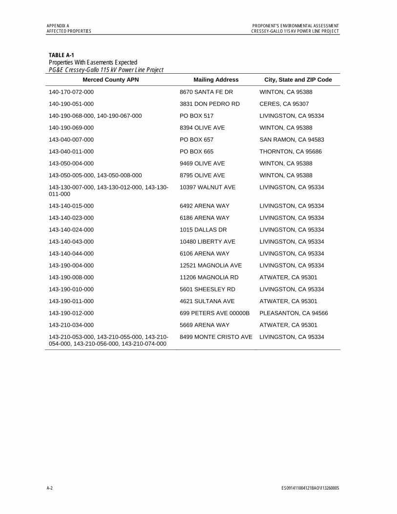
APPENDIX A PROPONENT’S ENVIRONMENTAL ASSESSMENT AFFECTED PROPERTIES CRESSEY-GALLO 115 KV POWER LINE PROJECT
A-2 ES091411004121BAO\113260005
TABLE A-1 Properties With Easements Expected PG&E Cressey-Gallo 115 kV Power Line Project
Merced County APN Mailing Address City, State and ZIP Code
140-170-072-000 8670 SANTA FE DR WINTON, CA 95388
140-190-051-000 3831 DON PEDRO RD CERES, CA 95307
140-190-068-000, 140-190-067-000 PO BOX 517 LIVINGSTON, CA 95334
140-190-069-000 8394 OLIVE AVE WINTON, CA 95388
143-040-007-000 PO BOX 657 SAN RAMON, CA 94583
143-040-011-000 PO BOX 665 THORNTON, CA 95686
143-050-004-000 9469 OLIVE AVE WINTON, CA 95388
143-050-005-000, 143-050-008-000 8795 OLIVE AVE WINTON, CA 95388
143-130-007-000, 143-130-012-000, 143-130-011-000
10397 WALNUT AVE LIVINGSTON, CA 95334
143-140-015-000 6492 ARENA WAY LIVINGSTON, CA 95334
143-140-023-000 6186 ARENA WAY LIVINGSTON, CA 95334
143-140-024-000 1015 DALLAS DR LIVINGSTON, CA 95334
143-140-043-000 10480 LIBERTY AVE LIVINGSTON, CA 95334
143-140-044-000 6106 ARENA WAY LIVINGSTON, CA 95334
143-190-004-000 12521 MAGNOLIA AVE LIVINGSTON, CA 95334
143-190-008-000 11206 MAGNOLIA RD ATWATER, CA 95301
143-190-010-000 5601 SHEESLEY RD LIVINGSTON, CA 95334
143-190-011-000 4621 SULTANA AVE ATWATER, CA 95301
143-190-012-000 699 PETERS AVE 00000B PLEASANTON, CA 94566
143-210-034-000 5669 ARENA WAY ATWATER, CA 95301
143-210-053-000, 143-210-055-000, 143-210-054-000, 143-210-056-000, 143-210-074-000
8499 MONTE CRISTO AVE LIVINGSTON, CA 95334
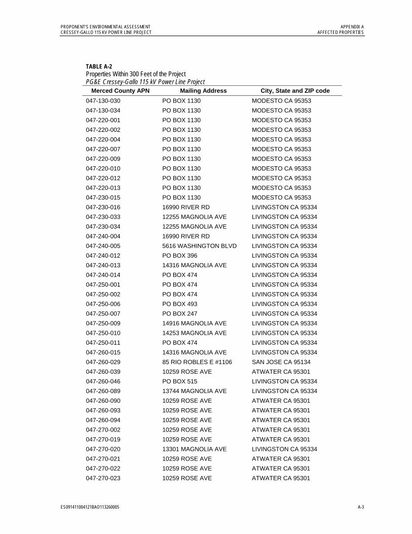
PROPONENT’S ENVIRONMENTAL ASSESSMENT APPENDIX A CRESSEY-GALLO 115 KV POWER LINE PROJECT AFFECTED PROPERTIES
ES091411004121BAO113260005 A-3
TABLE A-2 Properties Within 300 Feet of the Project PG&E Cressey-Gallo 115 kV Power Line Project
Merced County APN Mailing Address City, State and ZIP code
047-130-030 PO BOX 1130 MODESTO CA 95353
047-130-034 PO BOX 1130 MODESTO CA 95353
047-220-001 PO BOX 1130 MODESTO CA 95353
047-220-002 PO BOX 1130 MODESTO CA 95353
047-220-004 PO BOX 1130 MODESTO CA 95353
047-220-007 PO BOX 1130 MODESTO CA 95353
047-220-009 PO BOX 1130 MODESTO CA 95353
047-220-010 PO BOX 1130 MODESTO CA 95353
047-220-012 PO BOX 1130 MODESTO CA 95353
047-220-013 PO BOX 1130 MODESTO CA 95353
047-230-015 PO BOX 1130 MODESTO CA 95353
047-230-016 16990 RIVER RD LIVINGSTON CA 95334
047-230-033 12255 MAGNOLIA AVE LIVINGSTON CA 95334
047-230-034 12255 MAGNOLIA AVE LIVINGSTON CA 95334
047-240-004 16990 RIVER RD LIVINGSTON CA 95334
047-240-005 5616 WASHINGTON BLVD LIVINGSTON CA 95334
047-240-012 PO BOX 396 LIVINGSTON CA 95334
047-240-013 14316 MAGNOLIA AVE LIVINGSTON CA 95334
047-240-014 PO BOX 474 LIVINGSTON CA 95334
047-250-001 PO BOX 474 LIVINGSTON CA 95334
047-250-002 PO BOX 474 LIVINGSTON CA 95334
047-250-006 PO BOX 493 LIVINGSTON CA 95334
047-250-007 PO BOX 247 LIVINGSTON CA 95334
047-250-009 14916 MAGNOLIA AVE LIVINGSTON CA 95334
047-250-010 14253 MAGNOLIA AVE LIVINGSTON CA 95334
047-250-011 PO BOX 474 LIVINGSTON CA 95334
047-260-015 14316 MAGNOLIA AVE LIVINGSTON CA 95334
047-260-029 85 RIO ROBLES E #1106 SAN JOSE CA 95134
047-260-039 10259 ROSE AVE ATWATER CA 95301
047-260-046 PO BOX 515 LIVINGSTON CA 95334
047-260-089 13744 MAGNOLIA AVE LIVINGSTON CA 95334
047-260-090 10259 ROSE AVE ATWATER CA 95301
047-260-093 10259 ROSE AVE ATWATER CA 95301
047-260-094 10259 ROSE AVE ATWATER CA 95301
047-270-002 10259 ROSE AVE ATWATER CA 95301
047-270-019 10259 ROSE AVE ATWATER CA 95301
047-270-020 13301 MAGNOLIA AVE LIVINGSTON CA 95334
047-270-021 10259 ROSE AVE ATWATER CA 95301
047-270-022 10259 ROSE AVE ATWATER CA 95301
047-270-023 10259 ROSE AVE ATWATER CA 95301

APPENDIX A PROPONENT’S ENVIRONMENTAL ASSESSMENT AFFECTED PROPERTIES CRESSEY-GALLO 115 KV POWER LINE PROJECT
A-4 ES091411004121BAO\113260005
TABLE A-2 Properties Within 300 Feet of the Project PG&E Cressey-Gallo 115 kV Power Line Project
Merced County APN Mailing Address City, State and ZIP code
047-280-005 PO BOX 515 LIVINGSTON CA 95334
047-280-009 12748 MAGNOLIA AVE LIVINGSTON CA 95334
047-280-010 PO BOX 455 LIVINGSTON CA 95334
047-280-011 12374 MAGNOLIA AVE LIVINGSTON CA 95334
047-280-014 12746 MAGNOLIA AVE LIVINGSTON CA 95334
047-280-015 12748 MAGNOLIA AVE LIVINGSTON CA 95334
047-290-007 12255 MAGNOLIA AVE LIVINGSTON CA 95334
047-290-018 12521 MAGNOLIA AVE LIVINGSTON CA 95334
047-290-024 12255 MAGNOLIA AVE LIVINGSTON CA 95334
047-290-025 12255 MAGNOLIA AVE LIVINGSTON CA 95334
047-290-027 12521 MAGNOLIA AVE LIVINGSTON CA 95334
047-290-028 12521 MAGNOLIA AVE LIVINGSTON CA 95334
047-290-030 12521 MAGNOLIA AVE LIVINGSTON CA 95334
047-290-033 3156 ARENA WAY ATWATER CA 95301
047-290-034 3156 ARENA WAY ATWATER CA 95301
047-320-005 PO BOX 396 LIVINGSTON CA 95334
047-320-006 2717 W ROBERTS AVE FRESNO CA 93711
047-320-017 16990 RIVER RD LIVINGSTON CA 95334
047-320-018 1732 CALA VITA PL MANTECA CA 95337
140-030-015 8470 MEADOW DR WINTON CA 95388
140-030-024 13640 COLLIER RD DELHI CA 95315
140-090-059 PO BOX 7 MANTECA CA 95336
140-120-003 9681 WEST LN WINTON CA 95388
140-120-004 17685 LE GRAND RD LE GRAND CA 95333
140-120-007 PG&E PG&E
140-120-010 8244 PALM AVE WINTON CA 95388
140-120-015 9542 WEST LN WINTON CA 95388
140-120-016 9700 WEST LN WINTON CA 95388
140-170-003 3524 DOTHAN DR MODESTO CA 95357
140-170-004 9575 WALNUT AVE WINTON CA 95388
140-170-011 9095 PALM AVE WINTON CA 95388
140-170-012 9114 MERCEDES AVE WINTON CA 95388
140-170-013 9164 MERCEDES AVE WINTON CA 95388
140-170-016 7767 EUCALYPTUS AVE WINTON CA 95388
140-170-020 428 CENTRAL AVE HALF MOON BAY CA 94019
140-170-021 PO BOX 156 LIVINGSTON CA 95334
140-170-023 9095 PALM AVE WINTON CA 95388
140-170-024 9095 PALM AVE WINTON CA 95388
140-170-026 8633 PALM AVE WINTON CA 95388
140-170-029 8764 WEST LN WINTON CA 95388
140-170-056 9605 EUCALYPTUS AVE WINTON CA 95388
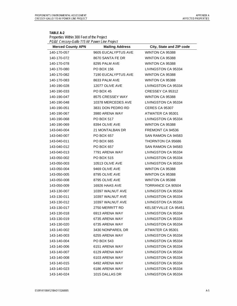
PROPONENT’S ENVIRONMENTAL ASSESSMENT APPENDIX A CRESSEY-GALLO 115 KV POWER LINE PROJECT AFFECTED PROPERTIES
ES091411004121BAO113260005 A-5
TABLE A-2 Properties Within 300 Feet of the Project PG&E Cressey-Gallo 115 kV Power Line Project
Merced County APN Mailing Address City, State and ZIP code
140-170-057 9605 EUCALYPTUS AVE WINTON CA 95388
140-170-072 8670 SANTA FE DR WINTON CA 95388
140-170-078 8295 PALM AVE WINTON CA 95388
140-170-080 PO BOX 156 LIVINGSTON CA 95334
140-170-082 7190 EUCALYPTUS AVE WINTON CA 95388
140-170-083 8633 PALM AVE WINTON CA 95388
140-190-028 12077 OLIVE AVE LIVINGSTON CA 95334
140-190-033 PO BOX 45 CRESSEY CA 95312
140-190-047 8575 CRESSEY WAY WINTON CA 95388
140-190-048 10378 MERCEDES AVE LIVINGSTON CA 95334
140-190-051 3831 DON PEDRO RD CERES CA 95307
140-190-067 3980 ARENA WAY ATWATER CA 95301
140-190-068 PO BOX 517 LIVINGSTON CA 95334
140-190-069 8394 OLIVE AVE WINTON CA 95388
143-040-004 21 MONTALBAN DR FREMONT CA 94536
143-040-007 PO BOX 657 SAN RAMON CA 94583
143-040-011 PO BOX 665 THORNTON CA 95686
143-040-012 PO BOX 657 SAN RAMON CA 94583
143-040-013 7791 ARENA WAY LIVINGSTON CA 95334
143-050-002 PO BOX 515 LIVINGSTON CA 95334
143-050-003 10513 OLIVE AVE LIVINGSTON CA 95334
143-050-004 9469 OLIVE AVE WINTON CA 95388
143-050-005 8795 OLIVE AVE WINTON CA 95388
143-050-008 8795 OLIVE AVE WINTON CA 95388
143-050-009 16926 HAAS AVE TORRANCE CA 90504
143-130-007 10397 WALNUT AVE LIVINGSTON CA 95334
143-130-011 10397 WALNUT AVE LIVINGSTON CA 95334
143-130-012 10397 WALNUT AVE LIVINGSTON CA 95334
143-130-017 2750 MERRITT RD KELSEYVILLE CA 95451
143-130-018 6913 ARENA WAY LIVINGSTON CA 95334
143-130-019 6735 ARENA WAY LIVINGSTON CA 95334
143-130-020 6735 ARENA WAY LIVINGSTON CA 95334
143-140-002 3430 NONPAREIL DR ATWATER CA 95301
143-140-003 6255 ARENA WAY LIVINGSTON CA 95334
143-140-004 PO BOX 543 LIVINGSTON CA 95334
143-140-006 6151 ARENA WAY LIVINGSTON CA 95334
143-140-007 6129 ARENA WAY LIVINGSTON CA 95334
143-140-008 6103 ARENA WAY LIVINGSTON CA 95334
143-140-015 6492 ARENA WAY LIVINGSTON CA 95334
143-140-023 6186 ARENA WAY LIVINGSTON CA 95334
143-140-024 1015 DALLAS DR LIVINGSTON CA 95334
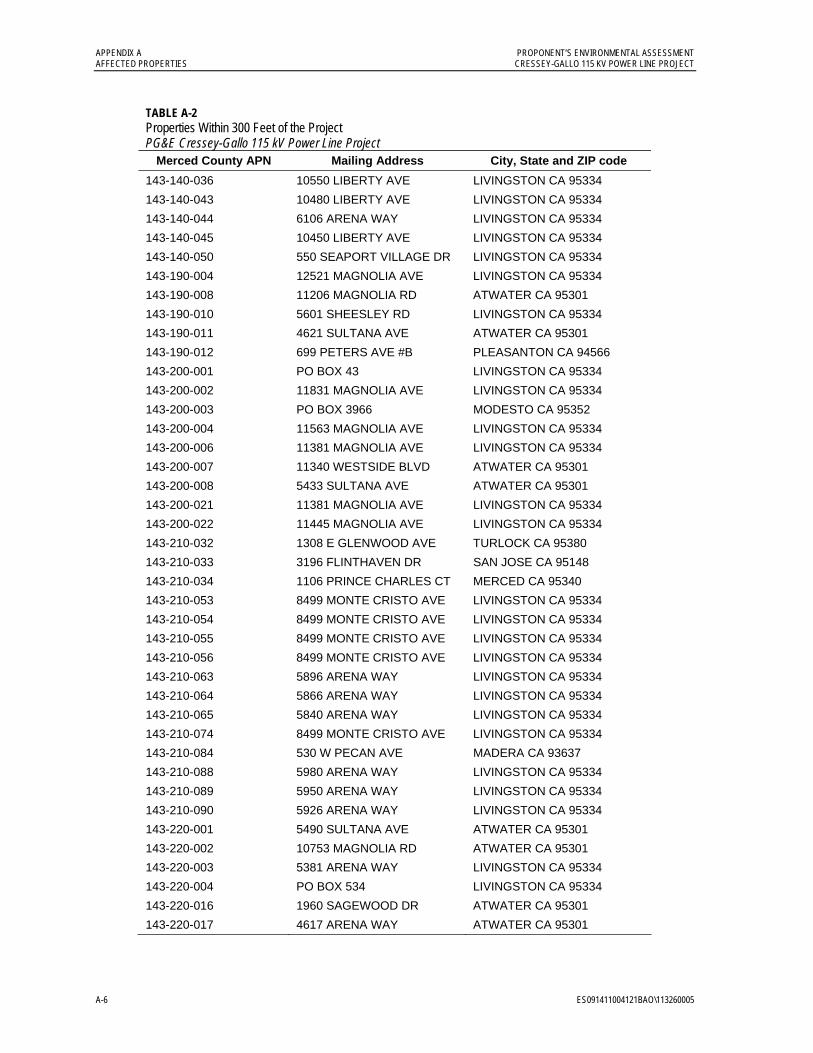
APPENDIX A PROPONENT’S ENVIRONMENTAL ASSESSMENT AFFECTED PROPERTIES CRESSEY-GALLO 115 KV POWER LINE PROJECT
A-6 ES091411004121BAO\113260005
TABLE A-2 Properties Within 300 Feet of the Project PG&E Cressey-Gallo 115 kV Power Line Project
Merced County APN Mailing Address City, State and ZIP code
143-140-036 10550 LIBERTY AVE LIVINGSTON CA 95334
143-140-043 10480 LIBERTY AVE LIVINGSTON CA 95334
143-140-044 6106 ARENA WAY LIVINGSTON CA 95334
143-140-045 10450 LIBERTY AVE LIVINGSTON CA 95334
143-140-050 550 SEAPORT VILLAGE DR LIVINGSTON CA 95334
143-190-004 12521 MAGNOLIA AVE LIVINGSTON CA 95334
143-190-008 11206 MAGNOLIA RD ATWATER CA 95301
143-190-010 5601 SHEESLEY RD LIVINGSTON CA 95334
143-190-011 4621 SULTANA AVE ATWATER CA 95301
143-190-012 699 PETERS AVE #B PLEASANTON CA 94566
143-200-001 PO BOX 43 LIVINGSTON CA 95334
143-200-002 11831 MAGNOLIA AVE LIVINGSTON CA 95334
143-200-003 PO BOX 3966 MODESTO CA 95352
143-200-004 11563 MAGNOLIA AVE LIVINGSTON CA 95334
143-200-006 11381 MAGNOLIA AVE LIVINGSTON CA 95334
143-200-007 11340 WESTSIDE BLVD ATWATER CA 95301
143-200-008 5433 SULTANA AVE ATWATER CA 95301
143-200-021 11381 MAGNOLIA AVE LIVINGSTON CA 95334
143-200-022 11445 MAGNOLIA AVE LIVINGSTON CA 95334
143-210-032 1308 E GLENWOOD AVE TURLOCK CA 95380
143-210-033 3196 FLINTHAVEN DR SAN JOSE CA 95148
143-210-034 1106 PRINCE CHARLES CT MERCED CA 95340
143-210-053 8499 MONTE CRISTO AVE LIVINGSTON CA 95334
143-210-054 8499 MONTE CRISTO AVE LIVINGSTON CA 95334
143-210-055 8499 MONTE CRISTO AVE LIVINGSTON CA 95334
143-210-056 8499 MONTE CRISTO AVE LIVINGSTON CA 95334
143-210-063 5896 ARENA WAY LIVINGSTON CA 95334
143-210-064 5866 ARENA WAY LIVINGSTON CA 95334
143-210-065 5840 ARENA WAY LIVINGSTON CA 95334
143-210-074 8499 MONTE CRISTO AVE LIVINGSTON CA 95334
143-210-084 530 W PECAN AVE MADERA CA 93637
143-210-088 5980 ARENA WAY LIVINGSTON CA 95334
143-210-089 5950 ARENA WAY LIVINGSTON CA 95334
143-210-090 5926 ARENA WAY LIVINGSTON CA 95334
143-220-001 5490 SULTANA AVE ATWATER CA 95301
143-220-002 10753 MAGNOLIA RD ATWATER CA 95301
143-220-003 5381 ARENA WAY LIVINGSTON CA 95334
143-220-004 PO BOX 534 LIVINGSTON CA 95334
143-220-016 1960 SAGEWOOD DR ATWATER CA 95301
143-220-017 4617 ARENA WAY ATWATER CA 95301

Appendix B Electric and Magnetic Fields

ES091411004121BAO\113260005 B-1
APPENDIX B
Electric and Magnetic Fields
The California Public Utilities Commission (CPUC) and the California Department of Health Services (CDHS) have not concluded that exposure to magnetic fields from utility electric facilities is a health hazard. Many reports have concluded that the potential for health effects associated with electric and magnetic field (EMF) exposure is too speculative to allow the evaluation of impacts or the preparation of mitigation measures.
EMF is a term used to describe electric and magnetic fields that are created by electric voltage (electric field) and electric current (magnetic field). Power frequency EMF is a natural consequence of electrical circuits, and can be either directly measured using the appropriate measuring instruments or calculated using appropriate information.
Electric Fields Electric fields are present whenever voltage exists on a wire, and are not dependent on current. The magnitude of the electric field is primarily a function of the configuration and operating voltage of the line and decreases with the distance from the source (line). The electric field can be shielded (i.e., the strength can be reduced) by any conducting surface, such as trees, fences, walls, buildings, and most types of structures. The strength of an electric field is measured in volts per meter (V/m) or kilovolts per meter (kV/m).
Magnetic Fields Magnetic fields are present whenever current flows in a conductor, and are not dependent on the voltage present on the conductor. The strength of these fields also decreases with distance from the source. However, unlike electric fields, most common materials have little shielding effect on magnetic fields.
The magnetic field strength is a function of both the current on the conductor and the design of the system. Magnetic fields are measured in units called Gauss. However, for the low levels normally encountered near power systems, the field strength is expressed in a much smaller unit, the milligauss (mG), which is one thousandth of a Gauss.
Power frequency EMF is present where electricity is used. This includes not only utility transmission lines, distribution lines, and substations, but also the building wiring in homes, offices, and schools, and in the appliances and machinery used in these locations. Typical magnetic fields from these sources can range from below 1 mG to above 1,000 mG (1 Gauss).
Magnetic field strengths diminish with distance. Fields from compact sources (i.e., those containing coils such as small appliances and transformers) decrease in inverse proportion to the distance from the source cubed. For three-phase power lines with balanced currents, the magnetic field strength drops off inversely proportional to the distance from the line squared. Fields from unbalanced currents, which flow in paths such as neutral or ground
APPENDIX B PROPONENT’S ENVIRONMENTAL ASSESSMENT ELECTRIC AND MAGNETIC FIELDS CRESSEY-GALLO 115 KV POWER LINE PROJECT
B-2 ES091411004121BAO\113260005
conductors, fall off inversely proportional to the distance from the source. Conductor spacing and configuration also affect the rate at which the magnetic field strength decreases.
The magnetic field levels of PG&E's overhead and underground transmission lines will vary depending upon customer power usage. Magnetic field strengths for typical PG&E transmission line loadings at the edge of rights-of-way are approximately 10 to 90 mG. Under peak load conditions, the magnetic fields at the edge of the right-of-way would not likely exceed 150 mG. There are no long-term, health-based state or federal government EMF exposure standards. State regulations for magnetic fields have been developed in New York and Florida (150 mG and 200 mG at the edge of the right-of-way). However, these are based on limiting exposure from new facilities to levels no greater than existing facilities.
The strongest magnetic fields around the outside of a substation come from the power lines entering and leaving the station. The strength of the magnetic fields from transformers and other equipment decreases quickly with distance. Beyond the substation fence, the magnetic fields produced by the equipment within the station are typically indistinguishable from background levels.
Possible Health Effects The possible effects of EMF on human health have come under scientific scrutiny. Concern about EMF originally focused on electric fields; however, much of the recent research has focused on magnetic fields. Uncertainty exists as to what characteristics of magnetic field exposure need to be considered to assess human exposure effects. Among the characteristics considered are field intensity, transients, harmonics, and changes in intensity over time. These characteristics may vary from power lines to appliances to home wiring, and this may create different types of exposures. The exposure most often considered is intensity or magnitude of the field.
There is a consensus among the medical and scientific communities that there is insufficient evidence to conclude that EMF causes adverse health effects. Neither the medical nor scientific communities have been able to provide any foundation upon which regulatory bodies could establish a standard or level of exposure that is known to be either safe or harmful. Laboratory experiments have shown that magnetic fields can cause biologic changes in living cells, but scientists are not sure whether any risk to human health can be associated with them. Some studies have suggested an association between surrogate measures of magnetic fields and certain cancers while others have not.
California Public Utilities Commission Decision Summary Background On January 15, 1991, the CPUC initiated an investigation to consider its role in mitigating the health effects, if any, of electric and magnetic fields from utility facilities and power lines. A working group of interested parties, called the California EMF Consensus Group, was created by the CPUC to advise it on this issue. It consisted of 17 stakeholders representing citizens groups, consumer groups, environmental groups, state agencies, unions, and utilities. The Consensus Group's fact-finding process was open to the public,
PROPONENT’S ENVIRONMENTAL ASSESSMENT APPENDIX B CRESSEY-GALLO 115 KV POWER LINE PROJECT ELECTRIC AND MAGNETIC FIELDS
ES091411004121BAO\113260005 B-3
and its report incorporated concerns expressed by the public. Its recommendations were filed with the Commission in March 1992.
In August 2004 the CPUC began a proceeding known as a “rulemaking” (R.04-08-020) to explore whether changes should be made to existing CPUC policies and rules concerning EMF from electric transmission lines and other utility facilities.
Through a series of hearings and conferences, the Commission evaluated the results of its existing EMF mitigation policies and addressed possible improvements in implementation of these policies. The CPUC also explored whether new policies are warranted in light of recent scientific findings on the possible health effects of EMF exposure.
The CPUC completed the EMF rulemaking in January 2006 and presented these conclusions in Decision D.06-01-042:
The CPUC affirmed its existing policy of requiring no-cost and low-cost mitigation measures to reduce EMF levels from new utility transmission lines and substation projects.
The CPUC adopted rules and policies to improve utility design guidelines for reducing EMF, and provides for a utility workshop to implement these policies and standardize design guidelines.
Despite numerous studies, including one ordered by the Commission and conducted by the California Department of Health Services, the CPUC stated “we are unable to determine whether there is a significant scientifically verifiable relationship between EMF exposure and negative health consequences.”
The CPUC said it will “remain vigilant” regarding new scientific studies on EMF, and if these studies indicate negative EMF health impacts, the Commission will reconsider its EMF policies and open a new rulemaking if necessary.
In response to a situation of scientific uncertainty and public concern, the decision specifically requires PG&E to consider “no-cost” and “low-cost” measures, where feasible, to reduce exposure from new or upgraded utility facilities. It directs that no-cost mitigation measures be undertaken, and that low-cost options, when they meet certain guidelines for field reduction and cost, be adopted through the project certification process. PG&E was directed to develop, submit and follow EMF guidelines to implement the CPUC decision. Four percent of total project budgeted cost is the benchmark in implementing EMF mitigation, and mitigation measures should achieve incremental magnetic field reductions of at least 15%.
Reviews of EMF Studies Hundreds of EMF studies have been conducted over the last 20 years in the areas of epidemiology, animal research, cellular studies, and exposure assessment. A number of nationally recognized multi-discipline panels have performed comprehensive reviews of the body of scientific knowledge on EMF. These panels’ ability to bring experts from a variety of disciplines together to review the research gives their reports recognized credibility. It is standard practice in risk assessment and policymaking to rely on the findings and consensus opinions of these distinguished panels. None of these groups have concluded
APPENDIX B PROPONENT’S ENVIRONMENTAL ASSESSMENT ELECTRIC AND MAGNETIC FIELDS CRESSEY-GALLO 115 KV POWER LINE PROJECT
B-4 ES091411004121BAO\113260005
that EMF causes adverse health effects or that the development of standards were appropriate or would have a scientific basis.
Reports by the National Research Council/National Academy of Sciences, American Medical Association, American Cancer Society, National Institute of Environmental Health Sciences, World Health Organization, International Agency for Research on Cancer, and California Department of Health Services conclude that insufficient scientific evidence exists to warrant the adoption of specific health-based EMF mitigation measures. The potential for adverse health effects associated with EMF exposure is too speculative to allow the evaluation of impacts or the preparation of mitigation measures.
National Institute of Environmental Health Sciences In June of 1999, the federal government completed a $60-million EMF research program managed by the National Institute of Environmental Health Sciences (NIEHS) and the Department of Energy (DOE). Known as the EMF RAPID (Research And Public Information Dissemination) Program. In their report to the U.S. Congress, the NIEHS concluded that:
The NIEHS believes that the probability that ELF-EMF exposure is truly a health hazard is currently small. The weak epidemiological associations and lack of any laboratory support for these associations provide only marginal, scientific support that exposure to this agent is causing any degree of harm.
The NIEHS report also included the following conclusions:
The National Toxicology Program routinely examines environmental exposures to determine the degree to which they constitute a human cancer risk and produces the ‘Report on Carcinogens’ listing agents that are ‘known human carcinogens’ or ‘reasonably anticipated to be human carcinogens.’ It is our opinion that based on evidence to date, ELF-EMF exposure would not be listed in the ‘Report on Carcinogens’ as an agent ‘reasonably anticipated to be a human carcinogen.’ This is based on the limited epidemiological evidence and the findings from the EMF-RAPID Program that did not indicate an effect of ELF-EMF exposure in experimental animals or a mechanistic basis for carcinogenicity.
The NIEHS agrees that the associations reported for childhood leukemia and adult chronic lymphocytic leukemia cannot be dismissed easily as random or negative findings. The lack of positive findings in animals or in mechanistic studies weakens the belief that this association is actually due to ELF-EMF, but cannot completely discount the finding. The NIEHS also agrees with the conclusion that no other cancers or non-cancer health outcomes provide sufficient evidence of a risk to warrant concern.
Epidemiological studies have serious limitations in their ability to demonstrate a cause and effect relationship whereas laboratory studies, by design, can clearly show that cause and effect are possible. Virtually all of the laboratory evidence in animals and humans and most of the mechanistic work done in cells fail to support a causal relationship between exposure to ELF-EMF at environmental levels and changes in biological function or
PROPONENT’S ENVIRONMENTAL ASSESSMENT APPENDIX B CRESSEY-GALLO 115 KV POWER LINE PROJECT ELECTRIC AND MAGNETIC FIELDS
ES091411004121BAO\113260005 B-5
disease status. The lack of consistent, positive findings in animal or mechanistic studies weakens the belief that this association is actually due to ELF-EMF, but it cannot completely discount the epidemiological findings.
The NIEHS suggests that the level and strength of evidence supporting ELF-EMF exposure as a human health hazard are insufficient to warrant aggressive regulatory actions; thus, we do not recommend actions such as stringent standards on electric appliances and a national program to bury all transmission and distribution lines. Instead, the evidence suggests passive measures such as a continued emphasis on educating both the public and the regulated community on means aimed at reducing exposures. NIEHS suggests that the power industry continue its current practice of siting power lines to reduce exposures and continue to explore ways to reduce the creation of magnetic fields around transmission and distribution lines without creating new hazards. We also encourage technologies that lower exposures from neighborhood distribution lines provided that they do not increase other risks, such as those from accidental electrocution or fire.
U.S. National Research Council/ National Academy of Sciences In May 1999, the National Research Council/ National Academy of Sciences, an independent scientific agency responsible for advising the federal government on science, technology, and medicine, released its evaluation of the scientific and technical content of research projects conducted under the U.S. EMF RAPID Program, concluding that:
The results of the EMF RAPID program do not support the contention that the use of electricity poses a major unrecognized public-health danger. Basic research on the effects of power-frequency magnetic fields on cells and animals should continue, but a special research-funding effort is not required. Investigators should compete for funding through traditional research-funding mechanisms. If future research on this subject is funded through such mechanisms, it should be limited to tests of well-defined mechanistic hypotheses or replications of reported positive effects. If carefully performed, such experiments will have value even if their results are negative. Special efforts should be made to communicate the conclusions of this effort to the general public effectively.
The following specific recommendations are made by the committee:
1. The committee recommends that no further special research program focused on possible health effects of power-frequency magnetic fields be funded. Basic research on the effects of power-frequency magnetic fields on cells and animals should continue but investigators should compete for funding through traditional research funding mechanisms.
2. If, however, Congress determines that another time-limited, focused research program on the health effects of power-frequency magnetic fields is warranted, the committee recommends that emphasis be placed on replications of studies that have yielded scientifically promising claims of effects and that have been reported in peer-reviewed journals. Such a program would benefit from the use of a contract-funding mechanism
APPENDIX B PROPONENT’S ENVIRONMENTAL ASSESSMENT ELECTRIC AND MAGNETIC FIELDS CRESSEY-GALLO 115 KV POWER LINE PROJECT
B-6 ES091411004121BAO\113260005
with a requirement for complete reports and/or peer-reviewed publications at program's end.
3. The engineering studies were initiated without the guidance of a clearly established biologic effect. The committee recommends that no further engineering studies be funded unless a biologic effect that can be used to plan the engineering studies has been determined.
4. Much of the information from the EMF-RAPID biology program has not been published in peer-reviewed journals. NIEHS should collect all future peer-reviewed information resulting from the EMF-RAPID biology projects and publish a summary report of such information periodically on the NIEHS Web site.
5. The communication effort initiated by EMF-RAPID is reasonable. The two booklets and the telephone information line are useful, as is the EMF-RAPID Internet site. There are two limitations to the effort. First, it is largely passive, responding to inquiries and providing information, rather than being active. Second, much of the information produced is in a scientific format not readily understandable by the public. The committee recommends that further material produced to disseminate information on power-frequency magnetic fields be written for the general public in a clear fashion. The Web site should be made more user-friendly. The booklet Questions and Answers about EMF should be updated periodically and made available to the public.
3.12.4 World Health Organization The World Health Organization (WHO) established the International EMF Project in 1996 to investigate potential health risks associated with exposure to electric and magnetic fields (EMF). A WHO Task Group recently concluded a review of the health implications of extremely low frequency (ELF) EMF.
A Task Group of scientific experts was convened in 2005 to assess any risks to health that might exist from exposure to ELF electric and magnetic fields. Previously in 2002, the International Agency for Research on Cancer (IARC) examined the evidence regarding cancer; this Task Group reviewed evidence for a number of health effects, and updated the evidence regarding cancer. The conclusions and recommendations of the Task Group are presented in a WHO report titled: “Extremely Low Frequency Fields Environmental Health Criteria Monograph No.238” and Factsheet No 322.
“New human, animal and in vitro studies, published since the 2002 IARC monograph, do not change the overall classification of ELF magnetic fields as a possible human carcinogen.”
“A number of other diseases have been investigated for possible association with ELF magnetic field exposure. These include cancers in both children and adults, depression, suicide, reproductive dysfunction, developmental disorders, immunological modifications and neurological disease. The scientific evidence supporting a linkage between ELF magnetic fields and any of these diseases is much weaker than for childhood leukaemia and in some cases (for example, for cardiovascular disease or breast cancer) the evidence is sufficient to give confidence that magnetic fields do not cause the disease.”

PROPONENT’S ENVIRONMENTAL ASSESSMENT APPENDIX B CRESSEY-GALLO 115 KV POWER LINE PROJECT ELECTRIC AND MAGNETIC FIELDS
ES091411004121BAO\113260005 B-7
“the epidemiological evidence is weakened by methodological problems, such as potential selection bias. In addition, there are no accepted biophysical mechanisms that would suggest that low-level exposures are involved in cancer development. Thus, if there were any effects from exposures to these low-level fields, it would have to be through a biological mechanism that is as yet unknown. Additionally, animal studies have been largely negative. Thus, on balance, the evidence related to childhood leukaemia is not strong enough to be considered causal.”
“Policy-makers should establish an ELF EMF protection programme that includes measurements of fields from all sources to ensure that the exposure limits are not exceeded either for the general public or workers.”
“Government and industry should monitor science and promote research programmes to further reduce the uncertainty of the scientific evidence on the health effects of ELF field exposure.”
“Policy-makers, community planners and manufacturers should implement very low-cost measures when constructing new facilities and designing new equipment including appliances.”
“Changes to engineering practice to reduce ELF exposure from equipment or devices should be considered, provided that they yield other additional benefits, such as greater safety, or little or no cost.”
“When changes to existing ELF sources are contemplated, ELF field reduction should be considered alongside safety, reliability and economic aspects.”
3.12.5 International Agency for Research on Cancer In June of 2001, the International Agency for Research on Cancer (IARC), a branch of the World Health Organization (WHO), evaluated the carcinogenic risk to humans of static and extremely low-frequency EMF. In October of 2001, the WHO published a Fact Sheet that summarized the IARC findings. Below is an excerpt from the fact sheet:
In June 2001, an expert scientific working group of IARC reviewed studies related to the carcinogenicity of static and ELF electric and magnetic fields. Using the standard IARC classification that weighs human, animal and laboratory evidence, ELF magnetic fields were classified as possibly carcinogenic to humans based on epidemiological studies of childhood leukaemia. Evidence for all other cancers in children and adults, as well as other types of exposures (i.e. static fields and ELF electric fields) was considered not classifiable either due to insufficient or inconsistent scientific information.
"Possibly carcinogenic to humans" is a classification used to denote an agent for which there is limited evidence of carcinogenicity in humans and less than sufficient evidence for carcinogenicity in experimental animals.
This classification is the weakest of three categories ("is carcinogenic to humans", "probably carcinogenic to humans" and "possibly carcinogenic to humans") used by

APPENDIX B PROPONENT’S ENVIRONMENTAL ASSESSMENT ELECTRIC AND MAGNETIC FIELDS CRESSEY-GALLO 115 KV POWER LINE PROJECT
B-8 ES091411004121BAO\113260005
IARC to classify potential carcinogens based on published scientific evidence. Some examples of well-known agents that have been classified by IARC are listed below:
Classification Examples of Agents
Carcinogenic to humans (usually based on strong evidence of carcinogenicity in humans)
Asbestos Mustard gas Tobacco (smoked and smokeless) Gamma radiation
Probably carcinogenic to humans (usually based on strong evidence of carcinogenicity in animals)
Diesel engine exhaust Sun lamps UV radiation Formaldehyde
Possibly carcinogenic to humans (usually based on evidence in humans which is considered credible, but for which other explanations could not be ruled out)
Coffee Styrene Gasoline engine exhaust Pickled Vegetables ELF magnetic fields
DO ELF FIELDS CAUSE CANCER?
ELF fields are known to interact with tissues by inducing electric fields and currents in them. This is the only established mechanism of action of these fields. However, the electric currents induced by ELF fields commonly found in our environment are normally much lower than the strongest electric currents naturally occurring in the body such as those that control the beating of the heart.
Since 1979 when epidemiological studies first raised a concern about exposures to power line frequency magnetic fields and childhood cancer, a large number of studies have been conducted to determine if measured ELF exposure can influence cancer development, especially leukaemia in children.
There is no consistent evidence that exposure to ELF fields experienced in our living environment causes direct damage to biological molecules, including DNA. Since it seems unlikely that ELF fields could initiate cancer, a large number of investigations have been conducted to determine if ELF exposure can influence cancer promotion or co-promotion. Results from animal studies conducted so far suggest that ELF fields do not initiate or promote cancer.
However, two recent pooled analyses of epidemiological studies provide insight into the epidemiological evidence that played a pivotal role in the IARC evaluation. These studies suggest that, in a population exposed to average magnetic fields in excess of 0.3 to 0.4 μT, twice as many children might develop leukaemia compared to a population with lower exposures. In spite of the large number data base, some uncertainty remains as to whether magnetic field exposure or some other factor(s) might have accounted for the increased leukaemia incidence.
Childhood leukaemia is a rare disease with 4 out of 100,000 children between the age of 0 to 14 diagnosed every year. Also average magnetic field exposures above 0.3 or 0.4 μT in residences are rare. It can be estimated from the epidemiological study

PROPONENT’S ENVIRONMENTAL ASSESSMENT APPENDIX B CRESSEY-GALLO 115 KV POWER LINE PROJECT ELECTRIC AND MAGNETIC FIELDS
ES091411004121BAO\113260005 B-9
results that less than 1% of populations using 240 volt power supplies are exposed to these levels, although this may be higher in countries using 120 volt supplies.
The IARC review addresses the issue of whether it is feasible that ELF-EMF pose a cancer risk. The next step in the process is to estimate the likelihood of cancers in the general population from the usual exposures and to evaluate evidence for other (non-cancer) diseases. This part of the risk assessment should be finished by WHO in the next 18 months.
American Cancer Society In the journal, A Cancer Journal for Clinicians, the American Cancer Society (ACS) reviewed EMF residential and occupational epidemiologic research in an article written by Dr. Clark W. Heath, Jr., ACS’s vice president of epidemiology and surveillance research. Dr. Heath reviews 13 residential epidemiologic studies of adult and childhood cancer. Dr. Heath wrote:
Evidence suggesting that exposure to EMF may or may not promote human carcinogenesis is mostly based on...epidemiologic observations.... While those observations may suggest such a relationship for leukemia and brain cancer in particular, the findings are weak, inconsistent, and inconclusive.... The weakness and inconsistent nature of epidemiologic data, combined with the continued dearth of coherent and reproducible findings from experimental laboratory research, leave one uncertain and rather doubtful that any real biologic link exists between EMF exposure and carcinogenicity.
American Medical Association The AMA adopted recommendations of its Council on Scientific Affairs (CSA) regarding EMF health effects. The report was prepared as a result of a resolution passed by AMA’s membership at its 1993 annual meeting. The following recommendations are based on the CSA’s review of EMF epidemiologic and laboratory studies to date, as well as on several major literature reviews:
Although no scientifically documented health risk has been associated with the usually occurring levels of electromagnetic fields, the AMA should continue to monitor developments and issues related to the subject.
The AMA should encourage research efforts sponsored by agencies such as the National Institutes of Health, the U.S. Department of Energy, and the National Science Foundation. Continuing research should include study of exposures to EMF and its effects, average public exposures, occupational exposures, and the effects of field surges and harmonics.
The AMA should support the meeting of an authoritative, multidisciplinary committee under the auspices of the National Academy of Sciences or the National Council on Radiation Protection and Measurements to make recommendations about exposure levels of the public and workers to EMF and radiation.
APPENDIX B PROPONENT’S ENVIRONMENTAL ASSESSMENT ELECTRIC AND MAGNETIC FIELDS CRESSEY-GALLO 115 KV POWER LINE PROJECT
B-10 ES091411004121BAO\113260005
References American Cancer Society. 1996. “Electromagnetic Field Exposure and Cancer: a Review of
Epidemiologic Evidence.” A Cancer Journal for Clinicians, the American Cancer Society. January/February.
American Medical Association. 1994. Effects of Electric and Magnetic Fields. Report of the Council on Scientific Affairs to the American Medical Association. December.
California Public Utilities Commission. 1993. Order instituting investigation on the Commission’s own motion to develop policies and procedures for addressing the potential health effects of electric and magnetic fields of utility facilities. Decision 93-11-013. November 2.
California Public Utilities Commission. 2006. Order Instituting Rulemaking to update the Commission’s policies and procedures related to electromagnetic fields emanating from regulated utility facilities. Decision 06-01-042 January 26, 2006
National Institute of Environmental Health Sciences, National Institutes of Health. 1999. NIEHS Report on Health Effects from Exposure to Power-Line Frequency Electric and Magnetic Fields. Prepared in Response to the 1992 Energy Policy Act. June
National Research Council/ National Academy of Sciences. 1999. Research on Power-Frequency Fields Completed Under the Energy Policy Act of 1992 [Final Report, 1999]. May.
World Health Organization International EMF Project, 2001. Fact Sheet N° 263, ELECTROMAGNETIC FIELDS AND PUBLIC HEALTH Extremely low frequency fields and cancer. October.
World Health Organization. 2007 Extremely low frequency (ELF) fields. Environmental Health Criteria, Vol. 238.
World Health Organization. 2007 Electromagnetic Fields and Public Health: Exposure to extremely low frequency fields. Fact Sheet Number 322.
Pacific Gas & Electric Company. 2006. EMF Design Guidelines for Electrical Facilities.

Appendix C Construction and Operation Emissions

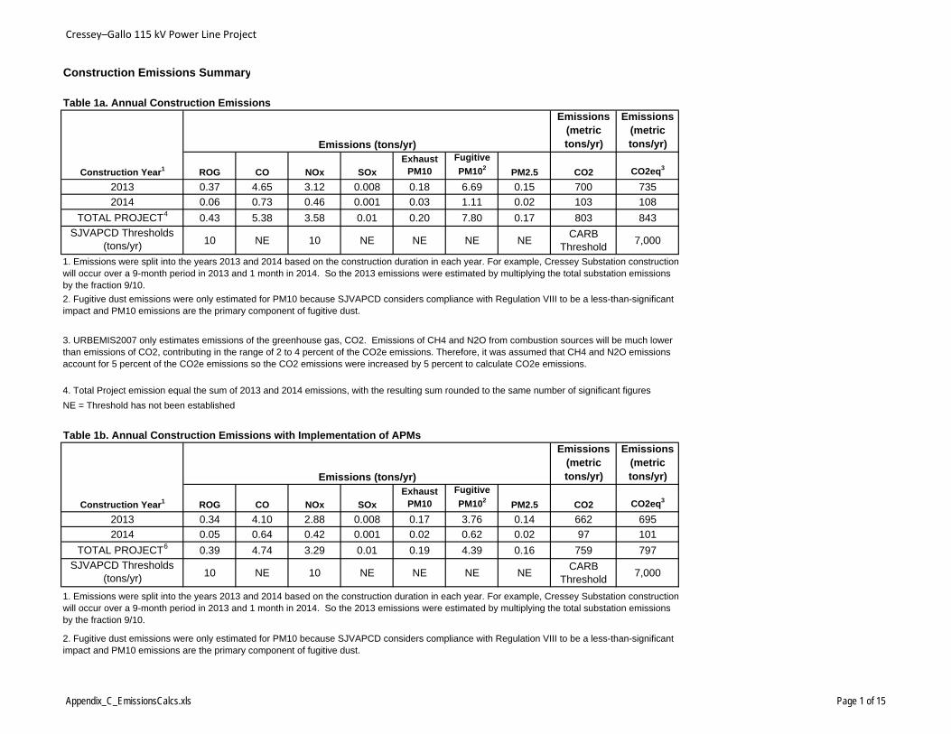
Cressey–Gallo 115 kV Power Line Project
Construction Emissions Summary
Table 1a. Annual Construction Emissions Emissions
(metric tons/yr)
Emissions (metric tons/yr)
ROG CO NOx SOx
Exhaust PM10
Fugitive
PM102PM2.5 CO2 CO2eq3
2013 0.37 4.65 3.12 0.008 0.18 6.69 0.15 700 735
2014 0.06 0.73 0.46 0.001 0.03 1.11 0.02 103 108
TOTAL PROJECT4 0.43 5.38 3.58 0.01 0.20 7.80 0.17 803 843
SJVAPCD Thresholds (tons/yr) 10 NE 10 NE NE NE NE
CARB Threshold
7,000
Table 1b. Annual Construction Emissions with Implementation of APMsEmissions
(metric tons/yr)
Emissions (metric tons/yr)
ROG CO NOx SOx
Exhaust PM10
Fugitive
PM102PM2.5 CO2 CO2eq3
2013 0.34 4.10 2.88 0.008 0.17 3.76 0.14 662 695
2014 0.05 0.64 0.42 0.001 0.02 0.62 0.02 97 101
TOTAL PROJECT6 0.39 4.74 3.29 0.01 0.19 4.39 0.16 759 797
SJVAPCD Thresholds (tons/yr) 10 NE 10 NE NE NE NE
CARB Threshold
7,000
Construction Year1
Emissions (tons/yr)
1. Emissions were split into the years 2013 and 2014 based on the construction duration in each year. For example, Cressey Substation constructionwill occur over a 9-month period in 2013 and 1 month in 2014. So the 2013 emissions were estimated by multiplying the total substation emissions by the fraction 9/10.
2. Fugitive dust emissions were only estimated for PM10 because SJVAPCD considers compliance with Regulation VIII to be a less-than-significant impact and PM10 emissions are the primary component of fugitive dust.
Emissions (tons/yr)
Construction Year1
NE = Threshold has not been established
3. URBEMIS2007 only estimates emissions of the greenhouse gas, CO2. Emissions of CH4 and N2O from combustion sources will be much lower than emissions of CO2, contributing in the range of 2 to 4 percent of the CO2e emissions. Therefore, it was assumed that CH4 and N2O emissions account for 5 percent of the CO2e emissions so the CO2 emissions were increased by 5 percent to calculate CO2e emissions.
1. Emissions were split into the years 2013 and 2014 based on the construction duration in each year. For example, Cressey Substation constructionwill occur over a 9-month period in 2013 and 1 month in 2014. So the 2013 emissions were estimated by multiplying the total substation emissions by the fraction 9/10.
2. Fugitive dust emissions were only estimated for PM10 because SJVAPCD considers compliance with Regulation VIII to be a less-than-significant impact and PM10 emissions are the primary component of fugitive dust.
4. Total Project emission equal the sum of 2013 and 2014 emissions, with the resulting sum rounded to the same number of significant figures
Appendix_C_EmissionsCalcs.xls Page 1 of 15
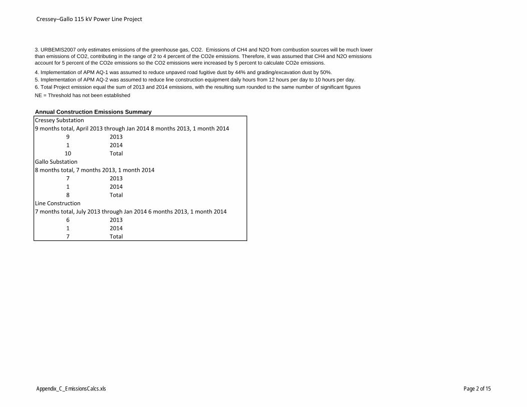
Cressey–Gallo 115 kV Power Line Project
Annual Construction Emissions Summary
Cressey Substation
9 months total, April 2013 through Jan 2014 8 months 2013, 1 month 2014
9 2013
1 2014
10 Total
Gallo Substation
8 months total, 7 months 2013, 1 month 2014
7 2013
1 2014
8 Total
Line Construction
7 months total, July 2013 through Jan 2014 6 months 2013, 1 month 2014
6 2013
1 2014
7 Total
3. URBEMIS2007 only estimates emissions of the greenhouse gas, CO2. Emissions of CH4 and N2O from combustion sources will be much lower than emissions of CO2, contributing in the range of 2 to 4 percent of the CO2e emissions. Therefore, it was assumed that CH4 and N2O emissions account for 5 percent of the CO2e emissions so the CO2 emissions were increased by 5 percent to calculate CO2e emissions.
NE = Threshold has not been established
5. Implementation of APM AQ-2 was assumed to reduce line construction equipment daily hours from 12 hours per day to 10 hours per day.
4. Implementation of APM AQ-1 was assumed to reduce unpaved road fugitive dust by 44% and grading/excavation dust by 50%.
6. Total Project emission equal the sum of 2013 and 2014 emissions, with the resulting sum rounded to the same number of significant figures
Appendix_C_EmissionsCalcs.xls Page 2 of 15
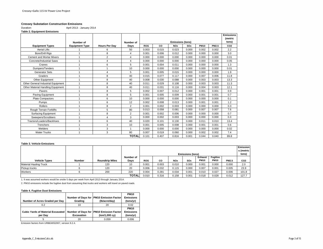
Cressey–Gallo 115 kV Power Line Project
Cressey Substation Construction EmissionsDuration: April 2013 - January 2014
Table 2. Equipment EmissionsEmissions
(metric tons)
ROG CO NOx SOx PM10 PM2.5 CO2
Aerial Lifts 1 6 50 0.003 0.015 0.023 0.000 0.002 0.002 2.2
Bore/Drill Rigs 1 8 4 0.001 0.006 0.012 0.000 0.000 0.000 3.0
Cement and Mortar Mixers 1 2 4 0.000 0.000 0.000 0.000 0.000 0.000 0.01
Concrete/Industrial Saws 1 4 4 0.000 0.000 0.000 0.000 0.000 0.000 0.05
Cranes 1 6 5 0.001 0.004 0.011 0.000 0.000 0.000 1.3
Dumpers/Tenders 1 1 10 0.000 0.000 0.000 0.000 0.000 0.000 0.01
Generator Sets 1 4 5 0.001 0.005 0.015 0.000 0.000 0.000 1.9
Graders 1 8 40 0.015 0.077 0.117 0.000 0.007 0.006 11.8
Other Equipment 1 8 40 0.008 0.030 0.088 0.000 0.003 0.003 13.3
Other General Industrial Equipment 1 8 40 0.011 0.029 0.108 0.000 0.003 0.003 11.3
Other Material Handling Equipment 1 8 40 0.011 0.031 0.116 0.000 0.004 0.003 12.1
Pavers 1 8 5 0.002 0.007 0.012 0.000 0.001 0.001 0.9
Paving Equipment 1 8 5 0.001 0.005 0.009 0.000 0.001 0.001 0.7
Plate Compactors 1 6 10 0.000 0.000 0.000 0.000 0.000 0.000 0.1
Pumps 1 6 12 0.002 0.008 0.013 0.000 0.001 0.001 1.2
Rollers 1 8 2 0.001 0.002 0.003 0.000 0.000 0.000 0.3
Rough Terrain Forklifts 1 5 80 0.013 0.058 0.081 0.000 0.007 0.007 7.6
Surfacing Equipment 1 8 2 0.001 0.002 0.006 0.000 0.000 0.000 0.7
Sweepers/Scrubbers 1 4 3 0.000 0.002 0.003 0.000 0.000 0.000 0.3
Tractors/Loaders/Backhoes 3 6 40 0.020 0.101 0.130 0.000 0.011 0.010 13.4
Trenchers 1 3 10 0.001 0.005 0.008 0.000 0.001 0.001 0.6
Welders 1 3 1 0.000 0.000 0.000 0.000 0.000 0.000 0.02
Water Trucks 1 3 80 0.007 0.019 0.060 0.000 0.002 0.002 7.4
0.101 0.407 0.816 0.001 0.044 0.040 89.8
Table 3. Vehicle EmissionsEmissions (metric
tons)
ROG CO NOx SOx
Exhaust PM10
Fugitive PM10 PM2.5 CO2
Material Hauling Truck 1 120 10 0.001 0.003 0.010 0.000 0.001 0.000 0.000 2.0
Pickup trucks 6 120 20 0.006 0.032 0.115 0.000 0.007 0.001 0.005 23.9
Workers 6 200 220 0.004 0.281 0.034 0.001 0.010 0.027 0.006 101.8
0.010 0.316 0.158 0.001 0.018 0.028 0.012 127.7
1. It was assumed workers would be onsite 5 days per week from April 2013 through January 2014.
2. PM10 emissions include the fugitive dust from assuming that trucks and workers will travel on paved roads.
Table 4. Fugitive Dust Emissions
Number of Acres Graded per DayNumber of Days for
GradingPM10 Emission Factor
(lb/acre/day)
PM10 Emissions (tons/yr)
0.2 10 20 0.02
Cubic Yards of Material Excavated per Day
Number of Days for Excavation
PM10 Emission Factor (ton/1,000 cy)
PM10 Emissions (tons/yr)
5 20 0.059 0.006
Emission factors from URBEMIS2007, version 9.2.4.
Number Roundtrip Miles Number of
Days
TOTAL
Emissions (tons)
Equipment TypesNumber of
Equipment TypeNumber of
DaysHours Per Day
Emissions (tons)
TOTAL
Vehicle Types
Appendix_C_EmissionsCalcs.xls Page 3 of 15
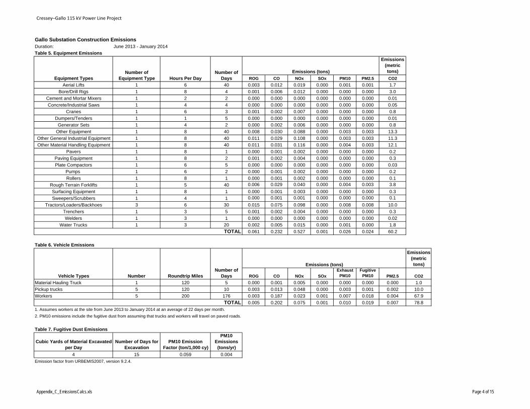
Cressey–Gallo 115 kV Power Line Project
Gallo Substation Construction EmissionsDuration: June 2013 - January 2014
Table 5. Equipment EmissionsEmissions
(metric tons)
ROG CO NOx SOx PM10 PM2.5 CO2
Aerial Lifts 1 6 40 0.003 0.012 0.019 0.000 0.001 0.001 1.7
Bore/Drill Rigs 1 8 4 0.001 0.006 0.012 0.000 0.000 0.000 3.0
Cement and Mortar Mixers 1 2 2 0.000 0.000 0.000 0.000 0.000 0.000 0.01
Concrete/Industrial Saws 1 4 4 0.000 0.000 0.000 0.000 0.000 0.000 0.05
Cranes 1 6 3 0.001 0.002 0.007 0.000 0.000 0.000 0.8
Dumpers/Tenders 1 1 5 0.000 0.000 0.000 0.000 0.000 0.000 0.01
Generator Sets 1 4 2 0.000 0.002 0.006 0.000 0.000 0.000 0.8
Other Equipment 1 8 40 0.008 0.030 0.088 0.000 0.003 0.003 13.3
Other General Industrial Equipment 1 8 40 0.011 0.029 0.108 0.000 0.003 0.003 11.3
Other Material Handling Equipment 1 8 40 0.011 0.031 0.116 0.000 0.004 0.003 12.1
Pavers 1 8 1 0.000 0.001 0.002 0.000 0.000 0.000 0.2
Paving Equipment 1 8 2 0.001 0.002 0.004 0.000 0.000 0.000 0.3
Plate Compactors 1 6 5 0.000 0.000 0.000 0.000 0.000 0.000 0.03
Pumps 1 6 2 0.000 0.001 0.002 0.000 0.000 0.000 0.2
Rollers 1 8 1 0.000 0.001 0.002 0.000 0.000 0.000 0.1
Rough Terrain Forklifts 1 5 40 0.006 0.029 0.040 0.000 0.004 0.003 3.8
Surfacing Equipment 1 8 1 0.000 0.001 0.003 0.000 0.000 0.000 0.3
Sweepers/Scrubbers 1 4 1 0.000 0.001 0.001 0.000 0.000 0.000 0.1
Tractors/Loaders/Backhoes 3 6 30 0.015 0.075 0.098 0.000 0.008 0.008 10.0
Trenchers 1 3 5 0.001 0.002 0.004 0.000 0.000 0.000 0.3
Welders 1 3 1 0.000 0.000 0.000 0.000 0.000 0.000 0.02
Water Trucks 1 3 20 0.002 0.005 0.015 0.000 0.001 0.000 1.8
0.061 0.232 0.527 0.001 0.026 0.024 60.2
Table 6. Vehicle Emissions
Emissions (metric tons)
ROG CO NOx SOx
Exhaust PM10
Fugitive PM10 PM2.5 CO2
Material Hauling Truck 1 120 5 0.000 0.001 0.005 0.000 0.000 0.000 0.000 1.0
Pickup trucks 5 120 10 0.003 0.013 0.048 0.000 0.003 0.001 0.002 10.0
Workers 5 200 176 0.003 0.187 0.023 0.001 0.007 0.018 0.004 67.9
0.005 0.202 0.075 0.001 0.010 0.019 0.007 78.8
1. Assumes workers at the site from June 2013 to January 2014 at an average of 22 days per month.
2. PM10 emissions include the fugitive dust from assuming that trucks and workers will travel on paved roads.
Table 7. Fugitive Dust Emissions
Cubic Yards of Material Excavated per Day
Number of Days for Excavation
PM10 Emission Factor (ton/1,000 cy)
PM10 Emissions (tons/yr)
4 15 0.059 0.004
Emission factor from URBEMIS2007, version 9.2.4.
Number Roundtrip Miles Number of
Days
TOTAL
Emissions (tons)
Equipment TypesNumber of
Equipment Type Hours Per DayNumber of
Days
Emissions (tons)
TOTAL
Vehicle Types
Appendix_C_EmissionsCalcs.xls Page 4 of 15
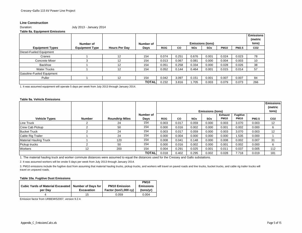
Cressey–Gallo 115 kV Power Line Project
Line ConstructionDuration: July 2013 - January 2014
Table 8a. Equipment EmissionsEmissions
(metric tons)
ROG CO NOx SOx PM10 PM2.5 CO2
Cranes 1 12 154 0.074 0.251 0.676 0.001 0.024 0.023 78
Concrete Mixer 3 12 154 0.013 0.067 0.081 0.000 0.004 0.003 10
Backhoe 1 12 154 0.051 0.258 0.334 0.000 0.028 0.026 38
Water Trucks 1 12 154 0.052 0.144 0.464 0.001 0.015 0.014 57
Puller 1 12 154 0.042 3.097 0.151 0.001 0.007 0.007 84
0.232 3.816 1.705 0.003 0.079 0.073 266
1. It was assumed equipment will operate 5 days per week from July 2013 through January 2014.
Table 9a. Vehicle EmissionsEmissions
(metric tons)
ROG CO NOx SOx
Exhaust PM10
Fugitive PM10 PM2.5 CO2
Line Truck 2 24 154 0.003 0.017 0.059 0.000 0.003 3.070 0.003 12
Crew Cab Pickup 2 50 154 0.000 0.016 0.002 0.000 0.001 0.002 0.000 6
Bucket Truck 2 24 154 0.003 0.017 0.059 0.000 0.003 3.070 0.003 12
Cable Rig Trailer 1 24 154 0.000 0.004 0.000 0.000 0.000 1.535 0.000 1
Material Hauling Truck 1 120 154 0.008 0.041 0.148 0.000 0.008 0.002 0.007 31
Pickup trucks 2 50 154 0.000 0.016 0.002 0.000 0.001 0.002 0.000 6
Workers 12 200 154 0.004 0.291 0.025 0.001 0.011 0.037 0.005 112
0.018 0.402 0.295 0.002 0.028 7.718 0.019 181
1. The material hauling truck and worker commute distances were assumed to equal the distances used for the Cressey and Gallo substations.
2. It was assumed workers will be onsite 5 days per week from July 2013 through January 2014.
Table 10a. Fugitive Dust Emissions
Cubic Yards of Material Excavated per Day
Number of Days for Excavation
PM10 Emission Factor (ton/1,000 cy)
PM10 Emissions (tons/yr)
4 15 0.059 0.004
Emission factor from URBEMIS2007, version 9.2.4.
Gasoline-Fueled Equipment
TOTAL
3. PM10 emissions include the fugitive dust from assuming that material hauling trucks, pickup trucks, and workers will travel on paved roads and line trucks, bucket trucks, and cable rig trailer trucks will travel on unpaved roads.
Emissions (tons)
Equipment TypesNumber of
Equipment Type Hours Per DayNumber of
Days
Emissions (tons)
TOTAL
Diesel-Fueled Equipment
Vehicle Types Number Roundtrip Miles Number of
Days
Appendix_C_EmissionsCalcs.xls Page 5 of 15
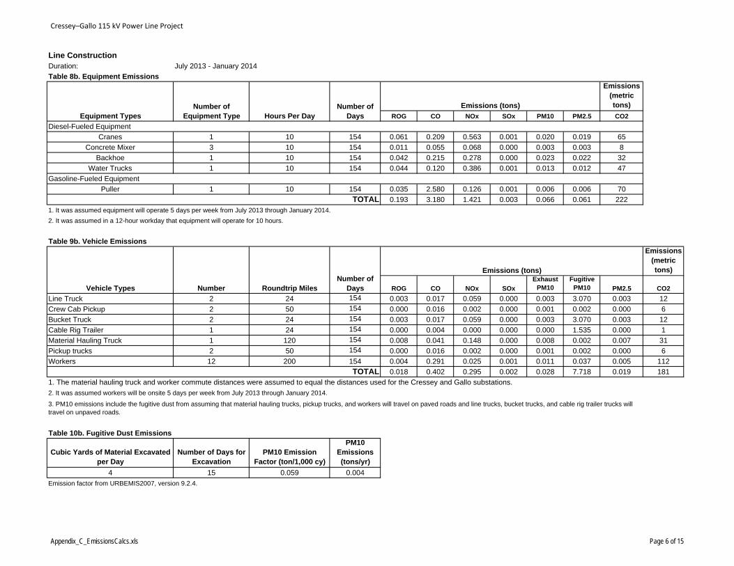
Cressey–Gallo 115 kV Power Line Project
Line ConstructionDuration: July 2013 - January 2014
Table 8b. Equipment EmissionsEmissions
(metric tons)
ROG CO NOx SOx PM10 PM2.5 CO2
Cranes 1 10 154 0.061 0.209 0.563 0.001 0.020 0.019 65
Concrete Mixer 3 10 154 0.011 0.055 0.068 0.000 0.003 0.003 8
Backhoe 1 10 154 0.042 0.215 0.278 0.000 0.023 0.022 32
Water Trucks 1 10 154 0.044 0.120 0.386 0.001 0.013 0.012 47
Puller 1 10 154 0.035 2.580 0.126 0.001 0.006 0.006 70
0.193 3.180 1.421 0.003 0.066 0.061 222
1. It was assumed equipment will operate 5 days per week from July 2013 through January 2014.
2. It was assumed in a 12-hour workday that equipment will operate for 10 hours.
Table 9b. Vehicle EmissionsEmissions
(metric tons)
ROG CO NOx SOx
Exhaust PM10
Fugitive PM10 PM2.5 CO2
Line Truck 2 24 154 0.003 0.017 0.059 0.000 0.003 3.070 0.003 12
Crew Cab Pickup 2 50 154 0.000 0.016 0.002 0.000 0.001 0.002 0.000 6
Bucket Truck 2 24 154 0.003 0.017 0.059 0.000 0.003 3.070 0.003 12
Cable Rig Trailer 1 24 154 0.000 0.004 0.000 0.000 0.000 1.535 0.000 1
Material Hauling Truck 1 120 154 0.008 0.041 0.148 0.000 0.008 0.002 0.007 31
Pickup trucks 2 50 154 0.000 0.016 0.002 0.000 0.001 0.002 0.000 6
Workers 12 200 154 0.004 0.291 0.025 0.001 0.011 0.037 0.005 112
0.018 0.402 0.295 0.002 0.028 7.718 0.019 181
1. The material hauling truck and worker commute distances were assumed to equal the distances used for the Cressey and Gallo substations.
2. It was assumed workers will be onsite 5 days per week from July 2013 through January 2014.
Table 10b. Fugitive Dust Emissions
Cubic Yards of Material Excavated per Day
Number of Days for Excavation
PM10 Emission Factor (ton/1,000 cy)
PM10 Emissions (tons/yr)
4 15 0.059 0.004
Emission factor from URBEMIS2007, version 9.2.4.
Emissions (tons)
Emissions (tons)
Diesel-Fueled Equipment
TOTAL
3. PM10 emissions include the fugitive dust from assuming that material hauling trucks, pickup trucks, and workers will travel on paved roads and line trucks, bucket trucks, and cable rig trailer trucks will travel on unpaved roads.
Gasoline-Fueled Equipment
TOTAL
Vehicle Types Number Roundtrip Miles Number of
Days
Equipment TypesNumber of
Equipment Type Hours Per DayNumber of
Days
Appendix_C_EmissionsCalcs.xls Page 6 of 15
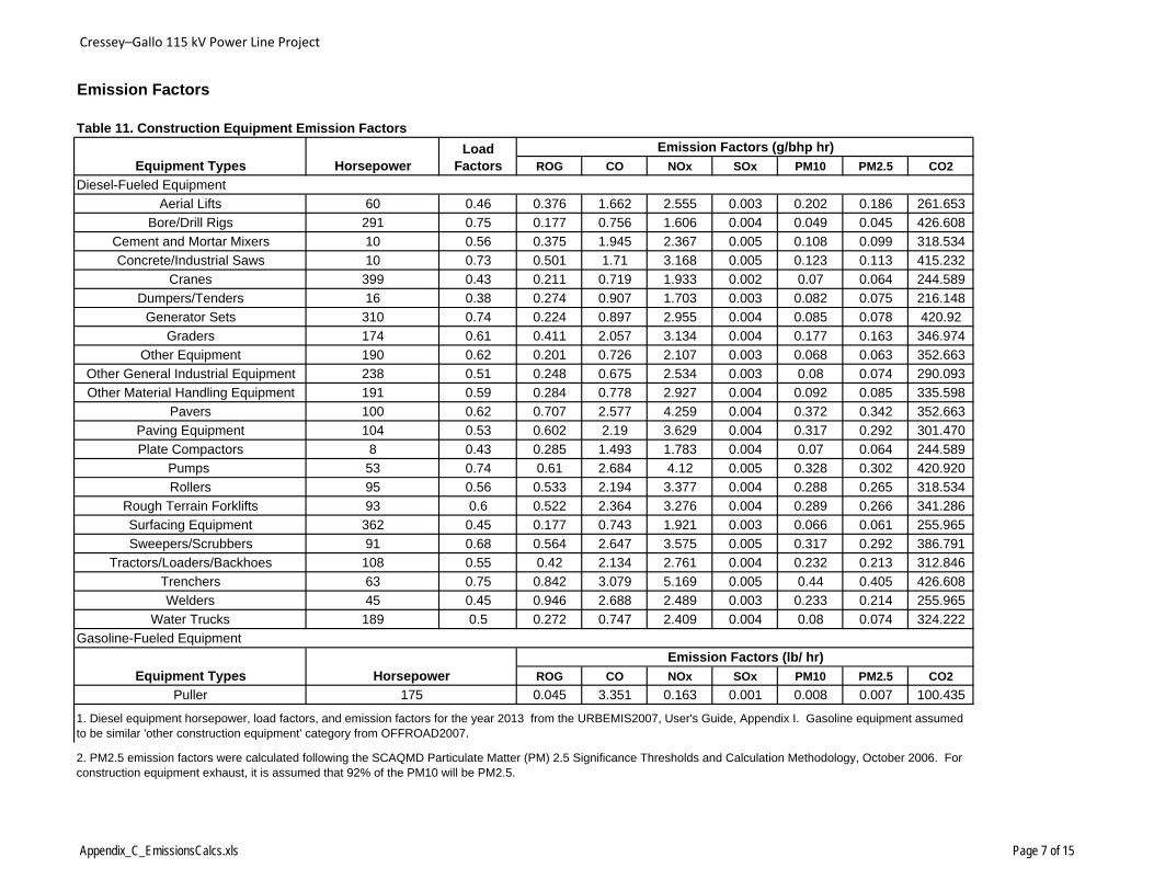
Cressey–Gallo 115 kV Power Line Project
Emission Factors
Table 11. Construction Equipment Emission Factors
ROG CO NOx SOx PM10 PM2.5 CO2
Aerial Lifts 60 0.46 0.376 1.662 2.555 0.003 0.202 0.186 261.653
Bore/Drill Rigs 291 0.75 0.177 0.756 1.606 0.004 0.049 0.045 426.608
Cement and Mortar Mixers 10 0.56 0.375 1.945 2.367 0.005 0.108 0.099 318.534
Concrete/Industrial Saws 10 0.73 0.501 1.71 3.168 0.005 0.123 0.113 415.232
Cranes 399 0.43 0.211 0.719 1.933 0.002 0.07 0.064 244.589
Dumpers/Tenders 16 0.38 0.274 0.907 1.703 0.003 0.082 0.075 216.148
Generator Sets 310 0.74 0.224 0.897 2.955 0.004 0.085 0.078 420.92
Graders 174 0.61 0.411 2.057 3.134 0.004 0.177 0.163 346.974
Other Equipment 190 0.62 0.201 0.726 2.107 0.003 0.068 0.063 352.663
Other General Industrial Equipment 238 0.51 0.248 0.675 2.534 0.003 0.08 0.074 290.093
Other Material Handling Equipment 191 0.59 0.284 0.778 2.927 0.004 0.092 0.085 335.598
Pavers 100 0.62 0.707 2.577 4.259 0.004 0.372 0.342 352.663
Paving Equipment 104 0.53 0.602 2.19 3.629 0.004 0.317 0.292 301.470
Plate Compactors 8 0.43 0.285 1.493 1.783 0.004 0.07 0.064 244.589
Pumps 53 0.74 0.61 2.684 4.12 0.005 0.328 0.302 420.920
Rollers 95 0.56 0.533 2.194 3.377 0.004 0.288 0.265 318.534
Rough Terrain Forklifts 93 0.6 0.522 2.364 3.276 0.004 0.289 0.266 341.286
Surfacing Equipment 362 0.45 0.177 0.743 1.921 0.003 0.066 0.061 255.965
Sweepers/Scrubbers 91 0.68 0.564 2.647 3.575 0.005 0.317 0.292 386.791
Tractors/Loaders/Backhoes 108 0.55 0.42 2.134 2.761 0.004 0.232 0.213 312.846
Trenchers 63 0.75 0.842 3.079 5.169 0.005 0.44 0.405 426.608
Welders 45 0.45 0.946 2.688 2.489 0.003 0.233 0.214 255.965
Water Trucks 189 0.5 0.272 0.747 2.409 0.004 0.08 0.074 324.222
ROG CO NOx SOx PM10 PM2.5 CO2
Puller 0.045 3.351 0.163 0.001 0.008 0.007 100.435
Equipment Types
Emission Factors (g/bhp hr)Load FactorsHorsepower
Diesel-Fueled Equipment
Gasoline-Fueled Equipment
Emission Factors (lb/ hr)
Equipment Types Horsepower
175
1. Diesel equipment horsepower, load factors, and emission factors for the year 2013 from the URBEMIS2007, User's Guide, Appendix I. Gasoline equipment assumed to be similar 'other construction equipment' category from OFFROAD2007.
2. PM2.5 emission factors were calculated following the SCAQMD Particulate Matter (PM) 2.5 Significance Thresholds and Calculation Methodology, October 2006. For construction equipment exhaust, it is assumed that 92% of the PM10 will be PM2.5.
Appendix_C_EmissionsCalcs.xls Page 7 of 15

Cressey–Gallo 115 kV Power Line Project
Table 12a. Vehicle Emission Factors
ROG CO NOx SOx PM10 PM2.5 CO2
WorkerPassenger Vehicles,
Gasoline 0.0000 0.0016 0.0001 0.0000 0.0001 0.0000 0.6684
Material Delivery TruckHeavy-Heavy Duty
Diesel 0.0008 0.0045 0.0160 0.0000 0.0009 0.0007 3.6648
Pickup/Crew Cab Truck Gasoline Truck 0.0000 0.0021 0.0003 0.0000 0.0001 0.0000 0.8499
ROG CO NOx SOx PM10 PM2.5 CO2
WorkerPassenger Vehicles,
Gasoline 0.009 0.714 0.062 0.003 0.028 0.013 303.203
Material Delivery TruckHeavy-Heavy Duty
Diesel 0.379 2.032 7.244 0.016 0.410 0.339 1662.352
Pickup Truck Gasoline Truck 0.013 0.965 0.116 0.004 0.036 0.021 385.531
Table 12b. Calculation of Paved Road Emission FactorPaved Roads emission factor from AP-42, Section 13.2.1: Paved Roads (1/11)
E = [k(sL)0.91*(W)1.02]
where: PM10
k = 1.0 particle size multiplier, g/VMT [Table 13.2-1.1 ]
sL = 0.03 road surface silt loading (g/m2) [Table 13.2.1-2, for Ubiquitous Baseline Roadway with ADT >10,000 ]
W = 2.2 tons [Average vehicle weight from CalEEMod User's Guide, Appendix A]
E (PM10)= 0.092 g/VMT
4. The PM10 and PM2.5 emission factors include tire and brake wear.
Emission Factors (lb/mile)
Emission Factors (g/mile)
2. Truck age assumption based on the ARB Staff Assessment of the Impact of the Economy on California Trucking Activity and Emissions 2006-2014 , December 2009.
3. It was assumed that vehicles will travel at an average speed of 55 mph.
Vehicle Vehicle Type in
EMFAC2007
Vehicle Vehicle Type in
EMFAC2007
1. Emission factors from the California Air Resources Board's EMFAC 2007 model for the SJVAPCD. It was assumed that diesel trucks will be ten years old or newer so the model year in EMFAC was changed to 2000 through 2013, rather than the default of 1969 - 2013.
Appendix_C_EmissionsCalcs.xls Page 8 of 15
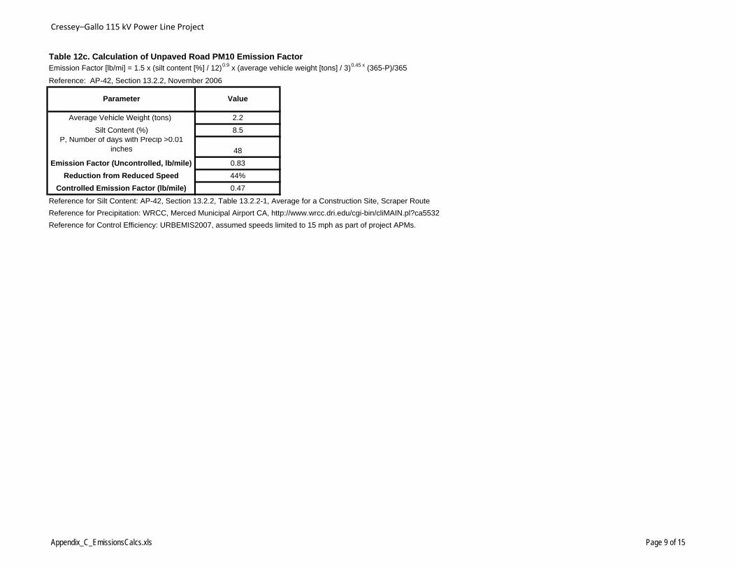
Cressey–Gallo 115 kV Power Line Project
Table 12c. Calculation of Unpaved Road PM10 Emission FactorEmission Factor [lb/mi] = 1.5 x (silt content [%] / 12)0.9 x (average vehicle weight [tons] / 3)0.45 x (365-P)/365
Average Vehicle Weight (tons) 2.2
Silt Content (%) 8.5P, Number of days with Precip >0.01
inches 48
Emission Factor (Uncontrolled, lb/mile) 0.83
Reduction from Reduced Speed 44%
Controlled Emission Factor (lb/mile) 0.47
Reference for Silt Content: AP-42, Section 13.2.2, Table 13.2.2-1, Average for a Construction Site, Scraper Route
Reference for Precipitation: WRCC, Merced Municipal Airport CA, http://www.wrcc.dri.edu/cgi-bin/cliMAIN.pl?ca5532
Reference for Control Efficiency: URBEMIS2007, assumed speeds limited to 15 mph as part of project APMs.
Reference: AP-42, Section 13.2.2, November 2006
Parameter Value
Appendix_C_EmissionsCalcs.xls Page 9 of 15
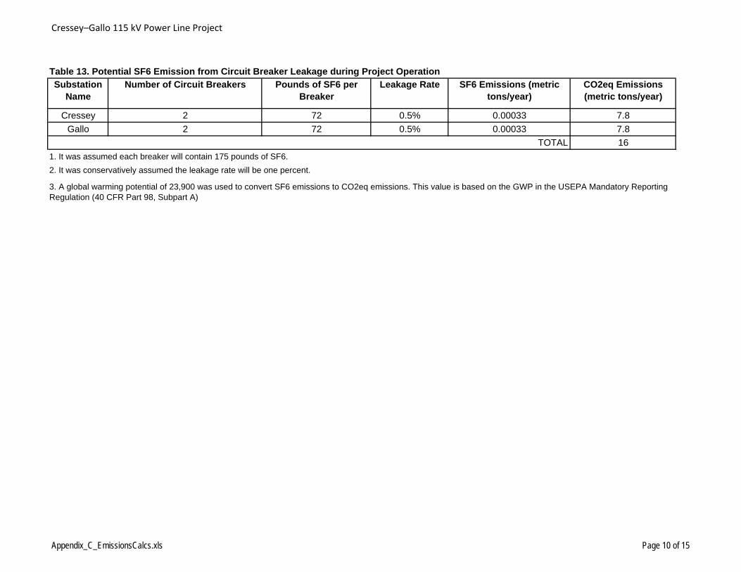
Cressey–Gallo 115 kV Power Line Project
Table 13. Potential SF6 Emission from Circuit Breaker Leakage during Project Operation
Substation Name
Number of Circuit Breakers Pounds of SF6 per Breaker
Leakage Rate SF6 Emissions (metric tons/year)
CO2eq Emissions (metric tons/year)
Cressey 2 72 0.5% 0.00033 7.8
Gallo 2 72 0.5% 0.00033 7.8
16
1. It was assumed each breaker will contain 175 pounds of SF6.
2. It was conservatively assumed the leakage rate will be one percent.
3. A global warming potential of 23,900 was used to convert SF6 emissions to CO2eq emissions. This value is based on the GWP in the USEPA Mandatory Reporting Regulation (40 CFR Part 98, Subpart A)
TOTAL
Appendix_C_EmissionsCalcs.xls Page 10 of 15
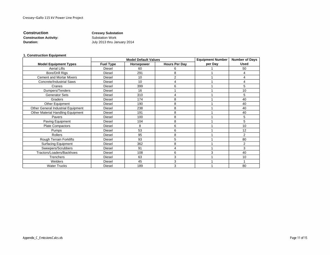
Cressey–Gallo 115 kV Power Line Project
Construction Cressey SubstationConstruction Activity: Substation WorkDuration: July 2013 thru January 2014
1. Construction Equipment
Fuel Type Horsepower Hours Per DayAerial Lifts Diesel 60 6 1 50
Bore/Drill Rigs Diesel 291 8 1 4Cement and Mortar Mixers Diesel 10 2 1 4Concrete/Industrial Saws Diesel 10 4 1 4
Cranes Diesel 399 6 1 5Dumpers/Tenders Diesel 16 1 1 10
Generator Sets Diesel 310 4 1 5Graders Diesel 174 8 1 40
Other Equipment Diesel 190 8 1 40Other General Industrial Equipment Diesel 238 8 1 40Other Material Handling Equipment Diesel 191 8 1 40
Pavers Diesel 100 8 1 5Paving Equipment Diesel 104 8 1 5Plate Compactors Diesel 8 6 1 10
Pumps Diesel 53 6 1 12Rollers Diesel 95 8 1 2
Rough Terrain Forklifts Diesel 93 5 1 80Surfacing Equipment Diesel 362 8 1 2Sweepers/Scrubbers Diesel 91 4 1 3
Tractors/Loaders/Backhoes Diesel 108 6 3 40Trenchers Diesel 63 3 1 10Welders Diesel 45 3 1 1
Water Trucks Diesel 189 3 1 80
Model Equipment TypesModel Default Values Equipment Number
per DayNumber of Days
Used
Appendix_C_EmissionsCalcs.xls Page 11 of 15

Cressey–Gallo 115 kV Power Line Project
Construction Cressey SubstationConstruction Activity: Substation WorkDuration: July 2013 thru January 2014
2. Trucks
Truck Type Number Fuel TypeVehicle Speed (miles
per hour) Miles per DayNumber of Days
UsedMaterial Hauling Truck 1 Diesel 65 120 10
Pickup trucks 6 Gasoline 70 120 20
3. Workers
Number of Daily Workers
Commute Miles Traveled per
Roundtrip6 200
4. Acres Graded/Excavation Quantity
Number of Acres Graded per DayNumber of Days for
Grading0.2 10
Cubic Yards of Material Excavated per Day
Number of Days for Excavation
5 20
Appendix_C_EmissionsCalcs.xls Page 12 of 15

Cressey–Gallo 115 kV Power Line Project
Construction Gallo SubstationConstruction Activity: Substation WorkDuration: August 2013 thru January 2014
1. Construction Equipment
Fuel Type Horsepower Hours Per DayAerial Lifts Diesel 60 6 1 40
Bore/Drill Rigs Diesel 291 8 1 4Cement and Mortar Mixers Diesel 10 2 1 2Concrete/Industrial Saws Diesel 10 4 1 4
Cranes Diesel 399 6 1 3Dumpers/Tenders Diesel 16 1 1 5
Generator Sets Diesel 310 4 1 2Other Equipment Diesel 190 8 1 40
Other General Industrial Equipment Diesel 238 8 1 40Other Material Handling Equipment Diesel 191 8 1 40
Pavers Diesel 100 8 1 1Paving Equipment Diesel 104 8 1 2Plate Compactors Diesel 8 6 1 5
Pumps Diesel 53 6 1 2Rollers Diesel 95 8 1 1
Rough Terrain Forklifts Diesel 93 5 1 40Surfacing Equipment Diesel 362 8 1 1Sweepers/Scrubbers Diesel 91 4 1 1
Tractors/Loaders/Backhoes Diesel 108 6 3 30Trenchers Diesel 63 3 1 5Welders Diesel 45 3 1 1
Water Trucks Diesel 189 3 1 20
Model Equipment TypesModel Default Values Equipment Number
per DayNumber of Days
Used
Appendix_C_EmissionsCalcs.xls Page 13 of 15
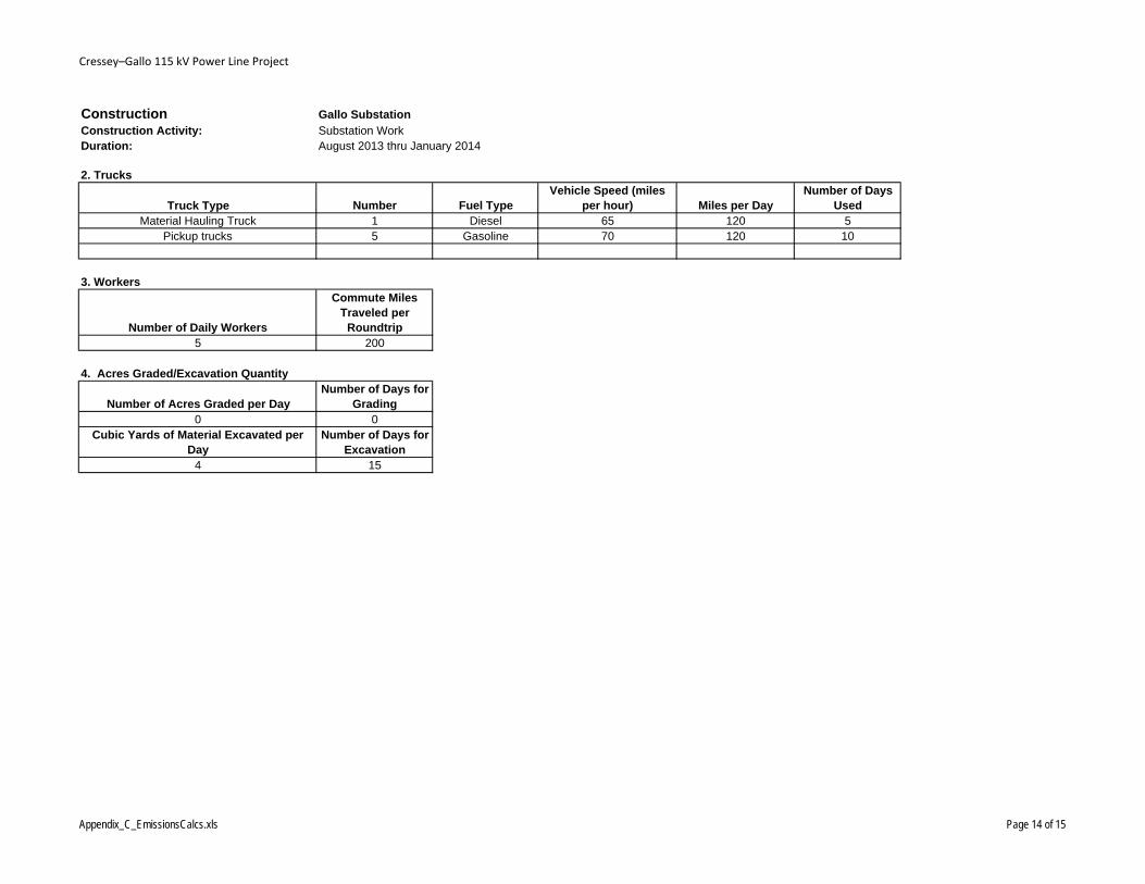
Cressey–Gallo 115 kV Power Line Project
Construction Gallo SubstationConstruction Activity: Substation WorkDuration: August 2013 thru January 2014
2. Trucks
Truck Type Number Fuel TypeVehicle Speed (miles
per hour) Miles per DayNumber of Days
UsedMaterial Hauling Truck 1 Diesel 65 120 5
Pickup trucks 5 Gasoline 70 120 10
3. Workers
Number of Daily Workers
Commute Miles Traveled per
Roundtrip5 200
4. Acres Graded/Excavation Quantity
Number of Acres Graded per DayNumber of Days for
Grading0 0
Cubic Yards of Material Excavated per Day
Number of Days for Excavation
4 15
Appendix_C_EmissionsCalcs.xls Page 14 of 15
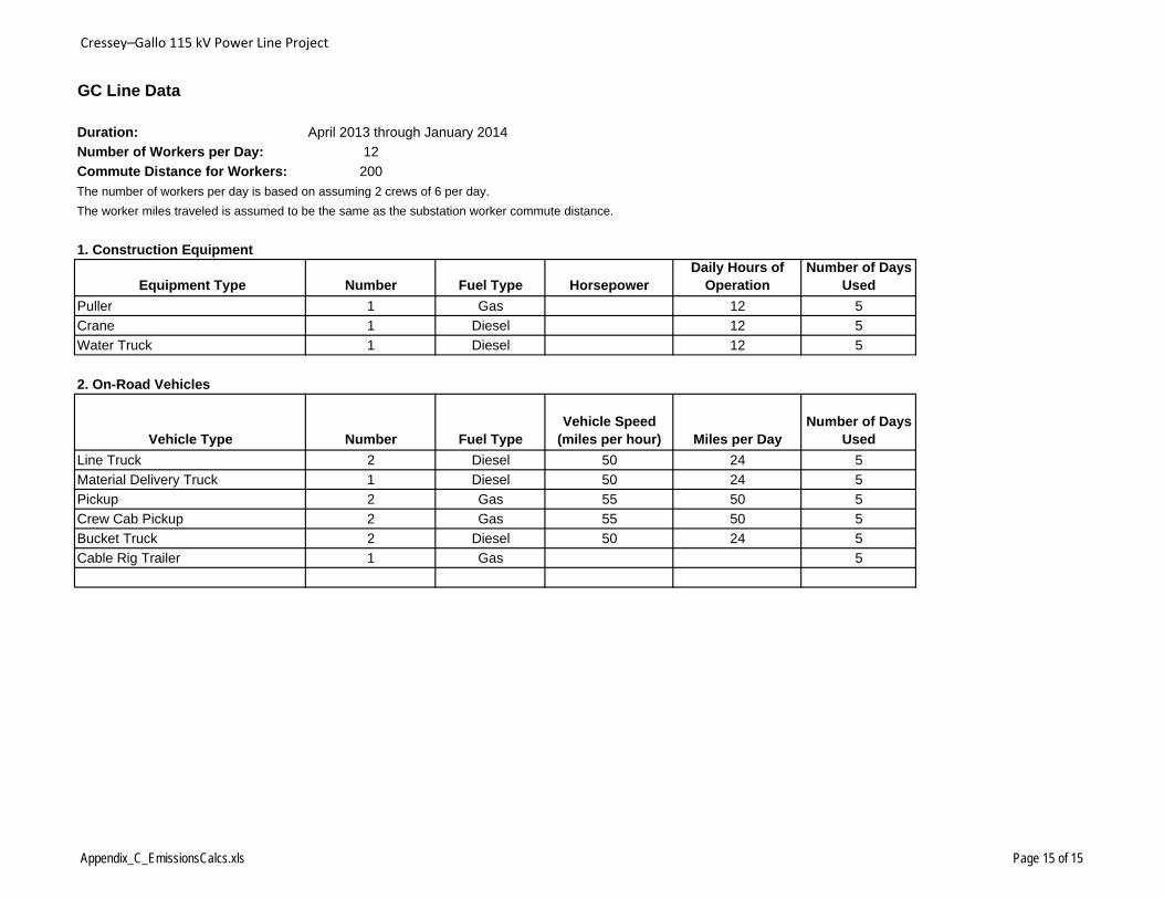
Cressey–Gallo 115 kV Power Line Project
GC Line Data
Duration: April 2013 through January 2014
Number of Workers per Day: 12
Commute Distance for Workers: 200
The number of workers per day is based on assuming 2 crews of 6 per day.
The worker miles traveled is assumed to be the same as the substation worker commute distance.
1. Construction Equipment
Equipment Type Number Fuel Type HorsepowerDaily Hours of
OperationNumber of Days
Used
Puller 1 Gas 12 5
Crane 1 Diesel 12 5
Water Truck 1 Diesel 12 5
2. On-Road Vehicles
Vehicle Type Number Fuel TypeVehicle Speed
(miles per hour) Miles per DayNumber of Days
Used
Line Truck 2 Diesel 50 24 5
Material Delivery Truck 1 Diesel 50 24 5
Pickup 2 Gas 55 50 5
Crew Cab Pickup 2 Gas 55 50 5
Bucket Truck 2 Diesel 50 24 5
Cable Rig Trailer 1 Gas 5
Appendix_C_EmissionsCalcs.xls Page 15 of 15

Appendix D Native American Heritage Commission
Correspondence

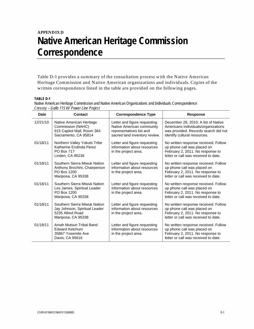
ES091411004121BAO\113260005 D-1
APPENDIX D
Native American Heritage Commission Correspondence
Table D-1 provides a summary of the consultation process with the Native American Heritage Commission and Native American organizations and individuals. Copies of the written correspondence listed in the table are provided on the following pages.
TABLE D-1 Native American Heritage Commission and Native American Organizations and Individuals Correspondence Cressey – Gallo 115 kV Power Line Project
Date Contact Correspondence Type Response
12/21/10 Native American Heritage Commission (NAHC) 915 Capitol Mall, Room 364 Sacramento, CA 95814
Letter and figure requesting Native American community representatives list and sacred land inventory review.
December 28, 2010: A list of Native Americans individuals/organizations was provided. Records search did not identify cultural resources.
01/18/11 Northern Valley Yokuts Tribe Katherine Erolinda Perez PO Box 717 Linden, CA 95236
Letter and figure requesting information about resources in the project area.
No written response received. Follow up phone call was placed on February 2, 2011. No response to letter or call was received to date.
01/18/11 Southern Sierra Miwuk Nation Anthony Brochini, Chairperson PO Box 1200 Mariposa, CA 95338
Letter and figure requesting information about resources in the project area.
No written response received. Follow up phone call was placed on February 2, 2011. No response to letter or call was received to date.
01/18/11 Southern Sierra Miwuk Nation Les James, Spiritual Leader PO Box 1200 Mariposa, CA 95338
Letter and figure requesting information about resources in the project area.
No written response received. Follow up phone call was placed on February 2, 2011. No response to letter or call was received to date.
01/18/11 Southern Sierra Miwuk Nation Jay Johnson, Spiritual Leader 5235 Allred Road Mariposa, CA 95338
Letter and figure requesting information about resources in the project area.
No written response received. Follow up phone call was placed on February 2, 2011. No response to letter or call was received to date.
01/18/11 Amah Mutsun Tribal Band Edward Ketchum 35867 Yosemite Ave Davis, CA 95616
Letter and figure requesting information about resources in the project area.
No written response received. Follow up phone call was placed on February 2, 2011. No response to letter or call was received to date.

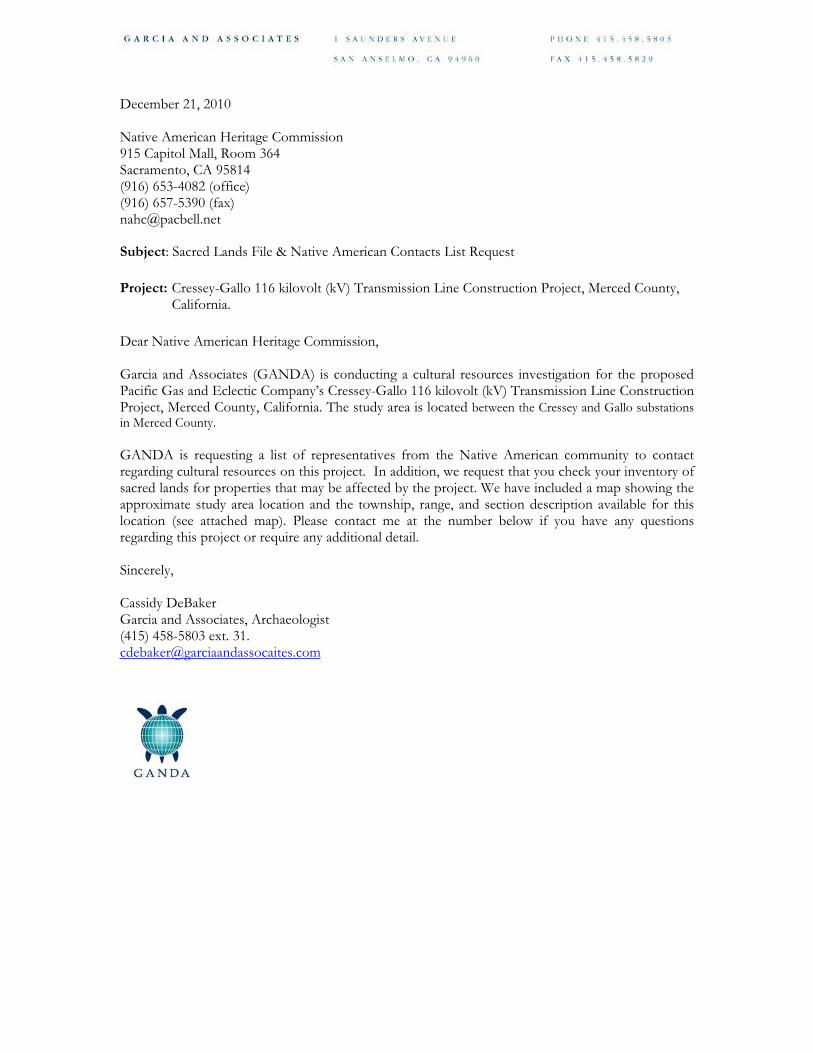
December 21, 2010
Native American Heritage Commission 915 Capitol Mall, Room 364 Sacramento, CA 95814 (916) 653-4082 (office) (916) 657-5390 (fax) [email protected]
Subject: Sacred Lands File & Native American Contacts List Request
Project: Cressey-Gallo 116 kilovolt (kV) Transmission Line Construction Project, Merced County, California.
Dear Native American Heritage Commission,
Garcia and Associates (GANDA) is conducting a cultural resources investigation for the proposed Pacific Gas and Eclectic Company’s Cressey-Gallo 116 kilovolt (kV) Transmission Line Construction Project, Merced County, California. The study area is located between the Cressey and Gallo substations in Merced County.
GANDA is requesting a list of representatives from the Native American community to contact regarding cultural resources on this project. In addition, we request that you check your inventory of sacred lands for properties that may be affected by the project. We have included a map showing the approximate study area location and the township, range, and section description available for this location (see attached map). Please contact me at the number below if you have any questions regarding this project or require any additional detail.
Sincerely,
Cassidy DeBaker Garcia and Associates, Archaeologist (415) 458-5803 ext. 31. [email protected]

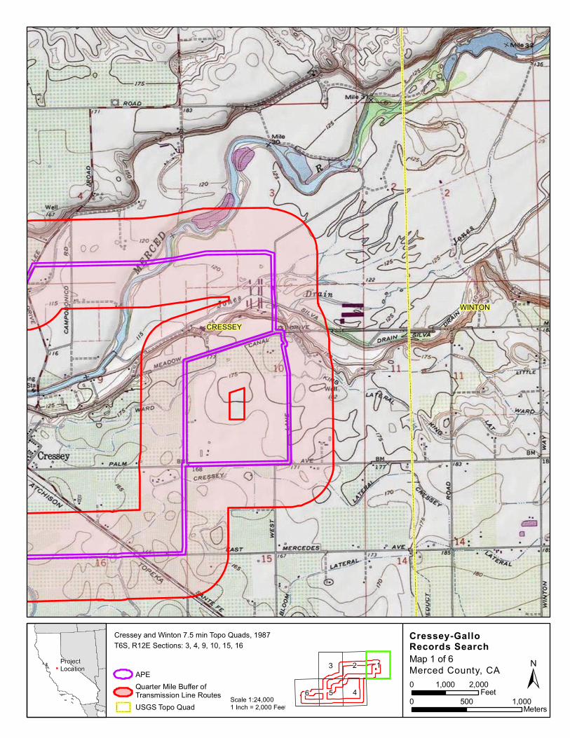
CRESSEY
WINTON
Cressey-GalloRecords Search
APEQuarter Mile Buffer ofTransmission Line RoutesUSGS Topo Quad
Scale 1:24,0001 Inch = 2,000 Feet
ProjectLocation Merced County, CA ±
Cressey and Winton 7.5 min Topo Quads, 1987
Map 1 of 6
6 4
123
50 500 1,000
Meters
0 1,000 2,000Feet
T6S, R12E Sections: 3, 4, 9, 10, 15, 16
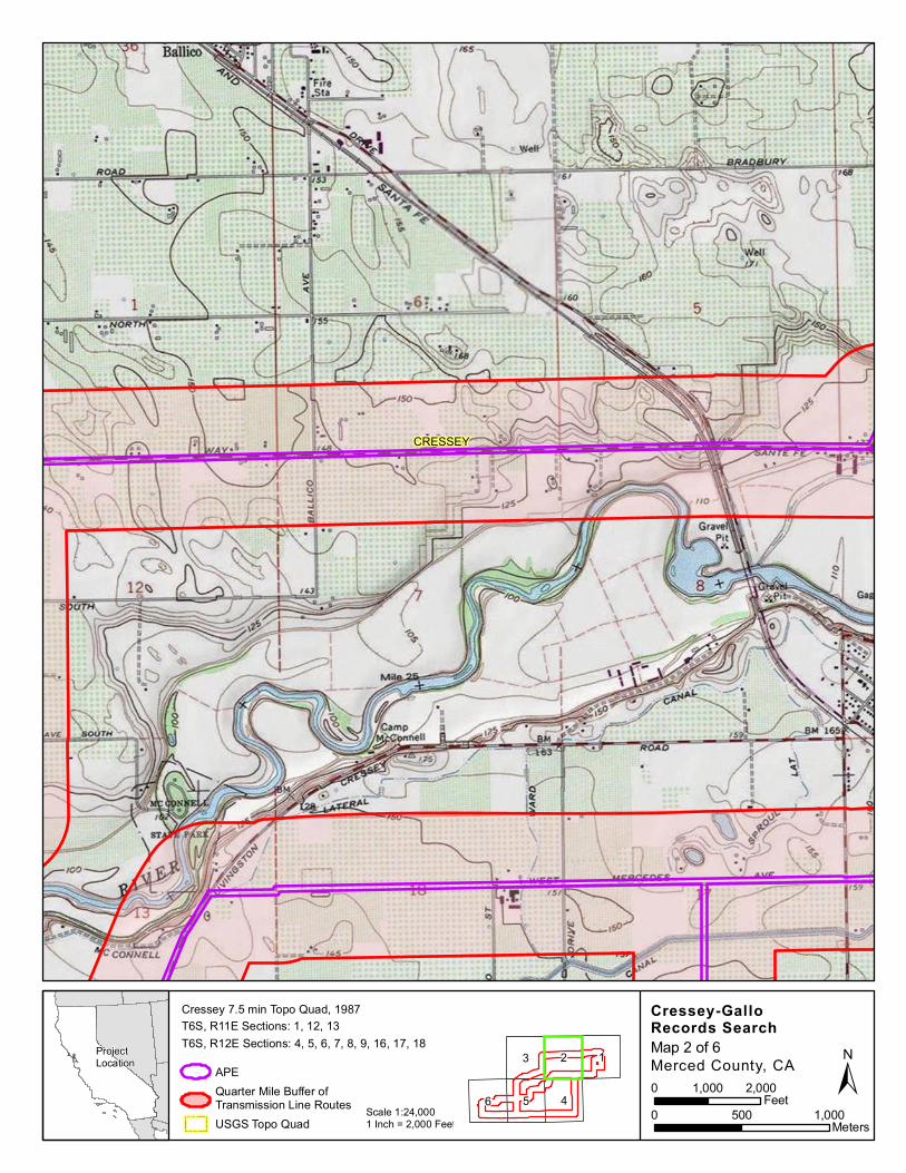
CRESSEY
Cressey-GalloRecords Search
APEQuarter Mile Buffer ofTransmission Line RoutesUSGS Topo Quad
Scale 1:24,0001 Inch = 2,000 Feet
ProjectLocation Merced County, CA ±
Cressey 7.5 min Topo Quad, 1987
Map 2 of 6
6 4
123
50 500 1,000
Meters
0 1,000 2,000Feet
T6S, R11E Sections: 1, 12, 13T6S, R12E Sections: 4, 5, 6, 7, 8, 9, 16, 17, 18

TURLOCK
CRESSEY
Cressey-GalloRecords Search
APEQuarter Mile Buffer ofTransmission Line RoutesUSGS Topo Quad
Scale 1:24,0001 Inch = 2,000 Feet
ProjectLocation Merced County, CA ±
Cressey and Turlock 7.5 min Topo Quads, 1987 and 1976
Map 3 of 6
6 4
123
50 500 1,000
Meters
0 1,000 2,000Feet
T6S, R11E Sections: 1, 2, 11, 12, 13, 14, 15, 16
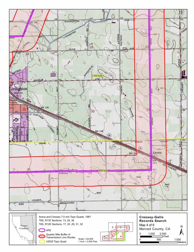
CRESSEY
ARENA
Cressey-GalloRecords Search
APEQuarter Mile Buffer ofTransmission Line RoutesUSGS Topo Quad
Scale 1:24,0001 Inch = 2,000 Feet
ProjectLocation Merced County, CA ±
Arena and Cressey 7.5 min Topo Quads, 1987
Map 4 of 6
6 4
123
50 500 1,000
Meters
0 1,000 2,000Feet
T6S, R11E Sections: 13, 24, 36T6S, R12E Sections: 17, 20 ,29, 31, 32
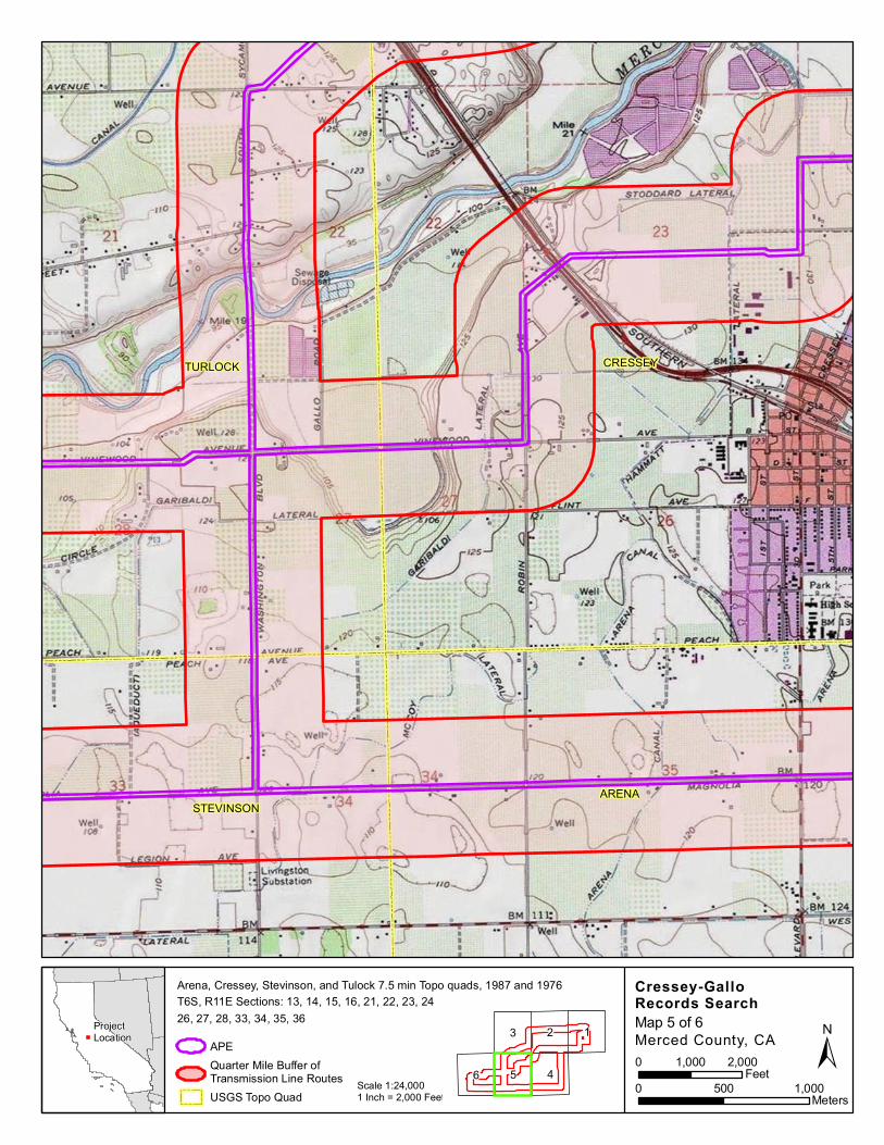
TURLOCK CRESSEY
STEVINSONARENA
Cressey-GalloRecords Search
APEQuarter Mile Buffer ofTransmission Line RoutesUSGS Topo Quad
Scale 1:24,0001 Inch = 2,000 Feet
ProjectLocation Merced County, CA ±
Arena, Cressey, Stevinson, and Tulock 7.5 min Topo quads, 1987 and 1976
Map 5 of 6
6 4
123
50 500 1,000
Meters
0 1,000 2,000Feet
T6S, R11E Sections: 13, 14, 15, 16, 21, 22, 23, 2426, 27, 28, 33, 34, 35, 36
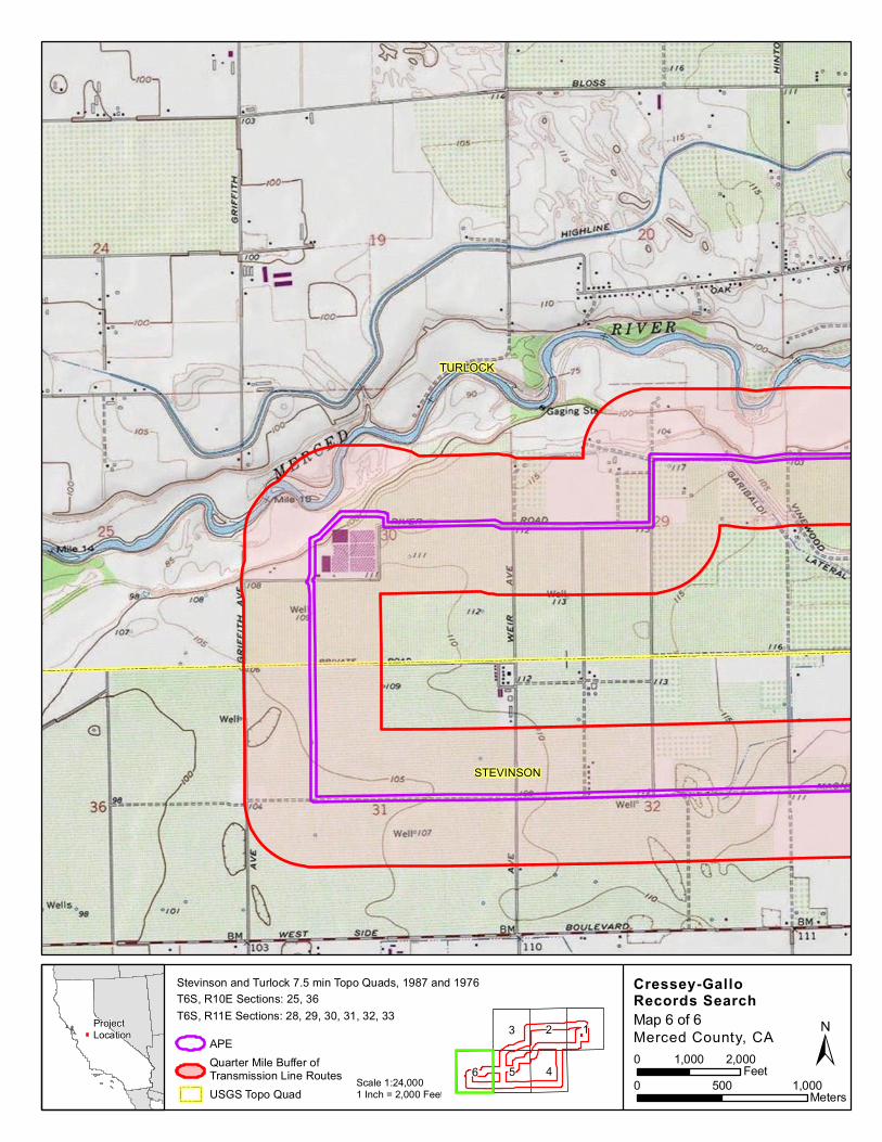
TURLOCK
STEVINSON
Cressey-GalloRecords Search
APEQuarter Mile Buffer ofTransmission Line RoutesUSGS Topo Quad
Scale 1:24,0001 Inch = 2,000 Feet
ProjectLocation Merced County, CA ±
Stevinson and Turlock 7.5 min Topo Quads, 1987 and 1976
Map 6 of 6
6 4
123
50 500 1,000
Meters
0 1,000 2,000Feet
T6S, R10E Sections: 25, 36T6S, R11E Sections: 28, 29, 30, 31, 32, 33

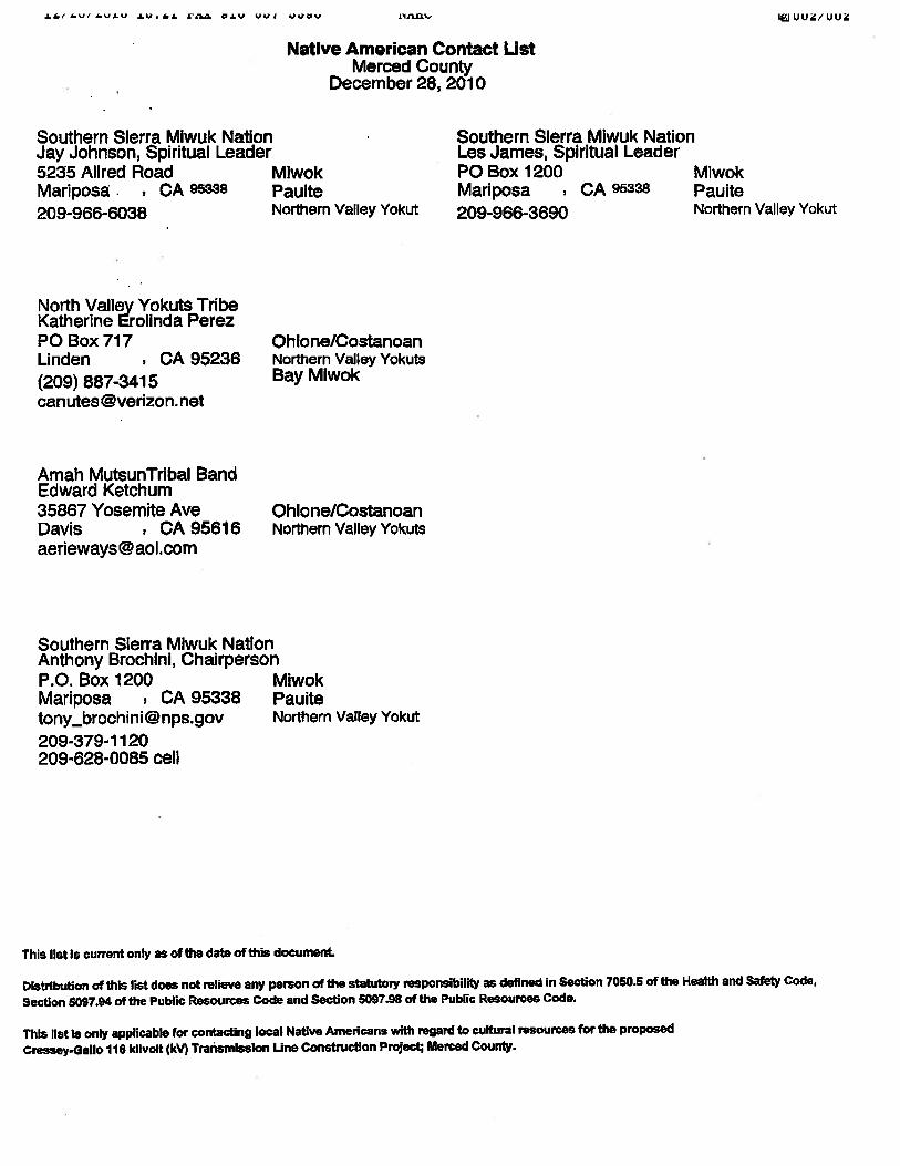
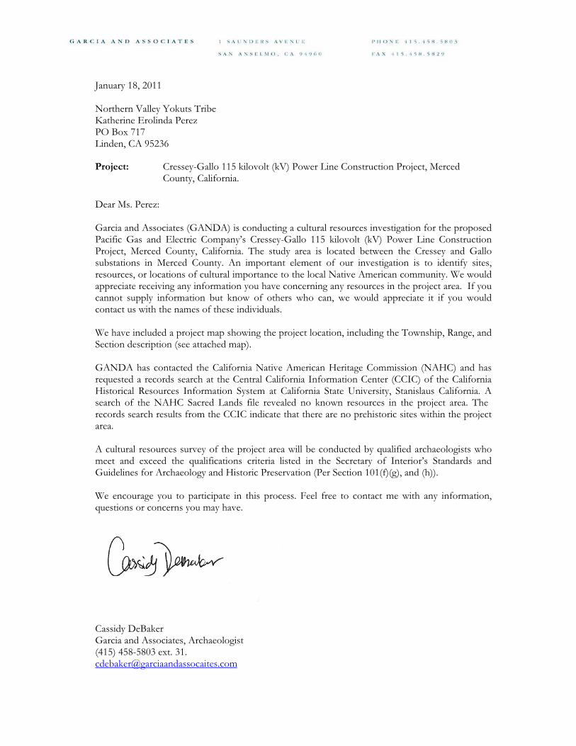
January 18, 2011
Northern Valley Yokuts Tribe Katherine Erolinda Perez PO Box 717 Linden, CA 95236
Project: Cressey-Gallo 115 kilovolt (kV) Power Line Construction Project, Merced County, California.
Dear Ms. Perez:
Garcia and Associates (GANDA) is conducting a cultural resources investigation for the proposed Pacific Gas and Electric Company’s Cressey-Gallo 115 kilovolt (kV) Power Line Construction Project, Merced County, California. The study area is located between the Cressey and Gallo substations in Merced County. An important element of our investigation is to identify sites, resources, or locations of cultural importance to the local Native American community. We would appreciate receiving any information you have concerning any resources in the project area. If you cannot supply information but know of others who can, we would appreciate it if you would contact us with the names of these individuals.
We have included a project map showing the project location, including the Township, Range, and Section description (see attached map).
GANDA has contacted the California Native American Heritage Commission (NAHC) and has requested a records search at the Central California Information Center (CCIC) of the California Historical Resources Information System at California State University, Stanislaus California. A search of the NAHC Sacred Lands file revealed no known resources in the project area. The records search results from the CCIC indicate that there are no prehistoric sites within the project area.
A cultural resources survey of the project area will be conducted by qualified archaeologists who meet and exceed the qualifications criteria listed in the Secretary of Interior’s Standards and Guidelines for Archaeology and Historic Preservation (Per Section 101(f)(g), and (h)).
We encourage you to participate in this process. Feel free to contact me with any information, questions or concerns you may have.
Sincerely,
Cassidy DeBaker Garcia and Associates, Archaeologist (415) 458-5803 ext. 31. [email protected]


January 18, 2011
Southern Sierra Miwuk Nation Anthony Brochini, Chairperson PO Box 1200 Mariposa, CA 95338
Project: Cressey-Gallo 115 kilovolt (kV) Power Line Construction Project, Merced County, California.
Dear Mr. Brochini:
Garcia and Associates (GANDA) is conducting a cultural resources investigation for the proposed Pacific Gas and Electric Company’s Cressey-Gallo 115 kilovolt (kV) Power Line Construction Project, Merced County, California. The study area is located between the Cressey and Gallo substations in Merced County. An important element of our investigation is to identify sites, resources, or locations of cultural importance to the local Native American community. We would appreciate receiving any information you have concerning any resources in the project area. If you cannot supply information but know of others who can, we would appreciate it if you would contact us with the names of these individuals.
We have included a project map showing the project location, including the Township, Range, and Section description (see attached map).
GANDA has contacted the California Native American Heritage Commission (NAHC) and has requested a records search at the Central California Information Center (CCIC) of the California Historical Resources Information System at California State University, Stanislaus California. A search of the NAHC Sacred Lands file revealed no known resources in the project area. The records search results from the CCIC indicate that there are no prehistoric sites within the project area.
A cultural resources survey of the project area will be conducted by qualified archaeologists who meet and exceed the qualifications criteria listed in the Secretary of Interior’s Standards and Guidelines for Archaeology and Historic Preservation (Per Section 101(f)(g), and (h)).
We encourage you to participate in this process. Feel free to contact me with any information, questions or concerns you may have.
Sincerely,
Cassidy DeBaker Garcia and Associates, Archaeologist (415) 458-5803 ext. 31. [email protected]

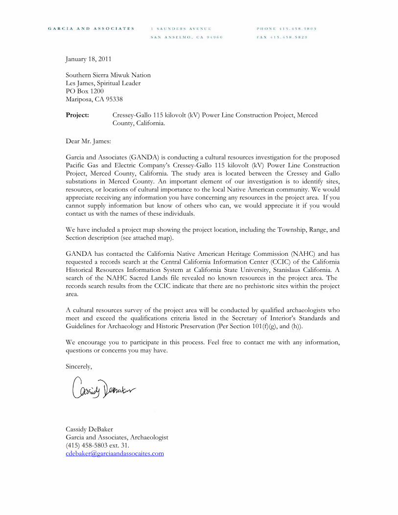
January 18, 2011
Southern Sierra Miwuk Nation Les James, Spiritual Leader PO Box 1200 Mariposa, CA 95338
Project: Cressey-Gallo 115 kilovolt (kV) Power Line Construction Project, Merced County, California.
Dear Mr. James:
Garcia and Associates (GANDA) is conducting a cultural resources investigation for the proposed Pacific Gas and Electric Company’s Cressey-Gallo 115 kilovolt (kV) Power Line Construction Project, Merced County, California. The study area is located between the Cressey and Gallo substations in Merced County. An important element of our investigation is to identify sites, resources, or locations of cultural importance to the local Native American community. We would appreciate receiving any information you have concerning any resources in the project area. If you cannot supply information but know of others who can, we would appreciate it if you would contact us with the names of these individuals.
We have included a project map showing the project location, including the Township, Range, and Section description (see attached map).
GANDA has contacted the California Native American Heritage Commission (NAHC) and has requested a records search at the Central California Information Center (CCIC) of the California Historical Resources Information System at California State University, Stanislaus California. A search of the NAHC Sacred Lands file revealed no known resources in the project area. The records search results from the CCIC indicate that there are no prehistoric sites within the project area.
A cultural resources survey of the project area will be conducted by qualified archaeologists who meet and exceed the qualifications criteria listed in the Secretary of Interior’s Standards and Guidelines for Archaeology and Historic Preservation (Per Section 101(f)(g), and (h)).
We encourage you to participate in this process. Feel free to contact me with any information, questions or concerns you may have.
Sincerely,
Cassidy DeBaker Garcia and Associates, Archaeologist (415) 458-5803 ext. 31. [email protected]


January 18, 2011
Southern Sierra Miwuk Nation Jay Johnson, Spiritual Leader 5235 Allred Road Mariposa, CA 95338
Project: Cressey-Gallo 115 kilovolt (kV) Power Line Construction Project, Merced County, California.
Dear Mr. Johnson:
Garcia and Associates (GANDA) is conducting a cultural resources investigation for the proposed Pacific Gas and Electric Company’s Cressey-Gallo 115 kilovolt (kV) Power Line Construction Project, Merced County, California. The study area is located between the Cressey and Gallo substations in Merced County. An important element of our investigation is to identify sites, resources, or locations of cultural importance to the local Native American community. We would appreciate receiving any information you have concerning any resources in the project area. If you cannot supply information but know of others who can, we would appreciate it if you would contact us with the names of these individuals.
We have included a project map showing the project location, including the Township, Range, and Section description (see attached map).
GANDA has contacted the California Native American Heritage Commission (NAHC) and has requested a records search at the Central California Information Center (CCIC) of the California Historical Resources Information System at California State University, Stanislaus California. A search of the NAHC Sacred Lands file revealed no known resources in the project area. The records search results from the CCIC indicate that there are no prehistoric sites within the project area.
A cultural resources survey of the project area will be conducted by qualified archaeologists who meet and exceed the qualifications criteria listed in the Secretary of Interior’s Standards and Guidelines for Archaeology and Historic Preservation (Per Section 101(f)(g), and (h)).
We encourage you to participate in this process. Feel free to contact me with any information, questions or concerns you may have.
Sincerely,
Cassidy DeBaker Garcia and Associates, Archaeologist (415) 458-5803 ext. 31. [email protected]

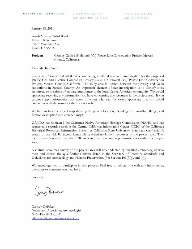
January 18, 2011
Amah Mutsun Tribal Band Edward Ketchum 35867 Yosemite Ave Davis, CA 95616
Project: Cressey-Gallo 115 kilovolt (kV) Power Line Construction Project, Merced County, California.
Dear Mr. Ketchum:
Garcia and Associates (GANDA) is conducting a cultural resources investigation for the proposed Pacific Gas and Electric Company’s Cressey-Gallo 115 kilovolt (kV) Power Line Construction Project, Merced County, California. The study area is located between the Cressey and Gallo substations in Merced County. An important element of our investigation is to identify sites, resources, or locations of cultural importance to the local Native American community. We would appreciate receiving any information you have concerning any resources in the project area. If you cannot supply information but know of others who can, we would appreciate it if you would contact us with the names of these individuals.
We have included a project map showing the project location, including the Township, Range, and Section description (see attached map).
GANDA has contacted the California Native American Heritage Commission (NAHC) and has requested a records search at the Central California Information Center (CCIC) of the California Historical Resources Information System at California State University, Stanislaus California. A search of the NAHC Sacred Lands file revealed no known resources in the project area. The records search results from the CCIC indicate that there are no prehistoric sites within the project area.
A cultural resources survey of the project area will be conducted by qualified archaeologists who meet and exceed the qualifications criteria listed in the Secretary of Interior’s Standards and Guidelines for Archaeology and Historic Preservation (Per Section 101(f)(g), and (h)).
We encourage you to participate in this process. Feel free to contact me with any information, questions or concerns you may have.
Sincerely,
Cassidy DeBaker Garcia and Associates, Archaeologist (415) 458-5803 ext. 31. [email protected]
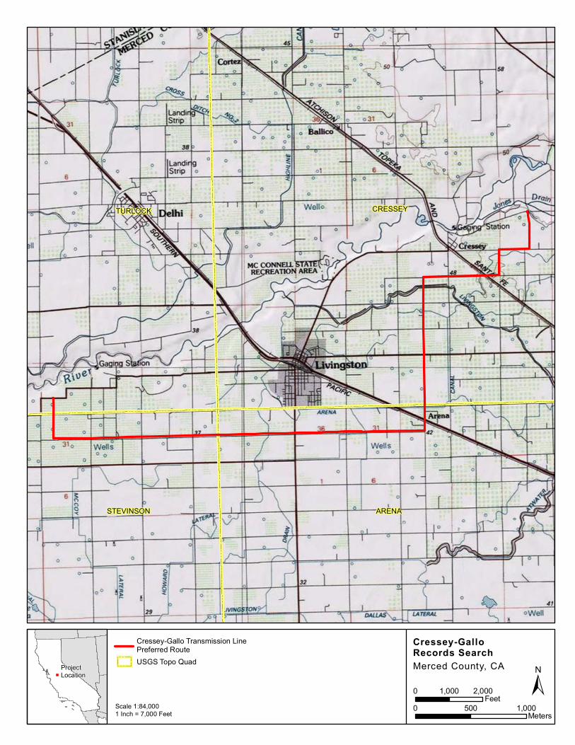
TURLOCK CRESSEY
STEVINSON ARENA
Cressey-GalloRecords Search
Cressey-Gallo Transmission LinePreferred RouteUSGS Topo Quad
Scale 1:84,0001 Inch = 7,000 Feet
ProjectLocation
Merced County, CA
±0 500 1,000
Meters
0 1,000 2,000Feet