Embed Size (px)
Citation preview
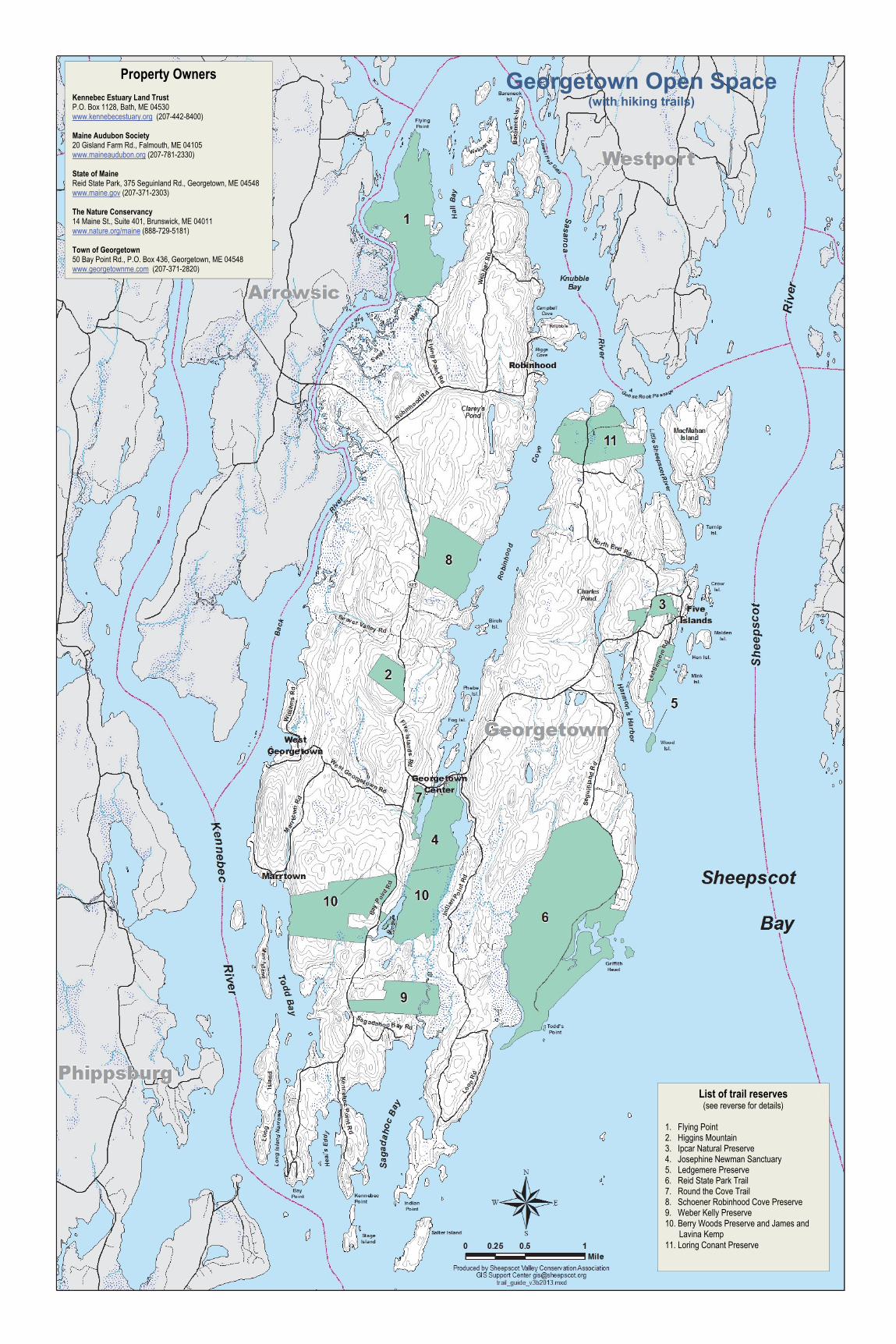
Property Owners
Kennebec Estuary Land Trust P.O. Box 1128, Bath, ME 04530 www.kennebecestuary.org (207-442-8400) Maine Audubon Society 20 Gisland Farm Rd., Falmouth, ME 04105 www.maineaudubon.org (207-781-2330) State of Maine Reid State Park, 375 Seguinland Rd., Georgetown, ME 04548 www.maine.gov (207-371-2303) The Nature Conservancy 14 Maine St., Suite 401, Brunswick, ME 04011 www.nature.org/maine (888-729-5181) Town of Georgetown 50 Bay Point Rd., P.O. Box 436, Georgetown, ME 04548 www.georgetownme.com (207-371-2820)
List of trail reserves (see reverse for details)
1. Flying Point 2. Higgins Mountain 3. Ipcar Natural Preserve 4. Josephine Newman Sanctuary 5. Ledgemere Preserve 6. Reid State Park Trail 7. Round the Cove Trail 8. Schoener Robinhood Cove Preserve 9. Weber Kelly Preserve 10. Berry Woods Preserve and James and
Lavina Kemp 11. Loring Conant Preserve
Georgetown Open Space (with hiking trails)

Trail Descriptions
1 FLYING POINT Trail Length: 0.8 miles, moderate with hills Owner: The Nature Conservancy Directions: From Route 127, take Robinhood Road. Proceed about 0.5 miles and turn left on Flying Point Road, keep left at Jamison Way. There is a small parking lot for about 4 cars on the left just before the marsh. Don’t drive across the marsh as there is no parking or turning on the other side. The path is an unpaved road. History: Flying Point Preserve was donated to The Nature Conservancy in 1995 by Ken Olsen. The Maine Department of Inland Fisheries and Wildlife holds a conservation easement on the preserve. Flying Point Preserve protects almost 4.5 miles of tidal salt marsh and mudflats along the shoreline of the Back River and Hall Bay and is primarily forested with oak-pine, pitch pine, and coastal spruce-fir. * No dogs allowed
2 HIGGINS MOUNTAIN Trail Length: 1.1 miles, difficult, steep on rock faces Owner: Kennebec Estuary Land Trust Directions: The trail head is located at the kiosk on Route 127, around the corner from the cemetery. This is a steep, elevated loop path that has views of the ocean and the entrance to the Sheepscot River when the trees are not in leaf. The path at the top is across rock ledge and is blazed with small piles of stone leading to the path back down to the trailhead. History: This preserve was donated by Mrs. Billie Todd from land that had been in her late husband Warren Todd’s family since 1850. At 250 feet above sea level, Higgins Mountain is the highest point in Georgetown. It is a habitat to a vigorous stand of broom crowberry, designated a rare plant. Also on the mountain is a pitch pine woodland, a rare forest type in Maine. * No dogs allowed
3 IPCAR NATURAL PRESERVE Trail Length: 0.75 miles, moderate with hills Owner: Town of Georgetown Directions: From Route 127, use the upper parking lot in Five Islands, on the left before the wharf. At the far end is the trailhead. The trail is steep in parts, requiring vigorous walking. History: In 1973 Adolph Ipcar, then chair of the Conservation Commission, approached Maude Steussey to purchase the wharf at Five Islands, at the time rented by the town for commercial and public use. This purchase included 30 acres in
two undeveloped parcels in Five Islands. Mr. Ipcar successfully spearheaded fundraising efforts and acquired Ford and Federal Grants to complete the purchase for the town. * Leashed dogs allowed
4 JOSEPHINE NEWMAN SANCTUARY Trail Length: 2.6 miles, 3 trails, easy to moderate Owner: Maine Audubon Society Directions: From Route 127 in Georgetown Center turn right at the sign for the sanctuary, shortly after crossing the first bridge on Robinhood Cove. Drive a short distance to a small parking lot. History: Josephine Newman, born in 1878 to a Georgetown native, spent most of her life exploring the shores of Robinhood Cove. Through her work she discovered at least one new species of moss in Maine. In 1968 she willed 119 acres to the Maine Audubon Society, which publishes a Guide to the Natural Communities of the sanctuary. * No dogs allowed
5 LEDGEMERE PRESERVE Trail Length: 0.4 miles, easy to moderate Owner: The Nature Conservancy Directions: From Route 127 in Five Islands, turn right on Ledgemere Road. Proceed to the gate. There are 3 parking spaces on the left side of the road just before the gate. The entire trail is the paved road that ends at the stone gate, which marks the end of the preserve. It is a wooded trail, with views of the southern approach to Five Islands, the back side of Mink Island, the southern tip of Southport Island, and the entrance to the Sheepscot River. A small beach is located down the path near the parking area. History: The Eustis family donated this land, and Wood Island, to The Nature Conservancy in 1966, subject to a life tenancy. After their deaths, the Conservancy sold the lots containing the main house and boat house, and used the proceeds to protect other land for conservation. Most of the preserve is wooded, dominated by red and white spruce with some balsam fir and white pine. The ground is a green blanket of mosses and lichens. * No dogs allowed
6 REID STATE PARK TRAIL Trail Length: 2.2 miles, easy Owner: State of Maine Directions: From Route 127 turn right onto Seguinland Road and drive to the Reid State Park entrance at the end of this road. Drive toward Griffith’s Head and park in the parking lot to the left. Walk back to the trail head which begins a short way down the access road to Todd’s Point. History: In 1869 Walter Reid, later a financier and philanthropist,
was born in nearby Harmon’s Harbor. In the late 1940’s he gave 766 acres of land that became the Park to the State of Maine in honor of his parents, Lydia and John Reid. It is comprised of sand beaches and dunes, a large estuary and some back woods land with trails that are groomed for cross country skiing in winter. Park management protection of dunes by promoting dune grass growth has resulted in extensive Piping Plover and Least Tern nesting areas. * Leashed dogs allowed
7 ROUND THE COVE TRAIL Trail Length: 1.4 miles, easy to moderate Owner: Town of Georgetown Directions: From Route 127 take Bay Point Road. Park at the Georgetown Historical Society building on the left. The trail begins at the kiosk behind the building. The path follows the cove and connects via a new bridge to the Josephine Newman Sanctuary. History: Thomas Trafton, who was granted the land by King George of England in the eighteenth century, had a lumber mill and shipbuilding operations on this land. In 1959, Lillian Reid sold it to the town for $1 with the stipulation that it remain in a natural state. * Leashed dogs allowed
8 SCHOENER ROBINHOOD COVE PRESERVE Trail Length: 0.75 miles, easy Owner: University of Maine, Easement to the Kennebec Estuary Land Trust Directions: Take Route 127 south 2.0 miles from the Back River Bridge. On the left is the entrance sign. The trail begins here. Park on the old woods road. History: In 1996 Jason and Virginia Schoener gave an easement on 154 acres of land that includes frontage on Robinhood Cove and the sledding field beside the entrance to the trails. The land has many impressive rock outcroppings. The University of Maine uses the land for scientific and educational purposes. The easement protects views and shoreline of the cove, and provides for low impact recreational uses on the land. * Leashed dogs allowed
9 WEBER KELLY PRESERVE Trail Length: 2.0 miles, moderate Owner: Kennebec Estuary Land Trust Directions: From Route 127 take Bay Point Road for 2.0 miles. The preserve is on the left with a parking lot and kiosk where the trail begins. This is a rolling upland dominated by pine hemlock and red oak. It is a habitat for warblers, woodpeckers and owls. Part of the trail is on an old wagon road for the Manson family
who owned the land for 130 years. History: In the late 1970’s, American artist Anne Weber returned from Paris and chose Georgetown because it had a thriving art community and supported a rural lifestyle. Having also a degree in Environmental Science, Weber felt strongly about preserving the land in its natural state. In 1999 she deeded 105 acres to the Kennebec Estuary Land Trust. * Leashed dogs allowed
10 BERRY WOODS PRESERVE AND JAMES AND LAVINA KEMP PRESERVE AT BERRY WOODS Trail Length: 4.1 miles, moderate Owner: The Nature Conservancy Directions: From Route 127, take Bay Point Road. A parking area for 4 cars is approximately 0.8 miles on the right. From the parking area, hikers can cross to the east side of Bay Point Road to access the James and Lavina Kemp Preserve, with a connector trail to the Josephine Newman Sanctuary, or stay on the west side to hike the Gamble and Kennebec River trails. This rolling preserve is primarily forested with white pine and red oak and includes 3,500 feet of shoreline on Robinhood Cove, 1,750 feet of shoreline on the Kennebec River, and 2,200 feet of shoreline on Wilson Pond. History: The western portion of the preserve was donated to the Conservancy in 2004 by Walter and Anne Gamble. The eastern portion was purchased in 2008 from Don Wilson using Land for Maine's Future Funds and a bequest from James and Lavina Kemp, bringing the total preserve acreage to 377 acres. An old feldspar mine is located on the eastern half of the preserve and several old homestead sites are evident. *No dogs allowed.
11 LORING CONANT PRESERVE Trail Length: 1.3 miles, moderate Owner: The Nature Conservancy Directions: From Route 127, turn left onto Old Schoolhouse Road (at the cemetery). Go 0.4 miles and take a left onto North End Road. Go approximately 1.7 miles to a parking area on the left side of the road opposite of the intersection with Soldiers Point Road. The preserve includes 1,170 feet of tidal frontage on Robinhood Cove, 1,050 feet of frontage on the Sasanoa River, and 570 feet of shoreline on the Sheepscot River. A hiking trail leads from the back of the parking lot to a loop trail that crosses both North End Road and Soldiers Point Road. The trail takes hikers through post-agricultural pine woodland and pine-oak forest and includes a lookout to Goose Rocks Passage on the east side of the preserve. History: The preserve was donated to the Conservancy in 2009
by Loring and Louise Conant and is named in honor of Loring’s father. The western side of the preserve shows evidence of past farming and includes the McFadden cemetery. An old granite dam is located on the eastern side of the property. *No dogs allowed.
______________________________________________
Georgetown Trails Guide Guidelines for trail use
Please be careful. You are responsible for your safety. Observe the owner’s rules posted at the trail head. Use the preserves during daylight hours only. Carry out everything that you bring in. Do not light fires or expect to camp. Use these preserves by foot only; no motorized vehicles are allowed. Please respect private property in and around the preserve. Leash your pet to protect resident wildlife, and note that some trails do not allow pets.*
The Georgetown Conservation Commission The Georgetown Conservation Commission provides a focal point for leadership in the development, use and conservation of Georgetown’s natural resources. The commission keeps an inventory of the natural resources in the town, publishes educational materials, hosts educational seminars, and cares for and maintains town owned open space. If you are interested in joining our group of volunteers, please call the town hall at 207-371-2820 or write us at: P.O. Box 436, Georgetown, Maine 04548. Acknowledgments This map was made possible by the generous help of many dedicated individuals. The Conservation Commission wishes to thank Lynne Flaccus of the Sheepscot Valley Conservation Association for producing the updated trails map; Nancy Sferra of The Nature Conservancy for updated descriptions of TNC preserves; Susie Wren for providing us with the previous electronic version of the map. Kathy Gravino and the Georgetown Historical Society generously allowed us to adapt their Open Space map of Georgetown. We thank Robin Moore, Chair of the Conservation Commission, John Hagan, and Kate MacKay for their participation in producing this map. Key web sites: http://www.georgetownme.com/ http://www.sheepscot.org/ http://www.kennebecestuary.org/ http://www.nature.org/ourinitiatives/regions/northamerica/unitedstates/maine/index.htm
© 2013 Georgetown Conservation Commission (ver 2.0)
© 2013 Georgetown Conservation Commission


![Starsin, Owners of cargo v Starsin, Owners &/or demise ... 2003.pdf · Starsin, Owners of cargo v Starsin, Owners &/or demise charterers [2003] APP.L.R. 03/13 ... owners under these](https://img.pdfslide.us/doc/110x75/5b34b4ba7f8b9aa0238e4fb6/starsin-owners-of-cargo-v-starsin-owners-or-demise-2003pdf-starsin.jpg)