Embed Size (px)
Citation preview
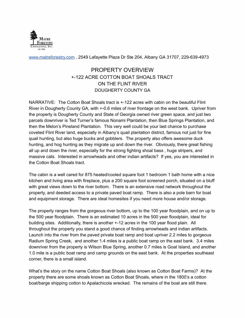
www.matreforestry.com , 2549 Lafayette Plaza Dr Ste 204, Albany GA 31707, 229-639-4973
PROPERTY OVERVIEW +-122 ACRE COTTON BOAT SHOALS TRACT
ON THE FLINT RIVER DOUGHERTY COUNTY GA
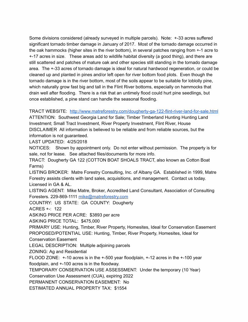
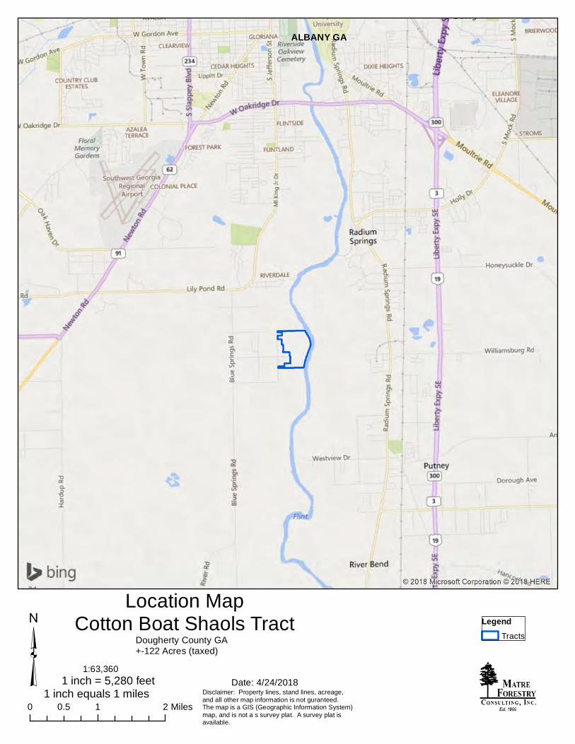
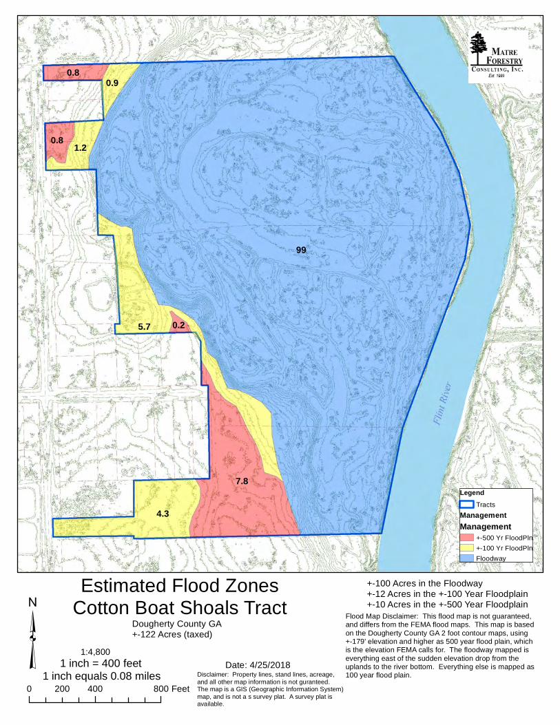
NARRATIVE: The Cotton Boat Shoals tract is +-122 acres with cabin on the beautiful Flint River in Dougherty County GA, with +-0.6 miles of river frontage on the west bank. Upriver from the property is Dougherty County and State of Georgia owned river green space, and just two parcels downriver is Ted Turner’s famous Nonami Plantation, then Blue Springs Plantation, and then the Melon’s Pineland Plantation. This very well could be your last chance to purchase coveted Flint River land, especially in Albany’s quail plantation district, famous not just for fine quail hunting, but also huge bucks and gobblers. The property also offers awesome duck hunting, and hog hunting as they migrate up and down the river. Obviously, there great fishing all up and down the river, especially for the strong fighting shoal bass , huge stripers, and massive cats. Interested in arrowheads and other indian artifacts? If yes, you are interested in the Cotton Boat Shoals tract. The cabin is a well cared for 875 heated/cooled square foot 1 bedroom 1 bath home with a nice kitchen and living area with fireplace, plus a 200 square foot screened porch, situated on a bluff with great views down to the river bottom. There is an extensive road network throughout the property, and deeded access to a private paved boat ramp. There is also a pole barn for boat and equipment storage. There are ideal homesites if you need more house and/or storage. The property ranges from the gorgeous river bottom, up to the 100 year floodplain, and on up to the 500 year floodplain. There is an estimated 10 acres in the 500 year floodplain, ideal for building sites. Additionally, there is another +-12 acres in the 100 year flood plain. All throughout the property you stand a good chance of finding arrowheads and indian artifacts. Launch into the river from the paved private boat ramp and boat upriver 2.2 miles to gorgeous Radium Spring Creek, and another 1.4 miles is a public boat ramp on the east bank. 3.4 miles downriver from the property is Wilson Blue Spring, another 0.7 miles is Goat Island, and another 1.0 mile is a public boat ramp and camp grounds on the east bank. At the properties southeast corner, there is a small island. What’s the story on the name Cotton Boat Shoals (also known as Cotton Boat Farms)? At the property there are some shoals known as Cotton Boat Shoals, where in the 1800’s a cotton boat/barge shipping cotton to Apalachicola wrecked. The remains of the boat are still there.
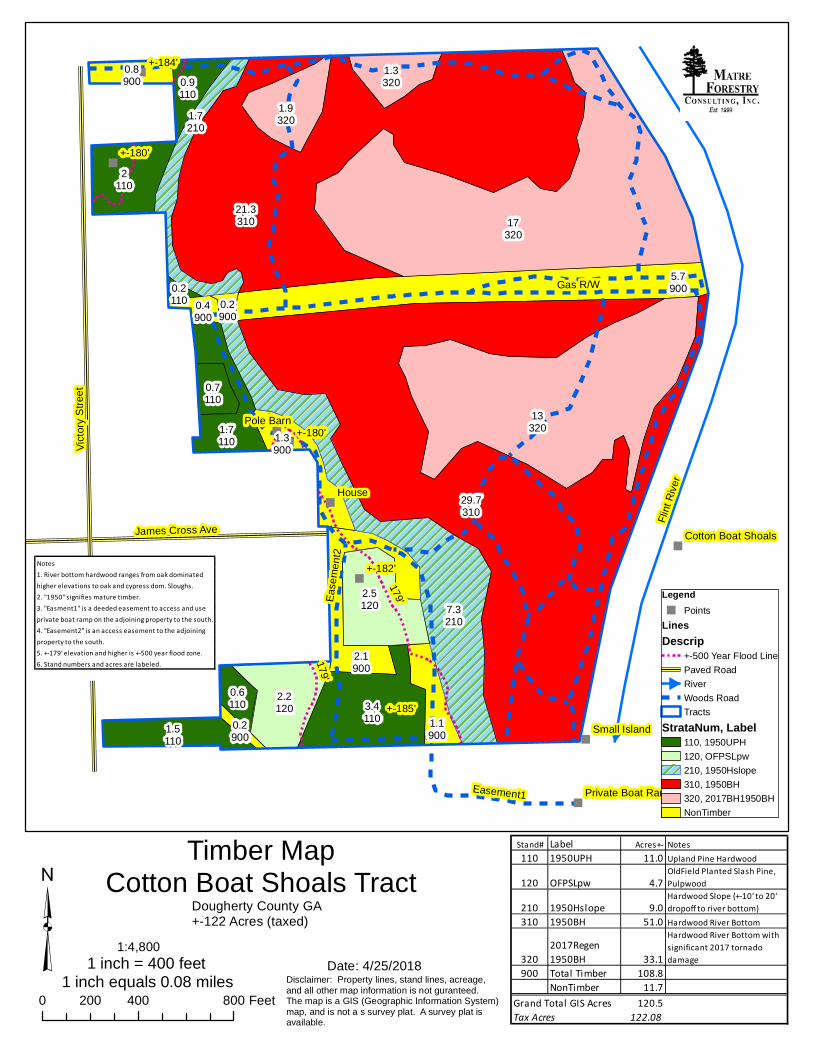
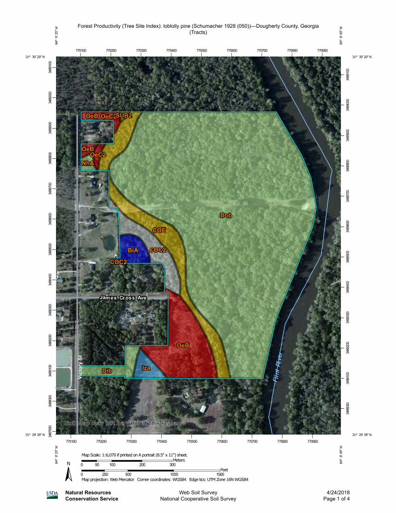
Some divisions considered (already surveyed in multiple parcels). Note: +-33 acres suffered significant tornado timber damage in January of 2017. Most of the tornado damage occurred in the oak hammocks (higher sites in the river bottom), in several patches ranging from +-1 acre to +-17 acres in size. These areas add to wildlife habitat diversity (a good thing), and there are still scattered and patches of mature oak and other species still standing in the tornado damage area. The +-33 acres of tornado damage is ideal for natural hardwood regeneration, or could be cleaned up and planted in pines and/or left open for river bottom food plots. Even though the tornado damage is in the river bottom, most of the soils appear to be suitable for loblolly pine, which naturally grow fast big and tall in the Flint River bottoms, especially on hammocks that drain well after flooding. There is a risk that an untimely flood could hurt pine seedlings, but once established, a pine stand can handle the seasonal flooding. TRACT WEBSITE: http://www.matreforestry.com/dougherty-ga-122-flint-river-land-for-sale.html ATTENTION: Southwest Georgia Land for Sale; Timber Timberland Hunting Hunting Land Investment; Small Tract Investment, River Property Investment, Flint River, House DISCLAIMER All information is believed to be reliable and from reliable sources, but the information is not guaranteed. LAST UPDATED: 4/25/2018 NOTICES: Shown by appointment only. Do not enter without permission. The property is for sale, not for lease. See attached files/documents for more info. TRACT: Dougherty GA 122 (COTTON BOAT SHOALS TRACT, also known as Cotton Boat Farms) LISTING BROKER: Matre Forestry Consulting, Inc. of Albany GA. Established in 1999, Matre Forestry assists clients with land sales, acquisitions, and management. Contact us today. Licensed in GA & AL. LISTING AGENT: Mike Matre, Broker, Accredited Land Consultant, Association of Consulting Foresters. 229-869-1111 [email protected] COUNTRY: US STATE: GA COUNTY: Dougherty ACRES +-: 122 ASKING PRICE PER ACRE: $3893 per acre ASKING PRICE TOTAL: $475,000 PRIMARY USE: Hunting, Timber, River Property, Homesites, Ideal for Conservation Easement PROPOSED/POTENTIAL USE: Hunting, Timber, River Property, Homesites, Ideal for Conservation Easement LEGAL DESCRIPTION: Multiple adjoining parcels ZONING: Ag and Residential FLOOD ZONE: +-10 acres is in the +-500 year floodplain, +-12 acres in the +-100 year floodplain, and +-100 acres is in the floodway. TEMPORARY CONSERVATION USE ASSESSMENT: Under the temporary (10 Year) Conservation Use Assessment (CUA), expiring 2022 PERMANENT CONSERVATION EASEMENT: No ESTIMATED ANNUAL PROPERTY TAX: $1554
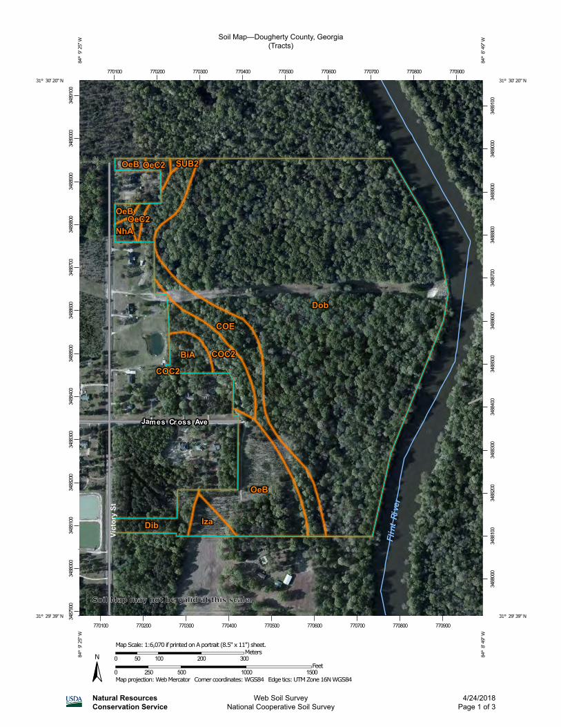
CURRENT ANNUAL FARM RENT: N/A IMPROVEMENTS: House, pole barn, deed access to private paved boat ramp, extensive road network. ESTIMATED TIMBER VALUE: Mature pine and hardwood, planted pines in pulpwood stage never thinned, and 2017 natural hardwood regen (tornado damage area). HUNTING: Great Flint River hunting tract for deer, turkey, ducks, hogs CROP BASIS: N/A SOILS: Dominant river bottom soil is +-90 acres Dunbar-Izagora-Bladen complex (occasionally flooded, somewhat poorly drained); and dominant upland soil is +-10 acres Orangeburg loamy sand, 2 to 5 percent slopes (no flooding, well drained). (Source: USDA Soil Map) WATER RESOURCES: +-0.6 Miles Flint River frontage, oak/cypress sloughs and ancient river bed, house well water TOPOGRAPHY: Flat to gentle roll. There is a major natural levie traversing the property, and the river bottom varies in elevation from sloughs, flat bottoms, to higher hammocks, and natural levees and drains. LOCATION/ACCESS: Paved road frontage on James Cross Ave (+-20’ at end of road) and Victory Drive (490’) OTHER: Indian artifacts are common. Will consider dividing. Surveyed into multiple parcels.
Location MapCotton Boat Shaols Tract
Date: 4/24/2018
LegendTracts
Disclaimer: Property lines, stand lines, acreage,and all other map information is not guranteed.The map is a GIS (Geographic Information System)map, and is not a s survey plat. A survey plat isavailable.
³0 1 20.5 Miles
1:63,360
1 inch equals 1 miles1 inch = 5,280 feet
Dougherty County GA+-122 Acres (taxed)
ALBANY GA
"
"
"
"
"
"
"
"
"
"
29.7310
21.3310 17
320
13320
7.3210
3.4110
2.5120
2.2120
2110
1.9320
1.7110
1.33200.9
110
0.7110
1.7210
1.5110
0.6110
0.2110
House
+-184'
+-180'
+-180'
+-182'
+-185'
Pole Barn
Small Island
Private Boat Ramp
Cotton Boat Shoals
5.7900
1.1900
2.1900
1.3900
0.8900
0.4900
0.2900
0.2900
Flint
River
179'
Victor
y Stre
et
Gas R/W
James Cross Ave
Ease
ment2
Easement1
179'
Timber MapCotton Boat Shoals Tract
Date: 4/25/2018
Legend" Points
LinesDescrip
+-500 Year Flood LinePaved RoadRiverWoods RoadTracts
StrataNum, Label110, 1950UPH120, OFPSLpw210, 1950Hslope310, 1950BH320, 2017BH1950BHNonTimber
Disclaimer: Property lines, stand lines, acreage,and all other map information is not guranteed.The map is a GIS (Geographic Information System)map, and is not a s survey plat. A survey plat isavailable.
³0 400 800200 Feet
1:4,800
1 inch equals 0.08 miles1 inch = 400 feet
Dougherty County GA+-122 Acres (taxed)
Stand# Label Acres+- Notes110 1950UPH 11.0 Upland Pine Hardwood
120 OFPSLpw 4.7OldField Planted Slash Pine, Pulpwood
210 1950Hslope 9.0Hardwood Slope (+-10' to 20' dropoff to river bottom)
310 1950BH 51.0 Hardwood River Bottom
3202017Regen 1950BH 33.1
Hardwood River Bottom with significant 2017 tornado damage
900 Total Timber 108.8NonTimber 11.7
Grand Total GIS Acres 120.5Tax Acres 122.08
Notes1. River bottom hardwood ranges from oak dominatedhigher elevations to oak and cypress dom. Sloughs.2. "1950" signifies mature timber.3. "Easment1" is a deeded easement to access and useprivate boat ramp on the adjoining property to the south.4. "Easement2" is an access easement to the adjoiningproperty to the south.5. +-179' elevation and higher is +-500 year flood zone.6. Stand numbers and acres are labeled.
"
"
"
"
"
"
"
"
"
"
29.7310
21.3310 17
320
13320
7.3210
3.4110
2.5120
2.2120
2110
1.9320
1.7110
1.33200.9
110
0.7110
1.7210
1.5110
0.6110
0.2110
House
+-184'
+-180'
+-180'
+-182'
+-185'
Pole Barn
Small Island
Private Boat Ramp
Cotton Boat Shoals
5.7900
1.1900
2.1900
1.3900
0.8900
0.4900
0.2900
0.2900
Flint
River
179'
Victor
y Stre
et
Gas R/W
James Cross Ave
Ease
ment2
Easement1
179'
Esri, USDA Farm Service Agency
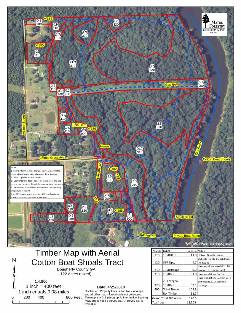
Timber Map with AerialCotton Boat Shoals Tract
Date: 4/25/2018Disclaimer: Property lines, stand lines, acreage,and all other map information is not guranteed.The map is a GIS (Geographic Information System)map, and is not a s survey plat. A survey plat isavailable.
³0 400 800200 Feet
1:4,800
1 inch equals 0.08 miles1 inch = 400 feet
Dougherty County GA+-122 Acres (taxed)
Stand# Label Acres+- Notes110 1950UPH 11.0 Upland Pine Hardwood
120 OFPSLpw 4.7OldField Planted Slash Pine, Pulpwood
210 1950Hslope 9.0Hardwood Slope (+-10' to 20' dropoff to river bottom)
310 1950BH 51.0 Hardwood River Bottom
3202017Regen 1950BH 33.1
Hardwood River Bottom with significant 2017 tornado damage
900 Total Timber 108.8NonTimber 11.7
Grand Total GIS Acres 120.5Tax Acres 122.08
Notes1. River bottom hardwood ranges from oak dominatedhigher elevations to oak and cypress dom. Sloughs.2. "1950" signifies mature timber.3. "Easment1" is a deeded easement to access and useprivate boat ramp on the adjoining property to the south.4. "Easement2" is an access easement to the adjoiningproperty to the south.5. +-179' elevation and higher is +-500 year flood zone.6. Stand numbers and acres are labeled.
"
"
"
"
"
"
"
"
"
"
29.7310
21.3310 17
320
13320
7.3210
3.4110
2.5120
2.2120
2110
1.9320
1.7110
1.33200.9
110
0.7110
1.7210
1.5110
0.6110
0.2110
House
+-184'
+-180'
+-180'
+-182'
+-185'
Pole Barn
Small Island
Private Boat Ramp
Cotton Boat Shoals
5.7900
1.1900
2.1900
1.3900
0.8900
0.4900
0.2900
0.2900
Flint
River
179'
Victor
y Stre
et
Gas R/W
James Cross Ave
Ease
ment2
Easement1
179'
Timber Map with 2 Foot ContoursCotton Boat Shaols Tract
Date: 4/25/2018Disclaimer: Property lines, stand lines, acreage,and all other map information is not guranteed.The map is a GIS (Geographic Information System)map, and is not a s survey plat. A survey plat isavailable.
³0 400 800200 Feet
1:4,800
1 inch equals 0.08 miles1 inch = 400 feet
Dougherty County GA+-122 Acres (taxed)
Stand# Label Acres+- Notes110 1950UPH 11.0 Upland Pine Hardwood
120 OFPSLpw 4.7OldField Planted Slash Pine, Pulpwood
210 1950Hslope 9.0Hardwood Slope (+-10' to 20' dropoff to river bottom)
310 1950BH 51.0 Hardwood River Bottom
3202017Regen 1950BH 33.1
Hardwood River Bottom with significant 2017 tornado damage
900 Total Timber 108.8NonTimber 11.7
Grand Total GIS Acres 120.5Tax Acres 122.08
Notes1. River bottom hardwood ranges from oak dominatedhigher elevations to oak and cypress dom. Sloughs.2. "1950" signifies mature timber.3. "Easment1" is a deeded easement to access and useprivate boat ramp on the adjoining property to the south.4. "Easement2" is an access easement to the adjoiningproperty to the south.5. +-179' elevation and higher is +-500 year flood zone.6. Stand numbers and acres are labeled.
99
7.8
5.7
4.3
1.2
0.90.8
0.8
0.2
Estimated Flood ZonesCotton Boat Shoals Tract
Date: 4/25/2018
LegendTracts
ManagementManagement
+-500 Yr FloodPln+-100 Yr FloodPlnFloodway
Disclaimer: Property lines, stand lines, acreage,and all other map information is not guranteed.The map is a GIS (Geographic Information System)map, and is not a s survey plat. A survey plat isavailable.
³0 400 800200 Feet
1:4,800
1 inch equals 0.08 miles1 inch = 400 feet
Dougherty County GA+-122 Acres (taxed)
+-100 Acres in the Floodway+-12 Acres in the +-100 Year Floodplain+-10 Acres in the +-500 Year Floodplain
Flood Map Disclaimer: This flood map is not guaranteed,and differs from the FEMA flood maps. This map is basedon the Dougherty County GA 2 foot contour maps, using+-179' elevation and higher as 500 year flood plain, whichis the elevation FEMA calls for. The floodway mapped iseverything east of the sudden elevation drop from theuplands to the river bottom. Everything else is mapped as100 year flood plain.
Soil Map—Dougherty County, Georgia(Tracts)
Natural ResourcesConservation Service
Web Soil SurveyNational Cooperative Soil Survey
4/24/2018Page 1 of 3
3487
900
3488
000
3488
100
3488
200
3488
300
3488
400
3488
500
3488
600
3488
700
3488
800
3488
900
3489
000
3489
100
3488
000
3488
100
3488
200
3488
300
3488
400
3488
500
3488
600
3488
700
3488
800
3488
900
3489
000
3489
100
770100 770200 770300 770400 770500 770600 770700 770800 770900
770100 770200 770300 770400 770500 770600 770700 770800 770900
31° 30' 20'' N84
° 9
' 25'
' W31° 30' 20'' N
84° 8
' 49'
' W
31° 29' 39'' N
84° 9
' 25'' W
31° 29' 39'' N
84° 8
' 49'' W
N
Map projection: Web Mercator Corner coordinates: WGS84 Edge tics: UTM Zone 16N WGS840 250 500 1000 1500
Feet0 50 100 200 300
MetersMap Scale: 1:6,070 if printed on A portrait (8.5" x 11") sheet.
Soil Map may not be valid at this scale.
Map Unit Legend
Map Unit Symbol Map Unit Name Acres in AOI Percent of AOI
BiA Bladen loam 2.0 1.7%
COC2 Cuthbert-Orangeburg complex, 5 to 8 percent slopes
4.0 3.3%
COE Cuthbert-Orangeburg complex, 12 to 17 percent slopes
9.9 8.3%
Dib Dunbar, Izagora, and Bladen soils
2.3 1.9%
Dob Dunbar-Izagora-Bladen complex
88.6 73.5%
Iza Izagora-Dunbar loamy fine sands
1.5 1.2%
NhA Norfolk loamy sand, 0 to 2 percent slopes
0.5 0.5%
OeB Orangeburg loamy sand, 2 to 5 percent slopes
10.4 8.6%
OeC2 Orangeburg loamy sand, 5 to 8 percent slopes, moderately eroded
1.0 0.8%
SUB2 Sawyer-Susquehanna loamy sands, 2 to 5 percent slopes, eroded
0.2 0.1%
Totals for Area of Interest 120.4 100.0%
Soil Map—Dougherty County, Georgia Tracts
Natural ResourcesConservation Service
Web Soil SurveyNational Cooperative Soil Survey
4/24/2018Page 3 of 3
Forest Productivity (Tree Site Index): loblolly pine (Schumacher 1928 (050))—Dougherty County, Georgia(Tracts)
Natural ResourcesConservation Service
Web Soil SurveyNational Cooperative Soil Survey
4/24/2018Page 1 of 4
3487
900
3488
000
3488
100
3488
200
3488
300
3488
400
3488
500
3488
600
3488
700
3488
800
3488
900
3489
000
3489
100
3488
000
3488
100
3488
200
3488
300
3488
400
3488
500
3488
600
3488
700
3488
800
3488
900
3489
000
3489
100
770100 770200 770300 770400 770500 770600 770700 770800 770900
770100 770200 770300 770400 770500 770600 770700 770800 770900
31° 30' 20'' N84
° 9
' 25'
' W31° 30' 20'' N
84° 8
' 49'
' W
31° 29' 39'' N
84° 9
' 25'' W
31° 29' 39'' N
84° 8
' 49'' W
N
Map projection: Web Mercator Corner coordinates: WGS84 Edge tics: UTM Zone 16N WGS840 250 500 1000 1500
Feet0 50 100 200 300
MetersMap Scale: 1:6,070 if printed on A portrait (8.5" x 11") sheet.
Soil Map may not be valid at this scale.
MAP LEGEND MAP INFORMATION
Area of Interest (AOI)Area of Interest (AOI)
SoilsSoil Rating Polygons
<= 80
> 80 and <= 82
> 82 and <= 86
> 86 and <= 90
> 90 and <= 94
Not rated or not available
Soil Rating Lines<= 80
> 80 and <= 82
> 82 and <= 86
> 86 and <= 90
> 90 and <= 94
Not rated or not available
Soil Rating Points<= 80
> 80 and <= 82
> 82 and <= 86
> 86 and <= 90
> 90 and <= 94
Not rated or not available
Water FeaturesStreams and Canals
TransportationRails
Interstate Highways
US Routes
Major Roads
Local Roads
BackgroundAerial Photography
The soil surveys that comprise your AOI were mapped at 1:20,000.
Warning: Soil Map may not be valid at this scale.
Enlargement of maps beyond the scale of mapping can cause misunderstanding of the detail of mapping and accuracy of soil line placement. The maps do not show the small areas of contrasting soils that could have been shown at a more detailed scale.
Please rely on the bar scale on each map sheet for map measurements.
Source of Map: Natural Resources Conservation ServiceWeb Soil Survey URL: Coordinate System: Web Mercator (EPSG:3857)
Maps from the Web Soil Survey are based on the Web Mercator projection, which preserves direction and shape but distorts distance and area. A projection that preserves area, such as the Albers equal-area conic projection, should be used if more accurate calculations of distance or area are required.
This product is generated from the USDA-NRCS certified data as of the version date(s) listed below.
Soil Survey Area: Dougherty County, GeorgiaSurvey Area Data: Version 11, Sep 11, 2017
Soil map units are labeled (as space allows) for map scales 1:50,000 or larger.
Date(s) aerial images were photographed: Apr 4, 2010—Apr 6, 2010
The orthophoto or other base map on which the soil lines were compiled and digitized probably differs from the background imagery displayed on these maps. As a result, some minor shifting of map unit boundaries may be evident.
Forest Productivity (Tree Site Index): loblolly pine (Schumacher 1928 (050))—Dougherty County, Georgia(Tracts)
Natural ResourcesConservation Service
Web Soil SurveyNational Cooperative Soil Survey
4/24/2018Page 2 of 4
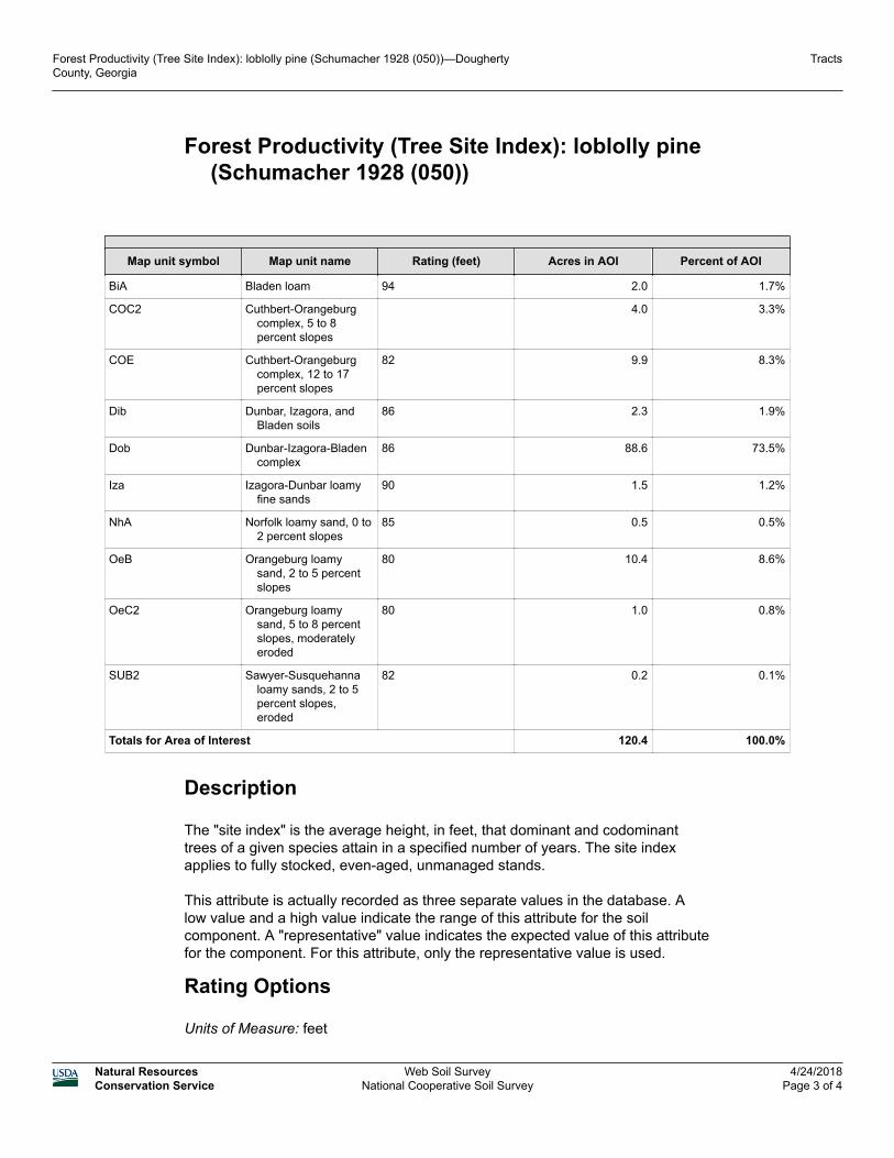
Forest Productivity (Tree Site Index): loblolly pine (Schumacher 1928 (050))
Map unit symbol Map unit name Rating (feet) Acres in AOI Percent of AOI
BiA Bladen loam 94 2.0 1.7%
COC2 Cuthbert-Orangeburg complex, 5 to 8 percent slopes
4.0 3.3%
COE Cuthbert-Orangeburg complex, 12 to 17 percent slopes
82 9.9 8.3%
Dib Dunbar, Izagora, and Bladen soils
86 2.3 1.9%
Dob Dunbar-Izagora-Bladen complex
86 88.6 73.5%
Iza Izagora-Dunbar loamy fine sands
90 1.5 1.2%
NhA Norfolk loamy sand, 0 to 2 percent slopes
85 0.5 0.5%
OeB Orangeburg loamy sand, 2 to 5 percent slopes
80 10.4 8.6%
OeC2 Orangeburg loamy sand, 5 to 8 percent slopes, moderately eroded
80 1.0 0.8%
SUB2 Sawyer-Susquehanna loamy sands, 2 to 5 percent slopes, eroded
82 0.2 0.1%
Totals for Area of Interest 120.4 100.0%
Description
The "site index" is the average height, in feet, that dominant and codominant trees of a given species attain in a specified number of years. The site index applies to fully stocked, even-aged, unmanaged stands.
This attribute is actually recorded as three separate values in the database. A low value and a high value indicate the range of this attribute for the soil component. A "representative" value indicates the expected value of this attribute for the component. For this attribute, only the representative value is used.
Rating Options
Units of Measure: feet
Forest Productivity (Tree Site Index): loblolly pine (Schumacher 1928 (050))—Dougherty County, Georgia
Tracts
Natural ResourcesConservation Service
Web Soil SurveyNational Cooperative Soil Survey
4/24/2018Page 3 of 4